Colorado abandoned mines From the Associated Press via the Fort Collins Coloradan:
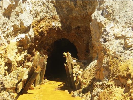
Site investigations and some cleanup work at 10 polluted mining complexes in four states were suspended because of conditions similar to those that led to a massive wastewater blowout from an inactive Colorado gold mine, U.S. Environmental Protection Agency officials said.
The sites include three in California, four in Colorado, two in Montana and one in Missouri, according to details obtained by The Associated Press following repeated requests for the information.
They have the potential for contaminated water to build up inside mine workings, EPA Assistant Administrator Mathy Stanislaus said. That would set the stage for a possible spill such as last month’s near Silverton, Colorado, where an EPA team triggered a 3 million gallon blowout of toxic sludge while doing excavation work on the inactive Gold King Mine.
The accident fouled rivers in three states and attracted harsh criticism of the EPA for not being prepared despite prior warnings that such a spill could happen.
“We want to take extra caution before we initiate any work,” Stanislaus said of the work suspensions. Some the mines were abandoned decades ago and have grown more unstable over time, raising the risk of an accident.
The stop-work order was issued last month but officials for weeks refused to disclose specifics.
Cleanup efforts on some of the mines have been going on for years yet remain unfinished, underscoring the complexity of a long-running attempt to address an estimated 500,000 abandoned mines across the U.S. Work on others was in the early stages.
In a report to Congress delivered Friday, the Government Accountability Office said federal agencies identified thousands of contaminated mine sites in recent years — even as their attempts to assess what harm is being done to people and the environment have lagged.
Further investigations were needed to gauge the danger posed by the 10 mining complexes under the suspension before work could safely resume, according to internal EPA documents released by the agency.
That includes categorizing their level of hazard. For those deemed a “probable hazard,” the EPA plans to keep the work stoppage in place until emergency plans are drawn up to deal with any accident.
The agency also wants to get the results of an Interior Department investigation into the Colorado accident before proceeding on most of the other sites. That’s expected in late October, department officials said.
Prior to the Aug. 5 Gold King spill, the EPA and its contractor, Environmental Restoration LLC of St. Louis, appeared to have only a cursory emergency response plan in the event of a spill, according to documents released under public records requests.
There was no cellphone coverage at the remote site in the San Juan Mountains, and the workers did not have a satellite phone, according to EPA documents. As a result, they had no way to immediately communicate with the outside world when the rust-colored water loaded with heavy metals, including lead and arsenic, began rushing toward downstream communities.
Fault vein in Standard Mine Gunnison County
One of the sites where cleanup work was subsequently halted was the Standard Mine in the mountains above Crested Butte, a ski town in west-central Colorado. Crested Butte Mayor Aaron Huckstep said that after work was suspended, the EPA met with residents and officials and made sure cleanup workers could communicate directly with the town in an emergency.
“They understood that they needed to make sure that the communication channels and the communication protocols were in place and the folks knew who to call and when to call them,” Huckstep said.
EPA documents show wastewater at the site periodically spills over a crudely-built impoundment, raising concerns about a “potential catastrophic failure” and the possibility of tainting Crested Butte’s drinking water. But Huckstep said he didn’t believe the Standard Mine was a threat to blow out, based on EPA statements and differences in the land.
The EPA said the town’s water meets safety standards.
Colorado Department of Public Health and Environment spokesman Warren Smith said wastewater flowing from the mine was not considered an acute health threat. Work on the site resumed Sept. 4 after officials determined appropriate safety measures were in place.
The Aug. 12 stop-work order from EPA Administrator Gina McCarthy did not apply to sites where halting operations would pose a threat to people or increase the potential for harm to the environment, according to internal EPA documents.
Also exempted were portions of the 10 stopped projects where construction already was completed, such as treatment systems for contaminated water that pours continually from many abandoned mine shafts.
That’s the case for two sites listed in northern California — the Leviathan sulfur mine near the town of Markleeville and the Iron Mountain metals mine near Redding. Water continues to be collected at the sites, to be treated and then discharged.
“We have not received any direction from EPA to shut down our treatment. It’s been business as usual for us out there,” said Scott Ferguson with the Lahonton Regional Water Quality Control Board, which is involved with the Leviathan mine.
EPA spokeswoman Laura Allen said other work at the two mines has stopped, including plans to remove a beaver dam at Leviathan.
The CPC/IRI ENSO forecast says there’s an approximately 95% chance that El Niño will continue through Northern Hemisphere winter 2015-16, gradually weakening through spring 2016. It’s question & answer time!
How strong is this El Nino now?
The only real way to answer this is to throw a bunch of numbers at you. Essentially, it’s “pretty strong.” The three-month, June-August average of sea surface temperatures in the Niño3.4 region (the Oceanic Niño Index) is 1.22°C above normal, via the ERSSTv4 data set. This is the third-highest June-August value since records start in 1950, behind 1987 (1.36°C) and 1997 (1.42°C).
The August average is 1.49°C, second behind August 1997 (1.74°C). The August Equatorial Southern Oscillation Index (which measures the strength of the atmospheric part of ENSO) was -2.2, second to 1997’s -2.3. There are many ways of measuring El Niño, so the ranking of El Niño will change depending on which variable (winds, pressure, etc.) or time period (monthly, seasonal) you want to examine.
When is El Niño going to hit?
El Niño isn’t a storm that will hit a specific area at a specific time. Instead, the warmer tropical Pacific waters cause changes to the global atmospheric circulation, resulting in a wide range of changes to global weather. Think of how a big construction project across town can change the flow of traffic near your house, with people being re-routed, side roads taking more traffic, and normal exits and on-ramps closed. Different neighborhoods will be affected most at different times of the day. You would feel the effects of the construction project through its changes to normal patterns, but you wouldn’t expect the construction project to hit your house.
Okay, then… but what’s going to happen in my home town?
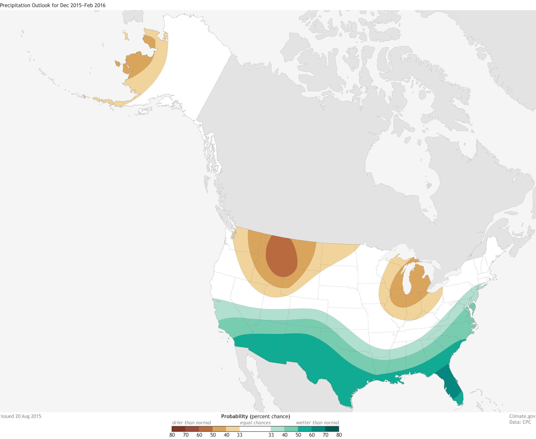
The expected changes in regional weather patterns due to El Niño are a big part of the NOAA Climate Prediction Center’s seasonal forecasts. Over North America, the Pacific jet stream (a river of air that flows from west-to-east) often expands eastward and shifts southward during El Niño, which makes precipitation more likely to occur across the southern tier of the United States. Check out the winter (December-February) forecasts here.
Chances of possible temperature (upper map) and precipitation (lower) outcomes for December 2015-February 2016: above normal, below normal, or near normal. Above or below normal means temperatures in the upper or lower third of the range of historical temperatures. White does not mean “near normal;” it show places where the chances for above-, below-, and near-normal temperatures are equal. Maps by NOAA Climate.gov, based on data from the Climate Prediction Center. Why winter?
The weather in the winter is controlled more by global atmospheric flow than summer weather is, when small-scale events like thunderstorms tend to be more important. Since El Niño’s remote effects are felt though its modulation of global flow, winter is when the most noticeable impacts occur.
Winter in the Southern Hemisphere is just winding down. Did El Niño have an impact on their winter?
A few months ago, Tony wrote about expected effects of El Niño during June-August. Most of the El Niño-related changes that have been identified during past events are in the Southern Hemisphere during their winter; there are also significant effects in the tropics. These include warmer weather in some areas of South America, dry conditions in India, Indonesia, and Australia, and warm and dry conditions in Central America and the Caribbean. Also, more rain than average in part of Chile, and some cooler temperatures in part of Australia.
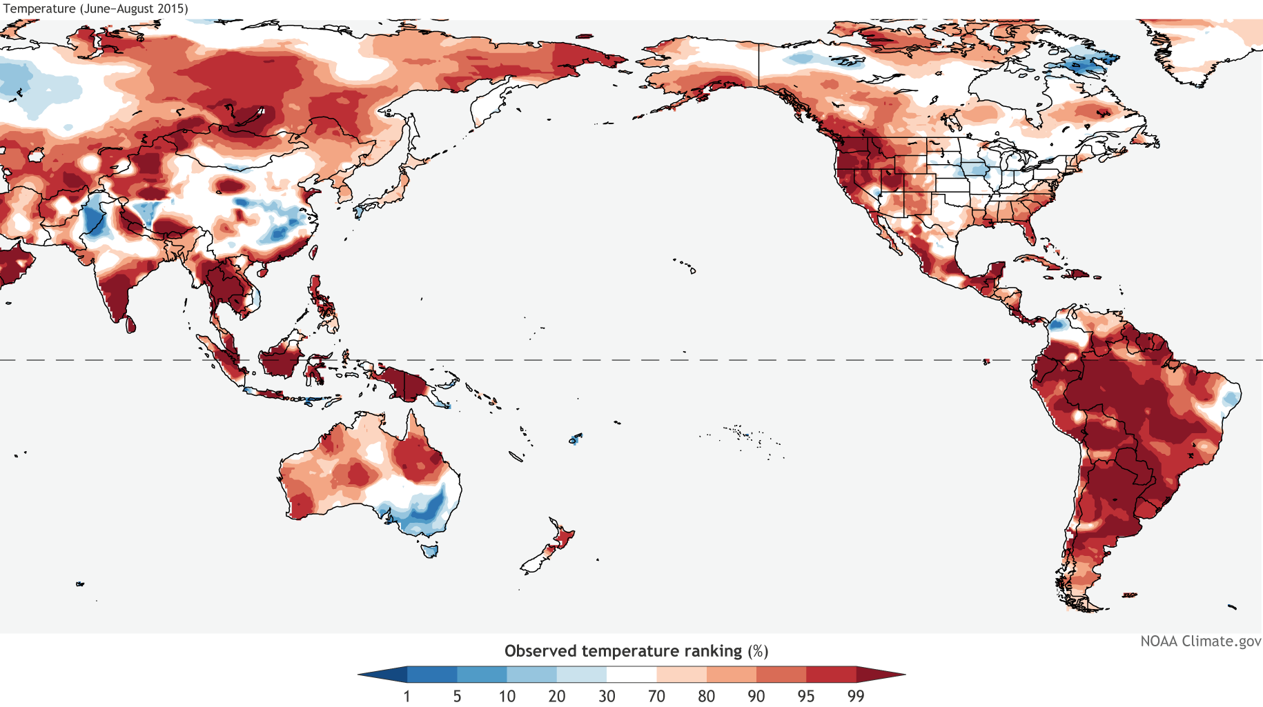
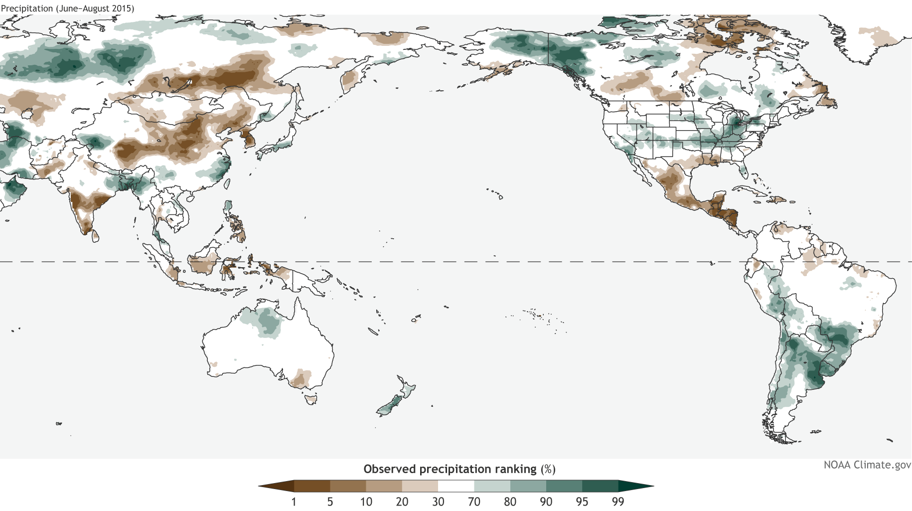
Observed temperature (upper map) and precipitation (lower) from June-August 2015. Observations are shown as their ranking in the period 1948-present: for example, a 90th percentile temperature means this June-August was warmer than 90% of the past June-August averages. Climate.gov figure from CPC data.
Much of South America did experience a very warm winter; in some areas, it was the warmest winter since these records began in 1948. Parts of Argentina, Uruguay, and Chile received a lot of rain during July-August. Central America and the Caribbean are very dry right now, with the June-August rainfall deficit just adding to a severe drought throughout the region. Also in line with expected conditions during El Niño, rainfall in some portions of India and Indonesia were well below average, and very few areas in this region saw more rain than average.
However, as we’ve said before (here and here, for example), El Niño impacts are not guaranteed, and an example of this is Australia’s recent winter, which was not nearly as dry as it has been during past El Niños.
What about the places that are directly affected by all that warm water? I heard the surface temperatures were more than 90°F in some places!
The warmer-than-average tropical Pacific waters can have a big impact on marine life. For example, there were large coral bleaching episodes (coral die-offs) during past El Niños, and it’s likely we’ll see a lot of coral bleaching this year. The warmer water can also affect fisheries, seaweed farms, ocean mammals, and birds.
What about the hurricane season? That’s supposed to be affected by El Niño, right?
El Niño can amp up the hurricane season in the Pacific, by providing lots of warm water to power the storms, and reducing the vertical shear (the change in wind speed/direction as you go up in the atmosphere). On the other hand, the shear is increased over the Atlantic, which makes it difficult for storms to form and strengthen. So far this year, the Pacific has been very active, and the Atlantic has been pretty quiet. There have been some unusual events in both basins recently – Tom wrote about them here and here.
Could El Niño die before this winter?
It’s unlikely. There is a large reservoir of warm water just below the surface of the tropical Pacific that will help to keep surface temperatures relatively high for at least a few more months, and the atmosphere is in sync with the ocean. However, the strength of the atmospheric response over the next few months is still to be determined. In 1997, the near-surface winds along the equatorial Pacific weakened so much that they reversed from normal, and blew from the west to the east, helping to reinforce the warm sea surface temperatures. We haven’t seen behavior like that yet, and it’s hard to predict right now if we will.
I keep hearing how the “Blob” (a large area of warm ocean temperatures off the West Coast of the U.S.) is going to be in a battle with this strong El Nino this winter. Which one will win?
El Nino and “the Blob” are not on an equal playing field, so the short answer is we expect El Niño to dominate the large-scale atmospheric pattern over the Pacific-North America this coming winter.
Sea surface temperatures during August compared to the 1981-2010 average. Climate.gov figure, based on data from NOAA View.
The Blob is not capable of changing the overlying atmospheric pattern in a significant way. In the Tropics, changes in ocean temperatures can easily lead to changes in the atmosphere above it. But outside of the Tropics, such as over the North Pacific Ocean, the physics are different, so ocean temperatures can’t effectively change the large-scale atmospheric flow or circulation pattern. The amount of heat in the Tropics is an enormous engine that drives rising motion and affects the whole globe’s circulation; the Blob is like a Fisher Price Power Wheel in comparison.
That said, the way that El Niño might affect water temperatures off the West Coast, or how those water temperatures might affect storms that are steered into the area by El Niño, is really hard to tell. As with any forecast, there are a lot of elements at play. However, El Niño is the dominant factor shaping the overall global picture for this winter.
Greg Hobbs at the 2015 Martz Summer Conference (of course there is a projected image of a map — this one was the division of Colorado into water divisions by major basin, heeding the advice of John Wesley Powell) From the Pine River Times:
The 9th Annual Water 101 Seminar will be held Sept. 25 at the Pine River Library in Bayfield. Keynote speaker will be Colorado Supreme Court Justice Gregory Hobbs.
Hobbs will speak on Colorado water history and law. Other speakers will include representatives from the Bureau of Reclamation, Corps of Engineers, Colorado Division of Water Resources, Pine River Irrigation District, Town of Bayfield, and La Plata/ Archuleta Water District.
The schedule also includes a presentation on the Colorado Water Plan (comments for which are due on Sept. 17) and the Southwest Basin Implementation Plan that will be part of the state plan. Water emgineer Steve Harris will speak on water banking.
The event will run from 8:30 a.m. to 5:30 p.m. Space is limited so register early! The general public registration fee is $35 before Sept. 16, or $40 after that date and at the door. The registration fee includes lunch, snack, and an information packet. The fee for professionals seeking CECs is $50 before Sept. 16 or $60 at the door.
The seminar qualifies for continuing education credits (CECs) for lawyers and realtors, training units for water utility operators, and teacher certificate renewal hours.
The seminar is sponsored by the La Plata-Archuleta Water District, Pine River Irrigation District, Town of Bayfield, Southern Ute Indian Tribe, and the Water Information Program.
For more information or to register, contact the Water Information Program at 247-1302 or visit their website at http://www.waterinfo.org.
The Colorado Lottery honored Montrose recently with one of its 2015 Starburst Awards.
The award recognizes Montrose’s excellence in use of lottery funds in creating the Montrose Water Sports Park; the City of Montrose is to formally accept the award at city council’s Sept. 15 meeting.
“This award provides further acknowledgement of all of the planning and effort that went into creating the Water Sports Park,” City Manager Bill Bell said in a statement Friday.
“While the city had a central role in creating this amazing community asset, the finished product represents the collaborative effort and vision of many organizations and individuals in the community. This award recognizes everyone who had a share.”
Great Outdoors Colorado (funded by lottery proceeds) provided partial funding to build the water park, as well as new trails along the Uncompahgre River and improvements to nearby Montrose Recreation District facilities.
Colorado Lottery noted exceptional collaboration among local entities in choosing Montrose for the Starburst Award. Montrose was one of 19 communities to receive a Starburst Award.
“These projects display how important outdoor recreation is to both Coloradans and visitors,” Lottery Director Laura Solano said in the statement.
“The Lottery congratulates and recognizes the 2015 Starburst winners for their vision in creating quality recreation opportunities in their communities.”
The Water Sports Park is located at Riverbottom Park on Apollo Road. It boasts six “wave simulator” structures within the river, several rock-terraced spectator areas, nearly one-half mile of recreation trails, Americans with Disability Act-compliant access ramps at each end of the park, two rock-climbing boulders and several fish-habitat improvements.
Wastewater Treatment Process FromThe Pueblo Chieftain (Chris Woodka):
The city of Pueblo laid out its case for more time to study which methods of reducing contaminants, especially selenium, in wastewater to state and county officials Friday.
“The city’s approach is not just a study, but an adaptive management program,” said Gabe Racz, the city’s attorney for water quality issues.
Pueblo plans to ask the Colorado Water Quality Control Commission in December for an extension of temporary modification for discharges from the sewage treatment plant east of Pueblo. The city wants three years to meet sulfate standards and 10 years for selenium levels.
There are complicated, interrelated processes that need to be implemented in order to meet new federal standards for selenium, ammonia and nutrients, said Gene Michael, wastewater director for Pueblo.
Northern Integrated Supply Project via The Denver Post FromBizWest (Dallas Heltzell):
In a 20-page letter sent last week to the U.S. Army Corps of Engineers, the EPA listed a series of objections to the Supplemental Draft Economic Impact Statement released by the Corps in June regarding the proposed Northern Integrated Supply Project. Echoing comments made in recent weeks by officials from Larimer County and the cities of Fort Collins and Greeley, the EPA said the Corps’ SDEIS lacked sufficient information to adequately predict the project’s potential impacts or to achieve the level of compliance with provisions of the Clean Water Act that the Berthoud-based Northern Colorado Water Conservancy District would need to get a federal permit to build and manage NISP…
“Although stressed and, in some instances currently degraded” by withdrawals for various uses, the Poudre and South Platte “river systems are of ecological, agricultural and recreational value to local and regional areas in Colorado and their aquatic and hydrologic functions are extremely difficult to replace,” wrote Martin Hestmark, assistant administrator in the Office of Ecosystems Protection and Remediation for EPA’s Denver region, in the Sept. 3 letter to the Corps’ Denver regulatory office.
Hestmark’s letter detailed concerns about what the agency regards as insufficient Corps projections about river hydrology, water quality, permitted discharges, aquatic biological resources, wetlands and riparian areas, agricultural impacts and climate change, as well as proposed steps to mitigate those harmful impacts and possible alternatives.
The EPA gave the project an EO-2 grade. The EO, or environmental objection. “signifies that the EPA’s review identified the potential for the NISP project to cause or contribute to violations of water-quality standards or significant degradation that, without sufficient mitigation, could be substantive and would occur on a long-term basis,” Hestmark wrote. “The ‘2’ rating signifies that the EPA’s review identified the need for improved impact analysis and mitigation to adequately assess the potentially significant, long-term environmental impacts of the proposal. Given the importance of documenting the project’s consistency with requirements in the Clean Water Act, the planned Phase II water quality effects analysis and the related mitigation for those effects should include a formal and full public review in advance of the final EIS.”
In a letter dated Aug. 28, Northern Water general manager Eric Wilkinson wrote that “NISP participants have spent $12 million on the detailed SDEIS process. Under the direction of the Army Corps of Engineers, several expertly qualified independent consultants have thoroughly studied all aspects of NISP as reflected by the funding provided by the NISP participants to complete those studies. …
“As planned by the Corps, in addition to the river-water quality evaluation completed for the SDEIS, detailed water temperature and water quality analyses will be completed prior to the release of the final EIS” late this year or early in 2016, Wilkinson wrote, adding that the project has received more than 100 endorsements from around the state, including industry and economic-development groups, newspapers and the Larimer County commissioners.
Northern Water’s boundaries include about 880,000 people living on 1.6 million acres in portions of Boulder, Broomfield, Larimer, Weld, Logan, Morgan, Sedgwick and Washington counties.
The Environmental Protection Agency has qualms about the review process for the Northern Integrated Supply Project, detailed in 20 pages of comments made public Thursday.
The EPA gave a rating of “Environmental Objections — Insufficient Information” to the Army Corps of Engineers’ supplemental draft environmental impact statement, which was subject to public comments until Sept. 3.
The “environmental objections” rating means the EPA has identified significant environmental impacts that the project must avoid. The “insufficient information” rating means the EPA found that the SDEIS doesn’t contain enough information to fully analyze the project’s environmental impacts.
The EPA’s comments aren’t necessarily binding, but the agency has veto power over the permitting process.
Both ratings are one step away from the worst the EPA can dole out. The EPA could have rated the project “environmentally unsatisfactory,” meaning it shouldn’t proceed as proposed, and “inadequate,” which would have required the Army Corps to release another supplemental draft.
The EPA’s rating is consistent with calls from the Fort Collins City Council, Save the Poudre and the Larimer County Board of Commissioners that the Army Corps conduct additional analysis of how NISP would affect water quality in the Poudre River, the primary source of water for a project that would create two reservoirs to provide 40,000 acre feet of water annually to 15 participants. Those include 11 cities/towns and four water districts. Towns include Windsor, Severance, Dacono, Eaton, Evans, Erie, Frederick, Firestone, Fort Lupton, Fort Morgan and Lafayette. The Fort Collins-Loveland Water District is a participant.
Essentially, the SDEIS includes a half-finished water quality analysis that predicts what kind of water quality effects might occur — temperature changes and increased concentration of certain sediments — but not the magnitude of those effects. The SDEIS says the full analysis will be in the final environmental impact statement, slated for release next summer.
NISP opponents took issue with the lack of full analysis because the Army Corps isn’t planning for a public comment period between the final EIS and its record of decision on the project.
In its comments, the EPA recommends the Army Corps publish the additional analysis before the final EIS and allow for a formal public comment period.
Hayfield message to President Obama 2011 via Protect the Flows FromGreenBiz.com (Sandra Postel/Val Fishman):
We’re not going to pull any punches. We’re building a water stewardship movement, and we hope you’ll join us. More than 130,000 people and 22 companies already have. Our goal is nothing less than to change the way society uses, manages and values freshwater.
By now most of us have heard the pronouncement “water is the new oil.” But in fact, it’s so much more. Water is the basis not only of our economies, but of life itself.
As demands bump up against the limits of a finite supply, rivers are running dry, lakes are shrinking and groundwater is being depleted. From California to China to Brazil, severe droughts have forced curtailments of water deliveries. This year, for the first time, the World Economic Forum in Davos, Switzerland, ranked water crises as the No. 1 global threat.
Known risks
Companies know that water risks pose bottom-line risks, and many have begun to boost their water productivity, getting more output and revenue per gallon used. Manufacturing facilities are recycling and reusing water. More food and beverage companies are working actively with their raw-ingredient suppliers to shrink the water footprints of their products.
Curbing water use is essential. But what do we do about the dammed and dried-up rivers and depleted wetlands?
In the Colorado River Basin alone, a $26 billion-a-year recreation economy depends not on water being diverted out of rivers, but on flows staying in rivers. During the drought of 2012, the western Colorado tourist town of Steamboat Springs saw cash registers go silent when the Yampa River dropped too low for rafting and fly-fishing.
Water security depends on meeting the needs of people and ecosystems. Achieving it requires two things: Figure out how to live happy and productive lives while consuming less water; and restore flows to depleted rivers and freshwater ecosystems.
The Environmental Protection Agency has qualms about the review process for the Northern Integrated Supply Project, detailed in 20 pages of comments made public Thursday.
The EPA gave a rating of “Environmental Objections — Insufficient Information” to the Army Corps of Engineers’ supplemental draft environmental impact statement, which was subject to public comments until Sept. 3.
The “environmental objections” rating means the EPA has identified significant environmental impacts that the project must avoid. The “insufficient information” rating means the EPA found that the SDEIS doesn’t contain enough information to fully analyze the project’s environmental impacts.
The EPA’s comments aren’t necessarily binding, but the agency has veto power over the permitting process.
Both ratings are one step away from the worst the EPA can dole out. The EPA could have rated the project “environmentally unsatisfactory,” meaning it shouldn’t proceed as proposed, and “inadequate,” which would have required the Army Corps to release another supplemental draft.
The EPA’s rating is consistent with calls from the Fort Collins City Council, Save the Poudre and the Larimer County Board of Commissioners that the Army Corps conduct additional analysis of how NISP would affect water quality in the Poudre River, the primary source of water for a project that would create two reservoirs to provide 40,000 acre feet of water annually to 15 participants. Those include 11 cities/towns and four water districts. Towns include Windsor, Severance, Dacono, Eaton, Evans, Erie, Frederick, Firestone, Fort Lupton, Fort Morgan and Lafayette. The Fort Collins-Loveland Water District is a participant.
Essentially, the SDEIS includes a half-finished water quality analysis that predicts what kind of water quality effects might occur — temperature changes and increased concentration of certain sediments — but not the magnitude of those effects. The SDEIS says the full analysis will be in the final environmental impact statement, slated for release next summer.
NISP opponents took issue with the lack of full analysis because the Army Corps isn’t planning for a public comment period between the final EIS and its record of decision on the project.
In its comments, the EPA recommends the Army Corps publish the additional analysis before the final EIS and allow for a formal public comment period.
Map of the Northern Integrated Supply Project via Northern Water
Arkansas River Basin — Graphic via the Colorado Geological Survey FromThe Pueblo Chieftain (Chris Woodka):
More than $1.3 billion in water projects for the Arkansas Valley are queued, although how they will be funded is unknown.
That’s the conclusion of the Arkansas Basin Roundtable, which finalized its comments on the state water plan Wednesday.
The roundtable again voiced its overriding concern that water for agriculture be protected.
“At some point, agricultural use may be more valuable (than urban use),” said Joe Kelley, La Junta water superintendent. “In some years, the cities may not have the demand. It’s best not to buy and dry, to take the water away permanently.”
The roundtable also agreed to eight challenges that were identified by Gary Barber, who chaired the roundtable for several years before becoming a consultant on the basin implementation plan. That plan is finished, but it feeds into the state water plan by identifying projects and goals for the Arkansas River basin.
A list of projects included rough cost estimates that still need revision. The most expensive included $400 million for future Colorado Springs development, $400 million for the Arkansas Valley Conduit, $277 million for the Pikes Peak Regional Water Authority and at least $100 million for Fountain Creek projects.
Another $100 million or so is needed for an Upper Arkansas multiuse project, a fledgling watershed protection effort and support for the Arkansas Valley Super Ditch.
Finally, there are 135 smaller projects that total about $65 million.
As far as challenges, the roundtable agreed to eight points Barber developed from 10 years of discussion. The most daunting is the need to find 30,000-50,000 acre-feet for new uses, both agricultural and municipal, that will occur because all of the Arkansas basin’s water is appropriated.
One particular concern noted that although needs have been identified, no solutions have emerged to fill those needs.
Other challenges include replacing nonrenewable Denver Basin groundwater, finding collaborative solutions, protecting recreational flows, maintaining water quality on Fountain Creek and in the Lower Arkansas Valley, renovating aging reservoirs and finding regional solutions.
Comments to the final draft of the state water plan are due by Thursday.
The plan and information about how to comment may be found at coloradowaterplan.com.
The final version of the Colorado Water Plan will be submitted by the Colorado Water Conservation Board to Gov. John Hickenlooper by Dec. 10.
As Congress sharpens its knives for what will likely be multiple committee hearings on the accidental release by the U.S. Environmental Protection Agency of 3 million gallons of toxic mine wastewater into the Animas River on Aug. 5, local officials are focused on disaster relief.
Their pleas for congressional help come amid a chorus of criticism aimed at the federal agency, which on Wednesday issued its own internal review of the blowout, concluding it was “likely inevitable” and caused mainly by an “underestimation of the water pressure in the Gold King Mine.”
The EPA report and a separate Department of Interior investigation are unlikely to satisfy members of Colorado’s congressional delegation who are calling for extensive hearings on the matter following the August recess, but Silverton town administrator Bill Gardner isn’t particularly interested in the blame game.
“We, as Silverton and San Juan County staff … think that shouldn’t be the conversation right now,” Gardner told The Colorado Statesman. “The conversation in Congress, which is what we’re going to need to find resources to remedy this problem, should be about, ‘What are the best steps for finding a solution?’”
Silverton and San Juan County on Tuesday adopted a joint resolution calling for a concerted effort — with other downstream communities affected by the blowout — to secure both short- and long-term federal disaster funding to stop the discharge, which has been occurring for years at a rate of up 800 gallons per minute. There are several abandoned mines in the area that have been draining into the local watershed since the late 1800s.
That doesn’t necessarily mean local officials are doing a 180 and suddenly seeking an EPA Superfund designation, which might make additional federal remediation dollars available, although that is a possibility. Gardner says there are so many toxic sites on the EPA’s National Priorities List and so little funding that a Superfund listing might not solve the problem.
Gardner acknowledges the EPA has a role going forward and points to the success the agency has had mopping up the nearby Mineral Creek drainage and working with the local Animas River Stakeholders Group to mitigate the situation in Cement Creek, which is devoid of aquatic life.
“So there has been some good work done, but the challenge comes with this sticking point about Superfund, and the concerns are real simple,” Gardner said. “EPA is not funded the way it was in 1990. It simply has lost support for funding.”[…]
in 1995 Congress cut off a tax on petroleum and chemical imports that provided a steady trust fund of billions in cleanup resources. By 2003 the fund had no set funding, and cleanup efforts slowed dramatically, with Congress paying for Superfund remediation out of the general fund.
In 2010, former EPA Administrator Lisa Jackson unsuccessfully lobbied Congress to reinstate the Superfund “Polluters Pay” tax, and Oregon Democratic Earl Blumenauer has introduced a bill to reinstate the Superfund tax in the current Congress, although its chances of success are thought to be slim with both chambers controlled by Republicans.
Whether the Gold King and other nearby mines need to be plugged, a wastewater treatment facility needs to be built in the Cement Creek drainage, or some other scientific solution should be implemented, Gardner says Congress should fund a comprehensive, long-term solution.
“The point is, we think we’d really be making a mistake if we use a Band-Aid approach,” he said. “The easiest Band-Aid — and I’m not saying it isn’t important, because it is — would be to just put the water treatment facility at Cement Creek. We need to look at the whole problem, and we think this could be a pilot program because we know there are thousands of mines throughout the Intermountain West that [are leaking toxins into watersheds].”
Meanwhile, the spotlight will continue to shine brightly on the EPA, with critics lining up on both sides of the aisle. Democratic Reps. Diana DeGette of Denver and Ben Ray Luján of New Mexico this week fired off a letter requesting an EPA oversight hearing to Energy and Commerce Committee Chairman Fred Upton, a Republican.
Rep. Doug Lamborn, a Colorado Springs Republican, sent a letter to EPA Administrator Gina McCarthy blasting the “blatant hypocrisy” of her agency, which he says would heavily fine or jail owners of a private company that caused such a disaster.
Of course, private companies — long since out of business — left the toxic mining waste surrounding Silverton. But they did it more than 100 years ago, when there was no EPA. A Lamborn spokesman did not return calls and emails requesting additional comment.
Rep. Scott Tipton, a Cortez Republican whose district includes Silverton, has been equally critical of the EPA. A spokesman on Wednesday said the lawmaker will consider Silverton and San Juan County’s request for federal disaster funding after the recess.
“With regard to federal assistance, Congressman Tipton’s office is reviewing all of the options to determine what is most appropriate and doable,” Tipton spokesman Josh Green said in an email, adding the EPA continues to drag its feet providing information about the spill.
“Congressman Tipton has numerous inquiries into the EPA asking critical questions about how the spill occurred, and the EPA’s response and communication following the spill, which was abhorrent and virtually non-existent,” Green said. “The EPA to date has not been close to being responsive enough, and this will no doubt be a topic raised during future Congressional hearings and investigations.”[…]
Legislatively, Colorado’s congressional delegation is split on party lines, with Republicans backing a Good Samaritan law that would absolve third parties — such as state and local governments, nonprofits and mining companies — from long-term liability cleaning up old mines.
Democrats would like to not only pass Good Samaritan legislation but also reform the 1872 Mining Law to require royalties from companies mining on public lands. That money would create a cleanup fund for abandoned mines.
Silverton’s Gardner, who came out of retirement to try to heal a divided town and was only on the job three weeks before the blowout, says Good Samaritan legislation is good starting point but Congress must quickly get off the EPA issue and come up with meaningful solutions.
“It’s clear to me that the debate over who is going to administrate and find the solution is contributing to a serious delay in addressing the problem,” Gardner said.
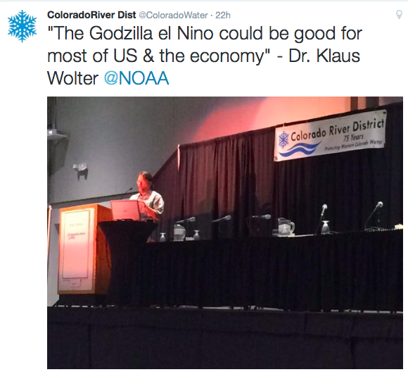
Klaus Wolter speaking at the 2015 Colorado River District Annual Seminar — Tweet via the Colorado River District
FromThe Grand Junction Daily Sentinel (Dennis Webb):
California’s water-supply problem is by default the problem of the entire Colorado River Basin, and basin states ignore it at their own peril, two speakers warned Thursday.
“You have to keep track of what’s going on in California. California affects the Colorado River and vice versa,” Jennifer Gimbel, principal deputy secretary for water and science at the U.S. Department of Interior, said during the Colorado River District’s annual water seminar in Grand Junction.
Pat Mulroy, retired general manager of the Southern Nevada Water Authority, warned that Lake Mead is dropping ever closer to a point at which it would no longer be capable of releasing water for downstream uses. That will lead to panic and irrational behavior, she predicted, and federalization of a river system under which water is now governed and allocated by interstate compact.
“We will have all-out chaos,” said Mulroy, now senior fellow for climate adaptation and environmental policy at the University of Nevada, Las Vegas’ law school.
California is coping with a severe drought, the effects of which have been amplified by the inability of varying interests there to build flexibility into water management, store water in wet years and otherwise prepare for dry times, Mulroy said.
“The story of California is the story of missed opportunities, and of the inability, the human inability, to find solutions,” she said.
Gimbel, former director of the Colorado Water Conservation Board, said part of California’s problem is a lack of sufficient in-state water storage capability to help it prepare for dry years, as opposed to the high-capacity storage provided by Lake Mead and Lake Powell on the Colorado.
“It’s quite honestly what’s saved our bacon over these last 15 years of the drought,” Gimbel said.
She said the heavy precipitation during what’s being called the “Miracle May” earlier this year helped stabilize water levels in Lake Powell. That has provided some breathing room for dealing with what’s an ongoing drought, and efforts to deal with it must continue, Gimbel said.
She said Lower Basin states have had “difficult discussions” in this regard, “and when things get bad people tend to go back to their positions.”
“… I think that we have to do better on this river. We cannot give up, and it means that when we get scared we cannot retreat to our corners and close the door. We can’t do it alone.”
She hopes that Colorado learns from California’s experience “about drawing lines in the sand, litigating and being unable to move forward.” She said as work began on Colorado’s state water plan, she worried about the rhetoric she was hearing, and about people falling back to their standard positions.
“You can protect what you want to protect, go after what you want to go after,” but everyone has to work together, said Gimbel, who praised the progress that since has been made on the plan.
Said Mulroy, “It is not easy to try to find a new balance point, it is not easy to try to understand your adversary’s position or your fellow stakeholder’s position.”
That is something that has yet to occur in California, she said.
Mulroy sees a need for people to view themselves as citizens of the Colorado River Basin. Everyone has to conserve water and participate in the management of the system, and water needs to be viewed not just as a right but a responsibility, she said.
“If we each take a little bit less in times when we can … and we set limits on how far we’re comfortable letting the system drop before we start recharging the system, then we won’t be sitting in front of dry reservoirs,” Mulroy said.
Asked about concern on the Front Range that conservation measures could mean fewer green lawns and reduced property values, she talked about the initial resistance in the Las Vegas area to efforts to have homeowners convert to more desert landscaping, before they realized it could be beautiful and also end the need to mow lawns.
“It is a real cultural shift, but people need to understand there is a need to conserve,” Mulroy said.
She said that in considering the challenges river basin states face in the years ahead, it’s important to keep in mind the “amazing transformation” that has occurred in connection with the Colorado River’s management over the last 20 years. Parties in Colorado and other states have overcome acrimony and finger-pointing to forge agreements that have drawn attention from people in other parts of the world who have river systems facing similar challenges.
“We need to look at the successes in order to keep the challenges that we face in perspective and not perceive them as insurmountable,” Mulroy said.
FromThe Grand Junction Daily Sentinel (Duffy Hayes):
Amid lots of previous discussion about a Front Range water grab, by way of a new transmountain diversion, speakers from the host group of Thursday’s water conference hoped to persuade attendees to focus their future attention on a more immediate need — water conservation and decreasing people’s usage.
Eric Kuhn, general manager of the Colorado River District, host of the 2015 Annual Water Seminar, focused his talk on “demand management,” a different way of saying finding ways to use less of the water in the river.
“If we’re in a problem, we’ve got to reduce our demands,” Kuhn told the audience. “Utilities do it. Every utility has a contingency plan for demand management. We should look at the (Colorado River Basin) as a big utility, and we’re going to have to figure out — when those times are needed, when the conditions are right — how to manage our demand.”
“The need for demand management is matter of when, not if,” Kuhn said.
As water officials across the state continue to work toward a statewide water plan, too much focus thus far has been on defending West Slope water interests from a new transmountain diversion — or TMD — of Colorado River water, speakers said.
“Our message is, if you look at the future, TMD is always a significant issue, but there are other things, now including preserving existing uses, that in our view have reached a par with, or exceeded in significance, that need for a TMD,” Kuhn said.
“We really need to stop focusing on this notion of a new transmountain diversion,” said Dan Birch, deputy general manager of the Colorado River District, who spoke after Kuhn. “A new TMD is not a real clear and present danger that we have in front of us.”
Click here to go to the #CRDSeminar Twitter stream from yesterday’s seminar.
Click here to go to the US Drought Monitor website. Here’s an excerpt:
Summary
East of the Rockies, abnormally warm weather prevailed again, and rainfall was sparse outside of the Great Lakes Region, The Midwest, Florida, and the South Atlantic and Gulf Coasts. Dryness and drought eased in some of the limited regions receiving moderate to locally heavy rain, but persistence or intensification was much more common.
Significant changes were made in areas where the warm, dry pattern has persisted for multiple weeks. D0 was broadly expanded in a broken pattern across the mid-Atlantic, The Northeast, and The Ohio Valley while widespread intensification occurred in most areas of dryness and drought from eastern Texas to western Mississippi…
Northern and Central Plains
As in some other parts of the country, abnormally warm and dry weather over the past 1 to 2 months led to a swath of D0 in the central Plains, primarily across Nebraska, northern and western Kansas, and eastern Colorado. Most of the new D0 region received less than half of normal rainfall in the last 30 days and/or 50% to 75% of normal since early July…
The Rockies, Intermountain West, and Pacific Coast
Moderate to heavy precipitation fell on parts of the Pacific Northwest, central and northern Idaho, and western Montana. Many areas reported 0.5” to 2.0” of precipitation, some sites reporting 3” or more in northwestern Washington and northwestern Montana.
Moderate to locally heavy rain was less extensive across central and southeastern Arizona, but a number of sites reported over 0.5 inch, and isolated amounts reached 2 inches in the central Highlands and near the Mexican border.
Elsewhere, almost the entirety of California, Nevada, and Utah was devoid of measurable precipitation.
In the northern tier of the West and in southern Arizona, rainfall was mildly beneficial, but fell on areas where drought was entrenched or intensifying in recent weeks, and was not enough to bring any categorical improvement. Across the central tier of the West, cooler weather kept conditions from deteriorating despite the dry week. No changes were made anywhere from the Rockies to the Pacific Ocean…
Looking Ahead
For the upcoming 5-day period, September 10-14, 2015, at least moderate rainfall (o.5 inch or more) is expected across most of the South and East. Specifically, from southern and eastern Texas, the Mississippi/Ohio Rivers’ Confluence, and the eastern Great Lakes Region eastward. Between 2 and 3 inches are forecast for coastal and south-central New England, southeastern New York, New Jersey, eastern Pennsylvania, Delaware, and eastern Maryland. Farther west, much of interior West Virginia, the Maryland Panhandle, and southwestern Pennsylvania should also receive 2 inches or more. To the west, eastern Kansas and western Missouri are expected to see 1 to locally 2 inches, but areas to the west and north of the central Great Lakes Region, the central Great Plains, and western Texas can expect less than 0.25 inch, save for scattered locations in the southern Rockies and northwesternmost Washington. A return to above-normal temperatures is expected from the High Plains westward to the Pacific Coast, with temperatures topping out 9oF to 15oF higher than normal from the Great Basin and San Joaquin Valley northward through the Intermountain West. Meanwhile, daily high temperatues will average a few degrees below normal from the central and southern Appalachians to the central Plains.
The odds favor a return to subnormal precipitation for the ensuing 5 days (September 15-19, 2015) from the Appalachians and Ohio Valley eastward to the Atlantic Coast from Georgia northward through New England. There is also a lesser tilt of the odds toward below-normal precipitation in west-central California and across western Texas and the southern High Plains. In contrast, wetter than normal weather is expected throughout Alaska and in the Pacific Northwest, Desert Southwest, Rockies, northern and eastern Great Plains, Mississippi Valley, and southern Florida Peninsula. Warmer-than-normal weather is anticipated from the High Plains eastward to the Atlantic Coast, except near the central Gulf Coast and Tennessee Valley. Meanwhile, cooler weather is expected to settle back into the northwestern quarter of the country.
Cucharas Dam via The Pueblo Chieftain FromThe Pueblo Chieftain (Chris Woodka):
There’s no danger of Cucharas Dam failing, because it is not storing any water, its owner explained Tuesday.
“The gates are locked open, the ogee crest (a spillway feature) was removed and we lowered the spillway, so the water just passes through,” said John McKowen, CEO of the Two Rivers Water and Farming Co. “There is no water behind the dam. It’s dry as a bone. There is no risk of storing water in it.”
Two Rivers is in a dispute with the Colorado Division of Water Resources over the future of the dam. The state wants it breached, or removed, so there is no possibility to store water. Two Rivers has filed a complaint saying the Huerfano-Cucharas watershed is not being properly administered.
At issue is how calls by the Welton Ditch are affecting upstream water rights, McKowen said.
An analysis of the Welton Ditch administration practices was included as part of the complaint filed in Pueblo water court last month.
“There needs to be a comprehensive discussion, and it may involve a change case. But people upstream are being hurt. That’s why we filed the complaint,” McKow-en said. “We’ve just reached a point where we had to bring it to a head.”
In a letter earlier this year, State Engineer Dick Wolfe indicated Two Rivers had not followed a 2013 compliance plan to show how rehabilitation would occur. It ordered a draft plan for breaching the dam by the end of June. McKowen’s attorneys said no plan for breaching the dam has been submitted because of the water rights issue.
The dam, located in Huefano County on the Cucharas River southeast of Pueblo, was built in 1906 to serve the Huerfano-Cucharas Ditch. McKowen purchased the ditch system, along with the Cucharas Dam and Reservoir in 2010, with the intention of building a new dam just downstream. At the time, the reservoir was under storage restrictions placed on it after a leak occurred in 1987.
On August 27, 2015, the US District Court for the District of North Dakota granted a motion for preliminary injunction to a coalition of 13 states (the States) attempting to block implementation of the Waters of the United States (WOTUS) Rule, promulgated by US EPA and the Army Corps of Engineers (the Corps) and set to go into effect the next day. On September 4, 2015, however, in response to questions regarding the scope of the injunction, the district court clarified that the injunction would only apply to the 13 plaintiff States. As such, but for these States, WOTUS will continue to take effect in the rest of the US.
In the motion for preliminary injunction, the States argued that the Rule, which broadens the definition of waters regulated under the Clean Water Act, “provides sweeping changes to the jurisdictional reach of the Clean Water Act (‘CWA’), drastically altering the administration of water quality programs implemented by the States, EPA and the Corps.” The court agreed, holding that US EPA likely violated its Congressional grant of authority and failed to comply with the requirements of the Administrative Procedure Act when it promulgated the WOTUS Rule. The court explained that the purpose of the Clean Water Act is to “restore and maintain the chemical, physical, and biological integrity of the Nation’s waters.” Thus, in order to fall within the jurisdiction of the Act, the waters in question must in fact impact the Nation’s waters. This Rule, the court held, would impermissibly allow US EPA regulation of waters that do not bear any effect on the integrity of the Nations’ waters.
US EPA issued a statement explaining that it considers the district court’s order to apply only to the parties that sought and obtained the preliminary injunction. Thus, plaintiffs Alaska, Arizona, Arkansas, Colorado, Idaho, Missouri, Montana, Nebraska, Nevada, New Mexico, North Dakota, South Dakota, and Wyoming are not subject to the new Rule and continue to be subject to the prior regulation. “In all other respects the rule is effective on August 28.”
In an August 28, 2015 Notice of Supplemental Information, the States complained that US EPA’s interpretation regarding the limited scope of the injunction is “contrary to, and in defiance of, the Court’s Order.” The same day, the court issued an Order Setting Briefing Schedule for the parties to address the issue “of whether the injunction applies nationally or in a limited geographic area.” Both sides submitted briefs on September 1, 2015 in support of their respective positions. The States argued that the district court has broad discretion to enjoin the WOTUS Rule application nationwide. However, US EPA and the Corps contend that the scope of the injunction should be limited to the irreparable harm identified by the plaintiff States; “an injunction should be no more burdensome to the defendant than necessary to provide complete relief to the plaintiffs.”
On September 4, 2015, the district court declined to extend the injunction beyond the 13 plaintiff States. The court reasoned that “respect for the decision making authority of the other courts who have ruled on this issue . . . [and] respect for the states who desire the implementation of the [WOTUS Rule],” demand that the court limit the exercise of its discretion. “Under these circumstances, the court declines to extend its decision beyond the entities that are actually parties in this litigation.”
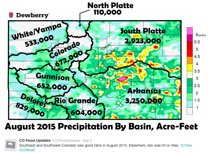
The reservoirs across Colorado are looking good in September despite the drier-than-average August across the state. The drainage basins are at an average of 115 percent for the state.
The South Platte Basin which feeds into the Denver metro area is at 117 percent of average. That puts the water level at Standley Lake at 103 percent. That lake provides drinking water for Westminster, Thornton and Northglenn.
In the southeast part of the state, the Arkansas Basin is at 145 percent.
Out west, every basin except for the Upper Rio Grande Basin is measuring at least 100 percent capacity. The Upper Rio Grande is at 92 percent.
The basin levels are good news considering that Colorado experienced a drier-than-average August with one-half inch less rain than normal.
House Science Committee Chairman Lamar Smith, R-Texas, called the actions of federal and contract workers who accidentally unleashed mining waste into the river at the abandoned Gold King mine near Silverton, Colo. “inexcusable.” The spill polluted waters in Colorado, New Mexico and Arizona. Wednesday’s hearing was the first of several scheduled in Congress.
“The EPA’s negligence is especially inexcusable, since there were known procedures that could have prevented the river’s pollution,” Smith said, adding that the agency has failed to be “transparent” about the spill in the weeks since.
Mathy Stanislaus, the EPA’s assistant administrator in the Office of Solid Waste and Emergency Response, described the accident, which resulted in the spill of at least 3 million gallons of contaminated water into the Animas River over two days in August, as “tragic and unfortunate.”
Stanislaus rebutted criticism from the Navajo Nation and others affected by the spill that the agency has not been transparent about the cause and effects of the environmental disaster.
“We have been as transparent as we possibly could,” Stanislaus said.
New Mexico lawmakers – Democratic and Republican – roundly criticized the agency for faulty communication in the days after the spill…
“What we have communicated with state of New Mexico is that the water has returned to pre-incident levels,” Stanislaus said.
The EPA official also rejected claims that the EPA ignored the dangers of a possible spill.
“We raised the issue, and that’s the reason we were there,” Stanislaus said. “There was a cave-in with water seeping, and we were there to address that.”
Stanislaus also noted that the Animas mine and three others nearby – the Mogul, Red and Bonita and American Tunnel mines – collectively discharge about 330 million gallons of water a year, compared with the 3 million discharged in the Animas spill.
Meanwhile, the director of the Navajo Nation’s Environmental Protection Agency, Donald Benn, told the congressional panel that the EPA’s lack of communication after the spill has fostered “a culture of mistrust.” Benn said the Navajo Nation didn’t receive word about the spill until 24 hours after the incident, and that came from New Mexico’s Environment Department, not the EPA. Benn also said the EPA later assured the tribe that the spill site had been plugged, but after Navajo officials went to the site to see for themselves, “it was clear that it wasn’t.”
“It was still mustard,” Benn said, referring to the bright yellow-orange color the river took on during the spill.
Mining legacy
Durango Mayor Dean Brookie said the 100-year-plus legacy of hard-rock mining in the Rocky Mountains “is the quiet but real catastrophe that has largely gone unnoticed by the public until now.”
Brookie said long-standing mining activity in the San Juan Mountains around Durango results in a “giant geologic game of whack-a-mole” that often causes the Animas River to run strange colors.
Brookie also sought to deflect at least some of the pressure on the EPA as a result of the spill.
“There is no denying they had their hand on the shovel during this incident, but they did not cause this spill on purpose,” Brookie said. “The EPA was at the Gold King Mine helping to address these long-standing environmental issues.”
Republican committee members complained that EPA Administrator Gina McCarthy did not testify on the issue Wednesday.
“Perhaps she doesn’t have good answers,” said Smith, the committee chairman.
Smith and other Republicans also said that if the spill had been caused by a private company, punitive action by the EPA would have been swift and severe.
“There appears to be a double standard,” said Rep. Gary Palmer, R-Ala. “If this had been a private company, I don’t think EPA would share the same optimism and I don’t think the EPA would have handled them the same way it has handled itself. You would destroy the company.”
Republicans accused the EPA of not scrutinizing its own actions as closely it would a similar incident caused by private enterprise. Committee members were also disappointed EPA Chief Gina McCarthy declined to attend the hearing and expressed skepticism that an investigation by the Obama Administration will be independent enough to detail what happened.
Mathy Stanislaus, Assistant Administrator for EPA’s Office of Solid Waste and Emergency Response, told the committee the agency has held itself itself accountable. “Most immediately, we’ve worked with the state and local communities to address the response,” Stanislaus said.
“That’s all well and good,” Smith replied. “But still a tragic spill occurred. It looks like to many of us that nobody’s been held accountable.”
The Navajo don’t trust the EPA:
State and federal water tests since the blowout have shown that water quality in the Animas River has returned to pre-spill levels. Still, Donald Benn, Executive Director of Navajo Nation Environmental Protection Agency, told the committee the Navajo Nation didn’t trust the feds
“When [the EPA] did let us know, it wasn’t really them that told us about what happened,” said Benn. “It was actually the state of New Mexico that approached us and told us about all this information.”
The Navajo Nation is doing its own independent water tests from EPA. During Wednesday’s hearing, they asked that the federal government pay for those tests.
The mine leaked before and it still leaks:
It’s not as dramatic as the spill, but wastewater has leaked from the abandoned mine for years, and it still does after the catastrophe. EPA collects that wastewater and treats it before releasing it downstream, but no one thinks this situation is ideal over the long haul.
“The Gold King Mine was draining anywhere from 200 to 500 gallons per minute prior to the blowout,” testified Dean Brookie, mayor of Durango. “If you can, imagine this mountain as a giant geologic whack-a-mole. You plug one mine adit [entrance], and you build up the pressure of water.”
According to the EPA’s testimony, average annual water discharge from Gold King and three nearby mines reach 330 million gallons per year. That dwarfs the three million gallons released on August 5.
Colorado Democratic Rep. Ed Perlmutter, who is also a member of the House Science Committee tried to make this point during the hearing.
“There’s no real bad guy,” he said. “We’re trying to fix something that’s been 100 years in the making. And we have a lot of these in Colorado. We need help with treatment plants in Silverton.”
Talk of a revived wastewater treatment plant:
There used to be a water treatment plant in the area that handled mining wastewater. It was shut down after the last active mine in the area closed. The company that ran it, Sunnyside Gold Corp., installed bulkheads to plug the mine and nearby tunnel.
Now Silverton and county leaders are calling for a revival of that water treatment plant with congressional appropriations. But there’s no timeline for when or if that might happen.
“The Gold King [mine] was discharging pollutants before the spill and continues after the spill. That is a well-documented situation,” said Ty Churchwell, backcountry coordinator in Colorado for the conservation group Trout Unlimited…
“Most draining mines just drain,” Churchwell said in an interview. “Thousands and thousands of these draining mines all over the United States.”
Though the true scope of the abandoned mine problem around the United States is unknown, groups such as mining watchdog Earthworks and the Western Governors’ Association and agencies including EPA and the U.S. Geological Survey have some rough estimates.
The USGS database includes more than 260,000 sites labeled as past producers. Earthworks has the number closer to 500,000, mostly in the western United States.
The Government Accountability Office released a report on the issue in 2011, which said the public watchdog had developed a uniform definition of abandoned hardrock mines in 2008.
GAO said it had determined there were at least 161,000 abandoned hardrock mine sites in 12 Western states and Alaska. The agency said 33,000 of the sites had degraded the environment by contaminating waters or leaving “arsenic-contaminated” waste piles…
Alan Septoff, spokesman for Earthworks, likewise faulted the agency. “The EPA screwed up, there’s no doubt about it. But why they screwed up is instructive.”
Septoff also said the spill was inevitable even without the agency’s mistake. “Because it was draining pollution into the Animas River already and threatened to do more, it was going to happen sooner or later. If they left it alone, same thing was going to happen.”
Earthworks has long been lobbying for reform of the 1872 mining law, including charging mining companies a fee for cleaning up mines that were abandoned before modern environmental laws.
Gold King started operating in the late 1800s and ran through the early 1920s. EPA works on a polluter-pays principle, but like other such sites, Gold King has a complicated ownership and liability history.
At one point, Sunnyside Gold Corp., the owner of a nearby mine that shut down in 1991, agreed to plug its site and clean up operations in the area. But water started building up, and a treatment system ran into legal and financial troubles, EPA said. The agency was left holding the bag to prevent disaster.
Septoff said the spill has raised the alarm on the wider problem. “The Animas is shaking stuff lose, politically speaking,” he said.
He added, “There’s no dedicated funding source to clean up abandoned hardrock mines. There isn’t even money to get a good handle of how bad the problem is.”
Debate over solution
Arizona Rep. Raúl Grijalva, top Democrat on the House Natural Resources Committee, has already introduced mining reform legislation (Greenwire, Feb. 12). Sen. Martin Heinrich (D-N.M.) has said he will, too, once Congress reconvenes.
The National Mining Association has opposed current mining reform legislation, saying it would add too much red tape and hurt resource independence. The group has called the cleanup fee a dirt tax.
NMA spokesman Luke Popovich recently expressed support for good Samaritan legislation, which would provide groups with liability protections for pitching in to clean up water pollution from old mines.
Late in 2012, EPA released a memo meant to appease concerns. It said groups don’t need a permit for certain discharges connected with abandoned hardrock mine cleanups under the Superfund law. Former Sen. Mark Udall (D-Colo.) was a main proponent.
But groups like Trout Unlimited and local regulators, who often help clean up contamination and hazards from abandoned mines, say the document was not enough to clear worries about getting involved with point source pollution.
“They’re the only ones that can work within the current legal framework to address the problem,” Churchwell said about the “underfunded and understaffed” EPA.
“We need to provide and find some mechanism to increase the capacity of those willing to join in the fight of cleaning up those abandoned mines,” he said, noting that there have been at least two other wastewater releases into the Animas in recent decades.
Rep. Scott Tipton (R-Colo.) and Sen. Michael Bennet (D-Colo.) have expressed their intention of introducing good Samaritan cleanup legislation in the near future. Plans were underway even before the spill (E&E Daily, June 9). But details remain unclear.
Despite bipartisan support, such a bill is by no means guaranteed passage. Some Democrats are wary of reopening discussions surrounding the Clean Water Act and sapping support from broader reform.
“It doesn’t address the funding issue,” Septoff said. “That is the real problem. It may suck the political air out of efforts to really address the problem.”
Arizona State University law professor Rhett Larson suggested in a Wall Street Journal op-ed that states create credits to encourage mining companies to clean up abandoned mines.
But groups like Earthworks have expressed opposition to companies getting liability protections. Septoff wonders what a private company would do if it had caused the Animas spill.
“There’s a historic problem, and then there’s the fact that we’re not learning from this mistake,” said Septoff. “That is the preferred solution to this.”
Beyond abandoned mines, groups, tribes and communities petitioned the administration last month to initiate rulemaking to prevent future spills from mine sites (Greenwire, Aug. 25, 2015). They also called for reform after the Mount Polley mine tailings spill in Canada, which released more than 1 billion gallons of waste.
Popovich called the rulemaking petition “transparent opportunism on the part of mining’s critics to distract policymakers away from adopting practical measures.” He said, “U.S. mines don’t need a poorer permit policy; they already have one of the most inefficient in all the world’s mining regions.”
From the House Committee on Science, Space, & Technology:
Today, the Committee on Science, Space, and Technology held a hearing on the August 5th spill of contaminated mine wastewater from the Gold King mine into the Animas River. The Environmental Protection Agency (EPA) and a team of contractors accidentally caused the release of 3 million gallons of wastewater during an exploratory effort to find solutions for remediating the flow of toxic mine wastewater into the Animas River Watershed.
Ranking Member Eddie Bernice Johnson (D-TX) said in her opening statement, “I believe it is important to understand what happened on August 5th and why, and explore what lessons we can learn from this event. However, we should also take this opportunity to highlight the inherently dirty, dangerous, and environmentally damaging process of metal mining.”
She continued, “I am not discounting the significance of the August 5th event at the Gold King mine or its potential environmental impact, but it is important to understand that the issue of mine drainage into the Animas Watershed did not begin last month. The EPA was acting as an environmental firefighter when they went to the Gold King mine. They were attempting to damp down a raging environmental hazard that had endangered the Animas Watershed for decades.”
Rep. Ed Perlmutter (D-CO) said, “The release at Gold King Mine was terrible and impacted communities in Colorado as well as New Mexico and the Navajo Nation. I am glad the EPA is taking responsibility for the mistakes and will work with all these communities impacted by these events. But it’s important to keep this release in perspective and understand this incident points to a much larger problem that’s been 100 years in the making. Each year, the Gold King, Mogul, American Tunnel, and Red & Bonita Mines release over 330 million gallons of wastewater into the Animas River. Instead of trying to assign blame to an agency working to clean up and prevent these releases, Congress needs to help states and local communities assess the dangers of similar mines and how we can provide the resources and tools necessary to speed up remediation work to minimize the impact to our communities and our environment.”
After the hearing, Ranking Member Johnson stressed the political nature of the Majority’s interest in this spill. She said, “It is unfortunate that the Majority’s interest in the accidental release of wastewater from the Gold King Mine in Silverton, Colorado, seems to be driven almost solely by EPA’s involvement in the August 5th accident. It would be refreshing if the Majority would extend the same zeal it has shown in investigating EPA’s actions in the Silverton release to a comparable effort to hold mining corporations accountable for a long standing pattern of violating federal environmental regulations.
“In the past three years 761 U.S. metal mining facilities violated federal environmental regulations. This industry is a bigger contributor of toxic chemical releases to the environment than any other. In 2013 alone, the metal mining industry accounted for 47%–that is, almost half—of all toxic chemical releases by all industries in the United States, releasing or disposing of nearly four billion pounds of toxic chemicals.
“I suspect that the Majority’s sudden interest in investigating the environmental consequences of the Gold King Mine accident will soon fade away and we will leave unexamined the far larger environmental impact of the metal mining industry. In the meantime, local leaders like Mayor Brookie and his constituents will continue to have to cope with the environmental legacy and public health consequences of metal mining’s decades of damage to the environment.”
From the New Mexico Department of Game and Fish via The Farmington Daily Times:
A statement from Game and Fish states the department consulted with the New Mexico Environment Department and New Mexico Department of Health before lifting the catch-and-release recommendation made following the release of more than 3 million gallons of toxic wastewater from the mine located north of Silverton, Colo., on Aug. 5 into the Animas River.
Seventeen fish from affected areas were tested, and results showed trace amounts of metals in the fishes’ tissue that are acceptable for human consumption, Mike Sloane, chief of fisheries for Game and Fish, said in the statement.
Karl Moffatt, state Game and Fish spokesman, said the department could not respond to questions from The Daily Times by Wednesday.
The tissue samples from the fish were tested for arsenic, cadmium, copper, lead, mercury and selenium.
Cory Styron, director of the city of Farmington Parks, Recreation and Cultural Affairs Department, said the announcement means the rivers are returning to normal.
“I think it clears up any misconceptions about fish in the river,” Styron said.
When the EPA crew breached the debris dam inside the Gold King Mine, it did more than cause the spill. It also made the first rounds of the blame game relatively easy.
The Clean Water Act and environmental rules usually protect the agency from liability. But those protections don’t apply in instances of negligence or if the agency triggers a spill. That means the EPA — and the taxpayers funding it — are on the hook for damages resulting from the release.
It’s a responsibility the agency has so far embraced. The EPA opened a claims process to compensate individuals for any losses resulting from the spill. They also agreed to reimburse states and other local governments. New Mexico has already set aside $1.25 million for cleanup. New Mexico Gov. Susana Martinez says she expects to reclaim every penny from the EPA.
Those promises might seem unfair to the American taxpayer. If a company had been responsible for the incident, the EPA might have levied fines or other penalties to cover the cost of the cleanup. But because the cop in this case committed the crime, everybody pays the price. However, given the region’s history of mining pollution, it’s clear the EPA is far from the only liable party. They are only the most obviously liable. When the EPA triggered the spill, it was playing its role in a decades-long effort to clean up after corporate mining.
Click here to go to the EPA website for the spill.
FromThe Colorado Springs Gazette (Ryan Maye Handy):
The rolling grasslands of western Douglas County might look like prime Front Range real estate. But beyond the beauty of the nearby foothills, there is a deeply buried problem with the land: Water is hard to come by.
Technically, there is some water in the shallow aquifers that lie beneath the western prairies, the next frontier of Douglas County’s growth. But decades ago, wells in the area started going dry or pumping muddy water into faucets. The Denver Basin aquifer, the historic provider of water for Douglas, is a finite resource that can’t sustain the growth that the county has planned for the next 20 years and beyond. When wells are drilled, they are poor producers and easily overwhelmed by daily tasks – such as fueling showers, running dishwashers and watering lawns.
“All the free water, the cheap water, is starting to go away,” said Larry Moore, the general manager of the Roxborough Park Water and Sanitation District, which runs area’s main water treatment facility. “All you’ve got to do is pump it up.”
But when water no longer pumps up, water districts and homeowners in Douglas must find an alternative. Once considered one of the fastest growing counties in the country, Douglas County’s growth has already outpaced its water resources.
The county’s water crisis has been unfolding for decades, but recently it has taken aggressive and unprecedented steps to try and reverse its fate. The county commissioners have set a goal to wean county residents off the Denver aquifer, an ancient water source that is rapidly declining.
Seven years ago the county hired Tim Murrell as its water resources planner to help engineer ways for residents to abandon their wells and join water districts that get their water from the mountains. As a water planner working for a county that doesn’t provide water service, Murrell’s job is unique.
“I am the only one of (my) type in the state who was hired by the county to look at water issues,” said Murrell, who previously helped New Mexico compile a state water plan.
Murrell’s task is to get rural communities to use what he calls “renewable water” – water that does not come from the area’s limited aquifer, but from reservoirs and rivers naturally refilled annually by snowpack.
While Murrell’s county role might be unique, his outlook is one of increasing popularity in Colorado, a state in the midst of creating its first statewide water plan. Due this December to Gov. John Hickenlooper, the water plan will identify Colorado’s future water shortages and suggest ways to bring more water to rapidly growing communities both east and west of the Great Divide. Critics of the plan have said that it offers many problems but few solutions, although the plan’s advocates say that is has begun a difficult and invaluable conversation about water. Public comment on the second draft of the plan closes on Sept. 17.
Thirty years ago, El Paso County was one of the few counties in the state that required proof of water before development plans are approved, said Mark Gebhart, deputy director of El Paso County Development Services. The circa-1986 ordinance requires all developments with lots 35 acres and under to have enough water for 300 years, three times the state requirement. That requirement has only been waived in rare cases when a district had other conservation measures in place.
But as in Douglas County, there are areas in El Paso that were settled years before water conservation and planning were mandatory, Gebhart added.
“They have never had to prove to anyone that they have water, and some of those properties in the southern part of the county, they don’t have water,” he said.
Nonetheless, El Paso County hasn’t seen a massive loss in groundwater, unlike those counties south and west of Denver.
“The highest areas of water level declines have been in Douglas and Jefferson counties,” said Gebhart. “Hundreds of vertical feet of water decline.”
Water becoming scarce
In Douglas County, lack of water has become a barrier to development and growth. While the county’s picturesque westside offers acres of open land, the farther west development pushes, the harder it is to find water.
The geology of the Denver basin means that western aquifers are shallower and less plentiful – wells have to be drilled deeper and at greater expense. For years, dry or poor quality wells were a well-known problem that became more noticeable as development spread. Sometimes businesses in the area go days without water, said Murrell.
One western subdivision, Plum Valley Heights, had been struggling for years to get its 29 homes off wells before they went dry. The community became one of the county’s first major successes of water planning, thanks to some luck, a 2014 ballot measure and millions of dollars of county money. The neighborhood also benefited from a new mindset, shared by the Douglas County commissioners, that the county’s water future was partly in their hands.
“The commissioners had never taken an active role on this in past,” said Commissioner Jill Repella. “If any community goes dry, who are they going to come to? They are going to come to the commissioners.”
It didn’t take long for Jack McCormick to discover that his well in Plum Valley Heights was no good. McCormick and his wife bought a house in the subdivision in 1986, and a couple of years later, McCormick suddenly realized what it meant to live with little water on Douglas County’s westside.
“I was out filling my horse tanks one morning and my wife was in the shower and the shower went dry,” McCormick recalled. “And I kept filling my horse tank.”
The episode began decades of wrangling to get more water for the subdivision, where McCormick became accustomed to not running multiple water appliances at once or having his water supply run out before the lawn was fully watered. Although his well had been tested when he bought the home, McCormick learned that there was much more going on underground than he had realized.
The Denver aquifer has four layers, each essentially an underground storage container for water. The basin stretches from southern Weld County to northern El Paso County, west to Jefferson County and as far east as Lincoln County. The water is coveted for its accessibility and high quality – unlike water that comes from the mountains, Denver aquifer water doesn’t require as much treatment to make it drinkable, Murrell said. The water is also irreplaceable: once it has been used up, there is no way to refill it.
By contrast, most water sources in El Paso County are considered renewable – such as the Widefield aquifer, which is refilled by stream flow, said Gebhart. Districts like Woodmoor Water and Sanitation, which rely primarily on non-renewable aquifers like the Denver basin, have purchased other water rights to make up for the loss, Gebhart said.
The Denver Basin aquifer remains is ideal for residents in central Douglas County, but simple differences in geology make accessing aquifer water close to the mountains nearly impossible.
As various layers of bedrock jut out of the land forming rock outcroppings and hills, a layer of the aquifer is lost. What layers that are left underground can be hard to reach and have unreliable water quality.
When he bought a house in Plum Valley Heights, McCormick knew nothing about wells, water and the aquifer. He came from Indiana, where his well was productive at only 75 feet deep. But in the Denver basin in Douglas, wells are drilled hundreds or thousands of feet down and can cost up to $1 million, said Moore. As a reminder that west Douglas water is not reliable, Moore keeps a jug of it in his office.
“It’s almost like red clay mud,” said Moore of the water in the jug. “That’s what they are pulling out is water and mud. The water is not very clear at all.”
Moore’s Roxborough district resolved the problem of poor well water nearly 40 years ago, when developers discovered that there wasn’t enough groundwater to sustain a subdivision. The district bought an old concrete water treatment plant from the city of Aurora and with it 50 years of water, which Aurora shuttled from the mountains in a massive underground pipe. But when Moore started with the district in 1989, the eventual expiration of the water contract loomed.
“That’s been my career goal, to figure out a water supply,” he said.
At the forefront in water planning
Driving along U.S. 85 west in Castle Rock last week, Murrell pointed out many “for sale” signs and small businesses in an industrial park – all competitors for limited resources. He also pointed to a vast expanse of empty grassland, adorned only with a few signs for Sterling Ranch, a subdivision of more than 12,000 homes approved in 2011 after years of hearings and wrangling over water. According to a county ordinance passed in 1999, Sterling Ranch has to have 100 percent renewable water, which means it won’t be relying on the Denver aquifer.
With such a big development on the horizon, big changes in water use will make Douglas County a forerunner when it comes to managing water.
“It has very often been at the forefront of trying to plan this out,” said Gebhart, of Douglas County’s approach to water planning.
In November 2014, after more than two decades of struggles to get a better water source for Plum Valley Heights, the neighborhood voted overwhelmingly to join the Roxborough district, which secured a new 90-year water contract with Aurora for $26 million. The new deal with Aurora brought 50 extra taps to Roxborough, which it offered to other westside businesses and residences, including Plum Valley Heights, which had dry wells.
After using the same crumbling water treatment facility since 1958, as of late summer Roxborough had started work on a new $32 million facility, half of which will be covered by Sterling Ranch, said Moore. The new water treatment plant will be finished in roughly two years, and be one of the first in the state to use ultraviolet technology for its primary form of water treatment, instead of relying on chemicals, Moore added.
But the Douglas County commissioners also took a bold step to help fund some of the much-needed changes in the region, said Murrell. It will cost $15 million to plug Plum Valley Heights in Roxborough’s system, $5 million of which was paid for with county money. The money will be eventually paid back in tap fees, said Murrell. Pitching in the money was a “no-brainer” for the commissioners said Repella, who added that a lack of water could have had a ripple effect on the rest of the county’s land value.
This year, the county has focused on participating in a multi-million dollar project known as the Water, Infrastructure and Supply Efficiency partnership, which links the Denver metro areas to system of recycled and unused water. If all goes as planned, the project will bring more water to communities like Douglas County, as it works to abandon its reliance on groundwater.
“We had a new realization that the county has a responsibility to be proactive to make sure that residents are moving in the right direction,” said Repella. “To take a step back and brush your hands and say, ‘Okay everybody, you are on your own now,’ that’s not responsible.”
Water hauler early Longmont via the Longmont Times-Call
Click here to go to the Colorado Watershed Assembly website to register and learn about the event. Here’s an excerpt:
We are proud to announce the 10th Annual Sustaining Colorado Watersheds Conference, hosted by the Colorado Watershed Assembly, the Colorado Foundation for Water Education, and the Colorado Riparian Association. This conference, taking place in Avon, CO from October 6-8, 2015, works to expand cooperation and collaboration throughout Colorado in natural resource conservation, protection and enhancement by informing participants about new issues and innovative projects and through invaluable networking!
In 2015, the conference will focus on what is needed to help ensure long-term sustainability for river health, public education, and organizational management.
Colorado needs a mother lode of water by 2050 – as much, in fact, as it takes to serve about 2 million people.
As our climate changes and population keeps soaring, the future looks scary dry.
That’s why Gov. John Hickenlooper wants the state’s first-ever statewide water plan in place by December.
In question is where to glean more water, who would pay for it, and how to avoid an all-out water war in a state where the Continental Divide isn’t just a hydrological contour, but also a battle line.
When The Colorado Independent last reported on the making of the plan in July, the first draft offered no specific answers. Now there’s a second draft that puts forth a litany of concepts state officials are touting as “win-win solutions.”
“Assembling such a plan, one that outlines numerous feasible steps the state, water providers and water users can take, is unprecedented in Colorado and represents a major step forward for our state,” Hickenlooper’s spokeswoman Kathy Green wrote in an email this week.
Several key water experts are unimpressed, lobbing the same criticisms about the second draft as they did about the first.
They say the revised, 416-page document still is less of a plan than a water study — a detailed account of the struggles faced by water users throughout the state, painstakingly compiled by an administration more interested in making everyone feel heard than in making tough decisions.
With 13 days [September 17] left for the public to comment, critics say the plan still lacks priorities and actionable specifics and that it fails to address the most practical question – how to pay for solutions. They’re also disappointed that it sets no clear expectations for how much, statewide, all of Colorado’s water users should be conserving.
“It’s a step in the right direction, but there’s still not much there in there,” said water lawyer Peter Nichols, one of Hickenlooper’s appointees to Colorado’s Interbasin Compact Committee, a statewide water working group.
“There are a lot of platitudes and clichés and nice words like ‘foster,’ ‘develop,’ ‘encourage,’ and ‘coordinate’ in this draft. But those aren’t action words. Those words won’t carry us. They’re not going to meet our water needs for 2050.”
A “back-of-the-napkin analysis”?
If, as the old adage goes, water runs uphill to money, the slope is especially steep in Colorado. Maintaining current water storage and delivery systems and keeping up with climate change and continued growth will, according to the state, cost $20 billion over the next 35 years.
The problem with that amount isn’t just that it’s ginormous. It’s unclear what the $20 billion would buy.
Colorado Water Conservation Board director James Eklund mentions the figure often in meetings and public appearances. Yet, when pressed for specifics, he says it’s just “a back-of-the-napkin analysis.”
According to the water plan, the $20 billion would pay for projects that have been deemed necessary in each of the state’s eight river basins. Yet, the costs for nearly half those projects are still listed on the plan as “forthcoming.”
“It’s all very much a work in progress,” Eklund said.
Colorado’s water chief is a tall, carefully coiffed and nattily dressed Stanford graduate who comes from a family of Western Slope cattle operators. He’s well versed in the practicalities and legalities of western water use, and seemingly at ease with the plodding pace of policy reform. He served as Hickenlooper’s senior deputy legal counsel before being appointed to lead the state on water.
Eklund lauds his boss for “spending the political capitol” to order Colorado’s first statewide water plan rather than, like other governors, taking a pass on one of the state’s most touchy issues.
“There are people in the water community that said you say the word(s) ‘state water plan’ and that’s toxic, that’s a third rail, you can’t touch that,” he said.
“(Hickenlooper) said I need the white paper on water. We all looked at each other and said we don’t have one of those. He said you’ve got to be kidding me. You’ve got a business with an input as critical as water is to the bottom line of that business — you know as water is to the bottom line the state of Colorado. You would say that was unacceptable to the CEO and the board of directors. So go do it.”
Since Hickenlooper’s executive order in December, Eklund’s staff has written and rewritten two drafts of the water plan. They’ve attended months of hearings and meetings asking what Coloradans want in their water future. And they’ve reviewed public comments from throughout the state – including, Eklund likes to note, the input of 26 high schoolers from Dolores.
“That kind of response is something we could have only dreamed of,” he said.
Eklund is especially proud that his staff has responded to all 25,869 public comments.
“We’re looking really hard at each one as it comes in,” he said.
As he tells it, the water planning process is an acme of civic engagement.
Having amassed 25,869 public comments isn’t, in itself, a vision for how to solve the state’s water woes, seasoned water-policy makers say.
“(They) need to sort through it, pull out what the priorities are. It’s not going to define itself,” said Denver Water chief Jim Lochhead. “A process is not a plan.”
The need for specificity
More details are key for Front Range business owners, Western Slope farmers and ranchers, environmentalists, water agency bosses and politicians who, like Eklund says of the Governor, also have their eyes on the bottom line. Although most agree on the need for a water plan, they differ – sometimes bitterly — about which water uses should take priority and who should bear responsibility for the projected shortfall. Without price tags, they say, there can be no meaningful discussion about funding strategies. And without funding strategies, there can be no hard look at what’s even possible.
Several close followers of the process tell The Independent that, as much as they want to show support, they’re finding it tough to buy into a plan that serves up little more than broad concepts.
“The plan, in fairness, offers lots of interesting information about what’s happening with water in Colorado. But it’s a water study, not a water policy and not a water plan. And that’s an important difference,” said Harris Sherman, who ran the Colorado Department of Natural Resources under Govs. Dick Lamm and Bill Ritter and recently stepped down as a top Obama appointee to the U.S. Department of Agriculture.
Eklund aims to have tackled a good portion of the state’s water solutions by the time Hickenlooper is term-limited in three years. Still, he balks when asked about upcoming agendas for water. Should Coloradans expect water bills in the legislative 2016 session? It’s too early to tell, he told The Independent. Should voters expect executive action while Hickenlooper is in office? “It’s premature for me to know,” he said.
“You have to crawl before you can walk.”
Hickenlooper’s office also defends the water plan, saying it’s not the point to chart a specific list of water projects or their costs.
“…To set up that straw man is misleading,” Green wrote.
In fact, she asserted, specifics could mess up the grassroots water planning approach Hickenlooper is committed to.
“The state does not have the authority to determine which projects go where and, should it attempt to do so, the collaboration and cooperation upon which the water plan was so respectfully built would collapse under the weight of such top-down action,” she said. “All parties would return to their traditional corners to fight it out, as they have for decades, with the same kind of infighting that prevents the very kind of holistic approach the water plan seeks to achieve.”
Critics counter that, in a time of climate change and rampant growth, a 416-page articulation of water goals without key financial details and actionable solutions isn’t holistic. It’s naive.
“There’s money involved in most of the ideas set forth in there…, but you wouldn’t know it. Without clear metrics, priorities, deadlines and a sense of who’s going to do what – without all the things I’d characterize as a real plan — there’s no path forward,” Lochhead said. “There are a lot of things on that list – including the funding – that, in my view, are unrealistic.”
“What can we actually do in three years?” state Water Conservation Board member John McClow asked at the July meeting. “The list needs to be more realistic.”
Who should pay? And how?
Eklund’s team has topped its list of “Potential Future Funding Opportunities” with the following: “A federal/state partnership similar to the Central Arizona Project” and “A federal/state partnership similar to the California State Water Project.”
Both are vast water delivery systems launched during the late- and mid- Cold War era, respectively, when the federal government used to pay for dams, pipelines and other projects that made Western deserts bloom.
Emulating those partnerships is unlikely now that the Bureau of Reclamation and Army Corps of Engineers no longer have the budgets or mandates for projects that would be as legally risky and expensive as they are politically divisive. The feds aren’t in the business of building massive water projects any more.
“Maybe Colorado didn’t get the memo,” said Pat Mulroy, a Nevada-based water expert with the Brookings Institution.
Funding is more likely to come from the private sector — whose resources can be limited – and from the state and municipal public sectors, mainly though tax or water rate increases.
In an effort to “identify and determine a path to develop a new viable public source of funding,” the water plan cites ways to glean $10 million here and $40 million there through various grant projects and government partnerships. The plan also suggests a container fee ballot measure that could generate about $100 million a year.
But, in the $20 billion scheme of things, that’s chump change.
Besides, counting on voter-backed funding can be risky. In 2000, Coloradans resoundingly rejected Referendum A, an effort to raise $2 billion for water projects. More recently, they’ve chewed up and spit out measures to raise taxes for transportation and education – both issues that poll higher than water among most Coloradans.
Even if voters could be persuaded to back a water tax, policy constraints such as the Taxpayer Bill of Rights (TABOR) could stand in the way. The current water plan overlooks Colorado’s knot of fiscal caps – an issue planners say they’ll be adding to the final draft.
Water utilities point out that because their customers already pay for water projects through monthly water rates, they’d be paying double through a tax increase.
“A statewide funding initiative, in my assessment, it’s not doable,” Lochhead said. “People aren’t likely to support paying twice.
Lochhead said Denver Water’s board would be willing to consider asking its 1.3 million customers to fund more delivery systems, reuse projects and conservation efforts to help stave off a shortfall. Problem is, he pointed out, he hasn’t been approached by state officials about the prospect of making such an ask. Neither had two other water agency bosses interviewed for this story.
As the gatekeepers of the most promising source of money in the state, water bosses wonder whom if not them the administration is so intent on collaborating with.
East v. West
The tension underpinning Colorado’s water situation is largely between urban and agricultural users. Although, by virtue of their populations, cities and suburbs have more money and political clout, agricultural communities generally have the upper hand because their water rights are usually older, giving them higher priority for Colorado’s dwindling water supplies.
Farming and ranching communities – especially those on the Western Slope with rights to Colorado River water – long have fought efforts by city folk to grab their water, pump it east through the mountains and fuel growth along the Front Range. More recently, environmentalists hoping to keep more water from being siphoned out of the at-risk river have echoed the Western Slope battle cry — “Not one more drop!”
That leaves sprawling Front Range cities and suburbs straining to live within their means. The well known “Use only what you need” campaign by Denver Water, the state’s biggest municipal water supplier, is one of many efforts that has been able to slash municipal water use.
It comes as no surprise that the water plan, in its second draft released in July, is calling for city dwellers and businesses to conserve water in hopes of saving 400,000 acre-feet per year. (An acre-foot is enough to serve two to three households per year at current water use rates.) The plan calls for “medium-level conservation” – meaning, presumably, saving more water than residents and businesses currently are conserving, but not so much that it hurts. Eklund’s team calls it a “stretch goal,” which is financial-speak for a way of challenging people to reconsider what they thought was possible.
The conservation plan is a goal, not a requirement. It’s voluntary.
Nobody seems to question cities’ need to keep conserving more water. Several water insiders do, however, question whether 400,000 acre-feet could actually be gleaned by urging city dwellers and suburbanites to cut back their laundry loads and backyard sprinkling. They also question whether the conservation policy is fair.
Even though municipalities serve about 86 percent of Coloradans, they only consume about 2 percent of the state’s water. Agriculture uses between 85 and 90 percent.
The water plan doesn’t set clear expectations for farmers and ranchers to conserve. Their water rights allow them to tap however much water they can put to what’s called “beneficial use.” If they use less, the water goes to the next user – and so on. So, as things stand, there’s a legal disincentive for agricultural users to cut back.
This doesn’t sit right with many city folks, especially knowing how much water goes wasted by inefficient techniques such as the use of unlined dirt irrigation ditches and canals.
“There’s no question that in other parts of the world, agriculture uses much less water,” Sherman said. “Things can be done. Improvements can be made.”
After reading the plan, Patricia Wells, the Colorado Water Conservation Board member representing Denver, said, “I was struck by the disparity of how we treat agriculture and how we treat the people of Colorado.”
“The only mandates in this plan are all about people.”
Calls for broader conservation are coming from unlikely players – the business community rather than from environmentalists.
At the state board’s July meeting about the plan in Ignacio, representatives from environmental groups praised the conservation goals as is and commended the plan’s commitment to keeping water in rivers to protect environmental and recreational flows.
“I’m here with two messages – that of appreciation and encouragement,” Bart Miller, a river expert with Western Resources Advocates, told Eklund and his board. “As it progresses, we’re seeing more details, really good things…”
The Denver Metro Chamber of Commerce, in the meantime, is strongly urging that conservation goals apply statewide — including to agriculture—rather than just to certain sectors.
“We want to make sure that all sides are giving,” said Mizraim Cordero, the Chamber’s vice president of public affairs. “I think there’s still room for more discussion about what goals are achievable by agriculture.”
Eklund notes that there’s a big difference between residential and agricultural conservation because water rights are property rights in Colorado.
“They’re running businesses in agriculture. They’re not doing it because it’s fun… They’re doing it to make money. If you’re telling them they’ve got to add a line item to their balance sheet that they didn’t otherwise anticipate, they’re going to ask you who’s paying for that. And right now, we’re not doing that,” he said.
Given the vastly disproportionate amount of water used by farms and ranches, Colorado isn’t likely to overcome its shortfall without arrangements between agriculture and utilities.
All too often, those arrangements have meant farmers selling off their land and water rights to cities. That practice, known as “buying and drying,” has left wide swaths of the state deserted. Crowley County, for example, once had more than 50,000 irrigated acres and now has only 5,000.
Hickenlooper has made it clear that preserving Colorado’s agricultural tradition needs to be a keystone of the water plan.
The easiest way forward would be if farmers and ranchers could directly market some of their water to utilities. But the “consumptive use” doctrine underlying water law blocks such deals because they put agricultural water rights in jeopardy. If farmers aren’t directly using their water, they risk losing it.
Several top water officials and political leaders have been urging Hickenlooper, in his plan, to enable a market-based system that removes legal barriers. The idea behind so-called “alternative transfer mechanisms” is that farms would step up conservation if cities, through innovative funding, could subsidize efficiency efforts and glean the water savings on a short-term basis. Farmers, in turn, would be assured protection from losing their long-term water rights.
It would be tricky. But it’s doable. Similar deals have been struck in California, which is under crisis with a severe drought. The point in Colorado is to avert a crisis before our next dry spell hits.
“If Hickenlooper wants to make this a priority of this administration, he has limited time to start getting things done,” Lochhead said.
“We’re waiting with bated breath and open ears. We’re all ears,” Eklund said.
Russell George, former speaker of Colorado’s House and Gov. Bill Owens’ natural resources chief who’s vice chair of the water board, said there’s “a beauty in itself” in the outpouring of civic participation.
But, given the looming shortfall, stakeholders are, indeed, “hung up” — and making sure to speak out while the administration is listening.
Environmental groups and their members are urging the administration to hone criteria for which of the 81 currently proposed “critical actions” are truly critical and should take priority. “Our thought is that it doesn’t really give enough detail such that you could take a giant list of projects and push them through,” Miller said.
Several water experts are pressing Hickenlooper hard to end the stalemate between the Front Range and Western Slope over using extra Colorado River water when it’s available. The water plan proposes a conceptual framework for how negotiations between the two sides should go. But it offers no concrete solutions.
“That’s where the plan falls short and where the state needs to get creative and ambitious and take a leadership role in actually brokering a deal,” said Nichols who, as a member of the committee that oversees compacts between Colorado’s distrusting river basins, has seen deal after deal blow up. “There are discussions going on about putting more meat on the bones before December and how to implement a meaningful plan, maybe by changing some laws.”
The business community is trying to galvanize its members to read the plan and chime in. The Denver Metro Chamber of Commerce is pressing for specifics about costs and what, if anything, Hickenlooper will do to prod agriculture to measurably cut back.
“We commend that the Governor has made water a major priority and has moved the ball. But we definitely encourage him and other leaders to continue (giving) specificity to help carry things out,” said the Chamber’s Cordero.
Is he confident that’ll happen by final draft in December?
A “get well soon” balloon floats in the contaminated waters of the Animas River flowing through Durango on Monday afternoon August 10, 2015 — photo The Durango Herald, Shane Benjamin From the Associated Press via the Fort Collins Coloradoan:
Leading House and Senate Republicans said EPA officials were frustrating their attempts to investigate the spill.
They want documents released explaining how a government cleanup team doing excavation work triggered the release of 3 million gallons of rust-colored sludge from the inactive Gold King Mine near Silverton, Colorado.
U.S. Rep. Lamar Smith of Texas suggested the hearings offer the agency a chance to dispel growing suspicions over its actions.
Meanwhile, some Democrats are pursuing a proposal for companies to pay for the cleanup of thousands of abandoned mines across the U.S.
FromThe Grand Junction Daily Sentinel (Charles Ashby):
Though he meant no pun, Gov. John Hickenlooper said there may be a silver lining to the recent spill of heavy metals from an abandoned Silverton mine into the Animas River earlier this month.
The incident has sparked a serious debate about the numerous hazardous mines left unremediated by private mining companies throughout the West, the governor said at a Club 20 roundtable discussion in Grand Junction on Thursday that touched on topics important to the Western Slope, from the sage grouse to severance taxes.
Hickenlooper said he’s spoken several times about the spill and mine issues in general with Gina McCarthy, the head of the U.S. Environmental Protection Agency, which is responsible for overseeing cleanup of all the abandoned mines.
“However much you hate the EPA, she’s the one who overruled her people and said, ‘We’re going to take responsibility and own up,’ ” Hickenlooper said. “Can you imagine what her lawyers said? She has been very clear, and never backed away, saying, ‘We’re going to do everything we can to make every raft operator, every fishing guide, we’re going to make everyone whole.”
The governor said as a result of the spill, the EPA is now talking about creating a broader water-treatment plan to protect the entire region from possible future environmental disasters, saying the Gold King Mine that led to the current situation is minor by comparison to what environmental damage other mines in the area could leave in their wake.
“If we end up getting a treatment plant out of this, which would be multi-millions of dollars, it might be a pretty good silver lining,” he said. “Getting water treatment there would be a big step in solving this. The Animas River after this disaster is going to come out better than it was before.
From the Associated Press via The Pueblo Chieftain:
Navajo Nation President Russell Begaye is asking the Federal Emergency Management Agency for help in the tribe’s recovery from a mine spill.
In a letter Tuesday, Begaye asks FEMA to appoint a recovery coordinator to the tribe, saying the agency is best positioned to assess the short- and long-term impacts, determine priorities and support recovery.
Click here for press releases and updates for Gold King Mine Response from the EPA
From the Glenwood Springs Post Independent (Scott Condon):
Joe Ramey, a meteorologist with the National Weather Service in Grand Junction, said some of the hype makes him cringe. An El Niño pattern — caused by warmer than average water temperatures in the Pacific Ocean — will definitely affect the weather in western Colorado this winter, but it’s still impossible to forecast with certainty what it will mean for specific locations in the mountains, he said. He has examined the 23 El Niño winters since 1950 to see how they affected Aspen, Steamboat Springs, Crested Butte, Telluride, Silverton and other Colorado ski resorts.
What he found for Aspen was “early snow, late snow but not in the heart of winter.”
Conditions have tended to be drier and warmer than average during December, January and February.
“What El Niño tends to do is produce snow outside of that window,” he said…
One factor that could make its mark on this winter is the El Niño is forecast to be strong to very strong. Ramey took a look at Aspen weather over the last two very strong El Niños — in 1982-83 and 1997-98 — to see what they produced. The 1982-83 winter was the sixth snowiest on record, based on data collected at the Aspen Water Plant, he said. Weather data has been collected there since 1979.
The snowfall was even more prodigious on the slopes. Old-timers say it was one of the best winters ever.
Snowfall was also above average for Aspen in 1997-98, Ramey said, with a particularly wet February, March and April.
However, Aspen’s snowiest winters since 1979 didn’t come during the strong El Niño years. The most snow fall October through May came in 1993-94 and 2006-07…
“It’s not easy to encapsulate what El Niño means,” he said.
Forecasters have nicknamed the current El Niño “Bruce Lee” and say it is already the second-strongest on record for this time of year. The Weather Service says it could be the biggest they’ve seen in 50 years.
The World Meteorological Organization says it appears Bruce Lee will strengthen before the year ends. And according to the Weather Service’s climate prediction center, temperature and precipitation impacts could last into 2016.
“There is a greater than 90 percent chance that El Niño will continue through Northern Hemisphere winter 2015-16,” the prediction center said in an El Niño advisory. “And around an 85 percent chance it will last into early spring 2016.”[…]
“The biggest correlation we see is many of our bigger storms and stronger storms have occurred in El Niño years,” Meier said. “As far as above-normal precipitation and below-normal precipitation (in Colorado), we haven’t seen any correlation.”
A legal battle has sprung up over the status of the Cucharas Dam, located on the Cucharas River in Huerfano County south of Pueblo.
The state wants the dam taken out, while the owner wants more time to fix it.
State Engineer Dick Wolfe issued an order to Two Rivers Water & Farming Co. to breach the dam in February, giving the company until the end of June to show 30 percent design work toward removal of the dam.
In a July 27 letter, Wolfe informed Two Rivers that he would file a civil action in Huerfano County District Court seeking $500 per day penalties since June 30 until an acceptable plan to breach the dam is filed.
Two Rivers responded on Aug. 7 with a complaint against Wolfe, Division Engineer Steve Witte and the Welton Land and Water Co. arguing that the Huerfano-Cucharas river system has not been properly administered.
Engineering reports submitted to Division 2 water court attempt to prove that the Welton Ditch on the Huerfano River east of Pueblo has expanded its use and is using water inefficiently. The state will ask for dismissal of those claims.
Two Rivers CEO John McKowen declined to be interviewed for this story.
Two Rivers, a company formed by Denver businessman McKowen, purchased the dam site, along with the rest of the Huerfano-Cucharas Ditch system southeast of Pueblo in 2010. Since then, the company has branched out into farming on the Bessemer Ditch and building greenhouses for marijuana growers through its subsidiary GrowCo.
The company also toyed with projects to supply El Paso County cities with water and to build a reservoir on the Excelsior Ditch east of Pueblo. Those have been abandoned. Two Rivers also got in a tussle with the Lower Arkansas Valley Water Conservancy District over the terms of a conservation easement on one of its Bessemer Ditch properties.
But its first project was taking over the Cucharas Reservoir, which has been under state storage restrictions since 1987, when water began leaking. McKowen at the time said he planned to bring the Huerfano-Cucharas Ditch system back into production and, in fact, harvested several crops.
Two Rivers subsequently purchased other reservoirs and ditches in Huerfano County. McKowen received, then gave back, a $10 million loan from the Colorado Water Conservation Board to renovate Cucharas Dam and eventually build a new dam just downstream.
The Colorado Division of Water Resources agreed to a compliance plan in August 2013, but in February issued a breach order, meaning the dam would have to be removed.
“I think the complaint is trying to slow down the breach order,” Witte said.
“Over the years, Two Rivers has done some work on the dam, but never enough to remove the storage restrictions. . . .
The time for talking about plans is over and it’s time to act on those plans, because it’s unsafe.”
The legal pushback is hardly surprising. The attempt to better define the scope of federal control over wetlands, streams and ponds has long been controversial – “It’s been litigated all the way to the Supreme Court three times already,” says Holly Doremus, a professor of environmental regulation at UC Berkeley, “and it might well go to the Supreme Court again.”
On August 28, Judge Ralph Erickson of the District Court for the District of North Dakota placed a preliminary injunction on the rule, stating that the Environmental Protection Agency had probably exceeded its authority in expanding the definition of waters subject to the Clean Water Act, and that the agency didn’t appear to have followed certain procedural requirements in promulgating the rule. While several other district courts had considered similar lawsuits, North Dakota was the only one to actually grant an injunction. The state is viewed as a “friendly jurisdiction for opponents of federal regulations, including the oil and gas industry,” says Doremus.
The rule, the 13 states argue, will “irreparably diminish” their control over their waters. But the increase in federal scope isn’t much – the EPA describes the rule as a “clarification” rather than an expansion of which small waterways fall under its jurisdiction. Statistically speaking, according to Judge Erickson, only between 2.8 and 4.6 percent more of the country’s intrastate waters would come under federal control than currently do.
Regardless of the legislative limbo, the EPA and the Army Corps of Engineers plan to forge ahead. The agencies say the “waters of the United States” rule, which has been in the works for years, now applies in every state except the 13 (Alaska, Arizona, Arkansas, Colorado, Idaho, Missouri, Montana, Nebraska, Nevada, North Dakota, South Dakota, Wyoming and New Mexico).
The North Dakota case is just one of at least 10 lawsuits seeking to block the new rule. Those suits involve parties from 29 states, the energy industry, agricultural interests and developers, and have been filed in various federal district courts and appeals courts. (Another lawsuit, from an environmental group, argues that the rule is too weak.) The EPA is trying to consolidate cases and get them transferred to the district court in Washington, D.C. “They don’t want to have to litigate in multiple forums on the same issues,” Doremus says, and because the D.C. circuit court is more familiar with administrative law issues and the extent of agency authority, it’s more likely to decide in favor of the EPA. On October 1, a judicial panel will consider whether to consolidate the multi-jurisdictional cases at a New York City hearing.
Although the challenges to the Clean Water Act have typically been framed as a “federal control vs. state control” issue, it’s important to note that seven states (Connecticut, Hawaii, Massachusetts, New York, Oregon, Vermont and Washington) plus the District of Columbia, favor the EPA’s new rule. They plan to intervene in support of it in appeals cases. That split in state support was not lost on Judge Erickson, who today denied a request from the 13 litigating states to extend the injunction nationally, citing the fact that other states do support the rule.
Larimer County commissioners on Tuesday voted to forward a citizens’ advisory board’s list of critical comments about a controversial water-storage proposal to the U.S. Army Corps of Engineers — but added their own letter supporting the project.
The commission had asked the all-volunteer Environmental and Science Advisory Board to review a Supplemental Draft Environmental Impact Statement on the proposed Northern Integrated Supply Project, which the Corps released in June. The ESAB report, dated Aug. 18, blasted what it called the SDEIS’ lack of detail on key issues and included a long list of concerns about NISP’s effect on such things as flows, fish habitat and water quality in the Cache la Poudre River as well as plans to mitigate the problems.
The county commissioners voted 3-0 to send the ESAB report to the Corps — accompanied by a letter from the commissioners saying that Larimer County is not opposed to NISP and believes the ESAB concerns can be addressed sufficiently. The commissioners’ letter lays out why it believes NISP to be very important to the future of Northern Colorado.
Fort Collins’ city staff also was critical of the impact statement for leaving key questions unanswered, and recommended last week that the Fort Collins City Council vote to express conditional opposition to NISP. The city council will consider that recommendation at Tuesday night’s regular session, which will be broadcast on cable Channel 14.
The Northern Colorado Water Conservancy District would build NISP if it receives a federal permit.
From email from the Northern Colorado Water Conservancy District (Brian Werner):
Earlier this week, Larimer County commissioners submitted a letter supporting NISP to the U.S. Army Corps of Engineers. It is the third county board to endorse NISP, following earlier endorsements from Morgan and Weld County commissioners.
All three commissioners have voiced their support of the project to build Glade and Galeton reservoirs. Utilizing these reservoirs, the project will provide water entities with approximately 40,000 acre-feet of new, reliable water supply each year.
NISP has the support from every newspaper representing project partners including: BizWest, Longmont Times-Call, Fort Morgan Times, Greeley Tribune, Carbon Valley Independent, Erie Review, Lafayette News, Lost Creek Guide, Louisville Times, Loveland Reporter Herald and the Coloradoan. This link contains the complete list of NISP supporters/endorsers.
Reasons for support are broad, but there is a shared view that NISP needs to be built has soon as possible to capture and store water in wet years for the needs of current and future generations in all years.
During the July 2 NISP rally, State Sen. Jerry Sonnenberg summarized what NISP will achieve for the 15 northern Front Range water providers. Sonnenberg said, “There’s been a lot of talk about using rain barrels this year. Well, we’ve got to find a way to keep Colorado’s water in Colorado. We have the ultimate rain barrel, ready to be filled, right up the road here.”
Another common theme among NISP supporters is that water conservation alone cannot meet the water needs of Northern Colorado. Several regional newspapers have made this point including the Ft. Collins Coloradoan, Loveland Reporter-Herald and Longmont Times-Call.
The Coloradoan editorial board editorial “NISP Needed to Solve Region’s Water Problem” pointed out: “The future of water in Northern Colorado – and our state as a whole – is now.” It also stated, “Our state – and Northern Colorado – faces a water shortage as the population grows. The Northern Integrated Water Supply project, in tandem with other efforts, is key to solving that problem.”
The U.S. Army Corps of Engineers extended the public comment period an additional 30 days.The comment period ended Thursday, September 3.
From the Fort Collins Coloradoan (Jacy Marmaduke):
The end of the public comment period signals an important step in a lengthy review process of a project that would transform the future of water use for Northern Colorado. Northern Water began petitioning more than a decade ago for the project, which would draw from the Poudre and South Platte rivers to supply 40,000 acre feet of water a year to 15 participating communities and water districts.
So, what’s next?
The Corps will review the comments and prepare a Final Environmental Impact Statement by next summer. At this point, no public comment period is planned for the final statement, project manager John Urbanic said Thursday.
After the final EIS, the Corps has to issue a record of decision – a final decision on whether it will grant Northern Water the federal permit necessary to carry out the project. That decision can be challenged in court.
The Corps’ final EIS will include additional analysis of how the project would influence water quality in the Poudre River. NISP opponents argue the Corps’ omission of that analysis in past environmental impact statements constitutes a violation of federal law, which requires the Corps to thoroughly analyze all potential environmental impacts of a proposed project.
Urbanic said the Corps may allow for public comments on the water quality data even if there’s no official public comment period for the final EIS…
Northern Water spokesman Brian Werner said he’s as excited to see the SDEIS comments as anyone else – but he’s not expecting any big surprises.
“I don’t think we’re gonna see a lot we haven’t already heard,” he said.
Northern Water is continuing to work on its plan to mitigate the project’s environmental impacts and developing another mitigation plan in communion with the Colorado parks and wildlife department.
Werner said he’s confident the Corps’ next report will unearth “good information” about NISP’s potential influence on Colorado’s environment.
“It’s not going to erase all questions and doubts, but it’ll do a great deal,” he said. “There’s nothing like good quality data to back up what you’re saying.”
Settling ponds used to precipitate iron oxide and other suspended materials at the Red and Bonita mine drainage near Gold King mine, shown Aug. 14, 2015. (Photo by Eric Vance/EPA)
The Environmental Protection Agency told The Denver Post on Friday it is still “evaluating treatment options” at the site where the agency spilled 3 million gallons of contaminants Aug. 5.
An EPA spokeswoman had said Aug. 14 that the agency was planning to build a commercial wastewater treatment system to mitigate metallic contaminants still flowing from the Gold King. The agency now says such a facility is still on the table, but not definite.
“If a water treatment facility is decided upon, it will likely be a temporary plant,” Nancy Grantham, an EPA spokeswoman, said Friday evening.
The EPA has said whatever treatment option they choose, it needs to be in place before winter when the current apparatus — several sediment ponds — will be obsolete or destroyed by the cold and snow.
Officials in Silverton and San Juan County, where the mine lies, have publicly called for a treatment facility below the Gold King and several adjacent mines, which leak hundreds of gallons of contaminated water every minute…
“I don’t think they know what to do at this point,” said Bill Simon, a coordinator for the Animas River Stakeholders Group, which has been working on remediation solutions in the Silverton area for decades. I think that’s good because it’s better to try and understand it before they come up with a solution that doesn’t work and spend a lot of money.”
More questions than answers face those tasked with deciding the most efficient and feasible plan for cleaning up leaky mines above Silverton.
The Environmental Protection Agency, at the behest of the San Juan County Commission, met with local and state officials at Silverton’s packed City Hall on Friday for an update about the Gold King Mine, where an EPA contractor accidentally unleashed 3 million gallons of toxic sludge into the Animas River in early August.
But for all the inquires into project time lines, funding and boundaries – or if the mine leakage from the Silverton caldera would even qualify for a Superfund designation – those looking for answers did not find much satisfaction.
The EPA could have summed up its response to all these inquiries by simply saying, “We need more data.”
The meeting’s main speaker was Mathy Stanislaus, an EPA assistant administrator based in Washington, D.C., who specializes in Superfunds – the federal program created specifically to clean up abandoned hazardous waste sites.
Stanislaus initially said one of the advantages of the mining network above Silverton is that there is already a slew of data, complied by various local entities such as the Animas River Stakeholders Group and the state health department.
But as it turns out, the EPA would have to rely on its own sampling before being able to answer questions such as: What would be the boundary of a Superfund designation? How many years would the project take to complete? Or where would the site rank among the nation’s worst polluted areas, if at all?
Stanislaus explained that in the coming months, the EPA will work with local groups to conduct an evaluation of a variety of factors, including groundwater and soil issues, threat of exposure to humans and animals, as well as the potential impact to drinking water. The agency will then identify possible short- and long-term solutions…
However, none of these actions guarantee the mines north of Silverton will even qualify for the National Priority List, which is the ranking system that prioritizes hazardous sites.
Heavy Metal E.P.A. Extra Pale Ale on tap at the Ska Brewery in Durango on August 4, 2015 via The Durango Herald
This true color image may seem like you are looking at Earth from space, but it is actually produced by combining specific data sets from the NOAA/NASA Suomi NPP satellite’s Visible Infrared Imaging Radiometer Suite instrument, known as VIIRS, into one composite image.
Click here to go to the NOAA Satellite and Information Service website. Here’s an excerpt:
Three of the VIIRS instrument’s 22 channels that measure different bands of the electromagnetic spectrum are used to create these photorealistic snapshots of the planet. The images are made by combining the RGB color channels 5, 4, and 3 (which are sensitive to the red, green, and blue wavelengths of light respectively) to create “true color” images. Several other channels are often also included to cancel out atmospheric interference, such as clouds and aerosols, which can cause a blurry picture.
With 22 channels available, VIIRS’s allows for a variety of different combinations allowing for vastly different images of the same thing. For example, the images below were both created using data provided by the Suomi NPP satellite’s VIIRS instrument. These images show the exact same storm only one day apart and represent just two of the many ways the VIIRS instrument can capture a storm. By using different channels and light wavelengths you get two drastically different views, revealing different features of the same storm.
This image is a “true color” RGB image of Tropical Storm Erika on August 25, 2015 from NOAA’s NOAAView Credit: NOAA
This image is a VIIRS IR image using band 5 of Tropical Storm Erika taken during an overnight pass on August 26, 2015 Credit: NOAA/NASA RAMMB/CIRA
“True Color” RGB composites (such as the first image) are used for many applications including differentiating snow, ice, smoke, and ash from clouds, or even the boundaries between warm and cold air masses.
Infrared images (such as the second image) can help, among other things, identify the location of a storm’s eye.
Other VIIRS multi-band images, like those created by the VIIRS day/night band and high resolution infrared channel, are also available for scientists and forecasters.
EcoFlight’s Flight Across America program dynamically engages college students about environmental issues, using a broad range of perspectives, both aerial and on the ground, to bring attention to pressing conservation issues. Students learn how such issues impact their lives and the world around them, and how to personally participate in advocacy work. Through the aerial perspective and discussions with diverse stakeholders and experts on the ground, EcoFlight offers a tangible educational experience, engaging students in the complexities of environmental issues throughout the West. It is our hope that by offering students the opportunity to delve deeply into issues central to the West, they become better prepared to participate in meaningful discussions public lands and advocate for their beliefs, as the next generation of leaders.
Flight Across America 2015 will focus on water conservation concerns in the West, emphasizing the crucial role water plays in sustaining life, and the mega drought happening in many states across the West. The program provides an excellent learning environment for students, combining the aerial perspective of the role of water in the health of ecosystems and how watersheds connect landscapes, with on-the-ground discussions of the impact of energy development, urban planning, recreation and agriculture on our water resources. The Colorado River Basin is in its 14th year of drought, and water is a top concern for population centers and agriculture. We will discuss the coping mechanisms of multiple states in the West, as they plan for the future in an attempt to balance an already over-allocated water supply with growing domestic demand. Climate models are predicting an even drier future, with sustained periods of sparse precipitation and significant loss of soil moisture that span generations, about 10 times as long as a normal three-year drought. In the face of these “mega-droughts” it is imperative that we begin thinking in terms of the future and not just the present for water management in the West.
In a five-day tour of four states, FLAA 2015 will engage college students with diverse conservation concerns of water in the West. EcoFlight will provide aerial tours of water storage and diversion projects, over energy development (both fossil fuel and renewable), over agriculture, and wild landscapes, and watersheds that are vulnerable to drought and water-loss. On the ground students will meet with diverse stakeholders – planners, public officials, conservation groups, sportsmen, energy industry representatives, Native Americans, recreationists and journalists to discuss the different and often competing interests in water and water conservation.
Colorado River Basin including Mexico, USBR May 2015
Concrete barriers along the eroded creek bank in downtown Evergreen are still in place nearly two years after the 2013 flood that caused the damage.
Evergreen businessman Jeff Bradley, manager of the property, said he has obtained a permit from Jefferson County for the project, and has plans to restore the bank. Bradley said he also needs a permit from the federal government, although the project does not involve funds from the Federal Emergency Management Agency.
A few miles down Highway 74 at Lair O’ the Bear Park, a bridge restoration project dating from the 2013 flood is scheduled for this fall…
Another major bridge project is in the works at Evergreen Lake Park, which is owned by Denver Mountain Parks. The aging bridge that provides the only vehicle access to the park is scheduled for replacement next year. The Evergreen Park and Recreation District and the Evergreen Metropolitan District are each contributing $40,000 for the project, which is estimated to cost $790,000. The park district has added an additional $40,000 from Jeffco grant funding it received to assist with the bridge replacement cost.
The 2013 flood contributed to the deterioration of the bridge at the Lake Park, EPRD board member Peter Lindquist noted.
Silverton, Colo., lies an at elevation of 9,300 feet in San Juan County, and the Gold King Mine is more than 1,000 feet higher in the valley at the left side of the photo. Photo/Allen Best
But Superfund — the federal program designed to clean up America’s most toxic sites — usually only proceeds with community support. And in Silverton, that’s lacking. Even after the Aug. 5 spill captured national attention and reinvigorated downstream communities’ insistence that the leaky mines be cleaned up, locals continue to bristle at the suggestion of Superfund. “We’re a tourist area,” Bev Rich, a lifelong Silverton resident, told the Durango Herald in 2013. “You hear the word ‘Superfund’ site and 99 percent think ‘danger.’ So why would you want to go to a Superfund site?”
Those who support Superfund, however — including many residents of the downstream city of Durango — say that there’s simply no other way for the region to move beyond its toxic past. Travis Stills, a Durango lawyer who’s worked on and studied Superfund sites, thinks the problem is too politically entrenched (and expensive) to be handled by state or local authorities alone.
Fearn disagrees. The 71-year-old engineering consultant and former mine owner is one of the strongest voices in Silverton’s anti-Superfund contingent. In 1994, he helped form the Animas River Stakeholders Group to try to prove that acidic drainage from the watershed’s mines could be cleaned up without interference from the federal government. And in recent weeks, he’s explained to the New York Times and other national media why Superfund still isn’t right for Silverton. Among the reasons: a designation would stigmatize the town and turn away tourists. Litigation and bureaucracy could delay the clean-up. Property values could decrease, new mining ventures be deterred, and local input be ignored.
All are valid fears — but not entirely rooted in fact. True, the idea of visiting a Superfund site doesn’t exactly appeal to tourists, but neither does the idea of visiting a Superfund-eligible site. And any stigma seems not to linger after the project is completed: There was a Superfund project in Aspen, Colorado, where million-dollar homes now stand. According to the U.S. Environmental Protection Agency, a peer reviewed study found that residential property values within three miles of Superfund sites increased 18.6 to 24.5 percent after the sites were cleaned up and deleted from the National Priorities List…
…asking Congress for emergency funds to deal with a long-term problem is unrealistic, and the piecemeal approach the Animas River Stakeholders Group has used isn’t a long-term solution either. While the group has been been moderately successful — it’s relocated mine waste away from streams, bought water rights and diverted ditches, and completed more than a dozen mitigation projects that have helped bring fish back to a once-lifeless stretch of the Animas — it hasn’t solved the problem. After more than 20 years of work, the Gold King Mine alone continues to dribble 200 gallons of tainted water per minute. More than a dozen others have similar discharge.
A “get well soon” balloon floats in the contaminated waters of the Animas River flowing through Durango on Monday August 10, 2015 — photo The Durango Herald, Shane Benjamin
Mountain Studies Institute, a nonprofit scientific research organization with an office in Durango, found a spike in metals as the orange plume passed through Durango on Aug. 6. But that spike quickly returned to conditions similar to how the river looked before the incident, according to samples.
“We tried to digitalize the data so that people can … come to their own conclusions about whether they’re comfortable with those numbers or not,” said Marcie Demmy Bidwell, executive director of the institute.
“There’s currently a ‘distrust’ for government that exists in our community, no matter what,” she continued. “I can’t answer the question for people whether they should trust their government on that versus everything else.”[…]
Early tests released by federal, state and local government agencies found initial spikes in metals, including lead, arsenic, cadmium, aluminum and copper. But the river returned to either nondetectable or pre-plume levels within a week.
Tests released Saturday by Mountain Studies Institute reflect similar data distributed after government testing. The results represent sampling at Rotary Park from Aug. 6 through Aug. 11. The data results are from samples taken from the Animas before the arrival of the Gold King plume, during the event and several days after the plume passed.
MSI was the only group taking samples from Rotary Park. It has been contributing as part of a unified response effort along with government agencies.
“At these levels, you would need to drink 2 liters of Animas water four days a week, for 16 weeks, to possibly experience adverse, noncancerous effects of those metals over a long period of time, years later,” MSI’s report states.
A slight increase in metals from a sample taken at noon Aug. 9 was observed, though it did not exceed toxic water-quality levels. Researchers believe the increase was caused by more water flow after rain Aug. 7.
“This slight uptick speaks to the lingering concerns post-plume from the deposited sediments. We would expect to see slight increases in metal detections as we experience precipitation events this fall and with spring runoff next year,” the report states.
The study focused only on risks to human health, not impacts to fish and other wildlife. Colorado wildlife officials on Wednesday said trout tested from the river appear to be safe to eat.
The MSI data was compared to national recreational screening levels for long-term chronic exposure. The analysis took into account how a person would contact the river, for how long at each exposure and then how that is repeated over a length of time.
The levels shown in MSI’s data reflect EPA screening levels for surface water consumption by an adult or child who intentionally or accidentally ingests 2 liters of water per day, for four days per week, over a 16-week period. The levels are conservative, assuming a person drinks 2 liters of river water every day while swimming or boating four times a week and is exposed to the sediments by camping or living along the river bank for a continuous 64-day period…
It also explains that pH dipped as the plume passed in the first 24 hours, but then stabilized to normal levels previously seen in the Animas.
Only manganese exceeded water-quality levels, which is naturally high in the Animas. Many were especially worried about mercury, but that was barely detectable after the plume moved through, and that offers a positive sign to researchers. Still, they urge caution moving forward.
“We don’t know exactly how those sediments will respond, where they’ll be transported to … ” Bidwell said. “The way we interact with metals is complicated, unlike drinking water where there’s a clear path of how we connect with it … our exposure to the sediments is nowhere near as simple.”
Meanwhile “The Durango Bootleggers” have christened a new orange-tinted ale, “Heavy Metal EPA,” according to Jonathan Romero writing for The Durango Herald. Here’s an excerpt:
Durango’s microbreweries have concocted a new microbrew to commemorate the Gold King Mine spill that even those lacking Gov. John Hickenlooper’s strong gastronomical constitution shouldn’t be afraid to try.
“I guarantee he’ll say it’s safe to drink,” Ska Brewing co-founder Dave Thibodeau joked. The city’s six breweries, which operate under the moniker Durango Bootleggers Society when working together for charitable causes, will debut their newest beer on Friday: the Heavy Metal Extra Pale Ale. Or … the Heavy Metal EPA.
Thibodeau, pleased with the clever wordplay, said through a burst of mischievous laughter that even the beer’s color was made to replicate that of the orange plume that rushed through town Aug. 5.
The brewers experimented at Ska to capture the yellowish-orange tinge that sent the Animas River to the top of national and international headlines, and ended up adding strains of yeast to make the beer extra cloudy and hazy. “And that’s all intentional,” Thibodeau added, still short of breath with laughter.
All joking aside, Thibodeau said the real reason for the beer is to raise money for the Community Emergency Relief Fund (CERF), which donates to those directly financially impacted by the spill.
Of the more than 550,000 abandoned mines in the United States, Colorado is home to approximately 23,000 of those, according to the Colorado Geological Survey.
Boulder County sits on one of two mineral belts in Colorado. Known as the Colorado Mineral Belt (CMB), this strip of deposits extends some 250 miles north from the La Plata Mountains in the southwestern part of the state to Boulder County. It is the CMB that bore the lion’s share of the state’s silver and gold deposits.
The majority of Boulder’s mining industry was “hard rock” mining for minerals and precious metals such as gold, silver and tungsten. And while hard rock mining was lucrative, the process of exposing these metals created what has become one of the West’s most enduring environmental concerns — acid mine drainage.
Virginia Brannon, director of the Colorado Division of Reclamation, Mining and Safety, says that there are about 500 abandoned mining sites that create environmental issues statewide and about 220 of those affect waterways.
“The fact of the matter is that the vast majority of abandoned mine sites are actually just mine openings, and they are a public safety issue — and that’s most of what we have, especially in Boulder County,” Brannon says. “It’s not tailings piled up or soil that’s contaminated or waterways getting contaminated — it’s an old mine opening, and maybe people think it’s cool to go into those when in fact it’s extremely dangerous. Or people fall in — it’s happeend in the backcountry.”
Brannon says there are six abandoned mines in Boulder County with environmental, as opposed to public safety, issues; two have been remediated and have on-going treatment, while four have not been addressed.
“But none of them have direct flows going into waterways as is the case with Gold King,” Brannon says…
Summitville Mine superfund site
Colorado’s share of the burden
The EPA’s website says that as of March 2012, the agency was spending $30,000 per day to treat contaminated mine drainage at the Summitville Mine in Colorado, “which will cost an estimated $170 million to clean up.”
Located in Rio Grande County, just 25 miles south of Del Norte, the Summitville Mine was first excavated around 1870, according to the EPA. However, the area was mined out by the mid-1880s. The site was reopened a number of times in attempts to extract more gold, but traditional mining techniques proved unsuccessful.
The site wasn’t lucrative again until the mid-1980s, when a new company — the Summitville Consolidated Mining Company, Inc. — bought the area and used new techniques to extract gold by treating the ore with a sodium cyanide solution, which pulled gold out of the ore. The valuable metal was extracted from the resulting solution using activated carbon in a large pool known as a heap leach pad.
The EPA claims that a leak was almost immediately detected in the liner of the mine’s heap leach pad.
The state government issued the Summitville Consolidated Mining Company a cease-and-desist order in 1991 after high levels of heavy metals were found in surrounding waters, presumably due to the damaged pad liner in the heap leach pad. The mining company filed for bankruptcy in 1992 and the EPA assumed cleanup of the site, but it would be another three years before the site was placed on the National Priorities List of Superfund sites.
At the time they took over the Summitville Mine cleanup, the EPA estimated that 3,000 gallons of contaminated water were leaking from the site every minute. Troublesome contaminants included copper, cadmium, manganese, zinc, lead, nickel, aluminum and iron, which leaked into tributaries of the Alamosa River and eventually into the river itself. The contamination ultimately wiped out all life across a 17-mile stretch of the Alamosa River.
This year marks the fourth five-year review of the Summitville Mine site.
Troubling as it is, the Summitville Mine is only one such story of mining contamination in the state. Many of the state’s abandoned mines leak at consistent low levels throughout the year. Some release toxic wastes during the spring melt. Still others release large quantities of contamination in one fell swoop — in the early 1980s, a spill occurred at the California Gulch Superfund site near Leadville, Colorado, killing off aquatic life on the headwaters of the Arkansas River. In 2009, thousands of gallons of Tangcolored mining waste flowed into a 400-mile watershed at the North Fork of Clear Creek, again killing life along part of the river.
With 23,000 abandoned mines, limited funding for cleanups and mining sites located across public and private lands, the possibilities for disaster are daunting.
Big 5 adit
Trouble at home
With Boulder’s rich history of mining, the county has shouldered its share of mining’s toxic legacy.
Just a mile and a half south of Ward in Boulder County sits the Captain Jack Mill site at the headwaters of the Upper Left Hand Creek. The site includes a number of mines, the Big Five discharging tunnel, a waste rock pile and a settling pond.
To fully understand the problem at Captain Jack, you have to first understand the flow of water near the site: Left Hand Creek is fed by James Creek, which in turn is fed by Little James Creek.
Little James Creek is currently devoid of life, but full of arsenic, beryllium, copper, iron, lead, manganese and zinc — all mining products. Yet by the time the Little James meets James Creek, just a mile downstream, most of the metals have settled and aquatic life resides. Even further down, where James Creek meets Left Hand Creek, the water is even cleaner — but not before Left Hand Creek gets a dose of polluted runoff from abandoned mines at the Captain Jack site.
All of this is old news: complaints about the quality of water on Upper Left Hand Creek have accumulated since the first days of mining, but the federal government didn’t got involved at the Captain Jack site until September 1986, when the Mine Safety Health Administration (MSHA) found the owners of the site improperly storing chemicals at the mill buildings. The EPA sent an emergency response team to the site. They recovered and removed barrels of chemicals, and then the EPA began testing Left Hand Creek.
But it wasn’t until 1992 that the Colorado Mined Land Reclamation Division received reports that mill operators were dumping waste directly into Left Hand Creek. The EPA was alerted soon after when a Boulder County Health Department official noticed a milky substance in the water. Subsequent water samples reveled high levels of zinc, cadmium, copper and lead.
The Left Hand Water District temporarily shut down its intake value while the EPA cleaned up, and the Captain Jack Mill was soon shut down permanently. In 2003 the EPA decided that the risk was too large not to place the mill site on the National Priorities List as a Superfund.
And while all eyes are on abandoned mines in the wake of the accident at Gold King Mine, Brannon from the Colorado Division of Reclamation, Mining and Safety asks people to remember that it was only in 1977 that the federal and state governments created laws to regulate soft and hard rock mining practices.
“People tend to think there’s always a responsible party or there most be some kind of financial assurance or someone we can go after,” Brannon says. “And in these old mines where mining happened before we had laws to restrict their activities, we don’t usually have anyone to go after.”
Bonita Mine acid mine drainage
Meanwhile Governor Hickenlooper would request a superfund listing for the area around the Gold King Mine if locals support it. Here’s a report from David O. Williams writing for The Colorado Statesman. Here’s an excerpt:
“The governor would certainly consider making the request [to the EPA] if there is broad local community support,” Hickenlooper spokeswoman Kathy Green said, adding that the governor has had several talks with local officials and the EPA Superfund topic has come up…
The same amount of contaminated water that was discharged suddenly on Aug. 5, when workers breached a dammed mining tunnel, is flowing out of the Gold King approximately every four days and has been for years, according to the EPA, which puts the current discharge rate at between 500 and 600 gallons per minute.
State and federal officials say three more mines near Gold King — Sunnyside, Mogul and the Red and Bonita — are cumulatively discharging more acidic mine drainage, laden with heavy metals such as lead, zinc, cadmium and copper, than the Gold King. That contamination, dating back to the late 19th Century, has rendered the upper drainage devoid of aquatic life.
“Everything’s on the table: EPA Superfund or other remedies,” Silverton Town Administrator Bill Gardner told The Statesman on Wednesday. “We’ve got to find something that works, and the most important thing is that we do it right, and we do it right the first time so this doesn’t become some prolonged study and analysis and not taking action.”
EPA officials say NPL listing, which on average takes about six months from initial proposal if a site qualifies, can bring millions of dollars of federal funding into play for remediation, but it has to have local support.
“The Gold King Mine site has never been proposed to be listed on the National Priority List (NPL),” the EPA states on its website. “At this time we haven’t received any requests from the governor to propose listing this site on the NPL, which we look for as part of the agency’s policy and practice.”
One thing local officials don’t support is suing the EPA, which the Navajo Nation — downstream from the Animas along the San Juan River in northern New Mexico — is preparing to do. Colorado Attorney General Cynthia Coffman also is considering legal action against the EPA.
“Absolutely not,” Gardner said. “I think that’s the worst thing that we as a community could be involved in. What we’re interested in is partnering with the EPA and whatever other federal and state organizations are necessary to find a solution. Legal action is only going to delay any kind of real results.”[…]
Silverton’s Gardner said the EPA is “doing quality work up at the site itself to get us through this winter,” building holding ponds that are slowing the discharge of acid mining drainage so contaminants can settle and pH levels can be lowered. He said town and San Juan County staff will meet with the EPA on Friday to discuss more permanent solutions, such as a water treatment facility or other high-tech fixes for a problem that has plagued the drainage for decades…
“The Hazardous Materials and Waste Management Division has very limited authority and funding outside of the Superfund process,” CDPHE spokesman Mark Salley told The Statesman. “The most likely way sufficient funds will be available to address the issue is by listing the site on the NPL.”
Silverton and San Juan County officials are seeking federal disaster funds after Hickenlooper already made an official state disaster declaration, sending $500,000 in assistance.
Professor Mark Squillace, who specializes in environmental, natural resources and water law at the University of Colorado Law School, said the heated political rhetoric needs to be removed from the discussion.
“It’s fair to say that the Republicans have blocked efforts to set up a reclamation fund for these abandoned mines,” Squillace said, referring to the lack of congressional action on the 1872 Mining Act. Proposals to reform the law would establish a system of royalties for mining on public lands and use that revenue to set up a clean-up fund. “If the state were to sue over this, it would tend to politicize an issue that needs to be addressed in a more bipartisan and constructive way than litigation is likely to achieve.”
Squillace adds that Superfund listing could get private mine owners to contribute to the cleanup, easing the burden on taxpayers.
“It’s not just a federal fund that would have pay for the cost of the cleanup, but it’s also private parties that have some responsibility for creating the mess in the first place,” Squillace said.
The alignment of the Arkansas Valley Conduit project was updated for Prowers County Commissioners and interested citizens during an informational meeting on Wednesday, September 2. The $400M project, to move 15 million gallons of water per day to 39 entities between Pueblo and Lamar, was proposed in the early 1960s. Because of lack of funding, it has made little progress until the past several years. Jean Van Pelt, Project-Program Coordinator for the Southeastern Colorado Water Conservancy District, and members of the Bureau of Reclamation, described the latest plans, concentrating on the path the water conduit will take through Prowers County, leading up to the City of Lamar’s two water storage tanks south off of Memorial Drive. Van Pelt stated that the group was also seeking, ”Local input on different infrastructures or features they may not be aware of that could affect the alignment.”
Kevin Meader, Principal Engineer for the Conservancy District said, “The Bureau is working on the preliminary design. We started that a year ago after the record of decision was issued on the Environmental Impact Statement. At that time we identified the preferred alternative for the conduit. By next year, we’ll put together an updated cost estimate which will go to Congress for appropriations for final design and construction towards the end of next year. From that we can move into final design and we’re looking at about 2017 and 2018 and the initial bidding on construction contracts is expected by around early 2020.” He added that if Congress approves the cost, it won’t be funded all at once, but probably in $25M to $45M payments over several years. Van Pelt added that in 2011 Congress agreed to share the project costs with the communities on a 65%/35% basis, and the $140M balance will not have to be borne by the 39 entities. Construction would begin at Pueblo Dam and head east to Lamar with a junction to Eads. Holly, Bristol, Granada and Hartman are not included in the conduit plans as those communities decided to opt out of a contract with the S.E. Water Conservancy District when the project was first proposed over 50 years ago. Van Pelt, when asked if they could opt back in, replied the process would be lengthy and costly for each of the communities, and any work on the conduit would be stalled while the necessary studies were conducted on constructing those new routes.
Meader pointed out the water supply would be a supplemental, not a primary water source, which would become palatable only after each entity provided its own disinfectant procedure before making it accessible to the public. The water would be strictly for human use and not for any ag-related purposes. He added that water quality in some communities along the pipeline, such as La Junta, Boone or Fowler, has shown a need for a potable water source.
A $600,000 project to produce a flood restoration master plan for Monument Creek is in the works.
The Fountain Creek Watershed Flood Control and Greenway District at its August meeting agreed to manage the project, which will be funded by the Colorado Department of Local Affairs, Colorado Springs, El Paso County and the Air Force Academy.
A team headed by Matrix Design Group will identify areas of concern within the Monument Creek watershed that are at greater risk for flooding after the 2012 Waldo Canyon Fire and damage from heavy flooding in 2013.
“When we get this finished, this will completely develop a master plan for the entire Fountain Creek Watershed,” said Larry Small, executive director of the Fountain Creek district. “If all the plans are implemented, this will be a big benefit to lower Fountain Creek area as well.”
It will look at mitigating damage from the AFA, where tributaries were most heavily affected in the 2012 fire, to the confluence with Fountain Creek.
The Waldo Canyon Fire burned 346 homes in western Colorado Springs, leaving much of the 18,000 acres it destroyed susceptible to increased flooding and erosion. That has also created problems in Upper Fountain Creek watershed as well as Monument Creek.
Those two waterways join in Colorado Springs and flow to Pueblo through Fountain Creek.
A $437,500 study of Upper Fountain Creek and Cheyenne Creek restoration was launched last year and completed on June 30.
The Cheyenne Boulevard drainage improvement demonstration project, a $367,000 effort to reroute floodwater, has started as a result of the study. It will be managed by the district.
The master plan for Fountain Creek south of Colorado Springs was completed in 2011.
The Fountain Creek district was formed in 2009 to deal with problems throughout the entire 932-square-mile watershed. Pueblo and El Paso counties jointly form the district.
The master plan would attempt to identify areas of concern in the watershed that affect public health, safety, infrastructure or critical habitat for Preble’s meadow jumping mouse. It would develop a plan for restoration, including preliminary design and cost estimate.
The project is expected to be complete by the end of 2016.
Eisenhower fishing “little boy falls” in 1955 in Maine.From the Sky-Hi Daily News (Kristi Martens, Steve Sumrall and Ashley Trotter):
At the Taste of History Champagne Brunch and Social, the Grand County Historical Association will offer guided tours of President Eisenhower’s summer playground at Byers Peak Ranch.
Join us on Saturday, Sept. 12 ,for the Taste of History Champagne Brunch fundraiser, and purchase tickets ($40 – $50) online at http://www.grandcountyhistory.org.
According to Charles Clayton, President Dwight Eisenhower is probably Fraser’s — if not Grand County’s — most famous visitor. From 1948 to 1955, and possibly as early as 1938, Eisenhower visited the Fraser Valley many times. During the early years of his presidency, from 1953-55, Eisenhower visited 26 days. He always stayed at one of the cabins on the 3,800 acre Byers Peak Ranch along St. Louis Creek, owned by his friends, Aksel Nielsen and Carl Norgren.
For decades prior to his presidency (1953-1961), Eisenhower was quite familiar with Colorado. Then an up and coming military man, Ike married Mamie Doud in 1916 at her family home at 750 Lafayette Street in Denver, now a National Historic Register site. Ike was 25 and Mamie aged 19 then. Denver became their home base while on active military duty throughout the world.
Research by Fraser historian Steve Sumrall shows that it was through Mamie’s father, John Doud, that “Ike” became acquainted with the Fraser Valley. Mr. Doud’s bookkeeper and financial advisor was young Aksel Nielsen. At the Doud home, Aksel met Ike probably circa 1925. Their friendship grew as they shared a passion for the great outdoors and fishing. Aksel introduced Ike to the Rocky Mountains as early as 1938, a trip which may have brought the future president to Byers Peak Ranch and Fraser’s famed fishing creeks.
At the time, Aksel Nielsen, along with business partner Carl Norgren, began purchasing land in the Fraser Valley. They had a deep appreciation for Byers Peak Ranch for Boys, founded and operated by Jessie Arnold from 1932 to 1939. Their children attended the summer camp that for a few weeks each year even allowed girls. Norgren’s daughter, Gene, the future Mrs. Walter Koelbel, was a camp counselor. Arnold built the many log cabins that still exist on the property.
When the camp went into default, Norgren and Nielsen stepped in and purchased the 160 acre Byers Peak Ranch in 1939. As part of the business and philanthropy corps of Denver, Nielsen and Norgren were involved with the National Western Stock Show and the gentlemanly occupation of cattle ranching. They purchased lands surrounding the Byers Peak Ranch for Boys, including Frank Carlsen’s property that had once belonged to the Gaskill’s.
By the mid-1950s, the two investors owned over 3,800 acres including a 3-mile stretch of St. Louis Creek — prime trout fishing waters. Their goal was to turn the land from a youth summer camp into a working cattle ranch, with a little fishing on the side. They urged their friend Eisenhower to visit their new ranch.
Growing up the third of seven brothers in Abilene, Kansas, Dwight Eisenhower loved to fish and hunt. Aksel realized that fishing at St. Louis Creek would be the salve that his buddy Ike craved as World War II loomed in the distance. Certainly after the war, when Eisenhower returned a true hero, Byers Peak Ranch offered the private escape for one of the leaders of the Free World.
Correspondence about visits to Byers Peak Ranch shows that in June 1943, Aksel addressed then Gen. Dwight D. Eisenhower: “I have gone up to the ranch, cleaned out the cabin and have everything ready for you … you can go up there and hide and nobody need know where you are … you may do a little fishing.”
Writing from the Supreme Headquarters of Allied Powers Europe on April 3, 1952, and prior to his election as president, Ike wrote to Aksel, “In spite of the rush of events and some of the complicated possibilities, I do hope that you and I may be able to pick up a few rainbow at Saint Louis Creek.” (These letters and others are on display at Cozens Ranch Museum, Grand County Historical Association, in Fraser.)
A few months later, upon receiving the Republican nomination for president in Chicago, Eisenhower picked the Brown Palace Hotel in Denver as his campaign headquarters. He was then off to Byers Peak Ranch to get to know his young running mate, Richard Nixon, plan their campaign strategy, and to fish and cook.
In his autobiography, Mandate for Change, 1963, Dwight Eisenhower explained, “In the Fraser area, which I started to visit just after World War II, Aksel and I like to stay for several days at a time. The gatherings were always a small group of men, and I … always the cook … In simpler pre-presidential years, this meant cooking at the most, for three or four. But once I started traveling with Secret Service men, signal detachments, and staff assistants, our simple fishing expeditions became as elaborate as troop movements.”
In August 1954, President Eisenhower invited former President Herbert Hoover to Byers Peak Ranch for a working vacation. Ike wrote to Hoover, “as to fishing: My own choice is to go over the Berthoud Pass to Fraser. The altitude of my friend’s little ranch there is under nine thousand feet. There is a small stream on which we catch ten and twelve inchers, and of course there is always the chance for the occasional big fellow of something on the order of sixteen or seventeen inches. I assure you that you don’t need to be especially terrified at the prospect of living on my cooking for a couple of days. My culinary reputation is pretty good … It is a grand place to loaf and we will have absolutely no one with us except my great friend who owns the place … I cannot tell you how delighted I am at the prospect of the two of us having a period together in such a quiet retreat,” wrote Eisenhower.
Unfortunately, Eisenhower’s last trip to Byers Peak Ranch was a year later, in September 1955. Aksel built a new cabin for Ike, now an older president at age 65. Wrote Aksel,“We moved into the new house up at Fraser … I will tell you that is has a beautiful Youngstown kitchen in which you can practice your culinary arts. It has a nice dining section off the living room where you can feed your guests. It has a beautiful living room overlooking the Continental Divide and Byers Peak. … It has St. Louis creek where it always was but we have built a pond just off the corral … “
Replied Ike, “I can’t wait until we get into the new house at Fraser. I suppose I shall be expected to produce something superlative on that beautiful new kitchen of yours.” Ike and his team visited the new cabin twice, and for the last time on Sept. 23, 1955 when they headed east, back to Denver over Berthoud Pass.
The next day, on Sept. 24, Eisenhower’s life-changing heart attack occurred after a day of golf in Denver. It permanently ended Ike’s retreats to Byers Peak Ranch. Due to Fraser’s high altitude, doctors insisted that Eisenhower’s summer playground move East for the remainder of his presidency, and life.
Today, a visit to Byers Peak Ranch, down a private dirt road, reveals a mix of refurbished structures along with many historic, log cabins. The “modern” 1955 modular house, with Ike’s fancy kitchen, is next door to the Gail Delaney property. Ike and Aksel’s first log cabins are further up the road, with one labeled, “Ike’s Cabin.”
Join us at the Taste of History Champagne Brunch and Social on Saturday, Sept. 12, from 10 a.m. – 1 p.m., to experience the glory of Byers Peak Ranch and with guided tours of the Eisenhower Cabins. For tickets, go to http://www.grandcountyhistory.org.
Click here to go to the US Drought Monitor website. Here’s an excerpt:
Summary
During the past 7-days, heavy rain (in excess of 2 inches) fell across portions of the Southern Atlantic Coast region (especially the Florida peninsula, and the coasts of both Georgia and the Carolinas), the coastal ranges and Cascades of the Pacific Northwest, the Midwest, Maine, and the southern Alaska Panhandle. Heavy rain also fell in portions of east-central Puerto Rico, in association with what was Tropical Storm Erika. Larger-scale areas of moderate precipitation (0.5-2 inches) were reported in the Southwest, remaining portions of the coastal ranges and Cascades of the Pacific Northwest, portions of both the Rockies and Great Plains, the north-central Mississippi Valley, the interior Southeast, parts of Ohio and Pennsylvania, and New England. Moderate precipitation was also reported across interior Alaska and the Seward Peninsula, the northern Alaska Panhandle, and much of the remainder of Puerto Rico…
Northern and Central Plains
Slight adjustments were made to the D0 depiction in eastern and central Montana this week, based on recent rainfall. In Nebraska, three relatively small areas of abnormal dryness (D0) were introduced this week, based on increasing dryness. In the Panhandle, September is typically the time to plant hard red winter wheat. Warm, dry conditions are a concern in getting crop sown with good seed bed moisture and established with ample time for optimal root development prior to hardening off before the arrival of winter. In south-central Nebraska (Hall and Adams Counties), there were reports of dryland corn and beans rapidly deteriorating. Abnormal dryness (D0) was also added to extreme southeastern Nebraska (Pawnee and Richardson Counties). In northwestern, north-central, and central Kansas, D0 coverage was expanded based on 30-day and 60-day PNPs and the CPC 3-month SPI…
Northern and Central Rockies
A continuing lack of precipitation across western Montana prompted a slight eastward shift of all drought categories. In north-central Colorado (southeastern and central Grand County) less than a quarter-inch of rain fell this week. This was a hot, dry period with high evaporative demand, prompting the introduction of a small area of abnormal dryness (D0) to the drought depiction…
Southern Plains
Lots of relatively small-scale adjustments were made to the drought depiction in Texas and Oklahoma this week, primarily deterioration. An area of extreme drought (D3) was added to east-central Texas. Along the border with southeastern Oklahoma, severe drought (D2) was expanded across southern McCurtain, Choctaw, eastern Bryan and southern Pushmataha Counties. Abnormal dryness was expanded northward into southern Le Flore and southern Latimer Counties. An area of D0 was added to part of far southwestern Oklahoma, based largely on soil moisture data. Plant Available Water (PAW) in this area at 4-, 16-, and 32-inch soil depths is approximately 0.10-inch, 0.50-inch, and 0.95-inch, respectively…
Southwest and California
No alterations were made to the drought depiction this week in these areas. Conditions will be reassessed next week…
Looking Ahead
For the upcoming 5-day period, September 3-7, 2015, a swath of rain (1.5-2.0 inches) is forecast across eastern Arizona, much of western and central New Mexico, and western Colorado. For the southern Atlantic Coast, 1.5-3.5 inches of rain is predicted. Beneficial precipitation is also expected for western Washington (1.5 inches), northern Montana (2-4 inches), and western sections of both Virginia and North Carolina (1.5 inches). For the ensuing 5-day period, September 8-12, there are elevated odds for above-median precipitation for most of the central and eastern CONUS, and for the southern coast of Alaska. There are elevated odds for below-median precipitation for the northwestern CONUS and northwestern Alaska.
Water intensity of energy but also why the West has so few water markets
The value of water depends upon context. To somebody in a desert, absent a drink for three days, nothing could be more valuable. In a flood, the value of the water would lie in its absence.
In Western states, where scarcity more generally prevails, we’re still fumbling with how much value to assign water. Stacy Tellinghuisen brings this observation to her work in evaluating water issues at the nexus with energy for Western Resource Advocates, an environmental non-profit. WRA in 2011 issued a report “Every Drop Counts: Valuing the Water Used to Generate Electricity.”
Stacy Tellinghuisen
In a conference call sponsored by The Biomass Monitor, Tellinghuisen said that one of the few water markets exists in northern Colorado. There, in the area north from Denver, many cities and farms get water diverted from the Colorado River via an elaborate diversion structure called the Colorado-Big Thompson project. Completed after World War II, the C-BT was intended to provide water to expand agriculture. Now, the water has mostly been purchased for municipal use in the Boulder-Greeley-Fort Collins area.
Water prices spiked between 2000 and 2008, said Tellinghuisen, reviewing the report that WRA did several years ago. “The price increased significantly, and that was largely due to significant drought in 2001 and 2002, combined with additional population growth in the region,” she said.
“I think that trend is a really relevant when you think about climate change and continued municipal growth across the West,” she added.
Why does this more highly developed market exist in northern Colorado? And why is it absent elsewhere?
Tellinghuisen explained that she thinks it’s because of the unusual nature of the C-BT. The project was finished at one time, water becoming available in the form of shares. This is in contrast with water availability in so many other places governed by the doctrine of prior appropriations. Appropriation dates vary greatly, as do allotments and other factors.
Tap fees are one way of measuring the value of water. They are the costs of getting the right to hook into the water-delivery infrastructure of a city or other jurisdiction. In theory, tap fees would be more-or-less uniform across a metropolitan area, just as the price of bread varies only marginally from one store to the next. In practice, said Tellinghuisen, there is great variability. She cited the example of Denver, which charges $5,000 for a tap fee, as compared with one of Boulder’s suburbs, where the cost is $25,000.
Even within individual cities, water can be valued very differently. Southern Nevada Water Authority has specified rates for existing users. How then to explain the current efforts by Las Vegas to extend pipelines hundreds of miles away to tap aquifers along the Nevada-Utah border? The cost of that water would necessarily be much higher.
Water consumed in generating electricity also varies greatly. Coal-fired power plants used significant quantities, typically 500 to 600 gallons per megawatt of production, while nuclear power plants use on the order of 700 gallons per megawatt. Combined-cycle natural gas plants use less, 180 to 200 gallons per megawatt.
Dry-cooling techniques for fossil-fueled generation can reduce water use by up to 90 percent, and more electrical production now comes from natural gas, instead of coal, resulting in a net reduction in the water footprint of energy.
In the renewable sector, biomass plants vary greatly, between 400 and 500 gallons per megawatt. Wind and solar use virtually none, except for concentrated solar—which uses a lot of water.
Solar panels, such these at the Garfield County Airport near Rifle, Colo., need virtually no water, once they are manufactured. Photo/Allen Best
Recent years have brought greater awareness of the water intensity of various forms of electrical production. Investor-owned utilities, the primary providers of electricity in Colorado and other states, are governed by state-appointed public utility commissions, and those utilities in recent years have begun describing water impacts in the resource-planning documents they are required to submit to regulators.
Arizona Public Service was among the first to begin disclosing water impacts, but others now do so, too. Statutes delegating authority to PUCs provide authority to consider water, said Tellinghuisen, but there’s also a broadening understanding of the water-energy nexus among energy companies and government regulators.
Why does it matter?
“It comes back to a zero-sum game,” said Tellinghuisen. Virtually all rivers in the West are tapped out. For expansion of water use for one purpose, other water uses must be curtailed. While there are laws that govern the transfer, meaning a new power plant couldn’t just seize water, causing cities and farms to go dry, it is part of societal choices. WRA obviously thinks that the minimal water use of renewables is a major argument for increased renewables.
FromModern Farmer (Gabrielle Saulsbery and Andrew Amelinckx):
Joe Wheeling, a co-owner of the James Ranch in Durango, Colorado, tells Modern Farmer that they rely almost exclusively on water from the Animas River for their irrigation needs. Their crops went without water for “three or four days” before the EPA agreed to provide them with water from Durango, but he says “it’s not a huge amount.”
Wheeling runs the The Gardens at the 400-acre ranch, along with his wife Jenn. They grow organic produce, flowers, and herbs. There’s also a dairy and grass-fed beef cattle operation there. He says that because they had ponds at the ranch they were able to water the cattle from there, but that “it’s impacted our irrigation and grazing cycle.”[…]
Trying to get an exact number on the farms and ranches impacted by the spill hasn’t been an easy task since information is still coming in from the various agencies…
A contact at the United States Department of Agriculture tells Modern Farmer that it’s still gathering information and doesn’t have any final data on what farms are affected, or how many, but that its county field offices are “communicating with producers in the interim to assess local conditions.”
The agency is “monitoring conditions closely to gather information on potential agricultural needs. That will let us know what might be necessary, or possible,” the source said.
What we do know is that in Colorado, there was a period of between three and seven days when irrigation water was shut down to an estimated 2,500 acres of land, and while that’s tough on crops, it’s the potential residual effects from the heavy metals that are more worrisome. And as of now there’s no way to quantify those effects…
Wheeling says they are taking it slowly when it comes to returning to using the river for irrigation purposes and will be looking for a variety of indicators before they do. Until then they’ll continue to use the water that’s being driven over from Durango to water their crops. He says the ranch invested in a sand filtering system for the farm a couple of years ago, which should help with providing clean water when they do return to using the Animas River.
“We’re pretty confident that that will filter out whatever remaining sediment might be there. We’re not just jumping into things. We’re being cautious,” he says by phone. “At the end of the day it’s the trust our customers have in us and we take that trust very seriously.
Upper Colorado River Endangered Fish Recovery Program
Ruedi Dam and Reservoir
A map of the Fry-Ark system. Aspen, and Hunter Creek, are shown in the lower left. Fryingpan-Arkansas Project western and upper eastern slope facilities.
Here’s the release from the Colorado Department of Natural Resources (Linda Bassi/Ted Kowalski):
The Colorado Water Conservation Board (CWCB) today [September 2] initiated the release of water from Ruedi Reservoir for the month of September for the benefit of the Colorado River endangered fish.
On August 31, the CWCB entered into a lease agreement with the Ute Water Conservancy District (UWCD) for water stored in Ruedi Reservoir, located on the Fryingpan River near Basalt, to supplement flows for existing instream flow water rights on the Colorado River. The CWCB approved entering into the Water Lease Agreement with the UWCD during a regular CWCB Board meeting in May 2015. This agreement allows the CWCB to lease between 6,000 acre-feet and 12,000 acre-feet of water from Ruedi Reservoir for instream flow use on the 15-Mile Reach of the Colorado River, located near Palisade, Colorado. No releases will result in overall flows from Ruedi exceeding 300 cfs.
The so-called 15-Mile Reach provides critical spawning habitat for the following endangered fish: Colorado pikeminnow, razorback sucker, humpback chub, and bonytail. It was determined that the water would be best utilized to preserve the natural environment at rates up to and exceeding the current instream flow rights to meet U.S. Fish and Wildlife Service (USFWS) flow targets for the four endangered fish species in the reach. “These types of ‘win-win’ agreements are needed to assure that Colorado can beneficially use water within Colorado and help recover endangered fish that use the Colorado River for habitat,” said James Eklund, the Director of the CWCB.
The UWCD was established in 1965 for the purpose of supplying domestic water service to the rural areas of the Grand Valley, encompassing roughly 260 square miles and servicing over 80,000 people. The UWCD originally entered into a Repayment Contract with the U.S. Bureau of Reclamation in September 2013, through which it purchased 12,000 acre-feet of water annually from Ruedi Reservoir. By entering into this lease, the CWCB has access to this water on a short-term basis for the benefit of four endangered fish species. Water released from Ruedi Reservoir under this lease will also be available for non-consumptive power generation immediately above the reach, providing additional late summer benefits to the local area.
“This is the first time that the Species Conservation Trust Fund has been used to purchase stored water to supplement flows to critical habitat for endangered fish. We are excited that we have been able to use this particular funding source and our instream flow program for this purpose,” said Linda Bassi, Chief of the Stream and Lake Protection Section of the CWCB. Currently, the CWCB holds two instream flow water rights on the reach. Jana Mohrman, Hydrologist for the USFWS for the Upper Colorado River Recovery Program, added that “it’s outstanding to see the initiative and cooperation on behalf of the endangered fish by Ute Water and CWCB.”
“Colorado has always been on the leading edge of balancing the development of water resources with recovery of endangered species, and this lease is another example of how Colorado has been able to creatively balance those competing interests,” said Ted Kowalski, Chief of the Interstate, Federal & Water Information Section,
The CWCB has already coordinated with a variety of stakeholders within the affected reaches to implement the releases of this water from Ruedi Reservoir. This coordination will continue throughout the month of September.