
From The Grand Junction Daily Sentinel (Dennis Webb):
Mother Nature’s gift of a Christmas-season storm has resulted in an above-average early season Colorado snowpack, a head start that could prove important to ensuring there’s an adequate water supply waiting to melt in the high country come next spring.
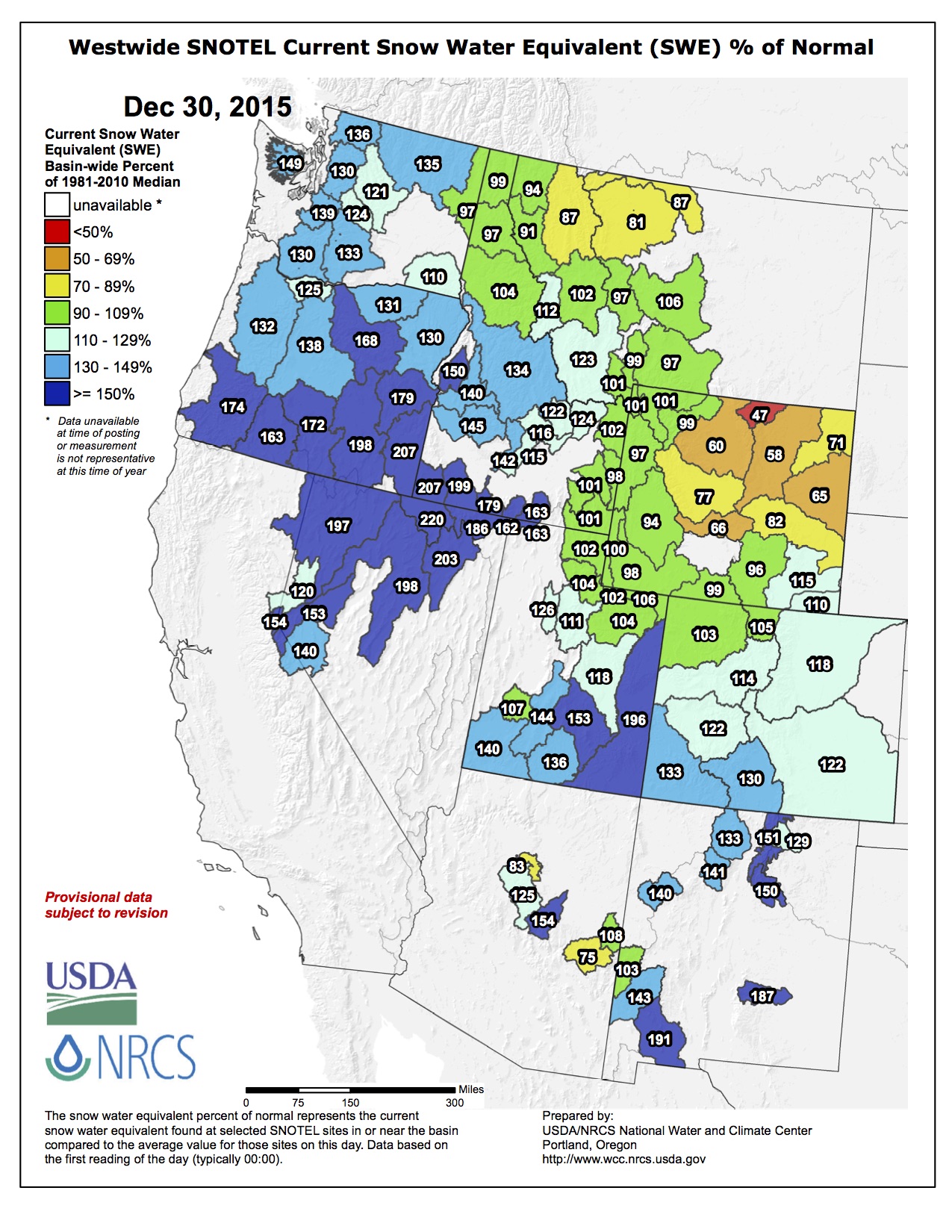
Statewide snowpack was at 121 percent of median as of Wednesday, according to federal Natural Resources Conservation Service data.
That’s consistent with forecasters’ expectations for the start of a snow season dominated by a big El Niño weather system in the United States. Such weather systems derive from above-average water temperatures in the eastern Pacific Ocean near the equator.
“What it tends to do is produce a wet fall for us here in western Colorado, and that has definitely happened,” said Joe Ramey, a forecaster for the National Weather Service in Grand Junction.
And the importance of that early wet season comes from the fact that stronger El Niños also have historically resulted in generally drier mid-winters, at least in northern Colorado.
So while the storm in the days leading up to Christmas certainly helped the ski industry, “it also put important water into the mountains that we’ll be drinking during the warm season,” Ramey said.
He said such storms make or break a season, and this one “had a big impact on us, bringing snowpack up quite a bit, to well above normal across the state, especially in southwestern Colorado.”
The Upper Colorado River Basin was at 101 percent of median on Dec. 20, Ramey said. By Wednesday, it was at 114 percent.
Basins in southwest Colorado are at 134 percent, the highest statewide, in a welcome start to the year in a part of the state that has especially lagged behind in snowpack in recent years. Ramey noted that Arizona and New Mexico also have seen significant amounts of badly needed precipitation.
El Niños typically result in more moisture in the southwestern United States, with the benefit reaching up into southwestern Colorado but not necessarily extending farther north. The Yampa and White river basins in northwest Colorado currently are at 103 percent of median, the lowest of any basin in the state.
The Gunnison River Basin stands at 121 percent of median.
This week, the website opensnow.com has been showing a deeper snow base at Powderhorn Mountain Resort than in major resort areas such as Vail and Aspen. The Mesa Lakes snowpack measurement site on the Grand Mesa currently is at 123 percent of median.
“It’s snowing right now,” Jeff Kieper, owner of Thunder Mountain Lodge on the Grand Mesa, said Wednesday. “We just got another seven inches in the last two days.”
He said the lodge has gotten a whopping 71 inches of snow over eight days — more than he’d ever seen over such a span after living in the Vail area and spending four winters on snowmobile tours across the West.
[…]
Ramey said it’s important to remember that it’s early in the season, with much of the season’s snowpack typically developing in January through March. Also remaining to be seen is whether the El Niño pattern can deliver a wet spring to the state, as has occurred in some past El Niño seasons.
From 9News.com (Victoria Sanchez):
Meteorologist Kyle Fredin with the National Weather Service in Boulder said the wetter-than-average conditions are fueling storms.
“If you can get moisture at the surface and cold air aloft mixing together, you know game’s on,” he said…
There’s potential for more strong storms through next year. Fredin said the ocean should cool back down into the summer and into early fall but until then, there is potential for more extreme weather.
“Whether it’s extreme weather event or whether it’s an average day, nature is trying to balance.”