#ElNiño: The latest ENSO discussion is hot off the presses from the Climate Prediction Center

middecember2015plumeofensopredictionscpc

Click here to read the discussion. Here’s an excerpt:

ENSO Alert System Status: El Niño Advisory
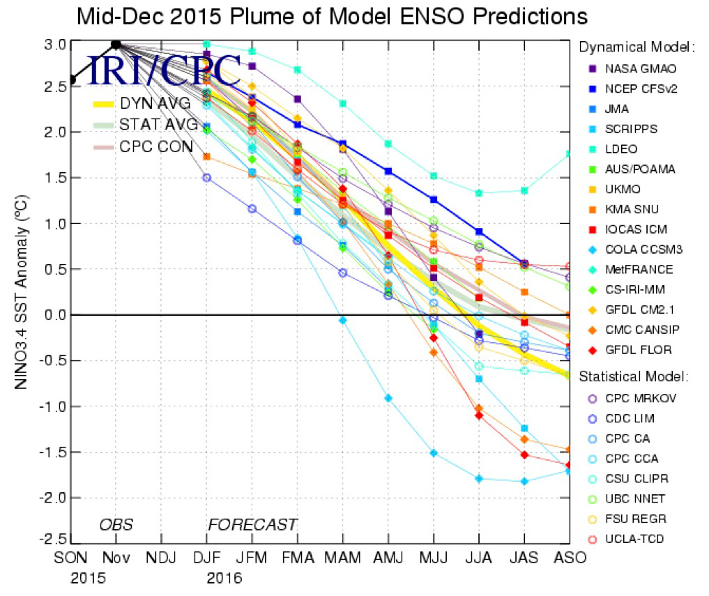
Synopsis: A strong El Niño is expected to gradually weaken through spring 2016, and to transitionto ENSO-neutral during late spring or early summer.

A strong El Niño continued during December, with well above-average sea surface temperatures (SSTs) across the central and eastern equatorial Pacific Ocean. All weekly Niño indices decreased slightly from the previous month. The subsurface temperatures in the central and eastern Pacific, while still well above average, weakened due to an upwelling equatorial oceanic Kelvin wave. Significant low-level westerly wind anomalies and upper-level easterly wind anomalies continued over much of the tropical Pacific. During the last week, another westerly wind burst occurred in the east-central Pacific. The traditional and equatorial Southern Oscillation Index (SOI) values remained strongly negative. Also, convection remained strong over the central and east-central tropical Pacific, and suppressed over Indonesia. Collectively, these atmospheric and oceanic anomalies reflect the continuation of a strong El Niño episode.

Most models indicate that a strong El Niño will weaken with a transition to ENSO-neutral during the late spring or early summer. The forecasters are in agreement with the model consensus, though the exact timing of the transition is difficult to predict. A strong El Niño is expected to gradually weaken through spring 2016, and to transition to ENSO-neutral during late spring or early summer (click CPC/IRI consensus forecast for the chance of each outcome for each 3-month period).

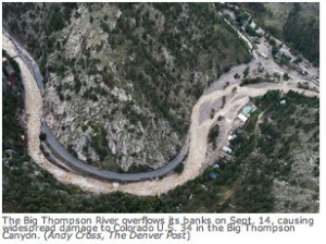
El Niño has already produced significant global impacts and is expected to affect temperature and precipitation patterns across the United States during the upcoming months (the 3-month seasonal outlook will be updated on Thursday January 21st). The seasonal outlooks for January – March indicate an increased likelihood of above-median precipitation across the southern tier of the United States, and below-median precipitation over the northern tier of the United States. Above-average temperatures are favored in the West and northern half of the country with below-average temperatures favored in the southern Plains and along the Gulf Coast.

#Drought news: Good snow for parts of #Colorado over the past week

Click here to go to the US Drought Monitor website. Here’s an excerpt:

Summary

Much of the Midwest continued to be 6-9 degrees warmer than normal in the past week. New England was warm, too, with Maine and northern New York as much as 9-12 degrees warmer than usual. Areas in northern Washington, Idaho, western Wyoming and much of California were 3-6 degrees warmer than usual, as were the coastal areas of the Mid-Atlantic and much of Florida. For areas west of the Missouri River, temperatures were generally cooler than normal, by as much as 9-12 degrees in parts of Arizona, New Mexico, Montana and South Dakota. On the wet end of the spectrum, much of southern California, southern Nevada, Arizona, southern Utah, southern Colorado, Kansas, northwest Missouri, southeast Nebraska, western Iowa, southern Florida, eastern Pennsylvania, and Maine recorded more than 200 percent of normal precipitation, with multiple storm events in the West. But the Pacific Northwest, northern Great Plains, south Texas, and the Southeast all had below-normal precipitation for the week…

High Plains and South

Portions of east Texas, east Kansas, southeast Nebraska, and the Texas Panhandle that were in the wettest part of the storm track got more than 200 percent of normal precipitation for the week. Temperatures were generally 3-6 degrees cooler than normal, as a good push of arctic air made it into the region. No changes were made in the High Plains or South on this week’s U.S. Drought Monitor…

West

As a series of storms came ashore along the West Coast and dove into the Southwest, many areas of California, Nevada, Arizona, Utah, New Mexico, and Colorado received significant amounts of rain and snow. Along with the cooler-than-normal temperatures, this was ideal for snow to accumulate in the higher elevations and for rain to infiltrate into soils. In Arizona, even though some time-scales are showing dry signals, the consensus was that the recent precipitation was enough to start showing improvements. Severe drought disappeared from Arizona, while much of the moderate drought ebbed in the central and northwest part of the state. Abnormally dry conditions shrank over much of central Arizona as well. In southwest Utah, moderate drought and abnormally dry conditions receded. Eastern Nevada has had good snow over the last several weeks, and snow water equivalent (SWE) is running 150-200 percent of normal for the water year, so moderate drought was removed over much of eastern Nevada. Continued dryness over much of northern Wyoming and southeast Montana led to a slight expansion of moderate drought and abnormally dry conditions this week. Most snow reports have this area at only 20-40 percent of SWE for this time of year.

In California, even with the rain and snow received over the last several weeks, many areas are still running below normal for precipitation and snow for the current water year. Wells, reservoirs, ground water, and soil moisture are all recovering slowly, which is to be expected after three-plus years of drought. Precipitation in northern California eased some of the exceptional drought. The consensus from California experts is that recovery will be slow, and many more storm events are needed through the rest of winter to really put a dent in the drought…

Looking Ahead

Over the next 5-7 days, an active pattern will bring precipitation to much of the Pacific Northwest and northern California, which could see as much as 8 inches of precipitation. Much of the area from the Mississippi Valley to the east also looks favorable for precipitation, with the greatest amounts along the Gulf Coast and Eastern Seaboard. Temperatures will be normal to slightly above normal over the West and East, cooler than normal over the High Plains, and above normal over the Southern Plains.

The 6-10 day outlooks show that the best chances for above normal temperatures are over the area west of the Rocky Mountains with the greatest chances over the West Coast. The best chances for below normal temperatures is over the Eastern Seaboard. The best opportunity for above normal precipitation is over much of California and into the Great Basin. Increased chances of above normal precipitation can also be anticipated over much of the Plains and into the Southeast. The greatest odds of below normal precipitation is anticipated over south Texas and the Great Lakes region into northern New England.

Big Thompson Canyon permanent repairs from 2013 flooding = $129 million, projected start this spring

The Big Thompson River September 14, 2013 via The Denver Post

From the Loveland Reporter-Herald (Saja Hindi):

Construction on U.S. 34 permanent repairs in Big Thompson Canyon could come as early as spring, and initial estimates show it could cost much more than anticipated.

The total corridor project cost is set at $129 million, which comes from the $450 million of federal money allocated to all 2013 flood repairs, according to Colorado Department of Transportation spokesman Jared Fiel.

CDOT Project Leader James Usher spoke to the Board of Larimer County Commissioners Tuesday morning about the project and education planned for residents — town meetings are planned for Loveland and Estes Park a month prior to construction, though no firm dates have yet been set. Agency officials will also host a telephone town hall, neighborhood meetings and update residents and business owners via a newsletter.

Engineers initially split the construction plans into 10 segments to be completed in packages, or phases, Fiel said, which could include several segments at a time.

They estimated that the first package, east of Idylwilde, would cost about $15 million, but the price estimates from the industry came in closer to $40 million, Usher said. That phase would cover about 150,000 cubic yards of rock work.

The main reason the price came in so high, Usher said, is because all the material that would be generated for repairs was going to have to be trucked in and out of the canyon.

But Usher said the project team is looking at potential solutions and reducing some of those risks, which will lead to a significant price drop…

Usher said CDOT is aiming to minimize the inconvenience to the public and residents along the corridor while maximizing safety.

Much of the design work was completed in the past six months, he said, and now the focus is on prioritizing work while conducting public outreach. The project itself could take about two years.

Cache la Poudre update: NISP could diminish spring streamflow

From the Associated Press (Dan Elliott) via Newser.com:

A picturesque Colorado river with a peculiar French name is the latest prize in the West’s water wars, where wilderness advocates usually line up against urban and industrial development.

This showdown has a new force: City dwellers who say a vibrant river flowing past their streets, parks and buildings is essential to their community’s identity and well-being.

The Cache la Poudre — pronounced KASH luh POO-dur — got its name in the early 1800s, when French fur trappers cached gunpowder on its banks. Long a vital source of water for drinking and irrigation, it has become a treasured slice of nature in the booming towns and cities along Colorado’s Front Range corridor…

A group of 15 cities and water districts wants to divert water from the lower Poudre, below the mountains, when the river is running highest and pump it into a new reservoir. The $600 million Northern Integrated Supply Project would capture water Colorado is legally entitled to keep but has no place to store, backers say.

Since 2009, Colorado could have kept another 1.3 trillion gallons from the South Platte and its tributaries, including the Poudre, but it flowed east to Nebraska because there was no place to put it, said Brian Werner, a spokesman for the Northern Colorado Water Conservancy District, which is overseeing the project.

This debate has all the elements of a traditional Western water fight.

Backers say they need to lock up future sources of drinking water for Colorado’s fast-growing population amid the recurring droughts and uncertainty of a changing climate.

Opponents want to prevent any more losses to the “in-stream flow” of the river, already so drained by irrigation and municipal systems that short stretches run dry nearly every summer.

River advocates also want to preserve the annual spring surge that comes from melting snow, which keeps the streambed healthy by flushing out sediment and provides a thrilling ride for kayakers. They say the reservoir project could reduce the kayaking season from an average of 54 days to 35 days a year.

Rising to the surface is the argument that a vibrant urban river flowing through Fort Collins, Greeley and the towns between them is an essential part of the coveted Colorado lifestyle, where even urban residents can connect with nature.

“This is like in-stream flow for human organisms and for the replenishment and well-being of the soul,” said Patty Limerick, Colorado’s state historian and faculty director of the Center of the American West at the University of Colorado.

Rivers have long been guarded as cultural assets around the United States and beyond, said Robert F. Kennedy Jr., president of the Waterkeeper Alliance, a nationwide network of local advocacy groups.

“It’s an argument we’ve been making for a long time,” Kennedy said. “It’s a longstanding recognition of the relationship between wilderness and free-flowing waters and America’s cultural and political institutions.”

…sections of the river are lined with parks and pathways, including the 20-mile Poudre Trail upstream from Greeley. Restoration programs are in the works, and Fort Collins plans a kayak course on the river in the city.

A big change came in 1986, when 76 miles of the upper Cache la Poudre were designated as a National Wild and Scenic River, protected by the National Park Service and the U.S. Forest Service from changes that could harm its cultural and recreational importance. In 2009, Congress designated the river as a National Heritage Area, formally encouraging a community-driven approach to preserving its natural, cultural, and historic resources.

But preserving water resources is a challenge in the arid West, even for the most beloved river, and cultural arguments have no easy path through Colorado’s complex legal system, which includes a separate water court to settle disputes.

Colorado lawmakers established a narrowly defined recreational water right for kayak courses in 2001, but experts say setting aside water for cultural values would have to be negotiated among the state and owners of water rights.

Environmental reviews of the reservoir project continue and obtaining the necessary state and federal permits could take years. Lawsuits are probably inevitable, and no construction date has been set…

The project’s backers recognize the river’s cultural value and are working to protect it, Werner said. The new reservoir might even be able to release enough water to avoid the periodic dry-ups, he said.

“We’re trying to do right by the river, we really are,” he said.

#Snowpack news: #Colorado SWE drops as a percent of normal, snow on the way

Westwide SNOTEL January 13, 2016 via the NRCS

From Steamboat Today (Tom Ross):

In its first Colorado Water Supply Outlook Report of the water year that began Oct. 1, 2015, the Denver office of the Natural Resources Conservation Service said statewide snowpack is 118 percent of normal. Colorado Snow Survey Supervisor Brian Domonkos characterized it as the best start to winter this decade and ranked it as the ninth best start since 1982.

“With a sizable chunk of the winter already behind us, this is a good starting point, however more than half of the winter remains,” he said in a written statement, adding that, in a typical year, Colorado has received about two fifths of the seasonal snowpack by the first week in January.

The mountains surrounding Steamboat Springs and the Yampa Valley aren’t leading the pack for Colorado, however. In fact, the Yampa/White Drainage, at 103 percent of median snowpack (water stored in the standing snow on the ground), is the lowest in the state. But at least it’s in plus territory. One year ago, the Yampa/White stood at 98 percent of median Jan. 7 and was poised to drop further during a mild February.

However, Domonkos said during a telephone interview Wednesday that snowfall patterns such as the one that delivered consistent, but modest snow accumulations of one to four inches at a time here during the week after Christmas, can be a significant contributor to overall snowpack.

The Tower site, above 10,000 feet on the Continental Divide north of Steamboat, is one of 13 snow measuring sites that were below 100 percent snowpack. Domonkos also mentioned the Elk and Little Snake watersheds in North Routt as being among the river basins that are below normal but still near the median.

There is an apparent disconnect between snowpack levels measured on the western summit of Rabbit Ears Pass — at 9,400 feet elevation where snowpack is 110 percent of median — and at the Tower site, where it’s just 69 percent of median, having slipped from 76 percent Jan. 1.

There’s more stored water on Buffalo Pass this week, with 14.8 inches, compared to 11.7 inches on Rabbit Ears. But Tower would typically have a little more than 21 inches stored in the snow on this date and hold one of the biggest snowpacks in the state.