Will Gore Creek restoration start this year? — The Vail Daily

Gore Creek
Gore Creek

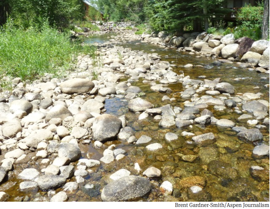
From the Vail Daily (Scott N. Miller):

Based on new standards of stream health, the Colorado Department of Public Health and Environment put Gore Creek on a list of impaired streams in the state in 2012. The local creek isn’t alone. A number of streams through and near mountain towns are on the list.

Still, “impaired stream” and “mountain playground” don’t sound good together. That’s why local officials have been working on plans to improve aquatic life in the creek for the past several years

That work took a lot of time because a host of causes affect the stream’s health, ranging from road sand and de-icer to runoff from parking lots to what landowners use to control weeds on their creekside properties. All of those things affect aquatic life in the creek — specifically, the small bugs that allow other aquatic life to flourish.

This week, the Vail Planning and Environmental Commission approved a town action plan to help with the creek cleanup. The Vail Town Council is expected to get its first look at the approved plan in February and will likely approve the plan soon after…

ENHANCEMENT PROJECTS

The plan has identified 42 streamside enhancement projects between the farthest reaches of East Vail and the confluence of Gore Creek with the Eagle River. Brooke Ranney, the projects and events coordinator with the Eagle River Watershed Council, said each of those areas is an acre or less in size. Those sites have also been prioritized. Most of the improvements focus on storm drainage. But some will have a direct effect on how people can reach the stream.

Ranney said one project is just west of the skier bridge in Lionshead Village. That area sees a lot of foot traffic, which has caused erosion along the banks. That project will stabilize the stream bank. But, Ranney said, the trick with that and other projects is stabilizing areas while still allowing access to the stream.

Arriving at the point of having a restoration plan in place has taken years of research and planning.

While Gore Creek landed on the state’s list in 2012, the new water-quality standards were understood several years before. Diane Johnson, of the Eagle River Water & Sanitation District, said the district started gathering data about the stream in 2008 as part of an effort to understand how the standards would affect the wastewater treatment plant just west of Lionshead in Vail.

RESEARCH GUIDES RESULTS

While the treatment plant can clean up water downstream, Johnson said there’s nothing the district can do about pollution upstream. But the research the district has done over the past several years will guide the town’s plan.

“We’re finally moving from field work, research and analysis to action,” Johnson said.

That field work has involved a lot time beating the bushes — literally. In 2015, the town hired SGM, a Glenwood Springs-based engineering company, to do a comprehensive inventory of the town’s storm sewer system.

“They did an excellent job,” Bertuglia said. “They literally got into the weeds and tracked where the (storm sewer) basins go.”

While the watershed council is a nonprofit group with a limited budget, Ranney said that group can help coordinate educational projects and, in some cases, round up volunteers for restoration projects. The council used a lot of volunteer help for a stream restoration project in Edwards a few years ago.

Community involvement is important in cleanup and restoration efforts, and Bertuglia said town residents seem ready.

“It’s encouraging how engaged the community has been,” she said.

Johnson said that’s going to be important in the future — and not just for people who live along the creek.

“We can all make personal choices,” Johnson said. “Anything that runs off your driveway or your lawn eventually makes it down to the creek.”

Colorado Springs: Overgrowth and forest fire hazards

Waldo Canyon Fire
Waldo Canyon Fire

From the Colorado Springs Independent (J. Adrian Stanley):

“I’m looking out my window at North Cheyenne Cañon [Park] right now, and it’s just a carpet of forest out there,” [Dennis Will] says with evident dismay.

If Will had his way, the park would go from having as many as 100 trees per acre to just 30 to 75. While that lush forest is beautiful, Will says the park isn’t meant to support so much greenery. Overgrowth puts the area at risk for fire and other hazards.

His department has done significant mitigation projects in the park recently, but rains spurred new growth, and Will says finding the funds to maintain work that’s already been completed once is a challenge.

If a fire did sweep down the Cañon, it could be a disaster of epic proportions. Steep slopes would make it difficult to fight. Homes, businesses and major parts of the city’s water system would be at risk. Floods would likely follow, carrying huge loads of sediment from the erosive granite hillsides. The Cañon/Bear Creek area is also home to the threatened greenback cutthroat trout, which might not survive such a calamity…

North Cheyenne Cañon is just one of many problems. Will says Colorado Springs has the largest wildland-urban interface of any city in the state of Colorado. According to the city’s 2011 Community Wildfire Protection Plan, the interface totals 28,800 acres. To put this in perspective, 24 percent of the city’s population lives in the wildland-urban interface.

And, as the 2012 Waldo Canyon Fire showed, the interface can go from beautiful to scary very quickly…

Another major player is Colorado Springs Utilities. Its infrastructure runs through the interface, and thus, preventing another major fire is in its best interest. Utilities’ budget for such mitigation was increased from $250,000 to $1.5 million after the Waldo Canyon Fire, according to Eric Howell, Utilities’ forest program manager.

Utilities treats 1,000 to 1,500 acres per year currently and plans to begin treating as many as 3,000 acres a year in the near future. In order to achieve its mitigation goals, Utilities maintains partnerships with the U.S. Forest Service, the Colorado State Forest Service, the Coalition for the Upper South Platte, Pikes Peak Fire Learning Network, the Colorado Springs Forestry Division and the Colorado Springs Fire Department.

While Utilities’ contribution is significant, most of its money is spent on watersheds outside the city. Utilities sets aside $75,000 to help match grants procured by the city’s fire and forestry departments.

The latest “Smart Move” newsletter is hot off the presses from @CSUtilities

Click here to read the newsletter. Here’s an excerpt:

Don’t forget to water- — even in the winter

Even though landscape plants are dormant and brown, they should be watered periodically. By choosing to winter water, your lawn and landscape plants will have a much better chance of greening up beautifully when the warm weather of spring returns.

  • Choose a warm winter day above 40 degrees and unfrozen soil.
  • Water one to two times per month from November to April.
  • Water at mid-day so it can soak in before it freezes.
  • Remove the hose from the spigot after watering to prevent freeze damage.
  • EmyMar2003Blizzard

    Weekly Climate, Water and Drought Assessment of the Upper #ColoradoRiver Basin

    Upper Colorado River Basin month to date precipitation January 1 through January 14, 2016
    Upper Colorado River Basin month to date precipitation January 1 through January 14, 2016

    Click here to read the current assessment. Click here to go to the NIDIS website hosted by the Colorado Climate Center.

    #ClimateChange: Mountains west of Boulder continue to lose ice as climate warms — CU Boulder

    alpineflowersniwotridgeviacuboulder

    Here’s the release from the University of Colorado at Boulder:

    New research led by the University of Colorado Boulder indicates an ongoing loss of ice on Niwot Ridge and the adjacent Green Lakes Valley in the high mountains west of Boulder is likely to progress as the climate continues to warm.

    The study area encompasses the Niwot Ridge Long-Term Ecological Research (LTER) site, thousands of acres of alpine tundra, subalpine forest, talus slopes, glacial lakes and wetlands stretching to the top of the Continental Divide in the Rocky Mountains. The Niwot Ridge LTER site, which includes Green Lakes Valley and CU-Boulder’s Mountain Research Station (MRS), is one of 26 North American LTER sites created and funded by the National Science Foundation (NSF) and one of the initial five LTER sites designated by the federal agency in 1980.

    The decline of ice at the Niwot Ridge LTER site appears to be associated with rising temperatures each summer and autumn in recent years, said CU-Boulder Professor Mark Williams of the Institute of Arctic and Alpine Research, lead study author. The decline is especially evident on the Arikaree glacier — the only glacier on Niwot Ridge — which has been thinning by about 1 meter per year for the last 15 years.

    “Things don’t look good up there,” said Williams. “While there was no significant change in the volume of the Arikaree glacier from 1955 to 2000, severe drought years in Colorado in 2000 to 2002 caused it to thin considerably. Even after heavy snow years in 2011 and again in 2014, we believe the glacier is on course to disappear in about 20 years given the current climate trend.”

    The new study looked at changes in the cryosphere — places that are frozen for at least one month of the year– at the Niwot Ridge LTER site going back to the 1960s. In addition to the changes occurring on the Arikaree glacier, the researchers also have seen decreases in ice associated with three rock glaciers (large mounds of ice, dirt and rock) as well as subsurface areas of permafrost – frozen soil containing ice crystals.

    The team used several methods to measure surface and subsurface ice on Niwot Ridge: ground-penetrating radar, which measures ice and snow thickness; resistivity, which measures the conductivity of electrical signals through ice; and seismometers to measure signals bounced through subsurface ice. “We found that a combination of all three methods provided the best picture of changing snow and ice conditions on Niwot Ridge,” said Williams.

    The researchers also discovered an increased discharge of water from the Green Lakes Valley in late summer and fall after the annual snowpack had melted, a counterintuitive trend that began in the early 1980s, said Williams. The increased discharge appears to be due to higher summer temperatures melting “fossil” ice present for centuries or millennia in glaciers, rock glaciers, permafrost and other subsurface ice.

    “We are taking the capital out of our hydrological bank account and melting that stored ice,” he said. “While some may think this late summer water discharge is the new normal, it is really a limited resource that will eventually disappear.”

    Scientists have been gathering information on the snow, ice and plant and animal abundance and diversity on Niwot Ridge going back to the 1940s, when CU-Boulder Professor John Marr and colleagues began studies. The two highest climate stations on Niwot Ridge, one at 10,025 feet and the other 12,300 feet, have been monitoring data continuously since 1952.

    “This study demonstrates declines in ice — glaciers, permafrost, subsurface ice and lake ice in the Niwot Ridge area over the past 30 years,” said Saran Twombly, LTER program director in NSF’s Division of Environmental Biology, which funded the research. “Long-term research at Niwot Ridge offers a rare opportunity to document the continuous, progressive effects of climate change on high alpine ecosystems, from ice and nutrients to plant and animal communities.”

    A special issue of the journal Plant Ecology and Diversity that includes several research papers involving CU-Boulder faculty and students is being published this month. Study co-authors on the Niwot Ridge snow and ice paper, part of the special issue, include emeritus Professor Nel Caine of CU-Boulder, Professor Matthew Leopold of the University of West Australia and professors Gabriel Lewis and David Dethier of Williams College in Williamstown, Massachusetts.

    From an ecological standpoint, Niwot Ridge has seen a significant increase in alpine shrubs above treeline in recent decades, said Williams. At one research site known as “The Saddle” at about at 11,600 feet in elevation and 3.5 miles from the Continental Divide, the ecosystem has gone from all tundra grasses and no shrubbery in the early 1990s to about 40 percent shrubs today.

    “Places that once harbored magnificent wildflowers in this area are being replaced by shrubs, particularly willows,” he said. “The areas dominated by shrubs are increasing because of a positive feedback – patches of these shrubs act as snow fences, causing the accumulation of more water and nutrients and the growth of more shrubs.”

    One nutrient, nitrogen — produced primarily by vehicle emissions and agricultural and industrial operations on the Front Range and elsewhere in the West — is being swept into the atmosphere and deposited on the tundra in increasing amounts, said Williams. Nitrogen deposition also is an issue in nearby Rocky Mountain National Park.

    Niwot Ridge is part of the Roosevelt National Forest and has been designated a United Nations Educational, Scientific and Cultural Organization (UNESCO) Biosphere Reserve. The Green Lakes Valley is part of the City of Boulder Watershed and CU-Boulder’s MRS is devoted to the advancement of mountain ecosystems, providing research and educational opportunities for scientists, students and the general public.

    To view a video on snow, ice and water research on Niwot Ridge visit this CU-Boulder climate website and click on “Water: A Zero Sum Game.” For more information on the Niwot Ridge LTER program and CU-Boulder’s Mountain Research Station visit this CU-Boulder webpage.

    #Snowpack news: “This [San Juan SWE] is way better than where we were last year” — Brian Domonkos

    From the Telluride Daily Planet (Stephen Elliott):

    The first Colorado water supply outlook report of the year brought good news for the state and particularly the San Miguel Watershed. The report, released Jan. 1 by the U.S. Department of Agriculture’s Natural Resources Conservation Service, found that the statewide snowpack is at 118 percent of normal, the most plentiful start to a winter water season since 2011.

    After several dry years, heavy precipitation early this winter and fall replenished reservoirs around the state, allowing water managers to take a cautiously optimistic look at what the summer might bring.

    “To be at this point at the beginning of the year is usually a good thing,” said Brian Domonkos, snow survey supervisor for the U.S. Department of Agriculture’s Colorado program. “What we can really hope for is a prolonged spring where temperatures stay pretty cool. Hopefully it stays cool well into the summer and that runoff will run off nice and even and it’ll be a nice water supply headed into the summer.”

    But weather is never a sure bet, and Domonkos said it was still early to predict a healthy water season.

    “We’ve only reached about the halfway point when it comes to our snowpack accumulation season. There’s a lot that can change,” he said. “It’s not the easiest for the weather in the mountains to maintain (those high levels of precipitation), but it’s certainly possible, and it could be higher.”

    All major river basins in the state have above-normal snowpacks, according to the report, but the San Miguel, Dolores, Animas and San Juan basins are collectively the highest above normal, at 130 percent. In the combined southwestern Colorado basin, which includes Telluride, December storms dropped a whopping 174 percent of the average precipitation for the month.

    The Telluride Ski Resort has already reported 161 inches of snow for the season.

    Reservoir storage in the combined basin is at 103 percent of average, compared to 88 percent at this time last year.

    The Colorado Snow Survey’s snowpack and streamflow forecasts put the San Miguel at 161 percent of normal snowpack, the highest in the combined basin. The other river basins range from the La Plata River, at 108 percent of normal snowpack, to the Dolores River, at 157 percent of normal snowpack.

    Domonkos added that the San Miguel has about twice as much water in its snowpack as at this point last year; a positive improvement, but also nowhere near record levels.

    “This is way better than where we were last year, but we are a good long ways from where the maximum is,” he said.
    That snow is so important because it holds the water that will keep the West green in the summer.

    Aspen to develop river management plan for upper Fork — The Aspen Times

    Roaring Fork River in early July 2012 via Aspen Journalism
    Roaring Fork River in early July 2012 via Aspen Journalism

    From Aspen Journalism (Brent Gardner-Smith) via The Aspen Times:

    The city of Aspen is seeking consultants to help it prepare a river management plan for the upper Roaring Fork River, which has been plagued in drought years by low flows as it winds through central Aspen.

    “The city of Aspen plans to study the upper Roaring Fork River, from its headwaters to a point just below the confluence with Maroon Creek,” the city’s request for proposals, or RFP, says.

    April Long, the city’s stormwater manager, said the development of a river management plan was one of the Aspen city council’s top ten goals in 2015. Long said she expects regional engineering firms specializing in water to put together teams of consultants and submit proposals to the city, which are due by Jan. 15.

    “Since 2008, the city has focused on improving the quality of water discharged through its outfalls. The city now feels it is important to focus its attention on one of the other probable causes for impairment – inadequate flows during periods of drought,” the RFP says.

    The city’s RFP also says it expects proposed consulting teams “to include members with experience and expertise in water resources engineering, river science, hydrology, water quality, stream geomorphology, Colorado water rights and water law, and group facilitation.”

    Long said the city’s river management plan will be similar to the ‘”stream management plans” that are called for in the recently released Colorado Water Plan, and that ongoing work being done by the Colorado Water Trust for Pitkin County on ways to add more water to the river will be looked at when formulating the city’s river plan.

    “Our ultimate goal for the project is to develop a plan that outlines operational, management, and physical options that improve the health of the river while respecting each stakeholder’s rights and interests,” the city’s RFP says.

    The Roaring Fork River flows into the city’s boundaries at Stillwater Drive east of downtown Aspen.

    The stretch of the river between there and the confluence with Castle Creek has been known to drop below 32 cubic feet per second, which the Colorado Water Conservation Board considers the minimum amount of water necessary to protect the river’s environment “to a reasonable degree.”

    “In the early 2000s several studies investigated the health of the Roaring Fork River and reported a severely degraded or impaired stretch of river within the city,” the RFP says. “The instream flow determined for this stretch in the 1970s is 32 cubic feet per second. During the droughts of 2002 and 2012, the river in this stretch dropped to only 5 cfs – only 15 percent of the instream flow.”

    One big factor in the amount of water in the Roaring Fork River through Aspen is the Salvation Ditch, an irrigation ditch that diverts water from the river at Stillwater Drive.

    The ditch has a senior 1902 water right that allows up to 58 cfs of water to be diverted and sent across lower Red Mountain to Woody Creek.

    During the drought of 2012 there were days when there was more water flowing down the Salvation Ditch than was flowing down the Roaring Fork as it winds through town.

    For example, according to a study done by S.K. Mason Environmental LLC, on July 27, 2012 there was 17.4 cfs flowing in the Salvation Ditch and 7.6 cfs of water flowing down the Fork below the ditch.

    However, Tom Moore, the president of the Salvation Ditch Company, said the shareholders who own land along the ditch company also need the water in dry years, they have made significant investments in the water system, and they are concerned about weakening their water right by not diverting the water.

    He also pointed out that the Salvation Ditch water right is senior to the 1930s era water rights held by the Twin Lakes Reservoir and Canal Co., which diverts water under Independence Pass. As such, the Salvation Ditch plays a role in keeping water in the Roaring Fork River, he said.

    The city’s Long said talking with the Salvation Ditch Co. will be an important part of the river management plan, which is why the city is seeking proposals that include consultants with an expertise in working with various stakeholders.

    The city’s RFP says “we hope that by determining valuable attributes of the river, we can work together as a community to lessen impairment and improve water quality, river health, ecological health, recreational opportunities, and riparian habitat in ways that closer meet the community’s goals.”

    Editor’s note: Aspen Journalism is covering rivers and water in collaboration with the Glenwood Springs Post Independent and The Aspen Times. More at http://www.aspenjournalism.org.

    A view of the Salvation Ditch diversion dam and head gate, just of off Stillwater Drive, east of Aspen. Smith / Aspen Journalism
    A view of the Salvation Ditch diversion dam and head gate, just of off Stillwater Drive, east of Aspen. Smith / Aspen Journalism

    #ColoradoRiver: Conservation in the West Poll — Nevadans Very Concerned About Drought

    From the Public News Service (Suzanne Potter):

    Nevadans are highly concerned about the drought; 72 percent say it is extremely or very serious according to the new 2016 Conservation in the West poll by Colorado College.

    Residents ranked drought higher in importance than voters from six other western states did. The poll found 68 percent of Nevadans support additional conservation measures over diversion of water from rivers in less populated areas. State Assemblyman Edgar Flores says much of the problem could be solved if people used water wisely.

    “It’s a everybody coming to the table type of issue,” Flores says. “And not just looking at how are we going to find more water, but ‘What am I doing to making sure that the water we do have, we’re preserving it and utilizing it in the most efficient manner.'”

    Nevada is the driest state in the nation, with the lowest annual rainfall. The state has received $1.8 million in federal funding to implement the “Water Smart” conservation program.

    The poll also asked people about public land and found a majority in the Silver State oppose efforts to transfer federal land to state control.

    Mauricia Baca is executive director with the Outside Las Vegas Foundation.

    “Whenever people discover these recreational opportunities they become more and more deeply connected to Nevada as a state,” says Baca. “If it were to transfer to a different sort of control where perhaps it was more privatized, that access would be restricted.”

    The poll also found that more than three quarters of Nevadans say conservation is important when choosing political candidates, and 72 percent support continuing investment in the Land and Water Conservation Fund.

    West Drought Monitor January 5, 2016
    West Drought Monitor January 5, 2016