Here’s the release from the Natural Resources Conservation Service (Brian Domonkos):
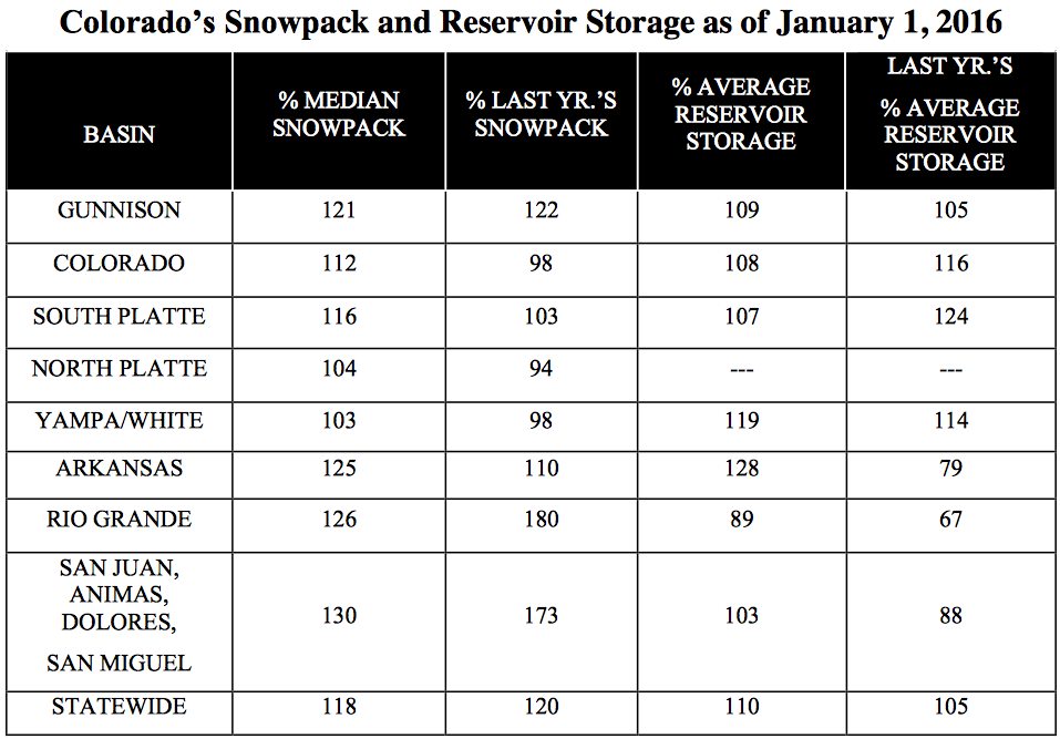
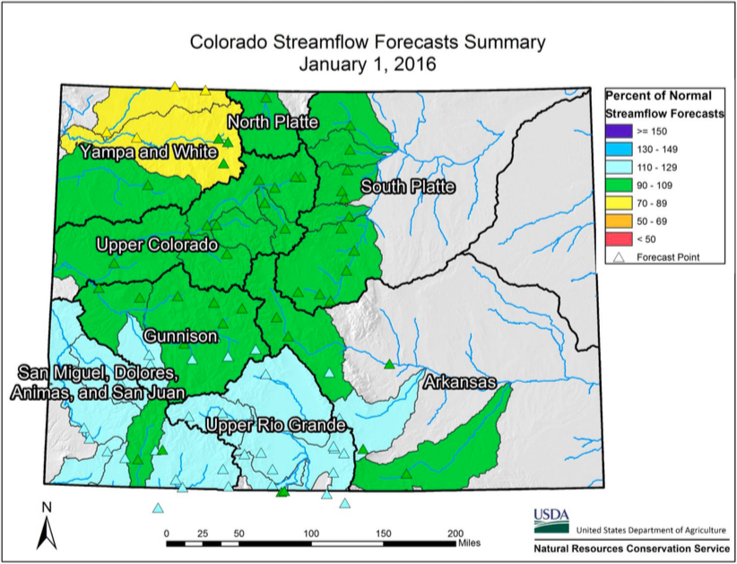
The January 1 Colorado Water Supply Outlook Report provides the first written update of snowpack in Colorado since the 2016 water year began on October 1, 2015. “Statewide snowpack is 118 percent of normal, considerably better than last year’s start” says Brian Domonkos, Colorado Snow Survey Supervisor with the USDA Natural Resources Conservation Service. In a typical year about two-fifths of the seasonal snowpack has accumulated to this point, a substantial portion of the accumulation season. Remembering last year Domonkos goes on to add, “With a sizable chunk of the winter already behind us this is a good starting point, however more than half of the winter remains”. Recapping last year, after near normal conditions on January 1, accumulation through January and early February was well below normal, a storm system in late February and early March provided a notable increase before another lull in precipitation through the rest of March and April. May, however, provided a reprieve from the dry pattern producing nearly 250 percent of average precipitation statewide.
The current strong El Nino has not disappointed the state of Colorado so far in 2016, providing between 103 percent of normal snowpack in the combined Yampa and White River Basins to as high as 130 percent of normal in the combined San Miguel, Dolores, Animas, and San Juan Basins. Some past El Nino events have been known to leave the northern half of the state high and dry. However, so far nearly all watersheds have benefited from this year’s El Nino event.
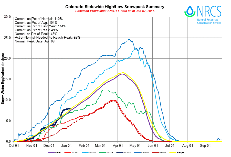
Statewide Basin High/Low graph January 7, 2016 via the NRCS
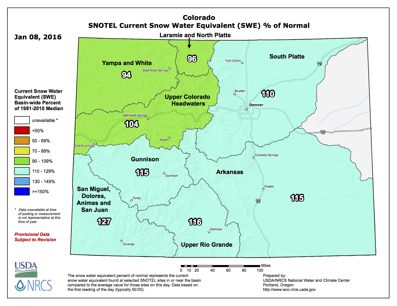
Of the 97 automated SNOTEL sites with available data, only 13 indicate snowpack is not quite up to 100 percent of normal. This does not equate to a poor start as these sites are sparse and scattered around the state. A few watersheds, including the Little Snake, Elk, Eagle, and Cache La Poudre River basins, do have slightly below normal snowpacks but are still near the median. This provides a good start for the seasonal snowpack across Colorado.
Precipitation statewide during the month of October started the water year off near normal but ramped up in November and December with monthly values of 97, 114 and 128 percent of normal, respectively. Water year-to-date precipitation is currently at 113 percent of normal. Reservoir storage is still in fair standing with help from last year’s well above average late spring precipitation. Statewide storage is 110 percent of normal where the only basin with below average total storage in the state are the combined reservoirs of the Upper Rio Grande.
While it is still early in the water supply game, streamflow forecasts are projected to be near normal for spring runoff season ranging from 80 percent of normal on the Little Snake River near Dixon to as high as 123 percent of normal Ute Creek near Ft. Garland. Snowpack is off to the best start since January 1, 2011, and the ninth best start since 1982.
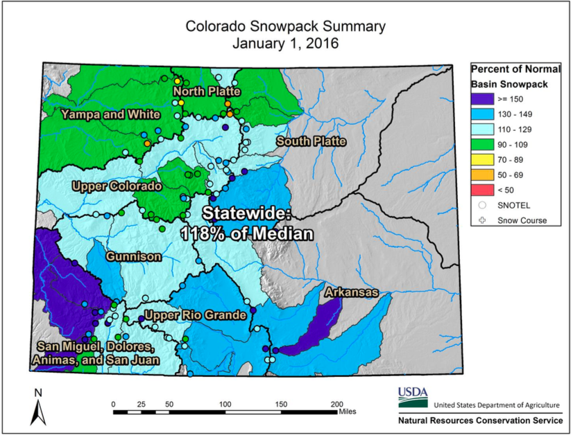
Statewide Snowpack map January 8, 2016 via the NRCS
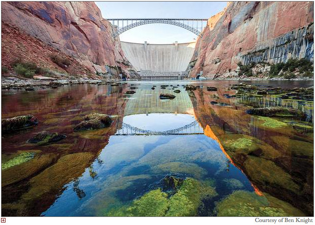
The Department of the Interior, through the Bureau of Reclamation and National Park Service (NPS), has made available for public review and comment the Draft Environmental Impact Statement (DEIS) for the Long-Term Experimental and Management Plan for the Operation of Glen Canyon Dam (LTEMP). The LTEMP would determine specific options for dam operations (including hourly, daily, and monthly release patterns), non-flow actions, and appropriate experimental and management actions that will meet the requirements of the Grand Canyon Protection Act, maintain or improve hydropower production, and minimize impacts on resources, including those of importance to American Indian Tribes.
The DEIS was filed with the Environmental Protection Agency on January 8, 2016, and a 90 day public comment period was initiated with the publication, also on January 8, 2016, of the Department of Interior’s Notice of Availability of the DEIS in the Federal Register. Written comments on the DEIS should be submitted by April 7, 2016.
The DEIS is available for reviewing on the internet at: http://ltempeis.anl.gov/. Compact disc copies of the DEIS are available for public review at the following locations:
J. Willard Marriott Library, University of Utah, 295 South 1500 East, Salt Lake City, Utah 84112.
For specific information about the web-based meetings, please refer to the LTEMP EIS website at: http://ltempeis.anl.gov/.
The purpose of the proposed action is to provide a comprehensive framework for adaptively managing Glen Canyon Dam over the next 20 years consistent with the Grand Canyon Protection Act and other provisions of applicable Federal law. The proposed action will help determine specific dam operations and actions that could be implemented to improve conditions and continue to meet the Grand Canyon Protection Act’s requirements and to minimize – consistent with law – adverse impacts on the downstream natural, recreational, and cultural resources in Glen Canyon National Recreation Area and Grand Canyon National Park, including resources of importance to American Indian Tribes.
The need for the proposed action stems from the need to use scientific information developed since the 1996 Record of Decision (ROD) to better inform the public of Department of the Interior decisions on dam operations and other management and experimental actions so that the Secretary of the Interior may continue to meet statutory responsibilities for protecting downstream resources for future generations, conserving Endangered Species Act-listed species, avoiding or mitigating impacts on National Register of Historic Places-eligible properties, and protecting the interests of American Indian Tribes, while meeting obligations for water delivery and the generation of hydroelectric power.
Click here to read the newsletter. Here’s an excerpt:
Water Leaders applications due Jan. 15
Applications for CFWE’s 2016 class of Water Leaders are being accepted through next Friday, January 15. Read application requirements, see course dates and scholarship information, and apply here.
Water Leaders participants receive extensive training in skills related to navigating conflict and diversity, leading self and others, and effective problem solving. You will leave the program with a better understanding of your strengths and how to use them, your challenges and how to work on them, skills to enhance your staff and team management work, and a network of peers to further your career growth.
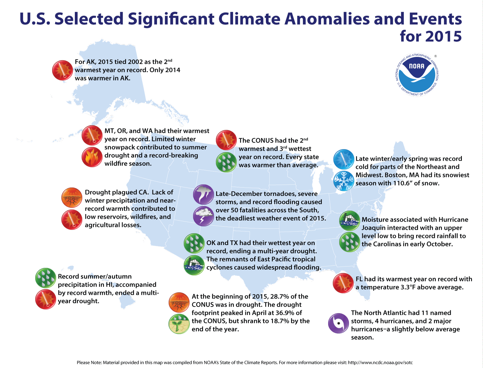
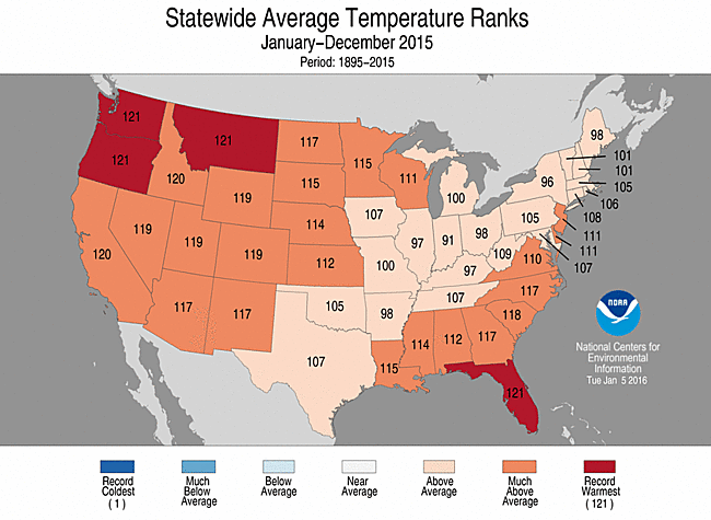
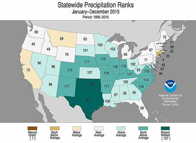
Record December boosted 2015 to 2nd warmest year for Contiguous US
Ten weather, climate disasters exceeding $1 billion impacted the nation
The 2015 annual average U.S. temperature was 54.4°F, 2.4°F above the 20th century average, the second warmest year on record. Only 2012 was warmer for the U.S. with an average temperature of 55.3°F. This is the 19th consecutive year the annual average temperature exceeded the 20th century average. The first part of the year was marked by extreme warmth in the West and cold in the East, but by the end of 2015, record warmth spanned the East with near-average temperatures across the West. This temperature pattern resulted in every state having an above-average annual temperature.
The average contiguous U.S. precipitation was 34.47 inches, 4.53 inches above average, and ranked as the third wettest year in the 121-year period of record. Only 1973 and 1983 were wetter. The central and southeastern U.S. was much wetter than average, while parts of the West and Northeast were drier than average. The national drought footprint shrank about 10 percent during the course of the year.
In 2015, there were 10 weather and climate disaster events, each with losses exceeding $1 billion. These events included a drought, two floods, five severe storms, a wildfire event and a winter storm. Overall, these resulted in the deaths of 155 people and had significant economic effects. Further cost figures on individual events in 2015 will be updated when data are finalized later this year.
U.S. climate highlights: 2015
Much warmer than average annual temperatures were observed across the West, Northern and Central Plains, Southeast, and Mid-Atlantic. Twenty-eight states, including Alaska, were much warmer than average during 2015 — Florida, Montana, Oregon and Washington were record warm. Alaska, California, and Idaho had their second warmest year.
Most of the central and southeastern U.S. were wetter than average, including 14 states that were much wetter than average. Oklahoma and Texas were record wet for the year, with both states becoming drought free for the first time since 2010. Parts of the Northeast and West were drier than average. Connecticut had its fourth driest year. In California, year-end precipitation helped erase early-year deficits, resulting in the state’s 13th driest year.
The U.S. Climate Extremes Index (USCEI) for 2015 was 70 percent above average, ranking as the fourth highest annual USCEI in the 106-year record and highest since 2012. The components of the USCEI that were much above average for the year included extremes in warm maximum and minimum temperatures, one-day precipitation totals and days with precipitation. The USCEI is an index that tracks extremes (falling in the upper or lower 10 percent of the record) in temperature, precipitation, drought and land-falling tropical cyclones across the contiguous United States.
Click on a thumbnail graphic to view a gallery of drought data from the US Drought Monitor. From the website:
Summary
It was a fairly dry week over much of the United States with the majority of the country seeing little to no precipitation. The exceptions were in south Texas, the Southeast, and along the Pacific coast. At the end of the current U.S. Drought Monitor period and the beginning of the next, the first of several storms started sweeping across the West Coast and into the Southwest. The resulting precipitation will be analyzed for potential improvements to the region next week. Temperatures remained well above normal for the upper Midwest and for most areas east of the Mississippi River. Departures of 5-10 degrees above normal were common from the Mid-Atlantic into the Southeast as well as in eastern North Dakota, northern Minnesota, and northern Wisconsin. Below-normal temperatures were common for most areas west of the Missouri River. Portions of the northern Rocky Mountains were 15-20 degrees below normal in the last week…
High Plains and South
Dry conditions prevailed over much of the High Plains and the South region, with southern Texas the only area showing any changes for the week. After a very wet end to the year, drought is not a concern over much of the Plains and the South-Central states. Most of the abnormally dry conditions in south Texas were removed this week, with only a few small areas of dryness remaining…
West
The weather pattern remains active over the West and the temperatures are very seasonal, cooler than the last two winters. There has been good snow accumulation in the upper elevations and rain in the lower elevations. For this week, improvements were made in eastern Washington and Oregon, where most areas to the east of Cascade Mountains had a full-category reduction in drought intensity, with moderate to severe drought lingering. Northern Idaho saw an improvement to the severe drought (D2) conditions, leaving moderate drought. Severe drought conditions also improved in southern Idaho this week. In northeast Nevada and northwest Utah, abnormally dry conditions improved slightly, and in southern Utah, moderate drought and abnormally dry conditions improved slightly. In the Four Corners region in northwest New Mexico, abnormally dry conditions improved. But prolonged dryness led to expansion of drought in northern Wyoming and southeast Montana. This area has not been as fortunate and dryness has lingered since autumn, so D0 and D1 expanded this week, pushing moderate drought into southeast Montana.
The analysis of California is ongoing, with the good start to the current water year bringing optimism to the region. The deficits over the last three years are significant enough that potential improvements are going to be slow to develop. The systems bringing precipitation to the region at the end of this current United States Drought Monitor period will be assessed next week…
Looking Ahead
Over the next 5-7 days, the active pattern will continue along the West Coast with several storms projected to bring precipitation from southern Oregon into southern California, Arizona and the Four Corners region. As these storms track eastward, much of the Midwest and East Coast will have the opportunity for ample precipitation as well. Cooler-than-normal temperatures over the western half of the country will provide a good opportunity for snow accumulation, especially at the higher altitudes. The East will see high temperatures of 8-10 degrees above normal.
The 6-10 day outlooks show that the odds for temperatures to be cooler than normal are greatest over the upper Midwest and Great Lakes regions as well as over much of the eastern United States, High Plains, and Four Corners regions. The greatest odds of warmer than normal temperatures is over the West Coast as well as much of Alaska. The best odds of above normal precipitation includes the west coast, Gulf Coast into Florida, and the Great Lakes regions. For much of the central Rocky Mountains, Midwest and into the Mid-Atlantic, there are above normal chances of below normal precipitation.
John Stulp, former State Agriculture Secretary, Prowers County Commissioner and current Special Policy Advisor to Governor Hickenlooper for Water issues, was one of eight speakers at the January 6th Crop Production Clinic held at Lamar Community College.
Stulp provided an update on the Governor’s State Water Plan which was presented to Hickenlooper last month. The ten year study provides information on current and future water needs for Colorado and how those needs will impact such areas as population growth, adequate water storage plans, conservation and environment, agricultural needs and non-consumptive uses. The information was compiled as a result of numerous Interbasin Water Committee and roundtable meetings conducted throughout the state for several years.
Stulp laid out some general statistics for the gathering, which began with a produced video detailing the aims of the study. He added, “Our future water uses are being determined by several factors including climate change, population growth, recent state forest fires and agricultural demands, all of which will impact our supplies.” Stulp commented on water distribution, adding that although most of our water flows on the western side of the Continental Divide, 80% of the population is on the east. The Western Slope population is at 562,000 with 918,000 irrigated acres and the eastern side of the state has a population count of 4,490,000 with 2,548,000 irrigated acres. Even with that amount, Stulp noted that only 5% of state surface land is irrigated. One graph showed the amount of water leaving the state from our river systems, with the Arkansas River’s estimate at 164,000 acre/feet per year.
“There will have to be some conservation efforts,” he said, noting that the state’ s projected population growth will take us to double the current 5,000,000 residents by 2050, half from the birth rate and the balance from an influx from the rest of the country. “Colorado is still one of the destination states for future growth and we need to take that into account,” he stated. Stulp told the audience that even with an additional 350,000 residents into the Denver area over the past several years; conservation efforts reduced water usage by 20%.
As southeast Colorado’s economy is heavily dependent on farming and ranching, Stulp noted that our agricultural growth will need to keep pace with state, national and global demands which will call for innovative ideas for water use, storage and conservation. Some ideas put forth from the study indicated a need for rotational fallowing, interruptible water supply, deficit irrigation, water coops and banks and water conservation easements. He noted that storage will play an important part in future water supplies, with thought being given to underground storage to reduce evaporation loss.