The health of our waters is the principal measure of how we live on the land — Luna Leopold
#Colorado #Snowpack Conditions Favorable to Start the 2016 Water Year — NRCS
Here’s the release from the Natural Resources Conservation Service (Brian Domonkos):
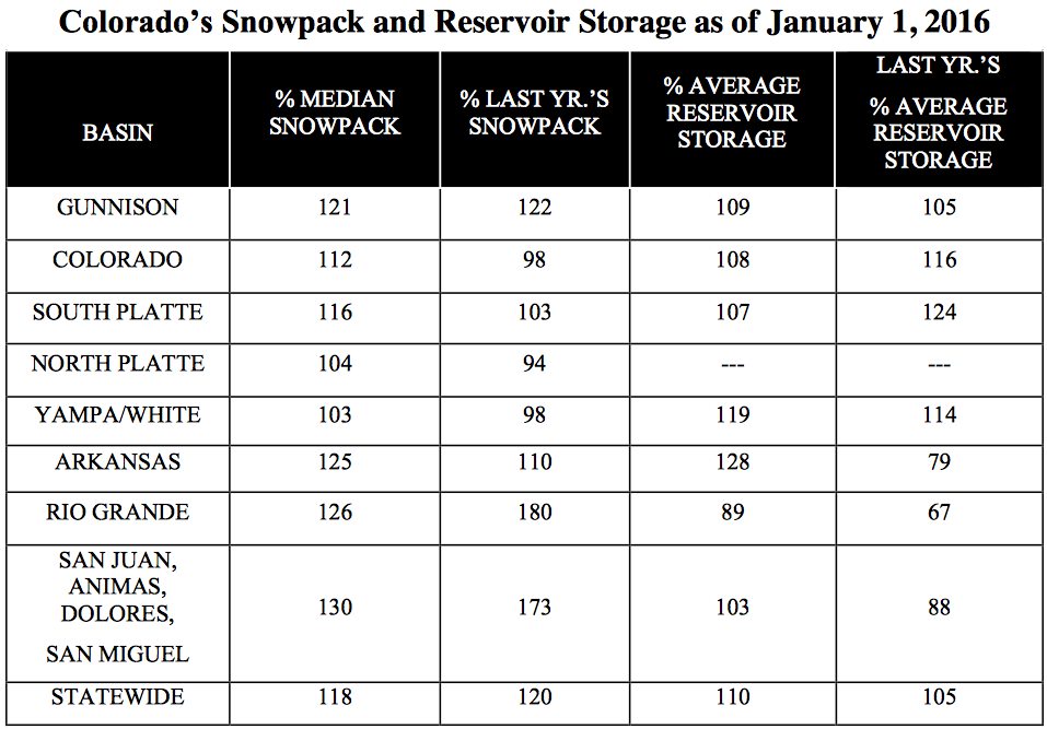
The January 1 Colorado Water Supply Outlook Report provides the first written update of snowpack in Colorado since the 2016 water year began on October 1, 2015. “Statewide snowpack is 118 percent of normal, considerably better than last year’s start” says Brian Domonkos, Colorado Snow Survey Supervisor with the USDA Natural Resources Conservation Service. In a typical year about two-fifths of the seasonal snowpack has accumulated to this point, a substantial portion of the accumulation season. Remembering last year Domonkos goes on to add, “With a sizable chunk of the winter already behind us this is a good starting point, however more than half of the winter remains”. Recapping last year, after near normal conditions on January 1, accumulation through January and early February was well below normal, a storm system in late February and early March provided a notable increase before another lull in precipitation through the rest of March and April. May, however, provided a reprieve from the dry pattern producing nearly 250 percent of average precipitation statewide.
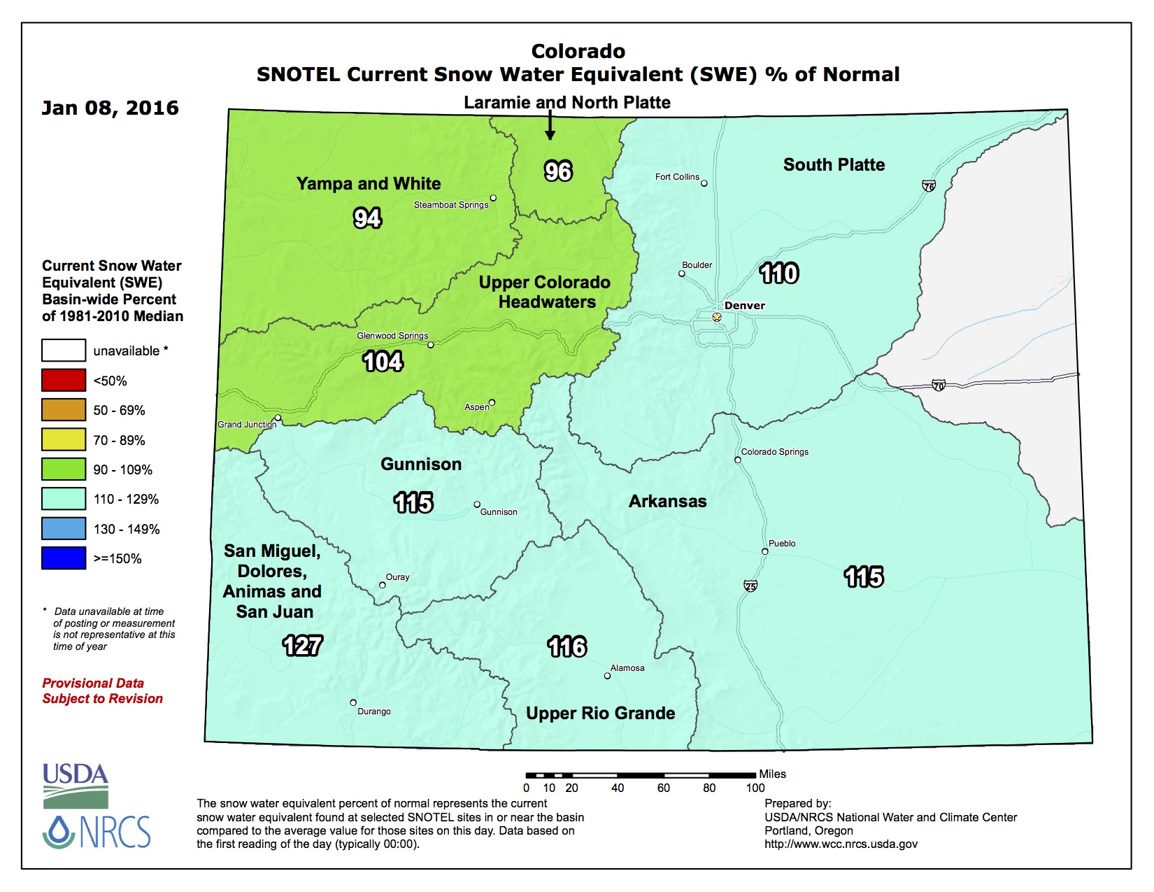
The current strong El Nino has not disappointed the state of Colorado so far in 2016, providing between 103 percent of normal snowpack in the combined Yampa and White River Basins to as high as 130 percent of normal in the combined San Miguel, Dolores, Animas, and San Juan Basins. Some past El Nino events have been known to leave the northern half of the state high and dry. However, so far nearly all watersheds have benefited from this year’s El Nino event.
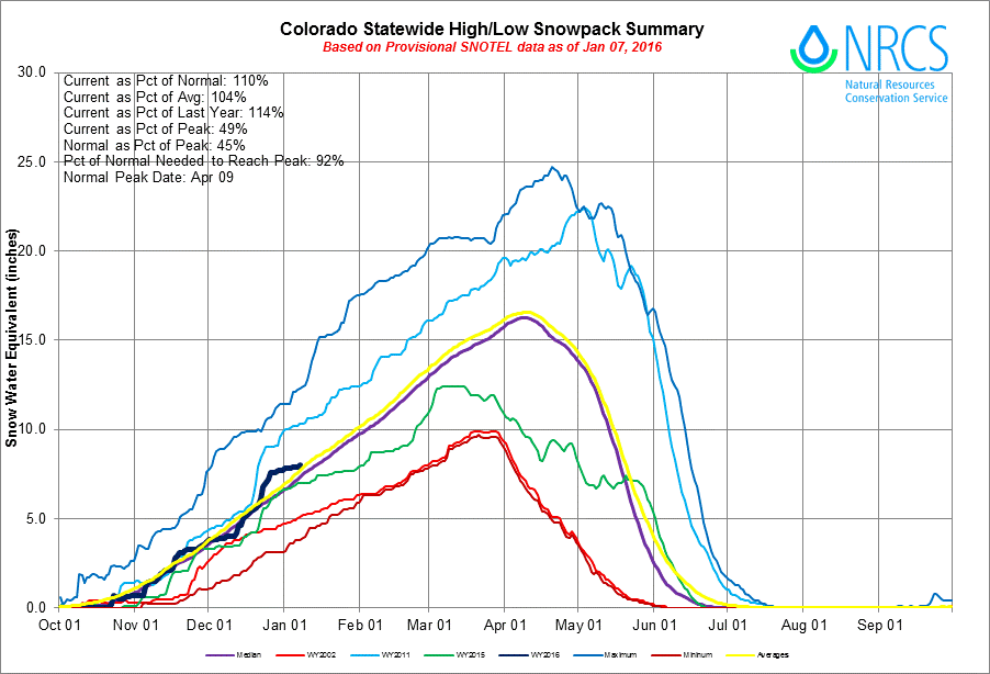
Statewide Basin High/Low graph January 7, 2016 via the NRCS
Of the 97 automated SNOTEL sites with available data, only 13 indicate snowpack is not quite up to 100 percent of normal. This does not equate to a poor start as these sites are sparse and scattered around the state. A few watersheds, including the Little Snake, Elk, Eagle, and Cache La Poudre River basins, do have slightly below normal snowpacks but are still near the median. This provides a good start for the seasonal snowpack across Colorado.
Precipitation statewide during the month of October started the water year off near normal but ramped up in November and December with monthly values of 97, 114 and 128 percent of normal, respectively. Water year-to-date precipitation is currently at 113 percent of normal. Reservoir storage is still in fair standing with help from last year’s well above average late spring precipitation. Statewide storage is 110 percent of normal where the only basin with below average total storage in the state are the combined reservoirs of the Upper Rio Grande.
While it is still early in the water supply game, streamflow forecasts are projected to be near normal for spring runoff season ranging from 80 percent of normal on the Little Snake River near Dixon to as high as 123 percent of normal Ute Creek near Ft. Garland. Snowpack is off to the best start since January 1, 2011, and the ninth best start since 1982.
Statewide Snowpack map January 8, 2016 via the NRCS