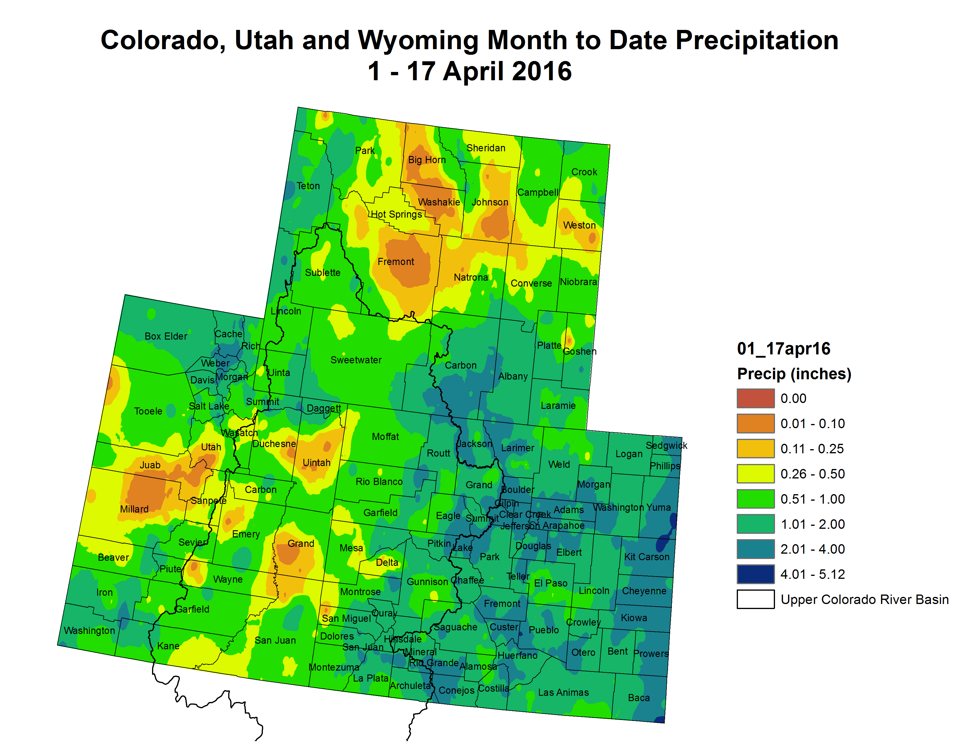
Click here to go to the US Drought Monitor website. Here’s an excerpt:
Summary
Continued dry weather in the East led to a broad expansion of abnormally dry conditions, especially from central Tennessee and Kentucky eastward and northeastward through the Appalachians and mid-Atlantic region. Meanwhile, heavy precipitation pelted the Plains, bringing significant relief to the areas of dryness and drought that had been intensifying and expanding for the previous few weeks. Out West, moderate precipitation brought improvement to some parts of the northern Rockies experiencing dryness and drought, and improvement was also noted in parts of California and adjacent areas as the impacts of the 2015-2016 wet season on the long-term drought come into clearer focus…
The Plains and Mississippi Valley
Heavy precipitation fell on large sections of the Plains and lower Mississippi Valley, bringing substantial relief to areas where dryness and drought quickly developed over the past several weeks. Locations from central and eastern Texas northward through the Dakotas recorded at least an inch of precipitation, with considerably more (3 to 9 inches) soaking parts of South Dakota, an area from central Nebraska through central and southwestern Kansas and the adjacent High Plains, and a swath from central Oklahoma through north-central Texas. Precipitation totals over the past 90 days in these regions climbed to near or above normal levels. Conditions justified 2-category improvements (from D2 [severe drought] to D0 [abnormally dry]) in small parts of northwestern Oklahoma. Wet weather also brought an end to abnormally dry conditions formerly centered in southwestern Louisiana. The beneficial rains evaded a few areas, most notably west-central Oklahoma, parts of the Texas Panhandle and adjacent High Plains, and the areas of D0 and D1 on the eastern side of the Plains extending into the middle Mississippi Valley. Precipitation for the past 60 to 90 days was only one-third to two-thirds of normal in eastern Kansas, northeastern Oklahoma, northern Arkansas, much of Missouri, and adjacent parts of Iowa and Illinois. Dryness and drought remained essentially unchanged where it existed, and D0 expanded southeastward into southern Missouri and northern Arkansas. Dry weather also prompted slight expansion of abnormally dry conditions near the Black Hills in southwestern South Dakota and adjacent Wyoming…
The Rockies and Intermountain West
The past 7 days brought little or no precipitation to the southwestern Rockies, the Great Basin, and much of Utah, keeping extant D0 to D2 conditions essentially unchanged. More precipitation fell on areas to the north and east, with 1 to locally 3 inches falling on many areas in the remainder of the Rockies and the northern Intermountain West. This removed severe drought from northwestern Montana, and reduced the extent of abnormal dryness in other parts of the state…
The Far West
Little or no precipitation fell on the areas of dryness and drought in the Far West from the southeastern fringes of Washington southward through Oregon, California, and Nevada, but with the wet season winding down (especially in California), its impact on the long-term drought situation and the conditions being set up for the summer dry season are coming into better focus. Based on improved reservoir levels (and potentially water supplies), streamflows, and to a lesser extent groundwater levels, additional improvement was introduced in the Drought Monitor, most notably in some parts of California most intensely impacted by the drought for the past few years. In a nutshell, the northward and northeastward extents of both the extreme (D3) and exceptional (D4) drought areas was reduced, including the removal of all D4 from southwestern Nevada. This is the first week since early July 2013 with no exceptional drought in the state of Nevada…
Looking Ahead
During April 21 -25, 2016, moderate precipitation totals of 0.5 to 2.0 inches with locally higher amounts are forecast for northern California, much of the Sierra Nevada, the northern tier of the Rockies and Plains, central and eastern Texas, and the central Appalachians. A few tenths of an inch at best are expected in other affected areas across the contiguous 48 states. Temperatures should average a few degrees above normal across much of the Intermountain West, Rockies, and Plains.
The odds favor above-normal precipitation across most of the contiguous 48 states and southern Alaska during April 26 – 30, 2016. There are enhanced chances for subnormal precipitation in the D0 areas in southeastern Georgia and northeastern Florida, and no tilt of the odds towards either wetness or dryness in central South Carolina and in the Big Bend region of Texas and adjacent New Mexico. Enhanced chances for warmer than normal conditions exist from the southern half of the Plains eastward to the central Appalachians and the Southeast Coast and across Alaska, but cooler than normal weather is favored in most of the Far West, the northern Plains, and the Northeast.
The City Council committed Colorado Springs on Wednesday to spend more than $460 million over 20 years on a stormwater projects pact with Pueblo County.
The intergovernmental agreement, negotiated chiefly by Mayor John Suthers, is expected to resolve Fountain Creek stormwater problems for downstream residents and avert lawsuits threatened by the U.S. Environmental Protection Agency through the Department of Justice and by Pueblo County.
Further, the accord would allow Colorado Springs Utilities’ Southern Delivery System to start pumping water as scheduled on April 27.
Pueblo County officials threatened to rescind that $825 million project’s 1041 permit, which they issued in April 2009, if the city didn’t ante up enough guaranteed funding for stormwater projects.
The deal now hinges on a vote by Pueblo County’s three commissioners, set for 9 a.m. Monday.
Any delay of the SDS would reduce the worth of warrants on equipment and work while leaving four partner communities – Colorado Springs, Pueblo West, Fountain and Security – without the water deliveries they expect.
The council, meeting in special session Wednesday, didn’t hesitate to approve the pact. Only Councilwoman Helen Collins, a steadfast foe of government spending, dissented in the 8-1 vote.
The agreement calls for 71 stormwater projects to be completed by 2035. Engineers for Pueblo County and Colorado Springs chose the projects and will review them each year to allow for fluctuating priorities.
The money will be spent in five-year increments, at a rate of $100 million the first five years followed by $110 million, $120 million and $130 million. Any private developers’ projects or other efforts would be in addition to the promised amounts.
If the projects aren’t completed in time, the accord will be extended five years. And if Colorado Springs can’t come up with the money required, the city-owned Utilities will have to do so.
The agreement was tweaked slightly Wednesday, on request of the Pueblo County commissioners, to increase one miscalculated payment to a water district by $332, to add the word “dam” to references to a study of water-control options, and to add “and vegetation” to a clause about removing debris from Pueblo’s city levees. A clause was added to note that after the agreement expires, both sides agree to coordinate and cooperate with one another, as they always will be upstream-downstream neighbors.
“This is basically an investment in this city,” said water attorney David Robbins, a consulting lawyer for the council. “The stormwater facilities would have ultimately had to be built anyway. They benefit your citizens, not just the people downstream.”
Asked about the option for a dam, Robbins said, “It has been studied, studied again, and another study may add to our knowledge, but doesn’t require this city to contribute any more money. The dam would require moving two railroads and an interstate highway. Just the facility relocation costs make it quite expensive.”
Colorado Springs has failed to properly enforce drainage regulations, conduct adequate inspections, require enough infrastructure from developers or properly maintain and operate its stormwater controls, the EPA found during inspections in August.
The downstream victim has been Pueblo County, which saw Fountain Creek sediment increase at least 278-fold since the Waldo Canyon fire in 2012, degrading water quality and pushing water levels higher, Wright Water Engineers Inc. found during a study for the county last year.
Sediment increased from 90 to 25,075 tons a year, while water yields rose from 2,500 to 4,822 acre-feet, the engineers found.
As Colorado Springs development sprawls, the amount of impermeable pavement grows. So the city also is beefing up its long-underfunded Stormwater Division, increasing the staff of 28 to 58 full-time employees, mostly inspectors, and more than doubling the $3 million budget for compliance to about $7.1 million.
The city and Utilities negotiated for nearly a year with Pueblo County, as Colorado Springs has beefed up its stormwater program to fix the problems and fend off the threats of lawsuits.
The Pueblo Board of Water Works would like to see up-front bonding and longer term for an intergovernmental agreement between Pueblo County and Colorado Springs.
Still, it’s probably the best deal possible, the board agreed during comments on the proposed deal at Tuesday’s monthly meeting.
In February, the board provided its input with a resolution recommending certain actions to Pueblo County commissioners.
Colorado Springs City Council approved the deal Wednesday, while Pueblo County commissioners will meet on it Monday. It provides $460 million for stormwater projects over the next 20 years, triggers $50 million in payments over five years for Fountain Creek dams and adds $3 million to help dredge and maintain levees in Pueblo.
“One of the things we encouraged Colorado Springs to do was bond the projects up front,” said Nick Gradisar, president of the water board. “It would be to everyone’s advantage to do the projects sooner rather than later.”
Board member Tom Autobee said the agreement is comprehensive, but was uncertain about the 20-year timeline for improvements.
“What I’d like to see is to extend it beyond 20 years for the life of the project,” Autobee said. “We need to look at that.”
Board member Jim Gardner was assured by Gradisar that Pueblo County is guaranteed a voice in which projects are completed.
“They have a priority list and can’t switch unless both sides agree, as I understand it,” Gradisar said.
“This is a great opportunity to correct the issues,” said Mike Cafasso.
“What we said got listened to,” added Kevin McCarthy. “I think this is the best deal we’re going to get.”
Colorado Springs won’t need the full use of the Southern Delivery System for years, but some can’t wait for the $825 million water pipeline to be turned on.
Pueblo County commissioners heard testimony supporting a proposed agreement with Colorado Springs designed to settle issues surrounding the City Council’s decision to abolish its stormwater enterprise after the county had incorporated it into conditions for a 1041 permit in 2009.
“One in five people in Pueblo County live in Pueblo West and are impacted by SDS,” said Jerry Martin, chairman of the Pueblo West metro board. “With the newest break, we will depend on SDS for a very long time.”
Pueblo West joined the SDS project as a costsaving alternative to a direct intake on the Arkansas River downstream of Pueblo Dam. It shared in the cost of permitting and building the pipeline.
Last summer, it used SDS when its own pipeline broke.
Pueblo West’s main supply comes from the South Outlet Works and crosses under the river. The new break is more severe, Martin explained.
An agreement reached last summer allows Pueblo West to use SDS before it is fully operational, and settled some lingering legal issues related to Pueblo West’s partnership in SDS.
Security Water and Sanitation District, located south of Colorado Springs, also needs SDS to go online before summer, said Roy Heald, general manager of the district.
“Security has an immediate need for water because there are emerging contaminant in our wells,” Heald said.
Seven of the district’s 25 wells into the Fountain Creek aquifer were found to be contaminated earlier this year. The solution is to blend water from the Arkansas River with the well water to dilute contaminants. Right now, Security gets enough water from the Fountain Valley Conduit to make its supply safe. But in summer, water demands will increase, Heald explained.
Larry Small, the executive director of the Fountain Creek Watershed Flood Control and Greenway District, said the agreement paves the way for flood control projects seven years after the district was formed.
Small was on City Council when the stormwater enterprise was abolished on a 5-4 vote. He voted against eliminating the fee that was then in place. He was hired to run the Fountain Creek district two years later. The district has representatives from both Pueblo and El Paso counties.
The district was formed by the state Legislature out of concerns about the effect of El Paso County’s growth on Fountain Creek and the danger that is posed to Pueblo.
The $460 million for Colorado Springs stormwater projects over the next 20 years is needed to slow down Fountain Creek, but that doesn’t mean Pueblo would be protected. There are at least 18 projects south of Colorado Springs involving either detention ponds or dams that the district wants to get started on.
That process would get a kick start with $20 million in the next nine months if the agreement is approved by commissioners and Colorado Springs City Council in the next week. Three more payments of $10 million over the next three years would follow under terms of the 1041 agreement.
“This agreement says that we’re not just going to put something in place, but that we’re going to monitor it,” Small told commissioners. “It’s a cooperative, collaborative process. We don’t have to rely on rumors and innuendo.”
The city of Pueblo also would benefit from a potential $6 million in Fountain Creek dredging or levee maintenance projects that would cost the city only $1.2 million over the next three years. Pueblo Stormwater Director Jeff Bailey last week told The Pueblo Chieftain that the city has projects lined up, depending on how the funds are structured.
A separate $255,000 project to dredge between Colorado 47 and the Eighth Street bridge already is in the works. It would be funded by Pueblo County, the Lower Arkansas Valley Water Conservancy District, the Fountain Creek district and the state.
For Colorado Springs, SDS is a 40-year solution to provide water both for future growth and redundancy for the major water infrastructure it already has in place. Earlier comments to commissioners from Colorado Springs officials indicated only about 5 million gallons per day initially would flow through the SDS pipeline to El Paso County. It has a capacity of 75 million gallons per day.
Colorado Springs Mayor John Suthers said warranties on the project kick in when testing on SDS is completed at the end of this month, however, so Colorado Springs also would like to see the pipeline up and running by next week.
Fountain Creek
Fountain Creek erosion via The Pueblo Chieftain
Fountain Creek swollen by stormwater November 2011 via The Pueblo Chieftain
Fountain Creek flooding 1999 via the CWCB
Fountain Creek Watershed
The confluence of Fountain Creek and the Arkansas River in Pueblo County — photo via the Colorado Springs Business Journal
The new north outlet works at Pueblo Dam — Photo/MWH Global
Greeley water officials are continuing to push a new water rate system that would provide residents with incentives to cut their consumption, and local leaders are warming up to the idea.
The Water and Sewer Board went over the plan again during its meeting Tuesday afternoon.
Today, Greeley residents pay a flat rate for water that doesn’t take into account how much they use, and regionally, that’s rare.
“Really, Greeley and Loveland are the only cities left in northern Colorado that have uniform rates,” said Eric Reckentine, the department’s deputy director of water resources.
A few cities, such as Aurora and Colorado Springs, charge their residents in uniform blocks for usage.
Greeley officials find the blocks arbitrary. Someone who irrigates a lawn that’s 1,000 square feet obviously will use more water to do so than someone who owns a 500-square-foot lawn.
Greeley is opting for a tiered water rate based on a water budget, or calculated allowance, water planners give residents. Planners use the number of people in a household and the amount of land the resident could irrigate to decide how many gallons a month each home should use. They allot 55 gallons per person per day. They give a little more than two gallons per square foot of irrigable land.
A four-person family on an average lot would get 21,000 gallons per month.
Under the new plan, the family would pay $3.88 per 1,000 gallons within the budget, and the rate would increase incrementally as the water usage exceeded the budget.
There are four tiers. If residents are within budget, using 100 percent or less of the allotment, they get the reduced rate. If use falls between 100 and 130 percent of the allotment, it’s considered inefficient use, and it will cost $4.74 for each 1,000 gallons in that range. If residents keep overusing and get into the 130-150 percent of their allotment range, they’ll pay $6.04 for that segment. If they get past 150 percent of their allotment, that will cost $8.62 for every 1,000 gallons.
The extra cost didn’t come in increments when city officials first heard the plan in February. Anything outside the budgeted water was charged at the highest tier a resident hit.
“You paid that amount for all of it,” Mayor Tom Norton said during an interview. “It was kind of more of a punishment.”
Greeley and water department officials said the goal was to recover costs for overuse, which is about 300 acre-feet every year. An acre-foot of water is how much an average family uses in a year.
“That’s several million dollars worth of water,” Water Board Chairman Harold Evans said.
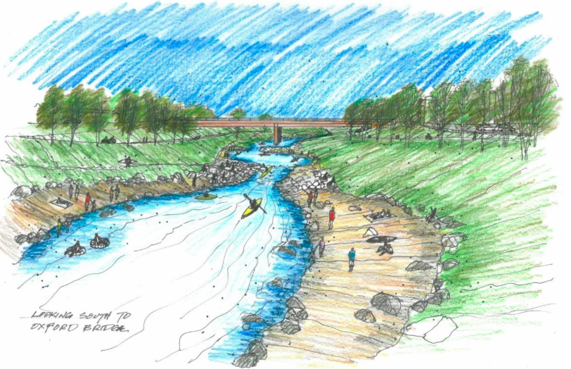
Local officials are anticipating the summer opening of a park along the South Platte River that will provide some fresh opportunities for a cooldown.
River Run at Oxford will be a multifaceted park and trailhead offering access to the metro area’s river, improved riparian habitat and unique recreational and educational opportunities officials hope will make it a regional draw.
The site is just west of Broken Tee Golf Course, along West Oxford Avenue on the Sheridan-Englewood border. When the first phase of the estimated $14 million project opens this summer, it will bring a rocky beach, in-water recreation features and a picnic pavilion with flush-toilet bathrooms to the east bank of the Platte, as well as improvements to ensure safer flood flow passage and a state-of-the-art sand filter for water running into the river.
“The point of this project was to engage the river for recreation but also from an ecological and function standpoint, as well as education,” said Laura Kroeger, an engineer with Urban Drainage and Flood Control Districtand manager of the River Run project.
Last week, earth movers shuffled boulders along the river bank as crews with contractor Naranjo Civil Constructors worked on a pair of drop structures that will create features for kayaking, paddleboards or inner tubes. One of the structures includes an adjustable concrete plate that can create a standing wave, a feature that Kroeger said exists only in one other place in the country, to her knowledge.
“Right now, if you want to kayak or play in the river , you would need a flow of about 1,000 (cubic feet per second) and that might only happen a few days a year,” she said of water flows required for river recreation. “With this, we can adjust the drop structure based on the release from Chatfield Reservoir to get more use. It’s designed for 200 cfs.”
River Run is about half a mile from the Oxford Avenue light-rail station and a short walk from the Englewood Recreation Center. The golf course is nearby and its parking lot has grown by 70 spaces to accommodate future River Run visitors.
Englewood has publicly accessible water at the lake at Centennial Park, but city open space manager Dave Lee said, “I think river access is the big thing we’ve never had before.”
“That’s one of the reasons people want to live in Colorado — for these unique opportunities,” added Dorothy Hargrove, Englewood’s director of parks, recreation and library.
The project continues to evolve. Kroeger said partners are pursuing funding to add safety signs as well as educational information to help teachers from area schools who could bring students to River Run to learn about riparian habitat.
River Run has two future phases: completion of a trail along the east side of the Platte, connecting it to the Big Dry Creek Trail near Union Avenue; and additional upstream flow improvements. It should conclude in 2018, Kroeger said.
Kroeger and others applauded the collaboration that went into the large-scale project. Aside from the cities and Urban Drainage, the South Suburban Parks and Recreation District, the Colorado Water Conservation Board and Arapahoe County Parks and Open Space are partners.
Arapahoe County Open Spaces grants and acquisitions manager, Josh Tenneson, said that collaboration dates to 2006 when the 21-member South Platte Working Group was convened. The group has allocated more than $25 million to various projects, including recent work at Littleton’s South Platte Park and the upcoming Reynold’s Landing Park project. All told, the county has dedicated around $5 million to River Run, he said.
Sheridan recently secured a $350,000 Great Outdoors Colorado grant to build a playground at the River Run trailhead. Sheridan City Manager Devin Granbery said he could see the park delighting city residents and boosting business at the city’s marquee shopping area, nearby River Point at Sheridan.
“I think it will serve as a regional draw similar to the way that (Denver’s) Confluence Parkdraws users into that area,” Granbery said. “Hopefully, after people use the amenities there, they’ll eat at a Sheridan restaurant or do some shopping.”
At the risk of sounding like a broken record, March set another heat record for the globe. As Earth continues to warm and is influenced by phenomena such as El Niño, global temperature records are piling up.
For 2016 year to date (January-March), the average temperature for the globe was 2.07 degrees F above the 20th-century average, according to scientists from NOAA’s National Centers for Environmental Information. This was the highest temperature for this period in the 1880–2016 record, surpassing the previous record set in 2015 by 0.50 degrees F. The globally averaged sea surface temperature for the year to date was also highest on record, surpassing the same period in 1998 by 0.42 degrees F, the last time a similar strength El Niño occurred.
For March, the average temperature for the globe was 2.20 degrees F above the 20th century average. This was not only the highest for the month of March in the 1880-2016 record, but also the highest monthly temperature departure among all months on record, surpassing the previous all-time record set last month by 0.02 degrees F. March also marked the 11th consecutive month a monthly global temperature record has been broken, and is the longest such streak in NOAA’s 137-year climate record.
The Arctic was also impacted by record global heat. Arctic sea ice reached its maximum extent for the year at 5.61 million square miles March 24, the lowest annual maximum extent in the satellite record. This was 431,000 square miles below average and 5,000 square miles below the previous record from 2015.
More: Find NOAA’s reports and download images by visiting the NCEI website.
Recently, I was fortunate enough to moderate a panel at the American Bar Association’s 34th annual Water Law Conference, which took place in Austin, Texas. The panelists were fantastic: Pat Mulroy, the former General Manager of the Southern Nevada Water Authority who now holds a number of positions, including Senior Fellow with the UNLV Boyd School of Law and Brookings Institution; Robert Puente, the President and CEO of the San Antonio Water System; and Vail Thorne, Senior Environmental Health & Safety Counsel with Coca-Cola. This week’s podcast is the Q&A session from that conference – a big thanks to the ABA and to each panelist for allowing the session to be recorded and released as a podcast. Listen in for terrific insights from these tremendous panelists.
In this session, you’ll learn about:
The importance of non-revenue water as a conservation measure
Water conservation and its use as a tool for system growth
Challenges faced by utilities as a result of conservation
How companies use conservation to further their social license to operate
How technology affects water conservation
Governance and a common problem often faced by utilities in sustaining their business model
Challenges utilities face when implementing green infrastructure
The importance of education when implementing a water conservation program
LOVELAND – Mike King, the new director of planning for Denver Water, said at a recent meeting that beyond additional transmountain diversions through the Moffatt Tunnel into an expanded Gross Reservoir near Boulder, Denver Water doesn’t have other Western Slope projects on its radar.
King served as executive director of Colorado’s Department of Natural Resources from 2010 until January of this year, when he took the planning director job with Denver Water.
After speaking to a luncheon crowd of close to 200 at the Northern Water Conservancy District’s spring water users meeting in Loveland on April 13, King was asked from the audience “How much more water does Denver Water need from the Western Slope?”
“I think if we get Gross Reservoir approved, the answer is for the foreseeable future, you know, we need to do that first,” King said.
King is a native of Montrose, son of a water attorney, and has a journalism degree from CU Boulder, a law degree from the University of Denver, a master’s in public administration from CU Denver and 23 years of state government experience.
“And I can tell you that the reality is, whether it is from a permitting perspective or a regulatory perspective, the West Slope is going to be a very difficult place,” King continued. “If there is water available, it is going to be a last resort. And I so think that the answer is, that won’t be on our radar.”
Denver Water is seeking federal approval to raise the dam that forms Gross Reservoir, in the mountains west of Boulder, by 131 feet. That would store an additional 77,000 acre-feet of water and bring the reservoir capacity to 118,811 acre-feet. Ruedi Reservoir, by comparison, holds 102,373 acre-feet.
The $360 million project would provide 18,000 acre-feet of firm yield to Denver Water’s system and result in an additional 15,000 acre-feet of water being diverted from the West Slope each year. On average, Denver Water’s 1.3 million customers use about 125,000 acre-feet of West Slope water each year.
The water to fill an expanded Gross Reservoir would mainly come from tributaries of the Fraser and Williams Fork rivers, via the Moffat Tunnel, near Winter Park.
Beyond the Gross Reservoir project, King explained that any future Denver Water projects on the West Slope would need to fit within the confines of the Colorado River Cooperative Agreement, signed by Denver Water and 17 West Slope entities in 2013.
The CRCA, says that “if there is more water, it only comes after the West Slope says they agree with it and it makes sense,” King said. “That sets the bar so incredibly high and gives them the ultimate ability to say, ‘This is good for the West Slope.’
“And so I just don’t think Denver Water is going to be looking to the West Slope,” King continued. “I think anybody who manages natural resources, and water in particular, will never say ‘never’ to anything, but I think it is certainly not on our radar.”
Not on Denver Water’s radar, perhaps, but it is worth noting that Denver Water is the only major Front Range water provider to have signed the cooperative agreement with the West Slope.
When asked what he thought of King’s remarks about West Slope water, Eric Kuhn, the general manager of the Colorado River District said he thought the comments reflect “the concept that if Denver takes more water from the West Slope it could undermine the security/reliability of what they already take.”
Kuhn’s comment relates to the possibility that if Denver Water diverts too much water from the Western Slope, it could help trigger a compact call from the lower basin states, which could pinch Denver’s transmountain supply of water.
Editor’s note: Above is a recording of Mike King, the director of planning for Denver Water, speaking after lunch in front of about 200 people at Northern Water’s spring water users meeting, a public meeting held at The Ranch event center in Loveland on Wednesday, April 13, 2016. The recording, made by Aspen Journalism, begins shortly after King had begun his remarks. It is 26:34 in length. At 8:20, King discusses the development of the Colorado Water Plan. At 22:40, King answers a question about the governor’s endorsement of the Windy Gap project and another phrased as “How much more water does Denver Water need from the Western Slope?”)
A buoyant crowd
Earlier in the meeting engineers from Northern Water — which supplies water to cities and farms from Broomfield to Fort Collins — told the mix of water providers and water users from northeastern Colorado that they could expect an average spring runoff this year, both from the South Platte and the Colorado Rivers.
They were also told that Northern Water was making progress on its two biggest projects: the Windy Gap Firming Project, which includes construction of Chimney Hollow Reservoir near Berthoud; and NISP, the Northern Integrated Supply Project.
NISP includes two new reservoirs, Glade and Galeton, to be filled with East Slope water from the Cache La Poudre River, which runs through Fort Collins and into the South Platte River.
Just before lunch, John Stulp, the special policy advisor on water to Gov. John Hickenlooper, read a surprise letter from the governor endorsing the Windy Gap project, which would divert an additional 9,000 acre-feet of water each year, on average, from the upper Colorado River and send it through a tunnel toward Chimney Hollow.
Windy Gap is part of the Colorado-Big Thompson Project, which diverts on average 260,000 acre-feet a year from the Western Slope.
The Windy Gap project does include environmental mitigation measures for the sake of the Colorado River, and has approval from the required state agencies and Grand County, but it still needs a permit from the U.S. Army Corps of Engineers.
Looking east toward the Chimney Hollow Reservoir site, which is just this side of the red ridge. On the other side is Carter Lake Reservoir and beyond that, the Loveland area.A graphic from Northern Water showing the lay out of Windy Gap Firming Project.
A political risk
After lunch, King shared some insights from his old job as head of the state’s department of natural resources.
“I think it’s important that you understand what the development of the state water plan looked like from the governor’s perspective and the state’s perspective,” King told his audience.
As head of DNR, King had oversight over the Colorado Water Conservation Board, which was specifically tasked by the governor in late 2013 to produce the state’s first-ever water plan, and to do so in just two years.
King said that he, Stulp and the governor knew that a water plan in Colorado could be “the place where political careers went to die.”
“So the thing we had to make sure that came out of this, knowing that we weren’t going to solve the state’s water issues in two years, was that we had to do this in a manner that politically, this was viewed as a big win, and that future governors and future elected officials would say, ‘We need to do this again and we need to continue this discussion,’” King said.
“Not because the governor needed a political win,” King added, “but because to have the next stage of the water plan, to have the discussion in five years, you can’t have an albatross around this, and I think we were able to do that, and so we’re very proud of that.
“If we had a political mushroom cloud, no one would have ever touched the Colorado Water Plan again,” King continued. “That meant we aimed a little bit lower than maybe we would have liked, and I’ve gotten this at Denver Water, talking about lost opportunities in the Colorado Water Plan. Maybe we did aim just a little bit lower than we should have.”
King said the state was not able to “reconcile the inherent conflicts” in the various basin implementation plans, or BIPs, that were put together by regional basin roundtables as part of the water planning process.
And he acknowledged that the plan has been criticized for not including a specific list of water projects supported by the state, and for reading more like a statement of problems and values than a working plan.
“One of things that has been driven home to me time and time again in the two months that I’ve been at Denver Water is that planning is not something you do every five or six years,” King said. “Planning is a continuous process.”
King also said that there were some “tremendous successes” in the water plan, including the basin implantation plans, or BIPs, even though they sometimes conflicted.
“We got BIPs from every single basin,” King said. “The basins turned over their cards and said ‘This is what we need.’ So now we have a major step forward.”
Other plan elements
King said other successes in the Colorado Water Plan include the stated goal of conserving 400,000 acre-feet of water by 2050 and a nod to changing land use planning in Colorado.
King said tying land use to water availability “was something we never discussed in Colorado because it infringed on local control and it was just kind of a boogieman in the room.”
But he pointed out that “the vast majority of the basin implementation plans said, expressly, ‘We need to have this discussion’ and ‘We need to start tying land use to water availability,’” King said. “That’s a good thing. That’s a major step forward.”
When it comes to land use and Denver Water, King said driving down the per capita use remained a high priority and that if Denver proper grows, it is going to grow up through taller buildings, not by sprawling outward.
King also said Denver Water was working to manage, and plan for, the already apparent effects of climate change, especially as spring runoff is now coming earlier than it used to.
“We know that the flows are coming earlier, we know that the runoff is coming earlier,” King said, noting that reality is causing Denver Water to plan for different scenarios and ask questions about storage and late summer deliveries of water.
“For us, the most immediate thing is, is that we know it’s getting warmer,” King said. “In the last 20 years we’ve seen that, the way the [run offs] are coming earlier. We know we’ve had catastrophic events that are incredibly difficult for us to manage. And so we’re trying to work through that.”
Editor’s note: Aspen Journalism, the Aspen Daily News and Coyote Gulch are collaborating on coverage of rivers and water. The Daily News published this story on Wednesday, April 20, 2016.
The Longmont City Council reached a consensus Tuesday night — they would rather the city pay roughly $47 million in cash instead of using debt for a portion of the Windy Gap Firming Project.
Water rates are set to increase by 9 percent in 2017, 2018 and 2019, then 8 percent in 2020 and 2021, said Dale Rademacher, general manager of public works and natural resources.
Paying cash for Windy Gap is cheaper for the city in the long run, but staff estimates it will raise water rates by 21 percent in 2017 and then by another 22 percent in 2018, rather than the planned 9 percent. Debt financing would have cost almost $25 million more in the long term with a predicted 5 percent interest rate but resulted in more gradual rate increases between 5 and 14 percent in the short term…
City Manager Harold Dominguez said there are plans in the works to test utility rate discounts for low-income households. To qualify, a single Longmont resident would need to make less than $12,720 in a year or a married couple would need to earn less than $17,146 in a year, although those limits could have adjusted slightly since the test program was introduced.
The City Council also directed Rademacher to explore alternative financing so the entire burden of the $47 million doesn’t fall on ratepayers. There’s a Windy Gap surcharge on new water taps that sunsets at the end of 2017. Councilmembers said they’d rather the surcharge just stayed in place in order to generate funds for the Windy Gap project.
Additionally, a property owner can either transfer non-historical water rights to satisfy a raw water requirement or pay cash-in-lieu. Staff will study limiting it to cash payment only in order to pay for Windy Gap.
Meanwhile, here’s the view from Grand County (Lance Maggart):
The long awaited development of Northern Water’s Chimney Hollow Reservoir cleared one of the final two hurdles on the road to construction in late March when the Colorado Department of Public Health and Environment (CDPHE) released its 401 water quality certification for the project, generally referred to as the Windy Gap Firming Project (WGFP).
The issuance of the 401 water quality certification from the CDPHE was one of two final steps in the permitting process required for construction on the project to begin. The 401 certification from the state comes after 13 years of work. According to Northern Water’s Public Information Officer Brian Werner Northern Water began the formal permitting process for the development of Chimney Hollow Reservoir in 2003. Since beginning the formal permitting process Northern Water and other participants have spent roughly 15 million dollars on the projects permitting process.
Now that Northern Water has received their 401 certification from the state the municipal water provider is awaiting a 404 wetlands permit from the US Army Corp of Engineers, the final permitting step before construction can begin on Chimney Hollow.
404 WETLAND PERMITS
As a matter of practice 404 wetlands permits from the Corp of Engineers require issuances of state certifications, like the CDPHE 401 water quality certification, before the Corp of Engineers can complete their own permitting processes. “This is the next to the last step in getting the project permitted,” stated Project Manager Jeff Drager.
Officials at Northern Water said they expect the 404 wetlands permit is forthcoming and anticipate its issuance in the next few months. Werner was quick to point out that Governor John Hickenlooper has officially endorsed the project, a first in the history of the state according to a press release from Northern Water highlighting the endorsement.
“Northern Water and its many project partners have worked diligently, transparently and exhaustively in a collaborative public process that could stand as a model fro assessing, reviewing and developing a project of this nature,” stated Hickenlooper in a letter read at Northern Water’s Spring Water Users meeting in Loveland last week by the Governor’s Water Policy Advisor John Stulp.
Once Northern Water has secured the final permit for the project from the Corp of Engineers work on Chimney Hollow Reservoir can begin. Chimney Hollow is eventually expected to store 90,000 acre-feet of water and will be located just west of Carter Lake Reservoir in southern Larimer County. The development of the reservoir will mean additional water diversions out of Grand County. The total estimated price tag for the WGFP is around $400 million.
ENDORSEMENTS
Despite environmental concerns produced by the additional diversions both Grand County and the conservation group Trout Unlimited have endorsed the project, following sustained negotiations between Northern Water and various stakeholders from the western slope regarding environmental mitigation and adaptive management plans for the Colorado and Fraser Rivers. A press release from Trout Unlimited praised the river protections that were reaffirmed with the state 401 certification.
“We strongly believe these permit conditions establish a strong health insurance policy for the Upper Colorado River,” stated Mely Whiting, counsel for Trout Unlimited. In their press release Trout Unlimited outlines conditions within the 401 certification the organization feels will address both fish habitat issues and water quality needs including: monitoring of stream temperatures, key nutrients and aquatic life, providing periodic “flushing flows” to cleanse the river during runoff and requiring ongoing monitoring and response if degraded conditions are detected.
The 401 certification and the environmental protections included with it were made possible in part from a more collaboratively minded interaction between west slope stakeholders such as Grand County and Trout Unlimited and east slope diverters Northern Water and Denver Water. “This long-term monitoring and flexibility of response is called ‘adaptive management’ and it’s a critical feature of the permit requirements,” stated Whiting. “Adaptive management recognizes that stakeholders can’t foresee every problem, and it provides a process for ongoing monitoring and mitigation of river problems as they arise.”
Grand County local Kirk Klancke is the president of the Colorado Headwaters Chapter of Trout Unlimited and has long championed the health of both the Fraser and Colorado Rivers. Klancke spoke positively about the adaptive management and collaborative spirit that has made negotiations for the WGFP possible. “We wouldn’t be at this point without the leadership of Grand County and their persistent efforts to improve the health of the Colorado River,” stated Klancke. “The Northern subdistrict also deserves credit for listening to our concerns and working with all stakeholders to find solutions.”
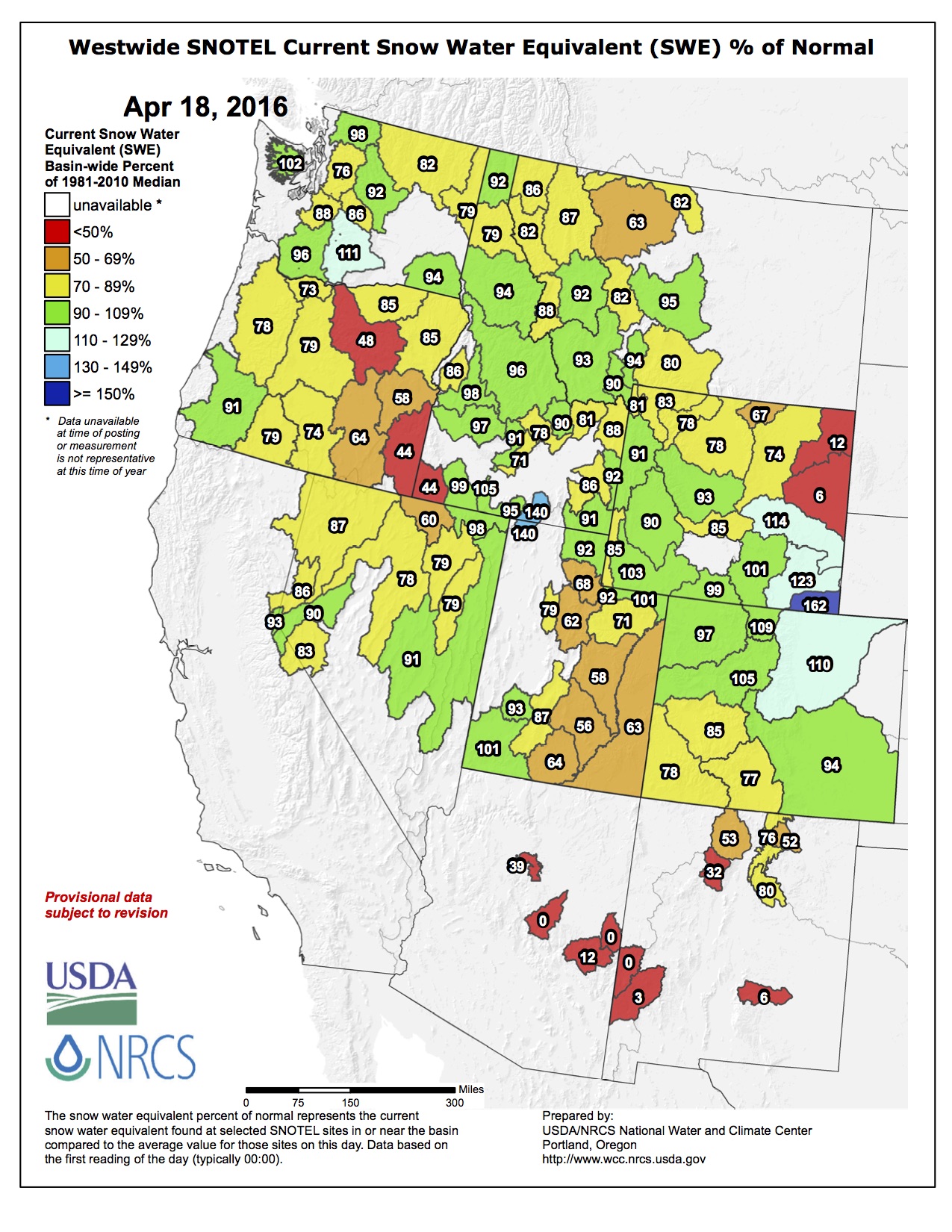
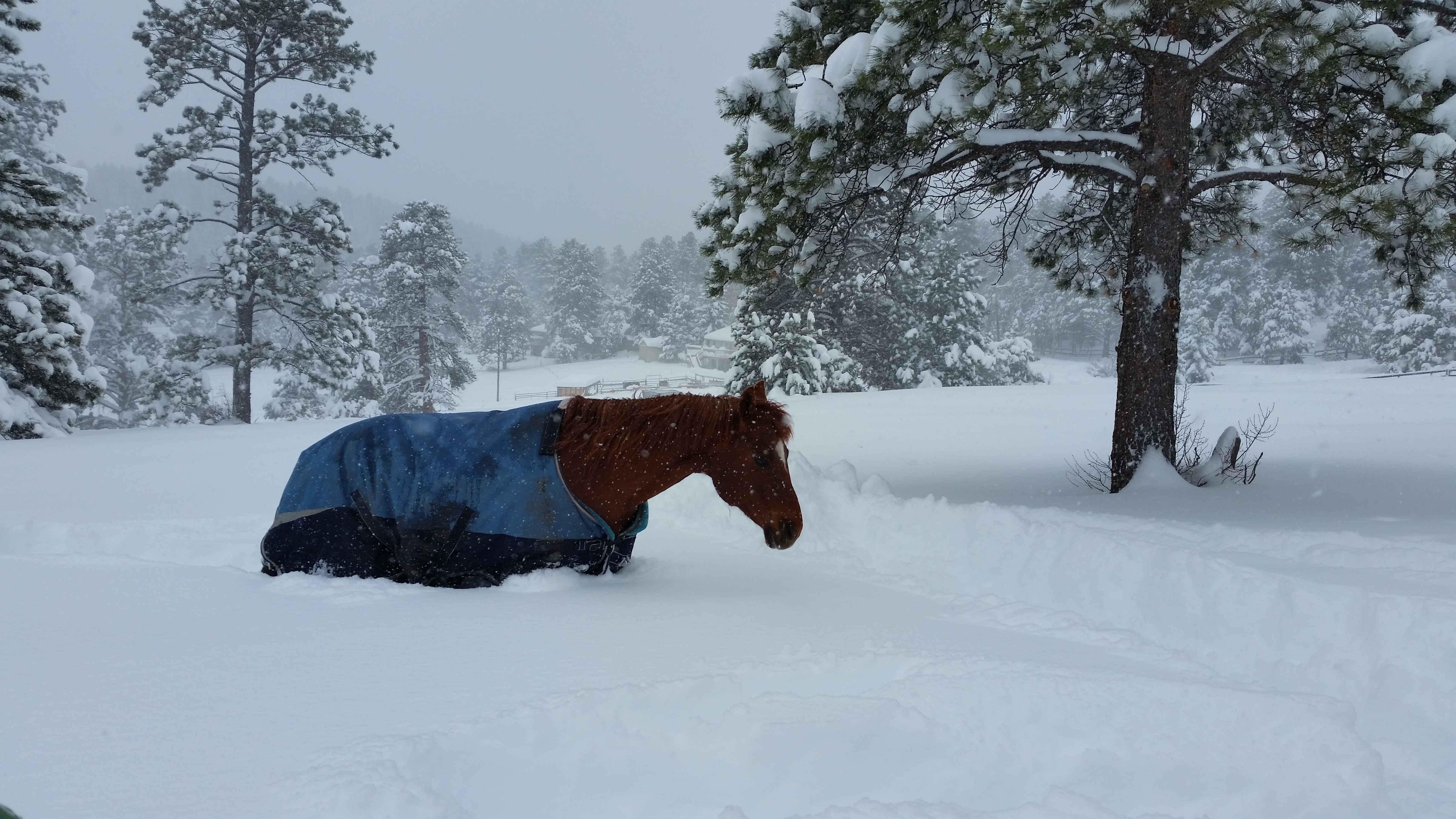
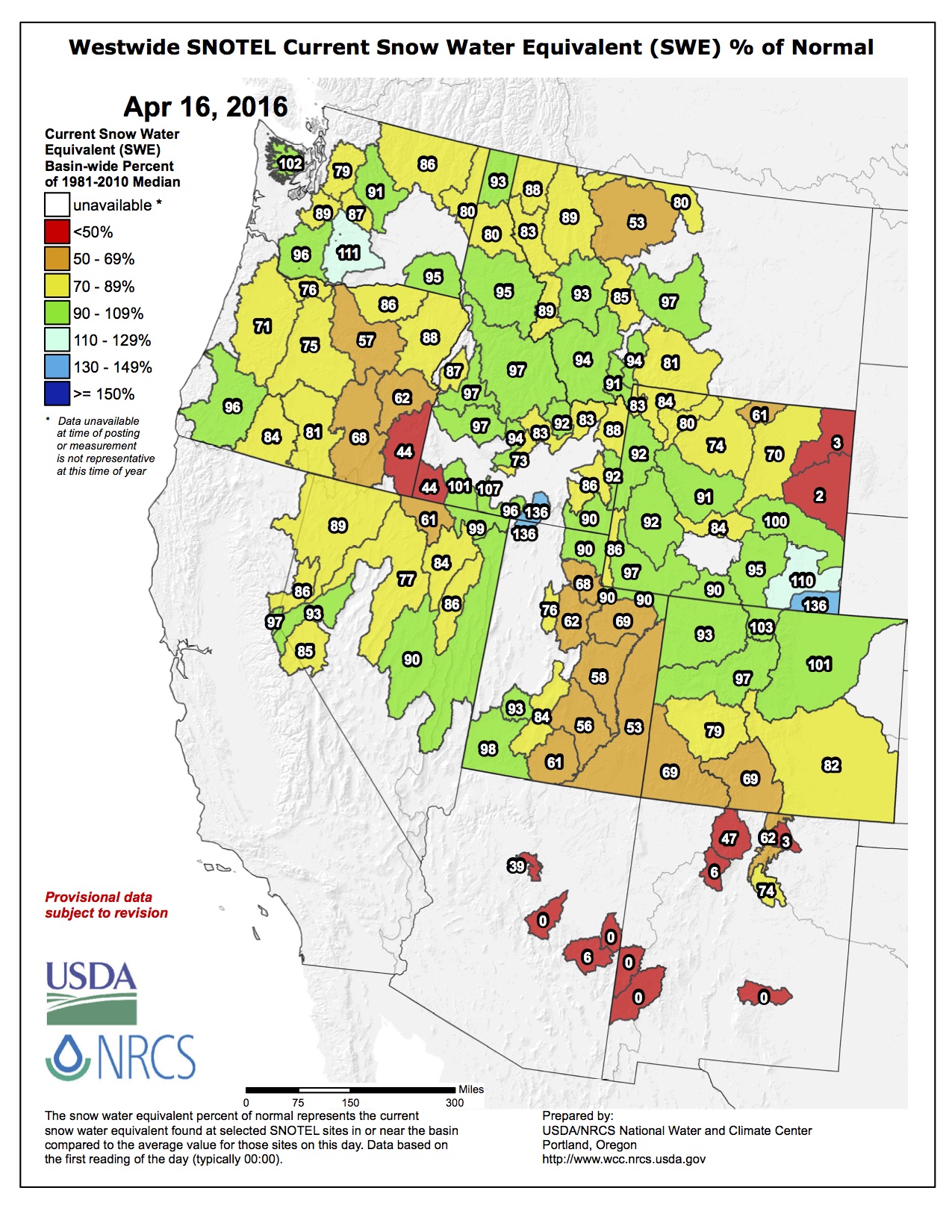
Last weekend’s snow was wet and heavy enough to snap trees, but a welcome relief for dry conditions in parts of the state.
Nearly all of the Arkansas River basin received 1-2 inches of moisture from the recent storms, bringing the year-to-date totals above average for the area. Pueblo received more than 1.5 inches of rain in the last week to bring the year’s total to more than 3 inches, according to the National Weather Service.
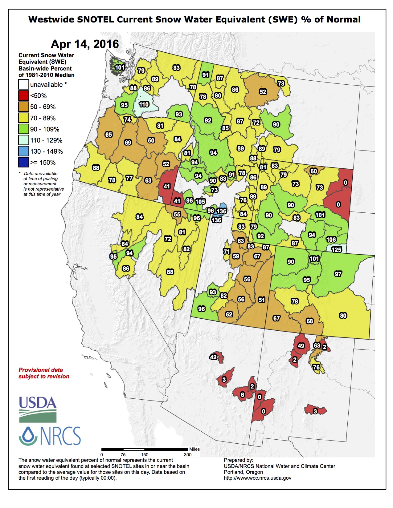
It was good news for Colorado’s snowpack in most basins, bringing the state up to 98 percent of median.
While the Southwest, Gunnison and Rio Grande basins remain below the median, the remainder of the state is at or above normal just as the peak day for snowpack in most places — mid-April — arrived. Prior to the weekend snow, most places had been lagging.
A range of 2-4 feet of snow fell in the mountain areas, with lower elevations in Chaffee and Lake counties reporting up to 2 feet of snow. Parts of Pueblo County got about 1 foot of snow, which was welcome, but caused some damage.
Dave Van Manen, ranger for Pueblo Mountain Park in Beulah, posted on Facebook a poetic tribute to one of his favorite trees that fell victim to the storm: “The ‘leaning tree’ — the large ponderosa pine at the start of the Tower Trail in Pueblo Mountain Park — succumbed to the weight of this weekend’s heavy wet snow. I have spent many, many hours in the company of this amazing tree. The words of Henry David Thoreau come to mind, ‘I frequently tramped 8 or 10 miles through the deepest snow to keep an appointment with a beech-tree, or a yellow birch, or an old acquaintance among the pines.’ In my mind, this tree will always be there at the start of the Tower Trail. — Ranger Dave.”
Water managers, who are hard-eyed realists when it comes to snow, might have a different take. The snowpack in the Upper Colorado and Upper Arkansas River basin is now at 120-140 percent of median in terms of water content, assuring a healthy supply once spring runoff begins.
Water from the Upper Colorado River basin supplies transmountain diversion projects such as Twin Lakes and the Fryingpan- Arkansas Project that bring water into the Arkansas River basin each year.
Storage in the Arkansas River basin remains nearly full, so continued wet weather this spring could mean water held in reservoirs may need to be released. At Lake Pueblo, water managers lowered the level successfully to meet an April 15 deadline in order to leave enough space for flood protection.
The Lower Arkansas Valley, which had been moving into drought conditions, received about an inch of precipitation and sometimes more from the rainy weather that began Saturday. That moisture will benefit winter wheat that was sown last fall and improve soil moisture for the coming growing season.
The massive spring storm has delivered in a big way to Winter Park Resort, which has picked up 23.5 inches of fresh powder over the last 48 hours with more on the way. The new snow sets up stellar late-season conditions and there’s still plenty of time to enjoy it as Winter Park closes on April 24 and Mary Jane closes on May 7.
Reports around Englewood listed snowfall depths varying from six to a little more than 10 inches. While the snowfall made a pretty picture, the water-heavy snow did result in many owners finding broken branches and damaged bushes in their yards…
“The heavy, wet snow broke some tree limbs in our parks,” said Jerry Barton, Englewood Parks supervisor. “I think we saw the most tree damage in Romans and Duncan parks.”
He said the crabapple trees got hit hard because the leaves were out and the pink blossoms had already bloomed. He said many of the pear trees on corners on South Broadway also suffered damage.
Two parks maintenance crews were out April 18. The crew in Romans Park on West Floyd Avenue was using a small chain saw to trim and take down many of the broken limbs. Crew member Jake McClure said they would have to get the larger chain saw as the broken limbs on many of the crabapple trees were too large to try to cut with the small chain saw.
Federal and state officials have agreed in principle to a $6 million settlement with a mining company to recover cleanup costs at the Superfund site just north of town.
A proposed consent decree with Denverbased CoCa Mines was filed in U.S. District Court in Denver Thursday.
The proposal would still be subject to a 30-day public comment period and the approval of the court.
Through last June, the U.S. Environmental Protection Agency had spent $10 million on the Nelson Tunnel/Commodore Waste Rock Pile Superfund site.
More than half of that money went toward the stabilization of the waste rock pile and the reinforcement of the West Willow Creek channel that runs along side it during an emergency response in 2008 and 2009.
In a complaint filed the same day as the proposed consent decree, EPA alleged that a company operating under a joint venture partnership with CoCa had sent 500 tons of mine waste onto the waste rock pile and contributed to its destabilization.
The complaint also alleged that CoCa inherited liability for the site when it bought out its former partner in 1989 and thereafter failed to conduct cleanup.
CoCa Mines owned and operated in an area that’s now part of the Superfund site from 1973 to 1993.
Cleanup work at the Superfund site has come to a halt while EPA conducts a feasibility study on potential remedies for the Nelson Tunnel, which is responsible for the majority of the contaminants in West Willow Creek.
One potential option would involve the dewatering of the collapsed tunnel, although it would be dependent upon the initiation of mining by Rio Grande Silver at the nearby Bulldog Mine. The tunnel, completed in 1902, was used to drain and ventilate mines along the Amethyst vein, while also providing a route to haul ore out of the mines.
About 47,000 Colorado Springs Utilities customers are being notified that a water quality standard has been exceeded at the Fountain Valley Authority’s water treatment plant.
Those customers get a blend of water from Utilities and the FVA, but the exceedance of Total Organic Carbon does not pose a health threat, Utilities advises.
Leaves, sticks, dirt and other substances washed into the Pueblo Reservoir, where the FVA gets its water, during heavy rains over the past two years.
The excessive levels of TOC occurred temporarily in the first quarter of 2016, Utilities reports. Although the TOC exceeded standards, it “does not pose an immediate health risk and is not an emergency,” Utilities said in a news release.
A standard is set for TOC because it can lead to formation of disinfection byproducts, which can have adverse health effects. Those byproducts include trihalomethanes and haloacetic acids.
Both byproducts are below drinking water standards and thus pose no health risks, Utilities reports.
The FVA also supplies water to Security, Widefield, Stratmoor Hills and Fountain through their water districts, which are responsible for alerting their customers.
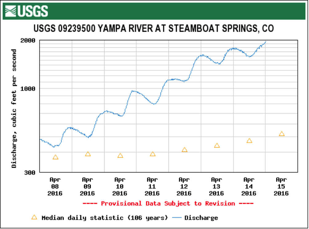
The last time the community funded a Yampa River management plan, in 2004, it was all about balancing the health of the town stretch of the Yampa with recreation. More than a decade later, plans are underway for a new river management plan, and this time, there is more emphasis on protecting the health of the river to help ensure ample water for the community in times of drought.
“In part, this is an update of the 2004 plan. But it’s more of a streamflow management plan, where we’ll be looking for target flows that support aquatic life and water quality,” city of Steamboat Springs Water Resources Manager Kelly Heaney said Tuesday after meeting with Routt County officials. “It’s almost like a drought resiliency plan for the river.”
And the new study will take in a longer stretch of the river — from the Chuck Lewis State Wildlife Area downstream to the city’s wastewater treatment plant west of town.
The Routt County Board of Commissioners agreed Tuesday to earmark $5,000 in its 2017 budget for a contribution toward a 50 percent local match of a $51,875 grant to fund the new management plan. The grant is part of $1 million allocated to the Colorado Water Conservation Board in accordance with one of the measurable objectives in Colorado’s landmark 2015 state water plan…
The [Colorado Water Plan] set the goal of covering 80 percent of a list of locally prioritized rivers with new stream management plans by 2030.
Heaney told the BOC that, with this grant, the Yampa will be among the first in the state to be the subject of such a study.
There is a plan underway on the Crystal River (upstream from Carbondale), Aspen and Pitkin County have begun work on a plan for the Roaring Fork and plans are in the works for the Colorado River and the San Miguel on the western side of the San Juan Mountains, Heaney reported.
“We’re kind of like pioneers, along with them,” she said.
Heaney said the Colorado Water Trust, which has, in the past, facilitated efforts to secure supplemental summer flows for the Yampa in drought years such as 2002 and 2012, will participate in the study. In 2002 and 2012, Colorado Parks and Wildlife placed a voluntary ban on fishing on the town stretch of the Yampa, because the shallow flows were too warm to hold desirable levels of dissolved oxygen for trout.
Water temperature and dissolved oxygen will be a part of the new river study, which will include a streamflow management plan meant to manage for target flows that support both aquatic life and water quality, Heaney said.
“We’re working with the Colorado Water Trust to get us to a place where we have a sustainable plan,” Heaney said.
The Water Trust will undertake a legal analysis of the city’s water rights and advise on different strategies to make the best use of them, she said. For example, strategies could include securing storage contracts, stream improvement projects and re-timing flows through wetlands.
AWRA 2016 Symposium Schedule
7:30am – Registration and Continental Breakfast
8:30am – Introduction and Welcome
Katie Melander, AWRA CO President
Laurna Kaatz, AWRA CO President-Elect
8:50am – Colorado Foundation for Water Education
9:0am – KEYNOTE PRESENTATION
Mike King, Director of Planning, Denver Water
9:45am – Break
10:00am – Morning Session
Title: Water Planning in the West
Moderator: Laurna Kaatz, Denver Water
Collaboration is Key: The Arkansas Basin Watershed Health Process – Gary Barber
Connecting Silos: Land and Water Use Integration in Colorado – Kevin Reidy, State Water Conservation Technical Specialist, CWCB
Integrated Water Supply Planning in Colorado – A Tale of Two Cities – Enrique Triana, MWH
When Water Gets Murky – Esther Vincent, Water Quality Specialist, Northern Water
1:00pm – Stepping Through Time: Colorado’s Climate, Water Resources, and Technology – Nolan Doesken, State climatologist
CONCURRENT SESSIONS
Afternoon Session A
Title: Technology and the West
Moderator: Dave Colvin, Leonard Rice Engineers
1:30pm – Scholarship Presentations
1:40pm
Measuring and Monitoring Our Snow-Water Resource – Noah Molotch, University of Colorado at Boulder
Improving Customer Satisfaction Using GIS – Robert Stansauk and Phillip Segura, Denver Water
Water Management Tools: Do You Know Where Your Water Is? – Dale Trowbridge, New Cache La Poudre Irrigation Company
Afternoon Session B
Title: The Colorado Frontier
Moderator: Bill Battaglin, USGS
1:30pm – Scholarship Presentations
1:40pm
Complying with SB-212, Rebuttable Presumption for Storm Water and Infiltration Facilities – Paul Hindman, Director of UDFCD
Nutrient trends in the Nation’s rivers and streams since 1972: Where does Colorado stand – Lori Sprague, USGS
Floodplain Development Permitting in Boulder County: A post-Flood Perspective – Harry Katz, Environmental Planner and Certified Floodplain Manager at Boulder County DOT
2:45pm Break
3:00pm The One World One Water (OWOW) Center at MSU Denver, and Colorado’s Water Education Legacy – Tom Cech , Director of the One World One Water Center at MSU
3:25pm Lightning Talks
Title: Changes in Water Administration – A Conversation with the Boots that run the Water
Moderator: Karlyn Armstrong, Colorado Division of Water Resources
Brian Romig – Lead Water Administrator, Supervising Water District 44, 54, 55, 56, 57, and lower 58 (Yampa River Basin), Colorado Division of Water Resources
Caren Aguilar – Accounting and Reservoir Administrator, Water Division 1 (South Platte River basin), Colorado Division of Water Resources
Doug Hollister – District 10 Water Commissioner and North Regional Team Leader, Districts 10, 14, and 15 (Fountain Creek, Arkansas River: Portland to Folwer, and Saint Charles River), Colorado Division of Water Resources
From the La Junta Tribune-Democrat (Bette McFarren):
Director of Water and Wastewater Joe Kelley led off Tuesday’s meeting of the Board of Utilities Commissioners. The design review on the new Wastewater Treatment Facility continues. “The State thinks there are more issues that need to be addressed before we can get to construction. I think they make this stuff up as they go along,” said Kelley. He referred to the fact that we have not only secured our loan, but are already in the process of paying it back with a rate increase. In addition, our regional efforts to build the Arkansas Valley Conduit now depend on additional federal legislation to allow the use of revenue from storage accounts to pay for state levels loans. “Without this legislation the AVC may not be financially feasible,” said Kelley.
On a smaller scale, the check valve for aeration blower #1 has been rebuilt and is now operational at the wastewater treatment plant. The water crew installed a new fire hydrant at the corner of Sixth St. and Colorado Ave…
The crew has installed a new primary service for the new Dialysis Center, which included new overhead primary, underground primary, vaults and meter pedestal. Service is ready to be energized.
New automated meters have been installed throughout the city. At the present, we are waiting for the next shipment of meters, said City Manager Rick Klein. Crews are reading meters since we currently have no meter reader.
The Environmental Protection Agency has sued a mining company operating in Mineral County in federal court to recoup hazardous waste cleanup costs.
The U.S. sued Coca Mines Inc. for cleanup of hazardous substances in the Nelson Tunnel and the Commodore Waste Rock Pile Superfund Site.
The superfund site is in the San Juan Mountains less than 2 miles from the town of Creede. Shafts were dug in a series of hard-rock silver mines operated between 1889 and the 1980s tapping the “Amethyst Vein.” Horizontal tunnels also were bored, including the Nelson Tunnel.
The Nelson Tunnel is partially collapsed but continues to drain acid runoff.
The Commodore Waste Rock Pile, just outside the entrance of the Nelson Tunnel, included a water conveyance system that failed around 1995, releasing mine waste containing heavy metals including arsenic, cadmium, lead, manganese and zinc into West Willow Creek.
The creek flows into the Rio Grande River 4 miles below the site.
In 2008 and 2009, the EPA conducted waste removal studies at the waste pile site.
The EPA is now in the process of completing a feasibility study of remedial actions for the site.
Through June 30, 2015, the EPA incurred nearly $10 million in costs. Some of those costs were covered by the Asarco Environmental Trust.
The lawsuit says the discharge each day from the Nelson Tunnel into Willow Creek carries 375 pounds of zinc, 1.37 pounds of cadmium and 6.39 pounds of lead. Zinc levels have hit 25,000 parts per billion, hurting fish reproduction for more than 4 miles down to a confluence with the main stem of the Rio Grande, where dilution eases the impact.
Pueblo County’s agreement on stormwater control with Colorado Springs comes at an ideal time for the city of Pueblo.
The city is looking at steps it must take to clear the Fountain Creek channel in order to obtain flood plain certification from the Federal Emergency Management Agency.
The agreement would provide an additional $3 million to the city of Pueblo, which could be matched by about $1.8 million in Colorado Springs money now held by the county and $1.2 million from other sources.
So, if it can find another $400,000 annually over three years, Pueblo would be able to complete $6 million in projects. Money could start arriving by the end of May if the agreement is approved.
“It’s not enough to get all the silt out,” said Jeff Bailey, Pueblo’s stormwater director. “We think it would take two or three times that to do all the work. But we could select areas and get the bulk of vegetation and silt out.”
Such critical areas would include the Eighth Street bridge, where Fountain Creek now flows through only two of the five archways because the other three are so badly silted over.
Another spot would be the north end of Fountain Creek, which is still littered with big cottonwood trees that washed down last spring.
“If we can open that up, it would provide more of an area to spread the water,” Bailey said.
A project approved by the Arkansas Basin Roundtable Wednesday would use $250,000 from the local sources and $5,000 in state money to remove debris and sediment between Colorado 47 and Eighth Street in Fountain Creek. The project would be funded by the Lower Arkansas Valley Water Conservancy District and Pueblo County — each providing $100,000 — along with the Fountain Creek Watershed Flood Control and Greenway District ($50,000 from Aurora funds through the Lower Ark).
The Lower Ark district would coordinate the project, which is patterned after a similar dredging effort at North La Junta on the Arkansas River.
Beyond the immediate cleanup, the city has hired a consultant to make recommendations for long-term fixes. It is also in the process of meeting with FEMA to determine current flood plain boundaries.
Fountain Creek is a moving target. The largest recorded flood in 1965 would be considered greater than a 100-year flood today. In addition, the increase in impervious surfaces in Colorado Springs to the north would make that same flood more intense by passing a larger volume of water more quickly. The new study will look at the new levels for a 100-year flood.
Another $6 million would help, Bailey said.
“First I would have to find out what kind of restrictions are on the money,” Bailey said. “Then, how soon can I have the money?”
The Sedalia Water Tank was constructed in 1890 by the Santa Fe Railroad and served as a water supply for the locomotives until diesel supplanted the use of coal-fired steam engines. Today, the water tank serves as the main water supply for Sedalia. The tank was listed on the National Register of Historic Places in 2002 for its role during the steam era of the rail system and for its contributions to Colorado history. Photo via Douglas County.
FromThe Douglas County News-Press (Shanna Fortier):
The Sedalia water tank, which is the sole supplier of water to the town and a historic site, is in the homestretch of receiving much-needed work, which will allow the tank to still be used, rather than replaced.
“This was a much-overdue project,” said Mary Kasal, district engineer for Sedalia Water and Sanitation District. “We’re pleased to get it done.”
Constructed in 1906, the Sante Fe Railway Water Tank stands in an open grassy area northwest of the unincorporated town of Sedalia. Two cottonwood trees stand to the west and a large, high, grass-covered berm traverses along the north between the tank and Highway 85.
The 140,000-gallon capacity water tank sits on a sag foundation and is 24 feet in diameter and 43 feet high. The cylindrical tank is constructed of large sections of steel that have been riveted together.
Historically, the tank was painted in Sante Fe colors, Sante Fe red with the Santa Fe logo in yellow, black and red. Today, the tank is painted metallic silver with the word “Sedalia” in red with a black outline facing Highway 85. Below, in black, it reads, “Elev. 5835.”
The water tank is on the National Register of Historic Places and in 1958, the railroad deeded the system (water tank, pipe and well pump) to the Sedalia Water and Sanitation District.
Today, the tank is still used as a water storage facility, which serves as part of the community’s water supply and distribution system.
But the tank had fallen into disrepair. It was old, rusted and was no longer up to code. New Occupational Safety and Health Administration certified access points had to be installed and new regulations for fresh-water drinking systems needed to be put into place for the tank to stay functional.
With grants from the State Historical Fund, Douglas County Community Development Block Grant and The Edmund T. and Eleanor Quick Foundation, the town was able to recoat the inside of the tank with Ecodur 201, a super green (solvent free, VOC free, BPA free) product from Castagra that uses natural vegetable oil.
“The town people love this tank,” said Matt Cullen of Castagra Products Inc., adding the the residents have been bringing workers food and water throughout the project. “We’re happy to work with the town on this project.”
Riding high: A baby alligator rests on its mother’s head to keep away from the water and attract some sun.The magical image was taken by was taken in St. Augustine Alligator Farm, Florida, in by John Moran via @MailOnline.
Everyone in the room agreed it needed to be done, but some were nervous about getting bitten or how you’d take the darned thing for a walk. Yet, even the alligator celebrated the partnership.
That was the tone for Monday’s work session of the Pueblo County commissioners to hear comments on a proposed stormwater agreement with Colorado Springs. Colorado Springs City Council and commissioners are anticipating finalizing the agreement next week.
The deal would require Colorado Springs to spend $460 million over 20 years to slow down water in the city, pay the first $20 million in $50 million for Fountain Creek dams south of the city in nine months and pay $3 million to Pueblo for Fountain Creek dredging, among other provisions meant to protect Pueblo.
Those payments are on top of 1041 permit conditions that must be met in order for the Southern Delivery System (a pipeline between Lake Pueblo and Springs) to be operated. The new agreement is needed because Colorado Springs City Council abolished the city’s stormwater enterprise in 2009.
“(Colorado Springs) leadership has the best intentions, but how vulnerable are the funds?” asked Bill Alt, a Fountain Creek landowner. “It’s going to take years to have an effect on the Lower Fountain.”
Alt, who lives just north of Pueblo, explained that Fountain Creek last year carved three new “canyons” on his property — as much as 60 feet wide, 25 feet deep and 1,800 feet long.
“In the words of Yogi Berra, it’s deja vu over and over and over,” he said.
Others joined his concerns, including Hector Arambulo and Frank Childress, who said Colorado Springs growth has made Fountain Creek’s problems more severe and voters have not supported past stormwater control efforts.
Ray Petros, Pueblo County’s water attorney, said the county has multiple options for enforcing the agreement. The funding is guaranteed through Colorado Springs Utilities payments to the city, the contractual arrangement could be battled in Pueblo District Court, the 1041 permit is still enforceable and the federal government also is taking action to make sure Colorado Springs cleans up its act.
“Could you stop SDS from flowing?” Alt asked.
“The remedies under the 1041 are complicated,” Petros answered. “But suspension of deliveries is one of the remedies.”
Several current and former public officials addressed the issue:
John Singletary, former chairman of the Lower Arkansas Valley Water Conservancy District, said the agreement could trigger the type of cooperation the district has sought for years.
“Did we get everything we wanted? Probably not,” Singletary said. “But finally, we’ve found a way Pueblo County and El Paso County can work together.”
Mark Carmel, a member of the Pueblo West Metro District board speaking for himself, was less optimistic and said the deal should be made permanent, not just for the 20-year time span it covers.
“What happens after 20 years?” Carmel said. “It’s not right that developers get profits while our people lose their property.”
Larry Atencio, a Pueblo City member speaking for himself, said the deal should also include support for a dam on Fountain Creek if studies show it would be the best protection for Pueblo.
Aurelio Sisneros, former Pueblo County treasurer and a past member of the Arkansas River Compact Administration, said a dam on Fountain Creek is the ultimate solution.
Charles Garascia, who has lived in Pueblo for eight years, said the county needs to look into flood plains and flood insurance alternatives.
Urging approval of the agreement were Jerry Martin, chairman of the Pueblo West board; Larry Small, executive director of the Fountain Creek Watershed Flood Control and Greenway District; and Roy Heald, general manager of the Security Water and Sanitation.
Martin and Heald said their communities need SDS now. Small said the funding provided in the agreement is crucial for its success.
Tom Strand, a Colorado Springs City Council member, said the agreement would ensure cooperation on stormwater projects and eliminate further stormwater challenges as SDS moves ahead.
“It’s a partnership I’m excited to be moving forward on,” Strand said.
Commissioners avoided saying much about the comments made Monday and agreed to consider approval at their regular meeting next Monday.
“We’re going to take careful consideration of all the comments and questions, as well as any others who want to weigh in,” Commissioner Terry Hart said.
Pueblo County leaders on Monday heard from residents who mostly favored a deal that would commit Colorado Springs to spend $460 million cleaning Fountain Creek.
That deal, if finalized, would clear the way for Colorado Springs to turn on its $825 million Southern Delivery System to siphon up to 50 million gallons a day of Arkansas River water northward 50 miles from Pueblo’s reservoir.
The deal also would give Pueblo $125,000 for an engineering study for a water supply project of its own: a possible dam along the creek to create another reservoir.
Pueblo has threatened legal action against Colorado Springs’ fouling of Fountain Creek with sediment-laden stormwater runoff.
The 27 or so Pueblo residents at Monday’s forum included nine who spoke in favor of a draft deal reached with Colorado Springs leaders this month. Two opposed it.
Pueblo County commissioners decided to seek legal advice on the deal Wednesday before voting April 25 — two days before Colorado Springs engineers plan to switch on their new siphoning system.
“Getting to this agreement has been an arduous journey,” Commissioner Buffie McFadyen said.
Failure to filter sediment and contaminants out of stormwater runoff that ruined the creek “has been a decades-long problem,” McFadyen said. “It appears the city of Colorado Springs is actually recognizing its issues. I believe it is sincere.”
Building a dam along a cleaner Fountain Creek “has been a suggestion by community members,” she said, adding that no location has been set and that opponents argue a dam would be a massive sediment trap.
“Could it work? That’s what is so important about doing the engineering study.”
A tainted aquifer and busted water pipe are two more reasons the Southern Delivery System needs to be turned on April 27 as planned, water officials told Pueblo County commissioners Monday.
Security has had to close seven of its more than 25 wells because of contamination in the Widefield aquifer, said Roy E. Heald, general manager of the Security Water District.
Perfluorinated compounds, PFCs that could harm human health, were found in the aquifer in February by the U.S. Environmental Protection Agency.
Security has resorted to dilution, but the dilution must be stepped up as summer approaches, Heald said.
“So it’s critical to have the Southern Delivery System turned on this month as scheduled,” he said.
Pueblo West is relying on SDS water. Colorado Springs Utilities sprang to the rescue when a major Pueblo West water pipeline burst in February. Utilities bailed the town out last July, too, after a smaller water line broke.
“This (break) may require us to stay on that (SDS) line for a very long time,” warned Jerry Martin, president of the Pueblo West Water Board.
He, too, urged commissioners to sign an intergovernmental agreement with Colorado Springs so the $825 million water project can start pumping 5 million gallons of water a day from the Pueblo Reservoir to Pueblo West, Security, Fountain and Colorado Springs.
The county threatened last year to revoke the project’s 1041 permit, which it issued to Utilities in April 2009.
Back then, Colorado Springs still was using a stormwater enterprise fund to ameliorate problems on Fountain Creek that wreak havoc on downstream users. The then-City Council eradicated the fund that November, though, infuriating Pueblo County officials who had relied on those stormwater efforts when they signed over the permit.
That permit wasn’t the only worry facing newly seated Mayor John Suthers last year, though.
In October, the U.S. Department of Justice warned Colorado Springs that the EPA might file a lawsuit because of the city’s failure to properly provide, maintain and inspect stormwater controls. The Colorado Department of Public Health and Environment then echoed that threat.
The city and Utilities have been negotiating for 10 months with Pueblo County, as the city has beefed up its stormwater program to fix the problems and fend off the threats of lawsuits.
Colorado Springs proposed a pact last week that would provide $460 million in stormwater projects, maintenance and operations through the year 2035, money that would be spent over and above grants or other funds.
So the county commissioners’ public hearing Monday was set to hear residents’ opinions on the agreement.
Also urging approval was Larry Small, director of the Fountain Creek Watershed, Flood Control and Greenway District.
Calling it the best stormwater management plan he’s seen in 43 years, Small said: “This is better than efforts we were taking as a community to incrementally deal with (stormwater). This is better because it has measurable objectives. It has clearly defined projects, clearly defined funding and a clear funding source.”
And the key element is a requirement that the city and county jointly reassess the projects and process every year, ensuring communication, collaboration and cooperation, he said.
But some Pueblo residents remained skeptical.
“What choices do you have if Colorado Springs reneges? You can go to court. They have more lawyers than they can use,” said resident Bill Alt.
“The stormwater agreement manual says people with detention ponds must abide by these rules. They’ve had rules for years, and they haven’t been abided by. Are there any penalties for someone who violates it?”
Commission water attorney Ray Petros cited four conditions that ensure compliance: Utilities’ guarantee to provide the money if the city fails to do so, contractural enforcement that can be upheld by Pueblo County District Court, potential permit suspension if obligations aren’t met, and the EPA and state health lawsuit threats that underscore the city’s need to comply.
“So we think it’s enforceable,” Petros said.
John Singletary said he’s comfortable with the pact.
“Did we get everything we want? Probably not. But finally we can find a way that Colorado Springs, El Paso County and Pueblo County can work together,” Singletary said. “When I was on the Lower Arkansas (Water Conservancy District), it meant a lot to me to protect people downstream. I feel very comfortable with how this is drawn up.”
The Colorado Springs City Council is expected to sign the accord during a special meeting Wednesday, and Pueblo County’s Board of County Commissioners is to vote Monday – two days before the SDS is scheduled to start operating.
From the Associated Press (Dan Elliott) via The Pittsburgh Tribune-Review:
A powerful weekend storm dropped welcome snow into the Colorado mountains before the critical spring runoff that determines how much water flows into rivers, reservoirs and farm fields, state and federal officials said Monday.
“From a snow-water standpoint, this storm turned out to be pretty significant,” said Karl Wetlaufer, a hydrologist for the Natural Resources Conservation Service, part of the Department of Agriculture.
April snow levels are closely watched indicators of how much water will drain into the four major river systems that begin in Colorado: the east-flowing Platte, Arkansas and Rio Grande and the west-flowing Colorado.
Federal data released Monday show that snow in the mountains that feed the Arkansas, the North Platte and the South Platte ranged from 94 to 109 percent of average. Southern Colorado’s Rio Grande Basin was only 78 percent.
West of the Continental Divide, the Upper Colorado River Basin was at 103 percent of average while the Yampa and White river basins were at 98 percent.
The Gunnison and Animas-San Juan river basins in southwestern Colorado were still below average, at 75 to 85 percent.
All of state’s west-flowing rivers eventually empty into the Colorado River.
Statewide, the snowpack was at 95 percent of normal, Wetlaufer told state and federal officials who gather monthly to monitor the outlook for water supplies.
The weekend storm brought up to 4 feet of snow to the central Colorado mountains.
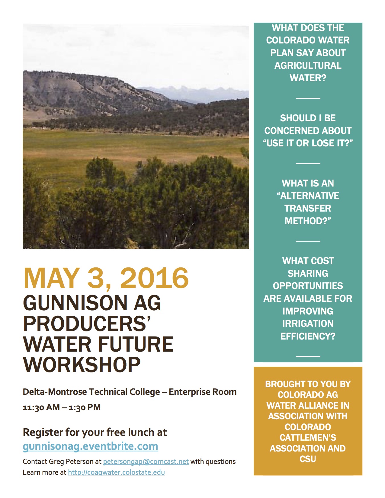
A Gunnison Basin Ag Producers’ Water Future Workshop will take place on Tuesday, May 3, 2016 from 11:30 a.m. to 1:30 p.m. at Delta-Montrose Technical College in the Enterprise Room. The Colorado Water Plan encourages the use of “alternative transfer methods” to keep water in agriculture while addressing the anticipated gap in future water supply given projected population growth. What does this mean for agricultural water users in the Gunnison Basin? Irrigators will hear about opportunities for cost sharing of efficiency improvements, water leasing programs, and concerns about “use it or lose it” at this workshop sponsored by the Colorado Ag Water Alliance with assistance from Colorado Cattlemen’s Association and CSU’s Colorado Water Institute.
Brief presentations will be followed by dialogue in which agricultural producers will have a chance to discuss challenges and barriers to these opportunities. Those presenting include Carlyle Currier from the Colorado Ag Water Alliance, Frank Kugel from the Gunnison Basin Roundtable, State Engineer Dick Wolfe, Perry Cabot from Colorado State University Extension, Aaron Derwingson from The Nature Conservancy, Phil Brink from Colorado Cattlemen’s Association, and MaryLou Smith from CSU’s Colorado Water Institute.
A slow-moving snowstorm brought about 2 feet of snow, totaling 2.42 inches of precipitation, to Salida Friday, Saturday and Sunday, and more snow is expected before the end of the month.
Just another April in Colorado.
The snowstorm impacted many aspects of life throughout Colorado, including Salida.
According to the Denver Post, more than 850 flights were canceled at Denver International Airport due to the conditions…
According to a Facebook post by Mal Sillars, Buena Vista received about 0.41 inch of precipitation and 10.1 inches of snow from the storm.
Cotopaxi didn’t have much snow sticking to the highway, but Anne Langford, owner of Cotopaxi General Store, said there was 2 feet of snow near her home. Reports from Sawatch indicate snowfall was lighter there, with about 2 inches of snow…
Following the weekend storm, total precipitation for April stands at 2.6 inches. Total precipitation for the year is 4.16 inches, 1.39 inches more than the historical average…
The Mail reported Friday that National Weather Service forecasters predict another “slow-moving storm” is expected to hit April 25 through 29.
A weekend storm that dropped up to 4 feet of snow in the central Colorado mountains improved the snowpack in most of Colorado’s major river basins.
Federal data released Monday shows the snows that feed the east-flowing Arkansas, North Platte and South Platte rivers ranged from 94 to 109 percent of average.
Southern Colorado’s Rio Grande Basin was only 78 percent.
West of the Continental Divide, the Upper Colorado River Basin was at 103 percent while the Yampa and White river basins were at 98 percent.
The Gunnison and Animas-San Juan river basins in southwestern Colorado were still below average, at 75 to 85 percent.
The snow was caused by a large area of low pressure in the upper atmosphere that was sitting and spinning over the central Rockies, drawing moisture from as far away as the Gulf of Mexico…
As of 6 a.m. on April 17 Denver’s official weather station had measured 12.1 inches of snow.
1869 Map of San Luis Parc of Colorado and Northern New Mexico. “Sawatch Lake” at the east of the San Luis Valley is in the closed basin. The Blanca Wetlands are at the south end of the lake, via Wikipedia.
Finding out where the San Luis Valley’s wetlands and irrigated acreage used to be could help determine where they should be in the future.
Chronicling that history to chart a future course is one of the focuses of a proposed watershed assessment project that Wetland Dynamics is seeking funding for. How those wetlands relate to wildlife habitat is another big component.
Cary Aloia and Jenny Nehring of Wetland Dynamics made an initial presentation and request for $37,000 to the Rio Grande Roundtable this week. The formal presentation and decision will be made next month. The project total is $164,000.
Although no one objected to the project, it sparked discussion about whether or not the roundtable should fund a project through an individual business, rather than a nonprofit organization, as previous funding requests have been made.
Aloia and Nehring said they were simply cutting out the middleman, and the costs for the project would probably increase $4,000-10 ,000 if it had to go through a nonprofit, which would take its portion and then contract with Wetland Dynamics to perform the work.
Colorado Water Conservation Board (CWCB) Program Manager Craig Godbout said individuals and businesses are not eligible for statewide account funds, but individual roundtables have discretion with regard to basin-allocated funds.
“There are no restrictions that I am aware of on what type of entity can be awarded basin accounts,” Godbout said.
Wetland Dynamics is seeking funds allocated to the Rio Grande Basin.
Funding for water projects around the state through CWCB and the basin roundtables is derived from severance tax revenues.
Nehring said this project will provide a Valleywide perspective about how drought and other changes have affected the wetlands that provide habitat to a variety of wildlife. She said several agencies and groups are monitoring their portion of the picture, but this would encompass the entire Valley and bring those agencies and groups together.
Aloia added that this project meets many of the environmental , recreational, agricultural and water administration goals of the roundtable.
She explained that this project will be completed by two entities: Intermountain West Joint Venture, which already has funding in place to provide historic and current wetland and agricultural uses in the Valley through its GIS model (and has completed similar projects in other parts of the western U.S.); and Wetland Dynamics, which will coordinate the project and bring everyone together to identify priority species, future water delivery projects and the best way to use water and land to benefit habitat.
“We are working cooperatively and collaboratively,” Aloia said.
Nehring said historical information is available as far back as the 1870’s through General Land Office surveys, which can be coupled with imagery captured from 1984 to the present. She said this information will show how wet areas in the Valley have ebbed and flowed through the years.
This information will help determine where habitats still exist and areas that can be targeted for conservation.
Nehring said Intermountain West Joint Venture will begin its work next month and will complete its part of the project in 18-24 months. Wetland Dynamics plans to complete its portion next year and will spread the $37,000 over a two-year period.
Aloia said there is a great deal of information, but it is in different places and with different agencies.
“We need to compile all of that,” she said.
Then priority species lists will be compiled and habitat areas identified for those species. All of the groups will then be able to cooperatively manage their water better to serve those habits, Aloia explained.
Brian Sullivan, wetlands program coordinator for Colorado Parks and Wildlife, said the department sees many benefits for this project and is firmly behind it. For example, it will provide information on the quantity and quality of wetlands for wildlife habitat and will help justify financial investments in the basin, he said.
Sullivan said Colorado Parks and Wildlife has pledged $46,000 towards this project, and he urged the roundtable to also support it. He said this project would be a great tool, “and you can’t have too many tools in the tool box.”
Kevin Terry, Rio Grande project coordinator for Trout Unlimited, added his endorsement of the project. One of the benefits , he said, would be consolidation of data in one place where it would be accessible to the different agencies.
Aloia said another outgrowth of the project will be identification of knowledge gaps, which can be the basis for future projects.
“It will highlight things we still don’t know,” she said. “It’s really a stepping stone for future projects.”
It will identify, for example , places where there could be restoration projects in the future to help bring back water resources that were present historically but are no longer present, she explained.
The information gathering and assessment will encompass the Valley floor up to 8,500 feet. Roundtable member Ed Nielsen said this sounds like a good project, but he believed it needed to encompass the mountains and headwaters too. He said it seems fragmented at this point.
Nehring said this a joint venture, and Intermountain West Joint Venture is setting the scope of this project. Aloia added that agricultural use, which is a key component of this project, is centered on the Valley floor.
Sullivan explained that the focus is on the irrigated landscape, which is where the biggest changes in wetlands have occurred.
Former Rio Grande Roundtable Board Chairman Mike Gibson said he personally had a problem with the roundtable funding an individual entity, because requests in the past have come through nonprofit organizations or state agencies. He said it had nothing to do with Wetland Dynamics, but he was concerned about the roundtable losing control over how money is administered and spent if the roundtable starts funding individual entities. He said he believed the roundtable had more oversight over projects going through nonprofit groups.
“I have a real concern,” he said.
Roundtable member Travis Smith said this is a worthy project, but it sounded like the roundtable needed to clarify some protocol issues.
“This application is about shared partnerships and getting agencies to talk to each other about water resources,” Smith said.
Roundtable member Dale Pizel said this seemed like a good project and he would hate for it not to be conducted simply because the roundtable had never funded projects through individual businesses before.
“If we need to have that discussion, let’s have it,” he said.
Roundtable member Judy Lopez agreed the discussion needed to be held. She also agreed this was a good project but was taking the roundtable into uncharted territory.
She asked if Billy Bob’s Excavating came in with a request for river restoration funding, would the roundtable fund it?
Pizel said if it fit with the roundtable’s goals, he did not have a problem funding “Billy Bob.” He said every project needs to have oversight to make sure it is performed correctly and fiscally responsibly.
Lopez said she did not think anyone had a doubt about how fiscally responsible Wetland Dynamics would be, but the roundtable needed to determine if it wanted to open this door and decide who could go through it. She said Aloia and Nehring are people of integrity, and this project meets many of the roundtable’s goals.
Godbout said his office requires reports and specific information, and he reviews that information carefully. He said he makes sure that the invoices match the work completed.
Roundtable member Rio de la Vista said, “So there is some oversight I think we can feel good about.”
Roundtable member Ron Brink said he was apprehensive about opening the gates to this type of funding.
Roundtable Chairman Nathan Coombs said, “The door can be opened. Just because it has not been opened doesn’t mean we shouldn’t. We should look at the project on its merits, if it accomplishes our goals.”
FromThe Grand Junction Daily Sentinel (Dennis Webb):
A review has led to the determination that there’s no need for the Colorado River District to make potentially expensive repairs to its Wolford Mountain Reservoir dam in the foreseeable future and it can resume full filling of the reservoir.
The review found that the risk of the Ritschard Dam in Grand County failing is extremely low despite the deformation problems it has been experiencing.
“We’re a public agency and we’re pretty gratified that we’re not looking at a 30-plus-million-dollar fix right now,” River District spokesman Jim Pokrandt said.
The rock-fill, clay-core dam was completed in 1995. It has settled near its center by about 2 feet, a foot more than expected of it as an earthen dam.
Its crest also has moved about 8 inches downstream.
The district already has spent about $1.5 million to install instruments to measure the dam’s movement.
It has considered possible repairs ranging from injecting concrete into the dam to shore it up to rebuilding it. The latter is something the district several years ago estimated could cost $30 million.
The district is taxpayer-funded and includes Mesa County. Any repairs might have come at least partly out of a separate enterprise fund the district derives from revenues such as water sales.
The district has called the dam problem the most important issue it faces. The reservoir is on Muddy Creek, and the town of Kremmling is just downstream, where the Muddy meets the Colorado River.
The reservoir can hold about 66,000 acre-feet of water.
The district began to rethink how it should deal with the dam movement after a three-person outside team of dam experts said no immediate action was required.
In February, it then held a workshop on the matter with participants including, among others, the outside team of experts, the state Dam Safety branch of the Colorado Division of Water Resources and Denver Water, which has a leasehold interest in the reservoir.
Participants concluded that the risk of the dam failing from the movement in a given year is one in 100 million, compared to the normally acceptable one-in-a-million risk of the dam failing from a flood overtopping the dam.
“Thus, the deformation- related public risk is much lower than other, normally acceptable dam-related risks,” the river district’s chief engineer, John Currier, said in a memo to the district board.
He wrote that the workshop participants concluded the chance of a dam failure from the problem is “very remote,” and that from a risk perspective “there is no compelling reason to proceed with remediation of the dam now or in the foreseeable future.”
“The dam is functioning properly, and has a very high probability of continuing to function properly even if deformation continues at the historical rate for many more years,” he wrote.
The district has been voluntarily keeping the water 10 feet below full as a precaution.
But those involved in the review agreed “that normal reservoir operation along with continued reasonable monitoring is appropriate,” Currier wrote, and that keeping water lower, while slowing down the dam’s deformation, merely prolongs how long it will take for that deformation to be complete.
As water pressures mount, Colorado Springs engineers are about to switch on one of the West’s boldest new water projects: an $825 million pipeline to siphon up to 50 million gallons a day of Arkansas River water from Pueblo, 50 miles away.
This highly contentious Southern Delivery System has been 27 years in the making. It resolves a core quandary for Colorado Springs (pop. 350,000), built on a high-and-dry, flood-prone plain away from rivers, with only two creeks to sustain people.
The project will pull from [the Fryingpan-Arkansas Project Pueblo Reservoir] — pumping water northward, uphill 1,500 feet — to support growth.
But there’s a hitch. Pueblo is demanding that Colorado Springs first commit to pay another $460 million before turning on the system as scheduled April 27 to clean up the dirty runoff Colorado Springs sends to Pueblo in Fountain Creek.
Colorado Springs leaders told The Denver Post last week they will agree, to avoid a legal war. Pueblo County officials, still reviewing a draft agreement, said they want to hear from residents Monday.
“If Fountain and Monument creeks were our only sources of water, we would only be a town of 25,000 people,” Colorado Springs Mayor John Suthers said in an interview after a treatment plant for the siphoned water was dedicated.
The SDS system “is an amazing engineering feat,” Suthers said. “It will take care of the future water needs of Colorado Springs for up to 50 years of growth.”
Pueblo and Colorado Springs officials agreed to vote on the deal April 26, the day before water engineers click a computer mouse to fire up the system.
For decades, Pueblo has been fighting Colorado Springs over the fouling of Fountain Creek, which flows from the Springs to Pueblo. The problem is stormwater runoff — chemical contaminants and sediment washing into the creek…
Under a draft deal, Colorado Springs would spend $460 million over 20 years to complete 71 stormwater cleanup projects. These include creation of ponds that slow and filter runoff and planting vegetation along drainage channels to stabilize sediment.
Colorado Springs will rely on general fund revenues from sales taxes to cover the $460 million, Suthers said. “If we have a downturn, we may have to look at something else.”
City Council president Merv Bennett said, “We’ve got to fix the stormwater problem. If we don’t do this, the EPA could require us to do it. This is a good deal.”
[…]
Eleven 2,000-plus horsepower pumps will propel the water from the reservoir through a 66-inch-diameter underground pipeline for 50 miles with an overall elevation gain of 1,500 feet.
The water must be used within the Arkansas River Basin, ruling out sales to south Denver suburbs. And wastewater, after treatment, must be returned via Fountain Creek to Pueblo.
Colorado Springs residents have paid for the system through water bills, which increased by 52 percent over four years.
City officials have been working since 1989 to install the system. “You have to handle all the legal, the permits, the right of way …,” said Edward Bailey, 80, who has led the efforts and whose name now appears on the treatment plant.
Moving water to people around the West entails altering the natural environment, Bailey said. “We have to do it right. We shouldn’t leave a big footprint. … I understand Pueblo and their concerns. We need to be very environmentally sensitive, but we cannot be preservationists.”
[…]
“Water drives our economic viability, our economic prosperity,” SDS program director John Fredell said.
“Now we’ve got it. Now we’re ready to go in Colorado Springs.”
Although we appreciate and commend the work of Pueblo County commissioners, the county planning department, county attorneys and Wright Water Engineers, we implore county officials to take more time before approving the 1041 permit that would allow water to flow from Lake Pueblo to Colorado Springs via the Southern Delivery System.
Schools, nonprofits and church buildings are among the properties hardest hit by the hikes, because the new rates assess the fee on commercial, retail or business properties based on the amount of impervious space on an area: the more roof and parking lot square footage, the higher the fee.
Owners of single-family homes pay a flat rate.
“Our mind was spinning when we got the bill,” said Lori Schreiner, business manager for St. Bernadette’s Church. “We budgeted for a 2 percent increase, which would have been about $40.”
Instead, the rate jumped from $1,493 to $2,790…
Residents and property owners started receiving bills reflecting the rate hikes in January. Residential homeowners are seeing their bill increase from $23.76 to $44.40 per year.
City officials have said the fee model is fairly standard across municipalities, and it makes sense that properties that push more water into the system should shoulder their share in the responsibility of maintaining it…
The city has 18 major drainages in need of 110 improvements, and another 70 improvements needed in localized neighborhoods. The city faces a $155 million maintenance backlog and hasn’t had a rate hike since the fee was instituted in 2000.
Many of the flooding issues are more prevalent in the older neighborhoods on the city’s east side, which were developed long before strict zoning guidelines were in place and the complexities of urban drainage were understood.
Jay Hutchison, the city’s public works director, said the city is in the design and planning stage for the first set of projects. Next year, construction is slated to begin on the installation of storm sewer systems at 20th Avenue and Nelson Street and 17th Avenue and Lee Street.
“We’ll have some followup projects that will start moving around town and continue for a number of years,” Hutchison said.
There are three main types of water in Ruedi Reservoir.
By Brent Gardner-Smith, Aspen Journalism
BASALT — Knowing who owns, or controls, the water in Ruedi has become of greater public interest since 2013, when all of the water in the reservoir was sold, as the new ownership regime could change how much water is released from the reservoir in any given year.
And how much water is released from Ruedi has implications for the quality of the trout fishing on the lower Fryingpan River and the health of four species of endangered fish in the Colorado River below Palisade.
Given that, we thought it worth figuring out who owns the water in Ruedi, and the resulting list, signed off on by the Bureau of Reclamation, is below.
There are three types of water in Ruedi. The first is “fish water,” or water held in storage in Ruedi until it is released to benefit struggling populations of native fish in the Colorado River between Palisade and Grand Junction, in what’s known as the 15-mile reach.
The fish water is released from Ruedi and sent down the Fryingpan River, which flows into the Roaring Fork River in Basalt, which in turn flows into the Colorado River in Glenwood Springs.
The second type of water in Ruedi is “contract water.”
This is water that has been sold by the Bureau of Reclamation to recover the costs of building and operating the reservoir.
Contracts for annual delivery of water from Ruedi vary in size from 12,000 to 15,000 acre-feet (AF) and there are now over 30 individuals and entities with water contracts.
When these Ruedi water owners are called out by senior downstream water rights holders, most significantly the large diverters near Grand Junction collectively known as “the Cameo call,” then they can ask Reclamation to release their “augmentation” water in Ruedi instead of stopping their normal use of water from their local sources.
In practice, this does not happen very often. But in a dry year, it could be important to many of the contract holders.
The third type of water can be viewed as “reservoir water.”
This is water not generally released from the reservoir, and includes the “dead” pool, the “inactive” pool, the “recreation and regulatory” pool and the “replacement” pool in Ruedi.
Ruedi was built, in part, to provide a “replacement” pool for the big upstream diversions of the Fry-Ark project, but these various “reservoir” pools are not a big factor in shaping the amount of flow out of the reservoir.
An angler in the Fryingpan River last fall, when the river was running about 300 cfs.
2015 flows
The question of how much water was flowing out of Ruedi, and who owns it, became an issue for many anglers on the lower Fryingpan River in September and October last year, when the river was consistently flowing at about 300 cubic feet per second.
At that level, the river can be hard to wade across, and local fly-fishing guides began to get complaints from some regular customers, who prefer levels in the 230 to 250 cfs range.
The river was high last year because 24,412.5 AF of water was released from Ruedi to help the endangered fish. This was an increase from 2014 and 2013, when 15,412 AF and 10,412 AF was released, respectively, as fish water.
There are three sub-pools of fish water in Ruedi, totaling 15,412.5 AF.
The first pool is 5,000 acre feet of fish water under contract to the CWCB and provided to the U.S. Fish and Wildlife Service for use in the 15-mile reach.
The second pool of fish water contains 5,412.5 AF. This pool is under contract to the Colorado River District, which acts as a custodian for the water on behalf of Western Slope interests.
The third pool contains another 5,000 AF and remains under the control of Reclamation, which considers it available for use in four-out-of-five years, or 80 percent of the time.
This third pool of fish water is, in essence, “extra” water that is provided by Reclamation to help the fish when conditions in Ruedi allow.
So while there is a total of 15,413.5 AF of fish water in Ruedi, only 10,413.5 AF of it is counted in our tally under the heading of “fish water.” We list the third pool of 5,000 AF, under the heading of fish water, but it is actually included in the “reservoir water” category.
A view of Ruedi Reservoir showing the face of the dam, the spillway, the building that houses a hydropower plant, and an overflow outlet just above it. The pool just below the outlets often has the biggest fish on the river lurking within it.
Contract water as fish water
In addition to the 15,413.5 AF of fish water released in 2015, there was also 9,000 AF of contract water released as fish water, which was a new development for both Ruedi and the lower Fryingpan River.
The 9,000 AF of contract water released as fish water was part of a 12,000 AF pool of water bought in 2013 by Ute Water Conservancy District in Grand Junction.
Ute Water bought its 12,000 AF for $15.6 million, or $1,300 an AF, to use as a back-up source of water. But last year it entered into a lease contract with the CWCB, at $7.20 an AF, so that the water could be used instead to benefit the endangered fish.
After Ute Water and CWCB finalized a lease arrangement in August to release up to the full 12,000 AF, only 9,000 AF could be released by the end of October without bringing flows over 300 cfs in the lower Fryingpan.
This year, though, Ute Water and CWCB hope to get an earlier start on releasing the full 12,000 AF as fish water, on top of the three pools of fish water totaling 15,412.5 AF.
If they succeed, that could mean 27,412.5 AF of water could be released from Ruedi as fish water, and flows in the Fryingpan could again be in the range of 300 cfs.
Given the discussion of water in Ruedi, a lingering question is, how much of the other contract water can be turned into fish water?
Bob Rice, a contracts specialist at Reclamation, said some of the water in contracts held by the Colorado River District could potentially be used for fish water, but it is currently unlikely that they will be.
While other contracts may also include the flexibility for the water to be used for “piscatorial,” or fish, uses, almost all of the water held by other contract holders is limited to use within their individual jurisdictions, and not in the 15-mile reach. The 12,000 acre-feet owned by Ute Water is a rare case, as the 15-mile reach is within their boundary.
So while more contract water may not turn into fish water in the future, it is the case that a fair amount of contract water could also be released along with fish water, at the request of the owners of the water. And that could bring the river up.
A map showing Ruedi Reservoir, the Fryingpan River, and the 15-mile reach on the Colorado River near Grand Junction.
The list
Here’s the list of who owns water in Ruedi, by acre-feet.
Some entities have multiple contracts for water in Ruedi. In those instances, we have added up the AF in each contract and combined them and included the amount of AF in each contract in parenthesis.
Ownership of Water in Ruedi Reservoir
Fish Water
5,000 AF Colorado Water Conservation Board, for 15-mile reach
5,412.5 AF Colorado River District, for 15-mile reach
Subtotal: 10,412.5 AF
(5,000 AF) (CWCB, for 15-mile reach, available 4-out-of-5 years. It’s often used as fish water, but technically it is in the “reservoir water” pool).
Contract Water
12,000 AF Ute Water Conservancy District
11,413.5 AF Colorado River District (500, 530, 700, 4,683.5, 5,000)
6,000 AF Exxon Mobil Corp.
2,000 AF Colorado River District (tied to 5,412.5 fish water as “insurance” water)
1,790 AF Basalt Water Conservancy District (300, 490, 500, 500)
1,250 AF Battlement Mesa Metropolitan District
600 AF West Divide Water Conservancy District (100, 500)
550 AF City of Rifle (200, 350)
500 AF Town of Basalt (200, 300)
500 AF City of Glenwood Springs
500 AF Snowmass Water and Sanitation District
500 AF Town of Carbondale (250, 250)
400 AF Mid-Valley Metropolitan District (100, 300)
400 AF City of Aspen
400 AF Town of New Castle
400 AF Garfield County
330 AF Summit County
300 AF Town of Silt (83, 217)
200 AF Town of Palisade
185 AF Ruedi Water and Power Authority
150 AF Wildcat Ranch Association (50, 100)
140 AF Wildcat Reservoir Company
125 AF Town of DeBeque (25, 100)
100 AF Crown Mountain Park and Recreation District (38, 62)
100 AF W/J Metropolitan District
75 AF Town of Parachute
43 AF Starwood Water District
35 AF Thomas Bailey
30 AF Elk Wallow Ranch LLC
21 AF Owl Creek Meadows
20 AF Westbank Ranch Homeowners Association
15 AF Owl Creek Ranch Homeowners Association
15 AF Ted and Hilda Vaughan
Subtotal: 41,087.5 AF
Reservoir Water
28,000 AF replacement pool
21,778 AF recreation and remaining regulatory pool
1,032 AF inactive pool
63 AF dead pool
Sutotal: 50,873 AF
The Southwestern Water Conservation District (SWCD or District) was created by the Colorado General Assembly in 1941, thereby marking the District’s 75th anniversary this year! The SWCD encompasses Archuleta, Dolores, La Plata, Montezuma, San Juan, San Miguel and parts of Hinsdale, Mineral, and Montrose counties. In a press release issued by SWCD board president John Porter, and recently printed in the Durango Herald, Porter shares some lessons learned in the past 75 years, ones that will be carried through the next 75:
Lesson No. 1: Adaptability is a Necessity
Times have changed since 1941. Colorado statute charges the district with “protecting, conserving, using and developing the water resources of the southwestern basin for the welfare of the district, and safeguarding for Colorado all waters of the basin to which the state is entitled.” Following this mandate, the district worked tirelessly for decades to ensure water supplies would meet growing demand by filing for storage project water rights in almost every major river basin. SWCD lobbied for federal dollars to be spent on project construction in our area. The philosophy was, and continues to be, to plant the seed and help it grow.
This work resulted in the establishment of the Florida Water Conservancy District and Lemon Reservoir; the Pine River Project extension; the Dolores Water Conservancy District and McPhee Reservoir; the Animas-La Plata Water Conservancy District; Ridges Basin Reservoir; Long Hollow Reservoir; the San Juan Water Conservancy District; and the proposed Dry Gulch Reservoir.
As population pressure threatens to dry up agriculture, and regulations and constituent values have expanded to include environmental protections and recreational use, the district’s mission has adapted necessarily. When the A-LP Project debate was underway, for example, SWCD was integral in the formation of the San Juan Recovery Program, established to recover endangered fish species populations in the San Juan River in New Mexico downstream of the proposed reservoir. SWCD currently funds a variety of essential work, including stream flow data collection and mercury sampling in local reservoirs. To address mounting concerns regarding future compact curtailment and drought, SWCD supports water supply augmentation through winter cloud seeding and exploring creative solutions like “water banking.”
Lesson No. 2: Be at the Table
Participation at the local, state and federal levels is essential to protecting our resources. That’s why the District is a member of Colorado Water Congress, a state entity focused on water policy.
The District takes positions and engages in debate on water-related bills during the state legislative season. We keep a close eye on federal water management policies, often submitting public comments and working with federal and state partners to ensure continued state control of water rights. The District is supportive of the Colorado Water Conservation Board’s instream flow program to establish minimum stream flows for the environment, and is working to improve the program’s ability to adapt to rural community needs for future development. As for the broader Colorado River system, SWCD participates in dialogue among Upper Basin states through the Upper Colorado River Commission.
At the local level, the district has represented water development interests in the collaborative River Protection Workgroup, which resulted in the Hermosa Creek Watershed Act. SWCD worked with other Roundtable members to ensure our corner of the state was heard in the Colorado Water Plan.
Lesson No. 3: Reinvest Local Tax Dollars Locally
It’s a not-so-well-kept secret that SWCD’s grant program supports water work across the district: domestic supply and irrigation infrastructure improvements, recreational development, habitat rehabilitation, collaborative community processes and water quality studies. Here are a few recent examples:
Archuleta, Mineral and Hinsdale counties: Rio Blanco habitat restoration by the San Juan Conservation District, watershed health via the San Juan Mixed Conifer Group.
La Plata County: Initial studies for Long Hollow Reservoir, the La Plata West Water Authority’s rural domestic water system.
San Juan County: Center for Snow and Avalanche Studies dust-on-snow research, mining reclamation through the Animas River Stakeholders Group.
Montezuma and Dolores counties: The Dolores River Dialogue (a collaboration focused on issues below McPhee Dam), irrigation efficiency improvements by the High Desert Conservation District.
San Miguel and Montrose counties: The San Miguel Watershed Coalition’s watershed studies and irrigation diversion improvements to allow fish and boater passage, domestic system upgrades for the town of Norwood.
Lesson No. 4: Educate the Next Generation of Leaders
For more than 20 years, the district has spearheaded regional water education by sponsoring an Annual Children’s Water Festival for students across the basin and administering the Water Information Program with contributions from participating entities. SWCD played an instrumental role in creating the statewide Colorado Foundation for Water Education, and continues to sponsor the organization. As generations of water leaders step back, new stewards must step forward to ensure that the Southwest Colorado we know and love continues.
“The water is our life blood that feeds all of us,” Southern Ute Tribal Chairman Clement Frost told participants in the 34th annual Water Seminar on April 1 in Durango.
The seminar is organized by the Southwestern Water Conservation District (SWWCD). This year’s event celebrated the district’s 75th anniversary…
The Animas/ La Plata Project and the now completed Lake Nighthorse were mentioned by Frost and other speakers as examples of choosing collaboration over litigation. They settle Ute water rights claims going back to 1868, senior to any other rights.
“The tribes and water users have a relationship that’s quite unique” versus other places where entities end up in court fights that can last for decades, explained Christine Arbogast with the lobbying firm of Kogovsek and Associates. “Here the tribes and non-Indian community decided in the early 1980s to negotiate and not litigate.”
The negotiations started in 1984 and concluded in 1986, she said, but they still needed congressional approval, which came in 1988 with bipartisan support from the Colorado delegation. But an irrigation water delivery system to the Dry Side had to be eliminated as part of that.
Arbogast called that a painful compromise, “that we all looked at the stewardship of water together and the preciousness of water together.”
Frost said, “I have the most admiration for the ranchers who gave up their rights to irrigation water. They understood it was necessary for Animas/ La Plata to move ahead.”
He commended the help of SWWCD “in helping us get things done. We all march together to take care of a problem, and not march apart to continue a problem.”
Speakers through the day cited the water district’s financial and other help in their various missions.
The district was formed in 1941 by the state legislature and is one of four such districts around the state, district Director Bruce Whitehead said. The district covers all of six counties and parts of three others. The district’s directive is to protect and develop all waters in the basin that the state is entitled to, he said.
District Board President John Porter noted there are nine river systems within the district, and they all flow out of state.
“Indian water rights cases couldn’t have been solved without storage,” he said. “Without that, non-Indians wouldn’t have much water after July 1” each year, when rivers tend to go on call.
The district is funded with property taxes. It has a $1.5 million annual budget and over the past 30 years has awarded almost $9 million in grants, Porter said.
Longtime Assistant County Manager Joanne Spina said $50,000 from SWWCD and $25,000 from the Southwest Water Roundtable helped the 18-lot Palo Verde subdivision near Three Springs install a water line to get Durango water when residents’ domestic wells started failing.
Travis Custer with the High Desert and Mancos Conservation Districts said education efforts on more efficient irrigation methods are part of “the idea that we are responsible for our resources. Water saved on the farm benefits everyone… It’s mitigation rather than emergency response. It doesn’t have to come at the cost of an ag operation.” Instead, it can be an enhancement, he said.
“We’re looking at ways to replicate efficiencies in the larger area,” Custer said. “We have to work together, agencies with agencies and with producers to build trust. In the West, these situations aren’t going to get any better. No new water will be created.”
Asked how more efficient irrigation might have consequences with the doctrine of “use it or lose it,” Custer said that doctrine has a lot of gray areas. “We have to look at opportunities to adjust our thought process and legislate to address the current situation. We want to keep land in ag. Legislation that prohibits conservation needs to be addressed,” he said.
The keynote speakers were water attorney and former Colorado Supreme Court Justice Greg Hobbs and Bill McDonald, a former director of the Colorado Water Conservation Board and a lead negotiator on the Colorado Ute Indian Water Rights Settlement Agreement and the implementing legislation.
“Remember your history is lesson 1,” McDonald said. He gave a brief history of water issues in Colorado and called water “the state’s liquid gold.”
Debates over trans-mountain water diversions started in the 1930s with the Colorado/ Big Thompson water project to bring water to northeastern Colorado. In 1937, a Governor’s Water Defense Association was created to defend against downstream states. In-stream flow rights became an issue in the 1970s.
Hobbs said about two-thirds of the water that originates in Colorado flows out of state to 18 downstream states. In the 1980s, he and fellow attorney David Robbins won a U.S. Supreme Court ruling to keep Ute water rights cases in state rather than federal courts. They also defended the constitutionality of in-stream flow rights.
“In-stream flow has been our safety valve to show we can preserve the environment in the name of the people,” Hobbs said. “It was a great day when that was upheld.”
The seminar finished with Peter Butler from the Animas River Stakeholders Group and discussion of toxic mine drainage from above Silverton. SWWCD helped with funding for four stream gauges near Silverton. The one on Cement Creek is how it was determined that the Gold King mine spill last August was 3 million gallons, he said. SWWCD also helped them get in-stream flow rights and has supported “Good Samaritan” legislation, he said and thanked the district for its support over the years.
The day included a tribute to Fred Kroeger, who was on the SWWCD board for 55 years and served as board president for 33 years. He died last year at age 97. He also served on various other state and local water-related boards and community service groups. He and buddy Sam Maynes Sr. were known for the lame jokes they told at the water seminars as well as for their water project advocacy including A/LP and McPhee on the Dolores.
“He set the standard by which we behave in the water business,” water engineer Steve Harris said of Kroeger. “Be a diplomat, dignified, a gentleman. Be willing to compromise. Don’t be a wimp. Don’t give up. Be involved.”
Arbogast added: “You never heard him call anybody a name. In today’s political environment, that would be pretty refreshing, wouldn’t it?”
Here’s a photo poem from Greg Hobbs. He was one of the keynote speakers at the shindig:
Southwestern District’s 75th Anniversary
Dominguez and Escalante peered into this ancestral
Great Kiva looking for the Colorado River
Where the Shining Mountains and their waters also lead us on.
East of the Divide where snowmelt’s stored for so many newer Coloradans
A slender ribbon, the South Platte, slices through the High Plains
POINT: Change needed to deal with storm water in county
By Mesa County Commissioners
Mesa County has received multiple calls and letters from constituents about the bills they’ve received from the Grand Valley Drainage District.
The Mesa County Commissioners want to be clear: Mesa County does not have authority over the Drainage District. It stands alone as a separate governmental entity.
That said, we have been attempting to work with the Drainage District for years to create a Greater Grand Valley Drainage Organization. We have the support of the 5-2-1 Drainage Authority, which includes the City of Grand Junction, the City of Fruita and the Town of Palisade, to move in that direction. As pointed out in a previous letter to the editor, the Drainage District was identified as a possible solution in 2003. However, the 5-2-1 Drainage Authority was pursued at that time due to the limits of the Drainage District boundaries. It was identified in 2003 that we need a valley-wide solution. Our most recent efforts started again in February 2015.
Unfortunately, our attempts have failed. The Drainage District is not willing to discuss amending its governance or boundaries to create one greater Grand Valley Drainage Organization. It’s truly a shame.
If a Greater Grand Valley Drainage Organization was ever to be formed, its board would be tasked with assessing the needs of the greater Grand Valley and then determining the appropriate storm water fees. Raising fees now is putting the cart before the horse.
That doesn’t mean we aren’t aware of the significant storm water challenges we face in the Grand Valley. It simply means we do not support the recent actions of the Drainage District. The district has ignored feedback from stakeholders, who had asked for a re-evaluation of the potential impact on businesses (that already pay a majority of the Drainage District’s mill levy). The district also ignored requests from local government partners to re-evaluate its governance structure.
A bit more history we want our constituents to know: The Grand Valley Drainage District is a separate governmental entity formed by the Colorado State Legislature pursuant to CRS § 37-31-100, et seq. Only the three-member “elected” board has control over the district’s operations. Yet, the district has not held an election for a number of years due to lack of public interest and uncontested positions. Essentially, this has led to a self-appointed board. The only other oversight of the district lies with the Colorado Legislature and our local representatives, Sen. Ray Scott and Reps. Yeulin Willett and Dan Thurlow.
It’s disheartening to us. We have a solution sitting right in front of us. Let’s combine the operational experience of the Drainage District, expand the district boundaries to include the entire Grand Valley, and operate the Drainage District under a fair governance system.
The rate-payers deserve a voice at the table.
Sincerely,
Commissioners Rose Pugliese, Scott McInnis and John Justman
COUNTERPOINT: Only one entity is doing something about the problem
By the Grand Valley Drainage District
For 13 years the five appointed representatives to the 5-2-1 Drainage Authority have had the power and authority to address Grand Valley-wide drainage and storm water issues.
There has not been, nor is there now, any question as to the importance of the issue, the need to take productive action toward mitigating the problems, and the need for additional revenue to take such actions. For 13 years various interests have resisted plans that would make progress toward these objectives a reality. For 13 years nothing but talk has been created. It is interesting, and sadly ironic, to note that this dysfunctional and counterproductive 5-2-1 governance model is exactly the one being proposed by certain parties to replace the current legislatively-adopted governance of the Grand Valley Drainage District (GVDD).
And during all this time, the expectation that the GVDD would continue to accept new and expanded responsibilities, obligations, and liabilities to deal with an urbanizing area continued to be taken for granted. The GVDD board realized that this approach to using the system we own, operate, and are financially responsible for was not sustainable. To continue its current operations, in and out of the growing urbanized area, and to accommodate the growing demand for a 21st century storm water system that would promote and sustain continued residential and commercial development, GVDD must make real progress toward addressing the drainage and storm issues within its boundaries.
If the 5-2-1 is not ready to assume responsibility for the larger valley-wide drainage and storm water obligation, the GVDD certainly understands. The creation of drainage and storm water systems on the Redlands and Orchard Mesa is going to be a complicated and very expensive undertaking. It will be a much different prospect than expanding and improving the GVDD conveyance system that exists on the north side of the river.
In 2013 the GVDD, under the legal authorities of Taxypayer Bill of Rights passed in 1992, created a Storm Water Enterprise to create a means by which to address the growing storm water and flooding concerns of an urbanizing area and to implement a fee to create revenue to begin that process. This TABOR enterprise mechanism has been used extensively and legally tested in Colorado. The bills that GVDD property owners have recently received are a result of these decisions on the part of the GVDD board in accordance with TABOR rules.
After listening to considerable public comment the GVDD board has adopted a fee structure that attempts to address the interests of existing business and new development, but at the same time the board must advocate for and protect the needs and concerns of the thousands of individual residents of the GVDD. Most often they are the ones in the GVDD office asking why something cannot be done to protect their lives and their properties. We know that any fee structure will be considered less than perfect by some of those affected and we take seriously the concerns that have been brought to our attention.
We thank the thousands of businesses and individuals who have sent in their payments to date and look forward to the improvements those payments will make to the best interests of the Grand Valley.
Board of Directors,
Grand Valley Drainage District
Irrigators in the San Luis Valley may get a boost thanks to the completion of a $4.6 million overhaul of a high country reservoir near Creede.
The Santa Maria Reservoir Co. completed the renovations on Continental Reservoir and its spillway last fall, making the reservoir eligible to have storage restrictions lifted later this summer should it pass muster from state inspectors.
The Continental was completed in 1928 and has a capacity of 27,000 acre-feet.
But seepage through the reservoir’s dam spurred the imposition of state restrictions in the late 1980s that have limited storage to about 15,000 acre-feet, reservoir company manager Jay Yeager said.
An acre-foot is roughly 326,000 gallons of water.
The added water would be a boost to the company’s 250 shareholders who irrigate on 70,000 acres on the valley floor.
“It helps the stockholders have more options to store more water for other entities and they can store more for their needs,” Yeager said.
While the Continental is not a large reservoir — less than a tenth of the size of Pueblo Reservoir — the added storage is significant given the small amount of storage on the Rio Grande’s headwaters.
The Continental is only one of four reservoirs whose combined storage amounts to just under 130,000 acre-feet.
The repairs to the reservoir included the layering of sand and gravel on the dam’s exterior designed to filter out sediment from the seeping.
While it won’t stop the seep completely it eliminates the sediment’s potential to make that seepage worse.
The project also included the repair of the siphon and canal system that connects the Continental to the Santa Maria Reservoir, which was also under state restrictions.
But full capacity might not be reached this season.
“It could take several years before it could really be full unless Mother Nature kicks in,” Yeager said.
Fort Morgan residents will be able to cultivate and enjoy green lawns and gardens this summer if they want to do so.
That is thanks to the increase in the Colorado-Big Thompson water quota announced Thursday and the resulting likelihood of no city lawn-watering or residential-water-use restrictions in coming months, according to Fort Morgan Water Resources/Utilities Director Brent Nation.
The Northern Colorado Water Conservancy District Board of Directors on Thursday approved increasing the Colorado-Big Thompson Project water pipeline quota to 70 percent, according to a news release. The Northern Water Board had set it at 50 percent last November.
Fort Morgan receives its water from that pipeline, with water availability subject to the quota set periodically by the Northern Water Board. This quota change does not affect city water rates, which are set by the Fort Morgan City Council. It only affects the amount of water available to the city for use.
But this new quota is one that still means good news for Fort Morgan water customers, according to Nation.
“I am pleased that the C-BT quota has been set at 70 percent for this water year,” he said Thursday afternoon. “70 percent allows our businesses and residents to enjoy high quality water with no restrictions.”
Here’s the release from the Mountain Studies Institute:
The fact that people in the community noticed when the Animas River was distinctly yellow-brown in color on February 15, 2016 reflects a heightened awareness of changes in water quality since the Gold King Mine release. Warm temperatures in mid-February initiated the first increase in runoff since last fall’s storms, picking up sediment in the process.
Mountain Studies Institute (MSI), a nonpartisan independent research station, has been monitoring water quality of the Animas River since before, during, and after the Gold King Mine release. MSI received lab results back from water quality samples collected from the Animas River at Rotary Park on February 15, and March 1, 2016.
“These samples are the first in a series of sampling that will occur as part of a monitoring program that aims to understand changes in water quality during 2016 storm events and spring runoff” said Scott Roberts, MSI’s aquatic ecologist. The monitoring program is part of a partnership between MSI and the City of Durango to convey Animas River water quality information to the public.
“Because we know that people are curious to see the data, MSI has posted water quality monitoring results and an explanation of those results on our website, http://www.MountainStudies.org” said Marcie Bidwell, MSI’s director. “By posting updated information on our website, we hope to keep the public informed as the season progresses. Links will also be available on the City’s website, http://www.durangogov.org.”
Results from the spring samples indicate some encouraging news. Metals of concern for human health (Arsenic, Lead, and Mercury) and those thought to be most harmful to aquatic life (Copper, Zinc, and Selenium) were found to be at levels considered safe by Colorado Department of Health and the Environment (CDPHE) water quality standards. All metals analyzed from these two spring samples were at levels considered safe for agriculture and domestic water supply use (based on CDPHE water quality standards). Additionally, all metals were below Environmental Protection Agency’s recreational screening levels, which represents the level at which no adverse health effects are expected to occur in humans consuming 2 liters of filtered water per day, from the Animas, orally, for 64 days each year for a total of 30 years.
However, the yellow-brown color of the Animas River at Rotary Park in Durango on February 15th did contain high levels of certain metals. Concentrations of Aluminum and Iron surpassed chronic water quality standards set by CDPHE to protect aquatic life from persistent, long-term exposure to metals. The brief exceedances of chronic water quality standards from one sample on one day do not necessarily indicate potential harm to aquatic life unless these levels persist continuously over a 30-day period.
The visible yellow or orange color of the river is mostly Iron and Aluminum. Iron particles of various sizes are suspended in the water column. Other metals, such as Zinc, readily bond to the Iron particles.
“MSI’s data supports the conclusions of local, state and federal partners that, from a public health standpoint, this year’s spring runoff is unlikely to be different from previous years. Monitoring and notification procedures are also in place to notify the public if conditions change.” said Liane Jollon, executive director of San Juan Basin Health (SJBH). “SJBH advises the public that it is always good practice to wash with soap and water after exposure to any untreated body of water, including the Animas River. Further information and more health tips for river users are available on our website at http://sjbhd.org/public-health-news/animas-river-health-updates/.”
In a partnership with the City of Durango, MSI plans to continue to monitor the water quality of the Animas River throughout 2016, focusing on understanding chronic exposure to aquatic life before runoff, during runoff, and into the summer season.
Please keep in mind that these observations are from only one location (Rotary Park in Durango) on the Animas River and may not be indicative of the entire Animas River watershed.
Runoff from autumn storms kicked up the levels of some contaminants in a southwestern Colorado river after a massive spill of toxic mine waste, but concentrations of other pollutants declined or didn’t change, researchers said Friday.
A report released by the Environmental Protection Agency could offer clues about what will happen to the Animas River this spring and summer when melting snow from the San Juan Mountains makes the waterway run higher, potentially stirring up pollutants that had settled to the bottom after the spill.
But the researchers said they couldn’t be sure that the pollutants they measured came from the Gold King Mine — source of the 3-million-gallon spill last August — or if they were from other mines that riddle the area. They also said they didn’t have enough historical data to know whether storms that hit after the Gold King spill stirred up more pollutants than ones before it…
Most of the metals settled to the bottom of the Animas before reaching the San Juan River in New Mexico, the EPA said. Experts have differed on whether and how much those metals will be stirred up when river flows increase after storms and from the spring snowmelt.
The nonprofit Mountain Studies Institute in Silverton monitored the river for the EPA in Durango, Colorado, about 60 miles downstream from the mine, and compiled a report.
Seven storms increased the flow of the Animas in Durango between Aug. 9 and Oct. 26. Concentrations of six contaminants increased after some of those storms, including aluminum and copper, the institute’s report said.
Levels of mercury and five other contaminants decreased after some storms, while the levels of seven others didn’t change.
State water officials don’t expect floods or above-normal flows in the Animas this spring and summer. The San Juan Mountain snowpack that melts into the river was only 66 percent of the long-term average on Friday.
Even if a weekend storm drops up to 2 feet of snow on the San Juans as predicted, it probably won’t be enough to cause the Animas to flood, said Kevin Houck, chief of watershed and flood protection for the Colorado Water Conservation Board.
Boulder County and federal officials are inviting residents and owners of property along flood-damaged portions of Left Hand Creek west of U.S. 36 to a Tuesday night community meeting.
The meeting, set for 5:30 to 7:30 p.m. Tuesday at the Altona Grange, 9386 N. 39th St., will include updates about designs and plans for restoration projects on portions of the creek, as well as a construction time frame for those projects.
Well associations have boosted the amount of water they intend to use, and a program to augment on-farm irrigation improvements is growing.
“We remain the only basin in Colorado that has regulated irrigation efficiencies,” [Steve] Witte said. “But in the years we have had it, we have increased the acreage in sprinklers and drip irrigation.”
Witte outlined enforcement actions in the Arkansas River basin, noting that violations of well regulations and breaching unsafe or illegal dams occupied his staff’s time last year. In addition, the Division of Water Resources is taking more of a consulting role in water court cases and filing statements of opposition “only if necessary.”
Last year, in 97 cases, the state filed just one statement of opposition, while settling 21 or 50 pending cases it was active in within Division 2, Witte said.
He also reviewed cannabis — hemp or marijuana — requests, noting that 69 growers, mostly in Pueblo County, had filed plans for water through his office.
About the only thing he wasn’t prepared to talk about: New rain barrel legislation that passed the Legislature this year.
City officials, already eyeing three future reservoirs to grow Aurora’s water storage system, appear to be close to buying land for the future Wild Horse Reservoir in Park County.
Aurora’s water system consists of 12 reservoirs that span the Front Range and Continental Divide, providing the city with more than 156,000 acre feet of storage located in three water basins. But even though they can supply the city with years of emergency supply in case of a drought, city officials say demands for water are increasing and that they will need more storage to provide services to potentially 600,000 residents in the coming decade.
Lisa Darling, Aurora Water’s South Platte Basin program manager, said that reservoir is likely to be designed and completed by 2022…
According to city documents, Wild Horse would provide the city with 32,400 acre-feet of water storage. The city is expected to complete the purchase and sale contract for the sea-horse-shaped reservoir by August of this year. Aurora Water officials say the project will cost the city $92 million to build out…
[Greg] Baker said Wild Horse has been easier to negotiate in part because it is being built on private land owned by Hartsel Springs Ranch in Park County. He said the owners see the economic opportunity in the recreational elements the reservoir will provide once completed.
Wild Horse will also be located 10 miles above Aurora’s Spinney Mountain Reservoir, which is also in Park County, meaning the city will not have to acquire additional water rights through court to use it.
The other two reservoirs planned are the East Reservoir and Box Creek.
The East Reservoir, which city officials began researching as a site in 2012, would sit just east of the Aurora Reservoir on the former Lowry Bombing and Gunnery Range. Darling said it could be completed in the next decade. Aurora Water is still in the land acquisition process with the Colorado State Land Board and the Rangeview Metropolitan District.
Darling said the East Reservoir project has been held up in part by federal agencies, who for years have been working to find unexploded ordinances that potentially remain on the site and could be harmful if not detonated properly.
One not-so-bright spot for the city is completing Box Creek, a site north of Twin Lakes in Lake County.
“The (National) Forest Service has been less than helpful to date,” said Aurora Water Resources Management Advisor Joe Stibrich about ongoing negotiations over the Box Creek site…
Aurora’s 12 reservoirs include Aurora, Quincy, Rampart, Strontia, Spinney, Homestake, Jefferson Lake, Twin Lakes, Pueblo, Turquoise, Henry and Meredith.
Popular notions to the contrary, bark beetle infestations do not equal more severe fires, according to a University of Colorado researcher.
The San Juan Mountains have seen plenty of both in recent years and Robbie Andrus, a doctoral student in geography, found the 120,000-acre West Fork Fire did damage for other reasons.
He told the Rio Grande basin roundtable Tuesday that dry, hot weather, topography and stand structure had far more to do with whether a fire would kill trees.
“Fire severity was very similar in beetle-killed and non-beetle-killed areas,” he said. “Essentially, from an ecological perspective, fire didn’t burn differently in those areas.”
His research included the West Fork burn scar as well as others in the San Juans where the spruce beetle had not been present.
All told, the research was conducted on 140 plots.
In looking at Englemann spruce infested by beetles, he focused on sections of the forest where trees had reached a gray stage, meaning they had dropped their needles but were not more than five years into the epidemic at the time of the fires.
Dan Dallas, superintendent of the Rio Grande National Forest, told the roundtable the study’s findings were not surprising, given that spruce are not a fire-resistant tree.
“We basically know that if fire of any sort gets up against a spruce tree, it’s going to kill it,” he said.
But Dallas noted that the U.S. Forest Service measures fire severity by how badly a fire scorches the soil.
Extremely burnt soil, which amounted to about 11 percent on the West Fork scar, can prevent the return of spruce stands.
Andrus did not dispute the importance of soil in determining severity but he said it would have been difficult to measure.
Dallas also told the roundtable there were concerns about the threat posed by the beetle-killed trees once they begin to fall, a process that can take as long as 50 years.
While that was not in the scope of Andrus’ study, Dallas worried about a fire hitting a section of the forest covered in downed spruce trees. “You have way more potential for damaging the soil,” he said. The Rio Grande has 588,000 acres of beetle- infested spruce stands, most of which have yet to fall.
Dallas also added that opponents of Forest Service thinning operations had cited Andrus’ work as a reason not to do thinning projects.
Andrus, a former wildlands firefighter, said he did not agree with that sentiment when it came to doing work that would protect homes or other structures. But he does believe that logging in remote sections of beetle-killed forest would not have an impact on the likelihood or severity of future fire.
West Fork Fire June 20, 2013 photo the Pike Hot Shots Wildfire Today
Click here to read the newsletter. Here’s an excerpt:
World Economic Forum Ranks Climate Change as Top Environmental Risk
The World Economic Forum’s (WEF) recently released Global Risks Report has for the first time ranked climate change “as the most severe economic risk facing the world.” The WEF’s report indicated that climate change is compounding and intensifying other economic, humanitarian, and social stresses such as mass migration.
In a January 22nd National Geographic article, Chief Risk Officer of Zurich Insurance Groups, Cecilia Reyes, stated that “climate change is exacerbating more risks than ever before in terms of water crises, food shortages, constrained economic growth, weaker societal cohesion, and increased security risks.” To view the full report visit the World Economic Forum.
Spring 2016 Water Information Program newsletter cartoon.
At the moment, snowpack looks good on Vail Mountain, Fremont Pass and at Copper Mountain — the closest snow-measurement site to Vail Pass. That’s good news, since much of the upper valley’s water supply is stored in snowpack, not reservoirs.
As of Monday, those three snow measurement sites were all within 5 percent of the 30-year historic median levels. That’s good, since we’re within a week or so of the historic peak of what’s called the snow year — roughly Nov. 1 through May 1…
STATUS OF RESERVOIRS
Peter Goble, of the Colorado Climate Center at Colorado State University in Fort Collins, said Dillon Reservoir is at roughly 90 of its average capacity for right now. But fresh water there will be diverted down the Blue River to Green Mountain Reservoir, which is currently at 40 percent. Granby Reservoir, near the Colorado’s headwaters, is releasing water into the river at normal rates right now, Goble said.
STORM HEADED THIS WAY
While snowmelt is on the minds of river-runners and others who depend on water levels right now, it looks like there’s still more precipitation to come.
Dennis Phillips, a meteorologist with the Grand Junction office of the National Weather Service, said a good-sized storm is headed for Colorado from the Pacific Northwest. That storm should hit in the next few days, Phillips said.
More important, Phillips said a low pressure system is expected to set up and stall over the Four Corners area. That system should remain into early next week.
That means there’s a good chance of precipitation, some of it heavy at times.
LOOKING INTO THE FUTURE
Weather forecasting loses a lot of certainty more than about 10 days into the future, but the weather service does do longer-term forecasts, based more on probabilities than actual patterns.
This year, the probabilities look pretty good for a slow, sustained snowmelt. Phillips said the 60-day outlook shows this part of Colorado with an above-average change of above-average precipitation and below-average temperatures. Looking further out, the 90-day outlook shows an above-average chance of above-average precipitation and above-average temperatures.
That came as good news to Eagle River Water & Sanitation District communications and public affairs manager Diane Johnson.
“If it gets to mid-June and warms up, that would be great,” Johnson said. “That means we’ve had a nice, slow snowmelt.”
Time is running out for snowpack to rebound in the Rio Grande basin but forecasters are optimistic the San Juan Mountains will still get above-normal precipitation in April and May.
The prospect of late spring snow, especially after a 45-day run with almost no snow in February and March, would be ideal, said Pat McDermott, a staff engineer for the Colorado Division of Water Resources in Alamosa “Late April and May snowstorms have a huge impact on this basin as far as runoff,” he told the Rio Grande basin roundtable.
Precipitation to date is at 82 percent of average in the basin but the National Weather Service’s long-term forecast calls for above-average precipitation in April and May.
The arrival of that snow would be good for irrigators come summer, but it would also impact how the state manages its deliveries under the Rio Grande Compact.
The compact, which divvies the river’s flows between Colorado, New Mexico and Texas, has sliding delivery requirements for Colorado that vary according to the amount of streamflows.
Right now the state predicts 645,000 acrefeet of flows on the Rio Grande at Del Norte, which, if true, would amount to 104 percent of the river’s average.
That would require a delivery obligation of 180,000 acre-feet and has led the state engineer’s office to set curtailments on irrigators at 13 percent…
On the Conejos, the San Luis Valley’s second biggest river and a tributary of the Rio Grande, the projected streamflow for the year is 280,000 acre-feet.
If that projection holds, it would be 93 percent of the river’s long-term average, according to records that date back to 1910.
The delivery obligation sits at 95,000 acrefeet, while curtailment is set at 22 percent.
Impossible to tell in mid-April, when conditions are mirroring those seen last year.
Snowpack in the Arkansas River basin is just 80 percent of average, but ahead of last year at the same time, Water Division 2 Engineer Steve Witte told the Arkansas Basin Roundtable this week.
Reservoirs are full — so full that the only reason more water is not being spilled is the abnormally dry March weather. Until a soaking shower in Pueblo on Sunday and Monday, Pueblo had been parched. Now, rainfall for the year is about normal, and conditions are expected to stay wet for a while.
Styling his talk “State of the Arkansas,” Witte delved into the statistics that paint a picture of unsettled conditions.
“In January things looked good, and I said the drought was over,” Witte joked. “By early April, things had declined. But remember last year when we had a Miracle May and Pueblo got a record 5.6 inches in one month.”
The best result was that reservoirs topped off.
The worst result was that those who had prudently saved water those reservoirs might lose it.
On March 2, Lake Pueblo held 272,000 acre-feet of water, which meant a lot of it could have been lost in order to get to the proscribed flood control volume of 245,373 acre-feet on April 15. Fortunately, the dry weather allowed about 25,000 acre-feet to be used in late winter and early spring, ending that threat.
For now.
“Unless we get another Miracle May,” Witte said.
John Martin and Trinidad Reservoir are also at the highest levels in years, providing assurance that even if the rains don’t come, the Arkansas Valley will be in relatively good shape this year.
The Yampa River was flowing at more than three times the median volume for April 14, but a meteorologist at the National Weather Service in Grand Junction confirmed the rushing river was rising due to rapid, low-level snowmelt, and the peak of spring runoff is likely still well in the future.
The Yampa was flowing at 1,650 cubic feet per second at mid-afternoon Thursday after dropping from its daily peak of 1,790 cfs, recorded by the U.S. Geological Survey just after midnight. Those flows compare to the median flow for April 14 of 470 cfs.
“About a week ago, the Yampa began to show a general trend upward with daily swings,” NWS forecaster Dennis Phillips said. “There was a surge with temperatures getting so warm, we saw water run off throughout the night. Low elevation runoff could crest soon.”
Consulting forecasts by the Colorado Basin River Forecast Center, Phillips said the expectation is that the nearby Elk River, which drains the west side of the Mount Zirkel Wilderness Area, should peak on or near June 1. A similar long-range forecast for the Yampa hasn’t been posted.
With a colder storm front due to influence weather in the Yampa Valley for the next four days or so, the forecast center anticipates the Yampa will calm down, with flows gradually receding into next week, Phillips said.
Historical data collected by the U.S. Geological Survey confirms how unusual this week’s flow on the town stretch of the Yampa has been. The record flow for April 14 on the Yampa at the Fifth Street Bridge was the 2,070 cfs, recorded in 1930. Not since the 1,810 cfs (mean flow for the entire day) recorded on April 14, 2000, has the Yampa seen anything similar to April 2016.
The mean flow April 14 in many seasons is in the range of 300 to 500 cfs, according to USGS records.
Here’s the release from the University of Colorado:
Active on social media? Care about weather? If the answer is ‘yes,’ the University of Colorado Boulder and the National Weather Service (NWS) want your help investigating large surface hail accumulations from thunderstorms in Colorado between April and September.
The goal of the crowdsourced study is to help researchers better understand and forecast hail-producing thunderstorms in Colorado and nationwide, said Associate Professor Katja Friedrich.
The researchers are asking users of Twitter, Facebook and email to document such severe storms with photos, video and measurements of hail depth for the Deep Hail Project, said Friedrich of CU-Boulder’s Department of Atmospheric and Oceanic Sciences. Friedrich and her CU-Boulder colleagues, including students, are teaming up on the project with Bernard Meier, lead forecaster of the National Weather Service Office Boulder.
Thunderstorms occasionally produce swaths of massive amounts of hail in Colorado. Such events sometimes are referred to as “plowable hailstorms” because some roads remain impassible until snowplows or bulldozers are used to clear them, said Friedrich.
“These severe storms pose a substantial risk to life and property and often result in motor vehicle accidents, road closures, airport delays, river flooding and water rescue activity,” she said. “Over the course of a summer, millions of people are affected by these kind of thunderstorms.”
According to Meier, the pilot project is to better understand why certain thunderstorms produce massive amounts of hail and how meteorologists can identify them. “We need to know when these thunderstorms occur, how much hail is on the ground and the extent of the hail swath,” he said.
One advantage of using Twitter for weather reports is geotagging, which is geographic information associated with individual tweets, said Meier. Geotagging allows weather researchers to see the time and place a particular tweet was sent, which is expected to enhance the timeliness and accuracy of online weather reporting and communication between the public and local weather forecast offices.
From the Ouray County Plain Dealer (Dalton Carver ):
Nearly 40 million people in the seven Colorado River basin states rely on the body of water and its tributaries, including the Gunnison, for their water needs.
However, climate change is being blamed for creating an imbalance in western water that could impact how Colorado River water is managed.
If the imbalance is left unchecked, it could impair the ability of the Colorado River to fulfill the needs of the almost 40 million people it sustains.
The 2016 SECURE report built upon the original basin studies that were published at the end of 2012.
The climate change data, gathered by an Intergovernmental Panel on Climate Change assessment, identified milestones, such as a temperature increase of five to seven degrees by the end of the century, as much as a seven percent decrease in April and July streamflow in several river basins and a decrease of precipitation over the southwest and south central areas of the country.
“A whole bunch of global climate models that are run by various research institutions are part of putting that together,” said Carly Jerla, a BuRec leader on the Colorado River Basin study. “[The Bureau of] Reclamation teamed up with those groups to take those projections and downscale them into hydrology stream flows we can then use to do projections on how our river systems operate with those kind of climate change adjusted flows in place.”
The Colorado House on Thursday gave final approval to a measure that would allow a quick response to emergency mine spills, such as Gold King.
The bill would authorize the use of emergency funds anytime hazardous circumstances exist at a legacy mine site.
The Colorado Division of Reclamation, Mining and Safety is currently allowed to use the funds only if the site is subject to the division’s regulatory authority.
“This is an important step to ensure we can take care of hazardous conditions at mining sites and protect our environment and public safety,” said Rep. Millie Hamner, D-Dillon, who co-sponsored the bill with Rep. Don Coram, R-Montrose.
Legacy sites are hard-rock mining operations that were abandoned prior to July 1, 1976…
At least 23,000 inactive mines have been identified in Colorado, many of which pose threats to public health and environment.
The legislation passed Thursday would allow for cleanups at sites that are not listed as a Superfund site.
It passed the House, 63-2, and now heads to the Senate for consideration.
Here’s the release from the Northern Colorado Water Conservancy District:
Northern Water’s Board of Directors increased the Colorado-Big Thompson Project quota allocation to 70 percent at its April 14 meeting. With snowpacks that feed the C-BT Project system being above average and storage reservoirs in good shape, the Board chose to make available an additional 20 percent as a supplemental quota for 2015.
The approval increased available C-BT Project water supplies by 20 percent, or 62,000 acre-feet, from the initial 50 percent quota made available in November.
The Board considered input from farmers and municipal water providers, demonstrating the varying demands and complex circumstances directors must consider when setting the quota. The C-BT Project supplements other sources of water for 33 cities and towns, 120 agricultural irrigation companies, various industries and other water users within Northern Water’s 1.6 million-acre service area.
Directors carefully considered streamflow forecasts and snowpack in the South Platte and Upper Colorado watersheds that contribute to C-BT Project inflow. The snowpack in these watersheds has increased during the past month and March precipitation throughout Northern Water’s boundaries was 132 percent of average.
“The Board set an average quota of 70 percent based on this being as close to an average year as you can get,” said Andy Pineda, Water Resources Department Manager. “Snowpacks in the Upper Colorado and South Platte basins are in better shape today than a year ago.”
Directors based their decision on the need for supplemental water for the coming year while balancing project operations and maintaining water in storage for future dry years.
When Northern Water’s Andy Pineda hinted at a 70 percent quota for users of the Colorado-Big Thompson Project at the company’s Spring Water Users meeting Wednesday, the room was all smiles and nods.
The farmers and municipal water representatives in the room predicted that would be the magic number, and on Thursday, Northern Water’s board of directors voted to make that number official.
The 70 percent quota is about as average as it gets, said Northern Water’s Brian Werner. He knows the old saying ‘There’s no such thing as an average water year,’ but so far, 2016 is proving that statement pretty much wrong.
In fact, when C-BT users were asked for input on the projected quota at the Spring Water Users meeting — the reason the meeting is called every year — the room was quiet until a couple people were goaded into taking the microphone.
“I think this is what we were expecting,” Werner said, and that’s why there was so little input. “Most water users are comfortable with a 70 percent quota in a year like this (where it’s) not too dry, not too wet.”
The C-BT quota sets the percentage of water from the project each participant can use for the year, Werner said. This year, each water user can use 7/10 of each acre-foot of water they own. For example, if someone owns 100 acre-feet of water, they can use 70 of those acre-feet over the year.
“This gives the farmers who are making decisions on planting and other things a good idea of what water they’re going to get,” he said.
Werner said the Colorado-Big Thompson project is basically an insurance policy for water users in northern Colorado. He explains it like a pie cut into three pieces.
The first two pieces of the water pie are snowpack and storage, and this year, both of those slices are falling in line with historic averages, if not exceeding them. The C-BT project, which collects and delivers water from the West Slope over to the East Slope and northern Colorado, is the third piece, and it fills in the rest of the pie. When the first two pieces look normal, so does the third. If the first two pieces are lacking, the third makes up for it, like in 2012 when the C-BT quota was set to 100 percent.
That said, if the water year goes up in flames and the state dries up, Northern Water’s board might raise the quota closer to 100 percent to help water users supplement the shrinking snowpack and storage slices, Werner said.
Werner said 33 cities and towns, 120 ag irrigation or ditch companies and about 1,500 individual farmers rely on C-BT water as a additional water source during the summer…
OTHER NORTHERN WATER PROJECTS
At the Spring Water Users meeting this week at The Ranch in Loveland, both the Northern Integrated Supply Project and Windy Gap Firming Project unveiled new development plans:
» The Northern Integrated Supply Project, which is in the permitting and planning process, unveiled a new plan for downstream water conveyance. Plans for NISP include the construction of two reservoirs — the Glade Reservoir northwest of Fort Collins and the Galeton Reservoir east of Ault. Northern Water initially planned a system of linking pipelines to pump water to users further south, but instead, unveiled a new, more eco-friendly plan at the meeting. The new plan would entail releasing 44,000 acre-feet of water per year into the Poudre River from the Glade Reservoir, letting it flow a 12-mile stretch through Fort Collins, then catching it again at a pipeline that would flow it down the Weld/Larimer County line to the Southern Water Supply Project, another Northern Water project that serves communities from Broomfield to Fort Morgan. In case of poor water quality in the Poudre due to runoff or wildfires, the plan contains a redundancy pipeline.
This new strategy for conveyance of water southward should improve the flow of the Poudre eight months out of the year on a normal year, said Carl Brouwer of Northern Water at the meeting. On a dry year, that number is even better.
» The Windy Gap Firming Project, which is one step away from getting its final permit and authorization, unveiled a new plan at the meeting to divert water out of the existing Windy Gap reservoir into a bypass channel. This would make the actual reservoir about half its size and create a freeflowing stream for most of the year. A stream rather than a reservoir would create more natural conditions for the reservoir’s wildlife, like a better flow of water and sediment and more temperature control.
The Windy Gap Firming Project also recently joined the Learning by Doing cooperative effort, in which they work with other water stakeholders to monitor and improve aquatic health and habitat on the Colorado River, said Jeff Drager, deputy manager of engineering at Northern Water.
Colorado-Big Thompson Project Map via Northern Water
Click here to read the assessment (scroll down). Here’s an excerpt:
Highlights
March was wetter than normal for the northern half of our region, including Wyoming, northern Utah, and northern Colorado, with drier conditions to the south.
Snowpack conditions held steady or improved in the northern basins in the past month, but declined in most southern basins, with rapid melt since April 1. Most of region’s basins have 80–110% of median SWE for early April, with an increasing number now below 80%.
The April 1 spring-summer runoff forecasts improved from the March 1 forecasts in the northern basins with high recent precipitation, but worsened in southern Colorado and southern Utah. Most of the region’s forecast points are expected to have near-average (90–109% of average) or below-average (70–89%) runoff.
The current El Niño event continues to wind down and is barely hanging onto “strong” status. The likely persistence of El Niño conditions through the spring and early summer is reflected in a wet tilt for most of the region in the seasonal precipitation forecasts.
Upper Colorado River Basin month to date precipitation through April 10, 2016 via the Colorado Climate Center.