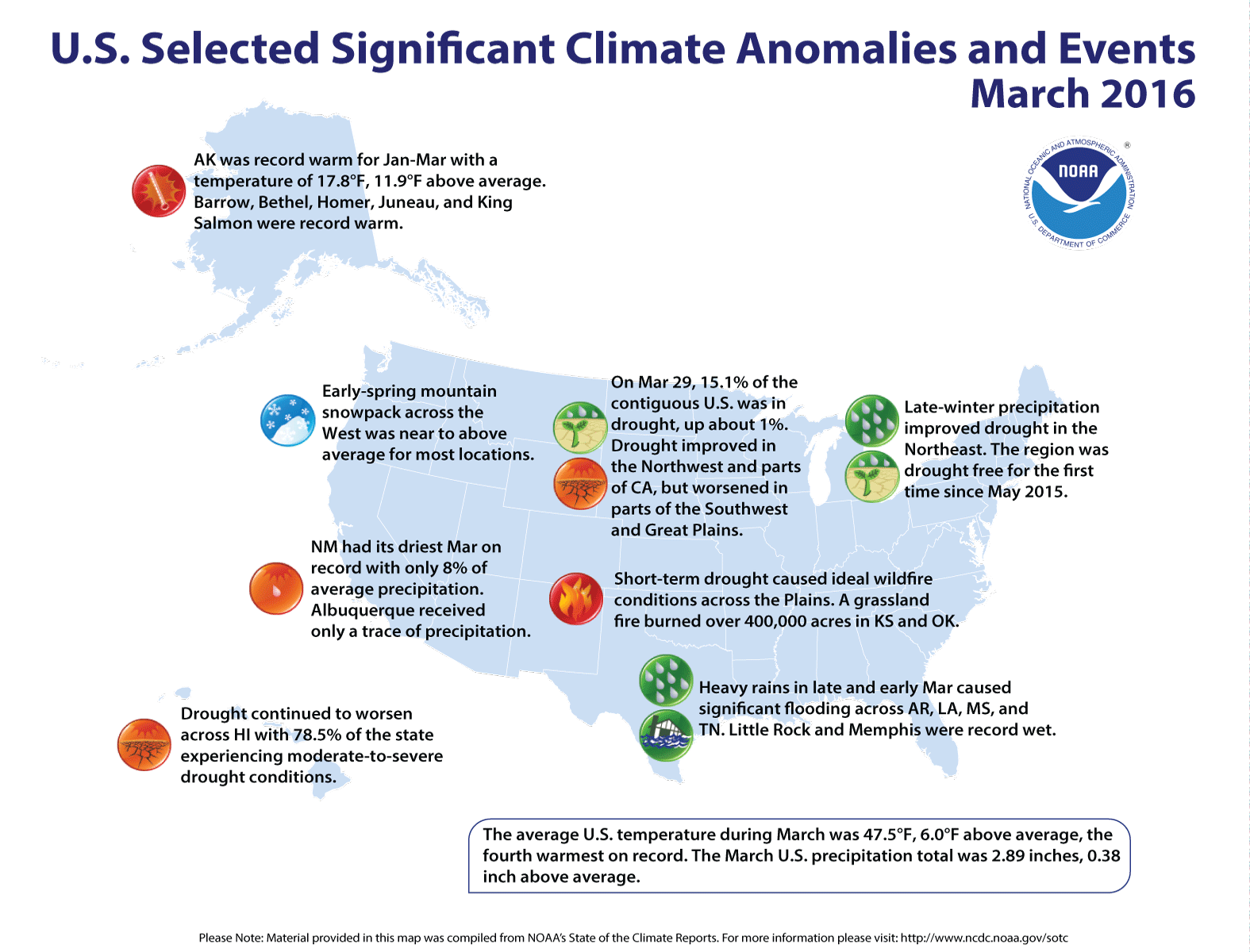
Click here to go the US Drought Monitor website. Here’s an excerpt:
Summary
This week was generally uneventful in those parts of the country experiencing abnormal dryness and drought, with only a few patchy areas received 1 to 3 inches of precipitation. As a result, dryness and drought either remained unchanged or deteriorated where it existed…
The Plains
In central and southern parts of the Plains, between 1 and 3 inches of precipitation fell on southern Oklahoma, and in a narrow swath from southwestern Oklahoma northeastward through southeastern Kansas and into central and southwestern Missouri; however, D0 was removed from only a few small spots where the largest amounts fell. A few patches in other parts of southern Kansas and central Texas reported about an inch, but light precipitation at best was observed elsewhere. D2 (severe drought) was introduced in parts of northwestern Oklahoma, and moderate drought expanded to cover west-central Kansas and an area from east-central Kansas into northwestern Missouri. Some locales from central Kansas southwestward across northwestern Oklahoma, the Texas Panhandle, and adjacent New Mexico reported less than 25 percent of normal precipitation for the last 90 days, and amounts totaled 4 to 8 inches below normal in parts of central and eastern Oklahoma, southeastern Kansas, southern and western Missouri, and northwestern Arkansas.
Farther north, only a few tenths of an inch of precipitation, if any, fell across the northern Plains, causing expansion of the areas experiencing abnormal dryness and moderate drought. Deterioration to D1 was noted in northeastern South Dakota and adjacent sections of North Dakota and Minnesota, as well as a smaller area in northwestern South Dakota. Farther south, abnormal dryness was introduced throughout the remaining northern tier of South Dakota, and in a band extending through south-central parts of the state. Over the last 30 days, 0.5 to 1.5 inches of precipitation fell on most locations, with little or none observed in western North Dakota, eastern Montana, and the parts of South Dakota and adjacent areas where deterioration occurred on the Drought Monitor…
The Rockies and Intermountain West
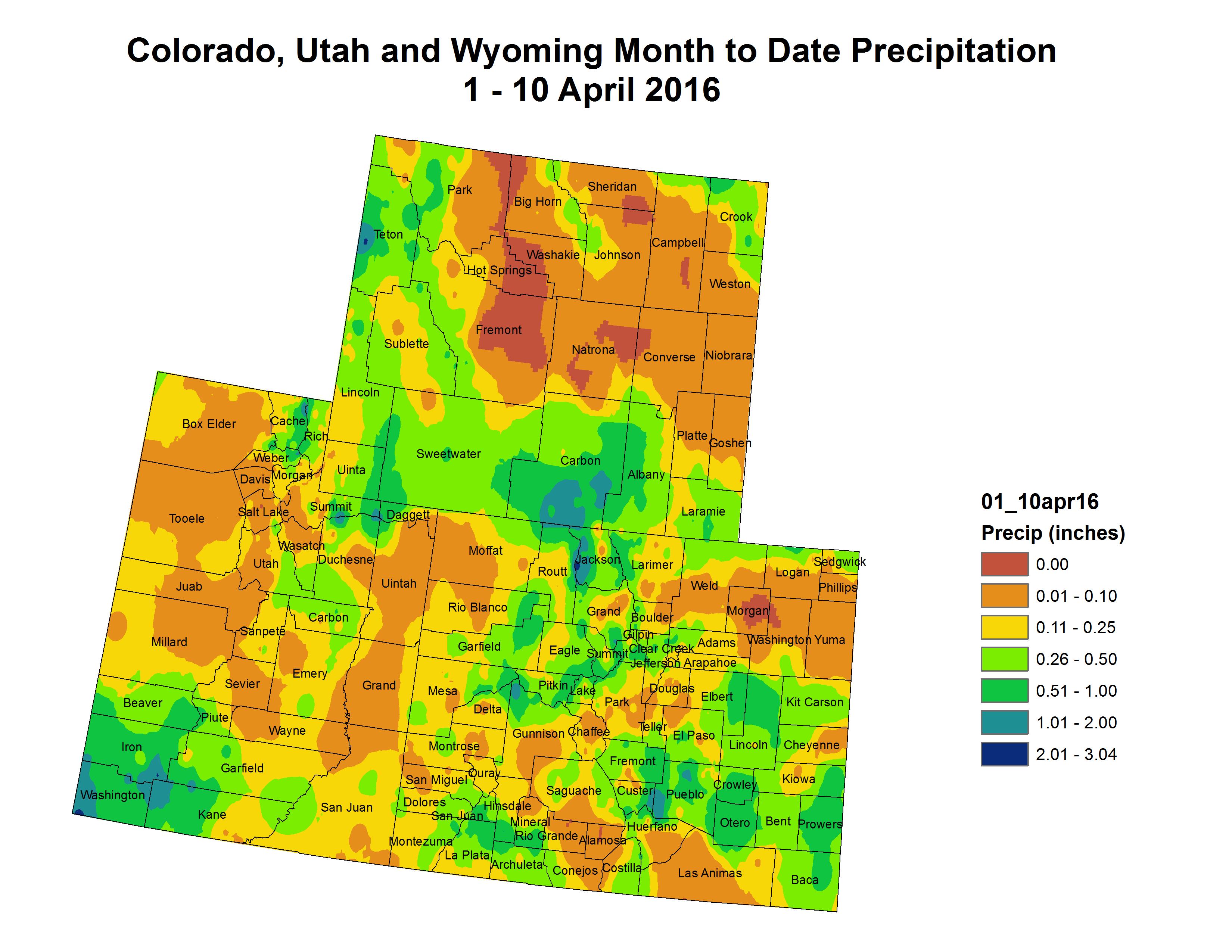
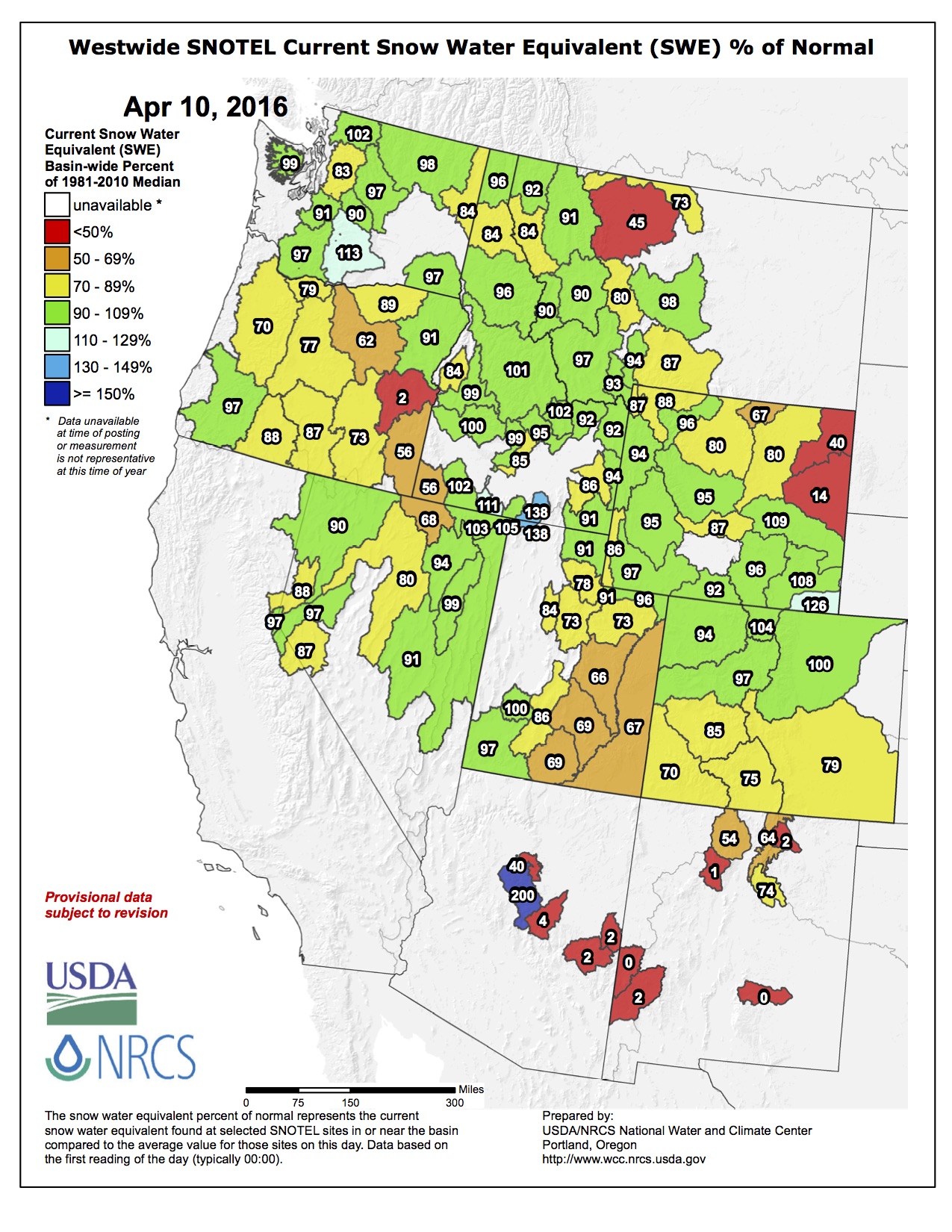
The past 7 days brought 0.5 to locally 2.5 inches of precipitation to much of southeastern Nevada, northwestern Arizona, and adjacent areas of Utah and the desert in California. Similar amounts were noted in central New Mexico and a few other scattered small areas, but in general, a few tenths of an inch of precipitation fell on the southern half of the Rockies and Intermountain West, and only scattered areas to the north reported measurable precipitation. Dryness and drought persisted unchanged in most of the region. D0 was extended northward in southwestern parts of the San Juan Range where snowpack peaked at only 80 percent of the typical annual maximum. Farther north, a reassessment of conditions led to the removal of D0 and a slight reduction of the drought area in part of northeastern Wyoming…
The Far West
Significant precipitation (1.5 to 3.0 inches) fell on the northern half of the area of exceptional drought in California, including part of the San Joaquin Valley, while lesser measurable totals fell on the rest of California and Nevada. In the context of the protracted drought that has gripped California and adjacent areas for the past few years, the benefit of one week of moderate to heavy precipitation in the most intensely affected areas was minimal, and no changes were introduced in any of the dry areas in California, Nevada, and Oregon…
Looking Ahead
Heavy precipitation is expected in some of the driest parts of the Plains during the next 5 days (April 14 – 18, 2016). Generally 3 to locally over 6 inches is forecast from the Texas Panhandle northward through western sections of Oklahoma, Kansas, and Nebraska as well as eastern Colorado. Forecast totals decrease markedly outside of this area, but amounts approaching or exceeding an inch are expected for much of the Plains from southern Texas northward through the central Dakotas. Moderate to locally heavy precipitation is also anticipated for southeastern Georgia and northeastern Florida, but only light precipitation, if any, is anticipated in the remaining areas of dryness and drought across the contiguous 48 states.
Over the ensuing 5 days (April 19 – 23, 2016), the odds favor wetter than normal weather from the southern half of the Plains eastward across the Gulf Coast States, and in the northwesternmost part of the Alaskan Panhandle. In contrast, enhanced chances for subnormal precipitation exist for the areas of dryness and drought in the central Appalachians, Northeast, northern Plains, Rockies, Intermountain West, and Far West. In addition, the odds favor below-normal precipitation in part of the east-central Alaskan dry area.
Dolores River Canyon near ParadoxFromThe Telluride Daily Planet (Stephen Elliott):
The federal Bureau of Land Management announced March 4 that it was soliciting public comment about the possibility of establishing Areas of Critical Environmental Concern, or ACEC, designation in 18 areas in southwest Colorado.
Conservation groups and local governments — including San Miguel, Dolores and Montezuma counties — weren’t pleased with the news.
They say the BLM’s announcement was poorly timed and could jeopardize their years-long negotiations for legislation protecting parts of the Dolores River while respecting the concerns of private landowners in the area.
The BLM contends local groups have known about these ACECs since at least 2007, and that the timing of its announcement was simply coincidental, the result of the unpredictability of the federal bureaucracy.
Yet members of these groups aren’t so sure.
“To have the BLM out of the complete blue say suddenly they’re going to impose ACECs on some of the same property we’ve been negotiating over for 6, 7, 8 years…That was really disturbing,” San Miguel County Commissioner Art Goodtimes said. “I want to chastise the BLM. This is the third or fourth instance of them making a decision — without notifying people — that has been potentially damaging to their ongoing efforts.”
San Miguel, Dolores and Montezuma counties, along with the environmental nonprofit San Juan Citizens Alliance, private landowners and other stakeholders, have been working for several years on possible legislation to protect portions of the Dolores River. They say they were getting close to a deal that satisfied, or at least didn’t offend, both sides of the environmentalist/land-user coin, and that the BLM’s announcement could stall that work.
BLM Tres Rios Field Office Manager Connie Clementson countered that the groups’ disgruntlement with the BLM’s alleged “poor timing” could have something to do with faulty memories: “One of the things that can happen when things take a lot of time is people forget about them.”
For example, Clementson said, the ACECs were first mentioned in the 2007 draft resource management plan for the region (if not before) and then again in 2013. She said she’s been reminding each of the county commissions of the pending ACEC amendments in quarterly updates for four years. She said she again informed the counties and community groups in early 2015 when she initiated the process to have the ACECs published in the Federal Register.
“We had about three days’ notice. We were told on a Tuesday that it was going to be in the Federal Register on Friday,” she said. “I guess people felt like it was a surprise because they had forgotten that we had been telling them for a long time this was going to happen.”
The proposed ACECs deemed relevant and important are Anasazi Culture/Mud Springs, Cement Creek, Cinnamon Pass, Coyote Wash, Disappointment Valley, Dry Creek Basin, Dolores River Canyon (Slick Rock to Bedrock), Grassy Hills, Gypsum Valley, Lake Como, McIntyre Canyon, Mesa Verde Entrance, Muleshoe Bench, Northdale, Silvey’s Pocket, Slick Rock, Snaggletooth and Spring Creek.
Among all the talk about the intricacies of how to protect the Dolores River, the purpose of preserving parts of the river can get lost.
“The set of canyons and valleys the river incises and crosses as it meanders in its somewhat-odd northwesterly trajectory are home to a diversity of habitats that spread from riverine otters to gypsum-soil loving plants to towering old growth Ponderosa pine and more,” said Jimbo Buickerood, Lands and Forest Protection Program Manager for the San Juan Citizens Alliance. “In sum the Dolores River is truly a unique river with a special character that charms its human visitors whether they fly fish its headwaters or are challenged by the significant rapids throughout the river corridor, as well as providing critical habitat to an immense array of animal and vegetative species across the amazing 9,000 foot altitudinal drop of its watershed.”
Some local stakeholders acknowledged they should have been paying more attention to the imminent ACEC announcement.
“It kind of did (take us by surprise), and it shouldn’t have,” Montezuma County Natural Resources and Public Lands Coordinator James Dietrich said. “The BLM planning process has gone on for so long. When they tell you at the beginning of the process that 11 years later you’re supposed to remember it, everybody has the responsibility to keep up.”
The local groups have mostly been working on legislation to establish a National Conservation Area, or NCA, along parts of the Dolores. Those negotiations won’t stop, according to Marsha Porter-Norton, who has been facilitating the negotiations.
“The NCA is by no means going away because of this ACEC proposal,” she said.
Ernie Williams, a Dolores County commissioner who has been central to the NCA negotiations, agreed that discussions would continue.
“We’ve been working on this thing for years. We still plan on moving forward, but we don’t know what the fallout (from the BLM’s announcement) is going to be yet,” he said.
According to Williams and others at the local level, an NCA designation is more flexible than an ACEC because it allows local communities to tailor the designation to their own needs.
“An NCA crafted locally is a much better fit for the communities. You get some of the nuances figured out that you might not get” with another designation, said Buickerood, of the SJCA. “With a lot of local involvement on this, we can really craft something that works well for local communities.”
Environmentalists aren’t the only ones involved in the negotiations. Indeed, the talks involve a balancing act between many, occasionally competing interests: local governments, private landowners, ranchers, recreational river users and those who rely on the lands adjacent to the river to make a living.
Williams, the Dolores County commissioner, said private landowners were already concerned about the prospect of an NCA designation, but that the announcement of possible ACECs has them even more worried, and this hampers his ability to negotiate. Williams and Dietrich, of Montezuma County, pointed out that Canyons of the Ancients National Monument near Cortez had once been an ACEC before being designated a national monument, and that private landowners were therefore worried about what new ACEC designations might mean for their grazing, water and property rights: some envision ACECs along the Dolores as a first step toward a national monument.
“We were working with the landowners within the Dolores River corridor trying to get the best answers for private land, then (the BLM announcement) comes out two weeks later and they felt like they got pressure put on them by the BLM,” Williams said.
Along with most of his local colleagues across the political spectrum, Williams would like to see the river protected by an NCA crafted by local interests.
“An NCA is put together with local people, local conservation groups, local landowners, local governments,” Williams said. “A (national monument) is a stroke of a pen out of Washington, D.C.”
[…]
For the time being, NCA negotiations among local groups and leaders will continue in parallel with, yet separate from, the current ACEC comment period. (The original deadline for comments on the ACECs was April 4, but counties asked for, and received, an extension until May 4. Both Dolores and Montezuma counties are currently working on letters opposing the ACEC designations.)
Here’s the release from Governor Hickenlooper’s office:
Gov. John Hickenlooper today formally endorsed the Windy Gap Firming Project, a water project that will serve cities and farmers on the northern Front Range as well as provide environmental benefits on the Western Slope.
The project expands the existing Windy Gap system built in the 1980s and includes the planned Chimney Hollow Reservoir southwest of Loveland to ensure more reliable supplies for the Northern Colorado Water Conservancy District and other project participants. It also includes several protective measures for fish and waterways on the Western Slope.
“Northern Water and its many project partners have worked diligently, transparently and exhaustively in a collaborative public process that could stand as a model for a project of this nature,” Hickenlooper said. “This is precisely the kind of cooperative effort envisioned for a project to earn a state endorsement in Colorado’s Water Plan.”
The Windy Gap Firming Project has been in the process of obtaining federal, state and local permits and certifications since 2003, including the required Fish and Wildlife Mitigation Plan approved by Colorado Parks and Wildlife, the Colorado Water Conservation Board and, most recently, the Section 401 Water Quality Certification from the Colorado Department of Public Health and Environment.
“Colorado moves the needle today with endorsement of a project that makes gains for the environment and water supply together,” said James Eklund, director of the Colorado Water Conservation Board, the agency that facilitated development of Colorado’s Water Plan. “Grand County, environmental stakeholders, and Northern Water set an excellent example of the collaboration necessary to achieve the bold measurable objectives of Colorado’s Water Plan and the Colorado and South Platte Basin Implementation Plans.”
“Northern Water worked closely with state biologists to ensure that impacts on streams and rivers – and the fish and wildlife that depend on them – were identified and addressed through mitigation for the benefit of the environment, wildlife and recreation,” said Bob Broscheid, director of Colorado Parks and Wildlife. “This was a thorough and unified process and shows what we can accomplish when we work together to reach shared goals.”
With necessary permits and certifications for the project in hand, Hickenlooper also today directed his staff to work with the U.S. Army Corps of Engineers in the federal agency’s issuance of a Section 404 Permit, the final federal regulatory step for the project.
Here’s the release from the Northern Colorado Water Conservancy District (Brian Werner):
Chimney Hollow Reservoir close to reality
Today the State of Colorado officially endorsed the Windy Gap Firming Project and Chimney Hollow Reservoir.
John Stulp, Governor John Hickenlooper’s Water Policy Advisor, made the announcement at Northern Water’s Spring Water Users meeting in Loveland. Reading a letter signed by Gov. Hickenlooper, Stulp told the 200 attendees that this is the state of Colorado’s first endorsement of a water project under the Colorado Water Plan, which was finalized last November.
“Further, the WGFP aligns with the key elements of the Colorado Water Plan…” Hickenlooper wrote.
Hickenlooper continued, “Northern Water and its many project partners have worked diligently, transparently and exhaustively in a collaborative public process that could stand as a model for assessing, reviewing and developing a project of this nature.”
Northern Water’s Municipal Subdistrict President Dennis Yanchunas spoke for the project’s participants in saying, “It’s really exciting to have that endorsement, the first ever by the state.” [ed. emphasis mine] Colorado’s endorsement came on the heels of state water quality certification in late March.
The Colorado Department of Public Health and Environment issued its 401 water quality certification for the Windy Gap Firming Project on March 25, bringing the project permitting process nearer to completion.
“This is the next to the last step in getting the project permitted,” said Project Manager Jeff Drager.
“The final step is the federal 404 wetlands permit from the U.S. Army Corps of Engineers, which we believe will be forthcoming in the next few months.”
The state’s endorsement of the WGFP culminates 13 years of diligent effort and lengthy negotiations to permit and authorize a project that will assure a reliable water supply for more than 500,000 northern Front Range residents.
The federal permitting process began in 2003 under the National Environmental Policy Act. The U.S. Bureau of Reclamation served as the lead federal agency and issued a final Environmental Impact Statement in 2011 and a Record of Decision in 2014 for Chimney Hollow Reservoir.
In addition, the Colorado Parks and Wildlife Commission and Colorado Water Conservation Board approved a fish and wildlife mitigation plan in 2011. The following year the Grand County Commissioners issued a 1041 permit and reached an agreement with Northern Water’s Municipal Subdistrict on a mitigation and enhancement package.
A wide variety of organizations, including Trout Unlimited, support the CDPHE’s long-awaited ruling.
“This permit is another step toward fulfilling the Windy Gap Firming Project’s potential to be part of a balanced water supply strategy for Colorado Front Range,” said Drew Peternell, director of TU’s Colorado Water and Habitat Project.
“Through a balanced portfolio – including responsible supply projects like WGFP – along with stronger conservation and reuse programs and ag-urban water sharing — Colorado can meet its diverse water needs…” Peternell added.
The Windy Gap Firming Project is a collaboration of 12 Northern Front Range water providers and the Platte River Power Authority to improve the reliability of their Windy Gap water supplies. Windy Gap began delivering water in 1985.
The participants include 10 municipalities: Broomfield, Erie, Evans, Fort Lupton, Greeley, Lafayette, Longmont, Louisville, Loveland and Superior; two water districts: Central Weld County and Little Thompson; and one power provider: Platte River. They currently provide water to 500,000 people.
The current cost estimate for WGFP is $400 million. To date the participants have spent $15 million on associated permitting costs.
The Windy Gap Firming Project is one step closer to being more than just big dreams and big dollar signs. The project, which would allow for the construction of the Chimney Hollow Reservoir southwest of Loveland, received the first endorsement a water project has ever gotten from the state of Colorado.
Governor Hickenlooper, John Salazar and John Stulp at the 2012 Drought Conference
John Stulp, special policy adviser for water to Gov. John Hickenlooper, read a letter from the governor at the Northern Water Spring Water Users meeting Wednesday at the Ranch in Loveland. In the letter, Hickenlooper applauded Northern Water for the Windy Gap Firming Project’s ability to bring communities together, protect fish and wildlife, and make Colorado’s water more sustainable, along with other ideals outlined in the Colorado Water Plan, which was adopted last November.
“Northern Water and its many project partners have worked diligently, transparently and exhaustively in a collaborative public process that could stand as a model for a project of this nature,” Hickenlooper said in a news release from his office. “This is precisely the kind of cooperative effort envisioned for a project to earn a state endorsement in Colorado’s Water Plan.”
While the endorsement from the state doesn’t advance the plan in earnest, it does give it credibility in the next and final step to getting its building permit completed.
“This is the next to the last step in getting the project permitted,” said Windy Gap Firming Project manager Jeff Drager in a release from Northern Water. “The final step is the federal 404 wetlands permit from the U.S. Army Corps of Engineers, which we believe will be forthcoming in the next few months.”
When the U.S. Army Corps of Engineers considers the project for the permit, it will want to know if the state approves of it. Now, with an official recommendation from the governor, the path should be smoother for the Windy Gap Firming Project and the Chimney Hollow Reservoir, Stulp said.
“I think this (project) is being done right,” Stulp said. “Now, we have the state’s endorsement and I think that will inform the fed agencies, the Corps at this point, that this has got strong support in Colorado.”
The city of Greeley was one of the original six cities to invest in the existing Windy Gap Reservoir. Now, the city is a participant in the Windy Gap Firming Project. Once the Chimney Hollow reservoir is built, Greeley will receive 4,400 acre-feet of water per year. An acre-foot of water is roughly the equivalent of one football field filled with a foot of water — that’s almost 326,000 gallons of water, or more than 8,000 bathtubs full.
Evans, Fort Lupton and the Central Weld County Water District are also participants in the Windy Gap Firming Project.
The project is estimated to cost about $400 million and participants have thus far spent $15 million, according to the Northern Water release. The reservoir will store 90,000 acre-feet of water and will be located near Carter Lake and parts of Northern Water’s Colorado-Big Thompson Project.
The Windy Gap Firming Project’s participants are primarily municipalities, but also include two water districts and one power company. The purpose of the project is to create an alternative water source for cities and companies to purchase water from instead of resorting to tactics like buy-and-dry or competing with agricultural land for water resources.
During his presentation at the Northern Water Spring Water Users Meeting, Metropolitan State University of Denver professor Tom Cech talked population growth. He said right now, Colorado is home to more than 5 million people. By 2030, that number’s projected to rise to more than 7 million after having already grown about 30 percent since 1990. In the South Platte Basin alone, that kind of population growth will equal a shortage of about 410,000 acre-feet of water, or about 134 billion gallons. Between 133,000 and 226,000 acres of irrigated land in the South Platte River Basin are expected to dry up by 2030.
With the rapid population expansion and resulting urban sprawl happening in Colorado, projects like these are more important than ever, said Eric Wilkinson, Northern Water’s general manager.
“People need water and we’re going to grow. Obviously people like this area, people move to this area and people will continue to come and we have to find ways to provide that water supply,” Wilkinson said. “This is a good way of doing it.”
Gov. John Hickenlooper on Wednesday weighed in formally backing the long-delayed and controversial $400 million Windy Gap project to divert more water from the Colorado River to the booming Front Range.
Hickenlooper ordered state officials to work with the U.S. Army Corps of Engineers to obtain a final federal wetlands permit needed for work to begin. His endorsement is expected to aid that effort.
Northern Water would expand its existing river diversion system built in 1985 by installing a new reservoir southwest of Loveland to hold diverted Colorado River water. That 29 billion-gallon Chimney Hollow Reservoir would supply farmers and growing cities.
“This is the first time he has endorsed this project. We were certainly hoping for it. We were pleasantly surprised,” Northern Water spokesman Brian Werner said.
“This means that construction, starting in 2019, is a reality.”
Northern Water has been planning the project, working with state and federal officials on permits, since 2003. A mitigation plan, approved by Colorado Parks and Wildlife and the Colorado Water Conservation Board, lays out measures to protect fish and off-set environmental harm including altered river flows.
Colorado Department of Public Health and Environment officials, responsible for ensuring water quality, signed off on March 25.
“Northern Water and its many project partners have worked diligently, transparently and exhaustively in a collaborative public process that could stand as a model for a project of this nature,” Hickenlooper said. “This is precisely the kind of cooperative effort envisioned for a project to earn a state endorsement in Colorado’s Water Plan.”
Front Range users would would siphon additional west-flowing water — up to 8.4 billion gallons a year — out of the Colorado River and pump it back eastward under the Continental Divide. That water, stored in the new reservoir, is expected to meet needs of 500,000 residents around Broomfield, Longmont, Loveland and Greeley.
Environment groups on Wednesday reacted with fury.
“This project will further drain and destroy the Colorado River and imperil endangered fish,” said Gary Wockner, director of Save the Colorado River. “We’ve registered 23 complaints with the Army Corps of Engineers. The federal government should deny the permit. This project is reckless.”
Colorado officials endorsed a long-sought water storage project that would include construction of Chimney Hollow Reservoir southwest of Loveland.
Gov. John Hickenlooper on Wednesday voiced his support for the Windy Gap Firming Project, which would divert water from the Western Slope to the Front Range to shore up supplies for municipalities and farmers…
Participants in the water-storage project include Loveland, Longmont, Greeley, Broomfield, Platte River Power Authority and two water districts.
The project recently received a key water quality certification from the Colorado Department of Public Health and Environment. The certification is needed to receive a final permit from the U.S. Army Corps of Engineers to build the project…
Map from Northern Water via the Fort Collins Coloradoan.
If the expected permits come through, final design on Chimney Hollow Reservoir would begin later this year with construction beginning in 2018-19, Werner said.
Chimney Hollow Reservoir would hold up to 90,000 acre feet of water. An acre foot is enough water to meet the annual needs of three to four urban households.
Larimer County would build and operate recreational facilities at the reservoir, which would be built west of Carter Lake. Carter Lake holds up to 112,000 acre feet of water.
The Windy Gap Firming Project has been under federal, state and local review since 2003. It has been challenged by environmentalists over the years because of its impact on the Colorado River’s ecosystem through increased water diversions.
In a recent email to the Coloradoan, the group Save the Colorado stated it would scrutinize the 404 permit decision from the Corps to ensure the project adheres to the National Environmental Policy Act, the Clean Water Act and the Endangered Species Act.
Supporters say the Windy Gap Firming includes measures that would mitigate its environmental impacts and protect fish, streams and water quality in Grand Lake and the Colorado River.
The project — formally called the Windy Gap Firming Project — calls for the construction of a new reservoir, called Chimney Hollow Reservoir southwest of Loveland. The reservoir will be designed to hold up to 90,000 acre feet of water, and reliably deliver about 30,000 acre feet of water every year, enough to support the needs of 60,000 families of four people.
It’s an expansion of the existing Windy Gap system built in the 1980s to divert water from the Colorado River to the Front Range. But the construction of a new reservoir is crucial, said Brian Werner, a spokesman for the Northern Colorado Water Conservancy District, the lead agency on the project.
Because of the Windy Gap project’s relatively junior water rights, water cannot be diverted in years when the snow pack is low. And during wet years, there’s not enough storage space in Lake Granby to store the Windy Gap water, which means it runs down the river.
“Windy Gap right now doesn’t have any firm yield,” Werner said, meaning that the system can’t be counted on to have water available for customers every single year.
“In wet years there’s no where to put it [the water], and in dry years there’s nothing to pump,” Werner said.
About 500,000 people live in the water districts that would be served by the Windy Gap Firming Project, including Broomfield, Lafayette, Louisville, Loveland, Erie and Evans. To date, the cost of planning and permitting the project has risen to $15 million, according to the Northern Colorado Water Conservancy District.
And with population numbers expected to jump in coming years, this project and others will be needed to ensure there’s enough water for the communities to grow, Werner said.
The project’s leaders have worked on agreements to mitigate environmental impacts to protect fish, ensure stream protection and reduce water quality impacts to Grand Lake and the Colorado River.
Last month, the Colorado Department of Public Health and Environment this week released its final “401 water quality certification,” meaning that the state had signed off on the plans to mitigate the environmental impact of the project on the Upper Colorado River.
Trout Unlimited, said the conditions imposed by the state health department put the “threatened river and fishery on road to recovery.
“We firmly believe these permit conditions establish a strong health insurance policy for the Upper Colorado River,” said Mely Whiting, counsel for Trout Unlimited, in a statement.
It took a long time to get here. Click here to take a trip back in time through the Coyote Gulch “Windy Gap” category. Click here for posts from the older Coyote Gulch blog.
Moffat Collection System Project/Windy Gap Firming Project via the Boulder Daily Camera
Windy Gap and C-BT Granby area facilities
Windy Gap Reservoir
Windy Gap Reservoir
Site of proposed Chimney Hollow Reservoir — Windy Gap Firming Project via the Longmont Times-Call
Chimney Hollow Reservoir site
Chimney Hollow Reservoir site via the Bureau of Reclamation
I had the pleasure of viewing the new documentary “River of Sorrow” from the Dolores River Boating Associates yesterday at the eTown Hall in Boulder. The Colorado Water Trust hosted the event. River Network President Nicole Silk, CWT Executive Director Amy Beattie, and filmmaker Cody Perry introduced the film by detailing their personal experiences which led them to a life working with water.
In the film a farmer in Montezuma County detailed the necessity, from her point of view, for McPhee Reservoir. She acknowledged that she understood the motivation of those that want higher releases from the dam for recreation and the environment and the conflict it causes with the irrigators in the Montezuma Valley.
This is the main message: There are too many straws in the Dolores River, or as one person in the film, says, “Yeah, the Dolores River is very iconic, but it’s really a river no more.”
One of the highlights was the rare film footage of boatmen and enthusiasts from the heyday of boating in the years leading up to first fill. Even after first fill the boating survived until the diversion structures were built and started delivering water from the Dolores Project to the San Juan Basin.
The reservoir filled during a wet time and for a while there was a gold medal trout fishery below the dam. Then dryness hit the region (and is still around).
Now, organizations are attempting to reconcile competing views, learning that water rights are in control, and trying to find recreation and environmental water for the river.
Here’s a review from Dennis Webb writing for The Grand Junction Daily Sentinel:
A new documentary film on the Dolores River is to some degree a lament to a river lost, or at least transformed to a degree that it’s hardly recognizable to people with long memories.
“River of Sorrows: Inheriting Today’s Dolores River,” … documents the changes wrought on the river first by the construction of the dam at McPhee Reservoir near the town of Dolores in the 1980s, and then by drought.
While it’s a story about one waterway, it’s one that echoes in river canyons across the West that face challenges similar to the one on the Dolores when it comes to competing demands for scarce water supplies.
“You could say that the Dolores is the canary in the coal mine,” said filmmaker Cody Perry of Rig to Flip, a film production company based in Steamboat Springs. “You could say that the Dolores is potentially the future of every river in the Colorado River Basin in terms of if we have intentions to further develop every drop.”
The Dolores originates in the snowfields of the San Juan Mountains, heads southwest to Dolores and then north along the Colorado border to Gateway before crossing into Utah and its endpoint, the Colorado River.
Perry’s company contracted with the group Dolores River Boating Advocates to tell the river’s story, and particularly describe its life before and after McPhee Reservoir.
The reservoir project provided an important supply of water to agricultural users, as the film shows. But, except for in the wettest of years, it went far in decimating whitewater rafting on what was coming to be considered one of the nation’s best stretches of whitewater, below the reservoir. The river had been growing in renown for its rapids and pristine, slickrock-studded scenery.
For the first five years or so after the dam’s construction, the stretch below it did prove to be a prime trout fishery. But then drought hit, flows dropped below the dam to as little as 20 cubic feet per second, the water warmed and many fish died along the stretch of the river above its confluence with the San Miguel River in Montrose County.
The film quotes Montezuma County Commissioner Larry Don Suckla about the passions boaters, anglers, farmers and others feel regarding the river, and the fact that each group feels threatened.
“But in reality everybody owns that river,” Suckla said.
From the farmers’ perspective, the fear is that they will get less water if more water is released downstream for the fish, he said.
“All the water is already allocated. There is no extra water that is available to send down the river,” Suckla says.
“It’s going to be hard to get this fixed,” he adds later.
The comment succinctly sums up the challenge faced by water managers and the competing interests when it comes to the Dolores, which got its name from the Spanish “El Rio de Nuestra Señora de Dolores,” meaning “The River of Our Lady of Sorrows.”
For whitewater enthusiasts, the film’s high point also is bittersweet. The filmmakers developed contacts with river guides who dug up film footage from the old days of the Dolores when the rapids sometimes raged, including in 1983, the epic spring runoff year when Lake Powell almost overflowed.
Immediately after showing this footage, the film cuts to the lower Dolores today below the dam, barely trickling with water. An unnamed voice provides narration.
“Yeah, the Dolores River is very iconic, but it’s really a river no more. It needs to be seen and supported and it needs to be a river again,” says the voice, which Perry said is that of Andy Hutchinson, a famed Grand Canyon river guide who serves on the board of Dolores River Boating Advocates.
Perry said the archival footage is both thrilling and a reminder of what’s been lost.
“There’s generations of kids who have no idea about this river, and we don’t have that piece of whitewater anymore. It’s a cultural loss, and the generations of people who ran it — there’s a massive gap to today’s river runners who have no idea that was down there,” he said.
He said he’s shown the film to schools, groups of so-called “water buffaloes” and others. He said he was surprised that water managers in particular thought it does a good job of describing the players and issues at hand.
While the film is sympathetic to boating and environmental interests, he said some more extreme environmentalists wish it was edgier. But he feels the film’s job was to educate more than advocate.
“Seven of 10 people in Colorado have never heard about this river, let alone the issues that are specific to it yet also common to other rivers,” he said.
Perry said he’s concerned about the future of agriculture, too. His hope that in the case of the Dolores River, agricultural, recreational and other interests can be willing to show more flexibility in their discussions with each other, and that legal tools can be provided for permanent transfer or long-term leasing of agricultural water for instream flows.
The various interests “need to stop digging in their heels and we have to start meeting each other halfway,” he said.
Go see the film then take in the sights of Four Corners and see the country and the Dolores River for yourself.
Location map for abandoned mine near Silverton. The Silver Wing is in the upper right corner of the aerial.
Here’s the release from Governor Hickenlooper’s office:
Gov. John Hickenlooper and members of Colorado’s federal delegation yesterday sent a letter to EPA Administrator Gina McCarthy asking for additional support for the Bonita Peak Mining District. Senators Michael Bennet and Cory Gardner, and Congressman Scott Tipton joined Hickenlooper on the letter in support of the local communities including the Towns of Silverton and Durango, San Juan and La Plata Counties.
“As part of Superfund designation process, we reiterate the importance of addressing the concerns expressed by the Town of Silverton and San Juan County and that cleanup moves forward in a way that works for all affected localities,” said Hickenlooper.
Specifically, the letter urges the EPA to expand the scope and planned timeline to operate the temporary water treatment plant on Cement Creek as well as provide adequate funding and collaborate with local governments, tribes, and the state to conduct long-term monitoring along the Animas River and at sites of specific concern to each community. The letter also reiterated support for an expedited claims and reimbursement process for the communities.
Gov. John Hickenlooper, Sens. Michael Bennet and Cory Gardner and Rep. Scott Tipton this week asked EPA Administrator Gina McCarthy for extra support — emphasizing the EPA role triggering the Aug. 5 Gold King disaster.
They’re demanding that the EPA ensure sufficient funding for cleanup as promised, that Silverton and nearby communities get a seat at the table as promised, and robust interim cleanup of creek water as promised.
“We urge you to prioritize funding for this project as soon as possible to restore the health of the Animas River watershed, protect public health, and maintain the local recreation and tourism economy,” Hickenlooper and the lawmakers said in a letter to McCarthy.
While EPA officials have proposed a priority listing of mine sites around Silverton and say they’ll treat the Gold King cleanup like any other site, the Colorado leaders insisted that “the EPA must recognize its role in the most recent spill and its subsequent obligation to this community.”
They contend a temporary treatment plant on Cement Creek “may not operate” beyond this fall and that “this facility has the ability to treat more of the acid mine drainage in the watershed.”
They asked EPA officials to expand the scope of those water-cleaning operations, to be continued until overall cleanup is done, and to speed up reimbursement of costs that towns, counties, tribes and businesses incurred due to the 3 million-gallon deluge — caused by botched EPA efforts to drain the Gold King Mine.
“We also have heard significant concerns from local communities that the current water quality monitoring on the Animas River is not sufficient,” the letter said. “It is likely that spring runoff will remobilize the sediments and metals deposited during the spill. … The EPA must provide adequate funding. … The funds pledged to date by EPA for these needs are insufficient.”
Meanwhile, Republicans in Congress continue to harass the EPA. Here’s a report from Matthew Daly writing for the Associated Press via 12NewsNow.com:
Senate Republicans vowed Tuesday to issue a subpoena to force the head of the Environmental Protection Agency to appear at a field hearing in Phoenix next week on a toxic mine spill that fouled rivers in three Western states and on lands belonging to two Native American tribes.
Wyoming Sen. John Barrasso said the Senate Indian Affairs Committee will vote Wednesday on a plan to subpoena EPA Administrator Gina McCarthy.
Barrasso chairs the Indian Affairs panel, which is conducting an April 22 hearing on the 3-million gallon spill at Colorado’s abandoned Gold King Mine. The Aug. 5 spill contaminated rivers in Colorado, New Mexico and Utah, as well as in the Navajo Nation and Southern Ute Reservation.
If approved, the subpoena would be the first issued by the Indian Affairs panel since 2004, during the Jack Abramoff lobbying scandal. Abramoff was a prominent Republican lobbyist who pleaded guilty to charges including conspiracy, fraud and tax evasion in the purchase of gambling cruise boats. He spent 3 and 1/2 years in prison…
Barrasso said the EPA has been “reckless,” first in causing the spill and then in failing to address it.
“They took their eye off the ball,” Barrasso said of the EPA. “They caused this toxic spill and now they are still not focused on cleaning up the mess they caused.”
An EPA spokeswoman said Tuesday that McCarthy was never invited to attend the hearing; an official who oversees emergency management was asked to testify.
In a letter to the committee, the EPA said it will make two high-ranking officials available to testify, including Mathy Stanislaus, an assistant EPA administrator who originally was invited to testify. Stanislaus initially said he had a scheduling conflict. The Associated Press obtained a copy of the letter Tuesday night.
Spokeswoman Melissa Harrison said earlier that the agency has agreed to provide written testimony for the hearing, scheduled for Earth Day.
McCarthy testified before the Senate Indian Affairs and Environment committees on the spill last year.
Barrasso called the agency’s initial response another indication that the EPA “has grown too big, too arrogant, too irresponsible and too unaccountable” to the American people.
“On Earth Day, the EPA ought to be there to confess the failures of the (Obama) administration” to those affected by the spill and specify “what they are going to do to correct it,” Barrasso said.
Barrasso cited news reports indicating that McCarthy is likely to be among U.S. officials joining Secretary of State John Kerry in New York at an Earth Day ceremony to sign a global climate change agreement reached in Paris last year. The agreement calls for the U.S. and nearly 200 other countries to reduce greenhouse gas emissions blamed for global warming.
McCarthy would rather be in New York “talking about what happened in Paris instead of going to Arizona to face the people who her agency has abandoned,” Barrasso said. “That’s what she thinks is more important.”
McCarthy plans to spend Earth Day in Washington, Harrison said.
The EPA recently announced it would spend $157,000 to help the Navajo Nation recover costs incurred during the response to the Gold King spill. The money is in addition to more than $1.1 million spent by the EPA in response costs for the Navajo immediately following the spill.
The EPA has awarded the Navajo more than $93 million in grants to develop environmental and infrastructure programs, Harrison said.
The confluence of Fountain Creek and the Arkansas River in Pueblo County — photo via the Colorado Springs Business Journal FromThe Pueblo Chieftain (Chris Woodka):
A proposed agreement between Pueblo County and Colorado Springs related to the Southern Delivery System took a year to pound out and centers on Colorado Springs’ failure to control stormwater.
Last April, Pueblo County commissioners were moving toward a compliance hearing for the 1041 permit that allowed Colorado Springs to build its $825 million pipeline project from Pueblo Dam to Colorado Springs.
At the time, Colorado Springs claimed it had spent $243 million on stormwater projects from 2004-14, but Pueblo County officials were skeptical.
A memo to commissioners from staff called the Colorado Springs accounting “conflicting and inconsistent.”
That launched a more thorough investigation that has taken as many turns as Fountain Creek itself toward reaching a final agreement.
Newly elected Colorado Springs Mayor John Suthers last summer proposed spending $19 million annually on a year-to-year basis to make up for the Colorado Springs City Council’s decision to abolish its stormwater enterprise in 2009. For just three years, the enterprise had generated about $15.2 million annually.
But a scathing EPA audit released in November revealed Colorado Springs had failed to meet even the minimum conditions of its state stormwater permit, opening the door for more mitigation.
“It elevated our status by showing that what people in Pueblo had been saying for years was true,” said Pueblo County Commissioner Terry Hart.
In January, Suthers offered Pueblo City Council and commissioners a 10-year, $19 million plan, which was met with little interest.
Council’s resolution asked for $500 million over 10 years, and commissioners questioned how projects would be verified. In early March, Suthers went public with Colorado Springs’ proposal to put a minimum of $460 million into projects over the next 20 years. He indicated that Colorado Springs Utilities was anxious to get SDS on line by April 27 to assure that warranties on water pumping and treatment are in place after testing concludes.
Later in the same week, on March 11, commissioners wrote to the Bureau of Reclamation updating 1041 permit compliance in anticipation of beginning SDS operations. Stormwater management on Fountain Creek was the major unresolved issue that could keep SDS from being turned on.
A month later, Pueblo County had obtained what commissioners and lawyers say are enforceable provisions to make sure Colorado Springs complies.
“This is a contract,” Hart said. “It has specific actions Colorado Springs has to meet, and gives us a seat at the table.”
Hart said the proposed IGA provides an additional layer of enforcement, on top of the 1041 provisions, which remain in place, and the federal Department of Justice enforcement of the Clean Water Act.
The proposed IGA also benefits Colorado Springs because it provides evidence of tangible steps toward compliance with the federal law, Hart said.
“Fixing the stormwater issues that we inherited stemming from the dissolution of the stormwater enterprise has been a top priority for me and the (Colorado Springs) City Council,” Suthers said in a statement released Monday. “Sustainable stormwater funding and management is not optional — it is something that we must do to protect our waterways, serve our downstream neighbors and meet the legal requirements of a federal permit.”
More coverage from Chris Woodka writing for The Pueblo Chieftain:
Protecting Pueblo from Fountain Creek flooding will take projects in Colorado Springs, Pueblo and everywhere in between.
A proposed intergovernmental agreement for Southern Delivery System between Colorado Springs and Pueblo County will kick-start projects in all areas, Pueblo County Commissioner Terry Hart said.
“This agreement allows the communities to get moving and tackle projects,” Hart said. “Lots of elements have value to all of the communities.”
Commissioners will hear public comments on the proposed agreement at a work session on Monday with a possible vote scheduled for April 25. There’s a lot to take in.
Last year, the county hired Wright Water Engineers to document the issues on Fountain Creek in the most comprehensive study to date. The Wright study connected the dots between Colorado Springs growth and deteriorating conditions on Fountain Creek, finding that 370,000 tons of sediment annually are stranded between Colorado Springs and the confluence with the Arkansas River each year.
That build-up is decreasing the ability of levees installed nearly 30 years ago to protect Pueblo.
“One of the best recommendations tions we had was to retain Wright Water Engineers,” said Commissioner Liane “Buffie” McFadyen. “I don’t think we’d be here without the work they did.”
One of Wright’s findings was that projects up and down Fountain Creek are needed to correct problems and protect Pueblo.
That includes the 71 projects within Colorado Springs that are covered under a $460 million, 20year commitment in the proposed IGA. Of those, 61 benefit Pueblo, so it was important for Pueblo to have a place at the table to determine timing of the projects, Hart said.
Under the proposed agreement, Pueblo’s engineers would be able to annually review progress of the projects, which over time will make up about two-thirds of the total Colorado Springs stormwater budget.
The 2013 sediment transport study by the U.S. Geological Survey showed there is some benefit to Pueblo from detention ponds in Colorado Springs. Those are among the first structures to be built under the proposed agreement. Work already has started on one in Sand Creek.
That study also showed the biggest benefit to Pueblo, both for controlling high flows and trapping sediment, would be a large dam between Colorado Springs and Pueblo.
“To build a dam, we have to get going now.
We need to know where it goes and what it looks like,” Hart said.
The Fountain Creek Watershed Flood Control and Greenway District is prepared to start working on those issues, but lacks funds. The IGA would provide $20 million from Colorado Springs in the next nine months to begin work on the dam question.
Those would be the first of five $10 million annual payments that were earlier negotiated by Pueblo County as part of its 1041 permit for SDS.
The district’s budget includes $2.5 million this year to continue a study of whether one or several dams could be built and to evaluate the relative cost effectiveness of alternatives.
The proposed agreement is important because the money might otherwise not start arriving until January 2017 at the soonest, and possibly even later if SDS were to be delayed in court, Hart said.
It also provides $125,000 for routine administrative tasks of the Fountain Creek district as a patch until more permanent funds are lined up.
Finally, work on the Pueblo levee system along Fountain Creek is the most important way to protect Pueblo in the short term, according to the Wright report.
The city of Pueblo has the primary responsibility for maintaining the levees and the new agreement would add $3 million over the next three years for that purpose. Pueblo would have to match those funds.
Pueblo County already is holding about $1.8 million, so Pueblo’s share would be $1.2 million, or $400,000 annually to leverage $6 million or more in improvements.
“We know $50 million isn’t going to be enough to build a dam,” Hart said. “We’re counting on the communities to bring in other grants or other funding for all the other projects as well.”
From the Colorado Springs Independent (Pam Zubeck):
The cost of deferred maintenance came into sharp focus Monday when Pueblo County and the city of Colorado Springs announced a 20-year, $460million deal to correct the Springs’ neglected flood-control system and pave the way for good relations over activating Springs Utilities’ $825million water pipeline from Pueblo Reservoir.
The agreement will cost the city an average of $23 million a year — 53 percent more than the $15.2 million raised by the city’s previous Stormwater Enterprise fee. The fee, adopted in 2007, was abolished in 2009 to comply with Issue 300, a ballot measure mounted by anti-tax activist Douglas Bruce as a way to end the “rain tax.” That action infuriated Pueblo County, which issued a construction permit in April 2009 for the Southern Delivery System pipeline in part on spending made possible by the stormwater fee.
Now, the city will pay considerably more.
“This IGA requires Colorado Springs to commit much more than [the Stormwater Enterprise] for stormwater mitigation to address the past practices of overlooking the stormwater problems and to address future issues,” Pueblo County Commissioner Sal Pace said in a release.
Mayor John Suthers told City Council on Monday it’s the city’s problem “regardless of the level of public support.” Besides opposing the enterprise in 2009, voters in 2014 rejected a regional drainage authority and fees, a measure opposed by former Mayor Steve Bach.
“This is not a problem that those of us in this room created,” Suthers said. “I’m not going to point fingers. But the fact of the matter is, it’s a problem we inherited. It’s a problem we have to deal with.”
He also noted that while city general funds and Springs Utilities rates will fund the agreement, nothing precludes developing a different funding source, such as fees or special taxes. Suthers also pointed out the IGA will “go a long way” toward resolving negotiations with the Justice Department over the city’s 2013 and 2015 Clean Water Act violations, which could bring fines and/or a court decree mandating levels of spending.
As outlined by Pueblo County, the intergovernmental agreement’s terms:
• Colorado Springs will spend $460 million during the next 20 years on 71 stormwater projects.
• If those projects aren’t finished by 2035, the IGA renews for five years at another $26 million per year.
• Pueblo County will play a “significant role” in timing, prioritization, selection and verification of mandated projects under a “strong mechanism for enforcement.”
• Utilities will pay the city of Pueblo $3 million ($1 million a year for three years) to protect its levees, in addition to $2.2 million already paid for that. But the money must be spent in the year in which it’s given, said David Robbins, outside attorney representing the Springs.
• Utilities also will make a one-time $125,000 payment to the Fountain Creek Watershed, Flood Control and Greenway District to help fund operations and studies, including whether to dam Fountain Creek.
• Utilities’ previously agreed-to payments to the Fountain district of $50 million over five years will be accelerated; the first payment of $9.6 million is due within 30 days of IGA approval. Then, four equal payments of $10 million will be made annually starting in January 2017. The money will fund erosion and flood control.
While the IGA’s funding is subject to annual appropriations in compliance with the Taxpayer’s Bill of Rights, the IGA is guaranteed by the Utilities enterprise, which can commit to a multi-year agreement, a city spokeswoman says.
Council and Pueblo County commissioners are expected to approve the IGA in coming weeks in advance of the April 27 scheduled activation of SDS.
Southern Delivery System map via Colorado Springs Utilities
Rep. J. Paul Brown, R-Ignacio, has pushed for the bill for several years, pointing to looming water shortages and pressure on agricultural communities.
The bill would require the Colorado Water Conservation Board to study the amount of water that has been delivered over 20 years to Nebraska from the South Platte River in excess of the amount allowed under the river agreement.
“The Front Range is depending on the Western Slope for water and there just isn’t any there to bring over,” Brown said.
The bill could receive a final vote in the House as early as Wednesday, before moving to the Senate for consideration.
Having survived an earlier appropriations hearing in the House, the bill stands its best chance yet of making its way through the entire legislative process. The $250,000 to pay for the study would come from existing severance taxes.
In addition to studying water leaving the state, the measure would examine possible locations for a reservoir along the river between Greeley and Julesburg.
Water officials would report back to lawmakers with findings…
There are 25 transmountain diversions across the state, in which water from rural Colorado is used for municipalities along the Front Range. Brown would like to avoid any more diversions.
“We cannot afford to go ahead and waste this water out of the state of Colorado,” Brown said. “There are all kinds of benefits to water storage, as we can see of the reservoirs all over the state of Colorado.”
Colorado fish biologists have been embroiled in a mystery surrounding Colorado’s native cutthroat trout.
For decades, biologists accepted that Colorado’s native cutthroat could be distinguished by their location: Greenbacks were east of the Continental Divide while Colorado River and Rio Grande cutthroat were in their namesake watersheds. This was important because the Colorado River and green back cutthroat are difficult to differentiate due to similar coloration and spotting.
Thought to be extinct by the 1930s, vestige greenback populations were discovered by biologists in the 1950s. Subsequent recovery efforts led to their down-listing from “endangered” to “threatened” in 1978. However, several years ago, researchers using innovative genetic technology, revealed half of these remnant greenback populations were actually Colorado River cutthroat trout.
This was a blow to recovery efforts since many of these populations were used to establish new populations. Spurred by the revelation, fish biologists tested cutthroat populations statewide and discovered that fish genetically-resembling greenbacks were numerous on the Western Slope, suggesting a possible deficiency in the genetic analyses.
At the time, genetic researchers were confident that their tests were reliable and thought the unexpected distributions of cutthroat could be reflecting the widespread sportfish stocking efforts in the late 19th and early 20th centuries. Colorado Parks & Wildlife, still wary of the findings, partnered with genetecists to develop a new genetic test to clarify the differences between our native cutthroats.
FISHING FOR INFORMATION
Fish taxonomists dug through historic federal and state records and accounts of fish stocking to develop a better understanding and a more detailed history of past events. Researchers also evaluated extensive museum collections of trout specimens assembled and preserved up to 150 years ago by explorers, before fish stocking was rampant. These historic specimens revealed that, prior to settlement, each major river basin had a distinct lineage of cutthroat trout.
It is now clear that Colorado historically had six – not three – distinct lineages of native cutthroat trout: Greenback cutthroat originated in the South Platte River; yellowfin cutthroat, thought to be indigenous only to Twin Lakes, actually inhabited cold waters throughout the Arkansas River basin; Rio Grande cutthroat continue to persist in their namesake watershed; a previously undescribed lineage existed in the San Juan River; and, two Colorado River cutthroat lineages were isolated in the Yamp/White and Upper Colorado watersheds. Historic fish stocking widely distributed fish, resulting in the inadvertent preservation of the greenback cutthroat outside of their native basin. Unfortunately, extensive searches for the descendants of yellowfin and San Juan cutthroat within and outside of their native drainages have failed.
Recovery efforts for our native cutthroat have always used what is considered to be the best science available. For a time, reintroduction efforts used fish that were not necessarily indigenous to the waters where they were introduced, but this increased the number of native cutthroat populations across Colorado, preserving the genetic diversity and resiliency of the species. As well, existing habitat was protected, rehabilitated and restored; and streams were secured from invasion by exotic fish species and disease. Now we are tasked with continuing these preservation efforts and expanding our unique remnat populations to ensure the legacy of Colorado’s cutthroat long into the future.
From the Republican River Water Conservation District (Deb Daniel):
The Republican River Water Conservation District (RRWCD) acting through its Water Activity Enterprise will again partner with NRCS to encourage water conservation through the Ogallala Aquifer Initiative (OAI). The RRWCD will provide incentives to producers that voluntarily implement certain water conservation measures. Last year the RRWCD teamed up with NRCS on this program and provided $510,000 to convert approximately five hundred ten acres (510 acres) from irrigated to dryland agriculture or grassland.
This year the District has expanded their participation in the program and will also provide funding along with the NRCS incentives on short-term irrigation rotations, and certain water management improvements such as soil moisture monitoring systems, weather stations, and conversion from sprinkler irrigation to an underground drip irrigation system.
In addition to the NRCS incentives, the RRWCD will provide between six hundred ($600.00) and one thousand two hundred dollars ($1,200.00) depending on the location of the well. In addition to the permanent well retirement practice, the District will be providing incentives to eligible producers that enter into short –term (1 -3 years) rotations from irrigated cropland to dryland cropping practices. Priorities have been established to focus RRWCD funding in areas that provides the highest level of credit for Colorado in the Republican River Compact.
Recent research has suggested that high capacity wells can reduce water consumption by as much as twenty percent (20%) in some cases, with little or no effect on the overall profitability of that particular well. To supplement NRCS incentives the RRWCD has earmarked fifty thousand dollars ($50,000.00) to producers who wish to continue to irrigate, but agree to reduce pumping by at least ten percent (10%) using water conservation measures such as weather stations, soil moisture monitoring and conversion from sprinkler irrigation to an underground drip system. More efficient irrigation systems can contribute substantially to prolonging the life of the aquifer, while maintaining a strong irrigated agricultural economy.
The RRWCD has consulted with groundwater management districts, the Water Preservation Partnership, and others to develop strategies to assist producers through financial incentives to voluntarily reduce water consumption. Several surveys distributed throughout the District to producers have indicated that voluntary, incentive based practices were preferred over regulatory water restrictions. The OAI provides yet another voluntary incentive based tool that all producers can use to help prolong the life of this aquifer. It is important that each and every irrigated agriculture producer evaluate their individual irrigation practices and determine if they can help reduce their impact on the aquifer by implementing one or more of these water conservation practices.
Walker Ranch now is home to a 1,315-acre conservation easement in partnership with the Department of Defense, furthering its protection of Fort Carson and wildlife habitat, The Nature Conservancy announced Friday.
The addition brings the Walkers’ total conservation easements to about 22,292 acres, conserving land next to Fort Carson through money from the Army Compatible Use Buffer program.
The Walker Ranch conservation is one of the largest, most successful such projects, creating a buffer against development along more than 20 miles of the Fort Carson boundary, The Conservancy said in a news release.
Gary Walker’s family has worked with the Conservancy and the U.S. Army since 2005, ensuring continued military use of a key installation and economic driver for the Colorado Springs area.
The easement protects not only the post, but also habitat for the ferruginous hawk, scaled quail, burrowing owl, Cassin’s sparrow, mule deer and pronghorn antelope…
The ranch also became the first restoration site in eastern Colorado for the endangered black-footed ferret in 2013.
“I hope to have all our lands under a conservation easement in my lifetime,” Walker said in a Conservancy news release. “This ranch is meant to be protected, and there is nothing more destructive to this fragile ecosystem than subdivision. Build up, not out.”
The threat of flash floods continues to linger in the minds of western El Paso County residents.
That worry loomed large for a group that met last week in Green Mountain Falls. They were focused on what might happen if torrential rains pound the Waldo Canyon burn scar and strike areas further upstream this summer.
Their concern has precedent. Thunderstorms on the barren, burned out slopes northeast of U.S. Highway 24 and in Woodland Park have filled Fountain Creek to its edges the last few years, leaving residents of Cascade, Manitou Springs and Green Mountain Falls spending each spring stacking sandbags and cleaning up after a series of floods.
Residents of those towns find themselves repeatedly asking the same question:
“What are they doing upstream?”
[…]
Those downstream remember a brief but powerful storm that hit Woodland Park in August 2013 and sent “a wall of water” pouring down Fountain Creek.
In an interview with The Gazette, Bill Alspach outlined years of planning and channel reconstruction that he said the Teller County city at the headwaters of Fountain Creek have been doing.
“We understand the creek,” Alspach said. “We’ve committed ourselves to being good stewards of the headwaters and good stewards to our neighbors. We’re doing this because it’s the right thing to do.”
Mayor-elect Jane Newberry said there is a “general feeling” in Green Mountain Falls that growth in Woodland Park has led to more storm runoff and a greater threat that Fountain Creek could pour over its banks and threaten bridges, homes and businesses in the communities below.
During the Aug. 22, 2013 storm, two bridges were damaged in Green Mountain Falls and several homes flooded in Green Mountain Falls and Cascade.
Newberry said she has “seen the city leaders in Woodland Park” focus on updating their development requirements to include a priority on drainage mitigation.
Alspach echoed that, saying that Woodland Park began its foundation of “stormwater stewardship” when the city council passed a resolution in 1994 requiring strict criteria for runoff retention.
In 2011 Alspach updated city code to require developers to include designs that slow runoff and reduce effect on Fountain Creek. He said that entails using landscaping, ponds and other features to force water into the ground before it flows toward the channel.
Alspach said businesses with large impervious parking lots and homeowners need to be aware of runoff on their property.
“Everybody contributes to impervious areas,” he said.
In 2014 Woodland Park partnered with Colorado Springs and El Paso County officials to have consistency within the watershed, Alspach said. Woodland Park has since rebuilt the west and east forks of Fountain Creek through town with help from CDOT and the Federal Emergency Management Administration. Alspach said the water now flows through culverts that include several features to help slow the flow.
Now, the city is focused on the next phase, which runs from the convergence of those forks to Aspen Garden Way just east of the Safeway store. Alspach said the city will begin taking bids from contractors on Wednesday to rebuild that portion of the creek. The work will include clearing the channel of debris and installing cutoff walls, boulders and other elements to control flow speeds.
The creek further east is beyond Woodland Park city limits and the responsibility falls to Teller County and private landowners.
Bryan Kincaid, who manages floodplain concerns for Teller County, said consultants who have worked with Woodland Park are in the midst of a stream bed stability assessment from the edge of Woodland Park to the El Paso County line.
“Everybody knows about the feud that has started between everybody downstream and Woodland Park,” Kincaid said. “We’re stuck right in the middle.”
Roads for private landowners along Crystola Road and near Crystola Canyon Road have been closed during heavy rains that send water churning down the usually dry creek bed.
Kincaid said Teller County maintains creek crossings at County Road 21, Creekside Drive and Crystola Canyon Road. The rest of the creek is on private land, he said. Alspach added that while Woodland Park and Teller County seek federal and state aid to help pay for channel maintenance, it’s a challenge for private residents to find money to maintain the creek on their property.
“They own the creek,” Alspach said, noting that landowners can partner with volunteer agencies like the Coalition for the Upper South Platte and the Rocky Mountain Field Institute to help keep the channel safe.
CUSP and RMFI have worked with residents all along Fountain Creek and other drainages plagued by flash flooding since the June 2012 Waldo Canyon fire. The more than 18,000-acre blaze left mountain slopes west of Colorado Springs without vegetation needed to help slow runoff flows during heavy rains. Continued concerns four years later prompted the Green Mountain Falls preparedness meeting.
Flooding is a threat to historic buildings across the country, and most communities are not prepared to protect their valuable resources.
Those are the findings of a new study published in the Journal of the American Planning Association, and co-authored by professors at the University of Colorado Denver and the University of Kentucky.
“Historic resources are a big part of the local economy,” said Andrew Rumbach, Assistant Professor of Planning and Design at the University of Colorado Denver. “So losing those resources is not only bad for the character and identity of the place, but it’s also bad for the local economy.”
Rumbach says Manitou Springs in Colorado is a classic example of an historic tourist town that has done a good job at preservation.
With help from the state, the town has put millions of dollars into improvements to direct water away from historic structures.
The town, named for its mineral water springs, has experience significant flooding in recent years. The flood waters caused more than $100,000 in damage to one of Manitou’s oldest buildings, an inn named The Cliff House at Pikes Peak.
“The Cliff House was here before the flood maps were developed,” said Paul York, the general manager. “You can’t exactly move The Cliff House’s location, it’s right here!”
The hotel has built flood walls to protect its parking structure. They say the wall can be deployed by a single person in less than 30 seconds, in case there is little warning about an oncoming flood.
“It’s come to this,” said York, as he demonstrated how to seal off the flood wall.
After nearly a year of negotiations, a stormwater deal has been reached between the city of Colorado Springs, Colorado Springs Utilities and Pueblo County commissioners.
The tentative intergovernmental agreement, which Mayor John Suthers outlined Monday to the City Council, will benefit not only Pueblo and Pueblo County, but also local residents, by providing $460 million in stormwater projects by 2035.
Those improvements are sorely needed, as the U.S. Environmental Protection Agency noted in dismal audits of the city stormwater program in 2013 and last August. Unless the situation improves dramatically, the EPA likely would sue Colorado Springs and restrict the MS4 permit that allows the city to send stormwater into the interstate water system.
The more immediate concern was Pueblo County’s threat to withhold the 1041 permit it granted to Utilities for the $825 million Southern Delivery System. That massive water system is scheduled to start delivering water April 27, and the intergovernmental agreement would be signed just in the nick of time…
Suthers started negotiating almost immediately after he was sworn in as mayor last June, and the mayor, Council President Merv Bennett and key leaders from Utilities made repeated trips to Pueblo to smooth the frayed relations and ensure that stormwater improvements would be forthcoming.
The talks proved tricky, as Pueblo’s city and county leaders felt increasing pressure to play hardball with Colorado Springs.
Suthers squeezed the city budget hard to produce millions of dollars. When the city’s southern neighbors balked because they had no guarantee, he placed the burden on Utilities to come up with future funding if and when the city fell short.
Along with that assurance, Pueblo County won a promise that if 71 critical stormwater projects aren’t completed by 2035, the pact will be renewed for five years with continued, commensurate funding increases.
The City Council and Pueblo County commissioners are set to vote on the pact in two weeks.
Provided they enact the agreement, it will mark a hard-fought resolution to Suthers’ most vexing challenge during his 10 months as mayor.
“I personally don’t think we could come up with any better result by litigating on two fronts,” he hold the council. “We could litigate with Pueblo at risk of jeopardizing the SDS being turned on … But I have a certain level of confidence the stormwater program we’re funding here will go a long way toward resolving our (legal) issues with the EPA.”
Besides, he noted: “I mean this very sincerely. It’s the right thing to do. And it’s something we should do.”
Colorado Springs would pay more than $605 million to cover environmental damage for the Southern Delivery System if a draft intergovernmental agreement with Pueblo County is approved.
The proposed deal includes a guarantee to spend at least $460 million over the next 20 years to repair and build stormwater structures in Colorado Springs in a way that benefits downstream communities, particularly the city of Pueblo.
“This has been a tough, arduous negotiation that has taken months,” said Commissioner Liane “Buffie” McFadyen. “After years of Colorado Springs’ failure to honor that commitment we finally have a deal the citizens of Pueblo County can rely upon. We now have guaranteed projects, guaranteed funding and a mechanism for enforceability to back up the guarantees.”
A public hearing on the agreement will be at 1:30 p.m. April 18 in commissioners chambers at the Pueblo County Courthouse. The soonest the board is expected to act on the IGA would be April 25, which gives Colorado Springs time to consider it as well.
Mayor John Suthers is presenting the deal to Colorado Springs City Council today. That group, sitting as the Utilities Board, could pass it on April 20 at the soonest.
Colorado Springs Utilities wants to turn on SDS on April 27.
“I want to make it clear we have not voted on this,” said Commissioner Sal Pace. “I intend to listen to the public next week.” [ed. emphasis mine]
In addition to the stormwater projects, the deal includes nearly $20 million for flood control projects on Fountain Creek within the next nine months, $125,000 to keep the Fountain Creek Watershed Flood Control and Greenway District afloat and $3 million to the city of Pueblo to dredge Fountain Creek.
The $20 million is part of Colorado Springs’ commitment to pay $50 million over five years to the Fountain Creek district under Pueblo County’s 1041 permit for SDS. Within 30 days of signing the IGA, about $9.6 million will be paid, which takes into account credit for $600,000 already provided by Colorado Springs Utilities to the district. Another $10 million would be paid on Jan. 15, 2017, ending a dispute about timing of this year’s payment.
“These immediate payments to the District are desperately needed to study the possibility of, and to potentially construct, a dam on Fountain Creek – this is our opportunity to comprehensively evaluate all options to protect the citizens of Pueblo,” said Commissioner Terry Hart.
The $125,000 would fund operating costs of the district, which now has few financial resources to draw upon.
“The $125,000 was a line in the sand for us,” McFadyen said.
The $3 million to the city of Pueblo for Fountain Creek dredging would require an equal match, part of which could come from $1.8 million held by Pueblo County from an earlier agreement.
The stormwater agreement requires a continued working relationship between Pueblo County and Colorado Springs. Engineers representing both areas have rated 71 current projects for benefits to Colorado Springs and to downstream communities. All but 10 of the projects benefit both.
The list will be reviewed and adjusted over the next 20-25 years to assure compliance and reflect changes in the drainage area.
The accounting includes only money provided by Colorado Springs and Utilities toward projects on the list and require expenditures of $20 million annually the first five years, expanding to $26 million per year in 2031-35. If the list is not complete by 2036, spending of $26 million annually would be required for another five years.
The payments would be guaranteed by transfer funds already paid to the Colorado Springs by Utilities.
Ray Petros, Pueblo County’s water attorney explained the agreement to the board today. Colorado Springs would agree to pay Pueblo County’s engineering costs for drawing up the list and to resolve any IGA disputes in Pueblo District Court.
In addition to the $460 million for stormwater, $50 million for Fountain Creek flood control and $5.2 million for dredging, Colorado Springs previously agreed to spend $75 million by 2024 for sanitary sewer upgrades and $15 million for damage to roads related to SDS.
The total cost for construction of SDS is about $825 million.
Seven years ago, the Pueblo County Board of County Commissioners gave Colorado Springs Utilities permission to build the Southern Delivery System Pipeline through what’s known as a 1041 Permit. That agreement required the City of Colorado Springs to keep water from flowing faster down Fountain Creek.
But a few short months after the SDS agreement was signed, Colorado Springs voters passed ballot issue 300 and the City Council promptly ended the Stormwater Enterprise.
The backlog of storm water improvement languished for a time and it looked like things were headed to court. Commissioner McFadyen expressed relief that things didn’t reach that point.
“Hopefully it saves taxpayers dollars on both sides and actually has an agreement that’s worthwhile and get to the point, it solves the problem.”
In November, Colorado Springs received notice of violation by the Environmental Protection Agency and the Colorado Department of Public Health and Environment for noncompliance with its Municipal Separate Storm Sewer System (MS4) permit under the federal Clean Water Act. That complaint was referred to the US Justice Department for legal action.
The basis of the violation was for failure to provide adequate resources to develop and enforce the MS4 Program…
All of the money committed by Colorado Springs in the proposed agreement comes from the city’s general fund. However Mayor Suthers said the IGA is a flexible agreement.
“If at some point in time Colorado Springs decides to join the rest of the world and have a storm water enterprise, they’re free to do so and that funding source can be utilized, but the voters have turned that down as recently as November of 2014.”
Both the Colorado Springs City Council and Pueblo County Board of County Commissioners must vote to approve the agreement. Pueblo will hold its first public hearing on the issue at their next regularly scheduled board meeting April 18.
Fountain Creek photo via the Fountain Creek Watershed Flood Control and Greenway District
Fountain Creek flood debris May 2014 via The Pueblo Chieftain
Fountain Creek swollen by stormwater November 2011 via The Pueblo Chieftain
Fountain Creek erosion via The Pueblo Chieftain
Fountain Creek during monsoon July 2012 via The Pueblo Chieftain
Fountain Creek swollen by stormwater in 2011 — photo via The Pueblo Chieftain
Fountain Creek through Colorado Springs.
Fountain Creek flooding 1999 via the CWCB
Old railroad bridge over Fountain Creek near Pueblo
Fountain Creek Watershed
The confluence of Fountain Creek and the Arkansas River in Pueblo County — photo via the Colorado Springs Business Journal
State legislation aimed at helping government deal with inactive mines contaminating waterways advanced Monday, a step toward cleanups at sites that cannot qualify for a federal Superfund designation.
The bill backed by Reps. Millie Hamner, D-Dillon, and Don Coram, R-Montrose, passed the House on its second reading. It allows for the use of funds collected by state mining regulators at inactive mine sites where hazardous circumstances exist.
But the amount, $100,000 in an emergency fund, is tiny compared with the magnitude of the problem, with hundreds of mines draining into streams and rivers.
“It’s a small amount of money, but every bit can help, and it provides more flexibility,” said Todd Hartman, spokesman for the state Department of Natural Resources.
Here’s a report from Jessie Thomas-Blate writing for the AmericanRivers.org blog. Here’s an excerpt:
This report identifies the 10 most threatened waterways in the country and highlights the urgent need for conservation, greater efficiency, and better management of water resources to prevent further harm to river health, wildlife, fish and recreation. Fierce competition for water from rivers under ever greater strain from growing demand and the impacts of climate change is threatening the health of rivers across the country. As pressure on limited water resources grows, conflict must give way to cooperation if we are to satisfy the nations’ growing water needs and maintain clean and healthy rivers.
America’s Most Endangered Rivers is a list of rivers at a crossroads, where key decisions in the coming months will determine the rivers’ fates. Over the years, the report has helped spur many successes including the removal of outdated dams, the protection of rivers with Wild and Scenic designations, and the prevention of harmful development and pollution.
This year, we found that outdated and ineffective methods of water management threaten major river basins on both the east and west coasts. The Apalachicola-Chattahoochee-Flint (ACF) River Basin, which includes portions of Alabama, Georgia and Florida, ranks number one on the list, followed by the San Joaquin River in California at number two.
More than eight million people depend on clean drinking water from these two systems combined, and water shortages threaten billions of dollars in agricultural production and fisheries.
The America’s Most Endangered Rivers list spotlights rivers facing urgent threats across the country. The Susquehanna River, for example, which flows through Pennsylvania and Maryland, is threatened by harmful dam operations. In Montana, the Smith River is at risk from a proposed mine and remains on the endangered list for a second year.
What do two rivers in the Southeast and California have in common? Both are threatened by battles over their water.
The Apalachicola-Chattahoochee-Flint Basin in Alabama, Georgia, and Florida tops a new list as the most endangered river in the U.S. this year, according to an annual report from the Washington, D.C.-based conservation group American Rivers. Second most endangered is the San Joaquin River in northern and central California.
“Both rivers suffer from increasing conflict among stakeholders who depend on their water,” including cities, farmers, and wildlife, says Chris Williams, a senior vice president at American Rivers. “And these issues are exacerbated by population growth and climate change.”
Other rivers high on the list include the Susquehanna in Maryland and Pennsylvania, the Smith in Montana, and the Green-Duwamish in Washington.
The annual list, which dates back to 1984, is based on three criteria: A river must be under serious threat, of regional or national significance, and at a turning point in a decision related to conservation. Last year, the Colorado River was number one, and since then two of its three biggest threats have been withdrawn: a controversial development and a plan for a tram. (A uranium mine proposal remains a threat.)
Past annual lists also helped raise awareness about the Hoback River in Montana, where oil and gas leases were defeated, and the Elwha River in Washington, where a series of dams was removed to restore the ecosystem.
Water conflicts are particularly timely now, notes Williams, given several imminent regulatory and court decisions.
“It is time to move away from the old-fashioned model of fighting over water, through grabs and lawsuits, and toward a cooperative model in which stakeholders sit down together and hammer out agreements, so everybody can get what they need,” Williams says.
ASPEN – Six statements of opposition have been filed in water court regarding the city of Aspen’s application for several new water rights, including rights for water from a well that may be drilled 3,000 feet down to reach a major underground aquifer.
The city is seeking rights for the new well, as well as increased diversions of 1.5 cubic foot per second from the Roaring Fork River into the Riverside Ditch, and a storage right of 1.5 acre-feet of water in Snyder Pond, which is in Snyder Park on Midland Ave.
Aspen has also filed an augmentation and exchange plan that involves releasing up to 7.85 cfs of water from the 400 acre-feet of water the city owns in Ruedi Reservoir on the Fryingpan River.
Such back-up water plans can protect junior water rights in the event of a call for water from holders of senior downstream water rights.
Attorney Paul Noto of the water law firm of Patrick, Miller and Noto, filed a statement of opposition on March 31 on behalf of five entities, including The Wonderful Company, which is owned by Stewart and Linda Resnick.
The Resnicks, said by Forbes to be worth over $4 billion, own an estate east of Aspen that the Pitkin County assessor estimates is worth $15.8 million.
Along with the Wonderful Co., there are four other parties represented by Noto in the case: the Stage Road Homeowners Association; Russell B. Wight, Jr.; Mountain Queen, Inc.; and Rocky Mountain Property II Trust.
In his sparsely worded statement of opposition, Noto suggests his clients’ concerns include the use of the proposed underground water, the use of water from Ruedi Reservoir and the use of an unspecified irrigation ditch that he claims the city “has no ownership in.”
Also filing a statement on March 31, the deadline to do so, was a collection of entities controlled by Daniel Och, the CEO of Och-Ziff Capital Management Group, who owns a home on Willoughby Way.
The entities are called Red Mountain Willoughby Associates, LLC, RMWW Holdings, LLC, RMWW Holdings 25 QPRT, and RMWW Holdings 30 Year QPRT.
“Opposers are the owners, users and beneficiaries of water rights that might be adversely affected by the granting of the application filed herein,” the statement of opposition from the Red Mountain entities states, without raising specific issues with the city’s application. Attorney Mark Hamilton of Holland and Hart filed the statement.
The Stillwater Ranch Open Space Association, the Duroux Ditch Co., the Basalt Water Conservancy District, and a state agency, the Colorado Water Conservation Board, also each filed a statement of opposition in the case.
The Stillwater Ranch Open Space Association is tied to a neighborhood of luxury homes, upstream of the Aspen Club.
The Duroux Ditch Company owns and manages the Duroux Ditch, which diverts water from Hunter Creek and sends it across Red Mountain to Willoughby Way.
The members of the Duroux Ditch Co. include Och, Will Mesdag, a former partner in Goldman Sachs and the founder of Red Mountain Capital Partners, LLC, and Bennett Goodman, a senior managing partner at the Blackstone Group and founder of the company’s GSO Capital Partners.
Christopher Geiger, an attorney with Balcomb and Green representing the Duroux Ditch Co., noted in his statement of opposition that the city must prove that its claimed water rights “are not speculative.”
Gleaning a party’s true intent from a statement of “opposition” can be hard to do, as statements don’t always signal litigious intent. Such statements can be filed as a means to learn more about a proposed new water right or to simply monitor a case.
But attorneys do sometimes suggest project-specific concerns in their statements of opposition.
“Applicant claims a tributary underground water right that is not fully augmented and is thus contrary to law,” was one point made in the filing by attorney Noto.
Noto’s mention of a “tributary underground water right” refers to the city seeking the right to drill down to reach an ancient aquifer sitting in a layer of Leadville Limestone below Aspen.
A map from the city's water rights application showing the location of the potential Queen Street Aspen Well.
Deep Well
The Aspen Queen Street Well is proposed for a site just off Queen St., in the Prockter Open Space, which borders the Roaring Fork and is across Neale Ave. from Herron Park.
The city is seeking the right to draw 3.3 cfs from the deep well primarily as a back-up water supply, but its application also seeks a long list of potential uses, including the production of geothermal energy.
The city also wants to increase diversions from the Roaring Fork River and into the Riverside Ditch, by 1.5 cfs. Today the ditch, from its head gate near the Aspen Club, winds through residential areas near Riverside Drive, goes under Highway 82, and then passes through Snyder Park.
The city said it intends to use 1 cfs from the additional diversions into the Riverside Ditch to fill, re-fill and freshen Snyder Pond, which is used to irrigate Snyder Park, and to use .5 cfs to irrigate the Prockter Open Space and neighboring Herron and Newbury parks.
But the new water right would also include many other potential uses.
A map from the city's water rights application showing Newberry and Herron parks and Prockter Open Space.
Aug plan
In a proposed augmentation plan, the city proposes to back-up its new water rights when needed by releasing water from Ruedi Reservoir. Ruedi water would protect the ongoing use of the Queen Street Well, as well as the other elements in its application, in the face of a downstream call.
The state, however, has concerns about the city’s proposed water rights.
In its statement of opposition, the CWCB said, “the proposed plan for augmentation and exchange may not replace depletions in the proper time, place and amount, which could injure the CWCB’s instream flow water rights.”
The CWCB holds an instream flow right of 32 cfs in the Roaring Fork between Difficult Creek and Maroon Creek and a right of 30 to 55 cfs, depending on the season, between Maroon Creek and the Fryingpan River.
“Terms and conditions should be included in the decree to ensure that the proposed change will not injure the CWCB’s instream flow water rights,” the statement of opposition from CWCB said.
The city is aware of the concerns of the CWCB and other water rights owners.
Phil Overeynder, an engineer with the city who oversees long-range water planning, said in February that the burden will be on the city to show that its use of water from a new Queen Street Well will not harm any other water rights.
A status conference in the case, number 2015CW3119 in Division 5 water court in Glenwood Springs, has been set for April 28.
Editor’s note: Aspen Journalism and the Aspen Daily News are collaborating on coverage of rivers and water. The Daily News published this story on Monday, April 11, 2016.
Please also see: “City of Aspen files for a water right tied to a deep new well”
The April 1st forecast for the April – July unregulated inflow volume to Blue Mesa Reservoir is 515,000 acre-feet. This is 76% of the 30 year average. Snowpack in the Upper Gunnison Basin is currently 87% of average. Blue Mesa Reservoir current content is 558,000 acre-feet which is 67% of full. Current elevation is 7487.0 ft. Maximum content at Blue Mesa Reservoir is 829,500 acre-feet at an elevation of 7519.4 ft.
Black Canyon Water Right
The peak flow and shoulder flow components of the Black Canyon Water Right will be determined by the May 1 forecast of the April – July unregulated inflow volume to Blue Mesa Reservoir. If the May 1 forecast is equal to the current forecast of 515,000 acre-feet of runoff volume, the peak flow target will be equal to 3,197 cfs for a duration of 24 hours. The shoulder flow target will be 300 cfs, for the period between May 1 and July 25. The point of measurement of flows to satisfy the Black Canyon Water Right is the Gunnison River below Gunnison Tunnel streamgage at the upstream boundary of Black Canyon of the Gunnison National Park.
Aspinall Unit Operations ROD
Pursuant to the Aspinall Unit Operations Record of Decision (ROD), the peak flow and duration flow targets in the lower Gunnison River, as measured at the Whitewater gage, will be determined by the forecast of the April – July unregulated inflow volume to Blue Mesa Reservoir and the hydrologic year type. At the time of the spring operation, if the forecast is equal to the current forecast of 515,000 acre-feet of runoff volume, the hydrologic year type will be set as Moderately Dry. Under a Moderately Dry year the peak flow target will be 8,029 cfs and the duration target at this flow will be 1 day.
Projected Spring Operations
During spring operations, releases from the Aspinall Unit will be made in an attempt to match the peak flow of the North Fork of the Gunnison River to maximize the potential of meeting the desired peak at the Whitewater gage, while simultaneously meeting the Black Canyon Water Right peak flow amount. The magnitude of release necessary to meet the desired peak at the Whitewater gage will be dependent on the flow contribution from the North Fork of the Gunnison River and other tributaries downstream from the Aspinall Unit. Current projections for spring peak operations show that flows in the Gunnison River through the Black Canyon could be between 5,000 cfs and 5,500 cfs for 1 day in order to achieve the desired peak flow and duration at Whitewater. If actual flows on the North Fork of the Gunnison River are less than currently projected, flows through the Black Canyon could be even higher. With this runoff forecast and corresponding downstream targets, Blue Mesa Reservoir is currently projected to fill to an elevation of around 7508.5 feet with an approximate peak content of 733,000 acre-feet.
Fog-filled Black Canyon via the National Park Service
Storm drain and open channel improvements between the East Rail Line (38th & Blake Station) and the South Platte River (Globeville Landing Outfall), Stormwater detention/conveyance between the East Rail Line (38th & Blake Station) and Colorado Blvd, (Montclair Basin) Stormwater detention/ conveyance immediately east of Colorado Blvd. (Park Hill Basin).
Lawyers for opponents of a huge northeast Denver flood-control project raised legal objections and notified the city about the possibility of lawsuits this week over two major components.
The “Platte to Park Hill” project is aimed at improving the flow of storm runoff toward the South Platte River. The city says it would provide heightened flood protection for some neighborhoods. And it also would divert water away from the planned state project to expand Interstate 70 and lower a portion below ground level, a source of controversy among opponents of the I-70 project.
The letters to City Attorney Scott Martinez, who says he is confident the project follows the law, cite potential legal violations and allege city officials have misled residents.
They target plans to regrade the western portion of City Park Golf Course to create a detention area and a mile-long open drainage channel along 39th Avenue, from Franklin to Steele streets, in and near the Cole neighborhood.
On Wednesday, Denver Public Works officials announced that the golf course option had been selected for the detention area over an alternative. They also disclosed that the overall project is now estimated to cost $267 million to $298 million, up at least 54 percent since the previous estimate last summer, because of an expansion in project scope.
Attorney Jerome M. Reinan sent one letter Tuesday. He says he represents a group of Cole residents, including Ed Armijo and Heidi Sue Harris.
He alleges city officials and contractors have misinformed neighborhoods about the project’s intent, which he characterizes as protecting I-70 and development in River North closer to the river. He also argues that the city has misused money raised by the wastewater rate over the years and violating the Taxpayer’s Bill of Rights. His final contention is that the drainage channel would take advantage of a low-income and minority neighborhood while disturbing contaminated soil.
Though the Cole neighborhood “is a generally underserved, low-income, minority neighborhood,” Reinan writes, “it has the organization and legal assistance it needs to prevent itself from being victimized by its elected officials.”
The allegations in the letter have been widely discussed among residents and examined by local media in recent weeks. City officials have pushed back against such assertions, saying the project would increase flood protection the most substantially for neighborhoods closer to I-70 while providing a basis for future projects that would provide relief further south.
“We are confident any city project, including this one, goes forward well within the bounds of the law,” Martinez said Friday. “As the process progresses, we strive to provide any clarity and certainty around any legal questions that may arise.”
The other letter raising the possibility of legal action was sent to Martinez on Monday, before the golf course’s selection was announced, by attorney Aaron D. Goldhamer. He says he represents former Colorado Attorney General J.D. MacFarlane, who served from 1975 to 1982.
Goldhamer’s letter cites past court decisions, the city charter and more recent documents involving Denver Parks and Recreation to argue the City Park Golf Course detention area would “remove city park land from current uses and would appear to violate applicable law,” which allows only parks and recreation uses on park land.
Goldhamer’s letter said MacFarlane hoped to avoid seeking legal intervention.
In a two-page response Martinez sent to Goldhamer on Friday, the city attorney disputed that argument.
“I want to assure Mr. MacFarlane that the recreational and open space values of the City Park Golf Course will be maintained,” Martinez wrote. “Dual use of parks facilities and compatible storm water management purposes are used nationally and have historically been lawfully used in Denver at many parks.”
He cited other golf courses and parks in the city and metro area that are graded to detain water during heavy storms while allowing golfing and recreation during dry weather.
There’s an interesting political wrinkle to Goldhamer’s involvement.
He’s currently running to represent the open Colorado House District 8 seat, which includes City Park. He is locked in a tight Democratic primary June 28 with Leslie Herod
Goldhamer said in an interview that his concern in drafting the letter was for good government, and “that speaks to me both as a candidate and as an attorney.”
He said city officials seemed determined to move forward with the drainage project, despite opponents’ objections.
“I think they’re going to proceed apace,” he said, “unless and until they have an injunction stopping them.”
Ballot measure 5A asks to increase the water district’s debt to $19.85 million, or a monthly tax increase of $1.89 per $100,000 of assessed value. The funds will go toward replacing the district’s current wastewater-treatment plant to comply with new federally mandated guidelines.
No one likes to pay more taxes, especially in a year when Snowmass Village property owners may be asked for more (the fire district is eyeing a new station and is currently weighing how to fund it). But by paying for it this way, the district hopes to avoid having to increase its rates in order to cover the costs.
The changes have to do with nitrogen and phosphorus removal in the treatment plant, district manager Kit Hamby said in a presentation at the April 4 Town Council meeting. Because of a mandate from the federal Environmental Protection Agency, the state of Colorado has established new discharge restrictions for sewer plants above a certain capacity, restrictions intended to improve stream quality.
Glenwood Springs-based engineering firm SGM is helping with the design of the new plant, and its current plan repurposes 75 percent of the currently facilities. However, the plant will still be getting a whole new building, and the current facility will have to continue to be operable while the new plant gets built…
Assuming the funding and design process moves forward as planned, construction will start next year and take 18 to 24 months. When asked at the council meeting about traffic impacts, Hamby acknowledged they will be significant…
SGM has estimated the project will cost about $19.8 million, said Joe Farrell, president of the water district board, at the meeting. The alternative to the mill levy is an increase in rates for water district customers, estimated at an 80 percent hike, and the board does not support that, according to a notice sent to voters.
Mayor Markey Butler asked about the penalties involved if the district didn’t move forward with the project. Hamby responded that the state can assess fees of $20,000 a day if it does not comply.
“Quite frankly, we don’t have a choice,” Butler said.
Ballots will go out to all registered voters in the Snowmass Water and Sanitation District over the next week. Completed ballots must be received by 7 p.m. May 3.</blockquote
The Yampa River basin stands to see near normal spring runoff after March provided an abundance of wet snow in the Park, Gore and Flat Top mountain ranges. The moisture may have come just in time…
The U.S. Geological Survey, which measures streamflows, reports the Yampa River at Fifth Street in downtown Steamboat Springs typically begins to rise in the first week in April, and on Thursday, the river spiked sharply, from just above 300 cubic feet per second (cfs) to almost 500 cfs. That’s about 100 cfs above the median for the date.
[Brian] Domonkos, who works for the Natural Resources Conservation Service in Denver, reported this week that, after a disappointing February, the northern half of Colorado was favored by the storm pattern in March. Still, the snowpack in the combined Yampa and White River basins is 97 percent of the median for the date.
Rabbit Ears Pass is among the outliers — the snow there was 73 inches deep Friday, and snowpack is 132 percent of median, with 33.3 inches of standing water, compared to the median 25.2 inches.
The Dry Lake snowpack measuring site at the foot of Buffalo Pass is 120 percent of median, but the Tower site near the top of the pass is just 86 percent of median, with 39 inches of water compared to the normal 46 inches. Yet, with a snow depth of 107 inches, Tower leads the state.
Tower is one of more than 800 remotely monitored snow measuring stations in the mountain west that scientists use to predict how much water will flow down streams and rivers this springs, which correlates directly with water supply…
Northwest Colorado is in much better shape than the combined San Miguel, Dolores, Animas and San Juan river basins, which drain the western San Juan Mountain Range. Snowpack there is just 71 percent of median. Snowpack at Red Mountain Pass and Molas Lake, between Silverton and Durango, is in the 60th percentile.
Shortly after midnight last Friday (April 1), irrigators in Colorado’s San Luis Valley opened the gate on a diversion dam and pushed 80,000 gallons-a-minute of the Río Grande into a canal system that includes 210 miles of ditch and serves hundreds of farmers.
April 1 marks the beginning of irrigation season for the valley’s farmers. The Río Grande is at the heart of the valley’s massive agricultural industry, and farmers waste no time in taking their share…
Agriculture is big business north of the border. An incredibly complex infrastructure of dams and canals spreads water from the river across the valley, most of it to fill shallow aquifers that feed hundreds of center pivot sprinklers. But the water demands of the industry on that side of the state line in spring often leave little water in the river by the time it hits New Mexico. At times in recent years, the river at the border was more than 90 percent smaller than when it entered the valley.
Environmentalists complain that dramatically altering the natural pulse of spring runoff has devastating ecological effects that extend far downstream. And rafting outfitters in Taos County have said Colorado irrigators sucking most of the river dry hurts their business by making popular sections of the river — namely the Taos Box through the Río Grande del Norte National Monument — impassible. “They’re starting earlier, and it’s more intense,” says Cisco Guevara, outfitter and owner of Los River Runners. Guevara and other outfits started running the Taos Box in March, when early runoff swelled the river enough to get a boat through. But between April 1 and April 5, flows at the state line dropped by more than half…
Exactly how low the flow will go depends on the snowpack in the Río Grande’s headwaters in Colorado. Under the Río Grande Compact — a water sharing agreement struck by Colorado, New Mexico and Texas nearly 80 years ago — Colorado must “deliver” a certain percentage of the river to the state line every year. That percentage varies, depending on the total amount of water that goes downriver each year.
The catch – for New Mexico – is that the delivery is calculated on an annual basis, meaning Colorado can let every drop of the river go to New Mexico during the fall and winter while taking most of the river during the spring and summer and still fulfill its debt to New Mexico.
Unfortunately for river rats like Guevara, peak rafting season happens to coincide with irrigation season.
Still, the demands of thirsty irrigators in Colorado don’t necessarily mean the river will shrink to a trickle at the state line. Peak runoff is still weeks off, and when ample snowpack melts in earnest and the Río Grande really gets rolling, farmers can only take so much water, meaning there’s plenty left for those downstream…
As of Wednesday (April 6), snowpack in the Río Grande headwaters was at 86 percent of the 30-year average, suggesting flows this year will be slightly below average. But that could change if the mountains see additional spring snow storms that bolster snowpack, as was the case last year.
Raft guides aren’t the only ones griping about the way water in the Río Grande is shared.
In 2014, Santa Fe-based environmental group WildEarth Guardians served notice of its intent to sue the state of Colorado, arguing extreme diversions for agricultural use imperiled the habitat of the endangered silvery minnow in the Middle Río Grande Valley.
No such lawsuit has been filed. Instead, the group is suing the state of New Mexico, hoping to compel the state engineer to limit the amount of water that can be diverted by the Middle Río Grande Conservancy District, which serves farmers in the center of the state.
From the Associated Press (Ryan J. Foley and Meghan Hoyer) via The Pueblo Chieftain:
This railroad town promotes its ties to Abraham Lincoln, Ronald Reagan and the poet Carl Sandburg. But Galesburg’s long history also shows in a hidden way: Aging pipes have been [leaching] lead into the drinking water for decades.
Blood tests show cause for concern. One in 20 children under the age of 6 in Knox County had lead levels exceeding the state standard for public health intervention, a rate six times higher than the Illinois average, in 2014.
Galesburg offers just one example of how the problem of lead-tainted drinking water goes far beyond Flint, Mich., the former auto manufacturing center where the issue exploded into a public health emergency when the city’s entire water system was declared unsafe.
An Associated Press analysis of Environmental Protection Agency data found that nearly 1,400 water systems serving 3.6 million Americans exceeded the federal lead standard at least once between Jan. 1, 2013, and Sept. 30. The affected systems are large and small, public and private, and include 278 systems that are owned and operated by schools and day care centers in 41 states.
Galesburg officials downplay the water’s potential contribution to lead poisoning, which can affect children’s mental development. But city councilor Peter Schwartzman called the AP’s findings alarming.
“Most people in Galesburg are not really being told that there is a problem,” said Schwartzman, an environmental scientist. “I’m very close to this and didn’t know it. I feel ignorant.”
The AP reviewed 25 years of sampling data reported by 75,000 drinking water systems that are subject to a federal lead rule that took effect in 1991. Details of the EPA data were first reported by USA Today.
While no amount of lead exposure is considered safe, the rule calls for water systems to keep levels below 15 parts per billion.
If more than 10 percent of sampled high-risk homes are above that level, water agencies must inform customers about the problem and take steps such as adding chemicals to control corrosion and prevent leaching of the lead.
In Galesburg, a community of 31,000 about 200 miles southwest of Chicago, lead levels have exceeded the federal standard in 22 out of 30 testing periods since 1992. City officials say their ground water and water mains are lead-free, but the toxin enters the supply in service lines that deliver water from the streets to 4,700 homes. Lead-based plumbing fixtures that were common in homes built before 1980 also contribute.
In a statement, the EPA said events in Flint and elsewhere have raised questions about how the lead rule has been implemented. The agency is considering changes to the rule and urging state water regulators to improve lead monitoring.
But the ultimate solution is expensive: It will take billions of dollars to replace millions of miles of lead service lines throughout the country. Those are the lines that connect water mains to homes, schools and businesses, remnants from a time when scientists didn’t understand the dangers caused by lead.
Water operators sought to distance their systems from the situation in Flint, saying they were taking actions to reduce lead.
“We try to minimize it, whatever our contribution is” to childhood lead poisoning, said Joseph Bella, executive director of the Passaic Valley Water Commission in New Jersey, which has repeatedly exceeded the standard.
Lead problems have been particularly persistent in Massachusetts communities outside Boston such as Malden, Winthrop and Chelsea, which have repeatedly exceeded the limit. The Massachusetts Water Resources Authority, which serves those cities, announced a program last month to make $100 million available in interest-free loans to replace lead service lines.
The crisis in Flint, where residents have been without tap water for months, has highlighted how tainted water can poison children. Even low levels have been shown to affect IQ, the ability to pay attention and academic achievement.
From the Associated Press (Dan Elliott) via CBSDenver.com:
About two dozen Colorado water systems have reported lead levels that exceed federal guidelines, but officials say the lead usually comes from pipes in older buildings and isn’t in the water supply itself.
An Associated Press analysis of Environmental Protection Agency data found that nationwide, nearly 1,400 water systems serving 3.6 million Americans have exceeded the federal lead standard at least once between Jan. 1, 2013, and Sept. 30, 2015. They include 278 systems that are owned and operated by schools and day care centers in 41 states.
In Colorado, 22 or 23 water systems reported lead levels that require them to take further steps, said Ron Falco, manager of the state Safe Drinking Water Program.
Lead problems have been detected in Colorado water systems serving a combined population of about 45,000, according to federal data, although a handful of systems serving about 9,000 people said the levels listed for their operations in the EPA data was incorrect…
Lead problems are less extensive in Colorado than in other areas because many of the state’s homes are new – built to house its booming population – and don’t use lead in their pipes, Falco said.
The town of Firestone reported a lead level of 34 parts per billion in 2015, according to the EPA data. The town said 11 older homes had lead in their water exceeding the federal standard.
Firestone’s supplier, Central Weld County Water District, began adding a corrosion-control chemical to the water in October, and the number of homes in which lead was found in the water dropped to six, Mayor Paul Sorensen said in a statement.
“It is our hope that this additive to our water supply will continue to reduce the lead levels inside these older homes,” he said.
A few small Colorado schools with their own water systems also reported lead levels above 15 parts per billion.
The Valley School District in northeastern Colorado has filtered water delivered to the Caliche school in Iliff. The building, which houses elementary and high schools, reported lead levels from 16 to 20 parts per billion in 2014 and 2015, according to the EPA.
The school district expects to start construction this summer on a new water treatment system for the school, Superintendent Jan DeLay said.
None of the 36 water systems operating in La Plata County have exceeded federal lead limits since 2013, but two systems reported spikes from samples taken in 2012.
According to data maintained by the Environmental Protection Agency, the Glacier Club and Durango West II Metropolitan District each had one water sample that exceeded the federal action limit of 15 parts per billion in their most recent sample periods.
In both cases, the spikes were isolated to one household as opposed to the entire water system or a section of the water system. Further testing was required, but once the high readings were isolated to individual homes, no further action was required.
The city of Durango, which operates the largest water system in the county, has not had any detectable lead in its water samples since at least 1992, according to EPA data.
A water sample taken in 2012 from a home in Durango West II subdivision, which serves 930 people, registered 45 parts per billion of lead.
Tyler Whitt, district water and wastewater operator, said a couple of residents installed water softeners, which increases the likelihood of elements being leached from plumbing inside the house, especially if faucets contain lead. Property owners with water softeners were notified of the high readings, he said.
There are no lead pipes in the ground and no lead coming from the source well, he said…
A similar situation occurred with the Glacier Club water system, which serves about 525 people.
The district did its regular testing in September 2012 at five locations specified by the Colorado Department of Public Health and Environment. One of the five homes had a high reading for lead, said Dave Harris, attorney for the Glacier Club.
“Prior to this incident, we’ve never had a lead-related incident, and subsequent to it, we’ve never had a lead-related violation,” he said.
After the high reading, the district went back to the residence and tested the same faucet and a different faucet. The faucet that was high in September 2012 was still high, but the other faucet inside the house was 87 percent lower for lead, Harris said.
“Our conclusion was clearly the faucet that had the higher lead content had some lead solder in it,” he said.
Pasadena, California-based construction and engineering services provider Tetra Tech has received a potential five-year, $47 million multiple-award task order contract from the U.S. Army Corps of Engineers to support the organization’s water resource management programs.
The company will provide analytical and consultation services such as research, analysis, and technical assistance for multiple centers in California, Pennsylvania, Colorado and Louisiana, Tetra Tech said Thursday.
Tetra Tech has identified the water management services market as one the company aims to grow in via its acquisition of Vienna, Virginia-based information technology services contractor Indus Corp. announced in March.
Dan Batrack, Tetra Tech chairman and CEO, said the company will aim to help the Army Corps of Engineers carry out its programs to plan and manage U.S. water resources under the contract.
The contract also covers help to identify water resources issues, develop modeling tools and manage national water data sets.
Variable Infiltration Capacity (VIC) Macroscale Hydrologic Model
During the period of January–March 2016, the average temperature for the contiguous U.S. was 4.6 degrees F above the 20th-century average, ranking as the third warmest on record, according to scientists from NOAA’s National Centers for Environmental Information. Alaska had its warmest start to the year on record, while 32 states across the West, Great Plains, Midwest and Northeast were much warmer than average. The year-to-date average precipitation total for the contiguous U.S. was 0.04 inch below the 20th-century average.
The March average temperature for the Lower 48 was 6.0 degrees F above the 20th-century average, which ranks as the third warmest March on record and the warmest since 2012. Every state in the contiguous U.S. had an above-average March temperature, but no state was record warm. The March precipitation total was 0.38 inch above average and ranked near the middle of the 122-year period of record.
Boulder County Commissioners Elise Jones and Deb Gardner signaled their support Thursday for a $53.8 million package of road, bridge, transit and trails spending, and equipment and vehicle purchases, that the county Transportation Department has proposed for this year.
Transportation Director George Gerstle spent much of his presentation of that overall 2016 capital improvements program focusing on the $29.9 million expected to be spent by the end of the year on the latest set of repairs and replacements of roads and bridges destroyed in the September 2013 floods.
“Road and bridge flood repairs are dominating the program in 2016,” Gerstle said.
Officials have estimated that flood damages to Boulder County’s transportation network amounted to $120 million, and work on emergency, and then temporary, and then permanent, repairs has been underway for more than 2 ½ years.
If things proceed as planned the rest of this year, by the start of 2017, Boulder County should have completed or at least started construction on between $50 and $70 million worth of transportation flood-recovery projects, Gerstle said.
Already, during the first quarter of 2016, about $11 million in such flood-recovery transportation projects are being constructed, Gerstle told the commissioners.
The Board of County Commissioners is expected to formally vote to adopt the Transportation Department’s Capital Improvement Program during one of the board’s regular business meetings next Tuesday or Thursday.
A “get well soon” balloon floats in the contaminated waters of the Animas River flowing through Durango on Monday afternoon August 10, 2015 — photo The Durango Herald, Shane Benjamin
From the Associated Press via the The Colorado Springs Gazette:
Republican Rep. Scott Tipton said Thursday a Superfund cleanup would be overseen by the U.S. Environmental Protection Agency, which caused an August mine spill that prompted the cleanup.
Tipton says it would be better to fund the effort another way. He didn’t offer specifics.
The EPA on Wednesday proposed adding the Gold King Mine and other sites to the Superfund list. Officials in Silverton and San Juan County and Gov. John Hickenlooper have endorsed it.
A cluster of 48 mining sites near Silverton, including the Gold King Mine, is expected eventually to find a spot on the National Priorities List of the nation’s worst disasters threatening public health and the environment.
But the EPA’s process requires this first step, followed by a period for comments. There’s no guarantee listed sites would receive funding for cleanup.
“I’m excited. This shows our work negotiating with the EPA is paying off,” Silverton town administrator Bill Gardner said. “It shows they are true to their word that there’s going to be a commitment from them, and that we are going to move forward quicker rather than slower.”
[…]
“The agency will follow the same process at the Bonita Peak Mining District as for all other proposed NPL sites,” spokeswoman Christie St. Clair said.
The priorities list serves as a basis for enforcement actions against potentially responsible polluters and for securing cleanup funds. For 35 years, the Superfund program has run on the principle that polluters should pay for cleanups, defraying costs to taxpayers. EPA officials hunt for parties legally responsible for contaminating a site and try to compel them to cover cleanup costs.
“The process is moving forward,” said Peter Butler, coordinator of the Animas River Stakeholders Group, which since 1994 has worked to stop contamination from hundreds of leaking inactive mines.
“Hopefully, actual metal reductions to the river happen sooner rather than later,” Butler said…
Gov. John Hickenlooper in February backed up southwestern Colorado residents in requesting EPA action to address the Gold King and other inactive mines contaminating headwaters of the Animas River — water that flows into New Mexico, tribal nations, Utah and eventually the Grand Canyon toward California.
“We are pleased the EPA proposed adding the Bonita Peak Mining District to the National Priorities List (NPL). This is a crucial next step in making the region eligible for necessary resources and comprehensive cleanup efforts under EPA’s Superfund program, but our work is not done,” Hickenlooper said Wednesday morning.
“We are working with the EPA to ensure that adequate funding for this site is provided, including immediate interim measures and options to mitigate any further water quality deterioration. We are also working to ensure state and local officials continue to have an active role and that there is robust and significant community involvement,” he said.
“Lastly, we continue to support efforts by our congressional delegation to reach consensus around ‘Good Samaritan’ legislation, which is one of the most significant tools at our disposal to allow for voluntary cleanups of draining and abandoned mines.”
Four counties in the southeast corner of Colorado have been listed under moderate drought as dryness continues to spread through that part of the state.
The designation came Thursday in a U.S. Drought Monitor report that also showed abnormally dry conditions in about 30 percent of southern Colorado, including El Paso, Pueblo and Huerfano counties.
Nearly all of Baca, Bent, Prowers and Kiowa counties were listed by the monitor as being in drought.
“Another week of little or no precipitation was observed in most areas from the southern Rockies into the central and south-central plains,” the report said.
In a state like Colorado, which is roughly 1,000 miles away from the nearest source of moisture, we depend on the jet stream to bring soggy storm systems our way.
But sometimes that doesn’t happen and it can mean an unwelcome yet frequent visitor called drought.
According to estimates by the U.S. Drought Monitor, as of April 7 there were 28,860 residents of Colorado now considered to be in drought.
That number is up over 10,000 from just one week ago with 7.36% of the state now considered to be in moderate drought.
Some locations experiencing the driest conditions include Eads, La Junta, Lamar and Springfield.
Abnormally dry, or pre-drought conditions, are being experienced across most of the southeast plains and in parts of southwest Colorado.
According to the latest snowpack reports from the Natural Resources Conservation Service, northern Colorado water users may finally get to let out the breath they’ve been holding.
In February, Brian Werner of the Northern Colorado Water Conservancy District said a wet, snowy spring would be key for a good water year. March and April are the most important months of the year for snowpack, he said.
Those wet spring snows came in March, with the official state total coming out of Denver International Airport at 18.4 inches of snow. Greeley, on the other hand, only got a total of 4.4 inches, according to the National Weather Service office in Boulder.
While those storms dropped varying depths of snow along the Eastern Plains of Colorado, they were of huge benefit to mountain snowpack, boosting most of the basins across northern Colorado to numbers near or above the historic average. According to the National Agricultural Statistics Service, as of April 4, the state was at 97 percent of the average for snowpack.
“March was good pretty much statewide,” Werner said. “We never get too over-confident, but we’re feeling pretty good about the water year.”
As of April 6, both the river basins that feed into northern Colorado — the Upper Colorado River Basin and the South Platte River Basin — were above 100 percent.
As for reservoir storage, the state is currently at 111 percent of average, according to the April 1 update from the Natural Resources Conservation Service. The Upper Colorado River Basin is at 111 percent of average and the South Platte River Basin is at 107 percent of the average.
Werner said not only are the water totals looking good, but since the snow had high water content, it helped improve soil moisture, something vital to farmers.
April will be key to deciding what the good water totals mean for farmers, Werner said. The Northern Colorado Water Conservancy District will hold its the Spring Water Users Meeting on April 13 at The Ranch in Loveland, where officials and producers can talk needs and forecasts. The next day, the Northern Colorado Water Conservancy District will decide water allocations. [ed. emphasis mine]
Southern Colorado may still be in murkier water, though. Though the storm that rolled through on March 26 hit southern Colorado harder than the metro area or northern Colorado, the March 23 blizzard didn’t. That kept the basins from getting a needed jump in moisture-packed spring snow. The Arkansas River, Upper Rio Grande and several other southern Colorado river basins are at or below 85 percent of the average.
“That’s a concern for southern Colorado,” Werner said. “We always say this — you want to be average or above average.”
The area’s saving grace may be in reservoir storage. The Arkansas River Basin and the rivers that make up the San Miguel area basin are both over 100 percent of the average, and the Upper Rio Grande Basin is at 94 percent storage, according to the NRCS report.
So while southern Colorado, which has struggled with drought for several years, will start the summer nearly 20 percent below average in snowpack, the area’s water storage may offset at least some of that burden, Werner said.
Though Southwest Colorado has yet to reap the benefits of a wet El Niño, as of April 1, statewide snowpack totals are up 150 percent from last year, according to the National Resource Conservation Service.
Karl Wetlaufer, assistant snow survey supervisor for NRCS, said data released Wednesday show just how much the dry spell in March affected the southern San Juan Mountains.
Combined metrics for the Animas, Dolores, San Juan and San Miguel basins entered March with 97 percent of normal snowpack. By the end of the month, the total was down to 81 percent.
March brought just 53 percent of average precipitation for the region.
“Overall, the biggest news in that corner of the state is that it was a very, very dry March,” Wetlaufer said. “That dry spell certainly had a notable impact on whether or not a lot of those basins will reach their normal peak accumulation amounts.”
However, because of major dumps in the central and northern parts of the state, snowpack totals are 150 percent higher than last year – bringing Colorado to just about normal averages.
“It was a really strange split where northern and central mountains got well above average, and southern mountains got well below,” Wetlaufer said. “So statewide, we’re actually very near normal levels.”
And, Wetlaufer added, there’s still time for more snow. With forecasters predicting a wet spring, there remains a chance for higher elevations to accumulate more snowpack before summer.
“If we have a cool and wet spring for the next few months, water supplies could still dramatically increase, and that’s a trend we’ve seen in previous years,” Wetlaufer said. “Even down in the southwest, with how much high elevation terrain there is, it could still turn things around.”
“April is a very large contributor to the entire water budget,” said Brian Domonkos of SNOTEL, the federal team in charge of tracking snowpack across Colorado and other states in the west.
Using long, hollow tubes, the team digs deep into the snow near Berthoud Pass, to test how deep the snow level is. At the bottom, they strike soil.
“The soil plug allows us to know that the sampler made it all the way to the ground and most likely captured the entire depth of snowpack,” he said.
The spot at Berthoud Pass is one place that can tell them a lot about snowpack conditions in other areas.
“This site was picked because it’s right on the Continental Divide,” Domonkos said. “So, in a way, we’re representing snowpack on both sides of the divide…
Statewide, snowpack levels sit at 98-percent of what is a normal level this time of the year. If you look closer, though, the SNOTEL team said that number doesn’t mean everything is near average, everywhere in the state.
“Southern half of the state just didn’t get the precip in the latter half of March that the northern half of the state did,” Domonkos said.
As for reservoir levels this summer, the team said those that rely on the Colorado and South Platte River basins, including those on the Front Range, appear to be in good shape.
“We would anticipate that reservoirs would get fill supplies,” Domonkos said, adding, “provided we don’t have dry spells going forward.”
Meanwhile, the Arizona and California are keeping a wary eye on forecasts into Lake Powell. Here’s a report from Tony Davis writing in The Arizona Daily Star. Here’s an excerpt:
Drought continues to put the squeeze on the Southwest’s water supplies, with Colorado River runoff forecasts declining for the second straight month.
The details
What: The April-July forecast for Colorado River runoff into Lake Powell is 74 percent of average, down from 80 percent in early March. It’s the second straight decline in the monthly forecast from a February prediction of 94 percent, said Brenda Alcorn, a senior hydrologist for the federal Colorado River Basin Forecast Center.
Why runoff is low: In February, the culprit was mainly warm weather, which triggers evaporation of river water. In March, the problem was more attributable to very dry weather in the southern half of the Colorado’s Upper Basin, including the Dolores River in Colorado and the San Juan River in [Colorado], New Mexico and Utah.
Why it matters: Much of the runoff into Lake Powell at the Utah border eventually makes its way to Lake Mead at the Nevada border. Mead is where much of Tucson and Phoenix’s drinking water is stored; it is pumped uphill to the two cities via the Central Arizona Project canal system.
What it means: The current low flows aren’t bad enough to trigger a shortage in CAP deliveries for 2017. But they make it more likely that a shortage will occur in 2018, said Chuck Cullom, CAP’s Colorado River program manager, and Bill Hasencamp, Colorado River resources manager for Southern California’s Metropolitan Water District. The feds currently predict a 54 percent chance of a 2018 shortage.
Why a 2017 shortage is unlikely: The U.S. Bureau of Reclamation, which operates the reservoirs, is scheduled to release extra water from Powell to Mead this year because Powell is storing more water than Mead. It will release 9 million acre-feet, compared to 8.25 million on average.
How a 2017 shortage could still happen: If it stays dry and runoff is very low into the Colorado from its tributaries in the Lower Colorado Basin, such as the Little Colorado, Paria and Virgin rivers. But it’s unlikely that it will be that dry and runoff will be that low, Cullom and Hasencamp said.
On March 29th, more than 300 Coloradans came together to learn about the water challenges facing the state and how techniques developed and perfected in Israel may help alleviate Colorado’s water needs. Colorado Governor John Hickenlooper called the summit a “big deal” for Colorado as he shared his vision for mitigating Colorado’s water issues during his afternoon remarks.
In his keynote address, best-selling author Seth M. Siegel (“Let There Be Water: Israel’s Solution for a Water-Starved World“), stated that the summit is an important step forward in addressing Colorado’s water challenges. “If we are going to solve our water problems, we will need all hands to help. United Water and Sanitation District and Netafim have proven ideas and methods which can be a model for addressing our water concerns.”
The summit was hosted by JNF and sponsored by Drs. Toby and Mort Mower, Netafim, and United Water and Sanitation District. Featured speakers included Governor Hickenlooper; former Colorado Governor Bill Ritter; Israeli Consul for Political Affairs Yaki Lopez; Drew Damiano, vice president of operations of United Water and Sanitation District; and other water experts. To see the full list of speakers please click here.
Israel once faced a similar water crisis to Colorado’s. Rapid population growth and a growing agricultural economy required more water than was available through natural resources. Through techniques like drip irrigation and the world’s largest desalination program, Israel turned its water crisis into a water surplus and now serves as a global model for successful water management.
JNF has effectively contributed to the development of water management and conservation systems in Israel for three decades. It has increased the country’s total water supply by 12% and helped Israel become a leader in water reuse. JNF’s network of 250 recycled water reservoirs provide almost half of the water used for agriculture in Israel, saving enough freshwater to meet the needs of 4.4 million people a year…
The Water Summit program tied together beautifully an impressive mix of water professionals, public officials, and JNF supporters who came together for local Colorado water issues. Participants walked away equipped with the knowledge needed to converse about local and global water issues and the technology Israel has to alleviate them.
A 4.6-mile pipeline that will carry water from Lake Nighthorse to Lake Durango went to bid March 31, and construction is expected to start within a month.
“That side of the county really needs help, and that’s what La Plata West is going to do,” said Mardi Gebhardt, a La Plata West Water Authority board member. “Lake Durango is going to be our partner in treating the raw water.”
A 30-inch line will extend from Nighthorse’s north shore, cutting through Bureau of Reclamation land and private property along Wildcat Ridge to a booster pump station. There, an 8-inch line will make a right angle west, running parallel to Wildcat Canyon Road (County Road 141) before winding north to Lake Durango.
Tap fees and a Colorado Water Conservation Board grant will finance the $3.4 million project, which is a collaborative between Lake Durango Water Authority, La Plata West Water Authority and the Southern Ute and Ute Mountain Ute tribes.
Charlie Smith, general manager of Lake Durango Water Authority, said more than 100 customers are on the waiting list for taps.
“For our service area, this is enough to meet the demands and future demands in the system,” Smith said, referring to the many customers hauling water. The authority can pump 400 gallons per minute, depending on demand.
Early projections anticipated the project would be complete by the end of 2015, but as Smith said, “there’s time, and there’s water time.”
A pending final environmental assessment from the Bureau of Reclamation and negotiations with 16 property owners abutting the project is a large part of that…
The pipeline is the first mechanism that will pump water out of Lake Nighthorse and a first step to fulfilling a grander scheme to supply water, particularly to the tribes, which have the largest claims to Nighthorse water.
The agreement among the four stakeholders allows the Ute Mountain Utes to come back at a later time and extend the pipeline. Peter Ortega, legal counsel for the Ute Mountain Utes, said the pipeline is the first phase of moving water to where the tribe really needs it.
“We hope it eventually will reach the western edge of the reservation,” Ortega said. “It’s moving water slowly in our direction.”
Tech titans Apple, Google, Microsoft and Amazon as well as global brand companies Ikea, Mars, Adobe and Blue Shield Blue Cross Massachusetts told a U.S. court Friday that they need the federal Clean Power Plan for economic reasons.
In two separate Amici Curiae briefs filed in U.S. Circuit Court supporting the EPA’s plan for reducing carbon emissions from the nation’s power plants by 32 percent, the corporate giants said without a “national carbon mitigation plan,” they face “undesirable business risk,” energy price volatility and higher costs.
With these arguments, the businesses seem to have flipped prospects for the Obama administration’s centerpiece climate change policy, which only a month ago looked dim after the U.S. Supreme Court ruled to delay its enforcement.
Since the eight companies collectively employ about 1 million people, account for nearly $2 trillion in market capitalization and are major energy consumers — the tech companies alone use 10 million megawatt hours of electricity a year — they have clout.
Their briefs refute some claims made by 27 states that are plaintiffs in the State of West Virginia, et al vs. U.S. Environmental Protection Agency case challenging the Clean Power Plan as an overreach of federal authority by the EPA in a way that would harm jobs and raise electricity prices.
Among the companies’ most interesting refutations? Their expansion plans depend partly on how they can procure low-carbon electricity.
Click here to go to the US Drought Monitor website. Here’s an excerpt:
Summary
The week’s heaviest precipitation fell on a swath from central Arkansas and adjacent Missouri southeastward across the Gulf Coast states. Between 2 and 6 inches fell on most of this region, easing some areas of abnormal dryness. Meanwhile, heavy snow blanketed parts of Wyoming and adjacent locales, with nearly 3 feet piling up on some spots in the higher elevations. This precipitation, along with assessments of a variety of monthly data recently updated through March, led to broad reductions in the extent and severity of drought and dryness in much of the interior Northwest, northern Intermountain West, and northern half of the Rockies, though patches of severe drought remain. Sharply dry conditions abetted the persistence or worsening of dryness and drought in the southern Rockies and most of the Plains, with strong winds and low relative humidity exacerbating conditions in the southern Plains toward the end of the period. Changeable conditions, alternating between spring-like and wintery, brought moderate precipitation to the central Appalachians and Northeast which had no significant effect on the abnormally dry areas in that region…
The Northern Plains
Around an inch of rain in south-central North Dakota and adjacent South Dakota prompted the removal of D0 from that relatively small region, but only a few tenths of an inch at most fell on other areas from eastern Montana through central Minnesota, generally keeping dryness and drought intact and prompting deterioration in a few areas. Very little precipitation this past month induced some D0 expansion in northeastern Montana and a new area of moderate drought in part of central and western North Dakota. Part of southwestern North Dakota received less than half of normal precipitation during the last 60 days…
Southern Rockies and Plains
Several tenths of an inch of precipitation fell on parts of western and central Texas, but another week of little or no precipitation was observed in most areas from the southern Rockies into the central and south-central Plains. The showery weather relieved some of the D0 in western Texas, but farther north and west, abnormal dryness and moderate drought continued to expand. D0 conditions worsened to D1 in southern New Mexico, and D1 expanded across central and southern Kansas, southeastern Colorado, and part of Oklahoma. To the north and east, abnormal dryness expanded to cover southern Nebraska and enveloped additional areas in northern Kansas, northern Missouri, and west-central Illinois as well. Strong wind gusts reached tropical storm to minimal hurricane force, most significantly in the Oklahoma Panhandle. This, along with low humidity, stirred up dense dust storms in a few spots, and favored the development and rapid expansion of wildfires. One large fire in Oklahoma caused by arcing power lines burned more than 53,000 acres over the course of a few days in Woodland and Harper Counties…
The Central and Northern Intermountain West and Rockies
A potent late-season snowstorm blanketed large parts of Wyoming and some adjacent areas under at least a few inches of snow, with 15 to 35 inches covering some of the higher elevations in Fremont, Natrona, Lincoln, and Park Counties. This precipitation and favorable conditions during March led to a significant reduction in the coverage of abnormally dry conditions, and lesser dramatic reductions in the coverage of moderate to severe drought. Moderate drought was removed from the entire northeastern quarter of Oregon…
The Far West
Some changes were introduced across California and the Southwest despite the fact that little or no precipitation fell during the week. Improved reservoirs and surface moisture indicators led to the removal of exceptional drought (in favor of D3) in the Sacramento Valley. However, there was some increase in D1 and D2 coverage in southern Nevada. Drought improvement has been observed in significant parts of California this past wet season, but only a portion of northern California has been pulled completely out of drought, and large swaths of extreme to exceptional drought remain in Nevada and the southern half of California…
Looking Ahead
For the next 5 days (April 7 – 11, 2016) should feature a swath of moderate to heavy rain from central Kansas and eastern Oklahoma northeastward through the Ohio Valley, lower Great Lakes region, the Appalachians, and the Northeast. Totals are forecast to range from just under an inch to near 2.5 inches, with the largest amounts expected in and around central and southern Missouri, and across New England. Moderate precipitation is also anticipated in much of California, with at least half an inch forecast everywhere but the southeastern deserts and west-central sections of the state, and locally 1.5 to 3.5 inches in the higher elevations statewide. The southern half of Nevada and the higher elevations of Arizona are expecting 0.5 to locally 2.0 inches. In contrast, little precipitation is expected in the northern tier of the West and Rockies, along the High Plains, in the northern Great Plains, and near the Gulf of Mexico. Light to moderate amounts (up to several tenths of an inch) are expected elsewhere. It should be a warm 5 days for most of the Plains and central and northern sections of the Far West, with daily maxima averaging 10F to 15F above normal in the northern Intermountain West and adjacent Rockies. Conversely, unseasonably cold weather should dominate the East, with temperatures on average topping out 10F to 15F below normal from the upper Mississippi Valley, Great Lakes, and Northeast southward into the Ohio Valley, central Appalachians, and mid-Atlantic region.
The next 5 days (April 12 – 16, 2016) should bring drier than normal conditions to the Great Lakes, adjacent Midwest, and middle Mississippi Valley, but odds favor wetter-than-normal weather for a large swath of the nation, including the East (outside Florida), the Tennessee and lower Mississippi Valleys, much of the southern Great Plains, and all but the northern tier of the country from the High Plains to the West Coast. Enhanced chances for wet weather also exist across Alaska.
From the CSU Extension Office (Wilma Trujillo) via The Sterling Journal Advocate:
Colorado State University Extension is offering a continuing education program on “Alternative Agricultural Water Transfer Methods: Deficit irrigation monitoring.”
This hands-on experience workshop is aimed to educate and train crop producers, crop consultants, water managers, users and regulators on the principles, advantages and disadvantages (including limitations) of selected water management techniques to quantify water balance components and consumptive use under different deficit irrigation levels. Colorado State University Extension specialist, Dr. José Chávez, Dr. Allan Andales, Joel Schneeklot, and Dr. Aymm Elhaddad, will provide information on the methods to estimate and measure crop water use or evapotranspiration and how to use the techniques for managing deficit irrigation regimes and documenting water balance components.
This one-day water management technical program will be held at the Country Steak Out Restaurant in Fort Morgan on April 21 from 8:30 a.m. to 3:30 p.m. The workshop offers 5 CEUs for certified crop advisor at no cost.
For registration, please contact the Morgan County Extension Office at 970 542-3540 or coopex_morgan@mail.colostate.edu or Wilma Trujillo at wilma.trujillo@ colostate.edu. Registration is free and lunch will be provided at no cost. Please RSVP by April 15; space and hand-outs are limited.
This program is sponsored by Colorado State University Extension, Colorado Water Conservation Board, Northern Water Conservancy District, West Greeley Conservation District and Central Colorado Water Conservancy District.
The beginning of March started off slow on the heels of a poor February but precipitation slowly ramped up, first in the northern half of the state then eventually working the wetter weather pattern throughout much of Colorado’s mountains. Unfortunately by the time the wet weather had impacted the southern mountains it was too little, too late, and also too warm. In some mountain locations, March precipitation was between 50 and 65 percent of normal and at lower elevations fell in the form of rain instead of snow. Snowpack at the lower elevations of the southern mountains have experienced snowpack melt since the beginning of March. The Dolores and San Juan River basins as a whole gained little additional snowpack since February 1, where the losses in snowpack at lower elevations nullified the accumulations at the higher elevations. Fortunately the northern portion of the state not only avoided the dry, warm weather but made considerable improvements beyond March 1 snowpack levels. Peak snowpack typically occurs in early to mid-April for much of Colorado, which means streamflows will likely begin to crescendo in the near future. This month’s forecasts are near normal in the Upper Colorado, North and South Platte watersheds but slightly below to below normal in all other basins.
Here’s the release from the Natural Resources Conservation Service (Brian Domonkos):
After lackluster February precipitation, the month of March provided near normal increases for the state as a whole, with year-to-date precipitation on April 1st at 98 percent of normal. March weather patterns in Colorado favored the northern half of the state, but provided little accumulation in the southern half. Upon closer analysis of the underlying data, the map below shows that snowpack is near to slightly above normal in the Colorado, Yampa, White, North and South Platte River basins. However, in much of the Gunnison, Arkansas, Rio Grande and San Miguel, Dolores, Animas and San Juan basins snowpack received minor accumulations and even experienced snowmelt at lower elevations, leading to below normal snowpack conditions in those southern basins.
“Snowpack improved markedly in the North Platte, Willow Creek (Colorado River) and Cache La Poudre River basins with increases of 17 percent or more in these watersheds. Unfortunately, some southern watersheds saw proportionate decreases in snowpack levels – the greater Arkansas, Rio Grande, San Miguel, Dolores, Animas and San Juan basins averaged nearly a 17 percent decrease in percent of median snowpack,” commented Brian Domonkos, USDA’s Natural Resources Conservation Service Colorado Snow Survey Supervisor.
Cumulative reservoir storage for Colorado has increased only minimally since last month and decreased as much as 4 percent in the Arkansas River watershed.
Domonkos went on to say, “Generally Colorado’s mountain snowpack typically peaks in the beginning of April. Without an abnormally cool or wet spring, snowpack should begin running off soon.”
Because various parts of the state are experiencing different weather patterns, streamflow predictions are ranging greatly. In general, water users and planners in southern basins should begin to expect 60 to 90 percent of normal runoff, while those in northern basins should expect 85 to 105 percent of normal runoff.
For more detailed information about individual Colorado watersheds or supporting water supply related information, have a look at the Colorado Water Supply Outlook Report or feel free to go to the Colorado Snow Survey website at:
The recommendation will be published in the Federal Register on Thursday, which sets off a 60-day public comment period before the rule can be finalized.
The proposal calls for adding eight new sites to the National Priorities List, including Bonita Peak Mining District in San Juan County.
The EPA recommended the site after Gov. John Hickenlooper sent a letter to federal officials in February backing the designation, which would inject large amounts of federal dollars into permanent restoration efforts. The action came in the wake of the Aug. 5 Gold King Mine spill.
Hickenlooper sent the letter to the EPA after Silverton and San Juan County expressed support for the listing.
“This is a crucial next step in making the region eligible for necessary resources and comprehensive cleanup efforts under EPA’s Superfund program, but our work is not done,” Hickenlooper said. “We are working with the EPA to ensure that adequate funding for this site is provided, including immediate interim measures and options to mitigate any further water quality deterioration.”
The listing would impact as many as 50 mining-related sites in the Gladstone area that have contaminated the Upper Animas, Mineral Creek and Cement Creek for more than a century.
Restoration efforts would likely include a permanent water-treatment facility, as well as long-term water quality monitoring…
Local officials, however, vow to closely watch the process, which could last for many years. They want a voice at the table and to ensure that boundaries of the proposed Superfund site don’t expand. Some also worry about blocking access to the backcountry.
Meanwhile, Hickenlooper on Wednesday renewed his support for Congress to pass Good Samaritan legislation, which would ease liability concerns for government and private entities to restore draining mines.
And the state Legislature on Wednesday advanced a bill that would allow the state to use emergency response funds for hazardous conditions at a legacy hard rock mine site that is a danger to the public. Currently, the state can only use those funds at mining sites subject to the state’s regulatory authority, so the bill would expand the state’s authority.
House Bill 1276 passed the House Agriculture, Livestock and Natural Resources Committee unanimously without any conversation. It now heads to the full House for approval.
Click here to go to the NOAA website for the current State of the Climate. Here’s an excerpt:
March was 4th warmest for contiguous US
Lower 48 states had 3rd warmest year to date, and Alaska was record warm
The March temperature for the contiguous U.S. was 47.5°F, or 6.0°F above the 20th century average, the warmest since 2012. The January-March temperature was 39.7°F, 4.6°F above the 20th century average, also the warmest since 2012. The March precipitation total for the contiguous U.S. was 2.89 inches, 0.38 inch above the 20th century average. The January-March precipitation total was 6.92 inches, 0.04 inch below average.
This analysis of U.S. temperature and precipitation is based on data back to January 1895, resulting in 122 years of data.
U.S. climate highlights: March
Temperature
Every state in the contiguous U.S. had an above-average March temperature. Temperatures were much warmer than average across parts of the Rocky Mountains, Central and Northern Plains, Midwest, and along the East Coast. No state had a record warm March.
The Alaska March temperature was the sixth warmest on record at 18.6°F, 7.8°F above average. Record warmth was observed across southern parts of the state. The end of March was particularly warm for Alaska with several locations setting new March daily temperature records. On March 31, the temperature at Klawock in southeastern Alaska reached 71.0°F, the warmest March temperature ever observed in the state.
Precipitation
Above-average precipitation was observed along the West Coast, Midwest, Southern Plains and Lower Mississippi River Valley. Seven states were much wetter than average. Record-breaking rain events at both the beginning and end of March caused significant flooding across parts of the Lower Mississippi River Valley. Memphis, Tennessee and Little Rock, Arkansas, each had their wettest March on record with 16.20 inches and 12.33 inches of rain, respectively.
Below-average precipitation was observed across parts of the Southwest and Central Plains and along parts of the East Coast, where eight states were much drier than average. New Mexico had its driest March on record with 0.06 inch of precipitation, only 8 percent of average.
According to the March 29 U.S. Drought Monitor report, 15.1 percent of the contiguous U.S. was in drought, up about 0.8 percent compared to the beginning of March. Drought conditions improved across parts of the Northwest and Northern California, however, drought conditions continued to impact over 90 percent of California. Drought conditions worsened in the Southwest and parts of the Southern and Central Plains. Short-term drought created ideal wildfire conditions along the Oklahoma and Kansas border, where a grassland fire charred more than 400,000 acres, the largest wildfire on record in Kansas.
Eagle residents overwhelmingly approved a sales tax increase to fund a river park project in a record-turnout election for the town.
The 20-year, half-percent sales tax increase to 4.5 percent will spark development of a $12 million riverpark project designed to transform a dirt parking lot used by truckers into a gateway for the growing town.
In a record turnout election for Eagle — spurred in part by an abundance of yard signs urging support for Ballot Question 1 — voters approved the measure 962 to 589. The project includes a whitewater park for kayakers and stand-up paddlers and terraced fields designed to lure passersby off Interstate 70 and into town. The hope is the project spurs mixed-use development on private land between the park and Eagle’s historic downtown.
“This is total validation for what’s going on right now in Eagle,” said Mayor Yuri Kostick, noting the proliferation of mountain bike trails that has elevated his town as a biking destination.
Kostick was heading over to the Bonfire Brewery, which served as an informal headquarters for river park supporters.
From the South Platte Sentinel (Greg Brophy/Mark Hillman):
Local ground water management districts protect the underground water rights of farmers and other residents of rural Colorado. House Bill [HB16-1337], now under consideration at the State Capitol, will ensure that water speculators cannot play deceptive games in court in order to exhaust the limited legal budgets of these districts.
HB 1337 will clarify a recent court decision, which found that state law was unclear regarding whether new evidence could be introduced when decisions of the Ground Water Commission are appealed in district court.
Essentially, the court said that entirely new evidence can be presented in court – evidence that was never considered by the commission or local ground water district.
HB 1337 is an easy fix. It simply requires parties in contested appli-cations to present all their evidence at the administrative hearing level. This is in line with how things are done in Water Court where the applicants must prove they are not injuring existing water rights and show all their evidence at that time.
HB 1337 ensures applicants only get one bite of the apple and aren’t able to put on multiple cases on the same contested application in order to run up the costs to the detriment of our communities, farms and towns.
Because of our roots in rural Colorado and in agriculture, we wanted to be sure people are aware of this important legislation.
We urge you to call or e-mail Senate President Bill Cadman to thank him for his leadership and let him know that this bill is important to rural Colorado.
While you’re at it, thank Sen. Jerry Sonnenberg (Sterling) and Sen. Larry Crowder (Alamosa) for their leadership in protecting Colorado agriculture. The future of eastern Colorado is in their hands!