#Colorado Springs and Pueblo County are still wrangling over stormwater problems — Colorado Springs Independent

From the Colorado Springs Independent (Pam Zubeck):

April 27 is the red-letter day for which Colorado Springs Utilities has waited at least 15 years. But now nobody wants to talk about it.

Mayor John Suthers refuses to discuss it. So do the three Pueblo County commissioners.

The taboo topic? Activation of the long-awaited, $825 million Southern Delivery System pipeline that will pump 50 million gallons of water a day from Pueblo Reservoir.

At issue is a rift between Colorado Springs and Pueblo County over the city’s stormwater management, or lack thereof. The city agreed to control drainage, which ultimately flows down Fountain Creek to Pueblo, as part of the so-called 1041 construction permit issued by Pueblo County in 2009. But it hasn’t done so.

Now, only weeks before SDS is turned on, Pueblo County says in a March 11 letter to the Bureau of Reclamation it might suspend the permit unless “enforceable” guarantees for stormwater control are incorporated into a pending intergovernment agreement.

Whether Pueblo County can stop water from flowing through the pipeline is in question, but Pueblo County officials hope their long-standing complaints to the bureau over stormwater eventually get traction.

Bureau spokesman Buck Feist tells the Independent that suspending SDS “is unnecessary” now, because progress is being made in complying with various SDS requirements. But he notes the bureau has authority to stop the project if the city fails to meet requirements of the Bureau of Reclamation’s 2009 Record of Decision, and that includes contracts with others, such as the 1041.

Months ago, Suthers and City Council vowed to spend $19 million annually on stormwater needs, but that apparently hasn’t satisfied Pueblo County. In an early March interview with the Gazette, Suthers bemoaned Pueblo County’s refusal to accept the city’s new offer to spend $445 million over 20 years on drainage, an average of $22.5 million per year…

Since then, Suthers has clammed up on that topic, as well as a related issue — the Environmental Protection Agency’s findings, in 2013 and again in 2015, that the city violated its federal stormwater discharge permit conditions.

“We are unable to discuss either matter at present due to the pending nature of both the EPA investigation and the continuing discussions with Pueblo,” Suthers’ communications manager Jamie Fabos says via email. She also noted no information will be released “until we have a result to share with our stakeholders and residents.”

In response to a Colorado Open Records Act request for correspondence with Pueblo County about the IGA, the city claims there were no responsive records, which suggests negotiations are verbal.

The city withheld its communications with the EPA and Justice Department, citing a CORA exemption for documents subject to a court order or Supreme Court rule. While the Indy couldn’t find a lawsuit involving the EPA violations, a court decree could be issued mandating that the city deal with stormwater problems.

But that might be “several months” away, with Department of Justice spokesperson Wyn Hornbuckle saying via email the negotiations are in the “early stages.”

Meantime, Pueblo County commissioners can’t comment, because the 1041 permitting process is a quasi-judicial function, barring them from making public statements ahead of a hearing, a county spokesman says.

Pueblo County, though, has documented the city’s failed stormwater system for years in letters to the Bureau of Reclamation. In a March 11 letter, the county noted that “negotiations on a proposed IGA continue to progress,” but added that “absent an enforceable IGA” that would address inadequate stormwater controls, county staff is “likely” to recommend county commissioners “temporarily suspend commercial operations of the SDS” and perhaps suspend or amend the 1041 permanently.

That’s the last thing Colorado Springs needs, because a noncompliance finding could impact its deals with the bureau to use Pueblo Reservoir. As Feist says via email, “Contracts between Reclamation and SDS participants do provide the bureau with the authority to immediately cease storage or conveyance of water until the commitments are implemented, if such action becomes warranted.”

Feist also says the law allows the Bureau of Reclamation to reopen the Environmental Impact Statement for SDS in certain circumstances.

As those issues loom, Colorado Springs needs to turn on the tap to test the new water treatment plant within designated warranty periods, says SDS project director John Fredell. Also, at least one SDS partner, Pueblo West, is using SDS on an emergency basis and needs regular deliveries as soon as possible, he says.

Asked if he plans to stick to the April 27 date, Fredell says, “I’m planning on it.” Asked if it will pose a hardship to the city if the pipeline isn’t activated on that date, he says, “It depends on how things shake out with our other systems.” He didn’t elaborate.

Among Pueblo County’s other complaints cited in the March letter is concern over Utilities’ Fountain Creek wetlands project. Completed in 2014 at a cost of $4.2 million, the project stabilized the creek’s banks and installed flora to improve water quality and to prevent erosion and reduce sediment washing down the creek to Pueblo.

But heavy rains and high creek flows last year disrupted the wetlands. While Fredell calls the project “a total success” for its boulder-laden banks’ withstanding the flows, it did get “beat up.”

“There was 20,000 CFS [cubic feet per second of water] in that storm,” he says. “It did get banged up, and there was a lot of sediment” jarred that filled the area. The project was designed to withstand 15,000 CFS.

Fredell estimates repairs, now underway, at $1 million, but a single wetland won’t solve the creek’s problems. He says at least 10 detention facilities and other improvement projects are needed to curb flooding and sediment transport.

The Fountain Creek Watershed Flood Control and Greenway District agrees, but needs money, which is another complaint of Pueblo County and a point of contention in the IGA debate. The 1041 permit requires Utilities to pay $10 million annually for five years after the pipeline delivers water. The county contends test flows started last fall, and the first payment was due in January.

The city says the first installment isn’t due until January 2017, assuming SDS is turned on this year.

It’s worth noting that some other agencies with a stake in SDS — including El Paso County, Colorado Department of Public Health & Environment, city of Fountain, Security Water and Sanitation Districts and Colorado Parks and Wildlife — have expressed no issues to the Bureau of Reclamation about Utilities’ permit and contract compliance.
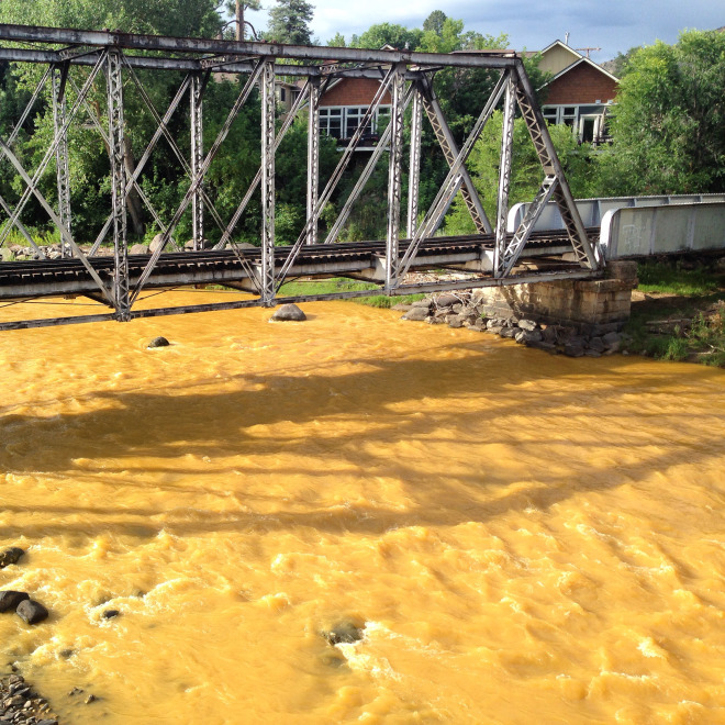
Southern Delivery System map via Colorado Springs Utilities

The WRA March 2016 E-newsletter is hot off the presses

Click here to read the newsletter. Here’s an excerpt:

What Will the Next President Do to Protect the West?

Presidential elections present Americans with an opportunity to discuss the biggest challenges we face, and for candidates to propose ideas to address those challenges. Thus far in the 2016 primary race, some of the candidates have done little to address the issues all Americans care about: good jobs, opportunities for our children to get the education they need, and access to care that allows us to lead healthy lives. Here in the West, voters also want to know how candidates will address our unique circumstances. However, through the first two western contests in Colorado and Nevada, many candidates have yet to present a vision to preserve the legacy of the West for all Americans and for future generations. As we seek to address climate change, provide clean energy to power our economy, protect the beauty of the West, and ensure that our great rivers sustain our communities, the next four years are critical. Yet we have heard so little from the candidates about the issues that are important, and unique, to the West.

Here’s what the candidates should address if they seek to win in the upcoming general election:

  • Westerners overwhelmingly support protections for our public lands so all Americans can enjoy them. The candidates should act boldly to stop “land seizure” efforts that would undermine access to public lands.
  • Last year, cuts in water supplies to Arizona were nearly triggered by historic low water levels at Lake Mead. We take more water from our rivers than the rivers can provide. The candidates should have plans to ensure that our rivers can support agriculture, cities, recreation and habitat that rely on our rivers.
  • More than ¾ of westerners want more clean energy from the sun and wind. Our region has the potential to become the nation’s center of clean renewable energy, strengthening our economies well into the future. How will the candidates take advantage of the West’s abundant sun and wind to create an electricity system that creates jobs and powers the economy of the future?
  • We have begun to address climate change, but it will take continued leadership to expand these efforts. Each candidate should present their plan to reduce carbon pollution.
  • Recently, 21 Florida mayors, from both major political parties called on the media and the presidential candidates to address the issues of climate change and sea level rise. Perhaps the West, which has been a leader on clean energy, should follow suit. Leadership from candidates on these crucial issues is necessary. Each of us, as Westerners, should demand that the remaining candidates for our highest office provide it.

    Western San Juans with McPhee Reservoir in the foreground
    Western San Juans with McPhee Reservoir in the foreground

    The top 50 Instagram photos by @USInterior

    From the Department of Interior via USA Today:

    Since the U.S. Department of the Interior is in charge of protecting the lands and wildlife of America, it puts them in unique positions to take some of the most spectacular photos you’ll see of the USA. [Click through and scroll through the gallery] to see which of the Instagram photos users liked the best, from 50 to 1. And then check out the rest of the Department of the Interior’s photos at their Instagram account, @USInterior (http://www.instagram.com/usinterior/).

    Every March, thousands of Sandhill cranes stop in #GreatSandDunes National Park & Preserve on their way to their northern breeding grounds. The fields and wetlands of #Colorado’s San Luis Valley provide excellent habitat for these majestic #birds. With the dunes and mountains nearby, they dance and call to each other. It’s one of nature’s great spectacles. Photo @greatsanddunesnps by #NationalPark Service.
    Every March, thousands of Sandhill cranes stop in #GreatSandDunes National Park & Preserve on their way to their northern breeding grounds. The fields and wetlands of #Colorado’s San Luis Valley provide excellent habitat for these majestic #birds. With the dunes and mountains nearby, they dance and call to each other. It’s one of nature’s great spectacles. Photo @greatsanddunesnps by #NationalPark Service.

    #ClimateChange will wipe $2.5tn off global financial assets #keepitintheground

    Coal
    Coal

    From The Guardian (Damian Carrington):

    Climate change could cut the value of the world’s financial assets by $2.5tn (£1.7tn), according to the first estimate from economic modelling.

    In the worst case scenarios, often used by regulators to check the financial health of companies and economies, the losses could soar to $24tn, or 17% of the world’s assets, and wreck the global economy.

    The research also showed the financial sense in taking action to keep climate change under the 2C danger limit agreed by the world’s nations. In this scenario, the value of financial assets would fall by $315bn less, even when the costs of cutting emissions are included.

    “Our work suggests to long-term investors that we would be better off in a low-carbon world,” said Prof Simon Dietz of the London School of Economics, the lead author of the study. “Pension funds should be getting on top of this issue, and many of them are.” He said, however, that awareness in the financial sector was low.

    Mark Campanale of the thinktank Carbon Tracker Initiative said the actual financial losses from unchecked global warming could be higher than estimated by the financial model behind the new study. “It could be a lot worse. The loss of financial capital can be a lot higher and faster than the GDP losses [used to model the costs of climate change in the study]. Just look at value of coal giant Peabody Energy. It was worth billions just a few years ago and now it is worth nothing.”

    “Physical climate change impacts are a systemic risk on a massive scale,” said Ben Caldecott, the director of the sustainable finance programme at the University of Oxford. “Investors can do much more to differentiate between companies more or less exposed and they can help reduce the risk to the global economy by supporting ambitious action on climate change.”

    The new study, published in the peer-reviewed journal Nature Climate Change, used economic modelling to estimate the impact of unchecked climate change. It found that in that scenario, the assets were effectively overvalued today by $2.5tn, but that there was a 1% chance that the overvaluation could be as high as $24tn.

    The losses would be caused by the direct destruction of assets by increasingly extreme weather events and also by a reduction in earnings for those affected by high temperatures, drought and other climate change impacts.

    If action is taken to tackle climate change, the study found the financial losses would be reduced overall, but that other assets such as fossil fuel companies would lose value. Scientists have shown that most of the coal, oil and gas reserves such companies own will have stay in the ground if the global rise in temperature is to be kept under 2C. The total stock market capitalisation of fossil fuel companies today is about $5tn.

    “There is no scenario in which the risk to financial assets are unaffected by climate change. That is just a fiction,” said Dietz. “There will be winners and losers.” Major investors such as Norway’s sovereign wealth fund – the world’s biggest – have already begun selling off high-carbon stocks such as coal companies.

    #Snowpack news: [#ElNiño] “It’s hanging in there, just barely” — Klaus Wolter

    Westwide SNOTEL map April 5, 2016 via the NRCS.
    Westwide SNOTEL map April 5, 2016 via the NRCS.

    From KUNC (Jackie Fortier):

    The El Niño that brought record warm winter temperatures to much of Colorado will continue into April, meaning more precipitation than usual — especially along the Front Range.

    “It’s hanging in there, just barely, which means that we have that setup that’s favorable for a wet spring… It has been wet in the northern and central mountains,” said University of Colorado-Boulder climatologist Klaus Wolter.

    “And the wrinkle in this, in 2016, is that it’s a bit warmer than it used to be so at the lower elevations you get maybe not as much snow, but higher up, the snowpack could continue to be above normal conditions.”

    The 2015/2016 El Niño has broken records. Data from buoys in the Pacific show that for about two weeks in February sea surface temperatures were the warmest recorded…

    Even though each El Niño is different, Wolter, a climatologist for over 20 years, was surprised by the record warm temperatures mid-winter.

    “February was the most unusual month of this El Niño. You could even argue that it looked more like a La Niña. That was when California dried up. March was the sixth wettest in northern California since 1920 and it filled up the reservoirs, that was very good. So that was a bit of a surprise in February.”

    The majority of California’s reservoirs are located in the northern half of the state, but Wolter found that this El Niño didn’t keep to the storm track he predicted earlier.

    “In general, things have been shifted a bit to the north, meaning that places like Seattle had a very wet winter, and southern California, Los Angeles and San Diego had a very dry winter. That’s not supposed to happen. Same in Arizona; Phoenix was exceptionally dry.”

    That dry zone from southern California through Arizona and northern New Mexico extended into southeast Colorado. The southern river basins —including the Arkansas and the Rio Grande — are currently at 86 percent of normal snowpack for this time of year, according to early April 2016 SNOTEL survey data…

    The El Niño, which began in spring of 2015, may keep Colorado’s snowpack at average levels going into spring melt – good news for the millions of people who depend on water from the state’s rivers, both in Colorado and much of the West.

    “If we continue into May with that pattern, that would be a bit less common. There have been El Niño years where it kept going all the way into June, the most recent was 1995… 1983 was like that too, another Super El Niño.

    “Right now we are on this glide path towards probably neutral conditions in the Pacific in probably June or July and then the data will show that the event [El Niño] is over.”

    Climatologists are debating what will happen next. Usually, a La Niña has the tendency to follow up a big El Niño, but Wolter isn’t convinced. Even with the best weather models, we’ll just have to wait and see.

    Activists continue effort in Boulder to block Gross Reservoir expansion — Boulder Daily Camera

    Moffat Collection System Project/Windy Gap Firming Project via the Boulder Daily Camera
    Moffat Collection System Project/Windy Gap Firming Project via the Boulder Daily Camera

    From the Boulder Daily Camera (Alex Burness):

    Environmentalists are rallying support for a renewed fight against a long-standing proposal from Denver Water to nearly triple the capacity of Gross Reservoir by diverting from the Colorado River Basin…

    Before a group of about 30 Monday night at Shine Restaurant and Gathering Place, the directors of two non-profits united in the fight against the expansion — Save the Colorado River and The Environmental Group — made presentations alleging impropriety on Denver Water’s part and soliciting donations to a legal fund.

    “They’ve been working on their decision, and we assume, feel very strongly, that (Army Corps) will issue the permit,” said Chris Garre, President of The Environmental Group, which is based in Coal Creek Canyon. “As soon as that happens, the clock starts ticking.”

    The Colorado River, the presenters said, is the most dammed and diverted on the planet. At the Colorado River Delta, there is no longer water, and there is concern that an expansion of Gross Reservoir would see some creeks and tributaries drained at the 80 percent level, with some “zero flow” dry days.

    An expansion of Gross Reservoir, which is a roughly 25-minute drive west from Boulder on Flagstaff Road, would have a significant local impact. In fact, it would be the biggest construction project in Boulder County history, and would likely take about four or five years to complete.

    The proposal seeks to increase the height of the dam by 131 feet, and would require the clearing of about 200,000 trees…

    “Caring for the environment,” Garre added, “particularly those who live in the environment, in the forest, is crucial to your experience in Boulder County. This has never been addressed by Denver Water. It’s been ignored.”

    While the universal downsides such major construction — noise and temporary aesthetic downgrade, among others — aren’t up for debate, Denver Water tells a very different story about the project.

    The public agency that serves 1.3 million people in the Denver metro area gets about 80 percent of its water from the South Platte River System, and another 20 percent from Moffat, a smaller clump up north. Expanding Gross Reservoir and thereby Moffat, Denver Water says, will help balance the existing 80/20 split.

    “This imbalance makes the system vulnerable to catastrophic events, such as the Buffalo Creek and Hayman fires, which caused massive sediment runoff into reservoirs on the south side of our system,” the agency published on its website.

    During times of severe drought, the argument continues, “We run the risk of running out of water on the north end of our system,” which would primarily impact customers in northwest Denver, Arvada and Westminster.

    Denver Water also maintains that as the Front Range continues to be one of the country’s fastest-growing areas, a shortfall in water supply is imminent unless addressed through projects like the one pitched for Gross Reservoir.

    #AnimasRiver: “I don’t believe they are manipulating the samples or the results” — Ryan Flynn

    From Environmental Technology Online:

    Utah has joined a growing list of disgruntled states who are unhappy with the manner in which the Environmental Protection Agency (EPA) has handled the Gold King Mine disaster last year. In summer 2015, almost 400 tonnes of heavy metals were released into the Animas River after a collapse in the mine, prompting fears that nearby water supplies would become contaminated.

    In the intervening months, several states have become so impatient and unsatisfied with the efforts of the EPA in monitoring the river that they have set up their own initiative to safeguard the citizens living in towns and cities downstream of the accident.

    An Independent Monitoring System

    Monitoring water quality levels is important at the best of times, but in the wake of last summer’s disaster, it has taken on a new dimension for the states living in close vicinity to the mine. Utah is the latest state to join with New Mexico and Colorado, along with the Navajo Nation, in demanding better sampling of the affected rivers.

    The conglomerate hope to collect samples from the Animas River and the nearby San Juan River on a weekly basis and have them assessed for heavy metal content, including cadmium, copper, lead and zinc.

    They also wish to gather real-time information on the turbidity of both rivers to determine how much sediment is passing through them at any given time. This will be achieved via the installation of a series of multiple sensors and probes – much like the remote water quality monitors mentioned here – at key locations along the rivers.

    In this manner, the concerned states hope to be aware of any impending influx of sediment into their water supplies and make the relevant warnings to residents and preparations for alternative drinking water supplies.

    Unhappy with the EPA

    Though the EPA met with the states at the beginning of March to thrash out a firm plan of action, pledging to provide $2 million towards the initiative, such steps have done little to appease some of the officials involved.

    On the one hand, officials from the state of New Mexico claim that the EPA have been misconstruing or distorting the actual effects of the mine disaster. Ryan Flynn, who is the environment secretary for New Mexico, says that the EPA are using a different set of standards to require governmental action than they normally do, and that they have claimed downstream ditches had not been affected when they actually had.

    “I don’t believe they are manipulating the samples or the results,” Flynn explained. “But when it comes to communicating those results, the EPA is totally misleading the public and the states about what is actually occurring.”

    Secondly, Flynn and his Utah counterpart Erica Gaddis were also critical of the low sum the EPA had pledged towards the monitoring operation. Utah has already spent $400,000 on monitoring equipment and recently committed to spending $200,000 more, while New Mexico struggled to find $100,000 to purchase its own monitoring apparatus.

    “We are a poor state, and we have some real stress on our budget because of oil and gas prices,” Flynn went on, “but this mission is critical to protecting our communities.”

    As a result, both Utah and New Mexico plan to sue the EPA for compensation and damages once the catastrophe has been averted. For now, though, the priority remains to make sure no sediment makes it into local drinking water supplies – especially with the imminence of snowmelt engendered by the arrival of spring.

    The Animas flows orange through Durango on Aug. 7, 2015, two days after the Gold King Mine spill. (Photo by Esm Cadiente www.terraprojectdiaries.com)
    The Animas flows orange through Durango on Aug. 7, 2015, two days after the Gold King Mine spill. (Photo by Esm Cadiente http://www.terraprojectdiaries.com)

    East Mesa Ditch owners open to leaving water in Crystal River

    A graphic from the Snapshot Assessment of the Roaring Fork Watershed , a report done by Seth Mason of Lotic Hydrological. The graphic shows how a section of the Crystal River below several major diversions can be nearly dried up.
    A graphic from the Snapshot Assessment of the Roaring Fork Watershed , a report done by Seth Mason of Lotic Hydrological. The graphic shows how a section of the Crystal River below several major diversions can be nearly dried up.

    GLENWOOD SPRINGS – The East Mesa Water Co. has told the Colorado basin roundtable it could potentially leave in the Crystal River about a third of the water it now diverts in late summer if enough improvements are made to its 8.5-mile-long irrigation ditch.

    Today about 30 to 40 percent of the water sent into the antiquated East Mesa Ditch is lost to evaporation and ditch leakage. But adding pipes and improving structures could reduce those water losses and allow more water to flow down the often de-watered lower Crystal River.

    The East Mesa Ditch has a senior 1902 water right to divert 31.8 cubic feet per second from the Crystal, as well as a 1952 right to divert another 10 cfs. The diversion structure for the ditch is nine miles south of Carbondale, on river right.

    “A 30 percent savings could mean, potentially, 10 (cubic) feet of water back into the Crystal River system,” said Richard McIntyre, the treasurer of East Mesa Water Co., during a grant application presentation to the Colorado roundtable on March 28.

    The ditch company is currently seeking $60,000 from the roundtable to improve three sections of the ditch as part of a $114,000 project planned for this year.

    McIntrye, representing the 12 owners in the East Mesa Water Co., also read a prepared statement to the roundtable as part of the grant presentation.

    “The ditch company believes that there are avenues becoming available to us that may assist in easing some pressures on the Crystal River system and benefit the shareholders as well,” McIntrye said. “However, before we are able to intelligently assess and address the issues it is essential that we make our delivery system efficient.”

    The biggest shareholders in the East Mesa Ditch include McIntrye, Paul and John Nieslanik, Tom Bailey of the Iron Rose Ranch, Hal Harvey, Tom Turnbull and Willa Doolan. Marty Nieslanik is the president of East Mesa Water Co.

    “Although we have made concentrated efforts to rehabilitate the infrastructure on the ditch recently, it remains in poor to satisfactory condition,” McIntrye continued.

    McIntrye said the ditch company was developing a five-year plan to “rehabilitate failing aspects of the ditch” and a 10-year plan to “pipe much, or even all” of the ditch.

    Last year the Colorado roundtable gave East Mesa Water Co. $60,000 to help fund what turned out to be a $760,000 project to repair a 450-foot-long tunnel and install 1,200 feet of pipe in the ditch. East Mesa also received a $300,000 grant from the Natural Resources Conservation Service for the work.

    “With irrigation efficiencies made by managing shareholders, combined with an effective delivery system, we hope to be a contributor to resolving the pressing issues that we all face in maintaining substantial water flows in the Crystal River and beyond,” said McIntrye, concluding his prepared remarks.

    The lands irrigated by the East Mesa Ditch are shown in purple, according to a technical report from Lotic Hydrological called Water Rights Allocation and Accounting Model Development for the Lower Crystal River.
    The lands irrigated by the East Mesa Ditch are shown in purple, according to a technical report from Lotic Hydrological called Water Rights Allocation and Accounting Model Development for the Lower Crystal River.

    ‘The four questions’

    A member of the roundtable then asked McIntyre if East Mesa was involved in the ongoing process to develop a stream management plan for the Crystal River.

    “We’ve attended a lot of the meetings,” McIntrye said. “And over years of attending those meetings we keep asking the four questions, as they obviously want some of our water: one, when do you want the water; number two, how much water do you want; number three, what’s the water worth to you; and number four, who is going to pay us? And it’s been impossible to get any one of those questions really answered, but we still attend the meetings.”

    McIntyre said East Mesa is forming an association of diverters on the Crystal River to gather information on its own and to possibly present an offer to the community.

    There are 12 irrigation ditches on the lower Crystal River and collectively they divert about 171 cfs of water from the river each day during irrigation season, according to Ken Ransford, the secretary of the Colorado roundtable.

    The Colorado Water Conservation Board holds an instream environmental flow right of 100 cfs on the Crystal, but the river often drops far below that level in late summer, at least in the section below the bigger irrigation ditches,

    East Mesa is the second largest diverter on the Crystal, behind the Sweet Jessup Canal.

    According to Ransford, the East Mesa ditch has diverted an average of 9,626 acre feet of water annually from 1952 to 2014. In 2014, it diverted 8,774 acre feet.

    According to records gathered and maintained by the Colorado Department of Natural Resources, East Mesa irrigates 383 acres of hay fields, which Ransford notes in his minutes of the March 28 roundtable meeting works out to “25 acre feet for each of the 383 irrigated acres.” In a follow-up email, Ransford notes it typically only takes two acre feet of water to grow an acre of hay.

    The East Mesa Water Co., in its grant application to the roundtable, says the ditch has a service area of 740 acres.

    And it says the hay grown on that 740 acres is worth about $500,000 annually, assuming a yield of four tons per acre and a hay price of $170 a ton.

    The ditch company, however, also says there is more value in how the hay fields look to tourists than in the hay itself, saying the economic value is “closely related to recreation and tourism.”

    “The effect on overall commerce would be significant if one of the most scenic views in the valley, that approaching Mt. Sopris, were to be brown and dry rather than green and lush because this ditch failed,” East Mesa’s grant application states.

    The proposed $114,000 ditch improvement project pitched to the Colorado roundtable last week includes replacing the measuring device at the headgate and replacing two failing sections of the ditch where it crosses Nettle and Thomas creeks. East Mesa says the improvements could save 150 acre feet of water a year.

    The 12 shareholders in the ditch company plan to put up $19,000 of the $114,000 project and are hoping to get a $35,000 from a grant from the Colorado River District and $60,000 from the Colorado roundtable.

    The roundtable gets its funds from the state’s Water Supply Reserve Account program. In turn, that account is funded with oil and gas severance taxes, which are down sharply this year.

    The Colorado roundtable now has $353,327 in its account for 2016. On March 28 the roundtable was presented with four grant requests totaling $263,500, including the $60,000 request from East Mesa.

    A next steps meeting has since been set for April 11. The roundtable is expected to vote on East Mesa’s application at its May meeting.

    Editor’s note: Aspen Journalism is collaborating with the Aspen Daily News and Coyote Gulch on coverage of rivers and water in Colorado and the West. The Daily News published this article on Monday, April 4, 2016.

    CWCB: March 2016 #Drought Update

    West Drought Monitor March 22, 2016.
    West Drought Monitor March 22, 2016.

    Click here to read the latest update from the Colorado Water Conservation Board. Here’s an excerpt:

    Statewide precipitation, as of March 25, is at 97% of average. A warm and dry February delivered only 55% of average precipitation statewide and coupled with a warm and dry start to March resulted in the introduction of abnormally dry and moderate drought conditions across the southeastern portion of the state. Late March storms have helped to keep snowpack up by bringing 92% of average precipitation to the state to-date; northern basins have received markedly more precipitation this month than basins in the southern portion of the state. Reservoir storage remains strong and water providers have no immediate concerns.

  • Three percent of the state is currently classified as experiencing moderate drought conditions according to the US Drought Monitor, while 31 percent of the state is classified as abnormally dry. This is predominantly concentrated in the southeastern portion of the state.
  • Statewide SNOTEL water year-to-date precipitation is 97 percent of normal. The Upper Rio Grande has the lowest year-to-date precipitation at 83 percent of average, while the South Platte has the highest at 109 percent of average.
  • The March 23rd snowstorm along the Front Range resulted in a “March” worth of precipitation in some areas but missed southern Colorado where conditions have been drier.
  • Combination of above average temperatures in the first half of the month and seasonally expected strong March winds led to rapid drying at low elevations and on the eastern plains.
  • Reservoir storage statewide remains above normal at 110 percent. The Arkansas basin has the highest storage levels in the state at 124 percent of average; the Upper Rio Grande has the lowest storage levels at 93 percent, just slightly below normal.
  • The Surface Water Supply Index (SWSI) as of March 1st is near or above average across the majority of the state, with the southern half of the state faring better than the northern half. The lowest SWSI value is -1.69 in the Upper White Basin. At this time of year the index reflects reservoir storage and streamflow forecasts, given recent precipitation in the northern half of the state these values are likely to change going forward.
  • Streamflow forecasts have fallen and now range from 107 percent to 65 percent of average with most forecasts near 90 percent of normal runoff expected this spring & early summer.
  • The long term experimental forecast calls for above average probability of precipitation through spring, with eastern Colorado favored more than the rest of the state. The strong El Nino event is likely to dissipate over the coming months.
  • The Colorado Flood Threat Bulletin will provide detailed 24 hr and long range 15 day forecasts April 1st through September 30th at http://www.coloradofloodthreat.com/
  • The Impacts of Climate Change on Human Health in the United States: A Scientific Assessment — EPA

    Click here to read the report. Here’s the summary:

    Climate change is a significant threat to the health of the American people. The impacts of human-induced climate change are increasing nationwide. Rising greenhouse gas concentrations result in increases in temperature, changes in precipitation, increases in the frequency and intensity of some extreme weather events, and rising sea levels. These climate change impacts endanger our health by affecting our food and water sources, the air we breathe, the weather we experience, and our interactions with the built and natural environments. As the climate continues to change, the risks to human health continue to grow.

    Current and future climate impacts expose more people in more places to public health threats. Already in the United States, we have observed climate-related increases in our exposure to elevated temperatures; more frequent, severe, or longer-lasting extreme events; degraded air quality; diseases transmitted through food, water, and disease vectors (such as ticks and mosquitoes); and stresses to our mental health and well-being. Almost all of these threats are expected to worsen with continued climate change. Some of these health threats will occur over longer time periods, or at unprecedented times of the year; some people will be exposed to threats not previously experienced in their locations. Overall, instances of potentially beneficial health impacts of climate change are limited in number and pertain to specific regions or populations. For example, the reduction in cold-related deaths is projected to be smaller than the increase in heat-related deaths in most regions.

    Every American is vulnerable to the health impacts associated with climate change. Increased exposure to multiple health threats, together with changes in sensitivity and the ability to adapt to those threats, increases a person’s vulnerability to climate-related health effects. The impacts of climate change on human health interact with underlying health, demographic, and socioeconomic factors. Through the combined influence of these factors, climate change exacerbates some existing health threats and creates new public health challenges. While all Americans are at risk, some populations are disproportionately vulnerable, including those with low income, some communities of color, immigrant groups (including those with limited English proficiency), Indigenous peoples, children and pregnant women, older adults, vulnerable occupational groups, persons with disabilities, and persons with preexisting or chronic medical conditions.

    In recent years, scientific understanding of how climate change increases risks to human health has advanced significantly. Even so, the ability to evaluate, monitor, and project health effects varies across climate impacts. For instance, information on health outcomes differ in terms of whether complete, long-term datasets exist that allow quantification of observed changes, and whether existing models can project impacts at the timescales and geographic scales of interest. Differences also exist in the metrics available for observing or projecting different health impacts. For some health impacts, the available metrics only describe changes in risk of exposure, while for others, metrics describe changes in actual health outcomes (such as the number of new cases of a disease or an increase in deaths).

    This assessment strengthens and expands our understanding of climate-related health impacts by providing a more definitive description of climate-related health burdens in the United States. It builds on the 2014 National Climate Assessment and reviews and synthesizes key contributions to the published literature. Acknowledging the rising demand for data that can be used to characterize how climate change affects health, this report assesses recent analyses that quantify observed and projected health impacts. Each chapter characterizes the strength of the scientific evidence for a given climate–health exposure pathway or “link” in the causal chain between a climate change impact and its associated health outcome. This assessment’s findings represent an improvement in scientific confidence in the link between climate change and a broad range of threats to public health, while recognizing populations of concern and identifying emerging issues. These considerations provide the context for understanding Americans’ changing health risks and allow us to identify, project, and respond to future climate change health threats. The overall findings underscore the significance of the growing risk climate change poses to human health in the United States.

    The graph shows recent monthly mean carbon dioxide measured at Mauna Loa Observatory, Hawaii.
    The graph shows recent monthly mean carbon dioxide measured at Mauna Loa Observatory, Hawaii.

    Consultant recommends that the Town on Fraser stand pat of fee structure

    Fraser Colorado
    Fraser Colorado

    From the Sky-Hi Daily News (Hank Shell):

    A financial consulting firm has recommended that the Town of Fraser keep its current water fee structure.

    Ehler’s Inc. conducted a study on the town’s water fees to determine what rate structure would best suit the town’s goals of promoting attainable housing, providing affordable water to year round residents and maintaining a consistent source of income.

    Paul Wisor with Ehler’s, speaking at the Fraser Board of Trustees’ March 16 meeting, said his firm had examined at two possible alternatives to the town’s current structure, which comprises of a quarterly base fee of $153 and an additional $1.50 per every 1,000 gallons used.

    Because 92 percent of revenue from the current structure comes from the base fee, it’s more stable for the town and predictable for residents, Wisor said.

    Grand Valley: Drainage fees collection update

    From The Grand Junction Daily Sentinel (Dennis Webb):

    The Grand Valley Drainage District has collected $10,000 so far in stormwater collection fees, even before most district residents have opened their invoices, the drainage district said.

    The bills mark the beginning of the district’s effort to collect about $2.5 million this year for stormwater management projects.

    A significant chunk of that money will come from outside Colorado, district General Manager Tim Ryan said.

    The Grand Junction Area Chamber of Commerce, meanwhile, raised questions about whether the fees are legal under the Colorado Constitution.

    “We want you to know there are still numerous questions about the GVDD’s process, in particular whether the bills are even legal: rather than a ‘fee,’ this may actually be a ‘tax’ that must be voted on by those affected before the money may be collected,” the chamber wrote this week to its members.

    The district has maintained the fee is indeed that and points on its web page to a 2015 decision in which an Adams County judge upheld a stormwater fee after finding that the county’s stormwater utility was a government-owned business that receives less than 10 percent of its funds from state and local authorities combined and is consequently exempt from the requirements of the Taxpayer’s Bill of Rights.

    In the ruling, the court also found that the fee was “reasonably related to the overall cost of providing services related to water drainage and water-related activities in the service area.”

    The chamber is considering withholding payment on its drainage district bill until it’s clear the district has the authority to demand the fees on top of the property taxes they pay to the district.

    The state constitution requires that businesses pay higher property tax rates than residences.

    “We encourage all of our members to review the information provided so that they may make an informed decision on how to proceed with the invoices,” the chamber wrote to its members.

    The district also maintains that the legislation that established it more than 100 years ago allows it to charge a fee.

    The district is billing residents and businesses $3 a month for every 2,500 square feet of impervious surface for stormwater improvements. Those improvements are needed because rain and snowmelt runs off surfaces such as roofs and parking lots, potentially exposing government agencies to fines for failing to control pollutants contained in the runoff.

    Most — 78 percent — of the bills sent out to commercial and industrial landowners went to addresses in the Grand Valley, but the 22 percent of bills sent outside the state account for about 50 percent of the revenue anticipated from that sector, Ryan said.

    That breaks down to about $500,000 coming from outside Mesa County and an equal amount from within the county, Ryan said.

    In many other places, stormwater improvement fees are a “part of the cost of doing business,” Ryan said.

    Drainage district employees, meanwhile, are already dealing with questions as bills arrive.

    One person complained to The Daily Sentinel that payments are to be sent to Denver.

    The address is to the ANB Bank processing center — the same one used by Mesa County to process property-tax payments, Ryan said.

    Most callers were cordial on Thursday and Friday, Ryan said, with many just wanting to be sure that the bill wasn’t a scam.

    Bicycling the Colorado National Monument, Grand Valley in the distance via Colorado.com
    Bicycling the Colorado National Monument, Grand Valley in the distance via Colorado.com

    #Snowpack news: #ElNiño fails to deliver good snow in S. #Colorado

    Click on a thumbnail graphic to view a gallery of snowpack data from the Natural Resources Conservation Service.

    From the Fort Collins Coloradoan (Jacy Marmaduke):

    Fort Collins received a whopping 67 inches of snow between October and March, more than 20 inches above the seasonal average and the third-most snow the city has seen during that period in a quarter century.

    Yet snowpack in the South Platte River Basin — the mountainous area that feeds Northern Colorado’s rivers, reservoirs and farmland — was mostly unfazed by the storms that have secured the 2015-2016 season places in the Fort Collins record books.

    As of April 2, South Platte River Basin snowpack was 107 percent of average. The Poudre River Basin snowpack sat at 106 percent of average and the Upper Colorado River Basin snowpack was 104 percent. Not too shabby, but those aren’t numbers we’ll tell our grandkids.

    What gives?

    The answer starts with an “El” and ends with a “Nino.”

    More specifically, an El Nino strong enough to land the nickname “Bruce Lee” among forecasters didn’t impact Colorado quite as much as some people predicted it would. More on that later.

    Fort Collins receives on average 47 inches of snow annually, so a few big snows can have a huge impact. Here’s proof: Between October and March, Fort Collins received nine storms that yielded more than 2 inches. The three biggest storms — 13.7 inches on Feb. 1-2, 13.4 inches on March 23, and 7.4 inches on Dec. 15 — accounted for more than half of the total snowfall.

    Same goes for precipitation from snow and rain. Fort Collins received 8.18 inches between October and March, close to double the average of 4.61 inches during the last 25 years. A few especially wet snows made all the difference.

    Experts measure snowpack using a metric called “snow water equivalent.” For example, Rocky Mountain National Park’s Bear Lake on April 1 bore a 53-inch blanket of snow that contained 17.5 inches of water.

    So it’s not just mountain snowpack but the moisture in the snow.

    Enter El Nino — or so forecasters thought. The irregular warming of the equatorial Pacific Ocean was supposed to bring storms into the southern and southwestern U.S., making for cooler, wetter winters in the South and warmer, drier winters in the North.

    Instead, explained National Weather Service meteorologist and resident El Nino aficionado Mike Baker, the Pacific jet stream that carries storms into the U.S. from the west set up further north than expected. That resulted in the Pacific Northwest getting straight-up clobbered with rain and snow.

    “They were getting pelted with flooding rains, gale force winds,” Baker said. “That’s not what you usually see with a strong El Nino.”

    At times, the jet stream wiggled southward, and the Pacific Northwest’s problem shifted to the Southeast.

    But alas, the jet stream never really got comfortable in the south and southwest, where it would have had a greater impact on Colorado’s storms…

    As for why that happened, climatologists have a few theories.

    Perhaps chief among them is a phenomenon called the Pacific Decadal Oscillation, which causes warming of the Pacific Ocean farther north of the equator, all the way up to Alaska. It only happens every 20 years or so.

    Baker theorized in a September Coloradoan article that the combination of the PCD and the historically strong El Nino could produce unstable winter weather. That’s because the jet stream that brings storms settles on a temperature gradient, where the Pacific shifts from warmer to colder.

    “It likes to latch onto the warm water,” Baker said. “Well, we had warm water everywhere. Maybe it was confused.”

    […]

    Baker emphasized the jury’s still out on what exactly happened this winter. But for mountain snowpack, the story is far from over.

    Snowpack generally peaks around the end of April, said Sarah Smith, water resources engineer with Northern Water.

    Northern Water, which supplies water to Fort Collins and other parts of northeastern Colorado, keeps a close eye on snowpack because it impacts their water users. Local snow is great for soil moisture in municipalities and farmland, but mountain snowpack plays a bigger role in reservoir and river levels, Smith said. Horsetooth Reservoir, a primary water source for Fort Collins fed by the Colorado River, held 116 percent of average levels on April 1.

    Although local officials say they’ll focus on water conservation no matter what, Smith noted spring rains and wet snows in particular can boost runoff and curb demand for supplemental water from reservoirs. So snowfall and rain in April and May — Fort Collins sees an average of 6.2 inches of snow in April and 0.7 inches in May — will be ones to watch.

    The April 2016 “Water News” is hot off the presses from @DenverWater

    Click here to read the newsletter. Here’s an excerpt:

    New rate structure in effect

    Beginning April 1, your water bill reflects Denver Water’s new rate structure. This new structure will begin to shift our revenue from such a heavy reliance on usage to a more stable fixed fee over the next few years, which means that future rate increases will be less subject to bigger jumps because of unpredictable weather.

    Residential customers will continue to be charged on a tiered structure — the more you use, the more you pay. Now, however, the rate structure is based on three tiers instead of four. The first and least expensive tier is based on indoor use. This rate is calculated by averaging your monthly water consumption reflected on January, February and March bills each year (beginning in 2016), which is a way of determining indoor water use (also known as your average winter consumption).

    Because the majority of our single family residential customers’ indoor water use is 5,000 gallons or less in the winter months, the minimum average winter consumption allowance is 5,000 gallons, and the maximum is 15,000 gallons. The minimum helps ensure customers aren’t penalized for low water usage in the winter.

    Each month, the amount of water you use up to your average winter consumption in tier 1 will be charged at the lowest rate. In tier 2, customers will be allotted 15,000 gallons in addition to their average winter consumption — what it takes to water an average-sized yard efficiently — for outdoor use, which falls into a higher-priced tier. Any use above that will fall into the third, highest-priced tier.

    Fixed monthly charge

    For residential customers, the fixed monthly charge has increased to $8.79 each month. The fixed monthly charge varies by meter size, but the majority of single-family residential customers have 3/4-inch meters.

    The costs to collect, store, treat and deliver water are expenses that have to be paid regardless of the amount of water customers use every year. No matter how much water customers use, we still need to maintain and operate more than 3,000 miles of pipe, 19 reservoirs, 22 pump stations, 30 underground storage tanks, four treatment plants and much more.

    Wait — don’t irrigate!

    When it comes to lawn watering, April is too early to go automatic. Set aside plans to program your sprinkler system for later months, when the ground is less likely to retain wintertime moisture.

    But you can still dig in and start preparing for the planting season.

    Here’s how:

  • Start from the bottom up and aerate your lawn. If you can, aerate after a rain or snow shower provides moisture, which helps prepare soil for the process.
  • Then take a top-down approach by checking the height and width of your trees, shrubs and perennials.
  • Prune any overgrowth — which makes excellent compost when shredded.
  • Watch your mail for a detailed explanation on Denver Water’s summer watering rules, which go into effect May 1.
  • Save water, get a rebate

    Here’s a simple springtime project that pays off: earn a rebate for installing a new water-efficient toilet.

    We offer rebates of up to $150 for purchasing a WaterSense-labeled toilet that uses an average of 1.1 gallons per flush or less. WaterSense is a national program that makes it easy to choose quality products that use less water. Makes sense to us!

    Orr Manufacturing Vertical Impact Sprinkler circa 1928 via the Irrigation Museum
    Orr Manufacturing Vertical Impact Sprinkler circa 1928 via the Irrigation Museum

    Arkansas Valley: Wetter conditions = fewer tumbleweeds

    Below is a video from 2013 when they were plowing tumbleweeds in Crowley County:

    From The Pueblo Chieftain (Chris Woodka):

    It rained so much in 2015, that you would expect another stampede of tumbleweeds by this time.

    But that hasn’t happened.

    There’s not a whole lot of rolling and tumbling going on.
    “We’ve seen less, but we’ve had a lot in the pastures,” said Gary Walker, whose 63,000acre ranches border Fort Carson in northern Pueblo County. “My biggest problems are from Fort Carson and the prairie dog towns.”

    Walker thinks a combination of more moisture, the timing of the rains and grazing contributed to a decline in the Russian thistle, the primary tumbleweed culprit.

    Typically, the plants can grow up to 5 or 6 feet before breaking off and blowing in the wind. During the drought of 2011-13, they clogged ditches, skirted up against fences and blew into piles across most of Southeastern Colorado. In some areas, there were stacks up to the eaves of houses.
    But there has been a lull this year.

    “We’ve seen some, but with the winds we’ve had in recent weeks haven’t created the big piles we were seeing,” said Bruce Fickenscher, rangeland specialist for Colorado State University Extension. “In Crowley County, we mowed them and grazed them more. There have been some places where the weeds blow in, but they’re staying put, more than in the past few years.”

    Walker said the plants grew with deeper roots, and also credits more cattle with cropping them closer to the ground earlier.

    “In the past, when we were moving more cattle, there were fewer tumbleweeds,” Walker said. “When we get back to a more normal deal, we’ll be able to graze more cattle.”

    But the natural conditions also play a role.

    “By and large, it’s because of the way the rains came and the size of them,” Fickenscher said. “The weeds provided some protection for the native plants underneath. With Russian thistle and kochia, the taproot is deep and brings nutrients up.”

    As long as the moisture continues, the tumbleweeds might not be as big a problem.

    “We’re sitting better this year than we have been in a while,” Fickenscher said. “After a couple years of rain, we have more moisture in the subsoil.”

    #AnimasRiver: “What we have here is a totally different animal” — AG Cynthia Coffman

    Cement Creek aerial photo -- Jonathan Thompson via Twitter
    Cement Creek aerial photo — Jonathan Thompson via Twitter

    From The Durango Herald (Peter Marcus):

    Colorado Attorney General Cynthia Coffman is preparing defensive and offensive strategies to legal disputes in the wake of the Gold King Mine spill…

    Some observers wonder why Coffman hasn’t sued the EPA, which admits that excavation during restoration work led to the blowout. Also, there are accounts that the agency knew a blowout was possible.

    Coffman says she is not shy about suing federal agencies, having joined the state in three lawsuits, including most recently over implementation of EPA carbon standards, known as the Clean Power Plan.

    “What we have here is a totally different animal because we have an environmental incident, whether accidental or intentional, whatever you want to call it, that requires a totally different approach,” Coffman said…

    “Am I prepared to apportion who has what liability? I’m not. I don’t feel like we know enough,” Coffman said.

    If lawsuits are filed, they’re likely to drag on for years, if not decades, Coffman said, pointing to the complicated nature of environmental cases, the long list of parties involved and leaking mines in the area.

    Hanging over the process is a potential Superfund listing, which would inject large amounts of cash into permanent restoration efforts at as many as 50 mining-related sites in the Gladstone area that have contaminated the Upper Animas River, Mineral Creek and Cement Creek for more than a century.

    A Superfund listing itself could result in a lawsuit from environmental groups, who may fear that restoration efforts don’t go far enough.

    Coffman said Superfund lawsuits are tricky, and there is a lack of institutional knowledge because Superfund listings are relatively rare. The attorney general’s office downsized its Superfund unit several years ago.

    “You have a new generation of attorneys in this office who may not have seen a Superfund case,” she said.

    Coffman said after receiving the two Notice of Intent to sue letters from New Mexico and Utah, her office assembled a 10-person Gold King Mine team, including environmental attorneys and governmental immunity and civil litigation experts.

    The attorney general’s office also has held weekly conversations with the governor’s office. Coffman said Gold King Mine is “near the top of the list.”

    “Litigation, it’s an important tool that attorneys have, but negotiation is equally important,” Coffman said. “Once you start litigation, the tone automatically changes, and sometimes irrevocably.”

    Democratic Gov. John Hickenlooper is optimistic that he can reach resolution with the two states out of court. But he said: “If they sue us, I think that unifying effort will be diminished.”

    Hickenlooper said he spoke with New Mexico Gov. Susana Martinez recently. New Mexico is concerned with water-testing plans, which the governor believes the two states can resolve.

    “The EPA … admitted responsibility, they said they would hold themselves to the same high standards they would any private-sector business and they were going to make good on what damages there were. Let’s wait and see before we pick up the telephone and call in the lawyers. Let’s see how well they live up to that commitment,” he said…

    Coffman may have to intervene if the EPA does not follow through, or if the agency’s efforts seem inadequate. She sent the agency a letter on March 15 urging it to settle at least 51 unpaid claims from individuals, which total nearly $5 million. Coffman said she has not yet received a response from the agency.

    “It’s easy to admit fault,” Coffman said. “It’s much harder to take responsibility and pay for the consequences of your actions.”

    How much drinking and fighting can the #ColoradoRiver take? — CNN #COriver

    Writing for CNN, Bill Weir asks the tough questions about the 21st Century reality along the Colorado River. Here’s an excerpt:

    “Whiskey is for drinking; water is for fighting.”

    My old man loved that old quote, almost as much as he loved whiskey, water and the American West.

    Bill Weir Sr. was a big-city detective with the soul of a cowboy.

    After a particularly rough week of murder and mayhem, he tossed his badge on his captain’s desk with indelicate instructions on where to put it.

    He packed his saddle and skis and left Milwaukee for the mountains.

    Once he was settled as a Coloradan, that old quote took on fresh significance.

    Atop his horse alongside a dry ditch or knee-deep in a trout stream, he’d grouse about water rights and population growth and the inevitable day of reckoning.

    “One day we’re going to raft the Colorado, kid,” he’d say. “Before it’s gone.”

    San Luis Valley: Talks continue on new groundwater rules — The Pueblo Chieftain

    Artesian well Dutton Ranch, Alamosa 1909 via the Crestone Eagle
    Artesian well Dutton Ranch, Alamosa 1909 via the Crestone Eagle

    From The Pueblo Chieftain (Matt Hildner):

    Although a trial for new groundwater regulations in the San Luis Valley isn’t set until January 2018, State Engineer Dick Wolfe said his staff is working toward settlements to avoid that court date.

    Wolfe told a Thursday meeting of the Rio Grande Compact Commission that efforts to compromise with the 30 objectors in the case have been underway for a few months.

    “I’m very optimistic we’re going to be successful working through those issues with those other objectors in hopes to reach stipulation with all of those objectors and hopefully avoid going to trial,” he said.

    Wolfe’s office submitted rules to the valley’s water court in September.

    They were the first attempt by the state to issue comprehensive groundwater rules for the valley since the 1970s, when a previous effort never reached implementation.

    The rules governing the roughly 4,500 highcapacity irrigation wells that tap into the valley’s two large aquifers require users to join a subdistrict, have an augmentation plan, or at least a temporary water supply plan.

    The aim of the rules is to mitigate the impact of groundwater pumping on the valley’s streams and rivers, which are hydraulically connected to the aquifers in varying degrees. The objections to the rules cover a number of issues but many question the use of the state’s Rio Grande Decision Support System, a computer model that’s used in the calculation of stream loss caused by pumping.

    But even if the rules do end up at trial, working toward settlements now can still pay off, Wolfe said.

    “Even if we don’t ultimately get to an agreement with all those objectors we hope to at least limit the number of objectors so ultimately that would have to go to trial and the number of issues we would have to litigate,” he said.

    2016 #coleg: HB16-1005 (Rain Barrels) is on its way to Gov. Hickenlooper’s desk

    From The Denver Post (Joey Bunch):

    “As a farmer’s daughter, I’m proud to have helped pass this common-sense water-conservation measure,” said Rep. Jessie Danielson, a Democrat from Wheat Ridge who was one of the bill’s sponsors.

    Conservation groups hope the legislation encourages Coloradans to capture and use runoff from their rooftops on their lawns and gardens to help people recognize that water is a precious resource in this arid state, compared to the amount they would have used from their garden hoses, otherwise.

    Photo via the Colorado Independent
    Photo via the Colorado Independent

    #ColoradoRiver: “…we see a warming trend” — Connie Woodhouse #COriver

    From Grist (John Upton):

    The new research, published in Geophysical Research Letters by academics and a federal scientist, focused on the upper stretches of the river. It attempted to parse out the different roles of temperature, precipitation, and soil moisture on the variability of yearly water flows since reliable record-keeping began in 1906.

    Annual Colorado River flows have naturally swung up and down over time, but the natural trends have been bucked in recent years and decades.

    “What we’re seeing now is that, consistent with more of the global observations in terms of warming, that it’s not just a fluctuation that’s within that historical back and forth,” Prairie said. “That oscillation is starting to break from that range.”

    Temperatures appear to have been playing a larger role in reducing the flows of water down the Colorado River since the late 1980s, the findings from the new study suggested.

    “If you look at the trend in temperature over this period, we see a warming trend,” said Connie Woodhouse, a University of Arizona professor who led the new research. “We’re finding in those years temperatures explaining a lot more of the variability.”

    Warmer temperatures cause more snow to fall instead as rain, and they cause snowpacks to melt earlier. Both of those effects lengthen growing seasons of riverside vegetation, which allows it to suck up more water as it grows. Higher temperatures also increase evaporation.

    The likely effects of climate change on rainfall, snow, and streamflow in the West remain difficult to assess, though they’re expected to lead to more rain and less snow, reducing the water volume of the snowpack that melts slowly to fill up the rivers. Storms may also shift southward.

    Recent assessments suggest that even without changes to precipitation, the flow through “most of the Colorado River” would “shift to moderately lower” levels as the planet continues to warm, said Andy Wood, a National Center for Atmospheric Research scientist who was not involved with the study.

    Lake Mead behind Hoover Dam December 2015 via Greg Hobbs.
    Lake Mead behind Hoover Dam December 2015 via Greg Hobbs.

    #AnimasRiver: #Colorado AG Coffman weighing options for lawsuit

    A “get well soon” balloon floats in the contaminated waters of the Animas River flowing through Durango on Monday afternoon August 10, 2015 -- photo The Durango Herald, Shane Benjamin
    A “get well soon” balloon floats in the contaminated waters of the Animas River flowing through Durango on Monday afternoon August 10, 2015 — photo The Durango Herald, Shane Benjamin

    From The Denver Post (Jesse Paul):

    Colorado’s top prosecutor said Tuesday that litigation in the wake of the Gold King Mine spill is an option she’s hoping to avoid as the state works to negotiate compensation after the August disaster.

    But Attorney General Cynthia Coffman explained all options are still on the table as fallout continues to unfold, and that the site’s current and previous owners, as well as the owner of a nearby mine, are all potential defendants if a lawsuit is filed.

    “I think we have to look at everyone involved in order to do a good job representing the state of Colorado,” she said in an interview with The Denver Post. “We look to everyone who has a piece of the puzzle and was part of the story.”

    Coffman has been weighing legal action against the Environmental Protection Agency since its contractors triggered the 3 million-gallon disaster, but now appears to be taking a broader assessment of those with links to the incident.

    A team of 10 attorneys in her office has been looking into the possibility of filing a lawsuit and working on possible defenses to threats of legal action against the state…

    “I would say we are still in the initial phases of the process,” she said of investigating whether to take any legal action. “For the first few months, this was really the governor’s project and responsibility… We were in a holding pattern in terms of litigation.”

    […]

    The attorney general’s office is reviewing the history of the Gold King and the nearby American Tunnel and Sunnyside Mine — both owned by the Canada-based conglomerate Kinross — as part of their process.

    Coffman said engineered plugs in the American Tunnel, installed to limit heavy metal drainage, likely were a factor in the Gold King’s contaminated water buildup and eventual release.

    Kinross said it has no role or responsibility in the spill despite claims from the Gold King’s owner, Todd Hennis, who has implicated them in the disaster.

    “We will vigorously defend ourselves from any potential legal action,” said Louie Diaz, a Kinross spokesman.

    Hennis bought the Gold King in 2005 after it went into foreclosure and then allowed the EPA to work on remediating the site. Agency contractors were excavating the mine’s collapsed opening when they accidentally triggered the disaster.

    Hennis declined to comment on any potential legal proceedings.

    Coffman said her staff has been in close contact with Gov. John Hickenlooper’s office over any Gold King legal action and that their interactions have been productive.

    Coffman and Hickenlooper battled in the state’s highest court over her decision to join a lawsuit challenging the EPA’s Clean Power Plan, with the attorney general coming out at the victor.

    Since then, Coffman said, their relationship has improved, making Gold King work easier.

    “The EPA admitted responsibility, agreed to hold themselves to the same high standards they would any private business, and they were going to make good on any damages,” Hickenlooper said Tuesday. “Let’s see how well they live up to that commitment before we jump into litigation.”

    Coffman said that while she still thinks the EPA could have been more transparent and accountable after the spill, it has made good strides in its response.

    Now, as far is she is concerned, is time to investigate the disaster and weigh the appropriate next steps.

    “This is a classic who did it,” she said. “Who is the most responsible and what are they going to pay?”

    Gold King Mine circa 1899 via The Silverton Standard
    Gold King Mine circa 1899 via The Silverton Standard

    #ColoradoRiver: Trout Unlimited praises river protections in 401 permit for Windy Gap project #COriver

    Ike enjoying the Fraser River back in the day
    Ike enjoying the Fraser River back in the day

    Here’s the release from Colorado Trout Unlimited (Randy Schofield):

    TU praises river protections in Windy Gap project permit
    Says 401 permit conditions put threatened river and fishery on road to
    recovery

    (Denver)-The Colorado Department of Public Health and Environment this week released its final 401 water quality certification for the proposed Windy Gap Firming Project (WGFP), which would divert additional water from the Upper Colorado River to northern Front Range communities. Trout Unlimited praised the 401 permit conditions for reaffirming the health of the Upper Colorado River and its world-class trout fishery.

    “We firmly believe these permit conditions establish a strong health insurance policy for the Upper Colorado River,” said Mely Whiting, counsel for Trout Unlimited.

    For years, Front Range water diversions have removed about 60 percent of the native flows of the Colorado headwaters, severely impacting fish and other aquatic life that depend on healthy flows to clean cobble and prevent the buildup of habitat-choking algae and sediment. The proposed Windy Gap expansion would further reduce native flows.

    TU said the conditions included in the 401 permit for WGFP address critical fish habitat and water quality needs by:

    * preventing stream temperature impacts during low flows in the summer.
    * providing periodic “flushing flows” to cleanse the river during runoff.
    * requiring ongoing monitoring and response if degraded conditions are detected.

    The 401 permit conditions largely incorporate the protections included in earlier agreements involving the WGFP sponsor, the Municipal Subdistrict of the Northern Colorado Water Conservancy District (Subdistrict) and its project participants, and other stakeholders, including Grand County, Trout Unlimited, and the Upper Colorado River Alliance.

    Under the 401 permit, the Subdistrict is required to monitor specifically for stream temperature, key nutrients, and aquatic life and submit results with an annual report that identifies any evidence of impairment (standards not met). If impairment is identified, the Subdistrict has to investigate to determine whether WGFP is causing or contributing to the impairment. If WGFP is found to play a role, then the Subdistrict is required to come up with a plan to solve the problem, consistent with state water quality laws.

    “This long-term monitoring and flexibility of response is called ‘adaptive management’-and it’s a critical feature of the permit requirements,” said Whiting. “Adaptive management recognizes that stakeholders can’t foresee every problem, and it provides a process for ongoing monitoring and mitigation of river problems as they arise.”

    TU noted that the permit builds on years of hard work, negotiations and collaboration. “We wouldn’t be at this point without the leadership of Grand County and their persistent efforts to improve the health of the Colorado River,” said Kirk Klancke, president of TU’s Colorado River Headwaters chapter. “And the Northern subdistrict also deserves credit for listening to our concerns and working with all stakeholders to find solutions.”

    “This permit is another step toward fulfilling the Windy Gap Firming Project’s potential to be part of a balanced water supply strategy for Colorado’s Front Range,” said Drew Peternell, director of TU’s Colorado Water and Habitat Project. “Through a balanced portfolio-including responsible supply projects like WGFP, along with stronger conservation and reuse programs and ag-urban water-sharing-Colorado can meet its diverse water needs, from municipal needs to recreation, while keeping our rivers healthy.”

    Under Section 401 of the federal Clean Water Act, the state of Colorado must provide the U.S. Army Corps of Engineers with a permit certifying that the project will comply with federal water quality standards. The remaining regulatory hurdle for the Windy Gap Firming Project is the final 404 wetlands permit by the Army Corps of Engineers, which the Corps could issue in 2016.

    Issuance of all permits for the project will release resources, including money needed for the design and construction of the Windy Gap Reservoir Bypass to create a new river channel and reconnect the river and its fisheries upstream and downstream of the reservoir.

    “It’s been a long and arduous process,” said Whiting of the WGFP permitting process, which has taken over 10 years. “It is time to roll up our sleeves and go to work for the river.”

    EPA tightens controls for work at West’s blowout-prone old mines — @DenverPost

    From The Denver Post (Bruce Finley):

    EPA chiefs are ordering extra headquarters reviews of all plans for work at blowout-prone old mines — policy tightening aimed at avoiding a repeat of the Gold King disaster.

    And Environmental Protection Agency officials on Thursday declared testing is done for a better early-warning system that would alert communities to surges of toxic mine muck.

    Separately, the EPA’s internal inspector concluded an investigation finding deficiencies in securing financial guarantees from companies that hurt the EPA’s ability to complete cleanups…

    The boosted review reflects efforts to increase work at hundreds of inactive mines contaminating waterways, work that EPA Administrator Gina McCarthy partially suspended in the aftermath of the Aug. 5 Gold King disaster. An EPA crew botched work at the Gold King Mine above Silverton, trying to drain it but triggering a 3 million-gallon torrent of acidic metals-laced mine water that turned the Animas River mustard-yellow…

    An EPA inventory, unveiled Thursday, listed some of the worst potential hazard sites — among an estimated 500,000 inactive mines in the West — including four in Colorado. The inventory lists 20 more sites around Colorado where toxic muck is known to be backed up yet the hazard has not adequately been assessed. It lists another 115 inactive mine sites, including 26 in California and more in Arizona, Idaho, Montana, Nevada, New Mexico, Oregon, Utah, Washington and Wyoming.

    The new rules require EPA crews to follow best practices to try to ensure that experts with the right engineering and other skills are involved. EPA crews also must give headquarters supervisors a technical assessment of blowout potential before beginning work, written documentation of talks with state and tribal officials and verification that emergency response plans are in place with satellite phones and other equipment available.

    At sites where states or tribes lead cleanup, regional EPA officials must define their support roles and, if landowners deemed responsible are involved, document owner willingness to handle emergency response.

    “No impactful delays are expected,” EPA spokeswoman Nancy Grantham said.

    The EPA this week completed final drills aimed at improving a system for notifying downstream communities ahead of blowouts via e-mail and phones. Improved early-warning plans were done to address concerns after the Gold King disaster raised by people living along the Animas in Colorado, New Mexico, Utah and tribal nations.

    The EPA’s Inspector General probe found environmental and financial risks resulting from a failure to collect accurate and complete data from companies responsible for contamination. The report said “data quality deficiencies and a lack of internal controls prevent the EPA from properly overseeing and managing its financial assurance program” — which is designed to ease the burden on taxpayers in dealing with environmental disasters.

    “If the EPA cannot determine if it has secured valid and sufficient financial assurance instruments from those private parties, taxpayers are at risk for paying significant amounts of those parties’ financial obligations,” the report said. “Public health protections may be delayed or deferred,” it said. And while the EPA is aware of the risks “it has not taken meaningful steps to address the problem” or disclosed this vulnerability.

    This image was taken during the peak outflow from the Gold King Mine spill at 10:57 a.m. Aug. 5. The waste-rock dump can be seen eroding on the right. Federal investigators placed blame for the blowout squarely on engineering errors made by the Environmental Protection Agency’s-contracted company in a 132-page report released Thursday [October 22, 2015]
    This image was taken during the peak outflow from the Gold King Mine spill at 10:57 a.m. Aug. 5. The waste-rock dump can be seen eroding on the right. Federal investigators placed blame for the blowout squarely on engineering errors made by the Environmental Protection Agency’s-contracted company in a 132-page report released Thursday [October 22, 2015]

    Gardner Announces USDA Grant for Flood Restoration and Mitigation Projects in Colorado

    Here’s the release from US Senator Cory Gardner’s office:

    Senator Cory Gardner (R-CO) today announced the United States Department of Agriculture (USDA) Emergency Watershed Protection (EWP) program will make $10,240,800 available to Colorado Springs and Manitou Springs for the purposes of restoration and flood mitigation after severe weather impacted the region last year. Gardner sent a letter on July 10, 2015 to President Obama requesting federal assistance for several counties in Colorado impacted by significant weather events.

    “I am pleased the Department of Agriculture has recognized Colorado’s need for federal assistance that will be used to restore the region and make infrastructure improvements to protect local communities from future flooding,” said Gardner. “Colorado Springs and Manitou Springs experienced recent flooding that devastated these localities. The impacts from the Waldo Canyon fire only made the problem worse. Western communities need flexibility to cope with the unique challenges they face, and I am pleased this grant provides local officials the necessary funds to address flooding as they see fit.”

    A rock slide just west of Manitou Springs has closed the exit off U.S. 24, Memorial Day morning, May 25, 2015. (Colorado State Patrol via Twitter)
    A rock slide just west of Manitou Springs has closed the exit off U.S. 24, Memorial Day morning, May 25, 2015. (Colorado State Patrol via Twitter)

    #Snowpack news: #ElNiño still around

    Westwide SNOTEL map March 31, 2016 via the NRCS.
    Westwide SNOTEL map March 31, 2016 via the NRCS.

    From the Sky-Hi Daily News:

    The month of March has been the 7th snowiest March in recorded resort history and the snowiest since 114 inches fell in March 2003, according to a news release from the resort. Since Friday March 26, they have picked up 20 inches of snow in the prior three days, 64 inches since March 15, and 83.5 inches (almost seven feet) in the entire month, putting Winter Park at over 300 inches of snow for the season.

    From the Mountain Town News (Allen Best):

    Winter got off to a good start high in the Rocky Mountains, but mid-winter was sluggish. Ketchum, for example, got just one inch of snow in February.

    Meteorologists last autumn had warned to expect just this sort of El Niño pattern. They also said to expect lots of moisture beginning in March and continuing until May.

    That’s still the prediction of Aspen-based Ryan Boudreau and his partner, Cory Gates, who own a micro-forecasting service called Aspen Weather. They told The Aspen Times they expect another 125 to 130 inches of snowfall on local ski slopes through the third week of April. The precedent Boudreau recalls is 1983, another El Niño year.

    That 1982-83 winter had also started strong, then turned ho-hum after Christmas. As the ski slopes began closing, the storms arrived one after another in Winter Park and other mountain towns. There was so much spring snow that Vail reopened for Memorial Day Weekend in late May.

    Then it got hot in June—and the snow vanished. Rivers roared. Downstream in the desert of Utah, managers of Glen Canyon Dam began to worry. Lake Powell, the second largest reservoir in the United States, can hold nearly one and a half times the annual, average flow of the Colorado River.

    This was not a normal year, though. Spillways were opened, but the volume was greater than ever experienced. The whole dam began to shake violently. Plywood was installed atop the dam, so that the reservoir could hold more water. It looked to be a lost cause, but then in mid-July the volume of inflow into Lake Powell began to slow. Calamity was averted—but narrowly.

    A relatively new and highly-regarded book called “The Emerald Mile” tells the story of that calamitous summer and a thrilling [boat] ride on the crest of those flood waters through the Grand Canyon.

    Can we expect that again? Not likely, as Lake Powell was only 46 percent full as of early March, so there’s lots of room.

    1983 - Color photo of Glen Canyon Dam spillway failure from cavitation, via OnTheColorado.com
    1983 – Color photo of Glen Canyon Dam spillway failure from cavitation, via OnTheColorado.com

    2016 #coleg: HB16-1005 (Rain barrels) passes initial Sen. vote

    Photo from the Colorado Independent.
    Photo from the Colorado Independent.

    From The Grand Junction Daily Sentinel (Charles Ashby):

    Though many homeowners already do it, Colorado residents soon could be able to use rain barrels — legally — to collect water from their rooftops under a bill that won preliminary approval in the Colorado Senate on Thursday…

    Sen. Michael Merrifield, D-Manitou Springs, who sponsored the bill in the Senate, said the measure has been altered to address as many concerns as possible to comply with Colorado’s complicated water laws, including making it clear that the use of rain barrels does not constitute a water right.

    Merrifield said a chief benefit of the bill is it will help educate Colorado residents about the importance of water, and how it is the life-blood of the state.

    “It allows urban residents to connect themselves to the water system of our state,” he said. “We are not blessed with a huge amount of water. The more our urban residents understand the system, the better for all users.”

    Under the bill, rain collection is limited to above-ground barrels and only for rooftops of single-family homes. It also bars homeowners’ associations from banning such barrels, although they are allowed to make rules governing the appearance of the barrels that are used.

    While no one spoke out against the bill when it won a voice vote on the floor of the Senate, Sen. Jerry Sonnenberg, R-Sterling, expressed his opposition to the measure when it cleared the Senate Agriculture, Natural Resources & Energy Committee on Wednesday.

    “My concern here is that if indeed we have rain barrels that may cause depletions out of order of priority storage … the next person in line would be the one curtailed,” Sonnenberg said. “That’s a concern for me, given that agriculture has 85 percent of the water.”

    To help address that issue, the bill was amended to require the State Engineer’s Office to report to the Legislature by 2019 whether there is any evidence that the use of rain barrels has caused injury to downstream users.

    Also opposing the measure in committee were Sens. Ray Scott, R-Grand Junction, and Randy Baumgardner, R-Hot Sulphur Springs. Supporting it from the Western Slope included Sens. Kerry Donovan, D-Vail, and Ellen Roberts, R-Durango.

    The bill requires a final Senate vote before it heads to the governor’s office. It passed the House last month on a 63-1 vote.

    #Colorado and the Feds meet to update abandoned mines inventory

    Colorado abandoned mines
    Colorado abandoned mines

    From The Denver Post (Bruce Finley):

    The Colorado Department of Public Health and Environment estimates that acidic metals-laced mine water contaminates more than 1,600 miles of streams and rivers. There are an estimated 23,000 inactive mines in Colorado — 22,000 on federally managed public land — that companies have abandoned. These are a main source of harm to waterways that affects human health and ecosystems.

    While multiple federal and state agencies hold information on inactive mines, there’s no comprehensive data hub that could be used to assess impacts, risks and costs for cleanup.

    Government officials from the CDPHE, Colorado Geological Survey, Colorado Department of Natural Resources, U.S. Forest Service, Bureau of Land Management and Environmental Protection Agency met Wednesday at the regional Forest Service headquarters to focus on how best to share data and identify gaps.

    CDPHE and the CGS are leading a $300,000 inventory initiative.

    “I don’t think we really know what the cumulative impacts of all these are,” CGS director Karen Berry said.

    Colorado officials also advocate legal changes to encourage voluntary cleanups. So-called “good Samaritan” legislation, introduced in Congress, would let companies and conservation groups launch projects to reduce contamination in streams without being liable, under the Clean Water Act, for remaining contamination, state abandoned mines program director Bruce Stover said.

    Such a change would make a difference, Stover said, and volunteer groups wouldn’t be held liable if well-intentioned cleanup work causes spills, such as the Aug. 5 Gold Mine incident where a 3-million-gallon torrent turned the Animas River mustard-yellow.

    Lawmakers also are considering reform of the nation’s 1872 mining law to charge hard-rock mining companies fees to create a fund that could be used to help deal with drainage from inactive mines.

    Gov. John Hickenlooper has met with fellow western governors and federal agency chiefs and found that a consensus has emerged to make cleanup of old mines a priority. At least 230 are known to be draining into Colorado waterways with 148 largely unaddressed — not visited since the 1990s.

    State officials say natural resources crews aim to visit those sites and test water this year to assess the harm.

    2016 #coleg: HB16-1392 (Water Banks Administration) update

    From The Pueblo Chieftain (Chris Woodka):

    A water banking bill being considered in the state Legislature would help farmers keep their water rights while increasing the range of uses.

    “Farmers always get the short end of the stick. The state likes to pick on farmers,” said Jay Winner, general manager of the Lower Arkansas Valley Water Conservancy District.

    Farms face a policy of “use it or lose it” that means if water can’t be used on a specific parcel of land, it flows downstream. Water banking could mean about 5-10 percent more water could be put to use each year, according to some estimates.

    “Once a farmer deposits the water in this water bank, he can use it in any way within the Arkansas Valley,” Winner explained.

    The bill, HB16-1392, is sponsored by Reps. Jeni Arndt, D-Fort Collins, and Ed Vigil, D-Fort Garland, and Sen. Larry Crowder, R-Alamosa. The Lower Ark district is backing the bill as a way of improving on the 2013 legislation, HB1248, that established a pilot program now being used by the Arkansas Valley Super Ditch.

    Winner spoke about the bill Thursday with The Pueblo Chieftain editorial board.

    Winner expects the water bank to succeed where others have failed because it will be useful to farmers. It allows for short-term leases, either to cities or other farms, that are now possible, but expensive and complicated to execute. No change in water right is required, since the leases would be made under administrative rules under the supervision of the Colorado Water Conservation Board.

    “This is a way to bring some land back into production,” Winner said. “The water rights decree never changes, but it provides more options to the farmers.”

    The legislation also could advance concepts such as deficit crop irrigation, supplementing sprinklers or well and or partial irrigation of a parcel.

    Farmers would be limited to putting water into the “bank” every three years in 10 or using no more than 30 percent of the total consumptive use water supply over that time. Water would not be able to leave its basin of origin. [ed. emphasis mine]

    “It makes the water more valuable to farmers,” Winner said

    Straight line diagram of the Lower Arkansas Valley ditches via Headwaters
    Straight line diagram of the Lower Arkansas Valley ditches via Headwaters