From The Durango Herald (Shane Benjamin):
There were two weak monsoon surges from late June through July, said Joe Ramey, a meteorologist at the National Weather Service office in Grand Junction. The stronger, third surge this week could hold the potential for flash flooding.
One such storm materialized about 3 p.m. Monday over Durango. It brought a mix of rain, hail and lightning that started a small wildland fire and flooded some businesses, including south City Market, where the back half of the store from aisles 1 to 6 was soaked.
The city of Durango reported some culverts were plugged, but no major flooding. The deluge centralized over the city, said Butch Knowlton, director of La Plata County’s Office of Emergency Management…
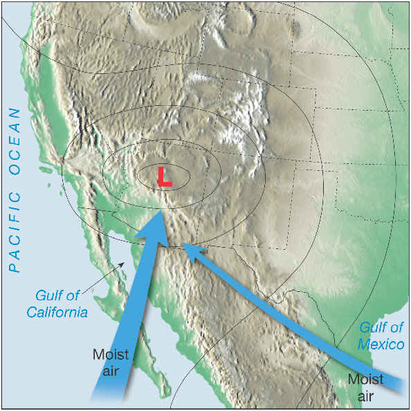
The monsoon is a seasonal phenomenon in which winds start coming from the south instead of the west. Then, as high pressure sets up in the Southwest, winds help pull water into the region from the gulfs of Mexico and California. Because of solar heating, a thermal low develops over the desert Southwest, which helps to pull even more rain into the region. As these two events interact, the familiar, seasonal pattern of almost daily thunderstorms ensues.
Where’s La Niña?
This year’s weather has been influenced by the El Niño phenomenon, which brought heavy snow to the Four Corners this winter. El Niño has ended, according to the weather service, but with a twist this year: El Niño’s opposite effect, La Niña, is unlikely to occur. La Niña is often linked to drier winters.“El Niño is over, but La Niña has not replaced it,” Ramey said.
El Niño occurs when temperatures in a patch of ocean off Ecuador’s coast rise by about 1 degree (0.5 degree Celsius) from three-month averages. The effect is that storms generally track in a more southerly direction across the U.S.
La Niña occurs when the patch of equatorial Pacific cools by about 1 degree from the average. It results in generally drier winters in the Four Corners as storms take a northerly track.
In June, weather service forecasters saw the ocean temperatures drop from El Niño, and reported the likelihood of a La Niña was 77 percent.
“It is now at 55 percent, so it is setting up for an ENSO (El Niño Southern Oscillation) neutral pattern,” which is neither El Niño or La Niña, Ramey said.
The neutral pattern isn’t necessarily bad news for the upcoming winter, he said, but it makes the long-term winter forecast more unpredictable.
“ENSO neutral years do not have a favorite pattern, and the storm tracks vary widely,” Ramey said. “The climate record shows these years can be dry or wet, so it is kind of a wild card.”
Since 1950, there have been 19 El Niños. Of those, in the season that followed a La Niña occurred 11 times and an ENSO neutral occurred five times.
