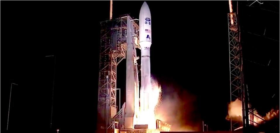
GOES-R, the first of NOAA’s highly advanced geostationary weather satellites, lifted off from Cape Canaveral, Florida, at 6:42 p.m. EST [November 19, 2016]. The satellite will boost the nation’s weather observation network and NOAA’s prediction capabilities, leading to more accurate and timely forecasts, watches and warnings.
In about two weeks, once GOES-R is situated in orbit 22,300 miles above Earth, it will be known as GOES-16. Within a year, after undergoing a checkout and validation of its six instruments, the new satellite will become operational.
“The next generation of weather satellites is finally here. GOES-R is one of the most sophisticated Earth-observing platforms ever devised,” said NOAA Administrator Kathryn Sullivan, Ph.D. “GOES-R’s instruments will be capable of scanning the planet five times faster and with four times more resolution than any other satellite in our fleet. With these new instruments and powerful new capabilities, GOES-R will strengthen NOAA’s ability to issue life-saving forecasts and warnings and make the United States an even stronger, more resilient Weather-Ready Nation.”
GOES-R will scan the skies five times faster than today’s GOES spacecraft, with four times greater image resolution and three times the spectral channels. It will provide high-resolution, rapid-refresh satellite imagery as often as every 30 seconds, allowing for a more detailed look at a storm to determine whether it is growing or decaying.
GOES-R data will help improve hurricane tracking and intensity forecasts, the prediction and warnings of severe weather, including tornadoes and thunderstorms. Additionally, GOES-R’s improved rainfall estimates will lead to more timely and accurate flood warnings.
“We are ready to receive and process GOES-R data into our forecasts as soon as it is available,” said NOAA National Weather Service Director Louis W. Uccellini, Ph.D. “Forecasters will not only have sharper, more detailed views of evolving weather systems, they will have more data – better data – ingested into our weather models to help us predict the weather tomorrow, this weekend and next week. This is a major advancement for weather forecasting.”
For the aviation sector, GOES-R will deliver clearer views of clouds at different atmospheric levels, generating better estimates of wind speed and direction and improved detection of fog, ice and lightning. This will improve aviation forecasts and flight route planning to avoid hazardous conditions such as turbulence.
“GOES-R will significantly improve the ability of emergency managers across America to prepare for, and respond to, weather-related disasters. Better situational awareness will result in better outcomes — from where to best position resources ahead of a storm to delivering more targeted information to local officials to decide if an evacuation is necessary,” said Craig Fugate, FEMA administrator.
GOES-R is flying six new instruments, including the first operational lightning mapper in geostationary orbit. This new technology will enable scientists to observe lightning, an important indicator of where and when a storm is likely to intensify. Forecasters will use the mapper to hone in on storms that represent the biggest threat. Improved space weather sensors on GOES-R will monitor the sun and relay crucial information to forecasters so they can issue space weather alerts and warnings. Data from GOES-R will result in 34 new, or improved, meteorological, solar and space weather products.
“We’ve crossed an historic performance threshold with GOES-R,” said Stephen Volz, Ph.D., director, NOAA’s Satellite and Information Service. “NOAA is now operating the most sophisticated technology ever flown in space to help forecast weather on Earth.”
There are four satellites in the GOES-R series: –R, –S, –T and –U, which will extend NOAA’s geostationary coverage through 2036.
“NOAA and NASA have partnered for decades on successful environmental satellite missions,” said Sandra Smalley, director of NASA’s Joint Agency Satellite Division, which worked with NOAA to manage the development and launch of GOES-R. “Today’s launch continues that partnership and provides the basis for future collaboration in developing advanced weather satellites.”
Beyond weather forecasting, GOES-R will be part of SARSAT, an international satellite-based search and rescue network. The satellite is carrying a special transponder that can detect distress signals from emergency beacons.
NOAA manages the GOES-R Series Program through an integrated NOAA-NASA office. NASA’s Goddard Space Flight Center oversees the acquisition of the GOES-R series spacecraft and instruments. Lockheed Martin is responsible for the design, creation and testing of the satellites and for spacecraft processing along with developing the Geostationary Lightning Mapper and Solar Ultraviolet Imager instruments. Harris Corp. provided GOES-R’s main instrument payload, the Advanced Baseline Imager, the antenna system for data receipt and the ground segment. The Laboratory for Atmospheric and Space Physics provided the Extreme Ultraviolet and X-Ray Irradiance Sensor, and Assurance Technology Corporation provided the Space Environment In-Situ Suite.
Additional GOES-R satellite information is available online.
Since launch on Saturday, November 19, GOES-R has transitioned to the ‘orbit raising’ phase of the mission and is making its way to geostationary orbit. The spacecraft is currently positioned in a sun-point attitude, which allows its solar array to harness the sun’s power. The GOES-R team has performed the first liquid apogee engine (LAE) burn without anomaly. This engine burn is part of a series of LAEs that will help position GOES-R in geostationary orbit. The next major milestone will be the second stage deployment of GOES-R’s solar array, which is currently scheduled to occur on November 30, 2016.
What’s next for GOES-R?
November 21, 2016
NOAA’s GOES-R satellite launched from Kennedy Space Center in Florida this weekend at 6;42pm on November 19, 2016. But what’s next for the nation’s most advanced weather satellite to-date?
The GOES-R team has confirmed satellite communication and power. Over the next several days, team members will perform a series of maneuvers to bring the satellite into geostationary orbit. This is expected to occur approximately 16 days after launch.
Once GOES-R — now GOES-16 — is placed in geostationary orbit, it will undergo an extended checkout and validation phase lasting approximately one year. The satellite will transition to operations immediately afterward. Whether it will serve as GOES East or GOES West has yet to be determined. The final decision will be based on the health and performance of the NOAA GOES constellation.
Click here to read more about the launch of GOES-R.
For the latest news about GOES-R, now GOES-16, stay tuned to the GOES-R launch page.