Click here to go to the US Drought Monitor website. Here’s an excerpt:
Summary
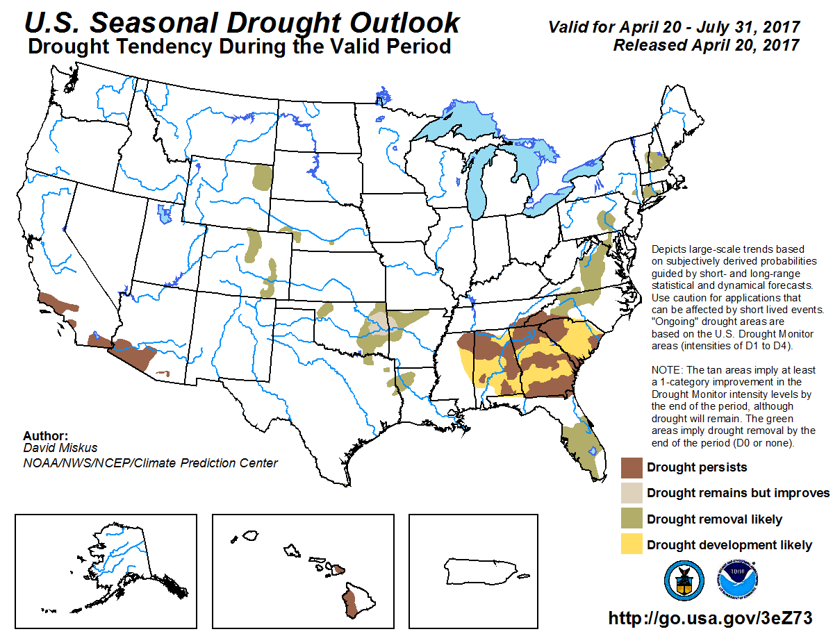
An active weather pattern provided above-normal precipitation during the USDM period (April 11-18) in much of the Southern Plains, West, Northwest, and parts of the Midwest. Below-normal precipitation dominated the Rockies, Southwest, Southeast and Northeast. Average daytime temperatures were generally above normal across much of the CONUS with the exception of the Northwest where temperatures were generally 3 degrees cooler than normal. Much of the Mid-Atlantic, Ohio Valley and Central Plains were 9-12 degrees above normal for the period. Drought conditions expanded and intensified for much of the Southeast where the lack of rains have begun to parch the soils. In the South, Texas continues to see above normal precipitation resulting in a continual decrease in overall area covered in drought (D1-D4). Meanwhile in the West, the onslaught of Pacific storms continue to bring copious amounts of moisture to the region, swelling the reservoirs, threatening snowpack records and padding the record high precipitation amounts. Additional information on the indices, impacts and changes in drought status can be found in the regional sections below…
High Plains
Precipitation in the High Plains region for the period was quiet for the most part with the exception of precipitation in eastern South Dakota and eastern Nebraska. Totals there amounted to about an inch or less, near to slightly above normal. Elsewhere was dry as the frontal systems that made it through were starved of moisture. In eastern Colorado, moderate drought (D1) was lifted along the Colorado and Kansas border as short and long term indicators appear to have mostly rebounded from the drought that began in that area last autumn. Also in eastern Kansas, D0 was trimmed back following the above normal precipitation at 60 days…
West
New Mexico had its warmest start to the year through March, while Arizona had its fourth warmest start. It was reported that the grasses in southeast Arizona are drying up quickly after greening up earlier than usual. For New Mexico as a whole, 61 percent of top soils are short or very short of moisture. The abnormally dry conditions prompted the expansion of D0 across the southern borders of both Arizona and New Mexico. In western Colorado, snowpack was generally above normal for the season and with an early and fast melt occurring, stream flows are generally much above average. However, the Yampa/White Basin was one of the only areas in the Upper Colorado River Basin that did not reach average peak snowpack. It was reported that not only is the snow melting early, but the crops are coming out of dormancy earlier than usual. Because of the warmer than normal temperatures, low elevation snow pack as disappeared much earlier than normal. Due to the above mentioned conditions, D0 was expanded to the north and west stretching across the Wyoming border. In California, Pacific storms continue to bring precipitation in the form of high elevation snow and valley rains to the region. These moisture laden storms are crucial for summer water resources as the runoff feeds into the streams and reservoirs. Forecasted stream flows for California river basins generally show much above normal volumes through the summer months. No other changes were made in the West.
*For details on Eastern Colorado and Eastern Wyoming, refer to the High Plains region…
Looking Ahead
During the next 5 days, temperatures are forecasted to be near to below average for the Northwest, High Plains and South. Warmer than average temperatures are expected in the Mid-Atlantic, Southeast and Southwest. During the same period, precipitation is forecasted to be the heaviest (3-5 inches) in an area stretching from Oklahoma east through the Tennessee Valley. Much of the Midwest and Northeast is also expected to see about an inch of precipitation. The 6-10 day outlooks call for an increase in probability that above normal temperatures are expected in the Southwest and South stretching into the Midwest and below normal temperatures in the Northwest, Northeast and parts of the High Plains. The odds are in favor of wet conditions in the Northwest, Northern Rockies and High Plains while the West and East Coasts dry out.
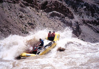
Rafting trips along the Arkansas River are getting a jump start this season, fueled in part by the heaps of mountain snow melting in the Colorado high country…
Many areas along the Arkansas River are seeing strong white water, coming from the mountain terrain in Leadville, about 150 miles away. Because of the rich high country snow, you’ll likely see faster water and bigger rapids.
In response to a call from Sen. Doug Lamborn for the Environmental Protection Agency to withdraw its federal lawsuit against the city of Colorado Springs, the Pueblo County commissioners have drafted a letter to lawmakers against that action.
On Wednesday, the commissioners agreed to send the letter to members of their federal congressional delegation.
“We felt that it was imperative that we draft this letter to both the House and the Senate to reiterate just how important this lawsuit is to Pueblo County in protecting our interests pertaining to water quality,” Commissioner Garrison Ortiz said.
Commissioner Sal Pace said lobbyists already are asking new EPA leadership to pull back on Fountain Creek and to not push forward with the federal lawsuit.
“There’s been some evidence that the EPA is going to heed the call of some of these political forces in El Paso County and Colorado Springs,” Pace said.
“We think it’s critically important to the county that the EPA stays strong in this matter and stands alongside the state health department, Pueblo County and the Lower Arkansas Valley Water Conservancy District.”
[…]
Ortiz said budget cuts to the EPA by President Donald Trump may affect the current lawsuit.
“That certainly played into the decision-making process whether to join in the litigation in the first place or not,” Ortiz said.
The proposed cuts especially to the EPA and some other agencies are certainly concerning . . . All that we are continuing to ask for is a seat at the table ensuring that our interests are continuing to be protected.”
Colorado Springs Mayor John Suthers said Tuesday that he plans to eventually ask City Council members to put a stormwater fee on the ballot if a settlement can be reached with the Environmental Protection Agency on a lawsuit the federal agency filed against the city last year.
Paying the annual cost of a $460 million, 20-year intergovernmental agreement with Pueblo County to build 71 major stormwater projects has “put pressure on police and fire” budgets and will eventually force the city to impose a stormwater fee like every other large U.S. city, Suthers told about 200 customers of Vectra Bank Colorado and others during an economic forecast at the Cheyenne Mountain Resort. He also thanked voters for allowing the city to keep $12 million in sales tax collections above revenue limits during the next two years that will be spent on stormwater projects.
The U.S. Environmental Protection Agency and the Colorado Department of Public Health and Environment filed a lawsuit in November against the city of Colorado Springs over water quality violations and stormwater program shortfalls dating to 2009. Pueblo County and the Lower Arkansas Valley Water Conservancy District later joined the suit…
Suthers told the Police Protective Association last fall that the $17 million a year it must spend on stormwater projects under its agreement with Pueblo County are guaranteed to keep the city budget tight, but relieving that burden with a fee could help the city reclaim $15 million to $16 million that could be spent on police and fire needs. Police Chief Pete Carey last year dismantled several special units, including one focusing on gangs, to put more personnel on patrol and reduce the response times that had moved sharply higher in the past few years.
Suthers also touted an improving local economy, a surging tourism industry as well as an improved relationship with the City Council, more spending to improve roads and stormwater and elimination of the business personal property tax and other tax breaks for business during his 20-minute speech. He urged the business-focused audience to use new flights added during the past year by Frontier and American airlines, and said fares are coming down on many routes from the Colorado Springs Airport because of competition among several airlines – including Chicago and Phoenix.
FromThe Grand Junction Daily Sentinel (Charles Ashby):
Gov. John Hickenlooper signed several bills into law Tuesday, including one that GOP Sens. Ray Scott and Don Coram have been working on for a few years now.
That measure, SB36, is designed to make it harder for land developers to drag farmers and ranchers through years of court proceedings over groundwater rights disputes.
Under current law, such disputes are handled by the Colorado Groundwater Commission, but appeals to district court can include new evidence not seen by the commission.
The bill gives district judges more discretion to decide what new evidence can be heard in those appeals.
Some opposition to the bill fell away when it was amended to include language that allowed new evidence to be included in an appeal if that evidence was wrongly excluded or could not “in good faith” be presented to the commission.
Scott of Grand Junction and Coram of Montrose said they don’t buy opponents’ contention that the definition of “in good faith” is so broad that it opens the door to any evidence being presented, as is the case now.
“It’s held to a higher legal standard,” Coram said.
“The rules of evidence are very tough,” Scott added. “If they can prove evidence was stuffed in a box somewhere in the basement for the last 50 years and was just found or something like that, it’s still a high bar to reach.”
The two lawmakers said the bill fixes a long-standing problem for poorer ranchers and farmers who found themselves spending more time in court battling well-heeled developers over those water rights.
The Colorado Farm Bureau said the bill will help ensure a fairer and more equitable appeals process.
Under a 1944 treaty, the US shares water rights to three rivers that cross the US-Mexico border — the Tijuana and Colorado Rivers, and the Rio Grande. Historically, water-sharing on these rivers involves complex, often difficult, discussions. Today, drought conditions in the American West and growing political tensions with Mexico give those talks a new sense of urgency — and uncertainty.
Among the many diplomatic challenges the United States faces with its southern neighbor are international water rights on the Colorado River — a river system in the midst of a lengthy, 16-year drought. The 1944 treaty guarantees Mexico 1.5 million square acres of water from the Colorado River annually. However, it is vague on how that water is to be shared during years when the river comes up short. Minute 319, a 2012 amendment to the treaty, established, among important water conservation policies, a drought contingency plan. That five-year pilot program is set to expire at the end of this year.
Despite the Obama administration’s efforts to get a new water-sharing deal, known as Minute 32x, signed before January’s inauguration, it remains stalled. Anne Castle, former Assistant Secretary for Water and Science in the Department of the Interior, told WhoWhatWhy that this issue needs immediate action.
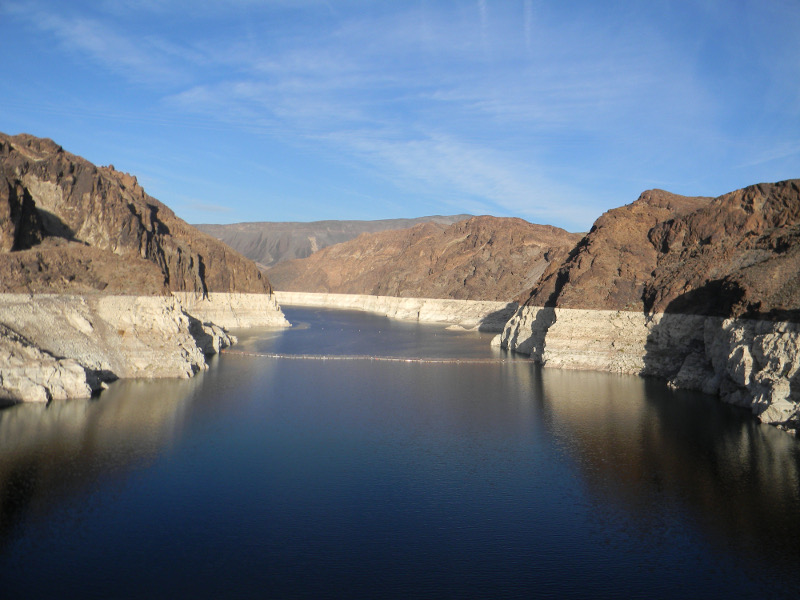
Water levels in the Colorado River have been in steady decline for nearly two decades. Ongoing drought conditions place considerable stress on the system and the reservoirs it serves throughout the Colorado River Basin. Among them, Lake Mead — America’s largest reservoir — today sits at historically low levels; about 41% capacity. According to Castle, there is a “substantial probability” — approximately a one in three chance — that levels at Mead will fall below the established “drought trigger point” — 1,075 feet — requiring the Secretary of the Interior to declare a water shortage. “This river,” says Castle, “is in crisis.”
Commonly called “America’s Nile,” the Colorado River is the most heavily litigated and managed river in the United States. On its 1,045 mile journey south from the Rocky Mountains in Colorado to the Gulf of California in Mexico, coursing through seven US and two Mexican states, the Colorado River serves 40 million people, supports major metropolises like San Diego, Las Vegas and Phoenix, and provides 75% of the water used in local agricultural districts.
What is left of the river by the time it reaches Morelos Dam on the US-Mexico border, the last dam in the system, is diverted to irrigate fields in the Mexican state of Mexicali. A 2015 New Yorker article compared the carefully controlled system, of which every drop is claimed, to a “fourteen-hundred-mile-long canal.” That major waterway, say experts, is currently over-allocated and slowly diminishing.
The Colorado River, which cuts through nine national parks including the Grand Canyon, is integral to what John Fleck, director of the University of New Mexico’s Water Resources Programs, calls the southwestern identity. He points out that border communities, such as San Luis Rio Colorado, have seen little of their namesake’s waters for nearly half a century.
“Imagine,” he told WhoWhatWhy, “living by a river taken away from you.” Decades of overuse, he said, turned the Colorado River Delta — once described by naturalists as a lush wetland — into the “dry channel” we find today.
Fleck cites a recent study by Brad Udall and Jonathan Overpeck that fingered climate change “as one of the main causes” of the Colorado River’s diminished flow. While the greater River system will not dry up, like its delta, anytime soon, it will, continue to experience critical decreases in water flow.
In March of 2014, a landmark environmental project laid the groundwork for restoring life to the Colorado’s barren delta. As part of a technique designed to mimic seasonal snowmelt, known as “pulse flow,” the gates of Morelos Dam were opened. Eight weeks of increased flows followed. The people of San Luis Rio Colorado celebrated the temporary return of their town’s namesake with live music and water games. Secretary Castle remembers the response as “amazingly affecting.”
The project was made possible in the midst of a drought by the cooperative policies outlined in Minute 319. The amendment not only works to promote the ecological health of the Colorado River Delta, it also contains a plan for shortage sharing, commits funds to improve water infrastructure and allows Mexico to store its allotted water in Lake Mead.
The greatest asset the US has for managing the effects of climate change on the River, according to Thomas Buschatzke, Arizona’s Director of Water Resources, is its relationship with Mexico.
“I can’t say enough how important it is to have Mexico as a partner,” he told WhoWhatWhy. “The more partners you have the more opportunities you have to develop effective tools.”
Allowing Mexico to store its water in Lake Mead helps keep water levels high enough to offset the drought trigger point. Additionally, in the event of a drought, both Mexico and the US must take the same proportion of shortages — meaning the burden of shortages is decreased by the number of stakeholders shouldering it. The agreement has thus far effectively staved off cutbacks and is enormously popular among Basin states. Minute 319, along with other water agreements signed over the past 10 years, says Buschatzke, represent a “relatively new relationship” with Mexico — one defined by a high degree of cross-border cooperation.
Current diplomatic policy and recent political rhetoric under the Trump administration, however, has already strained US-Mexico relations. The water-sharing agreement should be allowed to stand on its own, says Secretary Castle, but she fears it has the potential to become a “negotiating point” amidst “unrelated disputes” over issues such as NAFTA, the wall, and immigration.
Foreign Affairs Officer Sally Spener at the International Boundary and Water Commission, which oversees negotiations concerning the 1944 treaty, told WhoWhatWhy her agency’s work “seeks to find technical rather than political solutions,” to water disputes between the US and Mexico. Keeping politics out of a River that is a “vital” municipal and industrial resource, “affecting tens of millions of people in both countries,” is important to maintaining a constructive relationship.
Although, according to Fleck, there should be no partisan frame to this issue, this could be “one of a number of examples throughout history…where an agreement over a river was influenced by a broader relationship between two countries.” While water infrastructure development during the Second World War made cooperation between Mexico and the US mutually beneficial under the 1944 treaty, world events in 2017 may prove to negatively influence cooperative amendments to that original pact.
Fleck says he, and other water experts, were surprised by the outcome of the 2016 election and had expected to work with an administration that was “more sympathetic” to the water-sharing deal signed under Obama’s presidency. It’s furthermore possible, adds Secretary Castle, spending could be tight in terms of federal dollars going toward water conservation projects.
With a number of important deadlines coming up, Castle and a team of researchers published the Colorado River Future Project last fall. The study interviewed more than 65 Colorado River management experts on the present crisis and outlined suggestions for immediate policy action. That research was then disseminated to the Trump transition team in an effort to “accelerate the learning curve” that any turnover in the White House typically necessitates. The Trump administration, says Castle, is “fully cognizant of the importance and urgency” of the deal with Mexico.
Castle says she’s confident that Interior Secretary Zinke “is a thoughtful, considered person who will be listening hard to his advisors and the various stakeholders in this potential agreement.”
But vacancies in key Interior leadership positions continue to stall Minute 32x’s progress. “The really important positions at Interior are the Assistant Secretary for Water and Science, and the Commissioner of Reclamation, and those jobs haven’t been filled yet,” says Fleck.
Meanwhile, new appointments in Mexico — including Foreign Minister Luis Videgaray and Mexican ambassador to the US Gerónimo Gutiérrez — also need to be brought up to speed on pending negotiations.
In the event that Minute 32x does not pass by December 31, 2017, Lower Colorado Regional Director, Jennifer McCloskey said, “Our expectation is to continue to work.” Neither McCloskey or Buschatzke wanted to speculate on the potential consequences of unsuccessful water talks.
Castle, however, says Mexico is unlikely to go along with drought reductions if there is no deal in place that enforces a drought contingency plan. More crucially, she says, we may “go back to a situation where we don’t know what the treaty means anymore.”
For his part, Buschatzke is “cautiously optimistic” Minute 32x will pass. During negotiations his department often calls upon this axiom: “No one state, no one entity, no one water user.”
The Bureau of Reclamation, which manages dams and reservoirs on the Colorado River, said it will release 9 million acre-feet (11 billion cubic meters) from Lake Powell, sending it down the Colorado to Lake Mead, where it will be tapped by Arizona, California and Nevada…
…the planned release is above the annual average of 8.7 million acre-feet (10.7 billion cubic meters), and it should be enough to delay a widely expected shortage in Lake Mead, said Marlon Duke, a spokesman for the Bureau of Reclamation.
A shortage would trigger cuts in water deliveries to Arizona and Nevada, the first states to be hit under the multistate agreements and rules governing the Colorado River. That had been expected as soon as next year.
“It’s pushed that shortage likelihood out into the future,” Duke said, but it’s too early to say how far.
Melting snow is expected to raise the level of Lake Powell by about 50 feet (15.24 meters) by mid-July, but after the 9 million acre-feet (11 billion cubic meters) is released, the reservoir will be about 35 feet (10.67 meters) higher on Oct. 1 than it is now, he said.
The two reservoirs are part of the Colorado River system, which supplies water to about 40 million people and 6,300 square miles (16,317 sq. kilometers) of farmland in seven states and 20 Indian reservations. Mexico is also entitled to a share under a treaty.
A prolonged drought and rising demand for water have overtaxed the river. Some researchers say global warming is also affecting water flows.
Click here for all the inside skinny. From the website:
2017 Annual Symposium
The Colorado Section of AWRA and the Colorado Foundation for Water Education Present: The Confluence of Science, Policy and Change
Friday, April 28th
7:30 am to 5:30 pm
Mount Vernon Country Club
24933 Club House Circle
Golden, CO 80401
Keynote Speakers:
Mike Connor former Deputy Secretary of the Interior, currently with the Walton Foundation
Ken Salazar, former Secretary of the Department of the Interior
Click here to download a copy of the registration form (.pdf).
For your convenience you can sign up or sponsor the symposium here using PayPal.
When you click the “Add to Cart” button a shopping cart will open at the top of this page. When you are ready to checkout click the “Checkout” link in the shopping cart. The Checkout page will open.
Note: While you are on the Checkout page please enter the names of the individuals you are registering in the “Symposium Attendees” field at the bottom of the page. Separate the names with commas.
When you click the “Purchase Button” on the Checkout page you’ll be redirected to PayPal where you can use your credit card to pay.
Please note: All AWRA-CO memberships are valid for the Calendar Year (January through December). Therefore, if you haven’t renewed your membership in 2016, please renew your membership before registering at the Member’s rate. Otherwise, you may register as a Non-Member and automatically receive a 2017 Individual Membership for $20. Thank you!
House Bill 1289, which would extend a pilot program that streamlines the assessment of consumptive use and could ease the financial impact on water rights owner by simplifying the process, was heard by the House Agriculture, Livestock and Natural Resources Committee Monday. It was laid over until next week while lawmakers consider the impacts of the program.
Rep. Chris Hansen, D-Denver, said the program has proven to be a way to save money on the front end for water rights users in the Arkansas River Valley, where it was first implemented.
But this comes at a cost in the overall amount they can charge for their water rights, as the methods used generally err on the side of caution and underestimate the Historic Consumptive Use by 10-15 percent, Hansen said. “This is in a sense the horseshoes and hand grenades approach.”
In a short term transaction that is not always a drawback beause of the amount saved by not undergoing a full analysis…
Some Republican members of committee didn’t necessarily agree with that and expressed concerns that this would leave farmers losing out on the value of their rights.
They were concerned that it would place additional burden of proof on owners if they believed they didn’t receive a fair share because of the conservative nature of the analysis as opposed to buyers having to prove the engineering analysis was over valuing the rights…
Hansen disagreed, saying the bill doesn’t require the use of the program or say that it must be used by water court when deciding the value of rights.
John Stulp, water policy advisor for Gov. John Hickenlooper, agreed the program isn’t meant to be and end-all answer that would limit water right owners recourse in seeking adequate compensation for their resource…
The aim is to cut down on incidents of “buy and dry,” where a farmer sells his or her water rights to a municipality and loses the resource critical to cultivating the land.
Simplifying the process will make it easier for farmers to lease their water rights over a short term, rather than racking up vast sums of debt from engineering analysis and court costs arguing over the exact consumptive use of their rights.
While it is uncertain if there would be bipartisan support for the bill in the House, it is sponsored by Sen. Don Coram, R-Montrose, in the Senate.
This is a Colorado Foundation for Water Education webinar in partnership with the Colorado Water Congress. The webinar focuses on cyanotoxins and algal blooms – how they’re affected by nutrients and nonpoint source pollution, and how Coloradans in rural and urban areas alike are working to address these threats to our water quality and public health.
During this hour-long webinar, speakers explain the causes and challenges of coping with algal blooms and cyanotoxins; The U.S. Environmental Protection Agency’s health advisories and criteria for cyanotoxins; the link between algal blooms and nutrients; Colorado’s Regulation 85; and nutrient management and outreach efforts in the state.
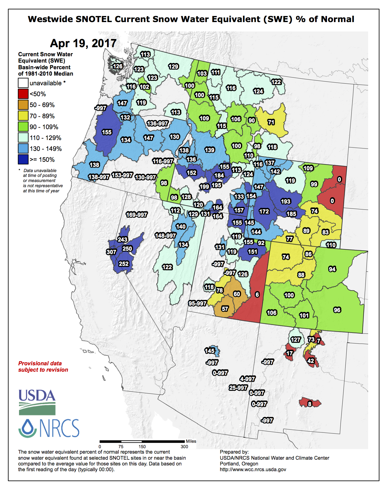
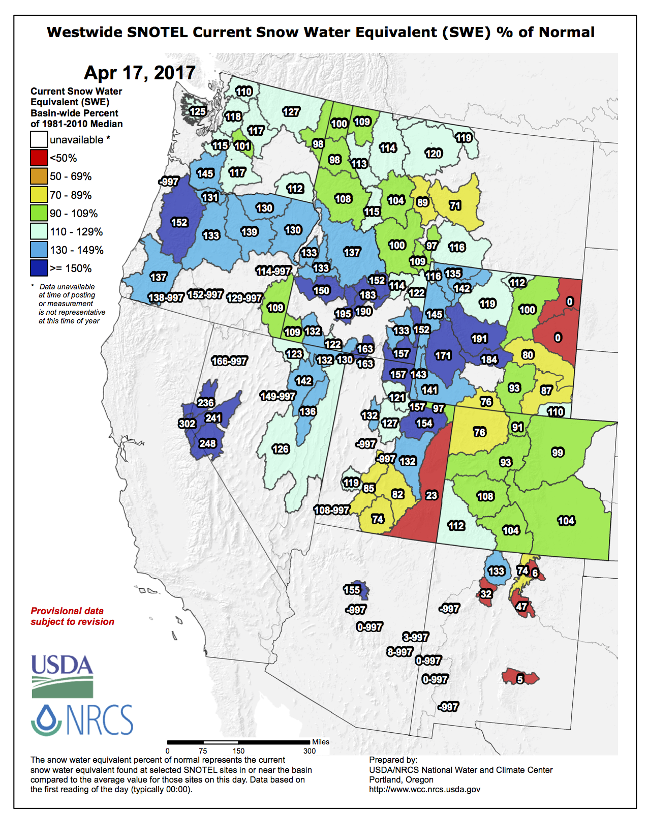
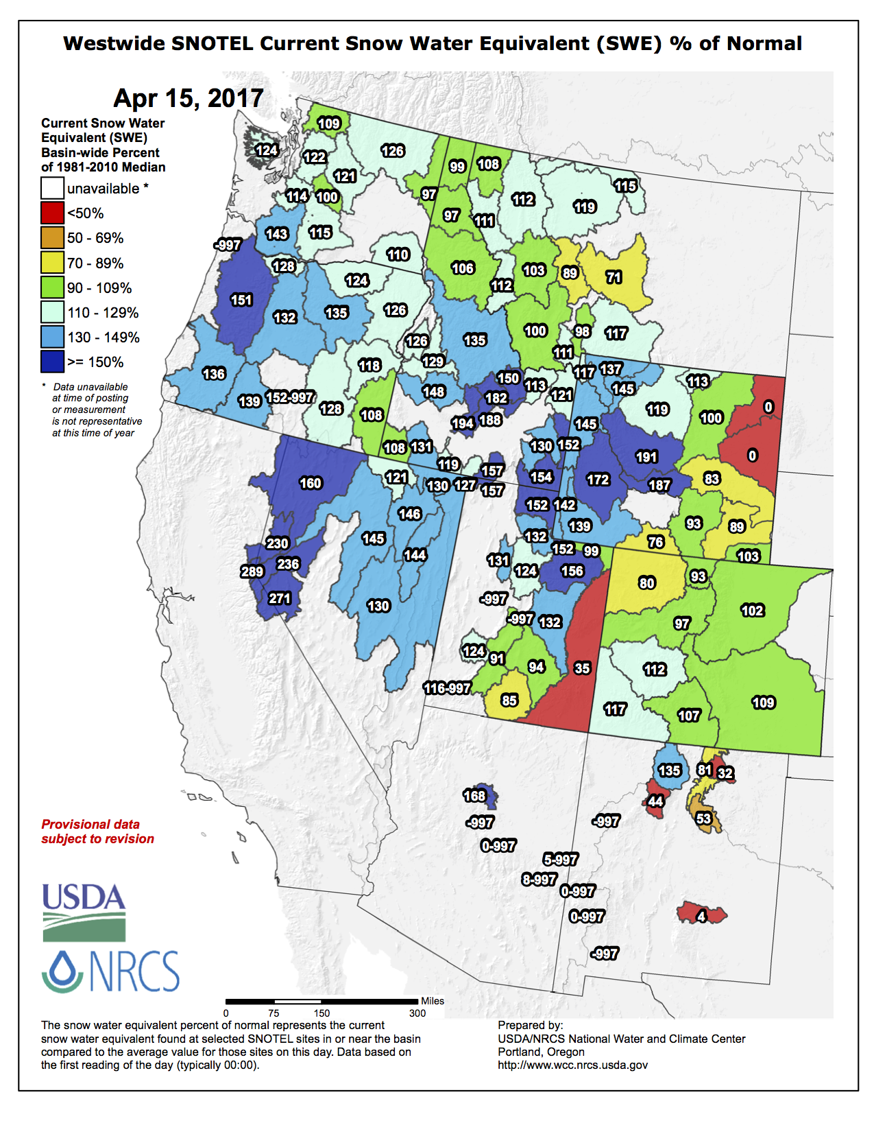
Westwide SNOTEL basin-filled map April 17, 2017 via the NRCS.
From the Associated Press (Susan Montoya Bryan) via The Charlottesville Daily Progress:
During a packed briefing in Albuquerque, the Bureau of Reclamation outlined its expectations for water supplies and management along the river system that flows through some of the state’s most populated areas.
The forecast is based on snowpack, soil moisture and climate predictions, but officials acknowledged it’s still a best-guess and that things can always change.
Bureau hydrologist Ed Kandl said temperatures are expected to be above average this summer across New Mexico and there are equal chances that precipitation will be average. Still, he said snowpack along the Colorado-New Mexico state line and the resulting runoff will bolster flows along the Rio Chama and Rio Grande.
“This year looks to be the best since 2008, which was the last good year,” he said.
At a monitoring site in Conejos County, Colorado, there’s as much snow as there has been since the station was established in the 1980s. Kandl said there’s still a lot of snow at the site.
However, the Sangre del Cristos near Santa Fe and other mountain ranges farther south have fallen below average thanks to hot, dry weather in March. A flash drought speeded up melting and dried out the soil in lower elevations.
In the Pecos River Basin, one of the key snowpack gauges has been below average all season.
Kandl pulled up a map of the western United States that detailed the results of the winter storm track over the Sierras and into northern Utah, where streamflow forecasts were 180 percent of average. From there, levels begin to drop off.
“It’s a very fine line between feast and famine,” he said, pointing to the sites in New Mexico that were below average. “A matter of 50 to 100 miles made all the difference in the world.”
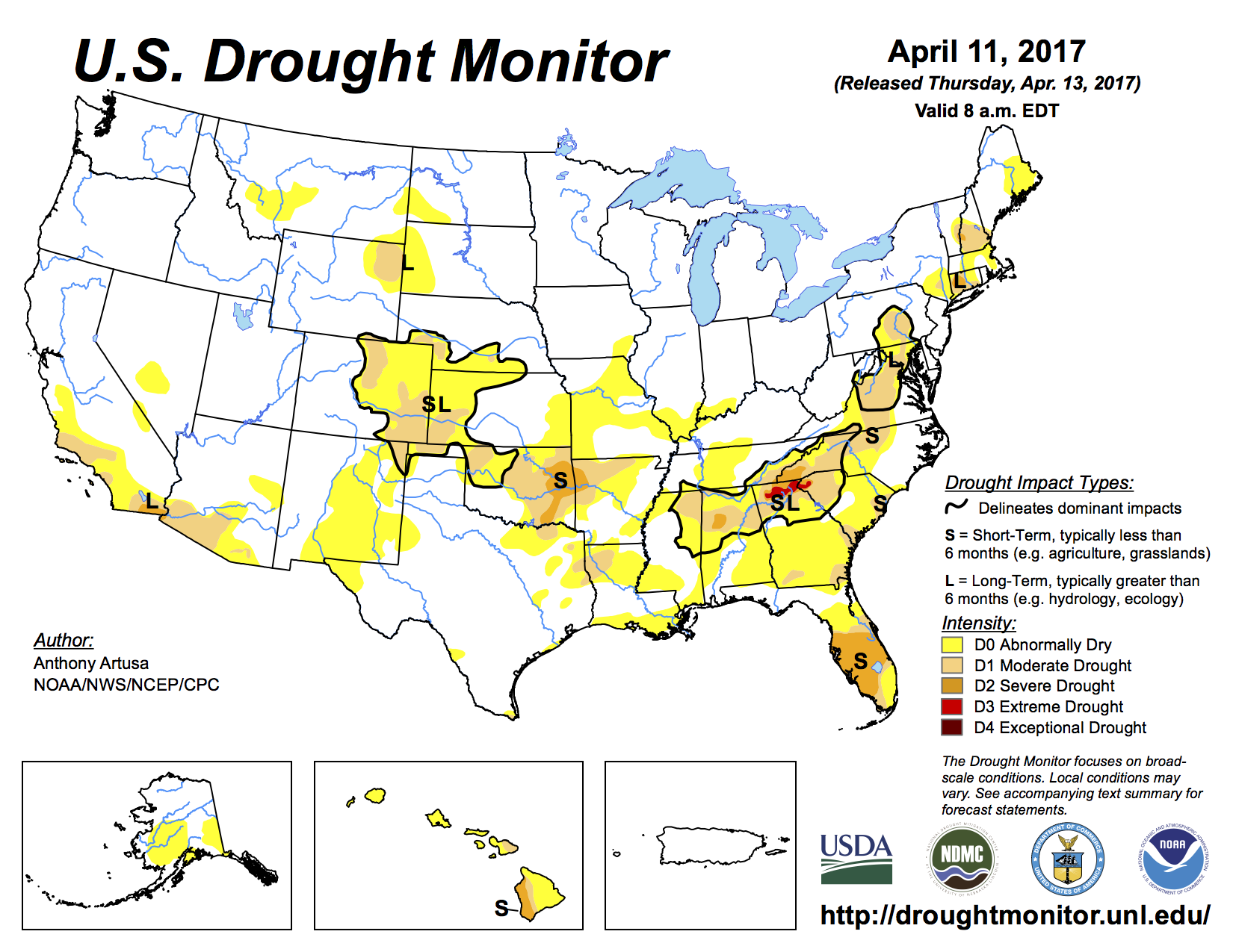
Despite the positive streamflow predictions along the Rio Grande, nearly half of the state is classified as abnormally dry on the most recent federal drought map . Still, that’s a vast improvement over last year at this same time, when nearly every square mile of New Mexico was dealing with some level of dryness or drought.
The Colorado high country had well below average snowpack for the first two and half months of the snow season, and ski resorts were delaying their openings. The forecast for January called for a switch in the weather pattern. Colorado needed something big to get out of trouble.
“Through the end of January, it was a complete rescue and then some. It came back, and it came back with flying colors.” Domonkos said it was a record breaking dry spell, followed by a record breaking January, that brought the snowpack levels as high as 152% of average. Then a warm, dry March dropped the numbers back down to average, and drew the attention of some of the nation’s top snow scientists.
“We could potentially have a shift from high rates of melt to slower melt,” said Keith Musselman, a hydrologist with NCAR in Boulder.
Musselman and his team of hydrologists recently published research showing that early season snowmelt might not mean that runoff water just gets to reservoirs sooner, but rather it could get intercepted along the way. Musselman says warm, dry springs will likely slow the flow of that melt, leaving it more susceptible to evaporation and absorption by plants.
“It requires a certain amount of water to fill up cracks and divots and depressions before you have water connect, and then create the stream flow,” Musselman said.
With a booming population in Colorado and the western United States, it is becoming more and more important to know exactly how much water is in our snowpack, and when it will reach our reservoirs. It’s so important, in fact, that NASA is in the Colorado high country trying to find a better technique to measure it.
The SnowEx project in a multi-year project being conducted in the Colorado Rocky Mountains. The goal is to combine current statistical methods with improved remote sensing and computer modeling to allow for better water planning. If successful, we could see soon have even more accurate snowpack measurements and runoff forecasts.
NRCS reported that Colorado’s reservoir storage was at 110% of average to start April, with an average snowpack still to melt off. Also, the majority of streams in Colorado are still anticipated to produce normal to above normal flows, with the exception of the Upper South Platte and streams in the Yampa and White River basins. Those streamflow projections are for current snowpack, and average spring precipitation.
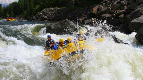
The early season on the Arkansas River in Colorado will serve “adrenaline-junkie guests looking for high water, big waves and big holes,” said Andy Neinas, the owner of Echo Canyon River Expeditions, based in Colorado.
But big water may also serve those seeking rides on the milder side. Mr. Neinas likened snowmelt to a block of ice on a sidewalk on a hot day.
“The cube of ice will obviously melt quickly,” he explained. “That’s our spring high-water season. Because there is so much more water, the block of ice will take a much longer time to melt, and that illustrates our long season of family-friendly flows.”
In southwestern Colorado, Mild to Wild Rafting plans to run its first full season on the Dolores River since 2008. It includes a Class IV rapid known as Old Snaggletooth that rafters ages 11 and younger must walk around when the water is high.
Water levels in some popular areas for rafting, like the Grand Canyon, are based on controlled dam releases, which are more predictable. Even among those that rely on nature’s tap, above-average snowfall doesn’t ensure higher water in rafting season, which is generally May through August.
Brian Merrill, the chief executive of Western River Expeditions, based in Salt Lake City, said snowpack had fallen sharply with warm March temperatures. This may affect trips on a stretch of the Colorado River in Utah known as Cataract Canyon, which cuts through Canyonlands National Park.
The Bureau of Reclamation said Monday it will release 9 million acre-feet from Lake Powell. The water will flow down the Colorado River into Lake Mead, which supplies Arizona, California and Nevada.
Last month, the agency projected it could release 11.1 million acre-feet, but a dry March reduced the amount of snow in the mountains that feed the river.
On average, Lake Powell releases 8.7 million acre-feet annually. An acre-foot can supply two typical homes for a year.
The two reservoirs are part of the Colorado River system, which supplies about 40 million people and 6,300 square miles of farmland in seven states.
Statewide Snowpack April 17, 2017 via the NRCS.
Arkansas River Basin High/Low graph April 16, 2017 via the NRCS.
Gunnison River Basin High/Low graph April 16, 2017 via the NRCS.
Laramie and North Platte Basin High/Low graph April 16, 2017 via the NRCS.
San Miguel, Dolores, Animas, and San Juan Basin High/Low graph April 16, 2017 via the NRCS.
South Platte River Basin High/Low graph April 16, 2017 via the NRCS.
Statewide Basin High/Low graph April 16, 2017 via the NRCS.
Upper Colorado River Basin High/Low graph April 16, 2017 via the NRCS.
Upper Rio Grande River Basin High/Low graph April 16, 2017 via the NRCS.
Yampa River Basin High/Low graph April 16, 2017 via the NRCS.
Cañon City community members will meet again with Cotter Corp. on Thursday to hear about the former uranium mining company’s pilot groundwater cleanup project.
Cotter hopes the project will reduce uranium and molybdenum contaminates to safe levels, but so far, community members have had mixed feelings about the effectiveness of the program.
Doni Angell, a member of the Lincoln Park Community Advisory Group that hosts the meetings and frequently comments on Cotter projects, said the proposed project, known as the Organic Bioreactor Work Plan, will only create a more concentrated toxic environment…
The project proposes an organic method using wet hardwood mulch to remove contaminates from the groundwater, rather than synthetic chemicals that most uranium mills use. The mulch, Cotter believes, would remove oxygen from water flow areas, causing the uranium to separate from the water. Because the water is migrating down slope through the mulch, Cotter anticipates successful contamination reduction using the natural aquifer as opposed to a mechanically propelled system.
“This is the simpler solution based on our tests, and sometimes the simple solution is the better solution,” Cotter project manager Steve Cohen said, adding that capital costs for this type of project are much lower than synthetic chemical-based ones.
Community Advisory Group member Carol Dunn said she does not know enough about the details of the project to make an assessment.
She said her hope going into Thursday relies on the relationship the community has developed with Cotter – a unique aspect of the Cotter/Lincoln Park site in relation to other Superfund sites where the responsible party is usually no longer present…
The project is in the informal public comment period, which was extended by the Colorado Department of Public Health and Environment from April 21 to May 7 last week after a request from the Community Advisory Group. The EPA and CDPHE – which oversees activities at the site because of its designation as a Superfund site in 1984 – are reviewing the details of the project and will provide comments following the May 7 comment deadline.
At that time, the agencies will also evaluate comments received from other agencies and the public, include the Community Advisory Group…
The original groundwater contamination in the Lincoln Park community was caused by the discharging of the uranium tailings into unlined tailing ponds. The ponds were closed in the early 1980s when the EPA listed the area as a Superfund site, and the waste was excavated and put into new lined ponds. The new ponds cut off most of the groundwater contamination, and, since then, the EPA has since declared the contaminated ground water status as “under control.”
The EPA is currently administering its 5-year review of the site to ensure that the site decision remedies are continuing to protect human health and the surrounding environment. The Community Advisory Group also has contributed to that project, providing the EPA with people to interview in the community about the impacts, or lack thereof, of the remaining contamination.
(The Community Advisory Group meeting will take place on Thursday at 6 p.m. in the Abbots Room at the Abbey Events Complex, 2951 East U.S. Highway 50. The meeting is open to the public.)
Parachute/Battlement Mesa area via the Town of Parachute.
FromThe Grand Junction Daily Sentinel (Dennis Webb):
A split Garfield County Commission on Monday approved a zoning change needed for Ursa Resources to continue pursuing a controversial wastewater injection well proposal in the residential community of Battlement Mesa.
But while Commissioner Mike Samson was part of the 2-1 vote approving the change, he said he has a lot of questions when it comes to injection wells and will be seeking a better understanding of the proposal from Ursa when it comes back to ask the county for a special-use permit for the well. It will need to get that permit under the new zoning…
Ursa currently has county and state approvals for two well pads in Battlement Mesa, and has said that if it gets the injection well pad approval, that could help eliminate the need for another pad by the community’s golf course and cut its overall planned number of pads in Battlement Mesa from five to four.
But some activists and Battlement Mesa residents fear that groundwater and surface water contamination, induced earthquakes and other impacts could result from an injection well, jeopardizing nearby residents…
Commissioner Tom Jankovsky voted against the zoning change. He said he’s been a fairly strong supporter of oil and gas development in the county, and the county’s decision to let Ursa drill in Battlement Mesa reflected the fact that mineral rights are a property right…
He said while he’s relatively comfortable with injection wells, Ursa’s proposed well is something that residents have sought relief from, and that’s a request he feels he can honor.
Commissioner John Martin said he doesn’t like injection wells because he thinks water brought up from underground during oil and gas production should be able to be filtered and put to agricultural and other surface uses, but the industry is only allowed to recycle it for oil and gas uses. If leftover water is not disposed of in injection wells it is sent to evaporation ponds, a form of disposal that raises health concerns, he noted.
Both he and Samson reiterated that the commissioners’ vote Monday doesn’t authorize Ursa’s operation of an injection well, but just lets the company proceed with seeking the permit to do so.
But their vote frustrated some residents, including Betsy Leonard, who said afterward that Martin and particularly Samson showed “no backbone” on the issue…
Resident Carol Fallon said she thinks the injection well is just designed to save Ursa money by avoiding truck hauling costs…
Matt Honeycutt, Ursa’s operating superintendent, said he’s happy Ursa will get the chance to move forward and show why it believes its plan is a good one. He said he expects the company will apply for the special-use permit within the next month or so.
He also responded to an argument from some residents that Ursa should be recycling the produced water in its operations rather than disposing of it. He said it does use its produced water from wells in its hydraulic fracturing operations, but has to have a place to dispose of the water that wells continue to produce after the fracking is done.
Ursa’s injection well also would require approval by the Colorado Oil and Gas Conservation Commission. It also has yet to receive county or state approval for the pad where the well would be located.
House Bill 1306 would establish a grant that would allow the Colorado Department of Public Health and Environment to test the water at all public schools in the state for up to three years.
The bill passed 12-1 and now heads to appropriations.
Under the bill, the Department of Public Health and Environment would be allowed to spent up to $300,000 per year for testing, according to officials…
Representative Jim Wilson was the only “no” vote Monday afternoon. He cited efficiency concerns and felt the testing could be more practical.
“Make no mistake.. I’m definitely in favor of testing the water,” Rep. Wilson reiterated.
HB 1306 still has a long way to go starting with appropriations.
If passed, older schools will be a priority for lead testing, officials said. Elementary schools will also be a priority since younger children face a higher risk.
The grant will not cover charter schools, which fall under a different category.
Click here to go to the website. Here’s an excerpt:
Highlights:
Very warm and dry conditions the first three weeks of March caused unusually early snowmelt across the region, with significant or complete meltout at low and middle elevations in many basins, and substantial SWE losses at some high-elevation sites. A return to an active storm pattern put accumulation back on track so that as of April 7th, SWE in most basins was still well above normal.
With the large snowpacks and early snowmelt, daily streamflows in northern Utah and western Wyoming rivers are at high (>90th percentile) or record-high values, including the Provo, Weber, Ogden, Bear, upper Green, Snake, Wind, Bighorn, and Yellowstone. There is an elevated risk of flooding in these basins as spring runoff progresses.
The April 1 NRCS spring-summer runoff forecasts came in lower than the March 1 forecasts at most points, though the regional picture is still dominated by above-average runoff. Forecast points in northern Utah and western Wyoming are expected to have >150% of average runoff, while points in Colorado, southern Utah, and eastern Wyoming, are split between the below-average (70-89%), near-average (90-109%), and above-average (110-129%; 130-149%) categories. Forecasted Lake Powell inflows have slipped to 130% of average, per both NRCS and NOAA CBRFC.
With the boost from storms late in the month, central and western Wyoming, much of Utah, and far eastern Colorado ended up with well-above-normal precipitation. Northwestern and southern Utah, northeastern and south-central Wyoming, and western and north-central Colorado stayed well on the dry side. Statewide, Wyoming was yet again very wet, in the 89th percentile for precipitation, with Utah in the 65th percentile and Colorado in the 34th percentile.
Like February, March ended up as very warm across the region, with temperature departures of +2°F to +10°F. Colorado had its warmest March on record, 6.4°F above normal, while Utah saw its 2nd-warmest March, and Wyoming, its 4th-warmest March.
Drought conditions have improved in central Utah and areas of eastern Colorado since early March, but deteriorated in other areas of eastern Colorado. D1 or D2 conditions now cover 22% of Colorado (down from 37%), 9% of Wyoming, and 0% of Utah.
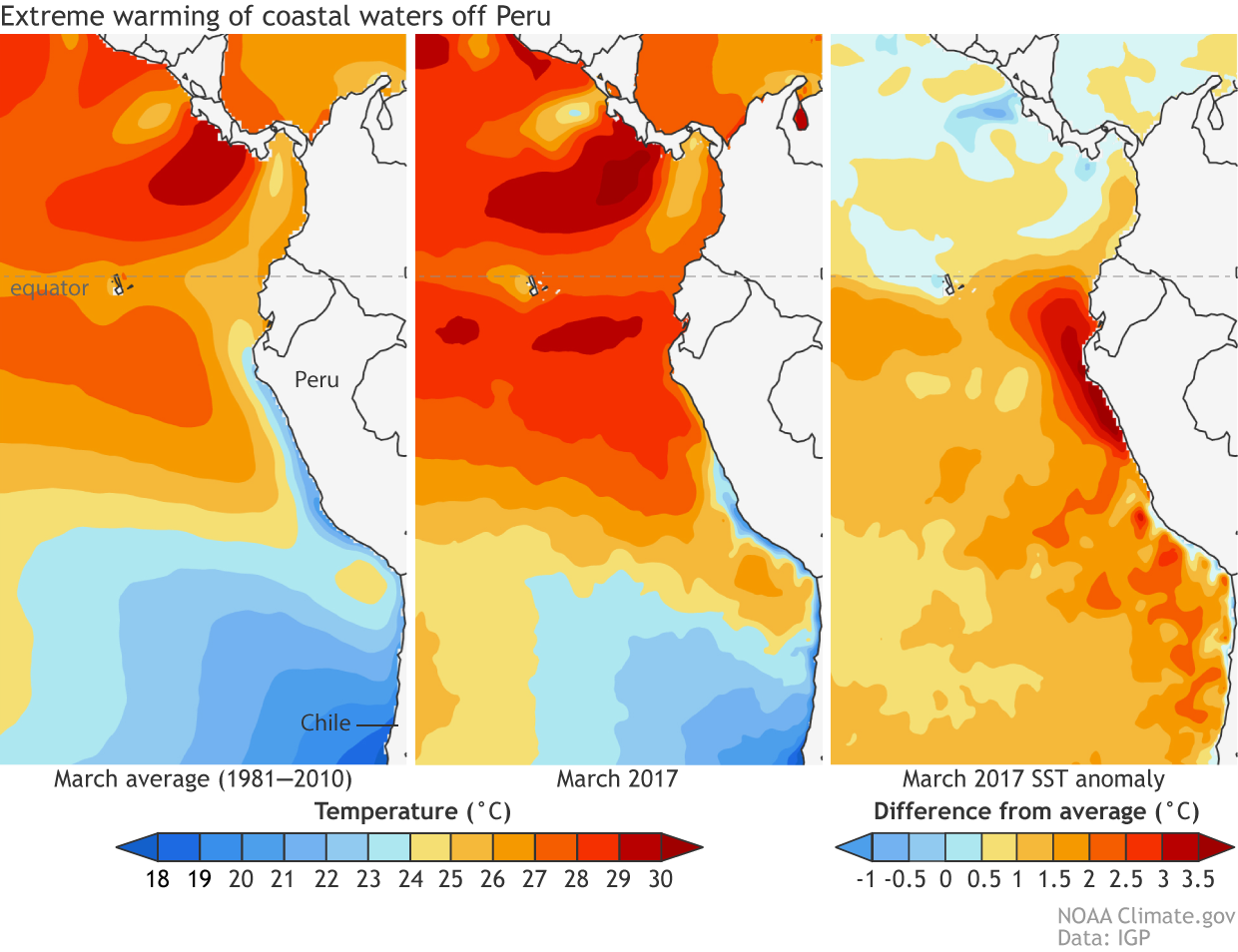
The tropical Pacific remains in ENSO-neutral conditions, though with warming sea-surface temperatures off the Peruvian coast in the Niño 1+2 region. The ENSO forecast models call for neutral conditions to continue through spring, with in increasing chance of El Niño conditions by fall.
From the Associated Press (Dan Elliott) via US News & World Report:
Colorado can expect an average to slightly below-average wildfire season this year, despite dry conditions and early outbreaks on the eastern plains, officials said Friday.
“But the fires will occur,” said Michael Morgan, the director of state Division of Fire Prevention and Control.
An average season in Colorado is about 45 wildfires burning a total of 160 square miles (415 square kilometers), Morgan said.
The outlook is based on expected weather patterns and fuel — the trees, grass, shrubs and other vegetation that can burn if a fire gets out of hand.
Most of the plains have been in a drought or near-drought conditions since mid-October. Last month, a wildfire in northeastern Colorado blackened 50 square miles (129 square kilometers) and killed 200 cattle.
But the mountains received heavy winter snowfall after a slow start. Most of the high country had average or above-average snowpack as of Friday.
Gov. John Hickenlooper, who appeared with Morgan for a briefing at the state Capitol in Denver, said Colorado averages four times as many wildfires as it did 15 years ago. He blamed climate change, which he said has lengthened the fire season by about 80 days…
Only about 7 percent of the state’s 2016 wildfires had natural causes, Morgan said. The rest were started by debris fires, campfires, prescribed burns, arson, mechanical failures or other causes, he said.
The state has adopted an aggressive tactic of monitoring for wildfires when conditions are dangerous and attacking them quickly, from the air if necessary, when they are reported.
Two years ago, the state rolled out two newly acquired aircraft equipped with infrared cameras, which officials said were so sensitive that one detected a campfire from 28,000 feet (8534 meters) in the air.
Morgan said the aircraft detected 43 fires last year that were so remote no one else had reported them.
Here’s the release from the Bureau of Land Management:
The Bureau of Land Management seeks public input as it begins updating a management plan for about 40 miles of the Upper Colorado River between Parshall and State Bridge.
The Recreation Area Management Plan update will guide the specific management of the Upper Colorado River Special Recreation Management Area (SRMA) within the Kremmling Field Office, an extremely popular area for commercial and private float-boating and fishing. More than 90,000 people visit the area each year.
“The original management plan for the area dates back to 2000, and a lot has changed since then,” said BLM Kremmling Field Manager Stephanie Odell. “We want to hear what the public would like us to address – things like ways to reduce crowding and user conflicts, potentially improving facilities, balancing use with conserving the natural resources of the area, or any other issues.”
The BLM is hosting three public open house meetings to answer questions and accept written comments:
• April 18 from 4-6 p.m. in Silverthorne at the Summit County Library, 651 Center Circle
• April 20 from 4-6 p.m. in Kremmling at the CSU Extension Hall, 210 11th St.
• April 21 from 6-8 p.m. in Denver at the REI Flagship Store, 1416 Platte St.
The BLM Kremmling Field Office collected more than $220,000 in commercial and recreation fees from the Upper Colorado River SRMA last year. These funds are used to manage the SRMA. Recreation on BLM lands in the Kremmling Field Office supports an estimated 280 jobs generating $8.4 million in labor income annually.
More information about the management plan update is available at: http://bit.ly/2obaSen
Comments must be received by May 15 and may be e-mailed to blm_co_kr_webmail@blm.gov or mailed to Bureau of Land Management, Attn: Shane Dittlinger, P.O. Box 68, Kremmling, CO 80459.
Before including your address, phone number, e-mail address, or other personal identifying information in your comment, you should be aware that your entire comment—including your personal identifying information—may be made publicly available at any time. While you can ask us in your comment to withhold your personal identifying information from public review, we cannot guarantee that we will be able to do so.
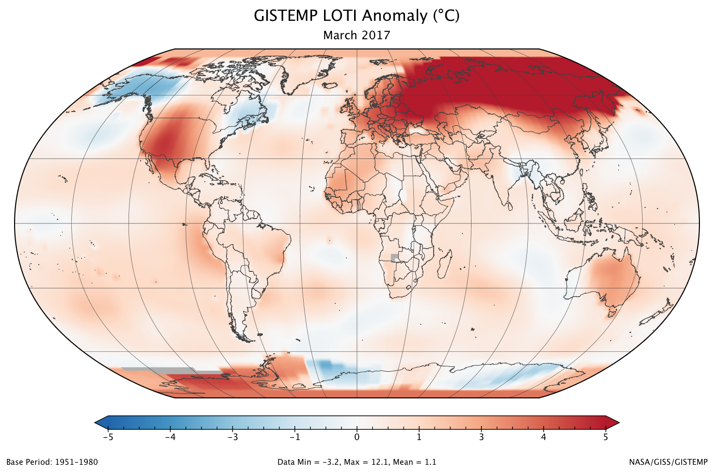
March 2017 was the second warmest March in 137 years of modern record-keeping, according to a monthly analysis of global temperatures by scientists at NASA’s Goddard Institute for Space Studies (GISS) in New York.
Last month was 1.12 degrees Celsius warmer than the mean March temperature from 1951-1980. The two top March temperature anomalies have occurred during the past two years.
March 2016 was the hottest on record, at 1.27 degrees Celsius warmer than the March mean temperature. March 2017’s temperature was 0.15 degrees Celsius cooler than March 2016, but 0.2 degrees Celsius warmer than any previous March.
The monthly analysis by the GISS team is assembled from publicly available data acquired by about 6,300 meteorological stations around the world, ship- and buoy-based instruments measuring sea surface temperature, and Antarctic research stations.
The modern global temperature record begins around 1880 because previous observations didn’t cover enough of the planet. Monthly analyses are sometimes updated when additional data becomes available, and the results are subject to change.
Global map of the March 2017 LOTI (land-ocean temperature index) anomaly shows that Europe and all of Russia (especially north central Siberia) were again much warmer than the 1951-1980 base period. Much of the United States was also relatively warm, but Alaska was instead cool. Credit NASA.
FromAspen Journalism (Brent Gardner-Smith) via The Glenwood Springs Post-Independent:
On March 9 the town of Carbondale notified the Federal Energy Regulatory Commission it plans to install a micro hydropower turbine in a pipe leading to its municipal water treatment plant on Nettle Creek.
On March 13 FERC found that Carbondale’s project qualified for a quick review under the Hydropower Regulatory Efficiency Act of 2013, which streamlined the permitting process for hydro projects of less than 5 megawatts.
And by April 27, if no one claims the project doesn’t qualify, the town can expect to get a letter from FERC saying the town does not need a license and can go ahead, at least as far is FERC is concerned.
At 28 kilowatts, Carbondale’s project is much smaller than the 5-megawatt limit in the efficiency act, it’s a new license using a nonfederal pipeline, and it complies with the Federal Power Act.
So far, FERC’s fine with it, and it’s received no objections from the public.
The project involves installing a “turbine/generating unit” in an existing 10-inch municipal pipeline, or “raw water intake line.”
The pipe is 1,800 feet long and transports about 1 cubic foot per second of water downhill from Nettle Creek to the city’s treatment plant. The plant is eight miles up the Crystal River valley on the lower slope of Mount Sopris.
The turbine would be built inside a vault installed in the pipeline, near the treatment plant. A short bypass system would allow water to be moved around the turbine for repairs and maintenance.
“It’s taking advantage of the water that is already going down that pipeline,” said Mark O’Meara, Carbondale’s utilities director. “We’re not going to increase it. We’re not going to be doing any additional diversion.”
O’Meara also said that since it’s a nonconsumptive use of water already running down a pipeline, the town did not have to change its existing municipal water rights to specifically add hydro as a use.
The turbine’s “installed capacity” of 28 kilowatts and its “estimated annual generating capacity” of 190,000 kilowatt-hours is about enough electricity to offset the amount of power used to run the water plant, O’Meara said.
According to Craig Cano, a media relations officer at FERC, the 28 kilowatt figure refers to how much power the turbine could produce at any moment.
“That’s real small,” Cano said, pointing out it’s 0.028 of a megawatt, while a typical baseload-generating power plant’s capacity is in the hundreds of megawatts.
The 190,000 kilowatt-hour figure refers to the total amount of energy produced over a year.
The resulting electricity would either be sent through the existing Holy Cross Energy system that today powers the plant, or perhaps be used directly in the plant, O’Meara said. The town would get credit from Holy Cross for hydropower sent out over the grid.
The project has been in the works since the 1990s, but it still has a long way to go.
On the list is an in-depth feasibility study considering design, engineering and cost. A 2012 estimate from engineering firm SGM put the cost at $180,000. O’Meara did not have an updated cost.
And since the water plant and pipeline are on U.S. Forest Service land, the agency also has jurisdiction over the project.
But O’Meara said after going to a recent workshop put on by the Colorado Energy Office, it seemed like the right time for the town to enter the streamlined FERC process and see how it goes.
It took only four days after receiving Carbondale’s “notice of intent” for FERC to issue its “notice of preliminary determination” that the project qualified for speedy review.
That notice, along with town’s initial notice, are on town’s website, on its utilities page.
Also on March 13, FERC opened two windows for parties to contest the qualifications of the project.
The first was a 30-day window to file a motion to intervene. By April 12, no one had.
The second was a 45-day window for less formal but still “contesting” comments to be made.
That window closes April 27, and as of April 13, FERC had received no comments.
“If no party contests staff’s initial determination that the project meets the criteria for a qualifying conduit hydropower facility within the 45-day public notice period,” FERC’s Cano said, “the facility is deemed to meet the criteria and FERC staff shortly thereafter will issue a letter notifying the filer that is project has met the criteria.”
If someone does file a comment contesting the project’s qualifications, FERC is supposed to then “promptly issue a written determination as to whether the facility meets the criteria,” Cano said.
Carbondale’s O’Meara said that as far as he knows, no one over the years has raised concerns about the project directly to the town.
Aspen Journalism is collaborating with the Post Independent, The Aspen Times, the Vail Daily and the Summit Daily News on coverage of water in the upper Colorado River basin. More at http://www.aspenjournalism.org.
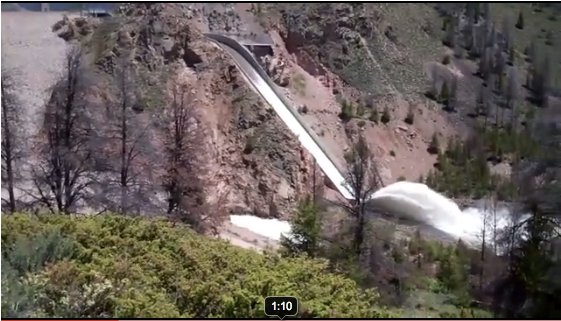
This year’s spill from McPhee Reservoir will be lengthy. Snowfall was particularly good this year. But a steady release is not what appeals to boaters. Better to vary the flow from high to medium levels to give river runners different experiences in the canyon…
A big Dolores spill does not occur often (the most recent of any size was in 2008), thus there are good reasons for making the most of it this year. Expect the river, ecology and terrain to be subjected to its dynamism.
Sediment movement with different flows is important as the river adjusts its pools and eddies while refreshing itself. And to what degree an underground aquifer will replenish depends on higher flows.
While Southwest Colorado will enjoy making the most of the Dolores, there are plenty of uncertainties about how to fund other water projects needed for a state population expected to double by 2050 (requiring an estimated 560,000 acre feet of water).
Both conservation and more efficient water uses are in the equation, but project funding is elusive. Severance taxes provide the bulk of the funding for the Department of Natural Resources, but energy extraction is not providing a predictable revenue source.
Flows on the Yampa River this week more closely resembled conditions typical of mid-July than mid-April, and federal scientists who keep an eye on the entire Colorado River Basin are now predicting that flows in the river, which runs through the heart of downtown Steamboat Springs, will trend below average through mid-summer.
“The headwaters of the Colorado River main stem and the San Juan Basin are currently forecast to receive near average runoff volumes, while the Yampa and White river basins now have forecasts for below average April-July runoff volumes,” hydrologists at the Colorado Basin River Forecast in Salt Lake City predict.
The Yampa was flowing at 309 cubic feet per second (cfs) at the Fifth Street Bridge in downtown Steamboat Springs at midday on April 13. That’s below the median for the date of 440 cfs. But this isn’t likely to be a replay of 2012 when the river peaked unusually early for the season at 1,570 cfs on April 27.
There is still 38 inches of snow on the West Summit of Rabbit Ears Pass, according to the Natural Resources Conservation Service.
Based on weather forecasts, the River Forecast Center expects the Yampa in Steamboat to spike to just over 400 cfs Friday, April 14 in the wake of temperatures pushing 70 degrees on Thursday, then retreat to below 230 cfs by April 21.
It’s a different story on the Elk River, which flows into the Yampa west of Steamboat. Contrary to the trend on the Yampa, the Elk was flowing well above average Thursday at 1,080 cfs, compared to the median 641 cfs…
The historic average peak flow for the Yampa is 3,070 cfs at the Fifth Street Bridge. The river peaked at 3,550 cfs on May 5, 2015, and at 3,430 cfs on June 9, 2016.
One of the heaviest runoffs this decade was in 2011, when the river peaked at 5,200 cfs on June 7. The highest recorded peak flow was 6,820 cfs on June 14, 1921, in an era when there were fewer dams upstream from Steamboat.
The San Juan Water Conservancy District (SJWCD) board discussed several aspects of its proposed Dry Gulch raw water storage project during its regular meeting Monday night, including loan nancing, a mill levy increase, contracts and new names for the project.
Among the decisions made at the meeting was approving a resolution allowing the district to apply for a $2 million loan to help acquire property needed for the project, as well as for preconstruc- tion expenses.
That loan, however, would be contingent upon the SJWCD successfully raising its mill levy to one mill during an upcoming election.
In introducing the topic to the board, chair Rod Profitt explained that he had already submitted the loan application to the Colo- rado Water Conservation Board (CWCB), but that the resolution would “essentially” formalize that application.
Profitt noted he would be appearing before the CWCB during that board’s meeting in May (to be held in Pagosa Springs) to see if the loan is approved, at which point the SJWCD would have to work on the mill levy increase being approved…
The resolution further states, “the costs to acquire the rest of the land needed for the reservoir basin and pre-construction expenses are expected to be $2,000,000.”
The 40-year loan, Proffitt explained during discussion, comes with a 2.75 percent interest rate, which mean debt-service pay- ments of about $96,129 per year.
One mill, he said in response to a question by board member Al Pfsiter, would raise about $213,000 per year, meaning the district would also have funding for other projects such as the stream management program…
The resolution passed 5-0, with board member Ray Finney absent from the meeting.
As of April 1, the snowpack in the San Miguel, Dolores, Animas and San Juan River Basin continued to look strong, sitting at 128 percent of median.
Statewide, the snowpack sat at 111 percent on that date.
“We’re still really high up there compared to some of the statewide drainages,” said Joe Crabb, one of the area’s water commissioners for the Colorado Department of Natural Resources Division of Wa- ter Resources. Crabb presented the informa- tion to the San Juan Water Con- servancy District board during the board’s regular meeting Monday.
While the local basin’s 128 per- cent of median is lower than the March 1 mark of 153 percent of median, it is better than it was in previous years.
The April 1, 2016, snowpack rang in at 84 percent, while the 2014 figure for the same time pe- riod was 86 percent, and, for 2011, was 99 percent. Crabb also explained to the board that recent high winds had the potential to impact the snow- pack by depositing sediment on top of the snow, which increases the rate it melts.
Crabb further noted that the snow water equivalent (SWI, the amount of moisture in the snow) remains good, with Crabb’s pre- sentation showing the SWI at 120 percent of median to date and 117 percent of the seasonal median.
In terms of the river flow, Crabb explained that the San Juan River through Pagosa Springs and the Piedra River had each surpassed 1,100 cubic feet per second (cfs) in March, though the runoff had fallen back in to the range of 600- 630 cfs following that. As of April 12, the flow of the San Juan River had inched back up, ringing in at 716 3 midday, with higher amounts at night. He noted that the peak river flow typically occurs around the end of May or first week of June, with the San Juan and Piedra rivers peaking at about the same time.
On April 1 statewide snowpack was at 108 percent of normal, down from 139 percent of normal last month and 156 percent on Feb. 1.
“It has been a bit of a rollercoaster snowpack season,” said Brian Domonkos, Colorado Snow Survey supervisor, referring to record low snowpack accumulation in October and November, followed by record high snowpack accumulation in December and January, and now a return to near record low snowpack accumulation again in March.
Relatively good snowpack remains in the Gunnison, Arkansas, and combined San Miguel, Dolores, Animas and San Juan basins, all above 118 percent of normal. Only the combined Yampa and White basins are now below normal.
March precipitation statewide was 64 percent of average with two SNOTEL sites recording as low as 20 percent of March normals. These low monthly totals dragged down the year-to-date precipitation from 123 percent of average last month to 112 percent on April 1. Fortunately, some recovery came at the month’s end to much of Colorado’s mountains mostly in the form of snow. The South Platte, Arkansas and the Rio Grande basins did receive enough snow to reach new snowpack peaks beyond the peak reached in early March. Snowpack typically peaks for all basins near April 10, the exception being the South Platte, which peaks two weeks later.
At the end of the month the Sangre de Cristo mountains were able to scrounge up considerably more precipitation than the rest of the state, helping to boost the late season snowpack in that region.
“March and April are the two months in which Colorado typically sees the greatest precipitation, accounting for over one-fifth of the year’s total,” said Domonkos. A slow start in March can be overcome in April.
While current snowpack and reservoir storage levels are normal to slightly above normal across much of the state, the recent snowmelt and dry conditions in March had significant impacts. As a result, spring and summer streamflow forecasts have dropped considerably since a month ago.
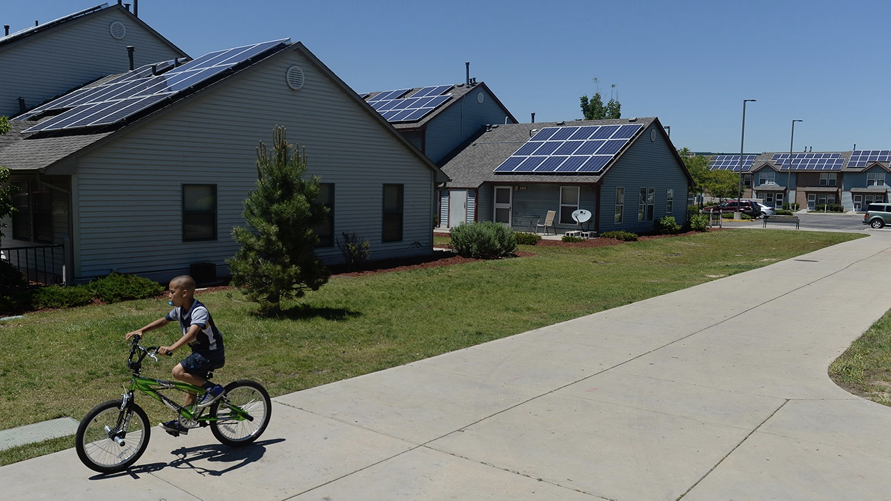
Not long ago, major electric utilities in much of the Southwest seemed bent on chasing rooftop solar companies out of the region. They saw the booming industry as a threat to their profits and sought rate changes that would make solar panels less financially attractive to homeowners. The electric companies advocated slashing the compensation those customers get for sending their excess power to the grid and adding new fees to their electric bills.
Because the electric companies are monopolies, state regulators have to approve such changes. In late 2015, the Public Utility Commission of Nevada set new rates that were so unfavorable to solar customers that they nearly snuffed out the residential solar business in the state. The number of households applying to connect solar panels to the grid dropped from a peak of nearly 3,000 in August 2015 to just 14 in July the next year. The biggest solar installation companies left the state, laying off thousands of workers.
But that’s not the end of the story. The public was outraged, and its objections resulted in a surprising shift: gradual rollback of the commission’s anti-solar decision…
Apparently big electric companies are learning that given the broad popularity of solar in the sunny desert region, they will have to accommodate rooftop solar instead of trying to kill it. This reflects the growing political might of the solar industry as it’s seen as a key job creator in much of the Southwest.
Please consider coming by the Community Building at Thornton’s Community Park on May 16th. I’ll be speaking about the climate crisis as part of the Climate Reality Project. Children are welcome. We’ve already baked in a lot of uncertainty about the future for them. The presentation revolves around three questions: Should we act; Can we act; and, Will we act? I’ll bring you up to date on the engineering effort around renewable energy.
Details:
What: Climate Change is Water Change: Colorado Update
Where: Thornton Community Park Community Building (Near the swimming pool), 2211 Eppinger Blvd, Thornton, CO 80229
When: Tuesday, May 16, 2017, 6:00 PM – 7:30 PM
About the Climate Reality Project:
With glaciers melting, seas rising, and 14 of the 15 hottest years on record coming this century, the threat of climate change has never been clearer. But with solar, wind, and other clean energy solutions becoming more affordable and accessible every year, neither has the way forward. And with 195 countries signing the historic Paris Agreement to cut greenhouse gases the world is finally united in working to seize the promise of renewables and create a safe, sustainable, and prosperous future powered by clean energy.
What’s in the way? Powerful fossil fuel companies and their government allies spreading fear and misinformation.
Led by Vice President Gore and CEO Ken Berlin, we’re here to change that. We connect cutting-edge digital media, global organizing events, and peer-to-peer outreach to share the truth about climate change and the solutions in our hands today with people everywhere. And with our more than 10,000 Climate Reality Leader activists building support for pro-climate policies at every level, and millions joining us to accelerate the global transition to clean energy, we have the chance to stop climate change and together create a future we can be proud of. We’re not about to waste it.
he University of New Mexico water posse had a great visit yesterday with Christopher Scott, the new director of the Udall Center for Studies in Public Policy at the University of Arizona. Scott spoke a couple of times and met with students at our Community and Regional Planning program, who have been doing a lot of work on wastewater reuse (shoutout to Caroline Scruggs, who’s leading this effort, and who hosted Scott).
Scott talked about the work he’s been doing in this same area, which raises non-trivial questions with deep implications for what happens when you “conserve” water – the fact that the water you “save” was often doing something useful somewhere else, whether you meant it to our not. Like a sewage treatment plant outfall into a river. Or, as from this 2014 paper, water leaking from the unlined All-American Canal on the Lower Colorado River that recharged an aquifer:
Certainly, California’s statewide snowpack numbers are great – over 160% of average in early April – even inspiring Governor Jerry Brown to recently declare the end of the current drought. Upper Basin states are rolling in the numbers as well – the Colorado River basin is currently at 122% and every major river basin in Utah is at or above historical average. But not to throw a wet blanket over this year’s good news, we still have a long way to go before taking our foot off the gas in encouraging everyone across the Colorado Basin towards greater conservation measures, smart water sharing agreements, and stabilization of the system overall.
The Colorado River is currently over allocated to the tune of more than a million acre feet (one acre foot is about 325,000 gallons) per year – there is physically not as much water in the river as is being taken out. The main storage reservoirs in the system, Lake Mead and Lake Powell, are both under 50% of their capacity. In order for the system to be sustainable, and in preparation for the uncertainty of more bouts of lingering drought and climate change, we must all work together to support a stable and reliable Colorado River system – from the headwaters in the Colorado Rockies to the lettuce fields of Yuma and beyond.
Here’s the Westwide SNOTEL basin-filled map from the NRCS.
The Upper Arkansas Water Conservancy District board of directors meeting Thursday included recognition of two longtime board members, Frank McMurry and Jim McCormick, who both resigned from their positions in recent months.
McMurry, a local rancher and former Chaffee County commissioner, resigned as a conservancy district director after 34 years representing Division 3 (Chaffee County School District R-31).
McCormick, a retired home builder and former Salida city councilman, resigned from his position as treasurer in 2016 after serving in that capacity since the founding of the Upper Ark district in 1979.
The Upper Ark board recognized McMurry’s decades of service by awarding him the George E. Everett Memorial Award, established in Everett’s honor “to recognize individuals who have made significant contributions to the preservation of water and its historic use in the Upper Arkansas Basin,” said District Manager Terry Scanga…
Prior to his resignation as treasurer, McCormick was the only remaining member of the original district board.
In keeping with tradition, the Upper Ark district commissioned a portrait of McCormick to grace the walls of the district conference room alongside portraits of the other original members.
McCormick’s portrait, painted by Salida artist Carl Ortman, was unveiled at Thursday’s meeting.
In 2016, the Conservancy led an unprecedented community outreach effort in which thousands participated in the writing of the High Line Canal Vision. This vision passionately states that the High Line Canal’s 71 meandering miles will be preserved and enhanced as a cherished greenway that connects
This image was taken during the peak outflow from the Gold King Mine spill at 10:57 a.m. Aug. 5. The waste-rock dump can be seen eroding on the right. Federal investigators placed blame for the blowout squarely on engineering errors made by the Environmental Protection Agency’s-contracted company in a 132-page report released Thursday [October 22, 2015]
Here’s the Click here to register. From the release:
JOIN US IN FARMINGTON. Building on last year’s successful conference, the 2nd Annual Conference on Environmental Conditions of the Animas and San Juan Watersheds with Emphasis on Gold King Mine and other Mine Waste Issues will continue to facilitate the exchange of data and research results associated with monitoring efforts related to the August 2015 Gold King Mine spill. Since the spill, quite a bit has happened on the site and this conference will provide an update of the increased understanding of the spill, along with lessons that have been learned.
The conference is an opportunity to meet, learn from, and share ideas on a broad effort that includes four states, three Environmental Protection Agency (EPA) regions, two Tribes, and numerous local and municipal agencies and public water systems.
The New Mexico Water Resources Research Institute (NM WRRI) will host the conference on June 20-22, 2017 at San Juan College in Farmington, New Mexico. This year’s technical program will include oral and poster presentations in addition to plenary talks from some of the region’s leading experts on environmental catastrophes and their impacts on our communities. This year’s conference will include an all-day educational field trip of the Animas and San Juan watersheds.
Particularly relevant topics to be featured at the conference this year include:
Geology, minerology, ore bodies and natural sources of contamination
Analysis of Animas and San Juan watersheds as a result of Gold King Mine spill
Effects of acid mine drainage after more than a century of mining
Effects of historical mill-waste discharges
Effects of historical spill events
Effects of the Gold King Mine spill
Differentiating geologic and historical contaminants from Gold King Mine spill contaminants
Transport and fate of mining contaminants in the Animas and San Juan watersheds
Contaminant uptake into the food web
Mining and milling contaminant impacts on surface water, sediment, groundwater, agriculture, livestock, wildlife, and humans
Long-term monitoring
Existing corrective measures to control mine seepage and hydraulic consequences
Options for additional source control, spill prevention, and remediation
E. coli and other organisms in nutrients
Streamflow and water quality sensitivity to climate change
Groundwater and surface-water geochemistry and their interaction with the hyporheic zone
The conference will support the activities outlined in the Gold King Mine Water Spill Long Term Monitoring Plan, prepared by the New Mexico’s Long Term Impact Team (April 4, 2016).
The orange plume flows through the Animas across the Colorado/New Mexico state line the afternoon of Aug. 7, 2015. (Photo by Melissa May, San Juan Soil and Conservation District)
FromThe Glenwood Springs Post Independent (John Stroud):
Glenwood was named as one of 19 recipients of an EPA Brownfield Area-Wide Planning Grant.
The grant will be used to develop a plan to revitalize so-called “brownfields” located in the area where the Colorado and Roaring Fork rivers come together, including the city’s 5-acre former sewer plant property that was decommissioned several years ago.
Also included in the planning area is the Colorado Department of Transportation 5-acre facility across Devereux Road from Two Rivers Park, and the 27.4-acre Holly Quarry site below the Glenwood Caverns Adventure Park that has been eyed by the Caverns owners for a hotel development.
The grant is intended to help the city create a strategy to tie together the confluence redevelopment, Two Rivers Park, the Sixth Street corridor master plan and the Seventh Street beautification project following the completion of the new Grand Avenue bridge…
Also participating in the planning process will be the Downtown Development Authority (DDA), the Glenwood Chamber Resort Association, the nonprofit Community Builders, Colorado Brownfields Partnership, Colorado Mountain College, GlenX and Super School, Glenwood Caverns Adventure Park, and other stakeholders…
Finally, the EPA grant will also help the city carry out its plan to restore the Colorado River shoreline at Two Rivers Park. Plans include interpretive signs, gathering spaces and landscaping.
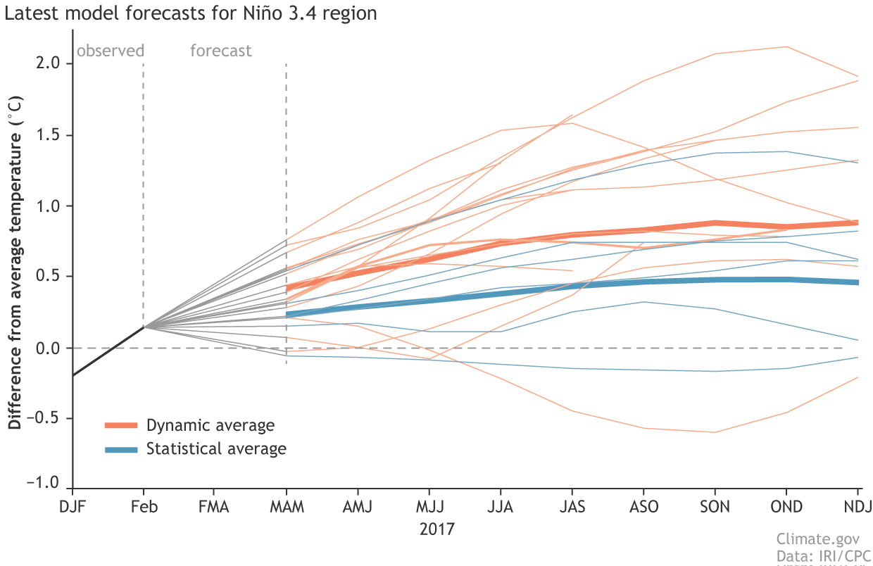
Synopsis: ENSO-neutral conditions are favored to continue through at least the Northern Hemisphere spring 2017, with increasing chances for El Niño development by late summer and fall.
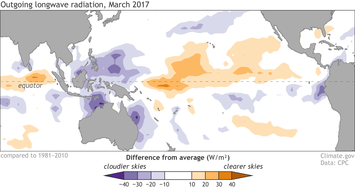
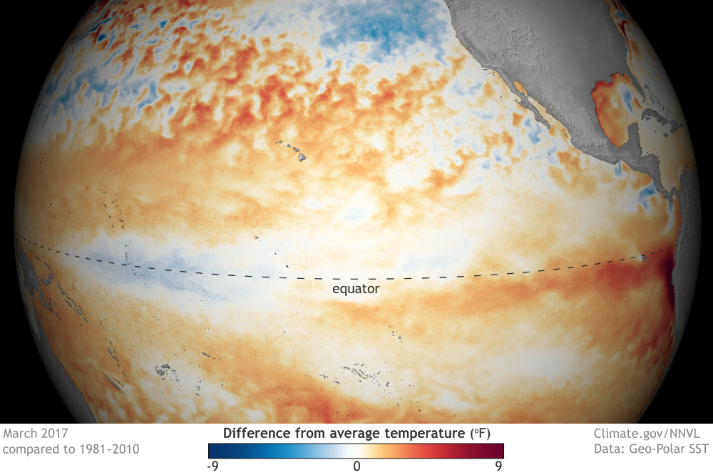
ENSO-neutral conditions continued during March, with near-average sea surface temperatures (SSTs) across the central equatorial Pacific and above-average SSTs in the eastern Pacific. The latest weekly Niño index values were near zero in the Niño-4 and Niño-3.4 regions, and +0.8 and +0.9°C farther east in the Niño-3 and Niño-1+2 regions, respectively. The upper-ocean heat content anomaly, averaged across the central and eastern Pacific, decreased to near zero during March, a reflection of above-average temperatures at depth in the east offset by below-average temperatures in the central Pacific. Atmospheric convection remained suppressed over the central tropical Pacific and enhanced over the Maritime Continent. The low-leveleasterly winds were enhanced over the central and western tropical Pacific, and weaker than average over the eastern Pacific. Also, upper-level westerly winds were anomalously easterly over the western and far eastern Pacific, while the Southern Oscillation Index was near average. Overall, the ocean and atmosphere system is consistent with ENSO- neutral conditions.
Most models predict the continuation of ENSO-neutral (3-month average Niño-3.4 index between -0.5°C and 0.5°C) through the late Northern Hemisphere spring. However, at least one-half of the dynamical model forecasts, including the NCEP CFSv2, anticipate an onset of El Niño as soon as the April-June season. Because of typically lower skill in forecasts made at this time of the year, and the lingering La Niña-like tropical convection and wind patterns over the western half of the Pacific basin, the forecaster consensus favors ENSO-neutral during April-June with a 60-65% chance. Thereafter, there are increasing odds for El Niño toward the second half of 2017 (~50% chance from approximately August-December). In summary, ENSO-neutral conditions are favored to continue through at least the late Northern Hemisphere spring 2017, with increasing chances for El Niño development by late summer and fall (click CPC/IRI consensus forecast for the chance of each outcome for each 3-month period).
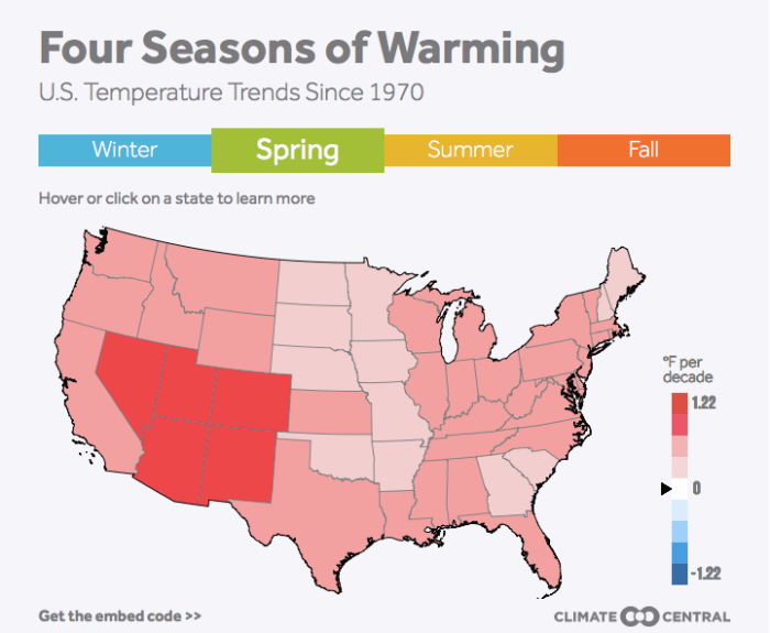
A winter heat wave is spreading inland from the West Coast and could bring unseasonable warmth spanning from coast-to-coast by the weekend.
Southern California is on track to continue setting hot temperature records, Phoenix will have its earliest first 90°F day of the year, and parts of the South could see temperatures 20°-30°F above normal.
While the heat is unusual in its magnitude, warmer winters in the U.S. are becoming the rule, not the exception. It’s the fastest-warming season for 37 states that roughly 220 million people call home.
Graphic via Climate Central. Click on the image to view an interactive version.
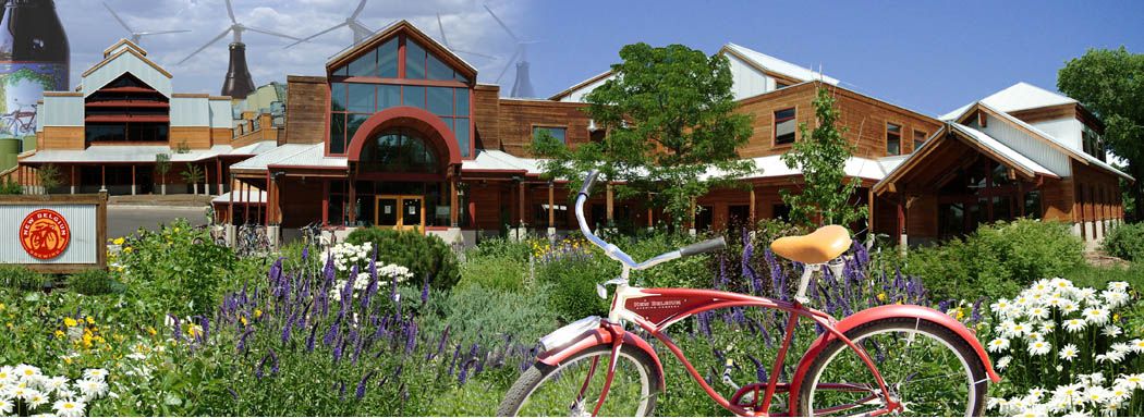
Northern Colorado breweries are gathering for Earth Day to discuss how breweries can help protect the local watershed.
Fourteen area breweries, including Odell Brewing Co. and Horse and Dragon Brewing Co., are gathering at 6 p.m. on Tuesday, April 18, at New Belgium Brewing Co. for the BreWater panel discussion.
“We’ve been gathering for the last couple of years to share water conservation practices and to learn about critical watershed issues from local experts,” Katie Wallace, assistant director of sustainability at New Belgium, said in a prepared statement. “This event will allow the greater community to hear about water issues that affect local brewers and to provide feedback on what matters to them.”
BreWater has already had success in helping fund the removal of the defunct Josh Ames Division Dam. Members have also toured the local watershed and hosted water experts.
“Brewers in Fort Collins are united on a lot of fronts,” said Carol Cochran, co-founder of Horse & Dragon Brewing Co., “but our common interest in great water is perhaps our strongest bond.”
The 14 breweries that are part of BreWater are 1933 Brewing, Black Bottle Brewery, CooperSmith’s Pub & Brewing, Equinox Brewing, Fort Collins Brewery & Tavern, Horse & Dragon Brewing Co., Intersect Brewing, Maxline Brewing, New Belgium Brewing, Odell Brewing Co., Pateros Creek Brewing Co., Snowbank Brewing, Soul Squared Brewing Co. and Zwei Brewing.
Guest who attend the panel will be able to get discounted beers and the chance to win local brewery gear.
The Northern Colorado Water Conservancy District Board of Directors on Thursday approved increasing the Colorado-Big Thompson Project water pipeline quota to 80 percent, according to a news release.
Fort Morgan receives its water from that [source], with water availability subject to the quota set periodically by the Northern Water Board. It had been adjusted to 50 percent last November.
Such quota changes do not affect city water rates, which are set by the Fort Morgan City Council. But it does affect the amount of water available to the city for use.
This new quota is one that means good news for Fort Morgan water customers, according to Nation…
Lots of data was taken into account by the Northern Water Board in setting this latest quota, according to the news release.
“The Board considered snowpack totals, stream flow runoff projections and input from farmers and municipal and industrial water providers in setting the quota,” the release stated. “C-BT supplements other sources of water for 33 cities and towns, 120 agricultural irrigation companies, various industries and other water users within Northern Water’s 1.6 million-acre service area.”
That includes Fort Morgan and Morgan County Quality Water District.
For Fort Morgan, the increased quota likely even means having more C-BT water available than will be needed by city residents and businesses, according to Nation.
“The higher quota also allows the city to lease out excess water above our projected needs for the year,” Nation said. “In most cases this water is leased by farmers to help complete their water supplies for the year.”
…the precipitation that fell in March within the water district’s collection area was 27 percent below what would be considered normal for that month, according to Northern Water.
Here’s a look at some of the work in progress at the National Renewable Energy Laboratory, National Oceanic and Atmospheric Administration and National Center for Atmospheric Research.
• Developing a system for predicting wildfires and wildfire behavior. This project at NCAR, funded by the National Science Foundation, is designed to help control the rapidly increasing costs after forest, grass and other wildfires. In 2016, more than 67,000 wildfires burned on 5.5 million acres around the nation. The U.S. Forest Service spends more than $2.5 billion a year trying to control wildfires. That amount increased 60 percent over the past decade.
• Measuring climate change. NOAA oversees collection of air data at a network of climate-observation stations. Scientists collect air samples and measure essential indicators of climate change, such as the concentrations of carbon dioxide in Earth’s atmosphere (more than 410 parts per million). Instruments used worldwide to measure air are calibrated using technology developed here.
• Forecasting weather. NOAA scientists develop the forecasting tools used by the National Weather Service, including a new system focused on severe storms.
• Space-weather studies. NOAA’s Space Weather Prediction Center monitors storms in space and issues warnings to aircraft pilots, military commanders and utility-grid operators about potentially damaging solar flares and eruptions.
• Solar, wind and advanced fuels. The super-thin solar panel technology developed at NREL has gone commercial. NREL researchers also have created better wind turbine blades used by companies such as General Electric. Other companies are looking at new fuels developed at the NREL facilities.
• New materials for industry. NREL researchers are developing materials including ammonia for fertilizer, ethylene for plastics and acrylonitrile for carbon fiber.
West Fork Fire June 20, 2013 photo the Pike Hot Shots Wildfire Today
FromThe Grand Junction Daily Sentinel editorial board:
We’re all familiar with the anticipated water supply gap that gave rise to Gov. John Hickenlooper’s executive order calling for the formulation of a state water plan.
That plan has been completed and the Colorado Water Conservation Board has sketched out an implementation measures with cost-effective ways to make the most of every drop.
The Legislature can do its part by passing a bipartisan bill that would embed urban water conservation into land-use decisions — something the staff at the Colorado River District has advised the Sentinel’s editorial board as a key to reducing pressure to divert Western Slope water to the thirsty Front Range.
HB1273 is sponsored by Reps. Chris Hansen, D-Denver, and Hugh McKean R-Loveland, and Sens. Don Coram, R-Montrose, and Matt Jones, D-Louisville.
The bill essentially requires that all new development be built “water-smart” from the start. It closes a loophole that allows new home developments to be less water-wise than they’re capable of.
This idea fits squarely within existing attitudes among Westerners about water conservation. A recent Conservation in the West Poll conducted by Colorado College as part of its State of the Rockies Project shows 77 percent of Colorado voters surveyed favor using water supply more wisely by encouraging conservation, reducing use and recycling. In contrast only 15 percent favor diverting water from rivers in less populated areas of the state to communities where more people live.
Colorado’s population is predicted to double by 2050, which means communities throughout the state will need more water than they currently have. As Western Resource Advocates points out, building new homes water-smart from the start is one of the easiest, cheapest, and most politically viable ways to reduce water needs — yet current law does not require new developments to even list the water-wise actions that are planned to reduce use.
The bill changes current law to require new developments to describe the water-conservation and demand-management actions that will be implemented, and makes a review of those actions an explicit part of the permit approval process. It prohibits local governments from approving permit applications unless applicants demonstrate that appropriate water conservation and demand management measures have been included in the water supply plan.
Common-sense strategies available to new home developers include low-water toilets and showerheads, efficient irrigation and xeriscaping. Local governments would decide which strategies for new development work best in their communities.
The bill would help fill the state’s water-supply gap, which will stifle economic development if not properly addressed. It will keep more water in Western Slope rivers for recreation and tourism.
Throughout the West, nine in 10 voters are willing to reduce the amount of water their households use. This bill helps meet that enlightened view.
The bill has passed the House and awaits a committee assignment in the Senate. We urge senators to support it and help the state continue to make strides toward eliminating the supply gap.
The tropical Pacific Ocean has been giving mixed signals recently, making a forecaster’s job even more difficult! In short, many of the computer models we use are predicting the development of El Niño over the next several months, but current conditions in the tropical Pacific aren’t showing many of the elements we’d expect ahead of a developing El Niño.
We’ve had neutral ENSO conditions since January, and forecasters predict that continued neutral is the most likely scenario through at least June. By September, chances of El Niño rise to about 50%, a slight edge over neutral (~40% chance) or La Niña (~10% chance).
What are forecasters seeing now?
We rely on prediction models because they provide the most likely evolution of the ENSO system better than we can compute on our own by eyeballing maps and charts and analyzing what has happened in the past under similar conditions.
Right now, many climate forecast models do predict the development of a full-fledged El Niño during this summer or fall. It’s likely that these models are acting on the much warmer-than-average waters near the coast of South America—the “Coastal El Niño” that I’ll get to a little bit later in this post. Predictions for the Niño3.4 region in the east-central Pacific, shown in the figure below, show chances for El Niño ramping up over the next year.
Climate model forecasts for the Niño3.4 Index, from the IRI/CPC Prediction Plume. Orange lines indicate the dynamical models and blue lines show the statistical models, with thicker lines depicting the average of the models. Niño3.4 values in excess of +0.5C are reflective of El Niño conditions. Image modified by NOAA Climate.gov.
While nearly all of the available dynamical models are predicting an El Niño, only about half of the statistical models are, and those that do are predicting a weaker event than the average of the dynamical models. Statistical models are based on previous events, and right now the tropical Pacific does not look much like it has before past El Niños.
As we have discussed in the past on this blog, El Niño sets in when the ocean and the atmosphere show coupled behavior—that is, when a stronger link develops between the warming waters in the central and eastern tropical Pacific, and the slowing down of the Walker circulation, in which the westward-blowing trade winds near the surface weaken and the eastward-blowing upper level winds also weaken.
Right now, the tropical Pacific Ocean is split. There is warmth in the eastern Pacific Ocean (the Coastal El Niño—I’ll get to that, I promise). But the western and central Pacific Ocean actually look more reflective of cool, La Niña-like conditions! This is indicated by drier conditions near the Date Line and wetter conditions over Indonesia.
Places that were more (purple) or less (orange) cloudy than the 1981-2010 average during March 2017, based on satellite observations of outgoing longwave radiation (heat). Thick clouds block heat from radiating out to space, so less radiation equals more clouds, and more radiation equals clearer skies. Climate.gov map from CPC OLR data.
Also, surface winds over the west-central Pacific have been blowing stronger than average (a stronger Walker circulation, more like La Niña). Meanwhile, the surface temperatures in the central Pacific are cooler than average, also more like La Niña than El Niño. Even the sub-surface ocean temperatures are below average in the central Pacific over the past month. As Aaron pointed out, in advance of an El Niño, we would want to see heat content that is above average.
Sea surface temperature in March 2017 compared to the 1981-2010 average. Cooler-than-average SSTs are present in the central equatorial Pacific and warmer-than-average SSTs are present over the eastern equatorial Pacific. NOAA Climate.gov map, based on GEO-Polar data.
Finally! The coastal El Niño!
During the last two months, strong warming developed in the eastern tropical Pacific Ocean, hugging the western coast of South America. Emily noted back in early February that the Peruvians designated this abnormal warmth as a “coastal El Niño” and it has resulted in unusually heavy rainfall along the coast of Ecuador and northern Peru, rivaling the major El Niño events in 1997-98 and 1982-83.
This local event is different from the El Niño-Southern Oscillation (ENSO) we’ve come to know and love, which spans the width of the Pacific Ocean basin. Coastal events tend to arise during the February-April period because sea surface temperatures are typically near the warmest of the year. Heavy rainfall starts when surface temperatures exceed roughly 28˚C (82°F). Ken Takahashi (Instituto Geofisico del Peru) provided the data below showing this coastal event over the past month.
Average of sea surface temperatures (SST) in the eastern Pacific during March from 1981-2010 (left panel), for March 2017 (middle panel), and for the difference between the left and middle panels, showing the SST anomaly, or departure from average, during March 2017 (right panel). Climate.gov map from IGP using UKMet OSTIA data.
Does a coastal El Niño often turn into ENSO events?
Interestingly, it was Peruvian fishermen who first gave “El Niño” its name in the late 1800s, when they noted unusual oceanic warmth near their coast. Later researchers, most notably Jacob Bjerknes in 1969, realized that the El Niño—the cycle in ocean temperatures—was often connected to the atmosphere above it, the “Southern Oscillation.” The latter is more far-flung, and reflects the change in the tropical Pacific circulation (winds, convection) that overlies changes in the ocean. The basin-wide El Niño-Southern Oscillation (ENSO) phenomenon was corroborated in the early 1980s, when detailed information became available with the advent of satellites and advanced monitoring systems like the Tropical Atmosphere Ocean (TAO) buoy array.
Although basin-wide El Niño events were once thought to originate as coastal El Niño events (footnote 1), we’ve since learned that this is not always the case. Coastal warming sometimes precedes strong coupling between the ocean and atmosphere (ENSO events) that span the entire tropical Pacific Ocean, but not always.
In this war of East versus West, which will eventually win out?
Most of the dynamical models favor the eastern pattern “winning” with an expansion of the coastal El Niño into a full-blown El Niño event. Mind you, only once since 1950 have we seen a sequence of El Niño, La Niña, El Niño during three consecutive years—in 1963-66.
While many models have been quite persistent over the last few months in their predictions for El Niño, they carry fairly wide uncertainty envelopes that translate into tempered probabilities for El Niño. Plus, we are still in a period of less skillful forecasts associated with the spring ENSO predictability barrier. Given this low model skill in the past at this time of year, and the conflict between the warm eastern Pacific and the relatively cool western Pacific, forecasters find that the odds of development of El Niño in the next six months, while elevated, are not quite at the threshold for an El Niño Watch.
Click here to go to the US Drought Monitor website. Here’s an excerpt:
Summary
Moderate to heavy precipitation (generally 0.5-3.0 inches, locally greater) was widespread across the contiguous U.S. (CONUS) during the past 7-days, with the notable exception of the Southwest and the southern High Plains region. There were also numerous reports of severe weather over the central and eastern CONUS, and strong winds over portions of the Pacific Northwest and northern Rockies on April 7th…
The northern and central Plains
The dryness/drought area over the northern Plains was re-configured this week, after a regional reassessment of conditions. The moderate drought (D1) area was shifted a bit to the west into northeastern Wyoming. This re-configuration reflects the recent precipitation that has been beneficial at the start of the growing season, and is focused primarily on the past 30-60 days. In addition, D0 was expanded in southwestern North Dakota to include the counties of Hettinger, Grant, Adams, and western Sioux. In southwestern Kansas, where generous rains (4-7 inches) fell during the past 30-days, a one-category improvement was made to the depiction. In contrast, where 1.5-3.5 inches fell during the same period, a one-category degradation was rendered to the depiction in northwestern and north-central Kansas. Several small-scale improvements were also made in eastern Colorado this week, including the removal of severe drought (D2) in north-central portions of the state, and much of the nearby D1 area…
The southern Plains
A one-category improvement was made in the Oklahoma Panhandle this week, which resulted in the elimination of lingering severe drought (D2). ACIS PNPs out through at least the past 90-days are easily in excess of 100-percent of normal, and often 200-percent or higher. This past week, 4-inches or more of rain merited a one-category improvement for the extreme southeastern Oklahoma counties of McCurtain and eastern Choctaw. In the eastern portion of the state, D2 (S) was expanded, and connected with the D2 area in neighboring Arkansas. In Texas, minor revisions were rendered to the depiction, until the final precipitation numbers came in for rainfall received between 12z Monday and 12z Tuesday (the final 24 hours of the data inclusion period for the week). This rainfall (in some cases up to 8-inches) resulted in substantial one-category improvements across the northeastern part of the Lone Star state…
The West
No changes were made to the drought depiction this week across the West. Recent stats for California (taken from the California-Nevada Drought Monitor Discussion Call) show an incredible year for precipitation and runoff. In the Sacramento area, the precipitation percentages since October 1, 2016 range from 120-percent to 300-percent or more of normal. The Northern Sierra 8-station index is at 205-percent of normal, only 0.8-inch away from the 1982-83 El Nino record, and the Central Sierra 6-station index is at 195-percent of normal. Snowpack is equally impressive at 157-percent and 180-percent of normal for this date in the Northern and Central Sierra, respectively. The Sierra reservoirs have made an amazing recovery this winter, with all the reservoirs at or just above their Top of Conservation levels…
Looking Ahead
During the next five days (April 13-17), the Weather Prediction Center (WPC) predicts 1.0-2.5 inches of precipitation from the southern High Plains northeastward across the mid-upper Mississippi Valley and into the western Great Lakes region. Heavy precipitation (3-4 inches, liquid equivalent) is expected across the Coastal Ranges of the Pacific Northwest and northwestern California, the Cascades of the Pacific Northwest, and the California Sierras. However, these areas are no longer in drought or dryness.
For the ensuing five-day period (April 18-22), there are elevated odds for above-median precipitation across most of the northern and central thirds of the CONUS, while near- to below-median precipitation is favored across the southern tier of states. Below-median precipitation is also favored for all of Alaska.
Northern Water’s Board increased the Colorado-Big Thompson Project quota allocation to 80 percent at its April 13 Board meeting. With many farmers concerned about the lack of recent moisture and the hope that cities may be willing to provide some rental water to help the region’s agricultural economy, the Board chose to make available an additional 30 percent as supplemental quota for 2017.
The approval increased available C-BT water supplies by 93,000 acre-feet, from the initial 50 percent quota made available last November.
The Board considered snowpack totals, streamflow runoff projections and input from farmers and municipal and industrial water providers in setting the quota. C-BT supplements other sources of water for 33 cities and towns, 120 agricultural irrigation companies, various industries and other water users within Northern Water’s 1.6 million-acre service area.
Directors considered the general dearth of moisture in March as they discussed the quota options. March precipitation was 27 percent below normal and contributed to the Board’s decision to raise the quota.
“It’s dry, it really is,” said Board President Mike Applegate. “The C-BT Project was created to provide a supplemental supply and we have the reserves to do that.”
He echoed the Board’s consensus in making its 61st annual C-BT quota. “Let’s make the water available now so our allottees can make their plans.”
Directors base their decision on the region’s need for supplemental water, while balancing project operations and maintaining water in storage for future dry years.
Lake Granby spill June 2011 via USBR. Granby Dam was retrofitted with a hydroelectric component and began producing electricity [in 2011] as water is released in the Colorado River.
Steve Austin has been measuring the precipitation levels in his backyard every morning since 2005 at his home in Northglenn. Outside of a few weekend trips, he hasn’t missed a day.
“I’ve been doing it so long, it’s just part of what I do,” he said. “Get up, get washed, shaved and measure the rain.”
He doesn’t keep that data for his own amusement but sends it off to the Community Collaborative Rain, Hail and Snow Network, or CoCoRaHS, an international group of volunteers that use their rain gauges to help the National Weather Service and other environmental organizations.
“Moisture is so important,” the retired engineer said. “If you only get one-tenth of an inch, CoCoRaHS wants to know.”
[…]
“Rainfall is so variable,” Education Coordinator Noah Newman said. “A rainstorm could go right in between the official stations of the National Weather Service and they might not know how much rain fell.”
And that’s happened before.
“It all started from the Fort Collins flood in 1997,” Newman said. The weather service’s station was out by I-25 and hadn’t picked up on the dangerous incoming storm. As a result, the community never received a warning to evacuate and five people died.
Colorado State Climatologist Nolan Doesken realized that starting a community network of rain gauges could save some lives and the network was formed, according to Newman.
What began with a handful of people in Colorado now comprises 20,000 volunteers across the United States, Puerto Rico, Canada, the Virgin Islands and the Bahamas.
The nonprofit asks that observers report data every morning, but it’s not required. The only equipment necessary is a $35 rain gauge.
Recording the precipitation measurement is simple. There is a funnel to direct rainwater into a plastic pipe, called the measuring tube, that tells how much rain fell in the past 24 hours.
Measuring snow requires a few additional steps, like weighing the snow from your rain gauge to determine the precipitation amount and reporting the inches of snow in your backyard. Volunteers say it takes between 5 and 15 minutes a day.
The Urban Drainage and Flood Control District (UDFCD) uses this data regularly. They have an alert system of 200 automatic rain gauges across the Denver and Boulder areas to measure and identify when heavy rainstorms are happening and alert the public of appropriate safety measures. But the volunteer data makes this system more robust.
Like many small towns across Colorado, Peetz has been told by the Colorado Department of Public Health and Environment that their sewage lagoons are leaking contaminants into the groundwater and must be replaced or remediated. The decision is based on a calculation of how much wastewater flows into the lagoons, how much evaporation takes place on a monthly basis, and how much water is left in the lagoons. It’s clear from that calculation that more water is flowing in than is evaporating, so the water can only be leaking out the bottom.
The trustees don’t argue that their sewage lagoons are seeping water into the ground underneath them, but they want proof that it’s actually doing harm. They reason that, being more than 150 feet above groundwater, the seepage is cleaned adequately in the earth, sand, and gravel that it percolates through.
It’s not just a stubborn streak in small town folk that’s driving their argument. Although Peetz doesn’t yet have any real numbers on the cost of new lagoons, they know that Fleming has priced theirs at more than $2.5 million. With diminishing assistance from state and federal agencies to pay for that kind of project, Fleming officials already know they’ll have to at least double sewer rates for a population that is largely on fixed income.
Environmental and civil rights groups filed a lawsuit against the Colorado Oil and Gas Conservation Commission Tuesday, alleging that the regulatory agency violated its responsibility to protect public health and the environment when it approved a 24-well fracking site near Bella Romero Middle School in Greeley.
The plaintiffs, which include the Sierra Club, Weld Air and Water, the NAACP Colorado State Conference and Wall of Women, also say that the COGCC failed to adequately assess whether the site in question was as far as possible from the school and from nearby homes.
Denver-based driller Extraction Oil and Gas is preparing to drill 24 new oil and gas wells in Greeley, located about 1,350 feet from the walls of Bella Romero. The project complies with state law requiring that drilling operations be at least 1,000 feet from schools. But critics say the COGCC did not sufficiently evaluate alternative locations for the development.
“The State of Colorado is failing to protect our children,” said resident and environmentalist Therese Gilbert. “We are subjecting children to conditions that are dangerous at their point in physical development, and then expecting them to actively play in those conditions.”
In an emailed statement, an Extraction spokesman wrote that the company “engaged in both an inclusive and very comprehensive process to obtain permits” for the site, and “that process was completed in compliance with all COGCC regulatory guidelines.” The location, he added, “was part of a series of alternative locations that were identified by Extraction to replace several older-vintage permitted locations, including the Gilbert, Sheep Draw and South Greeley sites.”
State Rep. Mike Foote of Denver proposed a bill that would have required oil and gas setbacks to be 1,000 feet from school property boundaries, not just school buildings. The Senate Committee on Agriculture, Natural Resources, & Energy postponed that bill indefinitely Wednesday afternoon.
Some critics are concerned that Extraction’s proposed project represents a threat to environmental justice, as it will significantly impact a low-income community of color. Bella Romero’s student body is 82 percent Hispanic or Latino.
“Communities of color are already disproportionately burdened by pollution and this is another example,” said Rosemary Lytle, State President of the NAACP Colorado State Conference. “No group of people should bear more than their share of impacts from industrial activities, yet it seems the COGCC does not even consider this.”
Todd Hartman, spokesman for the COGCC, says the agency is currently reviewing the lawsuit and does not yet have a comment.