Click on a thumbnail graphic to view a gallery of snowpack data from your favorite basins.

Colorado statewide basin-filled snowpack map December 31, 2018 via the NRCS.

Statewide Basin High/Low graph December 31, 2018 via the NRCS.

Upper Rio Grand River Basin High/Low graph December 31, 2018 via the NRCS.

South Platte River Basin High/Low graph December 31, 2018 via the NRCS.

San Miguel, Dolores, Animas, and San Juan Basin High/Low graph December 31, 2018 via the NRCS.

Laramie and North Platte Basin High/Low graph December 31, 2018 via the NRCS.

Yampa and White Basin High/Low graph December 31, 2018 via the NRCS.

Upper Colorado River Basin High/Low graph December 31, 2018 via the NRCS.

Gunnison River Basin High/Low graph December 31, 2018 via the NRCS.

Arkansas River Basin High/Low graph December 31, 2018 via the NRCS.
All the graphs are heading in the right direction. The SW basins have a long way to go. Maybe El Niño will save the day.
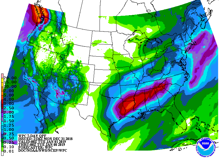
Here’s the 7-day quantitative precipitation forecast from NOAA. Looking good in central Arizona and the Colorado San Juan Mountains. Don’t go near Mississippi unless you’re in a boat.