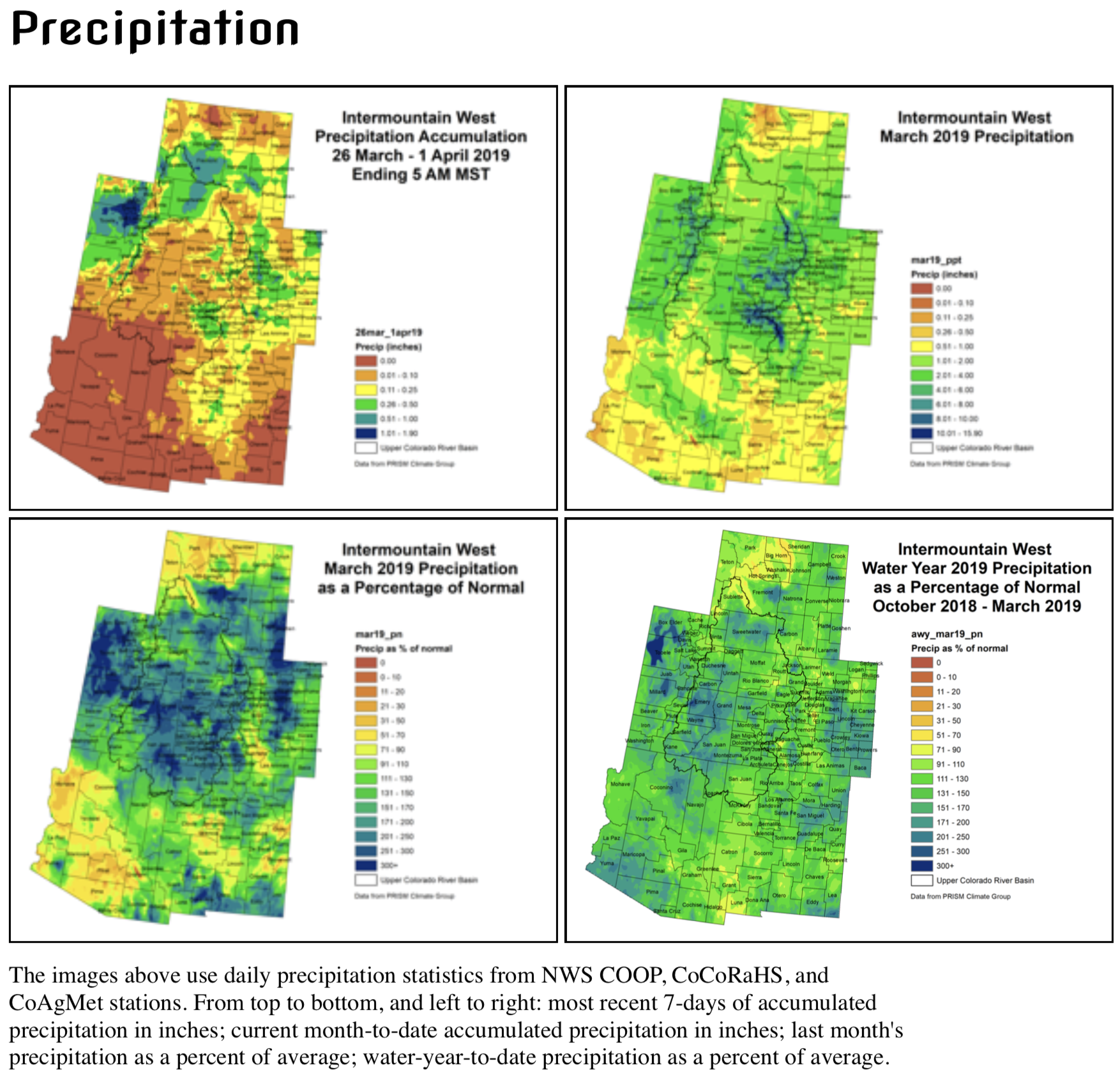
In the first three months of 2019, there were two weather and climate disaster events with losses exceeding $1 billion each across the U.S. These events included a severe storm event across the Southeast, Ohio Valley and Northeast, and one flooding event in the central U.S., which is still ongoing.
During March, the average contiguous U.S. temperature was 40.68°F, 0.82°F below the 20th-century average. This ranked in the middle third of the 125-year period of record. The year-to-date (January–March) average contiguous U.S. temperature was 35.03°F, 0.12°F below average, ranking among the middle third of the record. This was the coldest start to a year since 2014. The March precipitation total for the contiguous U.S. was 2.20 inches, 0.31 inch below average, and ranked in the driest third of the 125-year period of record. The year-to-date precipitation total was 8.03 inches, 1.07 inch above average, tying with 1949 as the 12th wettest January–March period on record.
This monthly summary from NOAA National Centers for Environmental Information is part of the suite of climate services NOAA provides to government, business, academia and the public to support informed decision-making.
March Temperature
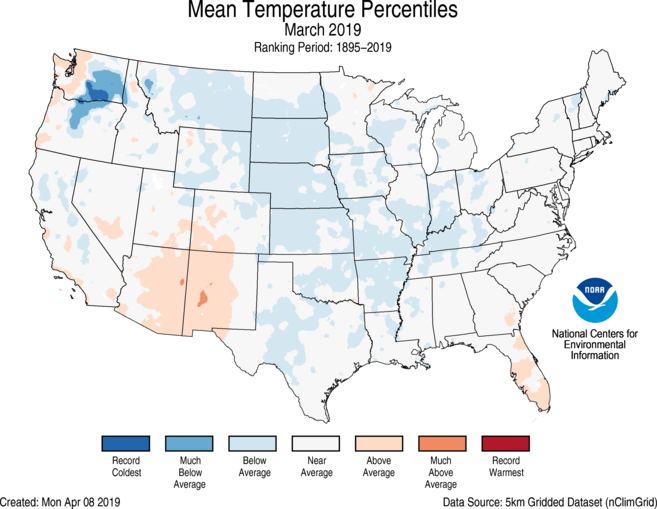
Below-average temperatures were observed in the Northwest, the Great Plains and across portions of the Mississippi and Ohio River valleys. A small pocket of record-cold temperatures was evident across a portion of Washington state.
Arizona and New Mexico had above-average temperatures during March, while most of the contiguous U.S. experienced near-average temperatures for the month.
The Alaska March temperature was 26.7°F, 15.9°F above the long-term average. This was the warmest March in the 95-year period of record for the state and exceeded the previous warmest March in 1965 by more than 3°F. All long-term climate stations north of the Alaska Range and Bristol Bay had their warmest March on record. Kotzebue’s average March temperature was warm enough to be among its 10 warmest Aprils on record.
March Precipitation
During mid-March, a “bomb cyclone” developed across the central U.S. bringing snow, blizzard conditions, heavy rainfall and above-freezing temperatures across parts of the interior U.S., which already had significant snowpack on the ground. This resulted in widespread flash flooding due to the combination of new rainfall, rapidly melting snow and frozen ground. A State of Emergency was declared for parts of Nebraska, Iowa, South Dakota and Wisconsin as the Missouri, Platte and Mississippi rivers breached their banks.
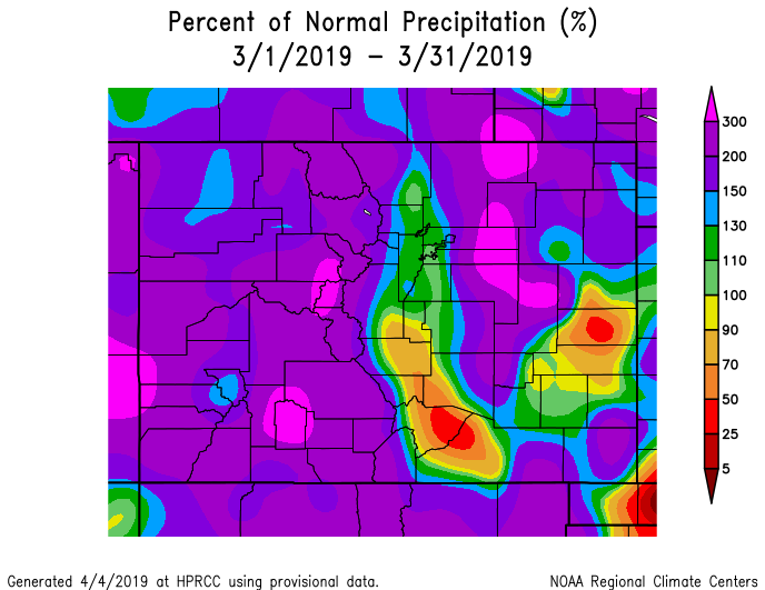
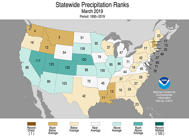
Above-average precipitation was observed across parts of the West, central Rockies and into the central Plains and middle Mississippi Valley. This precipitation exacerbated the flooding that occurred during the latter half of March in the central U.S. Flooding along these major rivers and tributaries is anticipated to continue well into April.
Below-average precipitation was observed across the Northwest, South, Southeast and East Coast. Washington and Montana had one of their 10 driest Marchs on record.
According to the April 2 U.S. Drought Monitor report, 6 percent of the contiguous U.S. was in drought, down from 12 percent at the end of February and is one of the smallest contiguous U.S. drought footprints on record. Drought conditions continued to improve across much of the West and intensified across parts of Washington, Texas and the Southeast.
January–March (Year-to-Date) Temperature
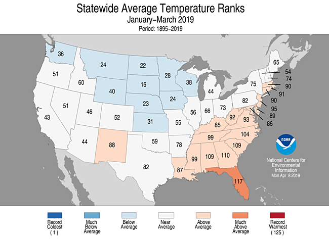
Above-average temperatures were primarily observed across the Southeast and Atlantic Coast. Florida had an average January–March temperature that ranked among its 10 warmest on record. Near-average conditions stretched from the southern Plains to the Northeast and across much of the West. Below-average temperatures were present across the northern and central Plains and parts of the West.
The Alaska January–March temperature was 16.6°F, 10.7°F above the long-term average, the third warmest on record for the state. Record temperatures were observed across most of the state with much-above-average temperatures occurring across the Aleutians and the panhandle.
January–March (Year-to-Date) Precipitation
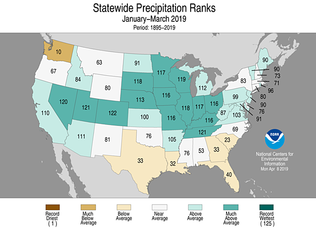
Below-average precipitation was observed across the South and parts of the Southeast. Washington ranked 10th driest for the year-to-date period. Above-average precipitation stretched from coast-to-coast with many states having one of their 10 wettest January–March periods on record; Colorado was fourth wettest, Tennessee and Utah were fifth wettest and Nevada sixth wettest.Below-average precipitation was observed across the South and parts of the Southeast. Washington ranked 10th driest for the year-to-date period. Above-average precipitation stretched from coast-to-coast with many states having one of their 10 wettest January–March periods on record; Colorado was fourth wettest, Tennessee and Utah were fifth wettest and Nevada sixth wettest.
Billion Dollar Weather and Climate Disasters
In February 2019, widespread damage resulted from severe weather and flooding in the South (MS, AL, TN) and high winds across Ohio Valley (IL, IN, OH) and Northeastern states (CT, MD, MA, NJ, NY, PA, VA, WV).
Historic Midwest flooding, which began in March and is currently ongoing, inundated millions of acres of agriculture, numerous cities and towns and caused widespread damage to roads, bridges, levees and dams. The states most affected include Nebraska, Iowa, Missouri, South Dakota, Minnesota and Wisconsin.
In April 2019, NCEI added three historical weather and climate events. The U.S. has now sustained 246 weather and climate disasters since 1980 where overall damages/costs reached or exceeded $1 billion (based on Consumer Price Index adjustment to 2019). The total cost of these 246 events exceeds $1.6 trillion.
Colorado School of Mines celebrated today the grand opening of a new 10,000-square-foot research facility in Denver that will pave the way for greater collaboration with industry, government and academia to tackle one of the biggest challenges facing society today – access to clean water.
The WE2ST (Water-Energy Education, Science and Technology) Water Technology Hub will accommodate large-scale research focused on developing innovative treatment technologies for produced water from oil, gas and mineral production, groundwater contaminated with emerging contaminants (including toxic poly- and perfluoroalkyl substances), saline and hypersaline streams, municipal water, wastewater and more — leading to sustainable water reuse.
“Colorado School of Mines was founded almost 150 years ago to help industry grow and thrive and since those early years, solving water and wastewater treatment challenges have been a key part of its research mission,” said Stefanie Tompkins, vice president of research and technology transfer. “As we approach our next 150 years, we want to continue to be a go-to place for the use-inspired research and innovation needed for society’s big challenges. This new facility is an important step in that direction, allowing our amazing researchers – in partnership with other research institutions, industry and government – to bridge the gap between lab-scale and commercial-scale water treatment technologies.”
Located off Interstate 70 and Quebec Street in Denver, the WE2ST Hub includes full analytical and wet labs for water analysis, a fabrication facility and a flexible research bay, with capacity for 30,000 gallons of water and rail line access for bringing in those water samples from anywhere in the U.S.
The industrial facility was previously operated by NGL Energy Partners, a midstream oil and gas company, which donated the entirety of the facility’s equipment to Mines, a gift valued at approximately $800,000.
“For over a decade, NGL Energy Partners has been treating oilfield waste water, creating clean water for use in irrigation, municipal and industrial applications, and, in addition, returning substantial amounts of clean water to the surface for beneficial use,” CEO H. Michael Krimbill said. “We are proud to be a part of this project and look forward to an ongoing collaboration with Colorado School of Mines through serving as a partner to assist in efforts to pilot and commercialize innovations that flow from the WE2ST Water Technology Hub.”
A gift of $1.5 million from the Colorado-based ZOMA Foundation will seed the facility’s operations and support several undergraduate and graduate research fellowships.
“ZOMA is excited to support the WE2ST Water Technology Hub and hopes the facility can help accelerate innovations that improve access to clean water and further sustainable water reuse,” said Luis Duarte, chief philanthropic officer of ZOMALAB.
The hub’s inaugural projects include a U.S. Department of Energy-funded collaboration with UCLA on solar desalination and a smaller project in collaboration with the National Renewable Energy Laboratory on hydrokinetic – or ocean wave – energy desalination. The hub is also one of the core research facilities of NAWI, the National Alliance for Water Innovation. Dr. James Rosenblum, a former postdoctoral fellow at CU Boulder and staff scientist at Jacobs Engineering, will oversee daily operations of the facility.
“We want to thank NGL Energy Partners and the ZOMA Foundation for their help in making possible a facility of this size dedicated to developing innovative technologies for the treatment and reuse of municipal and industrial wastewater,” said Tzahi Cath, director of the WE2ST Water Technology Hub and professor of civil and environmental engineering at Mines.
“To better partner with industry and municipalities and help them solve the real-world water treatment challenges they face, we needed more space than is typically available on a college campus,” Rosenblum said. “We’re excited to get to work at a much larger scale than ever before.”
Here’s the release from Representative Raúl M. Grijalva’s office (Adam Sarvana):
Chair Raúl M. Grijalva (D-Ariz.) today hailed House passage of the Colorado River Drought Contingency Plan Authorization Act, which he introduced April 2. Thanks to Grijalva’s leadership, the House approved the bill – formally designated H.R. 2030 – by a voice vote, expediting passage and avoiding procedural hurdles to get the bill closer to President Trump’s desk as fast as possible.
During a related debate in the Senate this afternoon, it was agreed that as soon as Grijalva’s bill is transmitted to the Senate, it will be considered approved and will be sent directly to the White House.
Grijalva’s widely endorsed bill, which received unanimous praise from Colorado River basin states, tribes and other stakeholders, implements the Drought Contingency Plan, a water-sharing agreement between Arizona, Colorado, Wyoming, Utah, California, New Mexico and Nevada that accounts for ongoing water shortages and regional climate change throughout the Southwest.
The Arizona Republic praised Grijalva’s leadership in advancing the bill last week, noting his intention to have the Natural Resources Committee serve as a public resource for data and research as the agreement is implemented and underscoring his commitment to widening the policy conversation beyond state-level representatives as the agreement is put in place.
The agreement establishes new water conservation measures to protect reservoir levels at Lake Mead and Lake Powell, using voluntary water reductions and innovative management strategies to avoid historic lows in Colorado River reservoirs, which would trigger dramatic water delivery cuts to the seven states.
In addition to each state, Grijalva’s bill enjoyed support from tribes throughout the region and from an alliance of conservation groups, who wrote a joint April 1 letter urging congressional approval. More information about the extraordinary network of support for Grijalva’s bill is available athttp://bit.ly/2G9bT2U.
A bill that would authorize the federal government to enact a drought plan for Colorado River basin states in times of shortage has passed Congress and is on its way to the White House for the president’s signature…
When enacted, the plan will spread the effects of expected cutbacks on the river and protect the levels of Lake Mead and Lake Powell, the river’s two largest reservoirs. Its aim is to protect water users from deep losses and keep the reservoirs and river healthy.
“The Colorado River is dissipating,” Grijalva told The Arizona Republic.
“There’s more demand from people and industries that depend on it. So how do we do that for the long-term? That’s the task ahead,” he said…
The drought plan is a short-term fix to stave off the most immediate effects of a 19-year drought that continues to threaten parts of the Southwest. Once the bill is signed by [the President], representatives of the seven river states are expected to meet again to finalize the deal.
Members of the Western Caucus released statements applauding the bipartisan passage of H.R. 2030, the Colorado River Drought Contingency Plan Authorization Act:
Chairman Paul Gosar (AZ-04): “I applaud Reclamation Commissioner Brenda Burman and Arizona Department of Water Resources Director Tom Buschatzke for all their hard work and leadership in bringing the Drought Contingency Plan together. The DCP reduces the threats associated with Lake Mead and Lake Powell falling to dangerously low levels. In my home state of Arizona, significant harm would ensue for farmers, tribes, cities and people if the water in Lake Mead dips below the 1020 feet threshold. In recent years, we have come dangerously close to that level as drought conditions and increased water use has threatened nearly 40 percent of the State’s annual water demand that comes from Colorado River water supplies. I am very grateful to the CRIT, the GRIC, the Central Arizona Project, the Salt River Project, irrigation districts, industrial water users, as well as other water users in Arizona and the West for uniting together and making significant voluntary contributions in order to allow these historic agreements to move forward. While the DCP may not be perfect in everyone’s eyes, it significantly reduces the threat of severe water shortages for Arizona and Western communities.”
House Natural Resources Committee Republican Leader Rob Bishop (UT-01): “With the states’ work and today’s vote, we have passed a solution that saves a river that serves forty million people, irrigates vast amounts of farmland, and encourages clean, emissions-free hydropower. I thank the Colorado Basin States for their leadership in negotiating and finalizing this plan, and Chairman Grijalva and colleagues in the House for moving quickly on this legislation. It is our hope the Senate will act quickly and send this bill to the president’s desk.”
Executive Vice-Chairman Scott Tipton (CO-03): “I am glad to see an effective strategy produced after years of collaboration between the seven states involved and the federal government. As the location of the headwaters for the river that supplies water to roughly 40 million people, Colorado plays an especially crucial role in the management of our most precious resource. This past winter brought much needed snowpack to the region, but there is no certainty this trend will continue in the coming years and it is important to have a contingency plan in place. Ensuring the Colorado River can meet the demands of all water users who rely on it is a shared responsibility among all Upper and Lower Basin states. The Drought Contingency Plan agreed to by the basin states will help ensure continued hydropower operations and compact compliance, and now each state must work to develop a plan for meeting the obligations of the DCP.”
Chief Budget Officer David Schweikert (AZ-06): “I am pleased to see this Colorado River Drought Contingency Plan Authorization Act passed through the House so we can better support our farmers, tribes, and all water users across Arizona. Even in a year of high rainfall, it is important that users of the Colorado River be responsible with water management, as Arizona has always been. The desert southwest, with our unique geography, is no stranger to drought and severe water conditions. The DCP is a great example of states working together to address extreme water challenges, without the federal government imposing a one size fits all solution.”
Chief Regulatory Reform Officer Andy Biggs (AZ-05): “Sustainability of the Colorado River is critical to maintain Arizona’s rapid growth and its strong agricultural economy. Arizona is in its 21st year of a long-term drought and has been able to sustain itself through this drought through implementation of successful conservation programs and robust collaboration between tribal, community, industry, and government leaders. The Colorado River Drought Contingency Plan will provide certainty to Arizonans – and to residents from the Colorado River Basin states – as to what their water security will look like for future generations. I thank all the stakeholders from Arizona for their leadership in this states-driven effort.”
Rep. Ken Calvert (CA-42): “The Colorado River is a critical source of water for approximately 19 million people in the southern California region. After 19 years of drought on the Colorado, Lake Mead is near critical levels. Thanks to the tremendous leadership of the seven Colorado River basin states and water users throughout the basin, the worst impacts of drought will be avoided. I applaud the work of Chairman Grijalva and Ranking Member Bishop to shepherd this legislation through the House, and I urge my Senate colleagues to take up this legislation swiftly to protect water supply reliability to southern California.”
Rep. Debbie Lesko (AZ-08): “The Drought Contingency Plan (DCP) is vital to the economic stability and overall future of Arizona. It took a lot of hard work to get this plan to Congress, and I am pleased to see it pass the House of Representatives with such broad bipartisan support. I am proud to support this bipartisan agreement and call on my Senate colleagues to quickly pass this bill so it can be signed into law. Arizonans are depending on it.”
Background:
The Colorado River Drought Contingency Plan (DCP) is a set of voluntary agreements among the 7 basin states (AZ, CA, NV, CO, NM, WY, UT), the U.S. and Mexico to use less Colorado River water. H.R. 2030 authorizes the Secretary of the Interior to execute and carryout multiple agreements in relation to the Colorado River Drought Contingency Plan.
H.R. 2030 Cosponsors include Representatives: Mark Amodei (NV-02), Andy Biggs (AZ-05), Rob Bishop (UT-01), Ken Buck (CO-04), Ken Calvert (CA-42), Liz Cheney (WY-At Large), John Curtis (UT-03), Diana DeGette (CO-01), Ruben Gallego (AZ-07), Paul Gosar (AZ-04), Debra Haaland (NM-01), Steve Horsford (NV-04), Jared Huffman (CA-02), Ann Kirkpatrick (AZ-02), Doug Lamborn (CO-05), Susie Lee (NV-03), Debbie Lesko (AZ-08), Mike Levin (CA-49), Alan Lowenthal (CA-47), Ben Ray Lujan (NM-03), Ben McAdams (UT-04), Grace Napolitano (CA-32), Tom O’Halleran (AZ-01), Ed Perlmutter (CO-07), Lucille Roybal-Allard (CA-40), Adam Schiff (CA-28), David Schweikert (AZ-06), Greg Stanton (AZ-09), Chris Stewart (UT-02), Scott Tipton (CO-03) Dina Titus (NV-01), Xochitl Torres Small (NM-02).
The DCP will reduce states’ water usage and target minimum water levels for reservoirs in the watershed including Lake Mead on the Arizona-Nevada border and Lake Powell on the Utah-Arizona border. Passage of H.R 2030 provides certainty and assists with ensuring a reliable supply of clean water for farmers, cities, tribes, other water users and future generations in the 7 basin states.
View the different plans codified by the DCP and a letter form the seven States of the Colorado River Basin requesting passage of federal legislation here.
Courtesy of House Committee on Natural Resources Republicans
Over the last century, water demand in the Colorado River Basin has increased while water supply has, on average, decreased. The average annual natural flows in the river are about 14.8 Million Acre-feet (maf). This is a decrease from the early 20th century flows of 18 maf, when many of these apportionments were enacted. The current natural flows no longer keeps up with the demands on the River.
The Colorado River Basin’s success is in large part due to the Basin’s water storage projects. These projects have capacity to store almost 60 maf or about four times the Colorado River’s annual flows. The Basin’s two largest dams are Glen Canyon Dam (Lake Powell) with a 26.2 maf storage capacity and Hoover Dam (Lake Mead) with 26.1 maf. These storage projects provide a reliable source of water for the Colorado River Basin.
Since 2000, the Colorado River Basin has experienced historic drought conditions. The Bureau of Reclamation has taken several actions, including the development of the 2007 Colorado River Interim Guidelines, to provide additional operational guiding principle and tools to meet the challenges of the drought.10 In December 2017, due to the continued drought, Reclamation Commissioner Brenda Burman called on the Basin States to put DCPs in place. Talks on the DCPs had been underway since 2015, but had not made significant progress until then.
The agreements include an Upper Colorado River Basin DCP and a Lower Colorado River Basin DCP. The Upper Basin DCP protects elevations at Glen Canyon Dam by keeping them above 3,525 feet, which is 35 ft above the minimum elevation needed to run the dam’s hydroelectric plan. In addition, it will help assure continued compliance with the 1922 Colorado River Compact and authorize storage of conserved water in the Upper Basin that could help establish the foundation for a Demand Management Program that may be developed in the future.
Courtesy of Bureau of Reclamation Commissioner Brenda Burman
The Colorado River irrigates nearly 5.5 million acres of farmland and serves approximately 40 million people in major metropolitan areas across nine states in the United States and Mexico including Denver, Salt Lake City, Las Vegas, Phoenix, Tucson, Los Angeles, San Diego, Mexicali and Tijuana, and a number of tribal reservations.
The Colorado River Basin (Basin) is currently experiencing its worst drought in recorded history. The period from 2000 through 2018 is the driest 19-year period in over 100 years and one of the driest periods in the 1,200-year paleo-record.
Over a decade ago, responding to five years of intense drought, the Department of the Interior (Interior) worked with the Basin States, tribes and other stakeholders in the Basin to adopt operating rules for Glen Canyon and Hoover Dams. These operating rules are known as the 2007 Interim Guidelines and were adopted to better coordinate the operations of Lakes Powell and Lake Mead, encourage water conservation, and to provide objective rules for shortages and reductions of water use in the Lower Basin by Arizona and Nevada.
Since 2007, the drought has persisted and more action, such as combining provisions requiring reduced use of water with new incentives to conserve water, is needed to protect these reservoirs that are essential to our environment and economy.
Following the extremely dry years of 2012 and 2013, when the Colorado River experienced the lowest 2-year runoff period in modern recordkeeping, the seven Colorado River Basin States began pursuing drought contingency plans. In 2014, Reclamation and the Basin States initiated a series of pilot projects to encourage additional, compensated, water conservation. Most recently, the adoption in September 2017 of a new, long-term cooperative agreement with Mexico known as Minute 323 included additional important water conservation and savings actions by Mexico. Some of these water savings actions would only be triggered if the DCPs are completed in the US, which intensified efforts to complete the DCPs in the Upper and Lower Basins.
In December 2017, [Commissioner Burman] called on all seven Basin States and key water districts in the Lower Basin to complete their work on finalizing the drought contingency plans by the end of 2018. During development of the DCPs, the states requested, and received, technical assistance from Interior on such matters as the projected risk facing the basin as a result of long-term drought. Interior is proud to have worked collaboratively with the States, tribes, non-governmental organizations and other Basin stakeholders on the DCPs.
Courtesy of the seven States of the Colorado River Basin3.19.19 letter
The Colorado River provides water to approximately 40 million people and 5.5 million acres of irrigated agriculture in the Upper Basin (Colorado, New Mexico, Utah and Wyoming) and Lower Basin (Arizona, California and Nevada). Since 2000, the Basin has experienced historically dry conditions and combined storage in Lakes Powell and Mead has reached its lowest level since Lake Powell initially began filling in the 1960s. Last year’s runoff into the Colorado River was the second lowest since 2000, and there is no sign that the trend of extended dry conditions will end any time soon even if 2019 provides above average runoff. Lakes Powell and Mead could reach critically low levels as early as 2021 if conditions do not significantly improve. Declining reservoirs threaten water supplies that are essential to the economy, environment, and health of the Southwestern United States.
Working together, the seven Basin States have developed drought contingency plans that are reflected in the agreements attached to this letter. We hereby request passage of federal legislation that would authorize and direct the Secretary of the Interior to sign and implement the agreements upon execution by the non-federal parties.
Federal legislation and subsequent implementation of the agreements will enable prompt action to enhance conservation of Colorado River water and provide us with water management tools necessary to address a looming crisis. These tools will assist us in reducing the probability that Lakes Powell and Mead will decline to critically low elevations.
Arizona, California, Colorado, Nevada, New Mexico, Utah and Wyoming spent years negotiating the drought plan. They aim to keep two key reservoirs from falling so low they cannot deliver water or produce hydropower.
Mexico has promised to store water in Lake Mead on the Arizona-Nevada border if the U.S. legislation is approved by April 22.
State water managers and federal officials have cited a prolonged drought, climate change and increasing demand for the river’s flows as reasons to cut back on water usage. The agreement runs through 2026.
In the lower basin, Arizona and Nevada would keep water in Lake Mead when it falls to certain levels. The cuts eventually would loop in California if Lake Mead’s level drops far enough.
The measure approved Monday reflects language proposed by the states but also includes a section that says the implementation of the drought plan won’t be exempt from federal environmental laws.
The Imperial Irrigation District in California, which holds the largest entitlement to Colorado River water, and environmental groups had raised concern about draft language they took to mean federal laws like the National Environmental Policy Act and the Endangered Species Act would be disregarded.
Multiple representatives from the seven Colorado River Basin states — Utah, Wyoming, Colorado, Arizona, Nevada, California and New Mexico — spoke on the urgent need for states to implement flexible water savings to ward off possible shortage declarations in the coming years.
In particular, congressional representatives stressed that while this past winter delivered outstanding hydrological conditions in many of the basin states, one good year is not a reason to relax.
“It is not an infinite resource, water, it is a finite resource and we need to treat it that way,” said Rep. Raul Grijalva, D-Ariz., and chairman of the U.S. House Committee on Natural Resources.
Both he and Bishop have been shepherding the bipartisan bill, which authorizes the U.S. Department of Interior’s Bureau of Reclamation to enact its provisions.
“The water from the Colorado River is not only the lifeblood for farmers and ranchers in eastern Utah, it also supplies drinking water to the rapidly growing Wasatch Front,” said Rep. Ben McAdams, D-Utah.
“Both Lake Powell and Lake Mead appear to be operating as designed but both are at uncomfortably low levels. Congress needed to act quickly so that the new agreement can be implemented, and water conservation efforts can begin.”
Added Rep. Greg Stanton, D-Ariz.: “The importance of the Colorado River to the West and to my home state cannot be overstated.”
The plans are designed to keep Lake Mead, in particular, from dropping below a level at which shortages would be declared and allow states to embark on water-saving strategies to keep more flows in the river, even as demands grow.
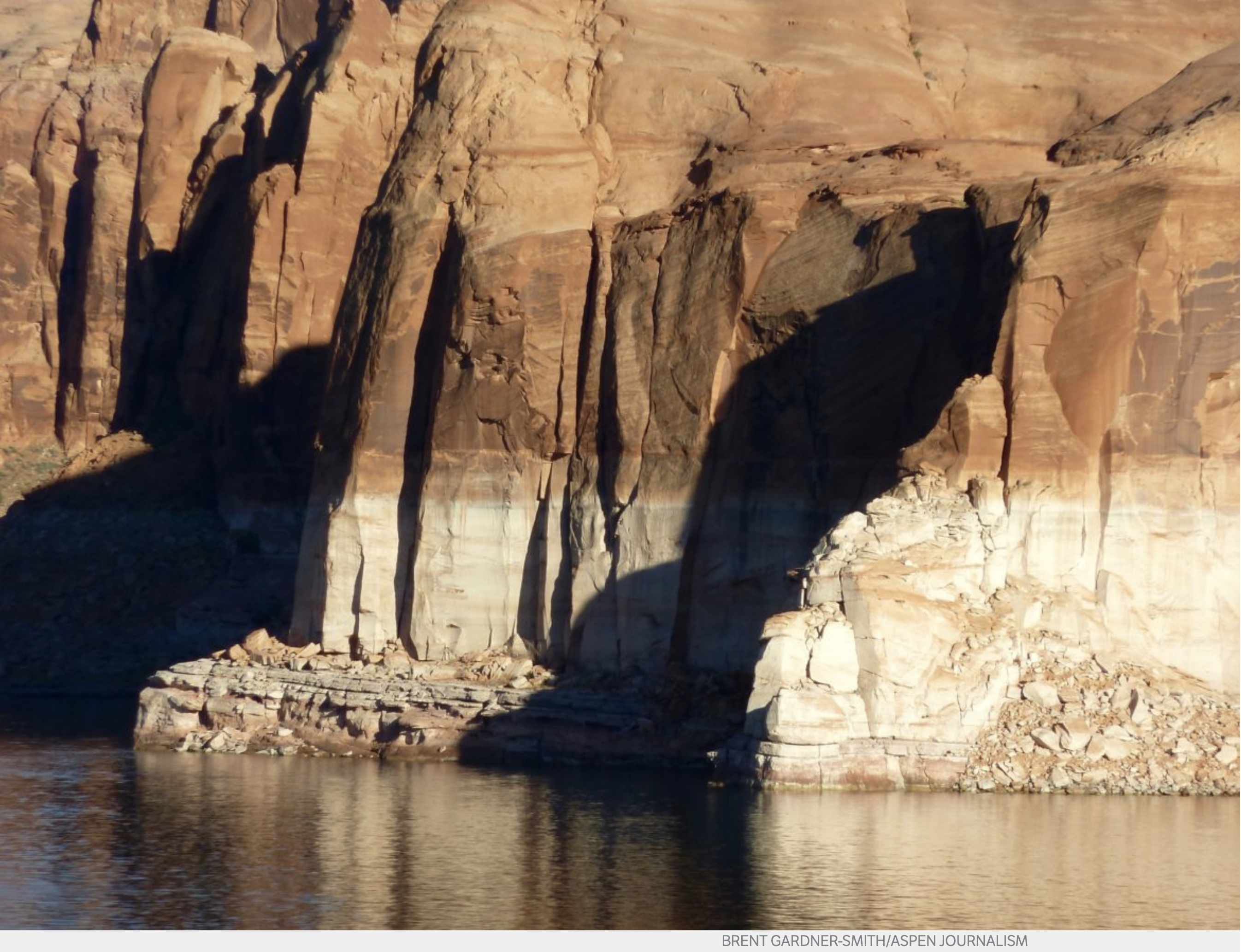
The bathtub ring in Lake Powell in October 2014. Today, the reservoir is under 40 percent full and water managers in Colorado, Utah, Wyoming and New Mexico are working on demand management programs that would reduce water use and send more water to the big reservoir that sits on the mainstem of the Colorado River. Photo credit: Brent Gardner-Smith/Aspen Journalism
A boater, Steve Skinner, makes his way toward Skull Rapid in Westwater Canyon. Future potential releases of water from Blue Mesa Reservoir down the Gunnison River and into the Colorado River could alter flows in Westwater, and boost water levels in Lake Powell. Photo credit: Aspen Journalism/Brent Gardner-Smith
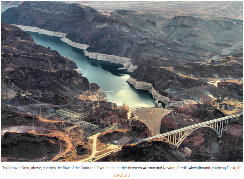
Hoover Dam plugs the Colorado River on the Nevada-Arizona border. Photo December 2012/Allen Best
Photo credit: Bureaus of Reclamation
Colorado National Monument from the Riverfront Trail near Fruita September 2018.
The Colorado River below Glen Canyon Dam. Photo credit: USBR
Colorado River “Beginnings”. Photo: Brent Gardner-Smith/Aspen Journalism
Scouting Upset Rapid, on the Colorado River. Photo: Greg Schaffron
Big Drop 2, on the Colorado River. Photo: Brent Gardner-Smith/Aspen Journalism
The upper Colorado River, above State Bridge. Photo: Brent Gardner-Smith/Aspen Journalism
One efficient and effective form of collaboration on the Colorado River, in the Grand Canyon. Photo: Brent Gardner-Smith/Aspen Journalism.
The Colorado River, between Loma and Westwater. Photo: Brent Gardner-Smith/Aspen Journalism
Metropolitan Water District of Southern California scouting team looking for where to site our Colorado River Aqueduct intake on the Colorado River. Boats powered w Model T motor! — Jeffrey Kightlinger via Twitter. I will miss the photos that Mr. Kightlinger published from the Metropolitan archives.
Prior to 1921 this section of the Colorado River at Dead Horse Point near Moab, Utah was known as the Grand River. Mike Nielsen – Dead Horse Point State Park
The All American Canal carries water from the Colorado River to farms in California’s Imperial Valley. The Imperial Irrigation District holds more rights to Colorado River water than any other user in the basin. Photo credit: Adam Dubrowa, FEMA/Wikipedia.
The U.S. Whitewater Rafting Team trains on its custom-built raft in December on the Colorado River. The team was on pace for a record descent of the 277-mile canyon [January 14-15, 2017] when a wave broke the frame and punctured a tube. Photo Special to The Denver Post by Forest Woodward.
Lake Havasu is a large reservoir behind Parker Dam on the Colorado River, on the border between California and Arizona. Lake Havasu City sits on the lake’s eastern shore. Photo credit MyGola.com
In 1922, Federal and State representatives met for the Colorado River Compact Commission in Santa Fe, New Mexico. Among the attendees were Arthur P. Davis, Director of Reclamation Service, and Herbert Hoover, who at the time, was the Secretary of Commerce. Photo taken November 24, 1922. USBR photo.
At the Colorado River delta, cheniers of dead clam shells epitomize the carbon dioxide being added to the atmosphere upstream. Photo credit Jansen Smith via Cornell University.
Spray irrigation on a field in the Imperial Valley in southern California. This type of irrigation is a lot better than the extremely water inefficient type of flood irrigation that is popular in this region. Still, in the high temperatures of this desert region a lot of the water evaporates, leaving the salts, that are dissolved in the colorado River water that is used, on the soil.
Colorado River headwaters tributary in Rocky Mountain National Park photo via Greg Hobbs.
Delph Carpenter’s 1922 Colorado River Basin map with Lake Mead and Lake Powell shown. The two giant reservoirs have always been part of the governance of the river.
Pour offs along the Colorado River. Photo via Brent Gardner-Smith/Aspen journalism
Colorado River Basin, USBR May 2015
Colorado National Monument from the Colorado River Trail near Fruita September 2014
Colorado River pulse flow (Minute 319) reaches the Sea of Cortez for the first time since 1998 on May 15, 2014 via the Sonoran Institute
Hayfield message to President Obama 2011 via Protect the Flows
Upper Basin States vs. Lower Basin circa 1925 via CSU Water Resources Archives
Lake Granby spill June 2011 via USBR. Granby Dam was retrofitted with a hydroelectric component and began producing electricity earlier this year as water is released in the Colorado River.
The Dolores River, below Slickrock, and above Bedrock. Photo: Brent Gardner-Smith/Aspen Journalism.
Here’s the release from the USBR:
The Bureau of Reclamation will host the 2019 operations meeting for the Dolores Project on Thursday, April 18, at 7 p.m. The meeting will be held at the Dolores Community Center, 400 Riverside Avenue in Dolores, Colorado.
“This meeting is a great opportunity for our partners and the public to find out how the 2019 water year is shaping up and to have any related questions answered,” said Western Colorado Area Office Manager Ed Warner.
Meeting topics will include a review of 2018 operations, projected water supplies and runoff for 2019 and the forecasted possibility of a boatable release to the Dolores River below McPhee Dam in 2019.
The meeting will also include presentations and representation from several agencies, including: Reclamation, Bureau of Land Management, United States Forest Service, Dolores Water Conservancy District, Colorado Parks and Wildlife, Dolores River Boating Advocates, American Whitewater and Fort Lewis College. There will be opportunities for questions, comments, and discussion during the meeting.
For more information, please contact Robert Stump at 970-565-7232 or rstump@usbr.gov.
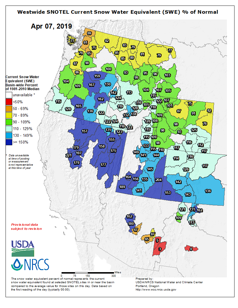
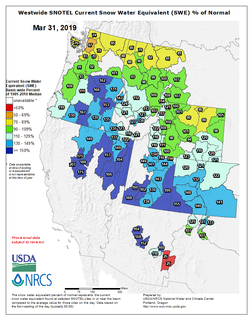
Westwide SNOTEL basin-filled map April 7, 2019 via the NRCS.
FromThe Glenwood Springs Post Independent (Scott Condon):
[Tim Miller] envisions Ruedi Reservoir filling during the first half of July, likely around July 4. The reclamation bureau and two other agencies have forecast the amount of water flowing into the reservoir this year at 120 percent to 140 percent of average for April through July.
Miller said one thing that stands out this year is the lower elevation snowpack is so big in the Fryingpan Valley. The Kiln snow telemetry site, at 9,600 feet in elevation, was at 147 percent of median on Thursday.
The Ivanhoe Lake site, at 10,400 feet, was at 168 percent of median. The last comparable snowpacks were in 2011, when winter wouldn’t end.
This year, Ruedi Reservoir is lower than usual for this time of year in the aftermath of the drought of 2018. Extra water was required for fighting the Lake Christine Fire and late-season irrigation.
The reservoir was at about 55 percent full. While that isn’t a historically low level, it is 10,000 acre feet lower than at this point last year and at this point in 2011, Miller said. Having the extra space compared to the big runoff year of 2011 is reassuring, he said.
Miller said he will keep the reservoir level hovering about where it is in anticipation of runoff starting soon.
The outlook for the reservoir is good for boaters because of the high probability it will fill right around July 4, Miller said.
The outlook for anglers on the lower Fryingpan River is less certain. Miller said the outflows from the reservoir will likely be higher from later this spring through July than they were last year. The flows in late summer and into fall will depend on the U.S. Fish and Wildlife Service’s plan for managing the Colorado River near Grand Junction for endangered fish species. Water from Ruedi Reservoir is often used to increase levels on the Colorado River.
The ideal situation this spring and summer would be slow, steady melting of the snowpack, producing a consistent inflow to the reservoir, according to Miller. But he knows Mother Nature will likely throw some curves.
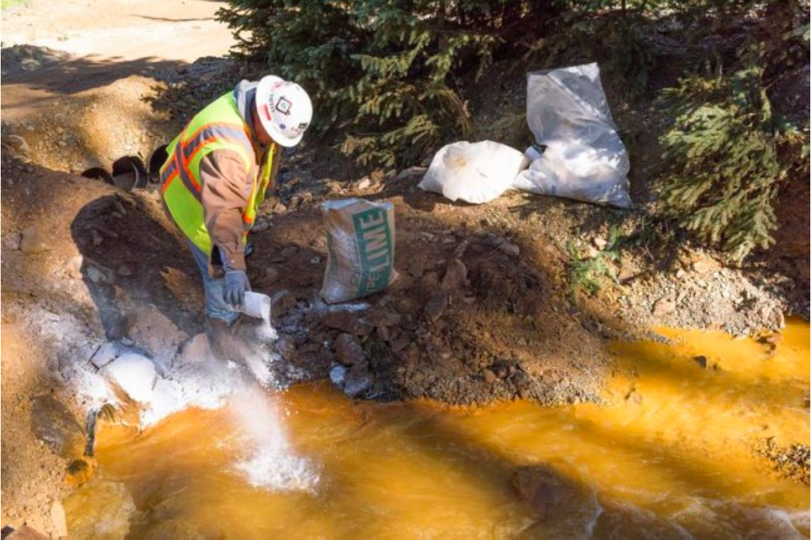
On April 7, 2016, the Environmental Protection Agency proposed adding the “Bonita Peak Mining District” to the National Priorities List, making it eligible for Superfund. Forty-eight mine portals and tailings piles are “under consideration” to be included. The Gold King Mine will almost certainly be on the final list, as will the nearby American Tunnel. The Mayflower Mill #4 tailings repository, just outside Silverton, is another likely candidate, given that it appears to be leaching large quantities of metals into the Animas River. What Superfund will entail for the area beyond that, and when the actual cleanup will begin, remains unclear. Eric Baker
From Governor Polis’ office via The Colorado Springs Business Journal:
Governor Jared Polis this week signed a bill to help prevent water pollution from future hardrock mining operations in Colorado.
Rep. Dylan Roberts, whose district was impacted by the 2015 Gold King Mine spill near Silverton, co-sponsored the bill with Rep. Barbara McLachlan.
“This is good for our environment, and keeps a thriving mining industry moving forward,” McLachlan said in an Apr. 5 news release issued by Colorado House Democrats. “We can’t go back in time but we can ensure we have a brighter, safer future and one that protects our precious water.”
HB19-1113 will ensure that when new mining permits are issued, sufficient and secure bonds are in place to ensure cleanup and better protect public health and the environment. The new law will end self-bonding for hardrock mines in Colorado and will explicitly include water quality protection in the calculation for the amount of bonding required. It will also require mining license applicants to set an end date for the cleanup of their operation, so that they can no longer just to do water treatment into perpetuity.
“Mining is a part of our history and always has been. For a long time, it has shaped our economy, our water rights system, and our communities,” Robert said in the release. “However, water is our state’s most precious resource and must be protected. This new law will modernize our hard-rock mining laws to protect clean water and ensure that taxpayers are never left on the hook for a private company’s spills.”
Mining operations have polluted more than 1,600 miles of Colorado rivers and streams, according to the release, and Colorado is one of just seven that allow “self-bonding,” which allows mines to operate with insufficient recoverable assets, leaving taxpayers vulnerable to potential cleanup costs.
Numerous small business owners, rafting outfitters, farmers, local elected officials and others from across western and southern Colorado testified at a House hearing in support of the bill. It passed both the House and Senate with bipartisan support.
Last month, Bruce Whitehead announced he was retiring after more than a decade as executive director of the Southwestern Water Conservation District, which is charged with conserving and developing water in nine Southwest Colorado counties.
Now, the search is on to replace Whitehead, a task that has prompted SWCD board members to analyze the agency’s mission and the way it does business in the face of challenges brought on by drought and climate change.
This week, the SWCD board held work sessions in Durango aimed at this endeavor, having guest speakers Friday lay out the realities of climate change in Southwest Colorado.
Brad Udall, a senior water and climate research scientist at Colorado State University, said, first and foremost, climate change is happening and having impacts all over the world.
“Within the scientific community, there is no doubt about what’s going on here,” he said. “This is an issue humans have to face up to and realize we’re causing.”
“Within the scientific community, there is no doubt about what’s going on here,” he said. “This is an issue humans have to face up to and realize we’re causing.”
“I’ll continue to stay current on Colorado water issues and will likely see many of you in the not too distant future,” he wrote in his email reply. “I will always deeply value the friendships made during my 11½ years with the district, my time in the state Senate and my 25 years with the Colorado Division of Water Resources.”
Bob Wolff, president of the water district board and representing La Plata County, said Whitehead’s institutional knowledge and experience are going to be hard to replace.
Reckoning with History is an ongoing series that seeks to understand the legacies of the past and to put the West’s present moment in perspective.
The Green New Deal and its proponents aim to tackle the intertwined issues of social and environmental justice in our age of anthropogenic climate change. To accomplish this, they believe they must deploy the federal government, since it is the only institution large enough to coordinate and invest in the necessary policies. But the idea of expanding the role of government has attracted critics, who rail against socialism. To historians, this sounds familiar.
This is not the first time socialism, new deals and the environment have intersected. During the catastrophe of the Great Depression of the 1930s, the federal government similarly attempted to ameliorate social and environmental harms by investing in people and places through the New Deal. Then, as now, critics dismissed it as socialism.
The “socialist” sobriquet stokes ideological fires but douses historical understanding. One prominent example — Bob Marshall’s argument for nationalizing forests during the 1930s — reveals how socialist solutions emerge from specific contexts and problems, not ideological bunkers. In Marshall’s case, the dire state of private timberlands in the early 20th century prompted his call for reform. When massive problems develop, cross jurisdictional lines and are associated with market failures, big government responses can seem like the only possible solution.
BY THE EARLY 20TH CENTURY, hundreds of years of unregulated cutting had ravaged the nation’s forests, and Americans faced a crisis that demanded intervention. “Rocks and mountains may be ageless, but men and society are emphatically of the present, and they cannot wait for the slow process of nature to retrieve the catastrophe caused by their unthinking destructiveness,” wrote Marshall, a forester for federal agencies throughout his career, a co-founder of The Wilderness Society and the person for whom Montana’s Bob Marshall Wilderness Area is named.
A massive evaluation of American forestry conducted by the Forest Service in 1932 both shaped and reflected Marshall’s views. Appearing the next year, A National Plan for American Forestry, known as the Copeland Report, showed that private forests were failing. (The majority of the nation’s timber came from privately held forests, just as it does today.) They burned more often, were not harvested to provide a “continual crop of timber,” failed to protect watersheds and offered few recreational opportunities compared to public forests. They caused social problems, too, with lumber workers doing dangerous, transient jobs that resulted in mangled bodies and left hollowed-out towns behind. As Marshall saw it, “The private owner is thus responsible for almost every serious forest problem.”
So, Marshall argued that American timberlands should be publicly owned. In 1933, four years into the Depression and during the first year of Franklin D. Roosevelt’s presidency, Marshall published The People’s Forests, his own radical extension of the Copeland Report, which advocated for public ownership of practically all commercial forests in America. He was writing amid an economic catastrophe mirrored in the nation’s wild and rural landscapes, where bankrupted farmers, out-of-work loggers and drought-driven refugees were common, not unlike today.
Throughout The People’s Forests, Marshall showed how private ownership, even when tempered by public regulation, fell short; only full public ownership could keep forests and communities healthy. He united a biological and social vision for forestry, one where human happiness and decent livelihoods might sprout from robust forests. In articulating that vision, he made his socialist case plain: “The fundamental advantage of public ownership of forests over private ownership is that in the former social welfare is substituted for private gain as the major objective of management.” Much the way today’s Green New Deal seeks to redress both economic and environmental impoverishment, Marshall sought to replace private profit with a broader public spiritedness that aimed for long-term stability, ending cut-and-run practices and ultimately strengthening communities.
Marshall’s call for reforms reflected an accelerating trend of expanding public lands in the 1930s, when the federal government acquired millions of acres for national parks, national forests and wildlife refuges. Newly passed laws, like the Migratory Bird Hunting Stamp Act (1934) and the Bankhead-Jones Farm Tenant Act (1937), helped the government fund refuges, acquire property for conservation and bail out private owners who lived on wrecked lands. Starting around the same time and lasting until the 1950s, Forest Service administrators advocated for public regulation of logging on private land, principally citing concerns about declining timber production and the threat of fire on poorly managed parcels. Though ultimately unsuccessful, those efforts illustrated a push to establish stability amid unsettling crisis, a goal Marshall shared.
When capitalism stumbles badly, producing degraded lands and gaping inequalities, socialistic solutions rise in popularity, because their incentives are not tied to profits. Marshall’s closing line argues for that perspective: “The time has come when we must discard the unsocial view that our woods are the lumbermen’s and substitute the broader ideal that every acre of woodland in the country is rightly a part of the people’s forests.” Shouting “socialist” as an epithet is a tired strategy, a failure to reckon with specific contexts and problems, whether it’s damaged timberlands in the 1930s or rising sea levels today. The People’s Forests and the Green New Deal highlight the ways social and environmental harms are woven together, a reminder that real solutions require a mutual untangling, and that — despite American history and politics’ suspicion of true socialism — government necessarily holds many of the threads.
Adam M. Sowards is an environmental historian, professor and writer. He lives in Pullman, Washington. Email High Country News at editor@hcn.org.
Like many Westerners, giant sequoias came recently from farther east. Of course, “recent” is a relative term. “You’re talking millions of years (ago),” William Libby said. The retired University of California, Berkeley, plant geneticist has been studying the West Coast’s towering trees for more than half a century. Needing cooler, wetter climates, the tree species arrived at their current locations some 4,500 years ago — about two generations. “They left behind all kinds of Eastern species that did not make it with them, and encountered all kinds of new things in their environment,” Libby said. Today, sequoias grow on the slopes of California’s Sierra Nevada.
In Deso-Gray, on the Green River. Photo: Brent Gardner-Smith/Aspen Journalism
Aspen trees, in the upper Roaring Fork River basin. Photo: Brent Gardner-Smith/Aspen Journalism
Aspen trees in autumn. Photo: Bob West via the Colorado State Forest Service.
Iron Fen. Photo credit from report “A Preliminary Evaluation of Seasonal Water Levels Necessary to Sustain Mount Emmons Fen: Grand Mesa, Uncompahgre and Gunnison National Forests,” David J. Cooper, Ph.D, December 2003.
“Bergen Park” was painted by John Frederick Kensett circa 1870. The painting illustrates the open, spatially-variable structure of a ponderosa pine stand with an open understory typical of some Front Range forests at that time. (Bergen Park, at an elevation of 7800 ft., is located near Evergreen, CO, 25 miles west of Denver.) via Rocky Mountain Research Station
The drying riverbed of the Middle Rio Grande near the Bosque del Apache National Wildlife Refuge on April 4, 2018. Photo credit: USBR
Here’s the release from Reclamation (Mary Carlson):
The Bureau of Reclamation invites the public to a presentation explaining plans for Rio Grande water operations in 2019. Snowpack is close to average in southern Colorado and northern New Mexico and a good spring runoff on the Rio Grande is expected.
The presentation will cover the process for determining the plan for water operations; a review of 2018 water predictions, as compared to actual storage and releases; and explanation of the 2019 water forecast and potential for storage and releases.
What: Release of Annual Operating Plan for the Rio Grande
When and Where:
Middle Rio Grande AOP: Thursday, April 18, 2019, at 1:30 p.m.
Bureau of Reclamation, 555 Broadway NE, Suite 100, Albuquerque, NM 87102. Webex available for the Albuquerque meeting, e-mail Mary Carlson at mcarlson@usbr.gov to participate.
Rio Grande AOP: Thursday, April 25, 2019, at 1:30 p.m.
El Paso County Water Improvement District No. 1, 13247 Alameda Ave, Clint, TX 79836.
Why: To learn more about the process used for determining this year’s operating plan, water forecast, water storage and potential for water storage and release.
How: Please contact Ms. Carlson at 505-462-3576 with any questions. If you are interested in the presentation and unable to attend either meeting, following the meeting it will be posted at https://www.usbr.gov/uc/albuq/water/aop/index.html.
Feel free to e-mail Ms. Carlson at mcarlson@usbr.gov for more information.
Miracle March, local reservoirs expected to be near full this summer
The heavy March storm cycles helped push the area out of a long-standing drought.
…Frank Kugel, general manager for the Upper Gunnison River Water Conservancy District (UGRWCD), stated Tuesday that Gunnison County is officially no longer in a drought, according to the Colorado drought monitor.
“The March storms were definitely very significant and in certain areas, in the first eight days of March we had a full month’s worth of precipitation,” said Kugel. “It was a great storm system for us, and has been very encouraging.”
The UGRWCD averages the five SNOTEL (Snowpack Telemetry) sites, which measures snowpack across the Upper Gunnison Basin. Kugel says, “We’re currently showing 150 percent of normal [snowpack] for this time of year.”
With the extended drought, some were concerned about the prospect of Blue Mesa refilling, even after a good snow year. But Kugel says they’re expecting the reservoir to fill to approximately seven-eighths of capacity, which, he says “is great considering it’s currently at 30 percent capacity.”
Kugel says Taylor Reservoir is expected to fill this year…
…being out of the drought is great news to go into the off-season. Look for a spectacular wildflower season this summer.
Click here to go to the Colorado Legislature website to read the bill:
Concerning the point of compliance related to the treatment process involved in treating reclaimed domestic wastewater for indoor nonpotable uses within a building where the general public can access plumbing fixtures that are used to deliver the reclaimed domestic wastewater.
SESSION: 2019 Regular Session
SUBJECTS: Natural Resources & Environment Water
BILL SUMMARY
In 2018, the general assembly authorized the use of reclaimed domestic wastewater for irrigation of food crops and industrial hemp and for toilet flushing if, at the point of compliance in the water treatment process, the reclaimed domestic wastewater met certain water quality standards.
The bill authorizes the water quality control commission (commission) to adopt rules requiring a point of compliance for disinfection residual related to the treatment process for reclaimed domestic wastewater used for toilet flushing within a building where the general public can access the plumbing fixtures used to deliver the reclaimed domestic wastewater. If the commission adopts the rules, the rules must establish a point of compliance for disinfection residual at a single location between where reclaimed domestic wastewater is delivered to the occupied premises and before the water is distributed for use in the occupied premises.
Click here to read the newsletter. Here’s an excerpt:
Colorado Water Loss Initiative
Stage 1 workshops begin in April. Join the free CO Water Loss Initiative now! Space is limited.
The Colorado Water Loss Initiative (CWLI) is a 4-stage program developed by the Colorado Water Conservation Board to train water suppliers on the cutting-edge practices for water loss and revenue recovery. This technical assistance program is being offered at NO COST to your utility, and will run Spring 2019 to Summer 2020. Join your peer systems who have already signed up to learn how to reduce costs and increase revenue!
Register at http://www.coloradowaterloss.org. From there you‘ll receive information on selecting your preferred workshop in Stage 1. A kickoff webcast has also been posted to the program website for additional information.
Officials from Denver, Arapahoe and Jefferson counties met with state and federal officials Thursday to coordinate the repair project, a news release stated. Staff, equipment and material will be on site over the next four weeks as the structure is permanently stabilized.
The dam is in Jefferson County, south of West Bowles Avenue and west of South Simms Street.
To save endangered fish and support healthy water levels, conservationists get creative on the Colorado River’s 15-Mile Reach
The Colorado River—that ancient and mighty flow that has carved the landscape of the American West over millennia—serves as a primary water source for approximately 40 million people. But there is a stretch in the headwaters that at times runs so low and weak it has trouble sustaining some of its oldest inhabitants.
This stretch, known as the 15-Mile Reach, is home to four federally endangered fish species–the Colorado Pikeminnow, Humpback Chub, Bonytail and Razorback Sucker. In the springtime, when irrigation diversions begin but snowpack runoff is still nominal, the 15-Mile Reach can drop to dangerously low levels.
Now, a groundbreaking deal between Walton Family Foundation grantee the Colorado Water Trust, the Orchard Mesa Irrigation District, Grand Valley Water Users Association and the U.S. Bureau of Reclamation, which manages water and power in the West, have secured a legal mechanism to be able to send more water down the river at critical times through a creative arrangement that both enhances environmental and recreational flows and protects existing water rights.
The deal provides habitat protection for these embattled fish species by bringing more water into the Reach when it is needed.
This mechanism allows water to be protected from the point of conservation all the way down and through any excess capacity at the Grand Valley Power Plant, then provides instream flow benefits down and through the 15-Mile Reach.
The agreement, like many involving water in the West, required resourceful thinking among all participants. That’s because under current state law, there aren’t many options for upstream water rights owners to send some of their water downstream for the benefit of conservation without going through an often protracted water court process.
And some might question whether using a water right, even for this kind of worthy cause, meets the “beneficial use” standard required by law.
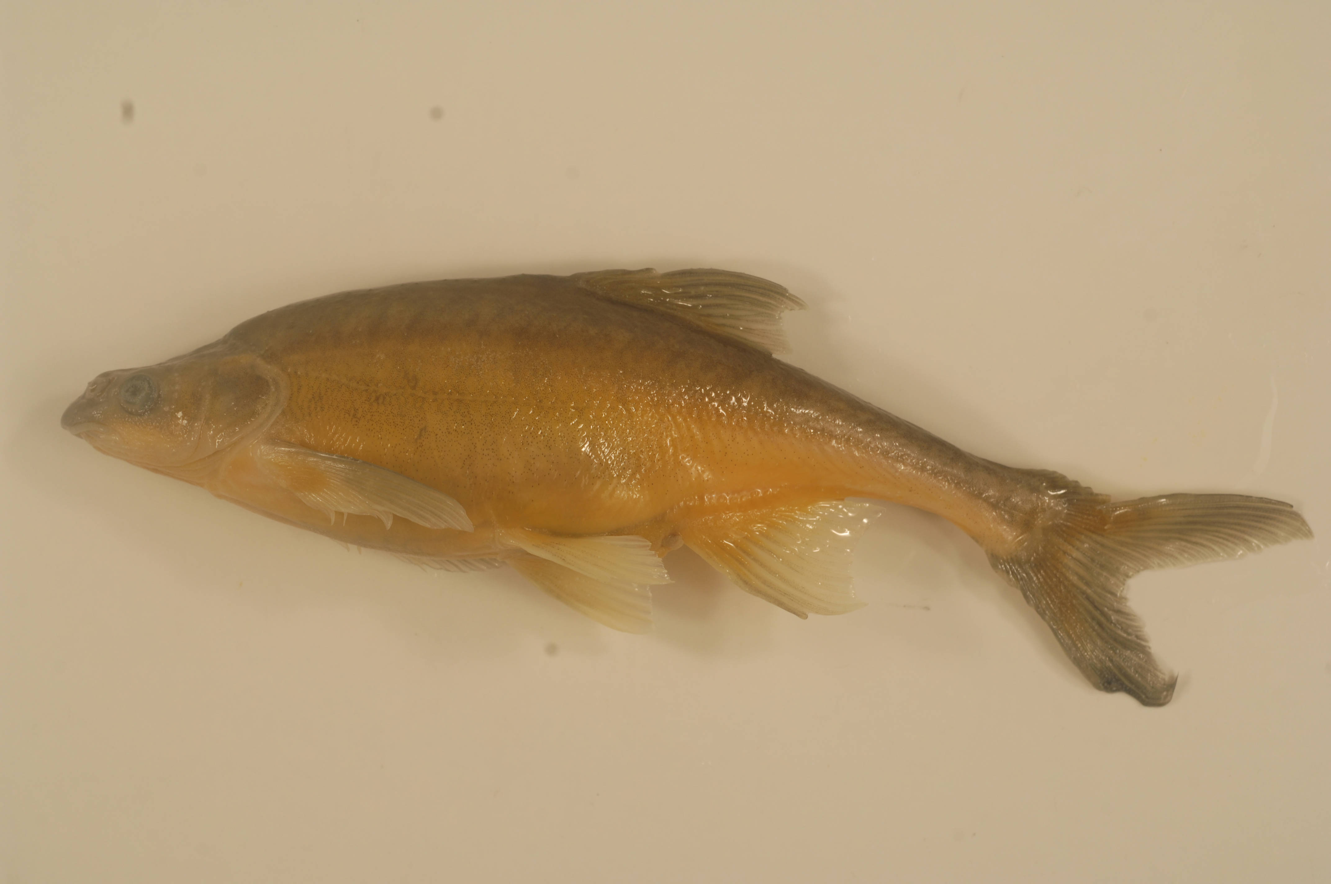
Humpback chub are one of four federally endangered fish species that rely on habitat in the 15-Mile Reach of the Colorado River. Humpback chub photo credit US Fish and Wildlife Service.
Faced with that hurdle, the partners needed to find another path forward that met that strict legal requirement. They found their solution just north of the Reach in the aging Grand Valley hydro-electric facility.
Built in 1933, the plant is now undergoing a substantial renovation with help from the Colorado Water Trust.
The Trust was able to lease excess capacity in the hydropower plant, and the Orchard Mesa Irrigation District used these proceeds from this lease to help pay for some of the renovations. This kind of creative win-win solution is a model for how we manage the river in the future.
By bringing clean power into the equation, the deal operates under the umbrella of existing law to give water rights owners the flexibility and go-ahead to support a healthy and sustainable river ecosystem.
“The agreement sends water to a critical reach of the river without requiring a permanent change to those water rights,” explains Anne Castle, a Colorado water lawyer and former assistant secretary for water and science at the U.S. Interior Department.
Water travels through a roller dam, generating power, then continues downstream. Roller Dam near Palisade. Photo credit: Hutchinson Water Center
Anne helped broker the groundbreaking deal.
“This arrangement could set a precedent moving forward,” Anne says, “and it also proves that there is a way for those with water supplies to be able to send water downstream in a voluntary, compensated and temporary manner.”
The final agreement is an innovative “three-fer” that provides multiple benefits.
First, the water is protected for instream flow benefits from the original point of use down to the hydropower plant. Then, the water’s momentum is harnessed by the plant and converted to clean energy. Finally, the water continues downstream, augmenting the 15-Mile Reach and helping the river flow at healthier levels, which benefits the fish.
The 15-Mile Reach is located near Grand Junction, Colorado
Water is scarce in the West. Securing the necessary federal, state and local approvals can require a great deal of coordination—and more than a little ingenuity. This is precisely why this nimble approach is such a landmark achievement.
As the health of the Colorado River Basin reaches a critical inflection point, with demand for water now exceeding supply, more agile, innovative projects like what is being accomplished for the 15-Mile Reach offer a new vision for a water-strapped West.
Complex problems often require innovative solutions. As growing populations continue to rely on the 1,500 miles of the Colorado River, this victory proves that progress is possible—often one mile at a time.
Ted Kowalski: Colorado River Initiative Lead and Senior Program Officer
Ted is a senior program officer, leading the Walton Family Foundation’s Colorado River initiative.
Upper Colorado River Endangered Fish Recovery Program
Click here to read the discussion. Here’s an excerpt:
The Colorado Basin River Forecast Center (CBRFC) geographic forecast area includes the Upper Colorado River Basin, Lower Colorado River Basin, and Eastern Great Basin.
Water Supply Forecast Summary:
With the exception of the Green River Basin of Wyoming all of the Upper Colorado River Basin experienced an increase in the April-July water supply forecasts between early March and early April. Similarly, much of the Great Basin noted increases with the exception of some of the northernmost sections.
Widespread significant precipitation occurred over most of the area during the first half of March. Storm systems with a sub-tropical moisture source, similar to those that occurred in February, resulted in large precipitation amounts that extended from southwest and central Utah into parts of southwest and central Colorado. In the areas that experienced the heaviest precipitation, snowpack conditions now range in the top three of the historical records dating back 35-40 years.
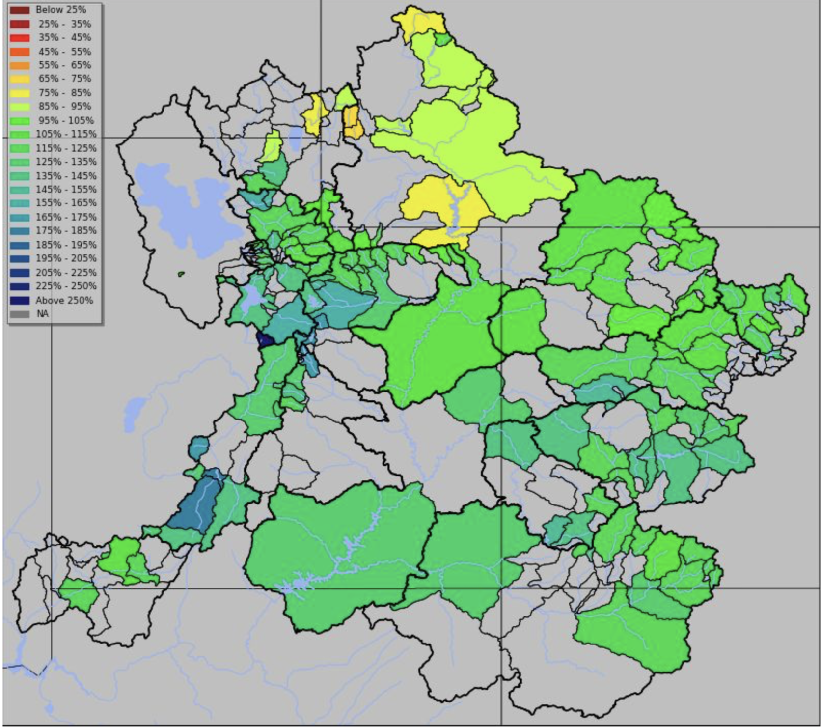
The largest increases in water supply forecasts between March 1st and April 1st occurred in the San Juan, Gunnison, and Dolores River Basins. Significant increases also occurred throughout the San Rafael and Sevier River Basins in central and southwest Utah. Due to record February-March precipitation amounts in these areas, April-July runoff volume forecasts range from near 115 to 200 percent of average. Currently only parts of the Green River Basin in Wyoming and the northern Great Basin (Bear River Basin) have forecasts below average for the 2019 season.
Very dry soil moisture conditions were widespread entering the winter season. These may have some impact on the overall yield of runoff that ends up in the streams depending on how the snow melt plays out. In areas with significant snowpack or where snowmelt is delayed the impacts of dry soils may be lessened.
April-July unregulated inflow forecasts for some of the major reservoirs in the Upper Colorado River Basin include Fontenelle Reservoir 630 KAF (87% average), Flaming Gorge 830 KAF (85% of average), Blue Mesa Reservoir 925 KAF (137% of average), McPhee Reservoir 430 KAF (146% of average), and Navajo Reservoir 920 KAF (125% of average). The Lake Powell inflow forecast is 9.20 MAF (128% of average). [ed. emphasis mine]
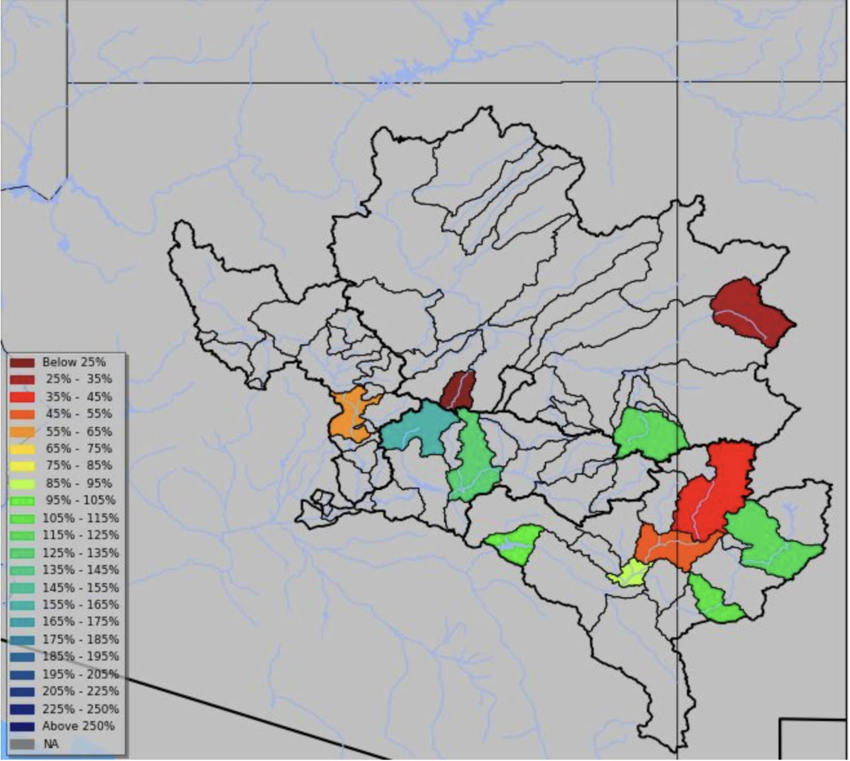
The Lower Colorado River Basin also started out March very wet particularly in the Gila, Salt, Little Colorado and Virgin River Basins. These areas were also very wet in February. While this area typically experiences drier weather over the next couple of months, many sites in Arizona and New Mexico have already reached their historical seasonal median Jan-May volumes due to rainfall and snowmelt over the past couple of months. April-July runoff volumes in the Virgin River Basin are expected to range from 115-120 percent of average (175-205 percent of median).
Upper Colorado, Great, Virgin River Basins: 2019 April-July forecast volumes as a percent of 1981-2010 average (50% exceedance probability forecast)Upper Colorado, Great, Virgin River Basins: 2019 April-July forecast volumes as a percent of 1981-2010 average (50% exceedance probability forecast)
Water Supply Discussion
March Weather Synopsis-Precipitation-Temperature:
Following a wet February across much of the Colorado River Basin, the first two weeks of March were a game changer with significantly above normal precipitation across much of Utah and Colorado. An anomalous trough across the Western U.S. during the first half of March was responsible for bringing multiple, moisture-laden storm systems through the Colorado River Basin. By the end of the month, the highest wet anomalies (in percent of normal terms) were across the San Juan, Dolores, and Gunnison Basins where 200-300% of average precipitation fell. Over
much of Utah and the Upper Colorado Headwaters, 130-200% of average was observed. In general, the only area that saw below normal monthly precipitation was the Green River Basin of Wyoming. Over Arizona, precipitation was mostly near to slightly above normal but increased to much above normal in the Gila River Basin and eastern Salt River Basin. The combination of two successive very wet months across much of the Colorado River Basin (particularly Utah/Colorado) has dramatically improved seasonal snowpack and resulting water supply forecasts…
March was cooler than normal over most of the CBRFC forecast area. This acted to preserve snowpack, even at lower elevations, that will contribute to the overall April-July runoff volumes…
Snowpack:
Much above normal (median) snow conditions exist across much of Utah and western Colorado and are generally higher in locations farther south. Currently, the only basin that does not have above normal snow is the Upper Green River in Wyoming which is near normal overall.
The following maps show the SNOTEL sites as a percent of normal (1981-2010 median) and also as a historical ranking for their period of record. The snow as represented in the CBRFC hydrologic model is also displayed.
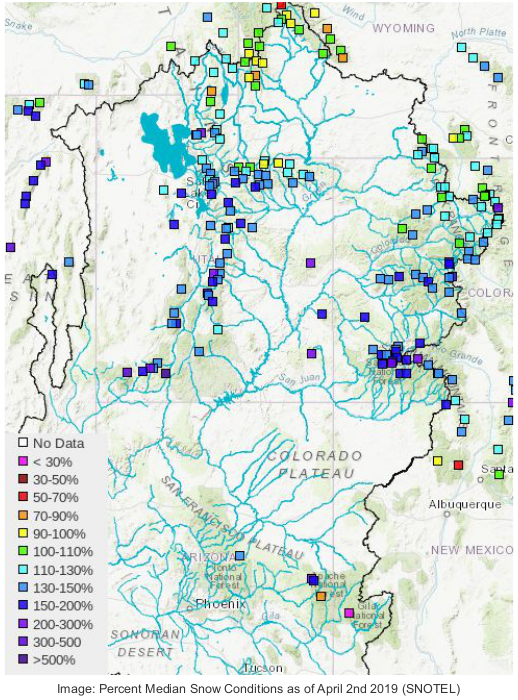
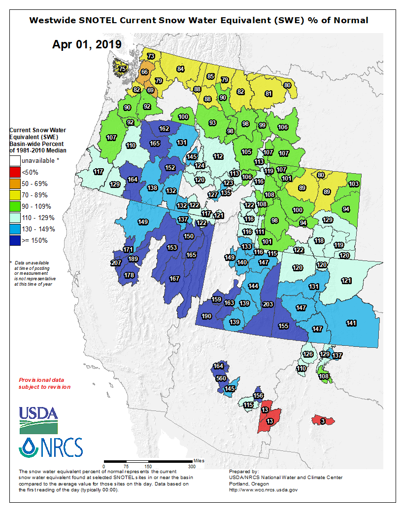
The image below displays the SNOTEL sites as a percent of their historical median as of April 2nd 2019. Those sites in the dark blue currently exceed 150 percent of median (or normal) for this time of year while those in the dark purple are at 200 percent or more of normal.
The snow percentile image displayed below indicates where the current snow measurement ranks in the historical record (typically 35-40 years) for each site. Those sites in black are the highest on record. Those in the dark blue are in the top 3 of their historical record, while those in the brighter blue are in the top ten. This map helps highlight the areas with unusually high snowpack at this time, such as the San Juan and Dolores basins in southwest Colorado.
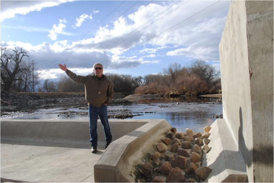
Scott Hummer shows off a fish passage at a North Poudre Irrigation Company diversion structure. His agency worked with Fort Collins Natural Areas and Colorado Parks and Wildlife to include a fish passage when the irrigation company replaced a diversion structure on the Poudre River that was destroyed by the 2013 floods. Work was completed [in February 2016]. (Pamela Johnson / Loveland Reporter-Herald)
Colorado Water Stories – Learning from our past, reimagining our future
Friday, April 19th
7:30 am to 5:30 pm
Mount Vernon Canyon Club
24933 Club House Circle
Golden, CO 80401
Come join us for an informative day of Colorado water stories and discussions. Speakers will include:
Amy Beatie (Deputy Attorney General for Natural Resources and the Environment)
Becky Mitchell (Director of the Colorado Water Conservation Board)
Interactive presentation on conflict resolution by Todd Bryan
Stories from retired State and Division Engineers, moderated by KUNC reporter Luke Runyon
This year’s conference will cover a range of topics from both a technical and policy perspective, including a deep-drill into ASR, geophysical applications, and how Coloradans are reimagining the river. The day will end with happy hour and a silent auction to benefit the AWRA Colorado and CGWA scholarship programs.
Here’s the release from the NRCS (Brian Domonkos):
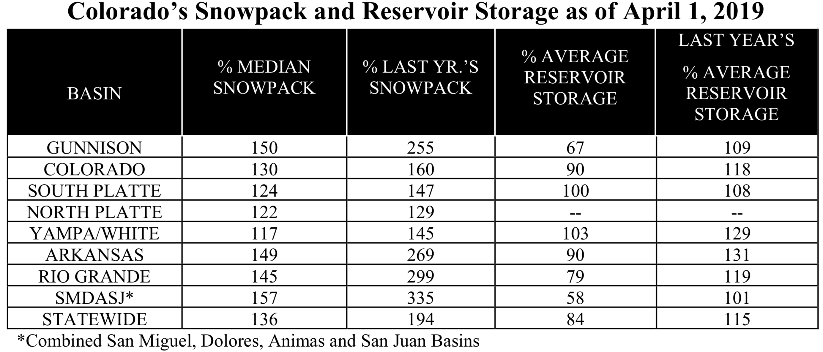
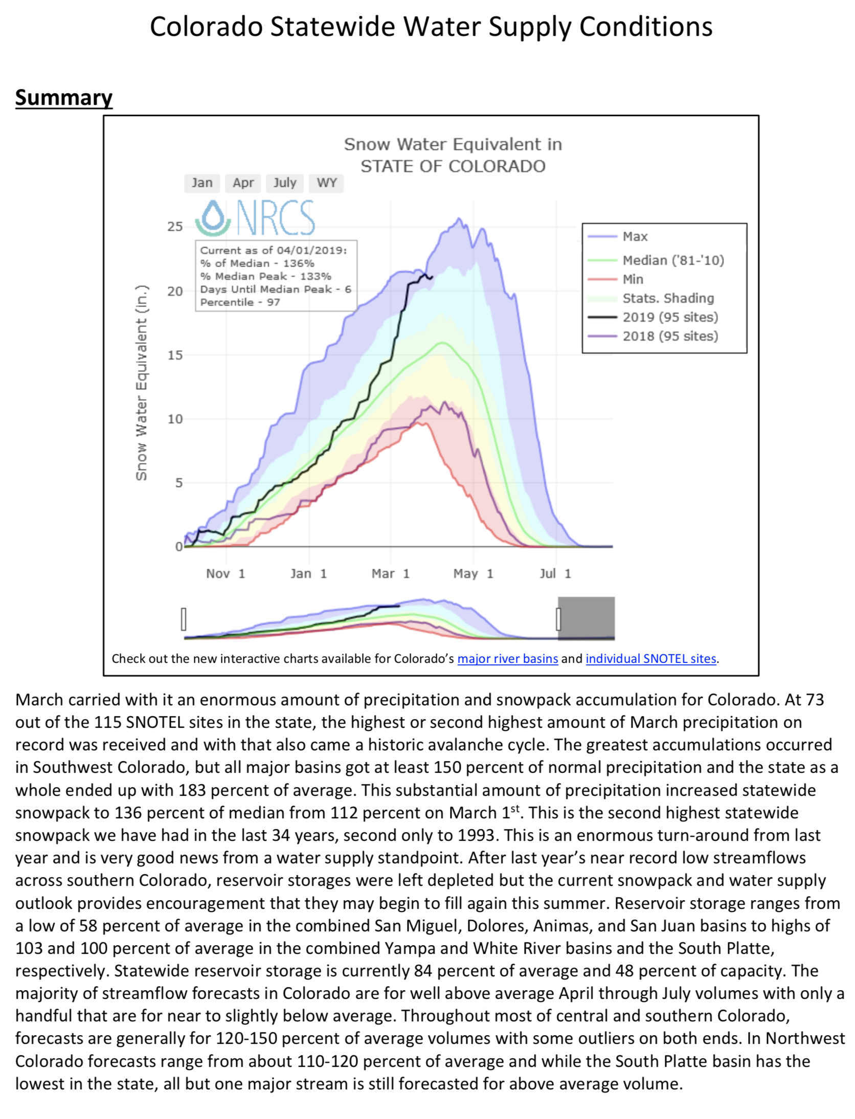
Snow accumulations between March 1 and March 15 have been the highlight of this winter coming in at near record levels across much of the state. At the end of March, snowpack across the state of Colorado is 136 percent of median up 24 percent from last month. The combined San Miguel, Dolores, Animas & San Juan Basins posted the largest gain of 35 percent followed by the Upper Rio Grande, Gunnison and Arkansas at 30, 32 and 25 percent respectively. Basin-wide snowpack improvements elsewhere in Colorado were slightly more modest. These improvements through March pushed snowpack past a significant milestone, “All individual major basins in the state are now above the typical annual snowpack peak, which often leads to a favorable water supply in each basin,” notes Brian Domonkos, Colorado Snow Survey Supervisor with the Natural Resources Conservation Service.
Statewide Basin High/Low graph April 3, 2019 via the NRCS.
March snowpack improvements showcase the impressive changes but equally noteworthy are current snowpack totals for the water year beginning on October 1. Snowpack observation points within the San Miguel, Dolores, Animas & San Juan combined basins indicate 157 percent of median, while snowpack in the Gunnison, Arkansas, Rio Grande, and Colorado indicate 150, 149, 145 and 130 percent of median respectively. “Current snowpack values in some individual basins on April 1, 2019 translate to nearly double or triple levels seen during this same time last year,” comments Domonkos. These improvements over last year are welcomed in restoring water supplies significantly depleted after last year’s drought.
Similar to snowpack March precipitation was particularly impressive which amounted to 183 percent of average for the state. Water year to date precipitation across the state is now 123 percent of average. Precipitation totals in the Gunnison and combined southwest basins are no less impressive each at 133 percent of average for the water year to date. By the numbers March is typically the second wettest month of the year in Colorado meaning accumulations this March were particularly impactful.
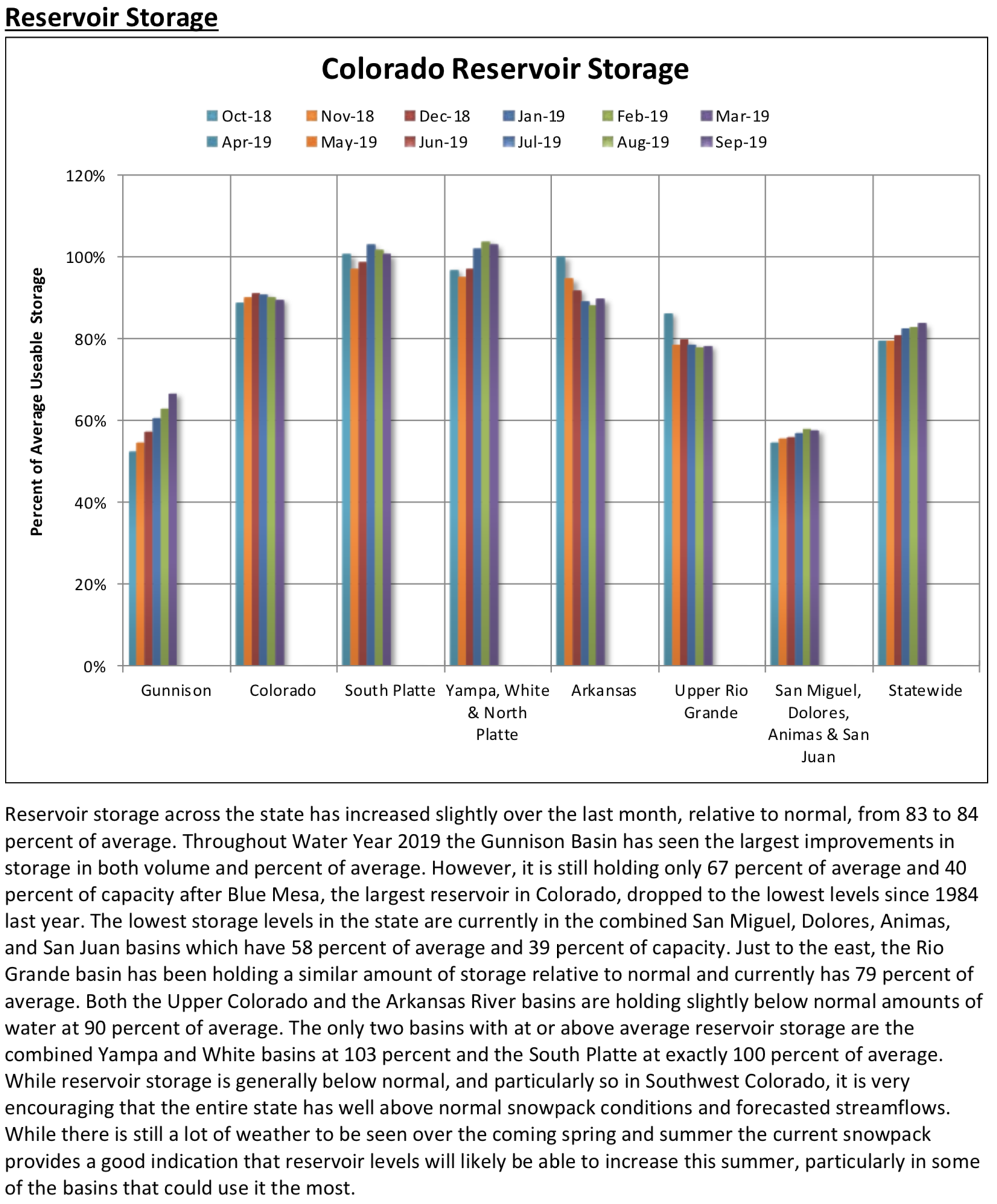
While reservoir storage levels across the state have seen little increase in recent months current snowpack levels are poised to increase storage levels across much of the state as the snow begins to melt. Most volumetric streamflow forecasts into spring and summer range from 100 to 150 percent of normal. Basins that have the highest forecasts, namely in Southern Colorado, are those that had the least streamflow last year, which should be particularly beneficial for water supply conditions in those areas.
Bonita Mine acid mine drainage. Photo via the Animas River Stakeholders Group.
Bulkheads, like this one at the Red and Bonita Mine, help stop mine water discharges and allow engineers to monitor the mine pool. Credit: EPA.
Summitville Mine superfund site
Argo Mine Boulder County
Central City back in the day
California Gulch back in the day
Mary Murphy Mine
Portal of the Pennsylvania Mine in Summit County, upstream from Keystone Resort. Photo courtesy of Jeff Graves, Colorado Division of Reclamation, Mining and Safety
Acid mine drainage Pennsylvania Mine via the Summit County Citizens Voice
Lincoln Park/Cotter Mill superfund site
Schwartwalder pipeline Cotter Ralston Creek
Gold King Mine entrance after blowout August 2015
Commodore waste rock superfund site Creede
Fault vein in Standard Mine Gunnison County
General view of the Sunnyside Mine and Lake Emma, southwestern Colorado photo via the Denver Public Library
Gold King Mine circa 1899 via The Silverton Standard
Abandoned Colorado mines that significantly affect surface water directly via The Denver Post
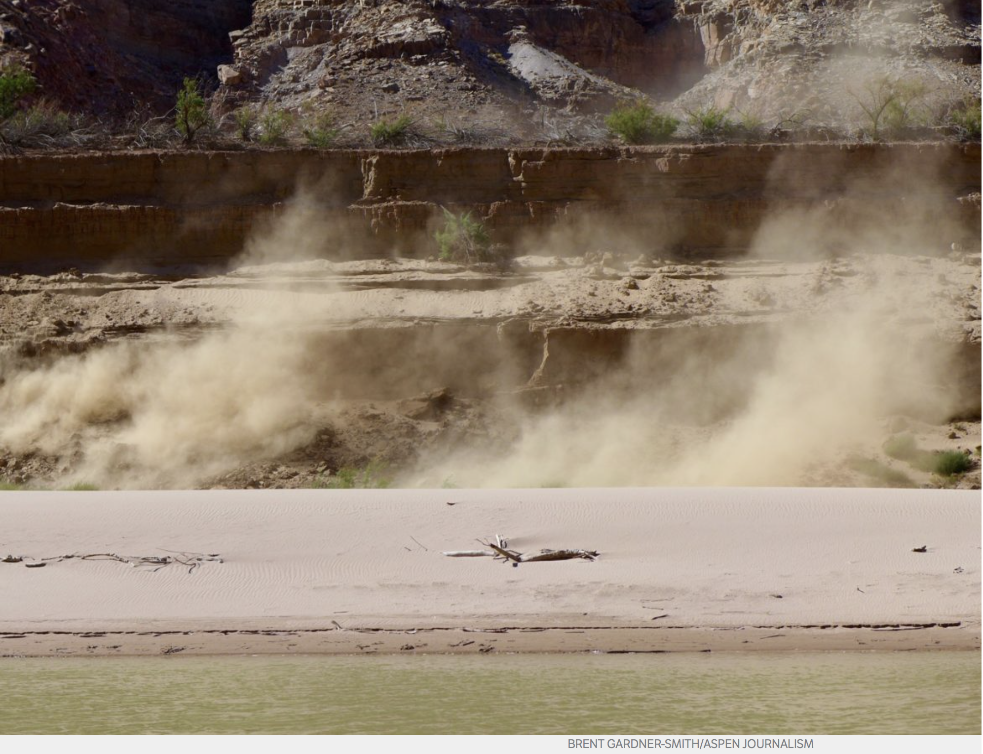
Both science and science fiction say the future is going to be hotter, drier and dustier, and this silt-fall in upper Lake Powell in September 2018 captures the trend. Photo credit: Brent Gardner-Smith/Aspen Journalism
On the first morning of a water conference in downtown Phoenix on Friday, an academic expert spoke of aridification in the Colorado River basin due to the ill effects of humans burning fossil fuels.
After dinner, a writer of vivid predictive fiction spoke about his book “The Water Knife,” which describes Phoenix in a dusty and water-starved river basin, in the not-so-distant future.
“First of all, the climate is changing, it’s happening now, it’s happening extremely rapidly and, in fact, it is accelerating,” said Kathy Jacobs, the director of the Center for Climate Adaptation Science and Solutions at the University of Arizona. “Second, severe weather is becoming more intense, sea levels are rising and oceans are being affected dramatically — incredible changes in the oceans and in the Artic. It’s largely happening because of human activities, and there are so many different avenues now to show that that is true.”
Jacobs also described the current impacts on the Colorado River basin, which includes the Roaring Fork River watershed.
“The connection between heat and runoff has become incredibly clear,” Jacobs said, and the result is “a huge decline” in water supplies.
“We’re seeing record-setting flow reductions, lots of temperature-induced losses, snowpack loss faster than we really had anticipated and earlier runoff, which of course affects a lot, especially in the upper basin,” she said.
And, she warned, “We’ve got a lot to adjust to and need to be significantly prepared for a lot more change than we’ve already seen.”
Later that evening, Paolo Bacigalupi said he didn’t want to be right about the bleak future in “The Water Knife,” but also said people are still not “engaging with the issue” of climate change.
“I just want us to be reality-based,” Bacigalupi said. “I don’t think that’s asking too much.”
Speaking louder than Bacigalupi was “The Water Knife,” a 2015 novel that mixes senior water rights with chaos, torture, murder, drugs and sex in a tale where the only thing that’s not shocking is that the Colorado River is drying up.
“Weather anchors used the word drought, but drought implied that drought could end; it was a passing event, not the status quo,” the book says. “But maybe they were destined for a single continuous storm — a permanent blight of dust and wildfire smoke and drought, and the only records broken would be for days where anyone could even see the sun.”
The Phoenix water conference was organized and hosted by the Lincoln Institute of Land Policy and the Babbitt Center for Land and Water Policy. (The conference was sponsored in part by the Walton Family Foundation, a supporter of Aspen Journalism.)
The attendees, many of them journalists, were offered a copy of “The Water Knife.”
A water knife is someone who cuts off people’s junior water rights, by force if necessary.
Angel Velasquez, the water knife in the book, at one point remembers the early days of his job working for the fictional head of the Southern Nevada Water Authority, “when he’d stood bodyguard behind Catherine Case as she went into meetings: bald bureaucrat guys, city water managers, Bureau of Reclamation, Department of the Interior. All of them talking acre-feet and reclamation guidelines and cooperation, wastewater efficiency, recycling, water banking, evaporation reduction and river covers, tamarisks and cottonwood and willow elimination. All of them trying to rearrange deck chairs on a big old Titanic. All of them playing the game by the rules, believing there was a way for everyone to get by, pretending they could cooperate and share their way out of the situation if they just got real clever about the problem.”
But the efforts of the water managers in the book didn’t work, and the seven states in the Colorado River basin harden their borders and stand behind their water rights, each fighting for what the law gave them, even if the river has stopped giving.
In the book, Case, the water manager, sits in her car with the water knife and ticks off a list of problems people didn’t see coming: “‘Snowpack up in the Rockies — that might as well be zero. No one planned for that.’ Tick. ‘Dust storms and forest fires are playing hell with our solar grid. No one planned for that.’ Tick. ‘All that dust is speeding snowmelt, so even when we get a good year, it melts too fast or else evaporates. No one planned for that.’ Tick. ‘Hydropower.’ She laughed. ‘That’s shot except in the spring because you can’t get a decent head in the reservoirs.’ Tick. ‘And then there’s California putting all these calls on the river.’”
That may be fiction, but it’s not far from what Jacobs, the climate expert, said Friday about what people can expect as the result of burning fossil fuels.
“It will be drier on average, but with more intense rainstorms, so we have to be prepared for both flooding and drought,” Jacobs said. “There is a likelihood, and I will say a certainty, of cascading effects increasing, including heat waves and resulting brownouts because of impacts on the electric system, or forest fires, air quality problems, health effects, a whole range of potential cascading effects on systems, because our systems are weak.”
Jacobs concluded her remarks by noting that “Many decision-makers really want a path to the future, they want to know what exactly the future is going to look like, and we cannot tell them.”
They might well consult “The Water Knife.”
Aspen Journalism covers water and rivers in collaboration with The Aspen Times, the Glenwood Springs Post Independent, the Vail Daily, the Summit Daily and the Steamboat Pilot. The Times published this story on April 3, 2019.
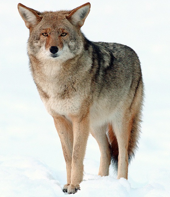
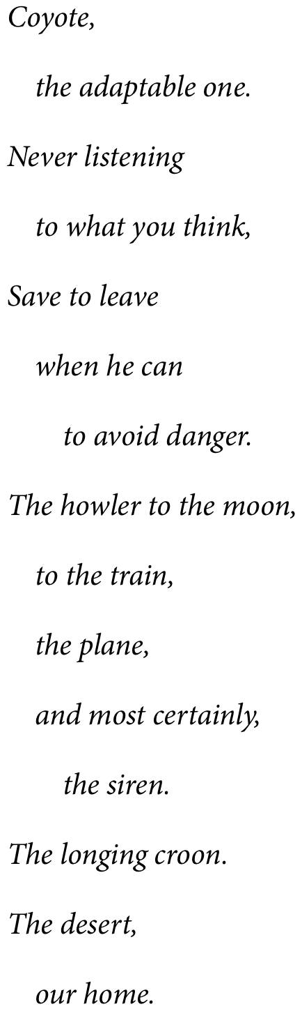
Thank you, Julie Lue. I so appreciated your essay on Coyote (“Overheard in Montana,” HCN, 9/4/17). As we experience this creature, so we discover the spirit of song, and whelping dens that have youth within. The cycle of seasons. Where in the spring? Now have they dispersed.
These are the songs of the rural. Experienced on the edge, but then, not quite. Unless one explores, and finds the places. The spaces of changing patterns. Coyote. The mischievous one.
Click on a thumbnail graphic below to view a gallery of drought data from the US Drought Monitor.
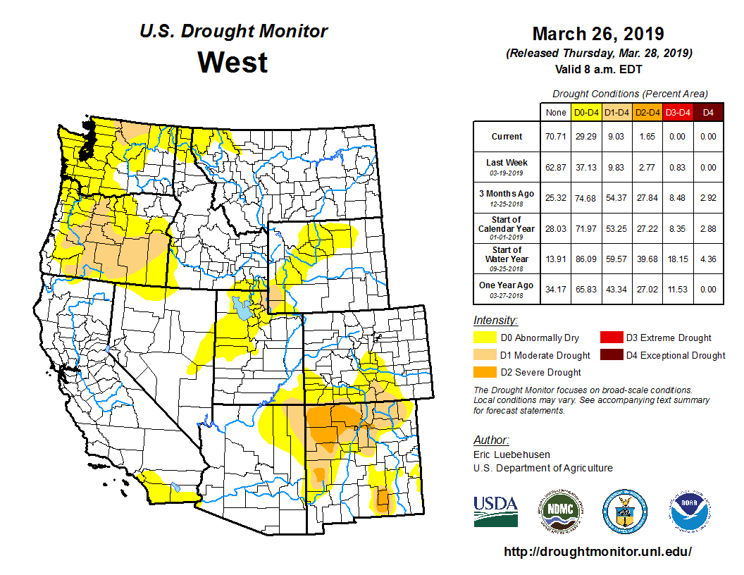
US Drought Monitor April 2, 2019.
West Drought Monitor April 2, 2019.
Colorado Drought Monitor April 2, 2019.
Click here to go to the US Drought Monitor website. Here’s an excerpt:
Summary
Large portions of the continental United States remained free of drought or abnormal dryness this week. The Northeast was completely free of drought or abnormal dryness, as was the Midwest, where significant river flooding concerns continued. Short-term dryness continued in parts of central and western Texas, with some moderate and severe drought shifting northward, while widespread rain in southern Texas led to improvements in conditions there. Short-term precipitation deficits in southern Alabama, southern Georgia, southern Louisiana, the Florida Panhandle, and South Carolina led to the expansion of abnormal dryness and moderate drought in some of these areas. Moderate drought was also expanded in parts of north-central Washington in response to short-term precipitation deficits there. Another dry week in Hawaii led to degradation in drought conditions on most of the islands…
Widespread precipitation fell across much of Nebraska and eastern Kansas this week while most of the rest of the region experienced drier weather. On the whole, temperatures were relatively close to normal in the region, with a cold pocket in northwestern Nebraska and a few warmer areas showing up in the western Dakotas. Aside from a reduction in abnormal dryness around Colorado Springs in response to decreasing long-term precipitation deficits, no changes were made to the map this week east of the Continental Divide, and the High Plains remained nearly devoid of drought or abnormal dryness…
Widespread precipitation affected northern California, western Oregon, and the northern Sierra Nevada this week. Precipitation also fell in the mountains north of the Snake River Valley in Idaho, southwestern Montana, northern Utah, and central Wyoming. Relatively warm conditions prevailed along the Pacific Coast, and in southern California, Arizona, and New Mexico. Elsewhere, temperatures were generally near normal. Moderate drought was expanded in parts of north-central Washington where precipitation deficits over the last 1-3 months led to the development of moderate drought. Low to very low snow water equivalent is also evident in the Idaho Panhandle and in northwestern Montana, and while this has not yet developed into moderate drought, abnormally dry conditions continue here. Abnormal dryness was reduced in the San Luis Valley in Colorado, where long-term precipitation deficits continued to abate…
Aside from southern Texas and northeastern Oklahoma, much of the region was dry over the past week. Temperatures were below normal in most of the region, except for southwestern Texas and the western Texas Panhandle. Moderate drought was added this week in southwestern Louisiana and in the Baton Rouge area because of short-term precipitation deficits over the past few months. Very dry conditions over the past 3 months led to moderate drought expanding into the Austin, Texas, area. Severe drought shifted northward in parts of south-central Texas in response to changes in short-term precipitation deficits there. After a widespread half-inch or more of precipitation this past week, short-term precipitation shortages were alleviated enough for widespread improvement in drought conditions in southern Texas. Elsewhere, some short-term dryness was taking place in Arkansas and Tennessee, but this was outweighed by longer-term precipitation surpluses…
Looking Ahead
Widespread precipitation is forecast this week from the Central Plains eastward through the East Coast. The heaviest amounts are forecast in eastern Texas and Arkansas and in the central Gulf Coast states. Precipitation is also forecast in the Sierra Nevada, northwestern California, western Washington and Oregon, and mountainous areas of Wyoming, northern Utah, and Idaho. Widespread above-normal temperatures are forecast over the next week, particularly in the central continental United States.
One week US Drought Monitor change map through April 2, 2019.
A night view as the California Department of Water Resources releases water from the Lake Oroville flood control gates down the newly-constructed main spillway for the first time since May 2017 in Butte County, California. Main spillway releases will continue to manage lake levels in anticipation of rain and snowmelt. Photo taken April 2, 2019. Photo credit: Ken James / California Department of Water Resources,
Click here to view a gallery of photos from the California Department of Water Resources.
The new rules would give local governments more tools to regulate where wells go. It would also make health and safety a top priority for state regulators.
The bill does include more than a half dozen amendments, some of which were requested by the state’s oil and gas industry in the final days before the legislature passed it.
Democratic sponsor Steve Fenberg of Boulder said it’s “in the best interest of the communities impacted by oil and gas extraction as well as the communities that have industry that supports their economies to accept these amendments,” and at the same time move forward with health and safety protections.
Opposition from Republicans and industry groups has been fierce. The Colorado Petroleum Council voiced their support for the amendments but remains opposed to the bill. Some opponents, like Weld County Commissioner Barbara Kirkmeyer, have filed statewide ballot issue paperwork in an effort to repeal the new oil and gas regulations.
One adopted amendment request by the industry includes changes to the Colorado Oil and Gas Conservation Commission. Currently, the state regulator is a volunteer or part-time job. The industry wants the role professionalized and it will become a full-time position under the COGCC.
Another industry-requested amendment specifies that efforts to protect both health and environment at the state and local level must be to “the extent necessary and reasonable.” That was a disappointment for the environmental group Colorado Rising, which labeled the amendment as a “loophole.” In the last election, Colorado Rising advocated for the failed Proposition 112 ballot measure that sought a 2,500-foot setback between energy development and homes and schools.
Most environmental groups, however, praised the passage of the oil and gas reform bill.
A final signature by the governor on SB 19-181 will be the first of many steps to completely implement the bill. It’s expected to launch a half dozen rulemakings on such matters as flowline regulations and methane controls. Those efforts will take months, even years, for the state to fully adopt.
FromThe Denver Post (Judith Kohler) via The Loveland Reporter-Herald:
The Senate voted 19-16 — all Democrats said “yes” and all Republicans said “no” — for Senate Bill 19-181, a repeat of the party-line votes through most of the bill’s journey.
The bill makes protecting public health and safety and the environment a priority when considering oil and gas projects. The Colorado Oil and Gas Conservation Commission, the main regulatory body, would no longer be charged with fostering development.
It also allows cities and counties to regulate oil and gas development under their planning and land-use powers, something communities have requested as drilling has increased in and near the growing cities and counties north and east of Denver…
Polis “is thrilled to see” the bill pass, according to a statement from his office. He thanked the sponsors and Erin Martinez, whose husband and brother died in 2017 when odorless gas from an uncapped flow line that was attached to a well seeped into the family’s home in Firestone.
Martinez, who was severely injured, spoke to the media and testified in support of the bill.
Since the bill was introduced March 1, hundreds of people spoke for and against it during Senate and House committee hearings. The oil and gas industry and its supporters, including several business organizations and elected officials from energy-producing areas, called on lawmakers to slow the bill down to give people more time to weigh in.
The Colorado Petroleum Council aired TV ads saying a handful of politicians were trying to pass the bill “in the middle of the night to shut down energy production in Colorado.”
Senate Majority Leader Steve Fenberg, one of the bill’s main sponsors, said many of the amendments approved through six committee hearings and debate in the House and Senate were in response to the industry’s concerns…
Language was changed in the House to try to allay the industry’s fears that cities and counties will pass regulations leading to drilling bans or drastically slowing growth in one of the state’s largest industries. Fenberg and House Speaker KC Becker, another of the bill’s prime sponsors, have said nothing in the bill would allow bans and that regulations need to be rational and fair. Amendments revising some of the bill’s language were aimed at making that clear, Fenberg said.
The revised language says state and local regulations must be reasonable and necessary. An earlier version of the bill said the state couldn’t act “arbitrarily or capriciously” when regulating oil and gas, which is considered a higher legal hurdle if the regulations are challenged…
Weld County Commissioner Barbara Kirkmeyer and former Arapahoe County Commissioner John Brackney said Wednesday they will try to put a measure on the November ballot asking voters to annul the changes and create a nonpartisan state regulatory body…
The legislation changes the commission from a part-time, volunteer body to a full-time, professional one. The amendment reduces the number of members to seven from nine, five of whom will be appointed by the governor. The heads of the state health and natural resource departments will be nonvoting members.
If Polis signs the bill into law, a lot more work lies ahead. The state oil and gas commission and the Colorado Department of Public Health and Environment will have to write rules to implement the law, including new air-quality regulations, new rules for monitoring well flow lines and pipelines and new financial requirements to ensure there is enough money to take care of inactive and abandoned wells…
Colorado Rising, the group behind Proposition 112, the failed ballot measure on bigger well setbacks, has been critical of amendments it views as “major concessions” to the industry. Development of the rules will be key, spokeswoman Anne Lee Foster said in a statement.
Several conservation and community groups with members along the Front Range and in western Colorado said the bill’s approval gives the public a much-needed voice and will better protect public health and safety.
“Grand Valley Citizens Alliance members past and present have been working on health and safety issues in Garfield County’s gas patch for over 20 years,” Leslie Robinson, the group’s chairwoman, said in a statement. “We want to thank both House and Senate legislators who made our vision reality — that people will finally have an equal voice about oil and gas development in their neighborhoods.”
Fears about drilling’s impacts have intensified as development has increased and moved closer to homes, schools and public places. The 2017 house explosion in Firestone galvanized the push for tougher regulations after investigators said the blast was caused by a leaking flow line…
One of the bill’s major provisions deals with forced pooling, which allows a company to drill oil and gas if just one of the mineral owners in an area agrees. A House amendment says at least 45 percent of the mineral owners must agree before a company can drill, lowering the bill’s original threshold from a majority.
Nearly 20 million Americans suffer from pollen allergies. Analysis of local temperature data by Climate Central and recent scientific research show that climate change is prolonging their season of suffering.
Global warming is extending the freeze-free season, giving plants more time to grow, flower, and produce pollen. And as atmospheric carbon dioxide (CO2) levels rise, laboratory experiments suggest, some plants that produce allergenic pollen produce even more of it.
These trends will worsen as humanity dumps more carbon into the atmosphere. Like global warming’s effects on heat waves and vector-borne diseases, climate change’s consequences for pollen allergies reveal how greenhouse gas emissions are already damaging Americans’ health…
More CO2 = More Pollen
By trapping more heat in the atmosphere, humanity’s carbon emissions have made the growing season longer. But carbon emissions also directly spur pollen production in some allergenic plants, independent of changes in temperature.
Take ragweeds, which are the third-most common allergen in the United States. Roughly one in four Americans are sensitive to their pollen.
Scientists have conducted laboratory experiments to determine how ragweed responds to various concentrations of CO2. One study showed that, as CO2 concentrations rise from 280 to 370 parts per million—which is what actually occurred in the global atmosphere between about 1900 and 2000—ragweed pollen production more than doubles. Under a CO2 concentration of 600 parts per million, ragweed pollen production doubles again. Today, atmospheric CO2 stands around 410 parts per million; if emissions grow unchecked, we could reach 600 parts per million in about 40 years. Similar patterns hold for timothy grass pollen, another common allergenic plant that sends out pollen early in the summer.
Which city in the world is most engaged in its natural environment? During four days in April, Denver, Boulder, Colorado Springs, and Fort Collins residents will be competing against over 170 cities around the world to find out.
From April 26 through 29, Colorado residents are encouraged to go outside to photograph and identify plants and animals, using the free iNaturalist app, as part of a global competition to win the City Nature Challenge!
Colorado counties participating in 2019 include: Adams, Arapahoe, Boulder, Broomfield, Clear Creek, Denver, Douglas, Elbert, Gilpin, Jefferson, and Park.
City Nature Challenge 2019 is an international effort to find and document plants and wildlife across the globe. Cities are competing against each other to see who can make the most observations of nature, who can find the most species, and who can engage the most people. The City Nature Challenge is organized by the California Academy of Sciences and the Natural History Museum of Los Angeles County.
Colorado nonprofits and government agencies like Colorado Parks and Wildlife, The Nature Conservancy, the WILD Foundation, MetroDNA, the City and County of Denver, and Great Outdoors Colorado (GOCO) all see the value in this effort to connect people to their environment and reap the benefits of crowd-sourced citizen science.
“We have so much amazing nature in and around Denver, that we encourage people to explore their neighborhoods and nearby natural areas to discover incredible wildlife,” said Chris Hawkins, urban conservation program manager for The Nature Conservancy in Colorado. “Not only will participants be having fun outside, but they will also be making valuable scientific contributions that will help The Nature Conservancy as we work to create a thriving region for people and nature.”
“I love the City Nature Challenge because it provides an outstanding opportunity for people to appreciate and pay attention to the smaller things in life, like the newly emerged insects, our diverse plant species, and the resident or migratory birds of the area,” said Melanie Hill, Director of Communications & Outreach for the WILD Foundation. “Once you begin noticing these things, whether it be in your backyard, urban areas, or nearby parks and open spaces, you quickly see that everything is connected and that we have a thriving natural world all around us. All you have to do is look and listen.”
Citizen Science and the iNaturalist app
To participate, download the free iNaturalist app, join the project, then get outside and start taking pictures of the nature around you. By participating, you will not only help a Colorado city win the competition, you will also be contributing crucial data about Colorado’s unique biodiversity. Scientists can then use this information to make important decisions about how to protect and improve Colorado’s nature.
The iNaturalist app that people use to identify species in the competition has been part of Colorado Parks and Wildlife’s efforts to engage citizen scientists over the past few years.
“At its core, it’s a citizen science project that is trying to engage as many people as possible to record the diversity of life wherever they happen to be,” said CPW Forest Management Coordinator Matt Schulz.
In just under four years, the app has documented more than 11,000 observations of nature in Colorado’s 41 state parks. The new technology is helping CPW biologists track the wildlife resources, and in some cases, even contributing toward furthering important research.
“Anyone can participate with this challenge,” Schulz said, “just by observing what is outside their door, whether it’s the tree that lines your street or the bird stopping over to find a bit of food. Anything alive and wild counts, so please help give Colorado a good showing. The information collected is used by land managers and scientists working on a variety of issues, from learning about the type of habitat an animal uses to what time of year certain flowers bloom. Also, iNaturalist allows other users to provide identification of each observation, so even if you don’t know what something is, it can still be valuable to snap a picture and load it up.”
In fact, other users jumping on the app to help identify species will be crucial to winning the contest. From April 30 – May 5, users who identify photos of wildlife down to the species level will count toward the point tally!
All of the supporting organizations see the City Nature Challenge as a great way to both get people outdoors in friendly competition and as a way to introduce people to a new tool that is both helpful to the casual wildlife viewer and to those who help manage those wildlife resources and habitats.
“Our money’s on Colorado communities taking the lead in the City Nature Challenge this year,” said GOCO Executive Director Chris Castilian. “Coloradans know how amazing our outdoors are – from our backyards to the backcountry, in our cities and towns and beyond. Here’s our chance to explore nature close to home and appreciate what makes our state so wild and beautiful.”
Join a more intense “BioBlitz” at a state park:
You can participate in the City Nature Challenge with others at two “BioBlitzes” in Denver-area state parks! What’s a BioBlitz? It’s a special event where groups of scientists, naturalists and volunteers conduct an intensive field study over a continuous time period (e.g., usually 24 hours).”
Although CPW does host 24-hour BioBlitzes, the City Nature Challenge BioBlitz is a five-hour version designed to get you outside using the iNaturalist app with others. Come join us!
BioBlitz Dates and Times
Sat., April 27 from 7 a.m. – 2 p.m. – Barr Lake State Park
Sat., April 27 – TBD – Chatfield State Park
Colorado state parks are a great place to be outdoors, as well as a great place to participate in the City Nature Challenge. Colorado State Parks within this year’s boundaries include: Barr Lake, Castlewood Canyon, Chatfield, Cherry Creek, Cheyenne Mountain, Eldorado Canyon, Eleven Mile, Golden Gate, Roxborough, Spinney Mountain, and Staunton.
Full disclosure, I have written articles for the magazine in the past.
Here’s a look at Denver Water’s Moffat Collection System Project and the Boulder County Commissioner’s hearing on 1041 jurisdiction from George Sibley that’s running in Colorado Central Magazine. Click through and read the whole article. Here’s an excerpt:
An interesting thing happened mid-March in Boulder which the media seem to have mostly missed. Commissioners from Grand County showed up at a noisy Boulder County commissioners’ hearing on a West Slope-to-East Slope transmountain water diversion project – to testify on behalf of the project. It is probably the first time ever, in the generally contentious history of Colorado water development, that the people in a basin of origin have supported a transmountain diversion project that people in the basin of destination oppose.
Although this is a story from just beyond our Central Colorado boundaries, it is a story of interest to anyone in the West who is wondering how, or even if, we are going to finally leave the 20th century and venture into the 21st and the Anthropocene Epoch we keep trying to pretend we haven’t brought on ourselves.
The report on the Boulder County hearing sounded like your usual 20th century public hearing on the kind of issue that seems almost structured to pit environmentalists against the developers of something or other – a hearing in which no one has to listen because everyone already knows what everyone else is going to say.
The issue in this case pits the usual Front Range environmental organizations against a public utility that everyone loved to hate through the 20th century, Denver Water (DW). DW wants to enlarge the Gross Dam and Reservoir it built in the 1950s in the foothills near Boulder, to hold some additional water it wants to import from the West Slope – its “Moffat Firming Project” which would bring a third more water on average through its Moffat Tunnel Project from the Fraser and Williams Fork Rivers in the Upper Colorado River watersheds…
For the West Slope and Grand County, DW is both funding and actively participating in planning and executing a Learning by Doing process – essentially, an adaptive management process of active experimentation in learning how to live with less water. Some of it is more conventional work providing funding and expertise to water treatment districts and irrigation districts needing to use less water more efficiently.
But some of it will actually be what strikes me as “creative environmentalism”: Actually reconstructing some streams to function ecologically with a permanent reduction of water – call it “downsizing” the stream to fit the unignorable realities of the future. Channels are narrowed and deepened to cool the waters, helping both the aquatic ecosystem and the human economy of floaters and fishermen; riparian vegetation is planted to shade the stream and stabilize banks; meanders are induced to give a healthy stability and resilience for the foreseeable diminished future. Half a mile of the Fraser near U.S. 40 has been so ‘remodeled’ and is open to public inspection (and fishing). DW has committed millions to this work. (The CRCA can be found online by browsing for the name in full.)
The Center for Environmental Journalism’s newest initiative is “The Water Desk,” an independent news organization dedicated to increasing the volume, depth and power of journalism connected to Western water issues.
Our focus is the Colorado River Basin, the water source for some 40 million people living in seven U.S. states and Mexico. Climate change, population growth and other forces are posing unprecedented challenges for managing water in a region stretching from Colorado’s Front Range to Southern California’s coast, and from the snow-capped peaks of Wyoming to the deserts of Northwest Mexico.
The Water Desk will work with journalists and media outlets to strengthen their water-related coverage and expand its influence. It will also produce its own content, help train the next generation of water journalists, engage with the community to inform water reporting and pursue innovative approaches to 21st-century storytelling.
The Water Desk will strengthen water journalism in a variety of ways, including:
Support for journalists: The Water Desk will provide funding, training and other resources to journalists and media outlets that cover Western water issues and the Colorado River.
Original content: Coverage of water issues produced by The Water Desk itself will have particular emphasis on data, multimedia, explanatory and solutions-oriented journalism.
Education and community engagement: The Water Desk will work with CU students, its News Corps program for investigative journalism, as well others beyond the campus to advance learning and to engage the community on Western water issues.
The Water Desk launched in April 2019 with support from a two-year, $700,000 grant from the Walton Family Foundation. We are seeking additional funding to build and sustain the initiative.
As a journalistic effort, the Water Desk will maintain a strict editorial firewall between its content and funders. Likewise, the Water Desk will have editorial independence from CU.
The Water Desk is interested in working across platforms and will be looking for ways to support journalism through newspapers, magazines, websites, radio/podcasts, television, video and other media. We’ll be releasing guidelines for applying for funding soon.
In short, the Water Desk will operate as a small news organization that also provides resources, training and other support to journalists, media outlets and students so that the public and policymakers are better informed about Western water issues and the Colorado River.
Here’s a report from Marshall Shepherd that’s running on the Forbes website. Click through and read the whole thing. Here’s an excerpt:
A recent piece by Dennis Mersereau in Forbes described how [the administration’s] proposed budget (likely “dead on arrival” in Congress) would result in mass layoffs of National Weather Service (NWS) meteorologists. On the Forbes Facebook page, I saw cliche and misinformed comments like “Good, meteorologists are always wrong anyhow.” Such statements are rooted in misperceptions based on experiences, lack of math-statistical literacy, and knee-jerk reactions. The reality is that weather forecasts are quite good when consumed with proper perspective. I pose the following question: If the weather forecast called for 70 degrees F in two days and it ended up being 68 degrees F, will people say the forecast was wrong? The answer is probably like many relationships. It’s complicated. Meteorologists seem to be held to a different standard than other professions that predict the future.
In response to the question posed, some people will say it was right and others will say it is wrong. How do meteorologists compare to other professions that try to predict the future like investors, economists, sports analysts, doctors, and political pundits? If an investor could pick the best performing stocks 80 to 90 percent of the time, would you likely give her your business? What if your doctor said that there was a 90% chance that your symptoms will worsen unless you take a certain medication, are you likely to fill the prescription? There is probably someone reading this and overanalyzing the questions. However, most people probably said “yes” to both questions. The National Oceanic and Atmospheric Administration (NOAA) Scijinks website is a good place to start:
“A seven-day forecast can accurately predict the weather about 80 percent of the time and a five-day forecast can accurately predict the weather approximately 90 percent of the time. However, a 10-day—or longer—forecast is only right about half the time.”
“A one-day temperature forecast is now typically accurate within about two to 2.5 degrees, according to National Weather Service data. In other words, when you see a forecast high of 82, most of the time the actual high will be between 80 and 85.”
“Still, most people take their forecasts for granted. Like a baseball umpire, a weather forecaster rarely gets credit for getting the call right….Six years earlier, the National Weather Service also made a nearly perfect forecast of Hurricane Katrina, anticipating its exact landfall almost 60 hours in advance.”
The Paseo Project is excited to present Acequia Aquí: The history and preservation of the Acequia Madre del Río Pueblo. The essay and series of maps illuminate the deteriorating acequia network at the heart of the town of Taos. Through community collaborations, The Paseo Project seeks to educate, illuminate and support this historic and culturally important public infrastructure. Through this exploration, the Paseo Project seeks to transform our community by celebrating the downtown acequia network through creative and artistic events and installations. With the help of this booklet, we hope that you will better understand the history and value the acequia system has provided to our community and imagine with us new ways that we can celebrate the gift of their presence. — The Paseo Project Team
The bathtub ring in Lake Powell in October 2014. Today, the reservoir is under 40 percent full and water managers in Colorado, Utah, Wyoming and New Mexico are working on demand management programs that would reduce water use and send more water to the big reservoir that sits on the mainstem of the Colorado River. Photo credit: Brent Gardner-Smith/Aspen Journalism
Western states take another important step toward stabilizing the Colorado River
The snow is deep this year along the Rocky Mountains, the spine of the American West. Today’s fresh powder will melt in the spring, feeding the headwaters and large desert rivers of Wyoming, Colorado, Utah, New Mexico, Nevada, Arizona, and California—the states that comprise the Colorado River Basin.
This region produces most of the nation’s winter vegetables, is home to ten national parks, and boasts millions of acres of wildlife habitat, where deer and antelope play, ducks fly, and fish rise. Healthy snowpack brings relief to the region after 19 years of drought, which drained Lakes Mead and Powell—the big reservoirs in the basin—to less than half full.
So, this wet year is welcome. But it’s not a long-term solution for a river system that is already way over-subscribed. Scientists predict the basin’s future will likely be hotter and, therefore, drier than its past.
The states just signed a drought contingency plan for the next seven years that will almost certainly require real reductions in water use, and this could be painful for those who will have to turn off their spigots.
But, first, here’s how we got to this momentous deal.
Arizona Navy photo via California State University
Water Wars
Exactly how to share limited water resources in the Colorado River Basin has been a debate for decades, almost since the states signed their original compact in 1922. (Many court cases followed.) In the 1930s, Arizona actually formed its own navy to defend its share of the river from California. In the ‘60s, the U.S. Supreme Court weighed in. Meanwhile, as cities and farms in the basin grew and prospered, parts of the natural landscape suffered. By the 1990s the Colorado had stopped flowing all the way to the sea most years.
That same decade, most parties laid down their arms (and their lawyers) and decided to try working together. They extended the table to make room for outdoor recreationists and others, from high country skiers and Grand Canyon rafters to hunters and anglers. This group of diverse stakeholders started to negotiate agreements on how the Colorado’s waters would be used.
Three years in the making, the drought contingency plan signed last week is the most recent of these agreements. Now, Congress will have to pass legislation to implement it.
There’s More Conservation to Come
As big a deal as the plan is, it is not without controversy, and it is not the final chapter. It does not solve all the river’s problems, but it is a bridge to get all parties safely to the year 2026, by which point the basin states must negotiate another round of water-use reductions. The good news is that almost everyone is still sitting at the table, proving wrong (for now) Mark Twain’s old adage that whiskey’s for drinking and water’s for fighting.
As just one small party in these negotiations, the TRCP is working hard to ensure that one of the benefits is better fishing opportunities.
From EOS Earth & Space Science News (Vincent Gabrielle):
Over the past 50 years, hydrology has experienced a revolution in theory, technical application, and interdisciplinary collaboration.
Space-based topographic data, real-time weather telemetry, and advances in computer technology have created a new, data-rich environment. This new environment has drastically changed how hydrology research is conducted and applied.
But as impressive as these technological advancements are, the hydrological revolution owes as much to a shift in culture.
The breadth and scope of hydrology have evolved. It’s no longer just a matter of the discharge of individual river basins or a top-down “central planner” approach to water resources. It’s not enough to consider water quantity and quality without considering contributing factors and processes.
“There’s been a renaissance in this field, and it happens at the intersections,” says Winston Yu, a senior water resources analyst at the World Bank.
Yu explains that hydrology can now encompass questions of ecology, economics, and politics. The field now recognizes plants and landforms as key factors influencing the movement, quality, and cycling of water. Human activity, too, is no longer considered external to the water cycle. “In each of these subfields, there’s tons of stuff happening,” he said.
The International Hydrological Decade
These changes occurred in parallel and in dialogue with each other. New technology facilitates new ways of thinking. Dissatisfaction with old paradigms and social demand motivate new research and new ways of thinking.
It’s not often that one can point to a specific time and place when both forces met to create something incredible. One of these moments occurred in 1962 in a little bar in Greece.
The International Association of Hydrological Sciences (IAHS) was holding a symposium on arid region groundwater in Athens. At the symposium, Raymond Nace, an American hydrologist with the U.S. Geological Survey (USGS), approached Léon Tison, then secretary-general of IAHS, with an ambitious proposal: a decadelong global hydrology research initiative. Modeled on the success of the 1957–1958 International Geophysical Year, the initiative would include longitudinal studies, global data collection, and the development of new hydrological education initiatives and would also integrate economics and environmental concerns into the standard “water cycle” paradigm.
Tison, busy with the conference and not terribly fluent in English, passed Nace off to a United Nations Educational, Scientific and Cultural Organization (UNESCO) scientific attaché, Michel Batisse. Batisse had been involved with the UNESCO Arid Lands Project and was taken by Nace’s proposal.
“The idea of setting up a realistic international program starting from these wildly ambitious dimensions seemed to me both exciting and possible,” Batisse would later write for UNESCO.
Over ouzo, Batisse gave Nace some insight into how to get his idea in front of the UNESCO governing board. They parted ways shortly after.
“I thought afterwards I had surely frightened him more than encouraged him by this peek into international bureaucracy,” wrote Batisse.
Nace’s proposal would eventually become the basis for the International Hydrological Decade (IHD), a foundational initiative in hydrology that encouraged scientists from all over the world to collaborate on water research. It’s hard to imagine the staggering ambition of such a project in the context of the 1960s.
These days, international science conferences are relatively common. Water issues are frequently front and center. But the IHD was proposed at a time when the international scientific community was split by the Cold War. Eastern and Western Bloc scientists were rarely allowed to collaborate.
The Birth of Modern Hydrology
To contextualize the IHD even further, hydrology as a distinct scientific discipline was still in its infancy. Although water had been a topic of philosophical inquiry for thousands of years and water infrastructure has existed since the dawn of civilization, hydrology was relatively late to develop.
At the time of Nace’s proposal, hydrology had formally existed for about 30 years in the United States. It had been carved out as a distinct discipline in 1931 by Robert Horton, “the father of American hydrology,” when he published the now familiar outline of the water cycle in his paper “The Field, Scope, and Status of the Science of Hydrology.” Horton recognized that “hydrology literature” was distributed across many disciplines, including ecology, agriculture, and engineering. Other pioneering hydrologists would follow suit.
“Instead of splintering, [hydrologists] amalgamated themselves into a new discipline, including elements of geology, biology, and so on,” said retired U.S. Army Corps of Engineers historian Martin Reuss.
This birth of hydrology coincided with a massive boom in water infrastructure development. Water was fast becoming a resource to be measured and managed. “The quantitative view of water…is so new to thought that familiar units are lacking,” wrote geologist William McGee in 1911.
Hoover Dam. Photo credit: Air Wolfhound Flickr Creative Commons
Acts of Congress empowered federal agencies like the Bureau of Reclamation and the Army Corps of Engineers to build irrigation, flood control, hydroelectric, and water navigation projects across the country. Water projects like the Hoover Dam, on the Colorado River border between Nevada and Arizona, became monuments in their own right.
This massive water infrastructure rollout was not without social and environmental costs. Although many of these projects were built in service of “conservation,” the word meant something different then than it does now. Ecological damage was not a consideration.
“True conservation of water is not the prevention of use,” said President Herbert Hoover in a 1929 speech. “Every drop of water that runs to the sea without yielding its full commercial returns to the nation is an economic waste.”
Social costs, such as the mass displacement and dispossession of Native Americans during the building of North Dakota’s Garrison Dam, were ignored by authorities. The cost-benefit analysis of these projects was often inconsistent and flawed. It was difficult to compare projects or prove that they met their objectives.
In addition, although hydrology had technologically advanced in terms of measurement, approaches were still limited and could not account for weather variations over time, basin topography, and soil properties.
Dr. Luna Leopold discusses the importance of bankfull discharge on the New Fork River near Boulder, Wyoming. Photo courtesy of U.S. Forest Service
Luna Leopold, then chief hydrologist for the USGS, lamented the lack of good, general tools for water management. “We, the engineers and other scientific personnel,” he wrote in 1959, “…are still trying to run a mechanized complex of water development with a tool kit…limited to a screwdriver and a pipe wrench.”
Redefining Hydrology and the Public Good
Ultimately, there was growing awareness of the tension between water infrastructure, water use, and a more expansive understanding of the public good.
In a coauthored piece for the USGS, Leopold and Nace explored the tension between government as developer and government as guardian of the land: “The basic trouble is that traditional concepts of protection and development are naive in relation to the complex nature of land and water problems in a mature society. The approach to these problems has been, and continues to be, a strictly engineering approach.”
In this atmosphere of discontent, political scientists, hydrologists, and economists started to consider other questions: How do you go about doing these projects while not ruining people’s health and communities? How do you evaluate whether a project should be done or if it’s working? What are the long-term costs of these projects?
“It seems to us that a first step toward answering [these questions] would be to reevaluate the criteria for determining what is in the public interest,” wrote Nace and Leopold.
Almost as an answer to these questions, the Harvard Water Program emerged in the late 1950s. Led by political scientist and Army Corps critic Arthur Maass, the program sought to syncretize the fields of hydrology, economics, sociology, engineering, and the new field of computer science into a unified whole.
The program tried to address all the objectives of water planners in a practical way. “The computer model was run such that everything had to be done in the political sphere, to inject common sense in water development,” historian Reuss explains.
It was the prototype for modern, interdisciplinary resources planning and was eventually incorporated into Army Corps practice.
Nace, too, recognized this need. In a 1964 paper outlining his rationale for the International Hydrological Decade, he called hydrology the “laggard science.” He pointed to the overemphasis on large-scale engineering over basic research, the limited scope of hydrology training, and the fractured state of the field. Unification, cohesion, and attention to the discipline were required.
“Wealth and engineering skill are no longer sufficient,” Nace wrote. “New concepts are needed in hydrology and water management.”
An International Effort
But it wasn’t just a matter of unifying practice in the United States.
“Neither water nor science recognizes geographic boundaries,” Nace wrote.
The water cycle was global. Water science needed to follow suit.
One month after bumping into Batisse in Athens, Nace’s proposal was introduced at a formal meeting of UNESCO’s executive board. Nace, it seemed, had not been deterred by international bureaucracy after all.
The measure quickly garnered support in the scientific community, but it took extraordinary effort to organize. Nace, Leopold, and Batisse traveled to Tashkent (now the capital of Uzbekistan) in the USSR to personally secure the cooperation of the Soviet hydrological community. After 2 years of negotiations and with the support of 90 United Nations members—including the Soviet Union—the International Hydrological Decade was launched in 1965.
Over the next 10 years, hundreds of scientists from all over the world worked together to establish a network allowing water to be examined at a global scale.
Participating hydrologists tried to answer basic questions, such as “How much water does humanity have?” and “Where is this water distributed in space and time?”
In addition, the program took into consideration social aspects that had eluded hydrologists in the past, including human migration, water quality issues, and the politics of water. It sought to inform people about flood patterns as well as drought. The watersheds of most member countries were mapped. The effects of urbanization on runoff and erosion were measured and assessed.
Scientists raised the profile of hydrology as a discipline and promoted the creation of hydrology programs at universities. The seminal interdisciplinary journal Water Resources Research was founded by Walter Langbein, a major contributor to the International Hydrological Decade, and published by AGU.
The Long Legacy of the International Hydrological Decade
Modern hydrology’s data-rich environment owes much to the foundational efforts of the IHD.
“I hope this doesn’t sound like an overstatement, but the IHD laid down the basis of hydrology as a science,” wrote András Szöllösi-Nagy, vice chair of the Intergovernmental Council of UNESCO’s International Hydrological Programme, in an email to Eos.
The data, the monitoring stations, and the global mapping of water formed the foundation of later studies that would incorporate satellite data and computer modeling. But just as important, the proliferation of hydrology research programs, scientific associations, study sections, and journals fostered the growth of the field.
“It is undeniable that hydrology plays at the global scale because we have the data,” said Rafael Bras, provost of the Georgia Institute of Technology and a hydrologist himself. He explains that information technology allows us to examine the enormous contextual, spatial, and temporal complexity of water. We can now see these things in almost real time.
“It’s truly revolutionary,” he said.
Today, hydrologists investigate some truly devilish problems, such as how fire, drought, plant communities, and urbanization affect watersheds.
“We’ve gotten better at remote sensing for plant cover, but we haven’t looked at plant adaptation over time,” explained Christina Tague, an associate professor of hydrology at the University of California, Santa Barbara. She went on to explain that plants adapt year to year in response to drought and that those adaptations are highly heterogeneous over time, location, and species. Developing models for these adaptations is a necessary challenge. Without a working understanding of the interplay of hydrology, plants, and fire, it is difficult to mitigate fire or manage water.
“You have to think about it as a system or it doesn’t make sense,” Tague said.
This systemic, interdisciplinary approach has become part of hydrology graduate programs all over the world. Ecologists, political scientists, geologists, and engineers have their hands in training the next generation of hydrologists. Organizations like the Consortium of Universities for the Advancement of Hydrologic Science sponsor cross-disciplinary training programs, bringing graduate students and researchers from diverse programs together.
“When I go to an AGU meeting and see the topics covered by early-career scientists, it is so much broader and more interesting [than when I was training],” says Scott Tyler, a professor of hydrology at the University of Nevada, Reno. “All the big challenges in hydrology are in other disciplines, how water fits in.”
“There’s an elephant in the room, though, the direct change that comes from humans,” says Murugesu Sivapalan, a professor of civil and environmental engineering at the University of Illinois at Urbana-Champaign.
Humans change natural processes so we can satisfy our needs, but nature and changes in culture have ways of turning this back on us in the long term, Sivapalan explained. Building a levee, for instance, can create more flood risk as people feel safe to encroach on rivers or coastlines. Water shortages can be attributed just as often to sociopolitical causes as to the weather.
With the threat of climate change looming, a systematic way of approaching water issues will be even more necessary. Water is essential for food, sanitation, transportation, and health. But it’s also a destructive force and a site of conflict.
When we talk about water, we are never talking about just one thing. Hydrology as a discipline has rapidly evolved to incorporate ideas and data from many different fields. In an era of rapid technological and social change, in a time when the social and environmental stakes are higher than ever, a robust, transdisciplinary approach to water is even more crucial.
Hoover Dam. Photo credit: Air Wolfhound Flickr Creative Commons
Here’s a guest column by Matt Rice, Bart Miller, and Aaron Citron that’s running in The Pagosa Daily Post:
After 19 years of drought across the Colorado River Basin, we know that our state’s water supplies are vulnerable, and we can’t rely on fluctuations in the weather — or a season of above-average snowpack – for the water security we need.
We are using more water than we have. As our population continues to grow, we need to implement structural, far-reaching conservation solutions to support healthy communities, businesses, and ecosystems. Although snow has been plentiful this winter, last year’s drought devastated local businesses, communities, and fish and wildlife across the state. We can’t afford to forget the images from just months ago: firefighters dropping gravel and mud on wildfires because there wasn’t enough water in the rivers, a first-ever “call” because of record-low water on the Yampa River, farmers standing in dry alfalfa fields, outfitters unable to operate because of low rivers, and fish so stressed from warm temperatures and low flows that anglers were urged to stay away.
Governor Polis has already shown leadership in his commitment to funding Colorado’s Water Plan, which lays out a blueprint for addressing the risks and uncertainties of a continued dry future. In his State of the State address, Gov. Polis committed to providing bipartisan, sustainable funding for the plan, and pledged that his administration would do its part to implement the Plan. He commended the work of his predecessor, Governor Hickenlooper, but acknowledged that there is much more work to do. He also requested $30 million this year to help pay for the water plan.
We recently learned that the budget proposed to the Colorado legislature would cut this $30 million in proposed funding down to $10 million. This reduction primarily cuts funding to lay the groundwork for the implementation of a multi-state Colorado River strategy that will be reviewed by Congress this week. The conservation strategies envisioned in that process can increase our water security and introduce more flexible water management strategies to the benefit of all Coloradans.
To implement this program, all Colorado River Basin states will need to reduce their use of water for the benefit of the whole system. In Colorado, this “demand management” would be a voluntary and market-based approach to conservation. It would be a flexible, dynamic way to provide greater water security, with benefits for the entire Colorado River Basin. The program would pay willing water users like farmer, ranchers, industries, cities and towns to temporarily reduce their water consumption, thereby keeping more water in our rivers and reservoirs. Those reductions can result from temporarily reducing the number of acres under irrigation or switching to crops that use less water, or similarly instituting drought restrictions in cities and towns.
This multi-state program, including demand management, is premised on stabilizing the levels in the Colorado River Basin’s largest reservoirs, providing greater certainty that we will have enough water in dry times. Conserved water would then be delivered to Colorado’s water “bank account” in Lake Powell, supporting the health of our rivers along the way. These increased water-flows support small businesses, rural communities, the outdoor recreation industry, and river habitats as well as birds and other wildlife.
On March 19, seven Colorado River Basin states finalized their drought contingency plans (DCPs), setting the stage for a more secure water future. A key part of the DCP for Colorado is the opportunity to store saved water in Lake Powell. It’s now up to Colorado to create a demand management program and starting putting water into it. Colorado has an opportunity to start building the framework we need to protect our water, but we can’t do it without the resources and support to construct proactive conservation measure like our demand management program.
We know how critical it is to protect our state’s rivers, provide clean, reliable drinking water supplies for our communities, and preserve our agricultural heritage. Colorado has made some progress toward implementing the Water Plan, but further action and investment is urgently needed.
Authors of this essay include Matt Rice, American Rivers; Bart Miller, Western Resource Advocates; and Aaron Citron, The Nature Conservancy.
Colorado has suffered from drought that has parched much of the state, hitting the Four Corners area especially hard, since late 2017.
While the snowfall that pounded Colorado’s mountains in recent weeks has helped break the near-term drought, water experts aren’t declaring an end to the troubling long-term trend of low water levels as the state’s climate shifts to greater aridity.
“Snowpack is only one part of the mosaic of the climate in Colorado,” said Jim Pokrandt, community affairs director for the Colorado River District.
In Colorado, snowpack forms a strong pillar of water storage, but spring rains and summer monsoons will still be required to keep this year’s water at a needed high. If trends continue, 2019 will be only the fifth year the state’s water-storage level is at or above average since 2000, Pokrandt said.
“It is hard to tell if we are out of the long-term drought or still in the new normal,” he said.
At the beginning of 2019, much of Colorado was still covered in shades of red on the map created by the U.S. Drought Monitor, a database of drought conditions maintained by the University of Nebraska Lincoln. The dry soil hurt many farms and ranchers in the west and southwest of the state, where the red was its deepest shade, denoting the harshest drought.
With the large snow dumps this winter and early spring, much of the state is back to normal, with some “abnormally dry” and “moderate drought” conditions holding on to patches of the southwest, according to the drought monitor’s most recent update.
Farmers are getting their hopes up that the snowpack will nourish dry soil and return their falling crop yields to a more healthy return.
“After a year of extreme drought across the state, the above-normal snowpack is extremely exciting for farmers and ranchers around Colorado,” said Don Shawcroft, president of Colorado Farm Bureau. “However, recovery will mean much more. Low commodity prices, natural disasters and other pressures have made this a really difficult time for agriculture.”
In urban Colorado along the Front Range, the drought was less harsh. In February, Denver hit its 25th month of below-average precipitation. Now snowpack in Denver’s water collection system is at 145 percent of normal. It is the most snowpack Denver has seen this time of year in more than 20 years, said Jose Salas, a Denver Water spokesman…
“Mother Nature gets first dibs on the water in the snow, with the soil soaking up moisture like a sponge,” Salas said. Only after the soil is saturated with runoff does the snowmelt flow into streams and reservoirs.
The McPhee Reservoir on the Dolores River north of Cortez is expected to fill and have an extended period of managed release, said general manager Mike Preston.
The snowfall totals came as a surprise to those who work with Preston at the Dolores Water Conservancy District. Usually, the bulk of their snow accumulation that feeds the river falls in December and January. By mid-February, snow totals were just above average. Then came March.
Storm after storm battered the area, piling up historic levels of snow. The above-average year comes after nearly two decades of sustained dry spells.
“Since about 2000 has been one of the worst periods on record,” Preston said. “But you still have good years.”
A key element of NISP, the “Water Secure” program represents a shift away from “buy-and-dry” and is instead an outside-the-box approach to meeting the future water needs of Northern Colorado’s growing communities while also preserving our vital ag industry and environment.
Northern Water will have to buy “dozens and dozens” of Larimer and Weld county farms to lock down enough Poudre River water to fill a proposed reservoir for the planned Northern Integrated Supply Project.
The unprecedented approach could substantially raise the price of NISP, a $1.2 billion storage and delivery project funded by the 15 Northern Colorado municipalities and water districts that will use the water. Northern Water leaders say the approach will also prevent the dry-up of thousands of acres of farmland in Larimer and Weld counties because the agency won’t strip the properties of water.
Instead of taking the buy-and-dry route of diverting a purchased property’s water rights to a new use, Northern Water plans to trade its South Platte River water rights for the farms’ Poudre River water rights. That means Northern Water will divert water from the Poudre River to store in the proposed Glade Reservoir and give the farmers a slightly larger portion of South Platte water from the proposed Galeton Reservoir.
Northern Integrated Supply Project (NISP) map July 27, 2016 via Northern Water.
Northern Water’s newly minted Water Secure program addresses a giant question mark that has lingered on the NISP road map for more than 15 years: The agency only has about half of the Poudre River water it needs for NISP. But it does have a lot of water from the South Platte River, which is less-suited for drinking than Poudre water and more expensive to treat.
This problem has never been a secret, but until now, Northern Water’s public plans included the assumption that farmers would willingly trade their water with the agency for free.
Those voluntary exchanges aren’t off the table, but Northern Water now plans to secure much of the water it needs by buying farms in two irrigation ditch systems — the New Cache la Poudre Irrigating Co. and the Larimer and Weld Irrigation Co. Once Northern Water owns those farms and their water, the agency will essentially be trading water with itself.
“We’ve just become the most willing shareholder on the ditch,” said Greg Dewey, a Northern Water water resources engineer and Water Secure project manager.
How we got here
Shares of Poudre River water in the New Cache la Poudre and Larimer and Weld ditches are coveted because they’re senior water rights, which means their owners have first dibs for usage. That becomes important during dry years when there isn’t enough water for everyone who’s claimed a slice of an overallocated pie.
Senior water shares are crucial for NISP because Northern Water’s current Poudre River supply (known as the Grey Mountain right) is a junior water right that will only be useful during wet years.
Dewey called Water Secure’s approach a “risk management strategy” born during negotiations with the two ditch companies. He said it became clear that the farms Northern Water was eyeing for trades are vulnerable to buy-and-dry, a controversial practice that has fed Colorado population growth at the expense of irrigated farmland.
“If that happens over the long-term, that jeopardizes our ability to exchange water with those systems,” Dewey said. “So this is a way to help preserve that exchange and also (address) a common interest we have with those companies to keep water in the system.”
Northern Water unveiled the Water Secure program in February after closing a deal on its first farm, a 28-acre property northeast of Greeley. The farm cost $330,000 and came with 30 acre-feet of Poudre River water. Northern Water will need to buy “dozens and dozens” of farms to secure about 25,000 acre-feet’s worth of water exchanges for NISP, spokesman Brian Werner said. An acre-foot of water meets the annual needs of about three or four urban households…
[Brian] Werner said staff is still evaluating how Water Secure will affect the price of NISP. He said the cost impact will depend on the ratio of farm purchases to willful water exchanges — and how much money Northern Water makes when it eventually sells the farms back to farmers.
Northern Water plans to pursue legal contracts that permanently bind the water to the farmland regardless of its owner, which would shield the farms from buy-and-dry and protect the agency’s water exchange agreements. The water provider plans to lease the land to the original owner or another farmer until selling it to another entity that would be required to keep the South Platte River water on the property.
“If we buy a farm and establish that water agreement, then we’ll be looking to sell it back into private hands,” Northern Water spokesman Jeff Stahla said. “Our goal is not to be the major landowner up there.”
[…]
The legal agreements, likely conservation easements or covenants, would be the first of their kind in the region if not the state. Boulder County leaders have found success with a similar approach for preserving open space, Werner said.
He argued more federal review is unnecessary because Northern Water has included the water exchanges in its NISP planning documents since at least 2004. Northern Water’s water court decree for the South Platte River water allows the trades.
Dewey, a Kersey native and former farmer, is Northern Water’s “boots on the ground” for the program, Werner said. Dewey said Water Secure is getting positive feedback from farmers who’ve watched irrigated agriculture dwindle in Larimer and Weld counties.
A group called the South Platte Regional Opportunities Working Group, or SPROWG, is proposing to store 175,000 acre-feet of water in a series of reservoirs on the South Platte River, from north of Denver to the Morgan County line. The project also includes a long pipeline to pump water from the river back to the metro area to be cleaned and re-used. Graphic credit: CWCB via Aspen Journalism
Brown and Caldwell, a leading environmental engineering and construction firm, today announced its selection by the Lower South Platte Water Conservancy District and other stakeholders to lead the South Platte Regional Water Development Study.
The seventh fastest-growing state in 2018 per the U.S. Census Bureau, Colorado is expected to add three million new residents by 2050. In the rain shadow of the Rocky Mountains, the South Platte River Basin (basin), home to most of the state’s population, is challenged with the greatest projected water supply gap of any of Colorado’s river basins.
The study will advance the South Platte Regional Water Development Concept, an initiative to bring municipal, environmental, and agricultural stakeholders together in new ways to manage and utilize water supply more effectively. It is potentially a pivotal step toward achieving the goals of the South Platte Basin Implementation Plan and Colorado’s Water Plan.
The analysis will focus on partner outreach and the identification of supply alternatives that consider timing, amount, and location of stakeholder water needs, possible organizational structures, water treatment strategies, and other drivers deemed critical to the potential success of the project. The final report will equip water providers with the information required to advance the concept in a collaborative and transparent way.
Initial concepts to be studied include multiple, operationally-linked storage facilities capable of storing more than 150,000 acre-feet of water and additional conveyance capacity strategically positioned throughout the basin. This infrastructure network will allow storage, reuse, and exchange of several water types including unappropriated native flow, reusable supplies, and agricultural water derived from alternative transfer methods. Water will be delivered to meet diverse municipal, agricultural, environmental, and recreational needs.
“The study is a key driver to conserving, protecting, and enhancing water supplies as the basin continues to experience unprecedented growth and subsequent supply challenges,” said Joe Frank, Lower South Platte Water Conservancy District general manager.
Directing a multi-disciplinary team, Brown and Caldwell will provide project oversight, coordinate a 60-strong stakeholder task force, evaluate agricultural requirements, and lead modeling. Stantec will integrate results of the South Platte Storage Study, a 2017 report detailing multi-purpose water storage possibilities in the Lower South Platte River basin. Cost estimating, organization structuring, and water treatment will also be part of Stantec’s remit. Leonard Rice Engineers will refine municipal, industrial, environmental, and recreational demands and support modeling. Sigler Communications has been engaged for stakeholder outreach. The team will be advised by Doug Robotham and attorneys from Holland & Hart.
“This project is an opportunity for diverse stakeholder collaboration and to develop implementable solutions to secure Colorado’s future water supply,” said Matt Lindburg, Brown and Caldwell project manager. “Our talented team is excited to leverage our collective expertise and move this important project forward for the betterment of Colorado’s residents and businesses.”
Project kickoff commenced in March with a draft of the final study scheduled for delivery within a year.
Welcome to the Powell150 education and outreach site! Bookmark the page now and check back soon for additional resources and information about upcoming events related to the 150th anniversary of the 1869 Powell Expedition.
John Wesley Powell at his desk—same desk used by the USGS Director today via the USGS
John Wesley Powell
John Wesley Powell replica. Photo credit: Greg Hobbs
John Wesley Powell’s recommendation for political boundaries in the west by watershed
Nearly the full length of Lake Powell on the Colorado River in southern Utah and northern Arizona is visible in this photograph shot by an astronaut aboard the International Space Station, on Sept. 6, 2016. The view is toward the southwest. Water flow is from the lower right toward the top. (Source: NASA Earth Observatory)
Officials will hear confirmation from the county’s emergency management manager on Wednesday that contaminated water recently released from the Gold King Mine did not adversely impact water quality downstream in the Animas River.
San Juan County Emergency Manager Mike Mestas will speak about the mine’s status in his presentation to the San Juan Water Commission during its monthly meeting at 9 a.m. Wednesday at the San Juan Water Commission Office Building, 7450 E. Main St. in Farmington.
The presentation will serve as an update for county water commissioners on the Gold King Mine spill of 2015, and what has happened since then.
The mine, near Silverton, Colorado, created concerns for water quality this winter when storms and avalanche danger cut off access to the facility that treats water draining from the mine.
The facility also lost power at that time, causing untreated water to bypass the plant and drain into Cement Creek for 48 hours.
An earlier spring
Though having a lot of snow is generally good for the water year, the type and timing of the snow also impacts the western cycle of water.
“It’s not just amount of snowpack we have that is critical, it’s also the type of precipitation we’re receiving, especially in the winter — whether we’re getting rain or snow,” said Orla Bannan, in a Yampa Valley Sustainability Council Talking Green event. Bannan works with water scarcity as strategic engagement manager for the conservation organization Western Resource Advocates in its Healthy Rivers Program.
She added when snow melts is critical, and “we’re seeing changes there.”
Springtime has sprung earlier and earlier in the Yampa Valley, according to data from the Natural Resources Conservation Services’ snow telemetry sites. Snowpack is reaching its peak and melting off earlier in the season. Dust on snowy, windy and sunny days can all increase how quickly snow melts off the mountains.
When that early snowmelt runs off into the streams that feed into the Yampa and Elk Rivers, the rivers also peak earlier. This has impacts to everyone who uses Yampa water.
When the river peaks early, flows can rush by before producers’ crops are ready to use them. The river level appropriate for river recreation in town can fall by early summer, closing the river at the hottest time of the year when many would like to be paddling, fishing or tubing down it. When flows are low, the river is also more likely to warm to temperatures that are unhealthy for trout and other aquatic species.
These changes are forecasted to continue, largely driven by warming global temperatures as human impacts continue to create a hotter atmosphere, according to the 2019 National Climate Assessment, a report authored by several federal agencies and reviewed by members of the National Academy of Sciences.
“In the last 50 years, Colorado has seen greater amounts of precipitation as rainfall as opposed to snowfall, and then snowmelt and subsequent peak flows have shifted by weeks,” Bannan said. “So, we’re already seeing those changes.”
Across the West, states with water cycles reliant on snow are seeing smaller snowpack, with a greater decline at lower elevations, Bannan said. Higher temperatures also intensify droughts as more water evaporates from streams and both crops and wild plant species use more water to grow in hot sun.
Longterm drought
One good year is not enough to mitigate the impacts of a decade of dry years, Bannan said.
Locally, Routt County was only pulled out of drought conditions last week, according to the U.S. Department of Agriculture’s Drought Monitor. Before snowmelt hits the streams, it will first soak into dry soil. While snowpack is above average, river forecasters are still predicting near-average flows in the Yampa.
As of Sunday, snowpack in the Yampa Valley contained 125 percent of its normal snow water equivalent, according to the NRCS, but the National Weather Service is forecasting flows in the Yampa River in April through July to be much closer to average — 91 percent of average at Stagecoach Reservoir and 100 percent in Steamboat Springs.
The Yampa is also part of a much larger watershed, flowing into the Green River and then the Colorado River, and then into Utah, Arizona and Mexico. Colorado is legally obligated to send a portion of its water — including Yampa River water — to downstream states in the form of an annual contribution to Lake Powell.
In recent years, below average water years have increased concern that Colorado won’t contribute enough water to Lake Powell to meet its legal obligations. Should that happen, an interstate call would be administered, requiring water users in Colorado to reduce use to send more water downstream to meet its obligations.
Just as upcoming flows in the Yampa are predicted to be slighter than its snowpack, flows in the Colorado River are predicted to be slighter than its snowpack, meaning the state needs several more good years to soothe water managers worries for Lake Powell.
“We’re going to have a normal year for Lake Powell,” Bannan said. “It’s going to go up a little bit, but it’s not going to go up a lot. It would take an awful lot of wet years for that reservoir to really recover.”
Statewide, water managers are working to plan how to divvy up water should Colorado be required to curtail water use due to an interstate call.
On the Yampa, the city and other partners are working to make the river more resilient to a changing climate. Kelly Romero-Heaney, water resources manager for the city of Steamboat Springs, explained programs to restore trees along the riverbanks will eventually help shade the river, preventing evaporation and temperature increase due to the heat from the sun’s rays. This will allow more of that water to make it downstream.
The city has also partnered with the Colorado Water Trust to increase flows in the river, and a new endowed fund set to launch later this year will help fund river management in the future.
“When it comes to the Yampa River, we don’t exactly know what to expect year-to-year, but we know that if we give the Yampa the ingredients it needs — like conserved lands, flowing water, restored riparian forests — then we’ve done the best we can do to at least help our rive buffer our self against the extremes we have coming our way,” Romero-Heaney said.

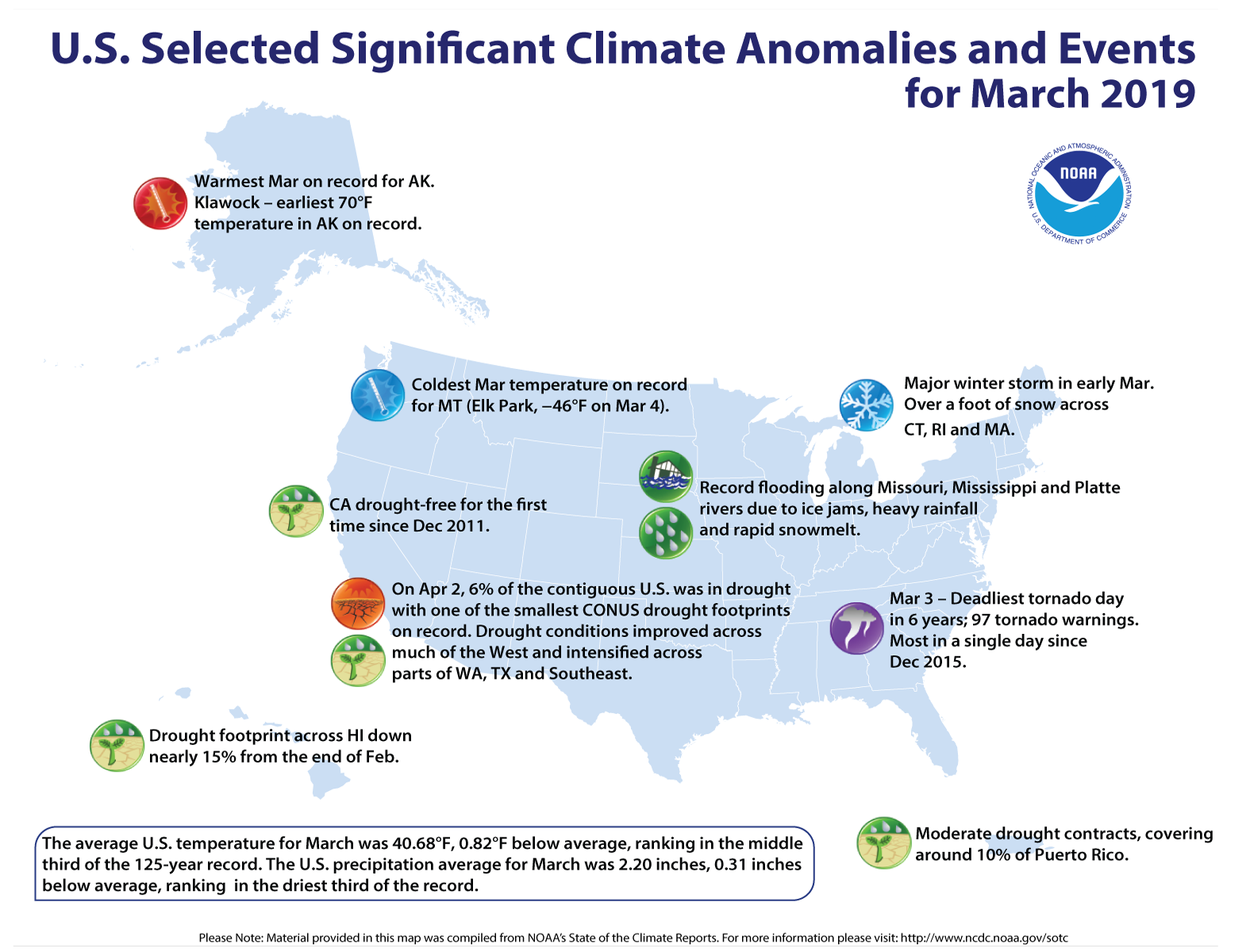
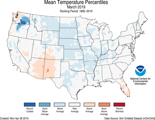
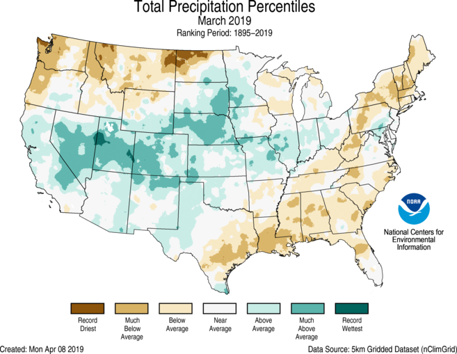
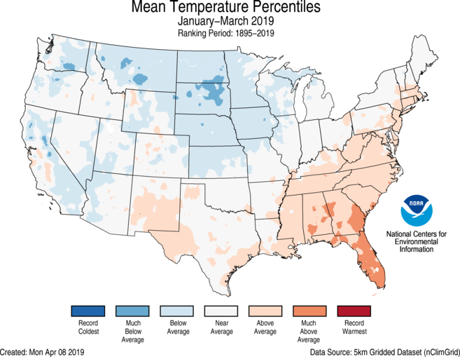
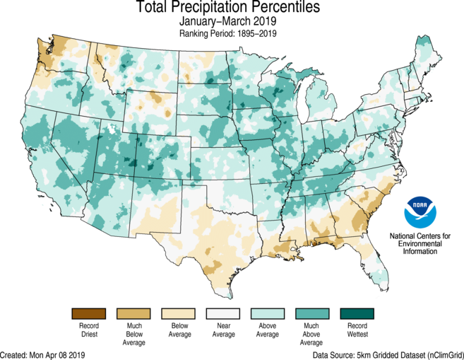
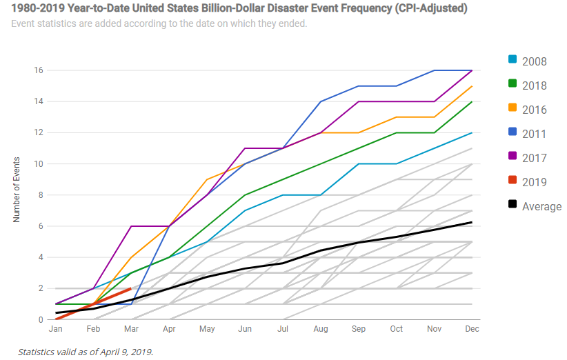
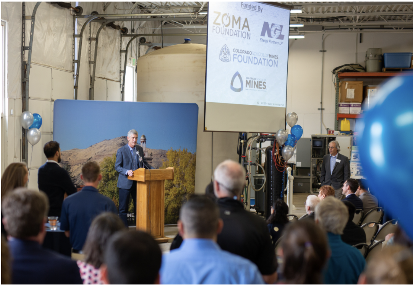


![The U.S. Whitewater Rafting Team trains on its custom-built raft in December on the Colorado River. The team was on pace for a record descent of the 277-mile canyon [January 14-15, 2017] when a wave broke the frame and punctured a tube. Photo Special to The Denver Post by Forest Woodward.](https://i0.wp.com/coyotegulch.blog/wp-content/uploads/2017/01/whitewaterraftgrandcanyonrecordattempt012017denverpost.jpg?w=453&h=302&ssl=1 "BZXXGRANDCANYON3.jpg")