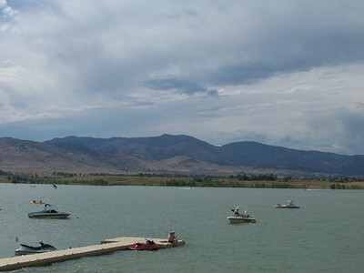
As confirmed cases of invasive mussel contamination on out-of-state boats reach record numbers in areas close to Boulder County, local authorities say the problematic species’ profile remains low, as it traditionally has, within county borders.
Reservoirs popular with recreational users in Boulder County have policies governing what boaters have to do before putting in, efforts to decontaminate all crafts entering local waters and biology to thank for the good news…
At Longmont’s Union Reservoir, inspectors in the past 10 years have come across only two vessels contaminated with invasive mussels, and so far, none have been found this year, according to John Brim, a city parks and open space ranger.
Because only wakeless boating is allowed at Union Reservoir, it doesn’t attract boats used most often at out-of-state bodies of water known to harbor the invasive species; Lake Powell is especially notorious…
At Boulder Reservoir, cases of contaminated boats are slightly more common, with one confirmed contamination this year, and about five suspected mussel contaminations, with several of those confirmed, since 2008, according to Boulder Reservoir Manager Stacy Cole…
Between 15 and 20 decontaminations have taken place this year in Boulder, including one Monday, for boats that haven’t received a permit tag from the city or those that have and since were used on an out-of-state waterway.
“Parks and Recreation staff use a mobile decontamination unit which flushes the system including ballast tanks with high-temperature water — 140 degrees Fahrenheit — necessary to kill mussels,” Boulder spokesperson Denise White said. “The city also adds potassium hydroxide to the decontamination water to kill any possible mussels before the wastewater enters the city’s sanitary sewer system.”
Boulder boosted its precautions for this year, requiring not only an initial decontamination process for untagged boats and those coming in after a stint outside Colorado, but also an ensuing seven-day quarantine period on dry land at Boulder Reservoir and a second decontamination before the vessel is allowed back in the water. Cole said there was no particular incident that prompted the city’s move. Rather, the growing number of mussel-infested waterways in surrounding states has prompted such prevention initiatives across the state, she said…
Boaters can receive their first decontamination for free from state officials in Denver, and then pay Boulder for their second decontamination at rates that vary from $35 to $175 depending on the size of the watercraft…
Broomfield protects itself from the pesky organism by disallowing boating on all its waterways.
Deal sealed for electrical co-op’s exit from Tri-State but the fee unknown
Tri-State Generation and Transmission and one of its 43 member co-operatives, Delta-Montrose Electric Association, have come to terms. Delta-Montrose will be leaving the “family,” as Tri-State members are sometimes called, on about May 1, 2022.
What it cost Delta-Montrose to exit its all-requirements contract with Tri-State, however, will remain a secret until then. The figure was redacted in the settlement agreement filed with the Colorado Public Utilities Commission last Friday. The figure can become public after the split occurs next year, according to Virginia Harman, the chief operating officer for Delta-Montrose.
The split reflects a fundamental disagreement over the future of electrical generation and the pace of change that has festered for about 15 years. Those different visions became apparent in about 2005 as Tri-State managers sought to build a major new coal plant near Holcomb, Kan., in partnership with Sunflower Electric.
The utilities were shocked when Kansas denied a permit for the plant, based on the time at the still-novel grounds of its carbon dioxide pollution. When Tri-State finally got its permit for the coal plant in 2017, it had spent nearly $100 million with nothing to show.
Meanwhile, the electrical world had turned upside down. Wind had become the cheap energy, not coal, and it was being integrated into power supplies effectively. Even solar was in cost competitive in places.
Along among the then 44 member cooperatives, only Kit Carson and Delta-Montrose had refused the 10-year contact extensions to 2050 that Tri-State had wanted to satisfy money markets for long-term loans. Their contracts remained at 2040. The contracts of other member co-ops—including those serving Durango, Telluride, Crested Butte and Winter Park—go until 2050.
Kit Carson was the first to get out. In 2016, assisted by Guzman, it paid the $37 million exit fee required by Tri-State and set out, also with the assistance of Guzman, to develop solar farms in dispersed parts of its service territory in northern New Mexico. It aims to have 100% solar capability by the end of 2022.
In November 2016, Delta-Montrose informed Tri-State it wanted to buy out its contract, too. It asked for exit figure. The negotiations did not yield an acceptable number to both, and in December Delta-Montrose asked the Colorado Public Utilities Commission to arbitrate. The PUC agreed over protests by Tri-State that the PUC had no authority. A week was set aside in June, later delayed to begin Aug. 12, for the case.
No figures have ever been publicly revealed by either Tri-State or Delta-Montrose, although a court document filed early in July reported that Tri-State’s price had been reduced 40%.
Meanwhile, Tri-State got approval from its members to seek regulation for rate making by the Federal Energy Regulatory Commission. That could possibly have moved the jurisdiction over the Delta-Montrose exit to Washington. It would not affect review by Colorado, New Mexico or other states in which Tri-State operators of resource planning.
Delta-Montrose and Guzman have not completed plans for how the co-operative may develop its local energy resources. The co-op had reached Tri-State’s 5% allowance for local generation by harnessing of fast-moving water in an irrigation conveyance called the South Canal.
For Tri-State’s new chief executive, Duane Highley, the task at hand may be how to discourage more exits by other member co-op. Tri-State has argued that it moved slowly but has now is in a position to realize much lower prices for renewable energy generation. It is moving forward on both wind and solar projects in eastern Colorado.
Delta-Montrose, with 33,000 members, is among the larger co-ops in Tri-State. But even larger one, who together represent nearly half the electrical load supplied by Tri-STate have all dissatisfaction with Tri-State’s slow movement away from coal-fired generation.
In Southwestern Colorado, Durango-based La Plata Electric recently asked for an exit figure, too.
Along the Front Range of Colorado, United Power, by far the largest-coop, with 91,000 members and booming demand from oil and gas operators north of Denver, has wanted more renewable energy and greater ability to develop its own resources. Poudre Valley has adopted a 100% clean energy goal.
Delta-Montrose, with 33,000 members, is easily among the 10 largest co-ops.
The settlement agreement filed with the PUC says DMEA “shall not assist any other Tri-State member in pursuing withdrawal from Tri-State. The agreement also says that DMEA and Tri-State agree to not disparage each other.
More than 30% of Tri-State’s generation comes from renewables, mostly from hydropower. This total is little different from that of Xcel Energy. But Xcel in 2017 announced plans to close two of its aging coal plants, leaving it at 55 percent renewable generation in Colorado.
Tri-State, too, is closing coal plants. A coal plant at Nucla, in southwestern Colorado, west of Telluride, will close early next year, several years earlier than previously scheduled. However, it’s small by coal plant standards, with a nameplate capacity of 114 megawatts, and operates only part time.
A larger reduction is scheduled to occur by 2025 when one of three coal units at Craig, in northwestern Colorado, will be retired. But a Tri-State official, speaking at a beneficial electrification conference in Denver during June, suggested that a second coal plant could also be retired early. That second coal unit is co-owned with other utilities in Colorado and other states, all of whom have indicated plans to hasten their retreats from coal.
Tri-State last week also announced a partnership with former Colorado Gov. Bill Ritter’s Center for the New Energy Economy to facilitate a stakeholder process intended to help define what Tri-State calls a Responsible Energy Plan. See: Tri-State Announces Responsible Energy Plan 20190717
A long-standing legal dispute in the Colorado energy industry came to an end Monday when Delta-Montrose Electric Association announced it would withdraw from its membership in Tri-State Generation & Transmission, effective May 1, 2020.
The early withdrawal is part of a definitive settlement agreement between the two energy companies.
Delta-Montrose Electric Association, a rural utility provider on the Western Slope, said it underwent the effort to secure cheaper rates for customers and purchase more renewable energy.
As demand shrinks and the industry retracts, counties and the state are in an untenable situation.
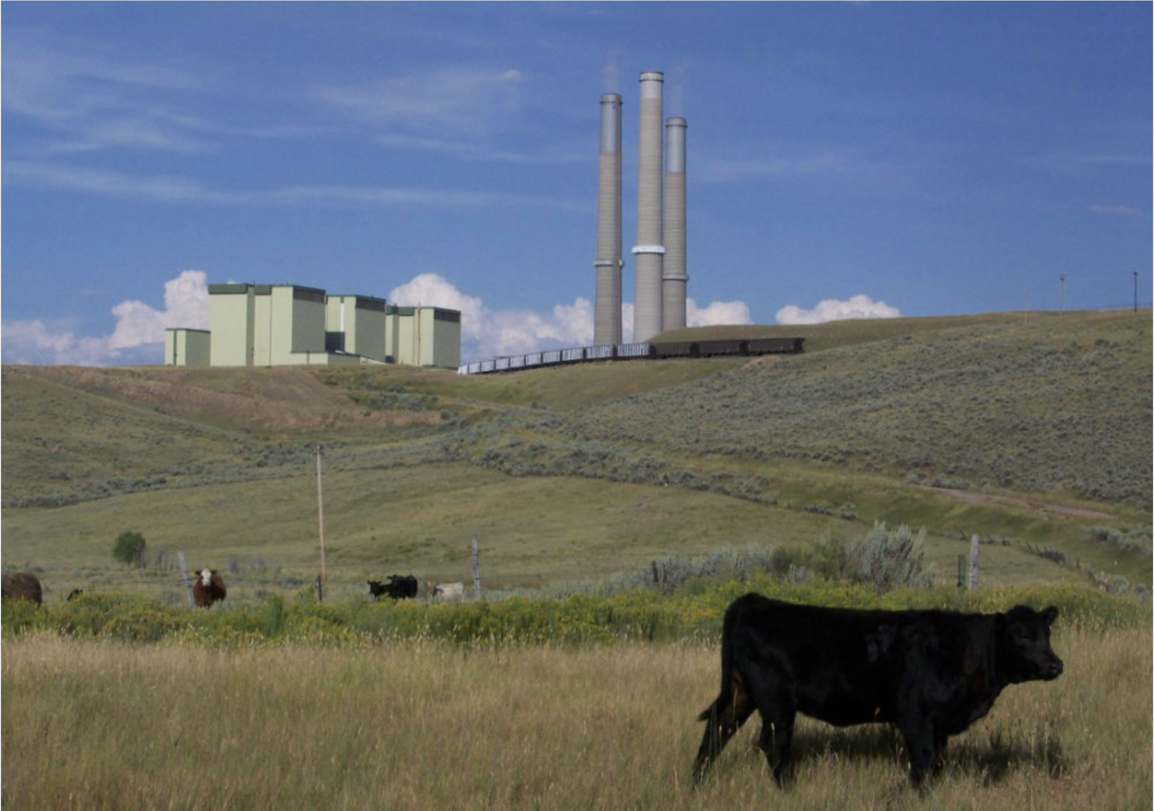
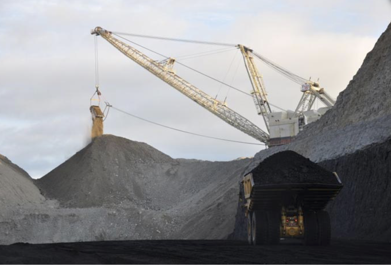
Over the last few months, Wyoming’s struggling coal industry has gone from bad to worse. In May, the third-largest mining company, Cloud Peak, filed for bankruptcy, leaving the pensions and future of hundreds of employees in jeopardy. Less than two months later, Blackjewel, Wyoming’s fourth-largest coal company, abruptly declared bankruptcy, idling mines and putting hundreds out of work.
As the hits against coal pile up, so do questions about the future of Wyoming’s coal mines and the economy they support. With even the Trump administration’s regulatory rollback’s offering no relief, the largest coal-producing state in the country is being forced to grapple with the decline of the industry that has long undergirded its economy.
Spring Creek Coal Mine. Photo credit: Cloud Peak Energy
Wyoming’s politicians have gone to considerable lengths to prop up the coal industry. Now, the state is walking an increasingly threadbare tightrope as it manages coal’s future. Lean too far towards promoting mining, with lax tax collection standards and cleanup requirements, and state and local governments may get stuck with cleaning up the mess the failed businesses leave behind. Tilt towards proactive tax collection and strong reclamation requirements, and risk becoming another factor pushing the coal economy into oblivion.
The depth of the current downturn was unforeseen even a couple years ago, said University of Wyoming economist Rob Godby. The Obama administration’s Clean Power Plan, which sought carbon emission reductions from the power sector, was expected to deal the industry a blow, and it was discarded by the Trump administration, anyway. Instead, it was cheap natural gas and to a lesser extent renewable energy sources — and the resulting shrink in demand for coal — that ended up knocking coal companies to their knees, said Godby.
The diminishing value of coal draws ominous parallels to the subprime mortgage bubble that precipitated the Great Recession of 2008. But the coal free-fall is likely to be even worse than the housing market crash, because houses always retained some value, while coal mines could end up worthless if investors see costs that outstrip potential income, said energy analyst Clark Williams-Derry of the Sightline Institute, a sustainability think tank.
With mines likely to close, Wyoming is entering a new and untested paradigm for coal — reclamation without production. Typically, mines clean up their mess as they go; if they don’t, then the state can shut down operations until they do. But once a company goes broke and the mine shuts down, the only funds for cleanup are reclamation bonds, which critics say are inadequate in Wyoming.
The Powder River Basin Resource Council has been pushing Wyoming’s Department of Environmental Quality to look harder at the balance sheet of companies before it allows them to buy mines. This effort has kept cleanup obligations from being transferred to Blackjewel and then possibly going unfunded during the company’s bankruptcy. Williams-Derry called that a “heroically smart move,” because now the cleanup costs are staying with the mines’ former owner instead of potentially ending up with the state.
In pushing for strong cleanup requirements, resource council Executive Director Joyce Evans said that requiring mines to do proper reclamation would create more jobs for out-of-work miners. Still, she said she doesn’t expect miners to embrace the prospect, even if the reclamation jobs pay just as well as mining, because of Wyoming’s history of “social dependency on coal and energy.”
Meanwhile, coal’s collapse is delivering a one-two punch of unemployment and unpaid taxes to Campbell County, where more than one-third of all coal in the U.S. is mined from the Powder River Basin. The Blackjewel bankruptcy put nearly 600 miners out of work, and the county may never get $37 million in taxes owed by the company, which was run by Appalachian coal executive Jeff Hoops. This is partly because of the county’s lenient approach to collecting back taxes. “We’ve been dealing with delinquent taxes and Mr. Hoops for several months in an amicable way to try and resolve (the unpaid taxes) without pushing them into what has happened now and keep our miners working,” said County Commissioner Del Shelstad in a July 3 meeting in Gillette.
Now, creditors are in line before the county to collect in bankruptcy court. For Gillette’s state Sen. Michael Von Flatern, an ex-coal miner, the delayed county tax payments and ongoing dependence on minerals “is starting not to make sense.” He described the current bankruptcies as the canary in the coal mine for the industry’s long-term decline. “We need to truly diversify our economy,” Von Flatern said. “We have a minerals, minerals, minerals economy.” But over next couple decades, it’s possible that there won’t be a market for Wyoming coal anymore, he said. “If Wyoming can’t do what we need to do to diversify our economy and change our tax structure, then we’ll be in the same place next time we go bust.”
Carl Segerstrom is an assistant editor at High Country News, covering Alaska, the Pacific Northwest and the Northern Rockies from Spokane, Washington. Email him at carls@hcn.org.
Here’s the update from the Colorado Water Conservation Board (Brent Newman):
The Colorado Water Conservation Board (CWCB) Project Management Team will release periodic updates on progress and accomplishments relating to the 2019 Work Plan for Intrastate Demand Management Feasibility Investigations. In this Update, we will discuss changes to the Workgroup process, the Orientation Webinar, and upcoming opportunities for engagement.
Workgroups to Proceed without Disclosure Agreement: After careful consideration of the comments and input received to date, CWCB and DNR leadership have decided that the Workgroup process will move forward without the proposed Ground Rules and Disclosure Agreement.
From Director Mitchell:
“The CWCB staff and Board have been moving forward in a process to investigate the feasibility of a demand management program in alignment with the Upper Basin Drought Contingency Plan. The Board and its staff have been in an ongoing conversation with stakeholders across Colorado about how to conduct this investigation transparently in the spirit of the Colorado Water Plan, while also providing space for a deliberative process where participants feel comfortable to freely consider complex, legally sensitive ideas and information.
“While the CWCB was contemplating asking participants to adhere to disclosure agreements out of an abundance of caution, after hearing feedback from our constituents across Colorado, the CWCB will adjust course and move forward without requesting that workgroup participants sign any disclosure agreements. Additionally, the workgroup meetings will be open to members of the public, with an opportunity for comment. As appropriate and dependent on the relevance of the workgroup discussion to interstate considerations, a non-disclosure setting may be necessary for elements of particular workgroup subject matter discussion.
“Each of the groups will work with CWCB staff to develop expectations around participation and communication in this effort. Through this investigation, I have high hopes that the groups will identify the relevant issues associated with the details of a potential demand management program and provide thoughtful feedback for staff and the CWCB Board to consider as we work through a public process with stakeholders to determine if and how demand management should be implemented in Colorado.
“The CWCB Board and State of Colorado will benefit from the workgroup participants’ expertise in Colorado River issues and water management. I have great appreciation for all of the individuals who have generously agreed to participate in the process.
“I recognize the need to maintain transparency and public participation throughout the activities of the CWCB. I appreciate those who reached out to the staff and Board with comments about our initial proposal. I sincerely hope this decision to adjust our direction provides clarity and simplifies the process for those involved in the workgroups. I look forward to continuing a meaningful public process and productive dialogue about the future of water management in Colorado.”
Online Resources: The CWCB hosted an Orientation Webinar for workgroup membership to provide an overview of the Drought Contingency Plan (DCP) process, and how demand management feasibility aligns with other efforts under the Upper Basin DCP. The Webinar also discussed the kickoff of the Workgroup process, and provided information to Workgroup membership about process and procedures. The Webinar was co-hosted in partnership with Colorado Water Congress (thanks, CWC!) The Webinar was open to the public, and the recording can be viewed here.
On July 18, CWCB staff presented on the 2019 Work Plan to the CWCB and the IBCC at the July Joint Meeting. A recording of the presentation can be found here.
First Regional Workshop Scheduled: The first regional workshop has been scheduled for Thursday, August 22nd. This workshop will be held in conjunction with the summer conference of Colorado Water Congress, at the Steamboat Grand Hotel in Steamboat Springs, Colorado. More information about CWC’s Summer Conference can be found here.
Upcoming Events: Colorado River Drought Contingency Planning and demand management feasibility investigation will be on the agenda at the following events:
Colorado Water Congress’ Summer Conference, August 20-22, 2019 in Steamboat Springs.
As always, keep an eye on basin roundtable agendas. Drought Contingency Planning and demand management feasibility are frequent topics. Roundtable schedules and agendas are available here.
For questions, comments, or more information, visit the CWCB website or email demandmanagement@state.co.us.
The Yampa River Core Trail runs right through downtown Steamboat. Photo credit City of Steamboat Springs.
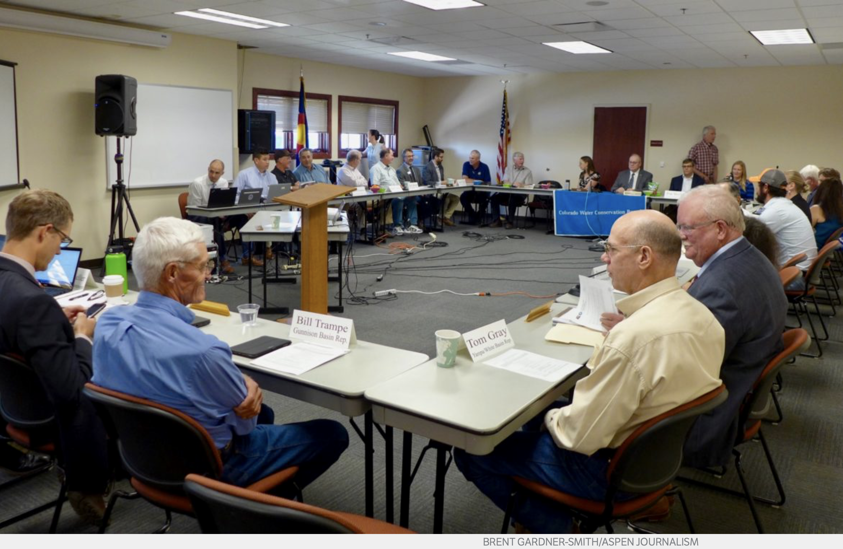
A meeting on Thursday, July 18, 2019 in Leadville between the members of the Colorado Water Conservation Board and the Interbasin Compact Committee, in a meeting room on the Colorado Mountain College campus. The CWCB members discussed the unfolding demand-management workgroup process in an unscheduled executive session, and then were challenged to explain their process. Photo credit: Brent Gardner-Smith/Aspen Journalism
State agency drops requirement for volunteer workgroup participants to sign non-disclosure agreements
After a week filled with pushback from water managers and users, especially on the Western Slope, the director of the Colorado Water Conservation Board has decided to hold upcoming workgroup meetings about a potential water-demand management effort in public and will no longer ask the workgroup volunteers to sign non-disclosure agreements or always meet behind closed doors.
“The CWCB will adjust course and move forward without requesting that workgroup participants sign any disclosure agreements,” director Becky Mitchell said in an update on the workgroup process released Sunday. “Additionally, the workgroup meetings will be open to members of the public, with an opportunity for comment.”
But Mitchell also reserved the option to shield from public view sensitive information and discussions that came up during the process.
“As appropriate and dependent on the relevance of the workgroup discussion to interstate considerations, a non-disclosure setting may be necessary for elements of particular workgroup subject matter discussion,” Mitchell wrote.
Mitchell said it was most likely that sensitive information would come up in the law and policy workgroup, which includes eight current or former water attorneys.
CWCB staff members, working closely with lawyers in the attorney general’s “defense of the Colorado River” subunit, have been crafting a process for months to investigative the feasibility of a voluntary, temporary and compensated demand-management, or water-use reduction, program in order to stay in compliance with the 1922 Colorado River Compact.
The CWCB intends to set up eight workgroups, each exploring a different aspect of a potential demand-management program in Colorado: law and policy; monitoring and verification; water-rights administration and accounting; environmental considerations; economic considerations and local government; funding; education and outreach; and agricultural impacts.
Each of the work groups is slated to meet four times over the next year, meaning there could be 32 work group meetings.
“The workgroups are kind of an extension of staff at this point. That’s how we’re seeing them,” Brent Newman, the head of CWCB’s section on Colorado River issues, told the CWCB directors in May. “They’re here to help inform staff about these solutions from a more technically diverse perspective. And then we’re going to bring those solutions to you guys.”
Asked if CWCB directors should attend the closed-door workgroup meetings, Newman advised against it.
“When you have a decision-making body like this board, having you all directly participate in some of the conversations of these working groups, it contravenes some open-meeting requirements, and we don’t want to do that,” Newman said.
The open-meetings law says that if two or more officials of a state public body, such as the CWCB, attend a meeting, then it’s a public meeting.
Steve Zansberg, an attorney at Ballard Spahr in Denver, is an expert on the state’s open-meetings law and the president of the Colorado Freedom of Information Coalition.
He said advisory committees, such as the CWCB’s proposed workgroups, are considered public bodies subject to the open-meetings law if they are appointed directly by the members of a public body, such as the CWCB directors.
But if staff members form such committees, and the committees report directly to staff members and not to a board, then they may meet behind closed doors.
“They are probably being very crafty and careful, and with the advice of the attorney general’s office, trying every which way to set these workgroups up as not being public bodies, and they are probably succeeding,” Zansberg said Friday, before Mitchell at the CWCB had changed course and opened up the meetings, or at least most of them.
Zansberg also said the Colorado Supreme Court stated in a 2008 case, Town of Marble v. Darien, that “the open-meetings law prohibits bad-faith circumvention of its requirements.”
“I’m not going to ascribe bad faith here, but it is an effort to evade or circumvent the requirements of the open-meetings law,” he said of the CWCB’s staff-meeting approach.
During the River District’s quarterly meeting in Glenwood Springs last week, the district’s general manager, Andy Mueller, brought up the CWCB’s proposed workgroup process with his board of directors, who represent 15 Western Slope counties.
Some of the directors voiced strong opposition to the CWCB’s requirement of a non-disclosure agreement and closed-door meetings, and unanimously passed a motion asking the CWCB to explain its process.
“In all my years of participating in policymaking at the state level, at the local level, I’ve never seen anything like this,” said Steve Aquafresca, who represents Mesa County on the River District board and is a former Mesa County commissioner and a former state legislator.
Marc Caitlin, a state legislator and the Montrose County representative on the River District board, said, “This idea of putting this behind closed doors, putting a gag in your mouth and having us be surprised, so wonderfully surprised, when this comes out is not going to make sense to me. I can’t believe that the CWCB believes that they can actually pull this off.”
He added: “I can’t believe the attorney general would even go along with this.”
Colorado Attorney General Phil Weiser explained his support for the CWCB’s process in a July 8 memo to the CWCB board.
He said the proposed nondisclosure agreement was meant to “strike a balance between the need for the CWCB to lead the investigative process in a manner that considers and protects the state’s ongoing strategies in interstate forums” while also “honoring the roles and perspectives of the subject matter experts” asked to participant in the workgroups.
The first version of the CWCB’s non-disclosure agreement — a six-page “confidentiality agreement” — ran into opposition from many invited workgroup members when it was released in June.
In July, a second proposed agreement — this time labeled as a “disclosure agreement” — was circulated. It was shorter but still contained two key provisions from the first proposal.
First, participants needed to agree to not attribute anything said in the closed-door workgroups. Second, the participants couldn’t share in a public setting what was said at the workgroups, unless they got permission from the CWCB.
The 74 invited participants are still being asked to volunteer as individuals and “subject-matter experts, and not as representatives of their organizations or clients, which also troubled some River District board members.
On Thursday, during a CWCB meeting in Leadville, Mueller told the CWCB directors that the River District board was seeking an explanation about the process, and that he and his staff could not participate until his board had learned more.
Mueller made his comments shortly after the CWCB directors held a long and unscheduled executive session to discuss the non-disclosure agreements.
CWCB chair Heather Dutton, who represents the Rio Grande River basin, responded by saying the board’s position on the workgroup process was still evolving.
Also during the meeting, the CWCB had invited the members of the state’s Interbasin Compact Committee to join them at the table to discuss aspects of demand management.
And Bill Trampe, a rancher from the upper Gunnison River basin who serves on the IBCC, the Gunnison Basin Roundtable, and the River District board, told the CWCB board members that their approach to the workgroup process was raising a lot of questions about demand management among his constituents on the Western Slope.
“Everybody is starting to think about how they might participate, because they like the voluntary, compensated, temporary part,” Trampe said. “And they recognize the fact that we probably better show up and participate in some fashion, so that our brethren on the east side of the mountain will also be willing to participate.
“But we know it’s going to hurt us like heck if we participate very deeply, and we’re trying to figure out how we can do it. And we feel like we’ve been shut out of this initial process. If you’re going to go behind closed doors and develop these ideas, we feel that that’s the wrong way to do it, that it should be open from the very beginning, and we can’t figure out why these different workgroups have things that they think they need to do behind closed doors,” Trampe said.
On Friday, Mitchell issued a workgroup update that said the non-disclosure agreements had been eliminated and that the meetings would be public.
That update took a softer approach to the remaining potential need for closed-door meetings and agreements to not discuss sensitive information, saying “each of the groups will work with CWCB staff to develop expectations around participation and communication in this effort.”
On Sunday, she issued a revised update that did not include that statement, but did include the new provision that some meetings could still occur, if necessary, in a “non-disclosure setting.”
In response the overall course change by the CWCB, the River District said, “We look forward to working with CWCB as they move forward with this important public-policy process. And we appreciate the deliberation that went into considering how the workgroups will do their work.”
Aspen Journalism covers rivers and water in collaboration with The Aspen Times and other Swift Communications newspaper. The Times published a version of this story on Monday, July 22, 2019.
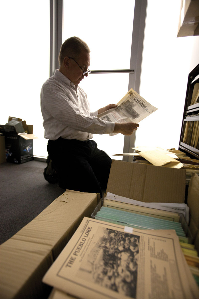
Mike Castellucci officially announced his candidacy for the Pueblo Board of Water Works on July 10.
Castellucci is a lifelong resident of Pueblo and a graduate of South High School and the University of Southern Colorado, now Colorado State University-Pueblo. This would be his first time running for an elected position.
Castellucci has worked in the finance and banking industry for over 23 years. He has owned his own business and worked for several local banks. He says his “diverse experience and knowledge will be very useful for the community as a board member on the Board of Water Works.”
Chris Woodka, a veteran reporter and editor who retired to begin a new career as a water professional, also has announced his candidacy for the Pueblo Board of Water Works.
Woodka, 64, is seeking the six-year seat being vacated by Kevin McCarthy.
“As a water professional for the past two years, and as a journalist who spent more than 30 years covering water issues, I would bring a unique skill set to Pueblo Water. I have a deep understanding of water issues in Colorado and the American West, a fundamental knowledge of the structure of Pueblo water and practical knowledge about completing complicated water projects,” Woodka said.
The Grand Valley Irrigation Canal, in Palisade, heading for Grand Junction. Photo: Brent Gardner-Smith/Aspen Journalism
FromThe Grand Junction Daily Sentinel (Alex Zorn):
Colorado Attorney General Phil Weiser met with Mesa County officials at a Grand Junction Economic Partnership roundtable discussion last Tuesday regarding ways the state office can better serve the Western Slope.
Weiser touched on the AG’s role outside of Denver and protecting Colorado water was among the main points of focus.
“Most people don’t really know what the AG does,” he began…
The Colorado Attorney General leads an office of 500 people out of Denver but, despite this, Weiser said he’s committed to having a greater presence in Grand Junction and would be open to hiring representation in the community…
Protecting the water rights of every Coloradan is a central issue.
Weiser told the roundtable he doesn’t want to see a future in which Colorado doesn’t have Palisade peaches because of water access rights.
He referenced Crowley County, where water rights were sold off and it devastated the community, and Weiser doesn’t want to see a similar situation in this part of the state.
As far as water rights are concerned, Weiser said he doesn’t want to see Coloradoans fighting with each other, nor does he want Colorado fighting with other states for the precious resource.
“This is going to be among the most important things we do,” he said…
Weiser and state Rep. Matt Soper will be hosting a town hall at the Colorado Mesa University Center Monday beginning at 5:30 p.m. The event will be in CMU’s University Center, Room 213, and parking will be provided in the parking garage off of 12th Street.
With concerns looming large over two expensive proposals to divert one of the Front Range’s most beloved rivers, the Cache la Poudre, to store supply for 15 Northern Colorado water providers and another to transport water out of the basin to Thornton via pipeline, more planning to keep water rights in the region for agricultural use is economically essential.
That is, unless Front Range residents approve of the disappearance of local farms and the volume of business, environmental benefit and cultural impact provided by the ag sector, panelists at a BizWest-sponsored discussion on water and energy policy said Thursday at the Larimer County Fairgrounds.
Northern Water is still working through the permitting process for the two reservoirs with hopes of filling them by 2028, while Thornton is suing Larimer County over a land use denial for the pipeline…
The construction boom across the Front Range has greatly expanded the markets for water shares, especially Colorado-Big Thompson units representing flow brought from the wet Western Slope to the dry Front Range through the Northern Water-managed Colorado-Big Thompson system. Those units can be transferred from farmers to municipalities without the hassle of water court…
As a result, market pressure has fallen on native basin water owners, whose values also are ticking upward.
“The level of scarcity has really come to bear since the last economic upturn,” Greeley Water and Sewer Director Sean Chambers said. “Water leaving northern Colorado is an export of our ability to grow now and in the future in a sustainable way. Denver metro economies can still find value even in this hyper-inflated (water) marketplace.”
[…]
Regulations or legislation to restrict water resources from being transported outside the boundaries of their local basins, though, are likely not a fair solution to farmers, former Northern Water manager Eric Wilkinson contends.
Because water rights in the state are considered property, agriculturalists should have the option to take advantage of selling them for fair market value, Wilkinson said. New public entities might need to be conceived or old ones redesigned to compete for water rights with the mission of preserving them for local use, he said.
But building political will for such efforts has been a challenge.While Boulder County taxpayers have funded aggressive open space programs that have resulted in the purchase and protection of vast swaths of farmland, voters in neighboring areas with conservative roots have been more cautious.
Yet there is urgency to gain the political capital needed to invest in the preservation of farmland through open space programs or otherwise before the land and water become too valuable, and thus tempting for owners to sell. Maps of the growth management areas of the municipalities north and east of Longmont show they have collectively targeted practically all undeveloped land along the Interstate 25 corridor to the Wyoming border.
“The Greeley City Council is thinking about trying to establish an open space tax of some kind,” Greeley City Manager Roy Otto said in an interview. “But I think to make this work, Weld County as a whole will have to do something like that, as well.”
Otto added praise for open space programs in Boulder and Larimer counties as a means of protecting land and ag, but said an “honest” education effort about peripheral consequences of limiting the development of municipal boundaries through dedicated open space has to occur with Longmont’s eastern neighbors.
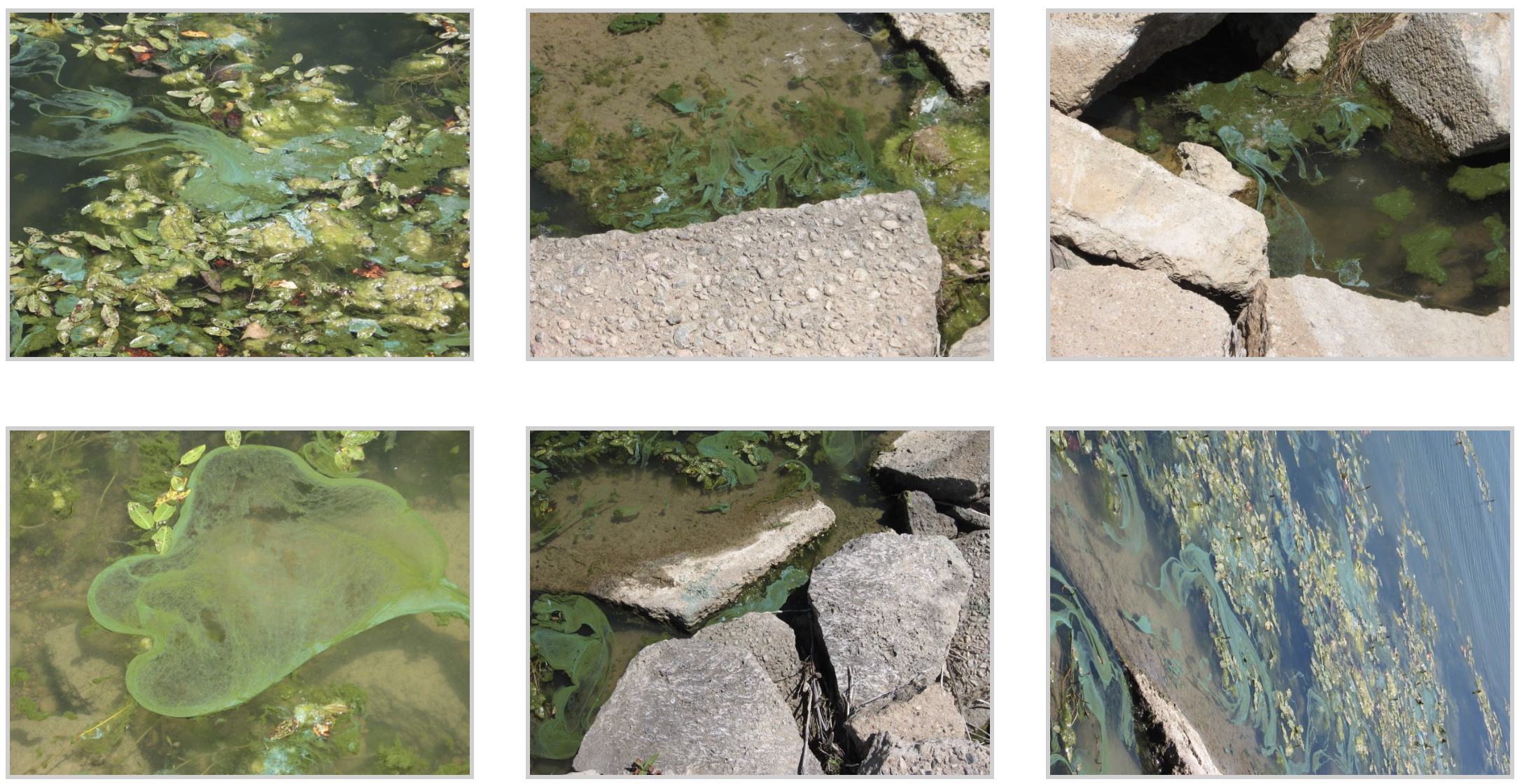
This is a precautionary alert to advise all users of the Timnath Reservoir that Blue-Green Algae (Cyanobacteria) may be present in areas of Timnath Reservoir. Blue-Green algae can cause illnesses such as; diarrhea, abdominal pain, eye and skin irritation, and rashes. Experts advise against wading or swimming in areas where Blue-Green Algae is present, and keeping pets and livestock away.
The photos below were taken At Timnath Reservoir.
Cyanobacteria blooms Timnath Reservoir July 2019. Photo credit: The Town of Timnath
How to spot blue-green algae
A cyanobacteria bloom can turn water turquoise, bright green, pea green, brown or other unusual shades. Rafts of froth or foam sometimes appear.
At times blooms appear along shorelines and in bays and other areas shielded from wind and waves, and often follow periods of hot, calm weather and can persist into the fall.
Experts advise against wading or swimming in water with this appearance, and keeping dogs and livestock away.
To protect yourself and your pets:
avoid contact with blue-green algae blooms
Do not swim or wade in water where blue-green algae is visible
Do not drink or cook with water from this reservoir
Clean fish well and discard guts – avoid eating fish that look unhealthy
If contact occurs, wash with clean water as soon as possible
If, after being in the reservoir, you or your animals have sudden or unexplained sickness call your doctor or veterinarian.
Driven by desire to know what lies beneath, crews bore deeper every day
EPA crews last week started to bore into the ground in what is expected to be a more than 500-foot journey to reach the American Tunnel in hopes of better understanding a complex network of mines in the upper Cement Creek basin, a tributary of the Animas.
It’s these mines that are considered the worst polluters of heavy metals seeping into the Animas River…
In 1959, however, when Standard Metals announced it was going to reopen the Sunnyside Mine, the now-defunct company also said it was going to extend the American Tunnel from the vast mine network to Gladstone, an old mining community about 10 miles north of Silverton.
Extending the tunnel solved two costly problems for previous mining companies: It allowed for ore to be easily taken out for further processing, and it created a better system for groundwater to exit the mine.
The move led to a three-decade period of prosperity, said Bev Rich, Silverton native and director of the San Juan County Historical Society.
“They discovered some really good gold, and a good reserve of it,” she said.
In 1991, however, the Sunnyside Mine, which had been taken over by Sunnyside Gold Corp., closed as a result of depressed gold prices. What was left behind, in terms of the American Tunnel, was a never-ending pathway for acidic discharges.
Sunnyside Gold initially pulled water coming out of the American Tunnel into a treatment plant, a costly yet effective method that took metals out of Cement Creek and greatly improved the quality of the Animas River.
But, in a move hoping to end its financial involvement in the Animas River basin, Sunnyside Gold entered an agreement in 1996 with the state of Colorado to shut down the treatment plant and instead install three bulkheads that essentially function as plugs to stem the acidic flow.
By 2001, though, it was thought the water had backed up and reached capacity within the Sunnyside Mine network, which has led some researchers and experts familiar with the basin to believe that water is spilling out into adjacent mines, like the Gold King.
Sunnyside Gold, which was purchased by international mining conglomerate Kinross Gold Corp. in 2003, has adamantly denied that its mine pool is the cause of discharge from other mines, saying there is no factual evidence for the assertion…
One thing is clear: After the Bonita Peak Mining District Superfund site was officially listed in fall 2016, EPA made it a priority to figure out what was happening with water movement underground. This past winter, a helicopter carrying an electromagnetic mapping device made the rounds around Silverton to try to understand the geological makeup of the San Juan Mountains, and hopefully, its groundwater workings.
This desire to know what lies beneath is what ultimately led to EPA drilling into the American Tunnel…
Guy, with the EPA, said it could take almost a month to reach the American Tunnel, boring through 20 to 30 feet of hard rock per day. The intent is to reach a portion of the tunnel between bulkheads 2 and 3, but it’s going to take more wells and more research to form a better grasp on how water moves underground in this geological puzzle…
Butler said the project plays into the larger question surrounding the Bonita Peak Superfund site: What is the ultimate strategy to fix issues in the upper Cement Creek area? EPA, for its part, has said that question warrants further investigation and time before being answered.
…water in Lake Powell would come within inches of topping the dam’s massive spillway gates as engineers frantically tried everything they could think of, rigging 4-by-8 sheets of plywood to extend the top of the gates and releasing more than half a million gallons per second into the Colorado River. Before it was over, the force of the water releases would gouge house-size holes in the dam’s crippled concrete spillways. The white water would tinge red from the bedrock sandstone, and ominous rumbling sounds would be heard as boulders the size of cars belched from one of the spillways into the river. The more water the engineers released, the more damage they did. But they had no choice.
“We were sitting on a pretty good catastrophe waiting to happen,” said Art Grosch, an electrician who worked at the dam and ran electrical cable into the mangled spillways.
“That lake (Powell) is 190 miles long and has something like 2,300 miles of shoreline,” he said. “And it was rising a foot a day.”
[…]
The 1982-83 El Niño was the strongest ever recorded at the time. The tales of its fury were recounted in newspaper headlines of the day — and later in books and scientific journals — as it unleashed disaster on virtually every continent, from searing droughts in Australia, Africa and south Asia, to violent floods in South America… In a normal spring, the last major snowfall in the Rockies occurs around the end of March. As temperatures rise in the lower elevations, the snowpack melts slowly and creates a steady stream of runoff as temperatures rise into the higher elevations. But there was nothing normal about the spring of 1983. The late-winter snowfall of January and February was actually below normal, but in early March it accelerated and didn’t quit until May. And then, instead of increasing gradually, temperatures skyrocketed. Instead of a slow, steady flow down from the mountains, the runoff gushed…In the Rockies, every tributary of the Colorado River was running high and fast, and the Colorado itself was running at 100,000 cubic feet per second — enough water to cover the entire 517 square miles of Phoenix in 6 inches of water in less than a day. And all that water was barreling into Lake Powell toward a choke point only a quarter of a mile wide. The only thing in its way was Glen Canyon Dam, which had only been completed 20 years before and had only been filled close to capacity once…
Gamble and his team were already releasing the maximum amount of water possible, about 40,000 cfs, through the eight massive turbines in the dam’s power plant. But as more and more water gushed into Lake Powell, Gamble knew he would have to begin releasing water through the dam’s two spillways, two massive tunnels bored into the sandstone on either side of the dam and running parallel to the river. The spillways are 41 feet in diameter — picture the height of a Boeing 737 from the runway to the tip of the tail — and extend more than half a mile, beginning about 600 feet upstream of the dam and emptying out a few hundred feet on the downstream side. Each tunnel is lined with concrete 3 feet thick and is controlled by colossal steel gates at the top — 52 feet tall and weighing 350,000 pounds — that control how much water is released. At the bottom of each is a “flip bucket,” a sort of 40-foot ski jump that sends the water into the air before it hits the river, dissipating its energy and controlling erosion. The first third of each spillway tunnel drops more than 500 feet in elevation from lake level at a 55-degree angle beforeintersecting with horizontal tunnels that were originally drilled to divert water around the dam while it was being built. The upstream portions of the diversion tunnels, which connected directly with the reservoir, were sealed with giant concrete plugs more than 150 feet long. Using the original diversion tunnels allowed the bureau to save time and millions of dollars by not having to drill thousands of more feet and line the new tunnels with concrete. When the spillways are wide open, they are capable of releasing 276,000 cubic feet of water per second, more than 2 million gallons a second, from the reservoir. That number was based on detailed studies of peak flows down the Colorado through history, both the 100 years of recorded history by man and the eons of geologic history recorded in the strata of the canyon walls…
On June 2, as the water surged toward the dam, it was just inches below the spillway gates. Engineers opened the left gate and began releasing 10,000 cfs, enough to fill 450 backyard swimming pools every minute, but still only a fraction of capacity. Three days later, they doubled the flow to 20,000 cfs and planned to open the gates even more. But early the next morning, on June 6, engineers began to hear strange rumbling noises from somewhere deep in the dam works…As the sun came up, Gamble stood on a platform above the spillway, which for two days had been sending an elegant arc of white water into the river below. But in the early morning light, Gamble could see large chunks of something — probably rocks or chunks of concrete the size of office chairs — being ejected into the river. And the white water had taken on a reddish tint, a hint that the spillway’s 3-foot concrete lining had somehow been breached and the native red sandstone that gave the Colorado its name was washing into the river.
Update: Post corrected to include the link to my Coyote Gulch post.
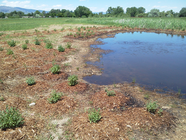
Colorado Parks and Wildlife (CPW) is seeking applications for wetland and riparian restoration, enhancement, and creation projects to support its Wetlands Program Strategic Plan.
CPW will award up to $1.3 million in funds from Great Outdoors Colorado (GOCO) to projects in Colorado that support the Wetlands Program Strategic Plan’s two main goals:
1. Improve the distribution and abundance of ducks, and opportunities for public waterfowl hunting.
2. Improve the status of declining or at-risk species.
The Colorado Wetlands for Wildlife Program is a voluntary, collaborative, and incentive-based program to restore, enhance and create wetlands and riparian areas in Colorado. Funds are allocated annually to the program and projects are recommended for funding by a CPW committee with final approval by the Director.
“Wetlands are so important,” said CPW Wetlands Program Coordinator Brian Sullivan. “They comprise less than two percent of Colorado’s landscape but provide benefits to over 75 percent of the species in the state, including waterfowl and several declining species. Since the beginning of major settlement activities, Colorado has lost half of its wetlands.”
Since its inception in 1997, the Colorado Wetlands Program has preserved, restored, enhanced or created almost 220,000 acres of wetlands and adjacent habitat and more than 200 miles of streams. The partnership is responsible for almost $40 million in total funding devoted to wetland and riparian preservation in Colorado.
See how Denver Water is addressing neighbors’ concerns about the Gross Reservoir Expansion Project. The post Reducing the impacts of a big expansion appeared first on News on TAP.
Denver Water is asking the U.S. Environmental Protection Agency for a rare exemption to the Safe Drinking Water Act, the latest move in the utility’s long-running legal dispute with state health officials over how best to keep lead out of its customers’ tap water.
In exchange for the exemption, the water utility, which serves 1.4 million people in metro Denver, is offering to spend more than $300 million replacing up to 90,000 lead service lines.
Though lead isn’t present in Denver’s treated water, it can leach into water as it is delivered to homes via these older, customer-owned water pipes. The contaminant, even in small amounts, is considered unsafe, especially for children.
In addition to replacing the lines, Denver Water has also offered to alter its water treatment protocols, conduct an extensive public education campaign, and provide free lead filters to customers whose water supplies are at risk of contamination.
The EPA will begin public hearings next month to consider the utility’s request and determine whether its proposed approach is as good or better than using an additive called orthophosphate to control corrosion from lead pipes. The state health department, backed by the EPA, ordered the utility to use orthophosphate as a corrosion-control measure last year and gave the utility until March of 2020 to implement the new treatment process.
Within weeks of the state’s order, which came in March of 2018, the City of Aurora, the Metropolitan Wastewater Reclamation District, and the Denver Greenway Foundation sued to stop the order, saying that the addition of orthophosphate to drinking water could cause millions of dollars in damage to the South Platte River watershed and would cause wastewater treatment costs to rise. Denver Water eventually joined the suit. Settlement talks since then have failed to yield an agreement.
Denver Water said it believes the alternate approach it is proposing has merit.
“We would attack the source of the problem and ultimately, at the end of the day, we believe that this could be a more effective approach than adding orthophosphate,” said Denver Water CEO Jim Lochhead.
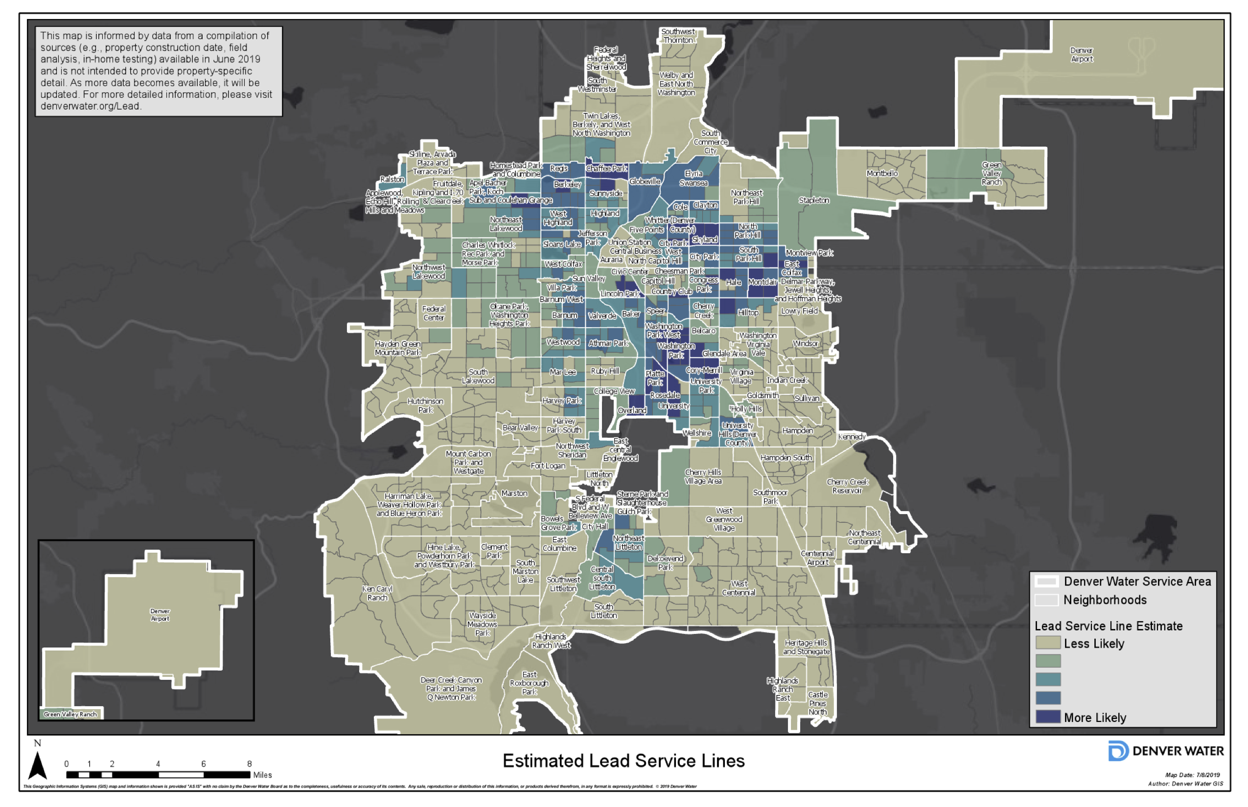
Graphic via Denver Water
Thousands of Denver-area homes built prior to 1951 are at risk of having lead-contaminated water due to aging service lines. A map compiled by Denver Water shows more than a dozen neighborhoods, including parts of Berkeley, Washington Park and Montclair, as being most at risk. Dozens of other neighborhoods on the map are less likely to face contamination, based on an analysis Denver Water has done which looks at such variables as the years in which neighborhoods were constructed and results of past water sampling.
Denver Water has been monitoring and testing customers’ tap water since 2012, when a routine sampling project showed lead in some taps that exceeded allowable levels.
Since then, the utility has conducted a series of studies to determine the best method for ensuring its water is not corrosive, and had previously offered to adjust the PH balance of its water to mitigate the problem. Up until now, it had also offered to replace a few hundred lead lines a year as maintenance on its system required, leaving any other replacement activity to homeowners and developers.
At that rate, it would have taken up to 50 years before all of Denver’s lead service lines were replaced.
The issue is complex for water providers. Adding orthophosphate is a highly effective way to eliminate lead because it dramatically reduces the corrosion in pipes, making it more difficult for lead to leach into drinking water. But as drinking water is used and then flushed into the wastewater treatment system, the phosphorous must be removed because it causes algal blooms and other environmental issues in waterways. Wastewater treatment operators are required to remove it before they return treated wastewater to streams.
In the seven years since Denver Water became aware of the problem, thousands of Denver residents have continued to be exposed to lead, but the extent of the problem isn’t clear. As part of its monitoring program, the utility has processed 5,600 customer requests for lead testing, with 2,000 of these showing lead levels of at least 1 part per billion, indicating the likely presence of lead service lines, according to Denver Water spokesman Travis Thompson. The Safe Drinking Water Act requires education and treatment when levels exceed 15 parts per billion.
What Denver is experiencing is much less severe than in some cities, such as Flint, Mich., where lead levels in tap water were hundreds of times higher before being discovered in 2015. Still, like other older urban areas, such as New York City and Washington, D.C., Denver must find a way to eliminate the lead or face legal action from the state and federal government.
Tyson Ingels, lead drinking water engineer for the Colorado Department of Public Health and Environment, said his agency would consider the evidence Denver Water presents to the EPA in August before it makes a decision about whether to support Denver’s exemption request. The EPA has so far supported the state’s orthophosphate order.
“Denver is seeking to demonstrate that this alternative is as good or maybe better at reducing lead at customers’ taps. The CDPHE is going to evaluate the evidence when it is submitted,” Ingels said.
Whether the utility will win the exemption isn’t clear. According to the CDPHE, just two exemptions in this area have been granted by the EPA.
“It’s going to be difficult,” said Alan Roberson, executive director of the Washington, D.C.-based Association of State Drinking Water Administrators. “It would have been tough before Flint, and it’s tougher now.”
Denver public health officials said they are supportive of the utility’s exemption request because it offers a more holistic solution to the problem, one that encompasses public health and the environment.
Elizabeth Scherer, air and water manager at the Denver Department of Public Health, said education and follow-up on the problem are a critical part of what Denver Water is proposing. “Denver Water and the city understand that education is a big component of the process and that outreach to non-English speakers and low-income communities will need to occur to make sure folks are comfortable with this approach.”
The EPA will hold hearings next month to gather the public’s input on the issue and is slated to make a decision by October. If the EPA does not grant the variance, then Denver will proceed with adding orthophosphate to its drinking water.
From the U.S. Department of Agriculture (Deb Schweizer):
In recent decades the number, severity and overall size of wildfires has increased across much of the U.S. In fact, the 2018 wildfire season in California recorded the largest fire in acres burned, most destructive fire in property loss and deadliest fires in the state’s history.
But for many USDA Forest Service employees, fire season is something they remember from the start of their careers, when they quickly learned there were five seasons: winter, spring, summer, fall and fire season. However, wildfire is year-round for much of the United States and the Forest Service is shifting to the concept of a fire year.
Wildfire season has become longer based on conditions that allow fires to start and to burn—winter snows are melting earlier and rain is coming later in the fall. What was once a four-month fire season now lasts six to eight months. For example, fires in recent years have burned well outside of the typical fire season throughout California, Arizona, New Mexico, Tennessee and New Jersey. Fires in the winter months are becoming part of the norm.
Other factors contributing to longer fire seasons include extended drought, tree mortality from pine beetles and invasive species such as cheat grass that allow fire to ignite easily and spread rapidly. Added to all this were policies that encouraged aggressive fire suppression for more than a century. These policies had the effect of allowing fuels to accumulate, leading fires to grow in size and intensity.
All these conditions are making wildfires harder to control and allowing forests to hold fire longer. For years, agencies relied on seasonal firefighters for summer months, but now that wildfires are burning into the winter, they need to reevaluate their hiring plans. Wildland firefighting agencies also need to evaluate the way they conduct training for year-round fire, as well as how to handle the inevitable workforce fatigue.
Forest Service crews plan for wildfire year-round. They know that it isn’t a matter of if there will be a fire, but when. They proactively pursue fuel reduction treatments like mechanical thinning and prescribed fires. When conditions are favorable, options such as these reduce the risk of catastrophic wildfires. Even in a year like this, which has been unusually wet and cool, fire managers see opportunities to prepare for wildfires. The Forest Service is committed to an all-lands response and works with state and local agencies in mutual aid and to reduce risk.
Residents who live in fire-prone areas must also plan and live in fire adapted communities. Defensible space, structure hardening and family plans for a possible evacuation, including pets, should be part of living in the wildland-urban interface. Nearly 90% of wildfires are human-caused, so preventing wildfire is important.
Now that we must plan for a fire year, we all have roles to play. What are you doing to help?
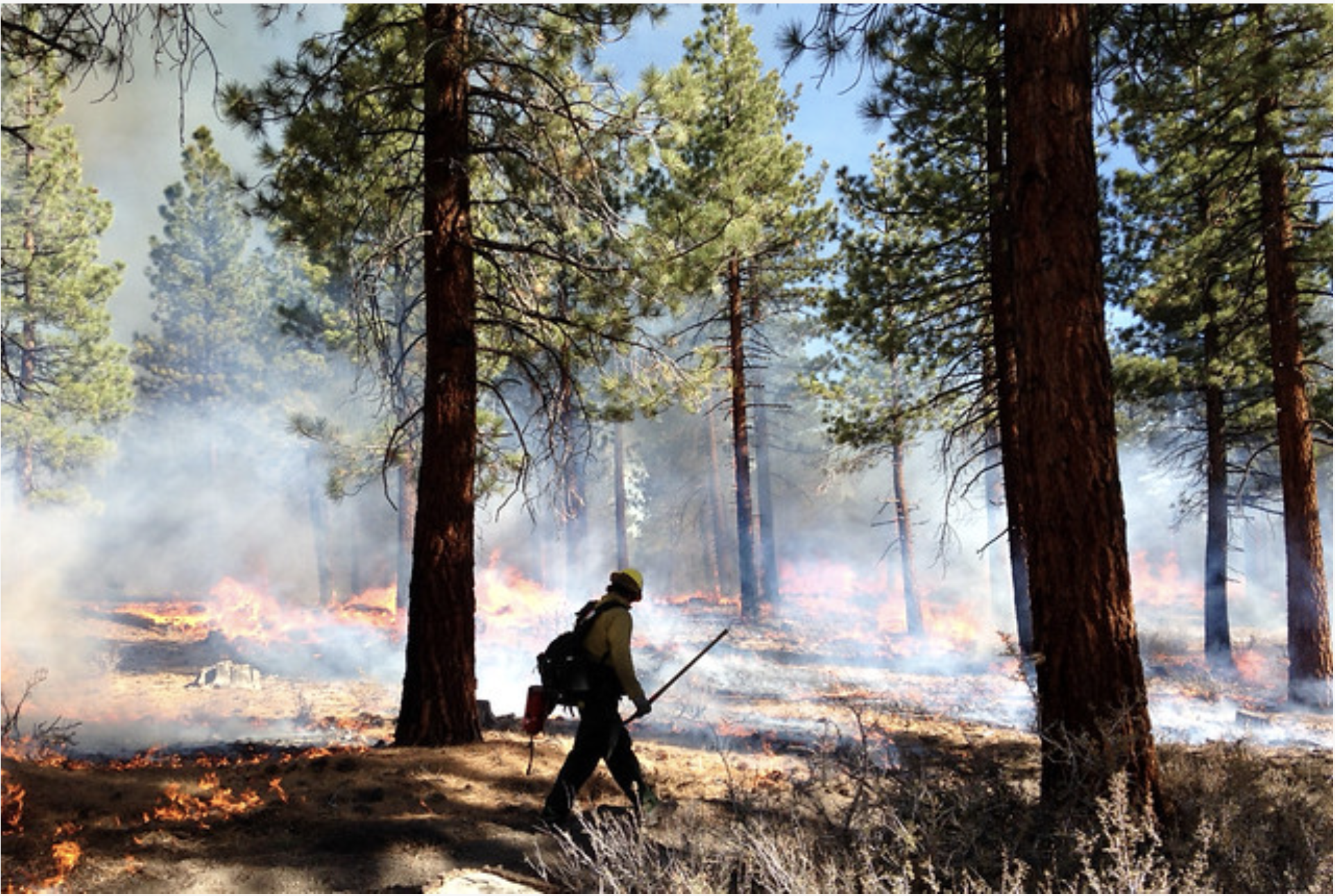
Prescribed fires are conducted in specific areas under desired conditions to reduce hazardous fuels build-up and restore the natural role of fire on the landscape. USDA Forest Service photo
Sean Tonner with Renewable Water Resources (RWR), who is peddling a water export plan he says is finding support among farmers and ranchers in the Valley, presented his plan to the town of Saguache last month during a town board meeting.
A former chief of staff for Gov. Bill Owen, who supported the plan, Tonner also worked with former State Senator Greg Brophy and other government officials on the project. Currently Tonner owns the 11,500-acre Gary Boyce ranch, purchased from Boyce’s wife following his death. He also leases grazing land in the same area. Tonner says he will retire the water rights for 3,000 of those acres.
He also said he could possibly retire the water rights to, for example, North Star Farms, and other area farms and ranches.
Tonner claims less than two percent of the annual confined aquifer recharge — 500,000 acre-feet — is needed by the Front Range. Farmers could sell all or a portion of their water rights to RWR for twice the going amount. A total of $60 million has been set aside to procure water rights.
Already enough Saguache County farmers and ranchers have agreed to sell their water rights to satisfy the proposed 22,000 acre-feet project, Tonner reported. The plan is said to be able to retire more than 30,000 acre-feet, reducing the overall usage from the Basin. This would presumably lessen the pressure on existing rivers and streams now providing water to the Front Range.
A pipeline along Highway 285, restricted to a 22,000-acre-foot capacity, would carry the water up over Poncha Pass into Chaffee County and from there it would eventually make its way into the Platte River. There would be no adverse impact on wildlife, Tonner claims.
The project would create a $50 million community fund for the county that could be used for a variety of purposes including education, law enforcement, tourism, economic development, conservation and other worthy cause. The county would manage the fund. Just the interest would generate $3-4 million annually, twice the amount of the county’s sales tax grants.
The board just happened to have a resolution on its agenda that evening to oppose the export plan, and following Tonner’s presentation, informed him of the upcoming vote. But before the vote was taken, a guest in the crowd asked to speak. He had flown in all the way from California just to attend the meeting.
Opposition to the plan
Case Vandereyk. addressing Tonner, announced that he was the owner of North Star Farms and told those attending the meeting he had “no interest” in selling his water rights and was basically opposed to the plan. “I never talked to anyone about selling my water rights,” he concluded. His statement was met with resounding applause from the audience.
In his first appearance in the Valley following the 2018 election, Attorney General Phil Weiser cautioned Valley residents to view RWR’s proposals to pump water from the Valley “very skeptically” citing legal, economic, and ecological concerns. Former Secretary of the Interior Ken Salazar, whose family has farmed in the Valley for generations, also strongly opposes the plan.
Cleave Simpson, with the Rio Grande Water Conservation District, formally opposes the plan and has stated that no matter what farmers and ranchers are offered for their water, he believes they will not sell.
Later on in the meeting, following Tonner’s presentation, the Saguache Town Board passed a resolution opposing the water transport project.
Colorado transmountain diversions via the State Engineer’s office
From the National Center for Environmental Information:
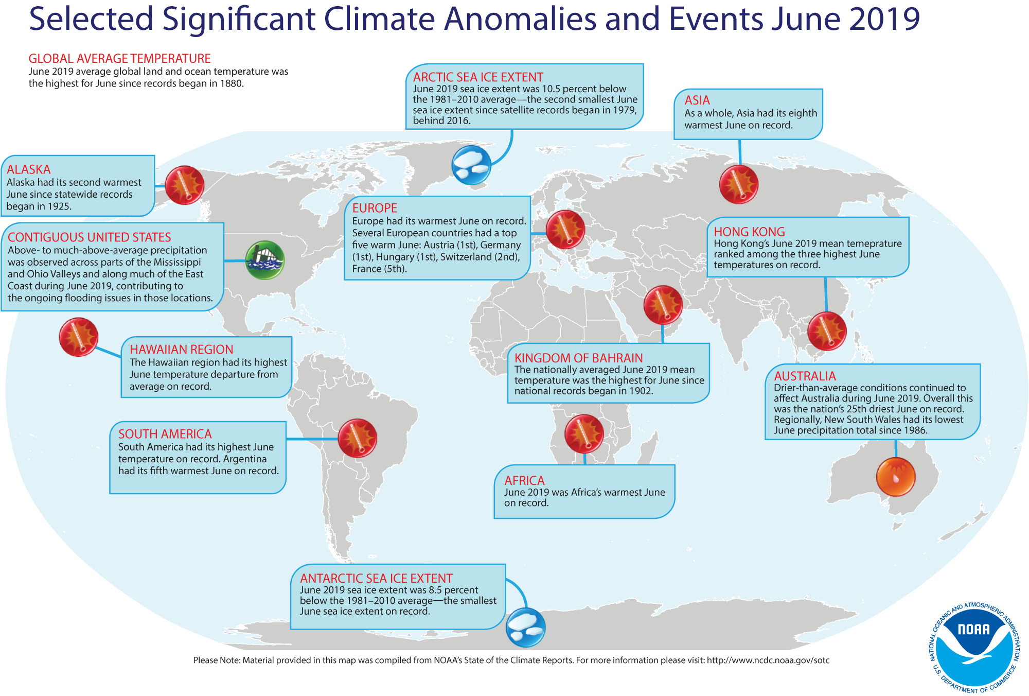
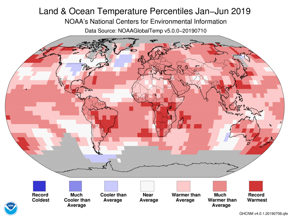
The global land and ocean surface temperature departure from average for June 2019 was the highest for the month of June in the 140-year NOAA global temperature dataset record, which dates back to 1880. The year-to-date temperature for 2019 was the second warmest January–June on record.
This monthly summary, developed by scientists at NOAA National Centers for Environmental Information, is part of the suite of climate services NOAA provides to government, business, academia and the public to support informed decision-making.
June 2019 Temperature
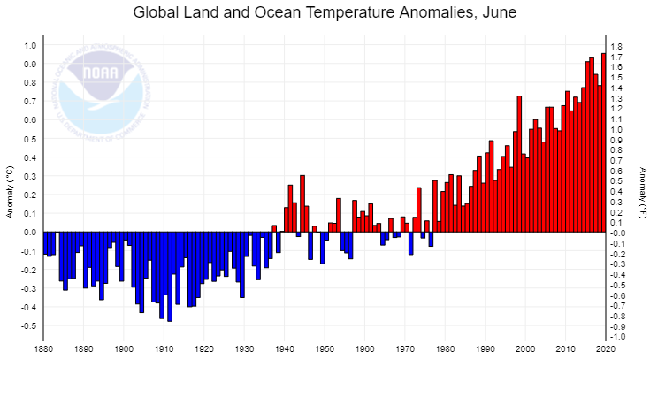
The June temperature across global land and ocean surfaces was 1.71°F above the 20th century average of 59.9°F and was the highest for June in the 1880–2019 record. June 2019 bested the previous record set in 2016 by 0.04°F.
Nine of the 10 warmest Junes have occurred since 2010. June 1998 is the only value from the previous century among the 10 warmest Junes on record, and it is currently ranked as the eighth warmest June on record.
June 2019 also marks the 43rd consecutive June and the 414th consecutive month with temperatures, at least nominally, above the 20th century average.
Record warm temperatures during June 2019 were present across parts of central and eastern Europe, northern Russia, Asia, Africa, South America, the north Indian Ocean, and across parts of the Pacific and Atlantic oceans. No land or ocean areas had record cold June temperatures.
The June globally averaged land surface temperature was 2.41°F above the 20th century average of 55.9°F. This value was also the highest June land temperature in the 140-year record, surpassing the previous record of +2.34°F set in 2015.
The most notable warm temperature departures from average were present across central and eastern Europe, north-central Russia, northeastern Canada and southern parts of South America, where temperatures were 3.6°F above the 1981–2010 average or higher. The most notable cooler-than-average temperatures were limited to parts of western Asia and Antarctica, where temperatures were at least 1.8°F below the 1981–2010 average or cooler.
Regionally, South America, Europe, Africa, the Hawaiian region and the Gulf of Mexico had their warmest June in the 110-year record. Asia and the Caribbean region had their eighth and ninth highest June temperature since continental records began in 1910, respectively. Meanwhile, North America and Oceania had their coolest June since 2009 and 2012, respectively.
The June globally averaged sea surface temperature was 1.46°F above the 20th century monthly average of 61.5°F — tying with 2016 as the highest global ocean temperature for June on record. June 2019 also tied with August 2015, April 2016 and June 2016 as the 10th highest monthly global ocean temperature departure from average among all months (1,674 months) on record. The 10 highest global ocean monthly temperature departures from average have all occurred since September 2015.
Sea Ice and Snow Cover
June 2019 marked the 20th consecutive June with Arctic sea ice extent below average. This was the second smallest Arctic sea ice extent for June in the 41-year record at 475,000 square miles (10.5%) below the 1981–2010 average and 46,300 square miles above the record low set in June 2016, according to an analysis by the National Snow and Ice Data Center using data from NOAA and NASA.
June 2019 marks the fourth consecutive June that the Antarctic sea ice extent was below average at 425,000 square miles (8.5%) below the 1981–2010 average. This was the smallest June extent in the 41-year record, surpassing the previous record set in 2002 by 62,000 square miles.
Year-to-date (January–June 2019)
The year-to-date temperature across global land and ocean surfaces was 1.71°F above the 20th century average of 56.3°F — tying with 2017 as the second highest for January–June in the 140-year record. Only January–June 2016 (+2.00°F) was warmer.
The most notable warm temperature departures from average were present across parts of the Northern Hemisphere, specifically Alaska, western Canada and central Russia, where temperature departures from average were +5.4°F or higher. Meanwhile, the most notable cool temperature departures from average were present across much of the contiguous U.S. and southern Canada, where temperatures were at least 1.8°F below average or cooler.
Record-warm January–June temperatures were present across central South America, the southern half of Africa, New Zealand and its surrounding ocean, as well as parts of Alaska, western Canada, Mexico, the Bering Sea, the Atlantic Ocean, Madagascar and surrounding Indian Ocean, and across parts of eastern Asia. No land or ocean areas had record-cold temperatures during January–June 2019.
Regionally, five of six continents had a January–June temperature that ranked among the four highest such periods on record, with South America having its warmest year-to-date on record and Oceania having a near-record January-June temperature.
The year-to-date globally averaged land surface temperature was 2.68°F above the 20th century average of 45.0°F. This value was the third highest for January–June on record, behind 2016 (+3.35°F) and 2017 (+2.79°F).
The year-to-date globally averaged sea surface temperature was the second highest for January–June in the 1880–2019 record at 1.33°F above the 20th century average of 60.9°F. June 2016 (+1.51°F) was warmer.
For two decades, hydrogeologist Lee Pivonka has monitored toxic waste at and around the Superfund site for Colorado Department of Public Health and Environment.
He’s one of the most prominent voices in the state calling for more scrutiny of the site.
Pivonka told Sentinel Colorado that pollution testing wells — not private wells for drinking — north of the Superfund site boundary were found to have unacceptably high levels of contamination as far back as 1995, when city councillors gave Murphy Creek the green light. Chemicals in many wells have never returned to acceptable levels, he said.
Dioxine plume Lowry Landfill via The Denver Post.
In 2002, EPA became concerned with a chemical called 1,4 dioxane. The stuff is widely found in trace amounts in household products such as detergents and shampoos. It is probably a carcinogen if ingested in high-enough concentrations through drinking contaminated water, the EPA says, but most people will not be exposed to it that way in their lifetimes. The New York state legislature recently passed a ban on products with more than trace amounts of 1,4 dioxane. The bill is pending Governor Andrew Cuomo’s signature.
For Murphy Creek golfers teeing off and residents, the danger is low, the WSDs said.
Further to their point, it’s unheard of for golfers to drink the creek water. The course itself, like the Murphy Creek neighborhood, is irrigated with clean City of Aurora water.
But scientists have also monitored 1,4 dioxane because it moves quickly in water. They believe that tracking the chemical could indicate other toxic waste following it.
As the state government’s lead researcher for the site, Pivonka has watched for the last 20 years and conducted more evidence about the leaking waste. In 2015, he co-authored a lengthy analysis to try and spur new fixes.
That paper mapped underground chemicals spreading down the Murphy Creek wash past East Jewell Avenue, below the edge of the Murphy Creek Golf Course and the community itself.
The paper estimated that 425.6 million gallons of contaminated water has leaked from the site in the plume, according to data from about a decade earlier. It’s a worrisome prospect for homes near the plume and on well water, such as the Raders’.
In the paper, Pivonka recommended that the EPA and the polluters try something new. The EPA recently heeded his suggestion that EPA stop injecting huge amounts of treated water north of the site.
Water was treated for various chemicals except for 1,4 dioxane, and pumped north of the site until the early 2000s. The WSDs then began treating water for 1,4 dioxane and injecting that north of the site until October 2018.
But while Pivonka and others conduct their own studies, the EPA and polluters have relied on separate studies and often come to separate conclusions. The debate over how and when the pollution has spread is rooted in a parallel universe of research at the EPA.
That agency’s conclusions, however, are often based on research commissioned by the WSDs.
The WSDs told Sentinel Colorado that, based on their information and EPA conclusions, the plan for containing the waste is currently protecting the public.
Karen Crummy of public relations firm BluePrint Strategies responded to Sentinel Colorado as the WSD spokeswoman. Crummy is routinely a spokesperson for oil and gas industry political causes.
The group believes the plume exists but is shrinking, pointing to data from a commissioned 2018 study indicating decreases in 1,4 dioxane levels at various locations north of the site.
Dave Wilmoth, a City and County of Denver official and environmental engineer, recently toured the site. He is a site expert representing Denver in the WSD group…
Wilmoth said the plan in place is working effectively. The contamination north of the site is little more than trace amounts of 1,4 dioxane, he said, blaming the outdated practice of dumping water contaminated with the stuff beyond the site’s northern barrier wall.
“No regulations,” he said of 1,4 dioxane. “No one knew.”
But that was almost two decades ago.
EPA spokesperson Rich Mylott said the containment plan is “working effectively to prevent off-site exposure to contaminants.”
However, the EPA is not sure that shallow and deep groundwater is safe from contamination, and directed the WSDs to commission their own studies of possible contamination. Two years ago, the agency declined to say in a multi-year study and report whether the site was adequately protecting the public.
The possible contamination of aquifers is a huge concern for Pivonka and Rader.
Two aquifers, the Denver and Dawson, overlap just north of the site where the plume is contaminating surface waters. The Dawson formation lies above the Denver, a 3,000-square mile table of water, separated by a leaky barrier of earth.
Both are important sources of drinking water for the dry Front Range. Serious contamination would threaten a key resource that scientists believe will become more scarce in the decades to come.
The EPA also acknowledges the existence of the surface water plume in the review but said the WSDs need to conduct more studies before it creates a plan.
In the years since, the polluters’ group has been doing just that. They say they are working to get the additional data EPA needs to again find the site remedy “effective and protective.”
The WSDs said it could also consider new solutions, such as drilling new monitoring wells — in addition to the 500 that already exist — changing how they monitor the groundwater, and studying the impact of injecting water north of the site.
The prospect of polluters running their own studies for the EPA worries Bonnie Rader, who is now chairing the site Community Advisory Group.
The group has long received funds from the EPA to hire out its own, independent contractors to study the pollution.
She doesn’t trust the polluters nor the EPA to reach their own conclusions.
The CAG consultant, McGinnis and Associates, reviewed a polluter-funded study of the site in 2013. Rader sent the review to a lead scientist at the EPA, who analyzed the study line-by-line, finding inaccuracies and omissions. The errors include misrepresenting levels of 1,4 dioxane in test wells.
McGinnis also believes the plume is growing, not shrinking.
It’s emblematic of an information gap that strains relationships between the various consultants and agencies.
Different studies come to different conclusions, frustrating all parties involved. Technical disagreements can turn sharky in tone.
Generally, the EPA and polluters believe they should stay the course, while CDPHE and the citizen-hired McGinnis and Associates think more should be done to contain and clean up the waste.
The EPA and polluters can press ahead with their own plans, but area residents and their consultants are extremely concerned about the leaking waste and continue to pressure them.
In the 2017 review, EPA staffers conducted interviews with locals. “All private citizens interviewed are concerned about groundwater contamination and the use of private residential wells,” the report says.
The gulf between the parties has also widened because of little trust and bad communication.
Four years after his paper’s findings, Pivonka said the EPA and polluters “have not been receptive to the recommendations, and continue the same approach to the site.”
Rader is disillusioned with the WSDs and their studies. She said she’s been hearing the same old reassurances for the last 30 years while the waste spreads north, closer to her home.
The polluters’ trust disagrees with the notion that they have not listened to residents, Crummy said. She said WSD representatives regularly attend meetings with locals.
The mass of evidence, varying conclusions and convictions on all sides leaves residents with vague concerns at best but nightmares at worse about the situation actually harming people…
…the mere possibility of pollution has encouraged new, suburban residents to forge an alliance with Rader and other environmental crusaders. While a subdivision lies close to the spreading plume, they are vehemently opposed to a new plan to house thousands of new residents on its doorstep, for reasons of their own…
The Superfund site and its leaking waste was not news to [Nicole] Johnston, who represents the eastern frontier region of the city. She actually became involved in the CAG herself before running for city council, and was interviewed in the EPA’s 2017 review study that downgraded the protectiveness of the site.
She said that 1,4 dioxane may not even be her biggest concern, compared to other chemicals dumped in the Superfund site.
“They put some really, really bad things in there,” she said. “Those other, really bad chemicals could be right behind it.”
Johnston met with Rep. Jason Crow that April afternoon when he visited the plume.
She said that, although the plume concerns her very much, the possibility of two injection wells about five miles from the site could dramatically change the area’s geology.
The wells, proposed by Wyoming- and Denver-based Expedition Water Solutions, would flush mostly saltwater and other by-products from oil and gas extraction more than 10,000 feet below the surface.
Injection wells are known to cause earthquakes in some circumstances, according to the United States Geological Survey.
But the science that the Superfund site geology could be disrupted is far from certain.
Zach Neal, a spokesperson for EWS, said the proposed location was the only possible place for the injection wells because of county zoning restrictions.
He added that the wells would be safely built and regulated. EWS would inject the waste far deeper below the surface than the Denver and Dawson aquifers.
Arapahoe County officials told Sentinel Colorado that staff are still reviewing the applications, and the state government agency charged with reviewing proposals has not taken action since EWS filed its paperwork in February.
Arapahoe County Commissioner Jeff Baker represents the Superfund site area and the residents that live in the unincorporated county. He said he’s also worried about the injection well permits and will be scrutinizing them, he said.
But Baker said he is also open to considering whether the solution to keeping residents safe from the Lowry Landfill should still be trying to contain the waste. He’s open to discussing a plan to clean up the waste, once and for all.
It’s an idea that Bonnie Rader has clamored for during the last 50 years.
Colorado Department of Natural Resources (DNR) Executive Director Dan Gibbs announced today the addition of a new member to his leadership team, Doug Vilsack, as the new Assistant Director for Parks, Wildlife and Lands.
“Doug is an important addition to the leadership team we are building at the Colorado Department of Natural Resources,” said Dan Gibbs, Executive Director, Colorado Department of Natural Resources. “Doug has played an integral role within the Department over the years serving as Legislative Liaison, helping to usher in key legislation such as the SB 181, Colorado’s new oil and gas law, spearheading passage of the Hunting, Fishing, and Parks for Future Generations Act and working to increase funding for the Colorado Water Plan.”
“Doug has demonstrated great leadership in program and policy development and has a true passion for wildlife and protecting Colorado’s public lands,” continued Gibbs. “I am thrilled to have Doug on board as we tackle important priorities for our Department including increasing access to our state lands for more Coloradans and developing new funding opportunities to support Colorado’s wildlife and outdoor recreation opportunities.”
In addition to serving as the Legislative Liaison for the Department for the last three years, Doug has diverse experience as an attorney handling water, energy, mining, and public lands issues. He also worked with the World Wildlife Fund (WWF) in Namibia developing successful community-based conservation programs to conserve elephants in Africa.
Doug is also a founder and leader of several non-profit organizations, including Elephant Energy, which works to establish distribution networks for small-scale solar products in rural Africa, and formerly as Executive Director of the Posner Center for International Development, a network of Colorado-based organizations and businesses dedicated to growing lasting solutions to global poverty.
Doug has a bachelor’s degree in Environmental Systems: Natural Resource Management from Colorado College and a J.D. from the University of Colorado School of Law.
The Assistant Director position at the Department acts as a policy advisor to the Executive Director, Deputy Executive Director, and Colorado Parks and Wildlife director regarding issues, legislation, and state and national policy developments in natural resources, parks, wildlife, trails, and outdoor recreation that impact Colorado.
Colorado Parks and Wildlife (CPW) on Thursday reopened a section of the Arkansas River below the dam at Lake Pueblo State Park to people on inner-tubes and non-whitewater boats.
Swimming, however, remains prohibited as always, even in life jackets.
The decision comes more than a month after CPW closed a 1-mile stretch of the river from Lake Pueblo State Park east to Pueblo Boulevard. CPW deemed the section unsafe for boaters and tubers due to irregular, high flows from melting mountain snowpack.
Also Thursday, the Pueblo Police Department and the Pueblo County Sheriff’s Office announced they were reopening to tubers and boaters the Arkansas east of Pueblo Boulevard all the way to the Otero County line.
At the time of the closure on June 11, river levels had swollen to near flood stage in places and pushed the rate of flow above 4,500 cubic feet per second (cfs). The average rate of flow in the Arkansas this time of year is 2,200 cfs.
“We are happy to lift the restriction and resume normal operations,” said Lake Pueblo State Park Manager Monique Mullis. “During run-off, river flows in this section can change daily depending on how much water the U.S. Bureau of Reclamation releases from the lake on a given day. But the runoff has peaked and flows should be gradually dropping the rest of the summer.”
In 2015, the river below the dam was closed for about three weeks.
CROA said rafting on the Upper Colorado north of Winter Park and the Lower Colorado through Glenwood Springs and Grand Junction will last into October, as will be the case with Yampa near Steamboat Springs. In the Durango area, which saw meager flows a year ago due to drought, the Animas should support rafting through September. Sections of the Arkansas likely will be raftable through September and, closer to Denver, Clear Creek should have rafting well into August.
According to Hattie Johnson, Southern Rockies stewardship director for American Whitewater, an organization that represents outdoor sports aficionados, river conservationists and more than a hundred local paddling club affiliates across the country, the higher-than-normal flows in these areas don’t necessarily mean they should be considered off-limits. But extra caution should be exercised…
Click on a thumbnail graphic to view a gallery of drought data from the US Drought Monitor.
US Drought Monitor July 16, 2019.
West Drought Monitor July 16, 2019.
Colorado Drought Monitor July 16, 2019.
Click here to go to the US Drought Monitor website. Here’s an excerpt:
This Week’s Drought Summary
Hurricane Barry made landfall in southern Louisiana on July 13, delivering locally heavy showers and a modest storm surge but largely sparing crops and communities in the path of the poorly organized storm. Once inland, Barry drifted northward and was quickly downgraded to a tropical storm and—by July 14—a tropical depression. Outside of Barry’s sphere of influence, locally heavy showers dotted the Southeastern and Mid-Atlantic States, sparking local flooding. Locally heavy rain also soaked portions of the North, with some of the highest totals reported across the northern half of the Plains and the upper Midwest. Many other areas of the country, including a large expanse of the West and parts of the southern Plains and the Midwest, experienced warm, dry weather. In fact, near- or above-normal temperatures dominated the country, as mid-summer heat began to build. Areas affected by Barry’s remnants, including the mid-South, remained somewhat cooler due to cloudy, showery weather. In part due to mid-July heat, short-term dryness was of great concern across the lower Midwest, where compaction, crusting, and dryness was reported in previously saturated topsoils…
High Plains
Heavy showers and thunderstorms sweeping across North Dakota eradicated severe drought (D2) and reduced the coverage of moderate drought (D1) and abnormal dryness (D0). In the Dakotas, daily-record amounts for July 9 totaled 3.12 inches in Williston, North Dakota, and 1.29 inches in Watertown, South Dakota. The remainder of the High Plains remained free of dryness and drought…
West
Minimal changes were made, although generally cool weather in the Northwest contrasted with hot conditions in the Southwest. A few monsoon-related showers developed in the Four Corners States—the official monsoon start date in Tucson, Arizona, based on average dewpoint temperature, was July 13, the latest onset in that location since 2005. Meanwhile in eastern Washington, moderate drought (D1) was expanded due to an evaluation of water year-to-date precipitation totals; low reservoir levels; and soil moisture shortages. On July 14, USDA rated topsoil moisture 62% very short to short in Oregon and 39% very short to short in Washington…
Looking Ahead
Heat and high humidity levels will dominate the central and eastern U.S. through week’s end, except on the northern Plains. By early next week, however, markedly cooler, drier air will arrive across the Plains and Midwest. Meanwhile, the post-tropical remnants of Hurricane Barry will spark showers in the East through Thursday, while scattered showers and thunderstorms will affect parts of the nation’s northern tier. Five-day rainfall totals could reach 2 to 4 inches in the upper Midwest and locally 1 to 3 inches east of the Mississippi River. In contrast, dry weather will prevail in the south-central U.S. and from California to the Intermountain West.
The NWS 6- to 10-day outlook for July 23 – 27 calls for the likelihood of below-normal temperatures from the central and southern Plains to the Atlantic Seaboard, excluding southern Florida, while hotter-than-normal conditions will dominate the West and the northern High Plains. Meanwhile, below-normal rainfall in the Midwest and along the northern Pacific Coast should contrast with wetter-than-normal weather along the Atlantic Coast, in the Deep South, and across the Intermountain West.
Homestake Creek, flowing toward the Eagle River, near the Alternative A dam site being studied by Aurora Water and Colorado Springs Utilities, about three miles up Homestake Road from U.S. 24. The photo was taken on July 13, 2019. Photo credit: Brent Gardner-Smith/Aspen Journalism
The cities of Aurora and Colorado Springs are increasing their efforts to develop a reservoir on lower Homestake Creek in the Eagle River basin that would hold between 6,850 acre-feet and 20,000 acre-feet of water.
The two Front Range cities, working together as Homestake Partners, have filed an application with the U.S. Forest Service to drill test bores at four potential dam sites on the creek, renowned for its complex wetlands.
They briefed members of Colorado’s Congressional delegation in April about federal legislation they are drafting that would adjust the Holy Cross Wilderness boundary near the dam sites.
And Aurora spent $4.1 million in 2018 to purchase a 150-acre private inholding parcel that accounts for about half the surface area of the 20,000-acre-foot version of the reservoir, removing one obstacle in the way of submitting a comprehensive land-use application to the Forest Service.
“We are in preparation to permit this overall project, to try and get that larger application in, so every piece of the project has had more time and effort spent on it,” said Kathy Kitzmann, a water resources principal with Aurora Water.
One of four potential dam sites on lower Homestake Creek, about four miles above U.S. 24, between Minturn and Leadville. From this location, the dam that forms Homestake Reservoir higher up the creek can be seen. Photo credit: Brent Gardner-Smith/Aspen Journalism
Eagle River MOU
The Whitney Reservoir project is defined in part by the Eagle River Memorandum of Understanding, a 1998 agreement that gives Aurora and Colorado Springs a basis to pursue 20,000 acre-feet of water from the Western Slope.
Parties to the MOU include Aurora, Colorado Springs, Climax Molybdenum Co., Colorado River Water Conservation District, Eagle River Water and Sanitation District, Upper Eagle Regional Water Authority, and Vail Associates.
Peter Fleming, the River District’s general counsel, told the district’s board in a July 1 memo that the River District is “not participating in any Homestake Creek based alternative at this time, this effort is now being carried forward solely by the Homestake Partners.”
Under the MOU, various parties can pursue projects on their own, and the other parties are bound to support those efforts, but only to the degree that a proposed project meets the objectives of the MOU, including whether a project “minimizes environmental impacts.”
A view, from the Alternative A dam site, of the Homestake Creek valley. The triangle shape in the distance is the dam that forms Homestake Reservoir. Photo credit: Brent Gardner-Smith/Aspen Journalism
Serious intent
Whitney Reservoir takes its name from Whitney Creek, which flows into Homestake Creek just above the four potential dam alignments now being studied. The dam that would form Whitney Reservoir would stand across Homestake Creek, not Whitney Creek. Homestake Creek flows into the Eagle River at Red Cliff.
Asked how serious the two cities are about the Whitney Reservoir project, Kevin Lusk, the principal engineer at Colorado Springs Utilities, said, “We’ve been serious about it for the last 20 years.”
And he said the recent drilling application “is another step in the continuum from concept to reality.”
On June 25, the two cities submitted an application with the Eagle-Holy Cross Ranger District for permission from the White River National Forest to drill 13 test bores 150 feet to explore the geology under the four sites.
The sites are clustered on the creek between 3 and 5 miles above the intersection of U.S. 24 and Homestake Road, shown as Forest Road 703 on most maps. The intersection is not far below Camp Hale, between Minturn and Leadville.
The drilling application says Aurora and Colorado Springs are conducting “a fatal-flaw level reservoir siting study” that “comprises subsurface exploration to evaluate feasibility of dam construction on lower Homestake Creek.”
White River National Forest supervisor Scott Fitzwilliams said review of the drilling application itself is “fairly standard stuff.”
“We’ll definitely send out a scoping statement, asking for public comment, but it won’t be about a dam,” he said. “It will be about drilling the holes.”
Each of the 13 borings would take up to five days to drill, so there could be 65 days of drilling this fall or, if the application is not approved this year, in 2020, according to Lusk.
The project includes taking a “track-mounted drill rig or a buggy-mounted drill rig,” a “utility vehicle pulling a small trailer” and a “track-mounted skid steer” onto public lands along 10-foot-wide “temporary access routes.”
The drill rigs are about 8 feet wide, 22 feet long and 8 feet high. To get the rigs to drilling sites, some wetlands may need to be crossed and trees will be cut as necessary.
The information about the geology under the four sites will help determine the size of a dam on a given alignment and how much water a reservoir would hold, Lusk said. And that could affect how much wilderness area might be encroached on.
A map prepared by Aurora Water that shows a potential 500-acre adjustment to the Holy Cross Wilderness boundary near the potential Whitney Reservoir on lower Homestake Creek. The map as current as of July 16, 2019.
Wilderness boundary
Given that Aurora and Colorado Springs are still working through various options, it’s not clear yet how big of an adjustment to the wilderness boundary they might ultimately seek from Congress.
The current proposed legislation developed by the cities asks to remove 497 acres from the wilderness boundary, but it is also expected to include a reversion provision so if all 497 acres are not needed, the boundary adjustment could be reduced.
According to Lusk, in one the of the alternatives studied, about 80 acres would need to be removed from the wilderness area if Whitney Reservoir was to hold 20,000 acre feet of water. However, the cities have yet to rule out the option of building an alternate reservoir below the Whitney Reservoir location – Blodgett Reservoir – which could require a larger boundary adjustment, although not the full 497 acres.
An adjustment to a wilderness boundary requires an act of Congress and the president’s signature. In April, representatives from the two cities described the potential boundary change to staffers of U.S. Sens. Michael Bennet and Cory Gardner and U.S. Reps. Scott Tipton, Jason Crow, Joe Neguse and Doug Lamborn.
Fitzwilliams said Monday the Forest Service won’t accept a full-blown land-use application for Whitney Reservoir until the wilderness boundary issue has been worked out through federal legislation, if that is still needed after the final version of the reservoir is better defined.
Kitzmann said she is reaching out to stakeholders to continue to refine the legislative language and the map showing the extent of the proposed boundary change.
A wetland area along Homestake Creek in an area that would be flooded by a potential Whitney Reservoir. Aurora and Colorado Springs, seeking to build the reservoir, have recently submitted a drilling application to the U.S. Forest Service to search for fatal flaws in the geology under four potential dam alignments. Photo credit: Brent Gardner-Smith/Aspen Journalism
Wetlands and fens
On another front, Aurora Water and Colorado Springs Utilities staffers are hosting a tour this week for the directors of the Colorado Water Conservation Board of the Homestake Plant and Fen Relocation Project, near Leadville.
The CWCB directors, holding their July meeting in Leadville, also will hear a presentation at their meeting about the fen-relocation effort, which consists of moving “fen-like organic soils and plant life” from one location in blocks or bales to another location and “reassembling them in a specially prepared groundwater-fed basin.”
Many regulatory agencies do not believe it’s possible to re-create complex fen wetlands, according to a CWCB staff memo, but that regulatory stance “may be related to the lack of scientific investigation on fen mitigation.”
A 2016 study estimated between 26 and 180 acres of wetlands on lower Homestake Creek would be impacted by Whitney Reservoir.
“This is one of the finest wetlands we can find on our forest — it’s unbelievable,” Fitzwilliams said. “From an environmental impact standpoint, this would not be a project that we would be favorable to.”
But Lusk said the fen-relocation project near Leadville is “proof of concept” that replacing fens, while “a tough nut to crack,” can be done.
Fitzwilliams may be hard to persuade.
“You can mitigate,” he said, “but you can’t replace 10,000 years of work.”
A map from Colorado Springs Utilities that shows how tunnels could bring water to Whitney Reservoir from Fall and Peterson creeks, and from the Eagle River. The map also shows the route of a pipeline to pump water from Whitney Reservoir to Homestake Reservoir.
Homestake Reservoir, which is partially in Pitkin County, but mainly in Eagle County. Below the reservoir the Homestake Creek valley is visible, as well as short section of what’s known as Homestake Road. Water held in the potential Whitney Reservoir would be pumped up to Homestake Reservoir and then sent to the Front Range. Photo credit: Brent Gardner-Smith/Aspen Journalism
Forebay and pumping
Despite the wetlands and wilderness challenges, Lusk and Kitzmann said no fatal flaws have been found yet in what they view as an important future element of their water-supply systems.
The new reservoir would serve as a collection point for water brought in via tunnels from the Eagle River and Fall and Peterson creeks, and for water captured from Homestake Creek.
The reservoir would also serve as a forebay, as the water captured in Whitney Reservoir would be pumped 7 miles up to Homestake Reservoir. Once there, it can be sent through a tunnel under the Continental Divide to Turquoise Reservoir, near Leadville, and then on to Aurora and Colorado Springs.
The two cities own and manage Homestake Reservoir, the upper end of which is in Pitkin County. The reservoir opened in 1967 and normally stores 43,600 acre-feet of water from seven high-mountain creeks behind a 231-foot-tall dam. About 25,000 acre-feet a year is sent through the Homestake Tunnel each year to the Front Range.
Homestake Partners also has a conditional water-storage right from 1995 to store 9,300 acre-feet of water behind a potential 110-foot-tall dam in what is called Blodgett Reservoir, located on Homestake Creek below the Whitney Reservoir sites. Blodgett Reservoir also has a longer history, and has been viewed as an alternate location for older water rights – appropriated in 1952 and adjudicated in 1962 – that are tied to Homestake Reservoir.
Aspen Journalism covers rivers and water in collaboration with The Aspen Times and other Swift Communications newspapers. The Times published this story on Wednesday, July 17, 2019. This version includes a clarification concerning the size of the adjustment to the wilderness boundary and the date of the water rights for Blodgett Reservoir.
A raft, poised for action, on the Colorado River. Photo: Brent Gardner-Smith/Aspen Journalism
From the Colorado River Outfitters Association via The Valley Courier:
Mid-season Colorado rafting conditions are ripe and there are still plenty of adventures to be had this summer. With late season snow, cooler temperatures, slow runoff and higher water levels dominating most of June, July is bringing more steady water flow levels that promise to run for an extended season into at least early fall.
Temperatures throughout the state have warmed up, and with flows returning to more moderate levels, rafting trips with professional outfitters are starting to book out. In 2018, Colorado’s commercial rafting companies hosted more than 520,000 rafters over the course of the season, resulting in a nearly $176 million economic impact across the state. Members of the Colorado River Outfitters Association collectively raft more than 30 distinct stretches of river across eight major water basins.
“Water conditions vary by the river – all geographic areas have different levels of rafting, but we’re anticipating many runs will be open later this season than they have in several years,” said CROA Executive Director, David Costlow. “Durango has family to wild rafting, as does the Buena Vista to Canon City area. The Cache la Poudre outside Fort Collins, the Rio Grande near Creede, all sections of the Colorado and the Taylor near Crested Butte are enjoying consistent and full level flows. Talk with an outfitter of choice and take their suggestions, they know the best route for your preferences.”
Rafting outside of Glenwood Springs, Winter Park/Steamboat and Grand Junction will continue into the fall; most likely lasting until into October; the traditional close of the regular rafting season. The Animas in Durango should flow through September and the Poudre should have rafting to early September. In some sections, the Arkansas River will flow through September and Clear Creek will be raftable at fun flows to the middle or late August.
For comparison, last year at this time, some trips were unavailable due the low water levels. This year the steady melt and temperatures have delayed low water and is allowing outfitters to offer a range of moderate level trips for the next several weeks. Except for a few extreme runs, most all sections are available for rafting.
The Colorado River Outfitters Association (CROA) offers the following tips for both tourists, and locals alike, looking to book a rafting trip this season:
Raft close to where you are vacationing. There are many types of rafting options out there – if you have a vacation planned, it could be the perfect opportunity to check with an outfitter nearby to see if they have availability. This is a great starting point to get you out on the water. Then, discuss options with them to tailor your trip experience.
Choose a trip that is appropriate for you. Once you know where you are located either due to a planned vacation or day trip, most outfitters offer a variety of trips from more family friendly options to more extreme adventures, which can be selected based on experience level, fitness and desires for the trip.
Bring the kids! Rafting can be a wonderful experience for children, and Colorado outfitters offer many trips appropriate for kids. This time of year, some trips allow children as young as four. Still, be sure to verify any age and weight restrictions in place for the given conditions on the trips you’re considering.
Listen to the guide. Rafting guides are specially trained and experienced, as well as knowledgeable about local history, culture, geology and wildlife.
Know what to bring and wear. Some items are generally considered standard for any Colorado rafting trip. The outfitter will give you a list of what they have and suggested additional items you may need to bring. For example, an outfitter will have life jackets (PFDs), splash jackets, wetsuits and paddles but suggested items to bring may include quick drying shorts or swimsuits, river sandals or old tennis shoes, sunscreen, lip balm, change of clothes, etc.
The Gila River winds through many lands before and after it enters Arizona, including the territory of some Native American tribes that historically have relied on the water for their homes and their crops. One of those, the San Carlos Apache Tribe, has thrown shade on any future New Mexico Unit diversion by virtue of their refusing to be a party to virtually any aspect of the project, or its affiliated agreements.
The 2004 federal Arizona Water Settlements Act was intended to address the fact that some communities — particularly Native American communities — had long been on the short end of the stick when it came to water rights. The Central Arizona Project, known as the CAP, is a major diversion of Colorado River water that began supplying water to Phoenix and Tucson in the late 1980s — but it is only an outsized example of diversions that impacted downstream communities in southern Arizona over the years.
Four New Mexico counties are also included in the settlement legislation: Catron, Grant, Hidalgo and Luna. As a result, the New Mexico Unit of the Central Arizona Project was created, making available millions of dollars from the settlement. Farmers and landowners in southwestern New Mexico banded together to form the New Mexico Entity of the Central Arizona Project aiming to spend that money.
Should the N.M. CAP Entity proceed with their plan to divert up to 14,000 acre-feet of water from the Gila and San Francisco rivers, a rarely discussed sticking point lies ahead for the project. The AWSA that provides the money for the project includes by reference what is called the Consumptive Use and Forbearance Agreement, or “CUFA,” a deal among the federal government and downstream users of the Gila River.
Before the N.M. CAP Entity could start diverting water — should the project come to fruition — there are requirements that it must satisfy, most of which revolve around the San Carlos Reservoir, operated by the Bureau of Indian Affairs on San Carlos Apache tribal land. Most of the water users in that area and downstream signed on to the CUFA in 2005 and 2006, and are therefore guaranteed exchange water, or “credits,” for lost water resulting from the diversion upstream.
“The CUFA is a complex document,” said Dominique Work, a lawyer with the N.M. Interstate Stream Commission. “One requirement is that New Mexico can’t start diverting water unless there is at least 30,000 acre-feet in the San Carlos Reservoir at the beginning of each year.”
Even when the reservoir has 30,000 acre-feet in it at the beginning of the year, sometimes the water quality is poor, which is also a sticking point. The 22 water users that signed on to the CUFA agreed to forgo the right to sue over water quality or quantity.
But in a glaring exception, the San Carlos Tribe did not sign on to the agreement. They have also refused to allow a pipeline — as part of the AWSA — to be built on their land.
“The pipeline would provide water from farmers in the Safford, Arizona, area,” as part of the water settlement, Work said. “The farmers were given $15 million in the AWSA to build that pipeline. They built it until they got to the land boundary of the tribe, and the tribe said, ‘You aren’t building that on our reservation.’ So there is a means to get the water — and that is a prerequisite.”
Since the tribe has both refused to complete the project and refused to sign the CUFA, it is debatable whether their water needs would be met by the half-built pipeline.
Work asserted that the “mechanism is satisfied” for getting the tribe the water it is due. But it appears that the tribe — which Entity Director Anthony Gutierrez points out “only get[s] 6,000 acre-feet of water per year from the reservoir” — apparently wants their water to come from the Gila River. And that raises water quality issues.
Stephanie Russo Baca, staff attorney at the Utton Transboundary Resources Center at the University of New Mexico School of Law, isn’t so certain that San Carlos wouldn’t have standing to sue. She interprets the AWSA as giving the tribe the right to litigate against the Entity and whoever else it feels is culpable for low water quality.
“The Arizona Water Settlements Act states that the United States — on behalf of the San Carlos Apache Tribe — or the tribe itself can assert any claim against any party, including any claim for water rights, injury to water rights, or injury to water quality,” she said. “Even though the San Carlos Apache Tribe is a non-signatory to the CUFA, this does not preclude them from asserting their rights.”
PFAS contamination in the U.S. via ewg.org FromKOAA.com (Tyler Dumas):
A [new] groundwater treatment facility is going to be built just north of the existing one.
The facility will be paid for by the Air Force and will be built by the Army Corps of Engineers. The project is part of the agreement reached to protect Fountain’s water from contamination from Peterson Air Force Base in 2016.
Las Colonias Park. Photo credit: The City of Grand Junction
FromThe Grand Junction Daily Sentinel (Duffy Hayes):
Council on Wednesday…reached another important milestone in the development of Las Colonias Park, with the approval of a nearly $1.3 million construction contract that will create a new inlet channel of the river nearby, as well as extend the current water channel to draw more river runners to the park.
The contract — awarded to K&D Construction of Grand Junction — will lead to a new 475-lineal-foot inlet channel and an approximately 850-lineal-foot extension of the existing channel, providing for the addition of 1.77 acres of open water, according to city information prepared for councilors.
When the work is finished, by no later than the end of the year, the excavated channel extension will have continuous water flow when the Colorado is flowing above 810 cubic feet per second. The secondary channel that will be created will have drops and pools, in-stream habitat structures and boulders, and other recreational and interpretative amenities.
The Yampa River has finally fallen to a level that allows for commercial tubing.
On Monday, the river dropped below 700 cubic feet per second through downtown Steamboat Springs, according to the U.S. Geological Survey, the flow rate that typically kicks off tubing with commercial outfitters…
Though lower than it has been all summer, the river is still running quickly, with water temperatures around 60 degrees. The city of Steamboat Springs — and commercial outfitters — recommend wearing a life jacket on the water, even when on a tube.
The EPA recently ordered the Sunnyside Gold Corp. to do some drilling work to investigate where the water originates to help with cleanup. But just a few days ago, Sunnyside Gold sent a letter to the EPA essentially saying, “No, we’re not going to do it.”
What’s their rationale for refusing?
Back in 1992 when Sunnyside Gold Corp. closed the mine and started cleaning up, the company came to an agreement with Colorado that they would plug the mine and do a certain amount of cleanup.
Sunnyside Gold also agreed to clean up unrelated, neighboring mines to offset the pollution in the river. In a way, they were like pollution credits.
The company spent well over $20 million on clean-up. Now they’re basically saying, “Look, we came to this agreement with the state — the EPA signed off on the agreement — and we did everything that we were supposed to do.”
So what’s the next step?
We’ll it’s going to be another court battle, likely. So far, it has been the subject of a number of ongoing lawsuits. This is just going to add to that legal quagmire. In the meantime, it’s just going to delay progress on the superfund cleanup.
Do you foresee the cleanup will eventually finish?
It will take place, it’s going to take a long time. And that’s not totally surprising. Superfund designations tend to be very long, drawn out processes. Don’t expect them to wrap up the cleanup any time in the next 10 years, maybe not the next 20.
What are the detrimental effects to the environment?
Mostly it’s to aquatic life: bugs and fish. It’s bad for them. We’ve seen that dramatically on the Animas River, where the mine spilled into. The number of species of fish downstream for maybe 40 miles downstream has declined.
Are people threatened by these kinds of spills?
Not necessarily. People were certainly affected because they had to close the river and they had to shut off irrigation ditches. And it was also emotionally and psychologically traumatic for people, to see the river turn that color. As far as health effects go, there wasn’t enough lead or mercury in the spilled water to really affect human health, and many wastewater treatment facilities downstream are able to clean these things out.
Prior to mining, snowmelt and rain seep into natural cracks and fractures, eventually emerging as a freshwater spring (usually). Graphic credit: Jonathan Thompson
The project will require significant construction over seven years to increase the reservoir’s holding capacity to 119,000 acre-feet of water.
When built, the dam will be the tallest in Colorado.
Denver Water says the additional space is needed to spread out capacity outside of Denver for the water utility used by 1.4 million people in the city and its surrounding suburbs.
The proposed construction project is not without opposition from neighbors and environmentalists who say they will endure years of construction on a water project that will never provide water to their taps.
“Boulder County is going to host this reservoir but gets no water from it. We derive no benefit from it. We only pay the price of having this thing in our county,” said Tim Guenthner, who lives just above the dam in a subdivision of about 1,000 people.
Denver7 decided to take a 360 look at this issue and gathered perspectives from five people connected to the proposed construction project…
Boulder County Commissioners have also taken a stance that Denver Water must get local permits before it can start the project.
Denver Water spokesman Travis Thompson said Denver Water doesn’t believe the law requires that and points out it has undergone numerous environmental studies and worked through the state permit process. This issue will likely be decided by another judge…
Denver Water’s Gross Dam project manager, Jeff Martin, acknowledges the project will cause noise for neighbors.
“Well we don’t hide from the fact there’s going to be some disruption from the noise, but we are looking at ways of minimizing that noise,” Martin said.
As an example, Denver Water decided to move the quarry needed to make cement to a portion of the lake that will be covered by water once more capacity is added. The original plan had the quarry on a portion of land jetting out into the lake.
Have an on-site quarry will also mean less truck traffic.
Martin said even with conservation efforts, Denver Water needs more capacity. He said experts have provided the water utility with data showing there will be 5 million more people in Colorado by 2050.
Denver water has 90% of its storage lakes west and south of the metro area, but only has 10% up north. This new dam project will add significantly more water storage north of the city.
“That’s important because if we have a catastrophic event or a drought in one of the systems, it leaves us depending on the other system,” he said. “What we want to do is create a little bit more balance and put more water in Gross Reservoir. This project is going to triple the size of the reservoir.”
[…]
Kirk Klanke is a member of Trout Unlimited, an environmental group seeking to protect and restore rivers across the country.
His perspective is one many wouldn’t expect from a member of the environmental group. He’s a supporter of the new dam.
“I think it’s extremely selfish to think we shouldn’t grow,” he said.
He says Denver Water has the legal right to build more capacity someplace. Gross Reservoir is the best option.
“Raising an existing dam has far less environmental damage than building a new one somewhere else,” Klanke said.
He says Denver Water has agreed to put significant effort into protecting the Colorado River. When it is hot out, river temperatures rise if there’s only a little water flowing.
Denver Water has agreed to keep water in the river during those periods and fill the lake during spring runoff. It will also draw water at different places in the river to minimize the impact to one area.
It’s happened again—another daredevil mountain biker has leapt across the Tour de France peloton and produced a breathtaking video of the action.
Last week our editor Fred Dreier wrote about his affinity for this annual rite of July, and the growing tradition behind it. The long list of riders to jump the Tour de France includes Dave Satson, Alexis Bosson, Romain Marandet, among others.
Now, we can add Valentin Anouilh to the list. The 19-year-old jumped over the peloton during Monday’s 10th stage of the race. Behold, the video below.
On July 1, Denver Water announced the launch of a summer education and outreach program to inform the public about a proposed Lead Reduction Program Plan.
The executive summary of the draft plan is available for review and public comment until Aug. 7, 2019. Interested customers and stakeholders can access the executive summary and comment form here.
The water delivered to homes and businesses in Denver is lead-free, but lead can get into water as it moves through lead-containing internal plumbing and service lines that are owned by the customer and are not part of Denver Water’s system. By March 2020, Denver Water is required by the state health department to add orthophosphate to the drinking water it delivers to customers to help reduce the corrosivity of the water and reduce the risk of lead getting into the household water from these sources.
The draft Lead Reduction Program Plan is a proposed alternative to adding orthophosphate to the water system. The comment period is intended to gather input from the community about the components of the proposed program, which include:
Increasing the pH level, which further reduces the corrosivity of the water.
Providing at-home water filters for all customers in Denver Water’s service area with a suspected lead service line, free of charge.
Replacing the estimated 50,000 to 90,000 lead service lines with copper lines in Denver Water’s service area at no charge to the customer over the next 15 years.
To implement the multipart program instead of the orthophosphate additive, Denver Water is required to submit a variance request to the EPA in mid-August, which will incorporate public input. Following that submittal, the EPA will initiate its own public comment period before it decides which approach will be implemented.
Community members are encouraged to learn more and speak directly to Denver Water team members at a variety of events this summer. The project website has an updated calendar of activities.
Denver Water also has a map of estimated customer-owned lead service lines as a starting point to help customers identify the likelihood of their home having a lead service line. Customers are encouraged to verify the accuracy of the information represented by this map for their residence by requesting a free water quality test from Denver Water.
Click here to read the newsletter. Here’s an excerpt:
Snow Melt Promises to Fill Reservoirs
While it is mid-July, when you look to the mountain peaks, you will likely see snowcaps – another reminder of the extraordinary winter Colorado experienced. We saw huge storms well into spring and cooler than average weather which kept snow on the ground longer than usual. In particular, cold temperatures in April and May helped boost snowpack levels to record highs. The snow and the resulting runoff is filling the reservoirs across Colorado.
As reported on The Denver Channel.com, “The snowmelt boost couldn’t have come at a better time, according to Greg Smith, a hydrologist with the Colorado Basin River Forecast Center. There’s a big sense of relief this year that we’ve kind of rebounded.” The forecast center’s conditions map indicates above average water supply forecasts for reservoirs.
It’s hard to avoid getting swept up in Wendy Inouye’s enthusiasm when she talks about her garden.
“I love it!” she gushes. “I have so much joy from my garden. Every time I come out I always pause and look at it. You know that saying, take time to smell the roses? I literally do that every single day I come and go from my home.”
Inouye’s front yard at her home in Thornton, Colorado, just north of Denver, is full of “xeric” plants—shrubs and groundcovers adapted to survive in dry climates.
Inouye took out her lawn last summer and replaced it with a Colorado-friendly landscape, including red rock penstemon, hopflower oregano, and a plant called red-birds-in-a-tree. She didn’t want to waste any more water and said the grass in her front yard had no function. It was in full sun and its water needs were astronomical. By taking out 750 square feet of turf and replacing it with a variety of water-saving plants surrounded by rocks and mulch, she and her husband have reduced their water usage from 413 gallons a day to 200.
Pointing to a larger area Inouye said, “This was just one big flat piece of grass that was full of weeds.” She was tired of fighting nature, using pesticides and herbicides. Now she says, she has fun with all her beautiful flowering plants.
Ditching the “Green Carpet”
It was a lot of work for Inouye to transform her landscape even though she hired contractors to assist with turf removal and changes to her irrigation system. But she got support for her decision from the City of Thornton through a turf removal rebate program that paid her $1.00 for every square foot of turf she took out.
Water conservation and efficiency are important to every utility across the country, and especially in the West where “aridification” is occurring. That’s the term being used in the Colorado River Basin to describe the region’s transition to a water scarce environment due to climate change—a condition that will result in a shrinking supplies.
Water utilities have various strategies to get customers to lower usage. Many offer rebates for installing low-flow toilets and efficient showerheads in older homes to reduce indoor use. With outdoor use, water providers can use “cash-for-grass” incentives as Thornton did for Wendy Inouye. They can also offer free mulch, rebates for efficient irrigation systems, and audits of outside water use.
Recently the Alliance for Water Efficiency (AWE), a non-profit dedicated to efficient and sustainable use of water, produced an assessment concluding that utility-sponsored programs to promote sustainable landscapes save water. Tom Chestnutt, the lead author of AWE’s study, said that turf removal programs have been very successful, and they hit that tipping point causing customers to do something different with their front yards.
The idea of a “green carpet”—lots of grass in front of homes, buildings, and sometimes, even medians—has been described as an aesthetic (inappropriately, many say) imported from the East. In the West, where lawns require irrigation, some water providers see them as out of sync with a western lifestyle…
Lawns As a “Dispersed Version of a Reservoir”
[…]
[Jeff] Tejral says that Denver Water did an analysis of a cash-for-grass rebate in 2016 and it did not make sense to start one. Tejral’s group calculated the water savings and the cost of the rebates to be $75,000 dollars per acre foot of water conserved, which the agency concluded was not a wise use of its ratepayers’ funds. He said that it would make sense to spend that amount, if they were in dire straits, and a turf rebate were the last option available.
However, there may be another reason that Denver Water doesn’t have a turf removal program—lawns might be a safety net where use could be restricted in extreme drought conditions. At those times of severe need, Denver Water could drastically cut back outdoor usage which would be tolerated more easily than restricting use inside homes. Cutting back lawn watering is much easier to get customers to accept than limiting their shower times or their clothes washings.
This idea was expressed by Colorado University historian Patricia Nelson Limerick in the book she wrote about Denver Water, Ditch in Time: The City, the West and Water. As Limerick writes, Denver water managers see lawns offering a service that is far from evident to most observers. Lawns are devices that receive water that would otherwise bypass Denver unused. She adds that lawns offer a cushion if severe drought should arise, and without that cushion demand would be hardened. “Take out the lawns and water would be directed only to needs that would not be susceptible to restriction.” Limerick writes that to the late Chips Barry, former manager of the Denver Water Department, lawns looked a lot like a dispersed version of a reservoir, holding water that could, in urgent circumstances, be shifted to respond to genuine need.
In response, Tejral said that they are shifting away from viewing turf the way Barry did. He insists there are other benefits to having lawns and landscapes in general, and it’s important to manage landscapes for what is best in the long term for a lot of different purposes, which could include aesthetic. He said that Chips Barry was reflecting on where Denver was, but as it matures as a city and integrates with others, people are going to have to learn the true function of landscapes, which is complicated.
A stopover during Powell’s second expedition down the Colorado River. Note Powell’s chair at top center boat. Image: USGS
FromThe Grand Junction Daily Sentinel (Bob Silbernagel):
George Young Bradley was ecstatic on July 16, 1869. “Hurra! Hurra! Hurra!” he wrote in his journal that day. “Grand River came upon us, or rather we came upon that suddenly.”
Bradley was one of 10 members of the John Wesley Powell expedition that had left Green River, Wyoming, on May 24, 1869. The first 53 days of their expedition took them down the Green River, to its confluence with the Colorado, then known as the Grand River…
By the time they reached the confluence with the Grand River, they’d already lost one boat and many of their provisions in a wreck at what they called Disaster Falls. They’d survived the Gates of Lodore and a variety of smaller rapids.
They’d had their last contact with the outside world two weeks earlier, when they stopped at the mouth of the Uintah River. Powell and two others had hiked to the nearby Uintah Indian Reservation, mailed letters for crew members and replenished some of their lost provisions. One of the team members, Frank Goodman, left the expedition there.
By July 16, they were more than halfway through their 98-day journey, although they had no way of knowing it then. Nor did they know what lay ahead — the great rapids in Cataract Canyon,…Glen Canyon and in the Grand Canyon itself.
But they did know that the confluence of the Green and Grand rivers was a key point on the journey. Bradley was surprised that the junction of the two rivers didn’t produce the sort of tumult that occurred when lesser streams flowed into the Green…
“At last without warning … in broke the Grand with a calm strong tide very different from what it has been represented,” Bradley wrote. “We were led to expect that it was a rushing, roaring mountain torrent.”
[…]
Powell, the one-armed scientist and surveyor, was more pragmatic in his description of the confluence:
“The lower end of the canyon through which the Grand comes down is also regular, but much more direct,” he wrote. “Down the Colorado the canyon walls are much more broken.”
Powell said the team could see the snow-clad peaks of the La Sal Mountains when they looked up the Grand River.
The expedition spent four days at the confluence of the two great rivers, resting, taking scientific observations and repairing boats and other gear…
they relaunched their boats on July 21, and soon found themselves in the rough water of Cataract Canyon.
That afternoon, Powell’s boat, the Emma Dean, was swamped. Powell, Sumner and William Dunn were tossed into the river.
“We cling to the boat, and in the first quiet water below she is righted and bailed out; but three oars are lost in this mishap,” Powell wrote…
But they also rode through many rapids. On Aug. 21, just below Bright Angel Creek, Powell stood up on the Emma Dean, hanging by a leather strap with his one good hand.
“The boat glides rapidly where the water is smooth, then, striking a wave, she leaps and bounds like a thing of life and we have a wild, exhilarating ride for ten miles, which we make in less than an hour.”
[…]
By then, their rations were nearly gone, and they were uncertain how much farther they had to go to reach the Virgin River, where they knew Mormon settlements were nearby. There was also near mutiny among some of the crew members.
The combination of these factors led three members — O.G. Howland, his brother Seneca Howland and William Dunn to leave the expedition on Aug. 28, hike to the top of the canyon and attempt to march westward to civilization.
Centennial Water has been serving Highlands Ranch for more than three decades, with 90% of water coming from renewable river supplies, according to its website.
The local water district advocates for water efficiency throughout the year, but specifically collaborates with the Irrigation Association during July, Colorado’s warmest month.
Leading by example
Centennial Water follows a number of practices to ensure the community’s water supply is used wisely.
Those practices include utilizing high-efficiency rotary nozzles, which use 20% to 30% less water than traditional nozzles by slowly delivering multiple rotating streams instead of a fixed stream.
The water district also promotes a process called cycle and soak, which applies water in three, shorter cycles, allowing the water to seep into the soil, “promoting healthier plants and landscape and eliminating water runoff.”
Soil in Highlands Ranch has high clay content, meaning its water capacity is reached very quickly, sometimes as fast as five minutes, according to Thomas Riggle, Centennial Water’s water conservation and efficiency coordinator.
“Once soil reaches its water capacity, it can no longer hold water, which results in runoff,” Riggle said in the release. “Therefore watering for multiple, shorter periods of time is more effective and promotes healthier plants and soil.”
Centennial Water strives to educate community members on the history of water in Highlands Ranch and how to implement best water conservation practices. Schools, businesses and organizations can request a visit from a water ambassador or Centennial Water staff member at http://centennialwater.org/water-conservation/education-opportunities. The water expert will go over local water challenges and solutions.
Incentives
Centennial Water offers a number of incentive programs that reward residents for their water conservation efforts.
Piloted in 2018, the turf replacement program offers a rebate of $1 per square foot —with a $1,000 maximum — to residents who replace water-intensive plants, such as Kentucky Bluegrass, with xeric or drought-tolerant vegetation, such as bee balm, aster, coneflower, sunflower and marigold. Replacement with artificial turf or hardscape may be accepted but require further approval, according to Centennial Water.
Another program piloted in 2018 is the high-efficiency nozzle retrofit program. Residents may receive $1 for each traditional, fixed spray nozzle they replace with a rotary nozzle, which fits on most popup sprinkler heads.
With high 90’s and triple digits expected to hit the area, water stations have been installed throughout the city, including City Park, the Sangre de Cristo Arts Center, and the El Centro Del Quinto Sol Rec Center.
The most important message the department has…. stay hydrated.
“With the heat and everything, just trying to keep people hydrated and making the healthy choice the easier choice so they can see those water filling stations and right away go fill and get some fresh water,” said ….
If your business wants a water station, call the Pueblo Health Department.
Judge Juan Villasenor issued an order in 8th Judicial District Court on Sunday, granting the request of both No Pipe Dream and Save the Poudre to “intervene” in the lawsuit, essentially allowing both groups to back Larimer County’s decision to deny a permit for a section of water pipeline.
The ruling states that both groups have an interest in the decision of whether the pipeline can be built to carry water from the Poudre River to Thornton, but that “neither organization nor their members’ interests are entirely or adequately represented by the existing parties.”
[…]
The judge agreed in his ruling that those residents could be adversely affected by the pipeline and rejected Thornton’s argument that they should not have a say in the suit. He ruled that the group does have a legitimate interest in the case and is seeking the same result as the Larimer County — a court decision upholding the commissioners’ permit denial.
“Thornton contends — facetiously in the Court’s view — that the interests that the No Pipe seeks to protect aren’t germane to its purpose,” the ruling states, stressing that the residents’ interests could be harmed if the pipeline were built along either route.
“The outcome of this litigation could result in a loss of property through loss of the property itself, use, access or quiet enjoyment,” the ruling states, adding “Thus, No Pipe has an interest in the outcome of the litigation.”
[…]
The judge also allowed a second group, Save the Poudre, to join the lawsuit because, like No Pipe Dream, the nonprofit was involved in the process all along and is seeking the same result as Larimer County.
Desalination and water purification research, like this being undertaken at the Brackish Groundwater National Desalination Research Facility in Alamogordo, New Mexico, will help communities treat impaired or otherwise unusable water. Photo credit: Bureau of Reclamation
Here’s the release from the Bureau of Reclamation (Peter Soeth):
The Bureau of Reclamation announced that 30 projects will receive $5.1 million from the Desalination and Water Purification Research Program to develop improved and inexpensive ways to desalinate and treat impaired water.
“We are awarding grants to a diverse group of projects to reduce the cost, energy consumption and environmental impacts of treating impaired or otherwise unusable water for local communities across the country,” said Reclamation Commissioner Brenda Burman. “This funding is a direct result of the Trump Administration’s commitment to increase water supply and delivery through improved technology.” Twenty-five awards are for laboratory-scale projects, which are typically bench scale studies involving small flow rates. They are used to determine the viability of a novel process, new materials or process modifications. Awards are limited to $150,000.
Five projects are selected as pilot-scale proposals, which test a novel process at a sufficiently large-scale to determine the technical, practical and economic viability of the process. Awards are limited to $400,000 and no more than $200,000 per year.
Types of projects funded include modeling, testing new materials such as nanomaterials, and improvements on known technologies such as distillation and electrodialysis. Projects are funded in the following states:
Governor Laura Kelly appointed three members to the Kansas Water Authority. The Kansas Water Authority plans for the development, management and use of state water resources by state or local agencies.
Kelly appointed the following members:
1) David Stroberg (R), Hutchinson, for the central Kansas groundwater management district seat, from names provided per statute K.S.A. 74-2622 by districts #2 and #5.
2) Chris Ladwig (U), Derby and Spirit Aerosystems, for the industrial water users seat, from names provided per statute K.S.A. 74-2622 by the Kansas Chamber of Commerce.
3) State Senator Carolyn McGinn (R), Sedgwick, for the environment and conservation seat, replacing Department of Wildlife, Parks and Tourism Secretary Brad Loveless.
The Kansas Water Authority is made up of 24 members. Of these 24 members, 13 are appointed positions. The governor appoints 11 members, including the chair. One member shall be appointed by the President of the Senate, and one member shall be appointed by the Speaker of the House of Representatives.
Of the members appointed under this provision, the Governor appoints from the following requirements:
1) One shall be a representative of large municipal water users;
2) One shall be a representative of small municipal water users;
3) One shall be a board member of a western Kansas Groundwater Management District;
4) One shall be a board member of a central Kansas Groundwater Management District;
5) One shall be a member of the Kansas Association of Conservation Districts;
6) One shall be a representative of industrial water users;
7) One shall be a member of the state Association of Watershed Districts;
8) One shall have a demonstrated background and interest in water use, conservation and environmental issues;
9-10) Two shall be representatives of the general public.
What Denver Water’s Roberts Tunnel can — and can’t — do to enhance water levels on cherished stretch of river. The post Figuring out the flow in the North Fork… 6 more words
New summer water use reports help customers understand how efficient they are with outdoor watering. The post How much water does your landscape really need? 6 more words
Denver Water’s Cheesman Dam fills and spills thanks to last winter’s abundant snowfall. The post Historic dam puts on a spectacular water show appeared first on News on TAP.
Renting culture puts dreams of cultivating wildness out of reach.
Before I rented my first house in Boise, Idaho, a city with little precipitation and lengthy dry spells, I dreamt of having a xeriscaped paradise complete with a pollinator garden, raised beds of squashes with drip irrigation, and a rain-catchment system to store all the water I needed for my yard. Ten years and three houses later, I am scattering seeds of Kentucky bluegrass and pellets of fertilizer, and routinely using the sprinkler. What happened to my dream?
For renters like me, conservation can be difficult, or even impossible: According to a recent University of Utah study, renters of single-family houses in the state were 94% less likely than homeowners to make landscaping decisions. Meanwhile, the Pew Charitable Trust estimates that the percentage of renters nationally is at a 50-year high. In the three most populous Western states, the percentage of renter households ranges from more than a third of Washington and Arizona residents to almost half in California.
Fresh turf, in Thornton, near Denver.
In the yard of my first Boise rental, splotches of withered grass grew, but little else. The grounds were sprayed by a powerful herbicide that killed everything but the grass, and dust from the patches of empty dirt blew into my living room. The landlord told me I could not transform the yard with rocks and mulch. Instead, I had to “maintain” it.
At the time, I was reading Thoreau’s Walden. I decided to put one of his ideas into practice: “A man is rich in proportion to the number of things which he can afford to let alone.” I let new elm trees sprout to shade the yard. I let clovers and dandelions propagate to provide pollen for bees and nitrogen for the soil. I watered as little as I could, spread native grass seed, pulled weeds by hand, and put decorative rocks in front of the house to reduce the space I needed to water.
After a year without fertilizers, pesticides or mowing, the grasses grew tall, and they seeded new grass that sprouted the following spring. The yard did not look like the conventional grassy lawns of my neighbors, but it thrived in its own wild way.
At the end of my two-year stay, my landlord made me re-think Thoreau’s maxim: He kept my deposit and billed me for yard work performed on my behalf.
I drove by the property a few weeks later. Everything but the grass patches and oldest trees was gone. Without shade from the elms or groundcover, sunlight cooked the dirt into dust. The landlord’s mission to bring the land back to a monocultured lot negated any environmental good I thought I had done.
Landlords might install grassy yards to maintain property values or homowners’ association rules, or they might assume that a grass yard is both more desirable and easier to maintain than other yard types. In the arid West, about 70% of residential water is used for landscaping, and most of this water ends up on grass. Yet even during droughts, renters are told to maintain thirsty lawns.
Landlords might be surprised by how attractive a more natural yard can be, or by its other benefits. In addition to saving water, practices such as xeriscaping can require fewer chemical inputs. Pesticides can directly harm people, and the Environmental Protection Agency estimates that between 40% and 60% of the nitrogen used on lawns runs off into rivers and lakes, harming fish and other wildlife. Smarter decisions about Western yards can improve the health of people and the environment.
Even when landlords are flexible, the impermanence of renting can get in the way of environmental dreams. After living for nearly a year in Laramie, Wyoming, in a 100-year-old house carved into four apartments, I potted plants to attract lacewings and butterflies, I put together a composter for food and yard scraps, and I built three large planter boxes — all with the permission of my landlady. A month before I was due to re-sign the lease for another year, the landlady decided to sell the house. With no place to store anything and nowhere to replant any of my plants, everything ended up in the nearest dumpster.
I’m still inspired by Walden, but unlike Thoreau at his cabin on the pond, I have landlords who expect lawncare. Currently, at my new place in Denver, I am being cautious. The houses around me sell quickly, and my current landlady floated news that she might be selling soon. Luckily, with my lease signed for another year, I recently unboxed my composter. I might not be able to transform the entire yard, but I am pulling weeds by hand, and I have sown pollinator plants in a small box built in the backyard. This will not become the xeriscape paradise I dreamed of, and I won’t get away with not watering the lawn, but at least I know that this summer, a few butterflies and bees might visit.
Dillon townsite prior to construction of Dillon Reservoir via Denver Water
Here’s a report from The Summit Daily (Deepan Dutta). Click through and read the whole thing. Here’s an excerpt:
The lecture, titled “Dillon, Denver and the Dam,” took place in the old Historic Park Chapel behind the museum, where every pew was filled and the audience spilled out of the door. Mather, a former president of the Summit Historical Society who has written 20 books about Summit County’s rich history and has a doctorate in physical geography, spoke to the capacity crowd on why the reservoir was built and the numerous challenges it faced being built…
The reservoir’s need was first realized in 1907, when the city of Denver realized it would require a lot more water as it grew. In 1913, Denver Water started buying water rights around Summit County, seeing the area’s natural geography as ideal for a reservoir.
“This was a huge catchment area,” Mather said. “You had a confluence of three streams, the narrowing of the valley north of Dillon, you would have gravity flow through the tunnel across the Continental Divide, and all were very important.”
Unfortunately, many benefits that were found in geography were lost to the local geology. There were numerous challenges in trying to find a place to put the dam, and once it was found a whole lot of earth-moving had to be done to artificially strengthen the foundation and ensure water would not start leaking under the dam.
Before constructing the dam itself, a core trench was dug 90 feet deep under the entire length of where the dam now stands, down to the bedrock. Another trench was dug into the bedrock itself, and then giant holes were dug into that trench 300 feet deep and filled with concrete. Suffice to say, the dam built on top of that foundation is well reinforced.
When the dam was finally completed in 1963, it stood 231 feet tall, 5,888 feet long and over 580 feet wide. Twelve million tons of fill was used to build the dam, with most coming from borrow pits in the reservoir area.
Aside from the dam, constructing the reservoir itself was a herculean endeavor itself. Given that the entire purpose of the reservoir is to impound water for use elsewhere, the reservoir needed to be lined and segregated from the ground [water].
That’s why a steel liner was installed to ensure the water stayed in the reservoir and didn’t get contaminated. The liner – a quarter-inch thick, highly polished steel – was pieced together at the bottom of what is now the reservoir in 30-foot long pieces.
There’s also the matter of managing overflow. That job goes to a morning glory spillway, which is basically a giant cement funnel at the dam’s maximum capacity height of 9,017 feet. All overflows fall into this spillway, which features fins at the top to prevent a whirlpool at the top, which would create air bubbles that can deteriorate the spillway’s cement.
Overflow water runs straight down the gullet of the spillway, which is 15 feet wide at its narrowest part, before turning 90 degrees and running into the Blue River through a 15-foot wide fixed-wing gate, which can be opened and closed to regulate water flow into the Lower Blue River.
Denver Water employees Rick Geise and Nate Hurlbut assisted in setting the plug, which helps prevent chunks of ice and snow from falling into the spillway. Photo credit: Denver Water
When fall comes and the reservoir is lowered, the spillway is no longer in use. Mather explained that since cold water sinks, the spillway can get iced up inside, damaging the concrete. To prevent this, Denver Water uses a crane to lift a giant “plug” — a 6-ton steel disc — and lower it into the spillway, preventing ice and debris build-up.
Mather described another key component of the entire reservoir system, the Roberts Tunnel. The 23-mile long tunnel, which when built was the second largest in the world, takes water from the reservoir in the West through a 10-foot wide pipe across the Continental Divide and down 174 feet of elevation to the eastern portal in Grant.
Mather said the construction of the tunnel began one month to the day before she was born, on September 17, 1942. Construction of the tunnel officially ended two months to the day after Mather graduated from college, when the eastern portal opened 22 years later, on July 17, 1964.
Colorado’s landscape is carved up, in part, by meandering canals.
Over the years, the man-made waterways have shifted from pure tools of agriculture to spaces for outdoor recreation.
Denverite Beyhan Maybach asked Colorado Wonders about the history of the canals, and who owns them.
Maybach enjoys wandering the trail on the irrigation canal across the street from her 8-year-old daughter, Leyla’s, school in suburban Lakewood. Houses line each side of the canal and ducks float in the water. Leyla catches roly-poly pill bugs and collects wildflowers while her mom enjoys the serene environment.
“It’s beautiful. It’s very relaxing. It’s very meditative, in a way,” Maybach said.
Her interest in the waterways goes further than relaxing afternoons with her daughter — Maybach is an ecologist who studies how humans interact with the environment.
The origins of Colorado’s canals dates back to the mid-1800s, said Matt Bond, the head of youth education at Denver Water. They were especially important on the Front Range, where a lack of precipitation meant finding other ways to keep garden plots and fields watered.
“They started from the very earliest days, whether they were big formal canals in any way, or just someone trying to move water 25 yards farther away from the edge of the river to wherever their garden plot was,” Bond said.
But despite the fact a canal may run by your property, that doesn’t give you the right to use the water flowing through. Colorado’s water rights system, and most of those throughout the West, only grant rights to contract holders, not by proximity.
Two centuries on, some Colorado canals are remaking themselves.
One is the High Line Canal, which starts in Douglas County at Waterton Canyon and winds northeast all the way to Aurora near Denver International Airport. The 71-mile corridor was built, like others, to carry water to farmers along the route. Water from the South Platte River is funneled into a tunnel and carried in aqueducts before it arrives on the high plains, hydrating an entire region.
Today, the walkers and bicyclists follow the path as it winds through rural and urban areas. One of the High Line Canal’s great champions is Harriet LaMair, who heads up the High Line Canal Conservancy. She finds wonder in the area’s longevity.
“We’re right in the heart of the city of Denver and in the region, and yet this historic trail that was built to bring irrigation water to farmers way back in the 1800s is still here,” LaMair said.
The truth is, the canal has never been ideal for carrying water. There’s a lot of seepage and evaporation along the way.
Farmers Highline Canal near the Tuck Ditch Headgate April 30, 2019. Day 30 of the #30daysofbiking challenge.
The diversion dam on Maroon Creek operated by the City of Aspen, which gets its water supply mainly from Castle Creek, but also from Maroon Creek. Below this diversion is another diversion, for the Stapleton Ditch, that SkiCo uses to divert water for the snowmaking system on Buttermilk Mountain. Photo credit: Brent Gardner-Smith/Aspen Journalism
A headgate on an irrigation ditch on Maroon Creek, a tributary of the Roaring Fork River. Photo credit: Aspen Journalism/Brent Gardner-Smith
An irrigation ditch on Orchard Mesa in the Grand Valley, bringing water from the Colorado River to orchards and fields. The Grand Valley has been the center of discussions and a legislative effort around investment water speculation. CREDIT: BRENT GARDNER-SMITH/ASPEN JOURNALISM
Photo credit: Jonathan Thompson
Unlined water ditch in Fort Collins. (Photo by Tina Griego)
The Weaver Ditch as it winds through Sopris Park in Carbondale. While the ditch is an amenity for the community, the water in the ditch comes directly out of the Crystal River, which is often stressed from lack of water.
The Ella Ditch, in the Crystal River Valley, placed a call for the first time ever during the drought-stricken summer of 2018. That meant the Town of Carbondale had to borrow water from the East Mesa Ditch under an emergency water supply plan. Photo credit: Brent Gardner-Smith/Aspen Journalism
An irrigation ditch south of Silt, and the Colorado River. Photo credit: Brent Gardner-Smith
San Luis People’s Ditch March 17, 2018. Photo credit: Greg Hobbs
Credit: Cattleman’s Ditches Pipeline Project II Montrose County, Colorado EIS via USBR.
Photo credit: Allen Best
A portion of the Welch Ditch in Clear Creek Canyon. Photo credit Jefferson County Open Space via The Denver Post.
Jim Yahn: Photo by Havey Productions via TheDenverChannel.com
Bypass structure Grand River Ditch July 2016. Photo credit: Greg Hobbs
Grand River Ditch July 2016. Photo credit Greg Hobbs.
A view of the Salvation Ditch diversion dam and head gate, just of off Stillwater Drive, east of Aspen. Smith / Aspen Journalism
Colorado Water Trust partnered with the city of Aspen on August 10, 2021 to reduce diversions from the Roaring Fork River at the Wheeler Ditch to help boost river flows. The project added up to three cubic feet per second to the river’s flow, which will help maintain sustainable water levels. A view of the Wheeler Ditch headgate, looking upriver on the Roaring Fork River. Photo credit: Brent Gardner-Smith / Aspen Journalism
Michigan Ditch photo via AllTrails.com
The ditch that moves water from Lost Man Reservoir to Grizzly Reservoir and then under the Divide to the South Fork of Lake Creek and the Arkansas River.
Spring Creek Ditch
McKinley Ditch headgate photo via the Colorado Water Trust
Alan Ward stands at the Ewing Ditch headgate.
Greeley Irrigation Ditch No. 3 construction via Greeley Water
Coy Ditch Dam
Vallegos Ditch Headgate
Coffin v. Lefthand Ditch case document L. Lefthand Ditch headgate R. Credit: The Ditch Project
The country’s second largest potato producing region, is in its 18th year of drought in 2020. The San Luis Valley in Colorado is known for its agriculture yet only has 6-7 inches of rainfall per year. San Luis People’s Ditch
Bessermer Ditch via The Pueblo Chieftain
Grand River Ditch
Rocky Ford Ditch
Grand Valley Irrigation Ditch
Greeley irrigation ditch
Sunrise at Webster Lake off the Farmers’ Highline Canal Trail, Bike to Work Day, June 26, 2019.
The Colorado Canal in Ordway, CO. Photo: Brent Gardner-Smith/Aspen Journalism
The Government Highline Canal, in Palisade. The Government Highline Canal near Grand Junction. The Grand Valley Water Users Association, which operates the canal, has been experimenting with a program that pays water users to fallow fields and reduce their consumptive use of water. Photo: Brent Gardner-Smith/Aspen Journalism
The Grand Valley Irrigation Canal, in Palisade, heading for Grand Junction. Photo: Brent Gardner-Smith/Aspen Journalism
Transmountain diversion, the Lost Man Canal, in the Roaring Fork River watershed
High Line Canal
A jogger runs past a flume used to carry the High Line Canal over Lee Gulch in Littleton.
A sediment filtering system has been set up below the outflow gate on the dam at Grizzly Reservoir. The silt fencing and straw bales has been an effective way to trap sediment coming out of the reservoir, according to Scott Campbell, the general manager of Twin Lakes Reservoir and Canal Co.
The gray wolf recently sighted in Jackson County has been confirmed as a dispersing male from Wyoming. Photo credit: Colorado Parks & Wildlife
Here’s the release from Colorado Parks and Wildlife (Rebbeca Ferrell):
The wolf recently sighted and photographed in Jackson County, Colorado was confirmed by Wyoming Game and Fish to be a dispersing male gray wolf from Wyoming. The collared wolf is from the Snake River pack and was last recorded by transmission signals on February 12 during routine telemetry flights around South Pass.
Colorado Parks and Wildlife will monitor the area but is no longer actively pursuing the wolf’s location. CPW will remain in close communication with U.S. Fish and Wildlife Service, the USDA Wildlife Services, Wyoming Game and Fish and local municipalities. Under the Endangered Species Act, harming, harassing, or killing a gray wolf other than in cases of self-defense is unlawful.