El Niño is hanging on by its fingernails, but forecasters predict this event will wind down within the next couple of months. It’s likely that the temperature of the tropical Pacific Ocean surface will return to near-average soon, qualifying for “ENSO-neutral” conditions. Neutral conditions are favored to remain through the fall and winter.
Not dead yet
The June Niño3.4 index, our primary ENSO measurement, was 0.6°C above the long-term average, just above the El Niño threshold of 0.5°C. There is some evidence that the atmosphere over the central Pacific is still responding to that extra heating, as a bit more clouds and rain than average were present in June.
The Southern Oscillation Index and Equatorial Southern Oscillation Index were both slightly negative in June, also indicating some continuation of the weakened Walker circulation we expect to see with El Niño. But the upper-level and near-surface winds over the equatorial Pacific, another component of the Walker circulation, were close to average during June. All in all, El Niño is still present, but just barely.
That’s no ordinary rabbit
As frequent readers of this blog will know, we closely monitor the temperature of the water under the surface of the tropical Pacific. This can tell us if there is a source of warmer-than-average water to supply the surface, continuing to fuel El Niño, or not. In early June, there was a small downwelling Kelvin wave of warmer waters moving eastward under the surface of the Pacific, but this wave has dissipated recently.
Departure from average of the surface and subsurface tropical Pacific sea temperature averaged over 5-day periods starting in early June 2019. The vertical axis is depth below the surface (meters) and the horizontal axis is longitude, from the western to eastern tropical Pacific. This cross-section is right along the equator. Climate.gov figure from CPC data.
Overall, the heat content in the top 300 meters of the equatorial Pacific is just about average now, in early July. This is one of the major factors in our forecast for a return to near-average surface temperatures and neutral ENSO conditions. Once the surface temperatures return to average, and the source of extra heat to the air above the central Pacific is gone, the atmospheric component of El Niño—that weakened Walker circulation—will also return to average.
Now go away or I shall taunt you a second time
What may be in store for the fall and winter? Overall, most of the computer models we consult predict that the sea surface temperature in the Nino3.4 region will remain near average through the fall and into the winter.
Climate model forecasts for the Niño3.4 Index. Dynamical model data (purple line) from the North American Multi-Model Ensemble (NMME): darker purple envelope shows the range of 68% of all model forecasts; lighter purple shows the range of 95% of all model forecasts. NOAA Climate.gov image from CPC data.
One thing you may notice about the model forecasts is a slight upturn in the predicted anomaly (the departure from the long-term average) into the winter and spring. This upturn is also reflected in the forecast probabilities for El Niño, neutral, and La Niña, where the likelihood of neutral decreases somewhat from fall into winter, and chances for El Niño increase. (Neutral is still the most likely outcome.) The probability of La Niña remains fairly small, about 15%.
Vertical bar histogram showing probabilities for La Niña (blue), neutral (gray), and El Niño (red) conditions for the remainder of 2019 and into early 2020. Dashed lines show climatological (historical average) probabilities for these same three ENSO conditions. Figure from IRI.
One possible source for the increased winter El Niño probability lies, again, under the surface. In the Pacific Ocean to the south of the equator, in the region of 10°S-5°S latitude, there is quite a bit of warmer-than-average water under the surface. Ocean water is warmest at the surface, so one of the ways oceanographers measure the amount of heat is by finding the depth under the surface of the “20°C isotherm”—how deep you have to go under the surface to get to 20°C (68°F). (Isotherm translates as “constant temperature,” so the 20°C isotherm is the layer of water with a temperature of 20°C.) The deeper you have to go, the more heat is present in the ocean water above.
Currently, the 20°C isotherm is deeper than average in the Pacific south of the equator, indicating that strong warmer-than-average subsurface water persists in that area. The significance of the presence of warm water here is that the average subsurface ocean currents will tend to carry this warmth northward toward the equator over several months, potentially providing more warm water to the equatorial regions. In turn, more warm water under the surface at the equator could potentially influence the surface, making El Niño and neutral more likely than La Niña.
The winter is still a long time away, and there are many possible outcomes from the current conditions. Forecasters assign probabilities to these outcomes based on a lot of different factors—if you’d like to know more about probabilities, check out Tony’s and Michelle’s posts on the subject. It’s a sure bet that we’ll be here, closely watching the tropical Pacific and keeping you informed!
Thanks to Dr. Caihong Wen for her help with this post!
A submerged Boreal toad. Photo courtesy Colorado Parks and Wildlife / Melissa Butynski
Here’s an in-depth recap of the first trek this summer to collect and treat boreal toads up near Buena Vista via Jennifer Brown writing for The Colorado Sun. Click through and read the whole thing and for the photos. Here’s an excerpt:
Tim Korpita is wearing blue rubber gloves and thigh-high waders, but when someone shouts “Toad!” he lunges like a ninja.
He takes a giant step over the marsh grasses and is on his stomach at the edge of a slow-moving creek, clutching a tiny, speckled boreal toad between his thumb and index finger. He immediately turns the inch-long creature, checking for a green or pink spot on its inner thigh.
Nothing.
Korpita, a University of Colorado doctoral candidate, and Colorado Parks and Wildlife biologists last summer captured 250 boreal toadlets — beyond tadpoles but not quite terrestrial toads — in a high-elevation wetland along Cottonwood Creek. They injected them with a spot of either pink or green dye, visible through amphibian skin when held up to the sunlight.
Biologists collect and record data at a field laboratory as they bathe 35 Boreal toads captured on South Cottonwood Creek, west of Buena Vista, on Sept. 6, 2018. Photo courtesy Colorado Parks and Wildlife.
Pink was the control group, while the green-tagged toads received antifungal bacterial baths that scientists hoped would protect them from a pathogen killing off boreal toads throughout the Rocky Mountains. The disease is killing amphibians across the globe as biologists race to stop it before it’s too late.
Korpita, 29, and a parks and wildlife crew returned to the mountains above Buena Vista on a recent blue-sky day, hoping to find at least some of their study group.
By lunchtime on toad hunt day, after nearly two hours of peering along the edges of mountain ponds and in the mud-bottomed streams flowing through the bog, the team had found just six yearling toads. They spotted five more that afternoon, gently placing each one in a plastic bag with a clump of moss for moisture.
Of the 11, just two were tagged (one pink, one green), meaning there was little to say about whether a bath last summer in the lavender-tinted wash, dubbed “purple rain,” is saving their lives.
But this was biologists’ first trek of the summer. Colorado Parks and Wildlife and CU scientists plan to return every two weeks to the Chaffee County marsh to catch the black-and-gray toads and swab their skin for DNA before releasing them back to the pond. Each one, tagged or not, is showered with sterile water to rinse off the mud and placed in a large test tube for exactly one hour to collect a sample of the bacteria on their skin.
Meanwhile, on Korpita’s recent trip to the ponds, he sits under the shade of a pine tree in the middle of the forest and showered the first batch of captured toads. With a cotton swab, he strokes their clean skin for DNA samples. Back at the lab, Korpita will try to determine whether the toads carry the deadly chytrid fungus. And for the toads that received last summer’s fungus-fighting bacteria treatment, Korpita will try to see if it’s still active in their skin and protecting them from the disease.
The hope is that by summer’s end, Korpita will have captured enough toads that received his bacterial bath to know whether it works in the wild.
BUENA VISTA — Tim Korpita is wearing blue rubber gloves and thigh-high waders, but when someone shouts “Toad!” he lunges like a ninja.
He takes a giant step over the marsh grasses and is on his stomach at the edge of a slow-moving creek, clutching a tiny, speckled boreal toad between his thumb and index finger. He immediately turns the inch-long creature, checking for a green or pink spot on its inner thigh.
Nothing.
Korpita, a University of Colorado doctoral candidate, and Colorado Parks and Wildlife biologists last summer captured 250 boreal toadlets — beyond tadpoles but not quite terrestrial toads — in a high-elevation wetland along Cottonwood Creek. They injected them with a spot of either pink or green dye, visible through amphibian skin when held up to the sunlight.
Pink was the control group, while the green-tagged toads received antifungal bacterial baths that scientists hoped would protect them from a pathogen killing off boreal toads throughout the Rocky Mountains. The disease is killing amphibians across the globe as biologists race to stop it before it’s too late.
Tim Korpita searches for boreal toads in thick marsh grasses in the Cottonwood Creek drainage above Buena Vista in late June. Korpita treated the toads with a bacterial wash last summer in an effort to protect them from a fungus that is killing amphibians worldwide. (Nina Riggio, Special to The Colorado Sun)
Korpita, 29, and a parks and wildlife crew returned to the mountains above Buena Vista on a recent blue-sky day, hoping to find at least some of their study group.
By lunchtime on toad hunt day, after nearly two hours of peering along the edges of mountain ponds and in the mud-bottomed streams flowing through the bog, the team had found just six yearling toads. They spotted five more that afternoon, gently placing each one in a plastic bag with a clump of moss for moisture.
Of the 11, just two were tagged (one pink, one green), meaning there was little to say about whether a bath last summer in the lavender-tinted wash, dubbed “purple rain,” is saving their lives.
But this was biologists’ first trek of the summer. Colorado Parks and Wildlife and CU scientists plan to return every two weeks to the Chaffee County marsh to catch the black-and-gray toads and swab their skin for DNA before releasing them back to the pond. Each one, tagged or not, is showered with sterile water to rinse off the mud and placed in a large test tube for exactly one hour to collect a sample of the bacteria on their skin.
Meanwhile, on Korpita’s recent trip to the ponds, he sits under the shade of a pine tree in the middle of the forest and showered the first batch of captured toads. With a cotton swab, he strokes their clean skin for DNA samples. Back at the lab, Korpita will try to determine whether the toads carry the deadly chytrid fungus. And for the toads that received last summer’s fungus-fighting bacteria treatment, Korpita will try to see if it’s still active in their skin and protecting them from the disease.
The hope is that by summer’s end, Korpita will have captured enough toads that received his bacterial bath to know whether it works in the wild.
The tedious effort is one of many underway to save boreal toads, the only high-elevation toad in the Rockies. The slow-moving toads — listed as an endangered species in Colorado — can hibernate beneath the snow for six to eight months of the year, at elevations from 7,500 to 12,000 feet.
Boreal toads were so abundant, from the late 1800s and until the 1960s, that they would sit under Buena Vista lamp posts at night, gobbling up insects that swarmed to the light, according to historical articles reviewed by Parks and Wildlife. They live in Montana, Wyoming, Idaho, Alaska, Utah, Colorado and, until they died off there, New Mexico.
Northern Integrated Supply Project (NISP) map July 27, 2016 via Northern Water.
Here’s the release from the Larimer County Board of Commissioners:
The Board of Larimer County Commissioners and three members of the Northern Colorado Water Conservancy District Board will host a meeting at 1:30 p.m., July 24, 2019, at the Larimer County Courthouse Offices Building First Floor Hearing Room, 200 West Oak St., Fort Collins to discuss the proposed Northern Integrated Supply Project [NISP] Intergovernmental Agreement [IGA].
The IGA will address issues related to recreation, the relocation of U.S. Highway 287 and siting of conveyance pipelines in Larimer County.
The public is invited to observe the discussion. Staff from Larimer County and Northern Water will be available following the meeting to answer questions from the public and written comments will also be accepted.
An element of the proposed IGA is to include public meetings and public hearings with Northern Water, the Larimer County Planning Commissioners and Board of Larimer County Commissioners.
Fish in the Fraser River have struggled because there was too little water for the riparian area that had been created by natural flows. Segments have now been mechanically manipulated to be more narrow. Photo/Allen Best.
Welcome to Headwaters River Journey, the only off-the-power-grid exhibit venue, and Colorado’s most interactive place for people of all ages to dive into water conservation and conversation.
The intent of the Headwaters River Journey is to raise awareness about the critical role the Colorado River headwaters play in our environment, economy, and Colorado lifestyle, as well the vital actions we must take to conserve and protect our rivers and water supply. The Headwaters River Journey is housed within the Headwaters Center, a nonprofit operation created by the Sprout Foundation. The Headwaters Center aims to provide enriching cultural and educational opportunities, unique meeting and event spaces, and access to higher education through both hands-on and distance learning experiences.
Water We Talking About?
The water we drink. The water we bathe in. The water we use to clean our clothes, wash our dishes, and water our lawns. Where does it come from? Are we using it wisely? Will there always be a reliable supply?
In Colorado, the water we use comes primarily from our rivers, including the Fraser River flowing right outside Headwaters River Journey.
These rivers we rely on are greatly impacted by diversions, climate change, population growth, and the personal choices we make about water usage.
Headwaters River Journey, a nonprofit 501(c)(3), is a self-guided adventure through 31 immersive exhibits inviting visitors to explore the wonder of Colorado’s rivers, learn more about the threats to our water supply, gather to discuss water-related issues, and take action in conserving our greatest resource.
Between regularly watering thirsty lawns, enjoying lengthy showers and running the dishwasher too frequently, the average person uses over 18,000 gallons of water in just six months.
Since water is a finite resource and deeply ingrained in the Colorado lifestyle, a new museum at the heart of the Fraser Valley opening Sunday [July 14, 2019] is dedicated to educating visitors about the issues and potential solutions for water conservation.
The Headwaters River Journey, located on the first floor of the Headwaters Center in Winter Park, takes visitors on a journey to discover where their water comes from, the details of the river environment, how water is used and wasted and what is being done to protect the precious resource.
“It’s about getting people to focus on (water) because it’s a huge issue in the west,” said Bob Fanch, owner of the Headwaters Center and Headwaters River Journey. “I think what we’re trying to get across is to be part of the solution. If one individual turns into every individual and the actions are positive, the impacts on the river can be very significant.”
On Saturday, invited guests attended the grand opening of the Headwaters River Journey, which featured remarks from Fanch; Jimmy Lahrman, mayor of Winter Park; Philip Vandernail, mayor of Fraser; Dan Gibbs, executive director of the Colorado Department of Natural Resources; and Kirk Klancke, president of the Colorado River Headwaters chapter of Trout Unlimited.
“This is unique to say the least,” Gibbs said. “There’s nothing like this in the state or even the country where (…) there’s something so that a two-year-old can understand water conservation and for anyone in their 90s to understand the importance of water conservation.”
[…]
Situated right along the Fraser River, the museum focuses on the local ecosystem, the real issues it faces, such as diversions to the Front Range and rising temperatures, and features local stories of people taking steps to preserve Grand County’s rivers.
Visitors not only learn through the usual means of reading and watching video, but also interact with the over 30 exhibits. There are games where players virtually experience the life of a trout or the journey of an osprey, there are quizzes to test knowledge and encourage feedback, as well as stations to share ideas and solutions.
“We’re trying to make sure people understand the connection between water and lifestyle in Colorado,” Fanch said. “We also wanted to make it interesting and we didn’t want to dumb it down, but bring it up to a higher contemplative level.”
The whole experience is immersive in the same way a 4D amusement park ride is. Audio tracks of trickling creeks, tweeting birds and bugling elk play, bursts of cool air accompany video clips of a blizzarding Berthoud Pass and feel the difference between a 50 degree river and a 70 degree river.
The museum doesn’t just talk about sustainability either, it embodies it. The Headwaters River Journey is the only off-the-grid exhibit in the country, powered completely by solar, and it utilized local beetle kill wood and old water flumes in the design. The bathrooms also have low-flow toilets and all the lighting is LED.
Ultimately, Fanch hopes the Headwaters Center and its museum can be the “water mecca of the west,” where people can get together to discuss issues and come up with solutions.
“We want to be the Switzerland of the water world, where different interests can come here and talk about issues and figure out solutions together,” he said.
On July 2, the New Mexico Central Arizona Project (CAP) entity that oversees projects using federal money in the New Mexico Unit Fund slashed several components from the proposed Gila River diversion. The cuts reduced the project’s price tag by about $83 million, but also the amount of water that could be diverted and used for irrigation.
It’s the latest in a decades-long saga of how federal money should be spent on water projects in the southwest corner of the state.
Joe Runyan is the CAP entity representative from the Gila Farm Irrigation Association in the Cliff-Gila Valley. He said the Gila diversion project had been “dramatically minimized” since its beginnings, making it cost-effective and beneficial to farmers and other water users in the region.
“It would be irresponsible for us not to give future generations access to this water,” Runyan said. “We should be at the table when it comes to accessing Colorado River water. The next generation will be glad we did.”
Gila diversion supporters say the diversion project will improve regional agriculture and provide a sustainable water supply for rural areas during drought. But years of back-and-forth between the CAP entity, the Interstate Stream Commission and the Bureau of Reclamation – and a looming federal deadline – have prevented much progress toward that goal.
Opponents argue the diversion is expensive and will benefit only a few irrigators at great detriment to the region’s environment.
“There’s no hope of this project on its merits, but unfortunately we live in a time when merits don’t always matter,” [Norman] Gaume said at a New Mexico Wildlife Federation lecture in Albuquerque this past week. “The whole thing is upside down. It’s just a mess, and a shame.”
New Mexico’s entire congressional delegation and Gov. Michelle Lujan Grisham, who are all Democrats, oppose the diversion.
Commission members are appointed by the governor. Lujan Grisham hasn’t yet had the opportunity to make an appointment, but in April she did veto $1.7 million in funding requested by the ISC for Gila diversion planning and design. She also promised to end the project in her October 2018 water plan published during her campaign.
Gaume said if Lujan Grisham appoints a new Interstate Stream Commission, the Gila diversion will likely die, and the federal funds would still be available for smaller water conservation projects. But at this point, the ISC and CAP are moving forward with a business plan…
“The heart of this proposed action (the Gila diversion) is to use and preserve water for New Mexico that otherwise would be lost to Arizona, and has been for 50 years,” said CAP lawyer Pete Domenici Jr. “Our response to public officials who speak against this will suggest that they are doing something unprecedented by letting water go to a neighboring state.”
An economic analysis prepared by a federal consultant for Reclamation as part of the June draft environmental impact statement says the diverted water could support high-value, “thirsty” crops for farmers.
Those crops include lavender, hemp, potatoes, pecans and grapes. Many farmers in the region currently grow lower-value crops like alfalfa and cotton.
Revenue from the new crops might offset the estimated high price for farmers to access the diverted water. But the latest project changes won’t be able to be divert and store as much water, so that original crop revenue estimate likely won’t be as high.
Four project sites on the Gila could divert as much as 14,000 acre-feet (4.6 billion gallons) annually to four counties in southwest New Mexico: Catron, Grant, Luna and Hidalgo. That’s enough water to supply about 57,000 Albuquerque homes in a year…
Fourteen native fish species live in the Gila River basin, including the endangered Gila trout. The endangered southwestern willow flycatcher bird, loach minnow and the northern Mexican garter snake also call the river home…
The Interstate Stream Commission will visit proposed Gila diversion sites in August.
The Gross Reservoir Expansion Project will add 77,000 total acre feet — 72,000 for Denver Water use and 5,000 for an environmental pool that provides additional water for South Boulder Creek during low-flow periods — nearly tripling reservoir capacity.
Denver Water’s five-member Board of Water Commissioners on Wednesday approved a two-year, $4.5 million contract with Kiewit Barnard, a Joint Venture, for planning and pre-construction work during the final design phase of the $464 million Gross Reservoir Expansion Project.
If the team’s performance during the planning and pre-construction phase meets Denver Water’s expectations, a separate contract to build the dam may be signed between Denver Water and Kiewit Barnard.
“This is a major milestone in our 16-year effort to expand Gross Reservoir, as its original designers intended decades ago, to ensure a more reliable water supply in a future marked by greater uncertainty in weather patterns,” said Denver Water CEO/Manager Jim Lochhead.
Denver Water, the state’s largest water utility, serves 1.4 million people in Denver and surrounding suburbs.
Gross Dam enlargement concept graphic via Denver Water
The Gross Reservoir Expansion Project will raise the height of the existing dam, completed in 1954, by 131 feet, allowing the reservoir to nearly triple in size. When complete, the reservoir will be capable of holding about 119,000 acre-feet of water to provide greater system balance and resiliency.
The selection process for a construction manager/general contractor for the project began in August 2018 with information meetings, followed by a formal Request for Qualifications in October 2018. Three teams responded to the request and underwent extensive evaluations and interviews by a selection team that included experts from Denver Water, the project’s design engineer and subject matter experts.
The selection team focused on a value-based competitive process that examined each team’s qualifications, project approach, technical approach and cost.
“Kiewit Barnard met Denver Water’s high bar for doing a project that’s important not only to the 1.4 million people who rely on us for their drinking water, but also to the people who live around the reservoir,” said Jeff Martin, Denver Water’s program manager for the expansion project.
“We were impressed by the team’s experience with roller-compacted concrete dam construction, innovative approach and commitment to safe and responsible building practices,” Martin said.
The project calls for adding 900,000 cubic feet of concrete to the existing structure and building the first roller-compacted, concrete, arch dam in the United States. When complete, the Gross Dam will be the tallest in Colorado and the tallest roller-compacted concrete dam in the U.S.
“Kiewit Barnard, a Joint Venture, is very pleased to have been selected to work on this important project to support water demand for the greater Denver area,” said Jamie Wisenbaker, senior vice president of Kiewit Infrastructure Co., and an executive sponsor of the project. “We believe the team’s collective infrastructure experience in dam and reservoir construction and engineering will be a huge asset and look forward to safely delivering a high-quality project on time for Denver Water and the region.”
Kiewit is one of North America’s largest construction and engineering organizations with extensive heavy-civil experience in water/wastewater construction, including serving as lead contractor on the Oroville Spillways Emergency Recovery project in California. Kiewit is the No. 1 contractor for dams and reservoirs in the United States according to Engineering News-Record. The company also has strong roots and experience in Denver and across Colorado, including having constructed the Interstate 25 T-REX Expansion project, the U.S. 34 Big Thompson Canyon emergency repair project and the I-225 Light Rail Line project. The company also is building Denver Water’s new Northwater Treatment Plant.
Barnard Construction Co. Inc. brings a long track record of safety and quality on infrastructure projects in the U.S., including construction on more than 80 dams, reservoirs and dikes over the last four decades. The company’s work in this area includes new construction, raising dams and conducting emergency repairs. In 2019, Barnard was honored as a “Global Best Project” award winner by Engineering News-Record in the dam/environment category for the Muskrat Falls North and South Dams project located in Muskrat Falls, Newfoundland and Labrador, Canada.
The Gross Reservoir Expansion Project is awaiting a final federal government approval from the Federal Energy Regulatory Commission. Provided the remaining federal approvals come by the end of this year, the project is slated to be complete in 2025.
When finished, the expanded reservoir and associated mitigation projects will create what the Colorado Department of Public Health and Environment has described as a net environmental benefit to state water quality by generating a wide range of environmental improvements to streams, river flows and aquatic habitats.
Colorado’s boat inspectors have intercepted 51 mussel-infested boats this year, the same number as all of last year; and we’re only half-way through the boating season. Photo credit: Colorado Parks & Wildlife
Here’s the release from Colorado Parks & Wildlife (Joe Lewandowski):
The number of boats infected with mussels intercepted in Colorado by inspectors in 2019 is already even with the total from last year – and we’re only halfway through the boating season.
“I am just being completely over-run by mussel infested boats,” said Robert Walters, CPW’s assistant manager for the aquatic nuisance species program. “We are already up to 51 interceptions this year. We are having interceptions just about every day at waters throughout the state. And most of the boats are coming out of Lake Powell.”
Colorado Parks and Wildlife is warning boaters that they must clean, drain, dry and disinfect their boats before traveling to any reservoir in Colorado, especially when boats are brought in from out-of-state. Boats coming in from heavily infested Lake Powell are especially problematic. While boats are supposed to be inspected as they leave the desert impoundment, inspection stations there are overwhelmed and not all boats are thoroughly inspected. Mussels have even been found on paddleboards and canoes that have been in Lake Powel.
All boats that are not previously “sealed” at Colorado reservoirs receive a thorough inspection and engine flush at inspection stations. Any boats found with mussels must be completely decontaminated, a process that can last a week or more.
Colorado’s reservoirs are mussel free and the state and cooperating agencies operate a robust inspection program. But if an infestation occurs, it could be devastating for reservoirs and water-based recreation.
The number of boats infected with mussels is increasing. In 2018, 51 boats with adult mussels were found at inspection stations, far more than the previous record of 26 boats in one year. Since the ANS program started in Colorado in 2008, CPW staff and other entities have completed nearly 4.5 million boat inspections, more than 90,000 boats have been subject to decontamination procedures and more than 200 vessels with confirmed mussel infestations have been intercepted and decontaminated.
Mussel infestations cause a variety of major problems. Because mussels consume plankton, they disrupt the food web and out-compete sport fish and native fish. Mussels clog infrastructure, including reservoir dams, outlet structures and distribution systems that carry water for irrigation, municipal and industrial uses. Mussels also infest boats and damage engines.
Mussels have caused billions of dollars in damage, especially in the upper Midwest and Lower Colorado River. Nearby states where mussel infestations exist, include Utah, Arizona, Kansas, Nebraska, Texas and Oklahoma.
Kirstin Copeland, manager at Ridgway State Park, explained that the companies and organizations that own most of Colorado’s reservoirs could shut down all water-based recreation.
“They are concerned about potential damage to their infrastructure,” Copeland said. “They could say no to all boating.”
All boat owners who have been to Lake Powell should take extra care to inspect every inch of their craft and trailer – including lines, anchors, seat cushions, live wells and paddle craft. Owners can also call CPW if they have questions about the aquatic nuisance program and inspections.
The extreme water flow in the Arkansas River through Southern Colorado is finally dropping, It is now half of what it was a month ago. “We have come down to what we really refer to as the sweet spot,” said Echo Canyon Rafting, Owner, Andy Neinas, “So all sections of the Arkansas are open.”
Through the month of June there was arguably too much of a good thing. Water so high some potential customers staying away. Water was running over 5,000 Cubic Feet Per Second (CFS). Rafting companies agree to avoid certain sections of the river when the water is that high.
The flow dropped to 2,800 CFS this week. It means all sections of the river are now prime for rafting…
There is still a lot of snow on mountain peaks that feed water to the Arkansas River. Similar to the extended ski season this year, rafting will likely run longer than normal. Above average flows could continue into September.
We knew the June snowmelt would boost Colorado’s thirsty reservoirs, and now we can see just how much: Statewide, the reservoirs went from 59% capacity at the end of May to 76% at the end of June.
That still leaves plenty of room for more water, but the reservoirs are now sitting above average, at 105% of the normal capacity…
The Gunnison River, Upper Colorado River and Upper Rio Grande basins all saw significant upticks in reservoir levels. The Gunnison jumped from 60% to 85%; the Upper Colorado from 67% to 92%; and the Upper Rio Grande more than doubled, from 26% to 54%.
“It took a little while for the melt to happen (which was generally a good thing to mitigate any flooding concerns), but now that the melt has nearly completed, the streams and rivers are really flowing, and the reservoirs have started to fill nicely,” Russ Schumacher, a climatologist with the Colorado Climate Center in Fort Collins, wrote in an email…
The Dillon Reservoir is now at 97% capacity, up from 73%. The Blue Mesa Reservoir is now at 84%, up from 54%. Lake Granby is at 91%, up from 64%. The McPhee Reservoir, which was already at 88% capacity, is now full…
Further down the Colorado River, Lake Powell in southern Utah has seen its levels rise slightly, Schumacher said, but it’s still below average. The levels there should rise as the uptick in Colorado and Utah rivers travels south. But it could take one more wet year to see Lake Powell return to normal levels, Schumacher said.
The moisture in Colorado has had another benefit: The state is still 100% drought-free. And there’s been even more improvement in that area. The Palmer Drought Severity Index in Colorado , which sat at -0.72 in May, jumped into positive territory, at 2.28, indicating normal levels for the first time since the latter half of 2017.
Big water flows remain on the Arkansas River but the level has finally subsided enough for commercial raft trips to return to the Royal Gorge section of the river west of here…
The high water level advisory was lifted Wednesday after the water level went below 3,200 cubic feet per second for the first time since June 8. The advisories mean commercial rafters voluntarily avoid certain sections of the river because water levels are considered dangerous…
To put this year’s river levels into perspective, when the water level dipped to around 3,000 cubic feet per second Wednesday, it was well above the average level of 1,730 CFS for this time of year, according to the U.S. Geological Survey.
The river flow has varied wildly this time of year from a minimum flow of 254 CFS in 2002 to a maximum flow of 4,600 CFS in 1983.
President Donald Trump isn’t happy with Congress’ plan to provide aid to farmers affected by contamination from fire suppression foam at military bases nationwide, and he’s threatening to veto the defense spending bill over it and other issues.
The Trump administration does not believe the Department of Defense alone should be held responsible for the cleanup of the contamination at places like Cannon Air Force Base near Clovis and Holloman Air Force Base near Alamogordo.
“At potentially great cost and significant impact on DOD’s mission, the legislation singles out DOD, only one contributor to this national issue,” the White House states in a letter Tuesday addressing problems it has with the House version of the National Defense Appropriation Act of 2020. The White House didn’t specify who else should be forced to pay for the cleanup.
At least one local lawmaker is outraged by the president’s threat.
“It’s shameful,” U.S. Sen. Tom Udall, D-N.M., said of the objection to the contamination provision. The House is expecting to vote on the legislation this week. The Senate passed its version of the bill two weeks ago…
During a press call hosted by the Environmental Working Group, New Mexico’s senior senator questioned who else could be responsible for the polyfluoroalkyl perfluoroalkyl and polyfluoroalkyl substances (PFAS) contamination of the groundwater near bases such as Cannon and Holloman other than the DOD or the Air Force.
“The administration’s position is that the DOD and the Air Force are only a small part of the problem,” Udall said. He said that while the fire suppression foam has been used by other sources that may have exposed parts of the country to smaller amounts of PFAS, the exposure is “far more concentrated around Air Force bases.”
The Senate version of the defense spending bill would authorize the Air Force to construct an infiltration system for dairy farmers, such as Art Schaap, whose dairy operation has been affected by the contamination at Cannon Air Force Base. It would authorize the purchase of land impacted by the contamination.
“One issue is the big plume,” Udall said. He said the Air Force would be required to install a pump-and-treat system.
“The plume is not only headed for dairy farms, but other homes in the area,” the senator said of the Cannon contamination.
The federal government awarded 13 Western states $29 million in cash this month, with a directive to go out and save more water and energy.
Just one of the 45 grants handed out by the U.S. Bureau of Reclamation through its WaterSMART program went to a Colorado entity. The Grand Junction-based Grand Valley Water Users Association was awarded $178,884 to finish work improving a set of historical diversion structures that include the Roller Dam on the Colorado River, west of Glenwood Springs.
The dam, which began operating in 1915, is hard to miss driving along on I-70 as the highway parallels the Colorado River. The money will be used to modernize the measuring and monitoring systems on the dam and canal on a critical section of the river, which includes the 15-Mile Reach, where a number of endangered fish species have important habitat.
Mark Harris, general manager of the Grand Valley Water Users Association, attributes the win to his agency’s partnership with other West Slope irrigation districts, the Glenwood Springs-based Colorado River Water Conservation District, and the Colorado River Basin Roundtable. He said the partnership’s ability to contribute matching funds to the federal project was another key factor in the win.
This year, the GVWUA and its partners provided $220,000 in matching funds to win the WaterSMART grant.
“It’s not that there is anything special about us,” Harris said. “It’s that the stars at this particular time are in alignment.”
An earlier 2017 grant to the GVWUA provided $300,000 in federal dollars. The water users subsequently raised $500,000 in matching funds. All told, Harris said the improvements to the GVWUA infrastructure in recent years have reduced diversions from the Colorado River by 60,000 acre-feet. That’s enough water to serve roughly 120,000 urban households for one year.
The latest project, the second phase, will allow water users to reduce their diversions from the Colorado by an additional 4,000 acre-feet, thanks to improvements that allow more monitoring of the timing and amounts of diversions.
California and Utah were the big winners in the WaterSMART program this year. California was awarded $9.54 million for 12 projects, while Utah secured $5.4 million for 10 projects.
Colorado was second from dead last, with New Mexico coming in last, winning just one grant worth $150,000.
Josh German and Avra Morgan, program coordinators for the WaterSMART program, said the grant process is competitive and that Colorado water agencies, historically, have not demonstrated serious interest in the program.
This year 111 applications were submitted, and 45 were funded, German said. Grants are awarded using criteria that include points for the amount of water that can be saved, the potential to reduce conflict among water users, and use of hydropower, among other things.
Conserving water has been and continues to be one of the main focal points of the program,” German said.
In place since 2004, when it was part of a grant making program called Water 2025, the WaterSMART program also offers grants to help pay for water marketing and new scientific tools that support better water management.
Jerd Smith is editor of Fresh Water News. She can be reached at 720-398-6474, via email at jerd@wateredco.org or @jerd_smith.
Belly boaters, swimmers, inner-tubers and body surfers take note: You can now do your thing on Clear Creek in Jefferson County.
The Jefferson County Sheriff’s Office has removed its ban on water activities that had been considered too dangerous on July 1 because of fast water flows.
The ban – which had extended from State Highway 119 to Golden – has been lifted for swimmers and those using all single-chambered air inflated devices including belly boats, inner tubes and rafts, said a sheriff’s office news release Friday.
Today, July 12, the Jefferson County Sheriff’s Office ended all restrictions for activities on Clear Creek, including limits put in place through Golden circa July 1. Likewise, the Boulder Police Department has removed a tubing ban on Boulder Creek, which resulted in the postponement of the city’s annual Tube to Work Day…
By the way, Boulder’s Tube to Work Day is now scheduled to get underway at 8 a.m. on Friday, July 19. Life jackets and wetsuits are strongly recommended to be worn beneath business attire, and mandatory items include helmets, closed-toe footwear and waivers.
With the North Star Nature Preserve flooded and space dwindling under bridges, county open space officials are asking boaters to put in at the popular float spot’s midway point until further notice.
“We’re encouraging everybody across the board … to put in at Southgate,” Pryce Hadley, ranger supervisor for the Pitkin County Open Space and Trails program, said Monday. “The water is high for July and people need to be careful.”
[…]
The lack of Front Range diversions adds about 550 cubic feet per second to the Roaring Fork River, they said. That water began flowing down the Roaring Fork on Thursday evening, and the river peaked at just over 1,000 cfs July 6, Hadley said. It was running at 779 cfs Monday morning, he said…
“That’s still well above the 300 cfs we had midday on July 4,” Hadley said.
And that means boaters who begin at the normal North Star put-in at Wildwood are not going to be able to make it under a pedestrian bridge and a car bridge at McFarland Gulch, he said. While some stand-up paddlers might be able to make it under the bridges lying on their bellies face down, most likely cannot, Hadley said.
Portage is not possible either, he said, because the bridges and surrounding land are on private property, he said.
Here’s the release from the International Boundary and Water Commission United States and Mexico United States Section (Lori Kuczmanski):
On July 11 in San Diego, California, the International Boundary and Water Commission, United States and Mexico, signed a report with the implementing details of the Colorado River Binational Water Scarcity Contingency Plan. The agreement describes the actions the United States and Mexico will take to help protect the elevation of Lake Mead, an important Colorado River reservoir for both countries. In September 2017, the two countries agreed to the general terms of the Binational Water Scarcity Contingency Plan when the Commission signed Minute No. 323, “Extension of Cooperative Measures and Adoption of a Binational Water Scarcity Contingency Plan in the Colorado River Basin.” The latest report provides additional detail to ensure parity in how the plan will be implemented in both nations. The terms are based on the U.S. Lower Basin Drought Contingency Plan.
The “Joint Report of the Principal Engineers with the Implementing Details of the Binational Water Scarcity Contingency Plan in the Colorado River Basin,” signed by U.S. Principal Engineer Daniel Avila and Mexican Principal Engineer Luis Antonio Rascon Mendoza, was immediately approved by the Commissioners.
“With this agreement, the Commission is once again taking important action to further U.S.-Mexico cooperation to protect our nations’ shared water resources for years to come,” said U.S. Commissioner Jayne Harkins.
In accordance with Minute 323 and the Joint Report, the United States and Mexico will conserve water during drought conditions with the understanding they could get the water back when reservoirs recover. The volumes saved under the Binational Water Scarcity Contingency Plan are in addition to reductions that would take effect in both countries when Lake Mead is projected to drop to elevation 1075 feet or below, as described in Minute 323.
Paonia Reservoir was at 7 percent full at the end of September. Water year 2018 ranked as the third driest in the Colorado River Basin. Photo credit: Heather Sackett/Aspen Journalism
Here’s the release from the Bureau of Reclamation (Peter Soeth):
Reclamation launched a prize competition seeking new and improved techniques for the removal of sediment and transport of that sediment in a cost-effective manner. Of the 40 potential solutions received, six winners will share $75,000. Sedimentation is a significant problem for aging reservoirs as it reduces the amount of water that can be stored. It also impacts the dam outlets, water quality, recreation and downstream habitat.
“While sediment will never go away, we can seek to minimize its impact and allow the reservoirs to store water for agriculture and cities and minimize the risk of flooding,” said competition co-lead Jennifer Bountry. “The solutions have the potential to be cost-effective while preserving and sustaining the objectives of the reservoir.”
The prize competition sought ideas for the collection of sediment from the reservoir bottom, moving sediment from the collection site to the disposal site and delivering sediments to the downstream channel. Four submissions will each receive $16,250, while two submissions will each receive $5,000.
Two of the four top placing solutions were submitted by Baha Abulnaga with Mazdak International, Inc., of Sumas, Washington, and his proposed transport methods for sediments. His first solution proposed a hydraulic capsule pipeline for topset sediments. His second solution proposed transporting cohesive sediment as a sediment log using a pressurized pipeline. Abulnaga will receive a total prize of $32,500 for his two solutions.
The other top placing solutions receiving $16,250 each provided sediment collection options. Lawrence Kearns of Chicago, Illinois, proposed a Sediment Snake submersible robot for collecting reservoir sediments, and David Orlebeke of Ridgecrest, California, proposed the use of flexible augers.
The remaining ideas selected to receive $5,000 prizes are:
Eric Hinterman of Cambridge, Massachusetts, for his collection solution – CryoDredger utilizing inert liquid nitrogen. Hinterman collaborated with Barret Schlegelmilch, Phil Ebben, and Steve Link on the development of his solution.
Team of Pradeep Nalabalapu of Round Rock Texas, and Olivier Loidi of Toulouse, Midi-Pyrenees for their solution to collect reservoir sediments using adapted electro-coagulation methods.
“We are now planning for the next stage of the prize competition and determining how best to work with the winning solutions to conduct more testing to verify or enhance their practical application for collecting or transporting reservoir sediment,” said competition co-lead Tim Randle.
The Bureau of Reclamation partnered with the U.S. Army Corps of Engineers, Federal Energy Regulatory Commission, Natural Resource Conservation Service and American Rivers on various aspects of this prize competition.
Least Tern. Photo credit Doug German via Audubon. From Audubon Rockies (Daly Edmunds):
The Platte River Recovery Implementation Program (PRRIP) is a multi-state effort that began in 1997, when the governors of Colorado, Wyoming, and Nebraska joined with the U.S. Secretary of Interior to sign the “Cooperative Agreement for Platte River Research and Other Efforts Relating to Endangered Species Habitat along the Central Platte River, Nebraska.”
Based on the novel idea that a collaborative approach would prevent years of courtroom battles over limited water supplies and individual river species, the PRRIP works to accommodate the habitat needs of these threatened and endangered bird species by increasing stream flows in the central Platte River during relevant time periods. While these species require habitat in central Nebraska for survival, their habitat is created and maintained through a dynamic river system that begins with water from Colorado and Wyoming. The program also enhances, restores and protects habitat, and does so in a manner to accommodate new water-related activities. This is a good program but due to expire this year.
Wyoming Senator Barrasso (R) and Colorado Representative Neguse (D) each took leadership positions on this issue, sponsoring complementary bills in the Senate (S.990) and House (H.R. 3237), that propose to extend the program. Audubon Rockies and Audubon Nebraska thanked the entire Colorado Congressional Delegation for their unanimous, bipartisan support for these bills. Our offices also thanked Wyoming’s Senator Enzi for supporting the Senate bill, and Representative Cheney recently joined other western co-sponsors of the House bill. Additionally, all Colorado and Wyoming Audubon chapters sent letters thanking their respective congressional delegations for their unanimous, bipartisan of a strong stewardship program.
Least tern
Piping plover
Whooping crane adult and chick. Credit: USGS (public domain)
The Platte River is formed in western Nebraska east of the city of North Platte, Nebraska by the confluence of the North Platte and the South Platte Rivers, which both arise from snowmelt in the eastern Rockies east of the Continental Divide. Map via Wikimedia.
Meanwhile click here to enjoy the 2019 Audubon Photography Awards winners.
Birds make fascinating subjects, as the winners and honorable mentions of this year’s contest, our 10th, make clear. They’re at once beautiful and resilient, complex and comical. It’s no wonder why we love them so.
The images that won the 2019 Audubon Photography Awards, presented in association with Nature’s Best Photography, are as impressive as ever, but attentive readers might notice a few more images than usual. That’s because we’ve added two awards. The Plants for Birds category is inspired by Audubon’s Plants for Birds program, supported by Coleman and Susan Burke, which provides resources for choosing and finding plants native to zip codes in the United States. This category poses a new challenge to photographers: Don’t just capture an incredible moment—make sure it also features a bird and plant native to the location in which the photo was taken, in order to highlight the critical role native habitat plays in supporting bird life. And in the spirit of Kevin Fisher, Audubon’s longtime creative director who recently retired, the Fisher Prize recognizes a creative approach to photographing birds that blends originality with technical expertise. It honors a photograph selected from all of the submissions that pushes the bounds of traditional bird photography.
We want to extend a heartfelt thank you to all 2,253 entrants, hailing from all 50 U.S. states, Washington, D.C., and 10 Canadian provinces and territories. Your dedication to appreciating, celebrating, and sharing the wonder of birds and the landscapes they inhabit inspires us now and throughout the year.
Click a thumbnail graphic below to view a gallery of drought data from the US Drought Monitor.
US Drought Monitor July 9, 2019.
West Drought Monitor July 9, 2019.
Colorado Drought Monitor July 9, 2019.
Click here to go to the US Drought Monitor website. Here’s an excerpt:
This Week’s Drought Summary
A broken, highly-variable rainfall pattern predominated across the Country. Most areas where conditions are often dry during the summer followed this pattern, with little or no precipitation falling across the Far West and the northern Intermountain West. Other areas receiving subnormal precipitation – generally only a few tenths of an inch – included north-central North Dakota, most of northeastern Minnesota, part of the Upper Peninsula of Michigan and adjacent Wisconsin, central and southern Texas, and many areas across Louisiana and Mississippi. Farther east, rainfall was highly variable across the Southeast from Alabama through the Carolinas. Most of this area recorded at least a few tenths of an inch of rain, and roughly half received at least an inch. The heaviest amounts (2 to locally 6 inches) were concentrated along the Georgia/Florida border and the coastal Carolinas while totals on the low side were somewhat more common in south-central and northeastern Alabama, northwestern and east-central Georgia, upstate South Carolina, and a stripe across interior western North Carolina…
High Plains
Little or no rain fell on north-central North Dakota, and moderate to heavy amounts (isolated totals of 1.5 to 2.0 inches) were generally restricted to the fringes of the abnormally dry region. Conditions remained essentially unchanged, though there was some limited southwestern expansion of moderate drought. Subnormal short-term rainfall has been observed in a few areas across central and western Kansas and eastern portions of Nebraska, but D0 introduction was not yet warranted…
West
Light precipitation dampened western Montana, and little or none was observed farther west. As a result, conditions remained unchanged or deteriorated. Abnormal dryness expanded into parts of west-central and southwestern Montana, and adjacent portions of eastern Idaho. Abnormal dryness was also extended southward in eastern Washington, and brought into more of central and southern Oregon, particularly near the southwest coast. The continued slow drying trend also prompted some southeastward D1 expansion in central and northern Oregon, plus a small northward push of extreme drought in northwestern Washington…
Looking Ahead
During the next 5 days (July 11 – 15, 2019) a developing tropical system in the Gulf of Mexico is forecast to spread heavy rain from the lower Mississippi Valley eastward through northern and western Georgia, where totals exceeding 1.5 inch should be widespread. Between 7 and 15 inches of rain are forecast for the southeastern half of Louisiana, and 3 to 7 inches are anticipated through most of the rest of Louisiana, the southern half of Mississippi, and the southwestern quarter of Alabama. In other areas of drought, the precipitation pattern isn’t expected to bring any dramatic relief. Moderate rains of 0.5 to 1.0 inch are expected in central and eastern Tennessee, central and eastern Georgia, parts of the Carolinas, the most orographically-favored areas in northwestern Washington, and northwestern Minnesota. Only a few tenths of an inch at best are forecast in other areas of dryness and drought across the contiguous states. Meanwhile, abnormally high temperatures [daytime highs averaging 3°F to 7°F above normal] are expected in the central High Plains and the Intermountain West, and cooler than normal conditions – at least partially in association with heavy rains from the developing tropical system – should occur from the southeastern Great Plains eastward through the lower half of the Mississippi Valley into much of Alabama and Tennessee.
The CPC 6-10 day outlook (July 16-20, 2019) favors wetter-than-normal weather in the Mississippi Valley, upper Southeast, the northern Plains, the Northwest, and the eastern two-thirds of Alaska. Odds favor less rain than normal in central and western Texas, the immediate Southeast coastline, and northern Florida. Enhanced chances for above-normal temperatures cover Alaska and most of the Nation from the Rockies eastward. Only in the Northwest do odds slightly favor below-normal temperatures.
From email from the Colorado Division of Water Resources (Tracy Kosloff):
The Colorado Division of Water Resources is proposing a set of regional factors for Rainwater Harvesting Pilot Projects under House Bill 2015-1016 [colorado.gov]. Pilot projects may capture and use a specific amount of rainwater, referred to as historic natural depletion, out of priority without augmentation. The proposed regional factors estimate the historical natural depletion amount. The documentation and proposed accounting spreadsheet are posted for public comment during July 2019 on the Rainwater Collection [water.state.co.us] page of DWR’s website.
Prior to mining, snowmelt and rain seep into natural cracks and fractures, eventually emerging as a freshwater spring (usually). Graphic credit: Jonathan Thompson
Sunnyside Gold Corp. is refusing to carry out work ordered by the Environmental Protection Agency as part of the Superfund cleanup of mines around Silverton.
“Enough is enough,” Kevin Roach, with Sunnyside Gold, wrote in an email to The Durango Herald. “EPA has a clear conflict of interest and has wrongfully targeted SGC (Sunnyside Gold Corp.) … (and) SGC will no longer be a pawn in this never-ending science project.”
In June, the EPA ordered Sunnyside Gold to install five groundwater wells and two meteorological stations at mining sites around the headwaters of the Animas River as part of the investigation into the Bonita Peak Mining District Superfund site…
Sunnyside Gold has denied any responsibility but has been willing to work with the EPA in limited ways during the past three years. On Tuesday, however, Roach sent a letter to EPA staff saying Sunnyside Gold “declines to undertake the work,” arguing the company no longer has any liability for mining pollution issues in the Animas River watershed.
Peterson said Wednesday morning that EPA has not yet received the complete letter from Sunnyside Gold…
In 1996, Sunnyside Gold entered an agreement with the state of Colorado to install three plugs to stem the flow of acid drainage out of the American Tunnel, which served as the transportation route for ore, as well as mine runoff, from the Sunnyside Mine to facilities at Gladstone, north of Silverton.
By 2001, however, it was thought the water had backed up and reached capacity within the Sunnyside Mine network. Now, several researchers and experts familiar with the basin believe water from the Sunnyside Mine pool is spilling into adjacent mines, like the Gold King.
Sunnyside Gold, which was purchased by international mining conglomerate Kinross Gold Corp. in 2003, has adamantly denied that its mine pool is the cause of discharge from other mines, saying there is no factual evidence for the assertion.
Much of the work EPA ordered Sunnyside to do, however, seeks to gain more insight into the issue. EPA, too, intends to drill into the American Tunnel this month to better understand groundwater conditions in the area.
Earlier this year, Sunnyside Gold called for the EPA to be recused from leading the Superfund cleanup, arguing it is a conflict of interest for the agency to do so after it caused the blowout at the Gold King Mine in August 2015.
EPA’s Peterson said at the time the agency “will continue to require the company to take actions to ensure that financial responsibility for cleanup is not shifted to taxpayers.”
The white “bathtub ring” around Arizona’s Lake Mead (shown on May 31, 2018), which indicates falling water levels, is about 140 feet high. AP Photo/Ross D. Franklin via The Conversation
FromThe Conversation (Brad Udall, Douglas Kenney, John Fleck):
As Midwest states struggled with record spring flooding this year, the Southwest was wrestling with the opposite problem: not enough water. On May 20, 2019, federal officials and leaders from seven states signed the Colorado River Drought Contingency Plan, a sweeping new water management agreement for this arid region.
The plan is historic: It acknowledges that southwestern states need to make deep water use reductions – including a large share from agriculture, which uses over 70% of the supply – to prevent Colorado River reservoirs from declining to critically low levels.
But it also has serious shortcomings. It runs for less than a decade, through 2026. And its name – “Drought Contingency Plan” – suggests a response to a temporary problem.
As scholars who have spent years researching water issues in the West, we know the Colorado River’s problems are anything but temporary. Its waters have already been over-allocated, based on a century of false optimism about available supply. In other words, states have been allowed to take out more than nature puts back in.
Now the river is being further depleted by climate change-driven aridification. The next steps, post-2026, require a recognition that Arizona, Nevada and California will likely have to come to terms with permanent reductions in their Colorado River supply. For their part, Wyoming, Utah, Colorado and New Mexico must abandon dreams of taking ever-larger gulps from the Colorado River to support future growth.
The Colorado River is about 1,400 miles long and flows through seven U.S. states and into Mexico. The Upper Colorado River Basin supplies approximately 90 percent of the water for the entire basin. It originates as rain and snow in the Rocky and Wasatch mountains. Credit USGS.
Draining western reservoirs
The Drought Contingency Plan is an important step in that direction. By creating a new layer of rules that temporarily reduces water allocations, it significantly reduces the chance of emptying Lake Mead, the massive reservoir on the Arizona-Nevada border that supports residents of Arizona, Nevada, California and Mexico. Without the plan, the lake conceivably could have been sucked dry – a devastating prospect for 40 million people who live in the Colorado River Basin.
As a seven-year stopgap, the plan comes just in time. After 19 years of unprecedented low flows, the nation’s two largest reservoirs – Lakes Mead and Powell – collectively contain only 40% as much water as they held in 2000. And while the winter of 2018-2019 was a big snow year, it merely balances the previous year, when record-setting warm and dry weather in large parts of the basin lowered water levels in Lake Powell by over 40 feet.
Dry years like 2018 are the far more likely future. From 2000 through 2004, annual runoff totaled only 65% of the 20th-century average. And in 2012-2013, it was just 60% of the 20th century average. More episodes like these would seriously compromise the system’s ability to provide water to the seven Colorado River Basin states and Mexico.
A hotter, drier future
Climate change is and will remain a significant issue. Since 2000, Colorado river flows have been 16% below the 20th-century average. Temperatures across the Colorado River Basin are now over 2 degrees Fahrenheit warmer than the 20th-century average, and are certain to continue rising.
Scientists have begun using the term “aridification” to describe the hotter, drier climate in the basin, rather than “drought,” which implies a temporary condition.
Studies show that higher 21st-century temperatures have been reducing runoff. Warmer temperatures increase evaporation from soils and water bodies, and increase sublimation from snowpacks – direct conversion of snow and ice into fog or steam, without melting first. And they increase plant water use, due to a longer growing season and more warmth on any given day.
In a 2017 study, one of us (Brad Udall) and Jonathan Overpeck found that higher temperatures due to climate change had reduced the flow of the Colorado River by approximately 6%. The study projected that additional warming could reduce flows by approximately 20% in 2050 and up to 35% by 2100 if precipitation levels did not change. A 2018 modeling study estimated the flow losses due to higher temperatures at about 10%.
Overuse in the Lower Basin states of Arizona, Nevada and California is the second major problem. This problem is officially known as the “Structural Deficit” – a 1.2 million acre-foot gap, representing 8% of the river’s flow, between allocations made in the early 20th century and the amount of water the river can provide.
Cities from Las Vegas on the north to Tucson and Phoenix on the south and west to San Diego and Los Angeles all have come to depend on that water. Meanwhile, agriculture – including important areas like Yuma and the Imperial Valley, where much of the nation’s valuable winter produce is grown – uses 70% of the river’s water.
The All American Canal diverts water from the Lower Colorado River to irrigate crops in California’s Imperial Valley and supply 9 cities. Graphic credit: USGS
Looking past 2026
With the contingency plan only running until 2026, Basin leaders are already discussing the framework of a new planning effort. In our view, the process should be open and inclusive, given the huge number of competing interests in the region, including municipalities, agriculture, tribes and the environment.
An effective long-term plan should solve the overuse problem in the Lower Basin, while preparing for extended and unprecedented low flows. It should revisit a number of long-standing assumptions about how the river is managed, including the Upper Basin’s so-called “delivery obligation” to the Lower Basin, which leaves the upper states – Wyoming, Utah, Colorado and New Mexico – bearing the burden of climate change, while the Lower Basin states remain free to overuse. And it will have to address the reality that there is not enough water for users in the Upper Basin to continue exporting ever more water to growing cities like St. George, Utah, and Colorado’s Front Range.
Solving the twin problems of climate change and overuse will not be easy. The good news is that water users in the basin have found ways to work together for everyone’s benefit, first in a set of water management guidelines negotiated in 2007, and then with the Drought Contingency Plan.
Now, after staving off worry that system reservoirs could drop to calamitous levels, water users and managers can focus on these pressing longer-term issues. It is time to step back, look at the big picture and design a water management system that works for all stakeholders in the basin for the next several decades.
Brad Udall, Senior Research Scientist, Colorado Water Institute, Colorado State University; Douglas Kenney, Senior Research Associate and Director, Western Water Policy Program, University of Colorado, and John Fleck, Professor of Practice in Water Policy and Governance and Director, Water Resources Program, University of New Mexico
This article is republished from The Conversation under a Creative Commons license. Read the original article.
Gross Reservoir , in Boulder County, holds water diverted from the headwaters of the Colorado River on the West Slope. The reservoir is part of Denver Water’s storage system. Photo: Brent Gardner-Smith/Aspen Journalism
Raising the 55-year-old dam near Boulder is essential to keep a stable water supply in a changing climate, utility says. Residents insist conservation could be just as effective.
Denver Water — Colorado’s largest and oldest utility company — in July 2017 received one of the final permits needed to raise Gross Reservoir Dam by 131 feet to increase water storage capacity by 77,000 acre-feet, or an additional 25 billion gallons of Western Slope water…
The expansion, in the works for more than a decade, is part of the company’s long-term plan to help meet increasing water demands along the Front Range and buffer customers from future water-supply variability due to climate change…
Denver Water has been met with sustained opposition from Boulder County residents and a handful of environmental groups who say the utility can address its water needs through expanded water conservation efforts on the Front Range.
But with Colorado’s population growth showing no signs of slowing, water conservation may be inadequate to address projected shortages in the coming decades.
Other concerns raised by opponents include sustained disruption to surrounding residents, increased traffic, health concerns and environmental impacts to fish and wildlife.
Gross Reservoir is filled primarily from snowmelt that flows from the Fraser River, a tributary of the Colorado River. The water is transported underground from west of the Continental Divide to the east by a pipeline called the Moffat Water Tunnel.
The controversy over the Gross Reservoir expansion, estimated to cost $464 million, echoes an all-too-familiar story: a highly contentious discussion of tradeoffs that has rippled across the Western United States for decades.
As cities and states across the West grapple with swelling population alongside diminishing water supplies as a result of climate change, water-resource agencies such as Denver Water are faced with the delicate task of balancing the health of ecosystems with municipal, agricultural and recreational needs…
Jeff Martin, Denver Water’s project manager for the expansion project, doesn’t skirt around the controversy. He recognizes that the project is going to cause disruption and says that Denver Water has worked with the residents to find ways to minimize the project’s impact.
“This has been a process,” Martin said. “We started in 2004, it took 13 years to move through the environmental assessment and permitting process. And we’ve made a lot of changes and adjustments to our plans since the beginning.”
“No single solution is out there,” he said. “Our problem is rooted in demand and resiliency, and what I mean by resilience is that we have to make sure we have the water when we need it, and where.”
[…]
For Patty Limerick, director of the CU Boulder’s Center for the American West and former Colorado Historian, you can’t talk about water issues on the Front Range without first looking back in time.
When early white explorers arrived here, they deemed the Front Range unfit for settlement due to lack of water. Today, 1.4 million Denver residents have access to clean drinking water due in large part to Denver Water’s enormous infrastructure web that diverts water from the South Platte, Blue, Williams Fork and Fraser river watersheds to be stored in a network of reservoirs spread over eight counties, including Dillon, Strontia Springs and Cheesman.
“One thing that I find fascinating, and is important to talk about, is the incredible amount of engineering that had to occur to make any of this possible in the first place,” Limerick said.
“We, as a society, have to recognize the improbable comfort that was made possible by a taken-for-granted, but truly astonishing, water infrastructure that was put in place a hundred years ago.”
[…]
“The year 2018 was very similar to what we would expect to see under a climate change regime. And that was a very intense but short-term drought,” said Taryn Finnessey, senior climate change specialist with the Colorado Water Conservation Board.
“We saw some reservoirs in the state declined by 50 percent in a three- to four-month period. So that obviously could not be sustained multiple years in a row,” she said. “Water providers are increasingly integrating climate change models into their water supply projections. They know that what we’ve seen in the past might not fully represent what we might see in the future. Denver Water is one of the more advanced utilities when it comes to this.”
Finnessey says it’s not just about how much precipitation falls from year to year. It also has a lot to do with increasing temperatures, contributing to the long-term drying out of the West, a phenomenon scientists are referring to as aridification. As temperatures rise, more moisture is sucked up by the atmosphere through evapotranspiration, leaving less viable water for humans-use in the system.
“We are planning for infrastructure that will be built in the next 20 years, that is supposed to last for the following 100 years,” said Reagan Waskom, director of Colorado State University’s Colorado Water Institute. “Our world is changing significantly faster than that. And not in a linear way. How do we adapt to that?
“Water managers have to plan for extremes,” he added. “A year like this year is an argument for reservoirs. Even with climate change, you’re still gonna have some good years. And we need to be able to capture it and save it for the bad years, whether that’s in underground aquifers or in reservoirs.”
Denver Water’s collection system via the USACE EIS
Cyclists: I made this video a few months ago and was waiting for a good time to share it, but there won’t be a good time. There’ve been some deaths in New York City that hit close to home, with the usual poor response from media and police. I love riding a bike and I think everyone should do it but I’m also scared and I’m angry, and I’m injured now and feeling particularly vulnerable about getting back on the road in a few weeks. I don’t want to scare you out of riding, but we’re all this together and at some point I just have to put this out there.
Motorists: please understand that I hate being in your way far more than you do. It’s your convenience but it’s my life. Support protected bike lanes and infrastructure and we’re all better off. Every cyclists or scooter or pedestrian you see is a taxpaying human being with loved ones just trying to go about their business, and we have to work together and coexist.
Contiguous U.S. surpasses wettest 12-month period on record for third time this year
The June contiguous U.S. temperature was 68.7°F, 0.2°F above the 20th century average, ranking in the middle third of the 125-year record. The first half of 2019 was marked by large regional differences in temperature, but when averaged, the contiguous U.S. temperature was 47.6°F, 0.1°F above the 20th century average, and ranked in the middle third of the January–June record.
The June precipitation total for the contiguous U.S. was 3.30 inches, 0.37 inch above average, and ranked in the upper third of the 125-year period of record. For the year-to-date, the precipitation total was 19.05 inches, 3.74 inches above average, and the wettest such period in the 125-year record. Average precipitation across the contiguous U.S. for July 2018–June 2019 was 37.86 inches, 7.90 inches above average, and broke a record, exceeding the previous all-time 12-month period on record set at the end of May. The previous all-time 12-month record was 37.72 inches and occurred from June 2018–May 2019. Prior to that record, the all-time 12-month record was 36.31 during May 2018–April 2019. The previous July–June record was 35.11 inches and occurred from July 1982–June 1983.
This monthly summary from NOAA National Centers for Environmental Information is part of the suite of climate services NOAA provides to government, business, academia and the public to support informed decision-making.
Above- to much-above-average June temperatures were observed across 11 states, along the Pacific Coast, the Gulf Coast and the mid-Atlantic and New England coast, with Florida experiencing its third warmest June on record.
Below-average June temperatures were scattered across the central Rockies and central to southern Plains, the Ohio Valley to Great Lakes and into parts of the Northeast.
The Alaska average June temperature was 54.0°F, 4.8°F above the long-term mean and the second warmest June on record for the state. Kotzebue, Anchorage, Talkeetna and Yakutat each had their warmest June on record. On June 30, Northway reported a high temperature of 92°F, eclipsing the 50-year-old all-time record high temperature of 91°F, which occurred on June 15, 1969. The high temperature at Utqiaġvik (Barrow) on June 20 was 73°F, which is a record for the month of June.
Extremely warm sea surface temperatures across the Bering and Chukchi seas contributed to the lowest mean ice extent on record for June.
June Precipitation
Above- to much-above-average precipitation was observed from the Deep South, through the Mississippi and Ohio valleys and along much of the East Coast. Kentucky ranked third wettest, Ohio was fifth wettest and Tennessee ranked eighth wettest for June.
Flooding persisted along many of the major river systems and their tributaries across the central U.S. including the central and lower Mississippi River, the Missouri River, as well as the Illinois River.
As astronomical spring transitioned into summer in the Northern Hemisphere on June 21, an intense low pressure system brought more than a foot of snow to parts of the northern and central Rockies.
Below-average precipitation was observed across six states in the West as well as North and South Dakota.
According to the July 2 U.S. Drought Monitor report, 3.2 percent of the contiguous U.S. was in drought, down from 5.3 percent at the beginning of June. Drought conditions worsened across parts of the Pacific Northwest and Puerto Rico. Many large wildfires impacted portions of interior Alaska during June, where recent dry conditions contributed to an abundance of wildfire fuels. Drought conditions improved across much of the Southeast, parts of the Southwest, as well as across Hawaii.
Year-to-date (January–June) Temperature
Above- to much-above-average January–June temperatures were observed from Louisiana to New England. Nine states across the Southeast and mid-Atlantic had a top 10 warmest year-to-date period with Florida ranking warmest on record. Below-average temperatures were observed from the Rocky Mountains to the Great Lakes with South Dakota ranking 10th coolest for January–June.
The Alaska statewide average temperature for the year-to-date period was 29.2°F, 7.9°F above average, and ranked as the second warmest on record. Record warm temperatures were observed across western and northern areas of the state, with above- to much-above-average temperatures across the interior and southeastern portion of Alaska. Through June, Utqiaġvik (Barrow) has experienced its warmest year-to-date on record.
Year-to-date (January–June) Precipitation
Above-average precipitation blanketed much of the contiguous U.S. during this year-to-date period. Illinois ranked wettest, while 11 additional states had a top five January–June.
Below-average precipitation was observed in Washington state, which ranked eighth driest, South Carolina and North Dakota.
On election night 2016, Kim Cobb, a professor at the School of Earth and Atmospheric Sciences at Georgia Tech, was on Christmas Island, the world’s largest ring-shaped coral reef atoll, about 1,300 miles south of Hawaii. A climate scientist, she was collecting coral skeletons to produce estimates of past ocean temperatures. She had been taking these sorts of research trips for two decades, and over recent years she had witnessed about 85 percent of the island’s reef system perish due to rising ocean temperatures. “I was diving with tears in my eyes,” she recalls.
In a row house made of cinder blocks on the tiny island in the middle of the Pacific Ocean, she monitored the American election results, using a satellite uplink that took several minutes to load a page. When she saw Donald Trump’s victory, she felt shock and soon descended into severe depression. “I had the firm belief that Washington would act on climate change and would be acting soon,” the 44-year-old Cobb says. “When Trump was elected, it came crashing down.”
Back home in Atlanta, Cobb entered what she now calls “an acute mental health crisis.” Most mornings, she could not get out of bed, despite having four children to tend to. She would sob spontaneously. She obsessed about the notion that the US government would take no action to address climate change and confront its consequences. “I could not see a way forward,” she recalls. “My most resounding thought was, how could my country do this? I had to face the fact that there was a veritable tidal wave of people who don’t care about climate change and who put personal interest above the body of scientific information that I had contributed to.” Her depression persisted for weeks. “I didn’t recognize myself,” she says.
Nine months after the election, Priya Shukla, a Ph.D. student at the University of California-Davis who studies how climate change affects shellfish aquaculture and coastal food security, was in the Bodega Marine Laboratory, examining data showing rising ocean acidity caused by greenhouse gas emissions. She was also binge-listening to the podcast S-Town, which focused on an eccentric and troubled man prone to obsessing—ranting, really—about the possible apocalyptic effects of climate change. Shukla, 27 years old, realized she was “emotionally exhausted” by the toll of constantly scrutinizing the “huge tragedy” happening in the oceans. “I did not want to experience that fatigue,” she says, “because then I wouldn’t want to do this work anymore.” She decided to see a therapist. And these days she sometimes has to stop reading scientific papers: “I’m tired of processing this incredible and immense decline—and I’m a contributor to the problem. I have to walk away from the papers and don’t want to face myself in the mirror. I feel profound sadness and loss. I feel very angry.”
It’s hardly surprising that researchers who spend their lives exploring the dire effects of climate change might experience emotional consequences from their work. Yet, increasingly, Cobb, Shukla, and others in the field have begun publicly discussing the psychological impact of contending with data pointing to a looming catastrophe, dealing with denialism and attacks on science, and observing government inaction in the face of climate change. “Scientists are talking about an intense mix of emotions right now,” says Christine Arena, executive producer of the docuseries Let Science Speak, which featured climate researchers speaking out against efforts to silence or ignore science. “There’s deep grief and anxiety for what’s being lost, followed by rage at continued political inaction, and finally hope that we can indeed solve this challenge. There are definitely tears and trembling voices. They know this deep truth: They are on the front lines of contending with the fear, anger, and perhaps even panic the rest of us will have to deal with.”
These scientists know that the world will not be returning to the stable climate that has given rise to civilization. It’s ironic that the meteor that nearly obliterated life on earth during the age of dinosaurs is causing another mass extinction all these millennia afterward through the agency of humankind.
Releases from the Aspinall Unit will be increased by 650 cfs between Tuesday and Wednesday, July 9 and 10. This release increase is necessary to prevent Blue Mesa Reservoir from overfilling. At the current release rate it is projected that Blue Mesa Reservoir would spill within 2 weeks. The current forecast for the April-July runoff volume for Blue Mesa Reservoir is 1,060,000 AF of inflow, which is 157% of average. Flows in the lower Gunnison River are currently above the baseflow target of 1500 cfs. River flows are expected to stay above the baseflow target for the foreseeable future.
Pursuant to the Aspinall Unit Operations Record of Decision (ROD), the baseflow target in the lower Gunnison River, as measured at the Whitewater gage, is 1500 cfs for July and August.
Currently, diversions into the Gunnison Tunnel are 850 cfs and flows in the Gunnison River through the Black Canyon are around 1500 cfs. After this release change Gunnison Tunnel diversions will still be 850 cfs and flows in the Gunnison River through the Black Canyon will be around 2150 cfs. Current flow information is obtained from provisional data that may undergo revision subsequent to review.
Here’s the release from Colorado State University:
On a recent sunny day in Northern Colorado, a team from Colorado State University and the City of Fort Collins released eight bison on the windswept plains of the Soapstone Prairie Natural Area and the Red Mountain Open Space.
“It never gets old,” said CSU’s Jennifer Barfield as the majestic animals started to explore their new home, lumbering their way to join the rest of the Laramie Foothills Bison Conservation Herd.
The Laramie Foothills Bison Conservation Herd was established with nine females and one male calf in November 2015. The bison had valuable genetics from the Yellowstone National Park Herd and — thanks to science implemented at CSU — the animals were also disease-free.
Not even four years later, there are now 76 bison. The success of this conservation effort astounds even those closest to the project, including Barfield, who serves as the scientific lead and is a reproductive physiologist.
“It is incredibly exciting and fulfilling to see the partnerships we’re forming, and the way we’re able to share our bison with tribal and conservation herds, which is really what we intended,” she said. “What’s really surprised me is how quickly we’ve gotten to this point, and part of that is due to how well the animals are doing. They’re reproducing well and they’re just healthy, in general.”
New partners sustain, honor bison
Over the last few years, the project’s partners — CSU, the City of Fort Collins and Larimer County — have contributed bison to conservation efforts across the U.S. This includes teaming up with the Minnesota Zoo, which is helping to restore bison to some of the state park systems in that state, and the Pueblo of Pojoaque tribe in New Mexico, which manages bison on the Rio Mora National Wildlife Refuge, in partnership with the Denver Zoo.
Earlier this month, two bulls from the herd were delivered to the Oakland Zoo, where they will breed with female bison from the Blackfeet Nation, which partners with the zoo on its Iinnii Initiative, which aims to conserve traditional lands, protect Blackfeet culture and create a home for the buffalo. These female bison are from the Elk Island National Park in Alberta, Canada, and are descendants from animals captured on the Blackfeet land in the late 1800s.
The calves that are produced will go back to the reservation and live on the natural landscape in Montana. The bulls will follow suit, after a few years of breeding at the zoo.
Teri Dahle, coordinator for the Iinnii Initiative, said that the return of the buffalo to native lands provides hope for members of the Blackfoot Confederacy, which includes the Blackfeet Nation-Amaskapi Piikuni-Montana, Kainai – Blood Tribe-Alberta, North Peigan- Piikani Nation-Alberta and Siksika Nation-Alberta.
“It’s so important for us to have these buffalo, for many reasons, but most importantly for our spirituality,” she said.
At one point, more than 30 million buffalo freely roamed the tribal lands, but populations neared extinction in the 1870s and 1880s due to the slaughter of wild buffalo by settlers.
“Our whole lifestyle changed at that moment,” Dahle said.
She hopes the partnership will also provide educational opportunities for tribal youth. “They can be exposed to what it might be like to be a veterinarian, conservationist or zoologist,” she said. “Our youth could see the connections and the scientific part of the project, too.”
The new project has additional ties to Fort Collins. Dr. Joel Parrott, a veterinarian and CSU DVM program alumnus, is the president and CEO of Oakland Zoo.
“I am excited to partner with my alma mater to bring Yellowstone Park ancestry to Oakland Zoo’s California Trail,” he said, referring to a 56-acre park in the zoo dedicated to iconic species, including bison. “Introducing these two bulls to our female herd will bring a more diverse and strong genetic line to the animals we release to be free-ranging on Blackfeet tribal land and U.S. and Canadian national parks through the Iinnii Initiative.”
Meegan Flenniken, division manager of Land Conservation, Planning & Resource with Larimer County, said her team is thrilled that the conservation goals of the Laramie Foothills herd continue to be realized.
“The proven success of this project is not only to re-introduce bison to northern Colorado at Red Mountain Open Space and Soapstone Prairie Natural Area, but ultimately for animals from that herd to help establish herds elsewhere,” she added.
Jennifer Barfield, assistant professor in the College of Veterinary Medicine and Biomedical Sciences, says the growth of the herd has allowed them to share bison with tribal and conservation groups. Photos by William A. Cotton
Barfield said that the two bulls who recently left the herd are quite special since they were among the first group of calves born on the prairie in Northern Colorado.
“They’re our first generation of babies that are now going out and contributing to other herds,” she said. “We watched these guys grow from tiny little red calves and now, they’re big bulls, ready to go out and start contributing their genetics to the herd and to other herds outside ours. It’s rewarding but it’s always sad to see them go.”
Zoe Shark, public engagement manager for the City of Fort Collins natural areas, noted that the herd has had a major impact in the region and beyond, through social media.
“We’ve all been able to see how the community has been engaged, and really care about these animals and where they go, and how they’re contributing to conservation not only here, but outside of Colorado,” she said. “We have a lot of people who are interested in the bison and in learning more about them, their history and role in the ecosystem.”
In the first publicly released independent review of a 637-page modeling report and 113-page application for a “produced water” discharge permit, consultants hired by four conservation groups let loose on the science in Aethon studies describing methods and results as “misleading,” “very odd,” “questionable and unrealistic,” “surprising,” and “unwarranted and wrong,” among other things.
Aetheon and Burlington Resources seek permission from the BLM to expand the Moneta Divide oil and gas field by 4,250 wells and need a DEQ permit to discharge up to 2,161 tons a month of total dissolved solids at a rate of 8.27 million gallons a day. The effluent from oil and gas wells would flow through Alkali and Badwater creeks, into Boysen Reservoir in Boysen State Park and into the federally protected Class I flows of the Wind River — the source of Thermopolis’ drinking water.
“The draft permit violates the Clean Water Act, the Wyoming Environmental Quality Act, and the Department [of Environmental Quality’s] rules and regulations implementing those laws,” the Wyoming Outdoor Council, Powder River Basin Resource Council, National Audubon Society and Natural Resource Defense Council wrote the DEQ. “The discharge of produced water from this facility has damaged and continues to damage surface waters of the state and threatens downstream communities with undisclosed health risks,” reads the groups’ cover letter, signed by representatives in Lander, Sheridan, Washington, D.C. and Livermore, Colorado.
They urged the state regulatory agency to encourage the Texas-based energy company “to consider other, less environmental damaging alternatives to the discharge.” In the meantime, “the permit should be denied,” the letter reads.
Yet in the arid West, new water can be valuable, if it is properly treated. “Water resources in the West are a topic of great importance and these issues are currently being studie[d] by a multitude of governmental agencies and research institutes,” wrote Peter Jones, a consulting geochemist from Houston, Texas. He reviewed the Aethon proposal and made the seven-page review available to WyoFile.
“As planned, the Moneta Divide development will be on the forefront of technology and may well be a model for how produced water may be converted into a valuable resource,” he wrote.
Justin Krall, a District Wildlife Manager for Colorado Parks and Wildlife based in Westcliffe, sits on his mule Speedy as Jenny follows carrying saddle tanks with about 2,000 rare Hayden Creek cutthroat trout. Photo credit: Colorado Parks and Wildlife / Bill Vogrin
Here’s the release from Colorado Parks and Wildlife (Bill Vogrin):
Mule train helps CPW restore rare Hayden Creek cutthroat to mountain stream
With his sidearm sticking out from under leather chaps, Justin Krall swung up into the saddle of his mule, Speedy, and gently nudged it up the Cottonwood Creek trail as he tugged the reins of his other mule, Jenny, following behind.
On Jenny’s back were two large saddle tanks packed with about 2,000 rare Hayden Creek cutthroat trout and pressurized steel canisters pumping oxygen into the water. Krall, a District Wildlife Manager for Colorado Parks and Wildlife (CPW), was helping the agency’s aquatic biologists move the fish about six miles up the steep trail to the upper reaches of the creek.
Two more mules shared the trail with Krall, Speedy and Jenny. They belonged to Jeff Outhier of the U.S. Forest Service (USFS) who also helped carry the load up Cottonwood Creek trail along with dozens of CPW, USFS and Trout Unlimited volunteers on July 1.
They all endured hot sun and drenching rains as they hauled bags of four-inch fish and deposited them at various points upstream.
CPW went to extremes to get these fish into the creek because they are very special fish. They contain genetic markers matching museum specimens collected by early explorers. In 1889, ichthyologist David Starr Jordan collected a pair of trout specimens from Twin Lakes, near Leadville. Today those specimens reside at the Smithsonian Institution’s National Museum of Natural History. The Hayden Creek cutthroat trout are the only known modern fish to share their genetics.
The fish stocked July 1 are descendants of 158 trout rescued by CPW from the Hayden Pass Fire in 2016, which threatened to wipe out the only known population still in existence.
As the 2016 fire raged southwest of Cañon City, aquatic biologists and staff from CPW and USFS crossed fire lines to rescue the trout before monsoon rains came, flushing the creek with choking sediment. The fish caught that day were taken to the Roaring Judy Hatchery isolation facility near Crested Butte and spawned the following springs. Meanwhile, CPW surveys of Hayden Creek after the fire and subsequent ash flows didn’t find a single survivor.
But it’s not enough to save them in a hatchery. CPW wants to restore them to several streams within the Arkansas Basin to ensure these unique cutthroat genes survive.
“We are looking at several streams in the Arkansas basin where these fish could be introduced,” said Josh Nehring, CPW senior aquatic biologist. “Spreading them across the region makes them less vulnerable to extinction due to an isolated catastrophic fire or flood event. Restoring these unique fish is a key first step to preserving these unique genes and ensuring we continue to have them on the landscape.”
Carrie Tucker, a CPW aquatic biologist, addresses about 40 volunteers who came to Cottonwood Creek to hike bags of rare Hayden Creek cutthroat trout to their new home. Josh Nehring, CPW senior aquatic biologist, reaches into a bag of rare Hayden Creek cutthroat trout as news media and volunteers watch to see him return the fish to the wild whitewater of Cottonwood Creek. All photos courtesy of Colorado Parks and Wildlife / Bill Vogrin
Upstream mining has left a toxic legacy at the bottom of Coeur d’Alene Lake.
Early this spring, a migrating flock of tundra swans flew toward a long and narrow body of water in North Idaho marked on today’s maps as Coeur d’Alene Lake, seeking a stopover on their way north.
From a few thousand feet, the birds would have seen the expanse of the lake, surrounded by forested hills and shaped roughly like a human arm. Near the elbow, they would have flown over the political boundary marking the edge of the Coeur d’Alene Tribe’s reservation, which encompasses the southern third of the lake. To the north, the swans, thousands of them, would have glimpsed the high-rises of the resort town of Coeur d’Alene at the lake’s edge, and the lake’s outlet, the Spokane River, winding west. They would have passed sandy beaches and rocky peninsulas dotted with marinas, parks, homes and resorts, and the Coeur d’Alene River, which meets the lake at Harrison Slough. It is an appealing place to alight — and a lethally toxic wetland.
Indeed, many of the swans stopped at the slough. There, they stretched their long necks under the water, digging into contaminated sediment with their beaks to root up edible plants and invertebrates. And then, just as dozens of tundra swans do every year, many of them died, poisoned by the lead and other heavy metals in the mud, a legacy of Idaho’s hard rock mining.
As attractive as it appears, the landscape around Coeur d’Alene Lake can be lethal to animals, and dangerous to humans. The local health district warns people who swim, boat and barbecue along the picturesque lower Coeur d’Alene River to brush dirt from their pets, shoes and camping gear, so they don’t track lead-laced dust into their homes.
But the area’s mining past has left an additional, and largely invisible, legacy. Far below the surface of the lake lies another threat: 75 million metric tons of contaminated sediment, lining most of the lakebed. While the pollution in the watershed is the focus of a massive and ongoing cleanup led by the Environmental Protection Agency, protecting the health of the lake itself has been left to the state of Idaho and the Coeur d’Alene Tribe. The flaws of that approach — exacerbated by mistrust, political calculations and disagreements over cleanup obligations — are now imperiling both the lake and the life that depends on it, human and nonhuman alike.
RIGHT NOW, LEAD, MERCURY, ARSENIC and other toxins are bound up in the bed of Coeur d’Alene Lake. That contamination is sequestered there and stays relatively dormant, owing to the chemical conditions of the water. But scientists monitoring the lake say all this could change as more nutrients filter in from the watershed. They’re already seeing rising nutrient levels in some areas. That could one day trigger a release of contaminants into the lake, at poisonous concentrations.
The science is complex, but critical: The toxins are lodged in the lake’s sediment by a twist of chemistry, kept in check by the oxygen in the water. However, if the layer of water above the sediment loses all of its oxygen, the chemistry changes. If there’s an algae bloom, for instance, which nutrient pollution can cause, then Coeur d’Alene Lake is in trouble. When algae die, they sink to the bottom of the lake and decompose, in a process that can consume all the oxygen there. The resulting toxic cascade would devastate the lake’s ecosystem, starting with the algae. They could turn the clear, inviting lake into a vat of pea soup, the kind of mess that, in other places, has shut down water supplies and caused fish die-offs.
The region’s human inhabitants rely on the lake. It supports both a bustling recreation industry and significant lakeside property values, which would be threatened by algae blooms and toxin releases. The lake’s outlet, the Spokane River, is a major supplier of water to the Spokane Valley-Rathdrum Prairie Aquifer, the source of drinking water for more than 500,000 people. And culturally, the value of Coeur d’Alene Lake is unquantifiable; it’s considered a gem by the people of North Idaho, and its potential loss is so devastating as to be almost inconceivable.
Unfortunately, phosphorous nutrient levels have been increasing lately in the northern part of Coeur d’Alene Lake, with last year’s some of the highest on record. If regulators can’t rein in those nutrient inputs, major algae blooms and a massive release of lead and other toxic metals could result.
THE TOXIC CHEMISTRY is a large part of the problem the lake is facing. But there’s also a toxic history at work in the watershed.
The traditional homeland of the Coeur d’Alene Tribe extends across about 5 million acres of what is now western Montana, the Idaho Panhandle and eastern Washington, centered on Coeur d’Alene Lake. The people who lived there caught fish, harvested an aquatic root called the water potato and traveled along the lake and its rivers. They also pondered the lake and its origins and told stories about it, as they still do today.
By the mid-1800s, white missionaries, traders and soldiers were common visitors to the area. In the early 1870s, the Coeur d’Alene Tribe and the U.S. government negotiated the boundaries of a reservation that included — at the tribe’s insistence — nearly all of Coeur d’Alene Lake. But the U.S. Congress never ratified it. Instead, in 1890, it finally approved a significantly reduced reservation, which encompassed only the southern third of the lake.
Meanwhile, mining in the region was ramping up. In 1884, two brothers staked a claim on a tributary to the South Fork of the Coeur d’Alene River, upstream of the lake. By the end of the 20th century, that mine — one of dozens in what’s called the Silver Valley — was the most productive silver mine in the world. From the 1880s onward, companies like now-closed Bunker Hill, the region’s largest mining company, extracted millions of tons of lead, zinc and silver from the area. And millions of tons of toxic waste have been left behind, blown onto Silver Valley hillsides by smoke stacks employed during ore processing, discarded in tailings piles strewn across the floodplain, and washed downstream to Coeur d’Alene Lake.
In 1983, the federal government added the area to the list of Superfund sites, the most severely contaminated hazardous waste dumps in the country; one of the first, and perhaps most famous, was Love Canal, in New York. Overseen by the Environmental Protection Agency, the program cleans up contamination with money that comes primarily from annual appropriations by Congress and the companies responsible for the pollution; states are responsible for covering at least 10% of the cost. In the Silver Valley, the agency’s early efforts addressed human health risks in small towns like Kellogg, Pinehurst and Smelterville, Idaho, through initiatives like replacing the soil of contaminated yards and playgrounds with clean dirt.
A clear-cut near Santa, Idaho, above the St. Maries River, which feeds one of Coeur d’Alene Lake’s main tributaries, the St. Joe River. Clear-cutting can boost the amount of sediment and nutrients in runoff, spurring algae growth downstream. Photo credit: Jerome Pollos for High Country News
During the same period, in 1991, the Coeur d’Alene Tribe sued the state of Idaho, embarking on a decade-long legal battle to affirm its ownership of Coeur d’Alene Lake. That fight culminated in a 2001 U.S. Supreme Court decision ruling that “the bed and banks” of the southern third of the lake belong to the tribe. Idaho controls the rest. The two governments were yoked together as joint managers of the lake.
Upstream, the cleanup was working. By 2002, lead levels in the blood of Silver Valley residents were low enough to meet the EPA’s goals, and the agency had shifted its focus to include the rest of the Coeur d’Alene Basin, including Coeur d’Alene Lake. The same year, the agency released a “record of decision” — essentially a cleanup plan — to address contamination outside the Silver Valley.
That plan is important. It now guides how the EPA spends Superfund dollars in the Coeur d’Alene Basin — a total of nearly $700 million earmarked for cleanup in 2011, after major settlements with mining companies ASARCO and Hecla. The plan called for a range of activities, including treating wells and capping contaminated areas. But following a whirlwind of fierce local and state opposition to the perceived stigma of a Superfund label, the plan did not touch the toxic sediment at the bottom of Coeur d’Alene Lake.
In other words, though the lake was — and still is — part of the Superfund site, the 2002 decision carved it out of the area where Superfund money could be spent. Instead, the EPA developed an alternative: It helped broker a plan between Idaho and the Coeur d’Alene Tribe to manage lake contamination outside of the Superfund program.
But that framework, called the 2009 Lake Management Plan, has never been well-funded, and it lacks the regulatory teeth to prompt substantial change. Two and a half years ago, the Coeur d’Alene Tribe’s scientists raised an alarm over declining oxygen levels and rising signs of algae in Coeur d’Alene Lake. Now, as cooperation on the plan crumbles, the future of the lake — and of those who rely on it — is in peril.
Dale Chess, a limnologist for the Coeur d’Alene Tribe’s Lake Management Department, retrieves a water sample from the southern end of Coeur d’Alene Lake, near Plummer, Idaho, to test the oxygen levels during a research trip last October [2018]. Photo credit: Jerome Pollos for High Country News
REGARDLESS OF THE SETBACKS, efforts to understand the lake and avert a calamity continue.
On a clear morning last October [2018], the tribe’s lake scientists invited me out on their boat to see how they monitor water quality in Coeur d’Alene Lake. The day started off chilly and bright, the kind that seems to want to hold onto summer even as the coming winter looms. Despite the sunlight sparkling across the tops of the wavelets, it was cold on the water. We huddled in the boat’s heated cabin as we sped away from the marina, the roar of the twin engines insulating us from the world outside.
We stopped at a site the researchers call C5, partway up the forearm of the arm-shaped lake. Despite the chill, Dale Chess, a research scientist for the tribe, wore sneakers and shorts on the boat’s back deck as he gathered ropes, buckets and a Hydrolab, a high-tech device that can measure water temperature, dissolved oxygen and other parameters. Inside, Michael George, a technician and a member of the Coeur d’Alene Tribe, and Scott Fields, a program manager for the tribe’s Lake Management Department, transformed the boat into a floating laboratory, preparing sample bottles and a water filtering station.
According to U.S. Geological Survey data, in recent years, 98% of the lead that flowed into Coeur d’Alene Lake stayed there, an average of about 480 tons per year. The rest ended up somewhere downstream of the lake. The most polluted parts of the lake are at the mouth of the Coeur d’Alene River — south of the lake’s elbow — and north of C5.
Chess explained the lake’s ecology to me as he worked. He lowered the Hydrolab into the water, carefully dropping the instrument exactly one meter between readings. A waterproof cable snaked into the heated cabin, where it connected to a laptop manned by George. “How’s that depth?” Chess called to him, ready to adjust by an inch or two if needed. “That’s good,” George said.
A breeze from the south ruffled the water, sloshing rhythmic waves into the metal pontoons of the boat. In churning it, the wind also helped mix oxygen from the air into the lake, but only the top layer of it. Many lakes form layers of different temperatures in the summer, like a cake: As the sun warms the upper layer, the colder, denser water gets trapped at the bottom.
During the summer, the top layer seals off the bottom, preventing oxygen from reaching the lower layers. That means there’s only a finite amount of oxygen available at the lake bottom until the fall, when the upper layers cool off enough that the whole lake mixes again. At C5, the oxygen is almost gone by the end of the summer. Because of that, it’s an important area to keep an eye on. If regulators pay attention to the scientists, this could be an early-warning sign before catastrophic toxins are released from the lakebed. “It’s the site that’s really going to respond first,” Chess said. “We call it the canary in the coal mine.”
Laura Laumatia and Scott Fields, with the Coeur d’Alene Tribe’s Lake Management Department, collect and inspect water samples. Photo credit: Jerome Pollos for High Country News
Laura Laumatia, at the time the Lake Management Plan coordinator for the Coeur d’Alene Tribe, was out on the boat, too. A sunny woman with blond hair, she stood on the front deck at our next stop, in the southern, less-polluted section of the lake. She flung a hoop with fine mesh tied to it, like a butterfly net without a handle, over the side, then reeled it in and pulled it, dripping, back into the boat. Unscrewing the small plastic container at its base, she dumped the contents — greenish water, alive with hundreds of tiny, swimming organisms, each the size of a grain of salt — into a white five-gallon bucket. The bucket was destined for a classroom in Wallace, Idaho, where the teacher planned to use its contents to illustrate a lesson on food webs, hoping to help students understand that nothing lives in isolation.
Much of the problem with the Lake Management Plan, Laumatia had explained to me, is that it lacks regulatory authority. It includes goals like monitoring the lake, public outreach and identifying nutrient inputs, but no tools for enforcing reductions. Nutrients flow into the lake from a variety of sources, including diffuse ones like agricultural runoff and erosion from forests; specific ones like wastewater treatment plants; and also things individual communities or homeowners have more control over, like stormwater, lawn fertilizer and septic systems. But the plan doesn’t give the tribe or the state agency that’s party to it — the Idaho Department of Environmental Quality — direct power to limit pollution. Instead, policies and actions to rein in nutrients are largely left up to local governments and members of the public. So outreach and education were a big part of Laumatia’s job. If residents of the watershed understand the problem and the threats, they might, for example, welcome land use regulations that would keep nutrients out of the lake.
Dale Chess checks the data collected on a device that measures the temperature and marks the specific GPS coordinates showing where the data was collected during a research trip on Coeur d’Alene Lake. Photo credit: Jerome Pollos for High Country News
But that can be a tough idea to sell in North Idaho, where regulations are often seen as an infringement on private property rights, and where some residents believe the lake has already been cleaned up. Laumatia told me about a time a year or two ago, when she was invited to speak to the members of an influential Coeur d’Alene Lake property owners’ association. As the group’s leader was introducing her, he called the core logic of the Lake Management Plan itself — the idea that changing chemical conditions could release metals from the lakebed — a myth. “To be introduced in that way was so disheartening,” Laumatia said. The problem wasn’t that people disagreed on solutions, but that “there are individuals that are questioning the very idea that something needs to happen at all.”
After we finished collecting samples and measurements, we motored a few hundred yards up the St. Joe River, Coeur d’Alene Lake’s other main tributary, looking for the two moose we’d heard were hanging out there. Sure enough, we spooked them, a cow and small bull on the levee by the river’s outlet. As the animals ran across the spit of land, the cow loped through a thicket of cattails, launching a whirlwind of fuzz a dozen feet into the air, where it hung, floating in the sun.
Dead swans in a marshy area along Highway 97 near Harrison, Idaho. Six were seen in this area in May. Photo credit: Jerome Pollos for High Country News
SUCH VIBRANT LIFE ON THE LAKESHORE belies the dearth of living things below the surface, thanks to another toxic metal left over from mining — zinc. Zinc creates yet another conundrum for the lake and those who rely on it. Thirty-five percent of the zinc that enters the lake, or about 150 tons, sticks around annually, with the rest flowing down the Spokane River. “It’s a contaminant that is toxic to plants and animals,” Sheryl Bilbrey, the director of the Environmental Protection Agency’s Superfund program for the region that includes Idaho, told me. “Zinc is a problem in the system that we need to remove.”
To do that, the federal government is paying $48 million to upgrade a water treatment plant and build a groundwater collection system near Kellogg. Once the renovations come online in 2021, the facility, called the Central Treatment Plant, will strip zinc from groundwater contaminated by mining waste before it’s released downstream.
But there’s a catch: Because zinc is toxic to aquatic life, it may be keeping plants and algae in Coeur d’Alene Lake in check — like the chlorine that keeps a swimming pool clear. Remove it, and we don’t really know what will happen, though many scientists are concerned that if enough zinc is taken out of the system, algae growth could spike and release the toxic metals at the lake’s bottom. (The EPA disagrees that the upgrade will be an issue. “We certainly don’t want to create a problem in the lake, and we don’t think we are,” Bilbrey told me.)
“We want to meet water-quality standards, we want to have low metals, we want our lake to be healthy,” Craig Cooper, a lake scientist for the Idaho Department of Environmental Quality, told me. “So, getting these metals down is a good thing. But … it also exposes us greater to risks they were suppressing.”
Layered on top of that challenge are additional stressors, Cooper said, like climate change. Take, for example, the increased wildfire in the West. Wildfire soot and ash, which contain nutrients like nitrogen and phosphorous, can settle or get washed into rivers and lakes, especially when runoff surges after a blaze. More fires across the region could mean even more nutrients coming into Coeur d’Alene Lake. “We’ve got to pay attention to (controlling nutrients), we can’t just paper it over,” Cooper said. “We’re working on it … (but) there’s more we can and need to do, because if we don’t, then we lose this irreplaceable, priceless gem.”
A sign near the beach and marina area of Harrison, Idaho, warns of the harmful levels of toxic metals in the soil in and around Coeur d’Alene Lake, where concentrated amounts of lead and other contaminants have settled, a remnant of the Silver Valley mines upstream. Photo credit: Jerome Pollos for High Country News
POLITICAL BOUNDARIES DON’T MIRROR the natural edges of watersheds. And that means reducing nutrients to protect Coeur d’Alene Lake requires cooperation between agencies and governments with long, complex histories.
There are examples of successful collaborative projects in the watershed. For instance, Caj Matheson, a member of the Coeur d’Alene Tribe and the director of its natural resources department, told me about a partnership among the tribe, the state and a local children’s camp to rebuild a buffer at the edge of the camp’s property, thereby preventing nutrients from running into the lake.
To some extent, cooperation depends on the relationships individuals build, regardless of the history between the groups they’re affiliated with. Still, differences in values drive tensions that are difficult to overcome. It often boils down to concerns over individual rights versus a community outlook, Matheson told me. “Folks on one side don’t necessarily trust other people to do what’s right for everybody and for the environment, and on the other side I think people don’t trust that there’s enough respect for their personal private property,” he said. He also pointed out that many private property owners in the basin are willing to do what’s best for the lake. But, he said, “It’s hard to build the trust, easy to shatter.”
Many lakes across the country host lake associations, groups of people who own property along the shoreline. These can operate as social clubs and fundraising bodies, and often include an aspect of environmental conservation. The Coeur d’Alene Lakeshore Property Owners Association, however, appears to be largely dedicated to protecting its members’ private property rights. As a 2018 newsletter for the association notes: “CLPOA continues to fight for the issues that protect our right to use our waterfront property without unnecessary regulation and restrictions.”
Those issues include the Coeur d’Alene Tribe’s water rights claims, which the association is legally challenging as part of a lengthy adjudication process overseen by the state. Idaho sees that fight as separate from disagreements over the Lake Management Plan, since different agencies govern each process. But the tribe doesn’t compartmentalize things that way. “We govern things and manage things in a more holistic sense,” Matheson told me. “We see, on one hand, the state of Idaho doing this, but on the other hand, the state of Idaho doing that,” he said. “It makes it really, really tough for us to trust the state.” But with the future of the lake at stake, “whether you trust or don’t trust, the bottom line is … we’re all still working on it together, because we have to.”
Phillip Cernera, director of the Coeur d’Alene Tribe’s Lake Management Department, sits atop Tubbs Hill in downtown Coeur d’Alene, Idaho, overlooking an area that’s packed with cruise boats full of tourists during the summer months. Cernera says the lake’s decline is bound to impact the tourism industry of Coeur d’Alene. Photo credit: Jerome Pollos for High Country News
IN APRIL [2019], I attended an environmental conference in Spokane, hosted by the Spokane River Forum. Outside, damp air rose from the river, the roar of its falls mingling with the rumble of traffic zooming over a bridge. Inside, a few hundred people — scientists, students, agency employees, resource managers, local officials and others — gathered to discuss issues concerning the Spokane River-Coeur d’Alene Lake Basin.
There, I met with Phillip Cernera, the director of the tribe’s Lake Management Department, and his colleague, Rebecca Stevens, who sat with me at the edge of a mostly empty hotel ballroom. Our talk turned to the death toll of the tundra swans at Harrison Slough, and Stevens unfolded a large map onto the table in front of us. “Nothing’s going to happen until that stuff is happening right here,” Cernera told me, jabbing his finger at the map: the northern edge of the lake, where the buildings of downtown Coeur d’Alene are clustered near a waterfront town park. “If there were 400 dead birds washing up on City Beach, there would be an uproar.”
But no such thing has yet happened, and so the uproars tend to be about management. Two years ago, the Coeur d’Alene Tribe and the Idaho Department of Environmental Quality reported that, as of 2015, water-quality benchmarks set in the Lake Management Plan weren’t being met. At some sites, phosphorous was too high, oxygen too low and chlorophyll, a sign of algae, was rising, meaning the lake was tipping dangerously close to an outcome nobody wants. Since then, oxygen and chlorophyll measurements have improved, though phosphorous is still above the target level in the northern part of the lake.
Still, under the Lake Management Plan, the 2015 numbers should have triggered a review of the causes and prompted a coordinated plan to address them. According to the tribe, that never happened. “Since 2016, the Tribe has asked EPA and the State of Idaho what response actions will be taken,” the tribe’s lake management department staff wrote in a recent review of the plan. “Yet for more than two years there has been no response other than both agencies/governments wanting to engage in dialog to discuss the results of the water quality monitoring; that data has been available to EPA for years.”
At the Spokane environmental conference, Cernera, who, at 60 years old, has worked for the tribe for nearly half his life, stood at the front of the ballroom, where all of the attendees were gathered for lunch. He explained that, from the tribe’s perspective, the plan isn’t working: Despite its existence, the lake is deteriorating. “I really want to urge people to recognize that our lake is not some static thing; it is alive, it’s dynamic, and it’s on the decline,” Cernera said, his voice strident with emotion. “We need to protect this lake, and we’re at a crossroad. What’s it going to be?”
A duck swims alongside a dock near Plummer, Idaho, at the far southern end of Coeur d’Alene Lake, adjacent to the mouth of the St. Joe River. Photo credit: Jerome Pollos for High Country News
The tribe formally withdrew its support for the Lake Management Plan in early April, saying that the plan “has been ineffective in protecting lake water quality,” according to a letter signed by Chairman Ernest Stensgar and sent to state and federal officials. The letter goes on to ask the Environmental Protection Agency to “formally evaluate how they will use their authorities to address the legacy mining pollution that exists in Coeur d’Alene Lake.” In other words, what will the agency do now that its ad hoc alternative to a Superfund cleanup for the lake has failed to protect the waterbody? In retracting its support for the lake management plan, the tribe may force the agency’s hand — though, from the agency’s perspective, there’s nothing to force. “It’s really more of a local ordinance issue,” the EPA’s Sheryl Bilbrey told me. “There’s just a whole host of sources (of nutrients) that we don’t have authority to regulate.”
Cernera also spoke about what he’d like to see happen: An influx of funding from the Environmental Protection Agency to deal with the toxic pollution at the bottom of the lake. “Call a spade a spade,” he said. “The way I see it now, EPA is using the lake bottom as the largest repository (of mining contamination) in our basin, if not the country.”
But according to the EPA, the rules governing how it spends Superfund dollars prohibit the agency from using the money to manage the lake itself. After Cernera spoke — and the applause for him, mingled with a few whoops from the audience, had died down — representatives from the EPA and the Idaho Department of Environmental Quality also addressed the crowd.
Speaking on behalf of the EPA, Bilbrey leaned into the microphone on the table in front of her and kept her remarks brief and official. More needs to be done to protect the lake, she said, but exactly what that action might be is still the question. “The bottom line is the federal government can’t come in and tell the locals how to regulate.”
Dan Redline, the Coeur d’Alene region administrator for the Idaho Department of Environmental Quality, spoke next. He reiterated the state’s support of the Lake Management Plan, but wondered whether more was needed. “Is the Lake Management Plan really enough, given all the stresses in this watershed and where it’s going?” he asked. “I guess I’ll leave it at that.”
After Redline’s presentation, an audience member suggested some ways to reduce those stresses, like mandating the use of composting toilets and gray-water systems on shoreline properties. Why isn’t it possible, he asked, to institute those kinds of restrictions?
In response, Redline pointed to the political environment in the region. Indeed, Kootenai County, one of the three Idaho counties within the watershed, decided last year to give some homeowners the ability to opt out of building codes altogether. But even in North Idaho, politics don’t always play out in expected ways. As I later learned, the two commissioners who championed that change weren’t re-elected, and, a few months ago, Kootenai County reinstated the codes. Reading about the reversal, I wondered if there might be more support for regulations — small, sensible ones that would clearly benefit Coeur d’Alene Lake — than some might assume.
Later that day, I met a conference attendee named James “Trey” George III. He grew up in the area, moved away for a while after college, then returned and went to work for the city of Spokane last year. I asked him what he made of the panel. The contrasts between the various speakers’ remarks highlighted the quagmire they, and by extension, the lake, have found themselves in, he told me. “They all acknowledge there’s a problem. How do they solve it, and who’s got the authority?” George said. He told me about snowboarding at the ski resorts in the Silver Valley as a young adult, in the early 1990s. The landscape was so scarred by pollution that there weren’t any trees there then; now, the mountains are full of them. Perhaps that kind of change, in reverse, is the only thing that will prod Idahoans to act. “If that lake starts to go south visually, everything will change,” George said. “I have faith that if we get close to that, that we’ll reel it back in, because we don’t want to lose that lake.”
I wanted to agree, but seeing the disagreements over the lake’s management left me feeling uneasy about its future, considering how many problems are swirling around it. Right now, some 75 million metric tons of contaminated sediment are resting, uneasily, at the bottom of it, like so many buried resentments. Like many dangerous things, they’re invisible — cloaked by the beauty of the landscape. I thought of the day on the lake with the Coeur d’Alene Tribe’s scientists last fall: the moose, the drifting cattails, the calm water. I know the stats: The lake and its watershed are horribly polluted. But on that sunny October day, even as I watched the tribe’s Scott Fields and his colleagues filter water samples and measure oxygen levels, charting the health of the lake, it was hard to believe the landscape is really that hazardous. Of all the dangers facing Coeur d’Alene Lake, that may be the biggest. “Once you see the problem here,” Fields told me, “it’s way too late.”
Michael George, a water resources technician for the Coeur d’Alene Tribe’s Lake Management Department, retrieves a sediment-covered anchor from the bottom of Coeur d’Alene Lake during a data collection trip in October. The amount of organic materials and nutrients in the sediment are indicators of excessive nutrient loading from the lake’s watershed. Photo credit: Jerome Pollos for High Country News
Emily Benson is an associate editor at High Country News, covering the northwest, the northern Rockies and Alaska. Email her at emilyb@hcn.org.
This is Laura Paskus’ final article for The New Mexico Political Report:
Plans for the Gila River diversion have changed. Again.
At a meeting in Silver City on July 2, members of the New Mexico Central Arizona Project Entity voted to scale back development plans on the Gila River and one of its tributaries in southwestern New Mexico.
The vote took place following completion of a preliminary draft environmental impact statement (PDEIS) about the group’s plans in the Cliff-Gila Valley, on the San Francisco River and in Virden, a town in Hidalgo County near the Arizona border.
As proposed by the CAP Entity, the waters of the Gila River would be diverted, about three-and-a-half miles downstream from where the river runs out of the Gila Wilderness, via a 155-foot concrete weir wall. The project would also replace and repair existing ditches in the Cliff-Gila Valley, build storage ponds in the valley and in Winn Canyon, and create facilities for aquifer storage and recovery.
The proposal also called for storage ponds in Virden. And on the San Francisco River, the CAP Entity planned to replace existing diversions with a new weir and build an earthen embankment dam and reservoir in Weedy Canyon, west of Highway 180 between Reserve and Alma.
Altogether, along with improvements to existing ditches, the project would have cost more than $120 million to build.
Now, many of those components are off the table.
According to Jeff Riley, manager of the engineering division at the Phoenix area office of the U.S. Bureau of Reclamation, the CAP Entity’s attorney, Pete Domenici, Jr. worked up a modified alternative to fit within the budget of the federal construction subsidy, which is about $56 million.
Riley explained that the modified proposal still includes a Gila River diversion and some of the storage ponds, but will leave out Winn Canyon storage and the aquifer storage and recovery components. It also excludes the Weedy Canyon dam and storage on the San Francisco. The earlier plans for Virden remain.
“What this accomplished, was a project where all three areas”—the Cliff-Gila Valley, Virden and the San Francisco River—“still had pieces intact, but the cost would fall to about $50 million in today’s dollars,” said Riley…
A bill sponsored by U.S. Sens. Martha McSally and Kyrsten Sinema would put aside hundreds of millions of dollars for water storage projects, water recycling, and desalination plants.
The proposal would also create a new loan program for water agencies…
The bill is also sponsored by California Democratic Sen. Dianne Feinstein, and Colorado Republican Senator Cory Gardner.
Now their offspring are getting a fresh start after hitching a ride in saddlebags up a mountain stream
CPW staff spawn unique cutthroat trout rescued from Hayden Pass fire. Photo credit Colorado Parks and Wildlife.
The fish are the descendants of a unique species of cutthroat trout rescued from Hayden Creek in 2016 as a wildfire ripped through the Sangre de Cristo mountains, scorching nearly 17,000 acres near Coaldale.
In 2016, as the fire burned only a quarter-mile away, parks and wildlife fish biologists led by a fire crew hiked behind the fire line to remove about 200 of the fish from Hayden Creek. Wearing electrofishing backpacks, they shocked the water and waited for the stunned fish to float, netting as many as they could.
The biologists knew that particular type of cutthroat trout lived nowhere else but Hayden Creek and that the ash-filled runoff after the fire likely would kill them.
They were right. Monsoons that followed the fire sent ash and sediment into Hayden Creek, which turned the water acidic and depleted its oxygen. The remaining cutthroat suffocated. When biologists returned after the rains, they could not find one fish.
Trout rescued from Hayden Creek were taken to a hatchery near Gunnison, where they were isolated from other subspecies. Some were released in Newlin Creek, near Florence, and this week, 4,500 of their offspring were loaded into a hatchery truck headed for Westcliffe…
The fish, with orange-red splotches on its throat and across its belly, is hardly distinguishable from other cutthroat trout. Yet, the Hayden Creek cutthroat trout are the only fish known to share the genetics of a pair of fish now at the Smithsonian Institution in Washington, D.C. The fish were caught in Twin Lakes, near Leadville, in 1889 by an ichthyologist — the type of zoologist that studies just fish — named David Starr Jordan.
Cutthroat trout historic range via Western Trout
Colorado has three remaining subspecies of cutthroat trout that are native to the state: the greenback, the Colorado River and the Rio Grande. A fourth native cutthroat, the yellowfin, is presumed extinct.
The Hayden Creek cutthroat are part of the Colorado River subspecies, but have genetics unique even from Colorado River cutthroat.
Nehring released his fish one at a time Monday and watched afterward as they darted around in the clear water. Even at 4-inches long, they held their own against the current…
A parks and wildlife team will return in the fall to check on the trout, using electrofishing to catch and measure them. The hope is that they not only will survive, but will begin reproducing in about two years.
They will fill an important niche in the ecosystem, Nehring said. The fish eat mayflies, stoneflies, caddisflies and worms, and are food for bears, raccoons and other animals.
FromThe White Mountain Independent (Laura Singleton):
The Little Colorado River water adjudication, also known as the LCR Adjudication, is a judicial proceeding that was first filed in 1978 in Apache County Superior Court to determine the priority of all water rights within the Little Colorado River Watershed.
It is one of two water adjudications in the state of Arizona. The other is the Gila River Adjudication.
The Little Colorado River (LCR) and the Gila River Adjudications are significant because the “exterior boundaries of these two adjudications include more than half the state, where most of the Indian reservations and federal land are located,” according to the Arizona Department of Water Resources.
In the case of the LCR Adjudication, the 41-year battle for water rights has the potential to affect most White Mountain communities.
The case involves thousands of claimants and water users throughout Arizona and is still going on today.
“The adjudication and battles over water will not end in our lifetime,” assured David M. Newlin, executive director of the Little Colorado River Plateau Resource Conservation and Development Area, Inc.
Newlin provided some history of the LCR Adjudication during a special meeting of the Rainbow Lake Coalition on June 11.
Since the western United States began to be settled, Newlin explained, people recognized the value of water. The demand for water exceed the supply, especially in the drier climates throughout the southwest.
The legal proceedings for the LCR Adjudication are ultimately supposed to determine how to divide up the 160,000 acre-feet of surface water per year that comes from the Little Colorado River watershed. The Little Colorado River watershed is also the second largest watershed in Arizona, measuring 27,000 square miles.
Arizona adjudications via State of Arizona.
Who claims the water?
There are several Native American tribes involved in the LCR Adjudication. They include the Hopi Tribe, the Navajo Nation, the White Mountain Apache Tribe who has already settled, and the Zuni Tribe, according to the AZDW.
The non-Indian claimants are divided into the Silver Creek watershed, the Upper Little Colorado River watershed, and the Lower Little Colorado River watershed.
“There are many competing demands for water, including the Hopi Tribe, who has lived in the area the longest; the Navajo Nation; the United States government; non-Indian communities (such as Flagstaff, Winslow, Show Low, Snowflake, Springerville, St. Johns, and Holbrook); commercial and industrial interests (such as Salt River Project and Arizona Public Service); and numerous other individual and commercial interests,” according to a 2018 press release on the Hopi Times website.
What is adjudication?
Litigation through the Arizona Supreme Court has been the vehicle used to settle or “adjudicate” the Little Colorado River water rights but the process hasn’t offered a quick solution by any means.
Adjudicate means to settle a dispute. It’s a formal way of saying “to decide” or “to resolve” something, according to Merriam-Webster Dictionary.
“There are over 39,000 parties in the Gila Adjudication and over 6,000 parties in the LCR Adjudication,” according to the Arizona Department of Water Resources, the agency who is charged with maintaining all of the related data and documents.
Tribes at an impasse
The White Mountain Apache Tribe and the Zuni tribes have settled in the LCR Adjudication but the Navajo Nation Reservation and the Hopi Tribe have not.
The complexity of the case and the inability to find a settlement weighs heavy on both tribes.
“Every water district, every city, every corporation, every town is one side or the other of the argument,” says Newlin.
“In 2012, Senators John Kyle and John McCain had a settlement in the LCR adjudication,” explained Newlin. “They were just waiting for the Hopi and the Navajo to decide how to divide the water ‘proceeds’”
“The two tribes agreed to disagree and the settlement effort fell through,” explained Newlin. “So, the Hopi went back to the table and have since laid out a 10-year plan for what they wanted to adjudicate.”
The Hopi Tribe went to trial last September and the first phase of the water rights trial ended in December 2018, according to a November 2018 press release published in The Hopi Tribe website.
The Navajo and Hopi each claim priority water rights to the LCR, but have been unable to agree on the amounts to which they’re entitled.
“While our lawyers, on our behalf, have asserted for many years that the Navajo Nation is entitled to every drop of water in the Little Colorado River basin, the Little Colorado River continues to flow past the Navajo Nation and almost half of our households continue to haul water,” wrote District 2 State Representative, Albert Hale in an April edition of the Navajo Times.
“We know that clean water is essential for life,” Hale adds. “Without the LCR Settlement, the underlying litigation, which is already almost 40 years old, will go on forever. Our people will continue an existence limited from reaching their full potential by inadequate and unhealthy water supplies.”
Last August, fomer Navajo Nation President Russell Begaye met with Interior Department representatives “to discuss the framework for a settlement of Navajo water rights on the main-stem Colorado River and the Little Colorado River (LCR),” according to an August 20, 2018 story published by Native News Online.
“When it comes to LCR, we go full circle. We’ve come to this impasse before,” Begaye was quoted as saying.
Now, almost a year later, the impasse still lingers for the Hopi and the Navajo.
Who adjudicates the case?
The special master appointed by the court to oversee the case will consider all of the evidence and argument from the past and present water use trial and the future water needs trial. The judge will then produce a comprehensive report on the amount of water needed to by all claimants, including the Hopi Tribe and the Navajo Nation.
Eventually, a decision will be sent for review to the Superior Court of the state of Arizona.
“This is just like any trial,” adds Newlin. “The plaintiffs tell the Court what they plan to do, how the witnesses are organized, the topics, the evidence and how long they believe the trial will take.”
Going to trial
Every claimant in the LCR adjudication case has to pay for legal representation. Some claimants have private legal representation. Native tribes may be represented by the U.S. government.
Either way, it’s expensive and the cost increases as the cases enter the trial stage. Numerous White Mountain communities and water districts are represented by Brown and Brown PLLC in Eagar, and other attorneys.
Eventually, the Maricopa and Apache County Superior Courts are expected to adjudicate, issuing a “comprehensive final decree” of water rights for the Little Colorado River Watershed.
For more information on the LCR and other adjudications in the state of Arizona, visit the Arizona Department of Water Resources at https://new.azwater.gov/adjudications.
Denver Water employees Rick Geise and Nate Hurlbut assisted in setting the plug, which helps prevent chunks of ice and snow from falling into the spillway. Photo credit: Denver Water]
Nathan Elder, water supply manager for reservoir owner Denver Water, reported Friday that the reservoir was just under a foot from being full, with 2,600 acre-feet of storage space remaining. Elder predicted the reservoir would fill in about two days.
The latest inflow data showed 2,219 cubic feet per second flowing into the reservoir, while 1,840 cfs is flowing out. Elder said that, while the dam wasn’t meant for flood control, the flows in the Lower Blue would be much stronger if the dam wasn’t there at all.
“We constantly try to balance inflows with outflows,” Elder said. “If the dam wasn’t there, flows below the reservoir would be close or at 3,000 cfs.”
Elder said the Roberts Tunnel, which channels water from the reservoir to the Front Range, was currently off and not bringing water to the Eastern Slope. Denver Water will continue adjusting flows for the reservoir to keep it at full capacity until Nov. 1, when the reservoir is lowered 3 feet to leave room for snow precipitation.
Elder said Denver Water has been conducting twice-daily briefings with county emergency officials, updating the forecast on flows into the Lower Blue. Summit County emergency director Brian Bovaird said that all tributaries in the county were at or just below “action stage,” or when county flooding preparations take effect.
Bovaird said there is a possibility Denver Water will increase flows below the dam to up to 1,900 CFS by this weekend, close to the highest flow recorded below the dam. However, he said there was good news from the National Weather Service, which predicted no heavy rain this weekend to push the rivers over the edge.
Bovaird said that emergency officials will start to get concerned if the outflows rise to 2,100 CFS. But for now, Bovaird said he didn’t expect any major flooding to occur when the peak flows finally peter out next week. Bovaird reported some “nuisance” flooding in Silverthorne’s South Forty neighborhood, but it did not cause any structural damage or threaten homes.
Bovaird added things were looking good at the Goose Pasture Tarn dam, which was built in Breckenridge in the ’60’s and has been a source of concern due to the potential for flooding or even collapse. Tenmile Creek, which approached flood stage a few weeks ago, peaked last week without any significant flooding or damage.
Denver Water is more than 100 years old. Your sprinkler timer shouldn’t be. The post 5 things I love about my smart sprinkler clock appeared first on News on TAP.
Building on decades of work to curb lead in drinking water, the utility is looking at the next phase. The post Denver Water, state and federal agencies consider next steps on lead appeared first on News on TAP.
What you need to know about the tools and programs to protect your family from lead service lines. The post Quest for a lead-free Denver appeared first on News on TAP.
Screen shot of Animas River debris flow July 2018 aftermath of 416 Fire (CBS Denver).
FromThe Durango Herald (Jonathan Romeo) via The Cortez Journal:
Colorado has more than 300 miles of streams with Gold Medal status, which is intended to highlight the state’s rivers and creeks that provide outstanding fishing opportunities.
To qualify, a waterway must meet two criteria: have a minimum of 60 pounds of trout per acre and at least 12 trout measuring 14 inches or longer.
In 1996, a 4-mile stretch of the Animas River from the confluence of Lightner Creek down to the Purple Cliffs by Home Depot gained the Gold Medal tag and, ever since, has been marketed as a premier destination for fishing…
The water quality issues in the Animas are complex, said Jim White, an aquatic biologist for Colorado Parks and Wildlife based in Durango.
A combination of factors – heavy metals leeching from abandoned mines in the Animas headwaters around Silverton, above-average water temperatures, sediment loading and urban runoff – have had a detrimental impact on aquatic life.
As a result, fish in the Animas River are unable to naturally reproduce, and the waterway must rely on annual stocking of rainbow and brown trout by Colorado Parks and Wildlife.
In 2014, the Animas River started showing signs it was not meeting Gold Medal criteria, when a fish survey found a disappearance of large, quality-size trout in the stretch.
It was thought aquatic life would take a devastating hit from the Gold King Mine spill in 2015, which sent an estimated 3 million gallons of mine wastewater down the Animas River. Ultimately, however, subsequent studies showed the tainted waters had no effect on fish.
But in 2018, “everything went to hell,” White said.
Fish and other aquatic life were already stressed from low flows and high water temperatures when torrential rains in July 2018 hit the burn scar of the 416 Fire, sending a torrent of black mud and ash down the Animas River, which killed most of the fish in the waterway downstream of Hermosa Creek.
White said it may take up to four years to again meet Gold Medal standards in the Animas as the river recovers. Still, there’s been no discussion about delisting the impaired waterway, he said…
…Scott Roberts, an aquatic biologist with Mountain Studies Institute, has said it generally takes one to 10 years for a watershed to recover after a wildfire, but because only a small percentage of the 416 Fire burned at high intensity, he expects the timeline for recovery to be on the short end.
And, many wildlife officials, like Japhet and White, are hopeful the Environmental Protection Agency’s Superfund cleanup of mines around Silverton will help with metal contamination issues. EPA spokeswoman Cynthia Peterson said the work in the Bonita Peak Mining District will reduce the frequency of elevated metals in the Animas River, as well as the pulses of metals the agency suspects are being released from the mines.
White said this year’s high runoff will do wonders for aquatic life in the long run. He said wildlife officials plan to stock the Animas this summer and early fall.
Grizzly Reservoir on Lincoln Creek, well above its confluence with the Roaring Fork River. The reservoir briefly stores water before it is diverted under the Continental Divide.
Diversions from the Roaring Fork River’s headwaters to the Eastern Slope ceased on Thursday and are expected to be offline until the seasonal runoff slows down, possibly weeks from now.
Bruce Hughes, general manager of the Twin Lakes Reservoir and Canal Co., said that his entity, which controls the diversion of water from the upper Roaring Fork Basin to the Arkansas River Basin, is hitting the maximum amount of Western Slope water it can store in Twin Lakes Reservoir. In addition, water users on the East Slope that typically rely on Roaring Fork flows are able to meet their needs with native Arkansas Basin runoff.
“Legally we cannot take anymore,” Hughes said, adding that “we are still looking at quite a spell” before diversions can resume — possibly two or three weeks.
That means that as much as 550 cubic feet per second of water that is normally diverted through a 4-mile-long tunnel underneath the Continental Divide will stay in the watershed, adding to the already high flows coming down the Roaring Fork.
Add that to the impacts of a historic winter snowpack, which, thanks to a cold and wet spring, is in the top 10 of longest-lasting snowpacks, according to records kept by the Roaring Fork Conservancy.
The Roaring Fork River, measured at Aspen, likely saw its natural seasonal peak early Tuesday morning, when it hit 1,020 cfs. Flows began trending down after that, but they shot back up when the transbasin diversions ceased. Flows through Aspen cracked the 1,000-cfs threshold again on Friday, creating the fourth distinct peak since June 15.
The river will continue to flow naturally until the tunnels are turned back on. The Twin Lakes Reservoir and Canal Co. manages the system that collects water from the Roaring Fork River and from Lost Man, Grizzly, Lincoln, New York, Brooklyn and Tabor creeks, and delivers the water to Grizzly Reservoir. From there it is sent through the 4-mile-long Twin Lakes Tunnel, under the Divide, into Lake Creek and down to Twin Lakes Reservoir, on the east side of Independence Pass and a short distance from the confluence of Lake Creek and the Arkansas River.
Lincoln Creek. Photo: Brent Gardner-Smith/Aspen Journalism
There was a bit of an unknown when the Twin Lakes Reservoir and Canal Co. announced earlier in the week that diversions to the Front Range would cease Thursday, resulting in an increase in the water in Lincoln Creek and the Roaring Fork River. The water company’s allotment at Twin Lakes on the other side of the Continental Divide filled Thursday. As a result, an additional 550 cubic feet per second of water started flowing into the Roaring Fork River starting at about 1 p.m. Thursday.
Pitkin County Emergency Manager Valerie MacDonald said higher flows in the Roaring Fork River were evident Friday morning compared with Thursday evening. Twin Lakes officials told her the water levels released into the Roaring Fork wouldn’t exceed 550 cfs. In addition, runoff levels are easing. As a result she doesn’t expect problems with flooding.
The National Weather Service has issued a flood advisory for the Roaring Fork River near Aspen, but only minor lowland flooding is expected.
“This heavy runoff will cause the Roaring Fork River to hover near to above bank full stage into early next week,” the weather service office in Grand Junction said in a notice. Bank full stage is 4.0. Flood stage is 5.0. The river was expected to rise to 4 feet by early morning today, according to the weather service…
The U.S. Bureau of Reclamation decreased releases from Ruedi Reservoir from 917 cfs to approximately 717 cfs on Friday morning. Ruedi Reservoir is expected to fill to capacity today or tonight. And right on cue, inflow to the reservoir is expected to plummet. The forecast by the Colorado Basin River Forecast Center showed in the inflow falling below 900 cfs starting today.
Basalt Police Chief Greg Knot said no problems were reported on the Fryingpan River through Basalt during the period of highest releases…
A flood advisory was canceled Thursday for the Crystal River. The weather service said the river crested at 4.5 feet near Redstone and would continue to fall. Flood stage is 5.0.
After a period of slow ice loss in the middle of June, Arctic sea ice loss ramped up, and extent at the end of the month fell below 2012, the year which ended up with the lowest September ice extent in the satellite record. A pattern of atmospheric circulation favored ice loss this June, which was also characterized by above average temperatures over most of the Arctic Ocean, and especially in the Laptev and East Siberian Seas.
Overview of conditions
Figure 1. Arctic sea ice extent for June 2019 was 10.53 million square kilometers (4.07 million square miles). The magenta line shows the 1981 to 2010 average extent for that month. Sea Ice Index data. About the data Credit: National Snow and Ice Data Center
Arctic sea ice extent for June averaged 10.53 million square kilometers (4.07 million square miles). This is 1.23 million square kilometers (475,000 square miles) below the 1981 to 2010 average and 120,000 square kilometers (46,300 square miles) above the previous June record low set in 2016. Extent at the end of the month remained well below average on the Pacific side of the Arctic, with open water extending from the Bering Strait, and along the coasts of the Chukchi and Beaufort Seas all the way to Melville Island in the Canadian Arctic Archipelago. Sea surface temperatures (SSTs) in the open waters have been unusually high, up to 5 degrees Celsius (9 degrees Fahrenheit) above average in the Chukchi Sea, as indicated by the National Oceanic and Atmospheric Administration (NOAA) SST data provided on the University of Washington Polar Science Center UpTempO website. Large areas of open water are now apparent in the Laptev and Kara Seas with extent below average in Baffin Bay and along the southeast coast of Greenland.
Extent over the first 10 days of the month dropped quickly but then the loss rate suddenly slowed. From June 12 through June 16, extent remained almost constant at 10.8 million square kilometers (4.17 million square miles). Following this hiatus, extent then dropped fairly quickly through the remainder of the month. Overall, sea ice retreated almost everywhere in the Arctic in June. Exceptions included the northern East Greenland Sea, southeast of Svalbard, near Franz Joseph Land, and in the southeastern part of the Beaufort Sea, where the ice edge expanded slightly.
Conditions in context
Figure 2a. The graph above shows Arctic sea ice extent as of July 1, 2019, along with daily ice extent data for four previous years and the record low year. 2019 is shown in blue, 2018 in green, 2017 in orange, 2016 in brown, 2015 in purple, and 2012 in dotted brown. The 1981 to 2010 median is in dark gray. The gray areas around the median line show the interquartile and interdecile ranges of the data. Sea Ice Index data. Credit: National Snow and Ice Data CenterFigure 2b. This plot shows the departure from average air temperature in the Arctic at the 925 hPa level, in degrees Celsius, for June 2019. Yellows and reds indicate higher than average temperatures; blues and purples indicate lower than average temperatures. Credit: NSIDC courtesy NOAA Earth System Research Laboratory Physical Sciences DivisionFigure 2c. This plot shows average sea level pressure in the Arctic in millibars (hPa) for June 2019. Yellows and reds indicate high air pressure; blues and purples indicate low pressure. Credit: NSIDC courtesy NOAA Earth System Research Laboratory Physical Sciences Division
Following May’s theme, air temperatures at the 925 hPa level (about 2,500 feet above the surface) in June were above the 1981 to 2010 average over most of the Arctic Ocean. However, the spatial patterns between the two months were different. While in May, it was particularly warm compared to average over Baffin Bay and a broad area north of Greenland, in June the maximum warmth of more than 6 to 8 degrees Celsius (11 to 14 degrees Fahrenheit) shifted to the Laptev and East Siberian Seas (Figure 2b). It was slightly cooler than average over the northern Barents and Kara Seas and over central Greenland and the western Canadian Arctic.
The atmospheric circulation at sea level featured high pressure over the north American side of the Arctic, with pressure maxima over Greenland and in the Beaufort Sea, paired with low pressure over the Eurasian side of the Arctic, with the lowest pressures over the Kara Sea (Figure 2c). This pattern drew in warm air from the south over the Laptev Sea where temperatures were especially high relative to average. This circulation pattern bears some resemblance to the Arctic Dipole pattern that is known to favor summer sea ice loss, which was particularly well developed through the summer of 2007. So far, the pattern for the 2019 melt season is very different than the past three years, which featured low pressure over the central Arctic Ocean.
Figure 3. Monthly June ice extent for 1979 to 2019 shows a decline of 4.08 percent per decade. Credit: National Snow and Ice Data Center
June 2019 compared to previous years
The average extent for June 2019 of 10.53 million square kilometers (4.07 million square miles) ended up as the second lowest in the satellite record. The current record low of 10.41 million square kilometers (4.02 million square miles) was set in June 2016. Overall, sea ice extent during June 2019 decreased by 2.03 million square kilometers (784,00 square miles). Because of the fairly slow loss rate near the middle of the month, the overall loss rate for June ended up being fairly close to the 1981 to 2010 average. The linear rate of sea ice decline for June from 1979 to 2019 is 48,000 square kilometers (19,00 square miles) per year, or 4.08 percent per decade relative to the 1981 to 2010 average.
Sea Ice Outlook posted for June
Figure 4. This chart shows the projections of total Arctic sea ice extent based on conditions in May from 31 contributors. Credit: Sea Ice Prediction Network
The Sea Ice Prediction Network–Phase 2 recently posted the 2019 Sea Ice Outlook June report. This report focuses on projections of September sea ice extent based on conditions in May. The projections come variously from complex numerical models to statistical models to qualitative perspectives from citizen scientists. There were 31 contributions for projected total Arctic sea ice extent and of these 31, nine also provided projections for extent in Alaska waters, and six provided projections of total Antarctic extent (Figure 4). There were also seven predictions of September extent for Hudson Bay.
The median of the projections for the monthly mean September 2019 total Arctic sea ice sea-ice extent is 4.40 million square kilometers (1.70 million square miles) with quartiles (including 75 percent of the 31 projections) of 4.2 and 4.8 million square kilometers (1.62 and 1.85 million square miles). The observed record low September extent of 3.6 million square kilometers (1.39 million square miles) was set 2012. Only three of the projections are for a September 2019 extent below 4.0 million square kilometers (1.54 million square miles) and only one is for a new record at 3.06 million square kilometers (1.18 million square miles).
Thicker clouds accelerate sea decline
Figure 5. These plots show linear trends of satellite-retrieved cloud cover, percent per year, for March through June over the Arctic (70 to 90 degrees North) from 2000 to 2015. Blues depict declines in cloud cover while reds depict increases. Cloud observations are derived from CERES-MODIS SYN1 Ed3.0 product.
A new study led by Yiyi Huang of the University of Arizona presents evidence of a link between springtime cloud cover (Figure 5) over the Arctic Ocean and the observed decline in sea ice extent. Based on a combination of observations and model experiments, there may be a reinforcing feedback loop. As sea ice melts, there is more open water which promotes more evaporation from the surface and hence more water vapor in the atmosphere. More water vapor in the air then promotes the development of more clouds. This increases the emission of longwave radiation to the surface, further fostering melt. The process appears to be effective from April through June. But since the atmosphere influences the sea ice and the sea ice influences the atmosphere, separating cause and effect remains unclear.
Antarctic sea ice at record low for June
Figure 6a. This plot shows the evolution of linear trends in annual average sea ice extent for the Arctic, in blue, and Antarctic, in red. The trend was first computed from 1979 through 1990, then from 1979 through 1991, then 1979 through 1992, and so on. Even with the recent declines in Antarctic sea ice extent, the linear trend is still slightly positive. The reason for starting the trend calculation from 1979 through 1990 is that it provides a sufficient number of years to compute a trend. Credit: W. Meier, NSIDCFigure 6b. This plot shows the average annual sea ice extent from 1979 through 2018 in the Arctic, in blue, and Antarctic, in red, from the Sea Ice Index using the NASA Team sea ice algorithm. Credit: J. Stroeve, NSIDC
Sea ice surrounding Antarctica was at the lowest mean monthly extent for June, surpassing 2002 and 2017. At the month’s end, sea ice averaged approximately 160,000 square kilometers (62,000 square miles) below the previous record low set in 2002, and over 1.1 million square kilometers (425,000 square miles) below the 1981 to 2010 average. Ice extent was particularly low in the eastern Weddell Sea and the region north of Enderby Land (south of the western Indian Ocean), and north of eastern Wilkes Land. No region had substantially above average sea ice extent in June.
A new paper published by our colleague Claire Parkinson at NASA Goddard Space Flight Center (GSFC) discusses the large drop in Antarctic sea ice extent between 2014 and 2017. The winter maximum for 2014 was unusually high, setting the 40-year record maximum extent. Our earlier posts noted the dramatic recent decline, particularly in the austral spring of 2016. Sea ice has remained below the 1981 to 2010 reference period extent since late 2016.
While the recent decline is noteworthy, trends in Antarctic sea ice extent over the continuous satellite record since late 1978 remain slightly positive (Figure 6a). Antarctica experiences large inter-annual variability because of its unconfined geography—open to the Southern Ocean on all sides—and strong influences of the varying Southern Annular Mode pattern of atmospheric circulation. Sparse satellite data from the 1960s indicate large swings in that decade as well. Previous studies have attributed the onset of the recent decline as a response to a series of intense storms. Unlike Arctic sea ice extent, which evinces a longterm downward trend, Antarctic sea ice extent displays enormous variability that is natural for the southern sea ice system (Figure 6b). Thus, a clear climate-related signal cannot yet be discerned for sea ice in the southern hemisphere.
From the Associated Press via The Greeley Tribune:
A company that operates a historic railroad that carries tourists through southwestern Colorado’s mountains and forests was accused Tuesday in a lawsuit of causing one of the largest wildfires in state history.
Federal investigators found that a coal-burning engine operated by the Durango & Silverton Narrow Gauge Railroad and American Heritage Railways threw cinders or other hot material onto brush near its track and started a fire on June 1, 2018, according to the office of U.S. Attorney Jason Dunn.
Flames eventually consumed about 85 square miles (220 square kilometers) of land near Durango, prompting evacuation orders affecting hundreds of people. Much of the damage occurred in the San Juan National Forest and on other federal land…
Officials had not disclosed a cause of the fire before Dunn’s office filed the lawsuit, which says multiple eyewitnesses told federal investigators that one of the trains passed through the area immediately before the fire began…
Residents and businesses have filed their own lawsuit against the railroad company, arguing that it knew or should have known about drought conditions that summer.
A statement released by Dunn’s office said federal authorities estimated damage and fire suppression involving the blaze could hit $25 million.
“This fire caused significant damage, cost taxpayers millions of dollars, and put lives at risk,” Dunn said in a statement. “We owe it to taxpayers to bring this action on their behalf.”
The 416 Fire near Durango, Colorado, ignited on June 1, 2018. By June 21, the wildfire covered more than 34,000 acres and was 37 percent contained. Photo credit USFS via The High Country News
416 Fire July 2, 2018. Graphic credit Incweb
The 416 Fire started at about 10 a.m. on June 1, 2018, approximately 10 miles north of Durango, CO. Rocky Mountain Type 1 Incident Management Team is managing the fire. The fire is burning on the west side of State Highway 550 on some private land and on the San Juan National Forest. The fire is burning in grass, brush, and timber. The Weather conditions remain critical and fuels are ideal for significant fire growth. The fire has been very active and continues to burn in rough and inaccessible terrain. Many homes have been evacuated and structure protection is in place. Map via Inciweb
Screen shot of Animas River debris flow July 2018 aftermath of 416 Fire (CBS Denver).
Debris flow from 416 Fire. Photo credit: Twitter #416Fire hash tag
The Lower Colorado River Basin does not avoid a shortage in 2020 despite the plentiful snowpack on the Rocky Mountains this past winter.
Why? Well, the new Drought Contingency Plan defines different “tiers” of shortage. The Lower Basin will not drop into a Tier One shortage next year because Lake Mead will almost certainly remain above 1,075 feet in elevation.
At the same time, Mead will likely remain under 1,090 feet. That triggers a Tier Zero shortage.
“Under Tier Zero conditions, Arizona takes a reduction of 192,000 acre-feet in its annual Colorado River entitlement,” said Suzanne Ticknor, assistant general manager at the Central Arizona Project…
Arizona’s reduced supply in Tier Zero will affect certain users of the Central Arizona Project canal system. There will be a slight reduction to some Pinal County farmers, and the pool of so-called “excess water” will be eliminated.
Regular buyers of excess water have included the United States, the Arizona Water Banking Authority and the agency that replenishes groundwater in Central Arizona, which enables new home building.
The CAP is writing a new policy for excess water if and when it returns.
A flood advisory has been issued for all major rivers in the Roaring Fork watershed by the National Weather Service. The advisory is in effect until further notice.
According to a report issued Wednesday by the Roaring Fork Conservancy, the rivers in this watershed are currently flowing at more than twice the average for this time of year.
On Monday, the Roaring Fork River at Glenwood Springs hit 9,030 cubic feet per second, which is the biggest peak of 2019, according to RFC’s report. While flows have declined slightly since July 1, they are expected to surge over the next week, the report continued.
The Fryingpan River below Ruedi Reservoir was measured at 950 cfs on Wednesday, according to the RFC.
Basalt Police Chief Greg Knott said in his six years at the helm, he’s seen the Fryingpan River hit 950 cfs just one other time, which was in 2016.
Both Ruedi and Twin Lakes reservoir are expected to fill to capacity in the coming days.
“These elevated flows will cause the Fryingpan River to remain above bankfull levels,” according to the NWS. “Minor lowland flooding can be expected along the river.”
[…]
The July 3 report from RFC showed the Roaring Fork River in Aspen at 747 cfs and at a whopping 4,370 cfs in Basalt below the confluence with the Fryingpan River.
Southwest Colorado appears to be headed into a dry spell, and even the monsoon may be drier than average, according to the National Weather Service…
The onset of the monsoon, which usually arrives in mid-July, appears to be arriving later than usual, said Chris Sanders, a meteorologist with NWS.
“Typically, we look for a big ridge of high pressure to set up over the center part of the U.S.,” Sanders said. “That’s the most favorable pattern to get moisture to come up into the area. Right now, we’re seeing the exact opposite, where we’re having troughing coming into that area.”
Sanders said troughing can lead to drier air and shuts off the feed of moisture needed to produce afternoon storms in Southwest Colorado.
The pattern has the potential to remain stagnant going into August, but there may be some surges of moisture. It depends on what happens with the high-pressure ridge over the West Coast. Where exactly the ridge sets up will play a role in the possibility of moisture being pulled from the coast into the Intermountain West.
Sanders said it is difficult to determine when the monsoon will arrive, but typically, the monsoon starts during early to mid-July.
While the end of drought conditions is widely considered a positive, water experts warn that existing conditions could be a double-edged sword for Colorado.
On the positive side, the “amazing” June snowpack is good news for Colorado’s river-related recreation economy, said Tom Cech, director of Metropolitan State University’s One World One Water (OWOW) Center for Urban Water Education. Whether the snow melts gradually or in a late-spring or early-summer surge, it’s good news for tourists recreating on the state’s rivers and mountain creeks, though safety will be paramount as flows rise.
Rafters make their way down Clear Creek in Idaho Springs. Colorado’s rivers are running high after an epic winter and wet spring. Photo credit: Sara Hertwig via Metropolitan State University of Denver
Likewise, Colorado’s water infrastructure is capable of capturing large volumes of water in reservoirs for flood control and future use, said Thomas Bellinger, Ph.D., a hydrologist who teaches environmental science and policy, snow hydrology and water law in MSU Denver’s Department of Earth and Atmospheric Science.
“Past high-snowpack years – 1995 and 2003, for instance – proved that the state’s infrastructure can handle these conditions,” he said.
Reservoir storage remains generally low in anticipation of rising stream flows as rivers have yet to peak, the USDA NRCS said in a June 6 press release. Below normal reservoir levels will help in absorbing above normal stream flows.
Just don’t expect those full reservoirs to lead to lower municipal and commercial water prices, Cech said.
“In general, expect water prices to continue to escalate,” he said.
Steamboat Spring’s Fish Creek Falls, photographed the week of June 10, cascades 280 feet. Colorado’s rivers are running high after an epic winter and wet spring. Photo credit: Amanda Miller via Metropolitan State University at Denver
But a stretch of warm days in the High County – especially with rain added in – could melt a lot of snow quickly, sending a “pulse of water” into the Front Range via waterways such as Cherry Creek, Coal Creek, Boulder Creek and other tributaries that merge into the South Platte River north of Denver, Cech said.
Compounding the danger of a fast melt is the fact that the state’s snowpack is actually deeper than the data indicate, Bellinger said. Snowpack data cited in this story and other publications come from “snowpack telemetry” stations – known as SNOTEL – that are between 10,000 and 12,000 feet of elevation.
“There is a lot of snow above that elevation, and while it may melt slower because of cooler temps up there, much of it will melt into already-full rivers,” he said.
While it may defy logic, the current wet conditions in the mountains may increase the danger of wildfires, Bellinger said.
“The mountains are so green right now, and if this snowpack and a wet spring lead to a lot of undergrowth, that could become fuel for forest fires if it dries out in the late summer or fall,” he said.
Cech and Bellinger warn that the current drought-free conditions do not portend a drought-free future.
“This will likely be a good recovery year, but we’re coming out of an El Niño cycle, which tends to be wetter, and entering a La Niñacycle, which tends to be dryer,” Bellinger said.
El Niño patterns develop when water temperatures in the Pacific Ocean near the equator warm above average, according to the National Center for Atmospheric Research. La Niña conditions occur when that water is cooler than average.
Likewise, the long-term trends of climate change point toward extended periods of drought in Colorado, Bellinger said.
“With climate change, we can still expect these periods of relief,” he said. “But the trends point toward extended periods of drought in the American West.”
Today, Congressman Joe Neguse announced a FEMA grant will help rebuild the Lower Beaver Brook Dam in Clear Creek County. The dam is more than 100 years old.
The grant, worth $3,987,750, will fund a new concrete gravity dam to replace the highly-hazardous 114-year-old rockfill embankment dam. The purpose is to reduce risk of a future break and any related damage to communities downstream from a burst…
The dam is located just more than 7 miles northwest of Evergreen, on a Clear Creek tributary called Beaver Brook.

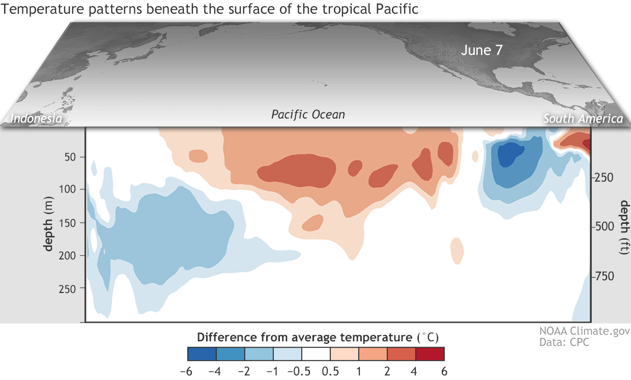
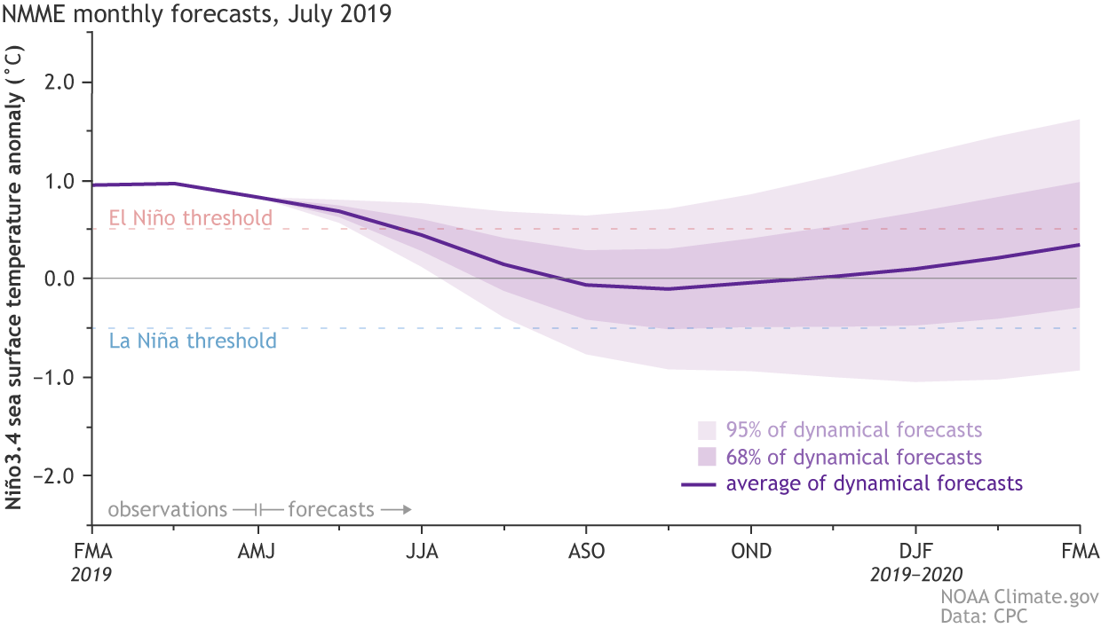
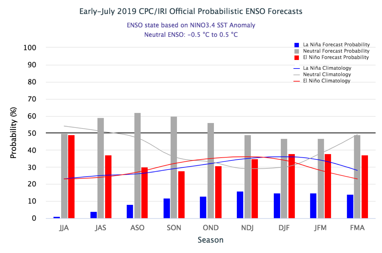
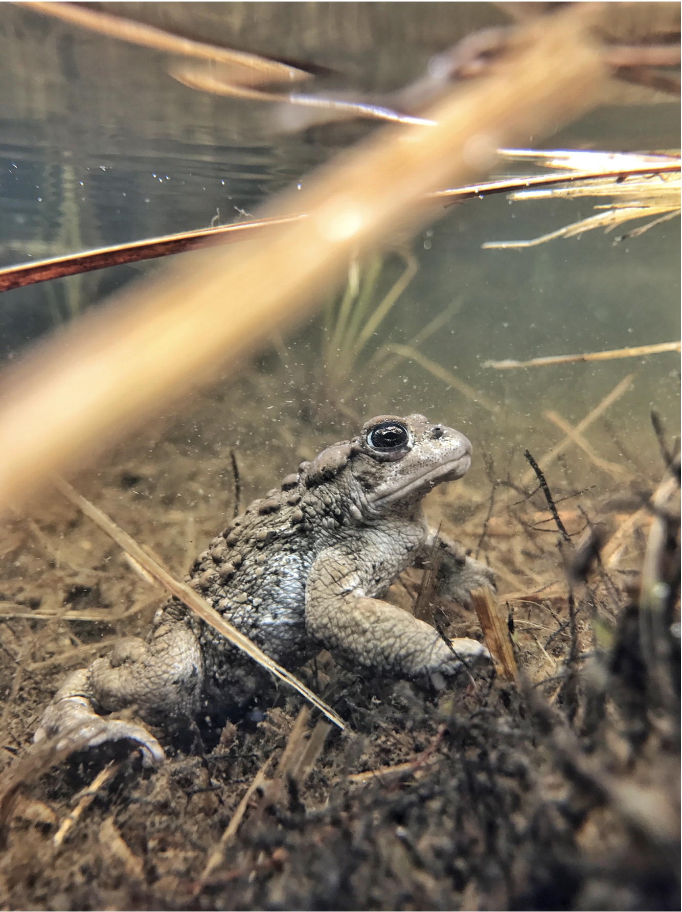
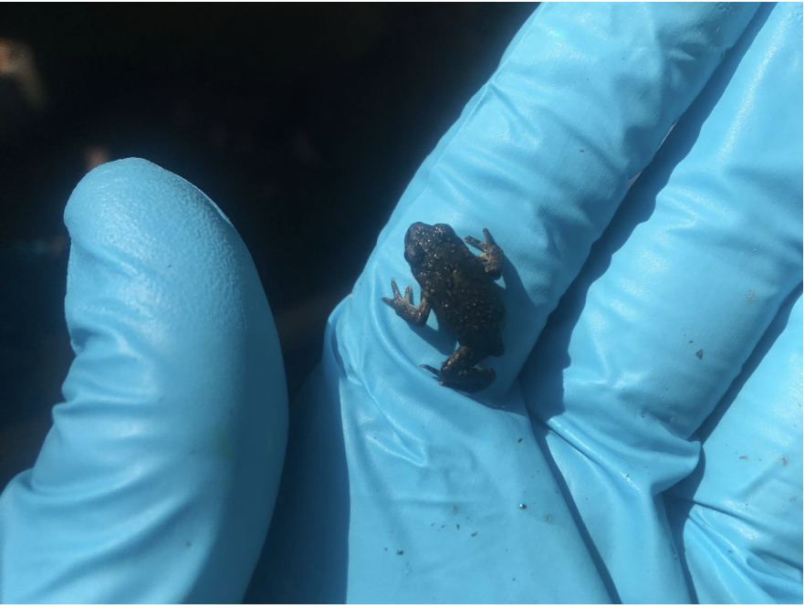


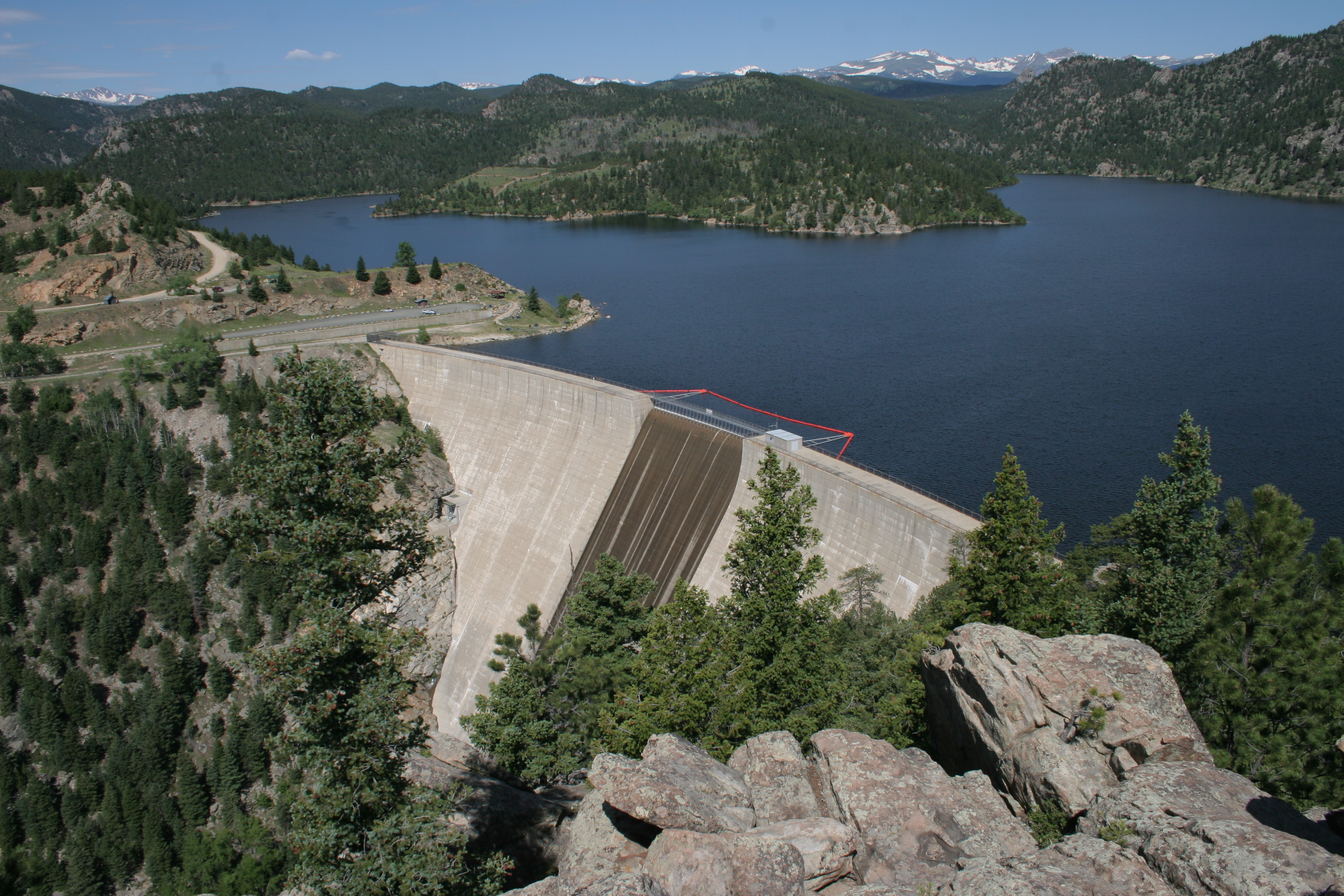

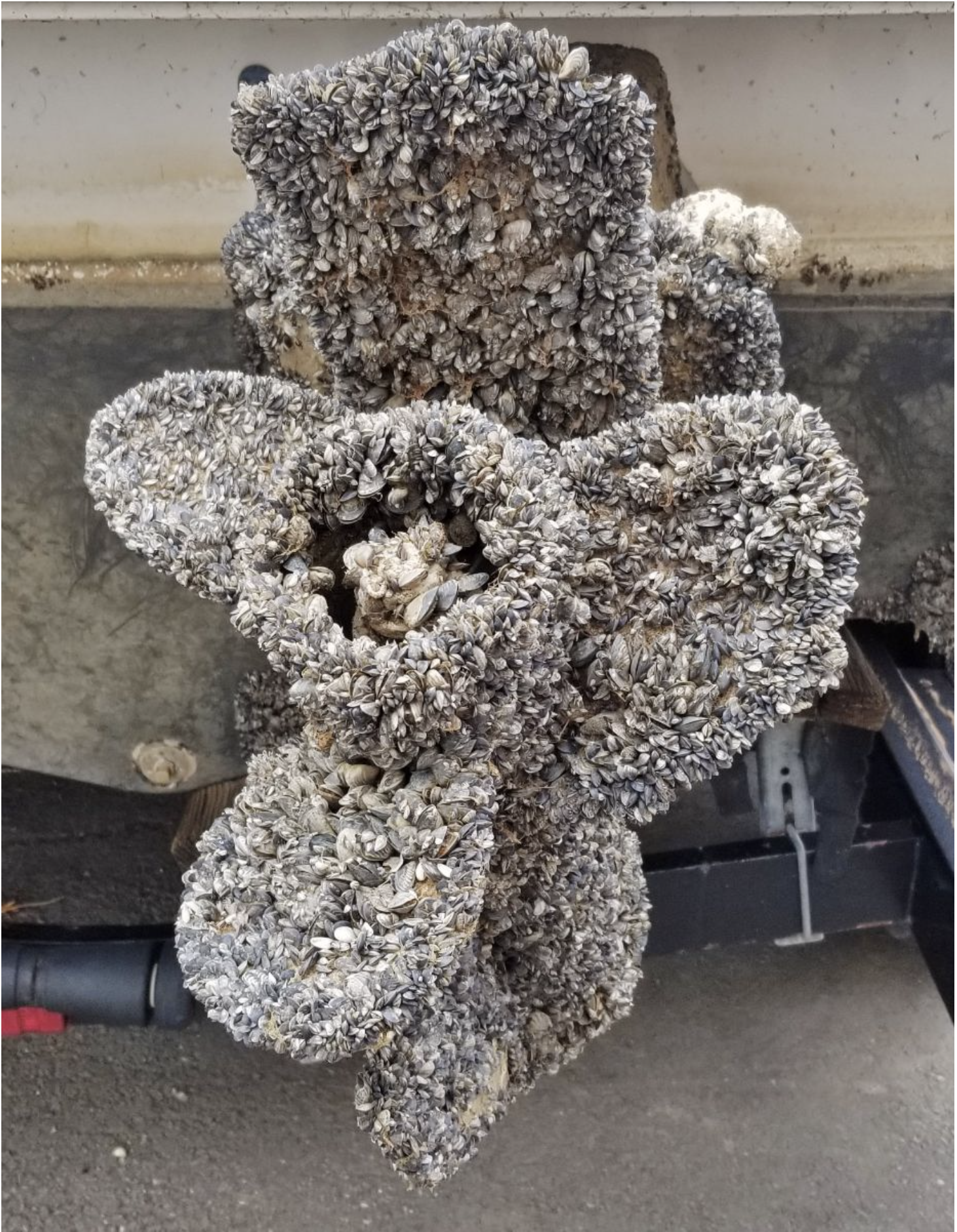


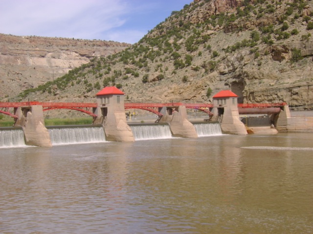


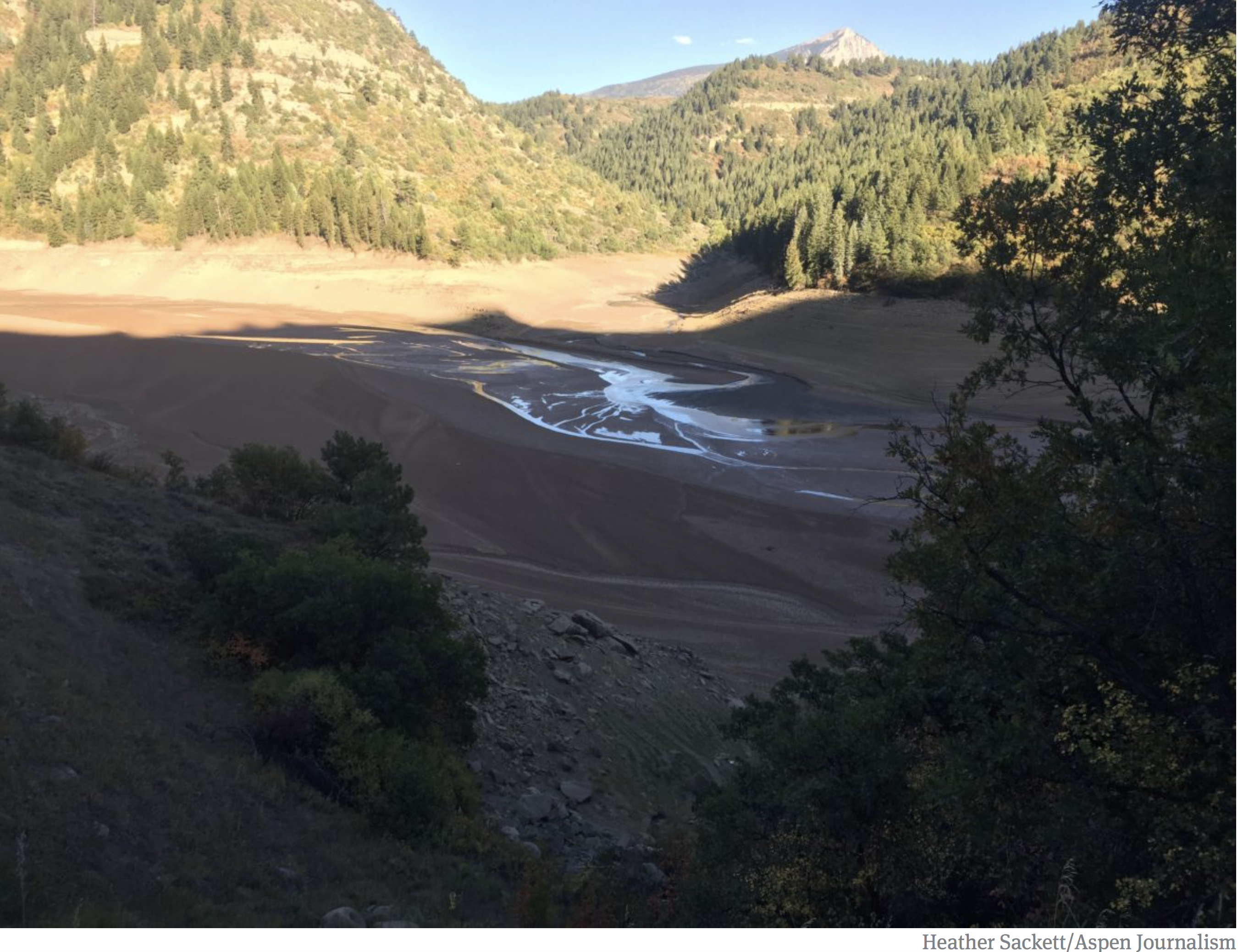


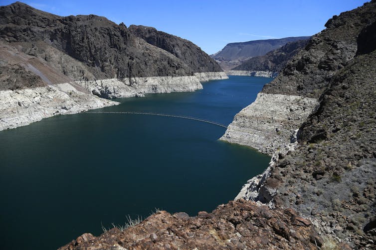

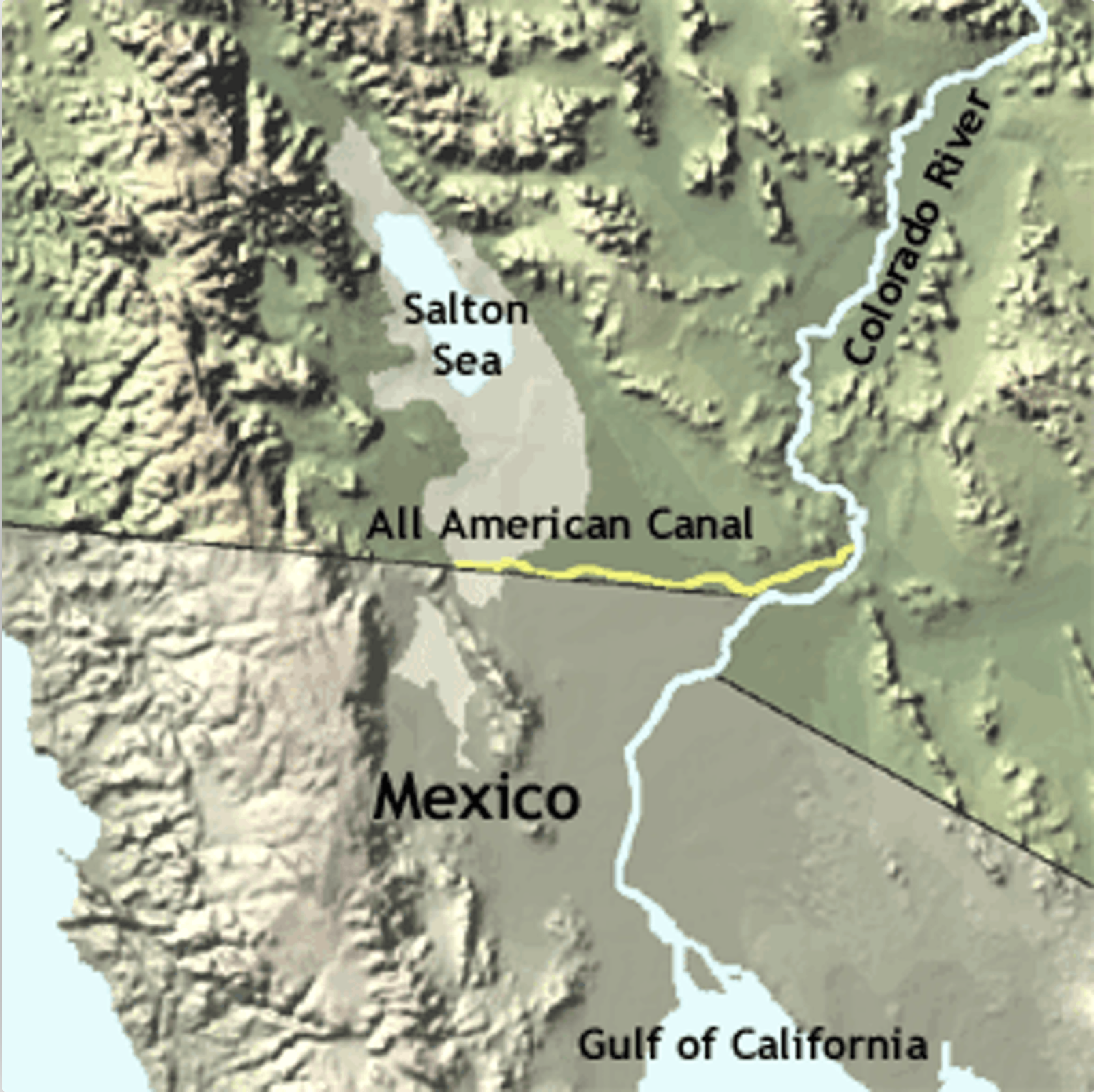
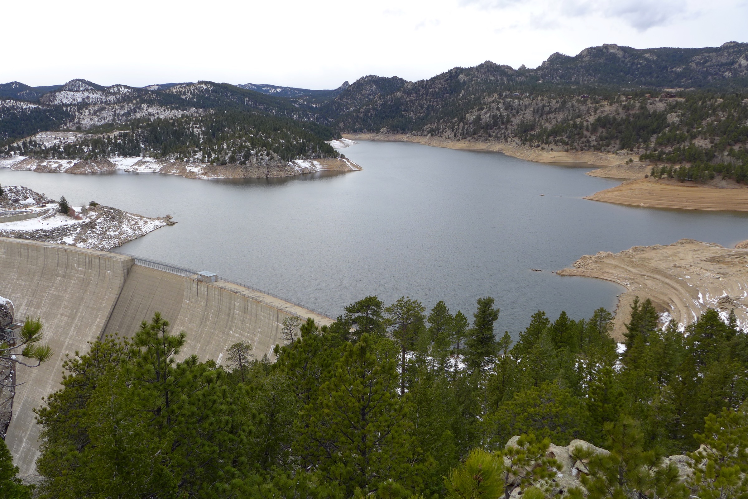

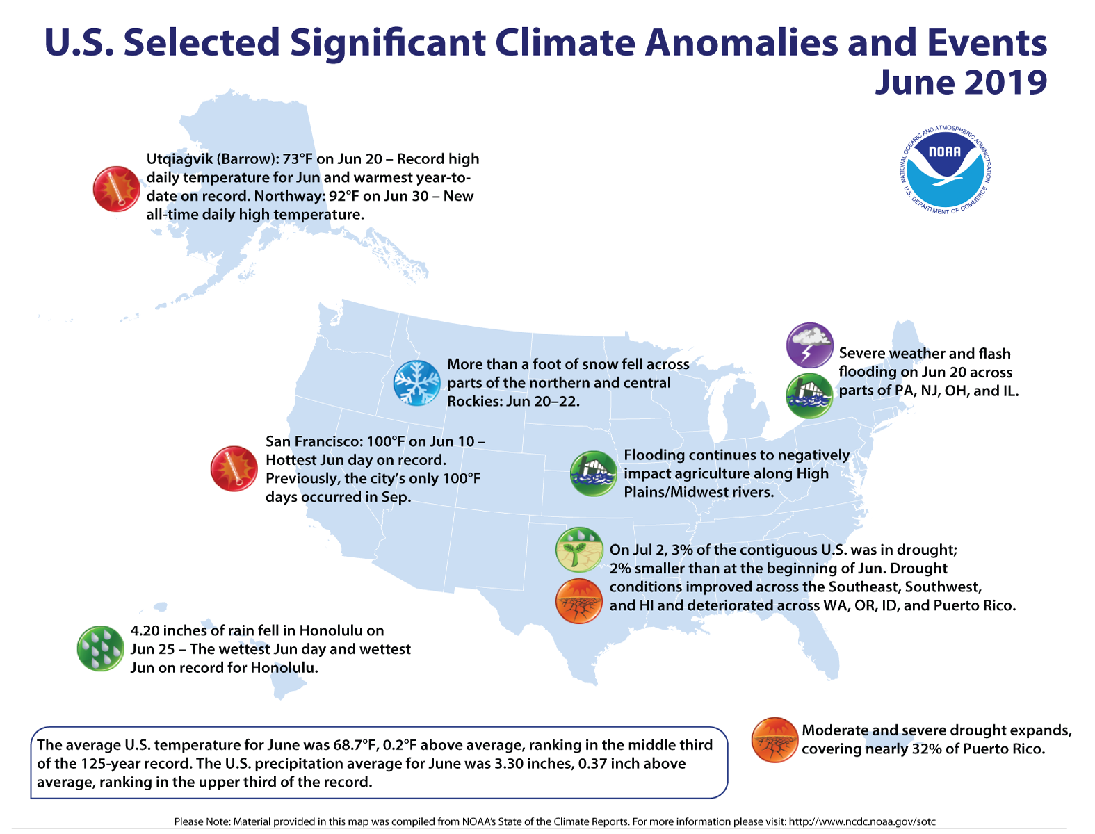
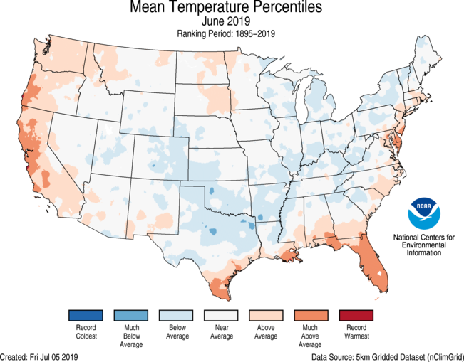
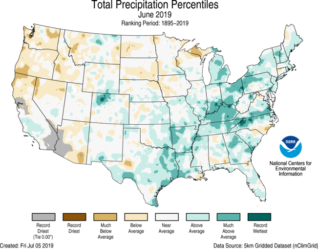
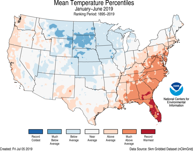
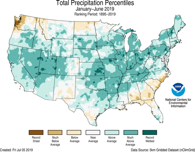
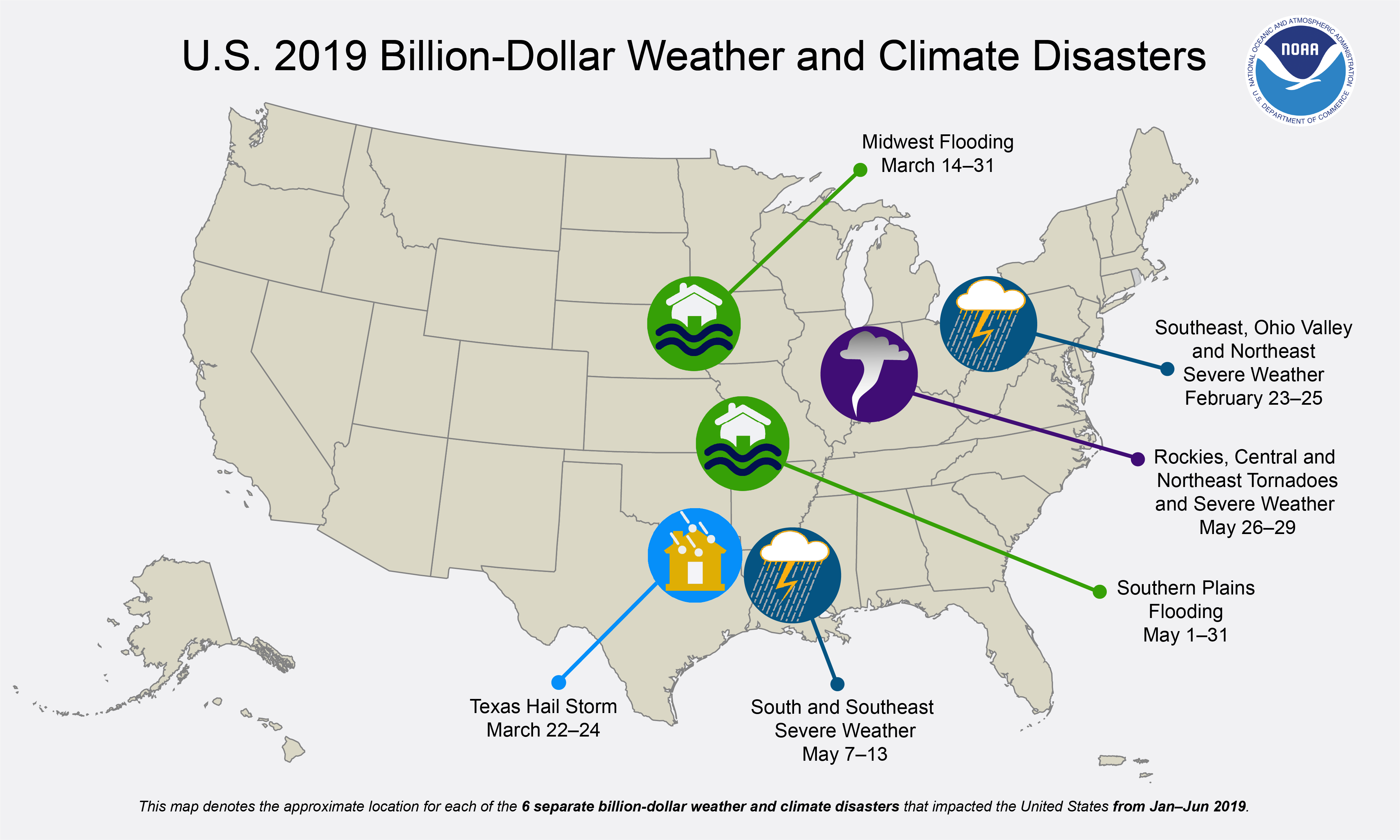
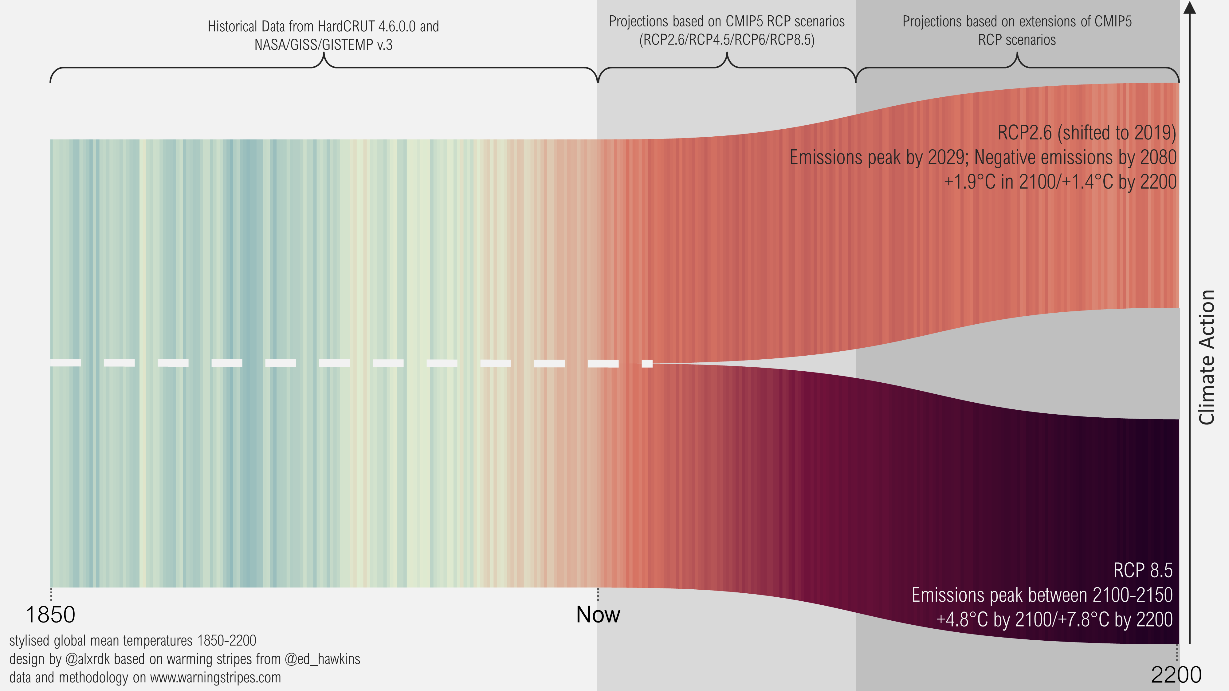
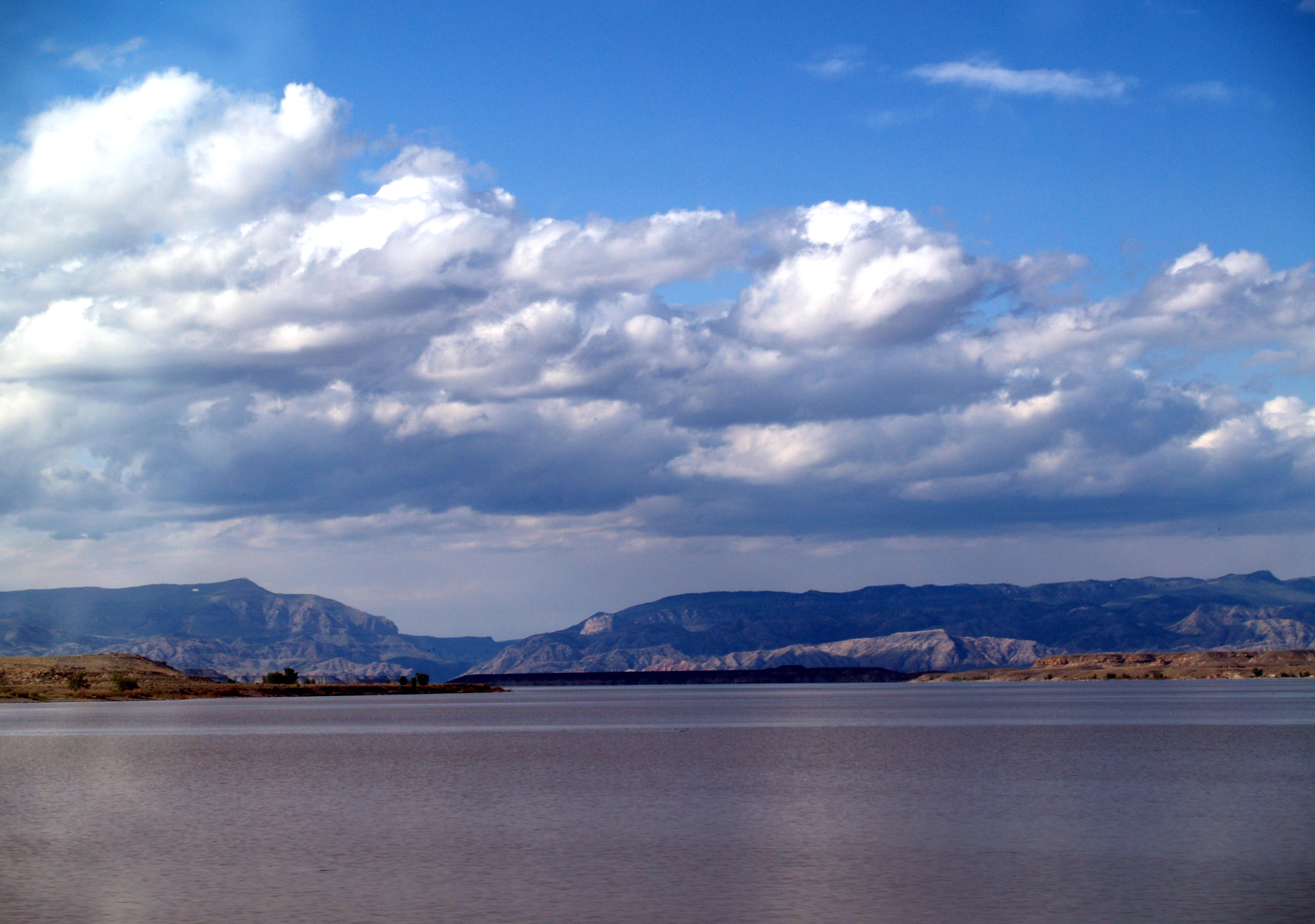


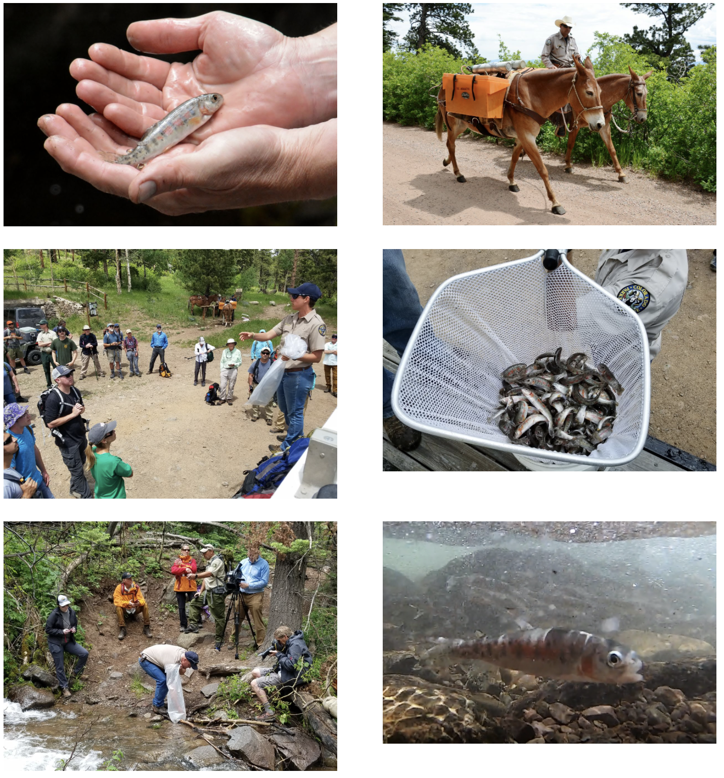

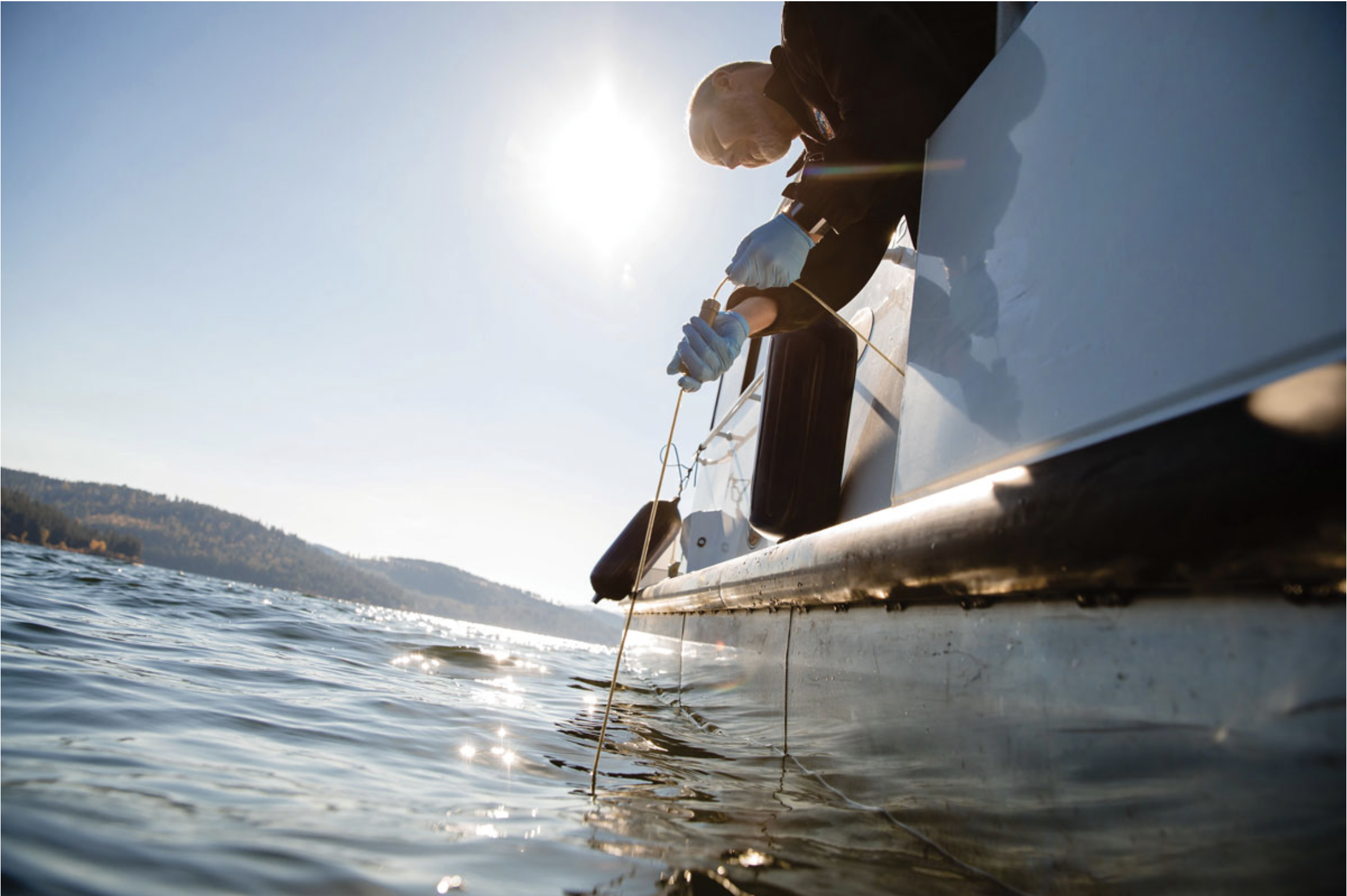
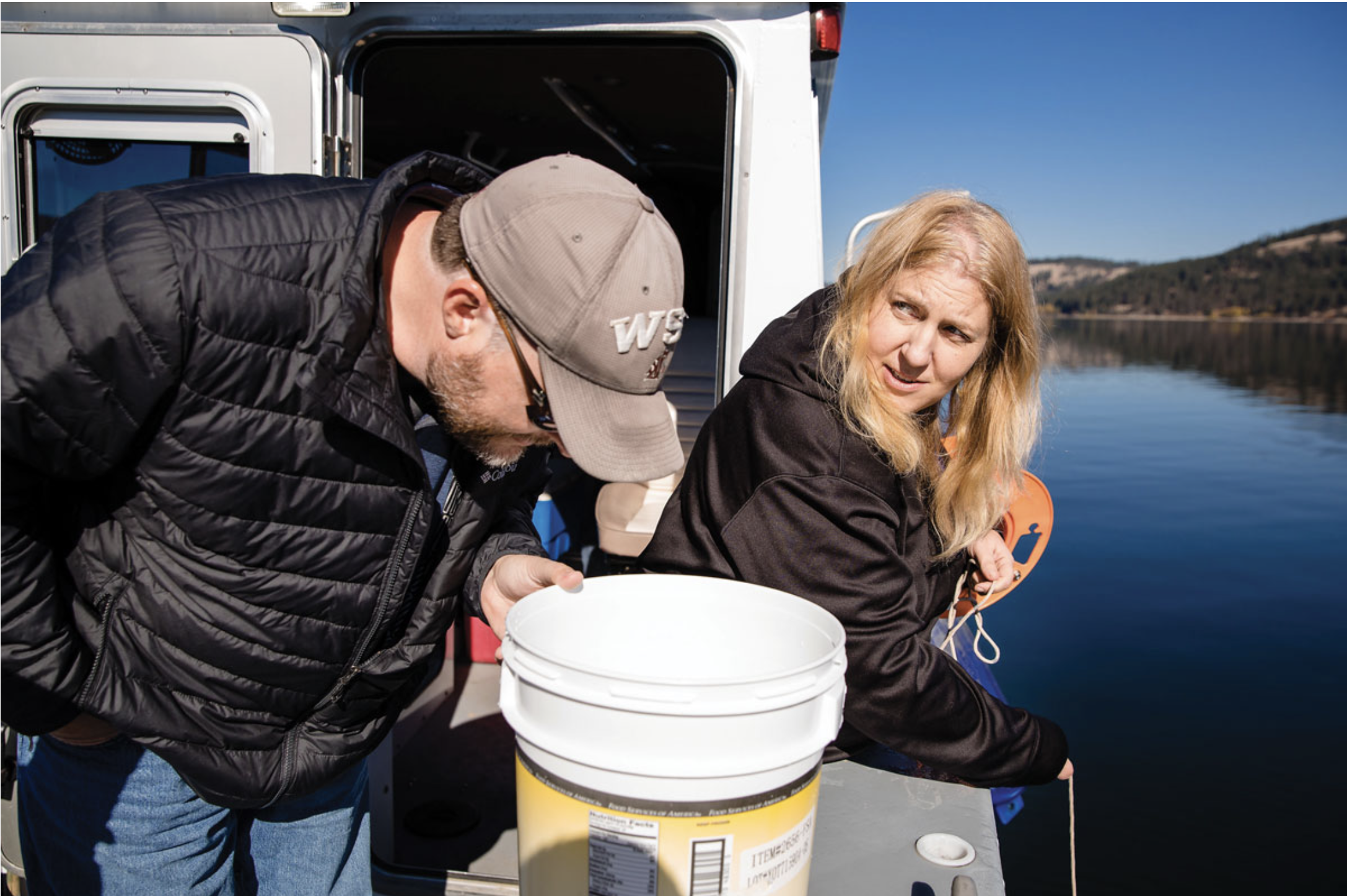

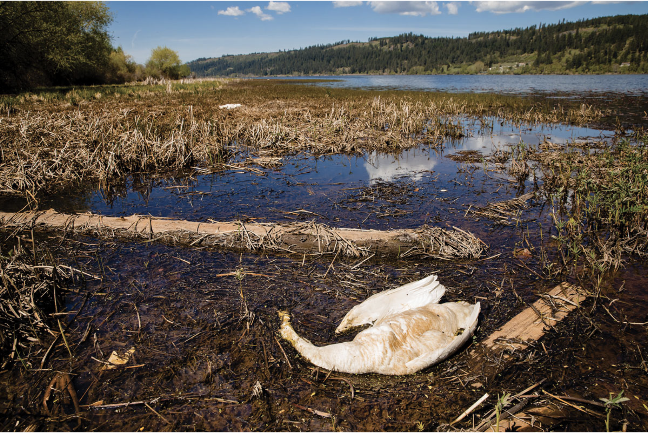


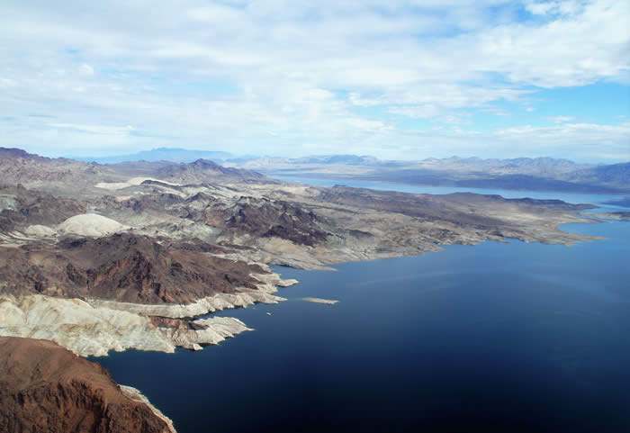
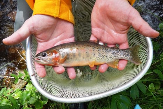


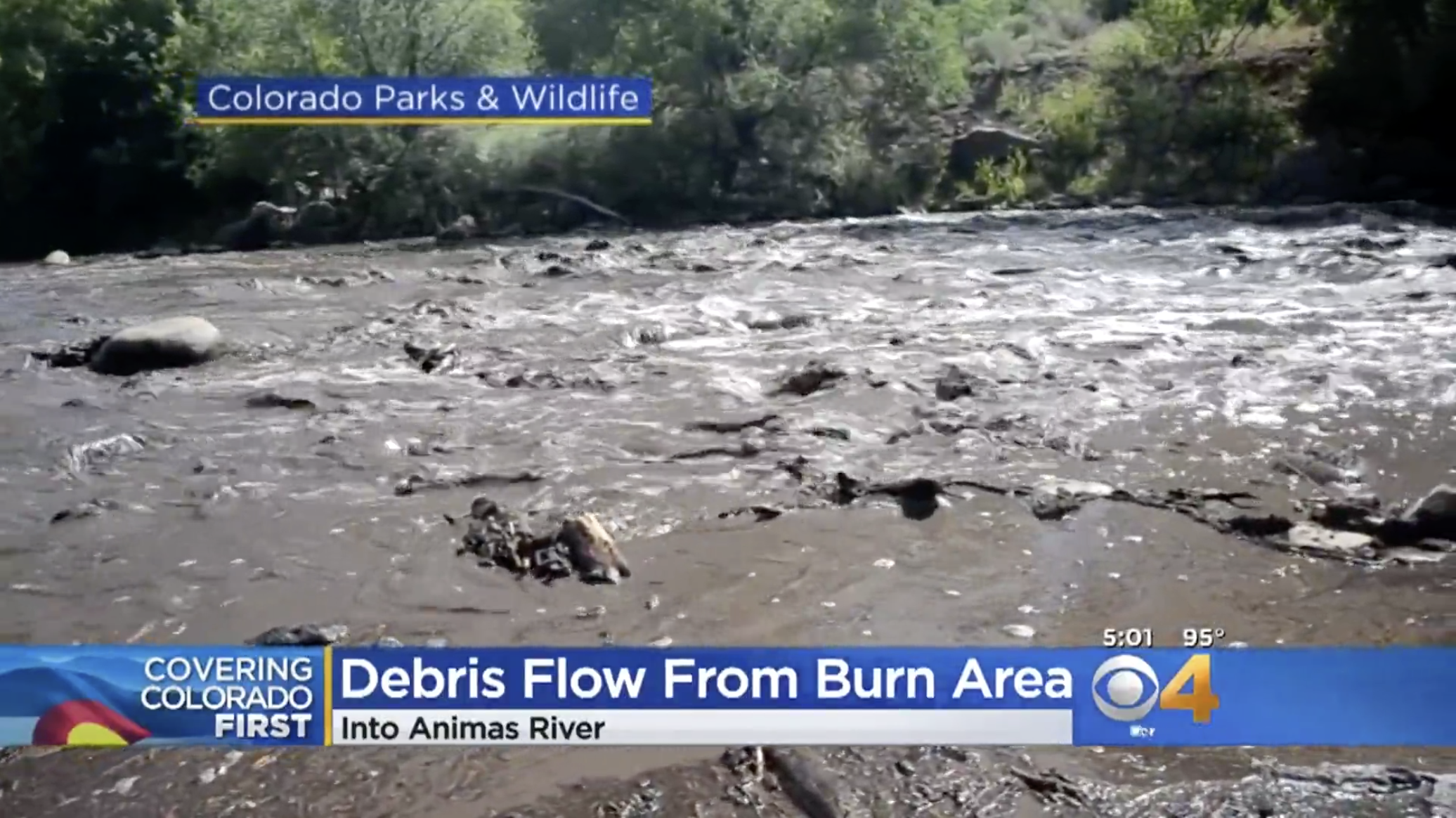
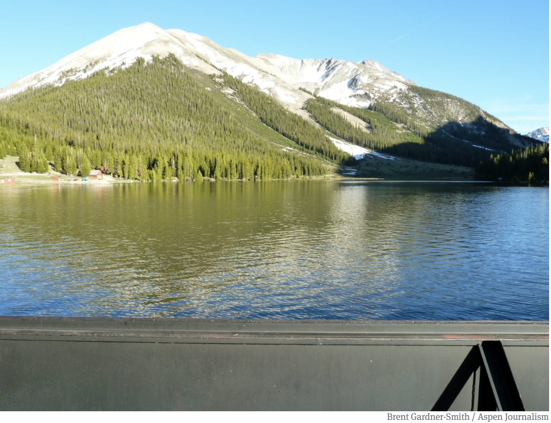
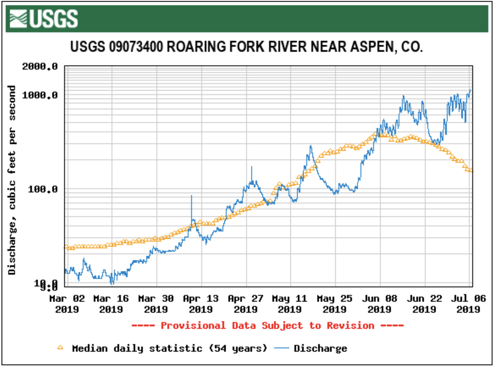
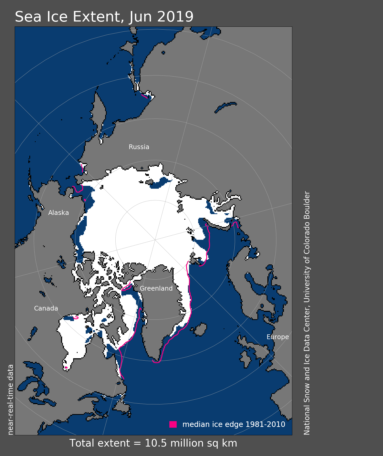
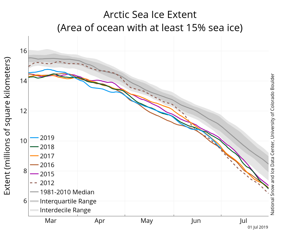


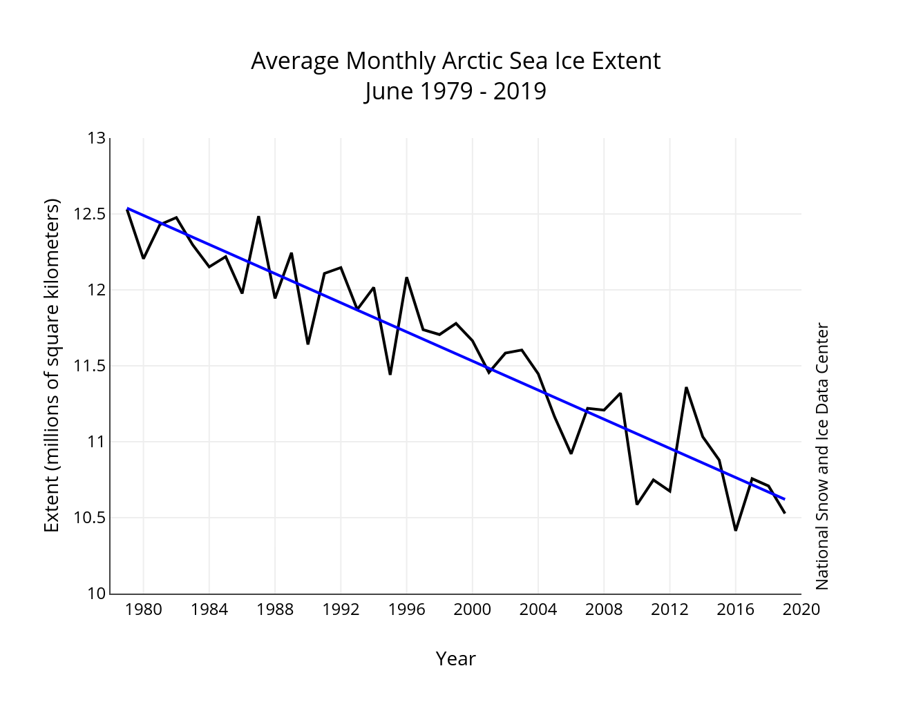


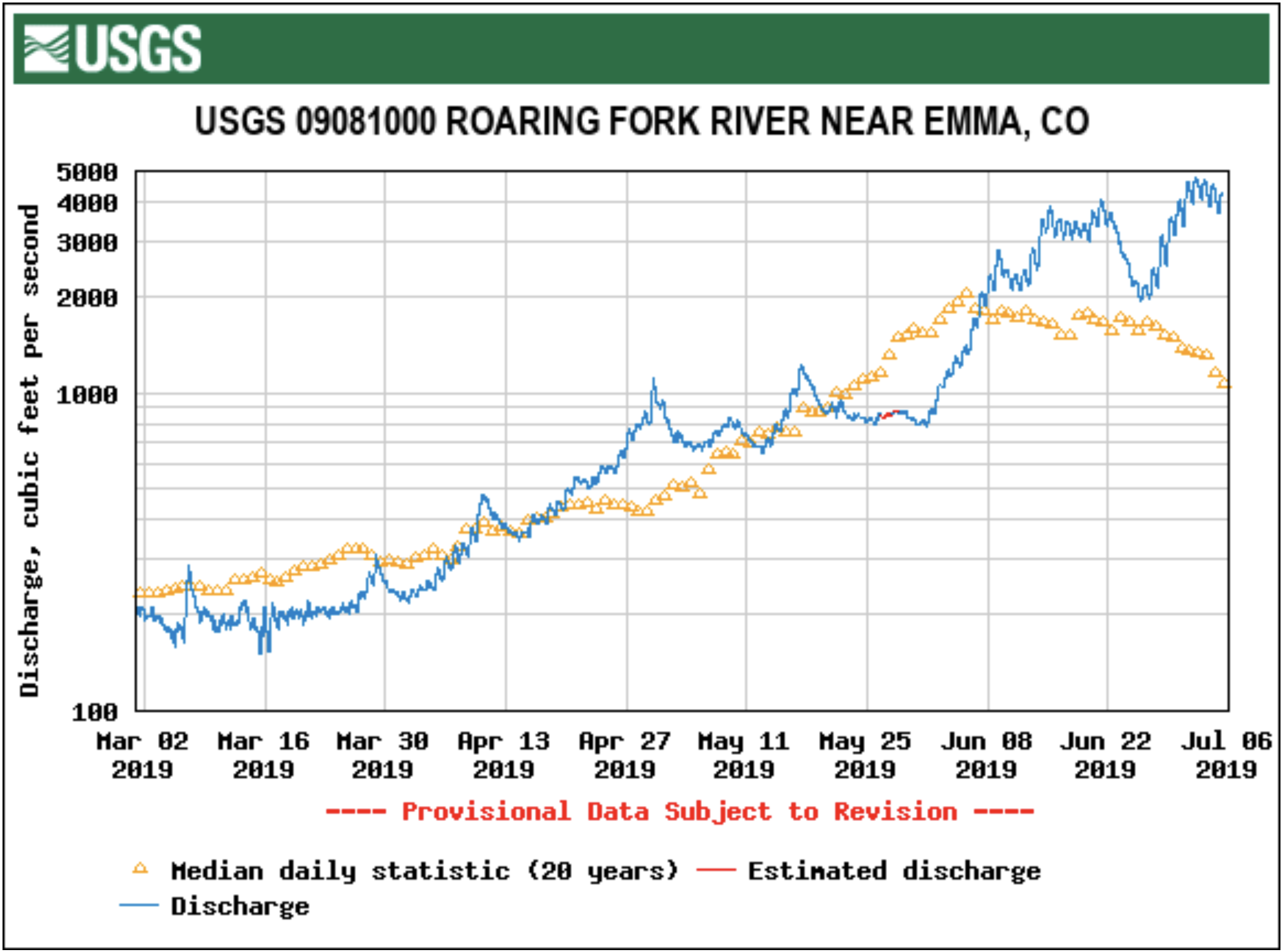

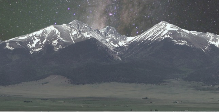
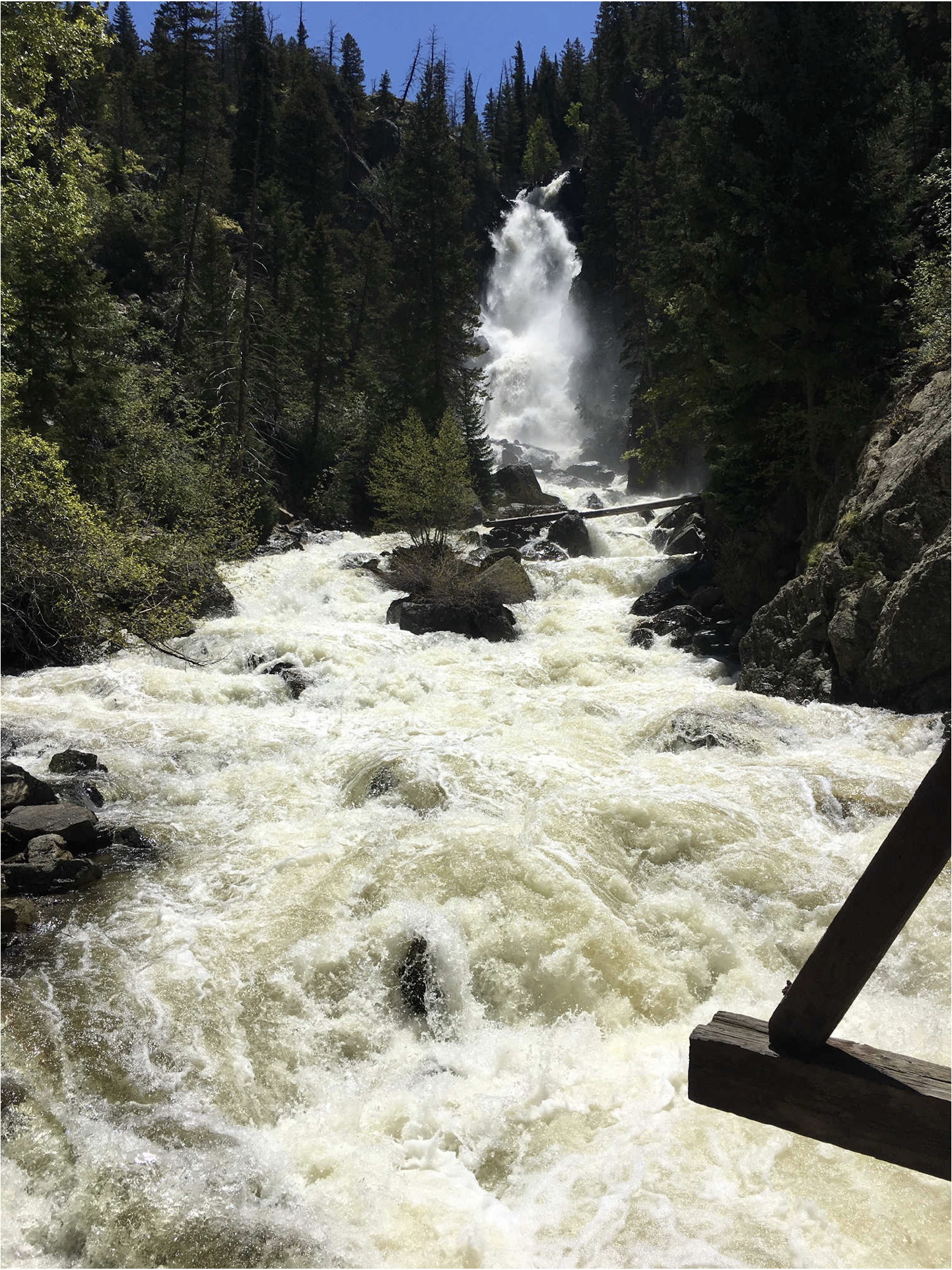
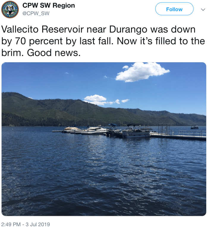
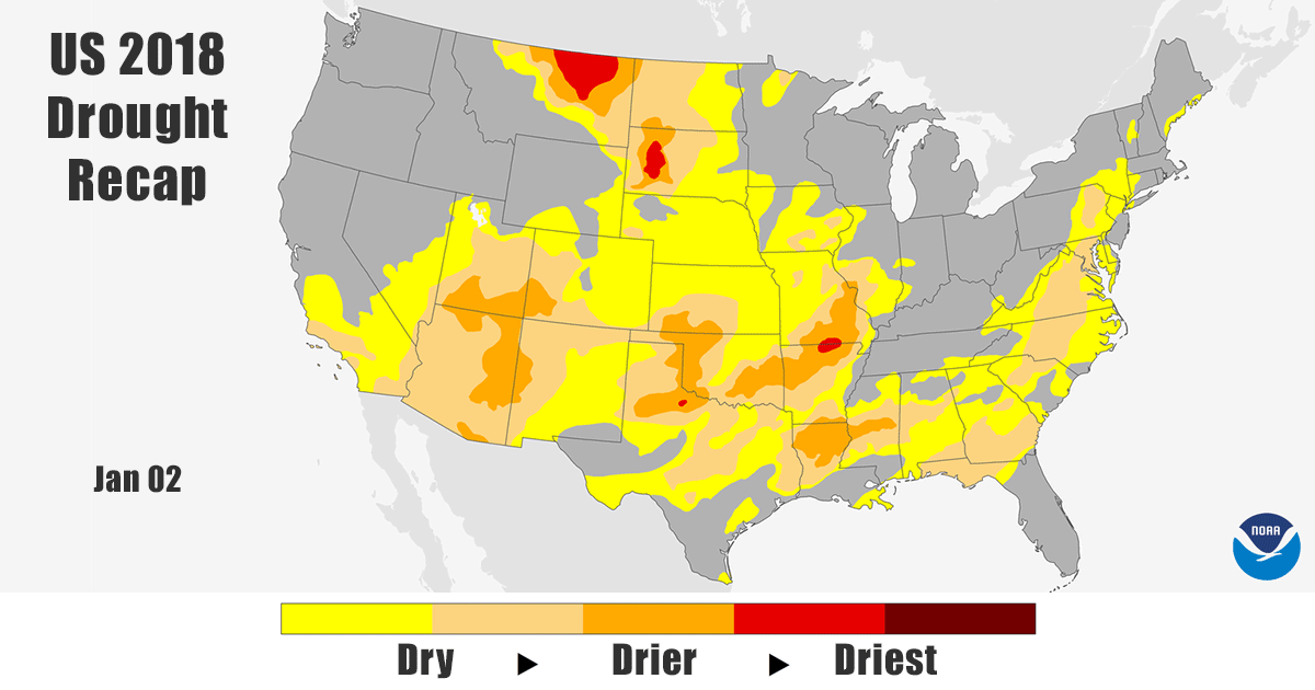