A graduate of the University of Arizona with a master of science degree in agricultural economics, Salmón was appointed to the position of Mexico IBWC Commissioner on April 15, 2009.
In his time with the Commission, which has the responsibility for applying the boundary and water treaties between the United States and Mexico, the two nations have taken huge steps forward in assuring that commitments to the primary binational water agreement in the Southwest – the 1944 Mexico-U.S. Water Treaty – were faithfully upheld.
“It was pleasure working with Commissioner Salmon,” said Jayne Harkins, Commissioner, United States Section, International Boundary and Water Commission.
“He was visionary and worked to find benefits to both countries on international projects. I wish him well in his future endeavors.”
Thanks to a minute to the Treaty backed by Salmón in 2010, Arizona and the other Basin States were able to participate in binational discussions on Colorado River matters. Arizona Department of Water Resources Director Tom Buschatzke observed that the personal relationships that developed from those discussions helped pave the way for future binational agreement.
“Commissioner Salmón recognized the value of personal relationships and worked to develop trust among colleagues on both sides of the border,” recalled Buschatzke.
“That work was a key component in successfully negotiating the minutes and managing the Colorado River.”
Commisioner Salmon with U.S. Interior Secretary Ken Salazar, at a November 2012 in San Diego (Tami A. Heilemann — Office of Communication, U.S. Department of Interior)
In November 2012, Salmón joined in San Diego with U.S. Secretary of the Interior Ken Salazar and other representatives of both countries at an official signing ceremony of Minute 319 to the 1944 Treaty. The ceremony capped three years of work to reach an agreement on a set of cooperative measures for management of the Colorado River system lasting through 2017.
Commissioner Salmón observed at the time that the agreement paved the way for cooperation that can “guarantee sustainability” in the border region, particularly on future water supply for Mexican border communities.
Salmón again was on hand at the U.S. “entry into force” event in September 2017 in Santa Fe, which constituted the final flourish of the intense binational negotiations over Minute 323, the successor update to Minute 319.
Minute 323 established a program of joint cooperative actions to improve Colorado River water management through 2026.
Like Minute 319, the new Minute 323 provides for the U.S. and Mexico to share proportionately in Lower Basin shortage and surplus, and allows Mexico to create water savings in the Colorado River system in the U.S.
The updated agreement also opened up opportunities for U.S. water users to fund conservation programs in Mexico, which in turn create “Intentionally Created Surplus,” or ICS, in Lake Mead. ICS is playing an important role in helping to keep the reservoir from descending to dangerously unstable surface levels.
Salmón’s work on the Commission extended to developments that directly impacted Arizona’s capacity to express its interests in Colorado River matters.
In 2010, he participated in treaty negotiations that produced Minute 317, known as the “Conceptual Framework for U.S. Mexico Discussions on Colorado River Cooperative Actions.” It established a binational process for coordination on Colorado River matters and expressly called for Basin State participation.
Also in 2010, Salmón negotiated with his U.S. counterparts on the enactment of Minute 318, which called for the creation of deferred water deliveries to Mexico after infrastructure damage caused by the 2010 Mexicali earthquake.
Minute 318 allowed Mexico to implement a form of its own ICS, then called “deferred deliveries.” Because Mexico could not beneficially use water as a result of extensive earthquake damage, the water was saved in Lake Mead for Mexico to use in future years.
In an interview with the University of Arizona Water Resources Research Center published shortly after his appointment to the Commission in 2009, Salmón hailed the level of cooperation on water issues between the U.S. and Mexico, particularly through the IBWC.
“Although there have been rough times in the relationship, the IBWC has been able to succeed, to the benefit of both countries,” he said.
“(T)here is an accumulated knowledge and methodologies developed for dealing with delicate issues that have worked in the past, and still work in the present.”
Salmón replaced Arturo Herrera who died in a plane crash in late 2008 along with his U.S. counterpart, Carlos Marin, while flying over flooded areas near Ojinaga, Mexico.
Salmón’s experience in water and agriculture is extensive.
Prior to assuming his position with the Commission, he served as Northwest Regional Manager of Mexico’s National Water Commission (Comisión Nacional del Agua), known as CONAGUA, and covering the state of Sonora and part of the state of Chihuahua where the Yaqui and Mayo river basins originate.
His duties with CONAGUA were sweeping. The federal institution deals with all aspects of water in Mexico. Among its many missions, CONAGUA administers water rights, and constructs, manages, operates and maintains reservoirs throughout the country. CONAGUA also manages irrigation districts and units.
The organization also is involved in the extensive negotiations occurring among the many stakeholders and interest groups in Mexico concerned with water issues – tasks that, in later years, would provide great preparation for Salmón’s duties with the Commission.
Gray wolves are currently protected under the Endangered Species Act, but the Trump administration has petitioned to delist them. That decision, expected this spring, will impact the management and possible reintroduction of wolves in Colorado. Photo credit: Tracy Brooks, U.S. Fish and Wildlife Service via Aspen Journalism
Here’s the release from Colorado State University:
Colorado residents will vote in November on a ballot initiative that calls for the proposed reintroduction of gray wolves to the state. Proposition 107, a citizen-initiated measure, would direct the Colorado Parks and Wildlife Commission to develop and oversee a science-based plan to restore wolves to the western part of the state.
To help ensure the public is informed on this topic, Colorado State University scientists have teamed up with Extension staff to produce and publish educational materials on the possible wolf restoration.
The resources include 12 information sheets on topics including wolf biology, wolves and livestock, disease, human and pet safety, big game and hunting, ecological effects and economics, and a robust list of frequently asked questions with answers.
“As Colorado’s only land-grant institution, CSU is uniquely positioned to provide science-based information on the subject,” said Kevin Crooks, professor in the Department of Fish, Wildlife and Conservation Biology and director of the new Center for Human-Carnivore Coexistence. “The educational materials have undergone extensive review by scientists within and outside CSU, including world experts on wolves.”
Crooks helped lead the development of these educational materials. The center he leads is focused on integrating science, education and outreach to minimize conflict and facilitate coexistence between people and predators.
The center’s team has developed projects in a variety of systems where human-carnivore coexistence is proving difficult. In addition to wolves, they are tracking growing conflicts with urban black bears and coyotes, polar bears in energy fields in Alaska, lions and cattle keepers in East Africa, and ranchers in systems with predators in the United States.
A trail of wolf tracks observed by Colorado Parks and Wildlife officers in Northwest Colorado on January 19, 2020. Photo credit: Colorado Parks & Wildlife
Wolves already spotted in Colorado
In early 2020, after the initiative was approved to be placed on the ballot, a pack of wolves was confirmed to be living in Moffat County in the northwestern part of the state. Another lone wolf was confirmed in North Park in summer 2019. These wolves likely migrated from a nearby state, perhaps Wyoming, where they were reintroduced 25 years ago.
“Science-based information provided from this team is critical to aid in policy development around wildlife and public lands,” said Ashley Stokes, associate vice president for Engagement and Extension at CSU.
Stokes said that these resources are also important for people who vote, so that they may better understand the issues surrounding potential reintroduction of wolves and the impacts on ecological systems, agricultural producers and local communities.
CSU researchers analyzing public response, media coverage
Rebecca Niemiec, assistant professor in the Department of Human Dimension of Natural Resources at CSU, recently led research studies on public perspectives and media coverage of the wolf restoration issue in Colorado.
“One thing we have found from our social science research is that the public has a diversity of beliefs about the potential positive and negative impacts of wolves,” explained Niemiec. “Some of these beliefs are supported by ecological and social science research, while some of them are not. Our hope is that with these educational materials, we can facilitate more productive, science-based discussions about wolf reintroduction and management.”
John Sanderson, who directs the Center for Collaborative Conservation at CSU, helped direct the scientific review process and worked with partners to produce the educational materials.
“The topic of wolves is uniquely contentious,” Sanderson said. “If wolves are part of Colorado’s future, we need an inclusive process of creating policy and making decisions that builds trust and identifies mutually acceptable solutions among people with different perspectives.”
Public surveys over the last few decades suggest support for wolf reintroduction from the majority of Colorado residents. Despite those survey results, restoring wolves in the state is a contentious topic that taps into diverse emotions and passions across various groups. And misinformation about wolves is widespread, on all sides of the issue.
Denver Water reservoirs expected to nearly fill, but higher summer water bills are on the horizon. The post Buckling up for what could be a hot, dry summer appeared first on News on TAP.
Click on a thumbnail graphic to view a gallery of drought data from the United States Drought Monitor.
US Drought Monitor June 9, 2020.
West Drought Monitor June 9, 2020.
Colorado Drought Monitor June 9, 2020.
Click here to go to the United States Drought Monitor website. Here’s an excerpt:
This Week’s Drought Summary
A strong upper-level ridge developed over the Southwest at the beginning of June, and expanded east to the southern Great Plains. 7-day temperatures (June 2 to 8) averaged more than 10 degrees F above normal across much of the southern to central Great Plains until a strong cold front arrived on June 9. From June 6 to 8, a vigorous upper-level trough progressed east and resulted in varying amounts of rainfall and much cooler temperatures from the Pacific Northwest to the northern Rockies and northern Great Plains. Around the periphery of the upper-level ridge, mesoscale convective systems with severe thunderstorms and locally heavy rain (more than 2 inches) occurred from the Upper and Middle Mississippi Valley southeast to the mid-Atlantic. After spending multiple days stationary over southern Mexico, Tropical Storm Cristobal tracked north across the Gulf of Mexico and made landfall in southeast Louisiana on June 7. The heaviest rainfall occurred to the east of its landfall. 7-day precipitation amounts (ending 12Z June 9) exceeded 5 inches, with locally higher amounts, from the Mississippi Gulf Coast east to the Florida Panhandle. A weak surface low remained located across the Gulf of Alaska at the beginning of June. The most widespread rainfall (more than 1 inch) occurred across southeast coastal Alaska, while scattered convection raised wildfire concerns over the interior of Alaska. Rainfall was suppressed ¬across Hawaii this past week, while heavy rainfall occurred well west of Puerto Rico during the first week of June…
Extreme drought (D3) was expanded across southeast Colorado based in part on soil moisture in the lowest 5th percentile. Above normal temperatures coupled with periods of strong winds continue to result in rapidly worsening conditions and reports of widespread selling of cattle. Trinidad, Colorado recorded only 1.66″ of precip year-to-date which is the driest January 1-June 9 on record. Data here dates back to 1948.The intensifying and developing drought conditions across Oklahoma also extended into the southern two-thirds of Kansas. This region missed out the widespread rainfall farther to the north across Nebraska and much above normal temperatures prevailed during the first week of June. Following the previous week’s expansion of abnormal dryness to cover a majority of Wyoming, moderate short-term drought (D1) was added to parts of Wyoming where the largest 60 to 90-day precipitation deficits along with SPI values support it. Widespread 7-day amounts of 1 or more inches of rainfall precluded additional expansion of abnormal dryness (D0) across much of the northern Great Plains, while there was a slight reduction of D0 across western Nebraska based on 7-day rainfall amounts…
Drought is rapidly developing or intensifying across northern and eastern New Mexico. Abnormal dryness was introduced to southeast Arizona based on SPI values. In addition, May 2020 was the 5th warmest May on record which is likely exacerbating the dyrness as a number of wildfires have developed. Abnormal dryness (D0) and moderate drought (D1) was expanded across southwest Utah, while the addition of extreme drought (D3) to Utah was supported by SPI values at various time scales. Farther to the north across Montana, widespread precipitation precluded a large expansion of abnormal dryness except for areas bordering Canada.
Unseasonably heavy precipitation, including high-elevation snow, prompted a slight decrease in the coverage of severe drought (D2) across parts of northeastern Utah. This decrease occurred where more than 1 inch (liquid equivalent) was observed. Likewise, 7-day precipitation (more than 1 inch) along with a wet late spring resulted in a slight decrease in extreme drought (D3) across northern California and severe drought (D2) in the southwest corner of Washington. Above normal precipitation during May into the beginning of June along with an increase in 28-day streamflows prompted slight improvements, while conditions worsened east of the Cascades. An increase in soil moisture and easing of long-term precipitation deficits resulted in a small 1-category improvement to the drought status across northeast Washington…
Drought continues to rapidly develop and intensify across the southern Great Plains. During a relatively wet time of year, precipitation has averaged less than 50 percent across much of western Oklahoma and the Texas Panhandle. This lack of rainfall coupled with periods of much above normal temperatures and strong winds have dried out topsoils quickly. According to the USDA’s National Agricultural Statistics Service, topsoil moisture being rated as short or very short across Oklahoma increased from 23 to 53 percent during the past week. Conversely, 1 to 2-category improvements were made along the Gulf Coast. Total rainfall amounts, associated with Tropical Storm Cristobal, included 8 inches at Pascagoula, Mississippi. Moderate long-term drought remains designated for the Mississippi Gulf Coast due to precipitation deficits dating back to 90 and 180 days…
Looking Ahead
On June 11, a cold front is forecast to cross the eastern U.S. Surface high pressure, behind this front, is likely to result in mostly dry weather from the Appalachians west to the Rockies. Along with the dry weather, a return of above normal temperatures is likely across the central and southern Great Plains. From June 11-15, the heaviest precipitation (locally more than 1 inch) is forecast across the eastern Carolinas and Florida Peninsula. Following the heavy to excessive rainfall during early June, an extended period of dry weather is likely along the Gulf Coast. Seasonal dryness is forecast across the Southwest and California, while occasional light precipitation occurs across the Pacific Northwest.
The CPC 6-10 day outlook (June 16-20) indicates increased chances of above normal temperatures extending from the Great Plains northeast to the Great Lakes and New England with below normal temperature most likely across the northern Rockies. A large area with increased chances of below normal precipitation covers most of the Great Plains, Mississippi Valley, Corn Belt, and Gulf Coast States. A slight tilt toward above normal precipitation is limited to the mid-Atlantic, south Florida, and parts of the Pacific Northwest and northern Rockies. Above normal temperatures are favored throughout Alaska along with slightly elevated probabilities of above normal precipitation.
United States Drought Monitor one week change map ending June 9, 2020.
FromThe Denver Post (Judith Kohler) via The Broomfield Enterprise:
The Colorado Oil and Gas Conservation Commission approved the rules Wednesday as part of ongoing revisions to oil and gas regulations mandated by Senate Bill 181, approved by the legislature in 2019.
The regulations deal with the well bore, or the hole that’s drilled to access oil or gas as well as the pipes and casings installed to inject fluids to make fractures in rocks and sand and bring up the oil and gas. The casings and cement that are part of the construction are also meant to ensure that no fracking fluids, oil or gas escape and flow into groundwater.
Heading into the hearing, there was general agreement among the parties on the proposed changes. Since the COGCC and the state Air Quality Control Commission began writing new rules, oil and gas industry representatives, community and environmental groups have clashed with each other and with agency staffers in hearings and meetings over how far the regulations should go.
But Julie Murphy, COGCC deputy director, said the agency was able to consider new rules on well bores earlier than expected thanks to a broad consensus among the various parties. She said the “top-line” change is the new requirement that the pressure in all wells across the state be tested annually to ensure that the casings and cement are still in good shape.
The annual testing and regular monitoring approved put Colorado at the head of the pack among oil- and gas-producing states, said Adam Peltz, an attorney with Environmental Defense Fund who has reviewed and worked on similar regulations across the country. He noted that the COGCC has tried to incorporate as many recommendations as possible from a 136-point list put together by a multi-state body of regulators and policy makers.
Another important change is a more precautionary approach to making sure that groundwater no matter, how far down it is located, is protected by isolating the oil, gas and fracking fluids with casings and cement, Murphy said…
The new rule is consistent with Colorado state groundwater standards, Freeman said. The COGCC staff added language saying that groundwater with less than 10,000 parts per million total dissolved solids in it must be protected, Freeman said.
The standard addresses the amount of salt in the water is and is the same one in the federal Safe Drinking Water Act and used by the Colorado Water Quality Control Commission, Freeman said.
Water with 3,000-10,000 parts per million of total dissolved solids is often called “brackish,” or saltier than fresh water, but it can be treated to use for drinking.
PRESS RELEASE FOR IMMEDIATE RELEASE CONTACT: Doug MacEachern or Shauna Evans June 10, 2020 PHONE: 602.771. 8507 or 602.771.8079 A Statement on the 40th Anniversary of Arizona Groundwater Management Act […]
Click here to read the release from the State of Colorado (Chris Arend, Heatheryn Higgins, Jessica Bralish, Matt Inzeo):
The Colorado Departments of Natural Resources, Public Health and Environment, Transportation and the Colorado Energy Office joined together in a statement expressing concern about President Donald Trump’s Executive order to lift reviews of environmentally impactful activities.
“The June 4, 2020, Executive Order from President Donald Trump directs federal agencies to bypass requirements for a number of bedrock federal environmental laws, including:
The National Environmental Policy Act
Endangered Species Act
Clean Water Act
Federal Policy and Land Management Act
It leaves to the federal agencies what projects or decisions they may move forward without complying with the protections of these and other laws, and removes the public’s ability to know about and comment on how such agency decisions will affect them and their communities.
Our Departments have successfully worked with local governments, businesses, stakeholders and citizens on numerous high profile projects where public engagement and additional environmental review enabled better projects, greater community buy-in, and increased protections for wildlife and natural resources. Specific examples include the Central I-70 Development in Denver, I-70 Mountain Corridor near Glenwood Springs, Upper Colorado River Endangered Fish Recovery Program, Canyons of the Ancients National Monument and Chatfield Reservoir Reallocation Project.
The attempt to avoid public engagement, environmental analysis and mitigation will damage Coloradans’ health, environment and economy. It will affect all parts of the state, from our prized public lands to urban development. It will threaten protections and careful balancing for water projects, as well as progress towards environmental justice including in building transportation infrastructure — which has had a legacy of significantly impacting urban downtowns and minority communities in the 1950s and 1960s, before these environmental protections were put in place. At a time when the risks of respiratory illnesses are especially worrisome, we should be doing more to account for communities’ health, not less.
The state of Colorado prioritizes efficient government processes with respect to project approvals, but emphasizes that public input and participation is a critical step in that efficient process, ensuring we’re not allowing public resources to be spent or used for publicly harmful practices.
While emergency exceptions do occur for some federal environmental rules, they are intended for true physical emergencies such as washed out roads from the 2013 floods, replacement of critical facilities after wildfires or failing dams.
Neither the COVID-19 emergency nor current economic conditions fall into that category that would justify shortcutting engaged, smart and thoughtful projects and decisions. Indeed, now more than ever, we need to ensure that projects protect our communities and safeguard Coloradans’ health, land, air, water, and wildlife.
Unilateral Executive Orders will only serve to delay needed highway improvements, critical energy infrastructure or efforts to protect our endangered wildlife and their habitat through litigation and administrative appeals.
We urge the Trump Administration to work with the State of Colorado on mutual beneficial projects which are collaborative, thorough, and protective of our environment and communities while providing long term benefits for all Coloradans.”
Will Toor, Executive Director, Colorado Energy Office
Dan Gibbs, Executive Director, Department of Natural Resources
Jill Hunsaker Ryan, Executive Director, Department of Public Health and Environment
Shoshana Lew, Executive Director, Department of Transportation
North face of Pike’s Peak as seen in profile from Conifer mountain. Photo credit: Greg Hobbs
The administration has brazenly axed another long list of environmental protections — when it should have been healing a nation wounded by the pandemic and racist violence.
Under cover of tear gas, the Trump administration last week intensified its ongoing demolition of the country’s bedrock environmental protections — a series of calculated moves made while the nation remained gripped by the twin viruses of COVID-19 and institutional racism.
It started on Thursday, June 4, when President Trump used the pandemic as an “emergency” excuse to issue an executive order allowing federal agencies to set aside key protections in the Endangered Species Act and the National Environmental Policy Act in order to speed up the construction of oil and gas pipelines, highways and other projects.
Trump’s long-threatened NEPA rollback, which will limit citizens’ ability to voice objections to destructive projects, poses a direct threat to minority communities already facing greater levels of illness and death under the COVID-19 pandemic following decades of environmental racism.
“Here we are in the midst of an epidemic that affects your respiratory system and communities that are concerned about respiratory health are losing a voice to stop projects that exacerbate serious health issues,” David Hayes, executive director of the State Energy and Environmental Impact Center at New York University’s School of Law, told The Hill.
The executive order came three days after Trump used police and teargas to clear away peaceful crowds protesting racially biased police violence to make room for his now-notorious photo op in front of St. John’s Episcopal Church.
And it came the same day the National Oceanic and Atmospheric Administration announced that world atmospheric carbon dioxide levels had reached a new record high of 417.1 parts per million, putting the planet further on the path toward runaway climate change. “Progress in emissions reductions is not visible in the CO2 record,” NOAA senior scientist Pieter Tans said in the announcement. “We continue to commit our planet — for centuries or longer — to more global heating, sea level rise and extreme weather events every year.”
The text of the press release continued: “If humans were to suddenly stop emitting CO2, it would take thousands of years for our CO2 emissions so far to be absorbed into the deep ocean and atmospheric CO2 to return to pre-industrial levels.”
The carbon dioxide data on Mauna Loa constitute the longest record of direct measurements of carbon dioxide in the atmosphere. C. David Keeling of the Scripps Institution of Oceanography began measurements in 1958 at the NOAA weather station. NOAA started its own CO2 measurements in May of 1974, and they have run in parallel with those made by Scripps since then. Credit: NOAA and Scripps Institution of Oceanography.
Which made it all the more perplexing when the EPA, following Trump’s order for additional “emergency” deregulation, announced it would ease the rules that require factories and power plants to report — or even monitor — their pollution emissions, although it did state that these industries should continue to obey existing pollution limits.
In another giveaway to industry, the new policy has been made retroactive to March 13, 2020.
As if those two changes weren’t enough, the slash and burn of environmental protections continued Friday, June 5, when Trump opened Northeast Canyons and Seamounts Marine National Monument to commercial fishing. The 4,913-square-mile reserve, located 130 miles off the coast of Cape Cod, was established by President Obama in 2016 under the Antiquities Act and is home to “fragile and largely pristine deep marine ecosystems and rich biodiversity,” according to NOAA.
The move came exactly one week after Trump declared June to be “National Ocean Month” in a bizarre proclamation that focused more on offshore oil and gas development and seafood production than conservation.
The changes were, of course, immediate criticized.
“This rollback essentially sells off the future of the ocean and the future of the ecosystem for almost no present economic benefit,” Miriam Goldstein, ocean policy director at the Center for American Progress, told The Guardian. She added that it’s “puzzling that the president is doing it now, in the middle of the pandemic and with police riots going on around the country.”
Mystic Aquarium was instrumental in providing the scientific rationale for the designation of the Northeast Canyons and Seamounts Marine National Monument, an area critical to combating the climate crisis that we are facing. To roll back protections is a mistake. pic.twitter.com/E9pdH1m6jd
Much like Trump’s similar moves to shrink or eliminate other national monuments established by Obama under the Antiquities Act, the change to Northeast Canyons and Seamounts is probably illegal. As we’ve written before, presidents have the legal authority to establish monuments but not to rescind or downsize them. Lawsuits over Trump’s previous monument reductions continue to work their way through the courts, and new suits over this rollback are already expected to follow.
Still more rollbacks are on the way.
Also on Friday June 5, the Trump administration moved forward with plans to reduce the protections offered under the Migratory Bird Treaty Act, another giveaway to the oil and gas industries — a particularly tone-deaf move during the middle of Black Birders Week, a nationwide event celebrating diversity in nature that coincided with the protests over racial police violence.
The changes to the 1918 international treaty law, which has helped hundreds of species over the past century, would decriminalize “incidental” (non-intentional) bird deaths caused by industrial projects such as oil pits, mines, telecommunications towers, wind turbines and other threats.
The changes aren’t final and are subject to a public-comments period, although citizens have already submitted approximately 200,000 public comments in favor of keeping the law as-is. But as National Audubon Society CEO David Yarnold pointed out, comment periods under the Trump administration “have become a cruel joke. The administration continues to ignore scientists, experts and … bird-lovers in favor of a few bad corporate actors who can’t be bothered with common sense environmental protections.”
Rep. Alan Lowenthal (D-Calif.) also criticized the changes, saying they would “lead to the deaths of thousands and thousands of birds protected under the MBTA. The administration’s radical action needlessly ties the hands of the [U.S. Fish and Wildlife Service], while at the same time undermining our international treaty obligations.”
What does all of this really mean in the long run? Legal experts have already pointed out that Trump’s executive order doesn’t have many teeth. “The Order is legally shaky and unlikely to accomplish much,” Dan Farber of UC Berkeley School of Law wrote this week.
Even corporate interests expressed some doubt, especially since the executive order will undoubtedly face court challenges. One engineer tweeted, as quoted by the Washington Post, that “there is *NO WAY* I would turn a shovelful of dirt based on this Order.”
But industry groups actively celebrated the changes and expressed hope they would extend beyond the “emergency” period.
“We value the importance of these reforms now and underscore the need for finalizing rules across regulatory agencies that will implement permanent reforms,” American Exploration and Production Council chief executive Anne Bradbury told the Post.
It’s the last two words of Bradbury’s quote — “permanent reforms” — that say the most. We can expect industry to continue to ask for — and the Trump administration to grant — expanded, permanent deregulatory favors beyond this “emergency” period, changes that will continue to worsen our environment for people, wildlife and entire ecosystems.
And as with so much the Trump administration has done over the past three and a half years, these slash-and-burn changes will come as quietly as they can manage, with regressive actions continuing to take place under cover of darkness or tear gas.
Of course none of them will address the many other real crises this nation faces — and as we’ve seen this past week, all of them will likely only serve to make things worse.
FromThe Denver Post (Alexander Burness) via The Loveland Reporter-Herald:
The effort to ask Colorado voters to repeal the Gallagher Amendment — a huge potential fiscal reform for a state in budgetary free-fall — took a key step forward Tuesday, receiving the necessary two-thirds vote in the state Senate.
Now it needs two-thirds support in the House, and Rep. Matt Soper, R-Delta, a sponsor, says he is confident he has secured the needed margin. That vote is expected later this week.
Gallagher, named for a former state senator, was initially approved by voters in 1982. It was designed to limit residential property taxation and ensure that business property owners paid a fair share. The calculation built into it is such that the financial impact of the coronavirus will result in substantial property tax cuts if Gallagher remains untouched. Legislative analysts predict K-12 education will lose roughly half a billion dollars, in addition to hundreds of millions of additional losses for local government spending.
Lawmakers want to avert that situation by repealing Gallagher, which many of them view as outdated and inflexible…
One of the main criticisms of Gallagher is that it’s one-size-fits-all, meaning that a recalculation triggered by rising property values in Denver affects rural communities just the same, even when property values there don’t change.
WISE System Map via the South Metro Water Supply Authority
FromThe Douglas County News Press (Elliott Wenzler):
A 2-million-gallon underground water tank, which will be the final piece of major infrastructure for the regional Water Infrastructure and Supply Efficiency (WISE) project, is under construction in northwest Douglas County…
“This will be big enough to provide most of the (water) demands that would be necessary for Douglas County for a long time,” said Mary Kay Provaznik, general manager of Dominion Water and Sanitation.
The $5 million project will provide storage for drinking water to the customers of Dominion Water and fire-flow capacity for the Highway 85 corridor. About half of the capacity will go to emergency services, which can be shared in the region, according to a release from the water district.
The tank, which will hold as much water as three Olympic-size swimming pools, will be 30 feet tall and buried in an area between Roxborough Park and Louviers…
“The interest in developing in this area is now possible,” Provaznik said. “Nobody knew how they could develop because there was no way to get renewable water. Now there’s a choice.”
Dominion Water, a special district serving a 33,000 acre area in northwest Douglas County, was formed in 2004 and includes Sterling Ranch, Roxborough and Sedalia.
Construction on the High Zone Water Storage project began in April and is expected to be completed by the end of the year, she said.
The Natural Resources Conservation Service reported below average precipitation in major Colorado basins during the months of April and May. Officials said the combination of low precipitation and warm temperatures have caused accelerated snowmelt across the state.
The snowmelt is particularly fast in southern Colorado, which has seen the least amount of precipitation. According to NRCS, recent conditions, combined with a dry late summer and fall last year, have led to an unusual relationship between snowpack and snowmelt runoff volumes….
Across Colorado, 49 out of 115 Colorado SNOTEL sites received the lowest or second lowest precipitation amounts on record for the combined months of April and May. Colorado mountains have also had warmer than normal temperatures. Officials said this combination has led to faster than usual snowmelt rates.
Streamflow forecasts in all major Colorado basins are below normal volumes, but officials say there are notable differences between northern and southern basins.
The North Platte, South Platte, and Colorado basins have the highest streamflow forecast values, ranging on average from 72 to 79 percent of normal volumes. The lowest streamflow forecasts are in the state are in the Rio Grande basin where they average to be a meager 41 percent of normal.
Officials said statewide reservoir storage is currently at 100 percent of average but varies considerably basin to basin. The largest storage in the state is in the combined Yampa and White basins as well as the Colorado basin where there is 115 percent of average storage.
On the low end, the Rio Grande basin only has 62 percent of average storage. Officials say this could pose water resource challenges considering the low streamflow forecasts.
Snow-dusted Gore Range in Colorado, photographed from the air.
While local streams are currently running fast and high, this season’s streamflow seems to have hit an early peak.
That peak has been driven in large part by an early melt-off of local snowpack.
According to data from the Eagle River Water & Sanitation District, Vail Mountain’s snowpack, as measured in snow water equivalent, melted off May 20, more than two weeks earlier than normal.
While the snowpack at Copper Mountain ran above the 30-year median this season, that site — the closest to the headwaters of Gore Creek — has also melted off. With the extra snow this year, that site melted off June 5. That site usually melts off by May 30.
There’s still snow on the Fremont Pass site — the closest site to the Eagle River’s headwaters. That site also had above-average snowfall over the winter…
Streamflows are also peaking early, and stronger than normal in some cases.
Gore Creek above Sandstone Creek peaked June 1 at 998 cubic feet per second. The usual peak of 792 cubic feet per second generally comes on June 5.
The Eagle River measurement site near the wastewater treatment plant at Avon also peaked at a higher than normal flow on June 2. The normal peak comes June 6…
West Drought Monitor June 2, 2020.
Assistant State Climatologist Becky Bolinger of the Colorado Climate Center at Colorado State University wrote in an email that drought conditions “could persist or worsen until the start of the monsoon. If there is not a strong start to the monsoon or if it doesn’t extend far enough north this summer, western Colorado and the Four Corners could really be hurting by the (end of September).”
With a chance for above-average summer temperatures it’s likely the state’s drought conditions will worsen. At the moment, all of Eagle County is in either “abnormally dry” or “moderate drought” conditions. Most of the state is in some form of drought, with the southern part of the state the hardest-hit.
In the valley, that means residents need to be careful with water use, particularly outdoor water use. While almost all indoor use ends up being returned to streams, very little outdoor water use ends up back in the river. That can hurt streamflows and aquatic life.
“If you care about local streams … be as efficient as you can,” Johnson said.
El Paso County’s Planning and Community Development Department has been recognized with an Achievement Award from the National Association of Counties. The awards honor innovative, effective county government programs that strengthen services for residents. The department won its 2020 NACo Achievement Award in the Planning Category for its Water Master Plan. This is the second award for the El Paso County Water Master Plan, which also won an award from the American Planning Association (Colorado Chapter) in 2019.
“It is a great honor for El Paso County to be recognized by the National Association of Counties for our Water Master Plan. El Paso County has developed into a national leader in the area of planning for growth and development, particularly with respect to potential impacts to our most important natural resource, water,” said El Paso County Planning and Community Development Executive Director Craig Dossey. “The Water Master Plan provides guidance that is intended to inform future land use decisions, to help ensure that we as a community are able to balance the efficient use of our limited water supplies with the water needs of the current and future residents of our great county.”
The Water Master Plan examines the current state of water resources in El Paso County and provides an overview of county water supply needs to sustain the current population and accommodate growth through the year 2060. The Water Master Plan is a tool used to evaluate development proposals and guide county officials, staff, citizens and water providers as the region experiences significant growth in the coming years. It is an element of the overall County Master Plan, which is currently being developed.
The public can participate in the Master Plan development process and virtually provide feedback on the County Master Plan via interactive online activities at http://ElPaso.HLPlanning.com.
Click here to read the statement From Water Education Colorado:
In January 2020, the Board of Trustees of Water Education Colorado adopted a set of Equity Principles to guide our programs. These principles followed meetings with Black and Latino colleagues. We learned from their personal experiences how racism devastates people of color and their families. The recent deaths of George Floyd, Breonna Taylor, and Ahmaud Arbery shockingly demonstrate how Black people and other People of Color continue to suffer from institutionalized racism and crimes perpetrated against them. We stand in solidarity with the Black Lives Matter movement in its insistence for justice and equity.
In our conversations, we are trying to listen more than we speak. We hear from our Black, Latino, and other non-white friends, neighbors and colleagues about the inequities they are more likely to experience in terms of access to education, access to outdoor recreation, and access to equal representation in decision making bodies, all of which affect their ability to influence the future of water for our state. With our Equity Principles (also in Spanish), we established our clear commitment to breaking down barriers to participation and providing opportunities for equipping all Coloradans, regardless of background, race or demographic, with the knowledge and skills needed to engage in making smart decisions for a sustainable water future.
In 2002, WEco’s formation was catalyzed by an act of the General Assembly providing startup funds and a legislative mandate to “help Colorado citizens understand water as a limited resource and make informed decisions.” We believe this mandate includes ALL people who call Colorado home.
For the past 18 years, we have worked to provide reliable, trustworthy, impartial water reporting and educational opportunities that help advance democratic systems for water management and protection. We have done so according to our values (read them here), which include that “Water is Life,” and therefore necessary to every person and living thing, and that “Information is for All,” and should be accessible to anyone who wants to understand and engage.
We are making strides to ensure our programs are available to assist diverse community members in understanding water well enough that they can confidently participate in the discourse around water issues at local, regional and state levels, for the benefit of current and future generations.
We recognize these small steps on our part are merely a start, but we hope they ripple through the Colorado water community as we work with our members, partners and program participants to be an agent for change. We are committed to scrutinizing our internal policies and procedures to ensure they are equitable and inclusive, and to continuing to listen and learn.
Sincerely,
Lisa Darling, Board President
Jayla Poppleton, Executive Director
Jayla Poppleton and Lisa Darling. Photo credit: Greg Hobbs
Denver is movin’ on up in the rankings for two-wheels! People for Bikes recently released its third annual ratings of the best cities for bicycling in the U.S.
Out of 567 cities, (drum roll please) Denver ranked 8th! The Mile High City has shown steady improvement since People for Bikes began its City Ratings program in 2018. Take a look…
2018 Rank 27th out of 480 cities
2019 Rank 18th out of 511 cities
2020 Rank 8th out of 567 cities
Denver’s Department of Transportation and Infrastructure (DOTI) is delivering a rapid buildout of 125 miles of bike lanes by 2023, making biking a safer and more comfortable commuting option. Denver’s three-pronged approach includes:
Coordinating the striping of bike lanes with street paving operations.
Installing high comfort bike facilities around the city that will serve as the backbones for future, large area bike network buildouts.
A significant buildout of the bike network in the city’s core where population densities are higher to significantly increase the number of Denver households within ¼ mile of a high comfort bikeway (a primary goal of the Denver Moves: Bikes Plan).
Of the 125 miles of bike lanes to be installed by 2023, the majority will be considered high comfort facilities that provide greater separation between people in cars and on bikes, traffic calming measures to slow vehicle speeds along residential roads, and greater connectivity to the places people want to bike.
What are high comfort bikeways? They provide:
Dedicated space on the street for people who drive cars and ride bikes
Street designs that lower the stress of riding and reduce potential conflicts between bikes and cars
A convenient and more viable way for people to get around safely
Better connections to the places people want to go, such as schools, parks, trails and transit.
People for Bikes’ city ratings are scored across five key indicators: Ridership (how many people are riding bikes), Safety (how safe is it to ride bikes), Network (how easy is it for people to bike where they want to go), Reach (how well the network serves all parts of the community), and Acceleration (how fast the community is working to improve biking).
Currently, there are total of 206 miles of on-street bike lanes in Denver. When complete, the city’s bike network, as identified in the Denver Moves: Bikes Plan, will consist of nearly 450 miles of bike facilities and every household will be within a quarter mile of a high ease of use facility.
Here’s the release from the NRCS (Brian Domonkos):
For the second month in a row all major basins in Colorado experienced below average precipitation during May. To express the degree of the dry conditions, 49 out of 115 Colorado SNOTEL sites received the lowest or second lowest precipitation amounts on record for the combined months of April and May. The combination of low precipitation and warm temperatures have caused accelerated snowmelt rates across the state and particularly in southern Colorado where precipitation has been the least. Recent conditions, combined with a dry late summer and fall last year, have led to an unusual relationship between peak snowpack and snowmelt runoff volumes. NRCS Hydrologist Karl Wetlaufer explains “While most of Colorado reached a near normal peak snowpack, the combination of drought conditions going into winter and recent lack of precipitation have led streamflow forecasts to be much lower than would commonly occur with a similar snowpack. This is particularly notable in southern Colorado”.
In addition to well below normal precipitation, the Colorado mountains have also had warmer than normal temperatures. This combination has led to snowmelt rates that are much faster than normally observed. In Southern Colorado, where snowpack reached near normal peak values, this led to snow melting out of SNOTEL sites several weeks earlier than normal. In northern basins where snowpack was above normal, snowmelt still occurred early but closer to a normal time than in Southern Colorado. This early snowmelt in combination with low precipitation values both have contributed to declines in streamflow forecasts over the last two months.
While the average of current streamflow forecasts in all major basins of Colorado are for well below normal volumes, there are still stark differences between the northern and southern basins. The highest forecast values in the state exist in the North Platte, South Platte, and Colorado basins. The average of forecast values in these basins range from 72 to 79 percent of normal volumes. The Gunnison and combined San Miguel, Dolores, Animas, and San Juan basins both have average forecast values of 55 percent of normal. The lowest streamflow forecasts in the state are in the Rio Grande basin where they average to be a meager 41 percent of normal. The Arkansas basin spans the gap of north to south with much higher forecasts in the headwaters compared to the much drier southern tributaries.
Statewide reservoir storage is currently at 100 percent of average but varies considerably basin to basin. The most plentiful storage in the state is in the combined Yampa and White basins as well as the Colorado basin where there is 115 percent of average storage. On the low end, the Rio Grande basin only has 62 percent of average storage which could pose water resource challenges considering the low streamflow forecasts as well. The water supply will have to be watched closely across Colorado.
Topic
Colorado River Basin Climate and Hydrology: State of the Science
Description
Western Water Assessment’s Jeff Lukas and Liz Payton will be providing an overview of the recently released report, “Colorado River Basin Climate and Hydrology: State of the Science” and answering audience questions.
Time:
Jun 18, 2020 11:00 AM in Mountain Time (US and Canada)
Click here to read the Coyote Gulch post about the paper.
Olympus Dam photo via the US Bureau of Reclamation.
From email from Reclamation (Elizabeth Jones):
Olympus Dam near Estes Park, Colorado impounds Lake Estes. The lake is the afterbay for Estes Powerplant, a hydroelectric powerplant that can produce up to 45 MW each hour. Colorado-Big Thompson Project water from the west slope fuels the Estes Powerplant. Project water discharged from Estes Powerplant is diverted from Lake Estes, routed to additional hydroelectric powerplants on the Front Range and is then stored in Carter Lake or Horsetooth Reservoir. Project water is rarely released from Olympus Dam into the Big Thompson River.
This is the season for snow-melt runoff into Lake Estes. In the past 10 days, natural inflow into Lake Estes has increased from a low of about 250 cubic feet per second (cfs) to a peak flow of about 1,020 cfs. Currently, natural inflow is decreasing (around 700 cfs); however, warmer or wetter days could result in natural inflow increasing again and the recent peak inflow could be surpassed.
Olympus Dam is not an authorized flood control structure. As such, the natural snow-melt or precipitation runoff that flows into Lake Estes is released from Olymus Dam into the Big Thompson River. Under normal operations, Olympus Dam does provide the benefit of shaving off the peak inflow. One way it does so can be explained using recent operations. During two days this week when peak inflow into Lake Estes was about 1,000 cfs, maximum release from the dam was 880 cfs. This is because outflows are generally the day’s average. Outflow does not follow the within-day variation, which ranged from 714 cfs to 1,020 cfs within a 24-hour period. Releases from Olympus Dam in the near term will be driven by whatever Nature provides from the headwaters of the Big Thompson watershed.
As the snow-melt runoff season progresses, Reclamation will provide information to the public regarding expected flows released from Olympus Dam.
PFAS contamination in the U.S. via ewg.org. [Click the map to go to the website.]
FromBloomberg Law (John Dunbar and Christina Brady):
After decades of inaction, the federal government has gotten serious about cleaning up PFAS, a class of compounds known as “forever chemicals” that have been linked to health problems and inhabit the bloodstream of nearly every American.
Congress has introduced dozens of bills mentioning “PFAS” so far in the 2019-2020 Congress, many more than in previous years. The boom in legislation has sparked a major increase in lobbying. In 2017, only four entities mentioned the issue in government lobbying reports. In 2018, the number grew to 35, and by 2019, it rocketed to 164.
More water utilities—which have pushed back against certain provisions to clean up PFAS—have lobbied on regulation of the chemicals than any other group. They rank above the air travel industry, cities, and chemical companies, a Bloomberg Law analysis shows.
“I continue to be shocked that people charged with keeping our water clean have been among the most vocal opponents of getting PFAS out of our water, and are in many respects just as bad as many of the polluters whose mess they are charged with cleaning up,” said Scott Faber, senior vice president for government affairs with the Environmental Working Group, a nonprofit advocacy organization…
One basic question underlies the debate over what to do about what is arguably one of the most pervasive public health threats facing Americans in years: Who is going to pay to clean up this mess?
[…]
Under proposed EPA regulation and congressional action, utilities are faced with removing the stubborn compounds from their systems and disposing of them in landfills which could be designated as Superfund sites. Water utilities are already dealing with an aging infrastructure, worries about lead, and costs associated with the coronavirus pandemic and its economic impact.
Among the tools in the EPA’s toolbox for cleaning up toxic chemicals like PFAS is the Superfund law, enacted in 1980, which gave the agency the authority to force polluters to pay for cleanup of toxic sites…
In July 2019, the Democrat-controlled House approved the National Defense Authorization Act (H.R. 2500), which contained an amendment by Michigan Democratic Rep. Debbie Dingell that would force the EPA to designate PFOA and PFOS as “hazardous” within a year, thus triggering the Superfund designation that would allow the EPA to compel cleanup.
An alliance of water associations wrote to the House and Senate armed services committees in August, saying the Superfund designation could “create liability for communities that encounter PFAS in their water treatment activities.”
The letter was signed by the American Water Works Association, the American Association of Metropolitan Water Agencies, the National Association of Water Companies, and the National Rural Water Association.
A coalition of industry groups also argued against the Superfund designation, saying such decisions are “not political questions that Congress is best positioned to address,” in a letter to the House. “EPA should retain its traditional authority to study potentially hazardous substances and to ascertain whether they should be designated under CERCLA.”
The letter was signed by more than a dozen industry associations, including the American Chemistry Council, whose members include 3M, which still manufactures PFAS compounds, and DuPont spinoff, Chemours Co., which now holds most of DuPont’s PFAS liabilities.
Faber, of the Environmental Working Group, said utilities aren’t usually big contributors of PFAS to sites that could be designated under Superfund and subjected to liability. And they don’t have deep pockets. The government usually goes after companies with resources, not “cash-strapped entities,” he continued.
Mehan, from the utilities group, said that EPA doesn’t sue municipalities under Superfund, but other entities—like polluters that have been declared responsible for cleaning up contaminated sites—”have and will. Hundreds of them.”
Mark W. LeChevallier is the former chief environmental officer for publicly traded American Water and is now a consultant. “Any utility has to be worried,” he said. “The ultimate disposal is an issue here. And that might be a concern that some utilities have. Will they have ultimate responsibility?”
[…]
In Colorado, where groundwater contamination is a problem thanks in part to the military’s use of firefighting foam at its facilities, state lawmakers proposed testing requirements for drinking water and setting limits for PFAS. But the proposal didn’t survive the bill’s first hearing.
“We had pushback from the utility companies,” said state Rep. Tony Exum Sr., a Democrat who represents a part of the state that has been contaminated with the chemicals. “To mitigate and prevent is very, very expensive, as well as enforcement.”
Similar to the federal level, the groups had liability concerns, which lawmakers sought to address, “but we just didn’t have enough time to move forward,” Exum said.
“We’re going to keep working on it so we can come to an agreement,” he continued. “We can’t take clean water for granted.”
I was in Crested Butte this weekend to ride bikes. Got rained out one day, went on a little hike, and was treated to this madness. @outsidemagazinepic.twitter.com/ziBPGLz6oj
Our drain pipes, reservoirs, power lines, roads, sewage systems, and more are all designed based on past climate data. But with the climate crisis comes the uncomfortable realization that the past can’t predict what we’ll need in the future.
In 1979, the Army Corps of Engineers predicted that by 2014, Optima Lake, in the panhandle of Oklahoma, would have 600,000 visitors a year camping, fishing, boating, and swimming. Instead, the lake sat empty, a dry expanse of land about three miles long. Today, it is still abandoned.
The Optima Lake and Dam was originally intended to control flooding from Beaver Creek and the North Canadian River. After $45 million was spent on its construction, though, the lake never filled up, and it has never reached more than 5 percent of its capacity.
Ed Rossman, a planning branch chief for the Corps of Engineers’ Tulsa District, told a local NPR station in 2013 that the project had been led astray because planners used historical climate data to pick the spot where the dam would be built. That data was wrong by the time construction was completed, and the water no longer flowed there. “We know that the historic record may not be a good snapshot for the future,” Rossman said.
In other parts of the world, the opposite problem has occurred. A flooding barrier put up in the 1990s in the Netherlands to protect Rotterdam will likely fail 25 years sooner than was predicted when it was first built in the 1990s. Replacing the barrier will cost around a billion euros, 10 million of which would be just the cost for taking it down.
The issue here, in its different guises, is one that engineers and city planners continue to face, and which reveals an inherent problem with how we’ve planned, designed, built, and made predictions around all of our infrastructure. At its core, this problem revolves around a concept called stationarity.
Stationarity is the idea that, statistically, the past can help you predict and plan for the future—that the variations in climate, water flow, temperature, and storm severity have remained and will remain stationary, or constant.
Nearly all the infrastructure decisions with which we live have been made with the assumption of stationarity. Engineers make choices about stormwater drainage pipes based on past data of inches of rain. Bridge engineers design foundations that can withstand a certain intensity of water flow based on the severity a certain location has experienced in the past. Reservoirs are designed to hold water based on historical information about water flow, and the historical water needs of a community.
“Stationarity has been the foundational concept used in the design of water infrastructure for as long as knowledge of the past has been around,” said Chris Milly, a research hydrologist at the U.S. Geological Survey.
And it’s more than just water. Experts choose what materials to make power lines out of based on how hot it has been before in a given location; if the lines get too hot, they could sag or short circuit. Asphalt cracks at high temperatures, but you can design asphalt mixtures to withstand extreme heats; those mixture decisions are made based on past weather data. Train tracks, airport runways, power plants, sewage systems— they are all designed with the past climate in mind.
Yet the assumption of a stationarity world has not withstood the test of time, or of climate change. In 2019, the average temperature around the world was 1.7 degrees above the 20th century average; it was the second-warmest year ever to be measured. The planet’s temperature has been increasing steadily and the five warmest years since 1880 have all taken place since 2015. The increase in global temperature is causing temperature and weather extremes that past climate data can’t fully predict.
Experts say it means we need to undergo an ideological shift in how we think about infrastructure and how it interacts with the environment—discarding the notion that our history can dictate what we need in the future, and instead turn to more adaptable and flexible versions of infrastructure that embrace deep uncertainty.
Over the past two decades, many hydrologists and engineers have raised the alarm about how a stationary approach isn’t working anymore. In 2008, an international group of scientists (including Milly) announced in the journal Science that “stationarity is dead,” and that it was time we accept we’re living on a non-stationary planet.
How did stationarity die? We’ve changed the planet so much with carbon emissions and other human activity that the past can no longer reliably determine what will happen in the future, or guide decisions about what kind of infrastructure we will need, what size it needs to be, what material it needs to be made of, what kind of climate it needs to be able to withstand.
“When people say stationarity is dead they’re saying something pretty straightforward, which is the past is no longer a good guide to the future,” said Giulio Boccaletti, the chief strategy officer and global ambassador of water at The Nature Conservancy. “That’s pretty momentous for a sector like water, which for the last century has essentially based its designs on statistics from the past, rather than being able to predict what is going to happen. Then the issue becomes, well, OK, so how different will it be?”
Non-stationarity means that we live in a world where there is no such thing as “normal,” where every new year comes rife with uncertainty and the threat of extremes we’ve never seen before. And “stationarity cannot be revived,” the Science paper declared.
Engineers constantly have to make choices when designing infrastructure. If you are designing a road with a stormwater system—a pipe underneath the road that moves water away to prevent flooding—how big would you make the pipe? It would have to be a different size depending on whether you lived in San Diego, Minneapolis, or New York City.
Engineers don’t just pick a random diameter that they think sounds good—the process is systematic, said Mikhail Chester, an associate professor of civil, environmental, and sustainable engineering at Arizona State University.
“Often at the national level, there are engineering societies that will make recommendations that make their way into city codes,” Chester said. “And those say that when you design a stormwater pipe, it needs to be able to accommodate a 10-year-event, or something like that.”
A 10-year event isn’t when something happens every 10 years. It’s when an event, like an earthquake or flood, has a 10 percent chance of occurring each year. A 100-year event, rarely used when designing infrastructure, has a one percent chance of occurring each year.
Where do engineers get that probability? Weather stations have collected data on what happened in the past—rain, water flow, temperature—and we have records that go back 40 to 60 years. When trying to decide how big to design something, engineers will often go to the National Weather Service or the National Oceanic and Atmospheric Administration’s website. They plug in the location of the infrastructure they’re designing for, and see what the past has been like for that area. “This concept is everywhere in infrastructure,” Chester said.
It’s also linked intimately with stationarity. It’s only useful to use past data if you assume that the future will be similar to the past. “How big should my reservoir be, for example,” said Boccaletti. “The idea was, if I build a reservoir that can hold water for long enough to ride through whatever droughts there have been in the past, then surely that will also be adequate for the future.”
But if the future is going to be different, then the past isn’t so helpful. One paper on stationarity said designing infrastructure in this way was like “dancing on the tip of a needle.”
Twenty years ago, discussions about stationarity versus non-stationarity were non-existent in the context of infrastructure, Chester said. Figuring out how to design non-stationary infrastructure has only started to be discussed, researched, and published about in the last 10 years.
“Here I am today, in 2020, and I’m an engineer,” Chester said. “And I’ve literally had these conversations with engineers where they say to me, ‘Something’s not right. We’re seeing extremes happening at a greater intensity and more frequently than we’ve experienced in the past.”
To complicate matters further, infrastructure isn’t designed for only the next few years. Ideally, it will last decades. “If something is going to be there for a long time into the future, what should I be designing for exactly?” Chester said.
There’s not an easy answer to this question yet. Climate modeling is imperfect, but let’s say that one forecast estimates that flooding will get 12 percent worse. Should engineers make storm pipes 12 percent bigger?
“It doesn’t quite work that way,” Chester said. “Upsizing everything is not financially feasible. We don’t have enough money to upgrade the infrastructure that we have, let alone start making it even bigger for uncertainty in the future. This is where we stand as engineers, trying to reconcile what to do.”
When temperatures rise, there’s more evaporation, leading to more droughts in some areas, but also more moisture in the atmosphere, and so more rainfall in others. Sea levels have risen about 7 inches since the start of the 20th century. Summers are getting hotter. The rainfall during Hurricane Harvey was 15 percent more intense and three times more likely to occur because of the changes to the climate caused by human activities.
Our infrastructure is already inadequate in the face of these changes, and will, in the future, when the climate has changed even more, become even more inadequate. In 2014, for the first time, the National Climate Assessment report included a section about the ways that climate change threatened infrastructure. The authors highlighted how power, sewage, roads, drinking water are all linked to one another, and one extreme weather event could cause a cascading effect, like in 2011 when a heat wave led to 20 different infrastructure failures in only 11 minutes, affecting millions in Arizona, California, and Mexico.
“It’s not unreasonable to think that you are going to start to see more failures of assets under even normal conditions,” Chester said. “But the worst is going to be the extremes.”
These cascading events will become more likely if we continue with static infrastructure that’s designed from the past. And yet, the Trump administration’s infrastructure revitalization plan doesn’t mention the risk of climate change, nor does it discuss the necessity of anticipating the uncertainty that comes with designing infrastructure for a future that doesn’t resemble the past.
The solution is to develop infrastructure that is agile, flexible, and ultimately adaptable, rather than sturdy, unchanging, and permanent. The goal isn’t to make rickety bridges or weak pipes that need to be replaced all the time, but to shift from an ideology of rigidity to flexibility so that the infrastructure that surrounds us can be updated quickly to match our environments.
One way to achieve that is through modularity, inherently adaptable infrastructure, that can be changed more easily, and with compatibility of hardware—like being able to easily raise the height of bridges, or change the size or scope of drainage, or design infrastructure with multiple uses. One example of this is that in Kuala Lumpur, they can use their traffic tunnels as stormwater tunnels if there’s an extreme storm or heavy rainfall.
There’s a field of decision science called decision-making under “deep uncertainty,” and engineers have started their foray into this discipline; the collaboration will be crucial for the future. Simply taking the time to predict a myriad of future conditions and walking through the outcomes is helpful too, and isn’t something that reliably happens now with infrastructure design. Instead of planning funding until a project is complete, it could anticipate future changes and adaptations that need to be made in the budget from the start.
In the UK, the Thames Estuary 2100 Project was one of the first to rigorously consider deep uncertainty and climate change right from the beginning of the planning process. A large part of the plan was to upgrade or replace the Thames Barrier, which protects London from flooding due to a storm surge.
Instead of looking at what happened in the past to determine how to modify the barrier, the group planned out multiple possible options for the future, created an “adaption map” with different choices arising depending on what was going on with the climate, like a choose your own adventure book informed by the climate.
Another approach is called “minimizing future regret.” “It’s a totally different way of looking at problems,” Chester said. “I don’t know how bad it’s going to be. What I do know, is that in making decisions, I want to minimize retreat about how I make those decisions. I essentially want to look at a number of scenarios of ways that I could adapt, and ask myself, ‘If I’m totally off in those scenarios, how bad is that? How much cost did I waste, how much resources did I waste, and what were the social, political, and capital concerns in doing that?’”
We need to build infrastructure that is safe to fail. Traditionally, infrastructure is designed to be fail-safe up to a certain point—those 10 or 100-year events. Anything over that, and severe consequences occur. At the moment we don’t design infrastructure with that failure in mind. Thinking about the consequences right at the beginning of the design process forces engineers and city planners to work to avoid them.
All of this doesn’t mean completely disregarding the past. “We need somehow to blend what we know from the past with what we can infer about the future,” Milly said. “Continuing to measure and observe the real system is a crucial part of this endeavor, because it gives us feedback about where the climate models might be on the mark or going astray.”
Non-stationary is a statistical problem that reflects a more existential one: How do you make decisions in the context of deep uncertainty? How do you plan for the future, when finally accepting that the future won’t look like the past?
Stationarity and non-stationarity can serve as apt metaphors to think about the climate crisis overall. We cannot continue to behave in the future as we have in the past, because we’ve changed the environment too much to do that. Even outside of infrastructure, we need to act differently than we did before. What Nietzsche wrote that “God is dead” he meant that the Enlightenment’s progression of science, philosophy, and society no longer needed to frame itself around the rules of religion and faith. Similarly, since “stationarity is dead,” we can no longer have faith in a constant, unchanging world, and the promise that a future will be just like the past.
This acceptance of uncertainty could prove useful in other domains too. Chester and his colleagues recently wrote that our inability to design adaptable and flexible infrastructure has been revealed in other sectors too, like during the COVID-19 pandemic. “With all types of infrastructure, including the medical infrastructure system, efficiency and resilience are in conflict,” they wrote.
Our medical infrastructure was only able to handle extremes it had dealt with in the past, but unable to adapt to a new, unprecedented extreme event. We weren’t able to easily scale up testing, contact tracing, or social and economic policies to help people as the country shut down. We ran out of essential medical equipment like PPE and ventilators.
“When the situation does change—and especially if the change is anomalous, high-impact, and rapid, allowing little time for adaptation—such a system will be very fragile, since the conditions to which it has been adapted no longer prevail,” the authors wrote.
Climate change, pandemics, population growth, resource demands—all of these factors reflect how fast and how much our societies are changing, and challenging us to innovate and develop along with them.
“The fact is that over the course of the next 100 years, everything is going to change because nature is changing quite significantly,” Boccaletti said. “And so we have to transition to a more adaptive and resilient system of managing.”
Click here to read the update (Megan Holcomb/Tracy Kosloff):
As predicted in last month’s report, snowpack has rapidly declined. Soils are exceptionally dry throughout the southern half of the state and much of the eastern plains. Thus, despite average mountain snowpack, drought conditions have quickly intensified – particularly in the San Luis Valley, Arkansas Valley, and parts of the western slope. Outlooks show the eastern plains as hot and dry for the next two weeks. May’s Water Availability Task Force (WATF) meeting confirmed some producers are anticipating significant decreases in winter wheat production and seeing stressed and delayed rangeland grasses. Succinct, local impact reports from CoCoRaHS volunteers can be found on the CO Climate Center website. Drought Plan activation is being considered for the agriculture sector in select counties by the WATF and Drought Task Force members.
The latest U.S. Drought Monitor, released May 28, shows two cells of deepening drought conditions across the San Juans and Sangre de Cristos as well as southeastern Colorado centered around Lamar. D3 (extreme) conditions first emerged on the Drought Monitor on May 5, covering 11% of the state. As of May 26, D3 has increased to 17.5% coverage.
D0 (abnormally dry) conditions cover 11.5% of the state; D1 (moderate) covers 21%; D2 (severe) covers 26%; and D3 (extreme) drought encompases 17.5% of the state. The north border remains drought free (23%).
The 90-day Standardized Precipitation Index (SPI) (from Feb. 24 to May 24) shows below average moisture for nearly all of Colorado aside from the Boulder-Longmont region.
Colorado Drought Monitor June 2, 2020.
ENSO forecasts continue to hold in neutral conditions, with a 65% chance of neutral conditions holding through the summer. By autumn, La Niña starts to become a possibility.
NOAA’s Climate Prediction Center three month outlook maps show very high confidence for above average temperatures June through August for the entirety of the state and equal chances of below, above, or average precipitation outlooks.
Reservoir storage remains just above average for most major basins except the southwest reservoirs (95% avg), the Upper Rio Grande (78%), and Arkansas (91%). Statewide, reservoirs are at 104% of average and 61% capacity.
Municipal water providers described above average demands in April and May, indicating early irrigation demands, but most reported average reservoir levels.
Drought is once again front-of-mind for rural leaders like Mineral County Commissioner Ramona Weber, who’s been talking with colleagues about the threat of water shortages and heightened wildfire risk…
In the wake of new research on megadrought in the West, and after an exceptionally dry spring, the Four Corners region is headed into the summer of 2020 with deep uncertainty. On top of the disruption from the coronavirus pandemic, summer forecasts suggest yet more heat waves, wildfire and water supply shortages.
A recent study in the journal Science concluded that global warming is responsible for about half the severity of the emerging megadrought, leaving the soil and vegetation parched and streams running low. Megadroughts are defined as dry periods lasting 20 years or more.
“My gut is that we are really at the beginning, that it’s going to get worse,” said Becky Bolinger, assistant State Climatologist for Colorado. “I hope I’m wrong.”
Ponderosa pine forests, redrock canyons and rolling desert vary the terrain in the region where Colorado, New Mexico, Arizona and Utah meet. But heading into the summer, the water situation is grimly similar throughout the Four Corners.
Streams are projected to run about half full, and ranchers, farmers and communities dotting the area will be forced to rely on groundwater and will likely face restrictions. And the praying’s already started for generous monsoon rains to bring relief soon.
West Drought Monitor June 2, 2020.
The latest U.S. Drought Monitor shows a growing area of abnormally dry to severe drought conditions in the Four Corners as vast areas of “extreme drought” grow along Colorado’s borders with New Mexico and Nebraska. Moderate to extreme drought now covers more than two thirds of Colorado, Utah and Nevada, and parts of northern Arizona and New Mexico.
Nearly 4.7 million people live in these drought-stricken areas, including the entire Navajo Nation Reservation, where the battle to slow the spread of the coronavirus has been underway for months.
The combination of scant water and unusually high temperatures has left vegetation parched. “Crispy” is the word Bolinger recently used in a tweet to describe her state. For much of Utah, Nevada and northern New Mexico, vegetation is similarly dry.
Forecasters say 2020 could bring another busy wildfire season, which officially began last Monday. The potential for significant wildfires is above normal through August, they say.
In early May, like many county officials in the Four Corners, leaders of the Southern Ute Tribe issued a fire ban throughout the reservation along the southern Colorado border: Burning waste, agricultural burning, fireworks and all campfires except for sweat ceremonies are prohibited. The Navajo Nation also implemented a fire ban last month.
In nearby Mineral County, Colorado, people are on alert, said Commissioner Ramona Weber, who also owns the Wild Beaver Mountain Man Emporium in Creede. With the make-or-break tourist season underway and coronavirus restrictions already threatening to scare visitors away, local businesses are worried about the drought…
NOAA’s Climate Prediction Center forecasts a good chance of a hotter-than-normal summer (60-70 percent likelihood) and drier than normal (40-50 percent likelihood).
Brent Bernard, hydrologist for the Colorado River Basin Forecast Center, said the data suggests to him that this summer could rival epic drought years—among the top 10 in a 125 years of historical record-keeping. He pointed to the U.S. Bureau of Reclamation’s most recent 24-month study of the Colorado River Basin, which found that flow into Lake Powell on the Utah-Arizona border was above average in only 4 of the past 19 years.
And the water supply forecast for the Colorado River at Glen Canyon Dam estimates that just 57 percent of normal flow will be available to recharge the reservoir this year.
In 2019, the Blue River Watershed Group started working on an integrated water management plan in partnership with Trout Unlimited to understand why there is a decline of fish between the Dillon and Green Mountain reservoirs and how to reverse or mitigate the problem.
The plan and its associated research is also intended to guide future goals and projects in the Blue River basin watershed.
Blue River Watershed Group Executive Director Erika Donaghy said the local water plan is a way to protect the Blue River watershed for its multiple uses, including being part of Summit County’s summer and winter recreation economy.
“In terms of planning for our future — and as the climate is changing and we know water is getting more and more scarce — … it’s a proactive plan to make sure that we are really using this scarce resource really wisely going forward and how do we protect its quality,” Donaghy said.
The conservation efforts in the plan also line up with Summit County Open Space and Trails efforts. Summit open space Senior Resource Specialist Jason Lederer explained that the county’s main goal is to have thoughtful management of natural water resources.
“The county has, in partnership with groups like the Blue River Watershed Group, worked hard to restore streams to a natural condition so that they provide better ecological function in terms of habitat and water quality components,” Lederer said.
The Blue River Watershed Group is in phase one of the plan, which includes assessing the conditions of the entire watershed by breaking up the watershed into three reaches. Donaghy explained that in this first phase of the plan, the group is putting together detailed descriptions of each of the reaches, including compiling information such as the average temperature of the water, the state of aquatic life, whether there are mining impacts and types of habitats.
These descriptions will come from data and studies that already have been done as well as new studies. The plan is meant to evaluate all uses of the watershed, including municipal as well as agricultural uses. Once the initial stage of the plan is complete, Donaghy said there will be some areas where there simply isn’t enough information to move forward, requiring more research and studies be conducted. In other areas, the group will have the information they need and can come up with solutions to improve issues that have been identified.
We will intervene, again, in the FERC preliminary permit process, but you can help too.
Little Colorado River Upstream towards Big Canyons. Photo credit: Sinjin Eberle
As we wrote in October, a Phoenix-based developer has proposed to build a pumped hydropower facility on and above the Little Colorado River in Arizona, one of the major tributaries to the Colorado River in the Grand Canyon. Because this is an energy-related project, the Federal Energy Regulatory Commission (FERC) is the federal agency that would permit the project. The developer, Pumped Hydro Storage, LLC, actually applied for preliminary permits for two complete projects within the canyon, holding their place in line for two possible locations in the same area.
In November, we filed our comments with FERC, opposing the projects on a number of grounds. First and foremost, the idea of building new dams, reservoirs, and other related infrastructure (imagine the pipes, wires, roads, and other structures needed for such a facility) on such a major tributary of the Colorado River would be a destructive, resource intensive, and in all likelihood, impossible, endeavor. Secondly, the facilities would be situated firmly within the Navajo Nation, on Navajo land – yet the Navajo were barely even consulted on the project prior to the permit applications being submitted to FERC, and have since come out strongly against the projects being built on their lands, and very close to one of the most significant cultural sites to the Hopi as well. Lastly, the Little Colorado River is home to a major humpback chub recovery project, a fish on the brink of being down-listed from Endangered to Threatened due to the success of the program.
Including from American Rivers, the proposal generated a wide body of opposition from sources who don’t often speak out against projects like this, such as the Bureau of Reclamation and Department of Interior, multiple Tribal Nations and the two local Navajo Chapters in the area, multiple conservation groups, and even Arizona’s Department of Game and Fish. Basically, nobody outside of the developer feels that these projects are warranted, or even a very good idea, let alone feasible.
Big Canyon Pumped Hydro Project #15024-000 | Credit: FERC permit application via American Rivers
Now, Pumped Hydro Storage has applied for a new project with FERC (Permit 15024-000), which would be located not within the Little Colorado River, but in Big Canyon, a tributary to the Little Colorado about 23 miles west of Tuba City, Arizona. Unlike the original proposal, in this new one Pumped Hydro Storage is proposing to extract groundwater, bring it to the surface where it would rest in three different surface reservoirs, and build a fourth, lower reservoir and a variety of pipes and penstocks and other infrastructure to generate electricity. Here is how it is described in the permit application:
The proposed project would be located entirely on Navajo Nation land and consist of the following new facilities:
A 450-foot-long, 200-foot-high concrete arch dam (Upper West Dam)
A 1,000-foot-long, 150-foot-high earth filled dam (Middle Dam)
A 10,000-foot-long, 200-foot-high concrete arch dam (Upper East Dam)
each of which would impound three separate upper reservoirs with a combined surface area of 400 acres and a total storage capacity of 29,000 acre-feet of water
A 600-foot-long, 400-foot-high concrete arch dam (Lower Dam) that would impound a lower reservoir with a surface area of 260 acres and a total storage capacity of 44,000 acre-feet of water
Three 10,000-foot-long, 30-foot-diameter reinforced concrete penstocks;
An 1,100-foot-long, 160-foot-wide, 140-foot-high reinforced concrete powerhouse housing nine 400-kilowatt pump-turbine generators
And a whole lot more associated infrastructure, including a new 15-mile paved road, powerlines, a 30-ft diameter tunnel, and more.
Map Credit: Stephanie Smith, Grand Canyon Trust
Finally, an additional twist, as reported in a recent Associated Press article, the developer concedes that there was overwhelming opposition to his original proposal, and that he would consider pulling the proposals in the Little Colorado River if this Big Canyon proposal were allowed to move forward. From the article:
The article then goes on to say:
Many of the reasons that Pumped Hydro Storage, LLC’s initial proposal shouldn’t move forward apply to this new proposal as well; namely that the project would be built on Navajo Nation lands, and neither the local Chapter, nor the Navajo Nation government, have given their permission to construct the project on their lands. Second, the idea of pumping significant volumes of groundwater from one of the most arid regions of the country to profit from cheap electricity is misguided, at best. And just like the first round of proposals, destruction of significant Hopi holy sites, as well as threatening critical humpback chub and other fish habitat, through the massive extraction of local groundwater, is simply not acceptable.
In addition to how environmentally destructive and wasteful these projects are, this proposal is especially tone-deaf and exploitive at this moment in our history. The Navajo Nation is grappling with some of the highest number of cases, and deaths per capita, from the novel Coronavirus pandemic. One of the reasons why the outbreak has impacted the Navajo so heavily is the lack of readily available clean water. In fact, in the western Navajo Nation, the lack of basic infrastructure to deliver water to people’s homes is sorely lacking, and most of the people in that area have to haul water themselves many miles to have any at all. The idea of building expansive infrastructure to extract scarce groundwater for a hydropower project that extracts the resource and the capital from it, when people around the project who lack that access to that very resource are working hard to defend their communities against a deadly virus, could not be more misguided.
It is important to understand that a preliminary permit only allows the developer to hold a location for a potential future proposal. It is not a license application. In fact, a preliminary permit is not even required to submit a license application or receive a Federal Energy Regulatory Commission (FERC) hydropower license. To learn more about hydropower licensing, visit the Hydropower Reform Coalition’s website.
We will intervene, again, in the FERC preliminary permit process, but you too can help by taking action here.
While it is unlikely that this project will ever advance past this phase, proposals like this underscore the importance of permanently protecting our last, best rivers like the Little Colorado.
Little Colorado River. Photo credit: Sinjin Eberle via American Rivers
The Roaring Fork River near Mill Street in Aspen was flowing around 255 cfs on Thursday afternoon. The Colorado River Basin Forecast Center predicts spring runoff will peak here for the year on Saturday. Photo credit: Heather Sackett/Aspen Journalism
Flows in local rivers are peaking this week, with a spring runoff that is slightly earlier and lower than normal.
“It kind of depends on where you are, but on the Colorado (River’s) main stem, for sure, the peak is below average,” said Cody Moser, senior hydrologist with the Colorado River Basin Forecast Center in Salt Lake City.
But despite the lower-than-average flows, this weekend is probably one of the best of the year to go boating on local waterways.
Vince Nichols, owner of the Aspen-based rafting company Blazing Adventures, said this weekend’s relatively big water is akin to a powder day.
The company is running trips on the upper Roaring Fork River, especially the Slaughterhouse section between Cemetery Lane and Woody Creek, and doing so in accordance with Pitkin County-mandated social-distancing and cleaning guidelines due to the COVID-19 pandemic.
“This will likely be one of the high-water weekends of the year,” Nichols said. “For the next seven to 10 days, there will be really good rafting conditions on the Roaring Fork.”
Flows in the Roaring Fork, at its confluence with the Colorado in Glenwood Springs, are predicted to be 74% of average for April through June. According to stream gauges, the Roaring Fork appears to have hit its peak seasonal flow on June 2 at just over 4,000 cubic feet per second. The normal period for peak runoff at this location is between May 29 and June 23, at about 5,900 cfs.
Predicting the exact day of peak flows near Aspen is trickier. The forecast center is predicting a peak for the Roaring Fork in Aspen on Saturday, at 490 cfs, because of rain expected that day. The Roaring Fork at Mill Street was running at a daily high of about 330 cfs on Thursday.
There would be more water flowing through Aspen if not for the Twin Lakes Tunnel, which takes water from the Roaring Fork headwaters near Independence Pass to Front Range water providers. About 600 cfs of water from the upper Roaring Fork basin was being diverted through the tunnel Thursday.
“The challenge is we’ve got that big warmup and precipitation in the forecast in this weekend,” Moser said. “It’s kind of a tough call.”
The low runoff, despite a snowpack that was slightly above normal, is due to 2019’s dry late summer and fall, plus this year’s drier-than-average March, April and May. Dry soils and plants sucked up a lot of the moisture before it made its way into the streams.
This photo taken on Thursday, June 4, shows little snow left on top of Independence Pass, the headwaters of the Roaring Fork River. This year’s peak spring runoff is slightly earlier and lower than normal. Photo credit: Brent Gardner-Smith/Aspen Journalism
Below-average flows
According to the U.S. Geological Survey gauges, the Crystal River near Redstone appears to have peaked on June 2, at about 1,750 cfs. The Crystal at this location usually peaks between May 25 and June 18, at about 1,930 cfs.
Downstream on the Colorado, flows peaked in DeBeque Canyon, above Grand Junction, on June 2, at about 13,300 cfs. A typical peak is about 17,000 cfs between May 24 and June 12.
This year’s peak flows on the Colorado near Grand Junction were augmented by releases from several upstream reservoirs to the benefit of endangered fish in the 15-mile reach between Palisade and the Gunnison River, which flows into the Colorado in central Grand Junction.
Beginning May 29, Green Mountain Reservoir, Wolford Mountain Reservoir, the Moffat Tunnel and other water-storage facilities released water to enhance the Colorado’s natural peak in the 15-mile reach. The augmented high flows enhance fish habitat.
Ruedi Reservoir, above Basalt on the Fryingpan River, did not participate in the coordinated reservoir operations this year because there was not surplus water to contribute, said Tim Miller, a hydrologist with the Bureau of Reclamation who manages water levels in Ruedi.
“I was getting kind of worried about fill a month ago,” Miller said. “I was pretty sure we didn’t have extra. We haven’t received anything near average precipitation for part of April or all of May.”
Ruedi Reservoir, which can hold 102,373 acre-feet of water, is currently 79% full. Releases from Ruedi will decrease Friday to allow it to fill, bringing flows on the Fryingpan to 115 cfs. Miller said it could end up about 5,000 acre-feet short of filling this year, which usually happens in early July.
Aspen Journalism is a local, nonprofit and investigative news organization that covers water and river issues in collaboration with The Aspen Times and other Swift Communications newspapers. This story ran in the June 5 edition of The Aspen Times.
From email from Reclamation [May 6, 2020] (Elizabeth Jones):
Green Mountain Reservoir is decreasing release to the Blue River. Green Mountain Dam will adjust release from 1,450 cfs to approximately 150 cfs in multiple adjustments over the next three days. Green Mountain Reservoir is discontinuing release for support of the Coordinated Reservoir Operations Program. No main stem Colorado River water rights administration is in effect. Green Mountain Powerplant will use all release for power generation while exercising the 1935 Direct Flow Hydropower Water Right. Green Mountain Reservoir is storing water under the 1935 First Fill Storage Right.
If you have any further questions, please don’t hesitate to reach out. Thank you.
Elizabeth E. Jones | Public Affairs | Bureau of Reclamation | Missouri Basin Region | 406.247.7607
Extreme drought increased to the south and now encompasses most of Baca County. Temperatures across the eastern plains have been 3-12 degrees warmer than normal for this time of year in the area.
Colorado Drought Monitor June 2, 2020.
In western Colorado, severe drought expanded to cover the remainder of Dolores, San Miguel and Montrose counties, along with the southern three-quarters of Mesa County.
Some improvement was noted in the central mountains as moderate drought shifted to abnormally dry conditions for all of Teller and Jefferson counties, and portions of Fremont, Park, Douglas and El Paso counties…
Nearly 1.4 million people in Colorado are in drought-impacted areas.
Colorado Drought Monitor June 4, 2019.
One year ago, Colorado was free from abnormally dry conditions and all levels of drought for the first time since tracking began in 2000.
Here’s the release from the US Department of Agriculture:
U.S. Secretary of Agriculture Sonny Perdue today announced the USDA Farm Service Agency (FSA) has already approved more than $545 million in payments to producers who have applied for the Coronavirus Food Assistance Program. FSA began taking applications May 26, and the agency has received over 86,000 applications for this important relief program.
“The coronavirus has hurt America’s farmers, ranchers, and producers, and these payments directed by President Trump will help this critical industry weather the current pandemic so they can continue to plant and harvest a safe, nutritious, and affordable crop for the American people,” said Secretary Perdue. “We have tools and resources available to help producers understand the program and enable them to work with Farm Service Agency staff to complete applications as smoothly and efficiently as possible and get payments into the pockets of our patriotic farmers.”
In the first six days of the application period, FSA has already made payments to more than 35,000 producers. Out of the gate, the top five states for CFAP payments are Illinois, Kansas, Wisconsin, Nebraska, and South Dakota. USDA has released data on application progress and program payments and will release further updates each Monday at 2:00pm ET. The report can be viewed at http://farmers.gov/cfap.
FSA will accept applications through August 28, 2020. Through CFAP, USDA is making available $16 billion in financial assistance to producers of agricultural commodities who have suffered a five-percent-or-greater price decline due to COVID-19 and face additional significant marketing costs as a result of lower demand, surplus production, and disruptions to shipping patterns and the orderly marketing of commodities.
In order to do this, producers will receive 80 percent of their maximum total payment upon approval of the application. The remaining portion of the payment, not to exceed the payment limit, will be paid at a later date nationwide, as funds remain available.
Getting Help from FSA
New customers seeking one-on-one support with the CFAP application process can call 877-508-8364 to speak directly with a USDA employee ready to offer general assistance. This is a recommended first step before a producer engages the team at the FSA county office at their local USDA Service Center.
Producers can download the CFAP application and other eligibility forms from http://farmers.gov/cfap. Also, on that webpage, producers can find a payment calculator to help producers identify sales and inventory records needed to apply and calculate potential payments. Producers self-certify their records when applying for CFAP and that documentation is not submitted with the application. However, producers may be asked for their documentation to support the certification of eligible commodities, so producers should retain the information used to complete their application.
Those who use the online calculator tool will be able to print a pre-filled CFAP application, sign it, and submit it to your local FSA office either electronically or via hand delivery through an office drop box. Please contact your local office to determine the preferred delivery method for your local office. Team members at FSA county offices will be able to answer detailed questions and help producers apply quickly and efficiently through phone and online tools. Find contact information for your local office at http://farmers.gov/cfap.
New research supports seeding efforts to bolster water supplies in drying regions, but some scientists question its effectiveness in addressing climate change.
Winter bonfires paying homage to snow gods have long been a tradition in cold weather regions around the world.
But in the last 70 years or so, communities in the western United States have gone beyond rituals and added a technological twist. Across hundreds of mountaintops, from the Sierra Nevada to the Sawtooths, Wasatch and Colorado Front Range, cloud seeding experts are now often burning small amounts of silver iodide with the aim of bolstering dwindling water supplies.
The vaporized metal particles are ideal kernels for new ice crystals. When moist, super-cooled air rises over mountain ranges under predictable winds, it sets up perfect conditions for the crystalline alchemy that creates snow, the white gold craved by ski resorts, ranchers and farmers and even distant cities that need mountain water to survive.
The scramble for water has intensified as global warming has battered much of the West during the last 20 years with heat waves, droughts and wildfires. With projections for declining snowpack and river flows, cloud seeding is becoming a regional climate adaptation measure costing several million dollars each year. In other regions, including parts of the central United States, seeding has also been used to try and enhance summer rains and to reduce the risk of severe hail storms.
Still Controversial
But even as governments and businesses increase the practice, questions remain about how effective it is, and some leading climate scientists say it should not be seen as a meaningful response to climate change. Though cloud seeding has expanded to cover tens of thousands of square miles across the West, there are no recent comprehensive studies assessing the effects in both targeted and non-targeted areas. Cloud-seeding permits are issued under a patchwork of state and federal rules, which sometimes cuts the public out of the process.
Several panels at a recent conference on weather modification addressed some of those issues, and included presentations on how efforts to cooperate on regional cloud seeding projects could serve as a model for governance of even larger scale climate-mitigating geoengineering projects.
Cloud Seeding targets North America. Map credit: North American Weather Modification Council
Some elected officials and water experts say the money is well spent because it produces millions of gallons of water that can be stored and used during drier and hotter summers, when stream flows dwindle. Scientific studies in the last few years show that cloud seeding works during suitable weather patterns that are already conducive to snowfall.
In the winter of 2018-2019, water managers in Colorado said their central mountains cloud seeding program produced between 80,000 and 90,000 acre feet of water at a cost of $2.70 per acre foot—a bargain in a region where prices per acre foot can reach $30,000. An acre foot of water is 325,851 gallons, enough for two average Colorado families for a year…
Research in the last two decades proves that the physical process works, but it’s still not clear how much water it produces. At best, the latest studies “hold promise for narrowing the uncertainty” that has accompanied such research over its long history, the paper concluded.
Altering clouds with plumes of metallic smoke might work on a localized basis, but it isn’t the right solution for large-scale and long-term regional drying and warming, said atmospheric scientist Kevin Trenberth, with the National Center for Atmospheric Research and the University of Auckland, in New Zealand.
Rivers provide us with some of our best memories with friends and family. Yet it often feels impossible to do those moments justice through the camera lens. With some coaching from Val Atkinson, one of the world’s most accomplished fly fishing photographers, you’ll come a heck of a lot closer!
Want to step up your photography game for your next trip to the river? Join us for a live how-to webinar with renowned river photographer Val Atkinson!
As part of our Eddied Out series, Western Rivers Conservancy is hosting Val for a one-hour instructional session about capturing rivers with your iPhone. He’ll show you:
Why light is everything
How to compose a great shot
The importance of moment
iPhone technical tips
What makes Val’s and some of WRC’s best river photographs work
About Val Atkinson
Val Atkinson is an internationally acclaimed fly fishing photographer whose work has taken him to over 30 countries. He has published four photography books, and his photography has appeared in more than 100 publications worldwide. This is a rare chance to learn from a true pro, who knows rivers intimately and knows how to capture them unlike anyone else.
As part of his beat, Geoffrey Plant of the Silver City Daily Press covers water issues, including the proposed diversion of the Gila River that has garnered interest across New Mexico and the nation. In his conversation with correspondent Laura Paskus, Plant looks ahead to irrigation season given New Mexico’s drought conditions. He also talks about the release of a draft environmental impact statement concerning the proposed Gila River diversion and how the local community has responded to a bill introduced by New Mexico Sens. Tom Udall and Martin Heinrich that would designate the Gila River and parts of its watershed as Wild and Scenic.
Havasupai Vice Chairman Matthew Putesoy is worried that a federal court decision regarding a uranium mine could lead to environmental catastrophe for his community and surrounding lands.
A U.S. District Court judge ruled May 22 against the tribe and two environmental groups in a seven-year-old lawsuit that sought to close the Canyon Mine, a uranium mine located about 10 miles south of the Grand Canyon’s south rim.
Putesoy said the tribe is not prepared to abandon its fight.
“From Havasu Baaja’s point of view,” he said, using the traditional name of his people, “the Guardians of the Grand Canyon will continue to battle the mining companies and someway, somehow, stop the mine from happening. Once the water is gone there’s no replacing it.”
The Canyon Mine lies within 1 million acres of federal lands surrounding the Grand Canyon that was withdrawn from any new mining for 20 years by the Interior Department in 2012.
The ban’s intent was to allow the U.S. Geological Survey to study the effects of such mines in the area to determine if environmental damage was likely to occur. The U.S. Forest Service determined that Canyon Mine, owned by Canadian firm Energy Fuels, could still operate because it could show a profit, as theMining Law of 1872 requires for a valid claim to be honored.
Seasonal peak reaches 417 parts per million at Mauna Loa observatory
Atmospheric carbon dioxide measured at Mauna Loa Observatory reached a seasonal peak of 417.1 parts per million for 2020 in May, the highest monthly reading ever recorded, scientists from NOAA and Scripps Institution of Oceanography at the University of California San Diego announced today.
This graph depicts the last four complete years of the Mauna Loa carbon dioxide record plus the current year. The dashed red lines represent the monthly mean values, centered on the middle of each month. The black lines represent the same, after correction for the average seasonal cycle. Credit: NOAA
This year’s peak value was 2.4 parts per million (ppm) higher than the 2019 peak of 414.7 ppm recorded in May 2019. NOAA scientists reported a May average of 417.1 ppm. Scripps scientists reported an May average of 417.2 ppm. Monthly carbon dioxide (CO2) values at Mauna Loa first breached the 400 ppm threshold in 2014, and are now at levels not experienced by the atmosphere in several million years.
“Progress in emissions reductions is not visible in the CO2 record,” said Pieter Tans, senior scientist with NOAA’s Global Monitoring Laboratory. ”We continue to commit our planet – for centuries or longer – to more global heating, sea level rise, and extreme weather events every year.” If humans were to suddenly stop emitting CO2, it would take thousands of years for our CO2 emissions so far to be absorbed into the deep ocean and atmospheric CO2 to return to pre-industrial levels.
No apparent response to economic impact of coronavirus
The carbon dioxide data on Mauna Loa constitute the longest record of direct measurements of carbon dioxide in the atmosphere. C. David Keeling of the Scripps Institution of Oceanography began measurements in 1958 at the NOAA weather station. NOAA started its own CO2 measurements in May of 1974, and they have run in parallel with those made by Scripps since then. Credit: NOAA and Scripps Institution of Oceanography.
The rate of increase during 2020 does not appear to reflect reduction in pollution emissions due to the sharp, worldwide economic slowdown in response to the coronavirus pandemic. The reason is that the drop in emissions would need to be large enough to stand out from natural CO2 variability, caused by how plants and soils respond to seasonal and annual variations of temperature, humidity, soil moisture, etc. These natural variations are large, and so far the emissions reductions associated with COVID19 do not stand out. If emissions reductions of 20 to 30 percent were sustained for six to 12 months, then the rate of increase of CO2 measured at Mauna Loa would be slowed.
“People may be surprised to hear that the response to the coronavirus outbreak hasn’t done more to influence CO2 levels,” said geochemist Ralph Keeling, who runs the Scripps Oceanography program at Mauna Loa. “But the buildup of CO2 is a bit like trash in a landfill. As we keep emitting, it keeps piling up. The crisis has slowed emissions, but not enough to show up perceptibly at Mauna Loa. What will matter much more is the trajectory we take coming out of this situation.”
Even though terrestrial plants and the global ocean absorb an amount of CO2 equivalent to about half of the 40 billion tons of CO2 pollution emitted by humans each year, the rate of CO2 increase in the atmosphere has been steadily accelerating. In the 1960s, the annual growth averaged about 0.8 ppm per year. It doubled to 1.6 ppm per year in the 1980s and remained steady at 1.5 ppm per year in the 1990s. The average growth rate again surged to 2.0 ppm per year in the 2000s, and increased to 2.4 ppm per year during the last decade. “There is abundant and conclusive evidence that the acceleration is caused by increased emissions,” Tans said.
The longest unbroken record of CO2 measurements
This plaque is fixed to the original building where C. David Keeling began taking carbon dioxide measurements near the top of Mauna Loa in 1958. Credit: Susan Cobb, NOAA.
Charles David Keeling of Scripps Oceanography, located at the University of California San Diego, began on-site CO2 measurements at a NOAA’s weather building on Mauna Loa in 1958, initiating what has become the longest unbroken record of CO2 measurements in the world. NOAA measurements began in 1974, and the two research institutions have made complementary, independent measurements ever since.
The Mauna Loa observatory is a benchmark sampling location for CO2. Perched on a barren volcano in the middle of the Pacific Ocean, the observatory is ideally situated for sampling well-mixed air – undisturbed by the influence of local pollution sources or vegetation – that represents the global background for the northern hemisphere. The Mauna Loa data, together with measurements from sampling stations around the world, are incorporated into NOAA’s Global Greenhouse Gas Reference Network, a foundational research dataset for international climate scientists.
The sun sets west of Mauna Loa on February 20, 2010, seen from NOAA’s Mauna Loa atmospheric baseline observatory, situated near the volcano’s peak. Credit: LTCDR Eric Johnson, NOAA Corps.
The Keeling Curve
Keeling was the first to observe that even as CO2 levels rose steadily from year to year, measurements also exhibited a seasonal fluctuation that peaked in May, just before plants in the northern hemisphere start to remove large amounts of CO2 from the atmosphere during their growing season. In the northern fall, winter, and early spring, plants and soils give off CO2, causing levels to rise through May. The continued increase in CO2 and the seasonal cycle are the main features of what is known as the Keeling Curve.
The two research institutions’ CO2 measurements often vary by a small degree. “We use independent instrumentation, calibration gases, and algorithms to compute the average, so small differences are to be expected,” Keeling said.
The two datasets, however, tell the same story.
“Well-understood physics tells us that the increasing levels of greenhouse gases are heating Earth’s surface, melting ice and accelerating sea-level rise,” Tans said. “If we do not stop greenhouse gases from rising further, especially CO2, large regions of the planet will become uninhabitable.”
For more information, contact Theo Stein, NOAA Communications, at theo.stein@noaa.gov.
Denver Water’s new headquarters on the leading edge of efficient heating and cooling. The post Doing right by the climate — on the inside and out appeared first on News on TAP.
The Grand River Diversion Dam, also known as the “Roller Dam”, was built in 1913 to divert water from the Colorado River to the Government Highline Canal, which farmers use to irrigate their lands in the Grand Valley. Water Asset Management has been buying up properties irrigated by the water in this canal. Photo credit: Bethany Blitz/Aspen Journalism
FromAspen Journalism (Heather Sackett/Luke Runyon). Click through to play the recording and for the great photo gallery showing farms purchased by Water Asset Management:
For five years, Zay Lopez tended vegetables, hayfields and cornfields, chickens, and a small flock of sheep here on the western edge of Colorado’s Grand Valley — farming made possible by water from the Colorado River.
Lopez has a passion for agriculture, and for a while, he carved out a niche with his business, The Produce Peddler, trucking veggies seven hours away to a farmers market in Pinedale, Wyoming.
Lopez also moonlights as a Realtor, with his finger on the pulse of the local real estate market. A few years ago, he noticed a strange new phenomenon. Much of the irrigated agricultural land sold in the valley — such as parcels just down the road from his farm — wasn’t being bought by another farmer. Instead, his new neighbor was Water Asset Management, a New York City-based hedge fund with deep pockets.
When Lopez and his wife Leah grew tired of trying to make ends meet, they decided to pack up and move to southern Colorado to grow hemp. They, too, sold their 26-acre farm to WAM.
“It was hard to make the mortgage payment plus all of our other payments, and I didn’t see — with our current model of what we were doing — how we could get out of that hole,” he said. “Selling the farm wasn’t really a choice. We had to do it.”
Lopez’s recent sale is the continuation of a trend that has made some in the agricultural communities west of Grand Junction nervous; has created a buzz among water managers; and has led state lawmakers to pass a bill looking at strengthening Colorado’s anti-water-speculation law.
WAM is buying irrigated land as an investment in the future potential value of the water. Although the company isn’t doing anything illegal, its actions have rekindled deep-seated and long-held fears about water in the West — that it could hasten the death of agricultural communities’ way of life and create an unregulated market for water that would drive up prices and drive out family farms.
Because of these sensitive issues, many people in the Grand Valley are reluctant to talk about WAM and what it is doing. Meetings have erupted in anger, some who have sold have become social pariahs, and top water officials from the valley’s canal companies refuse to talk to reporters on the record. For a while, a local rancher was actively updating a website “wall of shame” for people involved in Grand Valley water deals.
“They are the same concerns that have existed since the 1930s,” said Anne Castle, a senior fellow at the University of Colorado’s Getches-Wilkinson Center. “The east slope municipal diverters or an investment firm — it doesn’t matter who it is — are going to be able to offer more money for water than you could derive from farming or ranching. The concern is that if that becomes a trend, then the whole economy of the Western Slope changes and the agriculture economy will be very different and smaller than it is now.”
The Walton Family Foundation provides funding to KUNC and partial funding for Castle’s work. A member of the Walton family currently provides funding to Aspen Journalism via the Catena Foundation.
Farmer Zay Lopez ran his small market farm in the Grand Valley’s far west end for five years, using water from the Colorado River to grow vegetables. In December 2019 he sold his 26-acre farm to Water Asset Management. Photo credit: Luke Runyon/KUNC
Since 2017, WAM has spent $16.6 million buying up 2,222 acres of irrigated agricultural land in the communities of Fruita, Loma and Mack, west of Grand Junction. The company is now the largest landowner in the Grand Valley Water Users Association, the nonprofit canal company that delivers water to many Grand Valley irrigators.
WAM now owns 1,659 acres in the GVWUA delivery area, which according to its website has 23,341 irrigated acres. That means the hedge fund owns about 7% of the land irrigated by the Government Highline Canal.
WAM, whose headquarters is on Madison Avenue in Manhattan, says it “seeks to be a leader in managing global water investments that solve water quality and availability issues,” according to its website. WAM is run by co-founder and principal Disque Deane Jr., while Matthew Ketellapper has been doing much of the “boots on the ground” work in the Grand Valley as the company’s Colorado asset manager.
Deane has been involved in water markets in the West for years, buying water and land tied to water rights. He doesn’t give many interviews, but according to a 2016 ProPublica article, “debt, death and divorce” has become his sort of motto, because those circumstances drive people to sell.
WAM are cash buyers — a rare offer in this rural area. In many cases, WAM makes improvements to irrigation infrastructure, such as adding center pivots and lining ditches, and leases the land back to farmers to keep it in agricultural production.
Grand Valley’s farmland is expansive, with views stretching west to Utah, north to the Book Cliffs and south to Colorado National Monument. It is also exceedingly dry. The area where Lopez’s former farm is located was once a community of homesteaders known as New Liberty, who eked out a living by dryland farming before the construction of irrigation infrastructure, a notion at which Lopez marvels.
Not much would grow here without the region’s two main irrigation canals, which draw water from the Colorado River: Government Highline Canal and Grand Valley Irrigation Canal. The bigger of the two, the 55-mile-long Government Highline, snakes through the northern part of the valley and is managed by GVWUA. One hundred and fifty miles of ditches known as laterals bring water from the main canal to individual farms.
In mid-March, before the water began flowing in the canals and bringing the annual green return of irrigated agriculture to this valley, the air was thick with smoke as farmers burned their ditches and the earth was dusty, brown and parched.
What leaves people scratching their heads is this: How does a New York City investment firm plan to make money from marginal desert land in western Colorado?
“Everyone is very cautious about what these guys from New York are doing out here buying up our ground,” Lopez said. “I mean, honestly, it’s still kind of a mystery what their overall vision is.”
The Government Highline Canal flows past Highline State Park. WAM, a New York City-based hedge fund, has been buying up parcels of land that have water rights to the canal. Photo credit: Bethany Blitz/Aspen Journalism
‘Temporary, voluntary, compensated’
The key to WAM’s overall vision may lie in demand management, a state program still in the investigation and feasibility stage.
At the heart of such a program envisioned by state officials — and designed to be “temporary, voluntary and compensated” — is the concept of paying irrigators to use less water by fallowing fields. By doing so, there will be more water in the Colorado River flowing downstream to be stored in Lake Powell in an effort to bolster reservoir levels and help Colorado meet its Colorado River Compact obligations.
The future of the demand management feasibility investigation is unclear because the state on May 1 cut its budget by $750,000 due to the COVID-19-caused state financial crisis.
The thing many water managers and users in Colorado fear most is what’s known as a compact call. Under the terms of the 1922 Colorado River Compact, the Upper Basin states (Colorado, Utah, Wyoming and New Mexico) are required to deliver 75 million acre-feet of water over 10 years to the Lower Basin states (California, Nevada and Arizona). If the Upper Basin can’t deliver because of drought, climate change or any other reason, it could lead to a compact call, triggering involuntary cutbacks and an interstate legal quagmire that could drag on for decades.
A new demand management program would allow Colorado to send water to a 500,000-acre-foot pool in Lake Powell that would act as a modest insurance policy to help protect the Upper Basin against a compact call.
The Grand Valley, which takes its name from the “Grand River,” the historical name for the Colorado River, is well-positioned for a demand management program. Water left in the river at this location is almost certain to reach Lake Powell because there are few major diversions between here and the giant reservoir.
And entities in the Grand Valley have rights to a lot of water. With 1912 adjudication dates, Grand Valley irrigation districts are some of the most-senior water rights on the Colorado River and can call about 2,200 cubic feet per second down through the river system.
There is some precedent that a demand management program would work in the Grand Valley, as some irrigators here have participated in two different experimental pay-to-fallow programs undertaken by the Upper Colorado River Commission and the GVWUA. These types of programs have intense interest from many sectors, including municipalities, which often see transferring water from agriculture as a viable way to increase their supplies, as well as from environmental organizations that would like to see more water stay in the river.
Water Asset Management bought this 57-acre parcel as part of a $6 million deal in January. The land is irrigated with water from the Grand Valley Irrigation Company Canal. Photo credit: Bethany Blitz/Aspen Journalism
Returns on water
Since 2017, WAM has made investments in Grand Valley agriculture, choosing to make purchases of parcels in batches every few months. But in the past six months, the hedge fund has taken one step that signals what could be a renewed effort to sway Western water rules in its favor.
WAM recently brought onto its team a heavy hitter in the world of Colorado River politicking: Denver-based attorney James Eklund.
Eklund is the former director of the state’s top water policy agency, the Colorado Water Conservation Board, and served as the state’s representative to the Upper Colorado River Commission, another powerful policymaking agency on the river. He was one of the architects of the Drought Contingency Plan, the document that made the case for a demand management program throughout the Upper Basin. Soon after he left these public posts, he began representing WAM as counsel.
Eklund, who comes from a Western Slope ranching family, says WAM’s strategy is to buy irrigated land and then pump money into cutting-edge technology and practices, thereby increasing irrigation efficiency and crop yield. The leftover water could be, in exchange for payment, sent downstream under a demand management program.
“I definitely think that if there’s a program that pays farmers, (WAM is) interested in it — and for good reason,” Eklund said. “They want to make sure their investment is generating the types of returns that their investors expect.”
That strategy doesn’t sit well with Andy Mueller, general manager of the Colorado River Water Conservation District. His organization’s mission is to protect water interests on the Western Slope, which often means protecting agricultural interests. He worries that WAM’s land buys are being done with the intent to separate the water from the land and that the private equity fund does not have the community’s best interest at heart.
“I think a charitable view would be that they are engaging in the acquisition of private property in a capitalistic society, and they have the right to do that,” Mueller said. “And that might be as charitable as I could get with them.”
So far, WAM has been keeping the land in agricultural production, much the same as it had been with previous owners. According to Colorado water law, to retain its agricultural water rights, the company must continue to put the water to “beneficial use,” or, in other words, utilize the water to keep growing crops.
And Mueller’s fear of separating water from land isn’t currently possible under the rules of GVWUA, where three-quarters of the land purchased by WAM sits. Under that organization’s rules, the water cannot be sold separately from the land; you must own the land to get the associated water.
Without access to GVWUA records, it is difficult, if not impossible, to figure out exactly how much water WAM has the rights to. Class 1 land irrigated by GVWUA comes with 4 acre-feet of water per acre each irrigation season.
There is not a way to tell from publicly available property records how much of the land WAM has purchased is irrigated Class 1 land. But if all the land WAM has purchased is Class 1, then it would have at least 6,636 acre-feet of water.
Eklund said the amount of water held by WAM is akin to financial information, which the hedge fund, per its policy, won’t disclose. GVWUA director Mark Harris and the organization’s counsel, Kirsten Kurath have both repeatedly declined to be interviewed on the record for this story. However, Kurath, said in an email that GVWUA is aware of and monitoring activities within its district.
Another lingering, hard-to-answer question is how much WAM’s water is worth. Under the System Conservation Pilot Program, run by the Upper Colorado River Commission, Grand Valley farmers were paid $200 for every acre-foot of water they left in the river. Using this number as a benchmark, WAM’s 6,636 acre-feet of water could currently be worth more than $1.3 million. But that price the program paid to farmers was to lease it for only one year, which could bring the true value of the transferred water to tens of millions of dollars, experts say. How much it could be worth in a hotter, drier future is unknown.
“A lot of the crops we grow are not very profitable, so I think they are projecting, hey, this water is going to be more valuable than even the crops they are growing with it,” Lopez said.
Mark Harris, General Manager of the Grand Valley Water Users Association, checks on the entrance to Tunnel 3, where water in the Government Highline Canal goes through the mountain to Palisade, continuing to Grand County. Photo credit: Bethany Blitz/Aspen Journalism
Preventing speculation
WAM’s land buys have not escaped the attention of Colorado lawmakers, who say what the company is doing is legally dubious. State Sen. Kerry Donovan is a rancher who represents District 5, a stretch of rural mountains, agricultural valleys and ski towns on the Western Slope.
In the 2020 legislative session, before the coronavirus pandemic slowed legislative activity, she sponsored Senate Bill 48, which Gov. Jared Polis recently signed into law. The new legislation directs Colorado’s Department of Natural Resources to convene a workgroup to explore ways to strengthen the state’s anti-speculation law.
“I also hope (this bill) sends a message to people that might be looking to Colorado to make a quick buck that we’re not interested in that type of behavior in our state,” Donovan said. “If you’re just coming up here to buy up water to turn into a profit in the years to come for your clients, like, ‘No, thank you.’”
Colorado’s current anti-speculation doctrine is based on case law that says those seeking a water right must have a vested interest in the lands to be served by the water and must have a specific plan to put the water to beneficial use.
“(WAM’s) goal is to buy assets, to make money — and as much money as they can,” Donovan said. “I don’t want that type of player in the prior appropriation system, just full stop.”
WAM attorney Eklund says the investment firm’s directors are not speculators; they are farmers.
“The characterization of any farming or ranching operation that is putting water to a beneficial use as a speculator, that’s just plain-and-simple wrong,” he said. “In light of Colorado water law, this is not accurate as a description that they’re speculating here.”
Eklund sees a bigger role for WAM and other similar players in a potential future water market. He would like to see Colorado fill up that insurance pool in Lake Powell as quickly as possible and said WAM can help the state do that.
“(WAM is) looking at how they can move water down to Lake Powell to avert a crisis,” Eklund said. “And they’re trying to make sure that we’re becoming more resilient in the agricultural economy in the Grand Valley by strategically planning for how that water gets into the account in Lake Powell.”
Since 2017 Water Asset Management has bought 1,659 acres of land in the delivery area of the Grand Valley Water Users Association. Their most recent purchase was of land irrigated by the Grand Valley Irrigation Company Canal. Credit: Kaitlin Ketel w/Mesa County parcel data via Aspen Journalism
A shift?
The type of land purchase that WAM usually pursues has recently shifted. All of the Grand Valley land that the company bought up until this year had been irrigated with water from the Government Highline Canal, where the right to water depends on how much irrigated acreage someone has and where water is tied to the land.
But WAM’s most recent purchase in January was a $6 million deal on 541 acres in Fruita and irrigated by the Grand Valley Irrigation Company Canal, the other big player in Grand Valley agriculture. In its delivery system, shares of water can be bought and sold, and the amount of water is not tied to the land. It marks a departure from the company’s previous purchases, even as Eklund maintains it’s not a change in WAM’s strategy.
“I would say it’s very significant,” Mueller said. “Land that is irrigated under a private water right like the GVIC, that becomes more challenging and more threatening from a permanent-dry-up perspective.”
But even as suspicion and skepticism run high, some Grand Valley farmers, including Lopez, say WAM has been a good neighbor so far.
“Absolutely, they are committed to the future of agriculture in the Grand Valley. They are fronting a lot of money to do these irrigation projects and leasing the ground back to the farmers who had farmed it already,” Lopez said. “Now, is that just to look good to the community and their investors? I have no idea.”
This story is part of a series on water investment in the West, produced by KUNC in Greeley, KJZZ in Arizona, The Nevada Independent and Aspen Journalism.
Aspen Journalism is a local, nonprofit and investigative news organization that covers water and river issues.
KUNC’s Colorado River reporting project is supported by a grant from the Walton Family Foundation. KUNC is solely responsible for its editorial content.
In the Gunnison River gorge, CPW Aquatic Biologist Eric Gardunio, holds a whirling-disease resistant rainbow trout. CPW is stocking fish resistant to the disease throughout the state. Photo credit: Colorado Parks and Wildlife
Here’s an in-depth look at CPW’s efforts to recover Rainbow trout from Kevin Simpson that’s running in The Colorado Sun. Click through and read the whole article for the photos and details about the disease. Here’s an excerpt:
Genetics from Germany and a hardy cross with Gunnison River trout seem to be overcoming a nightmarish parasite that causes deadly whirling disease
Through dogged research that called on experts throughout the U.S. and even Europe, the rainbow has staged a remarkable recovery that required years of genetic testing, cross breeding and painstaking reintroduction into Colorado’s waters. Only recently have those efforts shown signs of enduring success against the parasite that nearly destroyed it.
And in large part, it has been developments in the rugged Gunnison River waters, where researchers cultivated a strain of rainbow — dubbed the HXG — that’s both disease-resistant and hardy enough to survive in the wild, that have pushed the effort toward sustainability.
More than 1.3 million of the new fish will be introduced into Colorado’s waterways this summer.
“It’s been an ongoing sort of thing, an evolution of little successes over time,” says George Schisler, chief of aquatic research for CPW and one of the key players in the long-running drama. “Now that we’ve got a lot of these HXGs in production, that’s the tipping point. We’re starting to see more and more little rainbows surviving in the wild.”
To get here, the fish beloved by anglers for its colorful appearance, relative ease to hook and admirable fight, had to overcome a nasty parasite, hungry browns and a whole lot of trial and error…
The department’s electrofishing along a 2-mile stretch of the Colorado near Kremmling in 1993 shocked well over 1,000 fish to the surface. Nehring recalls counting a huge population of wild rainbows from 16 to 24 inches long — but only five under 12 inches.
It was a mystery what happened to the little ones. The results of the count were nothing like they’d seen on that same stretch of river in the early ‘80s, when there were plenty of big rainbows, but most fell in the 9-inch range — evidence that the young ones were thriving.
At the same time, the brown trout population was virtually unchanged over that period. Nehring looked everywhere for possible culprits: water temperature, flow fluctuations during rainbow spawning and egg incubation, pollution, floods. But he could find no factors that seemed to make sense. That stretch of the Colorado seemed to be missing two years’ worth of wild rainbow trout fry — recently hatched fish — with no similar impact on the browns.
When Nehring called in to report the conundrum, his boss wondered if the answer might be something called whirling disease that plagued tiny rainbows but not browns.
“At that time I didn’t even know what whirling disease was,” Nehring says.
Although the life cycle of the parasite — Myxobolus cerebralis — has been understood only since 1984, whirling disease dates its discovery to the late 19th century at a trout farm in Germany. Scientific literature was sparse. In Colorado, a state fish pathologist determined after testing some infected rainbows that there was less than a 5% chance that whirling disease was responsible for the disappearance of the young rainbow population…
Although Nehring sounded the alarm, most fish and wildlife experts didn’t pick up on the damage that whirling disease was doing to the state’s rainbow trout population until years after they’d studied bottom-feeding tubifex worms. The worms, which live in the mud and sediment of river and lake beds, had proved unwitting distributors of the spores that infected young fish and fed on the cartilage that later would mature into bone.
The result is a misshapen skeletal structure, with deformities that include a telltale lateral curvature of the spine. Eventually, inflammation causes nerve malfunction. The result is a rainbow that whirls in endless circles, and either dies of the infection or becomes prey — often to the large population of brown trout. Cutthroat and some other species are vulnerable to the disease, too, but rainbows are particularly susceptible.
Click on a thumbnail graphic to view a gallery of drought data from the US Drought Monitor.
US Drought Monitor June 2, 2020.
West Drought Monitor June 2, 2020.
Colorado Drought Monitor June 2, 2020.
Click here to go to the US Drought Monitor website. Here’s an excerpt:
This Week’s Drought Summary
This week, dry conditions were common across parts of the central and southern Great Plains, as well as parts of the northern Great Plains, particularly in North Dakota. Dry conditions were also common in much of the Intermountain West. However, above-normal rainfall occurred in eastern Washington, as part of an unusual severe thunderstorm event in Washington and Oregon on Saturday. Near or slightly below normal temperatures were found across much of the central and south-central continental United States, while warmer than normal temperatures (with some locations reaching between 5 and 15 degrees above normal) were common in the western High Plains and the West. Meanwhile, dry conditions also occurred along the northeastern Atlantic Coast. Above-normal rainfall fell in south Texas, central and south Florida, and parts of South Carolina and North Carolina. Moderate, severe, and extreme drought expanded in parts of the southern and central plains where high evaporative demand and paltry precipitation continued. Elsewhere, drought conditions also spread or lessened in parts of the West, where recent precipitation or lack thereof either improved conditions or caused conditions to dry out further. Minor changes in moderate drought were also made east of the Great Plains; for more details on these, please see the regional paragraphs…
Warm and dry weather encapsulates the conditions across most of the High Plains this week, particularly in the western part of the region. Temperatures in the eastern part of the region were generally moderate, but temperatures from 3 to 12 degrees above normal were common in western Kansas, western Nebraska, and in eastern Colorado and Wyoming. Below-normal precipitation occurred in most of South Dakota and North Dakota, and primarily to the west of the U.S. 81 corridor in Kansas and Nebraska. Above-normal rainfall fell in parts of eastern Kansas, and a small area of above-normal rainfall also occurred west-northwest of Omaha, reducing the coverage of abnormal dryness in the Bohemian Alps and Platte River Valley areas of eastern Nebraska. Abnormal dryness expanded through much of central and eastern Wyoming to parts of northwest Nebraska and the Black Hills and Badlands in southwest South Dakota, due to increasing short-term precipitation deficits and, in Wyoming, high evaporative demand over the past month. Moderate drought increased in coverage along and north of the Missouri River in northwest North Dakota, where short-term precipitation deficits continued to build, and surface water shortages were indicated. In southeast Colorado and a small part of adjacent southwest Kansas, extreme drought expanded, as short-term precipitation deficits continued to worsen amid high evaporative demand…
Warmer than normal temperatures were widespread in the West this week, particularly in the Intermountain West area, where temperatures 9 or more degrees above normal were commonplace. Below-normal precipitation in southwest Colorado and in parts of Utah, Wyoming, and Montana led to degradations in conditions. Severe drought increased in coverage in southeast Utah and southwest Colorado, where short- and long-term precipitation deficits continued to build amid high evaporative demand. Short-term precipitation deficits led to an increase in moderate drought coverage in southwest Montana. As mentioned in the High Plains paragraph, large evaporative demand and inadequate precipitation led to the development of widespread abnormal dryness across much of central and eastern Wyoming. Meanwhile, above-normal precipitation in eastern Washington and parts of north-central Oregon, where a localized severe weather event occurred on Saturday, led to improved conditions as precipitation deficits lessened. Also as a result of recent precipitation, extreme drought coverage lessened in southwest Oregon…
Conditions in the South this week varied widely from east to west, leading to primarily improving or unchanged conditions in the eastern part of the region, and degrading conditions in the west. Like the Southeast, most of the South had temperatures this week between 5 degrees above and below normal; however, notable exceptions on the warm end of this occurred in parts of the Texas and Oklahoma panhandles. Scattered areas of above- and below-normal rainfall dotted the region generally to the east of Interstate 35. Moderate drought slightly increased in coverage in a small area of southern Mississippi, where paltry rainfall occurred this week. Improvement in drought and abnormal dryness areas was common in south Texas and along the Texas Gulf Coast, where rainfall this week was mostly above normal. Areas of moderate and severe long-term drought slightly shifted along the Rio Grande, while otherwise degradation was quite common in West Texas and the Texas Panhandle. Extreme drought developed in the Oklahoma Panhandle, and adjacent areas of the southern and central high plains, where conditions had become extremely dry in the short-term as a result of low precipitation and high evaporative demand. Severe drought was also introduced in a small area northwest of Oklahoma City, where short-term precipitation deficits had worsened…
Looking Ahead
As of the afternoon of Wednesday, June 3, the National Weather Service Weather Prediction Center is forecasting dry weather to continue over the southern Great Plains and the central and southern high plains from June 4 to the evening of June 8. Heavy precipitation is possible from the central Gulf Coast eastward into the Florida Peninsula. Through the evening of June 10, heavy precipitation is also possible in the Mississippi River Valley, as well as eastern portions of Nebraska, North Dakota, and South Dakota. Some of the forecast rainfall will likely be dependent on the evolution of Atlantic tropical cyclone Cristobal. Please monitor forecasts from your local National Weather Service office and the NWS Weather Prediction Center for rainfall forecasts and for information on possible hydrological impacts from Cristobal. For the latest information on Cristobal, please refer to information and forecasts from the National Hurricane Center. The Climate Prediction Center is forecasting increased chances for warmer than normal temperatures in California and across southern New Mexico, Texas, Louisiana, and the southeast Atlantic and Gulf Coasts for June 9-13. Meanwhile, near-normal or below-normal temperatures are forecast over much of the rest of the continental U.S. during this period. Increased chances for above-normal precipitation are forecast in the eastern and central United States as well as in the Pacific Northwest, while increased chances for below-normal precipitation are forecast in the High Plains, Texas, Oklahoma, and the Rocky Mountains.
Here’s the one week change map ending June 2, 2020 from the US Drought Monitor.
US Drought Monitor one week change map ending June 2, 2020.
And, just for grins here are early June US Drought Monitor maps for the past few years.
Click here to read the current assessment. Click here to go to the NIDIS website hosted by the Colorado Climate Center. Here’s the summary:
Summary: June 2, 2020
May in the Intermountain West Region saw the beginning of the summer precipitation pattern with the bulk of the precipitation showing up in eastern Colorado and eastern Wyoming. Less precipitation fell in the Upper Colorado River Basin, the rest of Utah and much of Arizona and New Mexico. Northeastern Colorado saw the best precipitation for the month with near normal conditions. Southeastern Colorado though, continued the dry pattern when precipitation should be increasing, which is not great for an already dry area. Western Colorado, most of Utah, and much of Wyoming are also continuing the dry trend.
Not helping the dryness in the IMW was the much above normal temperatures seen in May. Most of the IMW region saw 2-4 degrees warmer than normal and much of western Colorado and eastern Utah seeing 4-6 degrees above normal. There were a few spots with near normal temperatures, which include northeastern Colorado and northeastern Wyoming. The warm temperatures drove up evapotranspiration rates further drying out a region that has little water to give.
It appears streams and rivers in the Upper Colorado River Basin have seen their peak flow with flows starting to drop. The basin saw an overall drop in streamflows, with the number of streamgages seeing above normal flows dropping and the number of gages seeing below normal flows increasing. The three main sites in the basin appear to be peaking now or have peaked with flows in the Colorado and Green River fighting to stay in the normal range. The San Juan River seems to be fighting to stay in the below normal range.
As expected, soil moisture is dropping and vegetation health is mainly in the drought categories.
The outlook for the next week is hopeful for precipitation through Utah and western Colorado, with a nice bullseye in the parched San Juan Mountains. Little to no precipitation is in the forecast for eastern Colorado and most of New Mexico and Arizona. Unfortunately, beyond next week, it looks like the dry trend is back with increased chances of below normal precipitation through the IMW region.
Storm clouds are a metaphor for Republican strategy to politicize renewable energy for the November 2020 election. Photo credit: The Mountain Town News/Allen Best
Disturbing reports that Republicans plan to sow fears of climate change solution
Merchants of fear have already been at work, preparing to lather up the masses later this year with disturbing images of hardship and misery. The strategy is to equate job losses with clean air and skies, to link in the public mind the pandemic with strategies to reduce greenhouse gas emissions.
It’s as dishonest as the days of May are long.
“This is what a carbon-constrained world looks like,” Michael McKenna, a deputy assistant to Trump on energy and environment issues, told The New York Times.
“If You Like the Pandemic Lockdown, You’re Going to Love the Green New Deal,” warned the Washington Examiner. “Thanks to the pandemic lockdown of society, the public is in a position to judge what the ‘Green New Deal’ revolution would look like,” said the newspaper in an April editorial. “It’s like redoing this global pandemic and economic slump every year.”
What a jarring contrast with what I heard during a webinar conducted in Colorado during early May. Electrical utility executives were asked about what it will take to get to 100% emissions-free generation.
It’s no longer an idle question along the lines of how many angels can dance on a pinhead. The coal plants are rapidly closing down because they’re just too darned expensive to operate. Renewables consistently come in at lower prices. Engineers have figured out how to deal with the intermittency of solar and wind. Utilities believe they can get to 70% and even 80%, perhaps beyond.
Granted, only a few people profess to know how to achieve 100% renewables—yet. Cheap, long-lasting storage has yet to be figured out. Electrical transmission needs to be improved in some areas. Here in the West, the still-Balkanized electrical markets need to be stitched together so that electrons can be moved across states to better match supplies with demands.
This is from Big Pivots No. 11 (5.25.2020). To be on the distribution list, send you e-mail address to allen.best@comcast.net.
This won’t cost body appendages, either. The chief executives predict flat or even declining rates.
Let’s get that straight. Reducing emissions won’t cost more. It might well cost less.
That’s Colorado, sitting on the seam between steady winds of the Great Plains and the sunshine-swathed Southwest. Not every state is so blessed. But the innovators, the engineers, and others, are figuring out things rapidly.
Remember what was said just 15 years ago? You couldn’t run a civilization on windmills! Renewables cost too much. The sun doesn’t always shine and the wind doesn’t always blow. You had to burn coal or at least natural gas to keep the lights on and avoid economic collapse. Most preposterous were the ambitions to churn vast mountains to extract kerogen, the vital component of oil shale. This was given serious attention as recently as 2008.
The economics have rapidly turned upside down, and the technology just keeps getting better along with the efficiency of markets.
As detailed in Big Pivots issue No. 10, Colorado utilities are now seriously talking about what it will take to get to 100% emission-free energy. Most of that pathway is defined by lower or at least flattened costs.
Now that same spirit of ingenuity has been turned to redirecting transportation and, more challenging yet, buildings. It will likely be decades before we retrofit our automotive fleet to avoid the carbon emissions and other associated pollution that has made many of our cities borderline unhealthy places to live. Buildings will take longer yet. Few among us trade in our houses every 10 to 15 years.
It’s true that we need to be smarter about our energy. And we are decades away from having answers to the heavy carbon footprint of travel by aircraft.
But run with fright from the challenge? That’s the incipient message I’m hearing from the Republican strategists. These messages are from old and now discredited playbooks of fear. People accuse climate activists of constantly beating the drum of fear, and that’s at least partly accurate. But there’s also a drive to find solutions.
Too bad the contemporary Republican Party dwells in that deep well of fear instead of trying to be a beacon of solutions.
Do you have an opinion you wish to share? Shorter is better, and Colorado is the center of the world but not where the world ends. Write to me: allen.best@comcast.net.
Andy Mueller, the general manager of the Colorado River District, speaking at the district’s annual seminar on the Colorado RIver, on Sept. 14, 2018 in Grand Junction. Muller expressed concerns about how the state of Colorado might deal with falling water levels in Lake Powell and Lake Mead. Photo credit: Brent Gardner-Smith/Aspen Journalism
While a dry April and May hurt western Colorado runoff forecasts, Grand County’s remains above average for this time of year.
According to the Colorado River District, a winter of near-average snowfall withered prematurely and West Slope runoff has suffered.
The hot, dry summer and fall of 2019 set a poor stage for whatever snow was to come because of the dry soil that absorbs snowmelt before the streams can benefit.
“We are now in year 20 of an extended dry period that we should start accepting as the new normal,” Andy Mueller, general manager of the Colorado River District, said in a news release. “Warmer temperatures, dry soils and disappointing spring and summer moisture are defining how we look at future policies to determine how best to protect Western Colorado water security.”
The Colorado River District did mention that Grand and Summit counties continue to be bright spots for the West Slope water supply.
Snowpack peaked in Grand at above average in mid-April and continues to be above average for this time of year. This is good news as the county’s water feeds the Upper Colorado River and important reservoirs.
The Colorado River is expected to peak this week at Cameo at 12,900 cubic feet per second, aided by upstream reservoir releases to support endangered fish habitat.
Granby and Green Mountain reservoirs are expected to fill, the river district said, while Wolford Mountain Reservoir is already full.
The situation is much different to the west and the south, which have below normal snowpack and seasonal runoff forecasts at half of what is normally expected. Western Colorado contributes about 70% of inflows to Lake Powell, where the runoff forecast has now fallen to 56% of normal.
The river district expects the drought that began in 2000 to continue through 2020.
In the late 1990s, cosmologists made a prediction about how much ordinary matter there should be in the universe. About 5%, they estimated, should be regular stuff with the rest a mixture of dark matter and dark energy. But when cosmologists counted up everything they could see or measure at the time, they came up short. By a lot.
The sum of all the ordinary matter that cosmologists measured only added up to about half of the 5% what was supposed to be in the universe.
This is known as the “missing baryon problem” and for over 20 years, cosmologistslike us looked hard for this matter without success.
It took the discovery of a new celestial phenomenon and entirely new telescope technology, but earlier this year, our team finally found the missing matter.
Origin of the problem
Baryon is a classification for types of particles – sort of an umbrella term – that encompasses protons and neutrons, the building blocks of all the ordinary matter in the universe. Everything on the periodic table and pretty much anything that you think of as “stuff” is made of baryons.
Since the late 1970s, cosmologists have suspected that dark matter – an as of yet unknown type of matter that must exist to explain the gravitational patterns in space – makes up most of the matter of the universe with the rest being baryonic matter, but they didn’t know the exact ratios. In 1997, three scientists from the University of California, San Diego, used the ratio of heavy hydrogen nuclei – hydrogen with an extra neutron – to normal hydrogen to estimate that baryons should make up about 5% of the mass-energy budget of the universe.
Yet while the ink was still drying on the publication, another trio of cosmologists raised a bright red flag. They reported that a direct measure of baryons in our present universe – determined through a census of stars, galaxies, and the gas within and around them – added up to only half of the predicted 5%.
This sparked the missing baryon problem. Provided the law of nature held that matter can be neither created nor destroyed, there were two possible explanations: Either the matter didn’t exist and the math was wrong, or, the matter was out there hiding somewhere.
Remnants of the conditions in the early universe, like cosmic microwave background radiation, gave scientists a precise measure of the unverse’s mass in baryons. NASA
Unsuccessful search
Astronomers across the globe took up the search and the first clue came a year later from theoretical cosmologists. Their computer simulations predicted that the majority of the missing matter was hiding in a low-density, million-degree hot plasma that permeated the universe. This was termed the “warm-hot intergalactic medium” and nicknamed “the WHIM.” The WHIM, if it existed, would solve the missing baryon problem but at the time there was no way to confirm its existence.
In 2001, another piece of evidence in favor of the WHIM emerged. A second team confirmed the initial prediction of baryons making up 5% of the universe by looking at tiny temperature fluctuations in the universe’s cosmic microwave background – essentially the leftover radiation from the Big Bang. With two separate confirmations of this number, the math had to be right and the WHIM seemed to be the answer. Now cosmologists just had to find this invisible plasma.
Over the past 20 years, we and many other teams of cosmologists and astronomers have brought nearly all of the Earth’s greatest observatories to the hunt. There were some false alarms and tentative detections of warm-hot gas, but one of our teams eventually linked those to gas around galaxies. If the WHIM existed, it was too faint and diffuse to detect.
The red circle marks the exact spot that produced a fast radio burst in a galaxy billions of light-years away. J. Xavier Prochaska (UC Santa Cruz), Jay Chittidi (Maria Mitchell Observatory) and Alexandra Mannings (UC Santa Cruz), CC BY-ND
An unexpected solution in fast radio bursts
In 2007, an entirely unanticipated opportunity appeared. Duncan Lorimer, an astronomer at the University of West Virginia, reported the serendipitous discovery of a cosmological phenomenon known as a fast radio burst (FRB). FRBs are extremely brief, highly energetic pulses of radio emissions. Cosmologists and astronomers still don’t know what creates them, but they seem to come from galaxies far, far away.
As these bursts of radiation traverse the universe and pass through gasses and the theorized WHIM, they undergo something called dispersion.
The initial mysterious cause of these FRBs lasts for less a thousandth of a second and all the wavelengths start out in a tight clump. If someone was lucky enough – or unlucky enough – to be near the spot where an FRB was produced, all the wavelengths would hit them simultaneously.
But when radio waves pass through matter, they are briefly slowed down. The longer the wavelength, the more a radio wave “feels” the matter. Think of it like wind resistance. A bigger car feels more wind resistance than a smaller car.
The “wind resistance” effect on radio waves is incredibly small, but space is big. By the time an FRB has traveled millions or billions of light-years to reach Earth, dispersion has slowed the longer wavelengths so much that they arrive nearly a second later than the shorter wavelengths.
Fast radio bursts originate from galaxies millions and billions of light-years away and that distance is one of the reasons we can use them to find the missing baryons. ICRAR, CC BY-SA
Therein lay the potential of FRBs to weigh the universe’s baryons, an opportunity we recognized on the spot. By measuring the spread of different wavelengths within one FRB, we could calculate exactly how much matter – how many baryons – the radio waves passed through on their way to Earth.
At this point we were so close, but there was one final piece of information we needed. To precisely measure the baryon density, we needed to know where in the sky an FRB came from. If we knew the source galaxy, we would know how far the radio waves traveled. With that and the amount of dispersion they experienced, perhaps we could calculate how much matter they passed through on the way to Earth?
Unfortunately, the telescopes in 2007 weren’t good enough to pinpoint exactly which galaxy – and therefore how far away – an FRB came from.
We knew what information would allow us to solve the problem, now we just had to wait for technology to develop enough to give us that data.
Technical innovation
It was 11 years until we were able to place – or localize – our first FRB. In August 2018, our collaborative project called CRAFT began using the Australian Square Kilometre Array Pathfinder (ASKAP) radio telescope in the outback of Western Australia to look for FRBs. This new telescope – which is run by Australia’s national science agency, CSIRO – can watch huge portions of the sky, about 60 times the size of a full Moon, and it can simultaneously detect FRBs and pinpoint where in the sky they come from.
The technology and technique worked. We had measured the dispersion from an FRB and knew where it came from. But we needed to catch a few more of them in order to attain a statistically significant count of the baryons. So we waited and hoped space would send us some more FRBs.
By mid-July 2019, we had detected five more events – enough to perform the first search for the missing matter. Using the dispersion measures of these six FRBs, we were able to make a rough calculation of how much matter the radio waves passed through before reaching earth.
We were overcome by both amazement and reassurance the moment we saw the data fall right on the curve predicted by the 5% estimate. We had detected the missing baryons in full, solving this cosmological riddle and putting to rest two decades of searching.
Sketch of the dispersion measure relation measured from FRBs (points) compared to the prediction from cosmology (black curve). The excellent correspondence confirms the detection of all the missing matter. Hannah Bish (University of Washington), CC BY-ND
This result, however, is only the first step. We were able to estimate the amount of baryons, but with only six data points, we can’t yet build a comprehensive map of the missing baryons. We have proof the WHIM likely exists and have confirmed how much there is, but we don’t know exactly how it is distributed. It is believed to be part of a vast filamentary network of gas that connects galaxies termed “the cosmic web,” but with about 100 fast radio bursts cosmologists could start building an accurate map of this web.
This article was updated to indicate that Australia’s national science agency, CSIRO, operates the new telescope.
“Because humankind and our planet need another way” — Marylyn Waring
In 1953, a group of economists got together to create the Gross Domestic Product: a way to measure everything that involves a market transaction. But GDP doesn’t measure the single biggest contributor to almost every nation’s economy—the unpaid labour performed every day in homes, in families, and by volunteers—and it doesn’t account for the cost of externalities like the environment. In this funny, engaging and enlightening talk, noted economist Dr Marilyn Waring makes a compelling and accessible argument for finding a better way to measure what counts.
Dr Marilyn Waring is a prominent New Zealand economist and feminist, and a leading activist for human rights.
At 23 years old, Marilyn was one of the youngest New Zealanders ever elected to Parliament. She pushed to have marital rape criminalised and threatened to cross the floor to vote with Labour on a nuclear-free New Zealand, precipitating the 1984 snap election.
On leaving Parliament, Marilyn earned a PhD in Political Economy; her research has been influential in establishing the field of feminist economics. She argues for the economic importance of women’s unpaid work and the environment, revealing the serious policy consequences caused by ignoring these when calculating national economic measures such as GDP.
More recently, Marilyn’s work has focused on the inequities of globalisation and the importance of acknowledging women’s work as an international human rights issue. She has undertaken a range of projects dealing with these issues for the United Nations. This talk was given at a TEDx event using the TED conference format but independently organized by a local community. Learn more at https://www.ted.com/tedx
The Summit County Sheriff’s Office and town of Silverthorne have temporarily closed the Blue River from the base of the Dillon Dam to the Sixth Street Bridge in Silverthorne, according to a press release. The closure is due to high water caused by snow runoff being released from the dam.
Denver Water notified the town and Sheriff’s Office that water in the Upper Blue north of the Dillon Dam had reached 1,000 cubic feet per second on Monday, June 1. Sheriff Jaime FitzSimons and Silverthorne Police Chief John Minor agreed there was a risk of serious injury or even death presented by the high water.
The closure will remain in place until water levels are low enough that recreational boaters can safely pass under the Sixth Street Bridge.
Aerosol filter samplers probe the air over the Southern Ocean on the Australian Marine National Facility’s R/V Investigator. Photo by Kathryn Moore via Colorado State University
Here’s the From Colorado State University (Jayme DeLoss):
Colorado State University Distinguished Professor Sonia Kreidenweis and her research group identified an atmospheric region unchanged by human-related activities in the first study to measure bioaerosol composition of the Southern Ocean south of 40 degrees south latitude. Kreidenweis’ group, based in the Department of Atmospheric Science, found the boundary layer air that feeds the lower clouds over the Southern Ocean to be pristine – free from particles, called aerosols, produced by anthropogenic activities or transported from distant lands. Their findings are published in Proceedings of the National Academy of Sciences.
Weather and climate are complex processes connecting each part of the world to every other region, and with climate changing rapidly as a result of human activity, it’s difficult to find any area or process on Earth untouched by people. Kreidenweis and her team suspected the air directly over the remote Southern Ocean that encircles Antarctica would be least affected by humans and dust from continents. They set out to discover what was in the air and where it came from.
“We were able to use the bacteria in the air over the Southern Ocean as a diagnostic tool to infer key properties of the lower atmosphere,” said research scientist Thomas Hill, coauthor on the study. “For example, that the aerosols controlling the properties of SO clouds are strongly linked to ocean biological processes, and that Antarctica appears to be isolated from southward dispersal of microorganisms and nutrient deposition from southern continents. Overall, it suggests that the SO is one of very few places on Earth that has been minimally affected by anthropogenic activities.”
CSU researcher Kathryn Moore collected bioaerosol samples aboard the R/V Investigator, an Australian Marine National Facility research vessel. Photo by Kendall Sherrin (CSIRO, AU) via Colorado State University
Samples were collected during the NSF-funded SOCRATES field campaign, led by research scientist and coauthor Paul DeMott. Graduate student Kathryn Moore sampled the air in the marine boundary layer, the lower part of the atmosphere that has direct contact with the ocean, aboard the Research Vessel Investigator as it steamed south from Tasmania to the Antarctic ice edge. Research scientist and first author Jun Uetake examined the composition of airborne microbes captured from the ship. The atmosphere is full of these microorganisms dispersed over hundreds to thousands of kilometers by wind.
Using DNA sequencing, source tracking and wind back trajectories, Uetake determined the microbes’ origins were marine, sourced from the ocean. Bacterial composition also was differentiated into broad latitudinal zones, suggesting aerosols from distant land masses and human activities, such as pollution or soil emissions driven by land use change, were not traveling south into Antarctic air.
These results counter all other studies from oceans in the subtropics and northern hemisphere, which found that most microbes came from upwind continents. Plants and soil are strong sources of particles that trigger freezing of supercooled cloud droplets, known as ice-nucleating particles. This process reduces cloud reflectivity and enhances precipitation, increasing the amount of sunlight reaching the surface and altering Earth’s radiative balance.
A wave breaks off the side of the Australian Marine National Facility research vessel, the R/V Investigator, during the SOCRATES field campaign. CSU researchers found sea spray emissions dominate cloud-forming material over the Southern Ocean. Photo by Peter Shanks (CSIRO, AU) via Colorado State University.
Over the Southern Ocean, sea spray emissions dominate the material available for forming liquid cloud droplets. Ice-nucleating particle concentrations, rare in seawater, are the lowest recorded anywhere on the planet.
The air over the Southern Ocean was so clean that there was very little DNA to work with. Hill attributed the quality of their results to Uetake and Moore’s clean lab process.
“Jun and Kathryn, at every stage, treated the samples as precious items, taking exceptional care and using the cleanest technique to prevent contamination from bacterial DNA in the lab and reagents,” Hill said.
As the snowpack melts “faster than usual,” warmer and drier conditions have contributed to an increased risk of wildfires across parts of the state – despite statewide snowpack levels being reported “higher than normal” at the beginning of April. At that time, snowpack was at 102% of the norm statewide…
This increased lack of snowpack comes after a hopeful start to the year when it came to reducing drought risks…
The 416 Fire near Durango, Colorado, ignited on June 1, 2018. By June 21, the wildfire covered more than 34,000 acres and was 37 percent contained. Photo credit USFS via The High Country News
West Fork Fire June 20, 2013 photo the Pike Hot Shots Wildfire Today
The shrinking snowpack is concerning for wildfire season, especially in the southwestern corner of the state where several weeks of dry weather and early snowmelt have been observed. These conditions are similar to those…which resulted in several large wildfires including the West Fork Complex Fire and the 416 Fire.
A wetland area along Homestake Creek in an area that would be flooded by a potential Whitney Reservoir. The cities of Aurora and Colorado Springs are looking to develop additional water in Eagle County and divert it to the Front Range. Photo credit: Brent Gardner-Smith/Aspen Journalism
The White River National Forest opened a public comment period last week concerning the next phase of a would-be reservoir project dubbed the Whitney Reservoir. Water authorities in Colorado Springs and Aurora plan to divert water near the Vail Valley — normally destined for the Colorado River — to the Front Range by way of pumps and tunnels.
For comparison, Cherry Creek Reservoir stores more than 134,000 acre-feet.
Aurora Water and its southern counterpart, Colorado Springs Utilities, applied for a Special Use Permit to do so. Geologists would conduct ground-level seismic analyses of the ground below and also drill up to 150 feet below the surface. Currently, the operation proposes ten drilling sites.
The water could help Aurora meet the needs of a rapidly-expanding city while capturing water rights Aurora already holds, Baker said. He estimated the reservoir could be completed in 25 years if key steps were met, including a geological analysis.
The Whitney Reservoir project drew early attention from Colorado River conservationists and a fishing association concerned for the health of local fish habitats and the river system. Prolonged drought and existing diversions have already diminished Colorado River flows in recent decades.
The project could also impact pristine wetland ecosystems and would also require cutting near 500 acres from the Holy Cross Wilderness.
Members of the public can find more information about the project on the U.S. Forest Service website. Comments can be made any time but will be “most helpful” if submitted before June 30, 2020, the Forest Service said in an information release…
The water rights behind the proposed Lake Powell pipeline are not actually coming from the project’s namesake lake, but rather from the major reservoir upstream on the Green River.
Now, Utah water officials’ new request to overhaul those rights has handed opponents a fresh opportunity to thwart the proposed pipeline just as federal officials are about to release a long-awaited environmental review of the $1.2 billion project, which would funnel 82,000 acre-feet of water from Lake Powell to St. George.
The request, known as a change application, seeks to shift the the water rights’ “point of diversion” from Flaming Gorge Reservoir to a spot 400 miles downstream behind Glen Canyon Dam. The change, which also keys into where and how the water would be used, is needed to fit the goals of the pipeline, which is to bolster water supplies for Utah’s mushrooming Washington County.
The application was filed now because the timing made sense at this stage in the project’s development and has no bearing on whether the pipeline gets built, according to Joel Williams, assistant director of the Utah Division of Water Resources.
Environmental groups hope to block or at least delay the project’s approval if they can persuade Utah State Engineer Teresa Wilhelmsen to deny the change application filed April 13. Exhibit A in the many protests filed is the Colorado River system’s chronically diminishing flows in the face of climate change, long-term drought and overallocation…
A 1922 interstate compact divvies up water flowing in the Colorado River and its many tributaries among seven basin states and Mexico. For decades, Utah has underutilized its share, pegged at 23% of the Upper Basin’s flows above 7.5 million acre-feet, while the three Lower Basin states have historically drawn water in excess of their allocations, largely to fuel urban growth and corporate agriculture.
San Luis People’s Ditch March 17, 2018. Photo credit: Greg Hobbs
Here’s an opinion piece from Denise Fort that’s running in The Aspen Daily News:
Each spring, the acequias in New Mexico carry cold, clear snowmelt to freshly furrowed fields on small farms. The centuries-old irrigation culture is recognized in state law and supported by strong communities.
These farms often come to mind when we think about agriculture in the West: a cool riparian valley with adjacent fields and people rooted in the land, growing crops that may be sold at a farmer’s market in a nearby town.
So when former Interior Secretary Bruce Babbitt suggested in a recent Writers on the Range opinion piece published in the Aspen Daily News on May 12, that a portion of agricultural water rights should be transferred to urban areas, it no doubt conjured up some strong emotions — small family farms drying up so that suburbanites could water their lawns and golf courses.
But Secretary Babbitt’s proposal makes sense, and he is right about the need to recognize the mismatch in population in the Colorado River Basin between the urbanized West and rural areas where most of the basin’s water is allocated. He is also right that the Colorado River cannot continue serving 40 million people, irrigating the same acreage, and meeting our aspirations for healthy rivers, in this time of megadrought.
There are a lot of caveats to his idea of people voluntarily retiring irrigation rights, including the need to create a process that allows full public participation. But unless we begin to retire irrigated acreage with a carefully managed strategy, we will have showdowns among states and tribes that share the basin’s water and increasingly desiccated rivers.
The real obstacle to Babbitt’s proposal springs from our romanticized vision of what agriculture looks like in the West. New Mexico may have acequia-fed fields, but it’s also in the nation’s top 10 for the number of dairy cattle, the products of which are largely exported to other states.
For every rain-fed cornfield sprouting emerald-like in the Arizona desert, there are tens of thousands of acres of alfalfa fields guzzling up millions of gallons of water per year. The United States is the world’s largest exporter of food, which means that the arid West is, in effect, exporting our water via huge, corporate farms.
Let’s not forget that it is agribusiness — not small farmers – that’s responsible for 80% of the water use in the West.
Meanwhile, climate change is drying up what water remains. The declining flows and warming temperatures are no longer just a contested forecast about the future, but our lived experience.
In my own corner of the West I’m astounded by how quickly desertification is occurring, with hard-packed soils where there was vegetation just a few years ago. Those obnoxious dust storms (haboobs) seem to be moving northward, leading me to tell everyone to watch Ken Burn’s powerful TV series on the Dust Bowl. Ranchers are on the front line in New Mexico, where grazing is looking more and more problematic.
Of course, water isn’t just valuable to farms and cities. The West has a huge outdoor recreation industry that depends on hiking, rafting and fishing, and our riparian areas grant solace in hectic times. Declining river flows, dried up springs and parsimonious releases for fishes detract from this sector of a growing economy.
Babbitt proposes to alleviate this situation by creating a mechanism by which farmers can lease their water rights to municipalities for a set period of time. He proposes free-market transactions — entirely voluntary and at the full discretion of each operator — funded by the federal government. I suggest that agricultural water also be made available to remain in our rivers for the health of our fragile river ecosystems.
Of course, there is a danger to a market-driven solution. If there were a federally run market in water rights, one would expect to see low-value agricultural areas to be the first to be approached for water sales.
That may be why in Europe policies explicitly protect small farms. This could lessen the departure of farmers from parts of northern New Mexico or rural areas on Colorado’s Western Slope, and other areas where small farms still exist.
No one is choosing the drought that has settled into the western United States, along with warming temperatures, wildfires and the rest of our changed climate. We have to cooperate to lessen the effect of climate on individuals and our shared environment.
That is why Bruce Babbitt’s proposal deserves a good, full-throated civic discussion. I just hope it is followed by actions to help the lands and people west of the 100th meridian thrive in the 21st century.
Denise Fort is a contributor to WritersontheRange.org, a nonprofit dedicated to spurring lively conversation about the West. She is a Professor Emerita at the University of New Mexico School of Law and chaired President Clinton’s Western Water Policy Review Advisory Commission.
Colorado Water Plan website screen shot November 1, 2013
Click here for all the inside skinny and to register:
We want to hear about your hopes for the Water Plan update! Please join us for any or all of the Colorado Water Plan Listening Sessions, a series of conversations on the future of water in Colorado.
The Colorado Water Conservation Board (CWCB) will host a series of online public listening sessions to share updates about the Colorado Water Plan (Water Plan), hear from water leaders across the state, and gather feedback about how the Water Plan should approach the critical issues around Agricultural, Municipal & Industrial, Environmental & Recreational, and Forest Health & Watershed Health.
The format will be a GoToMeeting webinar that will include:
A CWCB summary of the current Water Plan update process
A panel discussion with community and industry leaders
Open discussion with attendees
Session dates and times are listed below:
June 3, 10 AM-11:30 AM – Municipal & Industrial
June 4, 10 AM- 11:30 AM – Forest Health & Watershed Health
June 10, 10 AM-11:30 AM – Agriculture
June 11, 10 AM – 11:30 AM – Environment & Recreation


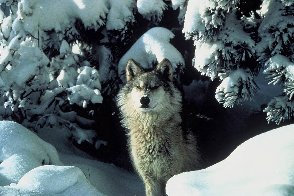
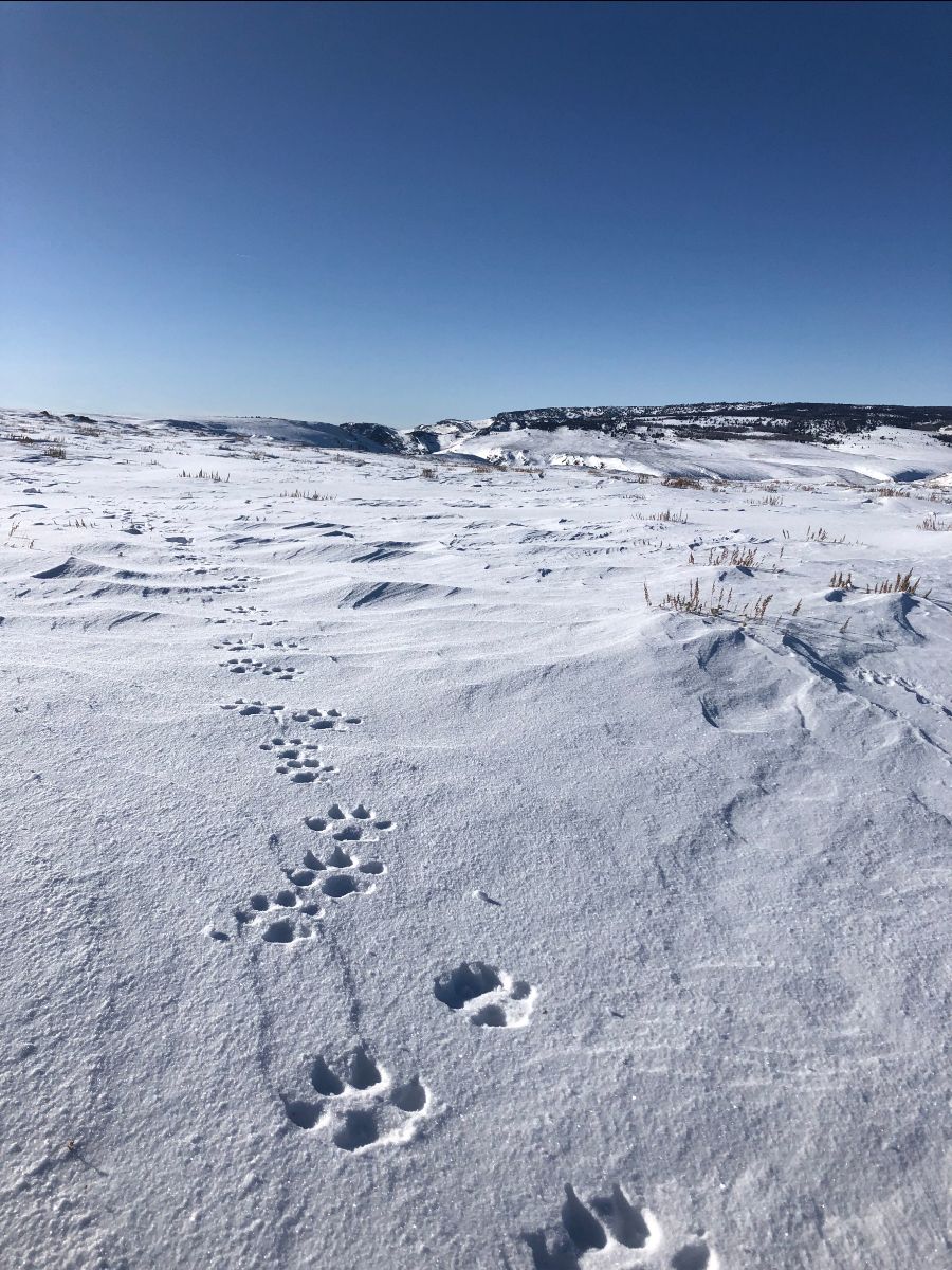


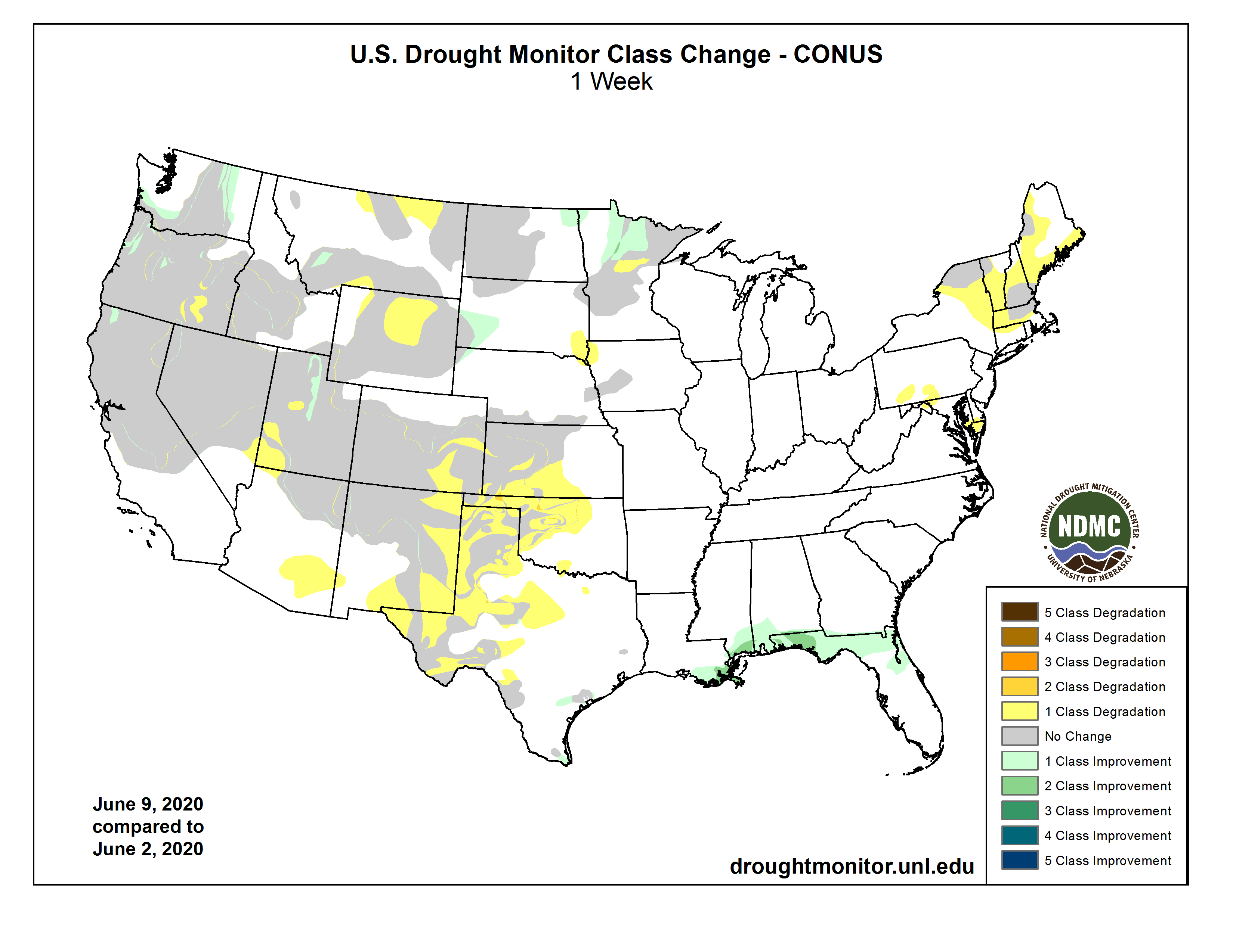


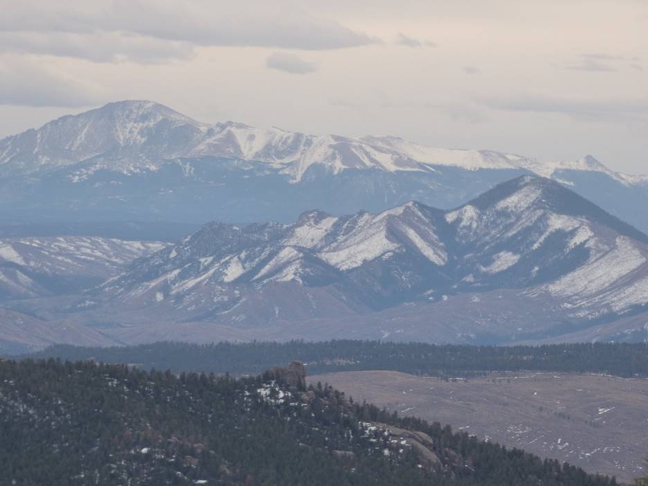
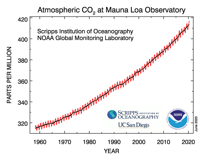


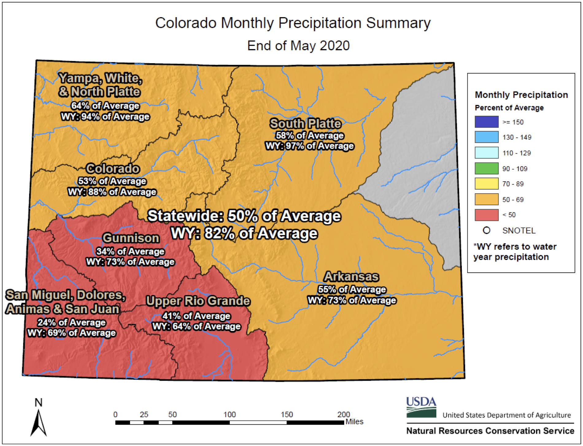
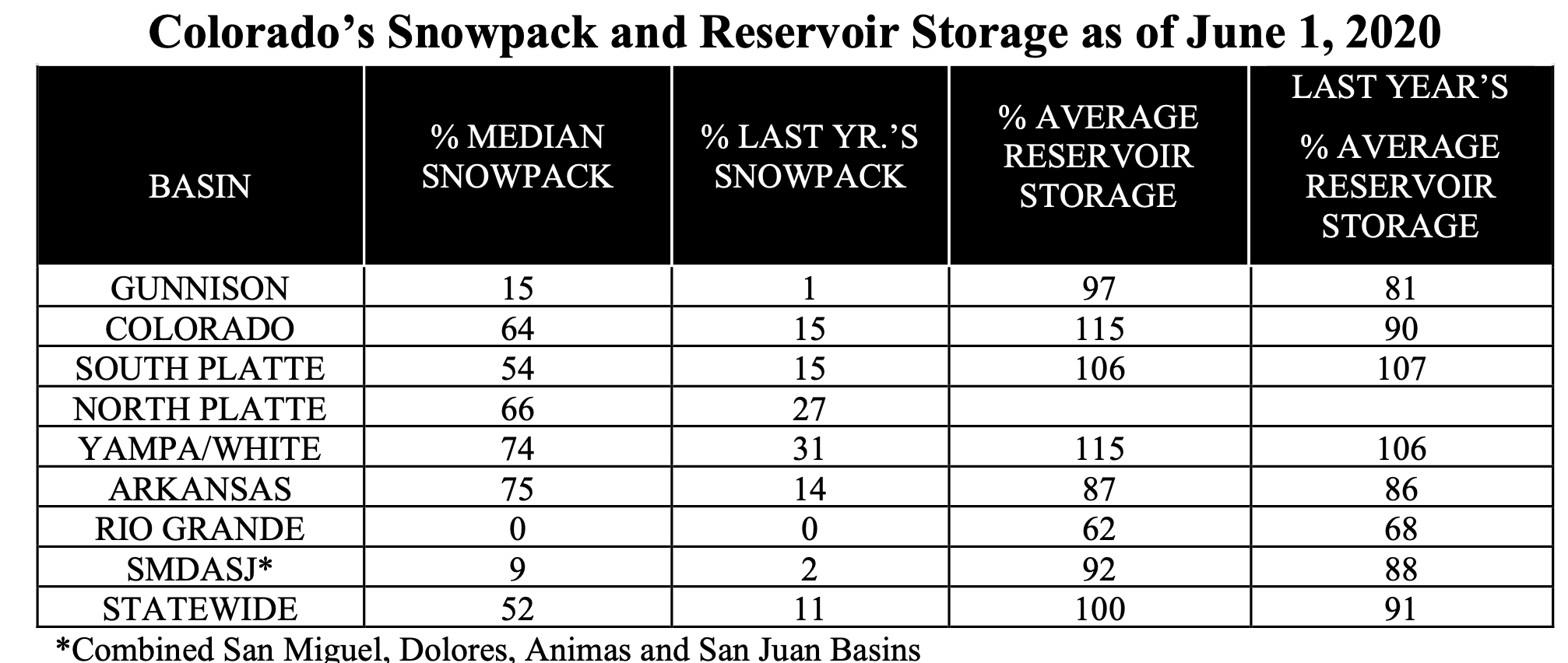

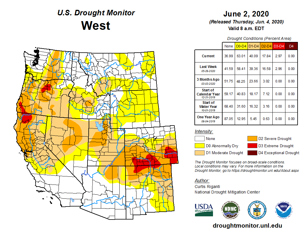


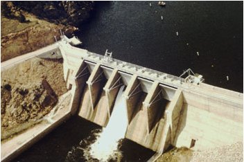
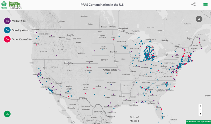
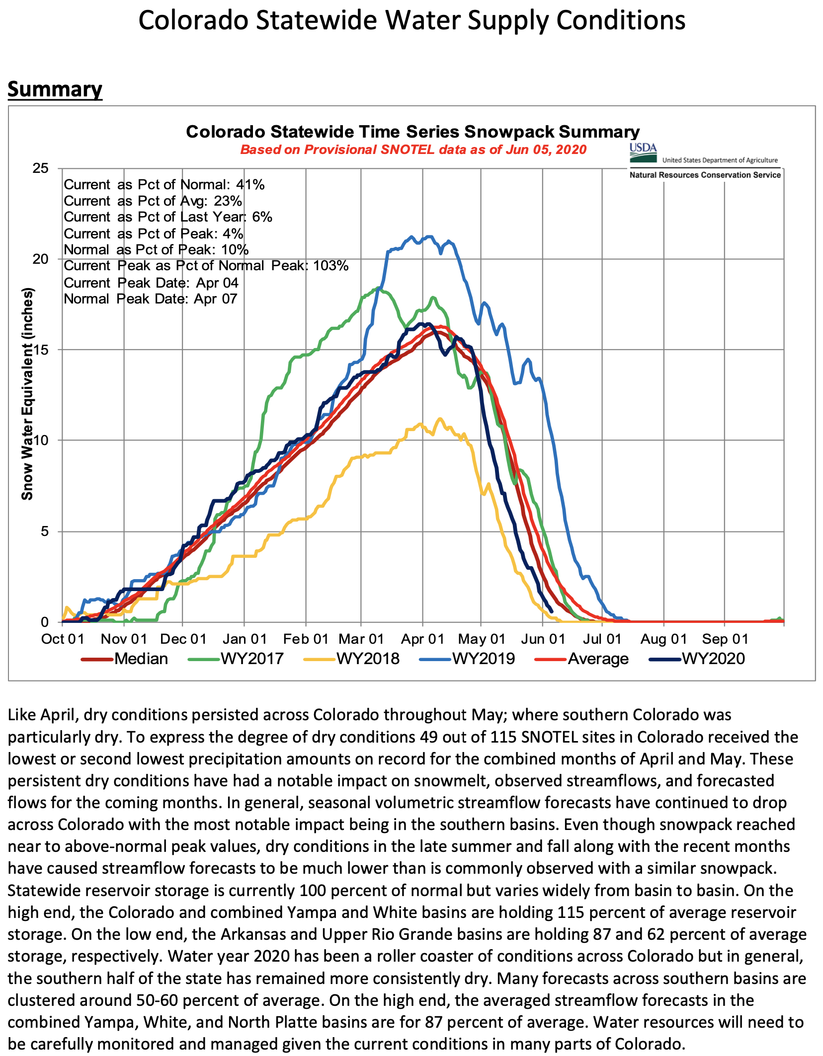
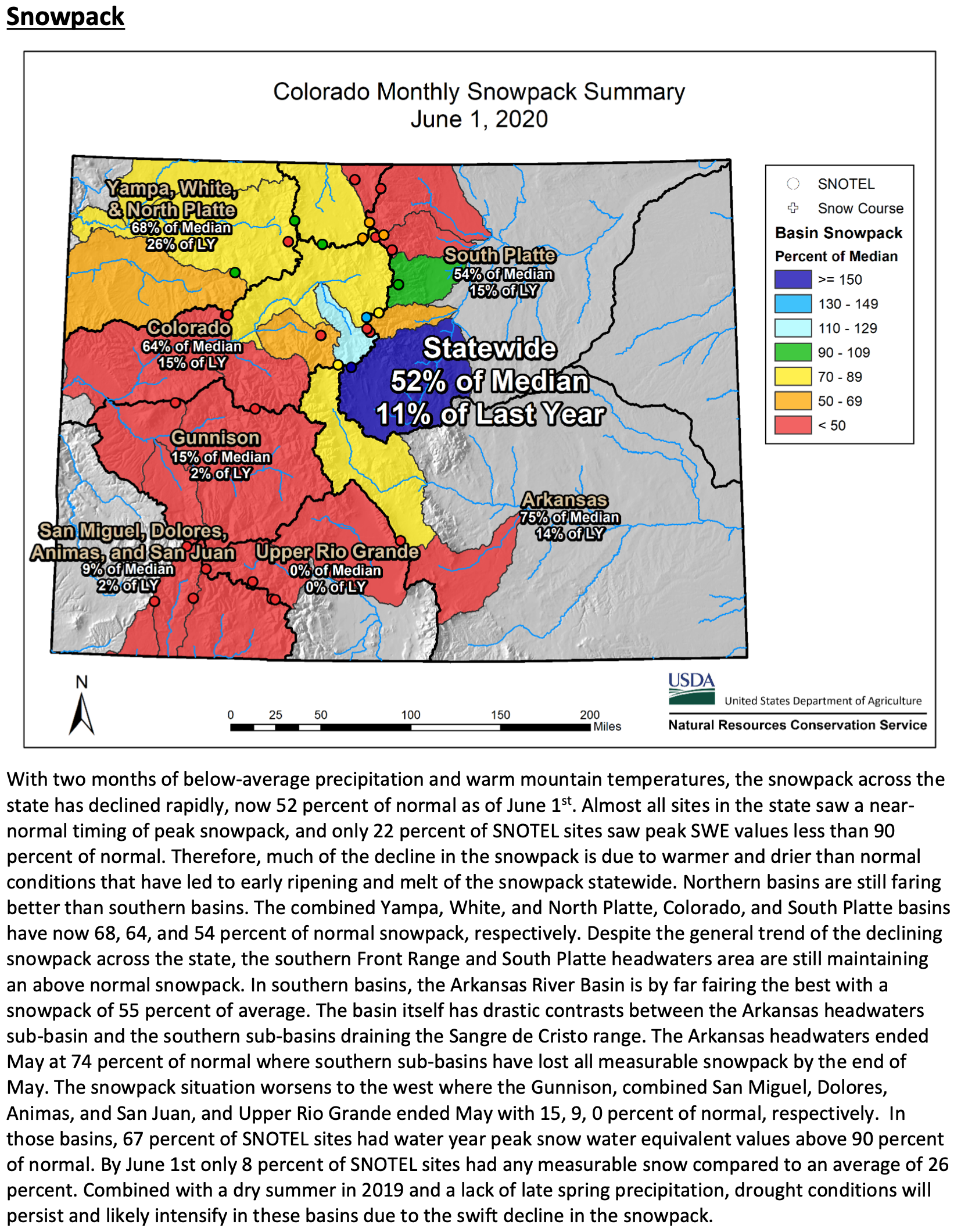
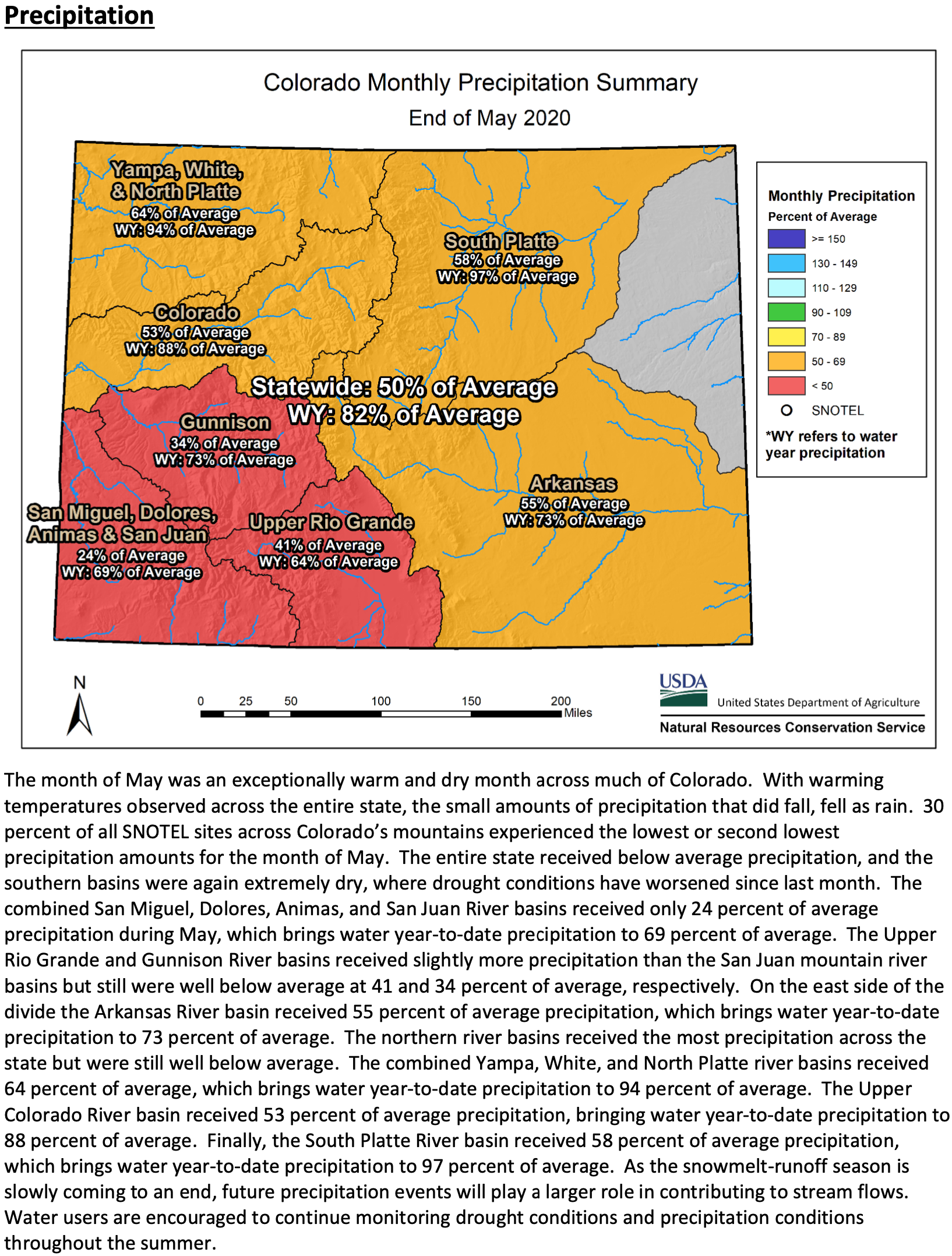
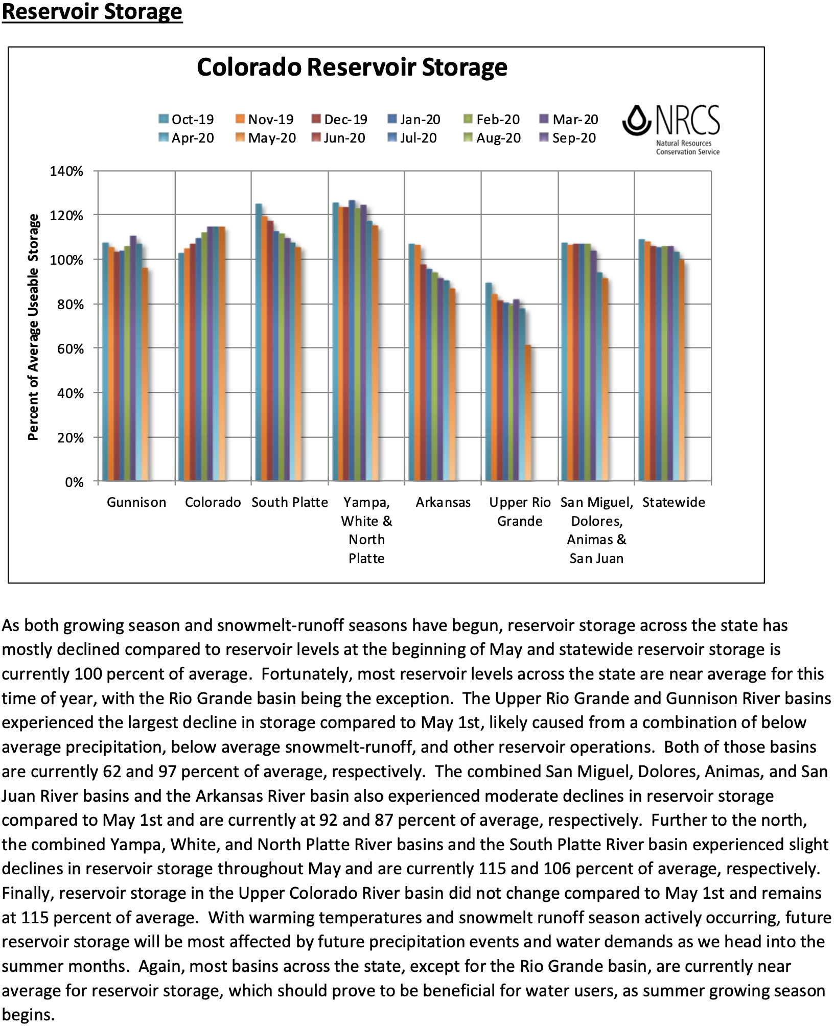
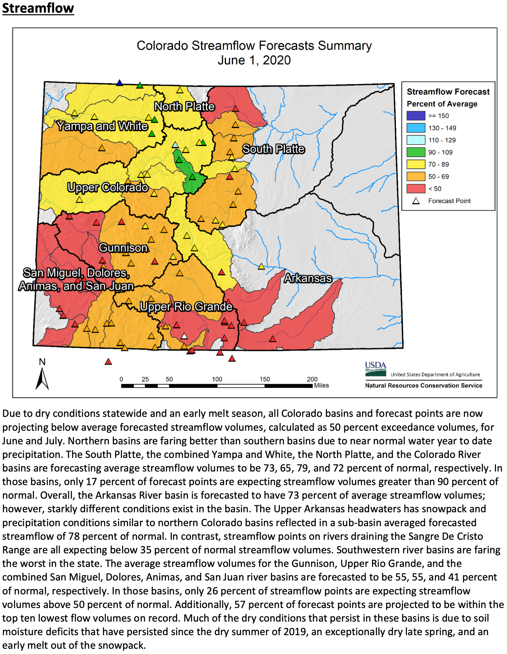

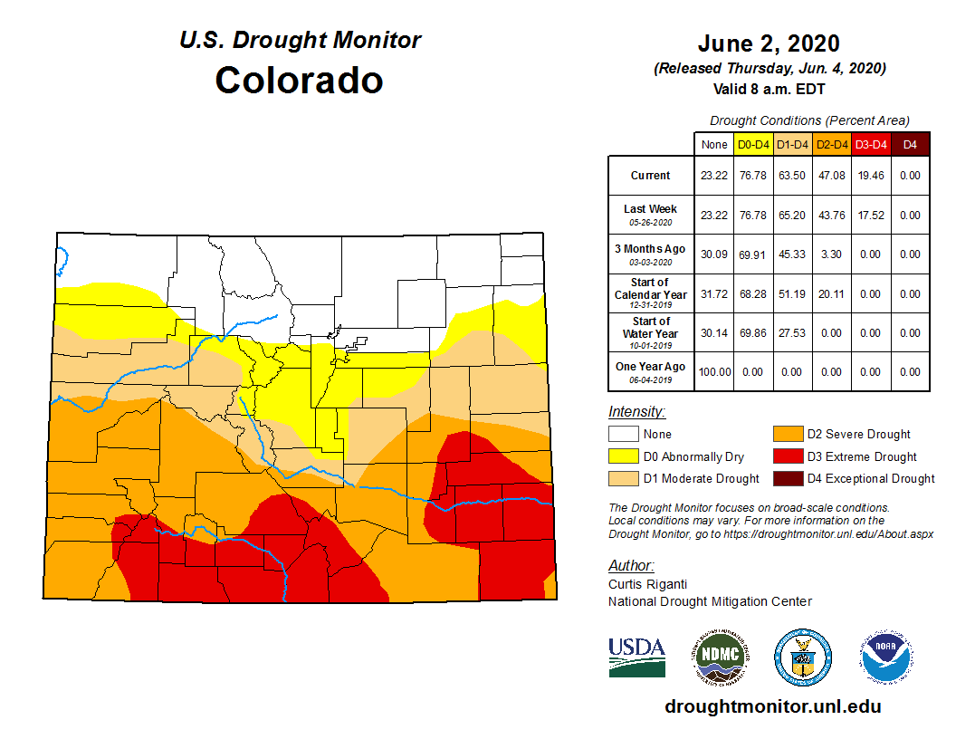
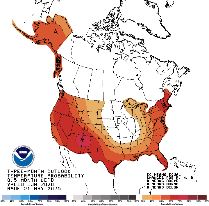


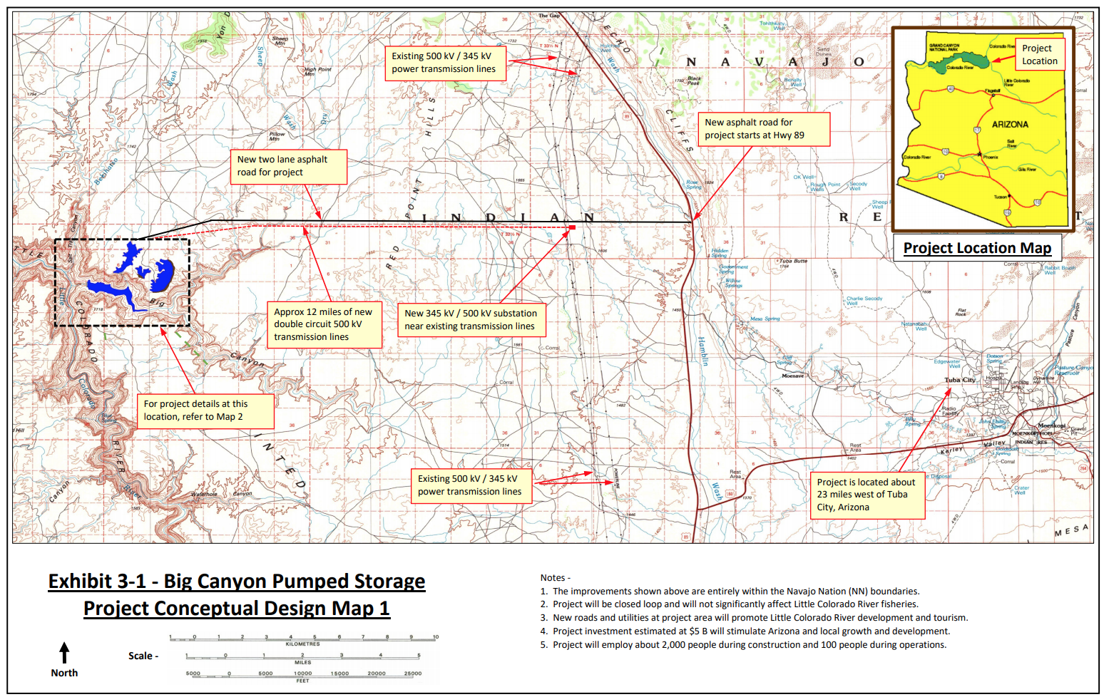


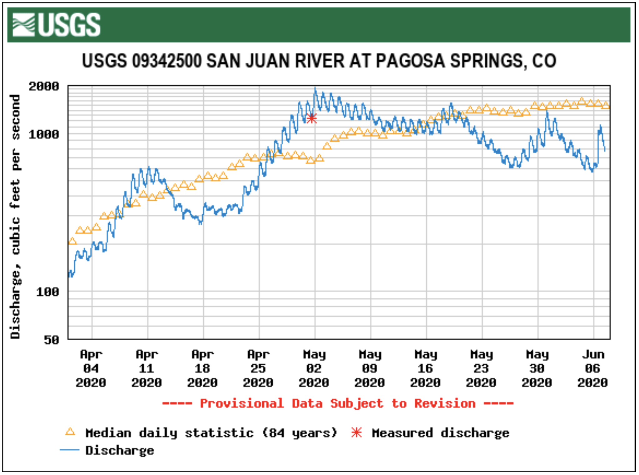


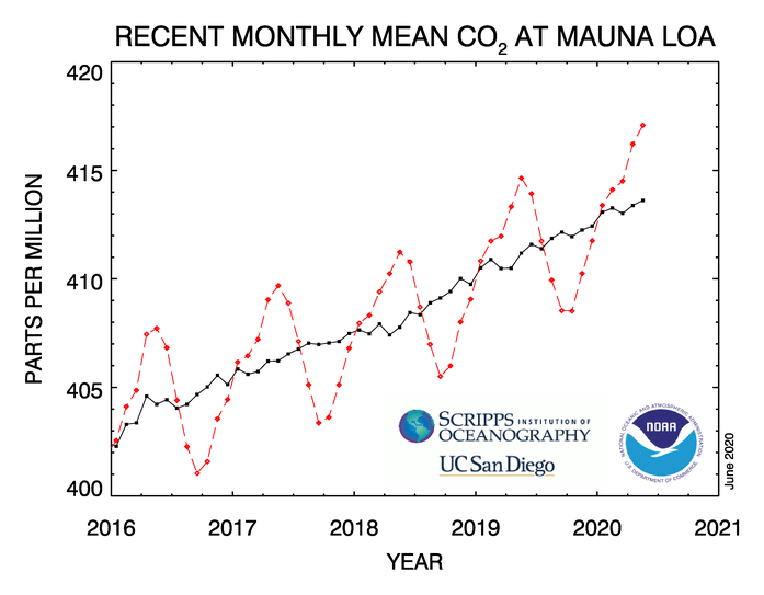
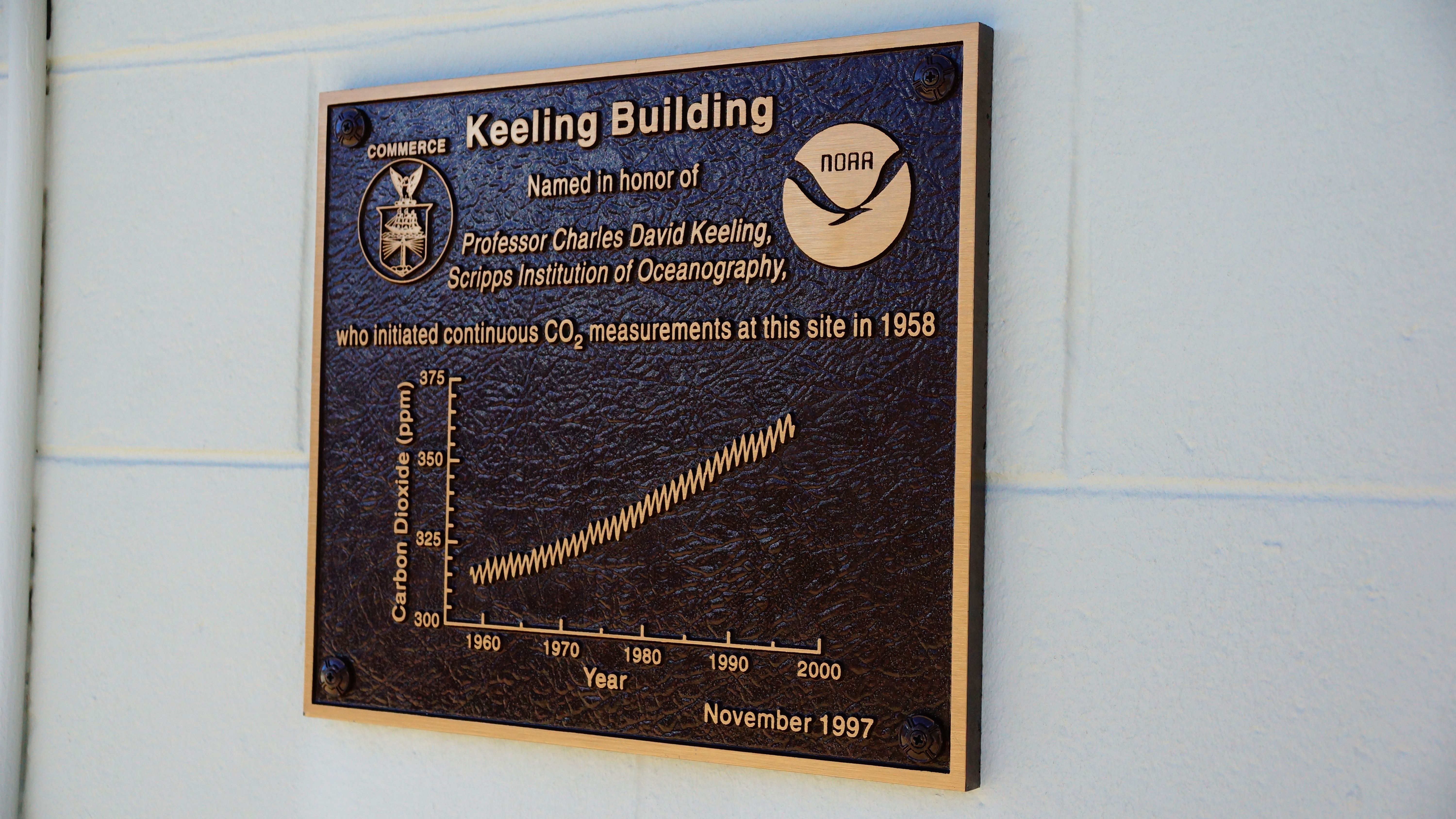


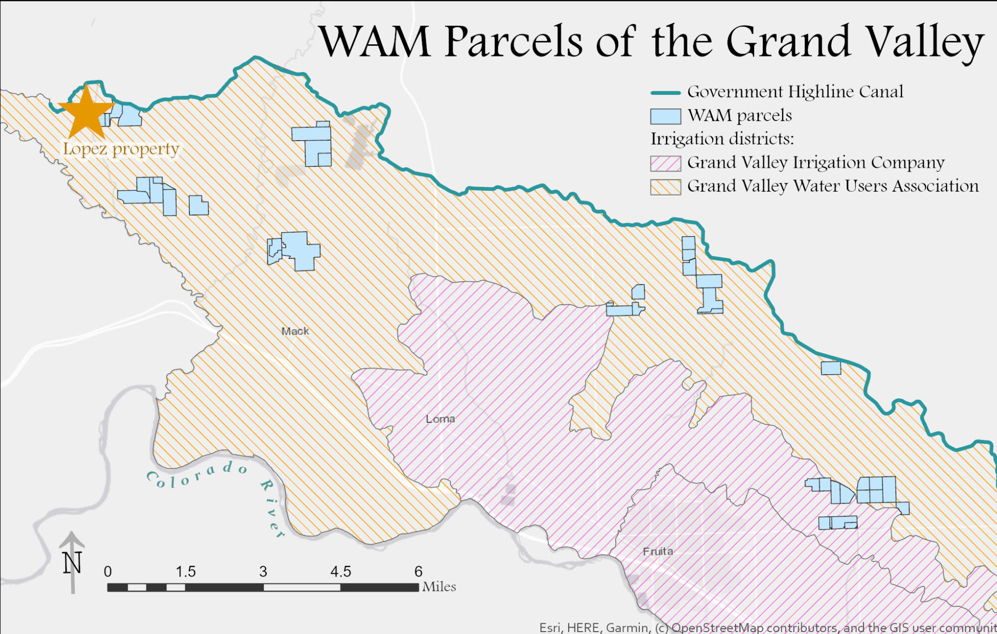
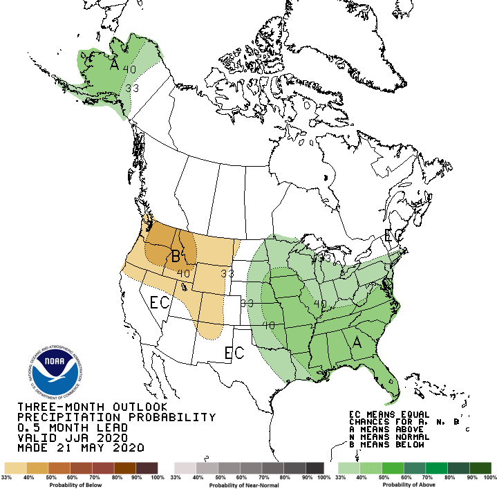


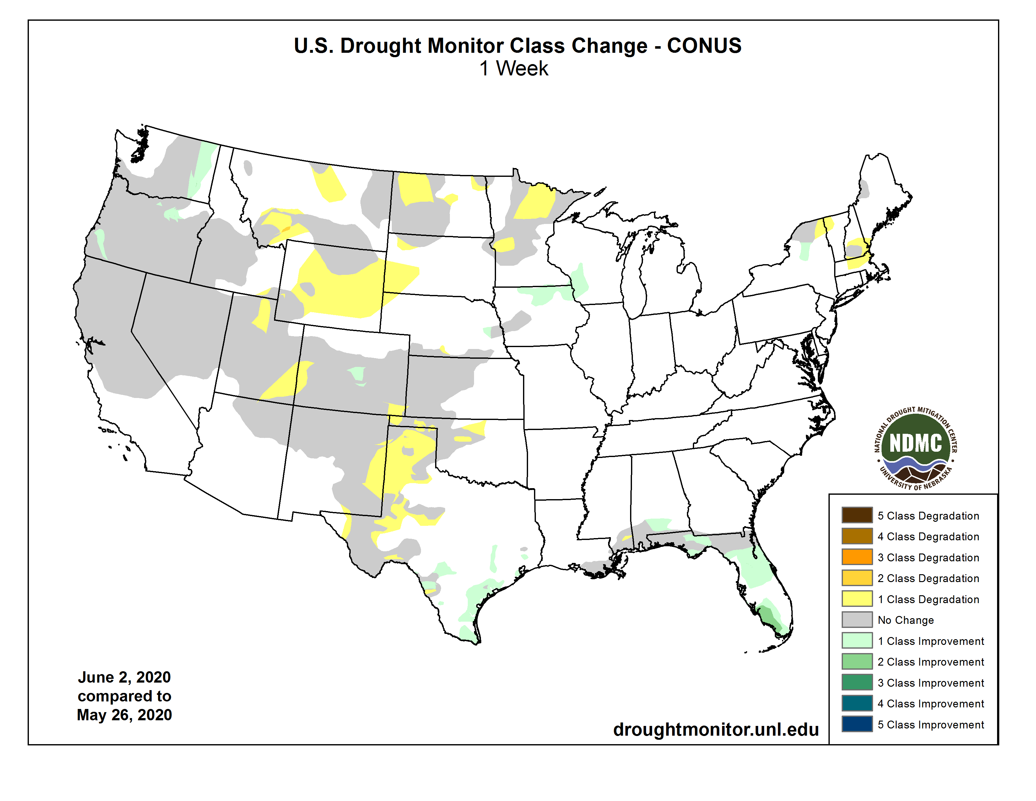
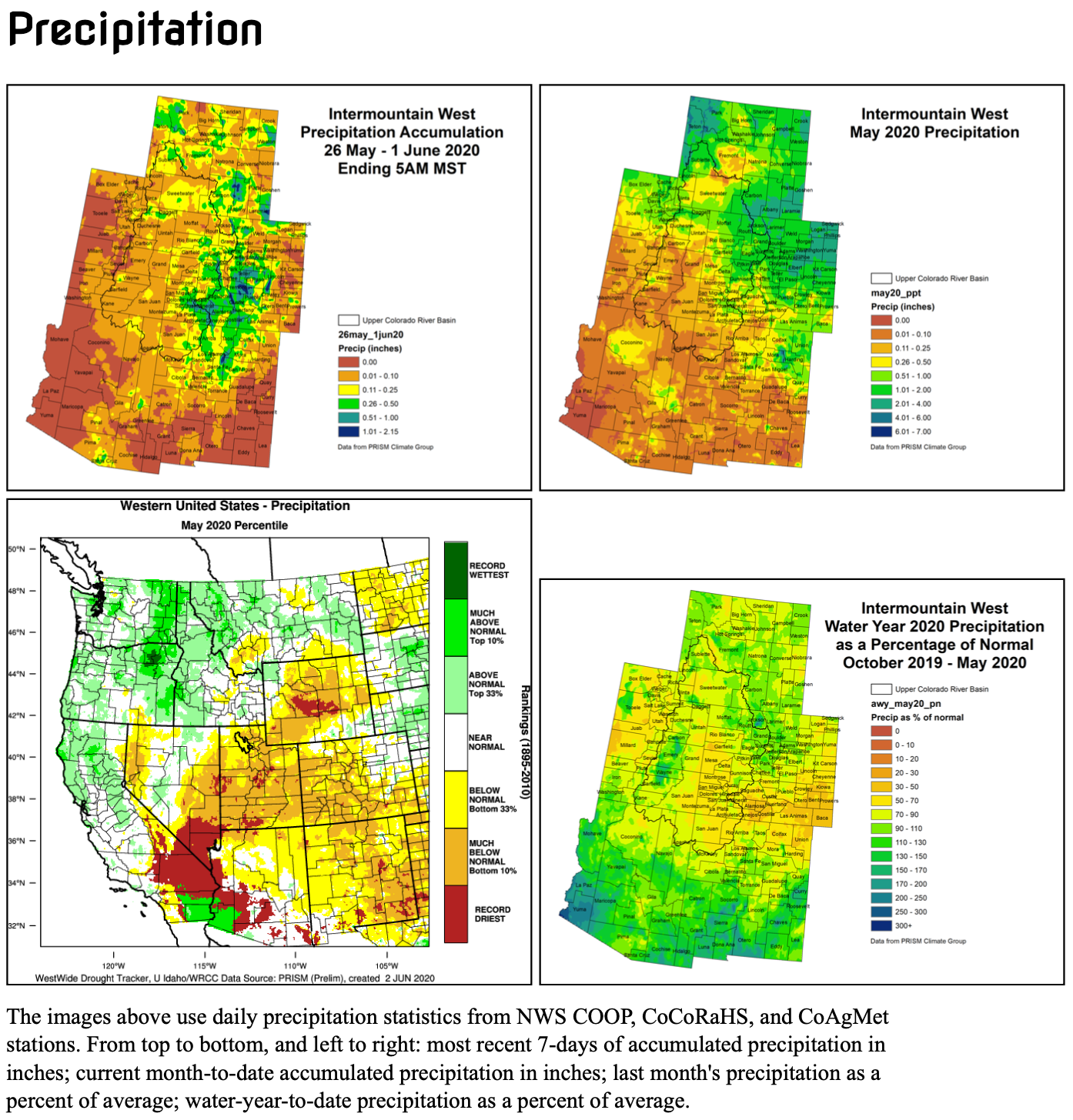
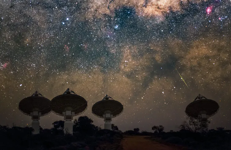


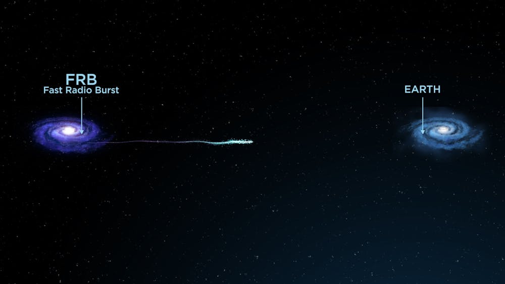
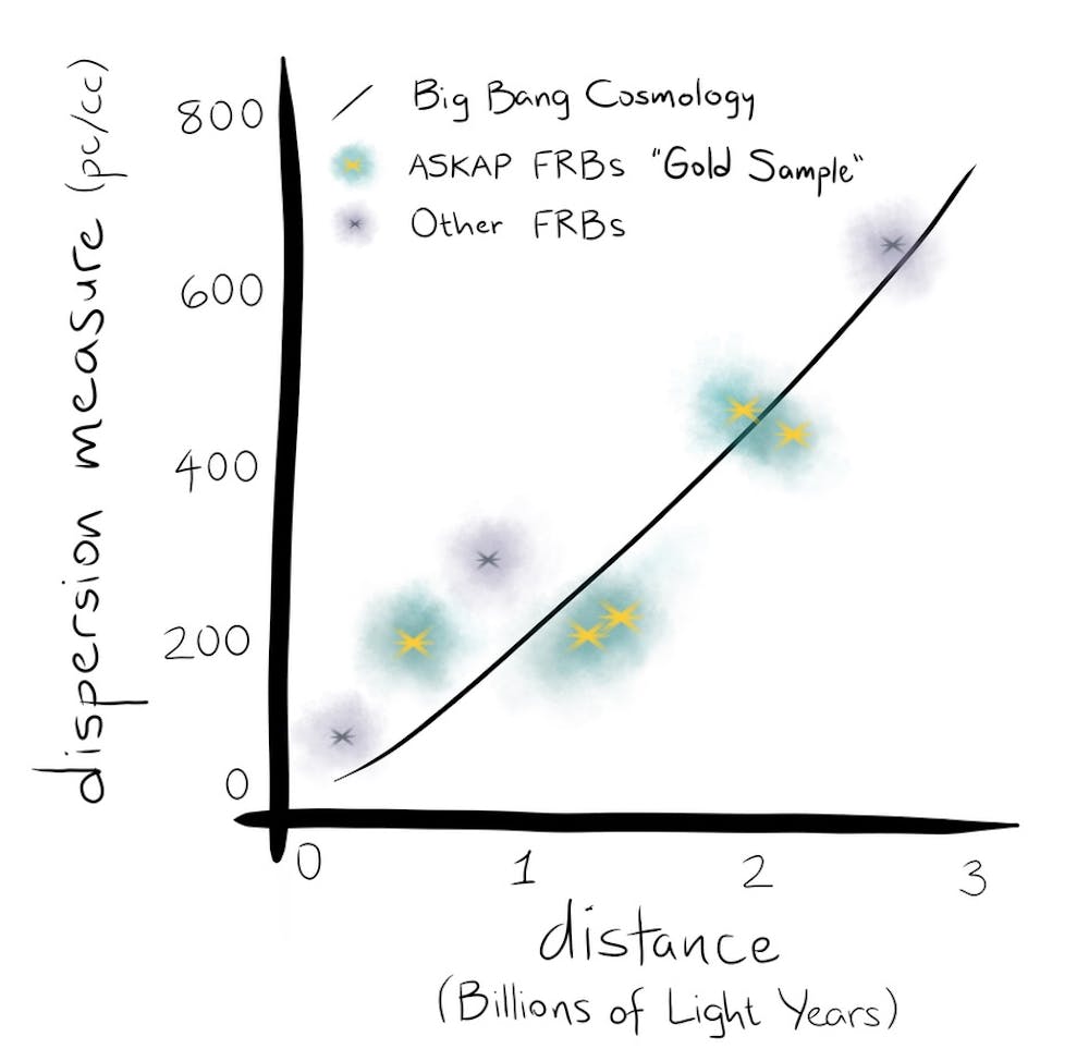


