“This is an amazingly comprehensive and interactive explanation of what’s happening on the Colorado River and the history of how we got here from the Babbitt Center for Land and Water Policy” — Heather Sackett
Join the OWOW Center for Episode 5 of TomTalks where co-director Jennifer Riley-Chetwynd joins an online conference hosted by Environment America. Jennifer presents the importance of the Colorado River and our state’s role as a headwaters state.
In part 2 of Colorado- The Headwaters State, co-director Jennifer Riley-Chetwynd talks with Environment America about how Colorado provides water for 19 states and Mexico through thick and thin.
In a 7-2 vote Thursday morning, the New Mexico Interstate Stream Commission declined to further fund the National Environmental Policy Act process for the controversial proposed Gila River diversion project in southwestern New Mexico.
The decision to stop work on the federally required environmental impact statement effectively prevents the New Mexico Entity of the Central Arizona Project, otherwise known as the N.M. CAP Entity, from pursuing its proposed development of 14,000 acre-feet of Gila River water under the terms of the 2004 federal Arizona Water Settlements Act. Any project that seeks to develop the AWSA water or use money from the New Mexico Unit Fund — the monetary component of the settlement — is required to complete an environmental impact statement as part of the process.
The move also portends a major policy shift regarding how the remaining $70 million in settlement funds will likely be spent, with the focus moving to so-called “non-Unit projects,” such as municipal and regional water supply projects.
During this May 8, 2020 webinar we heard an update on progress and current thinking around demand management in Colorado. Speakers discuss what “equity” might mean and how a pilot project slated to begin this summer could help answer some technical questions around feasibility. Join us to hear from leaders around the state working to move this exploration forward.
With Speakers:
Amy Ostdiek, Deputy Chief of the Federal, Interstate and Water Information Section, Colorado Water Conservation Board
Paul Bruchez, Reeder Creek Ranch and Outfitter
Kyle Whitaker, Water Rights Manager, Northern Water
Mark Harris, General Manager, Grand Valley Water Users Association
Rancher and fly fishing guide Paul Bruchez’s daughter and nephew sit in a hay field at the family ranch near Kremmling. Bruchez is helping spearhead a study among local ranchers, which could inform a potential statewide demand management program. Photo credit: Paul Bruchez via Aspen Journalism
Here’s a report from Jesse Paul that’s running in The Colorado Sun. Click through and read the whole article for somme of the details of the bill. Here’s an excerpt:
Gov. Jared Polis signed Senate Bill 217 at a ceremony at the state Capitol on [June 19, 2020], calling it a landmark piece of legislation that speaks to a national moment of reckoning.
Senate Bill 217 was introduced and passed in a matter of two weeks after being introduced in the days after Floyd’s May 25 death at the hands of police officers in Minnesota and as Denver and cities across the nation were being rocked by protests in response.
“This is a long overdue moment of national reflection,” Polis said just before he signed the measure at a ceremony in the Colorado Capitol. “This is a meaningful, substantial reform bill.”
Polis said the bill contains “landmark, evidence-based” changes that he hopes will help build trust between communities and law enforcement. But he said that more work must still be done.
Colorado is one of the first states to take legislative action in the wake of Floyd’s death and demonstrations across the nation.
Also in attendance at the bill signing were Democratic and Republican state lawmakers who worked on the legislation, as well as law enforcement officers and the family and friends of Coloradans killed at the hands of police.
The governor planned the bill signing for Juneteenth, which commemorates June 19, 1865, the day slaves in Galveston, Texas, learned they were free. It was more than two years after President Abraham Lincoln had signed the Emancipation Proclamation and about two months after Confederate General Robert E. Lee had surrendered at the end of the Civil War.
Someday in our dystopian half-life of a future, a sweaty and thirsty historian is going to work up the spit to write a long volume about how we of this generation manage to walk, sweltering and dust-tongued, through the accumulating evidence that we were allowing the planet to boil and burn.
He goes on to list reasons for voting this election:
We could’ve been ready for 9/11, but we weren’t. We could’ve been ready for the pandemic, but we weren’t. We are never ready for anything anymore. We don’t have the political will to get ready, and we’re too cheap to get ready for anything. We are never ready for anything anymore, because it’s become good politics to hold in contempt the ideas of the people who know what we need to do to get ready. We could’ve been ready for the climate crisis, and for all the crises arising from it, but we’re not because we don’t have the political will, won’t spend the money, and spend too much time listening to the angry and the loud.
Click through and read the whole thing.
Denver School Strike for Climate, September 20, 2019.
Releases from the Aspinall Unit will be increased to 1650 cfs on Friday, June 19th. Releases are being increased to maintain flows in the lower Gunnison River. The June 15th runoff forecast for Blue Mesa Reservoir predicts 59% of average for April-July inflows.
Flows in the lower Gunnison River are currently below the baseflow target of 1050 cfs. River flows are expected to return to levels above the baseflow target once the release increase has arrived at the Whitewater gage.
Pursuant to the Aspinall Unit Operations Record of Decision (ROD), the baseflow target in the lower Gunnison River, as measured at the Whitewater gage, is 1050 cfs for June through August.
Currently, Gunnison Tunnel diversions are 1040 cfs and flows in the Gunnison River through the Black Canyon are around 430 cfs. After this release change Gunnison Tunnel diversions will still be 1040 cfs and flows in the Gunnison River through the Black Canyon will be around 630 cfs. Current flow information is obtained from provisional data that may undergo revision subsequent to review.
From Colorado River Studies at Utah State University (Jack Schmidt, David Rosenberg, Jian Wang, Kevin Wheeler, and Eric Kuhn):
An essential question that drives discussion about the future of the Colorado River is, “How much water do we need?” The human body must have water to survive, and water is needed to grow crops, but the amount of water used by different societies varies greatly. In the Colorado River basin, our sense of the amount of water that we “need” is not just driven by basic survival, but is also affected by our preferences in urban and suburban landscaping, the crops that we grow, the technology and practices associated with irrigation, and the industry that exists. Thus, the question of “need” unavoidably becomes mixed with the question of “want,” and our sense of “want” is strongly affected by our aspirations for the future.
Obviously, any consideration about future water use depends on projections of population growth and anticipated agricultural and industrial uses of water. Depending on one’s vision of the future, including preferences about landscaping, agriculture, and in-stream flows to benefit aquatic and riparian ecosystems and river recreation, one might expect different future water projections in different parts of the Colorado River basin. In planning for future consumptive water use, it is important to distinguish between the amount of water we “need” to maintain the present urban areas and the existing agriculture and industry and the amount of water we “want.”
In the book Science Be Dammed, Kuhn and Fleck (2019) described how the original negotiators of the Colorado River Compact overestimated their projected future needs of water supply from the Colorado River. If one adds together the estimates of future water use made by each state in the 1920s, the total anticipated use in the Upper Basin was 8.1 million acre feet, more than twice the actual amount the Upper Basin is currently using a century later (Kuhn and Fleck, 2019, table 1). We are left to speculate as to whether these were well-intentioned over-estimates or political gamesmanship. Making such overestimates today, regardless of motive, complicates negotiations of the future of the Colorado River, because negotiators must sort need from want. Watershed runoff is decreasing as the regional climate warms (Udall and Overpeck, 2017; Milly and Dune 2020), and the pie that must be divided among the states is getting smaller.
Since the 1980s, Reclamation and the Upper Colorado River Commission (UCRC) have made many estimates of future water use. Sometimes, negotiators treat those projections as if they are precise and accurate predictions. In fact, every estimate is its own scenario—a possible trajectory of future consumptive water use. Each scenario is based on assumptions about population, cities, agriculture, and industry. Despite our best efforts, the scenarios do not necessarily enumerate all possible future conditions.
We see a disparity when comparing past projections to the actual consumptive use in the Upper Colorado River basin (Figure 1, dashed colored lines; UCRC 2007 and 2016; Bureau of Reclamation (BOR) 1981, 1984, 2012). Each recently-proposed scenario of future water depletion was higher than the actual consumptive use reported by Reclamation in its semi-decadal Colorado River Consumptive Use and Loss Reports (Figure, solid black line). In fact, since at least 2000, the actual Upper Basin uses and losses have been stable or slightly decreasing, not increasing. The retirement of thermal power plants and reduced irrigated areas may further decrease future Upper Basin depletions (see the analysis by Kuhn 2020).
Overestimation of future water needs is not unique to the Colorado River basin—many other water systems also have consistently overestimated their demands. Motives for overestimation are many (Heberger and Cooley, 2016; Kindler and Russell, 1984). Water managers may define scenarios of high future use so they can prepare for future unknown demand increases by securing enough water, while simultaneously communicating their political intentions to competing users. Overstated future depletions have the potential to focus attention on new infrastructure needs. However, managers must also avoid building expensive water supply infrastructure that goes unused should future water use be less than was anticipated. If there is a rush to build water-diverting or water-consuming infrastructure that subsequently becomes obsolete due to a changing climate, emerging technologies, or over-anticipated demands, those investments can easily become stranded assets (Kalin et al, 2019).
Scenarios help us plan for a diverse set of uncertain future conditions, even though most or all of the scenarios may never come to pass. Thus, we can consider scenarios that focus on aspirational growth as well as scenarios of continuing stable use or aggressive conservation.
As we move forward in negotiating the allocation of water supply that comes from the Colorado River, Figure 1 suggests that basin stakeholders should also consider scenarios of stable use that reflect continuing historical trends of no growth in total Upper Basin consumptive water use. Basin stakeholders should also consider scenarios where future use of water decreases due to changes in landscaping and irrigation practices.
The question then is: How should Colorado River stakeholders manage the future Colorado River in the face of these water demand uncertainties? For insight, read our white paper “Managing the Colorado River for an Uncertain Future.”
Bureau of Reclamation. (1981). Projected Water Supply and Depletions Upper Colorado River Basin. Salt Lake City, Utah.
Bureau of Reclamation. (1984). Projected Water Supply and Depletions Upper Colorado River Basin. Salt Lake City, Utah.
Bureau of Reclamation. (2012). Colorado River Simulation System Model, Demand Management Input Tool Current Trends and Other Scenarios. v4. Link: http://bor.colorado.edu/Public_web/CRSTMWG/CRSS/
Kuhn, E., and Fleck, J. (2019). Science Be Dammed: How Ignoring Inconvenient Science Drained the Colorado River. University of Arizona Press.
Milly, P. C., and Dunne, K. A. (2020). Colorado River flow dwindles as warming-driven loss of reflective snow energizes evaporation. Science, 367(6483), 1252-1255.
Udall, B., and Overpeck, J. (2017). The twenty‐first century Colorado River hot drought and implications for the future. Water Resources Research, 53(3), 2404-2418.
Full and permanent funding of the LWCF supports Colorado Parks and Wildlife’s mission to conserve wildlife and enhance outdoor recreational opportunities. Photo credit: Colorado Parks & Wildlife
Here’s the release from Colorado Parks & Wildlife (Olivia Baud):
The resolution, presented to the CPW Commission by Outgoing Chairwoman Michelle Zimmerman, supported full funding of the LWCF, federal funding to reduce the maintenance backlog on public lands, and respectfully requested the Colorado Congressional Delegation to support federal legislation that achieves these aims. With the passage of the Great American Outdoors Act, the LWCF is guaranteed to receive the maximum $900 million annual allotment advocated for in the resolution.
“We applaud the U.S. Senate for passing this historic act which supports Colorado Parks and Wildlife’s mission to conserve wildlife and enhance outdoor recreational opportunities,” said CPW Director Dan Prenzlow. “As the resolution highlighted, full and permanent funding of the LWCF is key to helping us manage our state parks and shared wildlife resources so that more people can enjoy the outdoors far into the future.”
Colorado uses LWCF federal funds to increase recreational opportunities for citizens and visitors. Since 1965, CPW has provided over 1,025 LWCF state matching grants totaling more than $61 million to fund local government and state park outdoor investments.
The LWCF program was enacted by Congress in 1965 to create parks and open spaces; protect wilderness, wetlands, and refuges; preserve wildlife habitat; and enhance recreational opportunities. Funds are allocated through both a federal program and a state-managed matching grant program and are derived from offshore oil and gas leasing revenues. While the LWCF program can be funded up to $900 million annually, it has only received maximum funding twice in its history prior to the passage of the Great American Outdoors Act.
To learn more about the LWCF and the Colorado Parks and Wildlife Commission, visit our website at https://cpw.state.co.us/.
The Boulder County Democrat says it’s time to “go big and be bold” with his sweeping 21st Century Conservation Corps for Our Health and Our Jobs Act, which provides economic relief from coronavirus shutdown while investing in overlooked forest management, wildfire mitigation and civilian corps.
U.S. Rep. Joe Neguse on Thursday introduced comprehensive legislation that aims to help Western economies better recover from the pandemic while addressing long standing conservation, forest management and wildfire challenges on public lands.
His bill would direct more than $40 billion toward wildfire prevention, bolstering the conservation corps to restore public lands, funding deferred maintenance on U.S. Forest Service land and delivering coronavirus relief for the country’s outfitters and guides. It’s one of the most ambitious public lands bills in recent memory.
Here’s some highlights of his legislation:
$3.5 billion for the Forest Service’s hazardous fuels, fire-risk reduction program, which is funded at about $445 million a year, and $2 billion for the Bureau of Land Management’s hazardous fuels program.
$6 billion for the Forest Service’s capital improvements and maintenance program, which also is funded at about $445 million a year. The agency estimates it has a $5.2 billion backlog of maintenance on roads and other infrastructure.
$600 million for state and private forests programs.
$100 million for Forest Service personal protective equipment.
$5.5 billion for the USDA’s Regional Conservation Partnership Program that focuses on water infrastructure development.
$150 million for the U.S. Fish and Wildlife habitat conservation program for private lands.
$4.5 billion for the Bureau of Reclamation’s WaterSMART program that gives water efficiency grants to farmers and ranchers.
$575 million for National Park Service programs.
$6 billion for construction and maintenance at national parks.
$9 billion for the Civilian Conservation Corps program to hire and train workers for public lands restoration while addressing unemployment during the pandemic.
$2 billion for the National Coastal Resilience Fund to restore shorelines.
$7 billion for direct payments to outfitters and guides enduring closures from COVID-19.
Temporarily waives permit fees for ski areas operating on public land and waives fees paid by guides and outfitters.
[…]
The American guiding industry saw bookings evaporate in March as the pandemic ground the economy to a halt. The decline in reservations by skiers, rafters, climbers and hunters lingered for three months and only recently have outfitters and guides seen a gradual return of customers, said Matt Wade, the head of policy and advocacy for the American Mountain Guide Association.
But even as outfitters ramp back up, they are incurring additional costs for protective equipment — think replacing all group tents with single-person tents — and seeing smaller guide-to-client ratios as they keep people distanced.
Many guiding businesses and outfitters saw business plummet 90% in the spring and the summer season is pacing to be about 50% down, Wade said.
Neguse’s relief fund would give outfitters the chance to apply for relief payments that would cover the gap between increased costs and declining revenues while keeping guides on the payroll…
Neguse is not creating new programs. He’s multiplying the budgets of a host of programs — like the Collaborative Forest Landscape Restoration, the Every Kid Outdoors, the Vegetation and Watershed Management, the Landscape Scale Restoration, Urban and Community Forestry, the Firewise, the Regional Conservation Partnership programs and dozens more…
Oregon Sen. Ron Wyden introduced a companion bill in the U.S. Senate and Neguse has enlisted support from counties in his Colorado district and a growing list of conservation, outdoor recreation and sportsmen groups. He said his bill “stands a good chance” as both Democrats and Republicans study another round of funding to help the country recover from the pandemic.
From the Rio Grande Headwaters Restoration Project via The Conejos Citizen:
In 2015, then-Governor John Hickenlooper signed a momentous document into being — the Colorado Water Plan. At the time, decades of analysis concluded that a gap was widening between the limited supply of water and an increasing demand from users.
This gap in water supply and demand would only grow worse and more insurmountable without decisive action. Simply conserving water wasn’t enough. The drought of 2002 drove home the fact that a decreasing and erratic snowpack would become the norm, wreaking havoc on communities and river systems across the state. Lawmakers, farmers, water managers, and others saw the writing on the wall and determined to be strategic and proactive.
The Colorado Water Conservation Board (CWCB), the government agency tasked with overseeing water supply and management and utilizing technical data and analysis to assist decision-making, were key partners in spearheading the unprecedented strategy. They couldn’t undertake the entire process on their own and looked to the Roundtables for on the ground planning.
Just as in the first BIP process, stakeholders from the Rio Grande Basin are encouraged to participate in subcommittees on each of the five target areas.
This update process will be facilitated by a local expert who has been trained in coordination with Local Experts from other basins by the state’s general contractor for the 2021 Water Plan. The Rio Grande local expert is the Rio Grande Headwaters Restoration Project (RGHRP) staff, with Daniel Boyes as lead expert. The RGHRP was involved in the first BIP and works to improve the health of streams and riparian areas across the San Luis Valley and recently completed Stream Management Plans for the Rio Grande, Conejos River and Saguache Creek.
Boyes and the other RGHRP staff have begun holding meetings to determine project possibilities and data gaps within the five key areas with community members providing valuable input. These meetings will determine what projects, goals, and objectives represent the Rio Grande Basin’s priorities for each of the key areas, providing once again valuable input to the overall state water plan.
With a below average snowpack for 2020 and no guarantee of continuing moisture or increased snow in 2021 or beyond, the Rio Grande Basin will face similar challenges as the rest of the state over the coming year: The creation of subdistricts to meet aquifer sustainability requirements, newly approved well rules and regulations for groundwater use, and the new SLV radar are unique local responses to these challenges. Participating in identifying and prioritizing new projects and goals is a simple way for the community to involve themselves with these crucial water decisions. With the help of the community, Rio Grande water leaders are working diligently to ensure our resources are able to meet needs and continue our San Luis Valley way of life.
The Roundtables, one for each major river basin plus an additional Roundtable serving the Denver metro population, were created in 2004 as a regional answer to address water needs as identified by a variety of stakeholders. All of these partners were needed to become the task force, which created the first-ever Colorado Water Plan.
These five hundred plus pages of graphs, data, photos, and text combined to tell the story of each of Colorado’s major river basins. But more than that, it creates a compass for Colorado’s basins to identify and implement projects in their region that addressed a multitude of issues such as stream flows, reservoir storage capacity, agricultural sustainability, environmental needs, water administration and even education and outreach on water topics. The Colorado Water Plan includes five major areas of water use: Municipal & Industrial, Agriculture, Environment & Recreation, Water Administration and Education & Outreach. Each of these areas affects all the river basins; however, water leaders recognize that the plan could not be a one size fits all effort. Geography, population, tourism, and other factors affect each region differently, so state officials decided to utilize the leadership of local roundtables. The resulting comprehensive state plan was made possible by thousands of hours of donated time from people in each basin who created an individual plan outlining the needs of their region and highlighting potential projects to address those needs. This basin implementation plan process, or BIP, allowed each basin to prioritize projects and informed the larger Water Plan’s goals and objectives. With many projects completed and numerous goals met over the past five years, new ones are needed to answer the increasingly pressing question of how to adequately meet diverse water needs with an ever-dwindling supply. To that end, the Colorado Water Plan is in its first iteration of updates, scheduled for completion in 2021.
For the past two years, CWCB staff has worked with stakeholders in all basins, as well as engineering firms, to complete data analysis through Technical Advisory Groups (TAGs) using updated data and the most up-to-date modeling tools available. These teams created five potential future scenarios facing Coloradans in the next 20-50 years. Each scenario incorporates existing data from the basins regarding current water use coupled with projected water use, population and economic growth, and, in some scenarios, potential impacts of climate change on water supply and use.
These technical updates necessitate an updated Basin Implementation Plan incorporating the modeling and identifying where other data gaps exist. In addition, projects which will address the gaps and meet Basin goals and objectives need to be prioritized for the next five years.
The current Colorado Water Plan can be found at https://www.Colorado.gov/pacific/cowaterplan/plan and the Rio Grande Basin Implementation Plan is online at http://rgbrt.org/rgbip-update/. To get involved or receive information about the current Rio Grande BIP process, please contact Daniel Boyes at daniel@riograndeheadwaters.org. Any community member from the six counties of the San Luis Valley is encouraged to attend Rio Grande Basin Roundtable’s monthly meetings (currently held virtually, with agenda and meeting information available at http://www.rgbrt.org , visit the Rio Grande Basin Roundtable’s Facebook page, or sign up for the quarterly Roundtable newsletter at info@riograndeheadwaters.org to learn more about upcoming BIP meetings and timelines.
Screen shot from the Vimeo film, “Rio Grande Headwaters Restoration Project: Five Ditches,” https://vimeo.com/364411112
Last week, a quarter of the state (25.49%) was under extreme drought. Now, the percentage has risen to 32.96%, which is roughly one-third of the state.
Conditions associated with extreme drought include:
Pasture conditions worsen
City landscapes are dying
Large fires develop
Rafting, fishing, hunting, skiing are reduced; fish kills occur
Grasshopper and insect infestation are noted
Reservoirs are extremely low; mandatory water restrictions are implemented; water temperature increases
Drought conditions started to develop in the early Spring due to a drier than normal March and April.
US Drought Monitor one week change map ending June 16, 2020.
Click on a thumbnail graphic below to view a gallery of drought data from the US Drought Monitor.
US Drought Monitor June 16, 2020.
West Drought Monitor June 16, 2020.
Colorado Drought Monitor June 16, 2020.
Click here to go the US Drought Monitor website. Here’s an excerpt:
This Week’s Drought Summary
Significant rainfall missed most areas of dryness and drought across the contiguous 48 states, with improvements limited to part of the northern Intermountain West, central Kansas, and a few isolated spots in both Oregon and upstate New York. Elsewhere, dry conditions persisted or intensified. In particular, abnormally hot weather, low humidity, and gusty winds have led to rapidly-intensifying dryness across the Plains States. Extreme drought expanded in northern New Mexico, part of central and western Oklahoma, eastern Colorado, and western Kansas while broad areas of abnormal dryness and some moderate drought were introduced farther north…
Conditions are rapidly deteriorating through most of the High Plains Region. Moderate to isolated heavy rainfall was observed in a few small areas in central Kansas, northeastern Nebraska, and adjacent South Dakota, but precipitation was scant and short-lived elsewhere. Improvements were introduced in central Kansas, but this is very much the exception. Although rainfall deficits only date back a few weeks to a few months, other factors are making things worse, specifically abnormal heat, low humidity, and gusty winds. High temperatures approached triple-digits as far north as South Dakota. All these factors led to broad areas of deterioration in eastern Colorado, southern Kansas, Wyoming, the Dakotas, and adjacent parts of Nebraska. Notably, extreme drought (D3) expanded to cover a large part of southern and eastern Colorado, and adjacent parts of Kansas…
Some northern parts of the region experienced another wet week while areas west and north of the Four Corners saw little or no rain. Exacerbating the dryness, temperatures averaged at least a couple degrees above normal in most dry areas, with weekly anomalies approaching +10 degrees F from the Great Basin northward into western Montana. Between 1.5 and 3.5 inches of rain fell on northeastern Oregon and adjacent Idaho, and from the Oregon and Washington Cascades westward to the Pacific Coast. The highest elevations in the Cascades and coastal ranges recorded 4 to 7 inches in a few spots. Elsewhere, only patchy light showers were noted in the rest of the Northwest and in parts of New Mexico, and other areas reported little or none. Recent rains have been sufficient to improve or remove dryness from western Idaho southward through the northern Great Basin, and in parts of western Oregon. In sharp contrast, conditions deteriorated along the southern tier of Montana and through parts of the Intermountain West, where precipitation has been much less abundant the past few weeks. Severe drought (D2) was introduced in southwest Montana…
Drought continues to rapidly develop and intensify across most of Texas and Oklahoma, with patchy dryness beginning to develop farther east in western Tennessee and adjacent Mississippi. Central parts of the region, soaked by heavy rain associated with Tropical Storm Cristobal last week, remained free of moisture deficits. Only isolated parts of Tennessee saw any significant precipitation this week. Western Texas and eastern New Mexico received less than 0.5 inch the past couple of months, and most of this area recorded under an inch for the past 90 days. Farther east in central Oklahoma, higher normals allowed rainfall deficits of 2.5 to 4.5 inches accumulate over the past few weeks. As a result, moderate to severe drought expanded in many areas from central Oklahoma to the Texas/New Mexico border as far south as the Big Bend. Precipitation shortfalls are less acute and of shorter duration on the east side of the South Region, but conditions deteriorated enough to introduce D0 there…
Looking Ahead
June 18-22 should be a fairly wet week (upwards of 0.5 inch rain) from the south-central Plains northward through Iowa and Minnesota, with the east-central Great Plains and the western Red River Valley of the South expecting over two inches. Farther east, a non-tropical storm is forecast to bring moderate to heavy rain to the Middle Atlantic States. Generally, areas from northern North Carolina through southern Pennsylvania should receive 0.5 to locally 2.0 inches of rain. The northern and western Great Lakes region should anticipate moderate amounts topping out under 1.5 inches. Looking from the Rockies westward, moderate to locally heavy (high-elevation) precipitation is anticipated in central and western Montana, and moderate totals are expected in the northern Great Basin and adjacent areas. Meanwhile, subnormal temperatures are forecast from the central Rockies and Plains northward to the Canadian border, with daily highs forecast to average around 6 degrees F below normal there. In contrast, higher than normal temperatures are expected in parts of Nevada and California, as well as the Northeast. Readings should be 6 to 12 degrees F above normal in upstate New York and New England.
The CPC 6-10 day outlook (June 23-27) shows a tilt of the odds toward above-normal precipitation from the central and southern Plains eastward to the Atlantic Coast, save Florida. Areas in and around the northern Great Basin should also expect above-normal precipitation. In contrast, subnormal totals are favored in the Big Bend, the central and southern Rockies, and the northern tier of states from the Great Plains to the West Coast. Increased chances of above normal temperatures cover the Eastern Seaboard, and also the Rockies westward to the Pacific Coast. Meanwhile, odds favor subnormal temperatures from the Plains to the Appalachians.
US Drought Monitor one week change map ending June 16, 2020.
This year’s outlook calls for near-average to slightly below-average precipitation for the Southwest.
It also calls for slightly above-average to above-average temperatures for the region.
San Juan County received only 0.13 inches of precipitation during June, July and August of 2019.
“It is definitely a better outlook than last year,” meteorologist Andrew Church of the National Weather Service in Albuquerque said shortly after posting the “2020 Monsoon Outlook for Central and Northern New Mexico” on the agency’s website on the afternoon of June 15. “It was one of the hottest and driest on record.”
This year’s outlook calls for near-average to slightly below-average precipitation for the Southwest and slightly above-average to above-average temperatures for the region. That means conditions are not set up for a wet, cool summer…
Last summer’s hot-and-dry weather in the Southwest was a function of the so-called “Four Corners High” — a high-pressure system that typically sets up over the region — failing to slide east and allowing a deep southerly flow to push into New Mexico…
Church doesn’t see the same thing happening this year, even though summer monsoon seasons in the American Southwest, with a few exceptions, have been increasingly disappointing for the last 15 years or so. In fact, he said he and his colleagues have taken to calling those dud years “nonsoons.”
The long-term trend pushing that change, he said, largely can be attributed to global warming. Church said the rapid warming of the Earth’s poles has impacted the jet stream, making it less predictable and more volatile. He described the jet stream as the steering mechanism for the subtropical moisture that feeds monsoon storms, so changes in its behavior will impact where that moisture goes.
FromThe New Mexico Political Report (Kendra Chamberlain):
“I wish I had better news,” said Dave DuBois, New Mexico’s State Climatologist and director of the NM Climate Center at the New Mexico State University, during a weather outlook webinar hosted by the National Integrated Drought Information System (NIDIS) held in May. DuBois was looking at a three-month weather outlook map forecasting rain during New Mexico’s summer months and monsoon season.
“I really didn’t want to see this,” he said, swirling his mouse over a patch of brown in the Four Corners area. “Not a lot of good news there. This is showing some probability for below-average precipitation for northwest New Mexico.”
Experts agree 2020 is shaping up to be a challenging year for water in New Mexico. Despite a near-normal snowpack last winter, dry soil conditions and a very warm spring — with hardly any precipitation since January — has thrust much of the state into drought conditions, again…
The northern portion of the state, along the Colorado border, is experiencing the worst of the drought. The Four Corners area in particular has been an epicenter of drought conditions for a few years now.
The latest modeling, visualized in the brown splotches on the weather outlook map, indicates the area may not see much water this summer, either.
“This is where we’re having problems,” DuBois said. “The further you get north, the drier it is.”
The mountains of New Mexico accumulated an almost normal amount of snow during the 2019-2020 “water year,” the time of year when the area receives the bulk of its precipitation. For New Mexico, the water year roughly runs from the first snows in October to a peak in April, when snowpack is at its highest, though the peaks in snowpack vary across elevation and latitude.
“We use that as our starting point for the start of the cold season, when we start to build our hydrologic storage areas,” DuBois said. “Usually, the peak snow is right around the beginning of April.”
Under normal conditions, the peak snowpack in April begins to melt in the early summer, leading to the runoff season, as the mountain streams carry the melted snowpack down from the higher elevations to the rivers.
In 2019, the state saw several big snow storms in the earlier part of the water year, dumping precipitation onto the mountain tops throughout the month of November. But the spring snowstorms, which would typically add to the snowpack to April, never materialized in many of the state’s water basins. Instead, the area saw unusually warm temperatures, which in turn led to an earlier runoff…
“They’ve had a really tough two years. The center of drought in the whole country was the Four Corners area,” DuBois said. “They’ve gone through a lot, and we’ve seen the impacts on native vegetation. It’s pretty bad. In some of those areas, they still haven’t really recovered. We’re seeing a longer term dry in the north, but indicators that the drought is pushing south.”
As people head out on the waters of Chatfield Reservoir, many probably don’t realize the lake is there now because of what happened 55 years ago on June 16.
“It was a 20-foot wall of water when it hit Littleton,” Jenny Hankinson said.
She is Curator of Collections at the Littleton Museum and helped put together an exhibit about the 1965 South Platte River Flood…
On June 14, 1965, Hankinson said about 14 inches of rain fell upstream near Castle Rock and Deckers adding too much precipitation to Plum Creek and the South Platte River forcing water over the banks collecting debris along the way…
Hankinson said 13 bridges were washed out along with 2,500 homes causing more than $500 million in damage at the time across Colorado. In 2020 dollars, that is the equivalent of more than $4.1 billion…
Due to the flood, Hankinson said development along the river is now smarter with fewer buildings, more parks and open land that can absorb the water. But, the biggest protection is the dam at Chatfield Reservoir built eight years after the flood.
Trains at 14th St and South Platte River June 19, 1965. Photo via Westword.com
From email from Colorado Parks & Wildlife (Travis Duncan):
At the 2020 virtual Partners in the Outdoors Conference [June 17, 2020], Colorado Parks and Wildlife (CPW) announced the winners of its annual Partner of the Year Awards.
CPW’s Partner of the Year Awards
CPW presents these awards to those who display outstanding efforts in support of Colorado’s Statewide Comprehensive Outdoor Recreation Plan (SCORP), State Wildlife Action Plan (SWAP), and CPW’s Strategic Plan.
In the introduction to the virtual awards ceremony, CPW Director Dan Prenzlow said, “The Partner of the Year Awards are presented to those who have displayed outstanding efforts in support of Colorado Parks and Wildlife’s mission, our Strategic Plan, our State Wildlife Action Plan, and the Statewide Comprehensive Outdoor Recreation Plan. Each of the organizations honored play an integral role in advancing and balancing outdoor recreation and conservation in Colorado.”
The Children and Nature Network’s (C&NN) Natural Leaders Initiative has been instrumental in CPW’s ability to build the leadership capacity and engagement of young diverse leaders in Colorado. Through a multi-year partnership, C&NN has served as a strategic partner regarding youth engagement at our Partners in the Outdoors Conference. They have provided professional development and leadership to allow cohorts of youth to connect with professionals in the outdoor and natural resource management industry in meaningful ways.
Through this partnership, we are: building trust, relationships and networks while breaking down identified barriers; utilizing and supporting existing programs including the Colorado Legacy Camp and GOCO’s Generation Wild coalitions; and helping to recruit and retain an outdoor recreation workforce that is diverse and representative of Colorado’s demographics.
The Children and Nature Network also partner closely with Great Outdoors Colorado through the support of the Generation Wild Coalitions. C&NN has facilitated three cohorts of Colorado Legacy Camp which is C&NN’s signature leadership training for diverse, emerging leaders between the ages of 18 and 26 years old. Participants in this multi-day intensive training leave camp with the skills and support they need to develop community-driven action plans to increase nature access for children, families and communities. The curriculum is built upon four foundational pillars: the power of personal narrative, leadership development, community organizing, and action planning.
We have expanded our partnership in 2020 with C&NN and they are working with us to build relationships with youth-serving organizations to increase the intergenerational connection and knowledge through the virtual conference and beyond. They will conduct a stakeholder scan and create an inventory of youth serving organizations, facilitate workshops to connect CPW with Colorado stakeholders and partners in engaging diverse youth leaders and advancing their leadership efforts. Additionally, C&NN is working to build the capacity of CPW as a model of equitable young professional development and retention among state/federal land management agencies.
As you cross into Colorado from New Mexico on I-25, one of the first things you see is Fishers Peak. This iconic mountain is located on a 30-square-mile property just outside the City of Trinidad and is the symbol of the community. Thanks to a unique partnership among Great Outdoors Colorado, The Nature Conservancy, The Trust for Public Land, the City of Trinidad and Colorado Parks and Wildlife, this property will become Colorado’s next state park, thus providing public access while protecting it for future generations.
This partnership supports almost all of CPW’s Strategic Plan goals. A key aspect of this project is to plan for both ecological and recreational goals from the beginning to ensure recreation and conservation priorities are balanced. This project supports conserving wildlife habitat while providing excellent outdoor recreation opportunities to connect people to the Colorado outdoors. This partnership is also helping the agency build awareness and trust with the public because it demonstrates our commitments from the Future Generations Act. Finally, this project will ensure public access to the outdoors while achieving land conservation priorities in southern Colorado.
A main reason for the partnership’s success is the collaboration of a local municipality, two national conservation nonprofits, and two state entities. The Trust for Public Land and The Nature Conservancy would not have pursued the acquisition without the demand and support from the City of Trinidad and the local community to preserve the property’s natural values and open it to the public. Nor would they have been able to risk acquiring and financing over $20 million of the purchase or committing to holding it indefinitely without GOCO and CPW’s financial support, which came largely from hunting and angling dollars. If you remove any one of the project partners, then the project simply would not have happened, and Fishers Peak would have been slated for private development.
Summit County Safe Passages (SCSP) is a diverse, community-based collaboration working toward a vision of balancing wildlife needs with a growing human population that lives, travels and recreates in Summit County. The team is working towards creating safe passage for both wildlife and people along our roadways by identifying key movement corridors for wildlife and prioritizing safety for motorists. The community support behind this partnership reflects a shared passion to conserve our wildlife and create safer highways for all.
SCSP protects wildlife corridors to ensure sustainable populations. Development of wildlife crossing structures improves habitat connectivity, enhances ecosystems and reduces wildlife-vehicle mortality. SCSC supports sustainable access/opportunity for outdoor recreation by improving safety for motorists through development of wildlife highway crossing systems, reduction of wildlife-vehicle collisions, as well as community outreach/public engagement. SCSP promotes stewardship by participating in community events and school programs to educate on the importance of habitat connectivity for wildlife. SCSP promotes conservation by enhancing landscape-scale connectivity across multiple types of land ownership, protection of migration corridors, and reduction of wildlife-vehicle collisions.
Pikes Peak Outdoor Recreation Alliance (PPORA) is a collaborative of businesses, nonprofits, and government agencies who recognize the value of our region’s incredible natural and recreational resources to our community, both as an economic driver and for our health and well-being. PPORA is led by a Board and Advisory Council consisting of outdoor industry and community leaders. Their goal is to shape the future of outdoor recreation in the Pikes Peak Region so that the region is known as THE place for outdoor recreation.
The PPORA partnerships allow CPW to create unity by being in collaboration with local outdoor recreation businesses and nonprofits, and also leverages the agencies’ ability to reach diverse and new audiences.
PPORA has gathered over 50 nonprofits, local businesses and government agencies to support their mission. Bringing partners together at events such as the State of the Outdoors, Colorado Springs Get Outdoors Day and Pikes Peak Outdoor Leadership Summits, PPORA’s supporters collaborate and learn about current outdoor issues and challenges. As a convener of diverse partners, PPORA builds partnerships that help everyone involved make progress on difficult issues. PPORA believes that together we are stronger. They brought partners together for five years at the Colorado Springs Get Outdoors Day to provide free outdoor activities for over 6,000 participants and hosted Gubernatorial candidates to share their thoughts on outdoor issues in 2018.
Since the floods of 2013, the Big Thompson Watershed Coalition is a valuable partner to CPW in stream restoration and riparian health, but has been a true community leader bringing together essential stakeholders to care for and improve the natural resources of the watershed. These stakeholders include municipal water suppliers, agricultural producers, habitat advocates, and government agencies who have successfully worked together to plan and fund several river projects.
The Big Thompson Watershed Coalition assists CPW in achieving the goals of our strategic plan by helping conserve wildlife and habitat to contribute to healthy ecosystems, they provide opportunities for CPW to increase awareness and trust for the organization, and they connect people with the outdoors. The BTWC has restored or improved over 10 miles of river. Currently, the BTWC is facilitating a multi-stakeholder group working towards a strategic plan for the Big Thompson River. This project has many potential benefits for the river but it also helps CPW connect and form relationships with other partners on the river. Finally, through their 71 outreach efforts, are getting the community outside and connected to nature.
The Big Thompson Watershed Coalition is a good partner to CPW for the many beneficial projects they have completed in watershed health and resilience planning; construction of river restoration improvements; forest health improvement projects; and community involvement opportunities in watershed stewardship through project planning/design, restoration workdays, monitoring, and organizational board leadership.
This organized group of volunteers has continually partnered with CPW to educate over 250,000 visitors at CPW’s Wildlife Museum in Durango about Colorado’s wildlife and ecosystems. The Durango Wildlife Museum Volunteers provide a public service and outreach that would not be possible with staff time and resources, making it an essential natural resource education program for CPW. The volunteers provide exceptional customer service and have recorded over 14,000 volunteer hours, equivalent to 6.7 full-time employees.
The Durango Wildlife Volunteers provide a public service and outreach that would not be possible with staff time and resources, making it an essential natural resource education program for CPW, one of the agency’s core competencies. Since the 1990s, museum volunteers have partnered with CPW to recruit, train, and retain committed volunteers annually. They assist CPW in providing “real life” opportunities for our youth to experience leading interpretive education to our community and visitors. They are dedicated to CPW’s mission while increasing awareness about wildlife management and participation in outdoor recreation while promoting conservation and stewardship of natural resources. Over the last three years, Durango Wildlife Volunteers have reached an average of 15,300 visitors annually with a record 16,923 in 2019.
This bear was rescued on June 16, 2020 from the East Canyon fire in souithwest Colorado by Colorado Parks and Wildlife officers. It is shown at CPW’s rehabilitation facility in the San Luis Valley. Photo credit: Colorado Parks & Wildlife
Here’s the release from Colorado Parks & Wildlife (Joe Lewandowski):
Bear rescued by Colorado Parks and Wildlife from East Canyon fire
A bear whose feet were badly burned during the East Canyon fire was rescued Tuesday by Colorado Parks and Wildlife officers and is now being cared for at a CPW facility in Del Norte. The bear is expected to make a full recovery.
“We always hate to see injured animals, but we’re pleased we were able to rescue this bear so we can nurse it back to health and return it to the wild,” said Matt Thorpe, area wildlife manager in Durango.
CPW’s Durango wildlife office received a call from the fire dispatch center late Tuesday afternoon explaining that firefighters saw a bear that appeared to be injured. It walked across a meadow and into reeds next to a pond. The location was on the east side of the Cherry Creek Road which is on the east side of the fire. The fire is burning about 30 miles west of Durango.
Wildlife officers Steve McClung, Andy Brown and Thorpe left as soon as they received the call and arrived on scene at 5:40 p.m. When the officers approached, the bear did not move.
“You could tell it was really hurting,” McClung said.
The bear was sitting in reeds and the officers used poles to push back the vegetation. That allowed them to administer a tranquilizer dart to sedate the bear. The officers examined the bear and found that its feet were burned. The bear was then placed in a trap and transported to the Frisco Creek wildlife rehabilitation facility for evaluation and treatment.
The bear is a male yearling, which means it was born during the winter in 2019 and is now living on its own. Bears usually stay with their mothers for a year. It was moving alone when it was spotted by the firefighters.
“Across the road from where we found it the area was burned heavily,” McClung said. “There were little spot fires and some stumps burning. We can’t say exactly what happened, but it probably got caught and had to move across some hot spots.”
Michael Sirochman, veterinary manager at Frisco Creek, said the bears paws were burned, but not so deeply that the animal was permanently injured.
“The prognosis is good and the underlying tissue is healthy,” Sirochman said. “We cut off the burned tissue that was sloughing off and we put on bandages.”
He said the bear weighed 43 pounds and was quite thin, but that’s not unusual for yearlings at this time of year. He expects that the bear will be ready for release in about eight weeks. The bear is being kept in a cage with concrete floors to assure the wounds will stay clean.
Bears that are taken in for rehabilitation are usually released near the same area where they were found.
This is the second rescue of a burned bear that Durango wildlife officers have been involved with in the past two years. A bear cub, whose feet were burned, was found during the 416 Fire north of Durango in 2018. It was also taken to Frisco Creek where it made a full recovery thanks to the care that it received from CPW veterinary staff. After it went into hibernation the bear was placed in a man-made den with another cub in the mountains west of Durango in January 2019. Game cameras showed that the bears emerged successfully from the den. No other information is known about those bears.
The photo below shows the condition of the bear’s paws. Photo credit: Colorado Parks & Wildlife
The Summit County Sheriff’s Office announced Tuesday afternoon that the Blue River had returned to safe conditions would be reopening for recreational activities immediately.
On June 1, the Sheriff’s Office and the town of Silverthorne were notified by Denver Water that flow levels were rapidly increasing to 1,000 cubic feet per second, presenting safety concerns for river recreationists.
Sheriff Jaime FitzSimons and Silverthorne Police Chief John Minor decided to temporarily close the river from the base of the Dillon Dam to the Sixth Street Bridge, where the water was high enough to injure someone floating past that point.
On Tuesday afternoon, the Sheriff’s Office and town got the thumbs up from Denver Water that flow levels on the river had significantly decreased and were once again safe for recreation. At 1 p.m. Tuesday, the Blue River below Dillon Dam was flowing at 301 cfs.
While the river has opened back up, officials are reminding anyone heading out on the water to use caution. Members of the public are encouraged to review the Summit County Swift Water Safety and Flood Preparedness Guide available on the county’s website. The guide contains information on the history of high water events in the county, along with instructions for building sandbag levees, household checklists, flood insurance information, safety tips for recreating and more.
An extra 593 million hectares of agricultural land, an area nearly twice the size of India, will be required by 2050 over 2010 levels. Photo: Avijit Ghosh – Future Without Green (India)/ UNCDD Photo contest 2018.
Desertification is the degradation of land in arid, semi-arid and dry sub-humid areas. It is caused primarily by human activities and climatic variations. Desertification does not refer to the expansion of existing deserts. It occurs because dryland ecosystems, which cover over one third of the world’s land area, are extremely vulnerable to overexploitation and inappropriate land use. Poverty, political instability, deforestation, overgrazing and bad irrigation practices can all undermine the productivity of the land.
The World Day to Combat Desertification and Drought is observed every year to promote public awareness of international efforts to combat desertification. The day is a unique moment to remind everyone that land degradation neutrality is achievable through problem-solving, strong community involvement and co-operation at all levels.
Even more specially these times, considering the COVID-19 situation. Actions based on the clear understanding of rights, rewards and responsibilities of land management can help address the COVID-19 fallout by tackling one of the primary environmental drivers of emerging infectious disease outbreaks. At the same time, strengthening the resilience of our food and water systems, can help reduce the effects of the pandemic on global poverty and food insecurity. Today, the motto “healthy land = healthy people” promoted by the Convention to Combat Desertification, is more true than ever.
2020 Theme: Food. Feed.Fibre. – the links between consumption and land
This year’s observance is focused on changing public attitudes to the leading driver of desertification and land degradation: humanity’s relentless production and consumption.
As populations become larger, wealthier and more urban, there is far greater demand for land to provide food, animal feed and fibre for clothing. Meanwhile, the health and productivity of existing arable land is declining, worsened by climate change.
To have enough productive land to meet the demands of ten billion people by 2050, lifestyles need to change. World Day to Combat Desertification and Drought, under the slogan “Food. Feed. Fibre.” seeks to educate individuals on how to reduce their personal impact.
Food, feed and fibre must also compete with expanding cities and the fuel industry. The end result is that land is being converted and degraded at unsustainable rates, damaging production, ecosystems and biodiversity.
Food, feed, and fibre is also contributing to climate change, with around a quarter of greenhouse gas emissions coming from agriculture, forestry and other land use. Clothing and footwear production causes 8 per cent of global greenhouse gas emissions, a figure predicted to rise almost 50 per cent by 2030.
With changes in consumer and corporate behaviour, and the adoption of more efficient planning and sustainable practices, there could be enough land to meet the demand. If every consumer were to buy products that do not degrade the land, suppliers would cut back the flow of these products and send a powerful signal to producers and policymakers.
In order to celebrate this observance and create awareness of this day, the UNCCD has prepared several activities: an on line event, a Youtube short film series related to the theme and the Contest Become #UNCCDLandHeroes, where young candidates propose a specific solution to limit the footprint that our production and consumption of food, feed and fibre leave on the land. The winner will be announced on 17 June.
Since the start of the coronavirus pandemic, use of the term “herd immunity” has spread almost as fast as the virus. But its use is fraught with misconceptions.
In the U.K., officials brieflyconsidered a herd immunity strategy to protect the most vulnerable members of its population by encouraging others to become exposed and develop immunity to the virus. Others reignited the discussion by focusing on how far we are from herd immunity. But trying to reach herd immunity without a vaccine would be a disastrous pandemic response strategy.
As mathematics and computer science professors, we think it is important to understand what herd immunity actually is, when it’s a viable strategy and why, without a vaccine, it cannot reduce deaths and illnesses from the current pandemic.
What is herd immunity?
Epidemiologists define the herd immunity threshold for a given virus as the percentage of the population that must be immune to ensure that its introduction will not cause an outbreak. If enough people are immune, an infected person will likely come into contact only with people who are already immune rather than spreading the virus to someone who is susceptible.
Herd immunity is usually discussed in the context of vaccination. For example, if 90% of the population (the herd) has received a chickenpox vaccine, the remaining 10% (often including people who cannot become vaccinated, like babies and the immunocompromised) will be protected from the introduction of a single person with chickenpox.
But herd immunity from SARS-CoV-2 is different in several ways:
1) We do not have a vaccine. As biologist Carl Bergstrom and biostatistician Natalie Dean pointed out in a New York Times op-ed in May, without a widely available vaccine, most of the population – 60%-85% by some estimates – must become infected to reach herd immunity, and the virus’s high mortality rate means millions would die.
2) The virus is not currently contained. If herd immunity is reached during an ongoing pandemic, the high number of infected people will continue to spread the virus and ultimately many more people than the herd immunity threshold will become infected – likely over 90% of the population.
3) The people most vulnerable are not evenly spread across the population. Groups that have not been mixing with the “herd” will remain vulnerable even after the herd immunity threshold is reached.
Reaching herd immunity without a vaccine is costly
For a given virus, any person is either susceptible to being infected, currently infected or immune from being infected. If a vaccine is available, a susceptible person can become immune without ever becoming infected.
Without a vaccine, the only route to immunity is through infection. And unlike with chickenpox, many people infected with SARS-CoV-2 die from it.
A vaccine is the only way to move directly from susceptibility to immunity, bypassing the pain from becoming infected and possibly dying.
Herd immunity reached during a pandemic doesn’t stop the spread
An ongoing pandemic doesn’t stop as soon as the herd immunity threshold is reached. In contrast to the scenario of a single person with chickenpox entering a largely immune population, many people are infected at any given time during an ongoing pandemic.
When the herd immunity threshold is reached during a pandemic, the number of new infections per day will decline, but the substantial infectious population at that point will continue to spread the virus. As Bergstrom and Dean noted, “A runaway train doesn’t stop the instant the track begins to slope uphill, and a rapidly spreading virus doesn’t stop right when herd immunity is attained.”
If the virus is unchecked, the final percentage of people infected will far overshoot the herd immunity threshold, affecting as many as 90% of the population in the case of SARS-CoV-2.
Proactive mitigation strategies like social distancing and wearing masks flatten the curve by reducing the rate that active infections generate new cases. This delays the point at which herd immunity is reached and also reduces casualties, which should be the goal of any response strategy.
People who are particularly vulnerable to COVID-19, such as people over 65, have been urged to stay inside to avoid exposure. However, many of these people live and socialize in communities of people in the same cohort.
Even if the herd immunity threshold is reached by the population at large, a single infected person coming in contact with a vulnerable community can cause an outbreak. The coronavirus has devastated nursing homes, which will remain vulnerable until vaccines are available.
How to respond to a pandemic without a vaccine
Without a vaccine, we should not think of herd immunity as a light at the end of the tunnel. Getting there would result in millions of deaths in the United States and would not protect the most vulnerable.
For now, washing hands, wearing masks and social distancing remain the best ways to lessen the destruction of COVID-19 by flattening the curve to buy time to develop treatments and vaccines.
Platte River Power Authority seeking to define pathway to 100% non-carbon energy
The Platte River Power Authority plans to cease production of electricity from its 280-megawatt Rawhide power plant north of Fort Collins by 2030, 16 years before its original retirement date.
The utility delivers electricity to Fort Collins and also three other owner communities: Loveland, Longmont, and Estes Park.
The decision to set the retirement resulted from a confluence of several factors. One of them, a new survey of customers this spring in the four towns and cities, once again affirmed broad support for non-carbon energy resources. The survey found 63% of residential customers viewed the non-carbon resources as somewhat or very important.
Platte River also has an 18% interest in two coal-burning units at Craig Generating Station. Unit one is scheduled to end production in 2025 and unit 2 no later than 2030.
The stage for today’s announcement was set in December 2018 when Platte River directors adopted a policy calling for 100% non-carbon energy mix by 2030. The resource diversification policy identified nine advancements that must occur in the “near term” to achieve that 2030 goal. They include active participation by Platte River in an organized regional market; matured battery storage performance and declined costs; and increased investment in transmission and distribution infrastructure.
Platte River is among most Colorado utilities who will be joining energy imbalance markets in the next two years. There is common agreement, however, that deep decarbonization such as planned by Platte River and other Colorado utilities will require participation in a robust regional transmission organization, or RTO, such as operate in other parts of the country.
Xcel Energy in December 2018 gained national attention when it announced its intentions to reduce carbon emissions 80% by 2030 as compared to 2005 levels. It operates in six states and supplies more than 60% of energy consumed in Colorado. Xcel said it planned to achieve emission-free electricity by 2050, but like Platte River, said technology must continue to evolve for it to achieve that goal.
Holy Cross Energy, the co-operative serving Vail and Aspen, has shown innovation that has attracted national attention, but nonetheless has committed only to a 70% carbon-free goal called Seventy70Thirty. It could, however, achieve that in 2021.
Several coal plants in Colorado have already been retired, and many more large units will be retired in the next decade. Only the plants at Hayden and Brush and Comanche 3 at Pueblo are currently scheduled to remain in operation. Xcel is the sole or majority owner of the three plants.
Spread of covid-19 interrupted Platte River’s integrated resource planning process, which had been scheduled to include public meetings. But managers of the utility decided it was best to announce the retirement to support state regulatory timelines. Colorado last year adopted a law that identified a target of 80% emissions reduction from the electrical sector by 2030 and 50% more broadly in the state’s economy.
“Although circumstances associated with the coronavirus prevent us from making this announcement in alignment with our current IRP process, we need to continue moving forward to reach our Resource Diversification Policy’s 100% noncarbon goal,” said Jason Frisbie, chief executive of Platte River.
“Rawhide Unit 1 has served us extremely well for the past 36 years,” said Wade Troxell, Platte River Board chair and Fort Collins mayor, “but the time has come for us to move toward a cleaner future with grid modernization and integration while maintaining our core pillars of providing reliable, financially sustainable and environmentally responsible energy and services.”
Platte River Power projects that 55% of electricity will come from coal this year, supplemented by 19% from hydropower, 17% from wind, 3% from solar. Another 1% comes from natural gas; and 5% comes from purchased power, which could include fossil fuels.
Construction to build Rawhide Unit 1 began in 1979 and commercial operations started in 1984 and has performed with exceptional reliability, capacity and environmental performance. It had been scheduled to retire in 2046.
“Unit 1 has outperformed nearly every other coal plant of its type in the nation and that is a testament not only to its design but also to the people who run it,” noted Frisbie, who began his career at the Rawhide Energy Station and became its plant manager before being promoted to chief operating officer, then general manager and CEO of Platte River.
In addition to Unit 1, the 4,560-acre Rawhide Energy Station also hosts five natural gas combustion turbines and a 30 MW solar farm, along with another 22 MW of solar power (with battery storage) currently under construction. Energy from the 225 MW Roundhouse wind farm located in southern Wyoming will be delivered to the Rawhide Energy Station and then to the owner communities.
Frisbie said plans will be developed to smoothly transition 100 workers to new roles at the other generation resources at Rawhide after the coal-plant closure. Following its retirement, Unit 1 will undergo a lengthy decommissioning process.
Coal for Rawhide comes from the Antelope Mine near Gillette, Wyo.
Allen Best is a Colorado-based journalist who publishes an e-magazine called Big Pivots. Reach him at allen.best@comcast.net or 303.463.8630.
Upper Gunnison watershed May 2019. Photo credit: Greg Hobbs
Click here for all the inside skinny and to register:
Gunnison State of the River
Description
Learn about current Gunnison Basin water conditions, drought, and water planning at the virtual Gunnison State of the River meeting hosted by the Colorado River District.
Agenda
•Bob Hurford, Division 4 (Gunnison Basin) engineer with the Colorado Division of Water Resources, will talk about the weak winter snowpack, the dry spring and how these factors are affecting streamflows, reservoir storage and water rights administration.
•Andy Mueller, general manager of the Colorado River District, will address the “Protection of West Slope water as we face an uncertain future.”
• Molly Mugglestone, director of communications and Colorado policy for Business for Water Stewardship, will present on a study that found Colorado’s rivers are major economic drivers producing nearly $19 billion in output annually from people recreating on or near rivers, streams, lakes, reservoirs and waterways.
• Tom Alvey, head of the projects committee for the Gunnison Basin Roundtable, and Jim Pokrandt, community affairs director for the River District, will discuss hot water topics in the basin including drought, fruit freezes, an update of the roundtable’s water plan for the region, how the new crops of hemp and hops are working and the River District’s Lower Gunnison Project.
Time
Jun 24, 2020 06:00 PM in Mountain Time (US and Canada)
Photo credit from report “A Preliminary Evaluation of Seasonal Water Levels Necessary to Sustain Mount Emmons Fen: Grand Mesa, Uncompahgre and Gunnison National Forests,” David J. Cooper, Ph.D, December 2003.
Hiking near a snow-speckled mountain on a late spring day, it’s not hard to find water running through a narrow stream. Come back several months later, and that stream might be empty.
In Nevada, most waterways work this way. Roughly 90 percent of the state’s streams are intermittent or ephemeral, running at only certain times of the year in response to snowmelt or precipitation, according to data compiled by the Nevada Division of Environmental Protection (NDEP).
It’s a fact throughout the West, from Arizona to New Mexico. Many streams are seasonal.
Scientists say these streams, despite running irregularly, are important for ecosystem health in arid areas. They connect waterways, replenish groundwater supplies and support wildlife. That’s one reason many environmentalists are concerned about a Clean Water Act rollback, set to go into effect later this month, that would exclude most of these streams from federal protection.
In 1972, Congress passed the Clean Water Act, giving the federal government the authority to protect and regulate water. But for years, states, activists and industry have argued over its scope. And the new rule offers a narrower interpretation of the federal government’s role.
Although the Clean Water Act will still protect heavily used waterways in Nevada, including the Colorado River and the Truckee River, it excludes many wetlands and most seasonal streams.
As a result, the rule has set off a flurry of legal challenges from environmental groups. And in recent months, several Democrat-led Western states, including Colorado, California and New Mexico, have sued the Trump administration to challenge the final rule.
Nevada has not joined those suits. In comments submitted last year, NDEP described it as a “considerable improvement” over the Obama-era rule it replaced. Still, state regulators say they are evaluating the new rule’s total effect, and they expect to have to adjust existing permitting programs. They argue any gaps in protecting water quality will be addressed under state law…
Joro Walker, a lawyer with the Western Resource Advocates, questions whether Western states have the enforcement resources to enforce the rules as the federal government steps back…
In other cases, the new rule calls into question whether even some larger rivers fall under the Clean Water Act. As part of the rulemaking, the Trump administration approved a more narrow federal definition of what the Clean Water Act protects as Waters of the United States, or WOTUS…
Pollution only tells one side of the story.
Development — filling wetlands or paving over small streams — can also degrade waterways. That’s why many environmental groups want to see wetlands and small streams, especially in Nevada, to be explicitly included in a broad definition of what the Clean Water Act protects.
Hartl, with the Center for Biological Diversity, notes that it has long been difficult to determine whether or not an ephemeral or intermittent stream fell under protection of the Clean Water Act.
“No one knows the answer until someone decides to pave over it,” he said.
For years, activists, politicians and the courts have argued over the scope of the Clean Water Act, specifically where the state’s jurisdiction begins and federal jurisdiction ends.
In 2015, the Obama administration broadened the scope of the Clean Water Act, applying it to wetlands and seasonal streams. The move came in response to significant confusion over a 2006 Supreme Court case that produced no majority opinion and five separate opinions…
Since the final rule was released in April, environmental groups and more than a dozen states have sued the Trump administration, kickstarting what is likely to be another round of lawsuits and court guidance. One of the litigants is Environment America, which has a Nevada chapter.
Levi Kamolnick, state director for Environment Nevada, said that water does not abide by state borders. He worries lax regulation of seasonal streams in one state could affect Nevada. For that reason, Kamolnick said seasonal streams should be protected by the federal government.
According to an EPA analysis completed in 2009, about 27,000 Nevadans were served by drinking water systems that relied on intermittent, ephemeral or headwater streams, he added.
“We absolutely think that the Trump Dirty Water Rule runs counter to the intent of the Clean Water Act,” Kamolnick said. “We believe strongly that any moves to exclude non-permanent water sources [from federal protection] is detrimental to the health of Nevadans.”
Map of Nevada’s major rivers and streams via Geology.com.
Prospect Lake in Memorial Park. By Beverly & Pack – Colorado Ballon Classic 2009, Labor Day Weekend, Prospect Lake in Memorial Park in Colorado Springs, CO. Uploaded by Tomer T, CC BY 2.0, https://commons.wikimedia.org/w/index.php?curid=19191608
Here’s the release from the City of Colorado Springs:
The City of Colorado Springs has closed Prospect Lake, in Memorial Park, effective immediately, until further notice due to the presumed return of toxic algae. The closure follows a visual inspection Monday, June 15 by Parks, Recreation and Cultural Services staff. A precautionary water sample is scheduled to be taken from the lake by Colorado Springs Utilities on Tuesday, June 16. This test is to confirm the presence of mycrocystin toxin, which is produced by cyanobacteria, also known as blue-green algae.
“Our region has again been experiencing hot, dry weather, creating conditions similar to what we experienced prior to the 2019 algae bloom in Prospect Lake,” said Erik Rodriguez, health, safety and environmental specialist with the Parks, Recreation and Cultural Services Department. “Given today’s visual inspection, and the lake’s recent history with mycrocystin toxin, we have closed Prospect Lake for usage at this time. If Tuesday’s water sample returns positive, we will continue to test weekly until the bacteria clears up.”
Prospect Lake was closed for 12 weeks in the late summer and early fall of 2019 due to blue-green algae. Since that time, Parks’ staff has taken proactive measures, including the application of an enzyme-based, non-pesticide treatment that consumes the biomass at the bottom of the lake and helps oxygenate the water. The first two treatments were applied May 26 and June 11. The next scheduled treatment is Tuesday. Additionally, more water will be added to the lake, which will increase the oxygen level and help dilute the toxin.
During the closure, the following activities are prohibited: swimming, bathing, paddle boarding, tubing, water skiing and non-motorized boating of any kind. No pets are allowed. The use of permitted motorized boats is encouraged as this activity can help aerate the water. Fishing areas will remain open, though anglers are urged to clean fish well and remove guts.
BLUE-GREEN ALGAE BACKGROUND
What is harmful algae?
Blue-green algae are a type of bacteria common in lakes throughout Colorado. When conditions are right, blue-green algae multiplies quickly. Those conditions include sustained hot weather, stagnant water, and polluted stormwater runoff.
These conditions result in too much nitrogen, potassium and phosphorus in the water. This causes the harmful bacteria to grow faster than the ecosystem can handle. The increased bacteria harm water quality, decrease the amount of oxygen available to animals living in the water, and can produce a toxin that is harmful to humans and pets.
Blue-green algae are self-limiting, naturally-occurring bacteria, which means it eventually phases itself out of bodies of water.
The Colorado Department of Public Health and Environment (CDPHE) offers additional information about blue-green algae on its website.
Thunderstorms are common across North America, especially in warm weather months. About 10% of them become severe, meaning they produce hail 1 inch or greater in diameter, winds gusting in excess of 50 knots (57.5 miles per hour), or a tornado.
The U.S. recently has experienced two rarer events: organized lines of thunderstorms with widespread damaging winds, known as derechos.
Derechos occur fairly regularly over large parts of the U.S. each year, most commonly from April through August. Dennis Cain/NOAA
Derechos occur mainly across the central and eastern U.S., where many locations are affected one to two times per year on average. They can produce significant damage to structures and sometimes cause “blowdowns” of millions of trees. Pennsylvania and New Jersey received the brunt of a derecho on June 3, 2020, that killed four people and left nearly a million without power across the mid-Atlantic region.
In the West, derechos are less common, but Colorado – where I serve as state climatologist and director of the Colorado Climate Center – experienced a rare and powerful derecho on June 6 that generated winds exceeding 100 miles per hour in some locations. Derechos have also been observed and analyzed in many other parts of the world, including Europe, Asia and South America.
Derechos are an important and active research area in meteorology. I expect that at least one or two more will occur somewhere in the U.S. this summer. Here’s what we know about these unusual storms.
A massive derecho in June 2012 developed in northern Illinois and traveled to the mid-Atlantic coast, killing 22 and causing $4 billion to $5 billion in damages.
Walls of wind
Scientists have long recognized that organized lines of thunderstorms can produce widespread damaging winds. Gustav Hinrichs, a professor at the University of Iowa, analyzed severe winds in the 1870s and 1880s and identified that many destructive storms were produced by straight-line winds rather than by tornadoes, in which winds rotate. Because the word “tornado,” of Spanish origin, was already in common usage, Hinrichs proposed “derecho” – Spanish for “straight ahead” – for damaging windstorms not associated with tornadoes.
In 1987, meteorologists defined what qualified as a derecho. They proposed that for a storm system to be classified as a derecho, it had to produce severe winds – 57.5 mph (26 meters per second) or greater – and those intense winds had to extend over a path at least 250 miles (400 kilometers) long, with no more than three hours separating individual severe wind reports.
Researchers are studying whether and how climate change is affecting weather hazards from thunderstorms. Although some aspects of mesoscale convective systems, such as the amount of rainfall they produce, are very likely to change with continued warming, it’s not yet clear how future climate change may affect the likelihood or intensity of derechos.
Speeding across the landscape
The term “derecho” vaulted into public awareness in June 2012, when one of the most destructive derechos in U.S. history formed in the Midwest and traveled some 700 miles in 12 hours, eventually making a direct impact on the Washington, D.C. area. This event killed 22 people and caused millions of power outages.
Top: Radar imagery every two hours, from 1600 UTC 29 June to 0400 UTC 30 June 2012, combined to show the progression of a derecho-producing bow echo across the central and eastern US. Bottom: Severe wind reports for the 29-30 June 2012 derecho, colored by wind speed. Schumacher and Rasmussen, 2020, adapted from Guastini and Bosart 2016, CC BY-ND
Only a few recorded derechos had occurred in the western U.S. prior to June 6, 2020. On that day, a line of strong thunderstorms developed in eastern Utah and western Colorado in the late morning. This was unusual in itself, as storms in this region tend to be less organized and occur later in the day.
The thunderstorms continued to organize and moved northeastward across the Rocky Mountains. This was even more unusual: Derecho-producing lines of storms are driven by a pool of cold air near the ground, which would typically be disrupted by a mountain range as tall as the Rockies. In this case, the line remained organized.
As the line of storms emerged to the east of the mountains, it caused widespread wind damage in the Denver metro area and northeastern Colorado. It then strengthened further as it proceeded north-northeastward across eastern Wyoming, western Nebraska and the Dakotas.
In total there were nearly 350 reports of severe winds, including 44 of 75 miles per hour (about 34 meters per second) or greater. The strongest reported gust was 110 mph at Winter Park ski area in the Colorado Rockies. Of these reports, 95 came from Colorado – by far the most severe wind reports ever from a single thunderstorm system.
Animation showing the development and evolution of the 6-7 June 2020 western derecho. Radar reflectivity is shown in the color shading, with National Weather Service warnings shown in the colored outlines (yellow polygons indicate severe thunderstorm warnings). Source: Iowa Environmental Mesonet.
Coloradans are accustomed to big weather, including strong winds in the mountains and foothills. Some of these winds are generated by flow down mountain slopes, localized thunderstorm microbursts, or even “bomb cyclones.” Western thunderstorms more commonly produce hailstorms and tornadoes, so it was very unusual to have a broad swath of the state experience damaging straight-line winds that extended from west of the Rockies all the way to the Dakotas.
Damage comparable to a hurricane
Derechos are challenging to predict. On days when derechos form, it is often uncertain whether any storms will form at all. But if they do, the chance exists for explosive development of intense winds. Forecasters did not anticipate the historic June 2012 derecho until it was already underway.
For the western derecho on June 6, 2020, outlooks showed an enhanced potential for severe storms in Nebraska and the Dakotas two to three days in advance. However, the outlooks didn’t highlight the potential for destructive winds farther south in Colorado until the morning that the derecho formed.
Once a line of storms has begun to develop, however, the National Weather Service routinely issues highly accurate severe thunderstorm warnings 30 to 60 minutes ahead of the arrival of intense winds, alerting the public to take precautions.
Communities, first responders and utilities may have only a few hours to prepare for an oncoming derecho, so it is important to know how to receive severe thunderstorm warnings, such as TV, radio and smartphone alerts, and to take these warnings seriously. Tornadoes and tornado warnings often get the most attention, but lines of severe thunderstorms can also pack a major punch.
A Colorado Parks and Wildlife officer heads out on patrol at Chatfield Reservoir. A $171 million redesign at the popular lake is now complete, providing more water storage for Front Range cities and farmers. But environmental concerns remain about the project’s impact on hundreds of bird species. June 8, 2020 Credit: Jerd Smith/Water Education Colorado
Chatfield Reservoir, one of the largest liquid playgrounds in the Denver metro area, will take on a new role this year, storing water under an innovative $171 million deal completed last month between the state, water providers, environmental groups and the federal government.
For millions of boaters, campers, cyclists, runners and bird watchers, the 350,000 acre-foot reservoir that sits southwest of the city is a year-round recreational hot spot, with 1.6 million annual visitors.
But for thirsty Front Range communities and farmers nearby and downstream, including Highlands Ranch, Castle Rock, the Greeley-based Central Colorado Water Conservancy District and six other water providers, Chatfield represents a rare opportunity to transform a reservoir once designed strictly for flood protection into a much-needed water storage vessel, a key goal of the Colorado Water Plan.
Thanks to the redesign, the reservoir will be able to hold an additional 20,600 acre-feet of water, an amount sufficient to serve more than 40,000 new homes or irrigate roughly 10,000 acres of farm land, while maintaining its ability to protect the metro area from flooding, according to the U.S. Army Corps of Engineers.
“It is cool to see it done,” said Randy Ray, manager of the Central Colorado Water Conservancy District and president of the Chatfield Reservoir Mitigation Company, Inc., which oversees the project. “It will be better when it fills up with water.”
Originally built by the Army Corps in 1975 to help control the South Platte River during floods, by the 1990s water agencies and others began looking at ways to actually store water there.
It wasn’t easy. To raise the shore level, hundreds of acres of land along the reservoir’s banks were revegetated to replace low-lying areas that will be inundated as water is stored. The cove that houses the marina was dredged, new boat ramps were built, and new habitat for birds was created downstream in Douglas County.
A 2,100 acre-foot pool of water for environmental purposes was also set aside. It will be used to provide water for recreation and improve flows for the South Platte River through Denver, Ray said.
Though the project has been praised for its multi-purpose nature, it also triggered a long-running battle with the Denver chapter of the Audubon Society, which feared the construction damage to bird habitat would not be adequately repaired in the reservoir’s new design.
The society’s lawsuit to stop the project ultimately failed. But Polly Reetz, the chapter’s conservation chair, said they plan to closely monitor how habitat and birds respond.
“We’re still not convinced it’s going to work,” Reetz said. “They’ve done some good work out there. Plum Creek is much better. But we plan to watch it very carefully and see what happens.”
The project’s $171 million price tag was paid by the cities and farmers who will store water there, with additional funds provided by the Colorado Water Conservation Board and the federal government.
“This project is a great example of federal, state and local authorities working together to address vital water supply issues along the Front Range,” said Army Corps Omaha District Commander Col. John Hudson in a statement.
That the reservoir is a highly valued part of the outdoor recreation scene in metro Denver was clear Monday morning. More than two dozen cars waited patiently to enter the park, campgrounds were brimming with visitors, and paddle boaters and sailors were already gliding across the lake.
Elizabeth Jorde and her son Jeremiah were waiting at the marina, hoping to reserve a slip for their family pontoon boat on Father’s Day.
Jorde said she’s looking forward to seeing what a fuller reservoir will look like on the many days she and her family come out to relax. But she also said the $171 million price tag seemed steep for the amount of water the project will store.
“I was flabbergasted,” she said. “It will be interesting to see if it is worth it.”
For Randy Ray the project will provided 4,274 acre-feet of critical new storage space for the farmers in his district, who anteed up $20 million to help get the deal done.
And he said it is proof that collaborative solutions to Colorado’s looming water shortages can be found.
“We rolled up our sleeves, put our differences aside and got this thing built,” Ray said.
Jerd Smith is editor of Fresh Water News. She can be reached at 720-398-6474, via email at jerd@wateredco.org or @jerd_smith.
Fresh Water News is an independent, nonpartisan news initiative of Water Education Colorado. WEco is funded by multiple donors. Our editorial policy and donor list can be viewed at wateredco.org.
A view of Fishers Peak from the property that will become Colorado’s next state park. Senate Bill 3 provides $1 million toward the park’s continuing development. Photo credit: Colorado Parks & Wildlife
Here’s the release from Colorado Parks & Wildlife (Rebecca Ferrell):
In the closing hours of the 2020 legislative session, Colorado legislators approved $1 million to support efforts to develop Colorado’s next new state park around iconic Fishers Peak near Trinidad.
The Colorado Legislature’s passage of Senate Bill 3 will provide critical funding to help Colorado Parks and Wildlife (CPW) develop trails and infrastructure on the 19,600-acre property that features Fishers Peak, a landmark that towers over Trinidad and guided pioneers along the Santa Fe Trail in the 1800s.
“We extend our sincere gratitude to the Legislature for recognizing the value of investing in Colorado’s state parks,” said Dan Prenzlow, Director of Colorado Parks and Wildlife. “As we’ve all worked through the many challenges of the COVID-19 outbreak, including budgetary challenges, one constant was the ability for people to center themselves a bit in nature while visiting our parks. Having this investment in our next state park will allow us to provide even more of Colorado’s outdoors to our residents and visitors.”
The funding authorized by this bill will support the early stages of the park’s infrastructure development. A master planning process that will guide future development of the park is also underway, involving community stakeholders and additional project partners The Nature Conservancy, Trust for Public Land, the City of Trinidad and Great Outdoors Colorado. While the property is not yet open to the public, CPW’s goal of providing initial public recreational access to a portion of the property by early 2021 remains in place.
“This initial investment in our 42nd state park would not have been possible without the strong advocacy and support of Governor Polis, Senators Leroy Garcia, Dennis Hisey, and Representatives Daneya Esgar and Perry Will, along with the businesses, local governments in Trinidad and Las Animas County and our non-profit partners,” said Dan Gibbs, Executive Director, Department of Natural Resources. “We came together during a difficult year to provide needed resources to move forward on what is going to be a signature and our second largest state park. I can’t wait to climb the flanks of Fishers Peak or try new mountain bike trails of this fantastic amenity which will serve as a draw for visitors and recreationists alike to explore the Park and other attractions of this incredible region of Southern Colorado.”
Though Senate Bill 3 has undergone several iterations as the state made adjustments for the costs of the COVID-19 pandemic, Gov. Jared Polis, the Colorado Department of Natural Resources and Colorado Parks and Wildlife remain committed to creating a state park with input from the local community, sportspersons and other conservation stakeholders.
The 9,633-foot summit of Fishers Peak looms over Trinidad. Photo courtesy of Colorado Parks and Wildlife / Bill Vogrin
As of June 4, Archuleta County is in “extreme drought,” according to the U.S. Drought Monitor.
The next classification from ex- treme drought is “exceptional drought,” which is the highest standard of drought on the U.S. Drought Monitor.
The southwest portion of the state features counties such as Archuleta, Conejos and Alamosa being fully in extreme drought, while others — such as La Plata, Mineral and Hinsdale — feature a mixture of extreme and severe drought, ac- cording to the U.S. Drought Monitor.
As of Wednesday, the San Juan River had a reported flow of 374 cfs, lower than the average for June 10 of 1,480 cfs.
The highest reported flow total for June 10 came in 1952 when the San Juan River had a reported flow of 4,120 cfs. The lowest total came in 2002 when the river had a flow of just 67.1 cfs.
The drought management plan for Pagosa Area Water and Sanitation District (PAWSD) will be going through some changes soon, and the PAWSD board is seeking input from a variety of community members on the plan’s trigger points.
In an email, PAWSD Manager Justin Ramsey explained that the drought management plan will have triggers that are based on river, lake and/or hydrologic data to encourage or require water use reductions.
Within the 2018 drought management plan, there are voluntary drought management water reductions that go all the way up to level four, or severe, drought management measures.
“It was based on the cumulative amount of water we had in the district, so how much water was in the river, how much water was in the lakes, including Hatcher,” Ramsey said in an interview on Wednesday.
Ramsey added that if totals were below a certain threshold, drought restrictions would occur per the 2018 drought management plan.
However, the basis for the 2018 drought management plan was determined to be “flawed,” Ramsey described.
“As you remember in 2018, we had somewhat of a drought. The river still flowed pretty good, but Hatcher really dropped,” he said. “I can have all the water in the world in the river; if I don’t have water in Hatcher, then we’re still screwed.”
In 2018, drought restrictions were not triggered until late October, Ramsey explained.
“But the lake got very low, and we don’t want that to happen again,” he said. “If we would have based it solely on the lake level, then we would have triggered it much earlier than October.”
The revised drought management plan will be “broken up” with various triggers, Ramsey explained, citing examples such as how much water is in Hatcher Lake, the water in the San Juan River and snow water equivalency, among other things.
“Any of those things could cause a trigger to occur. It’s not going to be a cumulative effect anymore. That’s what the major change is going to be,” he said, “instead of it being cumulative, we’re going to break out each of those little components and say if one of these happens, any of these components, we’re going into it.”
PAWSD is looking for input from people on both the environmental side and business side of the com- munity, Ramsey explained.
Anyone interested in serving on a committee to help with the revising of the plan can contact Ramsey at 731-7641 or justin@PAWSD.org.
If the storm that dropped up to a foot of snow in Colorado’s mountains [June 8-9] was unexceptional, it provokes a question about the shifting climate.
How can snowstorms occur in June when temperatures in Colorado have been rising significantly in recent decades?
The short answer is that weather remains variable. The climate — the accumulation of weather over longer periods — has been warming, but not so much as to drown out the noise of short-term variability. On any given day, short-term variability will trump broader trends.
June snowstorms are part of that short-term variability.
Records taken at Aspen, Breckenridge and Climax – the mine between Leadville and Copper Mountain – all show frequent snow during June for the last 70 to 90 years. In Summit County, last week’s snow was good enough to cause skiers to flock to Loveland Pass for a powder party. The largest June snowfall was 16 inches in 1984.
June snow is not weird—yet. But in coming decades, it may be.
“I think there’s a strong likelihood we will be measuring some decline in late season snowfalls in the next 30 years,” says Peter Goble, a climatologist with the Colorado Climate Center.
Statewide temperature 1895 through 2018 via the Colorado Climate Center.
Temperatures have been rising across Colorado for the last 30 years, an average 2 degrees F, but more so in some areas—western Colorado and particularly southwestern Colorado—than others.
It can still get cold—and record-breaking cold at that. But for every one new record low temperature, in Colorado, there are three record high temperatures set, says Goble.
Along the Continental Divide north of Denver, the story is similar to that of ski towns on the Western Slope.
“Yes, June snows have become an endangered species at the 8,000- to 9,000-foot elevation level in the northern Front Range,” said Klaus Wolter, a former long-time staff member of the Earth System Research Laboratory at the National Oceanic and Atmospheric Administration. The same can be said about September snows, which were much more common as recently as the 1990s, he adds.
Wolter, who lives at around 9,000 feet near the old mining town of Ward, west of Boulder, said that it’s striking how big snow events have petered out in recent decades. But they still occur, as witnessed by the foot of snow that fell last week near Red Feather Lakes, northwest of Fort Collins.
And, to add a couple more wrinkles, the precipitation west of Boulder and Fort Collins might look very different west of the Continental Divide. He also points out that May temperatures have actually dropped 3 degrees Fahrenheit at Ward in the last three decades. None of this is simple.
“As we have all just had a crash-course in how science works with covid-19 (and I am sure we will learn plenty more about it than we ever wanted over the next few months), climate change has similar issues where what is considered firm ground at any given point may be a bit shaky after all.”
Firm is the effect on river runoff of warming springs such as this one.
The winter produced an “average+ snowpack,” as Eric Kuhn, the former general manager of the Colorado River Water Conservation District, described it in a mid-April tweet. By then, the predicted inflow of the Colorado River into Lake Powell for April-June had declined to 75% of average.
Since then, the spring splish-splash into Powell, the second biggest reservoir in the Colorado River Basin, has diminished even more, to just 57% of average, according to a report issued Wednesday by the Western Water Assessment.
On the main stem of the Colorado River—including the Roaring Fork, Eagle and Blue rivers—runoff was forecast to be near to slightly below normal. Looking back to mid-winter, there were higher expectations.
Who purloined the precipitation? It was likely a result of above-average temperatures.
Nearly all of Colorado and Utah had temperatures 2 to 4 degrees above normal, and some places of western and southern Colorado had temperatures up to 6 degrees above normal, the report said.
Colorado had average high temperatures in May that ranked among the top 10 highest for the month since 1895, as did Utah.
This is part of a well-defined warming trend in Aspen, Vail and Steamboat Springs, but also Summit County and the Colorado River headwaters in Grand County. The shift is documented on a website sponsored by the Aspen Centers for Environmental Studies. It’s called the Forest Health Index. There you can study temperature, precipitation and other data for those river basins in Colorado that are at least one-third treed. That’s most of them.
In the Roaring Fork River Valley, for example, the average temperature has bobbed up and down year by year since 1980, but there’s been a general rise. Think about a hill in Iowa rather than the face of Maroon Bells. Still, that’s a breath-taking change when compared with climatic shifts of the past.
Less clear are the trends in the average peak streamflow. Precipitation also has giant ups and downs without a remarkable trend. The profiles of the Eagle, Yampa and Blue rivers look similar.
Frost-free days remain greatly variability in the Roaring Fork Valley, as true in other parts of Colorado, but the trend is clearly toward less frost and more warmth. Graphic via Allen Best/The Mountain Town News
The basins also have charts for frost-free days. This jumps around, too, but the trend is toward a longer growing season. That’s true in Aspen, and it’s true in Summit County, too.
Adam McCurdy, director of forest and climate for the Aspen Center for Environmental Studies, says the numbers come from a combination of satellite, radar and station data to reflect the general state of the river basin. The Roaring Fork data, for example, does not reflect precisely the temperatures and precipitation in downtown Aspen. They’re a more general look at Aspen, Basalt and Carbondale. The same would hold true for the upper Colorado River, which includes Winter Park and Kremmling, almost 50 miles apart.
Taking stock of the Colorado River Basin more broadly, scientists have been producing studies that detect a growing role of warming temperatures in the decreased river flows.
Jonathan Overpeck and Bradley Udall several years ago issued a study that found roughly half of the decreased flows in the Colorado in the 21st century were due to higher temperatures. The water was being taken up by increased evaporation but also transpiration by plants. In other words, what fell as snow and rain was returning to the atmosphere.
In a paper published in May in the Proceedings of the National Academy of Sciences, the two climate scientists—Overpeck from the University of Michigan and Udall from Colorado State University —dissect what is going on.
Climate change is causing the Southwest to aridify. (Left) Since the 1930s, increasing temperatures have caused the percentage of precipitation going to evapotranspiration (ET) to increase at the expense of precipitation going to Colorado River flow, resulting in an unprecedented and still ongoing megadrought (shading) starting in 1999 (8). (Right) Higher temperatures have already reduced Colorado River flow by 13%, and projected additional warming, assuming continued high emissions of greenhouse gases, will increase ET while reducing river flow even more through the 21st century. Data on Left are 20-y running means from ref. 5, and data on Right are calculated from Representative Concentration Pathways (RCP) 8.5 multimodel Coupled Model Intercomparison Project–Phase 5 (CMIP5) ensemble temperature increases projected for the Upper Colorado River Basin combined with temperature sensitivity of −9.3%/°C estimated by ref. 5, assuming no change in precipitation. Graphic credit: Jonathan Overpeck/Brad Udall
“It makes sense that longer growing seasons enabled by warming temperatures mean more total evapotranspiration, drier soils and reduced river flows,” they say.
What about increased precipitation? After all, a warming atmosphere can hold more precipitation, about 7% per one-degree increase Celsius (1.8 degree Fahrenheit).
Outside the American Southwest, some areas have been getting more rain and snow. That unevenness holds true even within Colorado. The Durango area has been getting distinctly drier. Precipitation in the Denver-Greeley area, in contrast hasn’t changed all that much.
Overpeck and Udall would have us think of the Dust Bowl, a time during the 1930s on the Great Plains of both hot temperatures and drought. Recent “flash droughts” on the High Plains in 2012 and 2017 highlight how extreme spring and summer temperatures can speed the onset, and worsen the impact, of dry spells and droughts.
Now, it’s fire season, too. Gunnison County this year found itself in “exceptional drought” in May, while the Aspen area has been in moderate drought, points out McCurdy, taking a break from parenting leave and the diaper-changing duties for an infant to talk with a reporter. In this case, Aspen and Vail would be just fine being called something other than exceptional.
Allen Best is a Colorado-based journalist who publishes an e-magazine called Big Pivots. Reach him at allen.best@comcast.net or 303.463.8630.
After years of community pressure for police reform, the city was primed for protest.
Protesters march through downtown Denver on June 4, 2020.(Photo by Tina Griego via The Colorado Independent)
On May 30, Denver’s third night of protests over the death of George Floyd, a Black man allegedly murdered by police in Minneapolis, thousands gathered in Civic Center Park, hoisting signs with slogans reading “No Justice, No Peace” and “Black Lives Matter.” Traffic cones and graffiti covered most of the statues, empty tear-gas canisters littered the streets and scorch marks scarred the vast lawn. Police in riot gear, holding paintball guns and foam bullet launchers, lined the streets surrounding the park.
Without warning, the officers began throwing metal canisters into the crowd. As they clinked to the ground, explosions boomed, and some of the canisters sprayed a grayish-yellow mist into the air. Protesters, gagging on the mist, stumbled towards the Capitol building, pushing aside the masks they wore to protect them from the coronavirus.
In the Western United States, Denver’s protests were early flashpoints for violent conflicts between protesters and police, resulting in more than 300 arrests and a curfew starting Saturday, May 31. In 2010, Denver outranked other U.S. cities for publicized incidents of excessive police force, and ever since, it has grappled with police reform. A highly developed network of protesters was primed for action when word of Floyd’s death on May 25 spread.
“Denver has a long history of abuse in its police departments,” said Alex Landau, who co-founded the Denver Justice Project after he was beaten nearly to death by police in 2009, after he asked for a warrant during a traffic stop. “There is more going on out here than people just expressing their feelings.”
Protesters have marched on Denver’s streets every day since May 30, with the peaceful afternoon assemblies routinely devolving into chaos as the sun went down. In early June, the tenor began to shift. Police Chief Paul Pazen joined the afternoon protest, marching arm-in-arm with protest leaders at the front of the crowd. That night, fewer officers arrived in riot gear, and the protest did not escalate to the violence of previous nights.
Though the police have toned down their presence, Pazen defended the initial show of force in public statements, calling it a response to vandalism, looting and water bottles and rocks being thrown at officers.
Protesters say that, in many instances, police officers escalated the violence unprovoked. Meanwhile, peaceful bystanders were reportedly caught in the crossfire: A tent in one of the park’s many homeless camps caught fire Thursday after being struck by a police projectile, and protesters were hit with rubber bullets while marching or simply standing. Journalists have also reported being targeted by police fire, even with their press credentials visible. (When I was covering the protests in late May, a police officer kicked a canister of tear gas into the pool of photographers I was standing near. The chemicals sprayed onto my face and blinded me for several minutes.)
Many in Denver carried signs and posted on social media, comparing the video of Floyd’s killing to the 2015 death of Michael Marshall, a homeless Black man with schizophrenia who had been arrested for trespassing. A deputy pinned Marshall to the ground, face down, during a psychotic episode at the jail. An autopsy later found that Marshall died by choking on his own vomit.
With a megaphone in hand, Tay Anderson, a member of the Denver School Board, led chants of “No justice, no peace,” and “I can’t breathe” through downtown last week. Anderson — at 21, the youngest Black man elected to office in Colorado — first stepped into the public eye as an organizer for Black Lives Matter in 2016, when he was still a student at Denver’s Manual High School.
From the front of the crowd, Anderson politely ordered the marchers to stop at traffic lights to let cars pass, and he did not tolerate protesters who sought to stir up trouble. While there has been some vandalism and violence against police officers, both the police and protest organizers blame those actions on a smaller group.
On Friday afternoon, Anderson called off a group of white protesters who ran after a police car. In a pattern that would become habitual as the weekend passed, he repeatedly rebuked agitators for harassing the police and defacing property. Since Monday, when the police presence began decreasing, other protesters have also joined in policing the crowd. Reports on social media described protesters taking fireworks from a man who appeared to be attempting to launch them at police.
“The people starting this are definitely not allies,” Anderson told me when I called him after the march. “We’ve asked folks to please just go home. We don’t have a need to tear up our city.”
While Anderson has condemned vandalism and violence against police, he says that the police reaction was disproportionate. “The police officers have escalated things,” he said. “There is no reason for them to show up in their riot gear to a peaceful protest.”
Lindsay Fendt is a freelance reporter based in Denver whose work focuses on the environment and natural resources. She is currently an Alicia Patterson fellow working on a book about the rise of environmental murders worldwide. Email High Country News at editor@hcn.org.
After a winter of near-average snowfall, Mother Nature put the brakes on Western Colorado’s snowpack beginning in mid-March. As a result, the snowpack withered prematurely and West Slope runoff has suffered, a fact compounded by the lack of subsequent spring moisture. The Gunnison River peaked in mid-May and the Colorado River peak is expected this week.
According to the Colorado River District, Western Colorado’s hot and dry summer and fall of 2019 set a poor stage for whatever snow was to come, especially in the Gunnison and San Juan basins. Dry soils absorb snowmelt before streams benefit. Lack of precipitation and high winds at the end of this past winter further decimated the conversion of snow to water supply.
“We are now in year 20 of an extended dry period that we should start accepting as the new normal,” said Andy Mueller, general manager of the Colorado River District. “Warmer temperatures, dry soils and disappointing spring and summer moisture are defining how we look at future policies to determine how best to protect Western Colorado water security.”
This precipitation map created by NOAA depicts precipitation as a percent of normal across the west. Looking at Colorado, it clearly shows how dry southwestern Colorado has been since Oct. 1, 2019 to May 31, 2020. In contrast, nortwestern Colorado has been a bright spot.
The bright spots for West Slope water supply continue to be in Grand and Summit counties, where the best snowpack peaked above average in mid-April and continues to be above-average for this time of the year, feeding the Upper Colorado River reservoirs such as Dillon, Green Mountain, Wolford Mountain and Granby.
The situation is much different to the west and the south with below normal snowpack and seasonal runoff forecasts that approached half of what is normally expected in the Grand Mesa zone above the Grand Valley and lower Delta County. The same holds for the greater Gunnison, Uncompahgre and San Juan river basins.
The Western Water Assessment, based at the University of Colorado-Boulder, reported that a “very dry” April in Utah and southern Colorado spurred snowmelt, while northern Colorado benefited from near- average precipitation and near- to below-average temperatures. Summer temperatures are expected to be well above average with near-average precipitation, although important seasonal monsoonal rain activity is difficult to predict.
Western Colorado contributes about 70% of inflows into Lake Powell, where the total April to July runoff forecast has now fallen to 56% of normal at 4 million acre-feet. Contributions from the Green River through Utah and Wyoming are not anticipated to be enough to offset Western Colorado’s dryness. San Juan Basin runoff is expected to be less than 50% of normal.
The accumulation of snowfall and associated runoff records over time inform water planners about drought or wet trends. Unfortunately, with fifty-six percent of normal runoff into Powell, the drought that started in 2000 continues through 2020. Lake Powell was last full in 1999. It’s just about half full currently.
Here are some reservoir outlooks throughout the Colorado River District:
− On the Colorado mainstem, Granby and Green Mountain reservoirs are expected to fill. Wolford Mountain, owned and operated by the Colorado River District, is already full.
− Ruedi Reservoir is projected to fill.
− Elkhead Reservoir and Stagecoach Reservoir in the Yampa Basin will fill.
− Blue Mesa Reservoir in the Gunnison Basin will hit 75% full due to inflows that are 54% of normal.
− Ridgway Reservoir and Taylor Park reservoirs will reach 90% capacity, with forecasted seasonal inflows of 54% and 70%, respectively.
River peaks are another data point of interest to many:
− The Gunnison River peaked on May 19 at about 5,000 cubic feet a second at the Whitewater gauge near Grand Junction.
− The Colorado River will peak this week at Cameo at about 12,900 cubic feet a second, with flows aided by upstream reservoir releases to support endangered fish habitat.
− The Yampa River near Deer lodge Park may already have seen its peak at about 13,400 cubic feet a second in early May.
Effie Baum, an ‘everyday anti-fascist,’ talks about President Trump’s threat to designate the movement as a terrorist organization, and corrects the record.
As cities across the United States entered a sixth day of protests sparked by the death of George Floyd, a Black man killed while in the custody of Minneapolis police officers on May 25, President Donald Trump did something no other president had done before: He attempted to make a terrorist designation via tweet. “The United States of America will be designating ANTIFA as a Terrorist Organization,” he wrote, referring to an anti-fascist movement that has gained momentum during his administration.
The next afternoon, speaking from the White House Rose Garden, Trump reiterated that promise as flash-bang grenades echoed nearby. Peaceful protesters, demonstrating against nationwide police brutality against people of color, were sent screaming and sprinting away. “In recent days, our nation has been gripped by professional anarchists, violent mobs, or, arsonists, looters, criminals, rider rioters, antifa and others,” Trump told reporters.
Experts called Trump’s designation an “empty threat” that would be challenged in court. But it wasn’t a new idea: Last year, Texas Sen. Ted Cruz, R, co-sponsored a bill to brand anti-fascists as terrorists. In Washington, Republican state Rep. Matt Shea — who has himself participated in far-right domestic terrorism, according to a bipartisan investigation last year — introduced a bill to investigate antifa. Neither gained traction.
Two years ago, tired of seeing anti-fascists portrayed as only masked, black-clad protesters breaking windows or getting into fistfights, an “everyday anti-fascist” group formed in Portland, Oregon. Popular Mobilization — or PopMob — was a response to the rallies continually being held in the city by far-right agitators like the Proud Boys and Patriot Prayer. As PopMob spokesperson Effie Baum told High Country News, the group’s goal was to send a clear message: Fascists aren’t welcome here.
PopMob also wanted to reframe the media’s image of antifa. The group coined the term “everyday anti-fascist” and turned counter-protests into dance parties, circuses and, most famously, free milkshake giveaways. HCN recently caught up with Baum to talk about Trump’s threat and the fact that not all anti-fascists wear black. Some, in fact, wear banana costumes.
This interview has been edited for length and clarity.
HCN: Let’s start with a very basic question: What is antifa?
Effie Baum: “Antifa” is short for anti-fascist. It is not a unified organization. Anybody can use (the term), and anybody who identifies as an anti-fascist could also say they are antifa. You don’t have to “join” antifa. It is a self-designated thing. If you are anti-fascist, you are antifa.
Where it gets muddy is that the media representation of “antifa” is often images of people utilizing a tactic known as “black bloc,” which is big groups of people dressed all in black that you see on television. And the issue with that is that, in addition to equating antifa only with that specific tactic, it does a huge disservice to all of the work that anti-fascists do besides that one very small thing, which is community defense. Ninety-eight percent of the work that anti-fascists do does not happen in the streets. Black bloc is a tactic — it is not an organization or a group.
The stereotype is that (people in black bloc are) disruptive, that they’re just troublemakers, but the fact of the matter is they are our front lines of defense from state violence and from violence that would be inflicted on us by the right.
One of the other things that anti-fascists do is expose fascists and people that are engaging in white nationalist and far-right ideologies and violent activity. A lot of it is also, like, internet research and looking at pictures from things like Charlottesville, and identifying the people in those photos and then posting their information as a way to raise that cost of participation.
HCN: My mind goes to the way that KKK groups were more visible in the 1960s, and those people were socially shamed out of participating in outwardly racist activities. Is that the logic of that practice, too?
EB: That’s exactly what it is. We want these people to be exposed because we know that the majority of people don’t share their ideology, the majority of people are not white supremacists or active, organizing, white nationalists, and don’t support that far-right violent rhetoric. So, by exposing them — yes, it makes them uncomfortable, because then all their co-workers know that they’re engaged in that work, their landlords, their spouses, because sometimes not even their family knows. And it is a way of making them be shamed by their community.
HCN: Yesterday, Trump reiterated the tweet that he sent out on Sunday, that he intends to designate antifa as a terrorist organization. How do you understand what he’s trying to do?
EB: Right now, in this moment, the people are a real threat to the power of the police and the power of the state and basically all of the authoritarianism that Trump has been utilizing in his time in office. And so (he is) desperate to discredit what is happening by any means necessary. Because it is growing and spreading so rapidly, they cannot contain it. So, given the public perception and stigma that already exists against anti-fascists, anti-fascists are an easy scapegoat.
It also works to delegitimize the movement, because if they say, ‘Oh, it’s just a bunch of white kids or white supremacists, or these out-of-towners or outside agitators’ — what that does is it delegitimizes the real issues that we are dealing with and (why) these marches and protests are happening: the murder of George Floyd, the rampant murder of Black men and women across the country by police, and the violence that the state and the police inflict on Black and brown bodies every day.
An authoritarian administration is always going to villainize those that are the most opposed to this rising tide of fascism and authoritarianism that we’re seeing both in the U.S. and internationally. By shifting the narrative away from the police brutality, they do get that public support from both sides that are clutching their pearls over broken windows, instead of focusing on the police violence that we’ve been seeing.
HCN: Legislators around the country, as well as Portland city and Oregon state officials, are talking a lot about broken windows right now.
EB: Well, I think it is just business as usual for the police, because the police basically protect property and the wealth of the ruling class. The entire purpose of the police is largely property protection, and capitalism prioritizes the safety of property and capital over people.
It is really absurd that people are more concerned about broken windows, which can be fixed, than the fact that we have an entire culture of policing that gets away with murder every single day. And the issue shouldn’t be whether or not Target got its windows broken, because Target is a multi-bajillion dollar organization that can afford to replace some windows. But people like George Floyd and all of the people that have been murdered by the police are never gonna get their lives back. Those family members are never going to get their sons and daughters, and sisters and brothers and spouses, back. Those people are gone forever. Windows can be fixed. Graffiti can be painted over or washed off. All of that is just stuff.
A common strategy for anti-fascists is black bloc. PopMob reframes the public’s image of antifa. Members of PopMob form a “Banana Bloc” band to oppose a KKK rally planned in Portland, Oregon. Photo credit: John Rudoff via The High Country News
HCN: Popular Mobilization started two years ago. Tell me how your role has shifted from when you formed then to what it is today.
EB: When we originally formed, our main goal was trying to encourage as many people as possible to show up and stand against these far-right groups that were having these rallies in Portland. We wanted to create an environment where it was more accessible and more welcoming for a larger, diverse group of people to show up and participate. The idea is that it would hopefully dissuade the police from using a lot of violence and crowd control.
The other thing that we do is try to make it fun as a way to invite more people to participate. And, you know, all of this stuff against anti-fascism and standing up against the violent far-right is so serious. And the thing is, one of the ways that you can really take away the power from those guys is to laugh at them.
Some Proud Boy-affiliated loudmouth from Florida named Joe Biggs was organizing, and they were busing and flying in far-right dudes from all over the country for this “war on antifa” in Portland (in August 2019). And so we decided we did not want them to have the capability of making what I refer to as “toxic masculinity riot porn,” which is the videos that they will post of themselves engaging in street fights. … So we encouraged people to be as ridiculous as possible and, like, dress up in banana costumes or the giant poop emoji and unicorns and dinosaurs so that any opportunity they had to try to make some video of them looking all macho would have something completely ridiculous in the background. We had an entire brass band dressed as bananas. That was the Banana Bloc — like, 50 people dressed in banana costumes.
It was also the largest coalition we’ve ever had around an action. We had more than 30 organizations signed on. It was a very broad-based, diverse coalition that ranged all the way from more militant organizations like Rose City Antifa, all the way to the NAACP, interfaith organizations, Buddhist Peace Fellowship, Portland United Against Hate — a very, very diverse group of organizations coming together united around one idea, which is we don’t want these fucks in our city.
HCN: What is your role in the current rallies — to back up Black and brown leaders?
EB: Yes. … It is not appropriate for us to take center stage in planning these; instead, we should be supporting the groups that are organizing events — amplifying, boosting, uplifting the voices of our local Black organizers. There are a lot of organizers in this town that have been doing this work for a really long time that are seasoned and (have been) working on police accountability for a long time.
HCN: A lot of our readers live in small communities or small cities. What do you say about being anti-fascist in places like that?
EB: Well, that’s part of our everyday anti-fascist thing. Anybody who is opposed to fascism, you are an anti-fascist. And you don’t have to show up in the streets or fill some role or be an organizer or a protester to identify as anti-fascist. You know, 75 years ago, everybody in this country was an anti-fascist. When we were at war with fascists in Europe, everyday people, everyone would have been an anti-fascist. Being an anti-fascist should not be a controversial thing. It should be controversial to be a fascist.
Leah Sottile is a correspondent at High Country News. She writes from Portland, Oregon.
The 77-acre Sweetwater Lake and more than 400 acres surrounding it could be open to the public if a conservation plan shifts the property into the White River National Forest. (Provided by The Conservation Fund via The Colorado Sun)
Click here to read the memorandum. Here’s an excerpt:
Increasing the productivity of National Forests and Grasslands
The American people rely on our National Forests and Grasslands for a variety of products and services that sustain jobs and livelihoods in rural communities, feed America, and supply the clean water that sustains life. I am directing the Forest Service to focus resources on activities that support the productive use of these lands to deliver goods and services efficiently and effectively to meet the needs of our citizens. The Forest Service will:
streamline processes and identify new opportunities to increase America’s energy dominance and reduce reliance on foreign countries for critical minerals;
modernize management practices and reduce regulatory burdens to promote active management on Forest Service lands to support and protect rural communities, critical watersheds, and species habitat;
and expedite broadband development on Forest Service lands to increase internet connectivity in rural America.
Valuing our Nation’s grazing heritage and the National Grasslands
The Forest Service manages 3.8 million acres of National Grasslands across 12 Western States. These lands are managed for a variety of sustainable multiple-use goods and services for the American people. The National Grasslands are a conservation success story; abandoned and infertile after the Dust Bowl in the early 20th century, they now support a thriving agricultural industry and provide important wildlife habitat. They are a symbol of pride for many Americans.
The National Grasslands play a vital role in the fabric of rural communities, supporting thousands of jobs, contributing hundreds of millions of dollars to the economy, and producing food for America and the entire world. They are managed sustainably with the help of ranching families, who pride themselves as conservationists, ensuring that these lands will remain productive for generations to come. To this end, the Forest Service will:
establish in forest plans that grazing and support for grazing on the National Grasslands is essential for their management within the framework of their governing statutes;
streamline renewal of range permits and range improvements on the National Forests and Grasslands;
and enhance flexibility for Forest Service employees to work with ranching families and communities.
Increasing access to National Forest System Lands
It is imperative for the Forest Service to manage the National Forests and Grasslands for the benefit of the American people. These lands provide a multitude of public benefits, including diverse recreational opportunities, access to world-class hunting and fishing, and forest products that support America’s traditions and way of life. Accordingly, the Forest Service will:
increase access to Forest Service lands by streamlining the permit process for recreational activities and embracing new technologies and recreation opportunities;
open public access to National Forest System lands with currently limited access where feasible in cooperation with States, counties, and partners;
and improve customer service by modernizing and simplifying forest products permitting and the Forest Service land exchange process.
Expediting environmental reviews to support active management
Management activities on National Forest System lands require compliance with the National Environmental Policy Act and other applicable laws and regulations. Under this administration, the Forest Service has worked to streamline the corresponding processes while conserving public lands and ensuring the sustainable use of natural resources. I am directing the agency to further emphasize this effort through greater accountability for efficient decision making, succinct and understandable documentation of compliance, and focused and effective public engagement. The Forest Service will:
set time and page limits on the completion of environmental documents, including categorical exclusions, environmental assessments, and environmental impact statements;
streamline policy to ensure environmental reviews focus on analysis that is required by law and regulation;
work across the government to initiate the development of policies for alternative procedures to streamline consultation processes and environmental reviews;
and expedite compliance with State Historic Preservation Offices for vegetation management and facility and infrastructure improvements
Extreme drought made another large increase in southern Colorado according to the most recent update from the National Drought Mitigation Center.
Remaining areas of Las Animas, Bent, and Baca counties that had been in severe drought shifted into extreme conditions. Extreme conditions also grew in Huerfano, Crowley, and Lincoln counties, and entered southeast Pueblo County.
Colorado Drought Monitor June 9, 2020.
Severe drought expanded toward the north, increasing in Elbert, Lincoln, and Cheyenne counties. Severe conditions also expanded into southern Kit Carson County.
Above-normal temperatures and strong wind have contributed to conditions degrading. NDMC notes widespread sales of cattle in the region.
Trinidad in western Las Animas county has recorded just 1.66 inches of precipitation between January 1 and June 9, the driest start to the year since 1948 when records began.
Just under 1.4 million people in Colorado live in drought-impacted parts of the state.
Colorado Drought Monitor June 4, 2019.
Nearly two-thirds of the state is experiencing moderate drought or worse. One year ago, Colorado was free from abnormally dry conditions and all levels of drought for the first time since tracking began in 2000.
Experts have recommended how the United States can drastically curb the use of throwaway plastics with new federal legislation.
According to legal analysts who advised Congress at a briefing in January, the United States could reduce its contribution to the global plastic pollution crisis by implementing sweeping federal policies that restrict plastic use and hold manufacturers accountable for responsibly handling waste.
The expert group, composed of members from Frank G. Wells Environmental Law Clinic at UCLA and ocean conservation organization Surfrider Foundation, specifically recommended that Congress craft federal legislation banning single-use plastic products such as bags, straws and expanded polystyrene foam food containers. They also called for establishing “extended producer responsibility” schemes, which hold plastic manufacturers responsible for the waste they create.
Their recommendations, along with a new report, drew on research into existing legislation targeting plastic pollution in the United States and across the world. The experts found that the key to reducing plastic pollution is curbing consumption. The report and its presentation resulted from a semester-long project by UCLA students Charoula Melliou and Divya Rao, in collaboration UCLA attorney Julia E. Stein, Surfrider’s legal expert Angela Howe and plastic bag legal expert Jennie Romer…
Top 10 sources of plastic pollution in our oceans.
What Works
There are currently no federal laws restricting single-use plastics, but that doesn’t mean there aren’t good examples that could serve as useful templates.
According to Stein, Congress could shape federal policy by following existing local and state laws that have already been crafted to tackle plastic problems with bans on all types of single-use plastic items, from bags to expanded polystyrene foam food containers to straws. California made headlines in February after lawmakers proposed a phaseout of all plastic products that aren’t completely recyclable.
Such laws are grounded in scientific evidence that plastics are problematic because they don’t break down in the natural environment and pose a danger to wildlife and probably people.
There’s a precedent for using state and local laws to help craft national legislation: microbeads. After several states and municipalities banned the sale and manufacture of health and beauty products containing these ecologically damaging exfoliating plastic beads, the United States passed a federal act doing the same.
Most experts agree banning single-use plastic products is a more useful strategy for reducing plastic use and pollution than recycling, which is much less effective. A ban also tackles the issue at the source, helping to curb greenhouse gases coming from the rapidly expanding petrochemical industry that uses fossil fuels to produce plastic.
Commonly Used Plastics
With plastic so ubiquitous, where to start? Experts say that banning just the most commonly used and littered items could cut pollution significantly.
That puts single-use plastic bags front and center…
Broader Focus
Besides banning common problematic single-use plastic products, the expert group also recommends Congress pass legislation that would hold corporations accountable for handling plastic waste at the end of its life.
Extended producer responsibility regulations require manufacturers of plastic products to take their items back for reuse, recycling or disposal to increase recycling rates and prevent plastic waste from entering landfills and the natural environment. Container-deposit legislation is one example of such a program that’s widespread — though not ubiquitous — around the United States.
Telesetsky says these schemes may be useful when designed to manage long-lasting plastic products, but they’re trickier to implement and incentivize when plastic packaging is involved. “The problem with applying extended producer responsibility principles to existing single-use plastic is that there is simply no market for all of the reprocessed cheap packaging plastics that are being generated,” says Telesetsky. “Cheap plastics have a finite usable life before they are inevitably landfilled or burned.”
[…]
Telesetsky praises the new briefing because it raises awareness of a critical problem. But unlike the briefing group, she proposes banning single-use plastic products outright, on a global scale, in addition to incentivizing innovation in creating new biodegradable products and packaging, which she argues would stop plastic pollution more closely to its source. And it would address the issue on what she sees as a more radical and international — and thus more impactful — scale.
Yet Stein emphasizes that while her briefing has a national focus specifically tailored to U.S. Congress, the wider view is international.
“We support international efforts to address plastic pollution, but the United States also needs to take responsibility at home for its own contribution to the problem.”
Will Congress take up that challenge?
Stein says she and other members from the UCLA-Surfrider group who traveled to Washington, D.C. in January held several legislative briefings for Congressional members and staff, including those involved with last year’s 2018 Save Our Seas Act.
The act provides some funding for federal marine cleanup and waste-prevention efforts through NOAA’s Marine Debris Program. Already, two of the bill’s cosponsors, Senators Dan Sullivan (R-AK) and Sheldon Whitehouse (D-RI), have begun working on a revamped “2.0 version.”
“Overall, we felt the reception was positive — plastic pollution is a topic that is on the minds of the American public and the congresspersons who represent them,” Stein says. “We’re hopeful that Save Our Seas 2.0 legislation in the Senate may provide a chance to think about comprehensive federal strategies to reduce plastic pollution.”
CPW Image – A wolf eats on an elk carcass in northwest Colorado
Here’s the release from Colorado Parks & Wildlife (Randy Hampton):
With warmer weather and decreasing restrictions, more people are recreating in the outdoors, and Colorado Parks and Wildlife is seeing an increase in the number of sightings of potential wolves in the state.
“Public reporting vastly increases our ability to know what’s happening across the state,” says Dan Prenzlow, Director of Colorado Parks and Wildlife. “While not all reports end up being verified as wolves, we make every effort to investigate credible sightings through on-the-ground investigations, biological sampling, and deploying a variety of survey techniques.”
There are several known and some additional credible reports of potential wolves in the state at this time.
Wolf “1084M” North Park Update
The lone wolf that was first confirmed in North Park one year ago continues to persist in that area. The male wolf, designated by Wyoming Game and Fish as 1084-M, was collared in the Wyoming Snake River pack and dispersed into Colorado where he was first photographed in July, 2019. CPW pilots regularly fly the area and assist in keeping track of 1084’s movements. On the ground, wildlife managers conduct ground surveillance and communicate regularly with private landowners in Jackson County.
New report in Laramie River Valley
Wildlife managers are attempting to confirm a credible wolf sighting in the Laramie River Valley in Larimer County. An animal sighted in the area was wearing a wildlife tracking collar, which indicates it is likely a dispersal wolf from monitored packs in Montana or Wyoming, however flights and ground crews have been unable to detect a signal or visually confirm the wolf. It has been determined that the animal in Larimer County is not wolf 1084-M from neighboring Jackson County. If a wolf or wolves are confirmed in Larimer County, they would be the furthest east in Colorado in nearly a century.
New report in Grand County
Two groups of campers in Grand County over the weekend of June 6-7 were surprised to see a large wolf-like animal in the area in very close proximity to their camps. The incidents were reported to CPW. Wildlife officers and biologists responded to the area to gather biological evidence that could be used to confirm the presence of a wolf versus a coyote, lost or escaped domestic dog or domestic wolf-hybrid. Additional searches and monitoring of the area are continuing. Contacts with local animal control officials confirm no missing hybrids in the area. Biological samples were limited. The animal approaching humans so blatantly is atypical wolf behavior so additional work will be needed to fully confirm the animal’s identity. More information will be provided when available.
NW Pack Update
In the very northwest corner of Colorado, Colorado Parks and Wildlife staff continue to monitor the state’s first known pack of wolves since the 1930s. As many as six wolves have been confirmed in several previous sightings by staff, hunters, and landowners. The pack, originally reported to CPW late last year, has been relatively quiet of late.
Wildlife managers were able to recently capture an image of a lone wolf feeding on an elk carcass in the area. Only one wolf was seen over several different nights so it is unknown if the wolf is a member of the known pack or the animal is a new lone disperser into the area.
Disease tracking
CPW biologists and veterinarians have analyzed scat (feces) samples and determined that several members of the pack in northwest Colorado are positive for eggs of the tapeworm Echinococcus canadensis. This parasite can lead to hydatid disease in wild and domestic ungulates. These tapeworms have been found in wolves in Wyoming, Montana, and Idaho. Hydatid disease has not been widely seen in Colorado but testing has been limited. CPW is increasing monitoring for hydatid disease including collecting and analyzing coyote scat to establish baseline data.
While Colorado Parks and Wildlife is working to monitor wolves, follow up on wolf sighting reports, and track disease, it is important to note that wolves in Colorado remain under the jurisdiction of the U.S. Fish and Wildlife Service. Wolves are a federally endangered species in Colorado and until that designation changes, all wolf management is under direction of the federal government. Killing a wolf in Colorado is a federal crime and can be punishable with up to a year in prison and a $100,000 fine.
Colorado Parks and wildlife has assembled a Frequently Asked Questions document addressing many issues people are curious about. This can be accessed here.
Campers, landowners, and outdoor recreationists that see or hear wolves in Colorado are encouraged to complete the computer-based wolf sighting form which is available online at https://cpw.state.co.us/learn/Pages/Wolf-Sighting-Form.aspx. If unable to use the online form, sightings can be reported to the nearest CPW office.
Image from Grand County on June 6, 2020 provided courtesy of Jessica Freeman via Colorado Parks and Wildlife.
Image from Grand County on June 6, 2020 provided courtesy of Jessica Freeman via Colorado Parks and Wildlife.
(Point of measurement is the Gunnison River below Gunnison Tunnel streamgage at the upstream boundary of Black Canyon of the Gunnison National Park)
Projected Operations
Gunnison River flows (Black Canyon/Gunnison Gorge)
Currently around 400 cfs, possibly increasing to 600-700 cfs during July-August
Projected Blue Mesa Reservoir maximum fill = 620,000 AF at 7495 ft elevation
Projected Blue Mesa Reservoir conditions on Dec 31 = 473,000 AF at 7475 ft elevation
Click here to read the current Aspinall Unit Forecast.
Humpback chub are one of four federally endangered fish species that rely on habitat in the 15-Mile Reach of the Colorado River. Humpback chub photo credit US Fish and Wildlife Service.
FromThe Grand Junction Daily Sentinel (Dennis Webb):
Recent abundant flows of Colorado River water between Palisade and the Gunnison River confluence during another spring runoff season weren’t entirely the work of Mother Nature.
They also were the product of a coordinated, voluntary effort by operators of upstream reservoirs to coordinate releases of water into the river to bolster peak flows in that stretch of river and aid in the recovery of endangered fish.
This was the 12th coordinated release since the first one occurred in 1997, and the fifth one in the last six years. The coordinated releases occur as conditions warrant and allow each year, to flush out fine sediment in gravel beds that serve as spawning habitat for rare fish. They also improve habitat for insects and other macroinvertebrates that fish feed on…
The upper Colorado River and its tributaries in Colorado, Utah and Wyoming are home to four endangered fish. Don Anderson, a U.S. Fish and Wildlife Service employee who serves as the instream flow coordinator for the Upper Colorado River Endangered Fish Recovery Program, a public-private partnership, said that what’s known as the 15-Mile Reach of the Colorado River between the Palisade area and the Gunnison River confluence is primarily used by two of the endangered fish, the razorback sucker and Colorado pikeminnow. But a third endangered species, the bonytail, sometimes makes use of the stretch. And a fourth, the humpback chub, which favors deep, rocky, fast-flowing stretches in places such as Westwater Canyon downstream, also indirectly benefits from water releases primarily aimed at bolstering flows in the 15-Mile Reach.
The 15-Mile Reach experiences less of a spring runoff peak than some other parts of the Colorado River because of Grand Valley irrigation diversions just upstream. The goal of this year’s coordinated releases was to achieve daily flows averaging at least 12,900 cubic feet per second upstream at Cameo, an amount that was nearly achieved on some days last week. At times during a couple of days flows exceeded 13,000 cfs, Michelle Garrison, senior water resource specialist for the Colorado Water Conservation Board, told entities involved in the coordinated release program in a conference call Wednesday. She said the effort was a success, and Anderson agreed. He told participants that without getting hung up on exact numbers, flows at that level, which meant peak flows of about 12,000 cfs in the 15-Mile Reach, do good work for the endangered fish and their habitat.
The effort involved in part coordinated releases by the Bureau of Reclamation from Green Mountain Reservoir, Denver Water from Williams Fork Reservoir, and the Colorado River District from Wolford Mountain Reservoir. The Northern Colorado Water Conservancy District also was a participant.
“Man, you guys did a nice job of coordinating as well as you possibly could with the water you had available,” Anderson told reservoir operators…
The coordinated releases can have benefits far beyond the 15-Mile Reach. Anderson said this year’s coordinated releases helped downstream in the Moab area by topping off flows into a wetland that is a potentially valuable razorback sucker nursery. Also, Utah state wildlife officials have reported concerns about seeing smallmouth bass, which prey on endangered fish, possibly spawning for the first time below Westwater Canyon. The coordinated releases may have helped combat that due to the higher and faster flows, cooler water temperatures and increased water turbidity.
Coordinated runoff flows are just one water-delivery effort targeting the 15-Mile Reach. Each year releases of dedicated endangered fish water are made to boost low flows in the reach later in the summer. Also, releases sometimes are made around early April to supplement flows in the reach after irrigation diversions have begun but before the river levels gain from spring runoff. This year was the first year such releases occurred after stored water was specifically held over from last year with the primary goal of possibly serving that purpose.
The Fish and Wildlife Service says various recovery efforts appear to be working, with scientific analysis showing the razorback sucker and humpback chub could be reclassified as threatened under the Endangered Species Act.
This map shows the 15-mile reach of the Colorado River near Grand Junction, home to four species of endangered fish. Water from Ruedi Reservoir flows down the Fryingpan River and into the Roaring Fork, which flows into the Colorado River in Glenwood Springs. Map credit: CWCB
Click here for all the inside skinny and to read the EIS:
The public comment period for the Lake Powell Pipeline Project will close at 11:59 p.m. MDT on September 8, 2020
The Bureau of Reclamation, on behalf of the U.S. Department of the Interior, has issued a Notice of Availability of the draft Environmental Impact Statement/draft Resource Management Plan Amendment for the Lake Powell Pipeline Project, in accordance with the National Environmental Policy Act of 1969. The Department is seeking public comment on the draft EIS/draft RMPA during a 90-day public comment period that will close at 11:59 pm MDT on September 8, 2020.
State and local water officials are pleased with the results of the draft environmental impact statement, more commonly referred to as an EIS, while opponents of the project carry a different view.
“(This) is an important milestone because we can get a permit,” said Brock Belnap, an associate general manager at the Washington County Water Conservancy District overseeing the Lake Powell Pipeline project. “The law requires the federal government to study all the various impacts on the environment the project might affect.”
Based on those environmental impacts, the federal government must establish whether a proposed project is warranted…
“We’re very pleased that the environmental impact statement recognizes that Washington County has a need for the project,” Belnap said.
The EIS also finds Washington County is able to pay for the pipeline project as long as the projected growth continues, Belnap said…
There are two courses recommended for the Lake Powell Pipeline to take. One is the Southern Alternative and the other is the Highway Alternative. While both routes start at Lake Powell and end at Sand Hollow Reservoir, they also either pass through or close to lands held sacred by Native Americans in Arizona.
The Southern Alternative, which is the preferred alternative, travels south of the Kaibab Paiute Reservation along a preexisting utility corridor. The Highway Alternative would take the pipeline along Arizona 389, which cuts across the reservation…
The Kaibab Band stated in the supplement that the Lake Powell Pipeline will create an imbalance by “moving the Colorado River from where the creator placed it across a hundred miles of landscape and depositing it where it does not belong. … This action will make the river angry and confused, the results of which are unknown but clearly a source of imbalance in the world.”
[…]
There is currently a water rights change application before Utah’s state engineers that would allow just over 86,000 acre-feet of water from the Green River above the Flaming Gorge Reservoir to flow down to Lake Powell.
Utah already has rights to that water, Belnap said. If the application is approved, the point of diversion – the location where the state would be allowed to draw water from – would shift from the Green River to Lake Powell…
The Utah Rivers Council, along with over environmental advocacy groups, have sent petitions to Teresa Wilhelmsen, the state engineer, asking her to deny the application.
“Climate change is reducing the flows of the Colorado River because it’s reducing the snowpack of the entire Colorado River Basin,” Frankel said. “As the flows of the river drop, it means that there is less water available to divert. This draft EIS totally shirks the responsibility to determine whether there’s water available in the Colorado River to put in a pipeline.”
There are many peer-reviewed studies available that state there won’t be enough water in the Colorado River to support the pipeline due to climate change, Frankel said. Climate change data used in the draft EIS concerning the subject either ignores these studies or takes from a study that is at least a decade out of date, he said.
This $2+ billion project would pump 28 billion gallons of water 2,000 feet uphill across 140 miles of desert to provide just 160,000 residents in Southwest Utah with more water. Graphic credit: Utah Rivers Council
Sasata – Own work Sampling of fungi collected from summer, 2008 foray in Northern Saskatchewan mixed woods, near LaRonge In this photo, there are a few leaf lichens, probably Icelandmoss (Cetraria Icelandia), a couple of mosses or liverworts… (Bryophytes), peatland moss, (Sphagnum) as well as mushrooms. Online references in regards to lichens… CalPhotos: Cetraria islandica; Iceland Moss Cetraria (Iceland Moss) GETTING TO KNOW YOUR PRAIRIE LICHENS GETTING TO KNOW YOUR BOREAL LICHENS Medicinal Lichens”, by Robert Rogers Identifying North American Lichens–A Guide to the Literature
[Jeff] Ravage is a big fan of mushrooms. He’s also the North Fork watershed coordinator for the Coalition for the Upper South Platte, an organization that has been working to protect the ecological health and water quality of the 1.6 million-acre watershed southwest of Denver since 1998.
In early June, Ravage and a team of volunteers inoculated a massive pile of wood chips at Denver Botanic Gardens Chatfield Farms with mushroom spawn. The goal? To highlight how quickly and efficiently fungi can convert a pile of waste and debris into beneficial compost, using completely natural processes.
Ravage’s team has spent the last six years experimenting with and proving out this concept. Now, they want to demonstrate that this fungal degradation process works on an industrial scale in the hopes that foresters and land managers across the country — and even private companies — begin to replicate it.
“The goal is to create enough information to allow people to do this with their local mushrooms where they’re at,” Ravage said. “It could be done by people who run sawmills who have to deal with waste. It could be done by municipal waste management, who end up with a lot of tree trimmings from residents. It can definitely be done by forest managers.”
FromThe Glenwood Springs Post Independent (Charlie Wertheim):
Precipitation well below normal coupled with above-average temperatures have led to early snowmelt, according to a news release from the Natural Resources Conservation Service.
Streamflow forecasts predict between 72% and 79% of normal for the Colorado Basin, the release says. The forecast covers the period from June 1 through July 31, said Brian Domonkos, Colorado Snow survey supervisor…
As compared to last year, the Colorado Basin has just 15% of the snowpack it had on June 1, 2019…
“Soil moisture can’t be understated as a condition that will affect snowpack. We went into this year’s snowpack with pretty dry soils,” said Jim Pokrandt, director of community affairs for the Colorado River District.
Reservoir storage numbers are much better. The Colorado Basin was at 115% of normal on June 1, with no basins having higher percentages. That’s better than last year, when storage was at 90% on June 1, 2019. The state average for reservoir storage this June 1 was 100%.
“When it comes to water users, the information that talks about reservoir storage, that’s where we have an advantage. We’ll have good reservoir storage for agricultural and other water users to get through this year,” Pokrandt said…
“Not every irrigator has reservoir storage to call upon. Irrigators in Garfield County that depend on run of the river, they’re the ones that will feel the greater effect of the tapering off of snowpack and the acceleration of drought,” Pokrandt said.
A map in the release shows statewide precipitation at just 50% of normal, with the Colorado basin slightly better at 53% of average. The San Miguel, Dolores, Animas and San Juan basins collectively are at the state’s lowest at 24% of average.
Less concerning is data for the water year, which Domonkos said starts Oct. 1. Precipitation statewide for those eight months is 82% of average, with the Colorado basin at 88%.
Precipitation for the first 10 days of June is 100% of normal, which Domonkos said “is still pretty good.”
[…]
Colorado Drought Monitor June 9, 2020.
Nevertheless, the state is suffering from drought.
“The water availability task force is activating the ag[riculture] portion of the state drought plan. It’s an indication that there is drought, and if you look at the U.S. drought monitor as of the 2nd of June a little bit less than 77% of the state is in some kind of drought,” Domonkos said…
“Predictions are we’re going to have warmer temperatures and below-average precipitation through the summer, but you never really know until we get into the monsoonal season and see what happens,” Pokrandt said.
North American Monsoon graphic via Hunter College.
Critical fire weather conditions continue over the San Luis Valley. Avoid any activities that may spark a fire. The current Fire Danger rating is High. RGNF is under Stage 2 fire restrictions…
In addition to well below normal precipitation, the National Resource and Conservation Service reports the Colorado mountains have also had warmer than normal temperatures. This combination has led to snowmelt rates that are much faster than normally observed.
In Southern Colorado, where the past winter snowpack reached near normal peak values, this led to snow melting out of SNOTEL snowpack metering sites several weeks earlier than normal. The current snowpack level for the Rio Grande Basin is at 0.00 percent of normal. In northern basins where snowpack was above normal, snowmelt still occurred early but closer to a normal time than in Southern Colorado. This early snowmelt in combination with lower than normal precipitation both have contributed to declines in streamflow forecasts over the last two months.
The lowest streamflow forecasts in the state are in the Rio Grande basin where they average a meager 41 percent of normal. The Arkansas basin spans the gap of north to south with much higher forecasts in the headwaters compared to the much drier southern tributaries.
While the average of current streamflow forecasts in all major basins of Colorado are far well below normal volumes, there are still stark differences between the northern and southern basins. The highest forecast values in the state exist in the North Platte, South Platte and Colorado basins. The average of forecast values in these basins range from 72 to 79 percent of normal volumes. The Gunnison and combined San Miguel, Dolores, Animas and San Juan basins both have average forecast values of 55 percent of normal.
Some portions of Pitkin, Eagle and Garfield Counties are experiencing moderate drought because of hotter temperatures and below average precipitation in April and May.
The U.S. Drought Monitor upgraded Aspen and some parts of Pitkin County from “abnormally dry” to “moderate drought,” the second of five levels of drought severity.
In addition to abnormal temperature and precipitation conditions, the Aspen area entered the spring with below-average soil moisture. Drier soils reduce the amount of snowmelt that reaches streams.
“I don’t think it’s anything to be alarmed at,” said Steve Hunter, utilities resource manager for the City of Aspen. “But it’s something we’re watching very closely, due to the fact that we had some of the hottest and driest April and May on record in the south, and we’re not far from that where we sit here in Aspen.”
Above-average temperatures and below-average precipitation also took a toll on the area’s snowpack. While the past winter left an average snowpack in the Roaring Fork Watershed, the heat and dryness have caused it to melt away quicker than usual, which could lead to limited water resources over the summer…
The northern part of the state is experiencing normal water conditions, but much of southern Colorado is undergoing either “severe” or “extreme” levels of drought. Gunnison County, directly to the south of Pitkin, is mostly in “severe” condition.
Rio Grande and Pecos River basins. Map credit: By Kmusser – Own work, Elevation data from SRTM, drainage basin from GTOPO [1], U.S. stream from the National Atlas [2], all other features from Vector Map., CC BY-SA 3.0, https://commons.wikimedia.org/w/index.php?curid=11218868
The state will pay a total of $2.4 million to two law firms as a seven-year water dispute between New Mexico and Texas inches closer to a trial.
Each law firm received a $1.2 million sole-source contract, which was not open to competitive bidding…
The state Attorney General’s Office, however, said in a legislative newsletter the sole-source contracts were necessary because litigation would be disrupted if new law firms came in at this late stage.
The trial is scheduled to begin in the summer of 2021.
When asked about the hefty fees paid to the Albuquerque and Denver firms, Matt Baca, a spokesman for the attorney general, said they are “some of the best water lawyers and federal court litigators in the country.”
“The trial team is working aggressively to put New Mexico in the best position to prevail at trial,” Baca said in an emailed statement. “Our focus heading to trial is fighting to protect precious water resources for farmers, tribes, and all New Mexico families.”
The U.S. Supreme Court case involves complex legal wrangling but is simple at its heart.
Texas has accused New Mexico of letting farmers pump groundwater for irrigation near the Rio Grande, reducing the river flow and denying Texas its full share of water under [the] 82-year-old [Rio Grande Compact…
The Supreme Court appointed a “special master” to oversee the case.
Two years ago, the special master set deadlines for the legal battle, ordering that discovery of new evidence would end in the summer of 2020 and the case would then go to trial in the fall. The trial since has been bumped to next year.
Created by Imgur user Fejetlenfej , a geographer and GIS analyst with a ‘lifelong passion for beautiful maps,’ it highlights the massive expanse of river basins across the country – in particular, those which feed the Mississippi River, in pink.
Click here to read the current assessment. Click here to go to the NIDIS website hosted by the Colorado Climate Center. Here’s the summary:
Summary: June 9, 2020
Last week, the northern portions of the Intermountain West received half an inch or more of precipitation (with high elevations even getting snow). On the 30-day timescale, standardized precipitation index (SPIs) are a mixed bag of conditions. But the longer time scales show many negative SPIs, often less than -1.5, throughout Wyoming, Utah, and Colorado, with wetter SPIs in Arizona and southern New Mexico.
Snowpack has mostly melted out for most locations and streamflows are nearing, or have past, their peak flows for the season. Dry soils are evident throughout the IMW, and VegDRI shows severe dry conditions throughout WY, UT, and CO.
In the past week, hot temperatures and high winds really picked up, greatly increasing evaporative demand. Daily reference ET at our eastern plains CoAgMET stations showed much above average anomalies over the past few days.
While this week started with some cooler, wet weather, we will have a quick return to hot and dry conditions. Temperatures on the plains will return to the 90s and there is not much precipitaiton in the 7-day forecast.
The current warming trajectory could bring 100-year rainstorms as often as every 2.5 years by 2100, driving calls for improved infrastructure and planning.
Students in Sam Ng’s Field Observation of Severe Weather class hit the road every spring to observe storm structures, like this mesocyclone in Imperial, Nebraska. Photo by Sam Ng via Metropolitan State University of Denver
New research showing how global warming intensifies extreme rainfall at the regional level could help communities better prepare for storms that in the decades ahead threaten to swamp cities and farms.
The likelihood of intense storms is rising rapidly in North America, and the study, published [June 1, 2020] in the Proceedings of the National Academy of Sciences, projects big increases in such deluges.
“The longer you have the warming, the stronger the signal gets, and the more you can separate it from random natural variability,” said co-author Megan Kirchmeier-Young, a climate scientist with Environment Canada.
Previous research showed that global warming increases the frequency of extreme rainstorms across the Northern Hemisphere, and the new study was able to find that fingerprint for extreme rain in North America.
“We’re finding that extreme precipitation has increased over North America, and we’re finding that’s consistent with what the models are showing about the influence of human-caused warming,” she said. “We have very high confidence of extreme precipitation in the future.”
At the current level of warming caused by greenhouse gases—about 1.8 degrees Fahrenheit above the pre-industrial average—extreme rainstorms that in the past happened once every 20 years will occur every five years, according to the study. If the current rate of warming continues, Earth will heat up 5.4 degrees by 2100. Then, 20, 50 and 100-year extreme rainstorms could happen every 1.5 to 2.5 years, the researchers concluded.
“The changes in the return periods really stood out,” she said. “That is a key contributor to flash flooding events and it will mean that flash flooding is going to be an increasing concern as well.”
Better Science, Better Forecasts
The 2013 floods in Boulder, Colorado that killed nine people and caused more than $2 billion in property damage are a good example of how such climate studies can help improve flood forecasts, said Kevin Trenberth, a climate scientist with the National Center for Atmospheric Research in Boulder, Colorado.
“That was an exceptional event and the rain was like tropical rain. The radars greatly underestimated the magnitude as a result,” said Trenberth who returned to his home in Boulder during the floods with a broken foot, only to have to climb on his roof to direct the gushing water away from his house.
Storm pattern over Colorado September 2013 — Graphic/NWS via USA Today
A subsequent study found that the rain resulted from an unusual atmospheric brew over Colorado. Mountain thunderstorms mingled with a juicy atmospheric river from the tropics, dropping up to 17 inches of rain in a few days, nearly as much as Boulder’s annual average total. Human-caused climate change “increased the magnitude of heavy northeast Colorado rainfall for the wet week in September 2013 by 30%,” the study found.
A separate study concluded that global warming actually decreased the likelihood of the 2013 floods. The conflicting results hint at the complexities of climate research, but, since then, the influence of human-caused climate change on extreme weather has become more clear.
The risks will continue to increase as the atmosphere warms, said David R. Easterling, a climate extremes researcher and director of the U.S. National Climate Assessment. “The detection has been there for a while on a lot of extreme events,” said Easterling, who was not involved in the new study. “We’re going to see increases in extreme events, and we need to be prepared.”
Easterling said most current infrastructure, such as dams and bridges, was designed based on rainfall values from the mid- to late-20th century and was not built to withstand the more frequent extreme rains identified by the new research.
“There are going to be much more damaging floods that are going to wash out a lot of the infrastructure,” he said. “You’ll see more floods and bigger floods and major impacts to our civil engineering infrastructure.”
According to the Environmental Protection Agency’s website, data from the National Oceanic and Atmospheric Administration indicates that the percentage of total precipitation coming from intense single day events has increased significantly since about 1980, with nine of the top 10 years for extreme one-day precipitation events occurring since 1990. The EPA’s precipitation indicator website also shows similar changes at the global scale.
Warmer Air, More Moisture and Shifting Storm Tracks
One way to visualize the planet’s climate system is as a heat-driven pump that tries to balance the planet’s energy by circulating it around the globe and cycling it from oceans, to land, to the atmosphere. Global warming puts more heat into the pump and that energy is manifested elsewhere in the system. For instance, for every 1.8 degrees Fahrenheit of warming, the atmosphere holds 7 percent more moisture that can fall as extreme rain, hail or snow.
But global warming can increase rainfall by much more than 7 percent in individual events. In Hurricane Harvey, for example, the estimated boost in rainfall was about 30 percent, said Trenberth.
“The outcome depends on the kind of storm. If the rainfall is in or near the center of the storm, as for a hurricane, then the extra oomph from the latent heat release intensifies the storm and makes it bigger and longer lasting,” he said. “This can also happen for an individual thunderstorm.” He was not involved in the new study.
For storms outside the tropics, the most rain happens away from the center, which doesn’t necessarily make the rain more intense, but can affect the way the storms move and develop, he added.
“This is the atmospheric river phenomenon and requires the weather situation to remain stuck for a bit, as a river of moisture from the subtropics, like the pineapple express, pours into a region,” he said. A 2019 study showed that atmospheric rivers cause most of the flood damage in the Western United States already, and global warming is projected to intensify those events.
In addition to simply having more moisture in the atmosphere, global warming may also drive more extreme rainfall by shifting global weather patterns, said climate scientist Peter Pfleiderer, with Climate Analytics in Berlin.
In a 2019 study published in the journal Nature Climate Change, Pfleiderer and other scientists looked at how global warming changes weather patterns in ways that make heat waves, droughts or rainstorms longer or more intense. With global temperature increases of 2.7 to 3.6 degrees Fahrenheit (the range to which the Paris climate agreement hopes to limit warming), periods of heavy rain would increase 26 percent—the most of all the weather phenomena studied—the research found.
Friederike Otto, acting Director of the Environmental Change Institute at Oxford, said new research showing how global warming affects extreme rain regionally complements studies that identify the effect on individual events.
As a co-investigator with World Weather Attribution, Otto has been involved in a series of recent studies looking at how global warming affects droughts, heat waves and extreme rain. The strongest signal, as she expected, was with heat waves, but she expects rain events “far outside the observations so far.”
“One thing I only started to realize in the last year, is how important attribution is for making projections,” she said. Climate attribution studies show how the warming of the planet makes some extremes more likely, and intensifies other weather events. Linking measurements of what actually happens with model predictions “gives you more confidence that the changes are because of climate change,” she said.
Escalating Impacts Require Adaptation and Resilience
Floods caused by extreme rain are among the costliest climate-related disasters. A NOAA compilation of billion-dollar disasters lists a long string of deadly catastrophes caused, at least in part, by extreme rain. These include the January 2020 floods in New York, Michigan and Wisconsin, where significant damage along the shoreline of Lake Michigan was compounded by extremely high water levels in the lake, as well as a lack of seasonal ice cover.
2019 Nebraska flooding. Photo Credit: University of Nebraska Lincoln Crop Watch
In 2019, extreme and persistent spring rainfall in the Midwest led to one of the costliest inland flooding events on record. Floodwaters inundated millions of acres of farms, along with numerous cities and towns and Offut Air Force Base in Nebraska—the third U.S. military base to be damaged by a billion-dollar disaster in a six-month period. In all, that wave of flooding caused $10.9 billion in damage, NOAA estimated.
Earlier this month, persistent heavy rains contributed to the failure of a dam in Michigan, and Easterling said heavy rains were also implicated in the 2017 Oroville Dam failure that cost $1.1 billion and forced the evacuation of 180,000 people. The flooding caused by record rainfall from Hurricane Harvey in 2017 was a big part of the $125 billion worth of damage caused by the storm.
Extreme rain can also have an impact on a smaller scale. In mountainous areas, heavy precipitation over even a small area can be disastrous. In the Rocky Mountains, such cloudbursts have caused toxic floods of acidic water from abandoned mines, and in the European Alps, scientists say extreme rains are unleashing larger and more destructive rockfalls and landslides.
“We are going to get more intense, extreme precipitation, this is one of the things we are sure about,” said Hannah Cloke, a University of Reading natural hazards researcher and hydrologist specializing in flood forecasting.
The United Kingdom has been hit repeatedly by extreme rain in recent years, including Storm Desmond in 2015, which was linked with global warming and caused at least $550 million in damage, flooding nearly 10,000 homes and businesses. Cloke said the recent flooding has apparently even shaped her daughter’s world view. For a recent school assignment, the nine-year-old used plastic bottles to build a floating house reminiscent of the movie Waterworld.
“Most of the design standards for storm infrastructure are not high enough for the predictions, or even what we’re seeing right now,” she said. “We have to get away from the idea that you can just carry on business as usual. We have to adjust our expectations of what could happen. We need to get people out of harm’s way and be realistic about where we live.”
Cloke said the certainty of increased extreme rainfall means that communities have to adapt by creating or restoring natural areas that can soak up the rains in the uplands, and cities need to be redesigned with green roofs and other measures to prevent flood waters from piling up and destroying property. More and more, flood experts are thinking in terms of socio-hydrology, she said.
“You can’t just look at the water, at the heavier rain, and how fast it’s running down the rivers,” she said. “It’s about how humans and water interact at all levels, and how politics controls where the water is. It’s about who is at risk of flooding and whether those people have any agency to reduce the risk.”
New research like the PNAS study that shows the regional fingerprint of global warming on extreme rainfall can help reduce the risk, she said, because it enables better short-term forecasts.
“We have a lot of the right science in place but we still can’t predict the exact locations and amounts,” she said. “We don’t quite understand the development of the water cycle and we often underestimate rainfall for those reasons. But we shouldn’t be surprised that these rains are happening. We’re going to see entire cities at a standstill.”
Even in these tumultuous times with significant challenges arising each day – there are some issues that continue to require our attention and effort. One of those issues is water security. Water is becoming increasingly scarce around the United States, particularly in the West. Access to safe and affordable water has become even more critical because of its role in fighting the coronavirus pandemic. In the Colorado River basin — which has a population of roughly 40 million and accounts for 15 percent of the country’s agricultural production — demand already outstrips supply. Climate change could also worsen the situation. Meanwhile, in Washington, the Trump administration is rolling back a number of Obama-era environmental rules that have implications for water quality and water quantity. As Congress tries to respond to the pandemic and rescue the U.S. economy through trillions of dollars in federal aid, there is a push to include water infrastructure improvements as part of the solution.
Join POLITICO on Monday, June 15, at 8:20 AM MT/10:20 AM ET for this virtual deep-dive panel discussion on the policies and legislation needed at the state, regional and federal levels to meet the water needs of Western states and secure long-term solutions at a time when the attention and resources of local and state leaders are consumed by the pandemic crisis.
Agenda:
8:20 AM MT — Opening Remarks
8:30 AM MT — A Conversation with Governor Jared Polis, Colorado
8:45 AM MT — POLITICO Editorial Panel Conversation
Governor Stephen Roe Lewis, Gila River Indian Community
Rebecca Mitchell, Director, Colorado Water Conservation Board
Lake Powell, behind Glen Canyon Dam, shows the effects of persistent drought in the Colorado River Basin. (Source: U.S. Bureau of Reclamation)
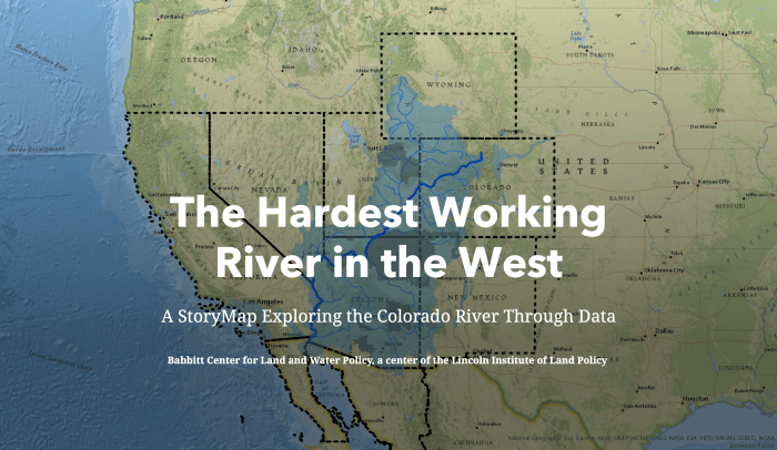


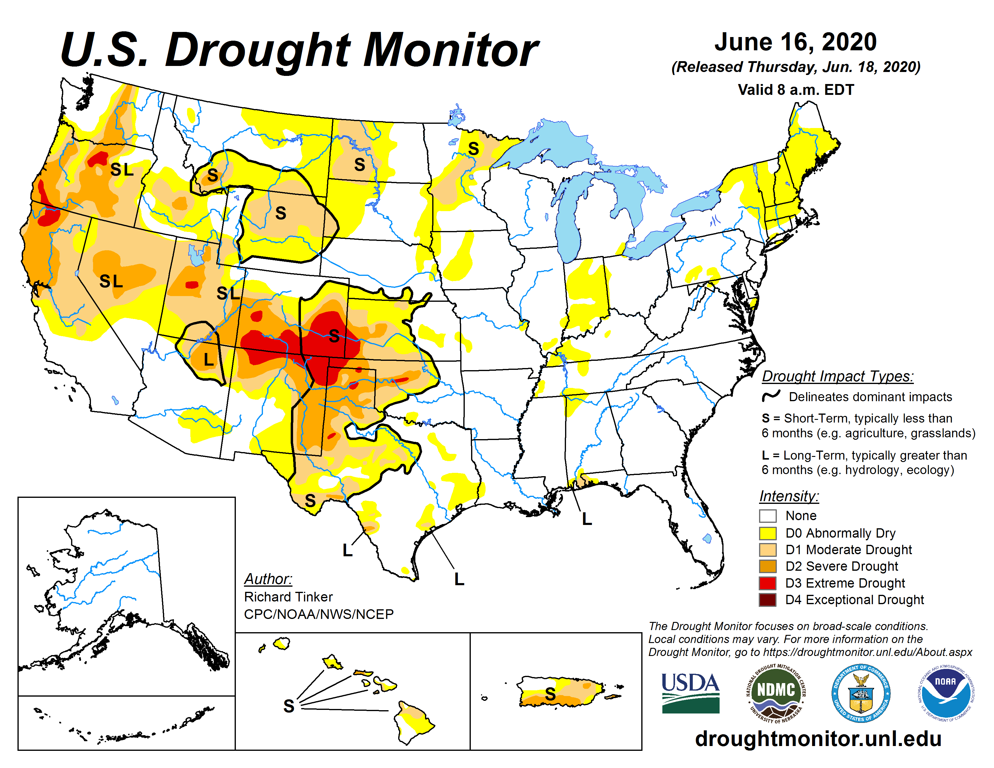


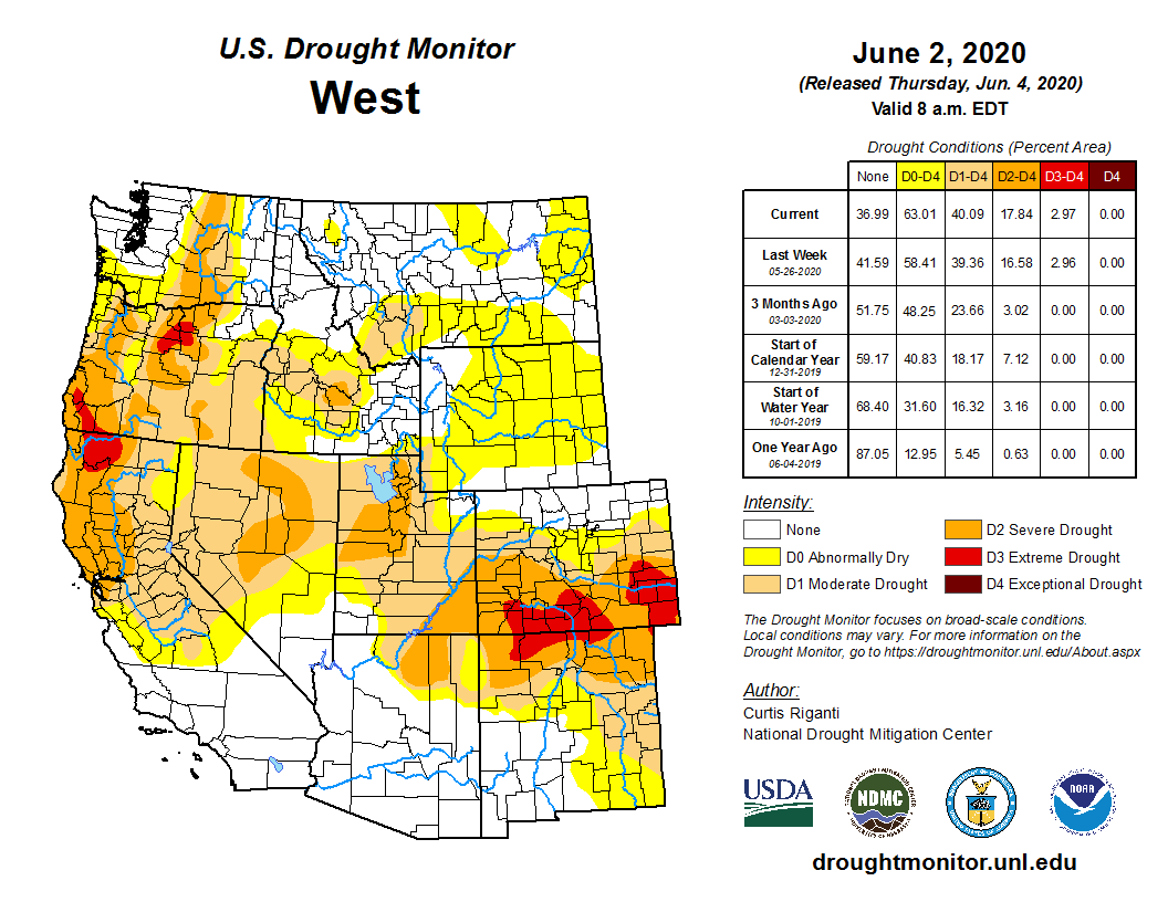


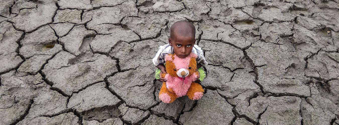


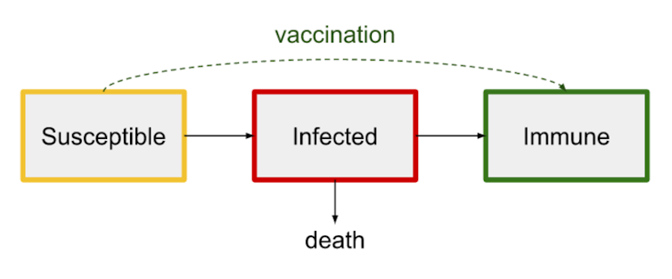
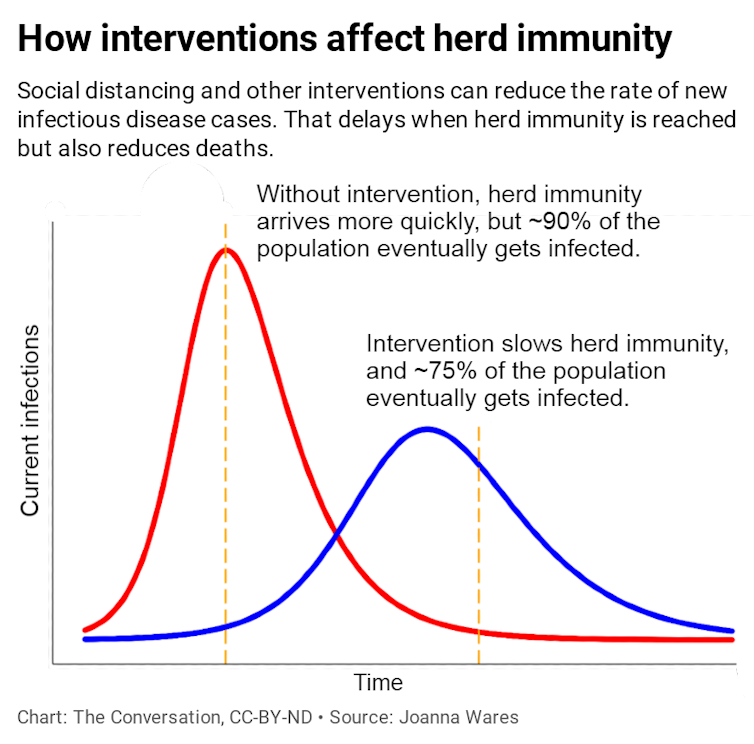

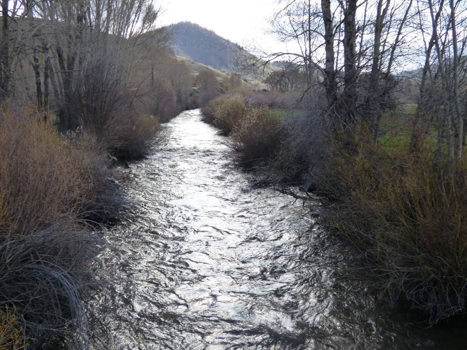


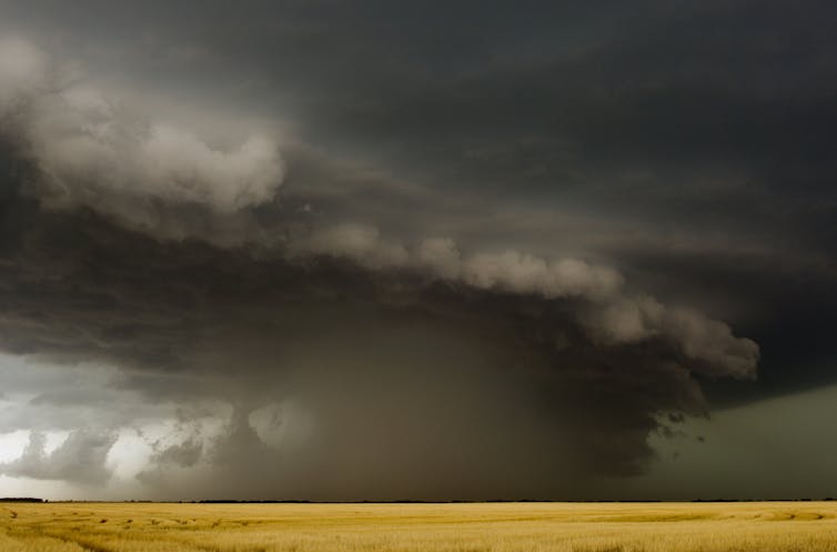
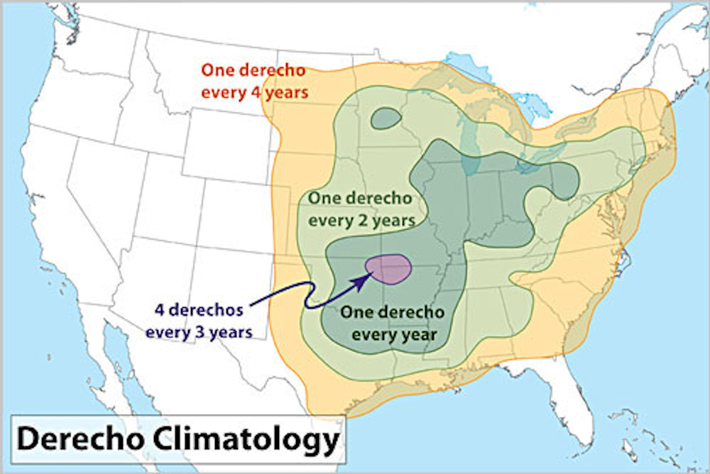
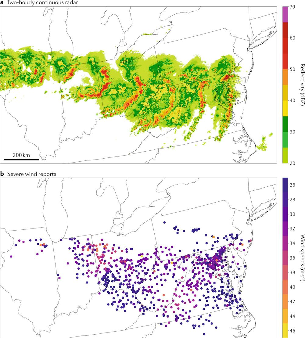


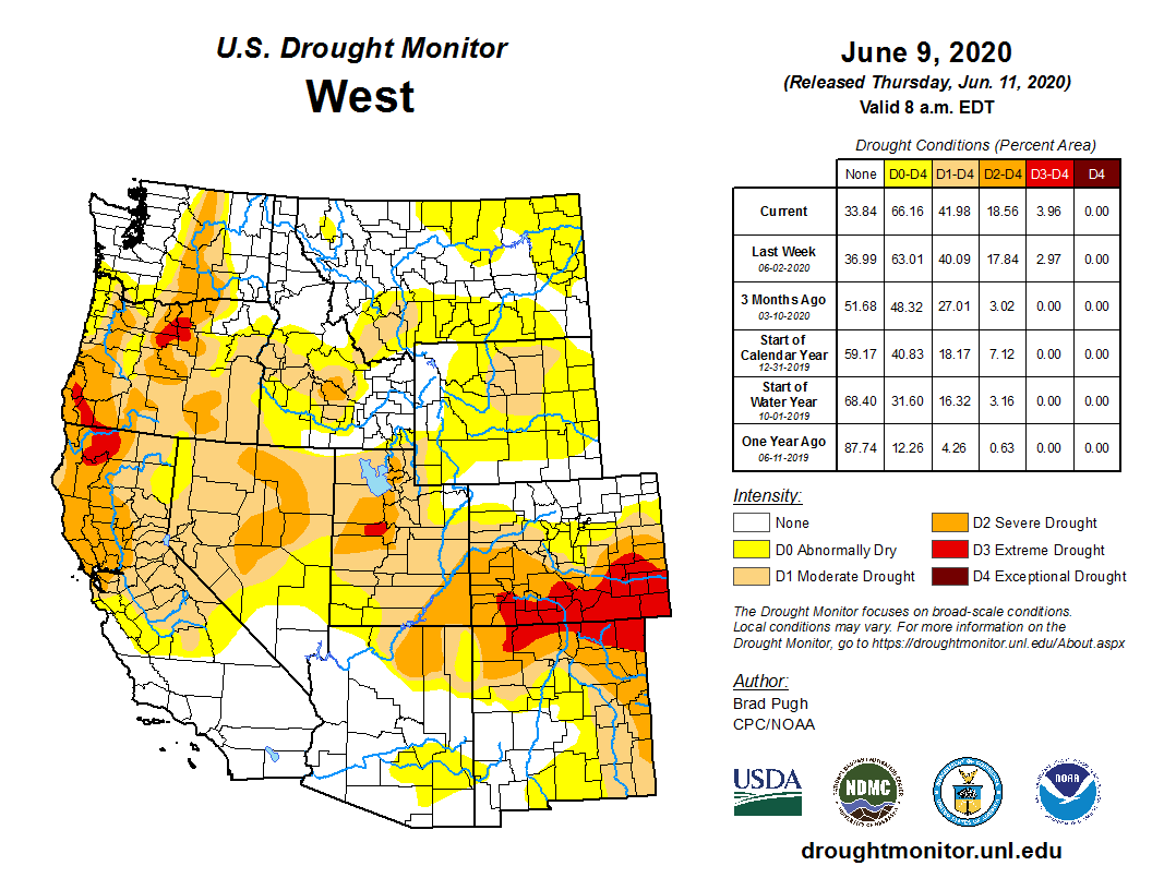


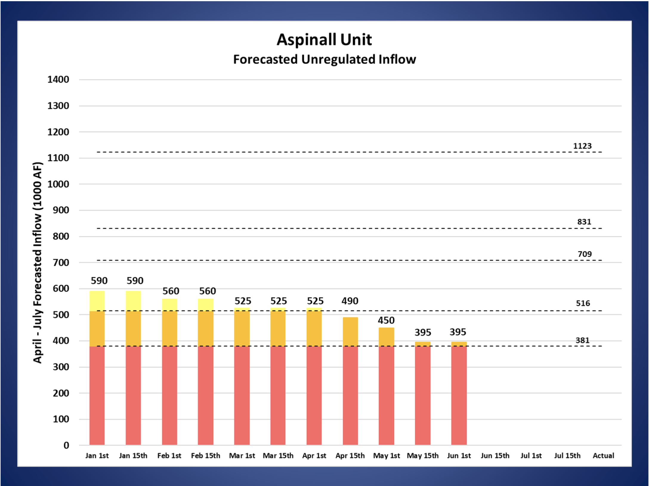


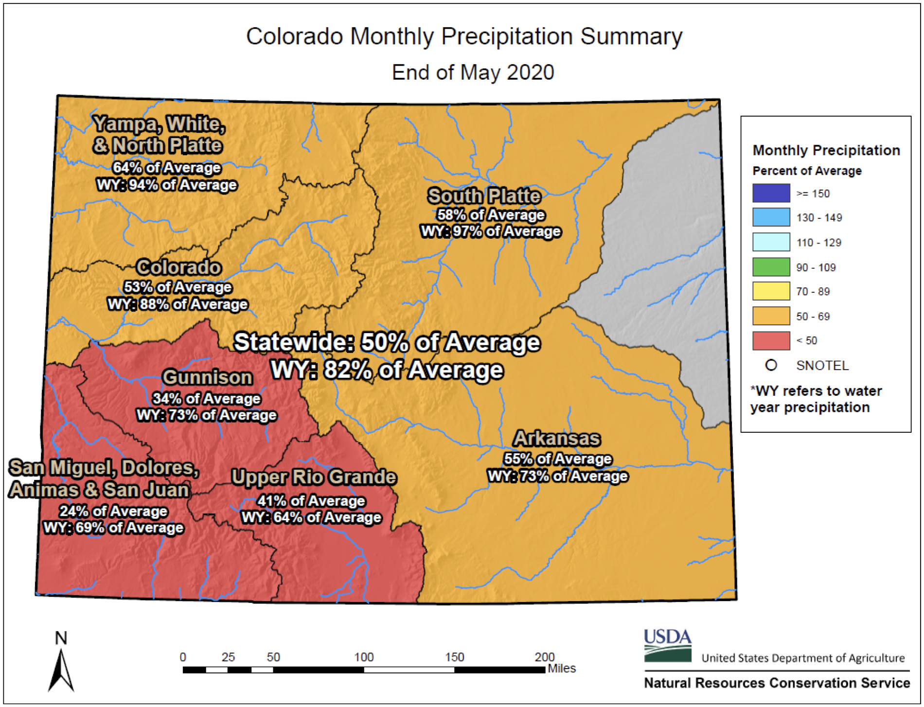


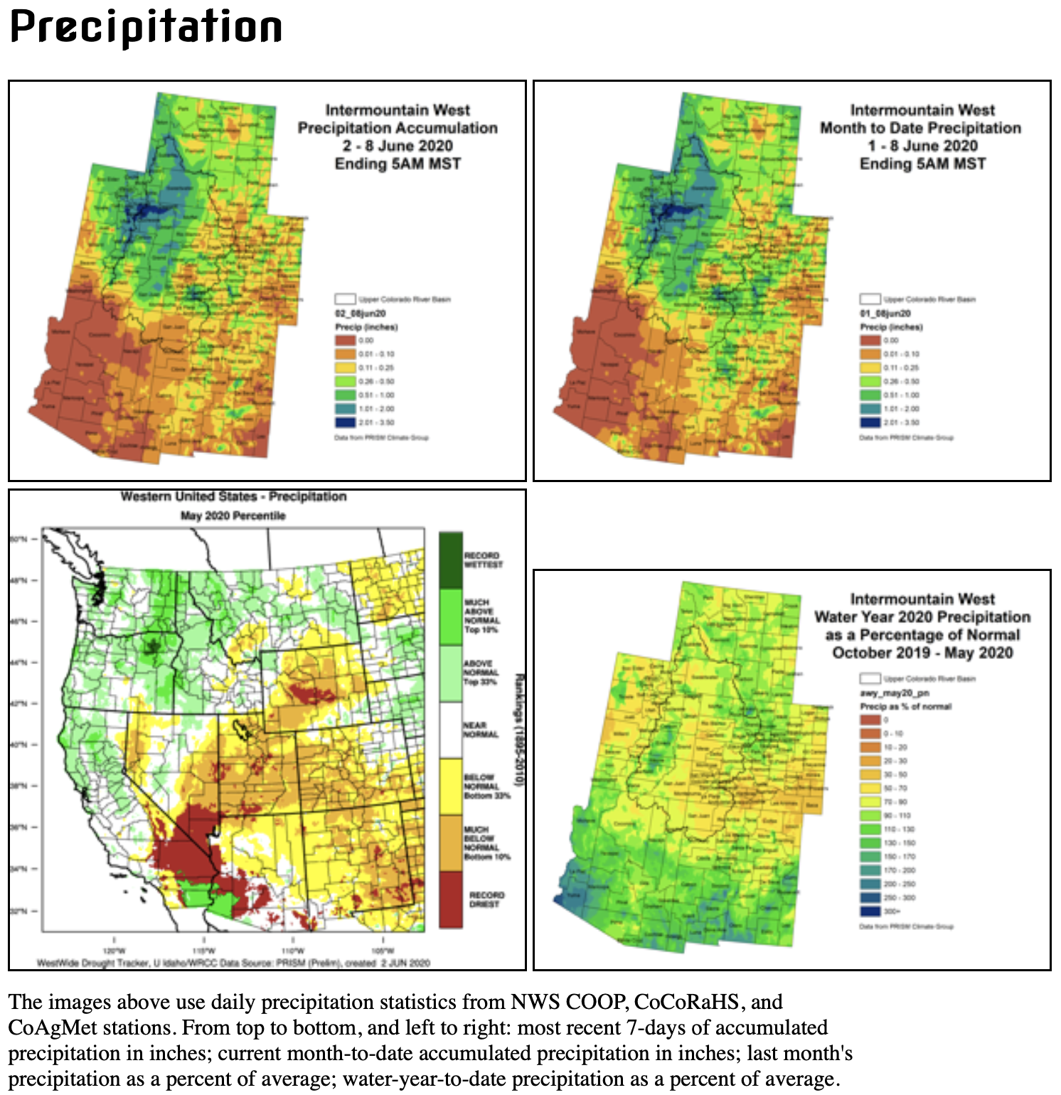

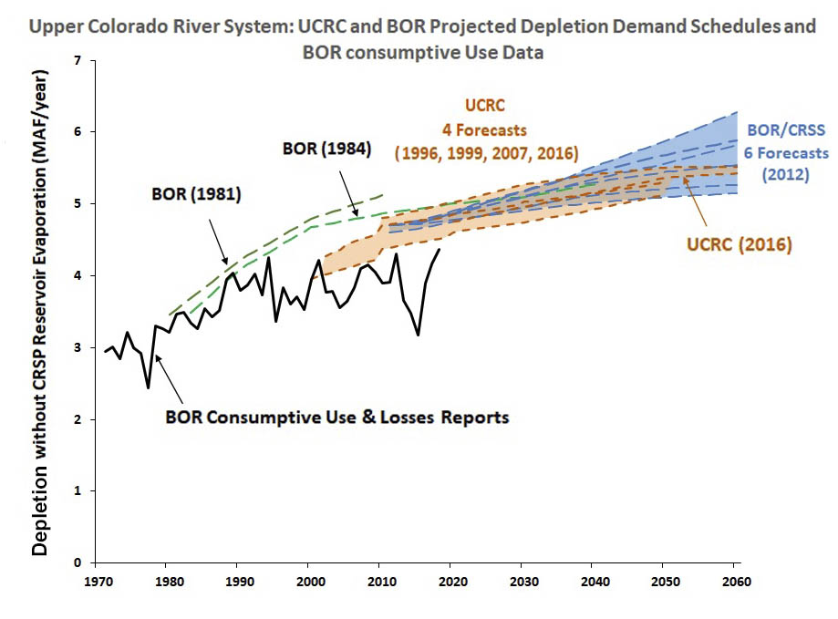
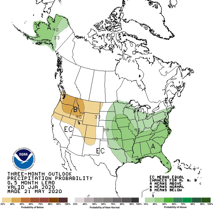
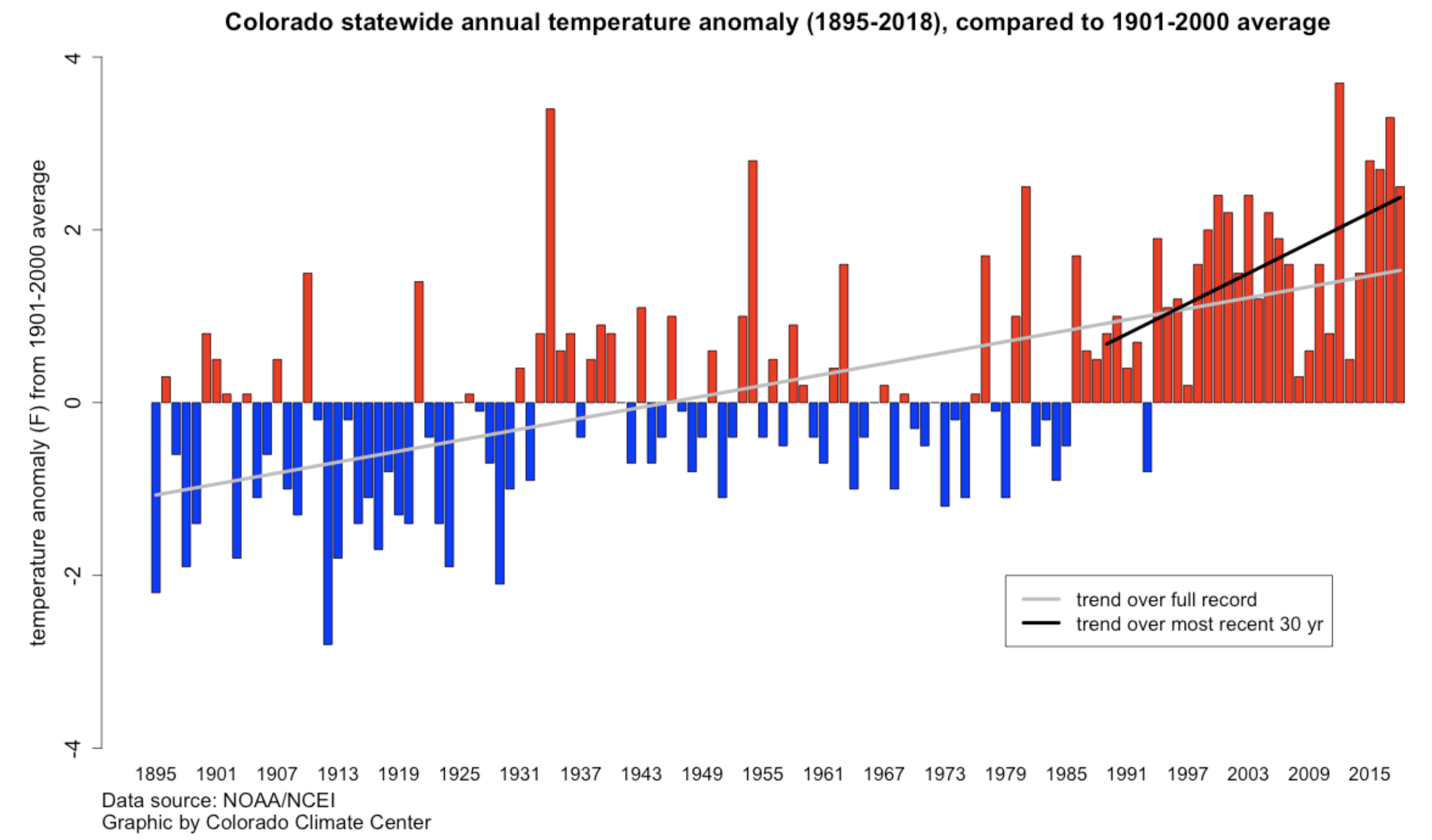
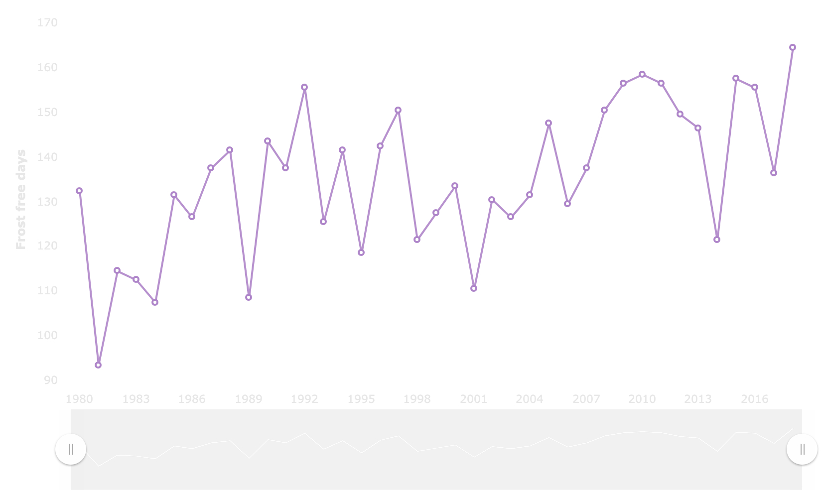
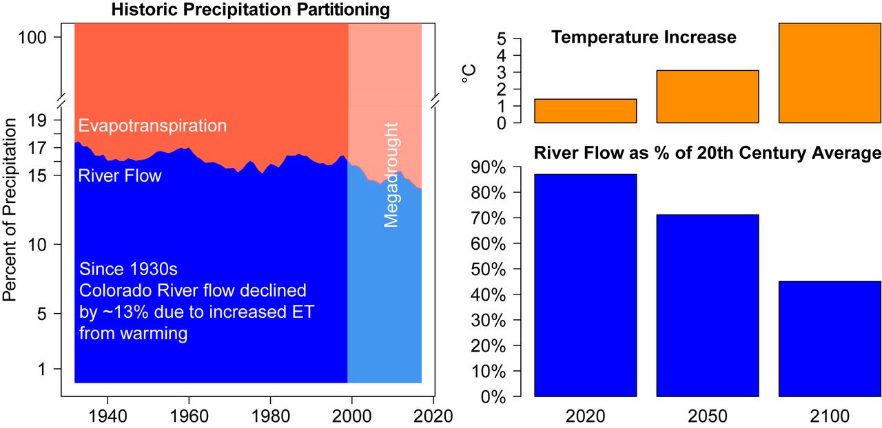


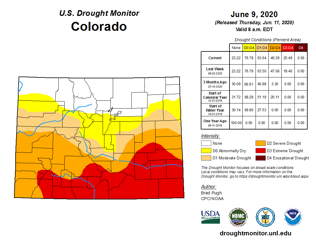
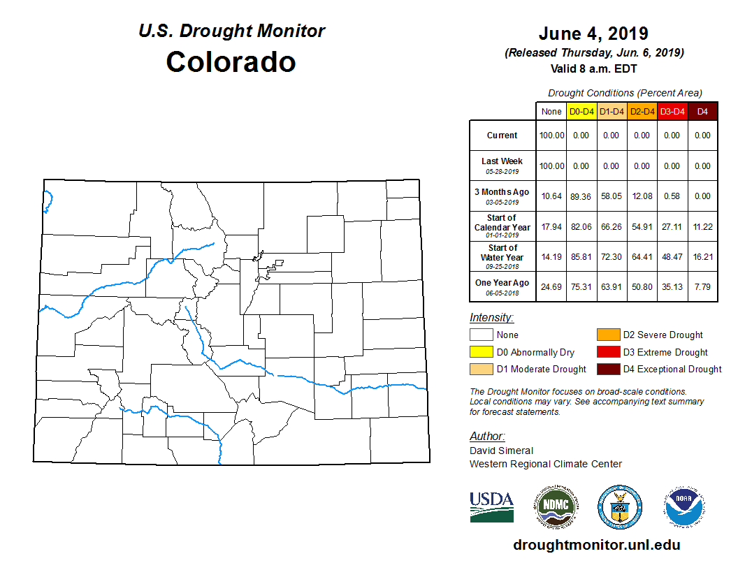

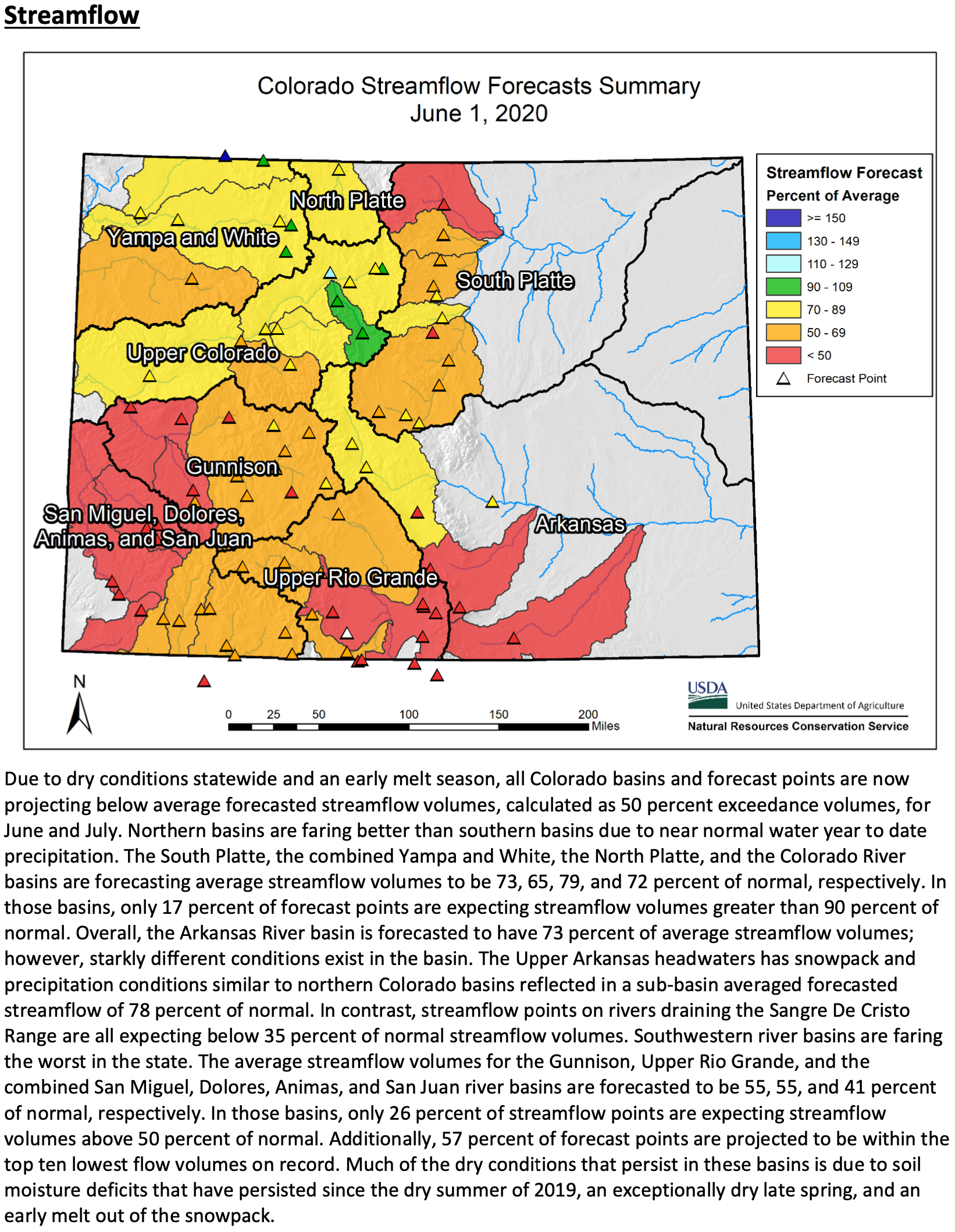
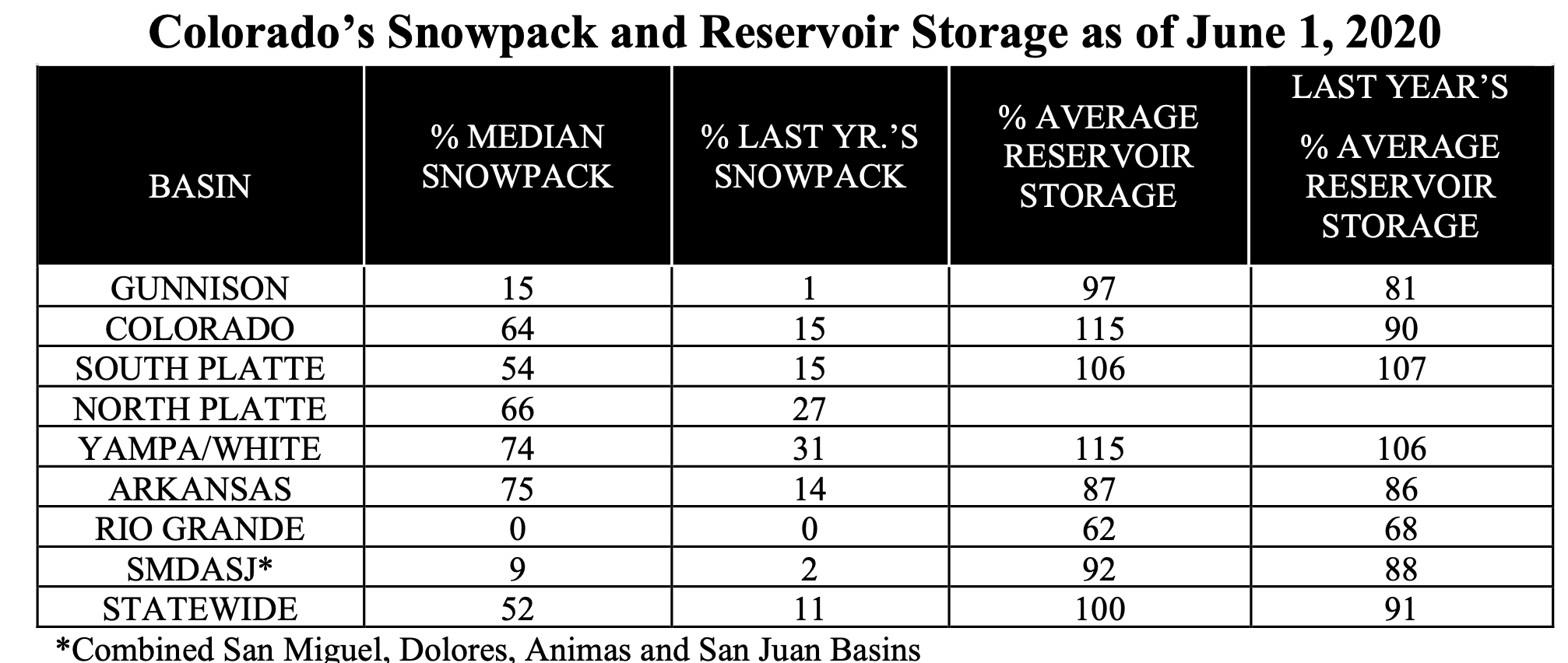


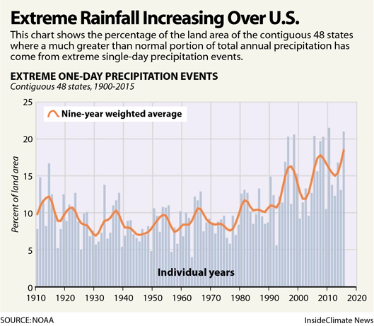
