Here’s a guest column from Hannah Holm that’s running in The Grand Junction Daily Sentinel:
Lately, I’ve been savoring clear skies like never before. My appreciation was magnified by days of feeling trapped in the smoke from California fires, even as our own Pine Gulch Fire calmed down. Meanwhile, friends and family in Washington and Oregon are choking on airborne soup thicker than anything we’ve had to deal with this summer.
I feel vaguely guilty that the same weather system that finally brought us rain, cooler temperatures and clear air earlier this month also fanned the heartbreakingly destructive flames farther west. We share the air, and that gives us in western Colorado a direct, tangible connection to the fate of West Coast forests and fires.
Water connects us, too, even if the connections aren’t as immediate and visible as wildfire smoke. Most of the water that flows into the Colorado River comes from Colorado’s mountains, so a bad snow year (or decade, or two) for us means less water for the 40ish million people that depend on the river, from Denver to Phoenix, Los Angeles and Mexico. Likewise, more snow in California’s Sierra Nevada Mountains and the eastern side of the Rockies reduces the draw on the river by giving Los Angeles and Denver more source water closer to home. Conservation actions in those cities benefit the river, and the whole river community, for the same reason.
Downstream conditions affect the headwaters in other ways, too, as desiccated, beat-up rangeland in the Four Corners area sends dust to the mountains that melts the snowpack earlier and reduces the amount of water that runs off into our streams.
Food also connects us, and food is very directly connected to water. If you like to eat salad in January, you need to keep water flowing to the Southern California farms that produce it.
Firefighters on the march: The Pine Gulch Fire, smoke of which shown here, was started by alighting strike on July 31, 2020, approximately 18 miles north of Grand Junction, Colorado. According to InciWeb, as of August 27 2020, the Pine Gulch Fire became the largest wildfire in Colorado State history, surpassing Hayman Fire that burned near Colorado Springs in the summer of 2002. Photo credit: Bureau of Land Mangement-Colorado, via InciWeb and National Interagency Fire Center.
To bring us back to where we started, fire and water are also connected, just as both fire and water connect far-flung communities. When the Pine Gulch Fire was at its most active, incident managers reported that the moisture content of the vegetation in the fire area was less than what you would typically find in a (perfectly flammable) piece of paper. That was a direct consequence of the same high temperatures and precipitation deficit that have diminished our streamflows and runoff into Lake Powell. Post-fire, we can expect ash and naked soil to run off into waterways, fouling fish habitat and drinking water intakes.
All of these connections are important to keep in mind as the states that share the Colorado River prepare to embark on a new round of negotiations over how to manage it. Representatives from all the states will face pressure to focus narrowly on enabling local water users to secure access to as much of the shrinking river as they can. That’s fair enough — no one wants to diminish their own future just to be the nice guy. But over the long term, it will help all of us to pursue actions that benefit the Colorado River system as a whole. That includes reducing the greenhouse gas emissions that are warming the atmosphere and intensifying both drought and wildfire.
Hannah Holm coordinates the Hutchins Water Center at Colorado Mesa University, which promotes research, education and dialogue to address the water issues facing the Upper Colorado River Basin. Support for Hutchins Water Center articles is provided by a grant from the Walton Family Foundation. Learn more about the center at http://www.coloradomesa.edu/water-center.
The Crystal River runs parallel to County Road 3 as it flows past the town of Marble. The Pitkin County Healthy Rivers board has expressed interest in a water quality monitoring program to see if the diversion of Yule Creek, a tributary of the Crystal, is having downstream impacts. Photo credit: Heather Sackett/Aspen Journlism
Pitkin County groups are keeping a close eye on a local marble-mining company that violated the Clean Water Act, as the company prepares to submit a permit application.
In March, the Army Corps of Engineers determined that Colorado Stone Quarries — the operator of the Pride of America Mine, above the town of Marble — violated the Clean Water Act when it relocated Yule Creek to make way for a mining road. CSQ is now retroactively applying for a permit from the Army Corps, which will require a 30-day public notice, public review and comments.
The Crystal River Caucus sent a letter to Gunnison County and Pitkin County commissioners on July 17 urging them to get involved during this upcoming public process to ensure the protection of local waterways Yule Creek and the Crystal River.
“Residents of the valley are concerned that future negligent or illegal actions taken by this company may put both Yule Creek and the Crystal River at additional risk,” the letter reads. “Even remedial actions, if not properly designed or carried out, could result in negative impacts downstream.”
Caucus chair John Emerick said that his group is supportive of protecting the water quality of the Crystal River and that the board plans to submit comments to the Army Corps.
“The place, to me, looks to be a mess, and they need to have a plan before they are allowed to operate,” Emerick said, referring to the state of the new channel.
Portals to the marble galleries of the Pride of America Mine can be seen in this still photo from drone footage. Quarry operators Colorado Stone Quarries relocated Yule Creek in 2018 to build an access road. Photo credit: Maciej Mrotek via Aspen Journalism
Creek diversion and diesel spill
In the fall of 2018, CSQ diverted a 1,500-foot section of Yule Creek from its natural channel on the west side of Franklin Ridge, a rock outcropping, to the east side of the ridge so it could build an access road. Operators piled the streambed with fill material, including marble blocks.
Although this move probably spared Yule Creek the impacts of a diesel spill last October, it was done without the proper permits or oversight, according to the Army Corps. CSQ was fined $18,600 by the state Division of Reclamation, Mining and Safety for the 5,500-gallon diesel spill.
Under Section 404 of the Clean Water Act, a project requires a permit from the Army Corps if it includes the discharge of dredged or fill materials into waters such as rivers, streams or wetlands. CSQ did not initially obtain a permit because company officials believed the work was exempt, citing the temporary nature of the access road and creek diversion.
Army Corp officials disagreed and determined the lack of a permit was a violation of the Clean Water Act.
CSQ now plans to submit a permit application next week, according to company spokesperson Lisa Sigler. The application will include alternative alignments for Yule Creek, including leaving the creek in the new channel or rerouting it back to the natural channel. At the Army Corps’ request, the application will include a biological assessment, cultural-resource survey and aquatic-resource delineation, Sigler wrote in an email.
The mine, known locally as the Yule Quarry, is owned by Italian company Red Graniti and employs 30 to 40 people. CSQ says there are enough marble reserves contained in its six galleries to continue mining at the current rate for more than 100 years. The quarry has supplied the pure white marble for renowned monuments such as the Lincoln Memorial, the Colorado Capitol building and the Tomb of the Unknown Soldier.
The creek diversion and access-road construction came after the quarry was granted a permit by DRMS in 2016 for a 114-acre expansion for a total of 124 permitted acres in the Yule Creek drainage.
This photo from September 2020 shows how quarry operators moved Yule Creek into a channel lined with marble blocks. Pitkin County groups are concerned the creek diversion could have downstream impacts. Photo credit: Heather Sackett/Aspen Journalism
Healthy Rivers concerns
Although the quarry sits in Gunnison County, about 3 miles up County Road 3 from the town of Marble, the relocation of the stream could have downstream impacts in Pitkin County. Yule Creek flows into the Crystal River, which flows through Pitkin County before it joins the Roaring Fork River in Carbondale.
Members of the Pitkin County Healthy Rivers board have said they support water-quality monitoring, especially regarding turbidity, or water clarity.
“We are concerned about sedimentation and water-quality impacts on the Crystal down in Pitkin County,” said Andre Wille, chair of the Healthy Rivers board. “We try to think on a watershed basis, so we don’t just focus on county lines.”
Heavy equipment in the streambed could kick up sediment, which is then suspended in the stream’s flow, Wille said.
“More concerning is probably the way those sediments then settle down and fill in the spaces in the gravel and in the rocks and smother insects,” he said. “If they are spawning, it smothers eggs of trout and fish, so it really kind of wrecks the habitat.”
CSQ general manager Daniele Treves said in a prepared statement that the quarry already has a water monitoring program at three locations on Yule Creek and has installed groundwater monitoring wells related to the diesel spill. The marble blocks placed in the new stream channel are intended to create step pools that encourage fine sediment to settle, he said.
“CSQ’s diversion of the Yule Creek simply redirected a portion of the creek from its then-present western channel to a historical channel approximately 200 feet to the east,” Treves said.
A video by Redstone resident and longtime local Maciej Mrotek shows how the area looked in May 2018, before the diversion, when Yule Creek was on the west side of Franklin Ridge. Drone footage from this past May shows the creek now running on the east side of the ridge in a channel filled with cut marble chunks and a road on the west side of the ridge where the creek used to be.
Mrotek, who said he has fond memories of playing in the area as a child, said the change was devastating.
“I took it very personally when I saw that, because I think it could have been handled in a much better way,” he said. “My goal is not to stop the mining. My goal is simply to channel the future activity of this mine in a positive fashion with a lot more oversight and respect.”
Aspen Journalism is a local, nonprofit, investigative news organization covering water and rivers in collaboration with The Aspen Times and other Swift Communications newspapers. This story ran in the Sept. 28 edition of The Aspen Times.
The Upper Gunnison River Water Conservancy District unanimously passed a Resolution in Support of Ballot Measure 7A. This measure from the Colorado River Water Conservation District, asks voters to approve a mill levy increase to continue it’s vital work protecting Colorado’s westslope water resources.
“We recognize the value of the River District as a voice for western Colorado water issues of importance to the Upper Gunnison River basin,” stated Sonja Chavez, General Manager, Upper Gunnison River Water Conservancy District.
The Colorado River Water Conservation District spans 15 Western Slope counties. River District directors are asking voters this fall to raise the mill levy.
With increasingly extreme summer temperatures and continued population growth in Northern Colorado, it’s no surprise that water supplies – and their users – are feeling the heat. Colorado’s arid climate has long defined water as a scarce and valuable resource, and increased water demand makes efficient water use an even greater priority. Northern Water offers a variety of programs to help our allottees conserve water where it counts: in landscapes.
Northern Water provides supplemental water to more than 1 million people in Northeastern Colorado and 615,000 acres of irrigated farmland. More than half of the region’s municipal water supplies are used for landscape irrigation. Although awareness of “Colorado-climate friendly landscapes” is growing, most residents cite lack of knowledge as their primary obstacle for not managing their landscape to use less water. Northern Water continues to develop creative ways to address both the financial and knowledge gaps that would otherwise prevent water users from pursuing outdoor water efficiency conversions. Our irrigation audits, landscape consultations and grant program aim to do just that.
Irrigation Audit Program
An irrigation audit is a great place to begin if you’re looking to reduce your outdoor water use. Northern Water’s irrigation audit program, offered in partnership with Resource Central and Irrigation Analysis, provides information to help property owners identify water waste within irrigation systems and offer direction for optimal water use. By diagnosing a variety of water-wasting issues, audits can provide a starting point for system tuning, a retrofit, or even landscape conversion project or other water-saving pursuit.
Audits offered through Northern Water are available to commercial and residential properties within district boundaries. The audit season runs from mid-June through early October. To request an appointment, please contact amazurek@northernwater.org.
Landscape Consultations
Envisioning the next steps for a landscape can be daunting, even if a property owner understands their specific irrigation inefficiencies and opportunities. Northern Water’s landscape consultations strive to educate and assist commercial property managers in planning a water efficient landscape conversion project
Landscape consultations are available to commercial water customers within Northern Water’s district boundaries. Consultations may include several topics, including plant selection, turf conversion, soil management and more. Appointments are typically 60 to 90 minutes and are first come, first served. To schedule a consultation, complete the intake form.
Grant Program
For those seeking to take the next step, Northern Water’s Collaborative Water-Efficient Landscape Grant Program is open to new or redeveloping landscapes at public or private facilities, including cities, enterprises, nonprofits, businesses, schools, multi-family complexes and HOA-managed landscapes. Potential grant applicants are required to take part in a consultation, and possibly an audit, prior to applying for funding. To schedule a pre-application consultation contact Chad Kuhnel at 970-292-2566. Consultations for the 2020 grant funding cycle must be scheduled prior to Oct. 1.
When it comes to outdoor water savings, replacing water-thirsty Kentucky bluegrass with low-water plant material provides the greatest impact, while maintaining a beautiful landscape. Our Water Efficiency programs are designed to provide resources, guidance and financial support to help customers reduce their outdoor water consumption.
Helen Reddy, the Australian-born singer whose 1972 hit song “I Am Woman” became the feminist anthem of the decade and propelled her to international pop-music stardom, died Tuesday in Los Angeles. She was 78.
The death was confirmed by her children in a message posted on her official fan page on Facebook…
“I Am Woman” reached No. 1 on the Billboard charts at the end of 1972 (a good six months after it was released — individual call-in requests helped build radio play) and earned her the Grammy Award for best female pop vocal performance. She was the first Australian-born artist to win a Grammy and the first to make the Billboard 100 record charts.
Some male observers called the song — beginning with the words “I am woman/ Hear me roar/ In numbers/ Too big to ignore,” sung by a 5-foot-3 soprano — angry, man-hating, dangerous or all three.
“That simply underlined the many things women needed liberating from,” a writer for Variety reflected in 2019. “Nobody called Sinatra a menace when he sang ‘My Way,’ a no less straightforward hymn to self-determination.”
During the 1970s, three of Ms. Reddy’s songs — including “Delta Dawn” and “Angie Baby” — went to No. 1 on the Billboard chart. Three others — “You and Me Against the World,” “Leave Me Alone (Ruby Red Dress)” and “Ain’t No Way to Treat a Lady” — made the Top 10. More than three decades later, The Chicago Tribune declared her the “queen of ’70s pop.”
Helen Maxine Lamond Reddy was born on Oct. 25, 1941, in Melbourne, Australia, the only child of Max Reddy, a writer, producer and actor; and Stella (Lamond) Reddy, an actress whose stage name was Stella Campbell. Her father was in New Guinea, serving in the Australian Army, when she was born. The Reddys performed on the Australian vaudeville circuit, and Helen began joining them onstage when she was 4…
Survivors include her two children, Traci Wald Donat, a daughter from her first marriage, Jordan Sommers, a son from her second, her half sister, Toni Lamond, an Australian singer-actress, and one grandchild…
In a 2013 interview, Ms. Reddy seemed philosophical. “I am at the age where I can just kick back and say what a wonderful life I’ve had,” she told The Sydney Morning Herald. And she laughed when one very familiar question came up: whether she was nervous the first time she went onstage.
“I don’t remember the first time I went onstage,” she said.
Colorado River, Black Canyon back in the day, site of Hoover Dam
Hoover (Boulder) Dam photo credit Ansel Adams circa 1942 via Wikipedia.
President Franklin Roosevelt at dedication of Boulder (now Hoover) Dam, September 30, 1935
Rarely seen back of the Hoover Dam prior to first fill
US Flag at Hoover Dam as the Olympic Torch passed over the dam in 1996
Hoover Dam from the Arizona side. Photo credit: Allen Best/The Mountain Town News
The construction of Hoover Dam created Lake Mead in 1935, which serves as the primary storage reservoir in the lower Colorado River Basin. Water levels in Mead have declined significantly since 2000 when the reservoir peaked at more than 1,200 feet above sea level. As of October 2019, the reservoir is less than 40 percent full at just over 1,080 feet above sea level. Credit: Jirka Matousek / Flickr via Water Education Colorado
Arizona power house at Hoover Dam December 2019. Each of the 17 hydroelectric generators at Hoover Dam can produced electricity sufficient for 1,000 houses. Photo credit: Allen Best/The Mountain Town News
Hoover Dam has enough concrete fora four-foot-wide sidewalk around the Earth at the Equator. Photo credit: The Mountain Town News/Allen Best
Tower with sculptures of the purpose of Hoover Dam. I love the navigation purpose. Elevator to the interior of the dam is located here.
Arizona/Nevada border marker at the base of Hoover Dam.
Terminus of the access road at Hoover Dam.
Looking downstream of Hoover Dam. On December 13, 2019 they were not generating much power. They are using the power plants to balance grid load now since they can spin up quickly as demand dictates. They can also use power to spin up the turbines so that they can supply energy to the grid instantaneously according to Terry Fulp. He told us that the power customers in the grid are willing to pay for this flexibility.
Coyote Gulch in a borrowed hard hat on the deck of the Arizona powerhouse at Hoover Dam on December 13. 2019.
Looking downstream from the base of Hoover Dam. Concrete structure in the center of the photo is the outlet for the Nevada side emergency spillway.
Beautiful tile work at the Arizona power plant in Hoover Dam. Elements of Native American art and industrial influences.
The Hoover Dam Arizona power plant turbines.
Looking down on the power plants from the top of Hoover Dam.
Face of Hoover Dam looking towards Arizona.
Hoover Dam, straddling the border between Nevada and Arizona, holds back the waters of the Colorado River in Lake Mead. In 2016, Lake Mead declined to its lowest level since the reservoir was filled in the 1930s. Source: Bureau of Reclamation
Hoover Dam schematic via the Bureau of Reclamation.
Intake towers for power generation at Hoover Dam December 13, 2019.
Hoover Dam plugs the Colorado River on the Nevada-Arizona border. Photo December 2012/Allen Best
Hoover Dam. Photo credit: Air Wolfhound Flickr Creative Commons
Hoover Dam dedication September 30, 1935. Photo credit U.S. Bureau of Reclamation via the Arizona Department of Water Resources.
Back of Hoover Dam prior to first fill photo via Reclamation.
Hoover Dam during construction via Historical Photos.
Hoover Dam spilling back in the day.
Hoover Dam photo via the US Bureau of Reclamation
Herbert Hoover presides over the signing of the Colorado River Compact in November 1922. Members of the Colorado River Commission stood together at the signing of the Colorado River Compact on November 24, 1922. The signing took place at the Palace of the Governors in Santa Fe, New Mexico, with Secretary of Commerce Herbert Hoover presiding (seated). (Courtesy U.S. Department of Interior, Bureau of Reclamation)
Hoover Dam is a concrete arch-gravity dam in the Black Canyon of the Colorado River, on the border between the U.S. states of Nevada and Arizona. It was constructed between 1931 and 1936 during the Great Depression and was dedicated on September 30, 1935, by President Franklin D. Roosevelt. Its construction was the result of a massive effort involving thousands of workers, and cost over one hundred lives. Originally known as Boulder Dam from 1933, it was officially renamed Hoover Dam for President Herbert Hoover by a joint resolution of Congress in 1947.
Click here to read the update (Megan Holcomb/Tracy Kosloff):
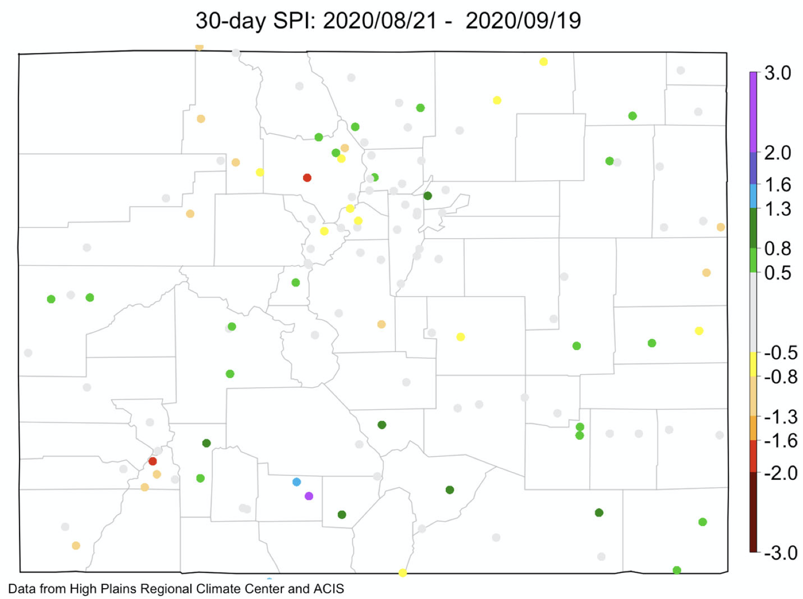
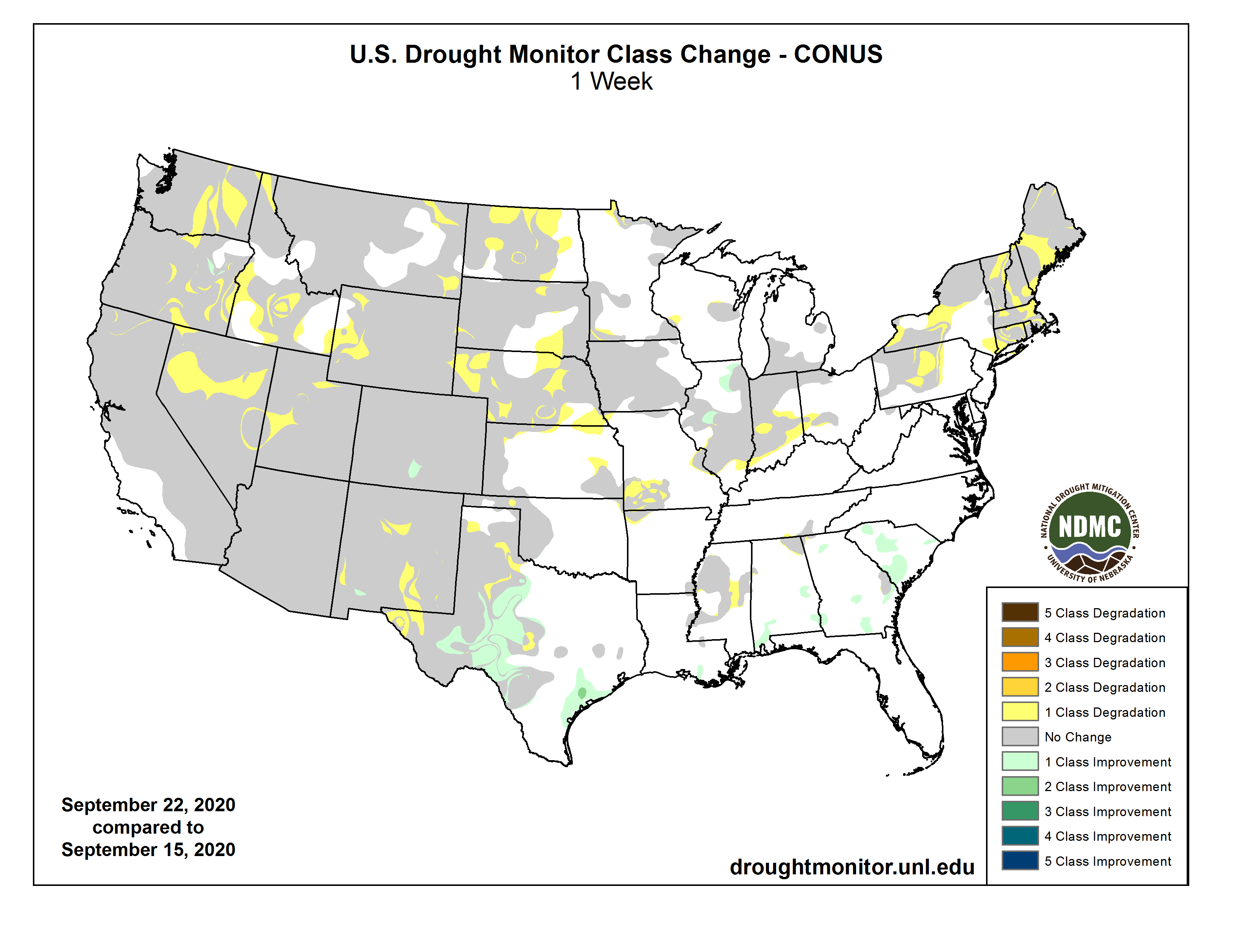
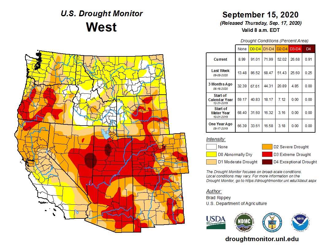
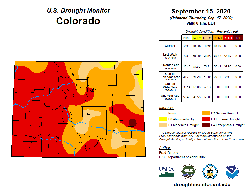
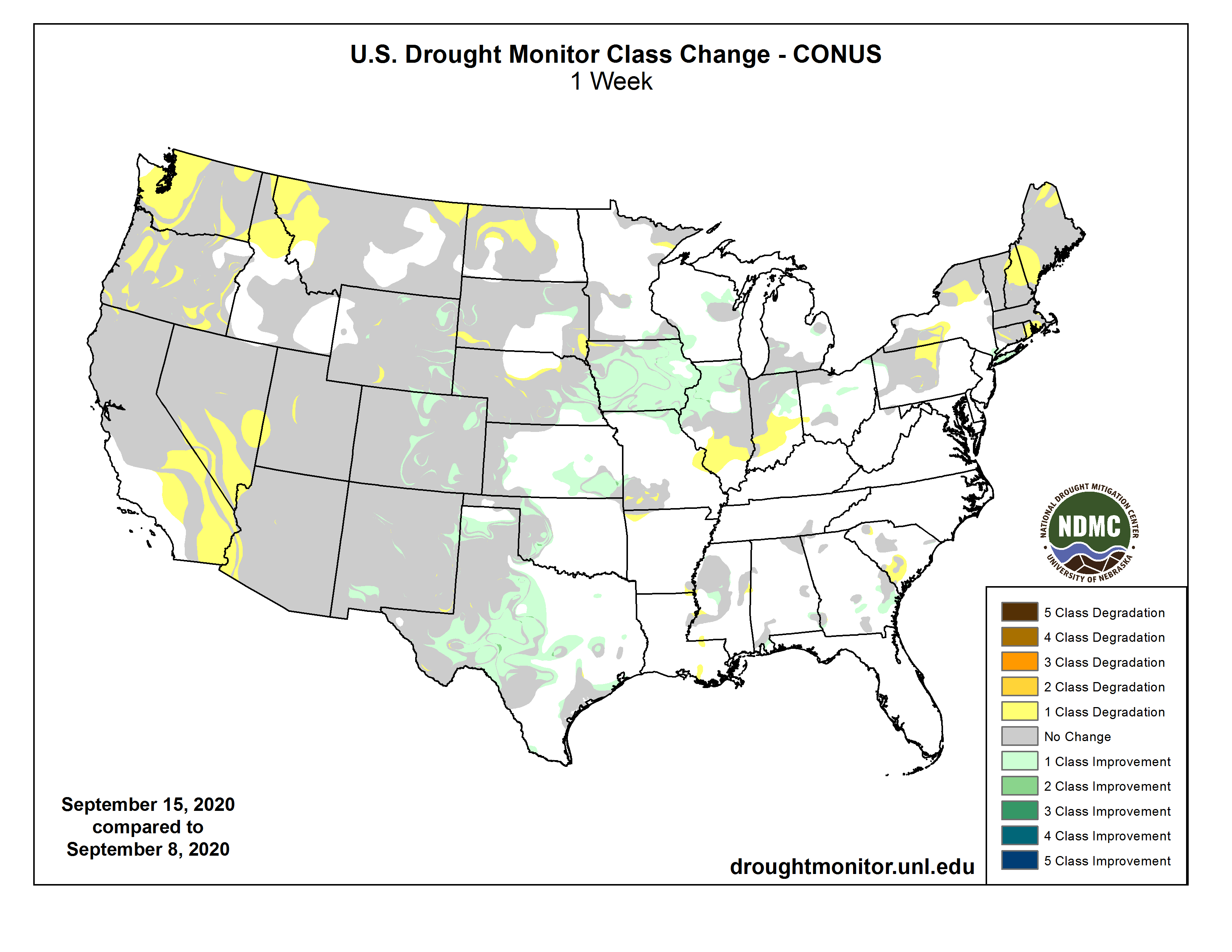
As the end of the water year draws near, Colorado experienced the hottest August on record since record keeping began in 1895. As of September 15th, the entire state is covered in dry conditions with over 50% of our state in extreme or exceptional drought. Minor temporary soil moisture improvements were made with the September 9th snowfall. The early storm broke numerous records including a record low temperature, earliest freeze, and the shortest number of days between a 100 degree day and a measurable snowfall. This widespread precipitation event extended over the eastern plains and resulted in over 10 inches of snow in north central Colorado and the San Luis Valley ‐ with some areas logging up to 18 inches. While this event brought SNOTEL measures to near average precipitation for September, August and September are still extremely (or near record) dry months for the state. On September 21, 2020, Governor Polis expanded Drought Plan activation to all 64 Colorado counties.
Colorado Drought Monitor September 22, 2020.
The Sept. 24 U.S. Drought Monitor, logged 0.4% of the state in D4 (exceptional) drought conditions; D3 (extreme) drought in 50% of the state; D2 (severe) drought covering 38%; and D1 (moderate) drought covering 11% of the state.
The 90‐day Standardized Precipitation Index (SPI) (June 22 to Sept 19) shows consistent dryness across the state with deeper shortfalls more prevalent throughout north central Colorado and front range. Below average precipitation is expected to continue over the next two weeks.
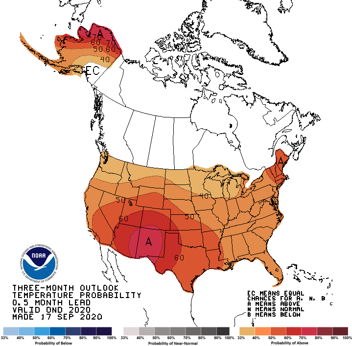
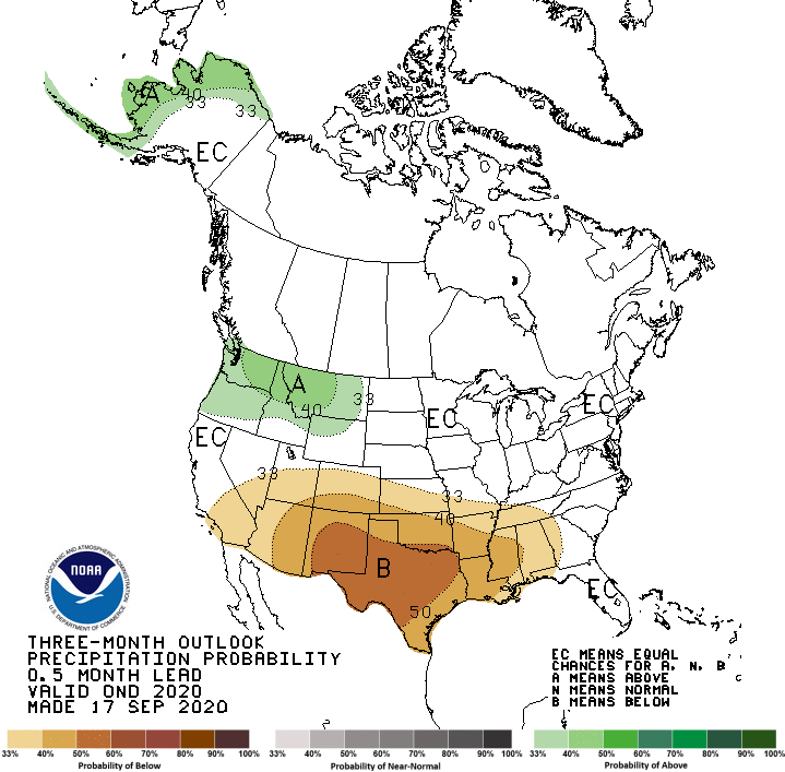
Tropical Sea Surface Temperatures indicate La Niña conditions, and the CPC issued a La Niña Advisory. There is now a 75% chance that weak La Niña conditions will continue throughout the fall/winter, increasing the likelihood of warm extremes for the state and less snow for the southern mountains and eastern plains.
The NOAA Climate Prediction Center three month outlook maps indicate higher chances for above average temperatures over fall and winter with a slightly enhanced chance of below average precip.
Statewide reservoir storage is currently at 85% of average, down from 90% last month. Storage in the northern half of the state is near average while the southern half of the state ranges from 67% to 77% of average.
Municipal water providers continue to report increased demands and most municipalities are experiencing normal to slightly below normal storage. Water providers are monitoring conditions as they consider the need for future restrictions. Currently, the following municipalities have active watering restrictions, due to the compounding impacts of wildfire: Glenwood Springs (active Aug.15), Fort Collins (beginning Oct 1)
Here’s the release from the City of Boulder (Samantha Glavin):
The City of Boulder has kicked off its update to the Comprehensive Flood and Stormwater (CFS) Master Plan.
The master plan was last updated in 2004 and guides city policy for flood management; stormwater quality and drainage; emergency preparedness and resilience; regulations; project prioritization; and education and outreach.
To support the update to the plan, the city is seeking community members to join a Community Working Group (CWG). The CWG will provide feedback to city staff and the project consultant during the master planning process. It will be comprised of individuals who live in Boulder who bring a broad range of perspectives to flood and stormwater management (i.e., residents, property owners, community advocates, water professionals). The CWG will be asked to:
Identify and examine issues related to stormwater and flood management;
Review and comment on technical documents;
Provide feedback about plan completeness and alignment with community goals and values;
Assist with community outreach; and,
Participate at public events, including at advisory boards and City Council meetings.
Interested individuals can apply by submitting an application online by Oct. 14, 2020. Hard-copy applications can be requested by emailing cfsinfo@bouldercolorado.gov or calling Laurel Olsen at 720-456-8819. Chosen applicants will be informed of their selection by Nov. 30, 2020. Working group meetings will begin in early 2021.
The CWG is the first step in the CFS master planning process, which will also include a larger public process to gather ideas and feedback from the community. Learn more about Comprehensive Flood and Stormwater Master Plan and timeline at https://bouldercolorado.gov/flood/comprehensive-flood-and-stormwater-master-plan.
At the board’s Sept. 21 meeting, they heard recommendations from town staff and special legal counsel regarding the potential for using the sale of revenue bonds to fund major improvements to its water system over the coming years.
However, instead of revenue bonds, it was recommended Monument create an ordinance to enter a site lease agreement and lease purchase agreement to market Certificates of Participation (COPs) — an alternate form of financing…
Presently, the town has a 2A water fund and an enterprise water fund for its improvements. Formal revenue bonds would have the town fund improvements from just one fund, Richey said. Using Certificates of Participation is a way many municipalities, counties and school districts fund projects without having to raise taxes and is a financial structure approved by the Colorado Supreme Court, Richey said. The collateral for the agreement would be town-owned property, infrastructure and improvements.
With the agreement, Monument would lease its collateral property to BOK Financial in Denver, which would act as the financial trustee in exchange for an anticipated $22 million. BOK Financial then leases back the property to the town, and Monument pays “base rents” to pay off the $22 million over time, Richey said.
Richey said Certificates of Participation also carry added protection for the town since they involve leases over a particular term and not transfer of title. Monument would not lose title to any of its assets, he said.
While town staff plans on raising $22 million through marketing these COPs, other terms like interest rates and repayment amount will depend on market conditions when the certificates go to market. The agreement guarantees the interest rate would not exceed 4.5%, but with present rates it is expected to be just under 3%, Town Manager Mike Foreman said…
Terms for repayment would not exceed 30 years, but Richey said town staff is negotiating for lower terms. Richey also said as base rents are paid, subleased property in the agreement could be removed, which is the goal, or substituted with other property of equal or lesser value.
The board approved the ordinance 6-0 with no opposition from trustees, staff or the public…
Foreman noted the anticipated $22 million from the COPs would leave an additional $5 million in the 2A fund.
The Waldo Canyon Fire changed the way our community looks at natural disasters. A project designed in response to side effects of the blaze is now completed, and aims to be proactive, rather than reactive.
Near Garden of the Gods lies the Camp Creek Drainage Improvement Project. It’s a 17-acre floodwater detention and sediment collection facility…
After the Waldo Canyon Fire, the burned vegetation was not able to absorb moisture in the way it normally would. Consequently, the area saw flooding, with sediment rolling down the hillsides as well.
So, the Camp Creek Drainage Improvement Project was designed, with the help of federal, state, and local agencies. A Federal Emergency Management Agency (FEMA) grant for $8.9 million bankrolled the project, as well as $844,000 from the city.
Representatives from FEMA and the state visited the completed project on Monday. “If we could do more mitigation across the country, we’d be a much safer country, we’d be a much more resilient country,” said Peter Gaynor, the FEMA Administrator…
In addition, approximately 100 people no longer live in the floodplain. “We’re really not moving people out of the floodplain, we’re moving the floodplain right? And so, we’re changing the shape and the footprint of the floodplain,” said Klein.
The 169 acre-foot storage reservoir is estimated to hold around 360,000 gallons of water, according to the Stormwater Enterprise Manager for the City of Colorado Springs, Richard Mulledy.
Mulledy said the project has made around 100 residents who previously lived within the floodplain safer. He also said they now do not have to pay for floodplain insurance, which can be expensive.
Plus, it will create better evacuation routes during floods if necessary.
Releases from the Aspinall Unit will be decreased from 1350 cfs to 1250 cfs on Monday, September 28th. Releases are being lowered while the Crystal powerplant is offline for maintenance. Diversions into the Gunnison Tunnel have also dropped over the last part of September. The actual April-July runoff volume for Blue Mesa Reservoir came in at 57% of average.
Flows in the lower Gunnison River are currently above the baseflow target of 890 cfs. River flows are expected to stay at levels above the baseflow target after the release change has arrived at the Whitewater gage.
Pursuant to the Aspinall Unit Operations Record of Decision (ROD), the baseflow target in the lower Gunnison River, as measured at the Whitewater gage, is 890 cfs for September and 790 cfs for October.
Currently, Gunnison Tunnel diversions are 950 cfs and flows in the Gunnison River through the Black Canyon are around 450 cfs. After this release change Gunnison Tunnel diversions will be around 900 cfs and flows in the Gunnison River through the Black Canyon will be near 400 cfs. Current flow information is obtained from provisional data that may undergo revision subsequent to review.
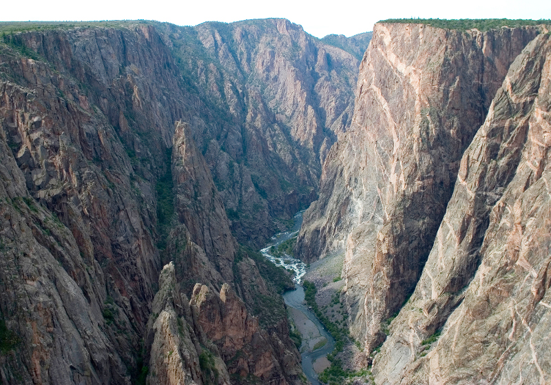
Looking downstream from Chasm View, Painted Wall on right. Photo credit: NPS\Lisa Lynch
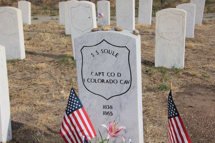
Mount Soule would honor Silas Soule, who commanded a company of the Colorado volunteers that attacked the peaceful encampment near today’s town of Eads, in southeastern Colorado. Soule withheld his soldiers from the attack and later testified against John Chivington, the commanding officer. Soule was assassinated in Denver the following April. Photo credit: Allen Best
Sand Creek Massacre at heartburn of proposals to rename 14,265-foot peak
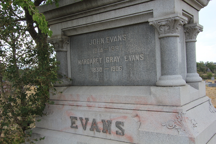
Through the lens of the 21st century, Colorado will soon revisit a still-festering wound suffered during its founding in the 19th century. Three proposals have been submitted to the U.S. Board of Geographic Names to give the 14,265-foot mountain west of Denver a new handle to replace the existing name, Evans.
One proposal would rename it Mount Cheyenne Arapaho, a nod to the victims of the Sand Creek Massacre in 1864, when John Evans, the namesake, was both territorial governor and the federal government’s Indian agent for Colorado.
Mount Soule would honor Silas Soule, who commanded a company of the Colorado volunteers that attacked the peaceful encampment near today’s town of Eads, in southeastern Colorado. Soule withheld his soldiers from the attack and later testified against John Chivington, the commanding officer. Soule was assassinated in Denver the following April.
Rosalie, the third recommendation, would restore the name the mountain had prior to 1890. Rosalie Bierstadt was wife of the famous painter, Albert Bierstadt. Mount Bierstadt is connected to Evans, the former Rosalie, by a ridge. Colorado currently has no 14,000-foot peaks named after a woman.
The final authority for such proposals resides with U.S. Board of Geographic Names, but that body will be listening closely to the recommendations of the Colorado Geographic Naming Advisory Board created recently by Gov. Jared Polis. The board is charged with making recommendations to the governor re changes and new names but also controversies regarding names of geographic features and certain public places.
“Names are important, not only because they signify what something is to us, but they reflect our values and our legacy, of who we are. In this you will play a critical role,” said Polis at the first meeting of the board last Thursday.
The board has 15 members, most of them state and local officials and representatives of historical and research institutions. They bring plenty of credentials, formal and otherwise, to the discussion, but those of the historian Patty Limerick stand out.
Limerick was consulted in the establishment of the Sand Creek National Historic Site in 2007. She also was involved in the renaming of a dormitory on the campus of the University of Colorado-Boulder. It had been named for David Nichols, a volunteer soldier at Sand Creek and an early proponent of what became the university. In 1989 it was renamed the Cheyenne Arapahoe Hall.
The Evans’s replacements are among 16 proposed name changes for mountains, reservoirs, and other features and one proposal to name a currently unnamed peak.
Many have to do with features that reflect attitudes of previous times. For example, there is a trio of Negros on the Western Slope (a creek, a mesa, and a draw) that have proposed new names, while in Chaffee County, Chinaman Gulch is proposed for a renaming as Trout Creek Gulch.
Jennifer Runyon, senior researcher with the U.S. Board of Geographic Names, suggested to Colorado’s new board members that some proposals will be easier than others. For example, a body of water east of Longmont is formally called Calkins Lake on federal maps, but locally it’s always called Union Reservoir.
Chinaman Gulch has some controversy. The local jurisdiction, Chaffee County, has opposed the name change, she said, believing that the name showed no disrespect. Too, the proposed revision, Trout Creek Gulch, would have introduced an inaccuracy, the Chaffee County commissioners said.
This is from the Sept. 22, 2020, issue of Big Pivots, a publication devoted to the energy and other transitions in Colorado. For a free subscription to the e-magazine, enter you name and e-mail address at BigPivots.com
Then there’s Squaw Mountain, the site of the some-time ski area west of Denver. A proposal has been submitted to call it Mount Mistanta, the anglicized name of the Cheyenne wife of William Bent, the trader in southeastern Colorado in the early 18th century.
Many features around the United States named squaw have been changed in recent years to reflect names used by Native Americans. Runyon cited new names from the Klamath, Paiute, Umatilla, and other tribes in their native tongues, as squaw is considered by many to be derogatory. But that belief is not universal, she observed. For example, the Navajo are proud of their squaw bread and their squaw dances, among other respectful uses of the word squaw.
The federal board prefers to “proceed cautiously and conservatively regarding name changes,” Runyon said. “There needs to be a compelling reason for the change.”
The board doesn’t go looking to change names. “We don’t even encourage name changes. We are here to help,” she said.
The federal board does not want to decide what is offensive. “That is quite subjective,” she said, citing the example of the various views of the word squaw.
And in no case does the U.S. Board of Geographic Names want to approve changes without local input. The commissioners of Clear Creek County, where Squaw Mountain is located, have said they didn’t want a change, although there’s evidence that recommendation may be revisited. The local jurisdiction will now be working with the new state board.
No proposal has been submitted to the federal board to rename the Gore Range, although that idea has flared sporadically in public discussions in Summit and Eagle counties in recent years. The range is named for an Irish baronet, George Gore, who led a large hunting expedition to Middle Park in 1864 and to the pass west of Kremmling that bears his name. Gore’s expedition was known for its wanton butchery of wildlife.
However, the new state board can take proposals directly from the public, Runyon said.
The Sand Creek Massacre occurred a decade after Gore’s gluttony, and the butchery astounded many even at the time. A 675-man force under the command of Col. John Chivington, most of them from the new city of Denver, charged into a camp of Cheyenne and Arapaho in the bed of Sand Creek at dawn on Nov. 29, 1864. The natives believed they had been offered protection from attack because of their declared intentions to be at peace. About two-thirds of those killed were women and children, and many of the bodies were mutilated.
In 2014, Northwestern University in Evansville, Illinois, a suburb of Chicago, and the University of Denver, both issued reports examining their connection to the massacre, as both universities had been founded by Evans.
“No known evidence indicates that John Evans helped plan the Sand Creek Massacre or had any knowledge of it in advance,” the Northwestern University report concluded. “The extant evidence suggests that he did not consider the Indians at Sand Creek to be a threat and that he would have opposed the attack that took place.”
John Evans, the founder of Northwestern University and the University of Denver and the namesake for two mountains in Colorado, is buried at Riverside Cemetery north of downtown Denver. Photo/Allen Best
If lacking blood directly staining his legacy, Evans was among “several individuals who, in serving a flawed and poorly implemented federal Indian policy, helped create a situation that made the Sand Creek massacre possible. In this regard, the most critical of his errors was to his failure to fulfill his responsibility as superintendent of Indian affairs to represent the best interests of Native peoples in Colorado.”
To compound that failure, the panel from Northwestern University said, Evans refused to fess up to the errors of his past, either immediately afterward or decades later. He never did criticize the massacre.
The University of Denver report, issued six months later, differed in that the study group included direct descendants of the Sand Creek massacre. It goes a small step further than the report from Northwestern in finding a “pattern of neglect of (Evans’s) treaty-negotiating duties, his leadership failures, and his reckless decision-making in 1864.”
5280, the magazine, succinctly summarized the legacy of Evans in a 2019 story. “History’s heroes don’t always age well,” it said when reporting the first official renaming proposal to the U.S. Board of Geographic Names.
There’s much to fuss over in all this naming and renaming. For example, Evans has a second mountain named after him, if not quite as high or prominent, in Lake County, near Fremont Pass. And it might be noted that there’s already an Arapaho Peak, west of Boulder.
Sand Creek has become sort of personal to me. My great-grandparents homesteaded on Colorado’s far eastern tier in the late 1880s, two decades after the Cheyenne, Pawnee, Sioux, and the others had been chased off. Today, some of my ability to wander around Colorado, poking my nose into historical artifacts such as Sand Creek, comes from that working of the landscape by my antecedents.
At considerable risk, Arapaho and Cheyenne Indians traveled to Denver in September 1864 to seek an understanding of peace. Front row, on left, John Wynkoop, the commander at Fort Lyon, in southeastern Colorado, and Silas Soule. Behind Wynkoop was Black Kettle. Photo via The Mountain Town News
I’ve been to the massacre site at Sand Creek two or three times for the post-dawn November remembrances convened by Cheyenne people from Montana and elsewhere. The participants then travel to Denver, to pay respects to Silas Soule at his grave in Riverside Cemetery along the banks of the South Platte River. (I am guessing there’s no similar ritual at the grave of John Evans, which is in the same cemetery). The next stop is the tribute to Soule in a building at 15th and Arapahoe, the approximate site of his assassination. Then they march on to the State Capitol.
In 2014, in a rumination on Sand Creek on the 150th anniversary, I wrote an essay published in the Boulder Daily Camera that suggested that the highway between Eads and Denver be given an honorary name. We have the 10th Mountain Division Memorial Highway between Minturn and Leadville, the Ronald Reagan Highway for I-25 as it passes through Colorado Springs, and many more.
Why not the Black Kettle Memorial Highway, I proposed then, which would have honored the Cheyenne chief who took many risks in the months before Sand Creek and at Sand Creek itself in an effort to achieve a peace. He was later killed by soldiers under the command of General George Armstrong Custer.
Of course, I think the Cheyenne and Arapahoe should have the largest say in what becomes of Mt. Evans, if anything. This is sure to be an interesting discussion…
Allen Best is a Colorado-based journalist who publishes an e-magazine called Big Pivots. Reach him at allen.best@comcast.net or 303.463.8630.
Rancher and fly fishing guide Paul Bruchez’s daughter and nephew sit in a hay field at the family ranch near Kremmling. Bruchez is helping spearhead a study among local ranchers, which could inform a potential statewide demand management program. Photo credit: Paul Bruchez via Aspen Journalism
FromThe Grand Junction Daily Sentinel (Dennis Webb):
The secondary economic impacts of paying western Colorado farmers to temporarily fallow fields in times of drought could be similar to the secondary benefits resulting from the spending of those payments, a new study has found.
But BBC Research and Consulting says the dollars from payment spending would flow to different businesses, potentially shifting from smaller, agriculturally focused communities to larger towns and cities.
In addition, the payments would only benefit the regional economy if they come from outside western Colorado, because payments originating on the Western Slope would only result in shifting money around within the region as opposed to creating a new economic benefit, the study says.
The research was commissioned by the Colorado River Water Bank Workgroup, which consists of the Colorado River District, the Southwestern Water Conservation District, The Nature Conservancy, the Tri-State Generation and Transmission Association, the Uncompahgre Valley Water Users Association, the Upper Gunnison River Water Conservancy District and the Grand Valley Water Users Association.
It’s intended to help gauge the impact on local agricultural economies should Western Slope farmers participate in voluntary, temporary, compensated fallowing as part of a demand management program involving Upper Colorado River Basin states including Colorado.
Such a program is being considered as a means for the states to be able to store extra water in Lake Powell so they can continue meeting their water delivery obligations to downstream states in times of drought, and head off potential mandatory curtailment of water uses under an interstate compact…
FARMING IMPACTS
The study looks at fallowing grass hay, alfalfa and corn. It estimates that regionally it would cost an average of $236 per acre-foot of water involved, or about $470 per fallowed acre, to get farmers to participate. It says producers also may require payments covering direct fallowing costs, such as weed and pest control, and payments also may have to be made to irrigation companies for lost revenues and added management costs.
The study evaluates a moderate, 12,700-acre hypothetical fallowing program involving 25,000 acre-feet of water a year for five years across western Colorado, and a more aggressive, 52,100-acre program that would involve 25,000 acre-feet a year for five years within each of four major Western Slope river basins.
The study finds that the moderate approach would result in a minimum of a $5.7 million annual reduction in crop production, and the aggressive approach, at least a $23.2 million reduction.
Those reductions would result in an estimated loss of at least 64 or 260 on-farm jobs, respectively, although most of those would involve the farmers themselves who are being compensated.
The study estimates that when comparing that compensation to their lost farm income, farmers collectively would come out at least $2.2 million ahead each year in the moderate scenario and $8.6 million ahead in the aggressive approach.
SECONDARY CONCERNS
The bigger focus of the study is what secondary effects would result from the fallowing due to impacts on businesses such as farm and ranch suppliers, and businesses providing household goods and services to affected workers.
In the moderate scenario, the study estimates at least 55 secondary jobs would be lost to reduced crop production, while there would be an increase of at least 27 jobs resulting from spending of fallowing payments.
Under the aggressive scenario, at least 236 secondary jobs could be lost from reduced production, compared to at least 109 new jobs being supported related to payment spending.
But the study says there could be a net annual gain of $546,000 in secondary income from the fallowing under the moderate scenario, and $2.4 million under the aggressive one.
Doug Jeavons, managing director at BBC Research and Consulting, said that despite the net job loss, the new jobs that would be created could tend to be in banking and finance, and those could pay more than the lost farm-related jobs.
The fallowing would mean fewer sales of seed, fertilizer, hauling services and labor, but could boost spending in areas such as purchase of vehicles and farm machinery, with some of the fallowing payments also being used for household consumption and reducing debt…
The study also says annual net secondary income also could fall with fallowing, by as much as $393,000 under the moderate scenario and as much as about $1.46 million under the aggressive one.
This could happen if farmers spend less of their fallowing money locally. It also accounts for the possibility that reduced forage production from fallowing could affect the livestock industry, driving up hay prices and causing ranchers to reduce herd sizes.
It says that based on what has been historically seen when it comes to hay production declines in the region, the moderate fallowing approach could result in just over a 0.5% drop in livestock production and a $3 million drop in annual livestock sales, and the aggressive approach, a possible 2.2% production drop and $13.4 million annual revenue loss.
GATHERING DATA
The Colorado River District said in its news release that its board hasn’t weighed whether a fallowing program is good for the Western Slope, but is gathering data through efforts such as the study to determine if it would have negative impacts, and if so, at what scale.
It also said if a demand management program is created in Colorado, Western Slope agriculture would only be part of the solution and Colorado River users in all parts of the state must contribute water to the program. This would include Front Range cities that divert that water across the Continental Divide…
Speaking on a river district webinar Thursday on the study, Sonja Chavez, general manager of the Upper Gunnison River Water Conservancy District, said any Western Slope fallowing program won’t be one-size-fits-all, and would have to be structured to address local concerns such as soil impacts…
One concern in her district is that parts of it may have such shallow soils that they could take three to five years to recover from fallowing.
Another consideration is that some western Colorado basins export substantial amounts of hay to other states, and even other countries.
If fallowing primarily reduced exports, effects on local livestock production might be minimal.
But BBC Research and Consulting’s report notes that hay exporters may be resistant to jeopardize customer relationships by fallowing fields…
BBC Research and Consulting says measures such as split-season versus full-season fallowing could reduce economic impacts from fallowing, and ensuring that participation is spread widely across and within various river basins could spread out the impacts.
Chavez likes the general idea of widely distributing fallowing, but says that could increase costs for monitoring such a program, evaluating results and ensuring that conserved water makes it downstream to be stored rather than being used elsewhere.
FromThe High Country News (Eric Siegel) [Originally published at High Country News (http://hcn.org) on 09/18/2020]:
For decades, the Great Basin Water Network has made a point of strange bedfellowing. Its ranks include ranchers, environmentalists, sportsmen, rural county commissioners, Indigenous leaders, water users from Utah, and rural and urban Nevadans. Over the years, these groups united against a single cause: the Southern Nevada Water Authority’s “Groundwater Development Project,” a proposal to pump 58 billion gallons of water a year 300 miles to Las Vegas from the remote rural valleys of Nevada and Utah. Nevadans called it the Las Vegas Pipeline; its ardent foes called it a water grab. In May, their three decades of resistance to the pipeline ended in victory: The project was terminated.
“Never give up the ship,” Delaine Spilsbury, an Ely Shoshone tribal elder who played a significant role in the Water Network, said in a recent interview. “Never. That’s the kind of feeling that I think most of us had. Just do the best we can and let’s make something happen, even if it does take forever.”
The Vegas Pipeline, had it succeeded, threatened to make a dust bowl of 305 springs, 112 miles of streams, 8,000 acres of wetlands and 191,000 acres of shrubland habitat, almost all of it on public lands. Major utilities in the West rarely fail in getting what they want (witness California’s Owens Valley, circa 1913), but the Water Network’s multipronged, intergenerational legal battle creates a different precedent, showing that diverse water interests can transcend any single approach or ideology — and win.
Delaine Spilsbury, an Ely Shoshone tribal elder who worked with the Water Network, stands at Swamp Cedars in Spring Valley, a site significant to her and the Western Shoshone that would have been threatened by groundwater pumping. Photo credit: Russel Albert Daniels/High Country News
UNEXPECTED ALLIANCES like this have their origins in the Cold War. In the late 1970s and 1980s, the Air Force sought to conduct hazardous testing of intercontinental ballistic missiles and supersonic military operations in eastern Nevada. This required deep drilling into newfound aquifers, and tribal nations, rural counties, ranchers and environmentalists became increasingly distrustful of the massive groundwater pumping. They put their differences aside to mobilize public opinion and beat back two federal projects — the Missile Experimental (“MX”) and the Electronic Combat Test Capability (“ECTC”).
Their single-minded focus on water and ability to tease out a strategy from a broad coalition of people proved an asset in resisting powerful entities. “We beat the federal government,” said Abby Johnson, who worked for a statewide environmental group fighting the MX project and later helped form the Great Basin Water Network. “It never would have happened had there not been such activism against it. The public opposition and outcry across rural Nevada was essential.”
This united front endured into 1989, when the Las Vegas Valley Water District filed 146 water right applications with the Nevada state engineer — the state’s top water regulator — to pump 800,000 acre-feet of groundwater from eastern Nevada. The former anti-nuclear coalition organized area residents again — this time against their own state, filing protests with the state engineer’s office. Great Basin National Park and the Bureau of Land Management, concerned that groundwater withdrawals could affect surface-water resources under their jurisdiction, also filed protests.
The water applications sat dormant for over a decade. But in 2002, in the face of worsening drought and looming supply shortages on the Colorado River, the newly formed Southern Nevada Water Authority (SNWA) reactivated the water filings. By 2005, the SNWA requested legal hearings. That was “when the project caught steam and really began,” said Steve Erickson, an organizer with the Water Network in Utah, who worked closely with residents in Baker, Nevada. “This was a feisty group of people, and they had worked on this stuff before. They knew they could win if they were persistent.”
In 2007, the Great Basin Water Network received nonprofit status, formalizing the coalition. It partnered with rural county governments to help pay for expert witnesses and legal representation in court, and established “water tours,” in order to teach Nevadans how the region’s landscape of springs, seeps and streams sustained a uniquely Nevadan way of life. These efforts helped establish the pipeline in the public imagination as another water grab.
But despite these advances, there was a breakdown in trust, as state and federal agencies greenlit the project, circumventing bedrock environmental laws. A 2004 federal wilderness bill included a rider granting the SNWA a public utilities right-of-way for the project, facilitating its approval. In 2006, the Department of Interior — including the Bureau of Indian Affairs, which failed to consult the tribes it represents — entered a closed-door agreement with the SNWA, dropping all federal protests in exchange for a contentious monitoring and mitigation plan.
A series of legal battles ensued at the state level. The Water Network’s initial legal strategy, which focused on due process rather than water law, ultimately prevailed in 2010 at the Nevada Supreme Court, which found that “the state engineer was ‘derelict in his duties,’ ” as Kyle Roerink, the Executive Director of the Water Network, said in a recent interview. The court’s decision voided SNWA’s water applications, forcing the Water Authority to re-file them with the state engineer, who in turn reopened the protest period.
The Water Network applied pressure from multiple angles, though, and the legal wins continued on other fronts. Activists successfully argued, for example, that the state engineer miscalculated the water levels in the basins where the Southern Nevada Water Authority wanted to pump, allowing for over-allocations. Their efforts convinced a district court to order the state engineer to recalculate.
Beyond its legal strategy, the Water Network built alliances geographically — notably with ranchers, farmers, and county commissioners in western Utah, who followed in lockstep with the Confederated Tribes of the Goshute there and the Church of Jesus Christ of Latter-day Saints, and public health, citizen science and conservation groups across the state. By 2015, their efforts convinced the Republican governor of Utah, Gary Herbert, to reject a bi-state water agreement that would have allowed the SNWA to pull water from the Snake Valley, in the Nevada-Utah borderlands. “The governor was getting pressure from all sides,” Erickson said. “At one time, he had three water lawyers and the director of the Utah Department of Natural Resources telling him to sign the agreement. But he listened to us.”
The Southern Nevada Water Authority, meanwhile, undertook its own political strategy — lobbying the state Legislature to change Nevada water law, then lobbying the Nevada congressional delegation to exempt the project from further federal environmental review, even as it aggressively promoted conservation measures and engineered a low-level intake pump at Lake Mead to secure its pumping capacities.
The Water Network’s continued pressure, applied from multiple angles, ultimately paid off. In March, the Nevada District Court denied the SNWA’s appeal for a final time — blocking it from pumping any water in eastern Nevada. After a string of seven straight legal losses, the SNWA announced that it would not appeal to the Nevada Supreme Court. In May, at its Board of Directors meeting, the Water Authority withdrew all its remaining water applications associated with the project, ending a 31-year battle.
Delaine Spilsbury, the Ely Shoshone leader, watched the board meeting via a video call. “I yelled at my son, Rick, ‘Get the champagne! — Get the champagne!’ It was hard to believe that it was happening. When it’s been that way for so long, you never think it will change.”
NEVADA HAS A LONG HISTORY of resource extraction, everything from gold, to rare earth minerals, to water. And the state is by no means a regulatory haven for environmental causes. But the defeat of the SNWA, along with other recent data, suggests that public opinion around natural resources, especially water, is changing. Since 2002, southern Nevada’s population has increased by 46%, but its per capita water usage has decreased 38%, and its consumption of Colorado River water is down 25%. The SNWA’s own partnerships up and down the Colorado River, and the Great Basin Water Network’s unexpected partnerships within the state, point to a larger shift.
Regardless of these changing attitudes, and the Water Network win, the decades-long battle produced collateral damage: deep mistrust between Nevada’s rural residents and the state, especially the Southern Nevada Water Authority.
Tom Baker, a fourth-generation rancher in the Snake Valley, understands as much. “We knew we could never let SNWA start at all,” he said recently, “because once they started, they would keep going. We knew that the amount of water they wanted wasn’t actually there. As soon as they figured that out too, they would have to keep expanding. Rural Nevada is very lucky that this project is finished.”
Such criticism is understandable, Simeon Herskovits, the Water Network’s longtime lawyer, said. “There is a long history of deceit and punitive actions taken by SNWA towards rural folks,” he said. As recently as 2019, for example, the agency tried to change state laws that protect senior water-rights holders in Nevada, such as farmers and ranchers in rural counties. The legislation would have allowed the state engineer to re-award the rights to junior users. “That meant there was no opportunity for trust. Rural interests knew there was no way they could take SNWA at its word.”
Pat Mulroy herself, former general manager of the Southern Nevada Water Authority and the architect of the now-failed project, agreed. Asked what she would have done differently on the Vegas Pipeline, she quickly responded: “Nothing we said or did was going to persuade them. We are city folk. People in the rural areas don’t trust us.” But then she paused, and turned the thought. “Look,” she said, “these battles are not going away. It is one of the divides, and there has to be bridges. Every move we made — whether with farmers in Utah or ranchers in White Pine County — they said no. That, to me, is the tragedy. This will never change unless people are willing to talk to one another.”
Eric Siegel is an editorial intern for High Country News. Email him at eric.siegel@hcn.org or submit a letter to the editor.
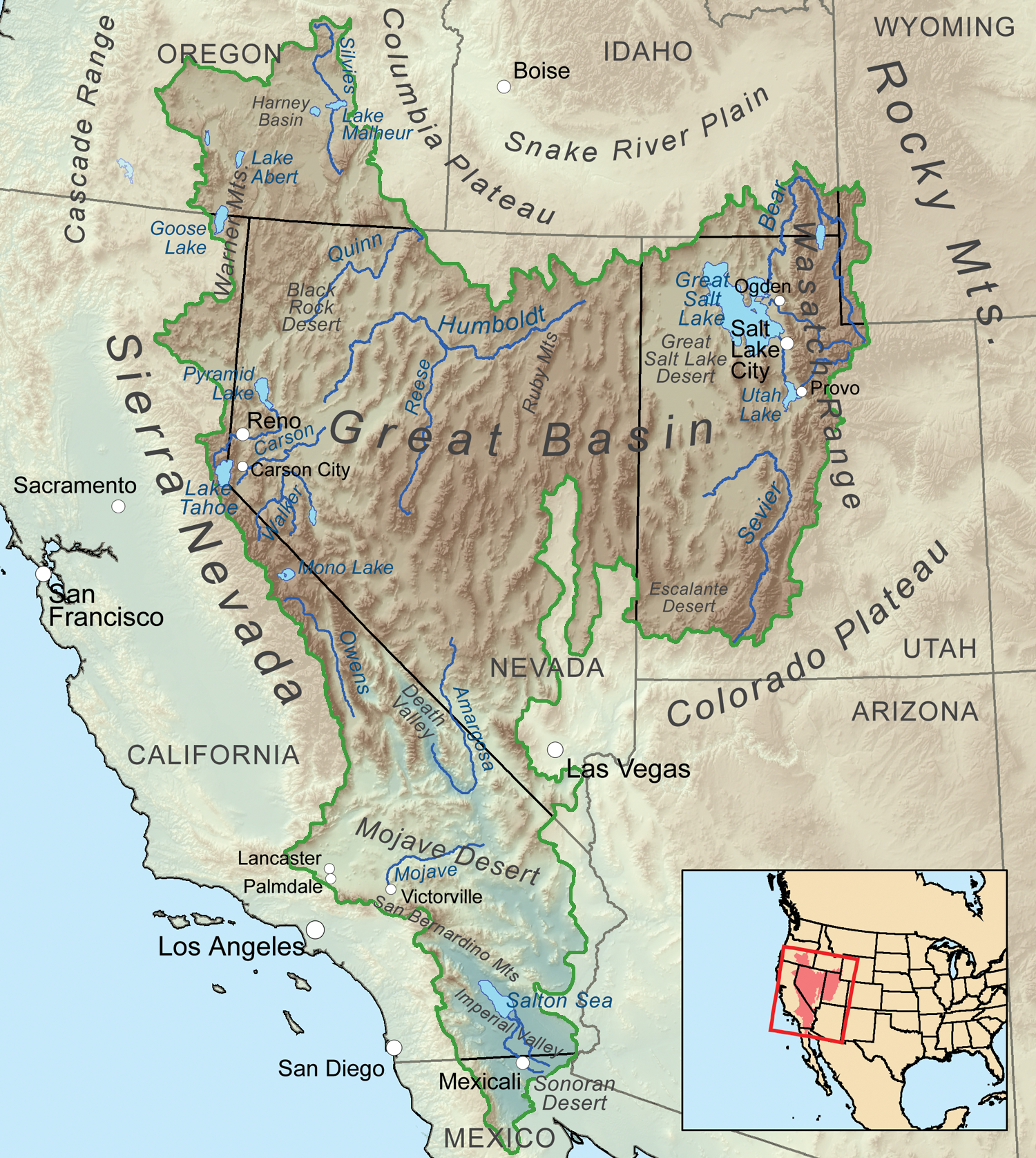
Map showing the Great Basin drainage basin as defined hydrologically. By Kmusser – Own work, Elevation data from SRTM, all other features from the National Atlas. Rand McNally, The New International Atlas, 1993 used as reference., CC BY-SA 3.0, https://commons.wikimedia.org/w/index.php?curid=12079426
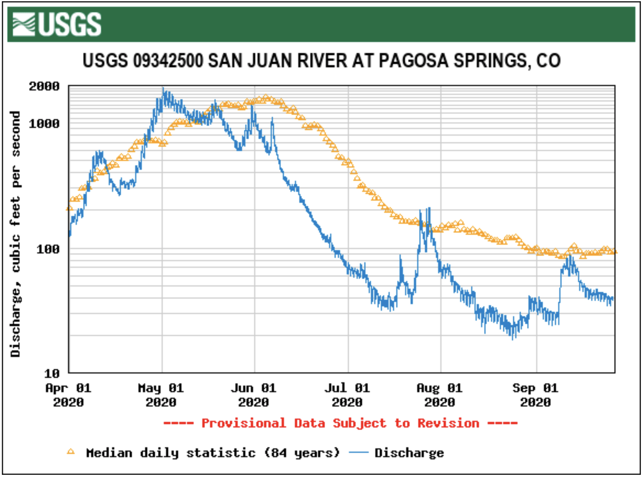
According to the U.S. Geological Survey, on the morning of Sept. 23, the San Juan River was flowing at 38.8 cfs, not even half of the average rate of 175 cfs for this date.
Based on 84 years of water re- cords, the lowest recorded water flow for this date was 11 cfs in 1953. The highest recorded water flow was 1,480 cfs in 2013.
10th Annual Upper Colorado River Basin (virtual) Water Forum: Coming to Terms with Limits and Uncertainty November 4-5, 2020 An On-Line Gathering
Highlights
Keynote: Navajo Nation President Jonathan Nez
Panels of Upper and Lower Basin State and Tribal Leaders`
Multi-State Ag Producers’ Roundtable
Many thanks to these early-bird sponsors:
Four Corners Water Center a Fort Lewis College, Strategic by Nature, Chevron,
Laurian Unnevehr and the Walton Family Foundation!
The state cited as a reason the 14,000 public comments submitted in response to a draft environmental impact statement (EIS) released in June.
The U.S. Bureau of Reclamation was supposed to have the final EIS out by November, with a final decision in January, but that ambitious time frame is expected to be pushed back while a “supplemental” analysis is conducted, according to Todd Adams, director of the Utah Division of Water Resources.
“The extension will allow more time to consider the comments and complete further analysis, which will contribute to a more comprehensive draft and final EIS,” he said. “When you think about the sheer volume of comments, it’s going to take some time.”
Among those comments was a bombshell request by the six other states that rely on the Colorado River for water to refrain from completing the EIS until the states work out their differences regarding the legality of diverting the water across major drainages…
“The Bureau [of Reclamation] comes out with a draft that says, ‘We [in Washington County] need another source of water,’ but they don’t say why. The EIS failed to consider a water conservation alternative,” said Zach Frankel of the Utah Rivers Council
Frankel and other pipeline critics speculated that commenters or higher-ups in the Interior Department had identified “fatal flaws” in the draft study that could render the pipeline’s approval vulnerable to legal challenges that are sure to follow.
“The delay of the environmental review affirms that Nevada and the other Colorado River Basin States are having an impact in this process against Utah,” said Tick Segerblom, who represents Las Vegas suburbs on the Clark County Commission. “With climate change and drought threatening us every day, we must be vigilant until the end. We cannot let our water supply be sucked away for golf courses and green lawns in southern Utah.”
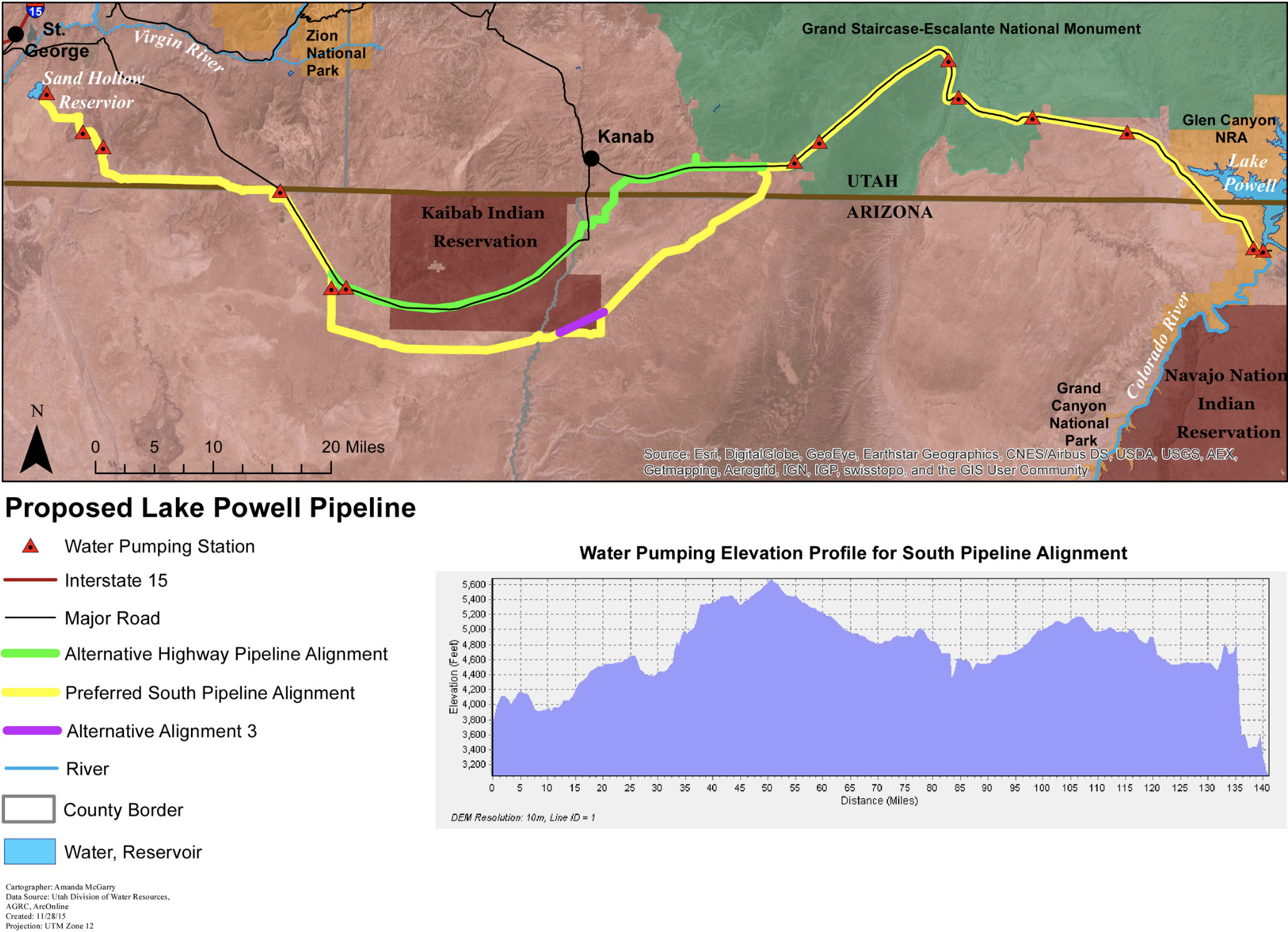
This $2+ billion project would pump 28 billion gallons of water 2,000 feet uphill across 140 miles of desert to provide just 160,000 residents in Southwest Utah with more water. Graphic credit: Utah Rivers Council
A hayfield near Grand Junction, irrigated with water from the Colorado River. Under demand management pilot programs, the state could pay irrigators to fallow fields in an effort to leave more water in the river. Photo credit: Brent Gardner-Smith/Aspen Journalism
From email from the Colorado River District (Alesha Frederick):
Study found demand management could result in fewer agricultural support jobs and reduce livestock production on the West Slope
The Colorado River Basin is in the 21st year of drought, and major reservoirs on the river are sitting at less than half full. There is growing concern that agricultural economies on the West Slope might be harmed if Colorado and other Upper Basin states (Wyoming, Utah and New Mexico) are unable to meet their obligations under the Colorado River Compact. With these concerns in mind, the state of Colorado is looking at ways to prevent such a crisis from occurring. One of the ideas Upper Basin states are discussing is paying water users to consume less water. The water saved would then be banked in Lake Powell. The states are calling it demand management.
The question is, if farmers and ranchers are paid to voluntarily fallow their fields, how would it change West Slope communities where agricultural businesses employ people, pay taxes and buy equipment? The recently released Upper Basin Demand Management Economic Study in Western Colorado sought to determine the secondary economic impacts that might occur if West Slope agricultural producers participate in a demand management program.
Consistent with its charge to represent and protect the Western Slope’s water interests, the Colorado River District has been actively engaged in statewide conversations about a potential Demand Management program. Through its participation in the Water Bank Workgroup, the District led the call for additional economic analysis that would help to inform the state’s decision whether or not to move forward with such a program.
“Our job is to protect West Slope water users. Studying the potential negative impacts of a new program such as demand management is vital to this work,” said Colorado River District General Manager Andy Mueller. “This secondary economic impact study ensures that agricultural producers on the West Slope have the information they need to make decisions about their farms and ranches. It’s part of the River District’s ongoing efforts to ensure water security for our farms, ranches, and rural communities.”
The Colorado River District’s Board of Directors has not weighed in on whether such a program is good for the West Slope. However, the Board is gathering data from efforts like this study to determine if such a program will have negative impacts, and if so, what the scale of those impacts is likely to be.
While the study examined the impacts of fallowing West Slope agriculture if a demand management program is created in Colorado, Western Colorado agriculture will only be one piece of the solution. If such a program is implemented, all types of Colorado River water users in all regions of the state must contribute water to the program. This study is not an endorsement of demand management but a study of its potential impacts.
The study examined two scenarios, a moderate and aggressive demand management program. The moderate demand management scenario considered a 25,000 acre-feet per year reduction in consumptive use by Western Colorado agricultural users for five years, while the aggressive scenario considered 25,000 acre-feet per year within each Western Slope river basin over a 5-year timeframe.
These are some of the key findings of the study:
* To pay producers at a level that they would incentivize participation in such a program, annual payments to irrigators are projected to range from an average of $194 per acre-foot under the moderate scenario to $263 per acre-foot under the aggressive scenario.
* For compensation payments and spending of those payments to benefit the regional economy, funding for those payments must come from outside of Western Colorado. If all that money was raised in Western Colorado, the payments would shift money around within the region, but it would not create a new economic benefit to offset the impacts.
* Growers producing forage crops including grass hay, alfalfa and corn are most likely to take part in such a program compared to fruit growers and small grain producers.
* Reduced production of forage crops, mostly hay, would require fewer purchases of items such as seed, fertilizer, labor, hauling and other services. This in turn could lead to a loss of an estimated 55 agricultural support jobs under a moderate scenario and 236 jobs under the aggressive scenario. Jobs supported by demand management payments could look very different from the jobs currently supported by hay production.
* Under an aggressive demand management scenario, a demand management program could increase local hay prices by about 6% and decrease the regional livestock inventory by about 2%. The potential price and livestock impact under the moderate demand management scenario would be much smaller.
The study was completed by BBC Research and Consulting and commissioned by the Colorado River Water Bank Workgroup made up of the Colorado River District, Southwestern Water Conservation District, The Nature Conservancy, Tri-State Generation and Transmission, the Uncompahgre Valley Water Users Association, Upper Gunnison River Water Conservancy District and the Grand Valley Water Users Association.
Heron Lake, part of the San Juan-Chama Project, in northern New Mexico, looking east from the Rio Chama. In the far distance is Brazos Peak (left) and the Brazos Cliffs (right), while at the bottom is the north wall of the Rio Chama Gorge. By G. Thomas at English Wikipedia – Transferred from en.wikipedia to Commons., Public Domain, https://commons.wikimedia.org/w/index.php?curid=1598784
Three agencies will use water from the Albuquerque Bernalillo County Water Utility Authority to protect Rio Grande silvery minnow habitat this fall.
On Wednesday, the water authority approved a lease of up to 7,000 acre-feet, or about 2.9 billion gallons, of its San Juan-Chama water to the U.S. Bureau of Reclamation at a cost not to exceed $700,000.
The San Juan-Chama project uses a series of tunnels and reservoirs to route Colorado River water into the Rio Grande Basin. Several cities, counties, pueblos and irrigation districts rely on the project for drinking water and agriculture.
The Bureau of Reclamation will pay $350,000 for the water. The Middle Rio Grande Conservancy District contributed $250,000 to the lease and the New Mexico Interstate Stream Commission contributed $100,000…
In 2016, the U.S. Fish and Wildlife Service released a new biological opinion regarding water management and endangered and threatened species such as the Rio Grande silvery minnow, southwestern willow flycatcher and the yellow-billed cuckoo.
Rio Grande Silvery Minnow via Wikipedia
Yellow-billed cuckoos have nearly been extirpated from the western U.S. Photo courtesy Rocky Mountain Bird Observatory.
Southwestern Willow flycatcher
Water agencies now manage the river to improve fish densities, but are not required to maintain certain river flow targets.
This year’s drought and minimal runoff have left water agencies scrambling to supply water to farmers and fish.
The MRGCD used 10,000 acre-feet from the water authority in June. The irrigation district had “repaid” that water to ABCWUA in late 2019 as a payment for a water loan from the early 2000s. But the district was forced to ask for the water payment back after running out of storage water.
Another release of stored water from El Vado Reservoir in July helped extend the irrigation season by nearly three months…
Under the lease, the water can be released from Abiquiu Reservoir through the end of 2022. Revenue from the lease will help fund the water authority’s program to plan for future water supply and demand.
The water authority has a contract with the U.S. Secretary of the Interior for about 15 billion gallons of San Juan-Chama water each year – making it the largest user of the project.
With five of Greeley’s six high mountain reservoirs in the burn area, erosion is expected to carry sediment into Greeley’s water supply. Left untreated, that could affect the city’s water quality. But officials are already planning to make sure that doesn’t happen.
The Cameron Peak fire ignited on August 13 on the Arapaho and Roosevelt National Forest near Cameron Pass and Chambers Lake. Credit: Inciweb
“When fires burn, if they’re hot enough, they can actually burn underbrush and soil,” said Adam Jokerst, Greeley’s deputy director of Water Resources, adding that vegetation is burned up as well. “With the lack of the vegetation … you can get increased erosion when it rains or when the snow melts.”
That erosion carries sediment into the Poudre River, which pulls water from the reservoirs to supply water for the city. Water with high sediment content can be harder to treat, Jokerst said, but it is possible to treat safely.
For better or for worse, Jokerst said, Greeley water officials have a lot of experience handling erosion into the water supply after dealing with the impacts of the High Park Fire in 2012. That fire burned more than 87,000 acres, making it the sixth-largest in state history.
There are at least a few steps to take to mitigate erosion impacts: aerial mulching, felling trees and adding flocculants during the treatment process. For aerial mulching, crews drop shredded wheat chips or straw from a helicopter. The mulch reduces erosion and helps with revegetation. Cutting down the burned trees and letting them fall into the gullies and rills — the channels created in the soil by water erosion — prevents stormwater and meltwater from carrying added erosion into the water supply.
Jokerst said it’s common to see the water get murkier during the runoff season every year. To provide clean, clear drinking water when that happens, crews use more flocculants, which are chemicals that help to separate the water from the sediment, in the treatment process. If there’s very high sediment content at the Bellvue Treatment Plant, officials can turn off the plant so it stop pulling water from the Poudre, Jokerst said. The city can then use the Boyd Treatment Plant…
If the fire keeps on into snowfall season in the winter, Jokerst said crews will have to wait until the spring to start on erosion control measures. Greeley officials are working with the city of Fort Collins, Northern Water and the Coalition for the Poudre River Watershed, a nonprofit Jokerst said will be a key entity in the post-fire recovery.
Long Draw Reservoir
Chambers Reservoir July 2016. Photo credit: Greg Hobbs
Marybeth Arcodia is an Atmospheric Science Ph.D. Candidate at the University of Miami Rosenstiel School of Marine and Atmospheric Science. She works with Dr. Ben Kirtman (previous ENSO Blog guest writer) studying climate variability and predictability. Along with a few members from her lab group, Marybeth helped create a subseasonal-to-seasonal forecasting blog called Seasoned Chaos, for scientists and non-scientists alike. Her research looks at how particular atmospheric and oceanic conditions in the tropical Indian and Pacific Oceans can affect weather and extreme events in the United States to lead to more confident climate forecasts on two week to two month time scales. She received her BA in Mathematics from Georgetown University in 2014.
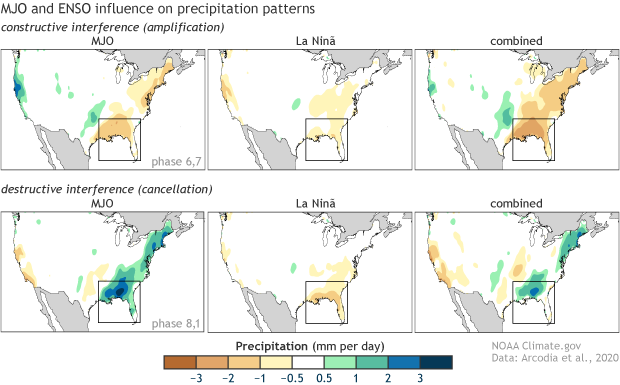
The famous Beach Boys lyric “Catch a wave and you’re sitting on top of the world” has a lot more to do with atmospheric science than one may realize. Our latest research has found that two atmospheric wave patterns forced from tropical systems, ENSO and the Madden-Julian Oscillation, work together to affect rainfall patterns in the United States, sometimes leading to extreme flooding or drought events (Arcodia et al. 2020). Luckily, climate forecasters can analyze these large-scale waves to make predictions weeks and months in advance.
The MJO launches into action
Particularly important to U.S. weather and climate are atmospheric waves that start in the tropics and travel to the midlatitudes. One major source of these waves is the Madden-Julian Oscillation (MJO). The MJO sounds fancy and, let’s be honest, boring, but it’s not! The MJO is a system of very tall or deep convective clouds (storminess) that travels eastward along the tropical Indian and Pacific Oceans approximately every 30-60 days. The convective region of the MJO has enhanced storms and rainfall, and it is usually sandwiched to the east and west by dry, sunny areas.
Averages of all January–March MJO events from 1979–2016. Green shading shows below-average OLR (outgoing longwave radiation, or heat energy) values, indicating more clouds and rainfall, and brown shading identifies above-average OLR (drier and clearer skies than normal). The purple contours show the location and strength of the Pacific jet at the 200-hPa level (roughly 38,000 feet at that location). Note the eastward movement of the wet and dry areas. How far the Pacific jet extends past the international dateline also changes with the phase of the MJO. NOAA Climate.gov animation, adapted from original images provided by Carl Schreck.
These convective storms form from surface convergence of winds, which then rise and diverge at the top of the troposphere. The convection disrupts the air at the top of the atmosphere, which results in long, planetary scale (~5,000 miles) waves that travel away from their tropical source into the midlatitudes near the top of the troposphere, like waves that ripple away on top of a lake from skipping stones. (1) These large-scale waves, known as Rossby waves, are due to the rotation of the Earth and characterized by north-south undulations around high and low pressure systems. Like most waves, these waves carry signals: radio waves carry classic rock to your car, microwaves carry microwave radiation to heat your frozen dinner, and atmospheric waves carry temperature, pressure, and wind signals that can alter the weather.
The atmospheric waves produced by the MJO can have different effects on the mid-latitudes depending on where the MJO convection (storminess) is on its journey from the Indian Ocean to the central Pacific (2). Our study analyzed the influence of the MJO during the Northern Hemisphere winter months, November-April, as this is when the MJO is typically strongest. We specifically focus on U.S. rainfall impacts since both drought and flooding events have vast societal, economic, and environmental impacts. While most prior studies investigated influences from the MJO on the West Coast, we focused on a strong relationship we discovered in the Southeast U.S. When the MJO starts out in the Indian Ocean and makes its way across Indonesia, the ripples it causes in the upper atmosphere often lead to a change in U.S. pressure patterns. Warm, moist air from the Gulf of Mexico is pushed over the Southeastern states, leading to rainfall. As the MJO makes its way into the central Pacific, the opposite pressure patterns head cool, dry air from the north to cause dryness in the Southeast U.S.
Another defining characteristic of the MJO is the dryness on both the east and west sides of the enhanced rainfall on the equator. These dry regions also create waves because of the sinking motion at the top of the atmosphere. An exciting area of research that others in our field are working on is how the waves from the rainy and dry regions of the MJO interact and influence North American weather patterns as the MJO is travelling around the globe (Lin et al., 2010, Tseng et al., 2011).
The S.S. ENSO cruise ship and MJO speedboat making their way across the “harbor” of the tropical Pacific Ocean. The cruise ship represents the stationary ENSO pattern creating steady, rolling waves. The speedboat represents the rapidly moving MJO travelling through the waves created by the S.S. ENSO, altering the wake that the MJO speedboat is producing. The floating person represents the United States that feels the impact from the both the cruise ship’s wake and the speedboat’s modified wake. Note that United States refers to just a specific region in the U.S. that changes with time. The impacts from the MJO and ENSO wave interference can vary both in space and time. Climate.gov cartoon by Emily Greenhalgh.
MJO & ENSO synergy
Things get really choppy when we add ENSO to the mix. ENSO is a stationary pattern in the tropics, but the MJO is a traveling pattern roughly following the equator. In fact, ENSO is controlling the background through which the MJO is moving. Specific MJO events can vary depending on the state of ENSO. The strength of the MJO convection, how fast it moves eastward, and how far it travels all change based on ENSO conditions. These ENSO-modified MJO events then lead to varied impacts on U.S. rainfall.
Imagine a massive cruise ship very slowly making its way back and forth through a harbor. As it moves, it creates steady, rolling waves. The MJO is then a speedboat, passing through the wake of the cruise ship. There are now two boats forcing waves in the same water. ENSO (cruise ship) modifies the MJO (speedboat) by altering the environment that the MJO is moving through. Since the speedboat is moving through already wavy water, it changes the wake that the speedboat produces (3).
To complicate things further, these modified MJO waves and the ENSO waves are now both traveling at different speeds at the top of the atmosphere and interact with each other, in the same way the wakes from two boats interfere. The interaction of these waves and their signals plays a role in U.S. weather via changes in pressure, temperature, etc.
Two climate signals interfering (i.e., combining) with each other. Bold blue curve sketches the result of the combination. Horizontal bars indicate conceptual thresholds for occurrence of extremely wet and dry events. Animation adapted by Climate.gov from http://www.acs.psu.edu/drussell/Demos/superposition/superposition.html.
he waves from the MJO and the waves from ENSO together impact U.S. rainfall through constructive or destructive interference. Constructive interference occurs when two waves are in phase (4), and the resultant wave has a much larger amplitude, resulting in a stronger signal than either of the individual waves. The opposite, called destructive interference, occurs when two waves are out of phase and cancel each other (5). You may have experienced destructive signal interference when your radio signal gets interrupted by another station and you hear a mix of two stations or no sound at all.
We can analyze constructive and destructive interference from the MJO and ENSO by looking at each U.S. rainfall signal individually (6). We can specifically look at the U.S. rainfall contribution from both the MJO and ENSO, for example, when the enhanced MJO convection is over Indonesia and an El Niño is happening, or when the MJO convection is in the central Pacific and La Niña is occurring. Since the MJO changes phase much faster than ENSO, we often see U.S. conditions from ENSO persist for an entire season, whereas the rainfall from the MJO can change weekly.
Constructive interference from the MJO and ENSO occurs when either wet or dry conditions occur in the same region simultaneously from both phenomena. Their signals are added together and the result is a much wetter- or- drier-than-average region. Destructive interference occurs when the same region experiences opposite signals from the MJO and ENSO, partially or fully masking one another.
Precipitation in mm/day broken down by active MJO phase during the winter months (Nov-Apr) of the 1998-2001 La Niña event (cold ENSO phase). The plot shows MJO-only rain (left), ENSO-only rain (center), and MJO + ENSO rain (right). Black boxes denote prominent areas of constructive (top) or destructive (bottom) interference. This example shows that both constructive (amplified signal) and destructive (weakened signal) can happen during different MJO phases in the same ENSO event. Climate.gov image based on data from Arcodia et al. 2020.
Where have I seen this before?
Destructive interference can even lead to a total wipeout of a signal. We saw that during the 1998-2001 La Niña event. The wave from La Niña resulted in drier-than-normal conditions in the Southeast U.S., a common characteristic of La Niñas. However, when the MJO was either just forming or dissipating during the La Niña event, it brought wetter-than-average conditions to the same region. These two waves destructively interfered, essentially canceling each other out. (7) The result was simply average rainfall (no wetter- or drier-than-normal conditions) for that time period in the Southeast U.S.
Constructive interference can also have notable impacts since the result is an intensified signal. This occurred in December 2015 when both the MJO and ENSO signals brought large amounts of rain to the Mississippi basin region, leading to massive flooding (Arcodia et al., 2020) (8). Flash droughts, rapidly developing droughts that can persist for weeks to months, can also be attributed to constructive interference. One such example was the summer of 2000 flash drought in the Southern U.S. when an ongoing La Niña event and active MJO both likely contributed dry signals to the region.
Typical impacts of La Niña on U.S. winter temperature and precipitation. Such impacts have been associated with past episodes, but all impacts aren’t seen with every episode. NOAA Climate.gov drawing by Fiona Martin.
Analysis of these events shows just how connected the tropics and the United States can be. Understanding how these waves interfere can improve our one-to-two week and monthly climate forecasts of temperature and precipitation. A longer lead time in a forecast for massive flooding or drought events can save lives, property, and money if our climate models can catch the waves from the MJO and ENSO. These atmospheric waves may not have us sitting on top of the world like the Beach Boys told us, but they are traveling pretty close (top of the troposphere to be exact) and could still have a big impact on the California surf.
Lead edited by Tom Di Liberto
Footnotes
(1) This coupling between deep convection and a circulation pattern characterized by low-level convergence, upper-level divergence, and vice versa (sinking motion due to upper-level convergence and low-level divergence) is similar to the tropical Walker cell.
(2) The location of above-average and below-average tropical convection can be seen in this graphic on the CPC MJO page.
(3) It is also believed that since the MJO itself is altered, then so are the atmospheric waves it produces that travel to the U.S.
(4) In-phase waves have their highest and lowest points aligned.
(5) Out-of-phase waves will drastically reduce the amplitude, or height, of the waves which causes the resultant wave to be nearly flat and lose its signal.
(6) We analyze the signals based on the state of each system: location of convective storms for the MJO and sea surface temperatures for ENSO. We then calculate the amount of rainfall that each signal contributed during specific conditions in the tropics, that is whether each contributed to wetter or drier conditions than average.
(7) We saw this in California during the massive 2015-16 El Niño event. California often experiences much wetter-than-normal conditions during El Niños. During this event, however, the El Niño signal brought only a small amount of rain (Paek et al., 2017; Yang et al., 2018) and the MJO brought a dry signal to the California region. When the two are added together, the signals slightly cancel each other out and played a role in the drought in the California region during that time. During this particular case, El Niño did not bring the expected rain, and the MJO brought dryness, and the result contributed to a drought in California during a time when they expected a lot of rain.
(8) According to NOAA’s National Center for Environmental Information (https://www.ncdc.noaa.gov/sotc/national/201513 ), December 2015 was the only month in their 121-year period of record with both the title of warmest and wettest month. Furthermore, the severe precipitation events caused record flooding, severe weather, and heavy snowfall resulting in over 50 fatalities, the deadliest weather event of 2015.
Scientists have been warning for months that the coronavirus could be spread by aerosols – tiny respiratory droplets that people emit when they talk or sneeze and that can linger in the air.
The Centers for Disease Control and Prevention appeared to acknowledge that risk on Sept. 18. It posted guidance on its website listing aerosols among the ways the virus spreads and saying there was growing evidence the airborne particles can remain suspended and travel beyond 6 feet. But three days later, that guidance was gone. A note in its place said a draft had been posted in error and that the CDC was still working on the update.
That kind of shifting by the government can be confusing. In the following five articles recently published in The Conversation, we turned to scientists to help explain what aerosols are, how airborne particles can transmit the coronavirus and how to protect yourself.
1. What you need to know about aerosols
When you talk or sing, the rush of air breaks up strands of mucus in your airways, sending droplets of it airborne.
While larger droplets quickly fall, tiny, light ones can linger in the air. If you’re infected, those droplets can contain the coronavirus, and early research suggests it can be viable for many minutes to hours.
They also discussed what people can do to protect themselves. “Wearing face coverings to decrease airborne exposure risk is critical,” they wrote, and “reducing the amount of time you spend in poorly ventilated, crowded areas is a good way to reduce airborne exposure risk.”
2. Is staying 6 feet apart enough?
The common advice for social distancing is to stay 6 feet apart. It’s easy to remember, but it doesn’t account for all aerosol risks – particularly indoors.
Because people infected with SARS-CoV-2 can transmit large amounts of the virus, there is no safe distance in a poorly ventilated room, Erath, Ferro, Ahmadi and their Clarkson University colleague Suresh Dhaniyala wrote in a second article. Air currents from a fan or ventilation system can spread respiratory droplets farther than 6 feet. So can speaking loudly or singing, as superspreader events have shown.
“Over time, it won’t matter where you are in the room,” they wrote. “While it’s not a perfect analogy, picturing how cigarette smoke moves through different environments, both indoors and outdoors, can help in visualizing how virus-laden droplets circulate in the air.”
A simulation shows the trajectories of droplets emitted by someone in a room with mixed ventilation. Credit: Goodarz Ahmadi and Mazyar Salmanzadeh / Clarkson University.
3. Airborne particles and superspreaders
A large number of COVID-19 cases have come from “superspreader” events where someone who is highly infectious spreads the virus to dozens of others.
Researchers in Hong Kong recently estimated that about 20% of the people infected there were responsible for 80% of the local coronavirus transmission. Choir practices, church services, nightclubs and a birthday party are just few of the documented superspreader events.
“The good news is that the right control practices specific to how pathogens are transmitted – hand-washing, masks, quarantine, vaccination, reducing social contacts and so on – can slow the transmission rate and halt a pandemic,” she wrote.
4. What airborne virus means for reopening
The way the virus spreads in the air is also a challenge for reopening businesses and schools.
“The evidence strongly suggests that airborne transmission happens easily and is likely a significant driver of this pandemic. It must be taken seriously as people begin to venture back out into the world,” he wrote.
With temperatures getting cooler, it’s going to be harder to keep windows open to bring fresh air into enclosed spaces, and that includes public transportation and school buses.
“Short trips. Masks for everyone. Far fewer passengers than before,” he wrote. “Those are my top recommendations for how America’s school buses should take kids to and from school during the pandemic.”
Editor’s note: This story is a roundup of articles from The Conversation’s archives.
Homestake Creek flows from Homestake Reservoir near Red Cliff. Starting Wednesday, Homestake Partners will be releasing water out of the reservoir to make sure that water can get to the state line as another option to fulfill the state’s upstream duties of delivering water to the lower basin states (Arizona, California and Nevada). Photo credit: Bethany Blitz/Aspen Journalism
Beginning Wednesday, Front Range water providers will release water stored in Homestake Reservoir in an effort to test how they could get water downstream to the state line in the event of a Colorado River Compact call.
Aurora Water, Colorado Springs Utilities and Pueblo Board of Water Works will each release 600 acre-feet from Homestake Reservoir, which is near the town Red Cliff, for a total of 1,800 acre-feet that will flow down Homestake Creek to the Eagle River and the Colorado River.
The release, scheduled to take place Wednesday through Sept. 30, will produce additional flows ramping up to 175 cubic feet per second.
That amount of water represents less than 0.3% of current systemwide storage for Colorado Springs Utilities and less than 0.4% of Aurora’s storage, according to a news release from Aurora Water.
The Front Range Water Council, an informal group made up of representatives from Front Range urban water providers and chaired by Denver Water CEO Jim Lochhead, approached the state engineer about running the experiment.
“The Front Range Water Council is, of course, concerned about what’s going on on the Colorado River in terms of climate change and the flows and compact compliance issues,” said Alexandra Davis, deputy director for water resources at Aurora Water. “We thought it would be helpful to do a pilot project to test some of those authorities and administration capabilities with the state engineer.”
The utilities are releasing water downstream that would have otherwise been sent to the Front Range in a water-collection system known as a transmountain diversion.
Two men fish the Eagle River just above its confluence with the Colorado River in Dotsero. Beginning Wednesday, Homestake Reservoir will begin releasing 1,800 acre-feet of water to flow into the Eagle River, then into the Colorado River and down to the Utah border. Photo credit: Bethany Blitz/Aspen Journalism
Compact-call scenario
A compact call could occur if the upper basin states (Colorado, Wyoming, Utah and New Mexico) can’t deliver the 7.5 million acre-feet of water per year to the lower basin states (Arizona, California and Nevada), as required by a nearly century-old binding agreement. This could trigger an interstate legal quagmire, a scenario that water managers desperately want to avoid.
A compact-call scenario could be especially problematic for Front Range water providers since most of their rights that let them divert water over the Continental Divide from the Western Slope date to after the 1922 Colorado River Compact. Many Western Slope consumptive water rights date to before the compact, so they are exempt from involuntary cutbacks under a compact call. That means those cutback obligations could fall more heavily on the post-compact water rights of Front Range water providers.
The goal of the pilot project is to see how the water could be shepherded downstream to the state line. Division of Water Resources engineers will have to make sure senior water rights holders don’t divert the extra water. Water commissioners are visiting dozens of irrigation headgates on the Eagle River to ensure this doesn’t happen, said Division 5 engineer Alan Martellaro.
“We will see how much work and time and pre-planning it is going to take to make sure these ditches don’t pick up the water,” he said.
But even with shepherding, it’s unlikely the entire 1,800 acre-feet will make it to the state line because of this year’s dry conditions. Water managers expect to see transit losses in the form of evaporation and thirsty riparian vegetation along the riverbanks sucking up the water. That’s OK because this year’s dry conditions could mimic the conditions that water managers would expect to see in a year with a compact call.
“Not coincidentally, if there’s a need to do this for compact administration in the future years, it’s probably going to be under dry conditions,” said Colorado State Engineer Kevin Rein.
Figuring out how much water actually makes it to Utah is one of the main questions this experiment will try to answer.
“That’s the perfect question to give validity to this pilot,” Rein said. “We will have a better answer for you on that after the pilot is done.”
Water managers will be closely monitoring stream gauges to track the release as it flows downstream. Martellaro estimates it will take the water about four days to get from the headwaters of Homestake Creek to the state line west of Grand Junction.
The release will be a big boost for streamflows in Homestake Creek and the Eagle River, which was running at 15 cfs near Red Cliff on Tuesday afternoon, according to the U.S. Geological Survey stream gauge. The Colorado River near Glenwood will rise from Tuesday’s reading of 1,920 cfs.
The release will begin at 9 a.m. [September 23, 2020] with an additional 25 cfs coming out of Homestake Dam and slowly ramp up to 175 cfs, reaching that level by Wednesday afternoon. It will stay there until Monday morning, then ramp down slowly over the final two days to keep fish from being stranded in side pools, Martellaro said. According to Greg Baker of Aurora Water Public Relations, streamflows will still be below spring runoff levels and there’s no concern about flooding.
The Eagle River, left, flows into the Colorado River in Dotsero. On Wednesday, Homestake Reservoir will begin releasing 1,800 acre-feet of water to flow into the Eagle River, then into the Colorado River and down to the Utah border. Photo credit: Bethany Blitz/Aspen Journalism
Demand-management implications
The reservoir release also could have implications for a potential demand-management program, the feasibility of which the state is currently investigating. At the heart of a demand-management program is a reduction in water use on a temporary, voluntary and compensated basis in an effort to send as much as 500,000 acre-feet of water downstream to Lake Powell to bolster water levels in the giant reservoir and, indirectly, to meet Colorado River Compact obligations.
Under such a program, agricultural operators could get paid to leave more water in the river, but the program stirs fears of Front Range water providers throwing money at the problem without having to reduce their own consumption, while Western Slope fields are fallowed.
Responding to those concerns, Denver Water’s Lochhead has said his agency would participate in a demand-management program by using “wet water.”
This week’s Homestake release is an example of how Front Range water providers could send water stored in Western Slope reservoirs downstream under a demand-management program.
“What we are trying to do is help the state engineer gather options and thinks through how these might operate in practice, which might be helpful to the state of Colorado,” said Pat Wells, general manager for water resources and demand management at Colorado Springs Utilities.
Aspen Journalism is a local, nonprofit, investigative news organization covering water and rivers in collaboration with The Aspen Times and other Swift Communications newspapers. This story ran in the Sept. 23 edition of The Aspen Times.
Click on a thumbnail graphic below to view a gallery of drought data from the US Drought Monitor.
US Drought Monitor September 22, 2020.
West Drought Monitor September 22, 2020.
Colorado Drought Monitor September 22, 2020.
Click here to go to the US Drought Monitor website. Here’s an excerpt:
This Week’s Drought Summary
Category 2 Hurricane Sally made landfall on September 16 near Gulf Shores, Alabama, around 4:45 am CDT, with sustained winds near 105 mph. Torrential rainfall across southern Alabama and western Florida sparked major to record flooding, while wind-related damage and power outages were common. Once inland over the Southeast, Sally quickly weakened but continued to produce heavy rain, extending as far north as southern Virginia. Mostly dry weather covered the remainder of the country, except for showers in the Pacific Northwest and heavy rain in the western Gulf Coast region associated with the arrival of Tropical Storm Beta along the middle Texas coast. Beta, the 23rd named storm of the Atlantic hurricane season—behind only 28 tropical cyclones in 2005—made landfall at 10:00 pm CDT on September 21 near Port O’Connor, Texas, with sustained winds near 45 mph. Meanwhile, drought remained entrenched across much of the western half of the country and parts of the Northeast. In the latter region, growing season-ending freezes (starting September 19) may limit re-growth of drought-stressed pastures, even if widespread precipitation returns during autumn. Western wildfires continued to degrade air quality across a vast area, with approximately six dozen fires in various stages of containment by September 22…
Western portions of the High Plains continued to experience serious drought impacts, including severely stressed rangeland and limited soil moisture for the germination and establishment of recently planted winter wheat. On September 20, according to USDA, topsoil moisture was rated at least one-half very short to short in Colorado (68%), Wyoming (65%), Nebraska (52%), and South Dakota (51%). On the same date, Wyoming led the region with rangeland and pastures rated 71% very poor to poor, followed by Colorado at 51%. Colorado led the nation—among major production states—in very poor to poor ratings for corn (35%). Most of the region’s weekly changes indicated worsening drought, amid mostly dry weather and above-normal temperatures…
Much-needed precipitation began to overspread the Pacific Northwest, signaling the change in seasons that should eventually deliver drought relief. For now, though, the Northwestern precipitation merely stabilized conditions in some areas and aided wildfire containment efforts. The Northwestern rain led to a daily-record sum of 1.14 inches on September 18 in smoke-plagued Eugene, Oregon. The National Weather Service office in Seattle, Washington, reported a record-setting total (1.35 inches) for September 19. However, the remainder of the West remained mostly dry. Ground reports and the Vegetation Health Index (VHI) continued to indicate severe stress on native vegetation, as well as rangeland. Very poor to poor ratings were indicated by USDA on September 20 on at least 40% of rangeland and pastures in every Western State except Idaho, led by Oregon (84% very poor to poor). On the same date, topsoil moisture was at least 60% very short to short in every Western State except Arizona, led by New Mexico (91% very short to short). Water Year 2020 (October 1, 2019 – September 30, 2020) will soon end, with preliminary summaries indicating a dire drought situation in much of the region and some areas continuing to observe drought expansion or intensification. More than six dozen wildfires remained active across the West, with the greatest concentration of fires (and poor air quality) persisting in the Pacific Coast States. The latest wildfires to surpass 100,000 acres of vegetation burned were both in California: Bobcat Fire, northeast of Pasadena, less than 20% contained, and the August Complex West Zone, near Covelo, about 40% contained…
Tropical Storm Beta made landfall on September 21 along the middle Texas coast, resulting in eradication of dryness (D0) and moderate drought (D1) in the western Gulf Coast region. Torrential rain fell mainly north of Beta’s center of circulation, including parts of the Houston metropolitan area. Numerous reports of at least 10 inches of rain were received from Harris County, Texas, where Houston’s William P. Hobby Airport netted 12.24 inches from September 20-22. Farther inland, additional improvements were introduced across central Texas in the wake of last week’s heavy rain, as drought impacts further faded. Meanwhile, a pesky area of dryness (D0) and moderate drought (D1) remained centered over Mississippi, with some further intensification noted. On September 20, USDA topsoil moisture in Mississippi was rated 56% very short to short. September 1-22 rainfall totals in Mississippi included 0.10 inch (5% of normal in Vicksburg and 0.22 inch (9%) in Meridian. (September 23-24 rainfall in Mississippi and neighboring states associated with the remnants of Beta fell too late to be considered for this week’s report.) Elsewhere, ongoing dry weather in western sections of Texas and Oklahoma led to some modest expansion of dryness (D0) and moderate to extreme drought (D1 to D3). For the year to date through September 22, precipitation in Midland, Texas, has totaled just 6.84 inches (62% of normal). Dalhart, Texas, is faring about as poorly, with 8.81 inches (60% of normal) falling from January 1 – September 22. The Vegetation Health Index (VHI) indicates that rangeland and pastures are significantly stressed across large sections of the southern High Plains, including much of western Texas…
Looking Ahead
The remnants of Tropical Storm Beta will drift generally northeastward and continue to weaken, although additional Southeastern rainfall could total 3 to 5 inches or more. Meanwhile, a series of cold fronts will cross the Midwest, generating scattered showers. Some of the most significant rain, 1 to 2 inches over the next 5 days, should fall in the vicinity of the Great Lakes. Farther west, mostly dry weather will continue during the next 5 days from California to the Plains and middle Mississippi Valley. In the Northwest, however, frequent showers—especially west of the Cascades—should provide relief from a dry summer and aid wildfire containment efforts. Aside from a surge of cool air into the Northwest, much of the country will experience near- or above-normal temperatures during the next several days.
The NWS 6- to 10-day outlook for September 29 – October 3 calls for the likelihood of above-normal temperatures in Maine and throughout the West, while cooler-than-normal conditions will cover most of the eastern half of the country. Meanwhile, near- or below-normal precipitation across most of the nation should contrast with wetter-than-normal weather in southern Florida and from the Great Lakes region into the northern and middle Atlantic States.
US Drought Monitor one week change map September 22, 2020.
Workers administer the plant-based chemical compound rotenone at Upper Sand Creek Lake in the Sangre de Cristo range. The chemical kills all fish in the waterway so that Rio Grande cutthroat trout, a native species, had be restored to the habitat. (Provided by Colorado Fish and Wildlife)
Here’s an in-depth look at the methods and motivation to restore Rio Grande Cutthroat trout in Sand Creek in the Sangre de Cristo from Kevin Simpson writing for The Colorado Sun. Click through and read the whole article, here’s an excerpt:
The multi-agency project to restore the native species has been years in the making. But the optics still can be shocking.
Colorado Parks and Wildlife, according to signs posted in the area, had used a chemical called rotenone to kill all the fish in the [Sand Creek] lakes and Sand Creek, which meanders south down the mountain before veering west to eventually disappear, after 13 miles, into the depths of the Great Sand Dunes.
The project is part of a long-planned strategy to restore the native Rio Grande cutthroat trout to waters where its numbers have dwindled toward the edge of extinction.
The Rio Grande cutthroat trout has dwindled in its native habitat. A multi-agency effort to restore it still can inspire anger and concern. (Provided by Colorado Fish and Wildlife)
Increasingly scarce in a dwindling native range and hybridized with other species like non-native cutthroats, which had been stocked alongside it many years ago, the Rio Grande cutthroat eventually will be reintroduced to the mountain lakes and streams where it once thrived…
The Sand Creek drainage was officially listed in a 2013 strategy document.
In 2019, meetings on both the Westcliffe and Alamosa sides of the mountain yielded no opposition — other than concern over the temporary loss of fishing — and little public comment. The project moved ahead, though a year later than originally scheduled due to a late fish spawn…
Joe Lewandowski, spokesman for CPW’s Southwest Region, which includes the Sand Creek drainage, notes that the state agency has done similar projects before and will do more of them throughout Colorado.
“We don’t get a great deal of pleasure having to poison a stream, but it is necessary to restore native species,” he said in an email to The Colorado Sun. “This has been done in waters to restore the Rio Grande, greenback and the Colorado River cutthroat; and these projects will continue…
After the 2003 conservation agreement, federal and state authorities started doing reconnaissance in 2004 to determine if the drainage could be restored. Geography that essentially isolated water flow, and therefore fish migration, proved fortuitous.
Sand Creek flows from its headwaters high in the Sangre de Cristo mountains to the Great Sand Dunes, where it disappears underground. (Provided by Colorado Fish and Wildlife)
Bunch points to several reasons why reintroduction of the Rio Grande cutthroat looms important. First, there’s federal policy that favors native species in national parks and preserves. Another has to do with the essential characteristics of a wilderness area. A third is for preservation of the species.
“This is an ideal opportunity to restore 13 miles of habitat for the Rio Grande cutthroat trout,” he said.
The stakeholders who signed the conservation agreement meet annually to discuss the status of its efforts. The key thing, Bunch said, is to prevent the listing of the Rio Grande cutthroat as an endangered species and ensure it has robust habitat…
Although the battle over listing the fish persists, all sides celebrate the ideas that in the case of the Sand Creek drainage, the area could become a refugium for the species, where the fish could naturally multiply and be used as a source for future stocking or restoration if some other habitat experiences problems — say, from wildfire.
The view from Music Pass in the Sand Creek drainage, where a multi-agency effort is unfolding to restore the Rio Grande cutthroat trout. (Provided by Colorado Parks and Wildlife)
It’s 1:36 a.m. and I’ve just gotten my daughter back to sleep after she threw up violently. She has no fever, no cough, no shortness of breath, but what if…. I think it’s food poisoning and not COVID-19, but I can’t know for sure. Not knowing is hard. I’ll call the pediatrician in the morning, but for tonight I’m left with racing “what if” thoughts.
Most people hate this all-too-familiar type of uncertainty. I find it fascinating.
As a psychologist, I’m interested in how people think differently when they’re anxious. That means I study what happens when people don’t handle uncertainty well and get lost in that bottomless pit of currently unanswerable questions.
If you’re having trouble handling pandemic uncertainty, psychology research can offer tips on how to deal with these unprecedented times.
The uncertainty-anxiety connection
There’s no script to follow for how to live through a pandemic. That can be hard to deal with because it’s natural to form narratives to help you know how to respond. In a movie theater, you know that when it gets dark, it means the movie is about to start – that movie theater script tells you not to panic and think the theater has lost power or is under attack.
In this moment, we are figuratively in the dark, and many people feel they’re drowning in unanswered questions and the anxiety they provoke.
When will a vaccine be available? When will schools reopen (or close again)? Who will win the election? Should I let my child do sports? Is my job safe, or for those less fortunate, when will I find a new job? How many more times will I see “your connection is unstable” during an important video call?
With life turned upside down, not knowing when the pandemic will end can trigger anxiety. Brothers91/E+ via Getty Images
The list of unanswered questions can feel infinite, with no quick or sure answers likely to come for some time. Sitting with these questions is scary, because not knowing can make you feel that the world is unpredictable and your fate is out of your control.
If you get stuck replaying the unanswered questions over and over and let anxiety guide your thinking, you’re likely to fill in the gaps with worst-case scenarios. A tendency to catastrophize and assign negative and threatening interpretations when situations are uncertain or ambiguous is a hallmark of anxiety disorders. In fact, “intolerance of uncertainty,” the tendency to fear the unknown and find the lack of certainty highly distressing and uncomfortable, is a strong predictor of anxiety in both adults and children and adolescents.
Given that COVID-19, the economy, racial injustice, climate change and the presidential election all take the need to tolerate uncertainty to a whole new level, it’s not surprising that the percentage of people reporting symptoms of anxiety rose dramatically in the U.S. in 2020.
Stop spiraling and think differently
No individual can fix all the problems American communities are facing right now. And answers to many of those known unknowns and unknown unknowns are elusive for the moment. But you can change the way you respond to uncertainty, which can make managing this difficult time a little easier.
You can reframe the meaning of not knowing to make it less scary.
Imagine three different ways I can think about the uncertainty I feel right now as my sick daughter sleeps down the hall.
First, I can choose to believe in my ability to manage whatever will come, so it is OK to take it a day at a time. I can handle not knowing exactly why my daughter threw up for now because I believe that I will seek appropriate medical care and that I can handle whatever results come my way.
Second, I can remind myself that uncertainty does not guarantee bad things will happen; it just means I don’t know yet. The anxiety I feel from the uncertainty does not actually mean a negative outcome is more likely. The fact that I’m worrying about whether my daughter has COVID-19 does not increase the likelihood of her having it. It just feels that way because of a common tendency, especially among anxious individuals, to think that just having a negative thought makes it more likely to come true. Psychologists call this thought-action-fusion.
Third, I can recognize that I cope with uncertainty in other parts of life all the time. I mean, try to envision exactly what your relationships and work will look like one year from now – there is so much you just don’t know. So I’ve had lots of practice tolerating uncertainty, which tells me I can handle uncertainty even though it’s hard. I’ve done it before; I can do it again.
Thinking differently about your ability to manage uncertainty is a skill that can improve with practice. Cognitive behavior therapy, for example, teaches people to examine their anxious thoughts and consider other ways to interpret situations without always assuming the worst; there are specialized versions of this treatment that focus specifically on changing how well you can deal with uncertainty. Moreover, as part of our research program, my lab at the University of Virginia offers free online interventions to help people shift their anxious thinking.
Of course, a fourth way to respond to my middle-of-the-night uncertainty would be to sink down into that pit of scary, unanswerable “what if” questions, but it’s time to sleep. I’m going with one of the first three options – I trust I can figure this out in the morning and handle whatever it is. It’s OK not to know right now.
Releases from the Aspinall Unit will be decreased from 1450 cfs to 1350 cfs on Wednesday, September 23rd. Releases are being lowered while the Crystal powerplant is offline for maintenance. The actual April-July runoff volume for Blue Mesa Reservoir came in at 57% of average.
Flows in the lower Gunnison River are currently above the baseflow target of 890 cfs. River flows are expected to stay at levels above the baseflow target after the release change has arrived at the Whitewater gage.
Pursuant to the Aspinall Unit Operations Record of Decision (ROD), the baseflow target in the lower Gunnison River, as measured at the Whitewater gage, is 890 cfs for September.
Currently, Gunnison Tunnel diversions are 950 cfs and flows in the Gunnison River through the Black Canyon are around 550 cfs. After this release change Gunnison Tunnel diversions will still be around 950 cfs and flows in the Gunnison River through the Black Canyon will be around 450 cfs. Current flow information is obtained from provisional data that may undergo revision subsequent to review.
The Grand County Commissioners voiced their support on Tuesday for a ballot measure that would finance water projects on the Western Slope.
Voters of the 15 counties on the Colorado River Basin, including Grand, will be asked in November to approve ballot question 7A for a mill levy increase of 0.248 mills for the Colorado River Water Conservation District. This would bring the total mill levy for the district up to 0.5 mills, equaling a yearly tax increase of $1.90 per $100,000 in assessed value for homes.
Mike Ritschard, the Grand County representative on the Colorado River District board, explained Tuesday that the district collected $169,388 from Grand in 2019. If passed, the measure would roughly double that amount and pump almost $5 million more per year into the entire district.
The district has not asked for a mill levy increase since it was created. Ritschard explained that reduced tax revenue from the energy industry and the Taxpayers Bill of Rights, combined with the reduction in assessment rates from the Gallagher Amendment, has led to financial challenges for the district.
Of the $5 million that could be raised, Ritschard said that 86% would go toward projects identified as priorities by local communities and basin round tables. The remaining 14% would fix the district’s financial deficit, but absolutely none of the funds would go toward creating staff positions.
While these funds cannot be committed to certain projects, they would go toward at least one of five categories: productive agriculture, infrastructure, healthy rivers, watershed health and water quality, and conservation and efficiency. Ritschard highlighted the Windy Gap bypass as an example of such a project…
Zane Kessler, director of government relations for the district, added that the fiscal implementation plan for the funds would ensure they are distributed equitably across the geographic region based on need, not just population…
While the commissioners expressed support for the ballot measure, Grand County makes up only a small portion of voters for it. The river district includes all the counties in the Colorado River Basin with the largest of the population being in Mesa County with Grand Junction…
The commissioners unanimously approved a resolution in favor of the ballot measure, joining Delta, Eagle, Garfield and Summit counties.
The Colorado River Water Conservation District spans 15 Western Slope counties. River District directors are asking voters this fall to raise the mill levy.
Since the 2016 revelation that groundwater in Fountain Valley, which provided drinking water for Security-Widefield and Fountain, was contaminated with toxic per- and polyfluoroalkyl substances (PFAS), which include a number of individual chemicals such as PFOS, PFOA, PFHxS and PFHpA, government agencies, residents and community activists have been struggling to come to terms with what is arguably one of the largest ecological contaminations in Colorado’s history.
On Aug. 4, Chris Reh, associate director of the U.S. Agency for Toxic Substances and Disease Registry (ATSDR), led a virtual information session for residents of Security-Widefield and Fountain regarding its ongoing PFAS exposure assessment. The assessment will randomly select participants and test blood, urine and tap water for levels of PFAS chemicals. According to Reh, the assessment will identify how people might be exposed to chemicals, calculate the extent of exposure and determine if there is a threat to health.
ATSDR’s exposure assessment is the first part of a process that will continue in 2021 with the Pease Study, a national multi-site study conducted locally by the Colorado School of Public Health that will look at the human health effects of PFAS exposure through drinking contaminated water. While the sites chosen for this study are near Air Force operations, PFAS exposure extends far beyond Air Force bases. Much of the focus in El Paso County is on Fountain Valley, but the Air Force Academy on the city’s Northside also released PFAS chemicals, and residents of Woodmen Valley report health concerns as well, though they are not included in the ATSDR exposure assessment.
El Paso County is one of eight sites nationwide identified by ATSDR for exposure assessments related to PFAS chemicals. The sites, located in Alaska, Colorado, Delaware, Massachusetts, New York, Texas, Washington and West Virginia, are co-located with Air Force bases that used aqueous film forming foam (AFFF), a type of chemical used to extinguish fuel fires and that contains PFAS chemicals…
Since 2016, community activists have been working to raise awareness of this environmental threat, and Colorado legislators have recently passed laws to address PFAS contamination. While much of the blame, and legal consequences, for this massive and widespread contamination have been aimed at companies that produce PFAS chemicals, such as DuPont and 3M, the military has known of the potential dangers of these chemicals since at least 1989.
The Air Force Occupational and Environmental Health Laboratory published a study titled “Biological Analysis of Three Ponds at Peterson AFB [Air Force Base], Colorado Springs CO” in November 1989 that raised concerns about contamination coming from the installation. “A series of three man-made ponds on the golf course at Peterson AFB, Colorado Springs CO were analyzed to determine their current ecological status and future potential for recreational fishing,” notes the report, which goes on to identify that “Pond 3 cannot be recommended for stocking with fish in its current condition. Low species diversity suggests that this pond is being stressed by an unknown pollutant.” The report identifies a nearby storm drain as a “chronic source of pollutants for this pond.” While the Air Force analyzed a number of factors, such as pH and the levels of phytoplankton and zooplankton, it was quick to identify AFFF as a possible problem, noting that it “was accidentally spilled into pond 3 shortly before the first fish kill. A subsequent restocking resulted in a second fish kill.”
[…]
Stephen Brady of the Peterson-Schriever Garrison Public Affairs office commented, “When there is a potential our missions are having, or may have had, an adverse impact on communities, we take appropriate measures to protect it. When PFOS was discovered in the aquifer south of base in 2016, we immediately stopped using the legacy foam during fire response and training. We replaced the legacy foam in our fire response vehicles in November 2016 and in the hangar fire suppression systems in 2018 with a more environmentally responsible foam. Our first responders will only use the new environmentally responsible firefighting foam for emergency life-saving response, and do not discharge it during training. The Air Force takes environmental stewardship seriously, and continuously strives to meet or exceed environmental standards.”
By the early 2000s DuPont and 3M were facing lawsuits from residents near their plants and increased scrutiny from the Environmental Protection Agency, but it wasn’t until 2016 that the EPA formally issued a health advisory regarding PFAS chemicals and set advisory levels of contamination at 70 parts per trillion (ppt)…
While Rosenbaum was organizing FVCWC, the Colorado School of Public Health began to study exposure and health effects from PFAS chemicals. The study was named “PFAS Aware.” In 2018 the PFAS Aware team began sampling water in Fountain Valley. Initial results published in December 2018 showed that “total PFASs in untreated well water ranged from 18 – 2300 ppt” and that “PFASs detected are typical of fire-fighting foam-impacted groundwater.”
On Sept. 18, 2019, the Air Force Academy sent a notice to Woodmen Valley residents, signed by Col. Brian Hartless, the installation commander, warning them that “firefighting foam containing PFOS and PFOA was used for firefighter training at the Academy from the 1970s until 1990, when we began to consolidate all of our training at Peterson Air Force Base. After that time, the equipment used to dispense the foam was periodically tested until approximately 2005.” Hartless did note that “this firefighting foam has never been used to extinguish a petroleum-based aircraft fire at the Academy” and that “the foam now in use at the Academy is a more environmentally friendly formula that we began using in approximately 2017.” Hartless went on to inform residents that the Air Force would begin sampling wells within the Woodmen Valley Fire Protection District.
According to Hartless, Air Force Civil Engineer Center representatives “identified 37 private wells used for drinking water at homes closest in proximity to the southern base boundary for sampling. To date, 35 of the 37 wells have been sampled.”
ATSDR contamination assessment area. Courtesy ATSDR via The Colorado Springs Indy
Bill Beaudin, a Woodmen Valley resident since 1978, questions the Air Force’s testing process. “The north border of our property is the south border of the Academy,” he says. “We live on six acres. For many years until 1995 we all used well water. We were offered to go on city water at that time and most of us took that option. About 38 families chose not to go on city water for whatever reason.”
Longtime residents like Beaudin were concerned about the fact that the Air Force only tested the wells still in use. “The rest of us all drank that water and so did our children for all of those years in the ’70s, ’80s and early ’90s until we went on city water,” says Beaudin, “and yet the Air Force Academy chose to just do this select group.”
On March 24, the Air Force announced in a news release, “recent well water monitoring tests on the southeast perimeter of the U.S. Air Force Academy show Perfluorooctane sulfonate (PFOS) and Perfluorooctanoic acid (PFOA) below the Environmental Protection Agency’s Lifetime Health Advisory level of 70 ppt.”
While the Air Force reported PFOS and PFOA levels below the EPA advisory limits, Rosenbaum says that doesn’t tell the whole story. ”There’s 4,700 different types [of PFAS],” she says, “PFHxS is toxic firefighting foam, which may or may not have PFOA, which is Teflon, or PFAS, which is Scotchgard water-repellent. So when the Air Force Academy said ‘we’re below levels of PFOA and PFAS,’ all of us activists who have been doing this for four years were like, ‘duh.’ You don’t have a Teflon pan company. You don’t have a Scotchgard water-proofing company. You have toxic firefighting foam, so here, Public Employees for Environmental Responsibility [PEER] did a FOIA [Freedom of Information Act request] to try to get the PFHxS levels, and they are really high.”
On March 12, 12 days before the Air Force’s statement, PEER reported that “The Air Force Academy test data of neighboring drinking water wells found levels of two individual PFAS chemicals, PFHxS and PFHpA, at more than 200 ppt in two locations” and “combined PFAS levels at a single well of 503.9 ppt and 537.8 ppt across two separate tests.”
The consternation over the levels of PFAS chemicals in the water stems from concerns over the health effects of exposure to these chemicals. Heightened levels of PFAS chemicals have been linked to health problems such as increased cholesterol levels, changes in liver enzymes, decreased vaccine response in children and increased risk of kidney or testicular cancer, according to Rachel Rogers, an environmental health scientist with ATSDR.
“A neighbor that was four houses away, her husband died of testicular cancer,” says Beaudin. “A neighbor who has since passed away died from both kidney and bladder cancer. They were longtime neighbors of ours.”
Rosenbaum notes, “The main health issues here are kidney cancers, prostate cancer and a lot of autoimmune diseases.” Autoimmune disease are often difficult to diagnose because symptoms can come from other common conditions…
Lawmakers in Colorado addressed problems with PFAS contamination during the 2019 legislative session. Tony Exum, D-House District 18; Lois Landgraf, R-House District 21; Pete Lee, D-Senate District 11; and Dennis Hisey, R-Senate District 2, sponsored House Bill 1279, which bans the use of AFFFs that use PFAS chemicals for testing or training purposes. In 2020 the same group of legislators sponsored House Bill 1119, which further regulates the use of PFAS chemicals.
On July 10, The city of Colorado Springs and Colorado Springs Utilities, along with the cities of Aurora, Greeley, Fountain and a number of water districts filed a motion to vacate an administrative action hearing by the Colorado Water Quality Control Commission (WQCC) in regards to a proposed new policy to address PFAS contamination, referred to as policy 20-1. The motion states, “The Joint Parties recognize the importance of assuring that drinking water supplies are not contaminated by PFAS, and that water supplies contaminated by PFAS are cleaned up. Vacating the administrative action hearing will not preclude the cleanup of PFAS; it will require that regulatory measures imposed by the Water Quality Control Division are properly authorized through a rulemaking hearing.”
Rosenbaum was confused by the motion. “At first the injunction was pretty difficult to understand,” she says. “Here we are Saturday morning and it came across that they wanted all the PFAS discussions taken out of the meeting. This is our fifth contamination to our water district here. We have to do something completely different and drastic and start writing new policy. The state health department wasn’t making a new law, they were adding language to the policy they already had in place.
According to Jennifer Kemp, a public affairs specialist with Colorado Springs Utilities, “The reason for our joining several other Front Range entities on the motion to vacate is because we did not agree with the WQCC’s approach to regulating PFAS. Under Colorado’s State Administrative Procedure Act, a policy is a general statement of interpretation that is not meant to be a binding rule. Therefore, we joined other stakeholders in asserting that the regulation of PFAS is so important that it should have been accomplished with a thorough rulemaking process to establish a statewide PFAS standard.”
On July 14 the WQCC adopted policy 20-1. “What this policy does,” explains Rosenbaum, “is it forces wastewater to test for PFAS. Your drinking water is fine, it’s not contaminated yet, but do you have an industry that’s dumping everything into the wastewater? We have the Clean Air Act, Clean Water Act, so they’re not dumping in rivers anymore but they’re dumping into wastewater.
Now we’re making that accountable in our state. Now we’re explicitly stating in writing CDPHE [Colorado Department of Health and Environment] will receive extra funding to help that water district do an investigation of the industries that are connected to the wastewater system to see if they have PFAS. If they do, now they have to filter it at their site. If you own a restaurant, you have a grease trap. You can’t just dump in the wastewater. If you have a dental office, it’s explicitly written that they have to filter mercury. We’re not doing anything different, we’re just directly applying it where they’ve gotten away with no rules because they’ve been allowed to self-regulate.”
While ATSDR completes their current study, Rosenbaum is planning her next steps. “We need to set maximum contaminant levels in this state,” she says. “What we can do is stop the industry from adding more [PFAS contamination] in. New Hampshire set it at 18 ppt, where the state health department wanted to set it at 700 ppt for PFHxS, which is stupid. The EPA isn’t monitoring PFHxS, they’re just doing PFOA and PFAS, so we brought in evidence from other states saying PFHxs is actually the more harmful one because it’s more prevalent.”
Valentine’s Day was sweet, spring break was fun, then… boom! COVID-19. Stay-at-home orders, workplace shutdowns, school closures and social distancing requirements changed lives almost overnight. Forty-two percent of the U.S. workforce now works from home full-time. In the six months since the “new normal” began, Americans have gained a fair amount of experience with working, studying and socializing online.
With schools resuming and cooler weather curtailing outdoor activities, videoconferencing will be as front and center as it was in the spring.
As someone who researches and teaches instructional technology, I can offer recommendations for how to make the best of the situation and make the most of virtual interactions with colleagues, teachers, students, family and friends.
Create a designated videoconferencing space
If working from home, select a location with a simple background that does not show angles of your personal space that you would like to keep private. Some videoconference platforms even include free virtual background options to choose from, or allow you to upload your own mock office image files.
If you aren’t able to add home classrooms, desks or workstations, be sure to create a designated learning space at a table for children and their school materials to create structure and a routine. Post schedules near the workspace, and limit distractions.
If lighting in your designated workspace is dark, invest in a ring light or other lamp to guarantee that you can be clearly seen.
Environment affects mood. Since many people now spend the majority of their time within the confines of their homes, it’s worthwhile to declutter, reorganize and clean on a regular basis to make home a space of peace and comfort in the midst of chaotic circumstances.
Get to know your videoconferencing software
To lessen the probability of having your meetings compromised by hackers, use passwords and log onto videoconferences only via secure, password-protected internet networks.
Use headphones with noise-canceling microphones for optimal sound. This can help provide clear communication.
Create accounts within videoconference platforms before going into meetings to access more available features and set your personal preferences.
If you’re tired of the “Hollywood Squares” effect of Zoom and the other major videoconferencing platforms, take a look at some of the newer alternatives, like Spatial, and keep an eye on projects in the works that aim to make videoconferencing feel more like real life.
Keep a schedule and take breaks
Set alarms five or 10 minutes before scheduled start times to remember when to log into videoconferences. Also keep your schedule written in a planner in case your phone dies or gets misplaced.
People with children participating in virtual learning may feel like they’ve become personal assistants trying to juggle multiple schedules. Showing students how to maintain their own schedules will not only lessen your load but will also teach them valuable planning and accountability skills that will carry them far beyond grade school.
Setting up a dedicated virtual classroom space can help kids develop a sense of routine. AP Photo/Jeff Chiu
Consider actually resting during scheduled breaks in videoconferences. Go for walks outside for fresh air, eat healthy snacks and drink water. Refrain from forcing children to work on homework during short breaks, and allow their eyes to rest, too. Excessive screen time can be bad for your eyes.
Sitting in front of a computer for long periods of time can cause pain in other parts of the body, so be sure to get up and move around during breaks. Being sedentary is generally bad for your health.
Keeping computers at eye level or using moveable webcams can help alleviate neck pain, and also avoid showing what’s in your nose. Maintaining an upright posture can help prevent back and wrist injuries; and using an external mouse for laptop navigation can help reduce strain on fingers and joints.
Identify available resources
Explore resources and benefits offered through your place of employment. Perhaps there is a designated budget for home office equipment like printers, desks, chairs, webcams and headsets. Many companies also offer free mental health therapy sessions, childcare provisions and extended family medical leave through the Families First Coronavirus Response Act.
If you have suffered personal losses due to COVID-19, taking time to grieve is essential; coping alone can weigh heavily on your mental health. Having the support of friends and colleagues can help you navigate these uncharted waters more successfully, but only if they are made aware of your circumstances.
Life online isn’t easy – be patient with yourself and others
The effects of living virtually online continue to affect everyone in various ways. Some are struggling with guilt from having to send children back to school while COVID-19 is still spreading rapidly – but work schedules or financial situations leave no other choice. Other families are struggling with the demands of keeping children home to learn virtually because their school districts aren’t offering an in-person option due to safety concerns.
People in supervisory roles should try to remember that life is different for everyone right now. It’s unreasonable to expect the same level of productivity without considering employees’ home-life situations.
While virtual learning is extremely inconvenient for parents who have multiple children, demanding careers or financial restraints, it’s important to recognize that most educators are doing the best they can – especially those who are also parents. Most are working to learn how to use new software applications, navigate learning management systems and adopt unfamiliar online strategies and classroom management techniques, often with no technical assistance.
Whatever your reality is right now, just trust your gut and do the best that you can. Take time to appreciate small pleasantries of life, incorporate daily physical activity, take walks to enjoy nature, reconnect with family through game or movie nights and try new cooking recipes. Be especially mindful of your attitude around children, since adults set the tone and highly influence the outlooks of impressionable young minds.
Living online is not the end of the world, but attitude is everything. Continue to do your best, and know that this too shall pass, hopefully sooner than later.
Here’s the release from Aurora Water (Greg Baker):
Reservoir release being made in cooperation with State Engineers Office
Beginning Wednesday, September 23, 2020, the Homestake Partners, which is comprised of Aurora Water and Colorado Springs Utilities, will make a one-time release of approximately 1,800 acre feet of water from Homestake Reservoir in Eagle County. The objective of this reservoir release is to determine the effectiveness of current administrative practices in shepherding released water from Homestake Reservoir, located south of Minturn, CO, downstream to the Colorado State Line.
This pilot project was developed by the Front Range Water Council and utilizes water contributed by Aurora Water and Colorado Springs Utilities, as well as by the Pueblo Board of Water Works. This water will be released from Homestake Reservoir into Homestake Creek, which is tributary to the Eagle River and the Colorado River.
The pilot release protocols were developed cooperatively with the Colorado State Engineer’s Office, with the release expected to provide the State and Division Engineers, as well as water users on the West Slope and East Slope, with valuable information related to compliance with the Colorado River Compact and the Upper Colorado River Compact. The project will test important aspects of administration practice. It will also provide data on hydrologic influences that would affect the timing and amount of the arrival of the released water at the state line.
“For municipalities that rely either wholly or partially on the Colorado River for their drinking water, it’s critical to understand all of the potential aspects a compact curtailment could have on our supplies,” said Pat Wells, General Manager for Water Resources and Demand Management for Colorado Springs Utilities. “Gathering this data before we get to that point will help us all plan for the future.”
As the water is released into Homestake Creek and travels downstream to the Eagle River and the Colorado River, the State Division of Water Resources will “shepherd” or facilitate the released water to the state line. The release of 1,800 AF represents contributions of 600 AF each by Colorado Springs Utilities, Pueblo Board of Water Works, and Aurora Water. This will not put any of the entities’ storage at risk; for example, 600 AF represents less than 0.3% of current system-wide storage in Colorado Springs Utilities’ raw water system and less than 0.4% of Aurora’s storage.
“The timing is perfect for this sort of investigation,” stated Alexandra Davis, Deputy Director for Water Resources for Aurora Water “Our reservoirs are well positioned at this time, even with the current drought conditions, and the lower flows in the rivers mean we will generate valuable information regarding protocols and practices currently in place for releasing stored water.”
The release is scheduled to occur Sept 23 – Sept. 30 and will produce flows of less than 175 cfs (cubic feet/second). These flows are higher than normal for this time of year in Homestake Creek and Eagle River, but within normal spring/summer runoff levels. There is no inundation concern for property adjacent to the tributaries.
The project also has the support by Boulder-based Western Resource Advocates.
“We are pleased these Front Range communities are taking a proactive step to address questions about conserving municipal water and shepherding saved water downstream,” Laura Belanger, senior water resources engineer and policy advisor with Western Resource Advocates said. ”This test release will help us understand potential benefits for water security and streams and demonstrates that all Colorado communities have an important role to play in ensuring a sustainable water future for Colorado.”
Laying pipe near Crawford, Colorado. Photo credit: USBR
Here’s the release from the Bureau of Reclamation (Marlon Duke)
The Bureau of Reclamation has awarded a total of $37.2 million for 11 salinity control projects in Colorado and Wyoming through its Basinwide and Basin States Salinity Control Programs. When the salinity control features are installed, these projects will prevent approximately 23,426 tons of salt each year from entering the Colorado River.
“The projects, when complete, will help provide higher quality water to municipal and agricultural water users in Arizona, Nevada, and California, preventing economic damages,” said Kib Jacobson, program manager for Reclamation’s Colorado River Basin Salinity Control Program.
Economic damages caused by high salinity in the Colorado River water often means reduced crop yields for farmers, growing a more salt-tolerant but lower-value crop, or extra expenditure of water to remove salt from the soil. High salinity can also shorten the useful life of household appliances and increase water treatment and facility management costs.
These projects were selected through a competitive process, open to the public. Reclamation solicits, selects and awards grants through funding opportunity announcements to projects sponsored by non-federal entities that control salt loading in the Upper Colorado River Basin. One of the primary selection criteria is the lowest cost per ton of salt controlled. The average cost per ton of salt for those awarded this year is $60.22. This is comparable to average cost per ton of salt of the 2017 FOA that averaged $58 per ton of salt.
Project proposals often include funding from other sources, and this year an additional $8.7 million in funding will go toward the salinity control projects selected, for a total of $45.9 million.
Reclamation will distribute the $37.2 million over the next 3 to 5 years: $33.7 million for projects in western Colorado and $3.4 million in southwestern Wyoming.
To learn more about the Colorado River Basin Salinity Control Program and Reclamation’s Basinwide and Basin States Salinity Control Programs, visit http://www.usbr.gov/uc/progact/salinity. To learn more about the funding opportunity announcement process, visit grants.gov.
The U.S. Supreme Court kicks off its new term next month with a unique “original jurisdiction” water dispute—the likes of which could become more common as the climate changes.
The justices are set to hear Texas v. New Mexico, virtually, on their first day of oral arguments Oct. 5. Original jurisdiction cases go straight to the high court, rather than working their way through lower benches first…
“The tradition has been the justices are not enthusiastic about hearing these cases because they involve such highly technical issues,” said University of Maryland law professor Robert Percival, who tracks environmental issues at the high court…
What’s on deck in Texas v. New Mexico?
Set for argument next month, Texas v. New Mexico involves the 1949 Pecos River Compact, which governs how the two states share water from the Pecos River, which runs more than 900 miles from northern New Mexico to western Texas.
The Supreme Court must decide whether a “river master” in charge of annual calculations gave New Mexico too much credit for water deliveries to Texas during a period of heavy rains and flooding from a major storm in 2014—when New Mexico stored water for its neighbor but ultimately lost some of it to evaporation.
The United States will argue as a friend-of-the-court supporting New Mexico in the case. The Bureau of Reclamation runs the New Mexico reservoir that held the water.
Does the case have broader impacts?
The dispute is an example of increasingly familiar situations in which decades-old water compacts don’t adequately account for population growth, economic shifts, and decreased rainfall and water storage capabilities, K&L Gates attorneys said in a recent analysis.
“As a result, these interstate compacts appear to be sometimes causing more disagreement than resolution,” attorneys Molly K. Barker, Natalie J. Reid, and Alyssa A. Moir wrote.
The Pecos River case will test the justices’ willingness to read water compacts strictly or flexibly, and to account for extreme weather and other changing circumstances, Craig said.
“It’s going to be interesting for seeing how the court tries to interpret these very old compacts in these situations that weren’t part of the bargain that states were initially striking,” she said…
What about future water disputes at the Supreme Court?
Two other interstate water cases are brewing before special masters, and could land on the Supreme Court’s calendar in a future term.
Texas is going up against both New Mexico and Colorado in a dispute over the Rio Grande Compact and how it treats groundwater that’s connected to the river. Mississippi and Tennessee are also fighting about groundwater in a closely watched case involving the states’ rights to a shared aquifer.
The cases are of particular interest as climate change affects water availability, University of Maryland’s Percival said.
“As climate change increases droughts and makes surface water increasingly scarce,” he said, “groundwater is where cities and states are increasingly turning for their water resources.”
For the West this summer, the news about water was grim. In some parts of California, it didn’t rain for over 100 days. In western Colorado, the ground was so dry that runoff at first evaporated into the air. And in New Mexico and Nevada, the rains never came.
Bill Hasencamp is the manager of California’s Metropolitan Water District, which provides treated water to 19 million people. What was most unfortunate, he said, was that, “the upper Colorado Basin had a 100 percent snowpack, yet runoff was only 54 percent of normal.” In 2018, a variation happened – light snow and little runoff, which doesn’t bode well for the future.
What everyone wants to know, though, is who loses most if severe drought becomes the norm…
What makes the Western Slope of Colorado most vulnerable to drought is a pact among seven states signed in 1922. It bound the states to give priority in a water crisis to the Lower Basin states of California, Arizona and Nevada, potentially leaving the Upper Basin states of Colorado, New Mexico, Utah and Wyoming high and dry.
A crisis could be approaching. The two giant reservoirs on the Colorado River are both below 50 percent of capacity. If drought causes even more drastic drops, the Bureau of Reclamation could step in to prioritize the making of electricity by the hydro plants at lakes Mead and Powell. No one knows what BuRec would do, but it would call the shots and end current arrangements.
Before that happened, California could “call” for the water it is owed — 4.4 million acre-feet annually. In that case, Wockner said, ranches and farms would be forced to go dry before city residents suffered.
For now, California has avoided flexing its muscle to get its fair share of the Colorado River. To stop the Colorado River’s reservoirs from dropping to “dead pool” where power generation fails, California acts as if serious drought never ended. Since 2000, when the punishing drought began, California has cut annual water consumption by 30 percent, using both carrot and stick.
California charges the highest water rates in the West and also pays for efficiency. Under a program called Cash for Grass, “A good size lawn removal can net a homeowner $30,000,” said Rebecca Kimitch, who works for the Metropolitan Water District.
The state also invests in smarter irrigation, piping leaky ditches in the Imperial Valley, the Colorado River’s biggest irrigator. And it invests in desalinization plants and reuses some of its water via a program that was first derided as “toilet-to-tap.” More recently, statewide laws restrict personal daily consumption to a measly 55 gallons, declining to 50 gallons by 2030.
As for the Upper Basin, states continue to push not for water conservation but for more dams and reservoirs that would drain water from the basin, such as the proposed St. George, Utah, Diversion from Lake Powell. John Fleck, Director of the water resources program at the University of New Mexico said, “it’s not a binary question of: Is there enough water? The way we need to think is that the system is at risk, and every time you take more water you create risks for existing users.”
Meanwhile, California is king of the Colorado River and wants you to know it.
“We’ll never give up that right – our first priority among all Colorado River water users — and never say we’ll give up that right,” Hassencamp told me. “ That’s our fallback position, though we’ll set it aside for now and try to work out a solution.”
For Colorado, Utah, Wyoming and New Mexico, this is a clear warning. As Hassencamp put it: “We recognize the pie is shrinking for good.”
Dave Marston is the publisher of Writers on the Range (writersontherange.org), a nonprofit dedicated to spurring lively conversation about the West.
Recently, some commentators have tried to dismiss recent increases in the areas burnt by fires in the US, claiming that fires were much worse in the early part of the century. To do this, they are ignoring clear guidance by scientists that the data should not be used to make comparisons with earlier periods.
The US National Interagency Fire Center (NIFC), which maintains the database in question, tells Carbon Brief that people should not “put any stock” in numbers prior to 1960 and that comparing the modern fire area to earlier estimates is “not accurate or appropriate”.
Here, Carbon Brief takes a look at the links between climate change and wildfires, both in the US and across the globe. As with any environmental issue, there are many different contributing factors, but it is clear that in the western US climate change has made – and will continue to make – fires larger and more destructive…
More area burned
Many areas of the western US are currently being ravaged by record-setting wildfires for the second year in a row. The Mendocino Complex fire in California is now the largest on record in the state, with firefighters expect the fires to keep burning for at least the rest of the month.
In California, 14 of the 20 largest wildfires on record have occurred over the past 15 years. At the same time, the western US has experienced some of its warmest temperatures on record, with 10 of the past 15 years among the 15 warmest years on record, based on temperature records from the US National Oceanic and Atmospheric Administration (NOAA).
According to data from the NIFC, there has been a clear trend in increased area burned by wildfires in the US since the 1980s, when reliable US-wide estimates based on fire situation reports from federal and state agencies became available.
Today, wildfires are burning more than twice the area than in the 1980s and 1990s. These figures include all wildland fires in both forested and non-forested areas. Most of the area burned today is in the western US, where dryer conditions tend to allow for large, quickly-spreading wildfires.
The black bars in the top panel of the figure below show the annual area burned (in acres) by wildfires since 1983 when reliable data became available. The blue line shows the linear trend in fires over the same period. The bottom panel shows all of the data in their database, including pre-1983 values where the data is of poorer quality.
The NIFC explicitly warns users on its website: “Prior to 1983, sources of these figures are not known, or cannot be confirmed, and were not derived from the current situation reporting process. As a result, the figures prior to 1983 should not be compared to later data.”
Annual wildland acres burned since reliable data was available in 1983 (top panel) and area burned since 1923 (bottom panel) showing periods when quality of data was poor and incomparable. Blue line in top panel shows linear trend. Data from the US National Interagency Fire Center; Chart by Carbon Brief using Highcharts.
This week, swap a car ride for a bike ride. Not only will you get some exercise, you’ll be automatically eligible to win a sweet commuter bike courtesy of the Colorado Classic!
We’re kicking things off this morning with a video greeting from Gov. Jared Polis, and we’ve got some exciting opportunities for you all week long!
Risk of severe water shortages in the seven-state Colorado River Basin have risen dramatically since April with new forecasts indicating that lakes Powell and Mead could hit crisis levels much sooner than previously expected.
U.S. Bureau of Reclamation Commissioner Brenda Burman said the change in the forecast is noteworthy.
“We’re dealing with more uncertainty than we thought,” she said during a virtual press conference Tuesday.
The Bureau of Reclamation is responsible for managing the two storage vessels and monitoring the mountain snowpack and runoff that feeds them every year.
As recently as April, when the last forecast came out, inflows to Lake Powell were projected to be roughly 75 percent of average this year. The latest report, however, indicates inflows will be just 55 percent of average.
In just five months, the risk that reservoir levels could fall low enough by 2025 to threaten power generation and the ability to release physical water to downstream users has risen 12 percent, according to Reclamation.
Carly Jerla, a hydrologist and water modeling expert, runs the modeling team for Reclamation’s Lower Basin operations.
The 21-year stretch of drought in the Colorado River Basin has made the system extremely vulnerable to changes in weather patterns, Jerla said.
“In this system, one year of poor hydrology can influence the ways these reservoirs are impacted for multiple years into the future,” she said.
Reclamation officials stopped short of saying how states should respond to the dire water supply predictions.
Seven U.S. states share water from the Colorado River Basin. These include Colorado, Wyoming, New Mexico and Utah in the Upper Basin, and Arizona, California and Nevada in the Lower Basin. Mexico also relies on the river’s flows.
Graphic credit: Western Water Assessment
The two regions in the U.S. are governed separately, with the Upper Basin states overseen by the Upper Colorado River Commission and the Lower Basin overseen by the Bureau of Reclamation.
The river is a major source of water in Colorado, where it supplies roughly half of the drinking water on the Front Range and irrigation water for ranches, fruit orchards and corn fields on the Western Slope and Eastern Plains.
Brad Wind is general manager of Northern Water. It serves cities and farms from Boulder to Greeley and is one of the largest water providers in the state. Wind said the rising risk levels aren’t that surprising.
But, he said, to help the drought-stressed system regain some semblance of balance will require much more work. “We can’t walk away from this.”
Last year, for the first time in history, the seven states agreed to adopt a basin-wide Drought Contingency Plan. The Lower Basin component of that plan is now complete and requires cutbacks in water use as levels in the reservoirs fall and reach certain elevations. Arizona has already had to cut back its water use in 2020 as a result of the agreement, and Mead’s levels have risen as a result of these actions and other conservation programs. Now at 44 percent full, the reservoir is the highest it’s been in six years, according to the Bureau of Reclamation.
But the Upper Basin, though it has agreed to big-picture elements of an Upper Basin plan, has more work to do to define how a major piece of that plan involving large-scale water conservation, called demand management, would work.
Rebecca Mitchell is director of the Colorado Water Conservation Board, the agency managing the demand management study process in Colorado. She also serves on the Upper Colorado River Commission, representing Colorado. In a written statement, she said the 2019 Drought Contingency Plan has provided additional security for the system and that the study will move forward even as conditions on the river worsen.
“Colorado will continue to track the hydrologic conditions, and work collaboratively with the other basin states,” she wrote.
With the new forecast, however, pressure to cut back water use is rising.
Since 2000, lakes Powell and Mead have lost nearly half of their stored water supplies. Back then the system was nearly full, at 94 percent, according to Reclamation. This year the two reservoirs are collectively projected to end what’s known as the water year, on Sept. 30, at just 53 of capacity.
Climate change and warmer temperatures continue to rob the river of its flows. In fact, water flowing into Lake Powell during that 20-year period was above average just four out of the past 19 years, according to Reclamation.
Jerd Smith is editor of Fresh Water News. She can be reached at 720-398-6474, via email at jerd@wateredco.org or @jerd_smith.
Brad Udall: Here’s the latest version of my 4-Panel plot thru Water Year (Oct-Sep) of 2019 of the #coriver big reservoirs, natural flows, precipitation, and temperature. Data goes back or 1906 (or 1935 for reservoirs.) This updates previous work with @GreatLakesPeck
As most of western Colorado is in an extreme drought, most of eastern Colorado is experiencing moderate to severe drought. While earlier in the summer southern Colorado was experiencing the driest conditions, the driest conditions now take up the western half of the state. The dryness extends into the Denver metro area and creeps to the east in the southernmost part of the state.
Treste Huse, a senior hydrologist for the National Weather Service in Boulder, explained that drought in Summit County started slowly this spring, then progressed to an extreme drought quickly. She explained that Summit County saw a dry fall and while winter saw a decent snowpack, the dry spring meant that the soil moisture was fairly dry going into the summer, which increased the wildfire danger. The U.S. Drought Monitor summary noted that topsoil moisture Sept. 13 was rated very short to short in Colorado.
Huse said that Summit County entered abnormally dry conditions by the end of May. The northern tip of the county went into a moderate drought toward the end of July. In mid-August, the area north of Dillon entered a severe drought. By Aug. 18, the whole county was in a severe drought with extreme drought in the north end of the county and the county was fully enveloped in extreme drought Aug. 25.
“It went fast, we just never got any rain,” Huse said. “That happens a lot of times with drought. You start to see a lot of impacts at once because they’re like, ‘I can go another month if we get some rain’ or ‘I can go two more weeks,’ but then finally there’s just no rain.”
In August, the Dillon weather station recorded 0.62 inches of precipitation, according to the National Weather Service almanac. The station records 1.93 inches in a normal year. So far in September there have been 0.41 inches of precipitation recorded at the station, while 1.02 inches is normal. However, September has seen 3 inches of snow so far, 2.5 inches above normal, which Huse said helped conditions.
Despite dry conditions, Huse noted that the reservoirs are still in good shape.
“What saved the reservoir storage was … the good snowpack of 2018-19,” Huse said.
Huse explained that the 2018-19 snowpack helped keep the reservoir full this year as this last winter, the snowpack barely reached average. Currently, Huse said that reservoir storage for the Colorado River Basin is 101% of average and at 86% capacity. As of Sept. 16, the Dillon reservoir is 95% full, according to Denver Water. Huse explained that parts of the Blue River are normal, such as the high reaches.
Last month was the hottest, driest August on record for western Colorado, according to Russ Schumacher, Colorado’s state climatologist and director of the Colorado Climate Center. He was one of three expert panelists who spoke at the third Yampa Basin Rendezvous discussion Thursday, which focused on changes in temperatures and precipitation amid what they described as a rapidly changing climate.
Routt County isn’t the only place topping charts. In its 2020 State of the Climate report, the National Oceanic and Atmospheric Association said the year is gearing up to be the planet’s second-warmest year in 141 years of temperature records. The warmest year thus far was 2016.
According to Schumacher, “These changes are going to affect the water cycle and everything that depends on it, which is pretty much everything.”
Among the most pressing threats climate change poses to Routt County are higher temperatures, reduced snowpack, increased risk of wildfires, more severe droughts and more extreme weather, according to a 2018 Greenhouse Gas Emissions Inventory. These would cause residual impacts to the local economy that depends on the ecosystem for everything from tourism to farming and to public health and safety, the report adds…
Unprecedented drought conditions pose serious risks to the Yampa Valley, from natural ecosystems to the people who depend on the health of those ecosystems. Ranchers have had an especially hard time this summer as they struggle to water their crops. For the second time ever, water managers placed a call on the main stretch of the Yampa River in August, meaning certain water users had to stop or curb their usage.
Longtime Steamboat Springs rancher Adonna Allen said her senior water rights meant she was not as affected by the call as some of her neighbors, but the dry summer has caused problems for everyone in agriculture.
Those growing hay have seen anywhere from 25% to 45% reductions in yields, Allen said. To make up for the loss, Allen had to convert pastures her family normally uses for grazing their cattle into hay fields, pastures she has not touched in 10 years…
Among the most devastating effects of hot, arid conditions for Colorado has been the propensity for large wildfires. The Pine Gulch Fire, sparked by lightning July 31 near Grand Junction, is the state’s largest wildfire in Colorado history. As of Friday, it was more than 139,000 acres in size and 95% contained, following about six weeks of firefighting efforts.
The Middle Fork Fire, 10 miles north of Steamboat, had grown to 5,445 acres Friday, according to the U.S. Forest Service. It continues to spread, fueled by gusting winds and dry weather.
Even after the flames are extinguished, such massive wildfires pose long-term hazards, such as flash flooding, mudslides and debris flow…
Credit: Russ Schumacher/Colorado Climate Center
Snowpack across Colorado has been thinning since the 1950s, according to the Environmental Protection Agency, with losses as much as 60% at some measurement sites. Scientists from Colorado State University and the University of New Hampshire project further reductions in snowpack by the end of the century, with losses as high as 30% in some areas.
That said, the northern mountains, including the area of Steamboat Resort, are less vulnerable to decreases in snowpack than southern parts of Colorado, Schumacher said. This is because the weather patterns that can deliver large snowfall are more dependable than farther south, where he described winters as either “boom or bust.”
Tourists in Colorado’s high country might want to snap a lot pictures while they can. Researchers predict that climate change will reduce the number of aspens that make fall color in the Rocky Mountains so captivating.
In Colorado, nothing says fall like a drive in the high country to see the bright orange and yellow leaves of the aspen trees shimmering against a crisp, blue sky. People flock to the mountains not only to see the vibrant colors, but they can hear them, too.
“When the wind blows, they kind of rattle or shake. So it’s sort of a multisensory experience,” says Dr. Jelena Vukomanovic, assistant professor in the North Carolina State University Department of Parks, Recreation, and Tourism Management.
Vukomanovich and her team of researchers just released a study looking at how the iconic trees in the Colorado landscape will fare in a warming world. Unfortunately for aspens, the future is already here.
Vukomanovich told H2O Radio that scientists are already starting to see declines in aspen trees in recent years because of more drought and warming temperatures but that climatologists aren’t sure that, as the Colorado climate warms, if it will be drier or wetter. Vukomanovich says it’s not clear if the Front Range will “go with the Southwest or the Northwest in terms of changes.” For that reason, she modeled three scenarios: if climate does not change from historical conditions observed from 1980 to 2010; under a 4-degree temperature increase with 15 percent less precipitation; and with a 4-degree decline and 15 percent more precipitation.
NC State News explains that overall, they found that aspen are expected to decline in all three climate scenarios. In the two warmer scenarios, the losses were more than two times greater overall, and aspen loss was even greater in the visible areas from the scenic byways. And, even if current conditions continue, there would be declines in the trees. At elevations between 6500 to 9000 feet where aspen are most abundant, they saw consistent decreases across all three scenarios. At the highest elevations above 9000 feet they saw lower declines, and they think that means the trees will shift to higher elevations as warming occurs.
FromThe New York Times (Nadja Popovich and Brad Plumer):
President Trump has made dismantling federal climate policies a centerpiece of his administration. A new analysis from the Rhodium Group finds those rollbacks add up to a lot more planet-warming emissions.
A handful of major climate rules reversed or weakened under Mr. Trump could have a significant effect on future emissions.
Together, these rollbacks are expected to result in an additional 1.8 billion metric tons of greenhouse gases in the atmosphere by 2035.
That’s more than the combined energy emissions of Germany, Britain and Canada in one year.
After weeks of increasingly intense drought, a few areas of improvement appeared in the latest conditions reported for Colorado by the National Drought Mitigation Center.
In north central Colorado, recently expanded extreme drought receded from Larimer and Gilpin counties, along with the eastern portion of Jackson County and parts of Clear Creek, Park, Chaffee and Jefferson counties, to be replaced with severe conditions. A pocket of extreme drought in Washington and Yuma counties was similarly replaced.
Colorado Drought Monitor September 15, 2020.
Severe drought in eastern Larimer and northwest Weld counties gave way to moderate conditions, as it did in Bent and Otero counties.
Drought remained stable elsewhere in the state, leaving most of western Colorado in extreme conditions.
Despite a mix of rain and snow last week for much of the state, topsoil moisture was rated 72 percent short or very short…
Overall, one percent of the state is abnormally dry, unchanged from the prior week. Moderate conditions increased from seven to 10 percent, while severe drought increased from 37 to 39 percent. Extreme drought dropped from 54 to 40 percent of the state…
A small area of exceptional drought – the worst category – that developed three weeks ago remains in central Kiowa County, representing less than one percent of the state’s area.
US Drought Monitor one week change map ending September 15, 2020.
Mancos and the Mesa Verde area from the La Plata Mountains.
Click here to read the newsletter. Here’s an excerpt:
The Southwestern Water Conservation District (“District”), based in Durango, Colorado, is seeking candidates for the General Manager position. The District was created by Colorado statute in 1941 to lead in the protection, conservation, use and development of the water of the San Juan and Dolores River basins for the welfare of the District, and to safeguard for Colorado all waters of the basin to which the state is entitled. The District encompasses all of La Plata, Montezuma, Archuleta, San Juan, San Miguel and Dolores counties and parts of Montrose, Hinsdale and Mineral counties. The District has a nine-member board of directors with an appointee from each board of county commissioners.
The General Manager serves as the chief executive and management official of the organization reporting directly to the District’s Board of Directors. The General Manager is responsible for all business operations (administrative, financial, technical and external affairs) and manages a small team of staff and contractors. The General Manager must be able to lead the team, delegate, and play to the strengths of others, and must possess strong oral and written communication skills and be capable of clearly communicating difficult issues with candor. The General Manager works collaboratively to bring together groups of diverse interests in complicated and sometimes contentious matters, and is expected to offer creative solutions to the Board that take into consideration the varying water-related priorities and perspectives of the District’s diverse constituency. The General Manager represents the District’s broad range of constituents and priorities at conferences, speaking engagements and on local, statewide, and national matters, as directed by the Board.
All application materials should be submitted electronically (PDF preferred) to generalmanager@swwcd.org by Friday, September 25, 2020 at 5:00 PM. Applicants are encouraged to apply promptly and are responsible for ensuring that application materials are received by the District before the closing date and time listed above.
At the most recent Pagosa Area Water and Sanitation District (PAWSD) meeting held on Sept. 10, the board of directors agreed to sign a new contract with SGM, an engineering and consulting firm based out of Durango, regarding the rebuilding of the Snowball water treatment plant.
Engineer Chad Hill spoke before the board on behalf of SGM. He outlined the company’s plans and ideas for rebuilding the Snowball water treatment plant.
Part of SGM’s plan includes a pretreatment study of the plant, which is already underway and should be done by the new year, according to Hill. Following the pretreatment phase, SGM will perform a pilot study on the plant. The pilot study is expected to start the last week of April and run through the first week of June or “longer if we need it to,” according to Hill.
The current Snowball plant was built in 1984 and, according to PAWSD Manager Justin Ramsey, is currently functioning properly. However, in a phone interview, Ramsey added that, “its like an old car, at some point we’re going to be spending more money than its worth to keep it running.”
Ramsey indicated that a main reason for rebuilding the plant is to expand its size.
At the meeting, Hill reassured board members that the project will be getting the “focus and at- tention that it deserves.”
The associate justice of the Supreme Court, whose career runs parallel to that of Justice Thurgood Marshall, is dead at 87
will remember her most for the umbrella in the rain.
It was 2013, and the Supreme Court was announcing its decision in the case of Shelby County v. Holder, the decision that gutted the Voting Rights Act and in which Chief Justice John Roberts declared the Day of Jubilee, writing:
Nearly 50 years later, things have changed dramatically. Shelby County contends that the preclearance requirement, even without regard to its disparate coverage, is now unconstitutional. Its arguments have a good deal of force. In the covered jurisdictions, “[v]oter turnout and registration rates now approach parity. Blatantly discriminatory evasions of federal decrees are rare. And minority candidates hold office at unprecedented levels.”
In dissent, Justice Ruth Bader Ginsburg measured Roberts for a feckless child who understands less about this country and its history than he knows about Sumerian calligraphy. She told him in no uncertain terms what his fanciful decision would mean in the real world.
“Congress approached the 2006 reauthorization of the VRA with great care and seriousness. The same cannot be said of the Court’s opinion today. The Court makes no genuine attempt to engage with the massive legislative record that Congress assembled. … One would expect more from an opinion striking at the heart of the Nation’s signal piece of civil-rights legislation…Throwing out preclearance when it has worked and is continuing to work to stop discriminatory changes is like throwing away your umbrella in a rainstorm because you are not getting wet.”
It was more than a clever metaphor, although clever it was. It was a statement of remarkable prescience, a statement from someone who knew that the dark elements in American history never die, but only sleep until the opportunity to wreak the old vengeances reveals itself again, as it almost always does. Justice Ginsburg fought those forces in the days when nobody even acknowledged their existence. Her career runs parallel to that of Justice Thurgood Marshall—two champions of freedom and equality who won great victories in front of a Court that they eventually were asked to join. It is a very small club. To join you need a will of iron, an unshakable granite commitment to principle, and a good measure of controlled, implacable ferocity. It is the ferocity that is the most important thing.
By all accounts, Justice Ginsburg was a boon companion, the late Antonin Scalia’s opera buddy, and a woman of great personal charisma. (On MSNBC Friday night, Hillary Rodham Clinton reminisced about how Justice Ginsburg essentially talked President Bill Clinton into nominating her to the Court by completely acing her face-to-face interview.) Her former clerks adored her. In an admirable demonstration of self-effacement, she thoroughly embraced her late-in-life persona as The Notorious RBG, even inviting camera crews in to watch her workouts. But, make no mistake, there was in Ruth Bader Ginsburg the soul and the heart of a terrifying opponent for the late rounds. In a remarkable string of victories before the Supreme Court in 1971, she forced the country to admit that, yes, the 14th Amendment’s guarantees covered women, too. This was a fight for a winter soldier and that was what it found in Ruth Bader Ginsburg, just as racial equality had found one in Thurgood Marshall. And she did it through broken ribs and five different fights with cancer.
If asked where in the United States is most vulnerable to drought, you might point to those states in the West currently suffering under hot and dry conditions and raging wildfires. However, according to a new NOAA-funded assessment, what makes a state vulnerable is driven by more than just a lack of rain: it’s a combination of how susceptible a state is to drought and whether it’s prepared for impacts. And the most and least vulnerable states could surprise you.
These maps show each state’s overall drought vulnerability (red) and how it ranks in the three individual categories that make up the score: sensitivity (blue), exposure (yellow-orange), and ability to adapt (purple). Darker colors show higher overall drought vulnerability and a greater degree of factors that increase the state’s vulnerability.
Sensitivity is the likelihood of negative economic impacts, which is based on the percentage of agricultural land, number of cattle, how much the state relies on hydropower, and recreational lakes. The exposure score reflects how often a state experiences drought and what assets, like the number of people and freshwater ecosystems, are at risk when it occurs. The ability to adapt score ranks how well the state can cope with and recover from drought, which depends on whether the state has a drought plan, how equipped it is to irrigate its land, and whether it is financially strong overall.
By this scoring system, the most vulnerable states are Oklahoma, Montana, and Iowa, while Delaware, Massachusetts, Connecticut, and California are least vulnerable to drought. Oklahoma gets its high vulnerability score from having an outdated drought plan and limited irrigation (low ability to adapt), as well as extensive agricultural activities and cattle ranching (high sensitivity). Despite facing recurring multi-year droughts (relatively high exposure), California ranks very low in drought vulnerability. Thanks to a strong economy and well-developed adaptation measures, it’s better prepared for an extreme drought when it occurs than most other states.
On the East Coast, the region is generally less vulnerable than other areas, given its wetter climate and lack of farming—except for New Jersey. As the most densely populated state in the country (very high exposure), it gets the region’s highest vulnerability score.
By breaking down drought vulnerability into three components, this assessment can help decision makers identify what makes their state vulnerable for better planning. And, as the study shows, even states that receive lots of rain can still be vulnerable.
Though drought is one of the costliest natural hazards in the United States, there are actions states can take to become more resilient.
This research was led by Johanna Engström, Keighobad Jafarzadegan, and Hamid Moradkhani from the University of Alabama and funded in part by NOAA’s Climate Program Office through its Modeling, Analysis, Predictions, and Projection (MAPP) program. The MAPP Program enhances our capability to understand, predict, and project variability and long-term changes in Earth’s climate system.
Hoover Dam, straddling the border between Nevada and Arizona, holds back the waters of the Colorado River in Lake Mead. In 2016, Lake Mead declined to its lowest level since the reservoir was filled in the 1930s. Source: Bureau of Reclamation
Seen from the air, Glen Canyon Dam holds back the Colorado River to form Lake Powell. The state of Colorado is looking into how to fund a program that would pay irrigators to reduce their consumptive use in order to send water downstream to a savings account in Lake Powell. Photo credit: Brent Gardner-Smith/Aspen Journalism
FromThe Associated Press (Sam Metz) via The Durango Herald:
After a relatively dry summer, the U.S. Bureau of Reclamation released models this week suggesting looming shortages in Lake Powell and Lake Mead – the reservoirs where Colorado River water is stored – are more likely than previously projected.
Compared with an average year, only 55% of Colorado River water is flowing from the Rocky Mountains down to Lake Powell on the Utah-Arizona line. Because of the below-average runoff, government scientists say the reservoirs are 12% more likely to fall to critically low levels by 2025 than they projected in the spring.
“This is a pretty significant increase over what was projected in April due to the declining runoff this year,” hydrologist Carly Jerla said.
The forecast could complicate already-fraught negotiations between Arizona, California, Colorado, New Mexico, Nevada, Utah, Wyoming and Mexico over future shares of the river that supply their cities and farms. Those talks will draw up new agreements by 2026 about use of the river that’s under siege from climate change and prolonged drought.
Some urban and agricultural water users have been forced to conserve water to secure the river long term, but it remains overtapped. And as cities like Phoenix and Las Vegas keep growing, the region is only getting thirstier.
“We know that warmer temperatures have contributed to the drought of the last 21 years, and we know that they have exacerbated it,” Bureau of Reclamation Commissioner Brenda Burman said.
Unlike the 24-month projections that the agency uses to allocate water to the seven states and Mexico, the models released Tuesday simulate various weather and usage patterns to help water users prepare for different scenarios.
Scientists use what’s called the Colorado River Simulation System to project future levels of the two reservoirs. They employed “stress testing” techniques based on river flows since 1988 to determine potential shortages if drought conditions persist.
Arizona, Nevada and Mexico agreed to cuts for the first time under a drought contingency plan signed last year. The water level in Lake Mead sits at 1,083 feet. When projections drop below 1,075 feet, Nevada and Arizona will face deeper cuts mandated by the plan.
Stress test models suggest a 32% chance Lake Mead will fall below 1,075 feet by 2022 and a 77% chance by 2025. The model’s median estimates indicate Lake Mead will drop by 35 feet by 2026.
The water level in Lake Powell is at 3,598 feet, and estimates suggest it could drop by 50 feet by 2026.
Here are the 16 pending proposals for name changes:
Mount Evans in Clear Creek County: three requests. Proposed alternatives: Mount Rosalie, Mount Soule, Mount Cheyenne Arapaho
Squaw Mountain in Clear Creek County. Proposed alternative: Mount Mistanta
Redskin Creek in Jefferson and Park Counties. Proposed alternative: Ute Creek
Chinaman Gulch in Chaffee County. Proposed alternative: Trout Creek Gulch
Redskin Mountain in Jefferson County. Proposed alternative: Mount Jerome
Negro Creek in Delta County. Proposed alternative: Hops Creek or Clay Creek
Negro Mesa in Delta County. Proposed alternative: Clay Mesa
Negro Draw in Montezuma County. Proposed alternative: Hops Draw
Benchmark Lake Reservoir in Eagle County. Proposed alternative: Nottingham Lake
V H Pasture Reservoir in San Miguel County. Proposed alternative: Elk Springs Reservoir
Vurl Reservoir in San Miguel County. Proposed alternative: Wapiti Reservoir
Unnamed Peak in Jefferson County. Proposed alternative: Cimarron Peak
Calkins Lake in Weld County. Proposed alternative: Union Reservoir
The Colorado Geographic Naming Advisory Board was created by Gov. Jared Polis at a time when people across the country have been calling for the removal of symbols of racism. Colorado was one of only two states without such a board.
Pitkin County commissioners passed a resolution Tuesday opposing the Colorado River Water Conservation District’s proposed tax increase. The River District has said the tax revenue would be used for fighting to keep water on the Western Slope, but commissioners said the ballot language was too ambiguous. The headwaters of the Roaring Fork River, near Independence Pass, are shown here. Photo credit: Brent Gardner-Smith/Aspen Journalism
In a reflection of long-simmering mistrust of the Colorado River Water Conservation District, Pitkin County is opposing the organization’s proposed tax increase on the Nov. 3 ballot.
Pitkin County commissioners in a special meeting Tuesday passed a resolution that said that without an identified use for the revenue, a tax increase is irresponsible and not in the best interests of county citizens.
The ballot question tells voters in the 15-county district that the money will be used for fighting to keep water on the Western Slope, protecting water supplies for Western Slope farmers and ranchers, protecting drinking water, and protecting fish, wildlife and recreation. But commissioners said the language was flawed and too ambiguous.
“It’s not that we don’t support the efforts of the water district, it’s not that we don’t support protecting water on the Western Slope,” Commissioner Patti Clapper said. “It’s just that I would like more clarification, more specification in the ballot language as to the benefits to the Pitkin County taxpayers.”
The resolution opposing the River District tax hike passed on a 3-2 vote, with Commissioners Greg Poschman and Steve Child voting against it. Both said they would like to hear from members of the public and the River District before making a decision.
River District general manager Andy Mueller wasn’t happy with the way the meeting was noticed or that the draft resolution wasn’t included in the packet materials for the public to see. In a last-minute request to postpone Tuesday’s vote, Mueller asked commissioners in a Monday night email for an opportunity to engage in direct communications with Pitkin’s five-member Board of County Commissioners about the ballot measure.
The BOCC did not take any public comment at Tuesday’s meeting. In order to vote on the resolution, the BOCC came out of Tuesday’s work session and went into a “special meeting.”
“The fact that they refused to allow public comment and input, and that they held it during a really strangely noticed meeting is really disturbing,” said Mueller, who learned Monday about the county’s resolution to oppose the tax measure. “The public in Pitkin County deserves a hell of a lot better.”
Pitkin County Commissioner Kelly McNicholas Kury said the BOCC discussed in August all the different questions on the ballot this year and whether the elected officials should bring in presenters both pro and con.
“The board decided at that time that we didn’t think it was necessary and there was enough information out there for us to make a decision rather than put time on the schedule, which we frankly don’t have, to allow these groups to come in and present,” McNicholas Kury said. “I know the River District would have liked the opportunity to present. (Pitkin County Attorney) John Ely sits on that board, and he’s given us the accurate picture. He’s been fair in his summaries.”
In July, the River District decided to move ahead with Ballot Issue 7A, which will ask voters to raise its property taxes from a quarter mill to a half mill. That works out to an increase of $1.90 per year for every $100,000 of residential home value, and will raise nearly $5 million annually.
According to numbers provided by the River District, the mill levy for Pitkin County’s median home value would increase from $18.93 per year to $40.28. Pitkin County’s median home value, at $1.13 million, is the highest in the 15-county district. The Glenwood Springs-based River District, which was created in 1937 to protect and develop water supplies in western Colorado, spans Grand, Summit, Eagle, Pitkin, Rio Blanco, Routt, Moffat, Garfield, Mesa, Delta, Montrose, Ouray, Gunnison, Hinsdale and Saguache counties.
Ely, the Pitkin County representative on the River District board, was the lone “no” vote against the ballot measure in July, saying that the district’s fiscal implementation plan — where it outlines how the tax money could be allocated — is not directly tied to the ballot language, so there’s no commitment on how exactly the money will be spent.
On Tuesday, Ely told the BOCC that environmentally minded Pitkin County has been a proponent of enhancing streamflows and improving riparian ecosystems, while the River District has been more “traditional” in seeking ways to develop the Western Slope’s water, meaning dam and reservoir projects.
“The district has not been aligned with many Pitkin County directives,” he said.
After learning of Tuesday afternoon’s impending vote on the resolution, environmental groups American Rivers and Western Resource Advocates, which support 7A, scrambled to rally their members in an attempt to stop, or at least postpone, the vote.
“Pitkin County representatives need to understand that this issue is bigger than them,” Matt Rice, director of American Rivers’ Colorado Basin Program, wrote in an email. “The most progressive communities and the most conservative communities, conservation organizations, agricultural associations, ranchers, water providers, business leadership, etc. are putting their differences aside and coming together to do what needs to be done for the Colorado River. None of us are getting everything we want nor are we going to agree on everything in the future — but we know we have to do something now.”
Other counties, including Summit, Eagle, Garfield and Delta, have passed resolutions supporting the River District’s ballot measure.
Water from the Colorado River flows through the Grand Valley Irrigation Company’s canal near Palisade, shown in a file photo. Pitkin County commissioners passed a resolution Tuesday opposing the Colorado River Water Conservation District’s proposed tax increase. Photo credit: Brent Gardner-Smith/Aspen Journalism
Historic mistrust
Pitkin County’s opposition to a River District tax increase is just the latest in the historically antagonistic relationship between the two entities, a dynamic that Poschman noted Tuesday.
“I know maybe there’s a necessary and justified amount of suspicion and mistrust that the money could be spent against our interests, because we do have a misalignment with Pitkin County and the River District,” he said.
Some of that mistrust can be traced to a River District-led project that included conditional water rights for 200,000 acre-feet of water storage on the Crystal River. The water rights for what is known as the West Divide Project were tied to three dams and reservoirs, including a dam just downstream from Redstone, which would have created the 129,000-acre-foot Osgood Reservoir.
The River District abandoned these conditional water rights in 2011 after being sued in water court by Pitkin County, but the memory is still raw for some.
“The timescale is still fresh in the minds of those people up the Crystal,” said Assistant Pitkin County Attorney Laura Makar.
The River District and Pitkin County have also been on opposing sides of designating the upper Crystal as “Wild & Scenic.” The River District has opposed the federal designation, saying it would end water-development opportunities in the valley, but Pitkin County still supports the move.
The narrows on the Crystal River just below Placita where a dam big enough to store 62,009 acre-feet of water was once planned by the Colorado River District and the West Divide Water Conservancy District. The Pitkin County BOCC passed a resolution opposing the River District’s proposed tax increase. Photo credit: Brent Gardner-Smith/Aspen Journalism
Competing water studies
The county is also going its own way on an analysis of water needs in the Crystal Valley. It recently hired hydrologist Kristina Wynne of Englewood-based water consultants Bishop-Brogden Associates to study backup water-supply options for Crystal River water users instead of relying on a study already underway by the River District and Rifle-based West Divide Water Conservancy District.
2018’s summer drought revealed a water shortage on the Crystal that may not leave enough for both agricultural users and residential subdivisions. Irrigators south of Carbondale placed a call on the river, meaning that upstream junior water rights holders — including some homes that use wells — would have to stop using water so the downstream senior irrigators could get their full amount.
The River District, which often advocates for the interests of agricultural water users, was awarded state grant money to study the issue.
Mueller maintains that his organization is no longer the dam builders of yore and emphasizes his desire for collaboration. Last week, he told members of the Crystal River Caucus that the River District will commit to not damming the mainstem of the Crystal and will emphasize solutions to the water shortage other than storage.
“I recognize our district has a lot of trust-building to do in the valley,” he said. “I think, frankly, the River District has evolved and realized that damming anything on the Crystal is not a good idea.”
But it’s a hard sell for some in Pitkin County.
“It’s pretty alarming we didn’t get a heads up from the River District,” said Kury, the county commissioner, regarding the district’s Crystal River study. “We’ve had to fight the River District before. We were taken off guard by the outreach to our constituents about shutting off their wells. I have some hesitancy in that relationship.”
Aspen Journalism is a local, nonprofit, investigative news organization covering water and rivers in collaboration with The Aspen Times and other Swift Communications newspapers. This story ran in the Sept. 17 edition of The Aspen Times.
The Colorado River Water Conservation District spans 15 Western Slope counties. River District directors are asking voters this fall to raise the mill levy.
FromThe Grand Junction Daily Sentinel (Dennis Webb):
A growing coalition is getting behind a Colorado River District tax-hike proposal intended to bolster its struggling balance sheet and strengthen its role in advocating for Western Slope water interests and helping fund projects.
However, opposition to the measure also emerged this week from Pitkin County commissioners, after their representative on the district board also was the only board member to have voted against the tax proposal. And while some other counties in the district have been formally endorsing the measure, so far there’s no indication that Mesa County commissioners will follow suit.
Pitkin County traditionally has been one of the largest sources of tax revenues within the 15-county district because of its high property values. As for Mesa County, it has by far the largest population and largest number of voters that will help decide the fate of the proposal.
The district board has placed a measure on the November ballot to boost the district’s property tax rate to 0.5 mills. The district’s levy is now capped at 0.252 mills and its effective current rate is 0.235 mills.
The move would raise the district’s annual revenue by an estimated $4.9 million and cost an additional $1.90 per $100,000 in residential property value. For business property, it would cost another $7.70 per $100,000 in assessed valuation…
The river district measure also proposes relieving the district from TABOR’s limits on how much revenue it can collect and spend in any year. The district still would have to go to voters for any further hike in its tax rate.
It is proposing to use just 14% of the new revenues the tax measure would raise to address its financial troubles. It plans to use the rest to partner with others on projects focused on agriculture, infrastructure, healthy rivers, watershed health and water quality, conservation and efficiency.
BACKERS LAUNCH CAMPAIGN
This week, supporters of the measure launched their campaign to support the district proposal, Question 7A.
“Water access is non-negotiable in the West,” Kathy Hall, chair for the Friends of the Colorado River District campaign group, said in a news release. “Nothing is as central to our area as water. Question 7A will ensure that Western Slope water gets used on the Western Slope instead of being diverted to the Front Range or the West Coast states.”
[…]
Among others stepping up to support the measure are Club 20, local peach farmer Bruce Talbott, local rancher Carlyle Currier, Moffat County rancher and former river district board member T. Wright Dickinson, and groups ranging from American Rivers to Business for Water Stewardship.
Matt Rice with American Rivers said during a Zoom meeting of supporters of the measure that the Colorado River is at risk due to factors such as drought and demand from cities outside the river basin and Lower Colorado River Basin states…
He said the tax proposal is critically important, as evidenced by the diversity of support.
“We have conservationists standing next to ranchers standing next to water providers to get this done. It’s never ever been more important,” he said…
COUNTY SUPPORT SOUGHT
Some county commissions within the river district — among them Garfield, Delta and Summit counties — have endorsed the tax measure, and supporters are continuing to pursue endorsements from other counties.
Steve Acquafresca, who serves on the river district board as the Mesa commissioners’ appointee to it, said he and the district’s general manager, Andy Mueller, recently visited with Mesa commissioners. He said he didn’t specifically ask for an endorsement of the measure, but asked them to speak out on it individually if they favor it…
The tax measure’s ballot language includes a clause Acquafresca requested, saying Mesa commissioners had said they wouldn’t consider backing the measure without it. The language commits the district not to use any of the new tax revenue to pay for fallowing of agricultural fields. Temporary, voluntary, compensated fallowing is being considered as one means of Colorado cutting its water demand to bolster water storage by Upper Basin states in Lake Powell during drought, to help ensure they can meet their delivery obligations to downstream states and Mexico…
Acquafresca said with Mesa County being particularly politically conservative, a lot of local residents are tax-averse and probably a fairly constant number of people are going to vote against any tax proposal. But he thinks some Mesa County residents are listening to the river district’s concerns about the greater competition for and threats to water resources at a time when the river district’s revenues and staff are shrinking.


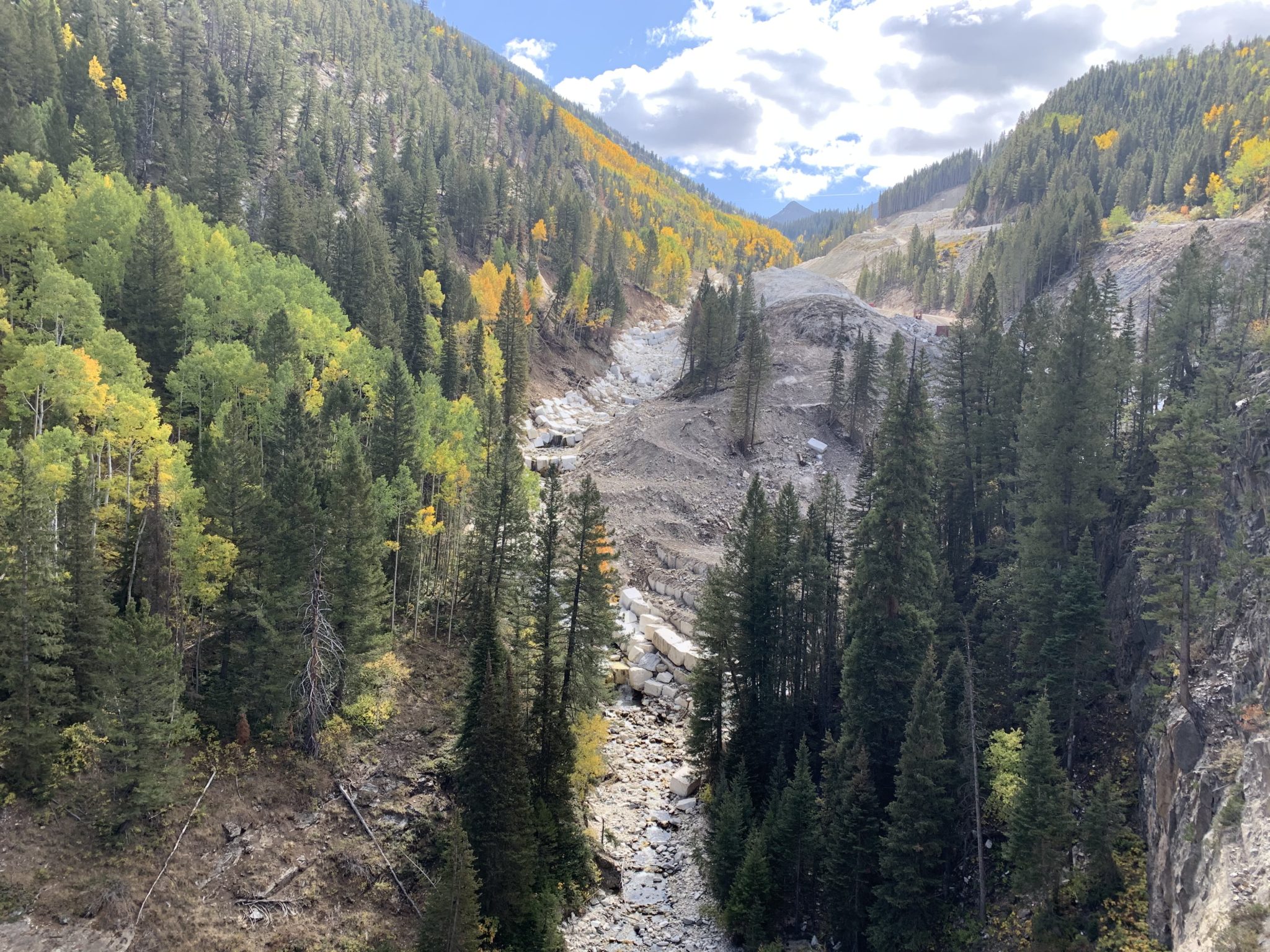


")