Here’s the release from the Natural Resources Conservation Service (Brian Domonkos):
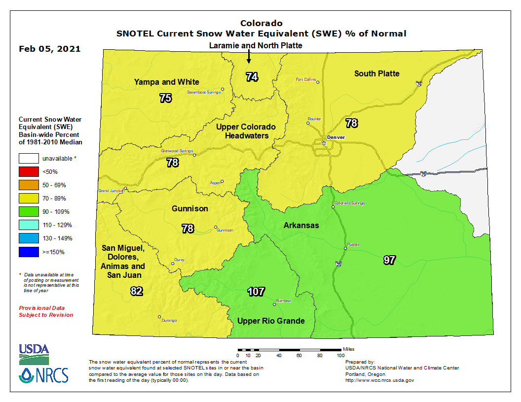
While Colorado did receive some mid-month precipitation accumulation, January received below average accumulation to the snowpack. This has been an unfortunate trend throughout the water year after a dry summer. Recent snow accumulations brought statewide snowpack back up to 77 percent of median and water year to date precipitation to 69 percent of average, as of February 1st. NRCS Hydrologist Karl Wetlaufer remarks “While it has been a dry water year so far, there are still two months left in the normal snow accumulation season which leaves time for this pattern to potentially change”. Several years in the recent past have observed substantial late spring and summer precipitation. While this isn’t anything to count on it can be a possibility for the snowpack to still recover to more normal levels.
Reservoir storage varies widely in the state from a low of 60 percent of average in the combined San Miguel-Dolores-Animas-San Juan river basin to a high of 106 percent in the combined Yampa-White river basin. Statewide reservoir storage is currently 82 percent of average. While reservoir storage is currently lowest in southern Colorado, it is encouraging that these basins did receive notable snow accumulation during recent storms.
In addition to the current snowpack and fall precipitation, one major consideration this year is that winter started with notable drought conditions across the state. The summer and fall of 2020 were abnormally hot and dry leaving soils in both the mountains and valleys of Colorado very dry. Wetlaufer continued to note that “With extremely dry soils existing under the snowpack, it is anticipated that soil moisture deficits will have to be satisfied by snowmelt, leaving less water available to make it to rivers and streams. This will lead to lower total streamflow amounts than would be commonly seen with a similar snowpack, regardless of what that ends up being”.
The average streamflow forecasts in different river basins range from 55 percent of average in the combined Yampa-White river basin to a high of 80 percent in the Upper Rio Grande river basin. Given the statewide drought conditions across Colorado going into winter, it will be a challenging year to determine exactly how to forecast the relationship between snowpack and streamflow. These relationships can also remain dynamic throughout the snowmelt season and on into the summer depending on future weather. Going forward, it will be important to keep an eye on changing conditions over the coming months.
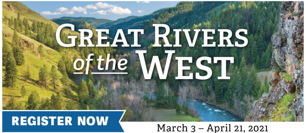
We have exciting news! Western Rivers Conservancy is launching a live online series called Great Rivers of the West, and we hope you can join us.
This highly informative, fast-paced, eight-part series begins on March 3, when author and photographer Tim Palmer will take you on a state-by-state virtual journey down the West’s greatest rivers. Each weekly episode will feature a travel- and conservation-inspired slideshow from Tim, a lifelong conservationist and paddler who has made the study of rivers his passion and career for over four decades.
Every episode will begin with an introduction from the founder and CEO of Fishpond, Johnny Le Coq; and WRC’s co-founder and President, Sue Doroff. Tim will follow with an enriching presentation that covers dozens of keystone rivers. He’ll tell you why they matter for fish and wildlife, why they’re worth exploring and ways to see them on your own.
After each episode, Tim and Sue will be on hand to answer questions from the audience.
BONUS! Each episode will end with a drawing for high-end gear from two of our sponsors, Fishpond and Sawyer Paddles & Oars. Just by registering for free you’ll be entered to win in all eight drawings.
The Great Rivers of the West series will air Wednesdays at 6pm Pacific Time, starting March 3.
For more information, and to register for the free series, visit us online.
Basin might become far drier than what managers have been planning for
Much has been said about a “new normal” in the Colorado River Basin. The phrase describes reduced flows in the 21st century as compared to those during much of the 20th century.
Authors of a new study contemplate something beyond, what they call a “new abnormal.”
The future, they say, might be far dryer than water managers have been planning for. This needs to change.
In the white paper, Kevin Wheeler and 11 others affiliated with the Utah State University-based Center for Colorado River Studies argue for the need for “wide-ranging and innovative thinking about how to sustainably manage the water supply, while simultaneously encouraging the negotiators of new agreements to consider their effects on ecosystems.”
In the 133-page report, they identified a wide variety of alternative management ideas, not simple tweaks but “significant modifications or entirely new approaches.” Some may consider these proposed approaches radical, they say, but the situation of the Colorado River Basin demands more than small, incremental changes.
“If the Millennium Drought, which has now persisted for more than two decades, has become the ‘new normal,’ or if the progressive decline of runoff resulting from climate change becomes even more apparent, major structural changes to water management in the basin will be urgently required,” the authors say in an executive summary.
They say they hope their research triggers further thinking and proposals.
Colorado will have to make do with what it has. This is despite projected population growth during the next three decades that will expand the current 5.8 million population by 3 million residents by mid-century. Think of another Aurora, Colorado Springs, and Pueblo every 10 years.
The era of massive new diversions from Colorado’s Western Slope ended decades ago. Relatively small—the key word is relatively—new diversions are planned: two in Grand County, where both Denver Water and Northern Colorado Water Conservancy District have projects using existing infrastructure. Aurora also wants to divert additional water from Eagle County.
This is from theBig Pivots, an e-magazine tracking the energy and water transitions in Colorado and beyond. Subscribe at http://bigpivots.com
Big, new diversions, such as from the Yampa River near Craig, face difficult and likely prohibitive economics, with the need to cross two or three mountain ranges to deliver water to the northern Front Range. Too, with warming very probably decreasing flows over coming decades, there’s uncertainty whether water will be available with any reliability, given Colorado’s commitments under compacts governing the Colorado River.
Between 85 and 90 percent of the Colorado River originates in snowmelt, mostly from Colorado but also Wyoming. A century ago there was plenty for the taking by all these states as well as the three lower-basin states, Arizona, Nevada, and California. Many, however, could see ahead to a time when there would not be plenty for all.
The Colorado River Compact drawn up by representatives of the seven states in 1922 assumed plentiful supplies of that time. The river delivered 17.7 million acre-feet from 1906 to 1930. They accordingly allotted 7.5 million acre-feet to Colorado and its neighboring headwater states and 7.5 million acre-feet to California and its neighbors, leaving water left over for delivery to Mexico.
At times, the river has delivered well enough. Keeping in mind that 90% of the flows come from the upper basin, the gauging station at Lees Ferry, at the top end of the Grand Canyon, the dividing point between upper and lower basins, has had an average annual natural flow of 14.8 million acre-feet between 1906 and 2018.
The drought since 2000 has bent down the numbers. From 2000 to 2018, the average estimated flows have been 12.4 million acre-feet. This is the Millennium Drought.
It could get worse—and it has been worse in the past. Tree rings indicate flows of 11.8 million acre-feet for the last quarter century of the 1500s. That’s natural.
Now come unnatural conditions, the influences of the greenhouse gas emissions that have been accumulating in the atmosphere. Climate change will make some places wetter, and some places drier. In the Colorado River Basin the evidence points strongly toward drier in the basin altogether.
Colorado statewide snowpack basin-filled map February 5, 2021 via the NRCS.
Colorado State University’s Brad Udall and others have already documented a drying underway, the increased evaporation and transpiration caused by rising temperatures. Udall’s research has found roughly half of the Millennium Drought can be attributed to those rising temperatures. He calls it a “hot drought.”
As for future warming, the authors of the report used temperature projections from two pathways identified by the International Panel on Climate Change. They analyzed reductions of flows ranging from 3% to 10% for each degree Celsius of warming.
Where does all this take the 40 million of us who live in the Colorado River Basin or depend in part on imported water from the basin? The latter includes the nearly 5 million people along Colorado’s urbanized Front Range corridor and the nearly 24 million people of southern California.
“Probable climate change conditions” will cause flow declines of 6.5% for each degree of warming, the study says. With less water available, less must be used. “Aggressive commitments to water conservation by both the Upper and Lower Basins will become critical in the next 25 years” to avoid drawing down the reservoirs in the basin, most notably Mead and Powell, below 15 million acre-feet.
Colorado and other upper-basin states should not try to use more water beyond 4 million acre-feet , despite the compact apportionment of 7.5 million acre-feet. They aren’t. Total consumptive use flattened out beginning in 1988. As for lower-basin states, they need to reduce demand to 6 million acre-feet after already cinching their collective belt in the 21st century to get within the 7.5 million acre-feet and then, within the last five years 6.9 million acre-feet.
John Fleck, the author of one book about the Colorado River and the co-author of a second book and former water reporter for the Albuquerque Journal, wrote in his blog on inkstain.net that the report clearly calls for water managers to commit publicly to deeper reductions in water use.
He also credits the level of details in the report, “a credible incorporation of the best climate science into the current Colorado River Basin policy framework, with an analysis done using CRSS, the modeling tool the management community uses to think about the Colorado River. This report, in other words, is written by a team deeply fluent in the language of Colorado River management.”
The report was posted on the same day that I spoke with a resident in Colorado’s Summit County, who said that in 30 years she had never seen it so dry during mid-winter.
As of mid-January, the U.S. Bureau of Reclamation projected 5.72 million acre-feet flow into Lake Powell. That’s 53% of average.
This comes after a subpar runoff in 2020 followed by a hot and dry summer, with massive wildfires from August to November, and now a winter that is, like the children of Lake Wobegone, above average—for warmth, that is.
Gunnison River in Colorado. Source: Bureau of Reclamation via the Water Education Foundation
From the Colorado Water Conservation Board via The Delta County Independent:
During the Colorado Water Conservation Board (CWCB) meeting on Jan. 25, an update on the current and ongoing Demand Management Feasibility Investigation was presented, including reiteration of the state’s guiding principles and the first steps of potential framework concepts for what a program could look like.
“The Demand Management Investigation remains an open, collaborative process, as we continue conversations with the Interbasin Compact Committee, Tribal Nations, non-governmental organizations, and stakeholders across the state,” said CWCB Director Rebecca Mitchell. “The big question is, can we design a program that creates a net benefit for Colorado and protects Colorado water users?”
The Step II Work Plan, which was approved in November 2020, aims to use information developed throughout the course of work done pursuant to the previous 2019 Work Plan to analyze whether a Demand Management program would be achievable, worthwhile, and advisable for Colorado as a whole.
The guiding principles articulated at the board meeting include: Demand Management is not a foregone conclusion; The framework is not a program, but a point for discussion; Issues are explored in an open and collaborative manner including engagement with Tribal Nations; and a program would be run by the state for the benefit of the whole state and its water users.
As part of the Step II Work Plan, CWCB will develop strawman concepts based on a matrix of elements, which were identified by each of the eight workgroups last year.
At the board meeting, staff presented on elements for monitoring and verification; education and outreach; and environmental considerations areas. These were presented as examples, as staff develops content relating to the other subject areas.
While no large-scale pilot programs will be implemented at this time, CWCB will soon begin looking at opportunities to use existing programs and funding sources to conduct smaller-scale demonstration projects that might help with on-the-ground learning. CWCB will also work to incorporate existing and ongoing projects and information into the framework.
A CWCB workshop will be scheduled in the near future to provide the next update on the feasibility analysis. The date and time of this virtual event will be added to the CWCB calendar.
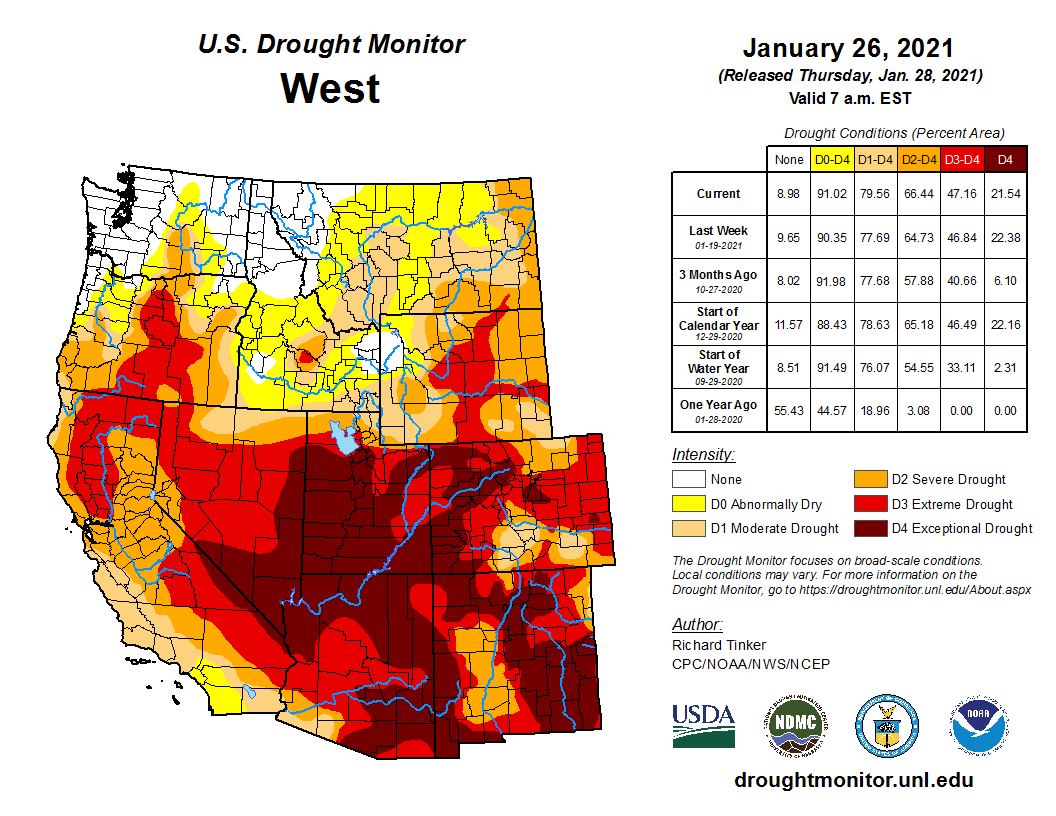
Click on a thumbnail graphic below to view a gallery of drought data from the US Drought Monitor.
US Drought Monitor February 2, 2021.
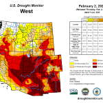
West Drought Monitor February 2, 2021.
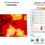
Colorado Drought Monitor February 2, 2021.
Click here to go to the US Drought Monitor website. Here’s an excerpt:
This Week’s Drought Summary
California’s most powerful storm of the season to date delivered drought-easing precipitation, including heavy mountain snow, but caused local flooding and landslides. Impacts from the multi-day storm system extended beyond California, adding to the benefit of other mid-winter weather systems in portions of the Western drought area. As the calendar turned from January to February, the Western storm finally turned eastward, producing wind and wintry precipitation in the Midwest and Northeast, as well as rain showers in the Southeast. As the drought-monitoring period ended, the former Western storm became a powerful low-pressure system along the middle and northern Atlantic Coast. In contrast, mostly dry weather prevailed throughout the 7-day period in several regions, including the northern Plains and the south-central U.S…
Much of the region settled into a cool, dry pattern, following the central Plains’ snowstorm that peaked on January 25. Further assessment of the that storm led to some additional reductions in drought coverage across the central Plains. In addition, a subsequent weather system clipped eastern Kansas with rain on January 30, helping to further reduce coverage of dryness (D0) and moderate drought (D1). For the areas that were affected by the January 25 storm, snow remaining on the ground into February has helped to boost topsoil moisture. (On January 24, just prior to that storm’s arrival, topsoil moisture was rated at least one-half very short to short in each of the states in the High Plains region, led by Wyoming at 90%, and followed by Colorado at 79%, North Dakota at 75%, South Dakota at 62%, Nebraska at 60%, and Kansas at 55%.) Daily-record snowfall totals in Nebraska for January 25 included 14.5 inches in Lincoln, 11.9 inches in Omaha, and 10.2 inches in Grand Island. For Lincoln, it was the snowiest January day on record (previously, 11.4 inches on January 3, 1971) and the snowiest day in any month since February 11, 1965, when 19.0 inches fell. Lincoln also achieved a January snowfall record, with 18.9 inches (previously, 15.6 inches in 2011). For Omaha, it was the snowiest day since January 10, 1975, when 12.1 inches fell…
Heavy precipitation and high winds accompanied a sprawling, slow-moving storm, which primarily impacted California. According to the California Department of Water Resources, the average water equivalency of the high-elevation Sierra Nevada snowpack climbed to 12.5 inches (70% of normal) by February 2, up from about 6 inches (less than 40%) just 10 days earlier. In an average year, nearly 30 inches of liquid accumulates in the Sierra Nevada snowpack by April 1. As the storm arrived on January 27, snow fell on the Sacramento Valley floor, where Redding, California, reported 1.5 inches. From January 25-29, rainfall totaled 14.41 inches in Big Sur, California, about 20 miles north of where a section of State Route 1 slid into the Pacific Ocean. On January 27-28, consecutive daily-record totals were observed in California locations such as Paso Robles (1.39 and 2.94 inches, respectively); Modesto (2.49 and 0.94 inches); and Stockton (1.37 and 1.43 inches). Stockton clocked a southeasterly wind gust to 58 mph on January 27, while Marysville, California, recorded 65 mph. Farther inland, Reno, Nevada, received 10.5 inches of snow, spread across 7 days (January 23-29). Flagstaff, Arizona, reported 43.5 inches of snow from January 19-29, boosting its season-to-date total from 7.1 to 50.6 inches (from 17 to 97 percent of normal). Drought improvements were focused on California, but drought coverage was also reduced—in part based on further analysis of other January storms—in the Pacific Northwest and the Southwest. Meanwhile, dry weather deepened its grip across parts of the interior Northwest, where there were some increases in coverage of dryness (D0) and moderate to extreme drought (D1 to D3)…
Mostly dry weather prevailed, leading to some general expansion of dryness and drought. The region’s most significant drought persisted across western Texas, where modest increases in coverage of moderate to exceptional drought (D1 to D4) occurred. According to the U.S. Department of Agriculture, Texas led the Plains in late January with 41% of its winter wheat rated in very poor to poor condition. Farther east, short-term dryness led to some expansion of abnormal dryness (D0) and moderate drought (D1), mostly from the lower Mississippi Valley and the central Gulf Coast eastward…
Looking Ahead
On February 4-5, a storm system crossing the nation’s mid-section will result in wind-driven snow from the upper Midwest into the Great Lakes region. Parts of the Midwest and Northeast could experience freezing rain, while late-week rain showers will occur in the Southeast, including much of Florida. The Midwest’s coldest air of the season will trail the storm, with temperatures during the weekend and early next week possibly falling to 0°F or below as far south as the Ohio and middle Mississippi Valleys. In parts of Minnesota and North Dakota, temperatures may remain below 0°F for at least 3 consecutive days, from February 6-8. Significant precipitation will be limited after cold air engulfs much of the country, aside from weekend rainfall in the Southeast and some wintry precipitation farther north across the eastern U.S.
The NWS 6- to 10-day outlook for February 9 – 13 calls for the likelihood of colder-than-normal weather nearly nationwide, except for above-normal temperatures across the southern tip of Florida and parts of the Southwest. Meanwhile, drier-than-normal weather west of the Rockies and in the Midwest and Northeast should contrast with near- or above-normal precipitation across the High Plains and Deep South.
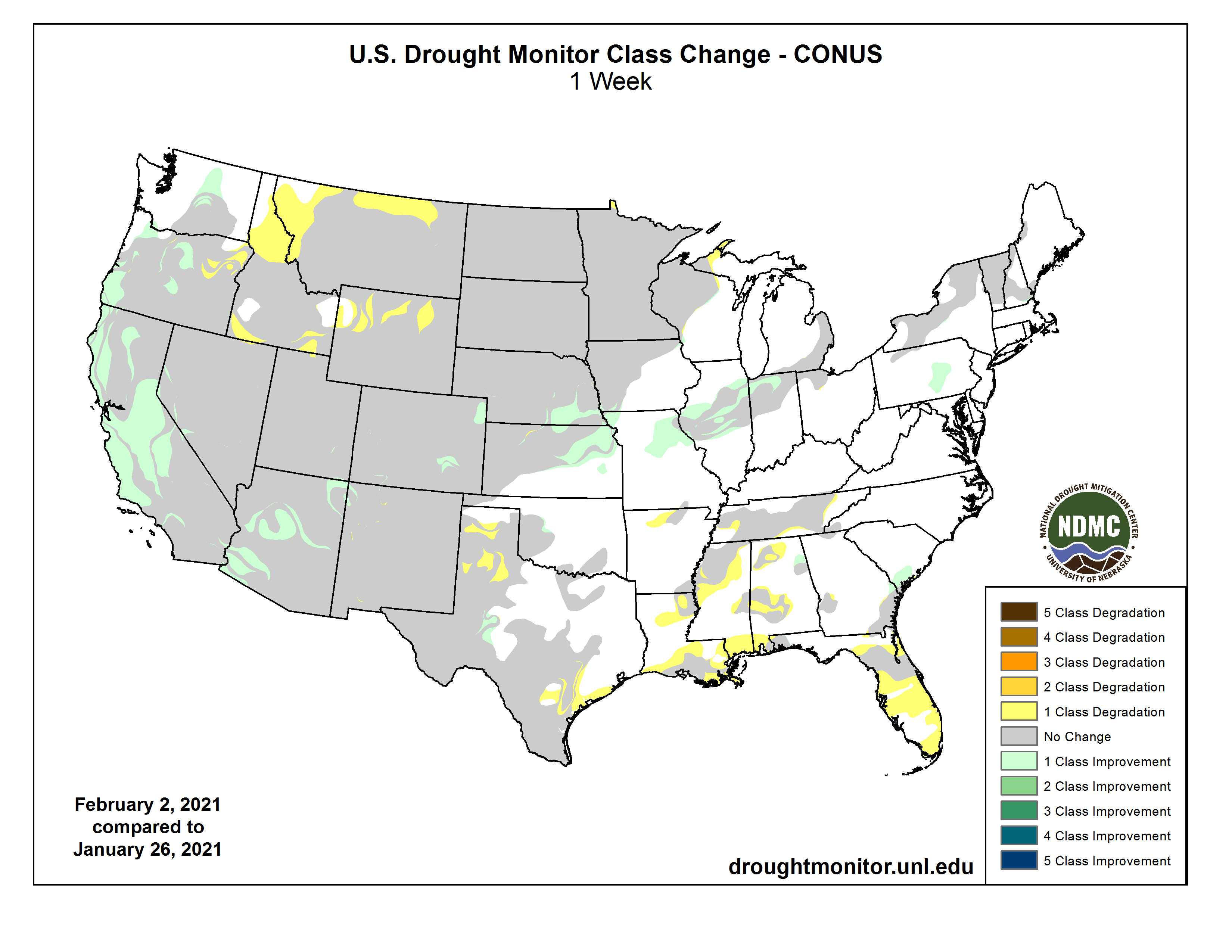
US Drought Monitor one week change map ending February 2, 2021.
Just for grins here’s a gallery of early February US Drought Monitor maps for the past few years.
The safety project includes replacing the dam near City Park with drops, which would make it safer for those tubing or kayaking from Lake Pueblo dam through the levee near downtown.
“It’s number one hazard mitigation project, but number two it is a tremendous quality of life project for the community,” said Seth Clayton, Executive Director of The Pueblo Board of Water Works.
The project is estimated to cost a little over ten million dollars. The board is hoping to receive a grant from the Federal Government.
Construction on the drops would begin sometime next year.
The San Juan Water Commission authorized Director Aaron Chavez to request a release from Lake Nighthorse in an attempt to capture that water for San Juan County residents — if the conditions are right.
The San Juan Water Commission hopes to someday have a pipeline that can reduce the losses from the river if a release from Lake Nighthorse is requested. However that pipeline does not yet exist.
That means the only way to deliver water from Lake Nighthorse to the City of Farmington is through the Animas River, and that has never been tried before.
The City of Farmington requested the action as it hopes to gather data while the river levels are low and the irrigators are not pulling water out of the river, the city’s Community Works Director David Sypher explained during the Feb. 3 meeting…
The proposed release would either be 40 cubic feet per second or 53 cubic feet per second. The release would last for five days and the City of Farmington would draw the water out of the Animas River using its pump at the Penny Lane diversion…
Chavez said during low flows he anticipates it could take 103 hours for the water to reach Penny Lane and there will likely be loss along the way. The water commission is projecting that 30 cubic feet of water per second would reach Penny Lane if 40 cubic feet per second was released. One reason Farmington hopes to do the release is to get better data about the amount of water lost.
If this release occurs, it will likely happen in March and it would cost $4,500 to $6,000 to replace the water in Lake Nighthorse. Sypher and Chavez would work together to ensure none of the water released from Lake Nighthorse passes the diversion at Penny Lane, where the pump station would take the water to Lake Farmington…
Multiple organizations would need to be notified, requiring two weeks of notification. These include the Colorado and New Mexico offices of the state engineer as well as the Animas-La Plata Association…
There has never been a release from Lake Nighthorse upon request of the San Juan Water Commission…
Sypher said the current drought forecasts are awful for the region. If the Animas River was to go dry, the water commission would likely need water released from Lake Nighthorse.
This pond is in Red Rock Canyon Open Space in Colorado Springs. State water engineers are beginning an evaluation of ponds without legal water rights throughout the Arkansas River basin. Photo credit: Colorado Division of Natural Resources via Aspen Journalism
State engineers in the Arkansas River basin are beginning to crack down on more than 10,000 ponds without legal water rights, which they say are harming senior rights holders.
Last month, Colorado’s Division of Water Resources in Division 2 rolled out a new pond-management plan, which they say will help relieve pressure in the over-appropriated basin by restoring water to senior rights holders. The first step was mailing on Jan. 14 informational brochures to 317 pond owners.
Even though the ponds targeted in this effort may have existed for many decades, they don’t have a legal right on the books to divert and store the water. The main concern with these ponds is water loss through evaporation. According to the brochure, for every acre of pond surface area, up to 1 million gallons of water — which is just over 3 acre-feet — is lost to evaporation each year. Division 2 Engineer Bill Tyner said, “Tens of thousands of acre-feet over time would be maintained in the Arkansas River system with a pond-management system in place.”
Although the cumulative water loss could threaten Colorado’s ability to meet its obligations to deliver water to Kansas under the Arkansas River Compact, the main issue is injury to senior water users. Added together, these ponds without a water right could deplete enough water that it makes it hard for these senior water rights holders to get the full amount to which they are entitled.
“Once we put the data together and we could look at the images of ponds and get a count of the number and relative sizes on average of those ponds, it did make us just very sure that this was a problem that could have some very negative consequences for the basin if we didn’t get more aggressive about the way that we took it on,” Tyner said.
Colorado transmountain diversions via the State Engineer’s office
Front Range water users divert water from the headwaters of the Roaring Fork and Fryingpan rivers into the Arkansas Basin, but the new pond-management plan probably won’t affect those transmountain diversions, Tyner said.
According to Colorado water law, anyone is allowed to divert water from a stream simply by putting it to beneficial use as long as it does not harm senior water-rights holders. To protect their ability to keep using the water and save their place in line, most users make their water right official by getting a decree through water court. This enshrines the water right in Colorado’s system of prior appropriation in which older water rights have first use of the river.
According to Colorado water law, anyone is allowed to divert water from a stream simply by putting it to beneficial use as long as it does not harm senior water-rights holders. To protect their ability to keep using the water and save their place in line, most users make their water right official by getting a decree through water court. This enshrines the water right in Colorado’s system of prior appropriation in which older water rights have first use of the river.
Because these undecreed ponds don’t have an official water right, they are taking water out of priority, which amounts to stealing water from senior users.
Matt Heimerich, the consumptive-use representative on the Arkansas River Basin Roundtable, said that over the past two decades the Arkansas River system has been under incredible pressure because of erratic and below-average flows. He described the shifting baseline of what constitutes a severe drought.
“It seems to me we just keep moving the bar lower,” he said. “How bad can the river get? We are always looking for the next threshold.”
Drought and warming temperatures fueled by climate change comprise the backdrop for the implementation of the pond-management plan.
“The system is drying out and the water right holder that typically would be in priority, they don’t have the amount of water they had in the past,” Heimerich said. “Ultimately, someone is taking a haircut that has a legitimate water right.”According to Colorado water law, anyone is allowed to divert water from a stream simply by putting it to beneficial use as long as it does not harm senior water-rights holders. To protect their ability to keep using the water and save their place in line, most users make their water right official by getting a decree through water court. This enshrines the water right in Colorado’s system of prior appropriation in which older water rights have first use of the river.
Because these undecreed ponds don’t have an official water right, they are taking water out of priority, which amounts to stealing water from senior users.
Matt Heimerich, the consumptive-use representative on the Arkansas River Basin Roundtable, said that over the past two decades the Arkansas River system has been under incredible pressure because of erratic and below-average flows. He described the shifting baseline of what constitutes a severe drought.
“It seems to me we just keep moving the bar lower,” he said. “How bad can the river get? We are always looking for the next threshold.”
Drought and warming temperatures fueled by climate change comprise the backdrop for the implementation of the pond-management plan.
“The system is drying out and the water right holder that typically would be in priority, they don’t have the amount of water they had in the past,” Heimerich said. “Ultimately, someone is taking a haircut that has a legitimate water right.”
This pond in Chaffee County near Salida is one of thousands in the Arkansas River Basin that is being evaluated by the Division 2 engineer’s office as part of a new pond management program. Engineers say ponds without decreed water rights could injure senior water rights holders. Photo credit: Colorado Division of Natural Resources via Aspen Journalism
Augmentation plans
In order to be allowed to keep water in a pond, pond owners must replace the water loss to the system, usually through what’s known as an augmentation plan.
In some areas in Division 2, pond owners can purchase water to replace their depletions through a conservancy district. Salida-based Upper Arkansas Water Conservancy District offers this replacement water, but manager Ralph “Terry” Scanga doesn’t believe there is enough water to fully augment all the ponds in the already over-appropriated basin.
“That’s a concern of mine because that’s a lot of water,” Scanga said. “I don’t think it’s being overstated what the impact could be.”
Scanga, who also serves on the Arkansas River Basin Roundtable, said it may be time to prioritize certain water uses over others. Having domestic water for use in homes may be more essential than ponds for aesthetic purposes, he said.
“You may want that pond and you may have enough money to purchase that augmentation plan from the district, but is that a wise use of that resource?” Scanga said. “Those are the real hard questions that need to be asked.”
Un-decreed ponds can be found throughout the state, including in the Roaring Fork watershed. Last fall, Division 5 engineers issued five cease-and-desist orders for ponds without water rights that they said were out of priority and depleting the Colorado River system.
So far, state engineers are focusing their pond-management plan on just the Arkansas River basin; it’s not yet a statewide program. Still, Tyner said it’s a big undertaking for his division. It could take five years for engineers and water commissioners to work their way through all the ponds.
“How do you eat an elephant? It’s one bite at a time,” Tyner said. “Our approach is to be systematic about it and fair as we go.”
Aspen Journalism covers water and rivers in collaboration with Swift Communications newspapers. Its water desk is supported by Sam Walton via the Catena Foundation. This story ran in the Feb. 1 edition of The Aspen Times.
FromThe High Country News [February 1, 2021] (Jonathan Thompson):
A half-century ago, the ‘Big Buildup’ transformed the West; now, it’s all coming to an end.
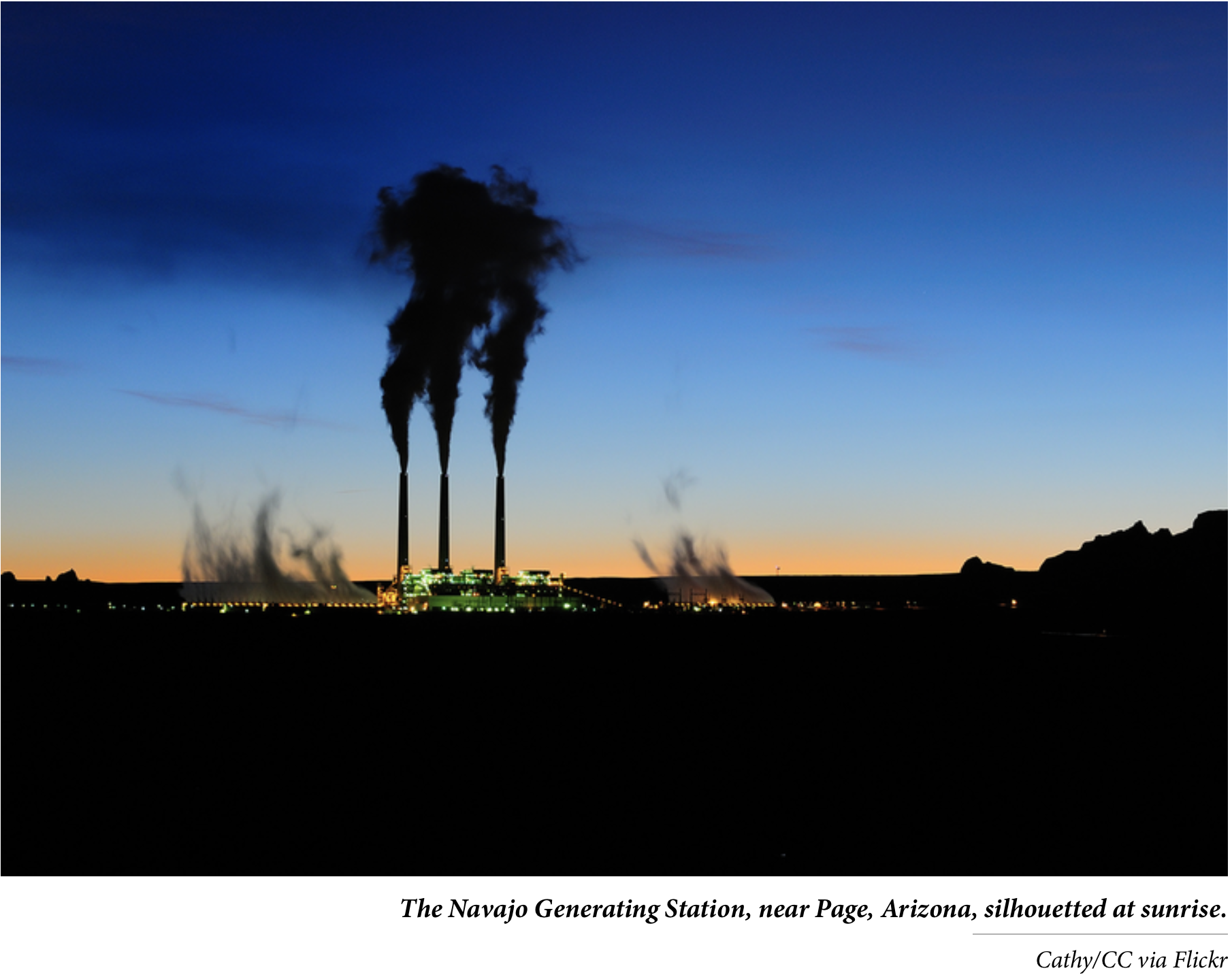
For nearly five decades, the Navajo Generating Station’s smokestacks towered over the sandstone and scrub of the Navajo Nation in northern Arizona, churning out greenhouse gases and other pollutants and serving as symbols of coal’s unquestioned dominance of the nation’s energy mix. But the plant shut down in December 2019, and the towers were demolished a year later. Now they symbolize something else entirely: The Big Breakdown of coal power and the ongoing transformation of the West’s economic and energy landscape.
In the late 1950s, several utilities across the Southwest teamed up to create a cabal called WEST, or Western Energy Supply and Transmission Associates, to construct six massive coal-fired power plants and their accompanying mines across the Colorado Plateau. The plants would then ship power hundreds of miles across high-voltage lines to the region’s burgeoning cities. It was the first and most ambitious phase of what scholar and author Charles Wilkinson would later dub “The Big Buildup.”
Four of the six proposed plants — Four Corners, Mojave, San Juan and Navajo — sprouted on or near the Navajo Nation in the 1960s and early ’70s. Huntington was built in central Utah, but the sixth plant never made it past the drawing board.
The Buildup’s real beneficiaries lay west and south of the Colorado Plateau, in the cities, where an abundance of cheap power lit the neon of Las Vegas and ran air conditioners in LA. The Navajo Generating Station powered the pumps that pushed Colorado River water into central Arizona, sending Phoenix’s suburbs sprawling into the desert and enriching the Southwest’s growth machine — all those real estate developers, mass-production homebuilders, the automotive industry, the corporate shareholders, the ratepayers and the executives.
For a half-century, the coal plants churned, pumping electricity onto the grid, cash into state and tribal coffers, and pollution into the water, land and air, unruffled by recessions or environmental protests and lawsuits, impervious to the booms and busts that plagued oil, gas and hardrock mining. Just as the coal leviathan maintained a steady stream of “baseload” power to the grid, so too did it provide an economic foundation for coal-dependent communities, together with a baseload level of smog.
Now that foundation is crumbling.
Coal as a power-generating fuel reached its apex in 2007. Soon thereafter, the price of natural gas came crashing down and that, along with renewable-energy tax credits and the decreasing price of solar and wind energy, wiped away coal’s cost advantage. States mandated that at least some of the electricity they consumed had to come from clean sources, California ordered the state’s utilities to break their coal habit for good, and the Obama administration implemented a variety of regulations that increased the cost of operating coal plants.
$54 million
Total annual royalties, bonus payments and water-use fees paid to the Hopi Tribe and the Navajo Nation by the owners of both the Navajo Generating Station and the Kayenta Coal Mine, which were lost when the plant and mine shut down.
$20.6 million
Compensation paid to Peabody CEO Glen Kellow in 2017 as the company exited bankruptcy. Peabody owns the now-closed Kayenta Coal Mine.
2,785
Number of coal-mining fatalities in the U.S. in 1913.12
Fatalities in 2019.
5
Fatalities in 2020.
20 million
Metric tons of carbon dioxide-equivalent greenhouse gases emitted by the Navajo Generating Station (CO2) and the Kayenta Mine (methane) annually while they were in operation.
472; 4,370; 259
Pounds of mercury, arsenic and selenium, respectively, emitted by the Navajo Generating Station annually when it was still operating.
1.3 million
Tons of coal combustion waste produced by the plant each year.
9 billion gallons
Amount of water drawn from Lake Powell each year for steam generation and cooling at the plant. This was all consumptive use, meaning none of this water was returned to the source.
3 million
Megawatt-hours of electricity the Central Arizona Project uses to lift, transport and deliver 1.6 million acre-feet of Colorado River water to Phoenix and Tucson annually — enough to power about 240,000 Arizona homes for one year. Most of that power previously came from the Navajo Generating Station.
15,000
Approximate number of households on the Navajo Nation that lack electricity.
Today, the products of the Big Buildup are coming down as surely as the Navajo Generating Station’s smokestacks. Mojave shut down in 2005; Reid-Gardner in southern Nevada went dark in 2019, as did the Navajo Generating Station and the Kayenta Mine that fed it. San Juan Generating Station in northwestern New Mexico will close next year, and the nearby Four Corners Power Plant is unlikely to run beyond 2031. Domestic coal consumption is down 65% since its 2007 peak, and some 45,000 coal miners have lost their jobs during the last decade. The Big Breakdown is reverberating across the West despite President Donald Trump’s market-meddling and regulation-eviscerating efforts to save the coal industry.
The transition won’t be easy: Coal-dependent economies are suffering mightily, from the Hopi Tribe and the Navajo Nation to towns like Farmington, New Mexico, and Gillette, Wyoming. Yet the Big Breakdown also opens up space for hope and opportunity, for a rethinking and refashioning of energy systems and economies. And already the air over the Southwest is a little bit cleaner than it’s been since the 1960s.
Sources: Bureau of Labor Statistics, Mine Safety and Health Administration, Energy Information Administration, Navajo Generating Station-Kayenta Mine Complex Draft Environmental Impact Statement (2016), St. Louis Dispatch.
Jonathan Thompson is a contributing editor at High Country News. He is the author of River of Lost Souls: The Science, Politics and Greed Behind the Gold King Mine Disaster. Email him at jonathan@hcn.org.
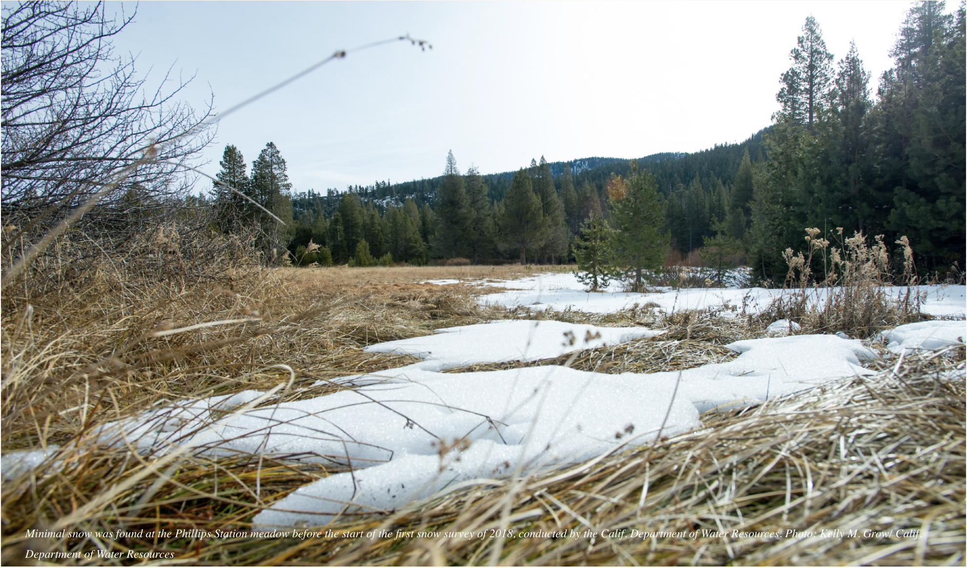
Minimal snow was found at the Phillips Station meadow before the start of the first snow survey of 2018, conducted by the Calif. Department of Water Resources. Photo: Kelly M. Grow/ Calif. Department of Water Resources
A new study compares snowpack across the world and offers a tool to help scientists pinpoint where this critical resource is waning — and what that means for ecosystems and economies.
Most of us know a bad drought when we see one: Lakes and rivers recede from their normal water lines, crops wither in fields, and lawns turn brown. Usually we think of these droughts as being triggered by a lack of rain, but scientists also track drought in other ways.
“The common ways to measure droughts are through precipitation, soil moisture and runoff,” says Laurie S. Huning, an environmental engineer at the University of California, Irvine. Her most recent work adds another dimension to that by looking at water stored in snowpack.
Huning is the co-author of a study in the Proceedings of the National Academy of Sciences, with U.C. Irvine colleague Amir AghaKouchak, which developed a new framework for characterizing “snow droughts.” These can occur when there’s an abnormally low snowpack, which may be triggered by low precipitation, warm temperatures or both.
Their research is timely. This winter, southwestern states have received just a quarter to half of the average snow-water equivalent —the amount of water held in the snowpack — the key metric for determining a snow drought.
And that can have sweeping impacts. The water content of a snowpack can change the amount and timing of when runoff occurs, and that has implications for wildlife, ecosystems, water resources, flood control, hydropower and drought mitigation.
Snow droughts can also have far-reaching effects on agriculture — and economies. California’s Central Valley, the heart of its agriculture industry, relies on snow melt from the Sierra Nevada. The state saw $2.7 billion in losses in the sector following low precipitation and warm temperatures during 2014-2015.
Frank Gehrke (DWR Chief of Snow Surveys) addresses the media during a snow survey at Phillips Station on April 1, 2015. The black tag on the pole is where the snow was in the drought year of 1977, the yellow tag is where the snow was last year, and the green tag is where the snow is on an average year. Measurements in Phillips began in 1942, and today is the first time there is zero snow for an April 1 measurement. Below-normal precipitation, combined with unusually warm weather, has produced meager snowfall during the traditional wet season. Florence Low / California Department of Water Resources
Snow droughts can also make conditions dire in regions that are already stressed by conflict and resource shortages. A snow drought in Afghanistan in 2017-2018 triggered crop failures and livestock loses that left 10 million people food insecure.
The concept of a “snow drought” has been around for several years, and it’s been studied in certain key locations, but until now scientists and water managers lacked a worldwide method to assess them.
The study aims to solve that. Huning and AghaKouchak have developed a standardized snow-water equivalent index in an effort better characterize and compare the duration and intensity of snow droughts around the world.
The results already reveal some areas of concern. Looking at data from 1980 to 2018, the researchers found a few hotspots where snow-droughts became longer and more intense during the 21st century.
The most notable area was the western United States, which saw a 28% increase in the length of periods of snow drought. Eastern Russia and Europe also saw increases, though less severe.
And on the flip side, some areas saw a decrease in snow drought duration, including the Hindu Kush, Central Asia, greater Himalayas, extratropical Andes and Patagonia.
“It’s important to remember that not only does the snowpack vary but the impact that it has differs across the world,” says Huning.
Huning hopes the framework developed for the study can help water managers better understand the amount and timing of snowmelt, and to integrate that with drought monitoring systems to recreate better resiliency and management of resources.
“We know that the snowpack is highly variable,” she says. “Further development of this framework can improve our near real-time monitoring of drought.”
The study didn’t delve into the specifics of why snow droughts may be becoming more severe in certain places, but other studies have found that climate change is playing, and will play, a role in reducing snowpack in some areas — including western U.S. states.
A study by UCLA climate scientists published on Aug. 10 found that in California warmer temperatures will cause more rainfall and less snow during the winter in coming decades. This will likely increase flood risks and reduce the snowpack that usually melts slowly over the spring months.
Earlier research found that a decrease in Arctic sea ice leads to changes in atmospheric circulation that creates a high-pressure system, known as an atmospheric ridge, off the Pacific coast. These ridges deflect storms, pushing them northward and leaving the region high and dry. A particularly stubborn system that developed in 2013, nicknamed the “ridiculously resilient ridge,” had a big hand in California’s five-year drought, which extended until 2017.
Better understanding of how to measure and track snow droughts can give water managers another tool to help plan for similar droughts and to better manage this changing resource.
“Snow is a natural resource and, given the warming temperatures that some parts of the world will see, the amount of snow is changing,” says Huning. “We need to recognize that there are so many different ways the environment and humans will be affected.”
Glen Canyon in 1873, near the confluence of the Colorado and San Juan Rivers. By Timothy H. O'Sullivan – U.S. National Archives and Records Administration, Public Domain, https://commons.wikimedia.org/w/index.php?curid=17428088
From American Rivers (Sinjin Eberle & Page Buono):
It’s time for hard conversations about what kind of future we want for the Colorado River and all who depend upon it.
The Center for Colorado River Studies at Utah State University recently published a preprint edition of their new white paper titled, “Alternative Management Paradigms for the Future of the Colorado and Green Rivers.” The authors of the paper include Kevin Wheeler, Jack Schmidt, Brad Udall, and former Colorado River District General Manager, Eric Kuhn, among a few notable others in the climate modeling and Colorado River management space (Disclosure: Jack Schmidt and Eric Kuhn both serve voluntarily on American Rivers’ Science and Technical Advisory Committee.) The new publication builds upon a 2020 white paper, “Strategies for Managing the Colorado River in an Uncertain Future.” Wheeler et. al ran scenarios for various planning strategies on one of the most managed rivers in the world, the Colorado, to better understand the implications of those decisions in a hotter and drier future. Using the same computer modeling tools used by basin managers (the Bureau of Reclamation CRSS model), they integrated new climate and river flow data and looked out decades into the future to explore and predict water supply conditions under various scenarios.
The outcome of the study, in short: we’ve got to be more creative, and we need to have some hard conversations about what kind of future we want for the Colorado River and all who depend upon it. American Rivers has been engaged with the authors of the study, and we’re coming up to speed with its prescient findings. But even more important than that, our desire is to spark a conversation with you about what kind of future lies before us, what this new science tell us about various realities on the river, and how can we design solutions for the river, together.
John Fleck, author of a pair of recent books on western water, recently posted his take on the study, including some of the key highlights. He underscored that “Under a relatively optimistic scenario (things don’t get any drier than they’ve been in the first two decades of the 21st century), stabilizing the system would require:
The Upper Basin to not increase its uses beyond its current ~4-million-acre feet per year of water use.
The Lower Basin to adjust to routinely only getting ~6-million-acre feet of water.
Basically, that means adapting to living in a 10-12 million-acre-foot (MAF) river, rather than a 17 MAF river as the Colorado River Compact assumes. Obviously, this stuck out to us too. While the Law of the River (the Colorado River Compact) essentially promised 7.5 MAF for the Upper Basin and 8.5 MAF for the Lower Basin (then added in Mexico’s allocation later), the Alternative Management Paradigms study makes clear that this is now an unattainable, and unwise, ambition.
Fleck points out that “Upper Basin water users have averaged about 4-million-acre feet/year since the 1980’s, but with plans to use more. The Lower Basin has reduced their use from the allowable 7.5 MAF to 6.9 MAF on average over the last five years. So to balance things out, Upper Basin use can’t grow, and Lower Basin use needs to shrink. More than it already has.”
The authors write that “the primary purpose of this White Paper is to provide provocative new ideas,” and they warn that “the current management approach that allows only incremental changes to the Law of the River may be insufficient to adapt to the future conditions of the basin.”
With both the warning and the desire for new ideas and thoughtful conversation in mind, we wanted to share some of the top conclusions from the study as an invitation for further conversation:
The Colorado River has been profoundly altered from its highest reaches to its delta. In the highly constructed and managed basin—complete with numerous transbasin diversions and large dams—the native river ecosystem has been profoundly altered, the Upper Basin less so than the Lower, but still to significant degree.
Unrealistic future depletion projections for the Upper Basin confound planning. There simply isn’t enough water to meet the aspirations for growth of the Upper Basin. “Unreasonable and unjustified estimations create the impression that compact delivery violations…are inevitable. Such distortions mislead the public about the magnitude of the impending water supply crisis and make identifying solutions to an already difficult problem even harder.”
Climate change is causing flow declines and additional declines are likely to occur. 2000-2018 flows in the Colorado River are nearly 20% less than during the 20th century. Even accounting for this decline is not sufficient for future planning—increased temperatures and the resulting aridity will likely precipitate further decline.
The Colorado River exists in a tenuous balance between supplies, demands and storage. Unplanned changes in this balance are likely to lead to highly undesirable outcomes. The Colorado River is already stretched. Any actions that decrease the inflows or increase demand are untenable. “If the Millennium Drought conditions continue and the 2007 UCRC future depletion projections materialize, the Colorado River’s water supply cannot be sustainably managed.”
Likely lower inflows and/or any increases to Upper Basin consumptive uses will result in a difficult basin-wide reckoning. Future reductions in water supply are likely, due to the effects of climate change, exacerbating tensions between the Upper and Lower Basin, especially if the Upper Basin increases its demand. Negotiations are already massively difficult. Planning for a supply that science suggests will not be realized makes difficult processes profoundly more difficult.
Lake Mead in 2017. Photo: Karen, (CC BY-NC-ND 2.0)
In addition to those “difficult reckonings” it is clear that unless something is done, the environment—the river itself—has the most to lose. But in addition to those, the study outlined these additional takeaways that are key to understanding the expansive challenge facing the Colorado River:
Lower Basin shortage triggers based on combined Lakes Powell and Mead storage are more logical and clearer than existing triggers (and different from simply looking at the individual lake levels on their own)
Neither a Fill Mead First nor Fill Powell First scheme promotes or improves Lower Basin water security
Flaming Gorge Reservoir releases provide little Upper and Lower Basin Risk Protection
Humans have significant control over demands but little control over inflows
Dire situations require solutions far from historic norms
As Kuhn, Fleck and others have stated for years, the study demands a reimagining of what we want versus what we need when it comes to water, and it grounds us in future-looking predictions of what we’re likely to have, which isn’t more and will likely be less. This is, perhaps, the epitome of inconvenient science, but it’s important science nonetheless, and if history has taught us anything, it is science that we can’t ignore. Doing so will cost us greatly.
You can read the study HERE, and you can learn more by staying engaged with us as we continue the work of distilling and contextualizing this research through additional blog posts, and other outreach, in the near future. We hope to catalyze a dialogue here—dare we say, a movement—and we look forward to your reactions, comments and ideas.
New plating at the Glenwood Springs water intake on Grizzly Creek was installed by the city to protect the system’s valve controls and screen before next spring’s snowmelt scours the Grizzly Creek burn zone and potentially clogs the creek with debris. (Provided by the City of Glenwood Springs)
FromThe Glenwood Springs Post Independent (John Stroud):
Some of the work related to Grizzly Creek Fire impacts
Infrastructure improvements associated with Glenwood Springs waterworks system brought on in part by last summer’s Grizzly Creek Fire will likely mean multiple years of increasing water and sewer rates for customers.
In 2020, the city conducted a water and wastewater rate study, which identified several “critical infrastructure needs” over the next 10 years totaling about $36 million.
City council has been reviewing and will decide on a recommended tiered water and wastewater rate increase over those 10 years. It expects to make a decision this spring.
Glenwood Springs Public Works Director Matthew Langhorst presented two rate increase options at a Jan. 21 City Council work session.
Option 1 would increase rates 26.2% this year, followed by 8% for three years, then 7% in 2025 and 5% from 2026 to 2030.
The second option has a higher initial rate increase for this year at 36.8%, followed by 5% for years 2022 through 2030…
Both options also include standard Consumer Price Index (CPI) adjustments annually after 2030. Historically, the CPI has ranged between 1% and 4%.
Langhorst also presented a comparison of what an average user’s monthly bill would look like under both options in year one, assuming different gallon usage.
The average user consuming 5,000 gallons of water currently has an estimated bill of $92. Under Option 1, that would increase to $113. Option 2 would be slightly higher at $122.
Langhorst said that 5,000 gallons of water is equivalent to what a medium-sized home with some landscaping would consume. “Compared regionally, the increased rates are in line with other jurisdictions,” he said.
Some of the identified capital projects are related to the Grizzly Creek Fire, which severely impacted the city’s main No Name and Grizzly Creek water supplies. Others are due to routine replacement of aging infrastructure…
Other capital needs include replacement or rehabilitation of equipment and additional storage capacity for firefighting capabilities, city officials said.
Glenwood Springs operates a municipal water supply system that supplies drinking water to more than 10,000 residents. The city obtains its drinking water from three surface water intakes in the Colorado River watershed…
The work session provided a preliminary overview of funding options. Council is tentatively set to review and make a decision about rates sometime this spring, and will also discuss a possible low-income assistance program, according to the city’s release.
James Eklund, hails from a Western Slope ranching family. He often works to add a touch of levity to otherwise serious-minded state-level water meetings. Photo credit: Aspen Journalism
FromThe Grand Junction Daily Sentinel editorial board:
Nothing unites rivals like a common enemy.
Colorado may be notorious for its intrastate water conflicts, but a recent flurry of newspaper articles on the potential for water speculation by Wall Street firms has water managers across the state agreeing on one thing: Private investment in a precious public resource that dictates every aspect of life in the West is too risky to tolerate.
On [the January 30, 2021] front page, the Sentinel’s Dennis Webb traced the angst stemming from press coverage of this issue to its primary source: friction between James Eklund, a Grand Valley native and fifth-generation Coloradan, and the Colorado River District.
Eklund should be a familiar name. He is the former director of the Colorado Water Conservation Board. He played a major role in getting the state’s water factions to agree to a state water plan that former Gov. John Hickenlooper called for in 2013. Perhaps more relevant, Eklund served as the state’s representative on the Upper Colorado River Commission during negotiations over a drought contingency plan that saw creation of a special storage account in Lake Powell.
Water conserved under a “demand management” program would be stored in this separate account to ensure adequate delivery of water to Lower Basin states. It’s a hedge against a disastrous “compact call” in which Upper Basin water uses could be curtailed to meet delivery obligations of the 1922 interstate compact.
Eklund has since moved to private practice as a Denver-based water attorney. Among his clients is Water Asset Management, a New York investment firm that has spent more than $16 million buying more than 2,000 acres of irrigated farmland in the Grand Valley.
Naturally, the Colorado River District is suspicious about WAM’s intentions — even though Colorado has some of the toughest anti-speculation laws in the nation. While individual landowners own water rights, they must put water to “beneficial use,” which doesn’t include selling water for profit.
Still, “buy and dry” scenarios — in which water is converted from one beneficial use (agriculture) to another (municipal taps) illustrate the ongoing battle against the commoditization of water.
The Colorado River District’s executive director, Andy Mueller, has openly speculated that Eklund is behind a media campaign “to discuss the virtue of free markets and water markets” in the western United States.
More troubling is the district’s assertion that Eklund is trying to help WAM take advantage of a potential drought mitigation tool he helped set up — the storage account in Lake Powell — by lobbying for private accounts within that pool.
That would grease the skids for marketing water from the Upper Basin (where the water is) to the Lower Basin (where the money is).
Eklund met with the Sentinel’s editorial board on Jan. 22. With every right to be indignant about assertions he labeled as “flat-out false,” Eklund struck a conciliatory tone.
“I’m leading with empathy here,” he said. “I share the anxiety of private investment in Colorado water. I understand it.”
Much of Webb’s reporting recounts the series of events that led to the imbroglio, but it’s also offers Eklund an opportunity to defend himself. He wouldn’t push for private accounts in Lake Powell, he said, because it violates the “Law of the River” and undermines the benefit of the bargain Colorado got when it joined the 1922 compact.
Nor would he represent a client bent on profiteering, he said.
In contrast, Eklund said, WAM hasn’t done anything but invest in improvements on agricultural land — boosting efficiency, sequestering carbon in soils and keeping land in production.
“I care too much about my family (his parents operate a ranch in the Plateau Valley), the Western Slope and Colorado agriculture to advise anyone that would cause harm.”
As Eklund noted, for all the district’s concerns, there’s not much separating their views. “They want the Western Slope to control the Western Slope’s destiny and I completely agree with that,” he said.
Eklund will be judged on whether WAM deviates from its current course. In the meantime, the silver lining in this all of this mistrust is that it has brought into sharp focus the need to protect water.
There are all kinds of doomsday scenarios at our doorstep. If we hope to continue life in western Colorado as we know it, we need to fight any changes to the law and work like hell to prevent a call on the river.
Colorado transmountain diversions via the State Engineer’s office
FromThe Grand Junction Daily Sentinel (Dennis Webb):
James Eklund remembers having to work to get the Colorado River District’s trust before, when he was director of the Colorado Water Conservation Board and was seeking support for a state water plan.
He said when talks began on the plan it was “dead on arrival” among representatives of the Western Slope district.
“People were saying it’s the wolf in sheep’s clothing. It’s going to be an excuse for more transmountain diversions” of water to the Front Range, he recalls.
Eventually, a plan was agreed on that the district got behind. But these days Eklund once again finds himself in a battle to gain the district’s trust, now because of his work as a private water attorney representing a New York investment firm that has been buying up Mesa County agricultural land and associated water rights and leaving the river district nervous about its — and Eklund’s — intentions for that water.
Viewed from the river district’s perspective, Eklund is a Denver water attorney that the district fears is trying to help his client take advantage of a potential drought mitigation tool he helped set up, involving the storage of water in a dedicated account in Lake Powell.
But Eklund also is someone who was born in Grand Junction, to parents who own a family ranch in the Plateau Valley that his great-great-grandparents homesteaded in 1888.
He spent every summer there while growing up, and continues to visit and pitch in doing ranch chores to this day when time allows. Given that background, he insists that for all the river district’s concerns, there isn’t much daylight between it and him when it comes to the desire to protect the Western Slope and its water…
He said the river district wants the same thing he does — strong Western Slope agriculture and water that is not at risk…
A MEDIA CAMPAIGN?
The river district’s concerns about Eklund and Water Asset Management, the New York company that now owns more than 2,000 acres of agricultural land in the Grand Valley, were amplified as a result of a Jan. 3 New York Times article on Wall Street investments in the West, followed by a Denver Post guest column in support of temporary, compensated, voluntary fallowing of Western Slope irrigated land to bolster water levels in Lake Powell.
Andy Mueller, general manager of the river district, views the two pieces as part of a media strategy by Water Asset Management, and likely Eklund…
He also views it as an attempt to put pressure on the state and the Upper Colorado River Commission, which includes representatives from Colorado and other Upper Colorado River Basin states, to move forward quickly with a proposal for managing water demand in times of droughts through measures including fallowing by farmers and ranchers, without safeguards to protect local economies…
Agricultural, municipal and other water conserved under a demand management program would be stored in a separate account in Lake Powell as provided for under a drought contingency plan involving the states. It would be available to ensure adequate delivery of water to Lower Basin states as required under a 1922 interstate compact, in order to avoid a potential “compact call” under which Upper Basin water uses could be curtailed to meet delivery obligations.
The river district long has been insistent that water conserved through demand management be temporary, compensated and voluntary, concepts the Colorado Water Conservation Board has committed to as it explores the idea.
The river district also wants the impacts of conservation shared proportionally among users in a way that Western Slope agriculture and ag-based communities are protected…
Mueller also long has been concerned that some entities might push to set up individual accounts within the pool of water created through demand management, to protect water diversions for municipal utilities while Western Slope agricultural use gets shut down under a compact call.
Theoretically, water in those accounts could come from investment firms buying up Western Slope agricultural land and water rights.
Mueller believes Eklund is lobbying for such accounts, based in part on the Times article exploring the concept of a market-based approach to western water that could result in more water being moved from agriculture to municipal use.
If that’s true, it could be argued that Eklund is gaming the very system he helped set up. He served as Colorado’s representative to the Upper Colorado River Commission during the negotiations leading to the drought contingency plan agreements, including establishment of a separate storage account in Powell…
But Eklund said he isn’t pushing for private water accounts in Powell. Only sovereigns can hold water there — not special districts, private entities or individuals — he said.
“That’s always been the case. That always will be the case as far as I can see,” he said.
He said it’s also the way it should be, and he wouldn’t lobby to change something he doesn’t believe in…
Eklund said allowing only sovereigns to hold water in the reservoir is linked to the bargain Upper Basin states got from the 1922 compact. That deal assured that Upper Basin states could develop water at their own pace, as opposed to fast-growing places such as southern California getting their hands on the bulk of Colorado River water.
Mueller told The Daily Sentinel that he knows Water Asset Management has been directly in contact with several Front Range water utilities arguing for their support for individual accounts in Powell.
“James Eklund himself was in the halls of one of the water utilities while I was there, doing exactly that, meeting with them and trying to lobby them for their support on those individual accounts,” Mueller said.
“That’s an amazing accusation,” Eklund said when told of Mueller’s comments. He added that Mueller’s assertion is “flat-out false.”
[…]
Denver Water spokesman Todd Hartman said, “Mr. Eklund has not been lobbying us on the matter of private accounts, and certainly has not done so in our hallways, as they’ve been largely empty since remote work began amid COVID-19 in March of last year.”
Hartman added that “Denver Water is in opposition to the concept of private water storage pools in Powell, as is the law. Private sector entities don’t have the legal ability to manage water across state lines nor within federally owned reservoirs. This can only be done by the states and the federal government.”
Eklund said he understands the river district’s nervousness about what’s being characterized as outside investments in Colorado water. Its job is to protect West Slope water, he said…
[Mueller] said Water Asset Management views water scarcity on the Colorado River as an opportunity to make money by moving water from rural to urban areas. The district believes investment firms are angling to speculate on Colorado’s water, contrary to Colorado’s antispeculation laws when it comes to water. A state task force is looking at strengthening such laws…
The Times article was followed within days by a column in the Denver Post by Brian Richter bluntly headlined, “Western Slope needs to suspend irrigation to avert water shortage catastrophe,” in which Richter supports agriculture playing a role in helping boost Powell water levels…
Bicycling the Colorado National Monument, Grand Valley in the distance via Colorado.com
He said all he and Water Asset Management can do is “make sure we walk the talk” by the company not taking actions such as flipping water for profit and being involved in buy-and-dry schemes to move water off agricultural lands. Eklund said it hasn’t done such things during three years of being invested in the Grand Valley. Rather, he said it is investing in improvements, boosting efficiency, sequestering carbon in soils and keeping land in production.
Eklund said he doesn’t represent companies that speculate on water, and antispeculation is important to him just as it is to the river district.
Flood irrigation in the Arkansas Valley via Greg Hobbs
Here’s a guest column from Terry Scanga that’s running on Heart of the Rockies Radio:
In Colorado, transfer of water from one type of use to another is a historical necessity and will continue throughout Colorado and the semi-arid West.
As economic and social needs change, water moves to new areas to satisfy changing needs.
Historically, mining utilized the majority of water in Colorado. As population increased the mining water rights moved to agricultural use. Due to improved transportation and the economies of scale in agricultural operations, much of our agricultural commodities are produced in areas with climates more conducive to large year-round production.
Many small agricultural operations that are no longer profitable have left the market and sold their operations and, in some cases, sold their water rights separately from the land to meet the changing demands. Some increase in the demand for water is now being driven by small specialty and organic farming operations. Still, in the larger farming areas of the state, there continues to be a demand for water and here these rights are not changing.
In recent years, the term “buy and dry” has become popularized by individuals intent on characterizing the purchase and transfer of an irrigation water right to other uses as an economic and environmental catastrophe. Doing so obfuscates the reason why drying up of formerly irrigated lands is necessary.
In fact, the need in water right transfers to dry up the land is to protect adjacent water rights from injury. This ensures that only the exact amount of water historically owned (used) by the irrigator is transferred to the new use. Without an exact proof of use, the amount of water moved may be much larger than was historically used and the environmental and economic damage would be large.
Of course, for many, the tedium of factual analyses does not lend itself to telling a “juicy” conspiracy story. To some others who really know the facts, there are ulterior motives. One of the motives deals with the promotion of an alternative method of moving water and not using the time-tested court process.
These promoters of the alternative wish to avoid the legal scrutiny and work of accurate analysis and quantification of historic use. They claim many reasons for advocating for alternative methods. Among these reasons are, “It takes too much time,” “It costs too much,” or “It’s too hard.”
The best but totally dishonest reason given is, “It means the land will be dried up forever,” all the while knowing their alternative would require dry-up too. From this has come another popularized term, “alternative transfer method,” or “ATM.”
Alternatives to the traditional water right transfer still require dry-up of former irrigated lands. There are actual alternatives, but these are marginally different from the traditional purchase and transfer of the water rights. These are temporary transfers, such as leasing of the water right and temporary fallowing of the formerly irrigated lands.
These temporary transfers or leasing of the historically consumed water from the irrigated land are complex transactions. To reduce the transactional costs in the engineering analysis required to accurately calculate the amount of water that could be transferred under a temporary lease without causing injury to adjacent water rights, the Upper Arkansas Water Conservancy District sponsored a study and development of a common technical platform called the “Lease Fallowing Tool.”
It is now available free of charge and is widely accepted by the water community. Except for pilot projects of limited duration, the water right still needs to undergo a legal decree change through the water court. In these temporary transfers or ATMs, the land is still dried up.
The legal requirement to prevent injury to remaining adjacent water rights becomes more difficult to ascertain and the ongoing monitoring and development of water infrastructure to maintain historic stream conditions is more daunting. One thing is clear about ATMs, to be effective in meeting future long-term needs, construction of more water storage facilities – reservoirs and recharge basins – will be required.
This really gets to the crux of the matter. Recently, articles have been written about Wall Street investors scooping up water rights in Colorado to market to out of state interests. This concern and others have triggered our legislators to promote legislation to prevent speculation.
The problem is the Colorado Water Doctrine already has anti-speculation inherently built into its water allocation system. In order to own a water right one must demonstrate beneficial use. As described above, it is this quantification of use that determines the amount of water owned that can be bought and sold.
So, unless a prospective buyer has a use in mind, in Colorado, buying a water right to simply hold without use gets him no water.
Firefighters on the march: The Pine Gulch Fire, smoke of which shown here, was started by alighting strike on July 31, 2020, approximately 18 miles north of Grand Junction, Colorado. According to InciWeb, as of August 27 2020, the Pine Gulch Fire became the largest wildfire in Colorado State history, surpassing Hayman Fire that burned near Colorado Springs in the summer of 2002. Photo credit: Bureau of Land Mangement-Colorado, via InciWeb and National Interagency Fire Center.
If there were any doubts that the climate is changing in the Colorado River Basin, 2020 went a long way toward dispelling them, thanks to yet another year of extreme weather.
Unprecedented wildfires, deadly heat waves, withering drought—the many indicators of the climate mayhem that scientists have been warning about for years—ravaged the landscape, claiming dozens of lives and causing billions of dollars in damage.
Colorado endured an unprecedented wildfire season. And so did California, in some cases burning where the wounds were still fresh from the epic fires of 2018. Utah experienced its driest year ever, and persistent high temperatures killed more people in Arizona than ever before. Monsoon rains that typically bring relief throughout the region were a no-show for the second summer in a row and now are being called the “non-soon.”
And, although the final climate data for 2020 just arrived and the new year is just weeks old, forecasters are already filled with apprehension about what lies ahead for the West this year.
“We’ve got a pretty deep hole that 2020 has dug for us,” said Jon Meyer, research climatologist for the Utah Climate Center who points to low soil moisture, high temperatures and other measures of a hotter, drier climate. “Even a good year is not going to break us out of that.”
West Drought Monitor January 26, 2021.
From the California coast to the eastern borders of Colorado and New Mexico, 2021 is beginning with virtually all of the Colorado River Basin in “extreme” or “exceptional” drought, conditions that haven’t been eased by this winter’s snowfall. Forecasters talk about a “snow drought” because the snowpack is so poor and snow cover across the West is lower than at any time over the past two decades. This year Lake Powell, the nation’s second largest reservoir, is expected to receive just half as much runoff as usual.
Record Numbers of Billion-Dollar Disasters and Deaths
Heat turned out to be the biggest factor in weather and climate related deaths in a dozen western and central states last year, according to the latest national billion-dollar disasters tally. The drought and heat wave caused 45 deaths—most of them heat-related—said Adam Smith, who collects the data for NOAA’s National Centers for Environmental Information.
Smith’s analysis is fast becoming a key metric in measuring the impacts of climate change. It compiles the costs in property damage and human lives associated with growing populations, more assets in harm’s way and the increased frequency of extreme weather, much of it driven by global warming. Last year the tally detailed $95 billion in costs tied to 22 events, the largest number of billion-dollar disasters recorded since NOAA began the list in 1980.
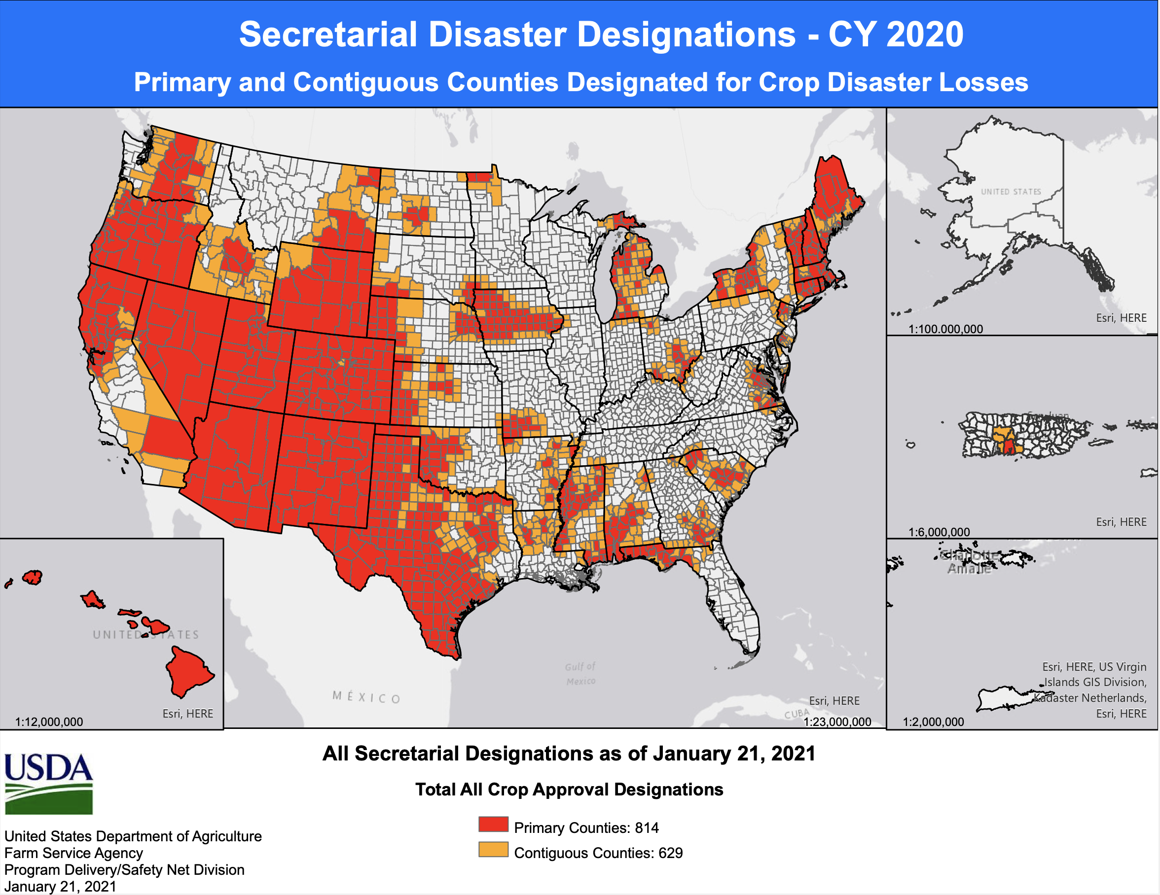
Secretarial Disaster Declarations as of January 21, 2021.
Smith said the estimate includes a broad range of quantifiable costs, such as damage to commercial and residential properties, crop losses, increased feeding costs for livestock and spending on fighting wildfires…
A Thirstier Atmosphere Dries Out Farms and Drives Fires
Mistie Christiansen, who oversees USDA Farm Service Agency programs in central Utah’s Emery and Carbon counties, said the climate trends are disrupting life on the land and the people who depend on it.
“Ponds are dry; streams are dry; springs that would normally have supplied livestock and rangeland are dry; rivers are historically low,” she said. “It’s the compound factor of multiple years of this issue that’s really hard. People are really struggling.”
Area ranches and farms that depended on irrigation from Muddy Creek ran out of water by the end of last June. Her family cut just one crop of hay instead of the usual three and had to spend $45,000 to buy more to feed its livestock. This year, they’re expecting to spend at least $30,000 to make up for what the desiccated land cannot provide. Meanwhile, the cows are weaker and pregnancy rates are down, she said.
Based on the string of rough years and how things are looking now, Christiansen said she wouldn’t be surprised to see another bad year for livestock growers. “And if things don’t change, you’ll see a major sell off,” she said.
Despite the pain that global warming brings to rural communities like hers, Christiansen believes a higher power is changing the climate, not humans. Still, she shares one view with many climate scientists.
“There’s no longer normal,” Christiansen said. “I would love to see what is normal anymore, because we just swing from extremes.”
Jeff Lukas, an independent climate consultant in Colorado, said the world’s rapid warming is making the atmosphere thirstier “and that is so apparent in the second half of 2020.” Dry years can happen in the absence of climate change, he said. But the atmosphere’s capacity to hold more water, which leads it to suck moisture from the soil, trees and snowpack, has increased significantly in response to what might seem like an insignificant amount of warming—about 2 degrees Fahrenheit.
“What [last year] will be mostly remembered for, from a weather and climate perspective, is how things dried out so much in the summer and fall as a result of both low precipitation and very high temperatures,” said Lukas, who tracked climate and weather events at the Western Water Assessment for more than a decade. The dryness “led to the kind of fuel conditions and fire weather, that led to those incredible wildfires in August and September.”
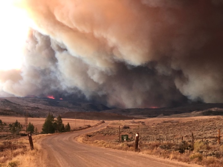
East Troublesome Fire. Photo credit: Brad White via The Mountain Town News
For Lukas, one day-long period of extreme fire behavior last year stands out: when Colorado’s East Troublesome Fire ran 20 miles, expanding from 18,000 acres to 180,000 acres, eventually jumping over the Continental Divide in Rocky Mountain National Park last October. He noted that the heat, aridity and winds that set the stage for the blaze are not completely unheard of in autumn. But for such a fire to ignite and grow into the second largest blaze in state history in October, a month that is normally cool and moist, is unprecedented…
2021 Set Up For More Heat and Drought
No one’s started using the word “scary” yet, but all reports seem to suggest 2021 could bring more of the same.
The snowpack for the Colorado River’s four Upper Basin states—Utah, Wyoming, Colorado and New Mexico—is 67 percent of average. That puts this year on par so far with 2018, which went on to be a terrible year for wildfire, drought and heat.
With reservoirs already low, the U.S. Bureau of Reclamation recently nudged those states to prepare for implementing the Upper Basin Drought Contingency Plan so Lake Powell can continue next year to meet the demands of the 40 million people who rely on Colorado River water.
The water that’s flowed into Lake Powell since October is 44 percent of the normally expected flow.
Drought is expected to persist into spring, and odds are that Colorado River Basin states will remain warmer and drier than normal, too.
“There really isn’t any good news for water resources in the Colorado River Basin right now, which is raising a lot of red flags coming into the upcoming year,” said Jon Meyer of Utah’s Climate Center.
Moraine Park and the headwaters of the Big Thompson River in Rocky Mountain National Park. Moraine Park is on the east side of the park and of the continental divide, near the town of Estes Park. This region has a number of areas call “parks”, which refer to open, level areas in the mountains, usage which comes from the French word parque. The names of these areas predate the establishment of the national park and are unrelated to the use of the word “park” in that context. By The original uploader was Kbh3rd at English Wikipedia. – Transferred from en.wikipedia to Commons., CC SA 1.0, https://commons.wikimedia.org/w/index.php?curid=1009783
Peaks to People Water Fund have launched its Big Thompson Initiative in Northern Colorado to proactively treat wildfire risk through accelerated forest restoration and stewardship in the watersheds.
The Big Thompson watershed’s water infrastructure supplies between 40 percent and 55 percent of Fort Collins, Loveland, and Greeley’s annual water needs, providing water to 30 additional towns and cities along the state’s front range. The state’s forests have become dense and overgrown after years of protection from wildfire, which has increased the risk of severe wildfires such as the Cameron Peak Fire that threaten water supplies with sedimentation and debris.
“Living in an environment where fire is part of the natural cycle is our reality in Northern Colorado, but Peaks to People and its partners are working to return the forest to a healthy condition that minimizes the intensity of fires when they do strike,” said Alex Castino, Great Outdoors Colorado Land Protection Program Officer. “This allows people and small businesses, plants and animals, waterways and water infrastructure, to bounce back quickly and thrive in this beautiful place we all call home,” Alex said.
East Troublesome Fire and Cameron Peak Fire map via Inciweb December 7, 2020.
The Cameron Peak and East Troublesome wildfires west of Fort Collins emphasize the urgent need for proactive treatment with a combined cost of over $149 million to suppress them and more than 1,000 miles of river impacted. The Peaks to People Water Fund team has analyzed and determined that treating 37,000 acres within the 575,000-acre Big Thompson watershed could reduce 90 percent of severe fire risk while conserving the forests most essential for water supply.
Peaks to People plans to invest a total of $90 million through the Big Thompson Initiative over the course of the next ten years to restore forests to their natural state and reduce the risk of severe wildfires. Treatments are costly at as much as $3,600 per acre with Peaks to People working with partners to leverage funds to stretch contributions…
Peaks to People have partnered with the Colorado State Forest Service, Nature Conservancy of Colorado, Big Thompson Conservation District, Larimer County Department of Natural Resources, Colorado Forest Restoration Institute, Brendle Group, and the Center for Collaborative Conservation to make this initiative successful. More funding must be raised to accomplish the initiative’s goals even though some funding is already in place.
Fishing the Big Thompson River. Photo credit: Larimer County
The San Juan Water Commission is considering asking for a release of Animas-La Plata Project Water. This water is stored in Lake Nighthorse in Durango, Colorado.
If the commission chooses to move forward with the release, it would be the first time that water is released from Lake Nighthorse upon the request of the San Juan Water Commission.
During the drought of 2018, the San Juan Water Commission took steps to request a release on behalf of the City of Farmington. However that release was cancelled as storms brought rain to the Four Corners region.
The water commission has been discussing a release from Lake Nighthorse as a test run that would allow it to address potential issues that could emerge. For example, making sure the water released from the reservoir reaches its intended destination.
The San Juan Water Commission meets at 9 a.m. Feb. 3 via Google Meets. A link is available on the agenda posted at sjwc.org.
Other agenda topics include legislation and long-term water development opportunities.
An excavator works in the bed of the Roaring Fork River near Basalt below a temporary dam. Boulders were being arranged to create one of two grade-control structures that will smooth out a section of river previously home to a steep drop created by a weir that channeled water to a diversion ditch. Photo credit: Curtis Wackerle/Aspen Journalism
Work currently underway in the Roaring Fork River between old town Basalt and Willits will make for a smoother ride for boaters beginning this spring.
The project, with an estimated price tag of $935,000, requires a temporary cofferdam during construction across much of the river’s channel, with heavy machinery in the exposed river bed. It will create two new “grade-control” structures to replace a weir that was used to channel water toward a diversion for the Robinson Ditch. That weir created a difficult passage for boaters that was often referred to as Anderson Falls.
Instead of that steep drop with no clear passage around or through, the project has been designed by Carbondale-based River Restoration to create a gradual riffle drop between the grade-control structures. The Robinson Ditch diversion structure, which delivers raw water for outdoor irrigation from April through October to customers in the Mid Valley Metropolitan District, will also be rebuilt as part of the project.
An excavator arranges boulders to create one of two grade-control structures in the Roaring Fork River, part of a $935,000 project to smooth out a section of river previously home to a steep drop. Photo credit: Curtis Wackerle/Aspen Journalism
Work on the project, which was approved for funding in March by Pitkin County’s Healthy Rivers and Streams board of directors, began in December and is permitted to take place through March 15, said Quinn Donnelly, an engineer with River Restoration.
The weir, he said, created “probably one of the bigger navigation hazards” on the Roaring Fork, resulting in many boaters avoiding that stretch, which is just above a boat ramp near the FedEx facility off of Willits Lane.
“We are trying to make a natural riffle here” that meets the needs of boaters, Donnelly said. Making that stretch of the middle Roaring Fork more accessible might also have the added benefit of taking pressure off other stretches of river and more crowded boat ramps farther downvalley, he said.
The project should also improve fish habitat as water scours the riverbed around the newly placed boulders.
The cofferdam is blocking the river across most of the channel, funneling the Roaring Fork’s winter flow into a series of culverts on river right. On Thursday morning, an excavator was picking up 3- to 6-foot-diameter boulders and arranging them in a line to form the upper grade-control structure. The site is visible from the bike path connecting Willits Lane to Emma Spur.
Donnelly said that most of the boulders that were being placed this week will be buried by alluvium below “scour depth,” with more rocks placed on top. The project has been designed to keep the ditch headgate clear of sediment and debris carried downstream.
Once the grade-control structures are completed, the current cofferdam will be removed. A second temporary cofferdam will be installed at river right to allow for the new headgate to be built. That, too, will be removed before the project is complete and the river flows unimpeded through the section.
As of last year, project planners had secured $256,200 in grants, including a $171,216 Colorado Water Plan grant and a $45,000 Water Supply Reserve Fund grant from the Colorado Water Conservation Board, as well as a $40,000 Fishing Is Fun grant from Colorado Parks and Wildlife.
Pitkin County’s Healthy Rivers fund, supported by a 0.1% sales tax, will cover the difference when all grants have been applied, said Lisa MacDonald, who works in the Pitkin County Attorney’s Office and provides staff support for the Healthy Rivers program.
MacDonald and Donnelly credited the Roaring Fork Conservancy and the Roaring Fork Fishing Guide Alliance for supporting the project. Donnelly noted that in any river project, there are myriad interests in play involving water users, riparian habitat and recreation. It is a balancing act, he said, but a successful model involves bringing stakeholders together and that has been the goal here.
The Roaring Fork River flows through culverts while being channeled around a temporary dam put in place to allow contractors to work on a project to smooth out a section of river previously home to a steep drop. Anderson Falls, which was created by a weir that funneled water into a diversion ditch, will be gone this spring. Photo credit: Curtis Wackerle/Aspen Journalism
Robinson Ditch Co. president Bill Reynolds, who is also the director of the Mid Valley Metropolitan District, said he’s happy to see the project making progress and believes it will enhance the experience for river users.
The ditch company paid for the engineering and design of its diversion infrastructure, he said. That infrastructure makes it possible for users in a wide swath of the midvalley to irrigate using raw water, as opposed to more-expensive treated potable water, which the district also provides via a series of wells, he said.
Ditch companies typically rely on government grants to make infrastructure improvements, he said, expressing gratitude for Pitkin County’s model of supporting river projects.
“Pitkin County and the funding mechanisms they’ve been using have been a blessing,” Reynolds said.
This story ran in The Aspen Times on Jan. 30.
The headgate for the Robinson Diversion is located on river right, just upstream from the boat ramp on Willits Lane on the Roaring Fork River. The Pitkin County Healthy Rivers Board is moving forward on a nearly $1 million project to fix the Robinson Diversion structure. Photo credit: Heather Sackett/Aspen Journalism
The headgate for the Robinson Diversion is located on river right, just upstream from the boat ramp on Willits Lane on the Roaring Fork River. The Pitkin County Healthy Rivers Board is moving forward on a nearly $1 million project to fix the Robinson Diversion structure. Photo credit: Heather Sackett/Aspen Journalism
The Robinson Diversion, located just upstream from the boat ramp on Willits Lane has long presented a hazard for boaters on the Roaring Fork River. Pitkin County Healthy Rivers has secured roughly $256,000 in grant money to permanently fix the area. Photo credit: Heather Sackett/Aspen Journalism
A view of the headgate on the Robinson Ditch and the boulder structure in the Roaring Fork River that maintains the grade of the river so water can reach the headgate. Pitkin County has received a water-plan grant to help repair the diversion structure and improve boating passage. Photo credit: Brent Gardner-Smith/Aspen Journalism
New Mexico water agencies are urging farmers to think twice about planting crops in what could be a tight water year. The state faces a big water debt to downstream users, and a multi-year drought is taking its toll.
The Office of the State Engineer recommends “that farmers along the Rio Chama and in the Middle Valley that don’t absolutely need to farm this year, do not farm,” according to a staff report that Interstate Stream Commission Director Rolf Schmidt-Petersen presented to the Commission earlier this month.
Irrigation supply along the river from Cochiti Dam to Elephant Butte Reservoir is governed by the Middle Rio Grande Conservancy District. The district cut its 2020 irrigation season a month short, because there wasn’t enough water to go around. A shorter season also helped deliver some river water to Elephant Butte as part of New Mexico’s Rio Grande Compact obligations.
In January, the district board voted to delay the start of the 2021 season until April 1, a month later than usual.
This year is on track to be a situation of water shortages and storage restrictions unlike any since the 1950s, said Mike Hamman, the district’s chief engineer and CEO and an Interstate Stream Commissioner. The district also anticipates receiving as little as half the usual allotment of San Juan-Chama water.
“The hydrology really started to shift in the early ’90s,” Hamman said. “We’ve got into this cycle of below-average, average, above-average years, and I’ve noticed that our climatic conditions (limit) the available snowpack. That exacerbates things a little bit more now, where we need to have well-above-average snowpacks to address the poor watershed conditions that may have resulted from a poor summer rain period or fall moisture.”
[…]
Regional farmers are advised to prepare for severe water shortages by exercising “extreme caution” in planting crops this spring and by using any available water only for the most essential uses…
The current Rio Grande Compact water debt of about 100,000 acre-feet, or 32 billion gallons, restricts how much the state can store in reservoirs.
By the end of January, the state will have released about 3,200 acre-feet, or about 1 billion gallons, of “debit water” from El Vado and Nichols Reservoir near Santa Fe to Elephant Butte.
Last year’s monsoon season from May to September was the driest on record for New Mexico.
The Rio Grande could go completely dry this summer all the way from Angostura Dam north of Bernalillo through Albuquerque, especially if this year brings another lackluster monsoon season…
‘Last page in our playbook’
The fail-safe options New Mexico relied on last year to stretch the Rio Grande water supply won’t be available this year. This summer on the river may look like what water managers and environmental groups worked to stave off during last year’s hot, dry summer months.
The Middle Rio Grande didn’t look good in July 2020. The MRCGD had just a few days of water supply left.
No water could have meant no irrigation for farmers, but also limited river habitat for endangered species, scarce drinking water supply for local communities, and meager flows for river recreation.
Then came word from the other Rio Grande Compact states of Colorado and Texas: New Mexico had permission to boost river flows by releasing a total of 12 billion gallons from El Vado Reservoir.
“That was the last page in our playbook, or pretty darn close to it,” Schmidt-Petersen told the Journal.
The release kept the Rio Grande from drying completely in the Albuquerque stretch and helped extend the irrigation season for central New Mexico farmers.
Colorado River water diverted via the San Juan-Chama Project also added to the trickling native Rio Grande flows.
Last summer’s massive release from El Vado was water that had been stored as assurance that the state’s Rio Grande Compact debt would be paid.
That water is gone. New Mexico still has to “pay back” the 12 billion gallons, plus any obligations accrued this year.
State Engineer John D’Antonio said the drought is shaping up to be as severe as the conditions the state experienced in the 1950s.New Mexico Drought Monitor January 26, 2021.
Gov. Michelle Lujan Grisham’s December 2020 emergency drought declaration could provide some financial relief for communities affected by the record-setting dry conditions.
“There could be appropriated up to $750,000 for each eligible and qualified applicant that the governor may designate from the surplus unappropriated money in the general fund, if there is any,” D’Antonio said.
The state Drought Task Force would determine which organizations or local governments receive the money, which under the emergency declaration could be used for water conservation projects, to offset economic losses caused by the drought, or as a match for federal funding.
Dylan Wilson on the banks of the Rio Grande near Las Cruces, N.M. Photo credit: Allen Best
Gloomy forecast
New Mexico will endure another double whammy of limited water supply and growing Rio Grande Compact water debt if snowpack levels don’t improve dramatically by early spring.
Statewide snowmelt runoff forecasts published Jan. 1 showed most of New Mexico at less than 80% of normal levels.
Since then, some snowstorms have brought much-needed moisture to the northern half of the state.
But New Mexico needs several months of above-average snow and rain to dig out of a drought before the hot summer months.
Westwide SNOTEL basin-filled map February 1, 2021 via the NRCS.
Groundwater wells in the lower Rio Grande region of southern New Mexico supply water for municipal and agricultural uses when the river is low.
“That’s not the same in the middle valley for all the farmers there,” Schmidt-Petersen said. “There are limitations on wells that have been in place for long periods of time, so some places can pump and some cannot, and similarly all the way up the Chama.”
Various efforts along the river or tributaries annually remove about 1.2 million tons of salt. But the largest brine-removal system in the basin has been shuttered for two years over earthquake concerns. In December, President Donald Trump’s outgoing administration released a final environmental review on what to do about it.
The chosen course: No action, leaving the fate of the project and of salt removal murky. Now local suppliers say they will be pressing the Biden administration to do the opposite.
“For the last two years the salt has been flowing back into the river,” said Bill Hasencamp, chair of the Colorado River Basin Salinity Control Forum, which represents all of the states that draw from the river. “We were very disappointed. There’s no plan to capture [it] going forward.”
Water suppliers have filed comment letters about the “no action” decision and sent letters to former Reclamation Commissioner Brenda Burman. The average annual economic loss from salinity levels in the Colorado River is estimated to be $495 million, Reclamation said in its environmental review.
Seismic Threat
At issue is the Paradox Valley Unit near the Colorado-Utah border. The project, in operation since 1996, took saline groundwater before it could hit the Colorado and the Dolores River, a tributary, and injected it more than three miles beneath the surface into a well disconnected from the river system. About 95,000 tons of salt were removed each year.
But injecting, like hydraulic fracturing, can cause seismic shifts.
Reclamation shut down Paradox Valley in March 2019 after a magnitude 4.1 earthquake, which the U.S. Geological Survey considers moderate in size. Operations resumed for a six-week test at reduced use in spring 2020, but the well currently isn’t operating.
Technical experts are evaluating next steps and it’s too soon for the agency to propose a new salinity control plan, Reclamation spokeswoman Linda Friar said in an email.
The agency currently doesn’t plan to issue a record of decision, which would finalize the “no action” plan Reclamation selected, she said.
Hasencamp, also manager of Colorado River resources for the Metropolitan Water District of Southern California, and others had pushed for that delay in comments filed with Reclamation earlier this month…
Rejected Options
In its environmental review, Reclamation considered and rejected building a new injection well, using evaporation ponds for brine to be treated at the surface, and building a discharge facility to evaporate and condense water before sending salt to a landfill.
The “no action” alternative was “in the best interest of public health and safety,” Ed Warner, Reclamation’s Western Colorado Area office manager, said in a news release.
James Eklund, former director of the Colorado Water Conservation Board, said when he served as the state’s representative on salinity control programs, he was “pretty adamant” that the bureau should switch from earthquake-causing deep injection wells to evaporating ponds in order to deal with the saltwater. Eklund is now at Denver-based Eklund Hanlon LLC…
Economic Losses
But more than 600 miles south, the loss of Paradox Valley could increase salinity levels at Imperial Dam by 9 to 10 parts per million, which could lead to $23 million in estimated economic losses each year, Harris, from the Colorado River Board of California, said in a December letter to Burman, a Trump appointee no longer in office.
The EPA doesn’t have a drinking water standard for sodium chloride, but it has a voluntary standard of 250 parts per million for chloride, a component of salt. Voluntary standards are generally related more to aesthetic concerns like taste and appearance.
“It’s not huge, but we get essentially a ton of salt in every acre-foot of water,” said Tina Shields, water manager for Imperial Irrigation District, which borders Mexico. “If you don’t continue to implement these upstream salinity control measures by default, it can only go up.”
Nearly all farmers in the Imperial Irrigation District have drains installed beneath the surface to leach salt away from crops, which requires even more water. But that’s not a permanent solution.
Imperial is the last stop for water before it gets into Mexico, where the Colorado River delivers water to 2.3 million people and 500,000 acres of agriculture…
Expensive Treatment
Urban areas will be able to weather the salt problem better than agricultural ones because they have mass treatment to comply with drinking water standards, said Patricia Mulroy, former general manager of the Southern Nevada Water Authority and owner of the consulting firm Sustainable Strategies.
Paradox Valley Location Map. Credit: Bureau of Reclamation
The Paradox Valley in western Colorado, a place with uranium mineral deposits. (Photo by Emily Hunnicutt via Flickr: Creative Commons)