FromThe Grand Junction Daily Sentinel (Dennis Webb):
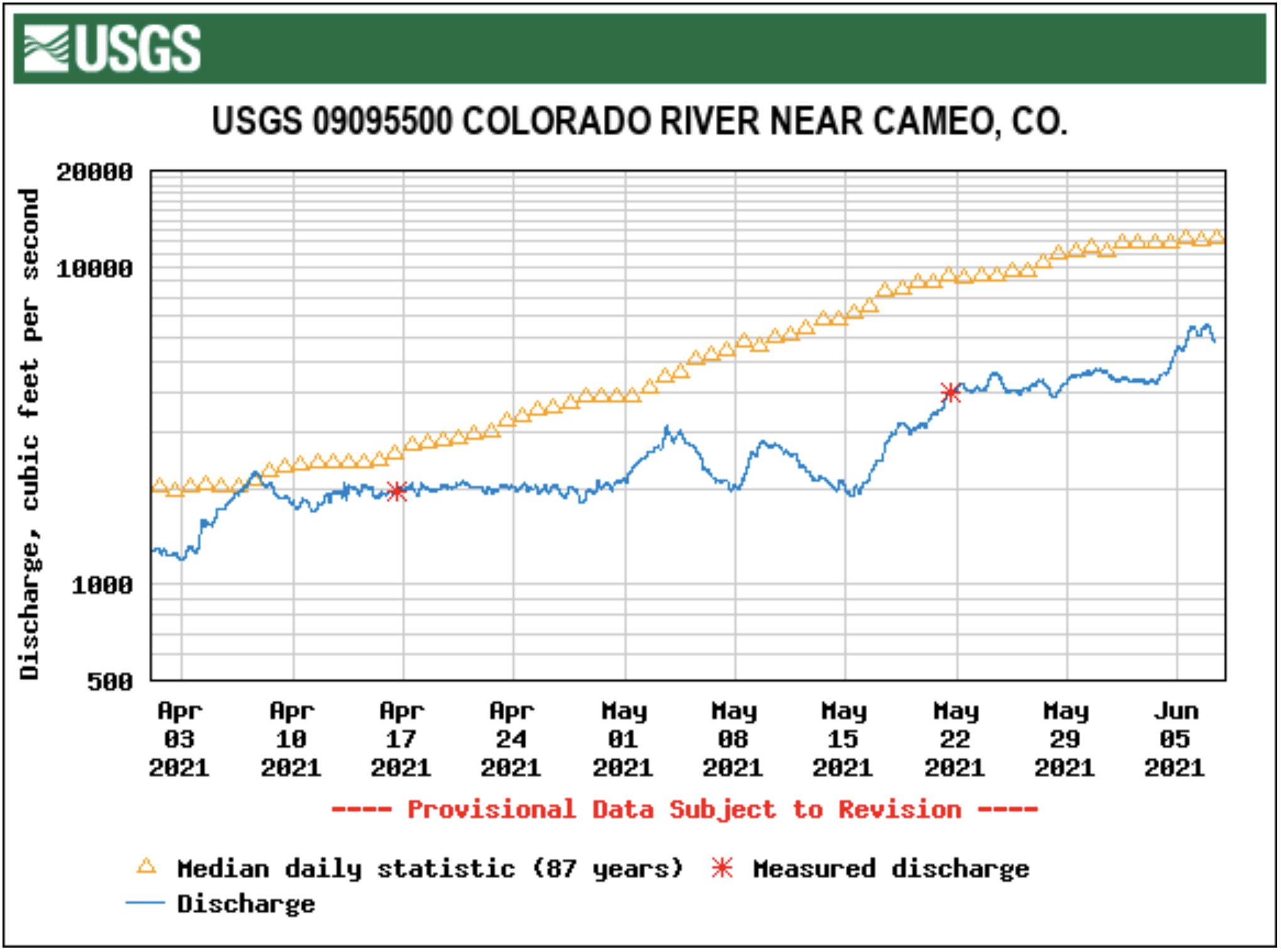
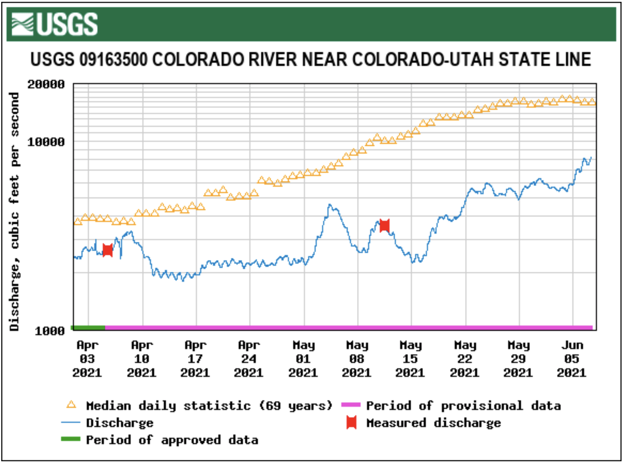
As of mid-day Friday, though, the U.S. Geological Survey gauge at Cameo was recording a relatively calm river flow — 4,840 cubic feet per second, compared to an average 12,700-cfs flow there for that date. Flows near the Colorado-Utah border were 5,860 cfs, a bit more than a third of average for that date.
Warming temperatures in recent days are accelerating snowmelt and boosting runoff some. Erik Knight, a hydrologist with the federal Bureau of Reclamation, said Friday that the federal Colorado Basin River Forecast Center was showing flows at Cameo likely hitting their seasonal peak by today, but at about 7,500 cfs, well below the typical 12,000-13,000 cfs average peak.
Said Russ Schumacher, state climatologist at the Colorado Climate Center at Colorado State University, “The streamflows throughout western Colorado are not looking good at this point and there’s not that much snow up there left to melt.”
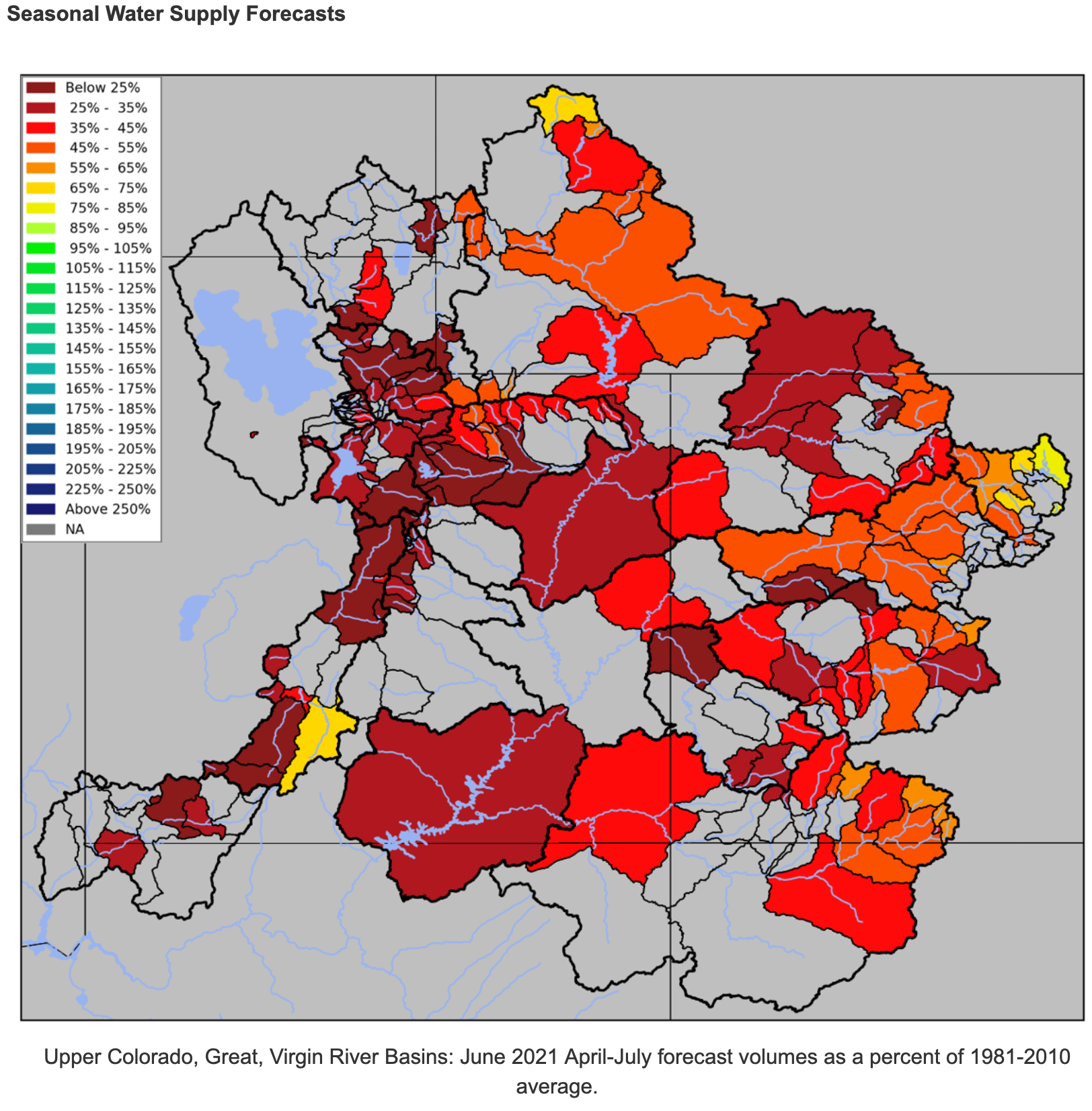
A continuing drought in western Colorado and beyond is having both in-state and more regional implications. The Colorado Basin River Forecast Center is now projecting that April-July inflows into Lake Powell will be just 25% of average.
The Upper Colorado River Commission, an interstate agency with representatives from Colorado, other Upper Colorado River Basin states and the federal government, noted in a May 20 news release that the water elevation in Powell was at 3,560.6 feet and is approaching its lowest recorded level since the reservoir began filling in the early 1960s. The Bureau of Reclamation reports that at the end of April, Powell held 8.5 million acre-feet of water, 35% of its live capacity. That’s the amount of a reservoir that can be used for purposes such as downstream release and power production.
May 2021 percent of normal precipitation. (Averaged by basins defined in the CBRFC hydrologic model). Map credit: Colorado Basin River Forecast Center
The Upper Colorado River Commission issued its news release to announce that Upper Basin states and the Bureau of Reclamation will begin development of a drought response operations plan, as called for under a 2019 agreement between the states and the Bureau of Reclamation. That’s after Reclamation last month said its most probable forecast is for the water level in Powell to fall to 3,525.57 feet in elevation as early as March 2022…
The response plan would seek to keep Powell from falling below 3,525 feet, to help assure Upper Basin states can continue complying with a century-old compact for sharing Colorado River water with downstream states, and not jeopardize hydropower production at Glen Canyon Dam…
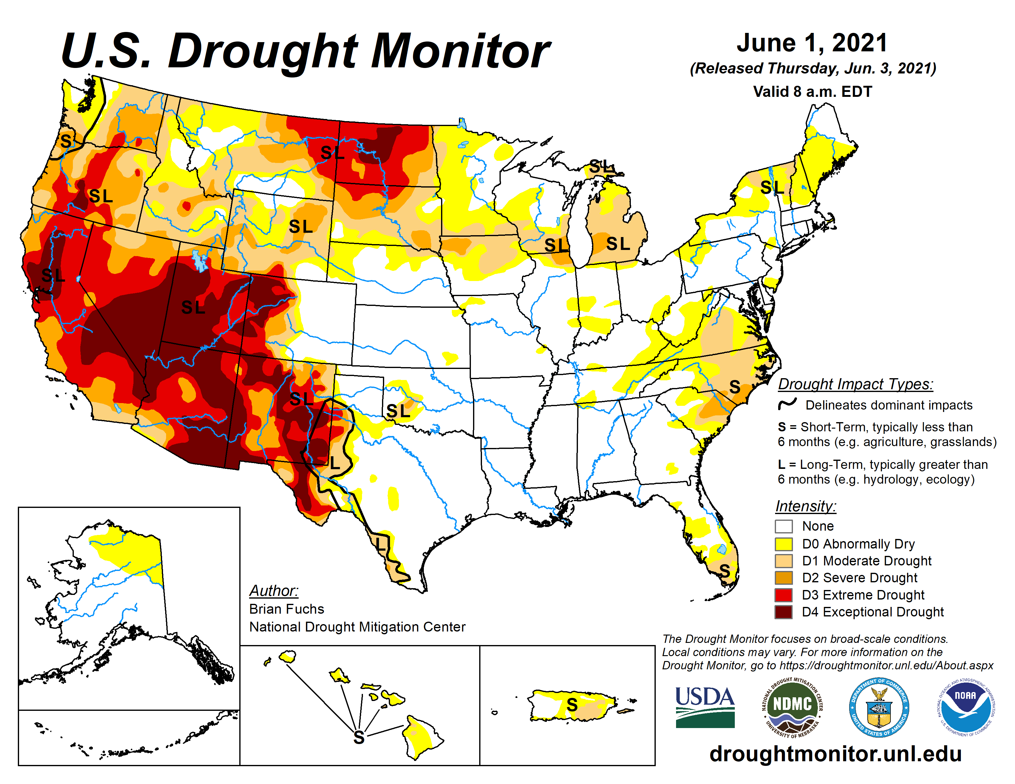
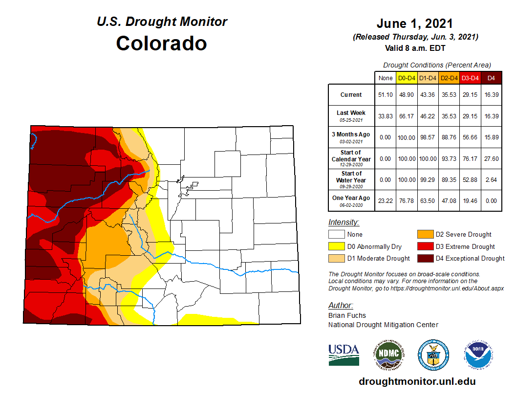
US Drought Monitor map June 1, 2021.
Currier said there’s concern about what limits federal land managers might put on grazing allotments due to the dry conditions.
Currier and other Interbasin Compact Committee members will be considering some of the bigger-picture drought issues at a meeting later this month. The Upper Basin states wouldn’t have to finalize a drought response operations plan until the Bureau of Reclamation finds it probable that Powell’s level will fall to or below 3,525 feet within 12 months, and only after consultation with Lower Basin states. However, the Interior secretary, consulting with basin states, also could take emergency action to keep the reservoir level above that threshold…
THE PLAN’S APPROACH
As agreed to in 2019, the Powell drought response plan would first consider making use of existing operational flexibilities in Powell, within legal and operational constraints. If that’s not enough to keep Powell’s water elevation above 3,525 feet, they will consider releases from Flaming Gorge, Blue Mesa and Navajo reservoirs upstream.
Aspinall Unit
“Blue Mesa doesn’t really have enough water in it to contribute a whole lot,” Currier said.
Knight said Blue Mesa is only about 43% full, probably half of normal this time of year, and seasonal runoff inflows into the reservoir this year are now projected to be just 46% of average…
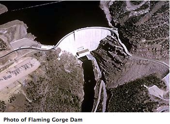
Flaming Gorge Dam. Photo credit: USBR
Currier thinks Flaming Gorge is the likely candidate for boosting Lake Powell water levels if help from upstream reservoirs is required…
Upstream reservoir releases also are only a short-term fix, Currier said. Officials are looking longer-term at approaches including managing demand for water through reduced consumptive use, but consumptive use is directly related to crop production, he said.
“Reduce your consumptive use, you’re probably producing less crops. That’s not a good solution for agriculture,” he said.
And then there’s the question of how to ensure that any water saved through such measures actually makes it down to Lake Powell, rather than simply being used by other water users upstream…
[Russ] said that so far in Grand Junction this water year, which started Oct. 1, is the sixth-driest on record. It’s drier than the previous water year through the same date…
Since Jan. 1, 2.04 inches of precipitation have been recorded at the Grand Junction Regional Airport, compared to 3.8 on average through this time of year.
Since March 1, average temperatures have been warmer than normal in Grand Junction, but only marginally so, by 0.3 degrees, said Erin Walter, a meteorologist at the National Weather Service in Grand Junction. But local temperatures over that time are still cooler than last year, she said.
Summit County received a $300,000 grant from the National Fish and Wildlife Foundation, among other partners, to restore the area’s riparian floodplain, wetlands and upland habitat.
The foundation awarded $3.1 million to 10 habitat restoration projects across the state from its Restoration and Stewardship of Outdoor Resources and Environment — or RESTORE — Colorado program. Grant awards from this fund are meant for projects on public and private conservation lands that have the greatest benefit for wildlife habitat and local communities.
The grant will contribute to a project meant to improve habitat quality and connectivity for native cutthroat, brown and brook trout species in the Swan River Valley. The project will restore 0.8 miles of the main stem of Swan River as well as 30 acres of riparian and upland habitat.
Colorado’s western slope remains trapped in extreme and exceptional drought while the eastern plains and portions of the San Luis Valley and northern front range have moved to drought-free conditions. More than half of the state is now listed as drought-free.
Colorado Drought Monitor map June 1, 2021.
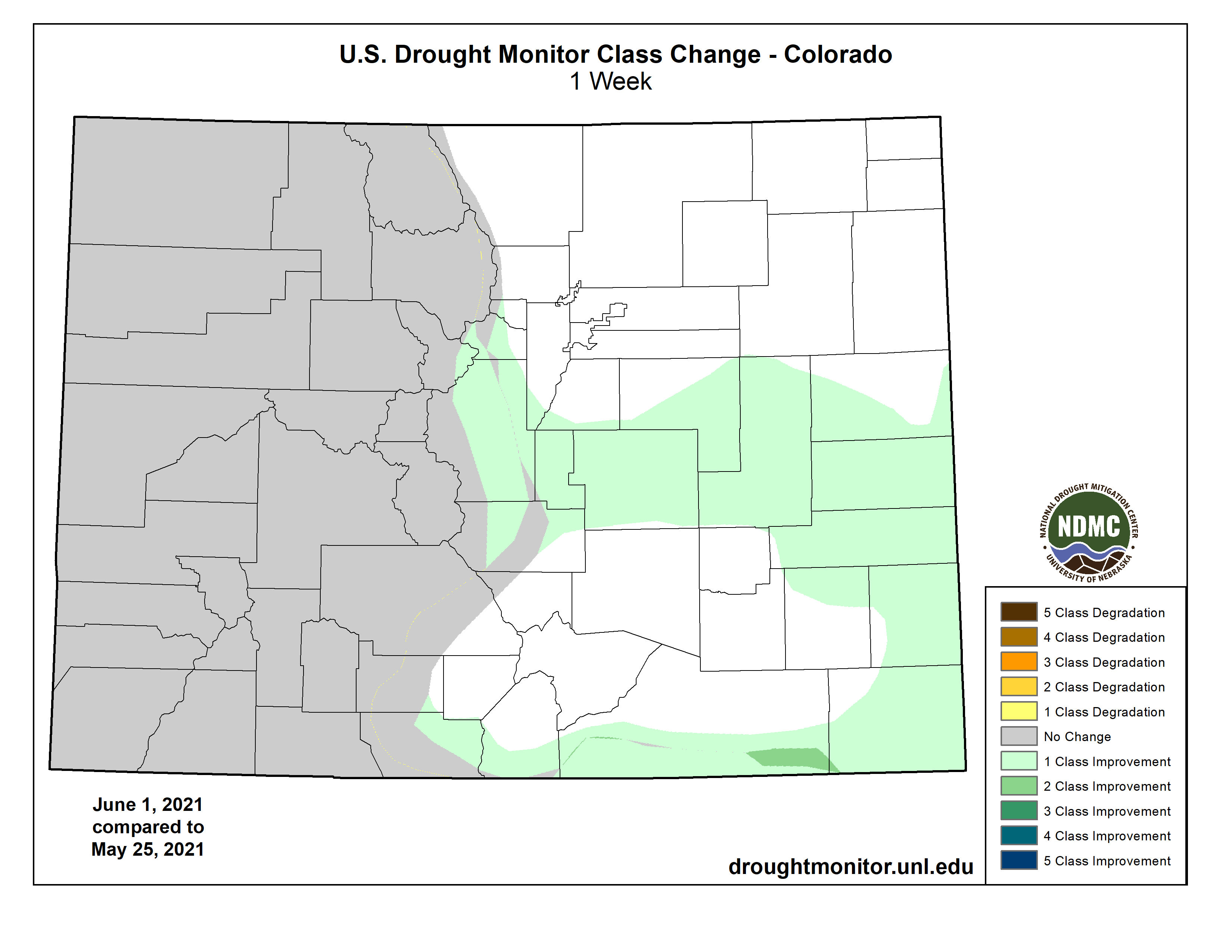
This week, parts of east central and southeast Colorado which were abnormally dry last week shifted to become free from drought. Some areas received as much as 150 percent of their normal rainfall for the week according to the National Drought Mitigation Center.
A strip of moderate drought in southern Las Animas County is now abnormally dry.
Improvements in the eastern half of the state began in mid-March as significant snow provided initial relief. During May, thunderstorms continued to bring rain to Colorado’s eastern plains, resulting in drought-free conditions for most northeast counties by the end of the month.
Colorado Drought Monitor one week change map ending June 1, 2021.
The first drought-free area in Colorado since mid-2020 appeared in late April.
The USDA noted that crop conditions continued to improve following recent moisture. Western counties have received little recent rain, and have experienced windy conditions. Red flag warnings from the National Weather Service have regularly been issued for high fire danger. Area reservoirs are at extremely low levels, limiting options for crop irrigation.
Overall, 51 percent of the state is drought-free, up from 34 percent last week, with an additional six percent in abnormally dry conditions, down from 20 percent in the previous week. Moderate drought covers eight percent of Colorado, down from 11 percent, while severe drought remains unchanged at six percent. Extreme and exceptional drought were also unchanged at 13 and 16 percent, respectively.
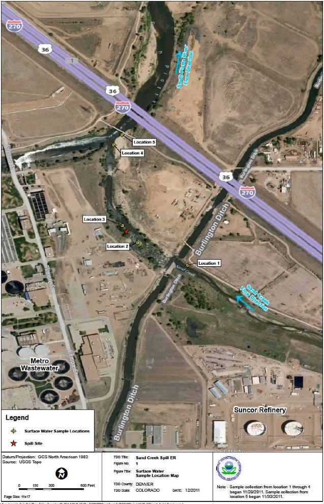
Two oil stains within eight days at Sand Creek near the Sankoa Energy Refinery have caused state health officials to worry that the 20-year-old underground clay wall containing toxic chemicals isn’t working. ing.
More than a year ago, the Colorado Department of Public Health and Environment ordered Sanko to replace a wall that stretched about 2,000 feet below about 30 feet parallel to Commerce City’s creek, records show. That mission came after a similar oil slick, And Suncor is set to begin designing wall modifications at the end of July.
“The refinery is in the final stages of planning to improve the boundary barrier system and is working with CDPHE on these plans. Work is expected to be completed in 2021 and will be more effective along Sand Creek. A barrier system will be built, “said Suncor spokeswoman Mita Adesanya in an email.
This is a sensitive moment for Suncor.Colorado officials Review Company application to update Outdated business license. Due to equipment failures and other failures at the refinery, 15 accidents occurred between March 27 and April 22 this year, and more than 100 failures occurred at the refinery in the last five years. , Air pollution has exceeded the permissible range. Since 2011, Colorado has settled at least 10 proceedings against Suncor.
A Sanko official said in an email on Friday that he was investigating the cause of the recent oil slick. On May 22 and May 31, Sand Creek’s public bike paths and green roads popular for fishing Occurred along.
Sanko and state officials do not expect permanent effects on creeks and wildlife, but “trends in groundwater data indicate that walls are less effective.” Was sent by director Jennifer Opira, according to a June 2 email received by The Denver Post, to local government officials in CDPHE’s Hazardous and Waste Management Department.
The cause of the May 22 spill has not been identified, Opila said in an email, but said it could have been due to a “May 20 power outage.” The refinery side of the wall, she said.
“It’s likely that groundwater levels have risen during this closure,” she wrote, and petrochemicals “flowed on and through walls,” she wrote. An emergency generator was installed to pump contaminated groundwater from the refinery side of the wall.
On May 31, a fuel leak at the refinery flowed down the road into an outdoor basin and then reached a stream, according to state officials. Suncor deployed three orange booms and vacuum trucks to clean them.
Along the green road on Thursday, fisherman Mike Medina threw a fishing line for carp in a Burlington irrigation ditch near the spill site…
According to state records, benzene levels at the time of the spill were as high as 3,900 ppb in refinery groundwater. This is more than the federal drinking water standard of 5 ppb. Colorado’s current water quality standards have been relaxed in industrial areas, allowing up to 5,300 ppb of benzene in Sand Creek.
Benzene levels found in pipes discharged to Sand Creek first soared beyond Sanko’s permit limits in the first week of June, but soon disappeared, according to state officials.