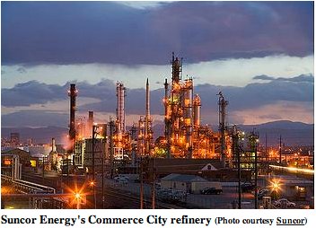
The Suncor refinery in Commerce City is pictured on Sand Creek near where it meets the South Platte River. Both streams have highly challenged water quality, though many conservationists argue they can get still better. Photo credit: Suncor
Clean water advocates say a state commission is preparing to double down on a bad decision last year that failed to protect Clear Creek and the South Platte, and that a broader ruling may endanger more pristine streams.
year ago, the state’s water quality commissioners overruled not only their staff but other state agencies like Colorado Parks and Wildlife, along with a broad and very angry coalition of conservation groups.
Now, according to the conservation groups, the commission is about to do the same thing again. Only this time, the river advocates say, their proposals threaten every river in the state, weakening a bedrock 33-year-old rule the state uses to implement the federal Clean Water Act.
Colorado industries and city wastewater plants could legally dump more pollution into state rivers if water quality commissioners endorse this year’s plan while also sticking with last year’s changes, conservation groups say.
They argue the actions would mean the potential reversal of intensive efforts to clean city waters flowing past low-income areas already heavily impacted by economic and environmental problems.
They claim it opens the way for water dischargers like Metro Wastewater, Molson Coors and others to seek permits for discharges that would further degrade waters they themselves have already tainted.
“It’s just going to roll the clock backwards on pollution,” said Mely Whiting, legal counsel for the Colorado chapter of Trout Unlimited.
Last year, the Colorado Parks and Wildlife division argued to upgrade protection of the South Platte and Clear Creek by saying there is “no evidence that pollution is irreversible,” according to supporting statements filed at the state. The Water Quality Control Commission in June rejected stronger protections for those urbanized stretches of water, including Clear Creek, which flows out of Golden and past the Molson Coors plant on its way to the South Platte.
“I’ve always felt that a strong anti-degradation policy is very important in Colorado,” Water Quality Control Commission Paul Frohardt said during last year’s hearing about the South Platte and Clear Creek. “But I also believe that that policy makes sense and will have broad public support when it’s focused on truly high quality waters.”
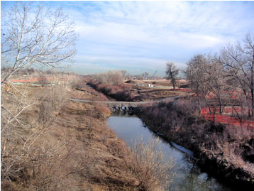
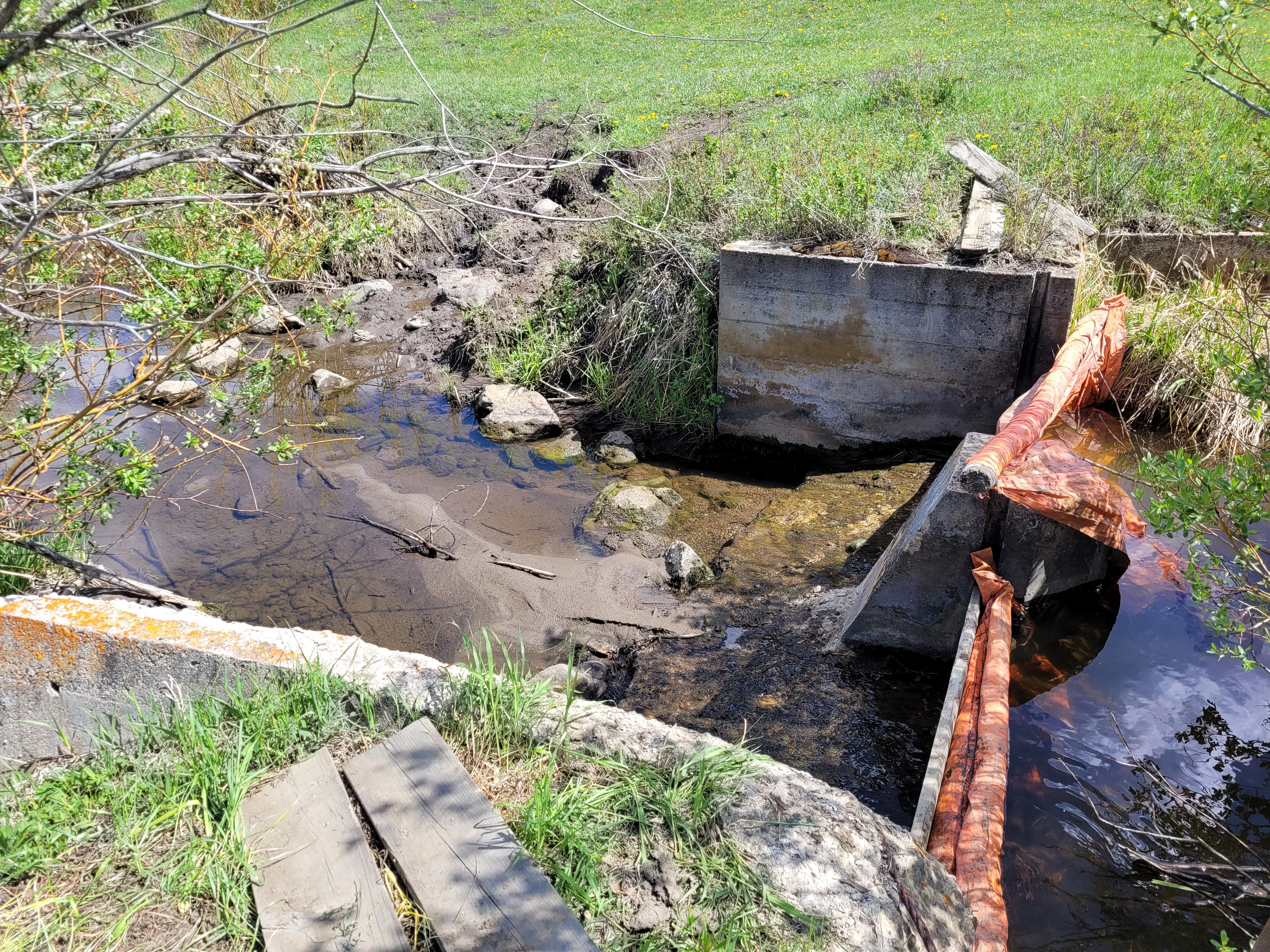
Sand Creek in Aurora.
Now the commission is taking on a scheduled five-year review of the anti-degradation rule applying statewide. Conservationists fear the commission is leaning toward loosening the strictest level of water quality review for all streams.
The “anti-degradation” rule currently in place says polluters seeking a new or renewed water quality permit must make a compelling argument that worsening the conditions of a stretch of river is an unavoidable part of an important economic development or civic improvement.
They must offer this proof even if the given stretch of water is already better than EPA water quality minimums. The state has until now effectively raised the floor of quality as a stream improves, and says those waters can’t be “degraded” below the new floor.
The Water Quality Control Commission has proposed new rules critics say would weaken that long-standing practice, by allowing dischargers to degrade the overall quality of a stream if even one regulated contaminant in the stream is already high.
Fierce opposition by conservationists
Big water dischargers who opposed the upgrade of urban river protections in written statements last year include Metro Wastewater, whose treated discharge makes up most of the water in the South Platte through Commerce City, and heavy industrial water users like Coors, according to state documents.
Metro Wastewater declined to comment. Molson Coors spokesman Marty Malone said in an emailed statement, “We have an established track record of leading water protection initiatives in our industry. We do not support degradation of water quality.”
Now that commissioners are pushing for a statewide weakening of the anti-degradation rule at their June 14 meeting, environmental advocates from Audubon to Trout Unlimited to Conservation Colorado are combining to mount fierce opposition.
Decades of intense and expensive cleanup efforts on urban streams like the South Platte, including by Metro Wastewater, have improved water quality and given the river a chance at more fish, wildlife and recreation, the coalition says. The state’s job is to keep pushing for even cleaner water, Whiting said, not to clear the way for backsliding…
At last year’s hearing, commission chairman Frohardt mentioned concerns of Metro Wastewater and others that they shouldn’t be responsible for further cleaning up river sections like the urban South Platte, because the waters are unlikely to ever support a major improvement in fish and wildlife beyond what they’ve recently achieved…
State officials said Thursday they are writing alternate versions of the change that they hope will satisfy concerns of the conservation groups. The commissioners will hear the various proposals and arguments about them in their June 14 meeting…
State officials have struggled, though, to explain why the regulations need to be changed. Clarifying the rules, Oeth said, will help establish how Colorado rivers got to their current water condition, and “to provide more clear direction to the commission about how to apply that past when they’re considering the specific example of segments in the future.”
[…]
The conservation alliance said the draft alternatives are also unacceptable unless they come with much stronger language guaranteeing the state will include economic justice concerns, and the voices of impacted neighborhoods, when considering controversial water discharge permits.
Clear Creek, Standley Lake watersheds including the Standley Lake Canal Zone via the Clear Creek Watershed Foundation.
The South Platte River Basin is shaded in yellow. Source: Tom Cech, One World One Water Center, Metropolitan State University of Denver.
Here’s the release from Farmers.gov (Joanna Pope):
Nebraska isn’t known as a destination for celebrities, but for wildlife enthusiasts and birdwatchers, Nebraska had a visit from a few “A-list” celebrities recently – just in time for American Wetlands Month.
Haven for Migrating Birds
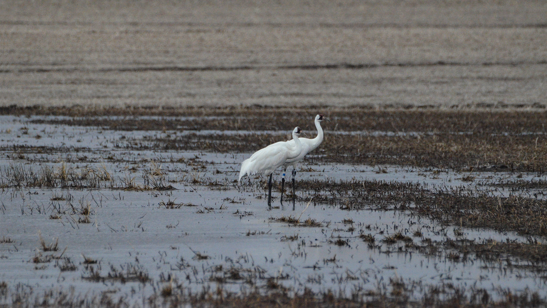
Trumbull Basin, a wetland located in Adams County in central Nebraska, was graced with the presence of four Whooping Cranes who stopped at the wetland during their migration north.
The Whooping Crane is one of the world’s most endangered species. There are currently just over 800 of these birds on earth.
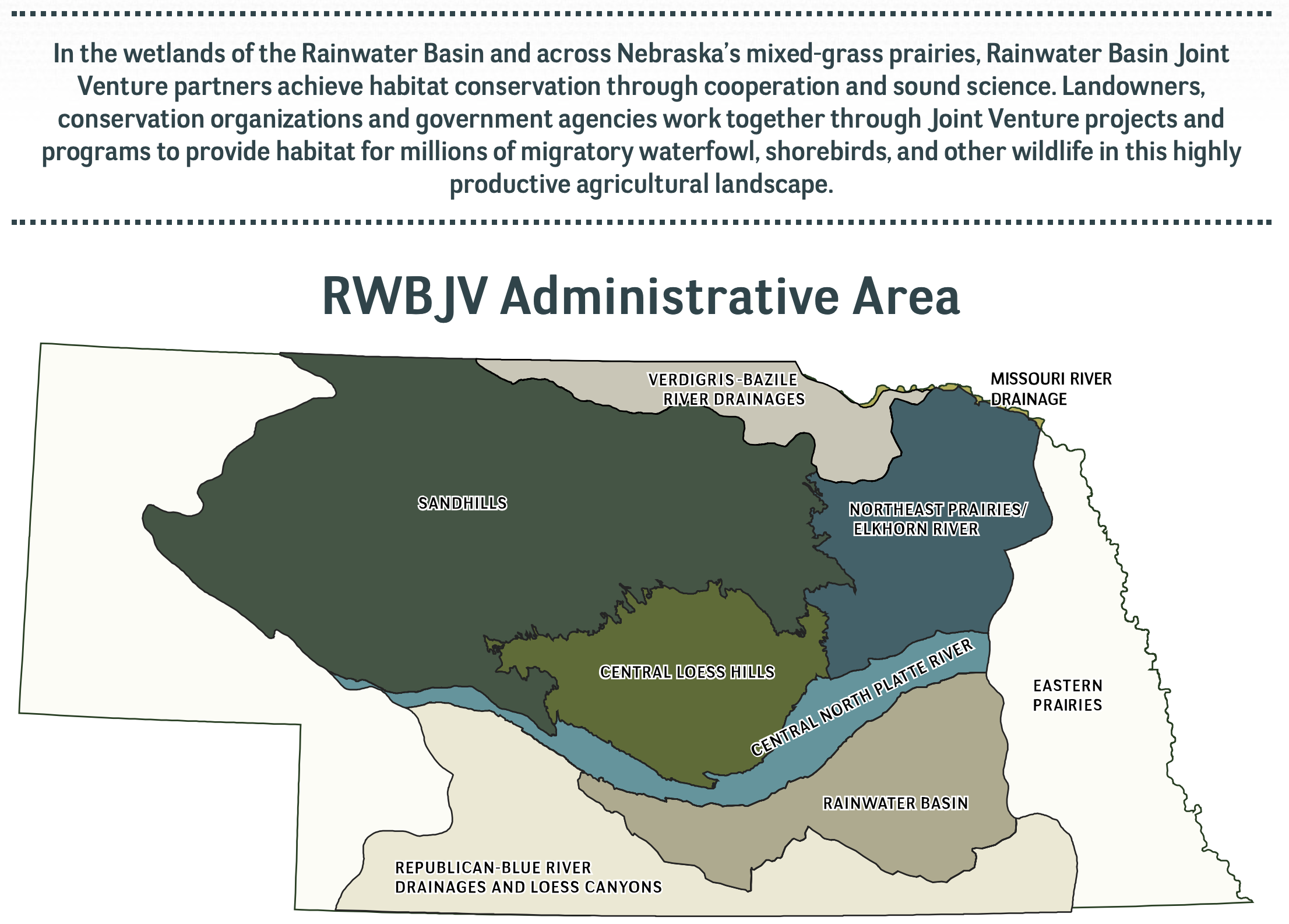
Trumbull Basin, the wetland where these rare birds called home for 11 days, is in the heart of a unique geographic area known as the Rainwater Basin.
Four Whooping Cranes recently stopped at Trumbull Basin during their migration north. Photo courtesy of David Baasch and the Crane Trust via Farmers.gov
The Rainwater Basin is a complex of wetlands covering portions of south-central Nebraska. The area is also part of the migration route known as the Central Flyway. In spring, birds that have wintered on the Gulf Coast and across Texas and Mexico funnel into this 150-mile-wide area over central Nebraska that contains thousands of wetlands.
The wetlands provide habitat for migrating birds. Despite being critical to migrating and local wildlife species, the Rainwater Basin wetlands have been greatly reduced from their historic numbers.
Restoring the Basin
USDA’s Natural Resources Conservation Service in Nebraska works closely with the Rainwater Basin Joint Venture, a non-government organization that works with landowners who voluntarily restore wetlands on their land. The Rainwater Basin Joint Venture, in cooperation with NRCS, helped restore the Trumbull Basin wetland.
“Seeing Whooping Cranes use one of the wetlands that a group of Nebraska landowners worked so hard to restore is extremely exciting and also really gratifying,” said Andy Bishop, coordinator for the Rainwater Basin Joint Venture.
Landowners Frank Hill, Larry Rouse, Don Cox, and Leo Pavelka worked with NRCS Resource Conservationist Ken Franzen and other partner agencies to help restore the large wetland near Trumbull, Nebraska. Photo taken in 2004 by Joanna Pope, NRCS.
At 465 acres Trumbull Basin is one of the largest privately owned wetlands in the Rainwater Basin. This wetland was restored through the former Wetlands Reserve Program, a voluntary NRCS conservation program that helped landowners protect, restore, and enhance wetlands on their property. Landowners can do this now with Wetland Reserve Easements through the Agricultural Conservation Easement Program. Across the country, more than 5 million acres have been enrolled in easements.
When this project was initiated back in the late 1990s, there were five landowners who each owned a portion of Trumbull Basin. Initially this project started with the goal to better manage irrigation water to improve cropping potential, but the landowners soon realized there wasn’t much they could do to improve the area’s cropping capability. The alternative to farming such a wet area was to work with NRCS to restore the wetland through WRP.
“Our programs are a great tool for farmers to explore when a piece of their operation isn’t meeting their needs, and they want to find a different way to manage their land,” said Jeff Vander Wilt, acting state conservationist for NRCS in Nebraska. “In the case of Trumbull Basin, this resulted in converting poorly producing cropland into critical habitat for one of the world’s most endangered species.”
The Rainwater Basin Joint Venture worked with landowners Don and Shanda Cox on a large wetland restoration project just north of Hastings, Nebraska. Photo taken in 2011 by Joanna Pope, NRCS.
An Ideal Wetland Habitat
Restoration was an incremental process beginning in 1999, with the last tract enrolled into WRP in 2006. Thanks to the landowners working with conservation agencies, including NRCS, the Rainwater Basin Joint Venture, Nebraska Game and Parks, and the U.S. Fish and Wildlife Service, Trumbull Basin was restored.
The restoration required removing 66,000 cubic yards of sediment from the wetland, filling a large concentration pit, and removing nearly 1.5 miles of berms surrounding the wetland. This work restored how the wetland originally functioned in the landscape, by allowing water to flow back into the wetland where it could provide habitat, prevent flooding, improve water quality, and recharge ground water.
The continued management of Trumbull Basin has helped maintain this site as ideal wetland habitat for migrating birds. Photo courtesy of David Baasch and the Crane Trust.
Since the wetland was restored, additional steps have been taken to ensure it continues to function. A management plan was developed that included grazing, prescribed burns, herbicide treatments, and tree cutting. The continued management of Trumbull Basin has helped maintain this site as ideal wetland habitat.
“Seeing wildlife use this wetland 15 years after it was first restored is extremely rewarding,” said Andy. “It shows we’re doing something right by helping landowners create and manage the type of habitat these extremely rare animals need to make their long journey.”
Graphic credit: Colorado Basin River Forecast Center
Scott Hummer sent these photos via email showing the conditions in the Upper Yampa River Basin. The Yampa River is a major tributary of the Green River and therefore the Colorado River. He added, “Inflow at Stagecoach this morning was 8.88 CFS.”
The Yampa River below the Stafford Ditch June 3, 2021. Photo credit: Scott HummerWatson Creek at Ferguson Ditch Headgate June 3, 2021. Photo credit: Scott Hummer
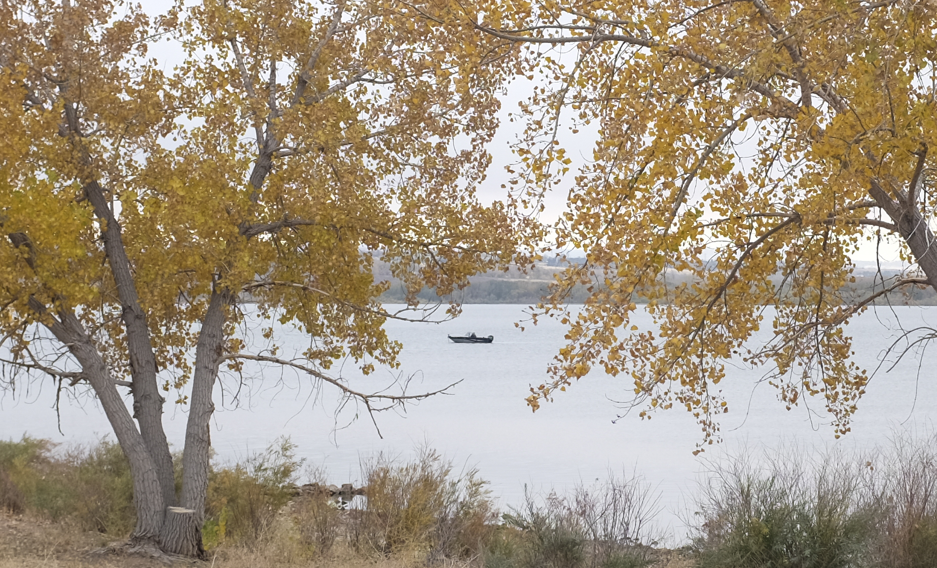
A boater floats in the waters at Chatfield Reservoir, near Denver, on October 18, 2020. Reservoirs across the state reported surging or record use this year as the COVID-19 pandemic drove more people outdoors. Photo credit: Lindsay Fendt/Aspen Journalism
Click here to read the newsletter. Here’s an excerpt:
CCWCD stores water in Chatfield Reservoir reallocation space.
Denver— June 3, 2021—CCWCD (Central Colorado Water Conservancy District (Central) is announcing the District’s water rights have filled 4,274 acre-feet of space in the Chatfield Storage Reallocation Project (CSRP), enabling irrigation users in Central’s groundwater augmentation plan to utilize Chatfield water for the 1st time.
“Central’s Board of Directors in 1983 appropriated the water rights necessary for the concept of storing water in Chatfield Reservoir. The intent in 1983 was to convert or reallocate flood control capacity in the reservoir to active water storage. Starting in about 1996, coordinated efforts of interested water providers along with non-profit organizations including The Greenway Foundation, Capitol Representatives, State of Colorado, United States Army Corps of Engineers and many others have led us to where we are today.” said Randy W. Ray, Central’s Executive Director.
Proposed reallocation pool — Graphic/USACE
Impact of Chatfield Reallocation
In addition to Central, six (6) other water providers benefit from water storage in the 20,600-acre-foot reallocation storage pool in Chatfield Reservoir. Central, a Water Conservancy District located in Greeley, CO, owns just over 20% of the reallocated space. The average annual groundwater withdrawals allotted to Central’s agricultural water users is 65,000 acre-feet.
“Having water storage located upstream of the Central District enables us to efficiently manage our water stored in Chatfield. We benefit from the on-stream nature of the reservoir in which large amounts of water can be stored in a short period of time. For example, on May 31st, the inflows to storage resulted in 558-acre feet. The recent precipitation events we have experienced this spring allow the project participants to store water which otherwise would have flowed down the river and into Nebraska.” said William Mihelich, Central’s District Engineer.
Denver Water’s collection system via the USACE EIS
FromColorado Public Radio (Michael Elizabeth Sakas):
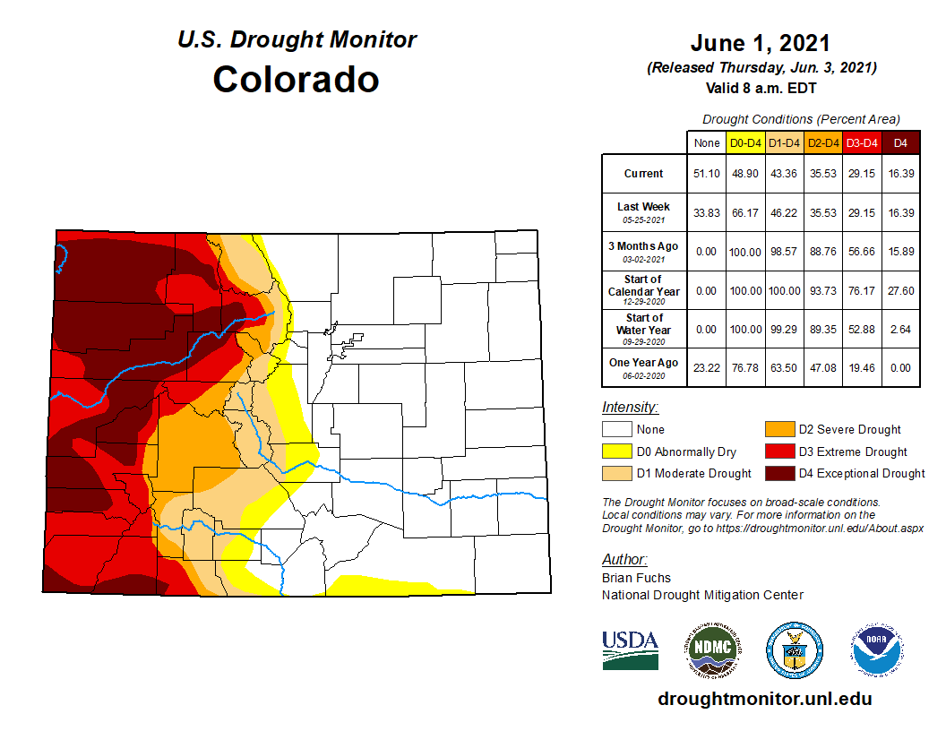
The National Weather Service said Denver has seen its wettest start to a year since 1983.
All that rain has made significant improvements to Colorado’s drought map. Three months ago, nearly the entire state was in a moderate drought or worse. Now that’s just 43 percent.
But the map shows a tale of two Colorados. While above-average rain has brought relief to the eastern half of the state, the West Slope is in a terrible drought.
Colorado Drought Monitor map June 1, 2021.
“Half of Denver Water’s supply comes from that West Slope side,” said Nathan Elder, manager of water supply at Denver Water.
So while those who live in Denver and the Front Range might be thinking, “What drought?”, Elder says it’s important to understand that water conservation is still needed, especially since half the city’s system exists in areas that are historically dry…
Elder says he expects reservoirs in the South Platte system will fill…
Elder says peak flows into Dillion reservoir will be about half of what’s normal. But overall, Denver’s reservoirs are 89 percent full, which Elder says is average for this time of year.
City takes same legal action it did against Larimer County
The city of Thornton formally went to court against the Weld County Board of Commissioners after the board denied the city’s application to build a water pipeline through the county.
The board’s decision, “exceeds its jurisdiction and/or is contrary to law, misinterprets and misapplies its criteria, and was arbitrary and capricious because its findings lack competent evidence to support the BOCC’s denial,” read the complaint filed June 2 in Weld County District Court.
As Thornton nears its deadline to construct a pipeline from a reservoir near Fort Collins, the quickest and most direct way for the city to get approval for a Weld County pipeline is through the courts, rather than submitting a whole new application. The city asks in the complaint for a district court judge to intervene and overturn the board’s decision.
Thornton started the process for the Weld County section of the Thornton Water Project in 2015. In 2018, the city formally submitted its application to build a pipeline through 34 miles of unincorporated county land. The city then went before the county’s planning commission twice and the board of commissioners four times. That fourth meeting, May 5, is when the board unanimously voted to deny the application…
The city is engaged in a separate legal battle — currently in the Colorado Court of Appeals — with the Larimer County Board of Commissioners, who denied a similar application from Thornton in 2019. The complaint Thornton filed in Weld County is the same kind that it filed in Larimer…
In both the Larimer and Weld County cases, Thornton argued the boards of commissioners didn’t have the jurisdiction to deny the city’s application because it has owned the WSSC rights for decades. What’s different about Thornton’s argument against Weld County is that it’s simpler, according to legal filings.
Weld County staff, the planning commission and the board initially told Thornton to not construct the pipeline in the right-of-way, or literally underneath county roads. Instead, they suggested planning to build on privately owned land next to the road. However, the planning commission and board later asked the city to consider areas for the pipeline in the right-of-way. Thornton did that and over time, submitted several amended applications.
The board asked also Thornton to obtain more construction easements from private landowners before the board reached a decision. So, by the May 5 board meeting, Thornton obtained easements for 95% of the total stretch of the pipeline.
Thornton described itself in the complaint as a good partner to Weld County, despite larger changes along the way. Still, the board denied the application. The city also argued that the board didn’t “orally find or conclude” that Thornton failed to meet five of eight criteria that the board is supposed to consult in its decision-making.
The city added in the complaint that the board still hasn’t issued Thornton a written denial…
The main reason for Thornton’s haste is rapid growth. The City council won’t approve applications related to large developments, such as Parterre, without the assurance of water from Larimer County.
Gunnison River in Colorado. Source: Bureau of Reclamation via the Water Education Foundation
Click here for all the inside skinny and register:
Join the Colorado River District for the Gunnison State of the River webinar on Thursday, June 10 at 6 pm! Our experts and special guests will be presenting on river forecasts, landmark accomplishments, project opportunities, and the impacts of and on recreation for the Gunnison.
One of the major tributaries of the Colorado River, your Gunnison River provides the life force for local West Slope communities. Learn more about the river’s hydrology and water supply as we enter another drought year, celebrate a Lower Gunnison victory that’s been years in the making, and hear from David Dragoo, founder of Mayfly, about the West Slope recreation economy and its impacts.
You’ll also receive information on exciting new funding for Gunnison River Basin water projects and plans to sustain flows throughout the basin as conditions shift to hotter, drier seasons.
If you cannot attend the webinar live, register to receive an emailed webinar recording for later viewing!
Agenda:
Welcome – Marielle Cowdin & Zane Kessler, Director of Public Relations and Director of Government Relations, Colorado River District (CRD)
Your Gunnison River, a Water Supply Update – Bob Hurford, Division 4 Engineer, Colorado Department of Natural Resources
The Lower Gunnison Project: Modernization in Action – Dave “DK” Kanzer, Director of Science and Interstate Matters, CRD
A Victory for the Lower Gunnison – Raquel Flinker, Sr. Water Resources Engineer/Project Manager, CRD and Ken Leib, Office Chief of the Colorado Water Science Center, U.S. Geological Survey
Rivers on the Fly, Recreation Economy and Impacts – David Dragoo, Founder of Mayfly
Community Funding Partnership – Amy Moyer, Director of Strategic Partnerships, CRD