Low-flow research on #ColoradoRiver sheds light on eventual new normal for #GrandCanyon — Oregon State University

Quagga mussels: Glen Canyon photo by Jeremy Monroe, Freshwaters Illustrated/USGS

Here’s the release from Oregon State University (Steve Lundeberg and David A. Lytle):

Researchers from Oregon State University say ecological data gathered during a recent low-flow experiment in the Grand Canyon is a key step toward understanding Colorado River ecosystems as the amount of water in the river continues to decline.

Dave Lytle, professor of integrative biology, and Ph.D. students Angelika Kurthen and Jared Freedman teamed with scientists from the United States Geological Survey during the March 2021 project to examine the quantity and diversity of invertebrates in the river. Monitoring aquatic invertebrates is an important tool for keeping track of stream health.

“The Colorado River and its dams are important to cities throughout the Southwest, and as a result of that management the river experiences some pretty unusual flows,” Lytle said. “During the day in the Grand Canyon, river levels can rise several feet, then they can drop down several feet, stranding your boat if you’re not careful. That’s because there’s high electricity demand during the day and lower demand at night.”

The high flow during times of heavy demand for power is known as hydropeaking.

“Hydropeaking can cause trouble for ecosystems downstream, and with our collaborators we’re experimenting with ways to change river flows to make them more compatible with productive ecosystems,” Lytle said. “Invertebrates are food for fish, birds and bats, and we want to enhance that food base by testing out different flow regimes that mesh with management ideas.”

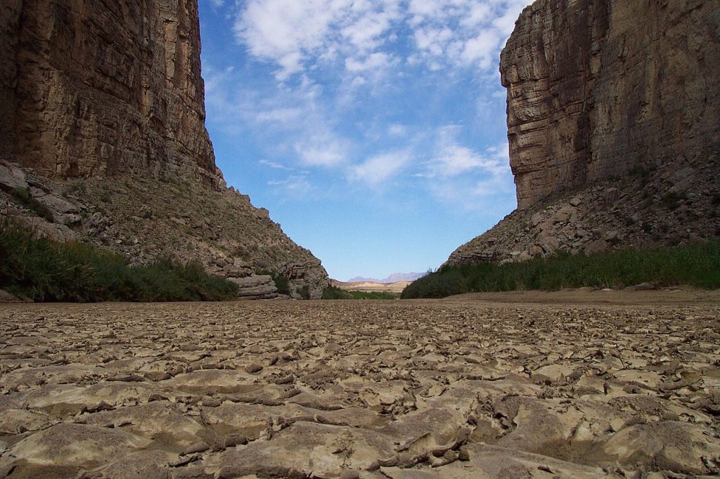
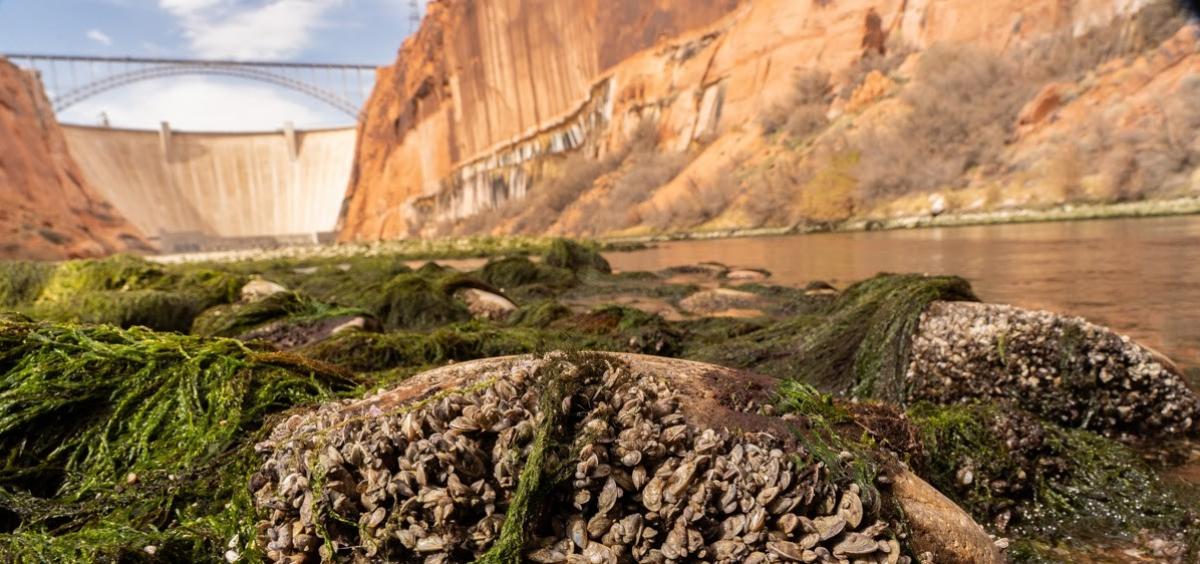
During the low-flow event, releases from Lake Powell through the Glen Canyon Dam were restricted so that the Colorado ran at 4,000 cubic feet per second compared to its usual flow of 8,000 to 15,000 CFS. Lytle’s team took samples to measure the quantity of invertebrates stranded by the low flows and environmental DNA samples to analyze the diversity of invertebrates in the water.

“During this spring’s low flow, gravel bars and parts of channels that had been submerged were exposed for the first time in decades,” Lytle said. “We saw really large areas of vegetation and invasive species like New Zealand mud snails and quagga mussels, which are there in high numbers at the expense of native invertebrates such as black flies, mayflies and midges that are better food sources for native fish.”

The Colorado River follows a 1,450-mile route generally southwest from north central Colorado to just east of Las Vegas. From there it turns south to form Arizona’s western border with Nevada and California, and then the border between Mexican states Sonora and Baja California before emptying into the Gulf of California.

Between the U.S. and Mexico, 40 million people depend on water from the Colorado. The snowmelt-fed river has seen its flows drop by 20% over the last 100 years as runoff efficiency – the percentage of precipitation that ends up in the river – has declined as summers have become hotter and drier, cooking the soil.

This year, for example, snowpack is 80% of average but sending just 30% of the average amount of water into the Colorado. Lake Mead, the reservoir behind Hoover Dam, is at an all-time low, and between them Lake Mead and Lake Powell, behind Glen Canyon Dam, are projected to be just 29% full within two years.

Completed in 1966, Glen Canyon Dam is 710 feet high and 1,560 feet long and named for the series of deep sandstone gorges flooded by Lake Powell. The lake draws its name from John Wesley Powell, the leader of the first boat expedition to traverse the Grand Canyon.

“Typically the Colorado River is coming out of Lake Powell fast and cold, which is a hostile environment for desert adapted organisms,” Lytle said.

For the recent experiment, low flow was maintained from March 15 through March 20, and immediately after that there was a big release of water, known as a high-pulse flow event, intended to scour out areas and possibly create new habitat for native fish and their food sources.

“During the first part of the low flow, we were in the far upper reaches of the canyon, and as soon as we finished sampling, we packed up the truck and raced across the desert 200 river miles away to Diamond Creek, where you can access the Grand Canyon from a road, just in time to capture the low-flow event moving its way down a long, sinuous canyon,” Lytle said. “And a USGS team was taking samples by boat throughout the entire canyon, complementary to what our group was doing. It was a real team effort, with people measuring riparian vegetation, taking drift samples of invertebrates in water, checking respiration of aquatic plants, and also noting the effect on fish and fisheries.”

As the climate continues to warm and the amount of water available for humans continues to drop, low flows such as the one during this year’s experiment may become the new normal, he added.

“That presents challenges but also opportunities for research,” Lytle said. “Prior to there being any dams on the river, low-flow events were part of the normal annual cycle of flows. In the spring, the river could flood quite spectacularly in some years, and by late summer or early fall into winter, flows could get to 4,000 CFS or even lower than that.”

Lytle says that kind of variation amounts to “exercise” for the river, which needs it for health just like a person needs both activity and rest.

“One question we’re asking is whether there could be ecological benefits, at least at certain important times of year, to low flows,” he said. “Low flows allow the water temperature to increase and let more light to reach the benthic zone, where the productivity of algae and invertebrates occurs. It also might favor greater production of those important native black flies, mayflies and midges.”

2021 #COleg: Audubon Boosts Water Awareness and Funding for Birds and People — @AudubonRockies

American Dipper. Photo: Evan Barrientos/Audubon Rockies

From Audubon Rockies (Abby Burk):

A recap of water in the 2021 Colorado legislative session.

Water—Colorado’s most precious resource for birds and people—was a central issue for legislators in the 2021 legislative session. Lawmakers approved more than $53 million in new bills for water-related projects. We all depend on healthy, flowing rivers. Amid brutal drought conditions on the West Slope, the Colorado Water Plan update, watershed and wildfire resilience needs, Audubon’s engagement amplified water awareness for legislators and partners across the state. Read on for highlights of what we accomplished together.

Water Funding Wins

Colorado Water Plan

Birds and people need clean, reliable water, and that is linked to funding. Audubon’s network submitted more than 900 action alerts to legislators to support HB21-1260, General Fund Transfer to Implement State Water Plan. HB1260 allocates $15 million to the Colorado Water Conservation Board (CWCB) Water Plan Implementation Cash Fund and $5 million to basin roundtables.

Do you have an environmental project, study, or planning idea ready to go? If yes, now is the time to apply. With these additional funds to the Water Plan grant fund, matches have been reduced to 25 percent for studies and planning, and the standard 50 percent match for construction projects remains. Grant application deadlines for 2021 are July 1 and December 1.

Watershed and Wildfire Resilience

The historic wildfires of 2020 and concerns over a strong 2021 wildfire season elevated watershed and wildfire resilience as top priorities. Two bills passed to help address these needs: SB21-054, Transfers for Wildfire Mitigation and Response, which allocates $9 million total with $4 million to CWCB Watershed grant program, and SB21-240, Watershed Restoration Stimulus, which distributes $30 million to the CWCB Watershed Grant program to protect watersheds from wildfires through study and restoration.

Colorado Drought Monitor map June 22, 2021.

Agriculture and Drought Resiliency

Colorado’s ranchers and farmers are struggling through yet another dry year. The Western Slope has suffered a drought three of the last four years. The birds, other wildlife, and communities that depend on agricultural landscapes are struggling too. Audubon and our partners supported three bills to help with agricultural drought resilience and improve soil health.

HB21-1242, Create Agricultural Drought and Climate Resilience Office, allots $500,000 to the Colorado Department of Agriculture (CDA) for the new Drought and Climate Resilience Cash Fund.

SB21-235, Efficiency Programs Stimulus, distributes $5 million total with $2 million for soil health grants to CDA.

SB21-234, Agriculture and Drought Resiliency, allocates $3 million to the Drought Resiliency Fund for uses providing financial and technical assistance to transport hay or feed from areas outside of Colorado, supports recovery of grazing lands post-fire/drought, and provides technical assistance to help producers prepare for future droughts.

The success of water funding clearly demonstrates to our state lawmakers that water is a priority issue for Coloradans. We hope policymakers will continue to focus on ensuring our natural infrastructure of watersheds, rivers, and wetlands are protected to meet our state’s environmental and community needs for generations to come.

Decision-maker Water Awareness

In May, Audubon Rockies and Business for Water Stewardship concluded the 2021 morning water legislator webinar series. Audubon and Business for Water Stewardship want to express deep appreciation to presenters and attendees of the water legislator webinar series. Over three sessions (The Value of Colorado’s Water, Water Connections, and Water Quality), more than 230 legislators, staff/aids, and informed members of the public attended the live sessions.

Collectively as a state, from residents to decision-makers, we need to lean in, learn more, and participate in the decisions around our water resources. The decisions we make about water and river health impact all of Colorado—birds and people alike.

#Drought, The Everything Disaster — Circle of Blue #ColoradoRiver #COriver #aridification

West Drought Monitor map June 22, 2021.

From Circle of Blue (Brett Walton):

When water stops flowing, painful days are at hand.

  • 89 percent of nine western states are in some form of drought, and more than a quarter of the region is considered in exceptional drought, the worst category in the U.S. Drought Monitor.
  • Droughts leave deep bruises that may not surface for months or years. Too much heat and too little rain can cause ecosystems to collapse and hasten the spread of non-native species.
  • Over the coming decades, a warming climate will cause more frequent and intense droughts, especially in the Colorado River basin.
  • It develops in stages, a story that builds upon itself. A few cloudless days. Then a rain-free week. Soon a hot, dry month.

    Now the hills are brown and the crops need watering — the first signs of drought.

    The intensely dry conditions that have settled over the American West and Upper Midwest this year are well past the brown hills stage. Nearly 89 percent of nine western states are in some form of drought, and more than a quarter of the region is considered in exceptional drought, the worst category in the U.S. Drought Monitor.

    The indicators of widespread dryness are everywhere. Lakes Mead and Powell, the major reservoirs on the Colorado River, are 35 percent full with a two-year outlook that worsened each month this spring. California officials told vineyards along the Russian River in May that the system is too depleted for irrigation. In Utah’s Great Salt Lake in April, sailboats were lifted out of receding waters too shallow to float. In the Klamath River that flows between Oregon and California, few juvenile salmon are expected to survive this season. In Arizona, the Rafael Fire, burning in the Prescott National Forest some 25 miles southwest of Flagstaff, grew to 36,000 acres since it was sparked on June 18 by lightning.

    When water stops flowing, painful days are at hand — even if the pain is not immediately evident.

    “The complexity of the drought phenomenon is not well understood by most people,” said Roger Pulwarty. Some people will say that we’ve experienced drought before, he mused. “Well, not like these. Not for this extent, not really addressing all the diverse ways in which it affects our economy, through the environment, through trade.”

    Pulwarty has wrestled with these questions about the consequences of drought longer than most. He was the director of the National Integrated Drought Information System, a drought monitoring and planning collaborative set up by Congress. And he was the coordinating lead author for a United Nations special report on drought that was published earlier this month.

    Drought, like a hurricane, tornado, or earthquake, is a potentially dangerous natural hazard. But Pulwarty notes that droughts have distinctive characteristics that separate them from other calamities. They are geographically diverse, spreading across a few counties or entire watersheds and regions. They are slow to begin but can last indefinitely, some “megadroughts” upending social and political stability over several decades.

    Drought, like a fearsome boxer, has a long reach. And like that fearsome boxer, the long reach of drought is pummeling.

    One Thing Leads to Another…And Another

    Specialists like Pulwarty, who is currently a senior scientist in the physical sciences laboratory at the National Oceanic and Atmospheric Administration, use the word “cascade” to describe the long reach.

    Consider this chain of events. Drought increases the risk of fire. It dries out vegetation and kills trees, turning forests into matchsticks. Fires in river headwaters don’t just burn trees. They also send ash and debris into reservoirs and rivers. The Las Conchas fire in northern New Mexico in June 2011 pumped so much ash into the Rio Grande that the Albuquerque Bernalillo County Water Utility Authority had to close its drinking water intake on the river. When they rampage through developed areas, fires can contaminate plumbing systems and water distribution pipes with volatile organic chemicals. The smoke is a public health threat.

    This house north of Windy Gap Reservoir was among the 589 private structures burned in the East Troublesome Creek Fire. Water managers worry soil damage by the fire will cause sediment to clog irrigation ditches and municipal water infrastructure alike. Photo credit: Aspen Journalism

    Or this scenario: low reservoirs mean that dams equipped with turbines generate less hydropower. Hoover Dam’s power-generating capacity is down 28 percent today compared to when Lake Mead is full. The Western Area Power Administration markets the power from Hoover and other federal hydropower projects in the West. Jack Murray, the acting vice president and desert southwest regional manager, told Circle of Blue that the shortfall in cheap hydropower means the agency has to make up the difference by buying more expensive — and sometimes more carbon-intensive — power on the spot market. That is an economic punishment for the small communities, irrigation districts, and Indian tribes that are some of the end users of the electricity.

    “Drought filters through any economic activity in which water is involved,” said Pulwarty. Hydropower, farm production, shipping on inland waterways, commercial river rafting, nuclear plants that need water to cool their equipment — the list is long. Drought is also a mental and physical strain, weighing on the minds of farmers who can’t plant fields and homeowners who run short of water.

    Creating a balance of water that’s taken from aquifers and water that replenishes aquifers is an important aspect of making sure water will be available when it’s needed.
    Image from “Getting down to facts: A Visual Guide to Water in the Pinal Active Management Area,” courtesy of Ashley Hullinger and the University of Arizona Water Resources Research Center

    When farmers pump groundwater to counteract water deficits in rivers and lakes, shallower domestic wells can dry up, which is beginning to happen throughout California. As of June 21, the Department of Water Resources had received 64 reports of dry wells this month, the most in any month since August 2016.

    There is a lesson here, drought researchers say. People can bankrupt a water system just as much as nature can. A full understanding of drought, they argued in a journal article published in January, takes into account the human failures of water and land management.

    San Joaquin Valley Subsidence. Photo credit: USGS

    Besides dry wells, pumping too heavily in California’s San Joaquin Valley caused the land to compact and sink. It’s another example of the cascade. That land subsidence, in turn, buckled the canals that carry irrigation water, reducing their water-carrying capacity in some areas by 60 percent. The estimated cost to repair the three major canals suffering from subsidence damage is more than $2.3 billion.

    Toxic-algae blooms appeared in Steamboat Lake summer of 2020. The lake shut down for two weeks after harmful levels of a toxin produced by the blue-green algae were found in the water. As climate change continues, toxic blooms and summer shutdowns of lakes are predicted to become more common. Photo credit: Julie Arington/Aspen Journalism

    Drinking water providers that rely on lakes instead of groundwater have a different concern in drought: the presence of algal blooms. Though some blooms contain toxins that are harmful to humans, the sheer mass of algae is also a problem, encumbering the water treatment process. The algae clog filters, which have to be replaced more frequently. There is more sludge to discard. These all raise costs, says Frank Costner, the general manager of Konocti County Water District. The blooms are particularly bad in Costner’s water source: Clear Lake, the second largest freshwater lake in California. Water testing done by the Big Valley Band of Pomo Indians on June 7 showed that toxins in the lake’s eastern basins had already reached dangerous levels.

    Droughts leave deep bruises that may not surface for months or years, Pulwarty said. Even after rains return, reservoirs and aquifers take time to refill. Trees killed this year are fuel for next year’s fire. Too much heat and too little rain can cause ecosystems to collapse and hasten the spread of non-native species.

    Walk FOR the Canal is Back — @COHighLineCanal

    High Line Canal

    From email from the High Line Canal Conservancy:

    Our second annual Walk FOR the Canal is back and registration is now live!

    Join anytime, anywhere. Walk, bike, run or roll on or off the Canal from August 1 – October 10 as we come together to raise much-needed funds for our 71-mile linear park.

    All registered participants will receive a High Line Canal map and a bandana to show your support while on the Canal.

    Click here to register.

    Collision of crises threatens Rio Grande and its communities — Wild Earth Guardians

    Here’s the release from Wild Earth Guardians (Jen Pelz):

    Lawsuit threatened to protect river flows and trigger commitments to long-term solutions

    To maintain a living Rio Grande and seek climate resilience for both people and ecosystems, WildEarth Guardians today warned federal and state water managers in New Mexico that it will file a lawsuit in federal court if the water agencies don’t do more to protect and ensure recovery of imperiled species. The group sent its 60-day notice of intent to sue to the U.S. Fish and Wildlife Service, U.S. Bureau of Reclamation, State of New Mexico, and Middle Rio Grande Conservancy District detailing how past and present water management decisions continue to harm river flows, ecosystem health, and violate the Endangered Species Act.

    “The West is experiencing a collision of crises and the Rio Grande is at its center,” said Jen Pelz, Rio Grande Waterkeeper and Wild Rivers Program Director at WildEarth Guardians. “The path forward to a sustainable, climate resilient, living river will require learning to live within the river’s means and developing creative solutions that give a voice to values long ignored including flowing rivers, healthy ecosystems, and equity for human communities.”

    This year’s flows in the Rio Grande at the Otowi Gauge in northern New Mexico were estimated at 44 percent of average. The meager flows, the very limited amount of water in storage, and the inability to store spring runoff due to restrictions under the Rio Grande Compact mean very few opportunities for maintaining a connected river or flows to farmers through the summer.

    “This is really a worst-case scenario year on the Rio Grande,” explained Pelz. “Our hope is that these conditions will bring urgency and willingness for water managers and other interested communities and organizations to develop a comprehensive suite of solutions to deal with the crippling effects of climate change in an already overallocated river system.”

    The Rio Grande’s management in central New Mexico through Albuquerque is guided by the 2016 Biological Opinion issued by the U.S. Fish and Wildlife Service. The document is a collection of commitments made by the federal and state agencies to ensure the survival and recovery of three listed species including the Rio Grande silvery minnow, the Southwestern willow flycatcher, and the yellow-billed cuckoo. The group argues that the existing commitments are not enough to protect the river ecosystem or the vulnerable species given the warming climate and reduced flows in the river.

    “As conditions on the river continue to deteriorate due to climate change, the federal and state agencies have a duty to review their commitments and the assessment of harm to the listed species in the Biological Opinion,” said Samantha Ruscavage-Barz, Legal Director at WildEarth Guardians. “We hope this notice letter does what it is intended to do, which is to allow the agencies to engage in dialogue, reassess the situation, and meet the moment with solutions that evolve with the times. We look forward to engaging with the named parties and anyone else who has ideas for sustaining a living Rio Grande.”

    Over the two past decades, Guardians and other groups have urged the agencies to implement a water acquisition and leasing program to allow water to be used for environmental flows. These strategies are beginning to be implemented, but there is urgency to bring this program (as well as others) up to scale so that opportunities exist, even in less than ideal years, to help ensure the survival of river ecosystems, meet downstream water obligations, and rebalance inequities to the river and communities.

    “It’s becoming crystal clear that the predictions of climate scientists will and are coming to fruition,” added Pelz. “The solutions we thought we had decades to implement to avoid a catastrophe need to be designed and implemented now. It’s like the saying that ‘the best time to plant a tree is 30 years ago and the next best time is now.’”

    Some parts of the Rio Grande already experience a dry river most of the year. Photo by WildEarth Guardians.

    Other Contact

    Samantha Ruscavage-Barz, Legal Director, WildEarth Guardians, 505-401-4180.