A controversial water dispute in Laramie County that got held up last year because of the pandemic will see its day in court June 9-11 in Cheyenne.
17 ranch families are pushing back on a permit application by three members of the Lerwick family to drill eight high-pressure wells north of Cheyenne. These wells would appropriate 1.6 billion gallons of ground water from the Ogallala Aquifer, a water source that’s already gone dry in several other Western states.
Attorney Reba Epler owns a ranch in the area and said this case is crucial for establishing a more modern approach to water management in Wyoming…
The wells would use 4700-acre feet of water or the equivalent used by a town of about 10,000 people. Epler said her dad remembers fishing on some creeks that no longer flow in the area. Most local creeks have gone dry.
Wyoming rivers map via Geology.com
“Horse Creek is probably the last flowing creek in Laramie County,” Epler said. “And that creek sustains so much agriculture and so much wildlife, so many birds and fish and it is quite a magnificent creek and it is sustained by the base flow of the groundwater from the Ogallala Aquifer.”
Epler said granting permits on these wells would endanger Horse Creek.
The Ogallala aquifer, also referred to as the High Plains aquifer. Source: National Oceanic and Atmospheric Adminstration
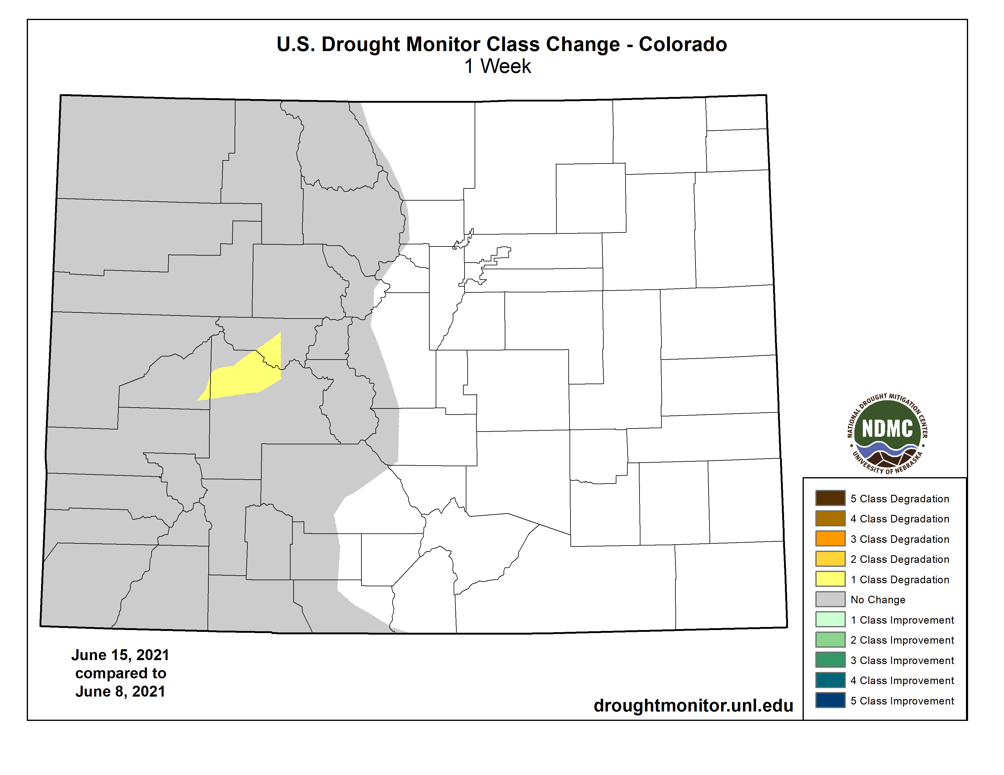
Like much of the southwest United States, western Colorado remains under extreme and exceptional drought according to the latest report from the National Drought Mitigation Center.
Portions of Gunnison, Pitkin and Delta counties in western Colorado saw severe drought degrade to extreme conditions, while the remainder of the state was unchanged.
Colorado Drought Monitor one week change map ending June 15, 2021.
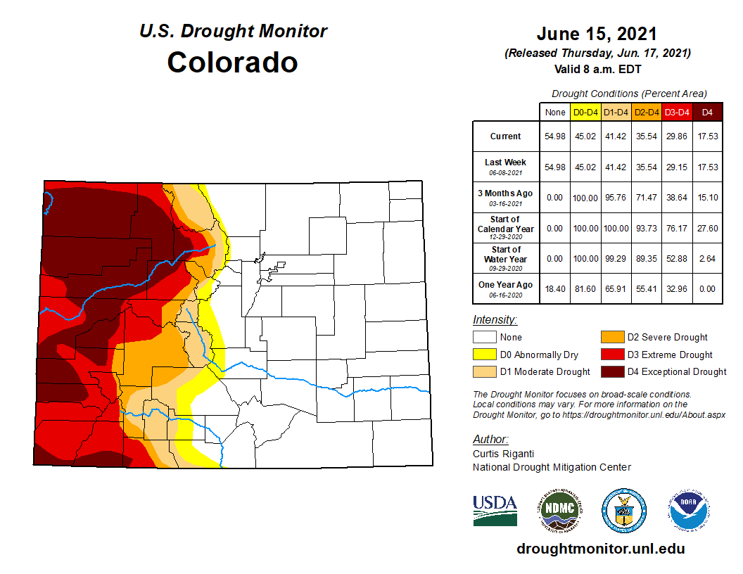
Thirteen of Colorado’s 64 counties have a least some area in exceptional drought, with most or all of their remaining area in severe conditions.
Colorado Drought Monitor map June 15, 2021.
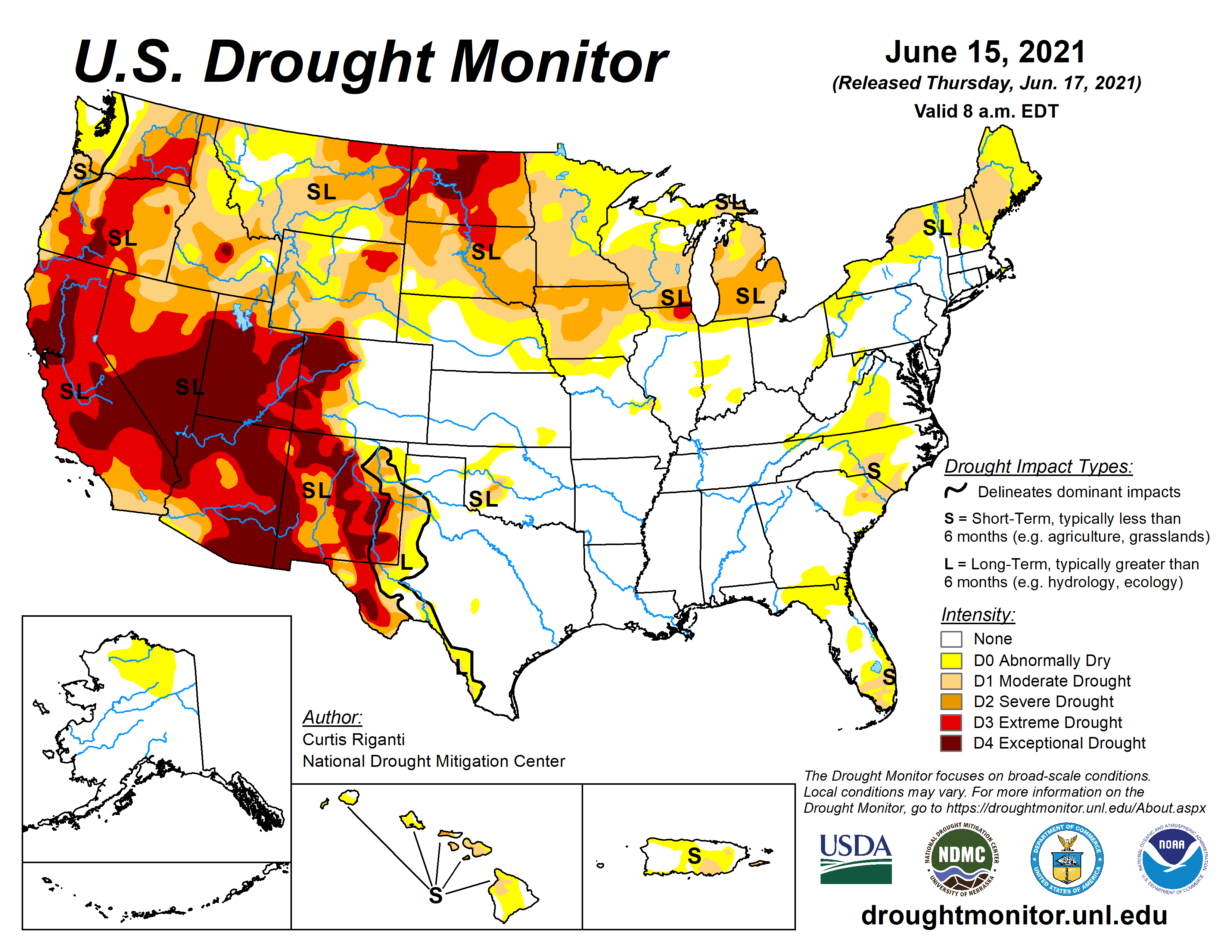
Much of the western United States suffered under hot temperatures and continued lack of rain during the previous week. Like western Colorado, large portions of California, Nevada, Utah, Arizona and New Mexico are experiencing extreme and exceptional conditions. Extreme drought stretches into central Oregon and southwest Washington. Much of North Dakota, along with smaller areas in northeast Montana and north central South Dakota are also in the two worst drought categories.
US Drought Monitor map June 15, 2021.
Last week, the National Weather Service issued a rare excessive heat warning for the Grand and Paradox valleys in western Colorado as temperatures in the area soared above 100 degrees and created risks for deadly heat-related illnesses.
Fire danger has been an increasing concern for agricultural producers in the western part of the state according to the United States Department of Agriculture’s weekly report.
In eastern Colorado, remaining drought and abnormally dry areas finished shifting to drought-free conditions over the past two weeks…
Overall, drought statistics are unchanged from last week despite shift in severe to extreme conditions in the three western Colorado counties. Fifty-five percent of the state remains drought-free, with an additional four percent considered abnormally dry. Moderate and severe drought both covered six percent of the state. Extreme conditions remained at 12 percent, and exceptional drought covers 18 percent of Colorado. Total does not equal 100 due to rounding.
The Pagosa Area Water and Sanitation District’s (PAWSD) lakes are full, but Archuleta County remains in moderate to severe drought and the snowpack is gone.
According to a June 14 press release from PAWSD Manager Justin Ramsey, all five of Pagosa’s lakes are now completely full.
This includes Lake Pagosa, Hatcher Lake, Stevens Lake, Village Lake and Lake Forest…
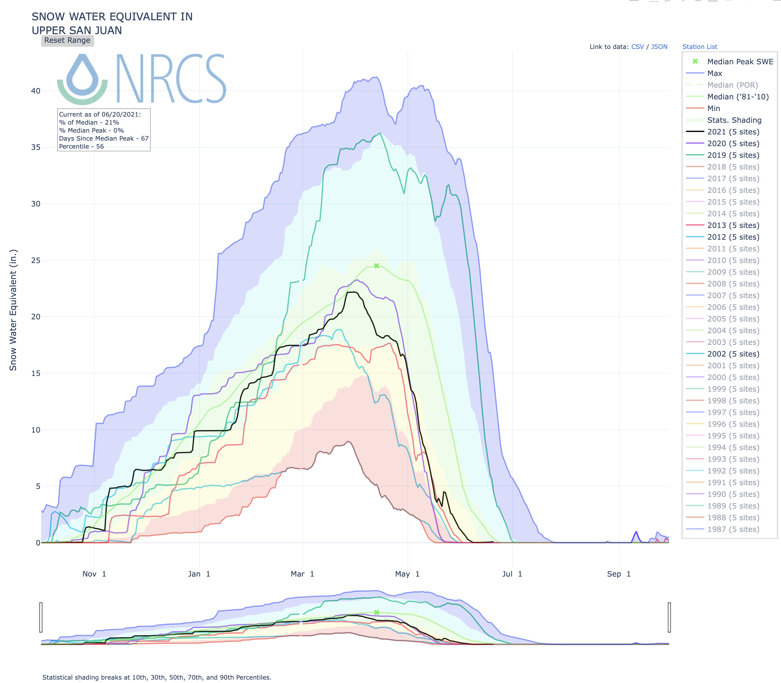
Snow report
According to the U.S. Department of Agriculture National Water and Climate Center’s snowpack report, the Wolf Creek summit, at 11,000 feet of elevation, no longer had a snowpack equivalent to any snow water amount as of 10 a.m. on Wednesday, June 16.
The average amount of snow water equivalent for this date is 5.2 inches…
The San Miguel, Dolores, Animas and San Juan River Basins were at 10 percent of the June 16 median in terms of snowpack.
Colorado Drought Monitor map June 15, 2021.
Drought report
According to the National Integrated Drought Information System (NIDIS), 100 percent of Archuleta County remains in a moderate drought stage.
The NIDIS website notes that under a moderate drought stage dryland crops may suffer, rangeland growth is stunted, very little hay is available and risk of wildfires may increase.
The NIDIS website also notes that 99.36 percent of the county is in a severe drought stage.
According to the NIDIS, under a severe drought stage, fire season is extended.
River report
According to the U.S. Geological Survey (USGS), the San Juan River was flowing at a rate of 562 cfs in Pagosa Springs as of 10 a.m. on Wednesday, June 16.
Based on 85 years of water records at this site, the average flow rate for this date is 1,280 cfs.
The highest recorded rate for this date was in 1979 at 3,850 cfs. The lowest recorded rate was 44.1 cfs, recorded in 2002.
As of 10 a.m. on Wednesday, June 16, the Piedra River near Arboles was flowing at a rate of 373 cfs.
Based on 58 years of water records at this site, the average flow rate for this date is 968 cfs.
The highest recorded rate for this date was 3,070 cfs in 1979. The lowest recorded rate was 18.3 cfs in 2002.
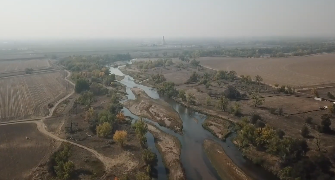
Here at the confluence of the Big Thompson and South Platte rivers near Greeley, a new conservation effort is underway. It restores wetlands and creates mitigation credits that developers can buy to meet their obligations under the federal Clean Water Act to offset any damage to rivers and wetlands they have caused. Credit: Westervelt Ecological Services