Yellowstone is losing its snow as the climate warms, and that means widespread problems for water and wildlife — The Conversation


Snow melts near the Continental Divide in the Bridger Wilderness Area in Wyoming, part of the Greater Yellowstone Area.
Bryan Shuman/University of Wyoming, CC BY-ND

Bryan Shuman, University of Wyoming

When you picture Yellowstone National Park and its neighbor, Grand Teton, the snowcapped peaks and Old Faithful Geyser almost certainly come to mind. Climate change threatens all of these iconic scenes, and its impact reaches far beyond the parks’ borders.

A new assessment of climate change in the two national parks and surrounding forests and ranchland warns of the potential for significant changes as the region continues to heat up.

Map showing the parks and forest land within the Greater Yellowstone Area
The Greater Yellowstone Area includes both Yellowstone and Grand Teton national parks, as well as surrounding national forests and federal land.
National Park Service

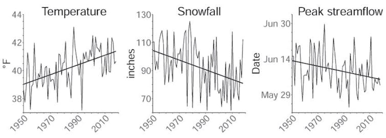
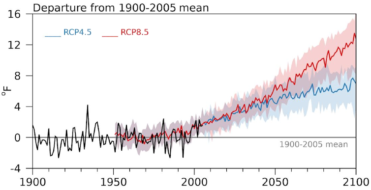
Since 1950, average temperatures in the Greater Yellowstone Area have risen 2.3 degrees Fahrenheit (1.3 C), and potentially more importantly, the region has lost a quarter of its annual snowfall. With the region projected to warm 5-6 F by 2061-2080, compared with the average from 1986-2005, and by as much as 10-11 F by the end of the century, the high country around Yellowstone is poised to lose its snow altogether.

The loss of snow there has repercussions for a vast range of ecosystems and wildlife, as well as cities and farms downstream that rely on rivers that start in these mountains.

Broad impact on wildlife and ecosystems

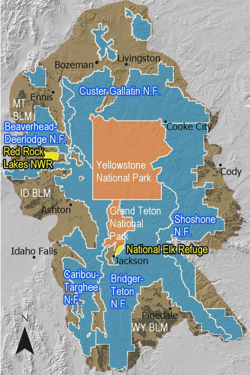
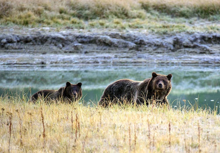
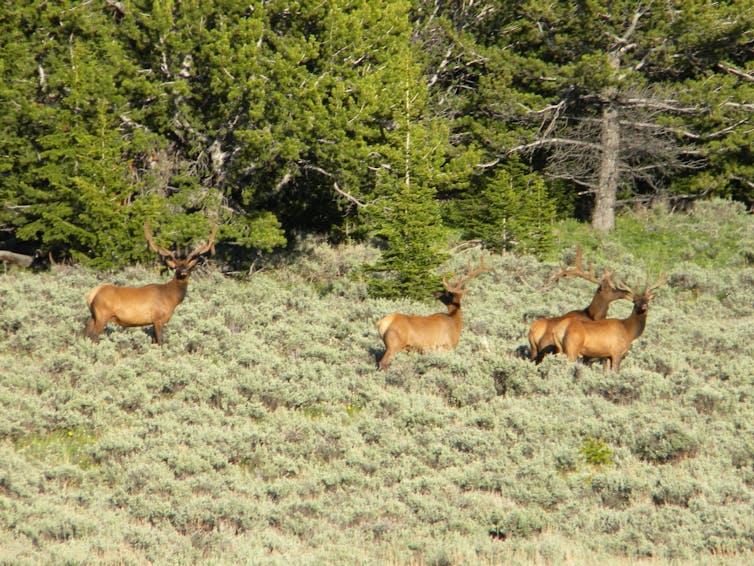
The Greater Yellowstone Area comprises 22 million acres in northwest Wyoming and portions of Montana and Idaho. In addition to geysers and hot springs, it’s home to the southernmost range of grizzly bear populations in North America and some of the longest intact wildlife migrations, including the seasonal traverses of elk, pronghorn, mule deer and bison.

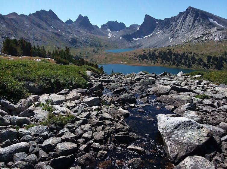
The area also represents the one point where the three major river basins of the western U.S. converge. The rivers of the Snake-Columbia basin, Green-Colorado basin, and Missouri River Basin all begin as snow on the Continental Divide as it weaves across Yellowstone’s peaks and plateaus.

A bear and cub walking along a river in Yellowstone National Park.
Less water in rivers can harm cutthroat trout, which grizzly bears and other wildlife rely on for food.
Karen Bleier/AFP via Getty Images

How climate change alters the Greater Yellowstone Area is, therefore, a question with implications far beyond the impact on Yellowstone’s declining cutthroat trout population and disruptions to the food supplies critical for the region’s recovering grizzly population. By altering the water supply, it also shapes the fate of major Western reservoirs and their dependent cities and farms hundreds of miles downstream.

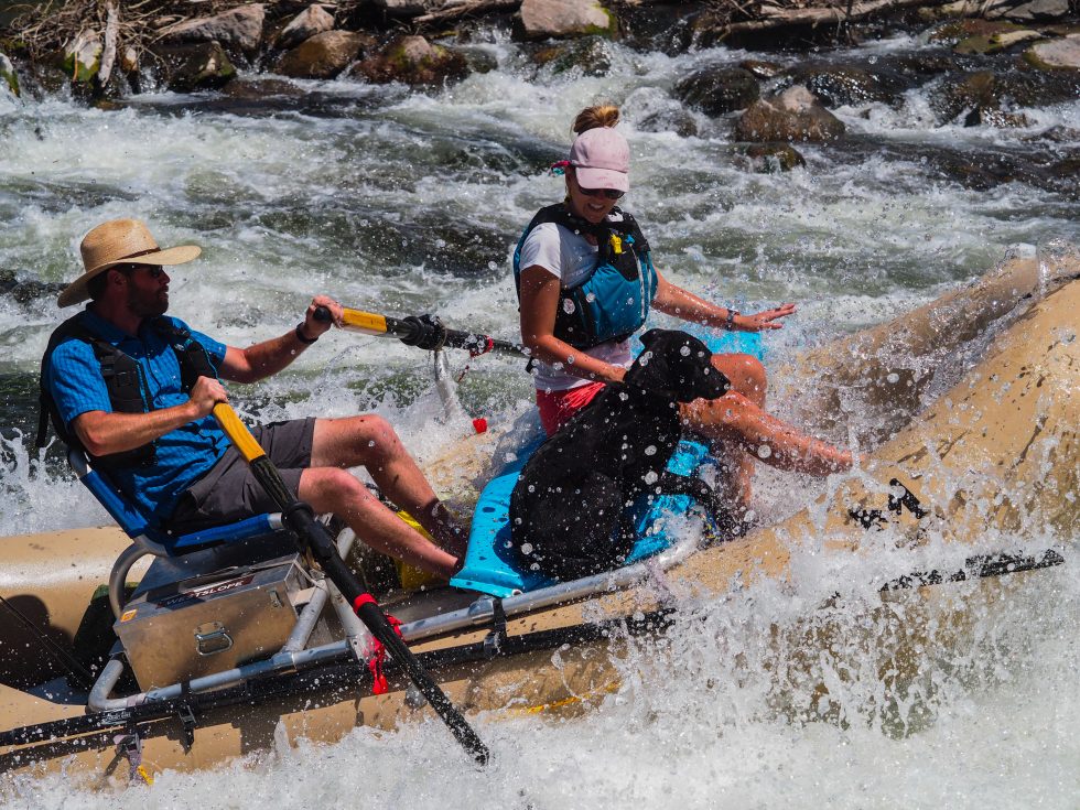
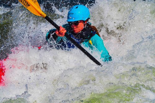
Rising temperatures also increase the risk of large forest fires like those that scarred Yellowstone in 1988 and broke records across Colorado in 2020. And the effects on the national parks could harm the region’s nearly US$800 billion in annual tourism activity across the three states.

A group of scientists led by Cathy Whitlock from Montana State University, Steve Hostetler of the U.S. Geological Survey and myself at the University of Wyoming partnered with local organizations, including the Greater Yellowstone Coalition, to launch the climate assessment.

We wanted to create a common baseline for discussion among the region’s many voices, from the Indigenous nations who have lived in these landscapes for over 10,000 years to the federal agencies mandated to care for the region’s public lands. What information would ranchers and outfitters, skiers and energy producers need to know to begin planning for the future?

A group of elk in a grassland area.
Elk in the Greater Yellowstone Area could be affected by changes in the availability and quality of plants they eat along their migration routes. Changes to the elk population would in turn have an impact on grizzlies, wolves, and other parts of the food chain.
Bryan Shuman/University of Wyoming

Shifting from snow to rain

Standing at the University of Wyoming-National Park Service Research Station and looking up at the snow on the Grand Teton, over 13,000 feet above sea level, I cannot help but think that the transition away from snow is the most striking outcome that the assessment anticipates – and the most dire.

Today the average winter snowline – the level where almost all winter precipitation falls as snow – is at an elevation of about 6,000 feet. By the end of the century, warming is forecast to raise it to at least 10,000 feet, the top of Jackson Hole’s famous ski areas.

The climate assessment uses projections of future climates based on a scenario that assumes countries substantially reduce their greenhouse gas emissions. When we looked at scenarios in which global emissions continue at a high rate instead, the differences by the end of century compared with today became stark. Not even the highest peaks would regularly receive snow.

In interviews with people across the region, nearly everyone agreed that the challenge ahead is directly connected to water. As a member of one of the regional tribes noted, “Water is a big concern for everybody.”

As temperature has risen over the past seven decades, snowfall has declined, and peak streamflow shifted earlier in the year across the Greater Yellowstone Area.
2021 Greater Yellowstone Climate Assessment, CC BY-ND

Precipitation may increase slightly as the region warms, but less of it will fall as snow. More of it will fall in spring and autumn, while summers will become drier than they have been, our assessment found.

The timing of the spring runoff, when winter snow melts and feeds into streams and rivers, has already shifted ahead by about eight days since 1950. The shift means a longer, drier late summer when drought can turn the landscape brown – or black as the wildfire season becomes longer and hotter.

The outcomes will affect wildlife migrations dependent on the “green wave” of new leaves that rises up the mountain slopes each spring. Low streamflow and warm water in late summer will threaten the survival of coldwater fisheries, like the Yellowstone cutthroat trout, and Yellowstone’s unique species like the western glacier stonefly, which depends on the meltwater from mountain glaciers.

Temperatures are projected to rise in the Greater Yellowstone Area in the coming decades. The chart shows two potential scenarios, based on different projections of what global warming might look like in the future – RCP 8.5, if greenhouse gas emissions continue at a high rate; and RCP 4.5, if countries take substantial steps to slow climate change. The temperatures are compared with the 1900-2005 average.
2021 Greater Yellowstone Climate Assessment

Preparing for a warming future

These outcomes will vary somewhat from location to location, but no area will be untouched.

We hope the climate assessment will help communities anticipate the complex impacts ahead and start planning for the future.

As the report indicates, that future will depend on choices made now and in the coming years. Federal and state policy choices will determine whether the world will see optimistic scenarios or scenarios where adaption becomes more difficult. The Yellowstone region, one of the coldest parts of the U.S., will face changes, but actions now can help avoid the worst. High-elevation mountain towns like Jackson, Wyoming, which today rarely experience 90 F, may face a couple of weeks of such heat by the end of the century – or they may face two months of it, depending in large part on those decisions.

The assessment underscores the need for discussion. What choices do we want to make?

[Get our best science, health and technology stories. Sign up for The Conversation’s science newsletter.]The Conversation

Bryan Shuman, Professor of Paleoclimatology and Paleoecology, University of Wyoming

This article is republished from The Conversation under a Creative Commons license. Read the original article.

How many “boatable” days does a #Colorado river possess? We’re about to find out — @WaterEdCO #GunnisonRiver

River rafters, fishermen and SUP users float on the Gunnison River on June 20, 2021. The Boatable Days Web Tool developed by Kestrel Kunz, American Whitewater’s Southern Rockies associate stewardship director, along with the Upper Gunnison River Conservancy District and Trout Unlimited, forecasts flows for an upcoming boating season based on historic wet and dry years and will help river managers better manage rivers in a time of drought and climate change. Credit: Dean Krakel via Water Education Colorado

From Water Education Colorado (Dean Krakel):

Kestrel Kunz is surfing, Colorado style, in her kayak among the waves at the Gunnison Whitewater Park a few miles west of town. The waves are more than recreational play for Kunz. Flowing water is an important part of the work she does for American Whitewater as the organization’s Southern Rockies associate stewardship director. For Kunz, the Gunnison River is like a watery crystal ball that gives her a glimpse into a future increasingly threatened by drought and climate change.

Kunz is the mastermind behind a prototype web tool developed by American Whitewater and the Upper Gunnison River Conservancy District that may change the future of river management across Colorado and eventually the West. The tool, the Upper Gunnison Basin Boatable Days Web Tool, is based on historical wet and dry year flows and other data and gives river users and water managers the ability to check an entire season’s flow forecast.

The Boatable Days Web Tool, Kunz said, “shows the relationship between river flow and recreational opportunities. With a little research we can use historic flows to project how a dry or wet year, a new diversion project, a climate change scenario, or reservoir operations can positively or negatively impact river recreation opportunities and thus Colorado’s robust outdoor economy.”

Being able to look ahead is an especially important feature for the state’s fishing and rafting outfitters, Kunz said. “The web tool will give an estimation on what flows are going to look like and how that is going to affect the number of commercial operating days in an upcoming season and help them plan in advance.” If outfitters know they’re not going to have sufficient boatable flows in September and October they might bring employees in earlier or may have to shift the way they do business and when they do it.

Kunz sees the tool as an opportunity for water managers both locally and at the state level to use the information to better balance flows for recreation with other needs. “This tool provides an important snapshot into how recreation opportunities are going to be impacted by drought. The web tool in no way is going to solve our drought problem, but it’s a critical piece of the puzzle that’s been missing before now.”

Kestrel Kunz surfs in her kayak at the Gunnison Whitewater Park in Gunnison, Colo. on May 24, 2021. Kunz is American Whitewater’s Southern Rockies associate stewardship director and is the creator of the Boatable Days Web Tool, which helps forecast river flows. Credit: Dean Krakel via Water Education Colorado

Kunz and American Whitewater are currently working to fit other pieces of Colorado’s river puzzle together by finalizing boatable days studies on the Roaring Fork, Crystal, and Poudre rivers and creating similar web tools.

“I think the biggest thing the tool does is give us a perspective on how climate change and drought are impacting our rivers,” said Sonja Chavez, general manager of The Upper Gunnison River Water Conservancy District. Chavez believes the next step will be to gain a better understanding of how changing river flows affect the local economy.

“Gunnison has been discovered,” Chavez said. “We have a lot of people visiting and a lot more people on the river.” As river flows drop, rafters, boaters, and other water users are concentrated into certain segments of the river with more frequency, impacting the fishery and wildlife, boat ramps, wetlands and the boating experience. You can see in water short years how that recreation season is shortened and that’s important for a community like Gunnison that is dependent on recreation.

This web tool is going to be a good model for how communities can come together and identify how their rivers are functioning,” said Trout Unlimited’s Dan Omasta. Omasta was TU’s grassroots coordinator during the development stage of the Boatable Days Water Tool and worked with Kunz and American Whitewater to identify ideal flow ranges for fishing and floating, and the high and low thresholds for navigation.

“When is the river too low to float for a dory or raft with clients?” said Omasta. “The tool will especially help identify sections of river that become unnavigable at certain flows. The Taylor and Gunnison rivers are seeing a lot of pressure. They get busier every year and one of the ways to tackle that challenge is to spread people out and encourage them to be floating and fishing different sections.

“More people are recreating on rivers and that’s awesome to see. We just need to be smarter about how we manage it and hopefully this tool can play a part in that,” Omasta said.

Dean Krakel is a photographer and writer based in Almont, Colo. He can be reached at dkrakel@gmail.com.

#Thornton Water Project update

Thornton Water Project route map via ThorntonWaterProject.com

From Colorado Community Media (Liam Adams):

Following the Weld County Board of Commissioners’ decision to deny the city of Thornton’s application to build a water pipeline through the county, Thornton intends to use a state statute to overrule the commissioners’ decision.

Thornton City Council will vote on a resolution at a June 29 meeting directing the city to bypass the board’s denial and commence pipeline construction, according to a meeting agenda posted Thursday. If approved by the city council at that meeting, Thornton will skip past an otherwise lengthy and cumbersome process for getting the pipeline approved at a point where the city feels like time is wearing thin…

Thornton’s goal is to complete the entire Thornton Water Project, a 75-mile-long pipeline from a reservoir near Fort Collins, by 2025. So far, the city has built six miles of the pipeline in other municipalities where Thornton has negotiated agreements. However, the two biggest sections – one in unincorporated Larimer County and the other in unincorporated Weld County – have faced setbacks.

The Larimer County Board of Commissioners denied Thornton’s application for a “1041 permit” to build the pipeline in 2019, leading to a series of ongoing court battles between the city and Larimer County board. Then in May, the Weld County board denied Thornton’s application for a “use by special review” permit, causing Thornton to file a complaint against the board in Weld County District Court.

Thornton began to seriously consider using a state statute that would essentially reverse the board’s decision right after the Weld County commissioners’ denial, said city spokesperson Todd Barnes. Colorado Revised Statutes 30-28-110(1)(c) allows a utility that is financing and authorizing the construction of a project to overrule a denial by a county board of commissioners.

Thornton can use the statute for the denial in Weld Co., but not in Larimer Co. because the two permit application processes are different. Barnes said the city’s legal challenge in Weld County District Court “remains in place to preserve Thornton’s rights.”

The Weld County board was made aware of Thornton’s intentions to overrule the commissioners’ decision before the June 29 city council meeting agenda published, and the board negotiated with the city certain terms and conditions for the pipeline’s construction. Board Chairperson Steve Moreno issued a response to the city that was included in the agenda packet.

Moreno said, “Clearly, the Thornton City Council has statutory authority to override the Board’s decision.” Moreno asks the city to comply with the newly negotiated terms and conditions that are “based upon the original Conditions of Approval and Development Standards of USR 18-0130 (use by special review permit) but have been modified to better fit the circumstance of an override by Thornton.”