The health of our waters is the principal measure of how we live on the land — Luna Leopold
Dry times, dire consequences: Poor #runoff adds to water woes — The #GrandJunction Daily Sentinel #ColoradoRiver #GunnisonRiver
FromThe Grand Junction Daily Sentinel (Dennis Webb):
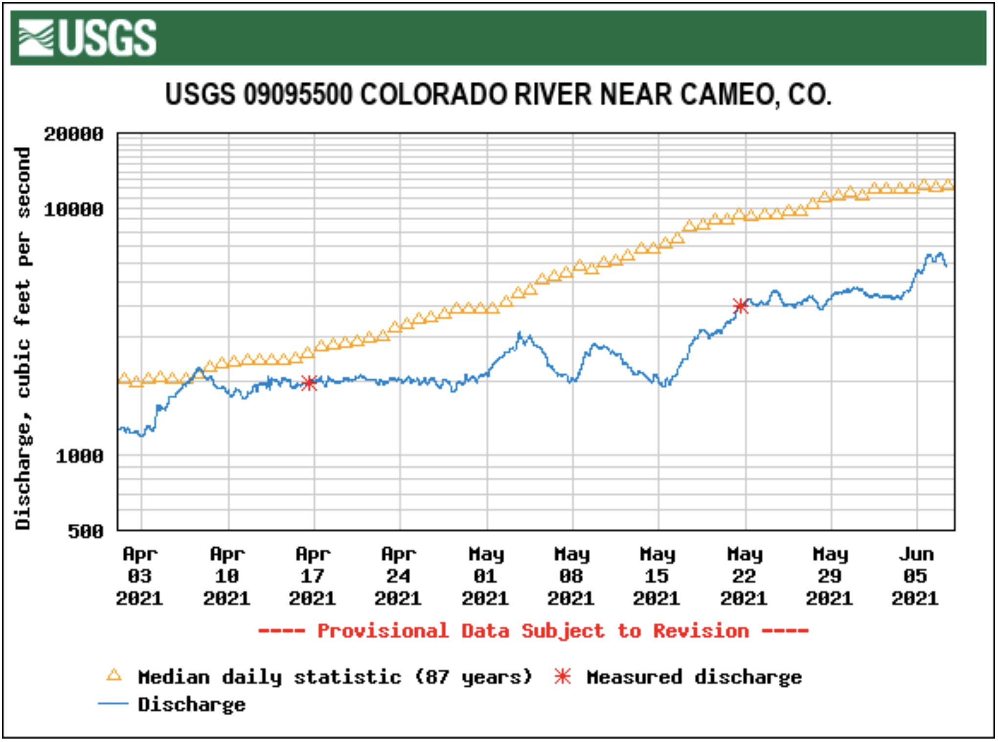
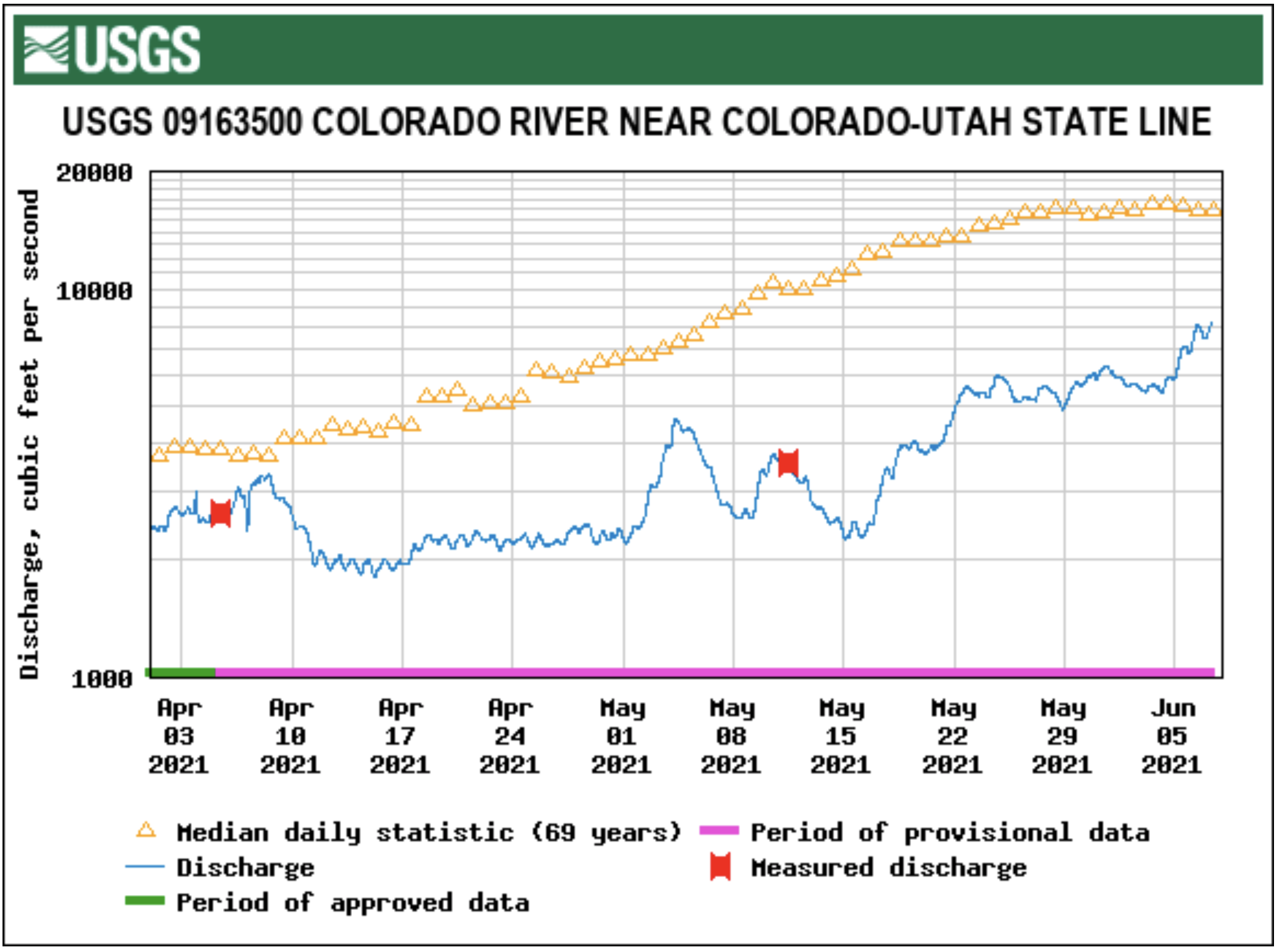
As of mid-day Friday, though, the U.S. Geological Survey gauge at Cameo was recording a relatively calm river flow — 4,840 cubic feet per second, compared to an average 12,700-cfs flow there for that date. Flows near the Colorado-Utah border were 5,860 cfs, a bit more than a third of average for that date.
Warming temperatures in recent days are accelerating snowmelt and boosting runoff some. Erik Knight, a hydrologist with the federal Bureau of Reclamation, said Friday that the federal Colorado Basin River Forecast Center was showing flows at Cameo likely hitting their seasonal peak by today, but at about 7,500 cfs, well below the typical 12,000-13,000 cfs average peak.
Said Russ Schumacher, state climatologist at the Colorado Climate Center at Colorado State University, “The streamflows throughout western Colorado are not looking good at this point and there’s not that much snow up there left to melt.”
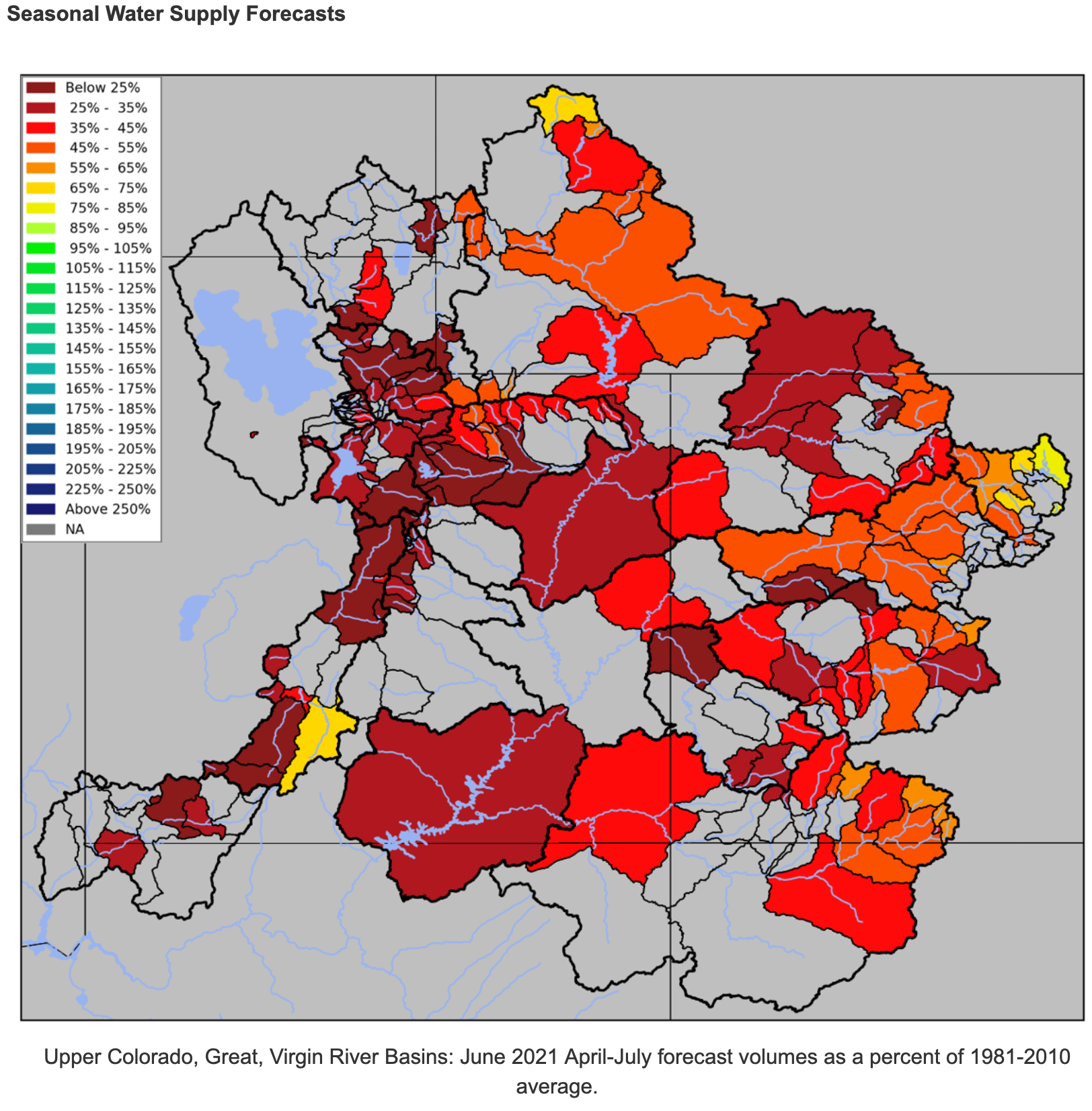
A continuing drought in western Colorado and beyond is having both in-state and more regional implications. The Colorado Basin River Forecast Center is now projecting that April-July inflows into Lake Powell will be just 25% of average.
The Upper Colorado River Commission, an interstate agency with representatives from Colorado, other Upper Colorado River Basin states and the federal government, noted in a May 20 news release that the water elevation in Powell was at 3,560.6 feet and is approaching its lowest recorded level since the reservoir began filling in the early 1960s. The Bureau of Reclamation reports that at the end of April, Powell held 8.5 million acre-feet of water, 35% of its live capacity. That’s the amount of a reservoir that can be used for purposes such as downstream release and power production.
May 2021 percent of normal precipitation. (Averaged by basins defined in the CBRFC hydrologic model). Map credit: Colorado Basin River Forecast Center
The Upper Colorado River Commission issued its news release to announce that Upper Basin states and the Bureau of Reclamation will begin development of a drought response operations plan, as called for under a 2019 agreement between the states and the Bureau of Reclamation. That’s after Reclamation last month said its most probable forecast is for the water level in Powell to fall to 3,525.57 feet in elevation as early as March 2022…
The response plan would seek to keep Powell from falling below 3,525 feet, to help assure Upper Basin states can continue complying with a century-old compact for sharing Colorado River water with downstream states, and not jeopardize hydropower production at Glen Canyon Dam…
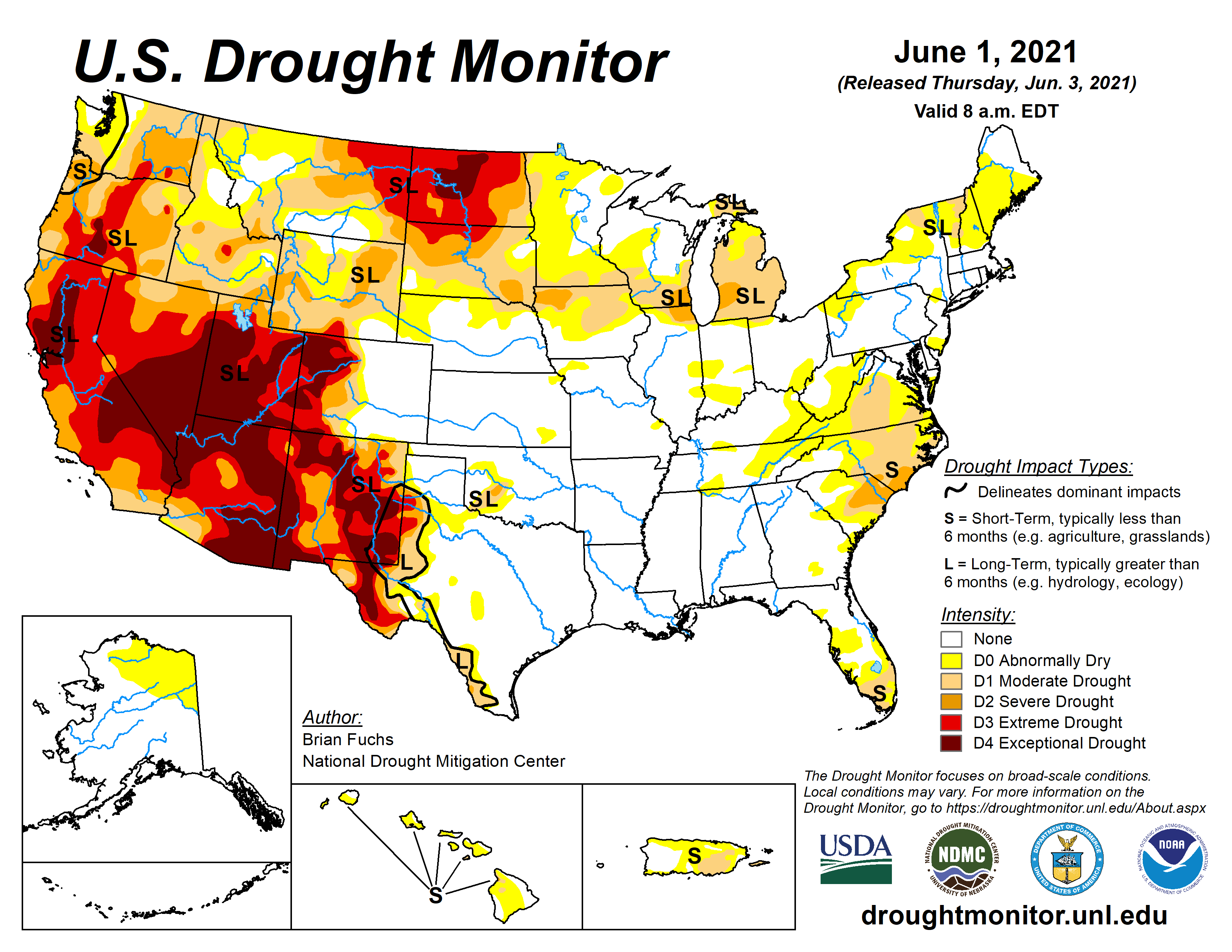
US Drought Monitor map June 1, 2021.
Currier said there’s concern about what limits federal land managers might put on grazing allotments due to the dry conditions.
Currier and other Interbasin Compact Committee members will be considering some of the bigger-picture drought issues at a meeting later this month. The Upper Basin states wouldn’t have to finalize a drought response operations plan until the Bureau of Reclamation finds it probable that Powell’s level will fall to or below 3,525 feet within 12 months, and only after consultation with Lower Basin states. However, the Interior secretary, consulting with basin states, also could take emergency action to keep the reservoir level above that threshold…
THE PLAN’S APPROACH
As agreed to in 2019, the Powell drought response plan would first consider making use of existing operational flexibilities in Powell, within legal and operational constraints. If that’s not enough to keep Powell’s water elevation above 3,525 feet, they will consider releases from Flaming Gorge, Blue Mesa and Navajo reservoirs upstream.
Aspinall Unit
“Blue Mesa doesn’t really have enough water in it to contribute a whole lot,” Currier said.
Knight said Blue Mesa is only about 43% full, probably half of normal this time of year, and seasonal runoff inflows into the reservoir this year are now projected to be just 46% of average…
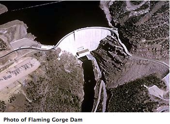
Flaming Gorge Dam. Photo credit: USBR
Currier thinks Flaming Gorge is the likely candidate for boosting Lake Powell water levels if help from upstream reservoirs is required…
Upstream reservoir releases also are only a short-term fix, Currier said. Officials are looking longer-term at approaches including managing demand for water through reduced consumptive use, but consumptive use is directly related to crop production, he said.
“Reduce your consumptive use, you’re probably producing less crops. That’s not a good solution for agriculture,” he said.
And then there’s the question of how to ensure that any water saved through such measures actually makes it down to Lake Powell, rather than simply being used by other water users upstream…
[Russ] said that so far in Grand Junction this water year, which started Oct. 1, is the sixth-driest on record. It’s drier than the previous water year through the same date…
Since Jan. 1, 2.04 inches of precipitation have been recorded at the Grand Junction Regional Airport, compared to 3.8 on average through this time of year.
Since March 1, average temperatures have been warmer than normal in Grand Junction, but only marginally so, by 0.3 degrees, said Erin Walter, a meteorologist at the National Weather Service in Grand Junction. But local temperatures over that time are still cooler than last year, she said.