The health of our waters is the principal measure of how we live on the land — Luna Leopold
Data gaps in Southwest #Colorado limit what we know about local #ClimateChange: Lack of radar and spotty ground monitoring make long-term forecasting difficult — The #Durango Herald
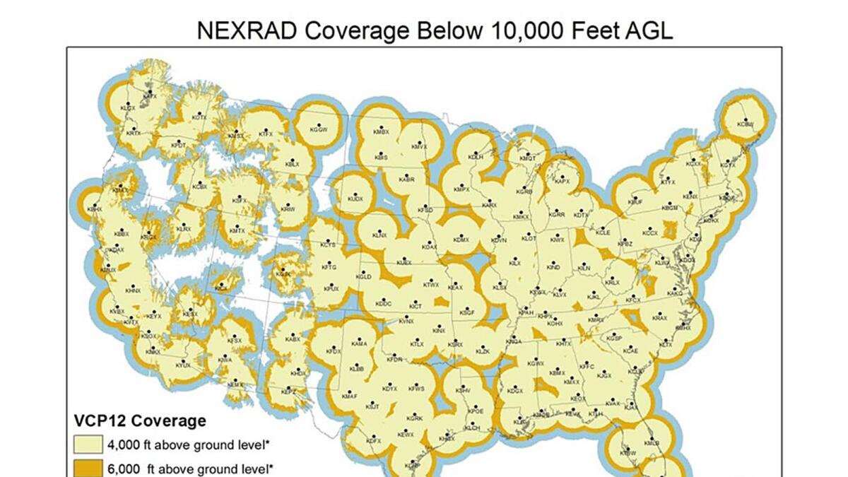
The Four Corners has a radar problem. The San Juan Mountains block signals from the nearest National Weather Service office in Grand Junction, leaving the region blind to low-elevation storms.
A proposed radar project in La Plata County meant to fill in data gaps has been in the queue since 2019 after the Colorado Department of Local Affairs awarded the county $1.7 million to construct a new radar system.
Location problems have stalled the project, but the continued push for radar has raised concern about another issue: climate data gaps.
A 2017 National Oceanic and Atmospheric Administration map shows radar coverage across the U.S. A new radar system in La Plata County was supposed to decrease coverage gaps, but the project has yet to come to fruition. (Courtesy of National Oceanographic and Atmospheric Administration)
Southwest Colorado has fewer weather monitoring stations than the East Coast and other parts of the U.S., according to Colorado state climatologist Russ Schumacher.
“The issue is more acute in the West where it’s more sparsely populated and the complex terrain makes the weather and climate so complicated,” he said. “Ideally, you’d have lots and lots of data quantifying what’s happening at all of these locations because they can vary quite a bit from place to place.”
Climate scientists rely on monitoring stations and the continuous data they collect over years to understand how the climate is changing. But in Southwest Colorado few weather stations have been collecting data long enough or consistently enough for scientists to determine how climate change is affecting communities in the region…
Scientists create 30-year “climate normals” to understand the typical climate of a place. They use these normals, which include temperature, precipitation and other variables, as a baseline to compare daily weather, predict future conditions and assess climate change.
To create these normals, or to determine any climate change trends, scientists need at least 30 years of continuous data.
In Southwest Colorado, few monitoring stations have been running continuously for that long. Many have only been placed in the last two or three decades.
Durango-La Plata County Airport’s temperature data extends back to 1996 and its precipitation data to 2000, according to the National Oceanic and Atmospheric Administration’s NOWData.
Ignacio’s NOAA weather monitoring data dates to 2000.
Mancos has data that dates back to 1898, but it has significant gaps in years of coverage. The station has been continuously recording temperature since only 1997 and precipitation since 2013.
Without this data, climate scientists can’t create climate normals or establish trends as the planet warms. Models that rely on this on-the-ground data become less accurate…
Climate researchers turn to other weather stations in the region to understand how the climate is changing.
Mesa Verde National Park, which has been consistently recording data since 1922, and Cortez, which has been consistently recording data since 1930, are two stations that Schumacher and his team at the Colorado Climate Center use to study climate change in Southwest Colorado…
Though climate scientists know broadly how climate change is affecting, and will affect, Southwest Colorado, the data gaps in the region have significant consequences.
Water managers could use localized climate data to better understand how climate change is affecting the flow of water, allowing them to notify water users of potential shortages and make decisions about infrastructure projects.
City and county managers who plan years in advance could incorporate climate change into their analyses…
The gaps in climate data are perhaps most visible with drought and water resources.
“Climate data is crucial for understanding drought. Because anytime that we’re trying to analyze a drought, we’re measuring it against what has happened before,” said Peter Goble, a climatologist and drought specialist with Colorado State University’s Colorado Climate Center.
According to the most recent National Climate Assessment released in 2018, rising temperatures will worsen drought in the western U.S. as snow shifts to winter rain and soils dry out. Droughts will be more severe and may become more frequent.
Drought driven in part by increasing temperatures shrunk Colorado River flows by 19% from 2000 to 2014, a 2017 study by the Colorado River Research Group showed…
The IPCC’s most recent report released this year found more direct links between global drought and human-caused climate change over the last 120 years, but it concluded that “projecting regional water cycle changes remains challenging.”
Making informed forecasts
Filling in the data gaps in Southwest Colorado and elsewhere would help climate scientists learn more about regional water cycles and ultimately develop projections.
For water managers, that information is critical.
“I wish we could look one year ahead as far as climate and know what we were going to get,” said Steve Wolff, general manager of the Southwestern Water Conservation District.
“There are some tools that look one month and three months out. They are not really accurate at best,” he said. “… For accuracy, we’re stuck to that seven to 14 day forecast.”
The information that climate scientists could glean from more data would help Wolff and other water managers make difficult decisions and prepare for worsening climate change…
Efforts to close the climate data gaps in Southwest Colorado are ongoing.
Schumacher, Goble and the Colorado Climate Center have been expanding their monitoring network, including Colorado State University’s Agricultural Meteorological Network (CoAgMET), which measures soil temperature, precipitation, wind and other variables near irrigated agricultural areas.
Over the last 40 years, the U.S. Department of Agriculture’s Natural Resources Conservation Service has grown its automated snow telemetry network (SNOTEL) across the West. The SNOTEL network now has more than 900 high-elevation sites that collect snowpack, temperature and other climactic data, data that is crucial for water managers like Wolff.
In 2019, a team of scientists founded Airborne Snow Observatories Inc., which uses planes, geospatial technology and other instruments to fly over mountain basins and more accurately assess snowpack and forecast snowmelt.
It’s a new tool that has flourished in recent years, giving Wolff and Schumacher more accurate data with which they can gauge water resources in Southwest Colorado and statewide.
Scientists are even turning to volunteers. The Community Collaborative Rain, Hail & Snow Network (CoCoRaHS), which was initially developed by the Colorado Climate Center in 1998, enlists volunteers across the country to help measure precipitation…
The proposed radar system in La Plata County, which has yet to find a suitable site, according to Stevens, will also help scientists to close climate data gaps…
As climate scientists work to expand their data collection networks, the question becomes one of money. The instruments and equipment needed for monitoring stations can be expensive to buy and maintain.
“As a researcher, I would say the ideal (weather station) density is the more data I can get, the better. If we had stations every half mile or quarter mile, we could find ways to put that all to use,” Goble said.
“But what’s the best practical density is an entirely different question,” he said.