Click on a thumbnail graphic to view a gallery of drought data from the US Drought Monitor.
US Drought Monitor map November 16, 2021.
High Plains Drought Monitor map November 16, 2021.
West Drought Monitor map November 16, 2021.
Colorado Drought Monitor map November 16, 2021.
Click here to go to the US Drought Monitor website. Here’s an excerpt:
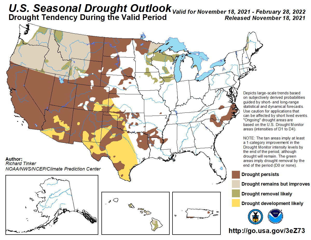
This Week’s Drought Summary
Drier weather in the southwestern United States, western Great Plains, and Southeast led to drought conditions developing or worsening for parts of these regions this week. The northern Great Plains, western Great Lakes, the Northeast, and the Pacific Northwest saw significant precipitation this week, which led to improving drought conditions in parts of these regions. Slightly warmer than normal weather occurred in the Northeast, and warmer weather also occurred west of the Mississippi River. The warmest temperatures, compared to normal, were found in the northwestern Great Plains and in the West, with some areas seeing temperatures at least 6 degrees above normal. In Hawaii, drought conditions stayed the same or worsened after another drier week. Similar conditions occurred in Puerto Rico this week, where degrading conditions were spread across the island…
The eastern edge of the High Plains region saw notable precipitation amounts this week, in particular the eastern parts of North Dakota and Kansas. Otherwise, largely dry weather ruled the week. Precipitation amounts were sufficient in northeast North Dakota to reduce long-term deficits enough to cause improvements in long-term drought. In eastern Colorado and western Kansas, drought worsened and expanded in some locations, as soil moisture continued to decrease and precipitation deficits on the short- and long-term continued to grow. Most of the High Plains saw a warmer than normal week, with the warmest temperature anomalies (4 to 10 degrees above normal) taking place in western Nebraska and Kansas, the western Dakotas, and eastern Colorado and Wyoming. Residual effects from the now mostly long-term drought continued in the Dakotas, where livestock producers had problems feeding herds due to alfalfa and hay shortages…
Mostly warmer than normal weather occurred in the West region this week. Many parts of the region saw temperatures range from 4 to 8 degrees above normal. Significant precipitation mostly occurred in the northern Sierra Nevada and in western Montana, northern Idaho, and in Washington and Oregon. In western Washington and Oregon, precipitation totals of 2 to 6 inches, with locally higher amounts, were common. Improvements were made to drought conditions in Washington, Oregon, Idaho, and western Montana where long-term precipitation deficits, soil moisture, and groundwater were improved the most. Conditions in south-central Wyoming and northwest Colorado also improved where short-term precipitation shortfalls had lessened and soil moisture had increased. In north-central Montana, short- and long-term precipitation deficits mounted and soil moisture and streamflow decreased, leading to the expansion of exceptional drought. In California, citrus crops have taken a hit as a result of the long-term drought conditions, and reservoirs continue to be very low…
In the South this week, rain fell primarily to the east of Interstate 35 in Texas and Oklahoma, and in Arkansas, northwest Louisiana, and parts of Tennessee. Overall, though, the week was somewhat dry across the region. Along and west of I-35 in Texas and Oklahoma, temperatures generally ranged from 2 to 6 degrees above normal, and some areas locally reached 8 degrees above normal. East of there, temperatures were either near normal or slightly cooler than normal. In Texas and the Oklahoma Panhandle, drought conditions largely stayed the same or worsened, due to mounting short-term precipitation deficits, decreasing streamflow in some locations, high evaporative demand, and decreasing soil moisture in some areas. Moderate short-term drought also expanded in coverage in northern Louisiana, western Mississippi, western Tennessee, and southern Arkansas this week, where short-term precipitation deficits worsened and soil moisture decreased. Drought conditions in Arkansas, Louisiana, Tennessee, and east Texas, along the Red River, and in deep south Texas, are mostly short-term. Other areas experiencing drought in the South have drought conditions on both the short- and long-term…
Looking Ahead
The Weather Prediction Center’s forecast (valid Nov. 17-24) shows a deep low pressure system over Canada affecting much of the central and eastern half of the Lower 48. The system’s warm front will bring a mix of snow, sleet, and freezing rain to the Northeast. Temperatures behind the front are expected to be up to 20 degrees above normal. The system’s cold front will push through the mid-section and eastern U.S. through Friday. It is expected to bring showers and thunderstorms to parts of the South and Southeast. Temperatures in the eastern half of the country are expected to drop 1 to 7 degrees below normal after the front passes. The cold air will set up lake-effect rain and snow showers over the Great Lakes. Meanwhile, a new storm system will affect the Pacific Northwest. This is expected to bring more rain and high elevation snow to the region. Temperatures across much of the West are expected to be 2 to 8 degrees above normal.
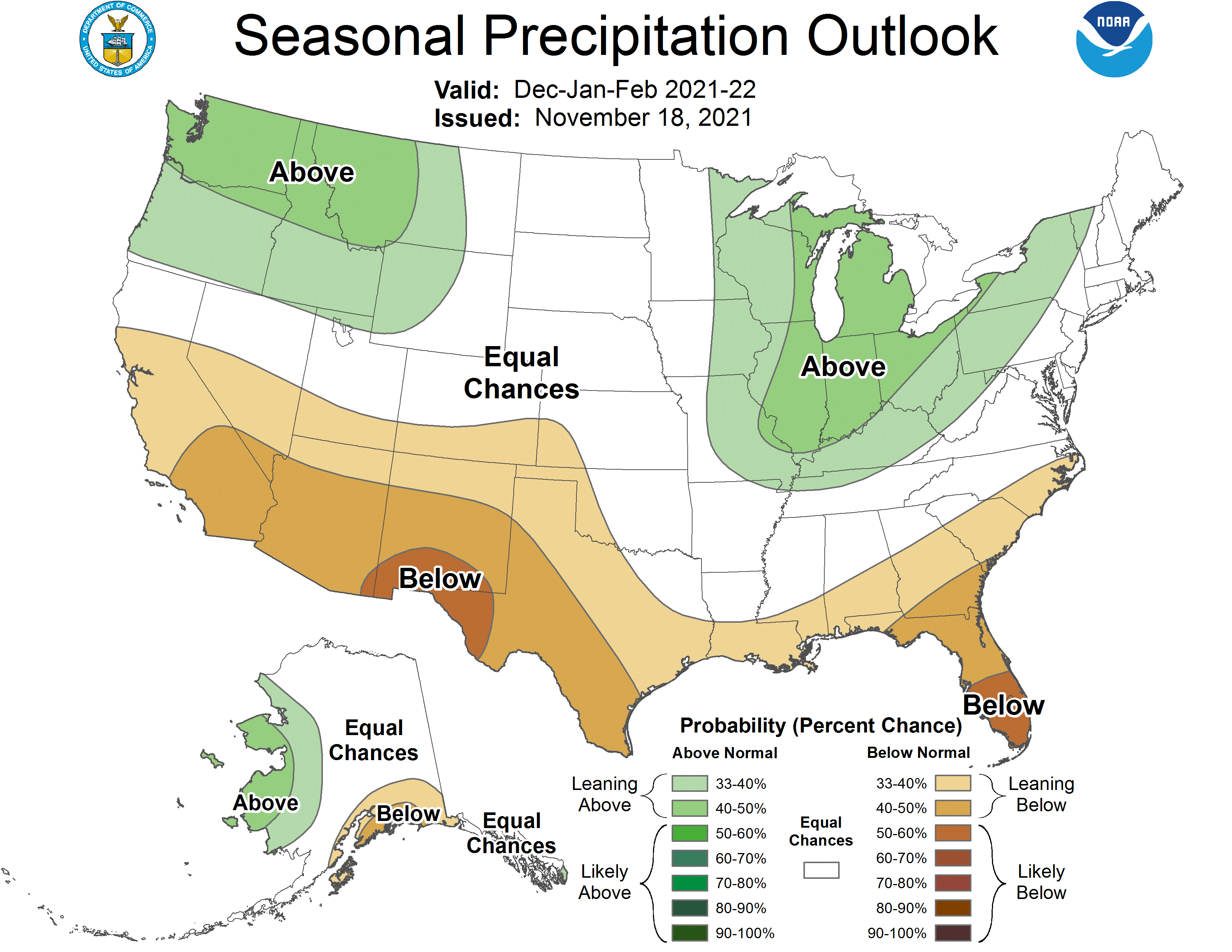
The Climate Prediction Center’s 8- to 10-day outlook (valid Nov. 24-30) favors below normal precipitation across much of the West and parts of the High Plains and Midwest. Above normal precipitation is favored from the eastern part of the Southwest along the Gulf Coast and into the Southeast. Above normal temperatures continue to be likely for the western U.S. Below normal temperatures are favored for much of the east.
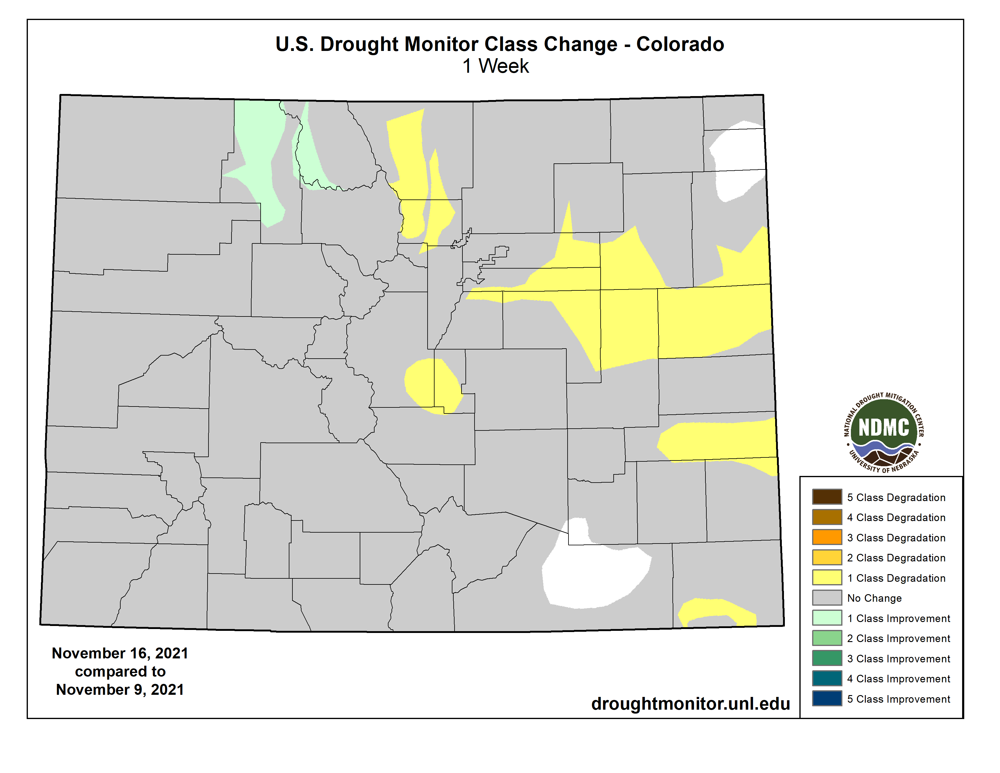
US Drought Monitor 1 week change map ending November 16, 2021.
The Uncompahgre may have a legal guardian in its future after a town vote, though critics of “rights of nature” resolutions call “personhood for the river” an empty gesture and a paradise for lawsuits from angry property owners.
The Ridgway town council has voted to give “rights of nature” to the Uncompahgre River that flows on the edge of its downtown, joining Nederland and a long list of international locations saying they want to be better stewards of their wild spaces.
The council followed the lead of Mayor John Clark in approving the river rights resolution 5-0, with one abstention. Supporters said that while their vote was largely symbolic, at the very least they want it on the record that preserving the environment of the Uncompahgre’s basin is important to town leaders.
“We believe nature deserves equal footing” with those who use the river’s water and other resources for other gains, Clark said after the vote on Nov. 10. “And so I’m pretty excited to be one of the few communities in the nation that are stepping up on this.”
It’s just a resolution for now, with no clear enforcement path. But the “personhood for the river” discussion is part of a growing effort to protect natural areas by granting them some legal form of a right to exist, after centuries of human intervention. Nederland already passed such a measure in the summer of 2021, and the nonprofits Earth Law and Save the Colorado are helping to spread the conversation in more Colorado towns. Save the Colorado says people have expressed interest in Lyons, Fort Collins and Crested Butte.
The natural rights movement has gone as far afield as New Zealand and Nigeria, with some efforts focused on protecting revered tribal lands, others to stop dams from forever changing valued waterways…
Legal critics of the strategy, though, contend that water can’t have rights unto itself, and that the people proposing to speak for Colorado’s rivers may have narrow views that don’t serve the state as a whole.
Cross Section 7, looking upstream channel, from right hand bank, October 23, 2003. Photo credit: USGS
“The problem is the assumption that one particular party gets to unilaterally say what the interests of the stream are,” said David McDonald, an attorney who has followed the natural rights movement for the Mountain States Legal Foundation. “The stream has no voice. It’s not a person. It’s a collection of inanimate objects. These organizations are asking us to give them a great deal of trust.”
For rivers, the premise begins with the reality that all the rights to the water in Colorado streams are already carved up and passed out to buyers including ranchers, town water supplies, beer brewers and power utilities. The trout and the frogs and the mayflies and the H2O itself don’t get a say, while the water is pushed and pulled and dammed and drained.
The rights of nature movement, Durango-based Earth Law attorney Grant Wilson said in an interview, treats rivers as living entities. That’s a revolution, he said, from centuries of water law that treats river water as a human property. Wilson went to Ridgway to explain the resolution before the town council held its vote.
Assigning the water and the wildlife a guardianship recognizes that “nature just like humans has inherent and fundamental rights, and that recognizing those rights and incorporating them into the legal system is a part of the solution to environmental degradation,” said Wilson, who worked with Clark on the proposal.
After a lot of “whereas-es” that give a nice history of the Uncompahgre Valley, the first “therefore” of the resolution hints at the real point: “The right to maintain natural flow sufficient in quantity to maintain ecosystem health.” Meaning that even those who paid a lot of money for water rights shouldn’t be able to just dry up the river in the ongoing drought — in the future, they may have to argue with an attorney appointed by the town to represent the Uncompahgre as a client worth protecting.
The idea of a legally recognized mouthpiece for the voiceless is already common, Wilson noted, for children in family court or the ailing elderly. The resolutions have rarely been tested in the United States to see what new legal structures they might create. In practical terms, a town like Ridgway could pass a resolution and then work toward appointing an “independent, qualified legal guardian serving as basically the human voice of ecosystems in a way that governments currently don’t,” he said.
Nederland’s Alan Apt said he brought a similar resolution to the town board he sits on not as a launching point for endless litigation, but to put into words the importance local residents place on Middle Boulder Creek. Apt said he agrees with water advocates’ desire to “have the ecosystem be part of the conversation, the Boulder watershed, so that when we make decisions, it’s a reference point.”
Nederland holds some of its own water rights from Boulder Creek, currently stored in Barker Reservoir, and sees itself as a high-country link between the origins of mountain water near the Continental Divide to the west, through town, and down to Boulder on the east, Apt said.
Mountain States Legal Foundation would want to know, McDonald said, which inanimate object has the new natural rights — the water flow? The mosquitos? The frogs? And who decides whether the water’s right to exist is more important than a rancher’s right to use water to raise cattle, or a town’s right to supply a popular kayaking rapid?
[…]
The resolutions are far from ironclad, McDonald acknowledged. “But these are fringe ideas that are becoming more popular, and ideas are powerful. I think it’s important to stand against them.”
Wilson has no doubt the resolutions in Ridgway and other cities will be questioned by those who hold water rights or development dreams. But, he said, even holding the discussion helps a mountain town agree on shared values and what’s worth protecting.
The Suncor refinery in Commerce City is pictured on Sand Creek near where it meets the South Platte River. Both streams have highly challenged water quality, though many conservationists argue they can get still better. Photo credit: Suncor
Following repeated pollution violations this year and calls to shut down the Suncor Energy oil refinery in Commerce City, Colorado health officials are seeking to renew the facility’s water quality permit, albeit with tighter restrictions.
The refinery has been allowed to operate on expired permits because the company applied to renew them before they lapsed. And now officials with the Colorado Department of Public Health and Environment are considering a new water quality permit for the facility, spokeswoman Erin Garcia said in a release.
The new permit would be more restrictive than the old one, Garcia said, and aims to better protect Sand Creek and downstream waters. The permit would also require more transparency surrounding the refinery’s operations and impose more pollution monitoring requirements and limits for toxic metals and chemicals.
Suncor would be required to conduct “frequent” site inspections ensure that drinking water moving through its property remains safe, bolster its maintenance operations and alert people by text message if or when a spill occurs…
But the draft permit isn’t finished yet, so state officials are soliciting public input. The department will host a virtual meeting Thursday between 6:30 p.m. and 8 a.m. to review current details of the draft permit. In addition the department will accept public feedback on the draft through Feb. 10, 2022. Additional details and public comment sections can be found online at http://cdphe.colorado.gov.
The facility has repeatedly violated pollution standards, even after state health officials boasted last year of fining the company up to $9 million for violations in 2017. Between March 27 and April 22 of this year, the refinery exceeded pollution limits 15 times, emitting too-high levels of hydrogen sulfide, carbon monoxide and sulfur dioxide…
State officials are also currently considering an air quality permit for the refinery, which would allow more of some types of pollution and crack down on others, The Denver Post reported in May. That proposed permit would raise permissible limits of volatile organic compounds that form ground-level ozone by 138 tons per year and allow 11 tons more particulate soot a year. It would, however, reduce sulfur dioxide and carbon monoxide…
In the bigger picture, however, Suncor has pledged to invest $300 million in the refinery before 2023 to make the facility “better, not bigger.” To that end, Adesanya told The Post in September that the company installed an automated shutdown system in part of the plant last year and will upgrade the rest of the facility with similar technology by the end of next year.
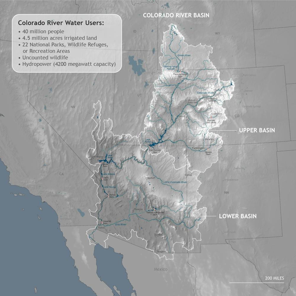
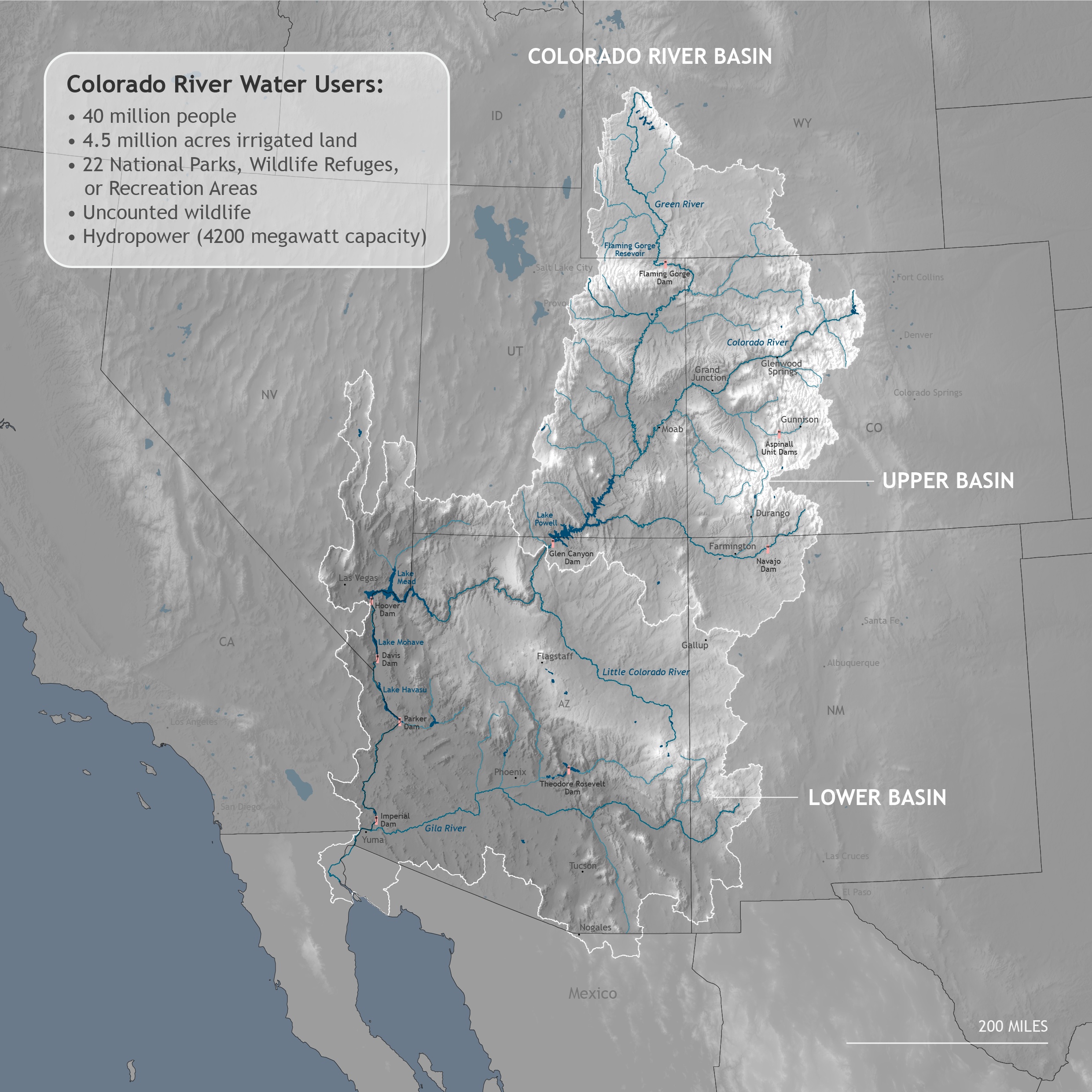
The Colorado River is a vital lifeline for the arid U.S. Southwest. It supplies water to seven states, Mexico, 29 Indian reservations and millions of acres of irrigated farmland. The river and its tributaries support 16 million jobs and provide drinking water to Denver, Salt Lake City, Albuquerque, Las Vegas, Los Angeles, San Diego, Phoenix and Tucson – in all, 40 million people.
These rivers also course through several of the world’s most iconic national parks, including the Grand Canyon in Arizona and Canyonlands in Utah. Today millions of people visit the Colorado River Basin to fish, boat and explore.
Southwestern states, tribes and Mexico share the Colorado’s water under the century-old 1922 Colorado Compact and updates to it. But today, because of climate change and rapid development, there is an enormous gap between the amount of water the compact allocates to parties and the amount that is actually in the river. With users facing unprecedented water shortages, the compact is hopelessly inadequate to deal with current and future realities.
I have studied water resource development for 35 years and written extensively about Native American waterrights and the future of America’s rivers. As I see it, the compact rests on three fundamental errors that now plague efforts to develop a new vision for the region. I believe the most productive way forward is for states and tribes to negotiate a new agreement that reflects 21st-century realities.
The Colorado River and its tributaries drain parts of seven Western states and 29 Indian reservations. Climate.gov
Flawed data and allocations
The compact commissioners made two fatal blunders when they allocated water in 1922. First, they appraised the river’s volume based on inaccurate data that wildly overestimated it. Actual annual historic flows were far below what was needed to satisfy the dictates of the compact.
There is evidence that the commissioners did this purposefully: Reaching an agreement was easier if there was more water to go around. This strategy guaranteed that the compact would allocate more water than was actually in the river, a situation now referred to as the “structural deficit.”
Second, the compact allocated water in fixed amounts rather than percentages of the river’s actual flow. That approach would be viable if river flow were constant and the agreement were based on sound science. But the Colorado’s flow is highly variable.
The compact divided the river artificially into an Upper Basin (Wyoming, Colorado, Utah and New Mexico) and a Lower Basin (Arizona, Nevada and California), and allocated 7.5 million acre-feet of water to each basin. An acre-foot is enough water to cover an acre of land to a depth of one foot, or about 325,000 gallons.
In 1944, a treaty allocated an additional 1.5 million acre-feet to Mexico, for a total of 16.5 million acre-feet. However, actual flow has typically been below that amount. River volume at the time of the compact was about 18 million acre-feet per year, but the 20th-century average was closer to 14.8 million acre-feet. And then things got much worse.
Drought and climate change have pushed the Colorado River to a crisis point.
In the past 20 years, climate change has further reduced the Colorado’s volume. A “megadrought,” now in its 21st year, has reduced flows by nearly 20%, and studies predict that it will fall 20% to 35% or more by midcentury. In late August 2021, Lake Mead, the nation’s largest reservoir, was just 35% full. Lake Powell, the second-largest U.S. reservoir, was less than 30% full.
That month, the Bureau of Reclamation declared an official shortage, which will force Arizona, Nevada and Mexico to make significant cuts in water use. In short, the original fixed allocations are no longer anchored in reality.
In my view, a much better approach would be to allocate water among the states and tribes in percentages, based on a five-year rolling average that would change as the river’s flow changes. Without such a shift, the compact will merely perpetuate a hydrological fallacy that leads water users to claim water that does not exist.
No Native participation
Beyond these errors, the compact also rests on a fundamental injustice. The 30 tribal nations in the Colorado River Basin are the river’s original users, and their reservations encompass huge swaths of land. But they were completely left out of the 1922 allocations.
Tribes have gone to court to claim a share of the Colorado’s water and have won significant victories, beginning with the landmark 1963 Arizona v. California ruling, in which the U.S. Supreme Court recognized water rights for five Indian reservations in the Colorado River Basin. The tribes continued to press their claims through numerous negotiated settlements, starting in 1978 and continuing to this day. They now have rights to over 2 million acre-feet of water in the Lower Basin and 1.1 million acre-feet in the Upper Basin. And 12 tribes have unresolved claims that could total up to 405,000 acre-feet.
Currently, however, tribes are not drawing all of their water because they don’t have the pipelines and other infrastructure that they need to divert and use it. This allows non-Indian communities downstream to use the surplus water, without payment in most cases. I believe a new compact should include tribes as equal partners with states and give them meaningful and significant roles in all future negotiations and policymaking in the basin.
[More than 140,000 readers get one of The Conversation’s informative newsletters.Join the list today.]
I see these discussions as an excellent opportunity to discard the compact’s unworkable provisions and negotiate a new agreement that responds to the unprecedented challenges now affecting the Southwest. As I see it, an agreement negotiated by and for white men, based on egregiously erroneous data, in an age when people drove Model T cars cannot possibly serve as the foundation for a dramatically different future.
In my view, the 1922 compact is now an albatross that can only inhibit innovation. Eliminating fixed rights to water that doesn’t actually exist could spur members to negotiate a new, science-based agreement that is fairer, more inclusive and more efficient and sustainable.
Ouray County Water Users Association wants to build Ram’s Horn Reservoir on the upper reach of Cow Creek, shown here. Ouray County has requested that the CWCB delay a filing for an instream flow water right below this reach. CREDIT: HEATHER SACKETT/ASPEN JOURNALISM
Ouray County is asking the state water board to delay a water court filing designed to protect streamflows so it can try to resolve issues in a separate but related water court case.
In July, the Colorado Water Conservation Board approved an instream flow water right on Cow Creek, a tributary of the Uncompahgre River, and asked staff to file for the right in water court by the end of this year. Instream flow rights are held exclusively by the state with the goal of preserving the natural environment to a reasonable degree. The state board, which is charged with protecting and developing Colorado’s water supply, holds instream flow rights on about 1,700 stream segments and 9,700 miles of stream throughout the state.
Now, Ouray County is asking the CWCB to delay the filing by six months so that the two governmental entities can try to work out the board’s opposition to a reservoir and pipeline project on Cow Creek on which the county is a co-applicant. CWCB directors will consider the request at their regular meeting Thursday.
In a November letter to Ouray County, Robert Viehl, the CWCB’s chief of the Stream and Lake Protection Section, noted that state statutes set clear rules and timelines for commenting and making hearing requests, and that the county’s request to delay the filing falls outside of those parameters.
“Any entity had the opportunity to state concerns with the Cow Creek appropriation and filing of the water right at the CWCB’s March, May and July 2021 meetings, when the appropriation was noticed before the board,” the letter reads. “This request by Ouray County is outside of the set administrative process for the appropriation and filing on instream flow water rights.”
The CWCB, at the recommendation of Colorado Parks & Wildlife, is seeking instream flow protections for a 7.4-mile reach of Cow Creek — from its confluence with Lou Creek to its confluence with the Uncompahgre River, downstream of Ridgway Reservoir. CPW says this reach contains important fisheries, including the last-known remnant population of bluehead sucker in the upper Uncompahgre River basin.
Colorado water quality regulators have issued a cease and desist order to the owner of two hard-rock mines located just outside the town of Nederland, alleging the mines have discharged potentially hazardous pollutants well in excess of permitted levels into nearby watersheds.
The Colorado Department of Public Health and Environment’s Water Quality Control Division issued a notice of violation on Nov. 5 to Grand Island Resources, LLC, which acquired the Cross and Caribou Mines in western Boulder County after the death of former owner and miner Tom Hendricks in 2020.
The violation notice came after a series of compliance advisories were sent to the company over the summer. The November notice alleges a failure to comply with current water quality standards, citing multiple excess effluent discharges of heavy metals during the months of December 2020 to August 2021, as well as a failure to comply with required reporting of additional water pollutants.
GET THE MORNING HEADLINES DELIVERED TO YOUR INBOX
Pollutants listed in the violation for exceeding the daily or monthly limits included lead, copper, zinc, silver and cadmium, with the self-monitored data showing several occasions where effluent discharges exceeded levels by up to three or four times the permitted amounts.
Grand Island Resources is currently permitted through the state to release treated wastewater via one outfall into Coon Track Creek within the specified effluent limits. The need to stay within these limits is underscored by the fact that the small creek serves as a tributary in the Boulder Creek watershed, ultimately joining another creek through the town of Nederland and flowing into the Barker Reservoir, one of several potable water sources for the city of Boulder.
In high concentrations, heavy metals are well documented to cause impacts to the environment and human health, including the ability to accumulate in the body over time and cause disease. Critically, the 2021 report of Boulder’s drinking water quality — which employs data from 2020 — reported no violations for lead or copper levels, and no public health advisories have been issued to date.
Direct water quality testing for the natural spring located off Caribou Road — a spring often utilized by locals and recreational visitors — was not immediately available, nor was the immediate source of the spring known.
Representatives of Grand Island Resources did not respond to requests for comment.
This is not the first time compliance advisories or notices of violations have been issued by CDPHE for the Cross and Caribou Mines. Publicly available documents show repeated enforcement actions regarding either excess effluent discharge or a failure to comply with reporting standards of treated wastewater dating back to the 1980s under previous ownership.
The current notice of violation for heavy metal water contaminants comes as Grand Island Resources is seeking revision of its current state permit, having filed for review with the Division of Reclamation, Mining and Safety, a branch of the state Department of Natural Resources, on Feb. 8. No determination has been made to date, with a pending response required from the mining company to proceed. At the same time, the notice of violation has been scheduled for a hearing before the Colorado Mined Land Reclamation Board on Dec. 15 to 16.
Grand Island Resources is also currently operating under a special use development agreement with the county of Boulder, according to Jesse Rounds, a senior planner with Boulder County Community Planning and Permitting. Rounds explained that this agreement is separate from the state mining permit and was acquired in the transfer of mine ownership.
According to Rounds, so long as the existing agreement is upheld, the agreement remains in place indefinitely. However, the county is now currently reviewing if the requested modifications to the state would continue to uphold the existing special use agreement, or if a full special use review may be necessary.
The Cross and Caribou Mines were once estimated to potentially be worth billions of dollars in gold, raising questions as to the long-term scale of mining to be conducted by the new company, and the subsequent implications for Boulder County.
“Mining has had an enormous impact on Nederland’s history,” Nederland Mayor Kris Larsen said in an interview. “It’s why our town exists in the first place, and I have no doubt that it will continue to be part of our future as the demand for domestically sourced minerals is only going to grow. But it can’t be done like it’s been done. It has to be done in a responsible way that protects our air, water, and common environment.”
SUPPORT NEWS YOU TRUST.
Colorado Newsline is part of States Newsroom, a network of news bureaus supported by grants and a coalition of donors as a 501c(3) public charity. Colorado Newsline maintains editorial independence. Contact Editor Quentin Young for questions: info@coloradonewsline.com. Follow Colorado Newsline on Facebook and Twitter.
The Four Corners has a radar problem. The San Juan Mountains block signals from the nearest National Weather Service office in Grand Junction, leaving the region blind to low-elevation storms.
A proposed radar project in La Plata County meant to fill in data gaps has been in the queue since 2019 after the Colorado Department of Local Affairs awarded the county $1.7 million to construct a new radar system.
Location problems have stalled the project, but the continued push for radar has raised concern about another issue: climate data gaps.
A 2017 National Oceanic and Atmospheric Administration map shows radar coverage across the U.S. A new radar system in La Plata County was supposed to decrease coverage gaps, but the project has yet to come to fruition. (Courtesy of National Oceanographic and Atmospheric Administration)
Southwest Colorado has fewer weather monitoring stations than the East Coast and other parts of the U.S., according to Colorado state climatologist Russ Schumacher.
“The issue is more acute in the West where it’s more sparsely populated and the complex terrain makes the weather and climate so complicated,” he said. “Ideally, you’d have lots and lots of data quantifying what’s happening at all of these locations because they can vary quite a bit from place to place.”
Climate scientists rely on monitoring stations and the continuous data they collect over years to understand how the climate is changing. But in Southwest Colorado few weather stations have been collecting data long enough or consistently enough for scientists to determine how climate change is affecting communities in the region…
Scientists create 30-year “climate normals” to understand the typical climate of a place. They use these normals, which include temperature, precipitation and other variables, as a baseline to compare daily weather, predict future conditions and assess climate change.
To create these normals, or to determine any climate change trends, scientists need at least 30 years of continuous data.
In Southwest Colorado, few monitoring stations have been running continuously for that long. Many have only been placed in the last two or three decades.
Durango-La Plata County Airport’s temperature data extends back to 1996 and its precipitation data to 2000, according to the National Oceanic and Atmospheric Administration’s NOWData.
Ignacio’s NOAA weather monitoring data dates to 2000.
Mancos has data that dates back to 1898, but it has significant gaps in years of coverage. The station has been continuously recording temperature since only 1997 and precipitation since 2013.
Without this data, climate scientists can’t create climate normals or establish trends as the planet warms. Models that rely on this on-the-ground data become less accurate…
Climate researchers turn to other weather stations in the region to understand how the climate is changing.
Mesa Verde National Park, which has been consistently recording data since 1922, and Cortez, which has been consistently recording data since 1930, are two stations that Schumacher and his team at the Colorado Climate Center use to study climate change in Southwest Colorado…
Though climate scientists know broadly how climate change is affecting, and will affect, Southwest Colorado, the data gaps in the region have significant consequences.
Water managers could use localized climate data to better understand how climate change is affecting the flow of water, allowing them to notify water users of potential shortages and make decisions about infrastructure projects.
City and county managers who plan years in advance could incorporate climate change into their analyses…
The gaps in climate data are perhaps most visible with drought and water resources.
“Climate data is crucial for understanding drought. Because anytime that we’re trying to analyze a drought, we’re measuring it against what has happened before,” said Peter Goble, a climatologist and drought specialist with Colorado State University’s Colorado Climate Center.
According to the most recent National Climate Assessment released in 2018, rising temperatures will worsen drought in the western U.S. as snow shifts to winter rain and soils dry out. Droughts will be more severe and may become more frequent.
Drought driven in part by increasing temperatures shrunk Colorado River flows by 19% from 2000 to 2014, a 2017 study by the Colorado River Research Group showed…
The IPCC’s most recent report released this year found more direct links between global drought and human-caused climate change over the last 120 years, but it concluded that “projecting regional water cycle changes remains challenging.”
Making informed forecasts
Filling in the data gaps in Southwest Colorado and elsewhere would help climate scientists learn more about regional water cycles and ultimately develop projections.
For water managers, that information is critical.
“I wish we could look one year ahead as far as climate and know what we were going to get,” said Steve Wolff, general manager of the Southwestern Water Conservation District.
“There are some tools that look one month and three months out. They are not really accurate at best,” he said. “… For accuracy, we’re stuck to that seven to 14 day forecast.”
The information that climate scientists could glean from more data would help Wolff and other water managers make difficult decisions and prepare for worsening climate change…
Efforts to close the climate data gaps in Southwest Colorado are ongoing.
Schumacher, Goble and the Colorado Climate Center have been expanding their monitoring network, including Colorado State University’s Agricultural Meteorological Network (CoAgMET), which measures soil temperature, precipitation, wind and other variables near irrigated agricultural areas.
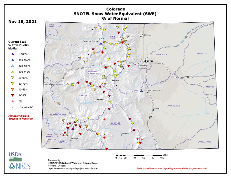
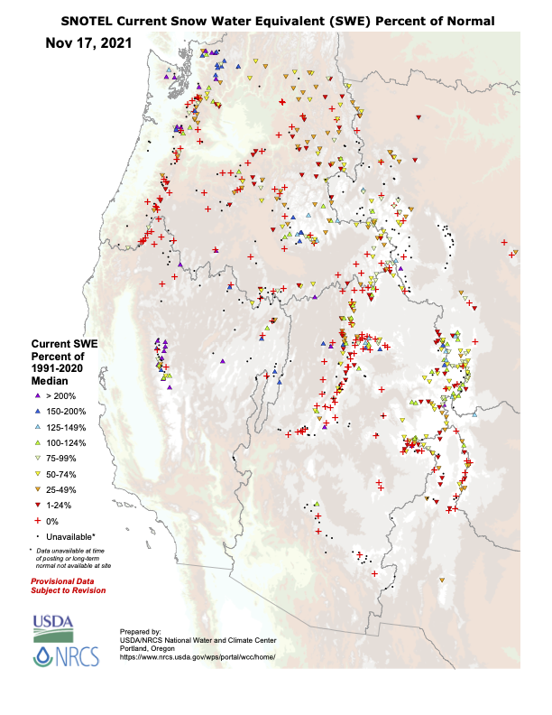
Over the last 40 years, the U.S. Department of Agriculture’s Natural Resources Conservation Service has grown its automated snow telemetry network (SNOTEL) across the West. The SNOTEL network now has more than 900 high-elevation sites that collect snowpack, temperature and other climactic data, data that is crucial for water managers like Wolff.
In 2019, a team of scientists founded Airborne Snow Observatories Inc., which uses planes, geospatial technology and other instruments to fly over mountain basins and more accurately assess snowpack and forecast snowmelt.
It’s a new tool that has flourished in recent years, giving Wolff and Schumacher more accurate data with which they can gauge water resources in Southwest Colorado and statewide.
Scientists are even turning to volunteers. The Community Collaborative Rain, Hail & Snow Network (CoCoRaHS), which was initially developed by the Colorado Climate Center in 1998, enlists volunteers across the country to help measure precipitation…
The proposed radar system in La Plata County, which has yet to find a suitable site, according to Stevens, will also help scientists to close climate data gaps…
As climate scientists work to expand their data collection networks, the question becomes one of money. The instruments and equipment needed for monitoring stations can be expensive to buy and maintain.
“As a researcher, I would say the ideal (weather station) density is the more data I can get, the better. If we had stations every half mile or quarter mile, we could find ways to put that all to use,” Goble said.
“But what’s the best practical density is an entirely different question,” he said.


