Researchers in Colorado State University’s Department of Atmospheric Science have developed a tool for predicting heavy rainfall that is now used daily by the Weather Prediction Center, part of the National Weather Service.
Example CSU-MLP forecast, for the extreme rainfall associated with the remnants of Hurricane Ida in the mid-Atlantic states in September 2021. The left panel shows the forecast probability of excessive rainfall, available on the morning of August 31, over a day in advance of the event. The forecast includes a “high risk” (probability exceeding 50%) for an area from Maryland through Pennsylvania, New Jersey and New York. The right panel shows the resulting observations of excessive rainfall (including flash flood reports and rainfall totals exceeding specified thresholds). The CSU-MLP correctly highlighted the corridor where widespread heavy rain and flooding would occur.
By working with the Weather Prediction Center over the past several years, Associate Professor Russ Schumacher and his group were able to tailor the tool to suit forecasters’ needs.
A concept-to-operations success story
Excessive rainfall is difficult to forecast, and Weather Prediction Center forecasters needed a tool to help them generate Excessive Rainfall Outlooks, which are issued for the contiguous United States one to three days in advance. These outlooks predict the probability for rainfall that may lead to flash flooding, so they are important for alerting people in harm’s way.
WPC forecasters examine many different data sources in creating Excessive Rainfall Outlooks, and the number of data sources have multiplied in recent decades. Given the tight turnaround, WPC meteorologists were interested in a tool that could synthesize at least some of the data and give them a reasonable starting point.
Enter machine learning plus atmospheric science Ph.D. student Greg Herman, whose undergraduate background included computer science and meteorology. Computers are good at quickly filtering huge datasets into a comprehensible output, and Herman and Schumacher harnessed that strength for the Colorado State University Machine Learning Probabilities system.
“The CSU-MLP prediction system provided the first such forecast, and represents the first machine-learning tool incorporated into WPC’s operations,” said Mark Klein, the Weather Prediction Center’s Science and Operations Officer. “Its forecasts have proven very skillful when compared to observations, and thus it has become a critical tool for our meteorologists.”
NOAA’s reforecasts, retrospective forecasts run with today’s improved numerical models, made it possible for Herman and Schumacher to train their machine-learning model using a consistent dataset. The CSU-MLP algorithm searches historical data from the reforecasts and rainfall record for conditions similar to the current weather forecast. It is able to quickly determine whether those conditions led to heavy rain.
The machine-learning model calculates the probability for heavy rain across the entire U.S., and it has adapted over time based on regional differences.
Herman and Schumacher first presented the tool to a testbed, the annual Flash Flood and Intense Rainfall experiment, in 2017. Based on user feedback from the testbed and WPC forecasters, they fine-tuned the model until it was ready for operations in late 2019. Schumacher’s group continued to work with forecasters to make improvements and released an update in 2020.
“Transitioning research work to operations at NWS is difficult; this project is one of few success stories,” Klein said. “Russ’ group has proven to be one of the best collaborators in academia that WPC has worked with.”
The forecast model is intended to make forecasters’ jobs easier by giving them a starting point to build on with their expertise and meteorological knowledge of the area.
“I’m really proud of the work my group and our partners at WPC have done on this,” said Schumacher, who is also Colorado’s state climatologist and director of the Colorado Climate Center. “It’s really satisfying to see a project go from the research idea all the way to the end product that you know somebody’s looking at every day.”
How much rain is ‘excessive’?
One challenge to forecasting excessive rain is defining what that means for a given area. A few inches of rain can be a bigger deal in Colorado than Louisiana, for example.
Forecasters go by how unusual the amount is for that area and whether it will cause flooding, which is also difficult to predict because terrain is an important factor. The same amount of rain will impact a burn scar very differently than a field.
Professor Russ Schumacher and his research group developed a tool for predicting heavy rainfall that is used daily by the Weather Prediction Center.
“We’ve used average recurrence intervals as our definition of excessive rain,” Schumacher said. “Does this amount of rain typically occur at this particular location once a year, twice a year, and so on. That helps to identify how unusual the rainfall is for that area.”
Schumacher’s group has adjusted the threshold for excessive rain to make their model more accurate for specific areas, but there’s still no consensus on what constitutes excessive rain.
“The heavier the rain is, the more difficult it is to forecast in general,” he said.
With a warmer climate expected to bring more heavy rain because warmer air can hold more water vapor, the CSU-MLP tool will be useful in predicting the extreme flooding that will follow.
Schumacher’s group, including research scientist Aaron Hill, recently received funding to work on extending the CSU-MLP system’s forecast range to four to eight days. They also are collaborating with the Storm Prediction Center to apply the CSU-MLP system to other types of hazardous weather, including tornadoes, hail and damaging winds.
Development of the CSU-MLP system was funded by NOAA’s Joint Technology Transfer Initiative. Schumacher and his colleagues wrote about this model and collaboration in the paper, “From Random Forests to Flood Forecasts: A Research to Operations Success Story,” published in the Bulletin of the AMS. Herman graduated from CSU with his Ph.D. in 2018 and now works as a research scientist for Amazon.com.
Click on a thumbnail graphic to view a gallery of drought data from the US Drought Monitor.
US Drought Monitor map November 2, 2021.
High Plains Drought Monitor map November 2, 2021.
West Drought Monitor map November 2, 2021.
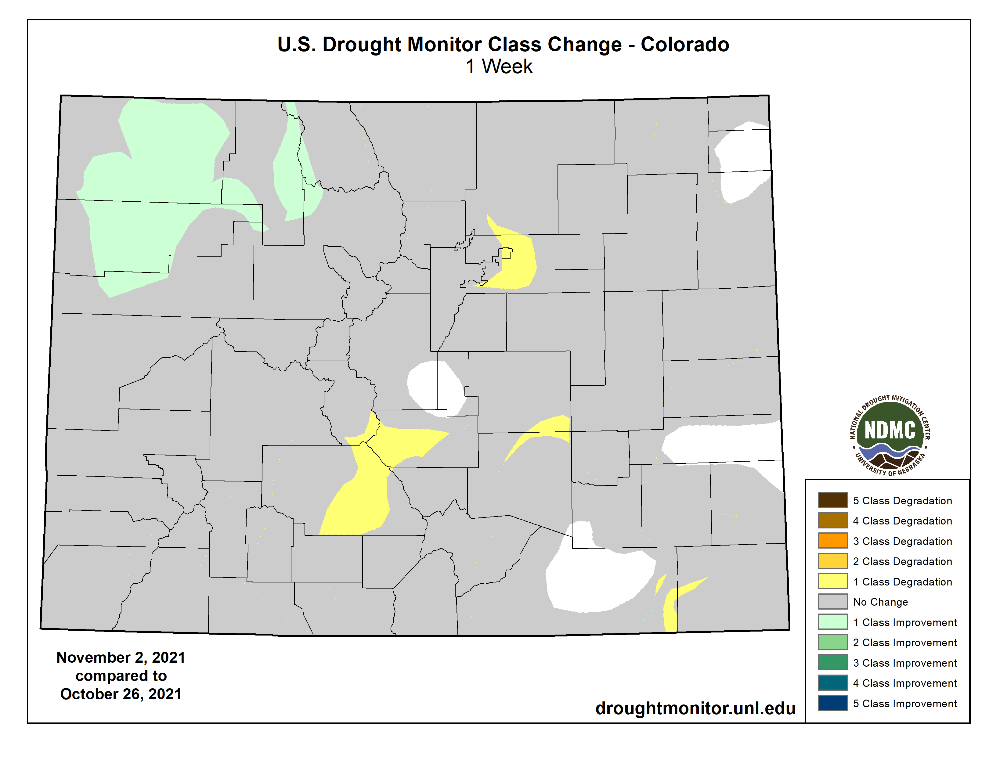
Colorado Drought Monitor map November 2, 2021.
Click here to go to the US Drought Monitor website. Here’s an excerpt:
This Week’s Drought Summary
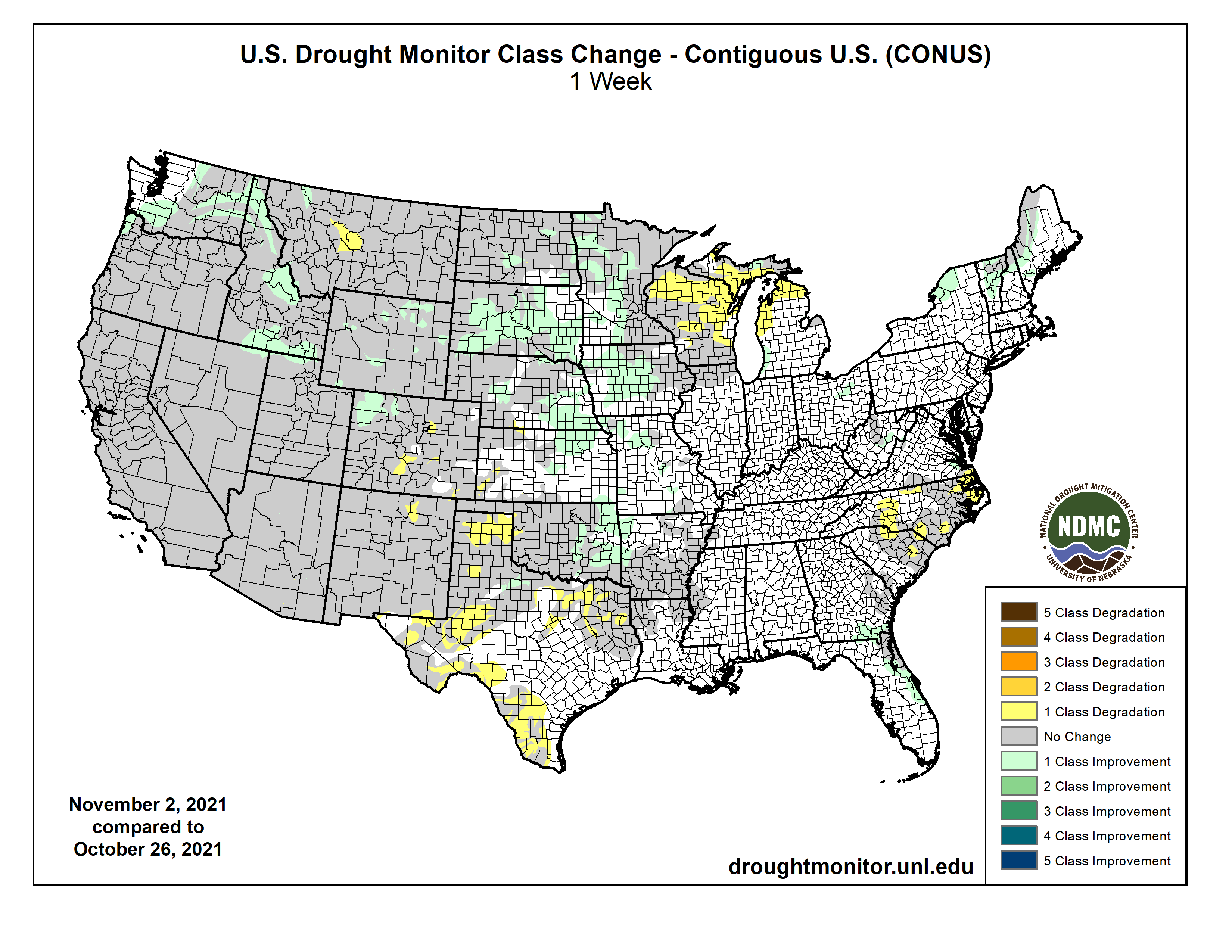
This week, a low pressure system slowly moved eastward across the eastern contiguous U.S. (CONUS) bringing heavy rainfall to many areas from the Mississippi Valley to the East Coast. Parts of the Central Plains, Gulf Coast, Northeast, and Mid-Atlantic saw over 2 inches of rainfall. Improvements were warranted where the heaviest precipitation fell across parts of the Central and Northern Plains, the Corn Belt, and northern New York and New England. Conversely, areas that missed out on adequate precipitation across the western Great Lakes and the Carolinas experienced degradation of ongoing abnormally dry and drought conditions, exacerbated by above-normal temperatures and increased evaporative demand. Across the western CONUS, an active storm track in the Pacific Northwest resulted in another week of improvements from Washington to northwest Montana. Soil moisture indicators continue to improve across much of the Western Region, leading to some localized improvements, but for most areas, long-term deficits remain intact and groundwater and reservoir levels remain well below-normal. Additionally, it is too early in the season for solid snowpack to build across many areas. Some localized degradations were warranted in Montana, east of the Front Range, and in the Southern Plains, as above-normal temperatures and high wind events have helped to worsen ongoing drought in those areas…
Many locations across the High Plains Region experienced improvement in drought conditions this week, from eastern Kansas and Nebraska northward, and westward to the northern Front Range. In eastern portions of the High Plains, above-normal precipitation in excess of 1.5 inches for several areas led to 1-category improvements. This region has also benefited from improved soil moisture in recent weeks as the storm track remained active during October. Across the western Dakotas and parts of Wyoming, improvements were also warranted, despite rainfall lacking for many locations, as drought indicators have continued to improve due to many locations receiving over 200 percent of normal precipitation since the beginning of October. Soil moisture and short-term rainfall deficits are much improved for most areas. However, while ground reports corroborate the improved soil conditions, they also indicate that rangeland conditions are slow to recover and stock ponds remain below-normal with poor water quality, indicative of longer-term hydrologic deficits. Along the southern Front Range, above-normal temperatures and below-normal precipitation resulted in further degradation, as evaporative demand has remained high, exacerbated by high winds…
Colorado Drought Monitor one week change map ending November 2, 2021.
An active storm track across the Pacific Northwest and northern California has resulted in improving conditions during October, with improvements in northern California and the central Great Basin being attributed mainly to the strong atmospheric river event in late October, which dropped record 24-hour precipitation in several locations. This week the active storm track persisted, leading to improvements across parts of western Washington and the interior Pacific Northwest. Soil moisture has and stream flows have improved greatly for many areas in the central and northern Great Basin, warranting some improvements across southern Idaho, northeastern Nevada, and northern Utah. However, groundwater and reservoir levels are slow to respond and will need continued above-normal precipitation this season to recharge. Snowpack has started to build across the northern Rockies and the Cascades, and even into parts of the Sierra Nevada, but it is still early in the season to reap the benefits. D4 (exceptional drought) expansion was warranted in central Montana, as stream flows have fallen below the 2nd percentile, NASA SPoRT and CPC soil moisture have fallen below the 2nd percentile, vegetation indices show increased stress, and 30-60 day SPIs have fallen to D4 levels. In addition, parts of this new D4 area have experienced a record dry period spanning September to October. The timing of this dryness has also stunted winter wheat growth in the region. Status quo was warranted elsewhere in the West as antecedent 30-day wetness and improved soil moisture offsets the observed above-normal temperatures for the 7-day period…
Rainfall amounts, associated with a slow-moving low pressure system traversing the eastern half of the Southern Region (eastward from Arkansas and Louisiana) were just enough to warrant a status quo depiction this week. Conversely, rainfall from this same low pressure system early in the week was heavy enough to warrant improvements across much of eastern Oklahoma, where many locations received more than 150 percent of normal precipitation for the 7-day period. Farther south, in eastern Texas, 7-day precipitation was below-normal, despite 0.5-1 inch of rainfall across a large region experiencing moderate (D1) to severe (D2) drought. Above-normal temperatures and high winds associated with the exiting low pressure system resulted in increased evaporative demand across much of eastern Texas. Despite the rainfall, there was even a report of a wildfire near Rusk County, Texas. Farther west across the Southern High Plains, conditions also deteriorated, resulting from D1 to D3-equivalent 30-90 day Standardized Precipitation Indices (SPIs), widespread NASA SPoRT soil moisture rankings below the 10th percentile (below the 5th percentile at shallower depths for many locations), below-normal precipitation, and above-normal temperatures (2-6°F above-normal)…
Looking Ahead
During the next 5 days (November 4 to 8), an active storm track across the Pacific Northwest and northern California is likely to continue, with locally more than 5 inches of liquid-equivalent precipitation falling along the coastal ranges and the Cascades. The southwestern, central, and much of the eastern CONUS is expected to remain dry. However, a mean frontal boundary is favored to set up along the Gulf Coast and Southeast Atlantic Coast, bringing the potential for some locations across southern Texas and the Florida Peninsula to pick up over 1 inch of rainfall. Maximum temperatures are expected to remain below-normal across the West Coast and above-normal across much of the central CONUS. Over the eastern CONUS, below-normal maximum temperatures are likely to moderate leading up to Tuesday, November 9.
The CPC 6-10 day extended-range outlook (valid from November 8 to 12) favors above-normal temperatures across the central and much of the eastern U.S. with below-normal temperatures likely for the Pacific Northwest, northern California, and the southern Florida Peninsula. Below-normal temperatures are favored for southern Alaska. Above-normal precipitation is likely from the Pacific Northwest and northern California, eastward to the Great Lakes and Ohio Valley, and southward to the Lower Mississippi Valley, with the greatest odds for above-normal precipitation across the northwestern CONUS. Below-normal precipitation is most likely across the southwestern CONUS, the Northeast, and Mid-Atlantic. In Alaska, odds are enhanced for below-normal precipitation across much of the state.
US Drought Monitor one week change map ending November 2, 2021.
Just for grins here’s a gallery of early November US Drought Monitor maps for the past few years.
“During our brainstorming process for a good farm name, we all had all these botany books in front of us,” recalls Noelle Trueheart. She and her business partners were searching for words that would represent their farming philosophy, and they were going back and forth between scientific names and the Latin terms for different species and crop varieties.
At a certain point, though, they stopped looking at the books. “That’s not really who we are,” Trueheart explains.
Though they have many years of experience in production agriculture, the three founders — Trueheart, Phil Cordelli and Betzi Jackson — wanted to honor a more humble inspiration: the common stories, farming practices and community spirit that exist beyond scientific frameworks.
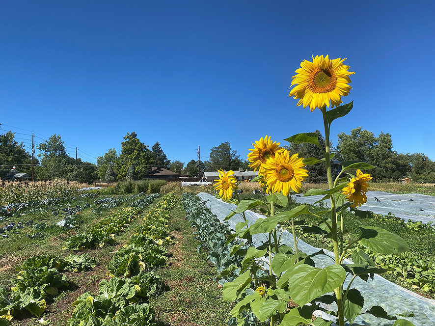
They settled on Common Name Farm, and broke ground this past April. Throughout their first season, they’ve sought to prioritize passion, play and goals that nurture both the community and the land.
Their combination of new farming techniques and age-old practices complement Common Name Farm’s location on the remnants of a 150-year-old farm that once covered two square miles across what’s now the city of Lakewood. They’re renting three acres from the Shelleys, a family that has raised horses and hay on the property for generations.
As the season winds down, the Common Name Farm partners are still harvesting squash varieties and root vegetables, creating bouquets from flowering herbs and planning to save seeds for next year.
Trueheart and Cordelli have each been farming for a little over a decade. “I think in retrospect, I’m not suited for much other than farming,” Cordelli admits. “I’m kind of loud. I don’t wear deodorant. I went to art school.” He was first introduced to farming in northern California, where he worked deep in a redwood forest a few miles from the Pacific Ocean. He’s been drawn to cultivating plants ever since.
Trueheart stumbled onto farming while working as a field archeologist in western Colorado. One day she found an orchard in Paonia and “was totally enamored,” she recalls. “The first day I was there, I was like, ‘Oh, my God, I have to know everything about this.’” A year a half later, farming had become her top priority — a priority that cost her about half her pay.
Last fall, Cordelli, Trueheart and Jackson, who’d grown up in unincorporated Jefferson County, made the decision to stop working for others and start their own farm. Finding land was a challenge, though. They looked for properties from Boulder to Sedalia. When they found places they liked, they sent owners “handwritten letters of inquiry,” Trueheart explains.
By late winter, they were close to signing a lease for a property in Boulder, but the landowners backed out.
After that, Cordelli, Trueheart and Jackson searched for part-time jobs. Jackson found a position on the Western Slope and moved in April, though she remains a mentor, advisor and friend to Cordelli and Trueheart.
The other two spent the early spring growing seedlings in Cordelli’s sunroom on “a wing and a prayer,” he remembers.
Then the Shelleys reached out in early April. Cordelli had known Terol Shelley’s daughter Kamise and son-in-law Derek for a few years. They’d met through the Rocky Mountain Farmers Union and once traded garlic seed and pepper starts for tarps. Cordelli and Trueheart wound up renting three acres from the family for their farm.
Colorado’s Front Range farming community is pretty small, Cordelli explains, and most people involved know each other. Many are younger farmers like Cordelli and Trueheart — though at 42, “perhaps in no other profession would I be considered young,” Cordelli notes.
The local farming community “has really supported us,” he adds. Throughout the spring and summer, Cordelli and Trueheart were able to borrow tractors and rototillers to prep the field. Other farms donated seedlings to help them catch up after their late start to the season.
“Both of us hate the toxic American masculine culture of ‘I did this all myself,’” Cordelli notes. “It’s not about ego. It’s about creating community and relying on community.”
It’s also about the land. “We attribute a lot of the [farm’s] success to the quality of the soil,” Trueheart explains.
“We had a hunch that the land would be productive,” Cordelli continues. “It’d never been sprayed. It was covered by plant material continuously — no bare soil blown away by the wind or burned up by the Colorado sun.”
“I don’t think anything’s ever been raised on this ground except hay and grass and cattle,” says Miss Betty Opal Mae Shelley. Now 97, she moved to the farm in the 1940s with her husband, Arthur George Shelley, when this corner of Garrison and Dakota streets was rural pasture. Today her next-door neighbors include Family Wine & Liquors, a 7-Eleven and rows of houses lining the streets.
Her husband’s family had lived on the property since the 1870s. John Everitt started with twenty acres — including the land where Common Name Farm sits — and eventually expanded the property from what is now Mississippi Avenue to Alameda Avenue and from Garrison to Union Street, for a total of two square miles.
Even after Lakewood incorporated fifty years ago and development began to boom, the Shelleys continued to farm their land. Both Trudy and Terol grew and sold hay with their children. Then Derek and Kamise ran the Everitt Family Farm until they moved to Idaho a couple of years ago…
Other remnants of Lakewood’s agricultural past are less obvious, including the 100-year-old apple trees that dot nearby yards and the ditch irrigation that Common Name Farm uses as a water source. Trudy and Terol Shelley’s grandfather was the ditch rider who built the waterway down from Clear Creek in the 1920s.
“Neither of us have ever farmed on ditch irrigation land before,” Trueheart says. “It is a little bit challenging, but this is where the anthropology nerd in me comes out.” Ditch irrigation has been an agricultural technique for thousands of years; the human-made ditches allow water to travel from rivers to crops, and farmers monitor how much to allow into their fields…
And that’s not the only way that Trueheart and Cordelli hope to take care of the land they’re farming. Part of their practice is keeping the soil covered and letting plants go to seed, including the brightly colored purple dragon tongue beans they’re saving…
They’re taking a regenerative approach to agriculture that prioritizes sustainability and working within natural systems. They practice techniques such as planting flowers like marigolds that attract beneficial bugs and help repel pests, and keeping the ground between covered rows with low-growing clover.
Cordelli and Trueheart are also dedicated to donating portions of their harvest to those in need. Trueheart and her daughter live at Warren Village, a housing option for single mothers experiencing homelessness. “It’s been a great place to start with our food-access work,” Trueheart explains. “We’ve learned about what people like and don’t like as much, and the food they care about.”
[…]
Common Name Farm produced many varieties of vegetables and herbs during its first season. Alongside rows of tomatoes, corn, beans, potatoes and leafy greens, the partners experimented with okra and de-hybridizing a Korean hot pepper into the single varieties from which it was created. Soon they’ll be planting garlic seeds for spring.
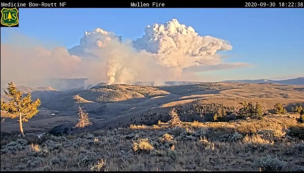
Late in the summer of 2020, as hunting seasons ramped up and the world reeled from the COVID pandemic, a fire ignited in southeast Wyoming’s Snowy Range.
It sparked to life on Sept. 27 and grew rapidly, fueled by winds that raged to 70 mph. What would ultimately be called the Mullen Fire consumed or damaged dozens of structures over more than 176,000 acres.
Researchers say the size and intensity resulted from a combination of vast swaths of beetle-killed trees and unusually dry conditions exacerbated by climate change. While fire is natural, and in many ways necessary, biologists and fire managers weren’t sure how a blaze that big would impact the health of the ecosystem.
Smoke from the Mullen Fire on Sept. 30, 2020. (InciWeb)
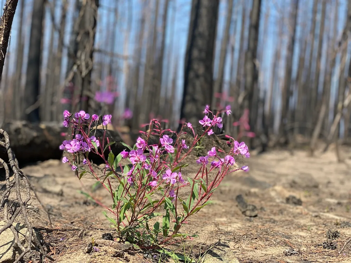
A little more than a year later, they have a much clearer picture. In some places, the Mullen Fire burned so hot it sterilized the soil — meaning plant regeneration may take decades. In other places, the threat of invasive plant species looms large, and runoff, erosion and water degradation remain possibilities. But across the bulk of the forest, scientists have found, the fire may well provide long-term benefits to wildlife. It cleared away dead trees that needed to go and ushered in aspens, willows, wildflowers and grasses.
“Hopefully we have a good snowpack and greater spring rain next year for continued recovery,” said Ryan Amundson, a Wyoming Game and Fish Department terrestrial habitat biologist.
There’s still much to be learned, but for now, wildlife and land managers are encouraged by what remains from Wyoming’s largest wildfire in recent history.
Wildlife habitat
Amundson was nervous when he first ventured into the burn area after snow melted and summer began, he said.
Little moisture fell on the area in April, May and June. Snowpack had been low. Spring regeneration — the plants that usually sprout as soon as the snow melts — was almost nonexistent. Then record high heat in June, cut the growing season short. He wondered if any plants would have a chance to grow back.
But summer rains arrived. By late September, some aspens in the burn area measured three feet tall. Willows and wildflowers flourished.
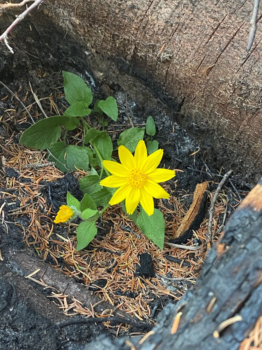
A yellow heart leaf arnica grows in the Mullen Fire burn zone. (Christine Peterson)
“In areas we were assessing in early spring, I thought I was going to see very high shrub mortality, but we just needed to be patient and let Mother Nature do her thing,” he said.
Not only did species like elk, deer and bighorn sheep survive into this year, they are thriving, said Lee Knox, Wyoming Game and Fish wildlife biologist in the Laramie region.
Deer killed during this year’s hunting season are fat, nourished by the new growth that sprouted in areas now cleared of stands of dead trees.
Bighorn sheep will particularly benefit from open areas created by the fire. Sheep need to be able to see long distances, and tree encroachment shrinks their available habitat. Wildlife officials are conducting a study with collared sheep to track their movements and progress in the newly cleared areas.
The post-burn forage in some places may be so good that Knox is concerned about elk and deer overgrazing the new aspen and willow growth, he said. He and other wildlife biologists will continue to encourage hunters to focus on herds in and around the burn area to be sure the new shrubs have a chance to grow.
“Deer and elk thrive in successional change,” Knox said. “There’s not a lot for them in old growth forests. They need forbs and grasses and aspen communities to allow them to be fatter and have healthier babies and expand.”
The lack of spring moisture and low snowpack also resulted in minimal runoff and erosion, according to a recent study completed by Game and Fish.
WyoFile is an independent nonprofit news organization focused on Wyoming people, places and policy.
A center pivot irrigates a field in the San Luis Valley, where the state is warming farmers that a well shut-down could come much sooner than expected. Credit: Jerd Smith via Water Education Colorado
The Colorado General Assembly’s interim Water Resources Review Committee is recommending new legislation that, if approved, could set aside millions to help water-strapped regions of the state meet their obligations to deliver water to Kansas, New Mexico and Texas.
It also recommended another bill designed to curb water speculation. Both measures are expected to be considered by the Colorado General Assembly next year.
Groundwater compact compliance
The committee on Oct. 27 approved a draft bill that creates a Groundwater Compact Compliance and Sustainability Fund to help pay for the purchase and retirement of farm wells and irrigated acreage in the Republican and Rio Grande river basins. The action was taken to reduce groundwater use that diminishes surface flows and ensure compliance with interstate compacts on both rivers. Legislative appropriations and federal revenue would bankroll the fund. The Colorado Water Conservation Board would distribute the money based on recommendations from the Republican River Water Conservation District and the Rio Grade Water Conservation District, with approval by the state engineer.
So how much land are we talking about? To comply with compact water delivery obligations and groundwater sustainability rules, 25,000 acres of irrigated land would have to be retired in the Republican basin and 40,000 acres in the Rio Grande basin by 2029. To date, just 3,000 acres in the Republican and 13,000 acres in the Rio Grande have been retired from production. Absent those reductions, well pumping could be curtailed.
When asked how much money is needed, Sen. Jerry Sonnenberg, R-Sterling, whose district includes the Republican River basin, said the conservation district there is looking for $50 million in addition to the $50 million it already has. Pinning the cost down is difficult; Sonnenberg noted that, “It’s harder to retire farm ground when you have $5 [per bushel] corn than it is when you have $3 corn.”
David Robbins, general counsel to both the Republican and Rio Grande districts, testified at an earlier committee meeting that the Rio Grande would also require at least $50 million on top of the $69 million it has already raised by taxing its farmers for sustainability efforts.
Water speculation
The committee also reported a bill that it views more as a vehicle for further discussion than a finished product. It prohibits the purchaser of a water right from engaging in “investment water speculation” and empowers the state engineer to investigate alleged violations. Investment water speculation is defined as “the purchase of agricultural water rights that are represented by shares in a mutual ditch company in the state with the intent…to profit from the increase in the water’s value in a subsequent transaction…or by receiving payment from another person for nonuse of all or a portion of the water” unless it’s part of a water conservation or instream flow program.
Committee members struggled with trying to balance concerns over speculation with protecting property rights. Sen. Kerry Donovan, D-Vail, committee chair and one of the bill’s sponsors, said she continues to hear from constituents on the West Slope about what looks like investment water speculation and its impact on farming operations. At the same time, she noted other groups are sending “a very conflicting narrative now that we actually have bills to respond to…and the feedback is don’t do anything, slow down.”
Sen. Don Coram, R-Montrose, another bill sponsor, emphasized that “it’s not our intent to take away the ability of a farmer whose 401K is his water [if that water were sold], but somehow we need to put some constraints” on speculative investments. “This bill as written,” he continued, “probably doesn’t get us there, but it does give us the opportunity to work through the session.”
With that said, Coram proposed an amendment that broadened the bill’s title by shortening it, from a bill “Concerning a Prohibition Against Engaging in Investment Water Speculation in the State” to one “Concerning Water Speculation in the State.” That change provides the bill sponsors with flexibility to flesh it out over the coming months without being locked in to the current text.
Water infrastructure investment
The committee also approved a letter to the state’s Task Force on Economic Relief and Recovery Cash Fund to consider investing money in water projects. The task force was created by the General Assembly last session to receive federal dollars from the American Rescue Plan Act of 2021 and recommend how to spend it. The legislature transferred nearly $850 million into the fund and among the eligible uses are “investment in water, sewer, or broadband infrastructure.”
The legislature convenes Jan.12…
Larry Morandi was formerly director of State Policy Research with the National Conference of State Legislatures in Denver, and is a frequent contributor to Fresh Water News. He can be reached at larrymorandi@comcast.net.
Click here to read the report. Here’s the executive summary:
The climate is changing. Global air temperatures are rising, as are sea levels throughout most of the U.S. Heavy rainfall is increasing in intensity and frequency. Atlantic hurricane intensity is on the rise, and the number of large forest fires in the western U.S. and Alaska is increasing and is exacerbated by drought and heat. In Alaska and the Arctic, sea ice is declining, permafrost is thawing, and warming is more than twice the global average (Walsh et al., 2014; Hayhoe et al., 2018; USGCRP, 2017).
Given close relationships with the natural world stemming from deep spiritual and cultural connections and subsistence lifeways, Indigenous peoples are on the frontlines of those experiencing and adapting to climate change. Indigenous peoples possess incredible resiliency and innovation, borne from Indigenous knowledges, worldviews, and countless generations of connection to place (Ford et
al., 2020). At the same time, climate change impacts for many Tribal communities are already severe (such as shifts in/loss of key cultural species and land loss due to erosion, flooding, and permafrost thaw), and the challenges they face responding to impacts are daunting (such as lack of funding and technical resources and legacies from colonialism and discrimination). The time to at is now, and the way to act is together: in community, taking care of one another and all our relations.
What Is the Status of Tribes and Climate Change (STACC) Report?
The Status of Tribes and Climate Change (STACC) Report seeks to uplift and honor the voices of Indigenous peoples across the U.S. to increase understanding of Tribal lifeways, cultures, and worldviews; the climate change impacts Tribes are experiencing; the solutions they are implementing; and ways that all of us can support Tribes in adapting to our changing world. Given this, the STACC Report was written for diverse audiences, including Tribal managers, leaders, and community members; the authors of future National Climate Assessments; federal and state agencies and decision-makers; and nongovernmental organizations. Over 90 authors representing diverse entities and perspectives contributed to this report, including the authors of 34 personal narratives and author teams who wrote topic reviews using elements from their own experiences and knowledge as well as information from the most current peer-reviewed literature. The development of the STACC Report was coordinated by the Institute for Tribal Environmental Professionals (ITEP), which was established in 1992 at Northern Arizona University with a cooperative agreement with the Bureau of Indian Affairs’ Tribal Climate Resilience Program. ITEP is honored to have worked with these authors, who together, along with the Steering Committee, form the STACC Working Group.
Why This Report Was Created
The Indigenous peoples of North America have seen many hardships, including legacies of colonialism, forced assimilation, intergenerational trauma, upheaval and repression of Native economic systems, and the loss of ancestral lands, languages, natural resources, and traditions. Due to colonialization and subsequent land dispossession, social exclusion, and discrimination, researchers have identified Indigenous peoples globally and in the U.S. as populations “at-risk” to environmental change (Ford et al., 2020; Nakashima et al., 2018). Tribes have, however, continually proven to be resilient and innovative, which is evident in their creating adaptation and mitigation plans and continuing to rely on traditional knowledges to inform actions and strategies. This resiliency and adaptation dates back thousands of years and holds true in today’s changing climate.
As numerous Indigenous persons would attest to, the close relationship that Tribes have with their lands, waters, resources, and heritage includes a responsibility to one another, to all relations, and to the past and future generations of human and nonhuman relatives alike. It embodies the need to care for and respect the needs of all things and recognizes the responsibility to honor the wisdom of their ancestors and carefully consider the consequences of their decisions and actions for future generations. This may lead Tribal members to ask: what does it mean to be a good ancestor?
Due in part to these worldviews that are tightly interwoven with many compounding dimensions, Tribal experiences with climate change can make Indigenous peoples particularly vulnerable to cascading and disproportionate impacts, while their responses simultaneously support Tribal resilience to those impacts and are discussed throughout the STACC Report.
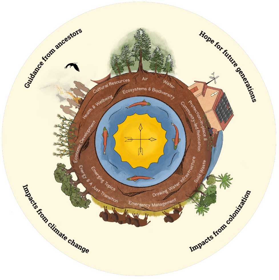
While Tribes cannot be thought of as one monolithic group, diverse Indigenous persons are in dialogue about synergies that exist among their worldviews. Numerous Indigenous persons have articulated that their worldviews understand all things as an interconnected whole, as shown in Figure 1, the Indigenous Holistic Worldview Illustration. There is inherent difficulty in writing a report that includes sectoral chapters about impacts experienced by Indigenous peoples that also reflects the interconnected nature of those experiences. However, as Figure 1 shows, each topic is interwoven with the others and all the systems of the world.
Although Indigenous peoples have been involved in various scientific reports related to climate change (see Ch. 1), a gap exists in the published literature of a holistic, in-depth review of the unique experiences of and threats to Tribes, in particular with first-hand experiences described. The STACC Report aims to fill this gap as well as provide recommendations for decision-makers and others supporting Tribal efforts.
Understanding Tribal Sovereignty
In order to effectively support Tribes in their efforts to address climate change, it is vital to understand Tribal sovereignty, self-determination, the federal trust responsibility, and consultation requirements within the government-to-government relationship. Tribal sovereignty is the inherent right of American Indians and Alaska Natives to govern themselves, and any decisions that could impact their property or citizens must be made with their participation and consent (NCSL, 2013; USDOI Frequently Asked Questions, n.d.). Similar to states, Tribes “possess the right to form their own governments; to make and enforce laws, both civil and criminal; to tax; to establish and determine membership (i.e., tribal citizenship); [and] to license and regulate activities within their jurisdiction…” (USDOI Frequently Asked Questions, n.d.). The Indian Self-Determination and Education Assistance Act of 1975 articulates a
The Indigenous Holistic Worldview Illustration visually depicts the interconnected way in which many Indigenous peoples experience the world and includes factors that influence the natural world. The various topics that the STACC Report addresses are included in the roots to demonstrate that while the Report is divided into independent chapters, the topics are, in reality, part of an interdependent whole. This illustration’s shape resembles a turtle in reference to Turtle Island, as some of the creation stories of Indigenous peoples of North America include a turtle, which can be thought of as either the continent of North America or as the entire Earth, depending on the storyteller. -Illustration design: Coral Avery and Molly Tankersley
pathway for Tribal control, responsibility, and autonomy over programs and services usually administered by the Bureau of Indian Affairs (USDOI Self-Determination, n.d.; USDOI Frequently Asked Questions, n.d). The federal trust responsibility addresses the reality that Tribal nations ceded their homelands in exchange for the guarantee of protection of their rights to self-government and lands and to provide for federal assistance (NCAI Tribal Governance, n.d.). The government-to-government (or nation-to-nation) relationship is a fundamental principle of the federal trust responsibility (NCAI State/Tribal Relations, n.d.), and government-to-government consultation must occur from the beginning stages of all decision-making that could potentially impact Tribes.
Executive Order 13175, which was established in 2000, “reaffirms the Federal government’s commitment to tribal sovereignty, self-determination, and self-government. Its purpose is to ensure that all Executive departments and agencies consult with Indian tribes and respect tribal sovereignty as they develop policy on issues that impact Indian communities” (DOE, 2000). This executive order was reaffirmed by the Biden administration on January 26, 2021. Sovereignty is an inherent right of Tribes, and the onus is on the federal government to ensure that right and government-to-government consultation are upheld. It is important to note that not all Indigenous groups/peoples have federal recognition, which limits their access to federal resources and impacts their ability to address climate change.
Interwoven Key Messages & Recommendations
The full list of Key Messages & Recommendations can be found within each chapter and in the Conclusion. Much like the interwoven nature of all the topics addressed in this report, the key messages and recommendations are interdependent and can be distilled into two themes: Respect and uphold Tribal sovereignty and self-determination and Integrate holistic responses in line with Tribal values.
Key Message & Recommendation: Respect and Uphold Tribal Sovereignty and Self-Determination
Tribal sovereignty and self-determination help to counteract historical trauma, disproportionate climate change impacts, and vulnerability and are strong themes in the Recommendations across all chapters. The remedial dynamic of recognizing and respecting the pre-existing right of self-determination of Tribes should be acknowledged. Each chapter identifies key ways to promote Tribal sovereignty, including, but not limited to, the following actions and examples:
Engage Tribes early and often in decision-making processes (Chs. 3 and 10). Many federal programs and policies affecting Tribes have been designed without meaningful Tribal participation. Tribes should be central to such decision-making. Engaging Tribes early and often helps to ensure that programs developed are accessible to Tribal communities and that Tribal concerns, values, and priorities are included in decisions such as those about land or water management, the development of regulations, choices about what science questions to pursue, and more. One best “early and often” engagement practice is to establish Tribal partnerships before developing project proposals. Building relationships with Tribal leaders, managers, and community members is key to ensuring respectful dialogue and that intentions are trustworthy.
Increase co-management of natural resources. Co-management of natural resources involves cross-jurisdictional, cooperative, participatory collaboration in decision-making, planning, and enforcement (Ch. 3), and contributes to strengthening of food security and the realization of food sovereignty (Ch. 5). As the Kootenai Tribe of Idaho describes in their narrative in Ch. 4.1, their state-Tribal partnership improved monitoring capabilities during the 2020 wildfire smoke season.
Respect, include, and protect Indigenous and traditional knowledges in climate change actions. Such knowledges are a fundamental and interwoven part of Indigenous cultures and are important for understanding and responding to changes that are occurring. For instance, during climatic and other disruptions such as wildfires, extreme weather, and the COVID-19 pandemic, when access to commercial foods may be cut off, traditional hunting, fishing, and gathering methods form a source of local resilience. In addition to the information in Chs. 2, 3, 4, 5, and 12, a resource for better understanding this concept is the Guidelines for Considering Traditional Knowledges in Climate Change Initiatives.1 As described in the Guidelines, Tribes must be able to choose to share or not share traditional knowledges with others.
Provide adequate funding for climate change adaptation (Chs. 4–12 and Appendix A). Inadequate funding remains one of the greatest barriers for Tribes to plan for and adapt to climate change, as well as to mitigate climate change through greenhouse gas reductions and developing a zero- carbon economy (Chs. 4.2.1, 6, 7, and 12). For example, across the U.S., Tribal communities are experiencing land loss due to erosion, flooding, and permafrost thaw (Chs. 4 and 10). Nationwide, at least $6.2 billion is needed over the next 50 years to protect, replace, and move existing Tribal infrastructure. This amount includes at least $175 million needed annually nationwide over the next ten years (Ch. 10).
Increase coordination among federal programs so that financial and technical resources are more easily accessed by Tribes and are used more efficiently. When accessing climate change adaptation resources, Tribes may face hurdles navigating a federal system in which funding and technical expertise are dispersed across multiple departments and programs, each with differing and sometimes complicated processes for accessing resources (Ch. 4.2.1, 9, and 10). For example, programs that provide funding to construct public drinking water systems are located within seven different federal agencies, and there is no lead federal agency or program to help communities facing relocation (Ch. 4.2.1 and 10).
Build and retain capacity within Tribes to manage and adapt their resources and infrastructure to climate change through passing down of knowledge between elders and youth, workforce development, professional training to increase technical and managerial expertise, and the equitable and ethical use of Indigenous knowledges and Western science (see Chs. 3, 4.2.1, 5, 7, and 12). Tribal Colleges and Universities, for example, are important institutions for students to transition from education to their careers as professionals; on-the-job training programs allow for the application of emerging technologies such as those in energy generation; and hiring community members first ensures the local community will benefit. Workforce development can transcend inequity issues, contribute to strong economies, and help maintain cultural integrity. Federal responses should integrate support for these local capacity-building and retention efforts.
Provide Tribally-focused data, resources, and actionable science to support Tribal decision-making (Chs. 3 and 6 and Appendix B). Climate change occurs globally but is experienced locally in a variety of ways. Climate change data that is more local and integrated with local observations and knowledge can be more relevant for planning and actions. The University of Washington’s Tribal Climate Tool,[2] for instance, provides Pacific Northwest Tribes with reservation-specific climate change data. Actionable science helps people make better decisions about things they care about and should start off with the question, “What does this community value?” This is aided by engaging Tribes early and often (see above).
Support the planning and implementation of Tribally-led solutions to Tribally-identified needs (Chs. 4.1 and 12 and Appendix A). Due to colonization, Tribes have had decisions about their futures imposed on them from outside entities. A key element of Tribal sovereignty involves Tribes identifying their own needs and priorities and leading their own responses and actions. The Climate Science Alliance’s Tribal Working Group is one example of successfully building, supporting, and accelerating Tribal resilience in a Tribally-led environment in which the planning and implementation aspects are fully supported (narrative, Ch. 12). Another example is described by the Nottawaseppi Huron Band of the Potawatomi in Ch. 4.1: they had concerns about air pollution from area sources, which led to them directing their resources to strategically install PurpleAir monitors and develop an Environmental Dashboard to help protect the health of their Tribal members.
Key Message & Recommendation: Integrate Holistic Responses in Line with Tribal Values
As described above, Tribal worldviews, experiences, and responses embody interconnectedness. Cascading impacts from, and holistic and interconnected responses to, climate change are addressed throughout the STACC Report and include actionable steps such as:
When developing climate change solutions, recognize the interconnectedness of systems and consider strategies that achieve multiple objectives (see Chs. 4.2 and 5). Ocean acidification and harmful algae events negatively affect Indigenous food systems and security, human health, and local economies. Solutions like clam gardens—essentially, rock walls in bays or inlets that increase shellfish productivity—are an integrated response to multiple climate change impacts (e.g., rising tides, food security, and ocean acidification) and draw upon traditional knowledges. Exerting economic sovereignty through sustainable enterprise development is another strategy Tribes use to address system interconnectedness and achieve multiple objectives (see Ch. 6). Additionally, rising air temperatures and increasing drought may stress native vegetation, leaving plants more vulnerable to insect outbreaks and providing greater opportunities for invasive plants to become established. Large-scale, uncharacteristically high-severity wildfires that could contribute to ecosystem conversion may continue to increase. Cultural burning is a stewardship practice that can enhance ecosystem resilience to climate change and achieve multiple objectives by promoting drought-tolerant and fire-adapted vegetation species; inhibiting insect pests that affect foods such as nuts, seeds, and berries; mitigating large-scale detrimental fires; and promoting the growth of basket-weaving materials and medicinal and food species. By working with the fire regimes of native and nonnative vegetation, cultural burning can also inhibit the establishment of invasive plants. Momentum is gaining for the use of this multifaceted strategy as recognition of the benefits of cultural burning spreads beyond Tribal communities, scientific understanding of the role that fire plays in ecosystems builds, and legal policies that limit cultural burns shift (Chs. 4, 4.1, 5, 8, and 12.)
Increase partnerships across jurisdictional boundaries and at different scales and integrate climate change considerations into ongoing planning and implementation processes (Chs. 3, 4.2, 6, 9, and 12). Climate change impacts are often interconnected and complex, sometimes crossing jurisdictional lines. Integrating climate change into ongoing planning and implementation, along with collaborative responses at larger geographic scales, has the potential to be more cost- efficient, more inclusive with respect to decision-making, and less time-consuming and to lead to actions that are more sustainable in the long term. Ch. 12 describes how Tribes are participating in a variety of cross-boundary, collaborative projects, including the Rio Grande Water Fund hosted by The Nature Conservancy. The Fund supports large-scale forest restoration by a variety of entities in the aftermath of an extensive wildfire to ensure a clean water supply for the region’s people and wildlife, both now and in the future. Examples of plans in which climate change can be considered as one factor among many include: FEMA Tribal Hazard Mitigation Plans; EPA Tribal Environmental Plans; Land/Resource Management Plans; Community Comprehensive Plans; and BIA forest, wildland fire, irrigation, fish and wildlife, agricultural, and integrated resource management plans.
Implement climate adaptation strategies that are proactive versus solely reactive (Chs. 4.2, 4.2.1, and 11). In contrast to reactive responses, proactive strategies anticipate future scenarios and plan for problems that may occur before they take place, helping to minimize harm. Climate-resilient drinking water systems, for example, provide reliable service with limited disruptions and/or harm in the face of changing environmental conditions and extreme climate events. If disruptions occur, systems can recover quickly. Infrastructure deficiencies provide opportunities to install new infrastructure in climate-resilient ways that can help decrease emergencies. System upgrades provide occasions to improve the climate resiliency of existing infrastructure.
Connect solutions to Tribal values and priorities, and recognize the tangible and intangible significance of climate change impacts. Tribes may have different views than their non-Tribal counterparts with respect to what they value and prioritize, and not all resources have tangible value or risk of loss (Ch. 8). Ch. 5 describes how the Swinomish Indian Tribal Community, for instance, developed Indigenous Health Indicators (IHIs) that contrast somewhat with a more western view of health. The indicators include community connection, cultural use, education, natural resource security, self-determination, and resilience. The Swinomish Tribal government used these IHIs to prioritize and make decisions about how to use limited time and resources to address sea level rise and storm surge impacts to key first foods habitats.
Support Tribes’ just transitions away from fossil fuels. Tribal self-determination means that decisions made by individual Tribes will vary, but a just transition away from fossil fuels and towards renewable energy will ensure that regenerative and sustainable economies are a part of the restoration of Indigenous peoples’ lifeways (Chs. 6 and 7). Some Tribal economies are dependent on fossil fuels, which is an unsustainable economic model, and the burning of fossil fuels is ultimately driving climate change. The Hopi Tribe’s economy has depended on coal for 50 years, and the closure of the area’s coal mine was a devastating loss. The Tribe is working towards transitioning to renewable energy development to improve the health of the community while also creating new revenue and jobs (narrative, Ch. 7).
The 2021 STACC Report is the first of its kind. Future STACC Reports will seek to identify new topics and developments important to Tribes and current topics that this edition did not cover. The authors of future Reports will also continue to strive to integrate topics holistically.
Building on the successes of Tribes and individuals who have dedicated their lives to elevating Indigenous peoples’ concerns and implementing the changes imperative to improving their lives, the 2021 STACC Report demonstrates the unique climate change impacts experienced by Tribes and the many ways they are responding. Gaining an understanding of Tribal worldviews, traditional knowledges, and the increased impacts that many Tribal communities face may lead to improved responses to climate change in the U.S. and greater environmental and social justice for the original peoples of this land. When we recognize we are not separate from our natural environment and value justice, equity, and respect for all our relations, we may collectively achieve a society in which all can thrive.
Orchard Mesa Irrigation District power plant near Palisade. Water from Colorado’s snowpack is distributed across the region through a complex network of dams, pipelines and irrigation canals. Photo credit: Orchard Mesa Irrigation District
The Orchard Mesa Irrigation District held a ceremony for the new power plant constructed.
The Grand Valley Power Plant was switched off in today’s groundbreaking ceremony as construction began on the new hydroelectric Vinelands Power Plant.
Max Schmidt, the manager of Orchard Mesa Irrigation District, says it was time to pull the plug.
“We took operation of the old power plant, and it’s 90 years old built in 1932, and it’s completely worn out. We are going to shut it down today [October 28, 2021], hopefully for the last time,” said Schmidt…
This new plant will allow for more power to be produced at the same flow rates.
“I can rebuild it for 3.5 megawatt, but if I build a brand new power plant for 4.54 megawatts. It will produce an extra four megawatts. Three megawatts is enough to power to the city of Palisade,” said Schmidt.
We are told the construction of a new plant is a win-win situation for the community.
“Number one is it provides additional water for recreation from the start Colorado river clear down to Lake Powell. Secondly, it provides clean energy generation, which we all know is a necessary thing. Third, it provides water for the 50-mile reach,” said Rob Talbott, the Orchard Mesa Irrigation District president…
The project has been in the works for about five years.
“We had to secure funding for the funding. This project is almost 65-70 percent funded by grants. Secondly, we were working with various agencies. We had to get the ability to sell the electricity to a buyer who’s willing to pay an adequate fee for the electricity we needed to work with the bureau of reclamation,” said Talbott.
Sorenson Engineering will construct the Vinelands Power Plant, and energy will be used by Holy Cross Energy.
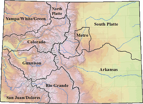
The eight major river basins, plus the Denver metro area, are shown on this map from the South Platte River Basin Roundtable. Each basin has its own roundtable, made up of volunteers, to address local water issues. Credit: Colorado Water Conservation Board
Here’s the release from Governor Polis’ office (Chris Arend):
Colorado Governor Jared Polis announced the appointment of Dan Gibbs, Executive Director, Colorado Department of Natural Resources (DNR), as Chair of the Interbasin Compact Committee (IBCC).
The IBCC was established to share information across Colorado’s eight major river basins and to facilitate negotiations amongst them. Its members provide expertise in water-related environmental, recreational, local governmental, industrial, and agricultural policy matters and it serves as a venue for consensus-building.
In this role, Director Gibbs will Chair the IBCC, a 27-member committee that includes representatives from the nine basin roundtables, Colorado Senate and House Agriculture Committee representatives, and six Governor appointees from geographically diverse parts of the state.
“Water is so important for Colorado’s economy and our quality of life,” said Governor Jared Polis. “Today now more than ever, we need strong leadership to ensure a healthy environment, viable agriculture, and thriving recreation and tourism across the state. Appointing Dan as Chair of IBCC will ensure we will have the leadership, communication, and collaboration needed to protect and preserve all of Colorado’s river basins.”
The 2005 Water for the 21st Century Act (HB 05-1177) ushered in a new era of regionally inclusive and collaborative water planning. It created the IBCC and the nine basin roundtables to secure an informed constituency and to expand public education, participation and outreach efforts for water policy.
“Now is the time to seek cooperative solutions to Colorado’s greatest water challenges,” said Dan Gibbs, Director, Colorado Department of Natural Resources. “As our state grapples with climate change, population growth, drought, wildfires and depleted water supplies, we need our river basins and the IBCC to be communicating and working together to help inform the Colorado Water Conservation Board as it creates policy. I look forward to working with members of the IBCC to continue their strong role in building collaboration and engaging with the basin roundtables on water issues.”
Director Gibbs will replace Russell George, who formerly chaired the IBCC. Russ’s steadying leadership helped to promote collaboration throughout Colorado’s water community.
From protecting customers from the risk posed by old lead service lines to preparing to meet the challenges of the future, Denver Water takes a long-term view when planning for the future.
And the utility has been recognized nationally for its work, by peer utilities as well as by federal officials.
Denver Water in early October was recognized — for the second time — by the Association of Metropolitan Water Agencies, a group representing the largest publicly owned drinking water suppliers in the United States.
At the association’s annual meeting, held in Denver this year, Denver Water received the group’s 2021 AMWA Sustainable Water Utility Management Award for its work to curb carbon emissions, increase its use of renewable energy and protect the environment and its communities.
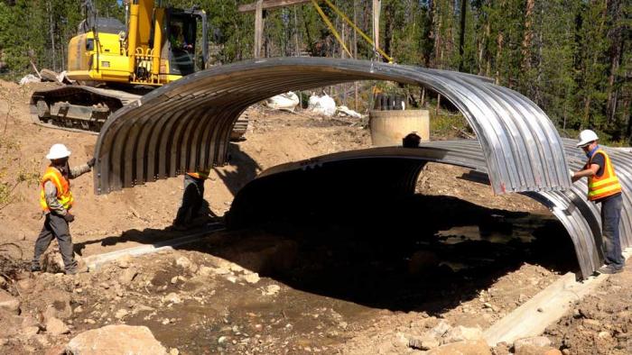
Denver Water crews install a new culvert over Cabin Creek in Grand County in partnership with the U.S. Forest Service and Grand County Learning By Doing. The new culvert will improve habitat for native cutthroat trout in the stream. Photo credit: Denver Water.
Denver Water’s groundbreaking Lead Reduction Program was recognized by the national utility association and also was highlighted by leaders at the Environmental Protection Agency earlier this year for the jobs it created and its unique approach to diverse communities.
Replacing all the old, customer-owned lead service lines in Denver Water’s service area at no direct cost to the customer will take 15 years to complete, and it’s just one of the major undertakings that make up the utility’s 10-year forecast for an estimated $2.6 billion investment into the system that supports about 25% of the state’s population, including Colorado’s capital city.
About 90% of the forecast investment over the next decade is dedicated to large projects and regular annual inspection and maintenance programs that protect customers, position Denver Water for the future and continue regular monitoring programs for infrastructure already in place. The remaining investment focuses on maintenance and improving the resiliency of the system.