Click on a thumbnail graphic to view a gallery of drought data from the US Drought Monitor.
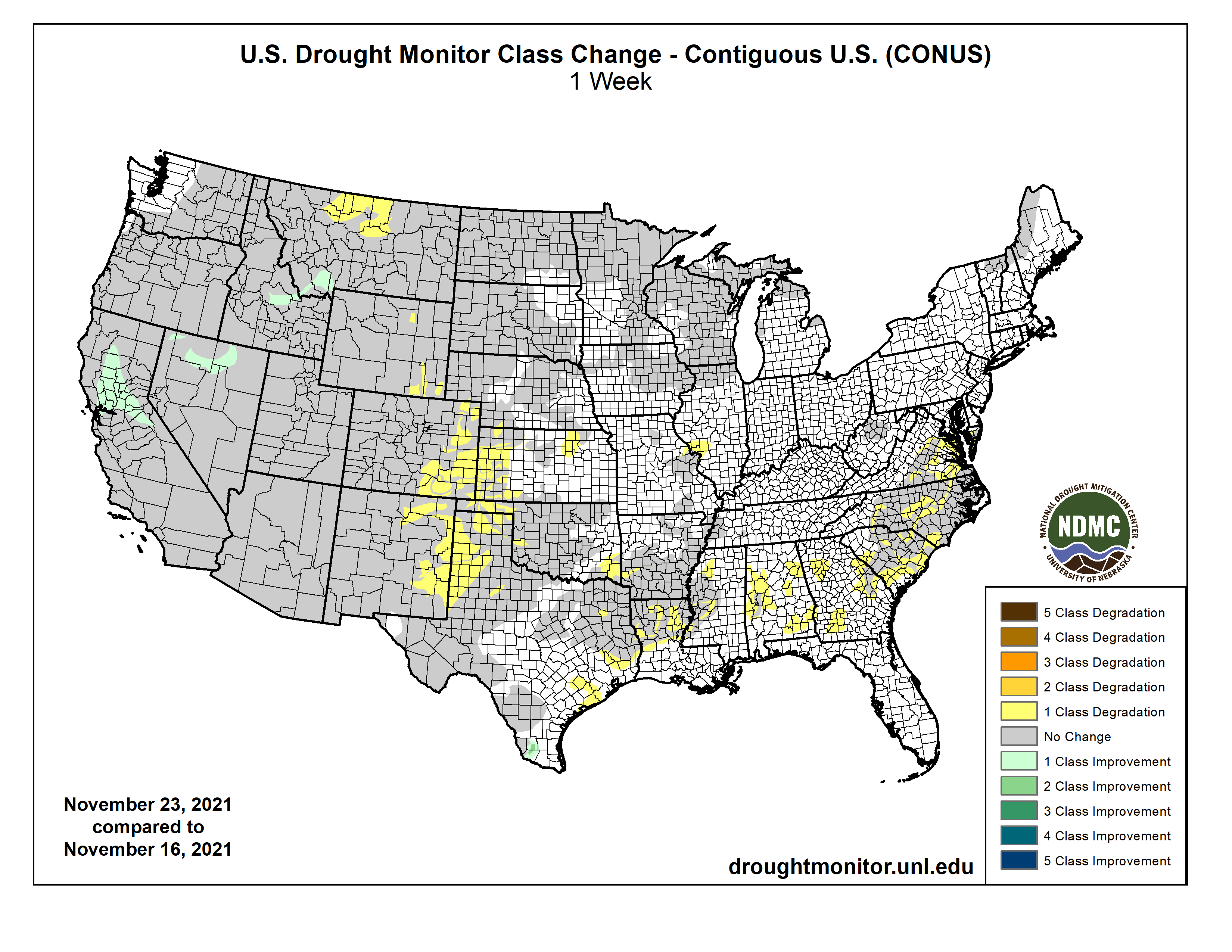
US Drought Monitor map November 23, 2021.
West Drought Monitor map November 23, 2021.
West Drought Monitor map November 23, 2021.
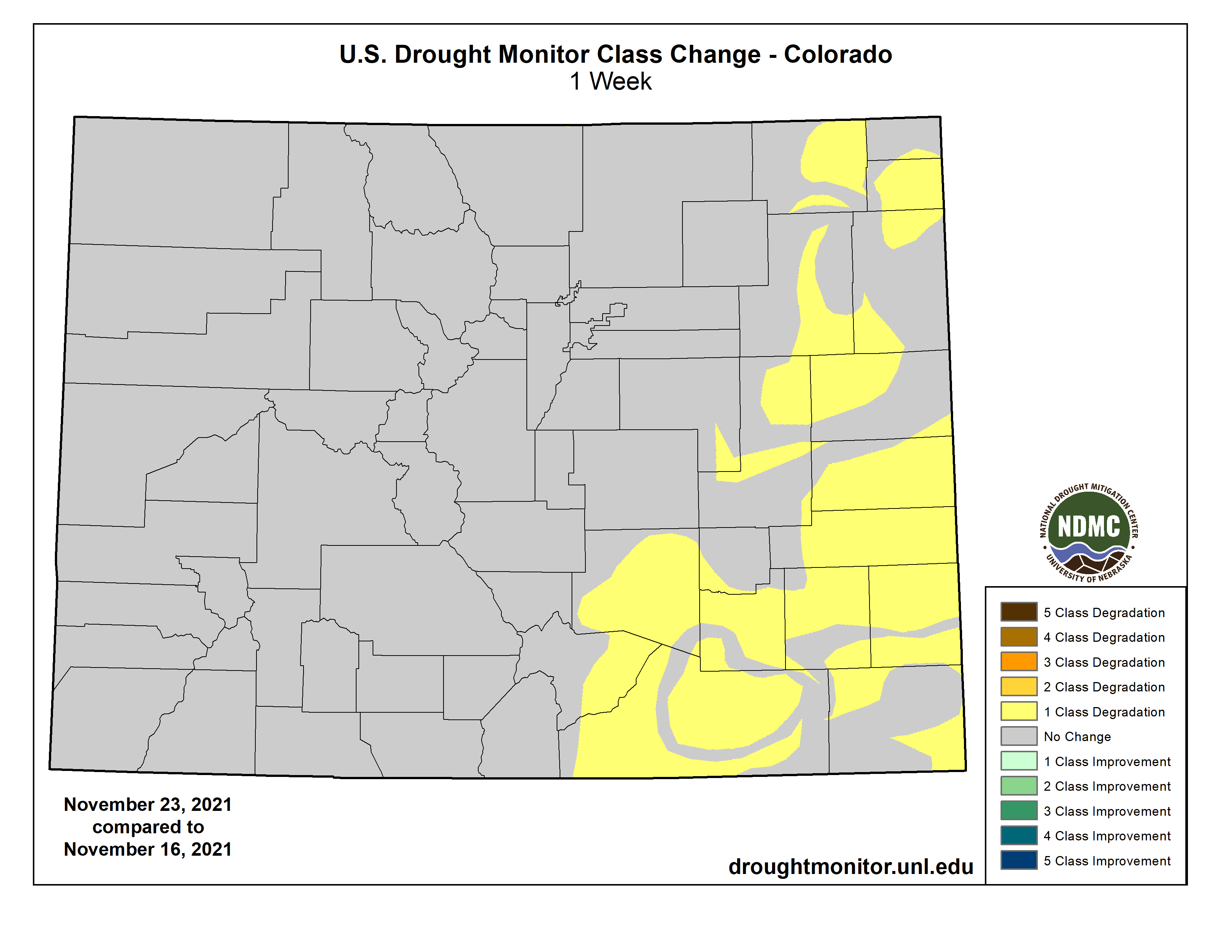
Colorado Drought Monitor map November 23, 2021.
Click here to go to the US Drought Monitor website. Here’s an excerpt:
This Week’s Drought Summary
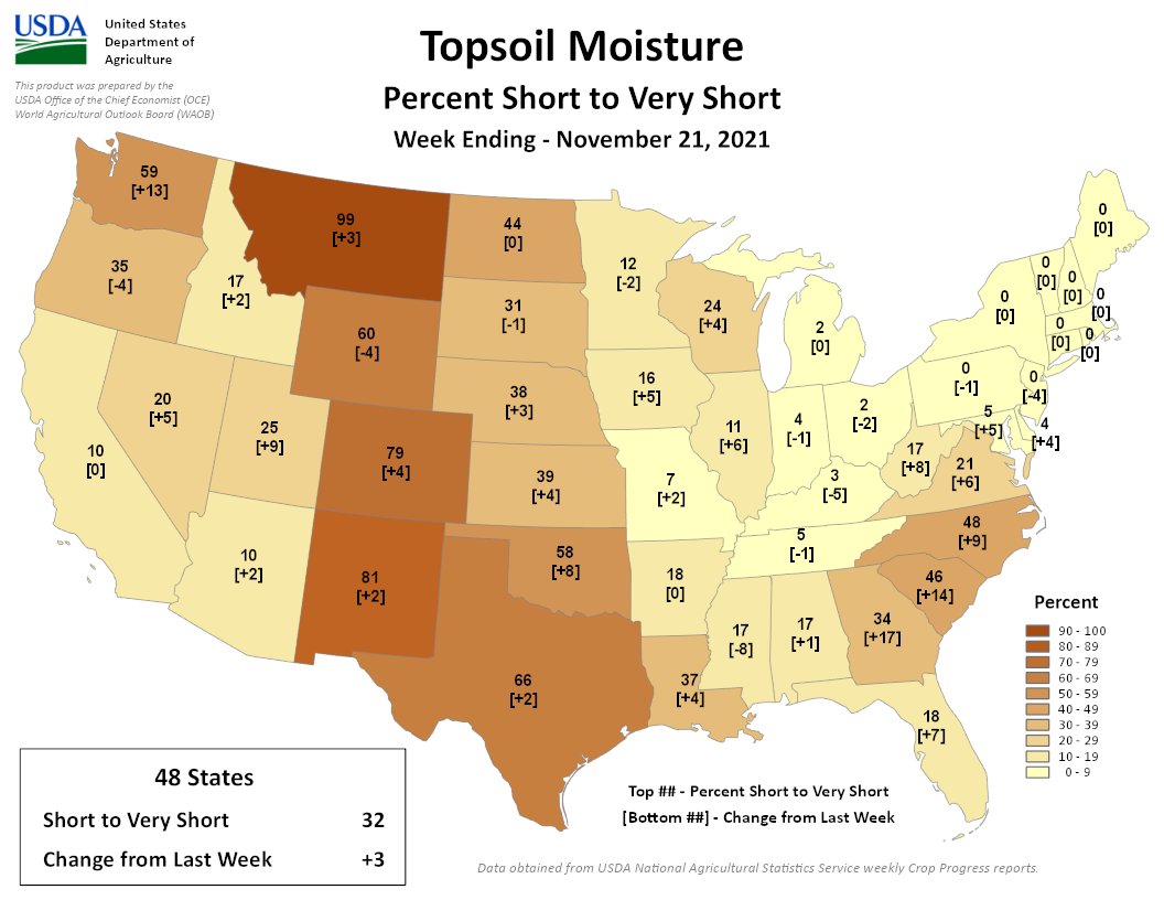
A couple Pacific weather systems moved across the contiguous U.S. (CONUS) during this U.S. Drought Monitor (USDM) week. The storm track kept to the northern states, but the systems dragged cold fronts with them that stretched the width of the CONUS, from the Great Lakes to the Gulf of Mexico coast. The systems spread rain and snow to the coastal Pacific Northwest and parts of the northern Rockies, but they weakened as they moved through a western ridge. This circulation pattern starved them of moisture, so much of the West to Great Plains received little to no precipitation, but the fronts picked up Gulf of Mexico moisture as they moved east, spreading precipitation across the Lower Mississippi to Ohio Valleys, eastern Great Lakes, and Northeast. Only a few areas received above-normal precipitation for this time of year, including spots in the Pacific Northwest, Ohio Valley, Deep South Texas, and the southern half of Florida. Weekly temperatures averaged near to cooler than normal in the Pacific Northwest, Great Lakes, Ohio Valley, and Mid-Atlantic states. Much of the West, Great Plains, and Southeast were warmer than normal. Persistent above-normal temperatures in the Plains contributed to excessive evapotranspiration in western portions of the Great Plains as well as parts of the West, as seen in EDDI and ESI indicators. Lack of precipitation, excessive evapotranspiration, and windy conditions further dried soils, again especially in western portions of the Plains, as seen in several soil moisture indicators. Drought indicators such as the Standardized Precipitation Index (SPI) and Standardized Precipitation Evapotranspiration Index (SPEI) showed dry conditions at long-term time scales in the West to northern Plains, at short-term time scales in the Southeast to Mid-Atlantic and Lower Mississippi Valley regions, and both short- and long-term time scales from the Southwest to southern and central Plains. Precipitation over the last 4 weeks lessened drought intensity slightly in parts of the West, but continued dryness expanded or intensified drought in parts of the Plains, Deep South, Southeast, and Mid-Atlantic states…
Except for half an inch or more of precipitation over the mountains of northern Colorado and northwest Wyoming, a tenth of an inch to no precipitation was observed across the High Plains region. Drying soils, high evapotranspiration, and worsening SPI and SPEI drought indicators led to expansion of D3 in northeast and southeast Colorado and southwest Kansas, and D0-D2 in eastern portions of Colorado and western portions of Kansas. Decreasing soil moisture, lack of snow, and dry long-term SPI/SPEI indicators prompted expansion of D3 in north central Wyoming and D1 and D2 in southeast Wyoming…
Colorado Drought Monitor one week change map ending November 23, 2021.
Half an inch to locally 2 inches of precipitation fell along coastal areas of Oregon and Washington, with half an inch over eastern Washington to northern Idaho. Less than half an inch occurred further south to northern portions of California and the Great Basin. Areas further south received no precipitation this week. Dry soils, high evapotranspiration, and severely dry SPI and SPEI values prompted expansion of D4 in northern Montana. According to November 21st statistics from the U.S. Department of Agriculture, 99% of Montana’s topsoil moisture was short or very short (dry to very dry) and 42% of the winter wheat crop and 99% of the pasture and rangeland were in poor to very poor condition. D1-D3 expanded in eastern New Mexico. Even though California and Nevada were mostly dry this week, the impacts from the atmospheric river event and frontal rains of October continued to be felt. With moist soils, wet SPI and SPEI indicators for the last 1 to 6 months, and slightly improved reservoir levels and snowpack, a reassessment of conditions resulted in the pullback of D4 in the Sacramento River Valley in California, and a pullback of D2 and D3 in northern Nevada. D3 was also pulled back slightly in southwest Montana and adjacent Idaho…
Half an inch to locally an inch of rain fell over Mississippi, Tennessee, eastern parts of Arkansas, and parts of Louisiana. Half an inch to locally over 2 inches was observed over Deep South Texas. Other than those areas, most of the South received no precipitation this week. Drying soils, high evapotranspiration, and worsening SPI and SPEI drought indicators prompted expansion of D0-D3 in western parts of Oklahoma and Texas, while D0-D1 expanded in eastern portions of Texas and Oklahoma to western parts of Mississippi. The rains in Deep South Texas eliminated moderate drought and contracted abnormal dryness along the southern Rio Grande River…
Looking Ahead
A frontal system will sweep across the eastern CONUS during November 24-30 with another Pacific weather system moving into the Pacific Northwest near the end of the period. They will be moving through a circulation pattern consisting mainly of an upper-level ridge in the West and trough in the East. An inch to 2 inches of precipitation is forecast to fall along the Texas coast to east Texas and over northern portions of the Northeast, with half an inch or more stretching from the southern Rio Grande Valley to New England. Half an inch to an inch of precipitation is expected over the northern Rockies and coastal sections of Oregon and Washington, with up to 5 inches in the forecast for northwest portions of Washington. Up to half an inch is predicted for parts of the Four Corners states in the Southwest, parts of the Great Lakes, and coastal parts of the Mid-Atlantic to Northeast states. Little to no precipitation is expected for much of the West, Great Plains, and Upper Mississippi Valley due to the circulation pattern associated with the western ridge. With the storm track to the north and systems moving into the Great Lakes, much of the Southeast will receive little to no rainfall. Temperatures are expected to be warmer than normal in the western and central CONUS and cooler than normal along the East Coast. The outlook for December 1-6 shows drier-than-normal weather favored from the Southwest to Great Lakes, from the Ohio Valley to Southeast, and western half of Alaska, with wetter-than-normal weather favored over the Pacific Northwest to northern Rockies, parts of southern Texas, and southeast Alaska. Odds favor colder-than-normal weather over the East Coast and warmer-than-normal weather over the western and central CONUS, with the warmer-than-normal conditions shifting eastward as the period progresses. Colder-than-normal temperatures dominate Alaska in the outlook.
US Drought Monitor one week change map ending November 23, 2021.
FromThe High Country News [November 23, 2021] (Sarah Tory):
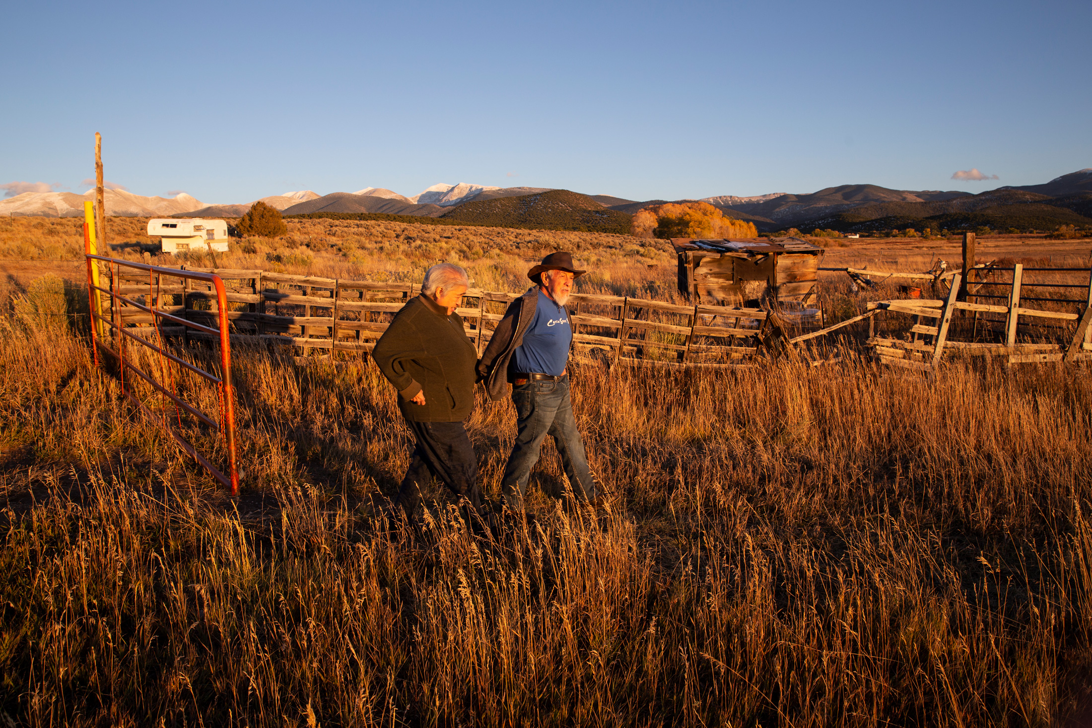
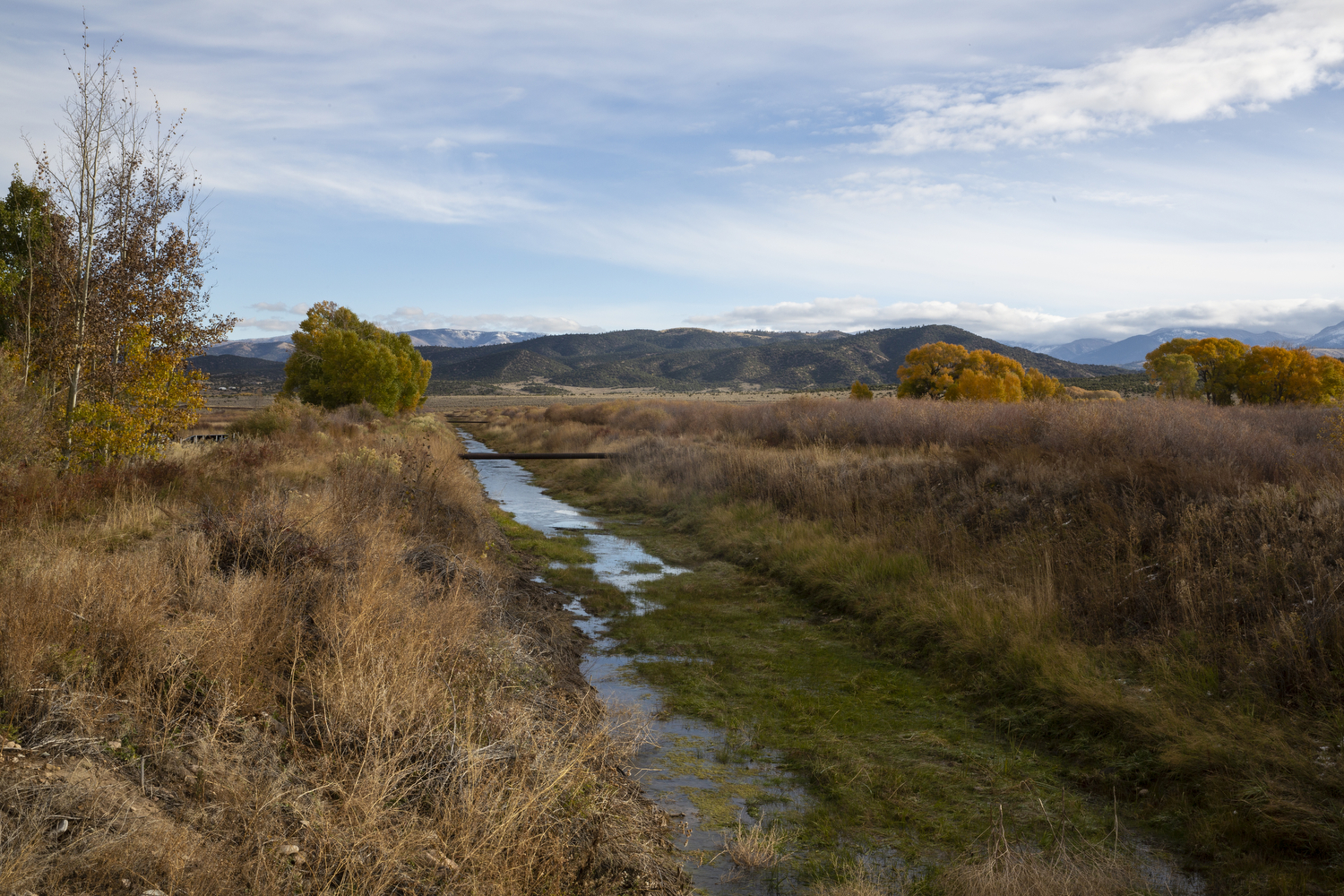
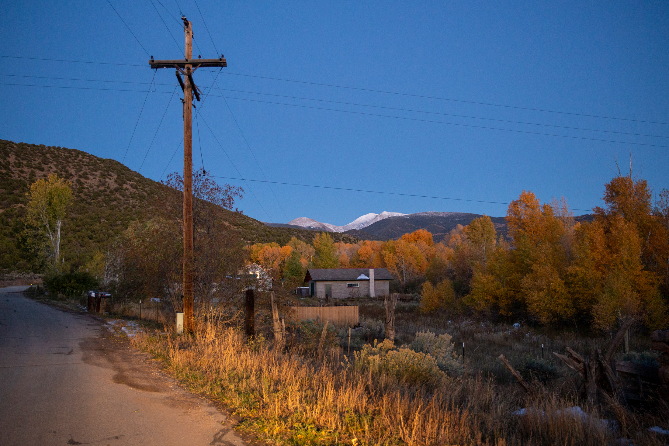
Every summer in Colorado’s San Luis Valley, a long, high desert valley ringed by mountains, Jose Martinez watches in admiration as water flows from an irrigation pipe across the contours of his land, feeding the eight acres of alfalfa he grows near his home in San Francisco, a town of less than 90 people. The water comes from a network of communal irrigation ditches, or acequias, which comes from an Arabic word meaning “water bearer.” The acequias were built in part by his ancestors who arrived in southern Colorado more than 150 years ago with other Hispanic families from what is now New Mexico, establishing seven villages around Culebra Creek.
“I get to thinking, back in the day, these men dug it all by what we call pico y pala — pickaxe and shovel,” Martinez, 76, told me when I visited recently. We were sitting in his kitchen on a cold October day with his wife, Junita, 70, while the two of them explained how acequias work.
Unlike normal irrigation ditches, acequias are a communal resource, collectively owned and governed by their parciantes, or members — the group of small-scale farmers with water rights to the ditch. Acequias are egalitarian, too: whether you irrigate one acre or 100 acres, you get one vote in decisions about the ditch in exchange for helping to clean and maintain the acequia. The parciantes elect a three-member commission to make decisions around ditch maintenance and operations, as well as a mayordomo to manage the irrigation infrastructure and tell people when they can irrigate and when they have to shut their gates.
Junita and Jose Martinez on their vara land, which is pipe irrigated with acequia water. Jose remembers when his family would plant vegetables on their plot, but now he plants hay, which requires less labor, and yields a larger profit. Luna Anna Archey
In Colorado, acequias are found in four of the southernmost counties and irrigate only a tiny fraction of the state’s agricultural output. But in a region where some water rights have been sold to the highest bidder and private gain is sometimes prioritized over collective well-being, acequias remain a powerful antidote to the forces threatening rural communities — a way of valuing local resources beyond their dollar amount and a catalyst for sharing them in times of scarcity. During dry years, acequias work to ensure that everyone weathers the shortages equitably; occasionally, Jose has opted to forego his water entirely when he sees no prospect of a decent crop, so that other parciantes can have more.
“Our concept is community,” Junita explains. “If I can’t get something, why should I hurt my neighbor, if I could just let him have my water — maybe he can grow something?”
The Culebra-Sanchez Canal, a feeder ditch in the acequia system in the San Luis Valley. Luna Anna Archey
THAT COMMUNAL MINDSET originates in part from the families who arrived in the southern San Luis Valley in the mid 19th century to settle the one-million-acre Sangre de Cristo Land Grant. Drawn by promises of land and resources, they established small farming communities on land where the Cuputa band of Ute people had roamed for thousands of years, until they were gradually killed or forced out by European colonizers beginning in the 1600s. The families settling the valley beginning in the 1850s were primarily from Mexico, which had sold the territory now known as New Mexico — including the southern end of the San Luis Valley — to the U.S. government a few years earlier at the conclusion of the Mexican-American War.
Families built acequias and shared access to a mountainous tract of land in the nearby Sangre de Cristo mountains, known locally as La Sierra, which they relied on for water, firewood and foraging. The land grant was eventually sold, but its subsequent owners honored the historical rights of local families to access La Sierra.
Growing up, Jose Martinez remembers how families built cellars to store the vegetables grown on the land nourished by the acequias, as well as meat from deer and elk hunted in La Sierra — food that would last them the winter. Although they live in what is now one of Colorado’s most impoverished counties, “we ate like kings,” he said.
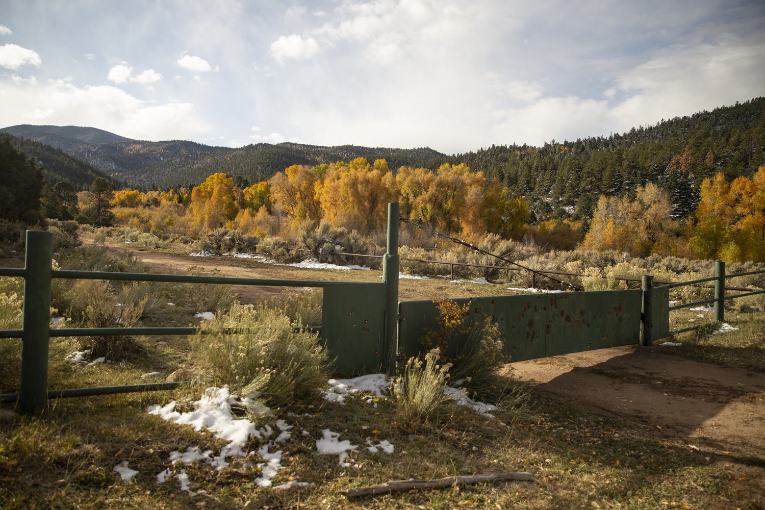
That all changed in 1960, when John Taylor, a North Carolina timber baron, bought 77,500 acres of La Sierra, renaming it the Cielo Vista Ranch and closing it off to the local community to create a logging operation. Taylor’s logging wrought lasting damage on the land. Poorly constructed roads created erosion, reducing the amount of water that flowed from the mountains into the acequias, according to area residents.
One of many gates blocking public access to privately-owned Cielo Vista Ranch. Residents with ancestral rights to the land won access in a Supreme Court ruling. They now have keys to the gates, but are only able to use the land for specific purposes, like gathering firewood, and they often face harassment by Ranch employees. Luna Anna Archey
The water wasn’t the only resource reduced or eliminated as a result of Taylor’s actions. Without access to La Sierra for grazing, local families lost their herds and the culture of self-sufficiency that had sustained them for decades. Many, like Jose Martinez’s family, moved out of the valley. Those that stayed saw their health and well-being deteriorate. People went on food stamps and rates of diabetes soared. There were psychological impacts, too.
“You lose the relevance of what your land means,” said Shirley Romero Otero, the head of the Land Rights Council, which formed in the town of San Luis in the late 1970s to stop Taylor from denying access to the property. (A group of San Luis community members are participating in The Colorado Trust’s Community Partnerships strategy; Romero Otero previously was part of this effort.)
In 1981, the Land Rights Council mobilized local residents to sue Taylor for blocking their historical right to access the property. The ensuing legal battle lasted 40 years, fought by generations of the same families and leading to an April 2003 Colorado Supreme Court ruling, Lobato v. Taylor. The ruling granted people the right to graze their animals, cut timber and gather firewood on the land, if they could prove they were heirs to property that was part of the original Sangre de Cristo land grant.
The privately-owned Culebra Range in the background of San Francisco, Colorado. Residents call the mountains La Sierra. Luna Anna Archey
“WE’RE SUCH DIEHARDS,” Junita told me, pointing to an old black-and-white photo from the early days of the land rights struggle taped to their refrigerator. Her husband was among the roughly 5,000 people given keys to access the ranch gates after a nearly 15-year process of identifying the land grant descendants.
“We won’t let go,” Jose added.
The Martinezes owe their persistence in part to the acequias, which are the lifeblood of each village, binding people to the land and to each other. Every spring, acequia communities gather for an annual ritual called La Limpieza to clean the ditch in preparation for the irrigation season. For families, it serves as a de facto reunion — regardless if someone has moved to Denver or to California, people come back for La Limpieza.
For Junita, that communal aspect is why acequias are important: working together to cultivate a shared resource. It’s also why she feels so strongly about protecting those resources from wealthy outsiders who threaten that culture. “We’re a land- and water-based people,” Junita explained.
The current owner of the Cielo Vista Ranch is William Harrison, heir to a Texas oil fortune, who bought the Cielo Vista property in 2018. According to its real estate listing, the ranch was listed at $105 million and encompasses 23 miles of the Sangre de Cristo Mountains, including 18 peaks over 13,000 feet and one over 14,000 feet, Culebra Peak — the highest privately owned mountain in the U.S., and quite possibly the world.
Harrison’s ranch hands have intimidated and harassed local people who tried to access the property, according to court filings and residents — despite the legal rulings affirming the rights of the land grant heirs. With the threat of a violent confrontation growing, Jose and Junita’s children told their father they don’t want him going up onto the ranch alone to collect firewood, which he, like many locals, uses to heat their home.
A week before I visited, the Land Rights Council filed a motion in Alamosa Municipal Court to safeguard local residents’ rights to access the ranch. During a two-day hearing, a judge heard testimony about how the ranch’s aggressive surveillance tactics infringed on the community’s hard-won traditional land rights, including tracking people with drones and armed ranch hands approaching people with dogs. The ranch denied use of such tactics.
In an email, Harrison, through his lawyer, wrote that he believes that a few “bad apples” have abused those rights on occasion, illegally hunting, joy-riding ATVs and sneaking onto the property to fish. “That being said, we are fully committed to bringing the animosity of the past to a close, and are making a good-faith effort to bring healing and peace,” he added.
A sign in the town of San Luis provides notification of a community meeting about accessing La Sierra. Luna Anna Archey
IF ACEQUIAS are the seams holding communities together, they are also what makes them vulnerable: the stitching that can come undone. In recent years, developers have approached communities elsewhere in the San Luis Valley to buy their water rights and then move the water from the aquifer below the valley over Poncha Pass and into the Arkansas River for growing Front Range cities.
“Some of those places look like ghost towns because of that,” said Peter Nichols, a lawyer with the Acequia Project, a pro-bono legal assistance program supported by the University of Colorado Boulder Law School.
Thus far, acequia communities have resisted those efforts, ensuring their water stays with the land. With the help of the Acequia Project and Colorado Open Lands, an environmental nonprofit, acequias have adopted bylaws that protect acequias from outside buyers.
Still, like any collaboration, acequias are not perfect, said Sarah Parmar, the director of conservation at Colorado Open Lands. “It’s messy because there are human relationships involved, and anytime you have a community that goes back multiple generations, there are going to be grudges and things that have happened that they’re going to bring into those situations,” Parmar said.
But more than anything, acequia communities recognize that water is not just an asset; “it’s a piece of everything,” Parmar told me. “If you pull on that thread, the whole sweater unravels.”
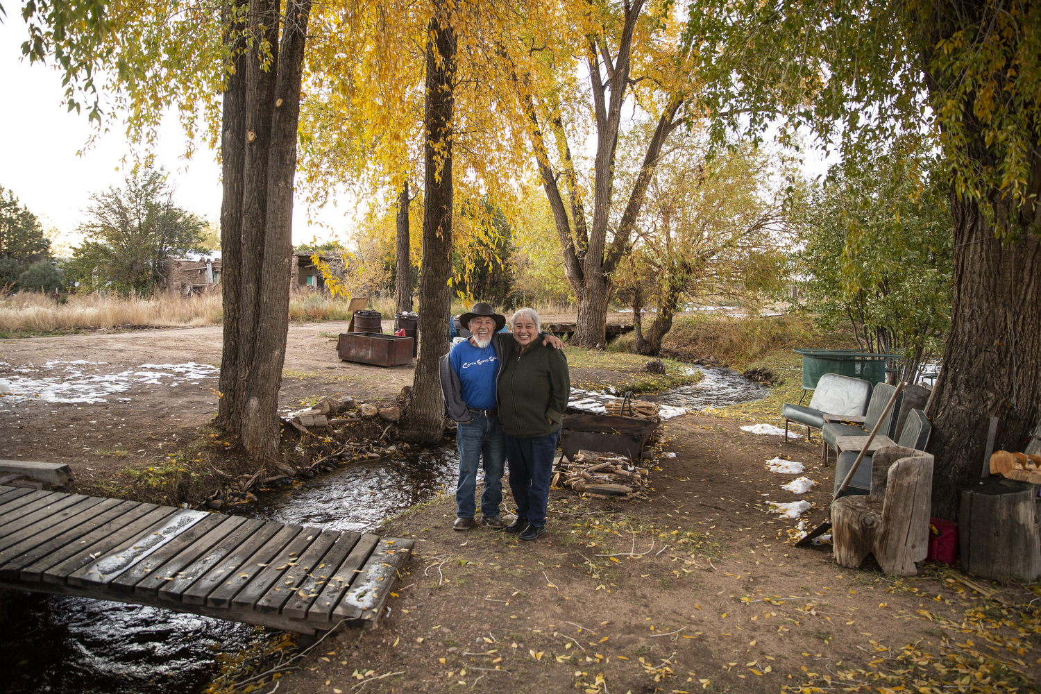
Junita and Jose Martinez at their home in San Francisco, Colorado. Nana Ditch, the “mother ditch,” runs through their property. Luna Anna Archey
JOSE GRABBED JUNITA’S ARM to steady her as the two walked outside to show me the Nana Ditch, the “mother ditch” that gurgles beneath the willow trees in their backyard.
“It would kill me to see water flow by that doesn’t belong to us,” Junita said. “We’d have to go away.”
Today, abandoned houses are scattered amongst the roads and villages of the Culebra watershed — a reminder of how this community, like so many rural communities, has changed. North of the villages, giant agricultural operations have replaced the smaller family-run vegetable farms that once filled the San Luis Valley, while their high-tech center pivot irrigation systems are depleting the aquifers beneath the valley floor at an alarming rate.
Meanwhile, so many people have left, with the population of Costilla County nearly half what it was in 1950. When their children were growing up, Jose and Junita moved to Colorado Springs so the girls could get a better education. But people are returning to the valley, too, like Martinezes did in 2002. Jose began growing alfalfa on his family’s eight acres again, and a few years ago, two of the girls bought the lots on either side of their parents, where they hope to one day build their own homes.
In the Spanish dialect spoken in northern New Mexico and southern Colorado, there is a term called querencia, which translates roughly to “heart home or place.” Even after they left the valley, Jose and Junita would bring the girls back to San Francisco every summer to remind them: “This is where you come home.”
Junita and Jose Martinez’s land on the periphery of San Francisco, Colorado. Luna Anna Archey
This story was republished with permission from Collective Colorado, a publication of The Colorado Trust.
Sarah Tory writes from Carbondale, Colorado. Follow @tory_sarah
Acequia La Vida via Greg Hobbs.
Santa Cruz River, Acequia de La Puebla, Chimayo
Selection of the 2015 native heirloom maize harvest of the seed library of The Acequia Institute in Viejo San Acacio, CO Photo by Devon G. Peña
An acequia along the Las Trampas in northern New Mexico is suspended on a trestle. (Eddie Moore/Albuquerque Journal)
Fig. 2. Mexican Land Grants in Colorado and New Mexico. The Baumann map depicted here mislabels these Mexican land grants as “Spanish”. Source: Paul R. Baumann 2001. SUNY-Oneonta.
Water from acequias, a shared collection of gravity-fed irrigation ditches have been a historical part of irrigation in the San Luis Valley. Acequia San Antonio via Judy Gallegos
Acequia del Cerro, San Luis
Acequia cleaning prior to running the first water of the season
San Pedro Acequia. The headgate of the second oldest acequia in Colorado. Photo by Devon G. Peña
Bella Cruz has lived next to the People’s Ditch in San Luis for more than 60 years. Appropriated in 1852, it is the first surface water right in Colorado. Photo credit: Alamosa Citizen
San Luis People’s Ditch March 17, 2018. Photo credit: Greg Hobbs
San Luis People’s Ditch spanning the long lot system
Local youth participate in the production of chicos del horno at Corpus A. Gallegos Ranch. San Luis, CO Photograph by Devon G. Peña
San Luis People’s Ditch via The Pueblo Chieftain
The country’s second largest potato producing region, is in its 18th year of drought in 2020. The San Luis Valley in Colorado is known for its agriculture yet only has 6-7 inches of rainfall per year. San Luis People’s Ditch