No amount of planning or legislation can make more water — but it can help the parched Western Slope make more use of the water it has.
The trillion-dollar Infrastructure Investment and Jobs Act authorizes, as part of an overall $55 billion for water infrastructure, $8.3 billion under its Western Water Infrastructure title for the Bureau of Reclamation between Fiscal Years 2020 — 2026.
On the laundry list of designated funds for Western Water Infrastructure are $3.2 billion for aging infrastructure, $1.5 billion for storage, $1 billion for the Drought Contingency Plan on the Colorado River and $400 million for WaterSMART and energy efficiency grants.
“All in all, it’s certainly the most meaningful investment in Western water resources that we’ve seen in my generation,” said Zane Kessler, director of Government Relations for the Colorado River District. The district sees an opportunity to fight for some of those dollars to flow into western Colorado, he said — and there are several meaningful investments that Colorado and the Western Slope are well-equipped to pursue…
The act provides additional funding to the Aging Infrastructure Account created in 2020’s Consolidated Appropriations bill. This funding helps the Bureau of Reclamation provide direct loans to finance the non-federal share of major, nonrecurring maintenance of water infrastructure owned by the bureau, in water projects across the West that require major upgrades or replacement.
“As those facilities, most of which are more than 50 years old, continue to age, the issue of storing and delivering water effectively, efficiently and in a timely matter only increases,” a summary from The Ferguson Group states. The Ferguson Group represents the Family Farm Alliance, of which the Colorado River District is a member.
Of the $3.2 billion, $100 million is to be available for dam rehabilitation, reconstruction or replacement. Another $100 million is to be available for reserved or transferred works that have suffered a critical failure, per the summary.
Water storage, groundwater storage and conveyance projects receive a $1.05 billion boost and of that, $100 million is to fund grants to plan and build small-surface water and groundwater storage projects.
There is $1 billion available for water projects authorized by Congress before July 1 of this year in accordance with the Reclamation Rural Water Supply Act of 2006.
The river district is pleased overall with the package of options the Infrastructure Investment and Jobs Act opens up, Kessler said, and it will be working to bring some of those dollars here.
The infrastructure act’s passage comes at a time of dire drought in the Gunnison Basin and Colorado.
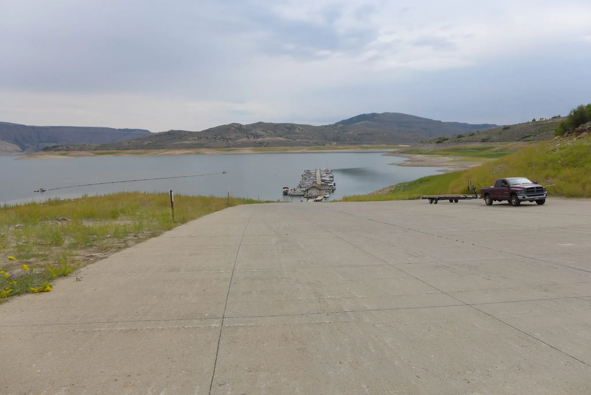
The boat ramp at the Lake Fork Marina closed for the season on Sept. 2 due to declining reservoir levels. The Bureau of Reclamation is making emergency releases out of Blue Mesa Reservoir to prop up levels in Lake Powell and preserve the ability to make hydropower. CREDIT: HEATHER SACKETT/ASPEN JOURNALISM
Earlier this year, Blue Mesa Reservoir was drawn down a total of 36,000 acre-feet between August and October and Flaming Gorge in Utah released 125,000 acre-feet. Navajo Reservoir in New Mexico is set to have released 20,000 by December — a trio of infusions mandated by the Upper Basin Drought Response Operations Agreement to keep hydropower operational at Lake Powell…
The earlier drawdown at Blue Mesa took 17,000 acre feet from the reservoir in August; 16,000 acre feet in September and 3,000 acre feet in October, according to BuRec numbers.
That provided the requisite 36,000 acre feet to Powell from Blue Mesa, but at the end of October, Powell was 156 feet from full pool, with an elevation of 3,544.25 acre feet. It had 7.18 million acre feet in storage — 30% of live capacity, as Catlin noted.
He and others eye the weather and potential snowpack. They wait. They hope.
Catlin said that as it is, the entire Gunnison Basin is drying so much, it’s hard to say what the overall impact might be — but more than agriculture would suffer…
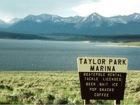
Taylor Park Reservoir
Blue Mesa has about 218,000 acre feet in storage, he said. Taylor Park, another pot of water in the BuRec-managed Aspinall Unit, sits “OK” at 59,000 acre feet in storage, Knight said. Ridgway Reservoir has 63,000 acre feet in storage, a bit low, but in light of how dry the year was, not as bad it could be, he also said…
Blue Mesa’s elevation sat at 7,431 this week — ideally, it would reach 7,490 by the end of December.
“We’ll be nowhere close to that,” [Erik] Knight said.
Already, there is not enough water flowing through the Colorado River to meet all of the demands on the watershed, which spans seven U.S. states and crosses into Mexico. And as the climate changes, scientists warn that those who depend on the watershed should plan to receive even less water each year…
Already, the Lower Colorado River Basin states that rely on Lake Mead — Arizona, California and Nevada — have been meeting to discuss and find funding for a program that would keep more water in the reservoir in an attempt to stave off further shortages and cuts. That plan would keep about 500,000 acre-feet in the reservoir next year and in 2023…
The states came together to develop the plan as part of a consultation clause in an existing 2019 agreement, known as the Drought Contingency Plan. That plan builds off of a set of operating guidelines for the river, approved in 2007 and set to expire in 2026. At the same time that water officials from the seven Colorado River states tackle near-term issues, they are all positioning to negotiate a new set of guidelines.
The Colorado River is governed by a series of overlapping laws, contracts, compacts and agreements, including the guidelines. Working within these structures, the states face a major challenge — to reduce use on the river and prepare for the worst-case scenario of a future with far less water to go around. Next month, water officials from across the basin are set to meet in Las Vegas to discuss that challenge and other issues facing the river.
John Entsminger, the general manager of the Southern Nevada Water Authority, said he is “cautiously optimistic” that the states will be able to find a way to lower use “because of the structures we’ve already put in place.” He noted that if Lake Mead were to hit 1025 feet above sea level, current agreements would already trigger cuts of about 1.3 million acre-feet of water.
The Nevada Independent spoke to Entsminger about the negotiations and how dry of a future Colorado River water officials should plan for. Our conversation has been edited for clarity and length.
What do you see as the greatest challenge facing the Colorado River moving forward?
I hate to be obvious, but the biggest challenge for the river is we have a lot less water than people have legal entitlements.
How does that play into discussions around management as they’re evolving right now?
It makes the interstate and international discussions much more difficult, because really what you’re ultimately doing is negotiating to divide up a far smaller pie than what was believed to be the case in the 20th century.
Brad Udall: Here’s the latest version of my 4-Panel plot thru Water Year (Oct-Sep) of 2021 of the Colorado River big reservoirs, natural flows, precipitation, and temperature. Data (PRISM) goes back or 1906 (or 1935 for reservoirs.) This updates previous work with @GreatLakesPeck.
You mentioned not that long ago, testifying in Congress, that “the river community is far from a consensus about how dry of a future to plan for.” What are some of the differing opinions right now? And where are people on establishing that baseline of what the future looks like for the river?
I was on a panel at the University of Colorado Law School within the last six weeks or so. And a couple people on the panel were asked that question of how dry a future should we be planning for, and I said I thought an 11 million acre-feet annual flow of the river is probably a good place to start based upon what I’ve heard from folks like Jonathan Overpeck and Brad Udall and other smart climate scientists.
But there were some folks on that panel that threw out a number of 13 to 14 million acre-feet, which, frankly, is quite a bit more water than the average of the last 20 years. So I think just from that exchange, you can see that there isn’t currently a consensus on what sort of worst-case scenario should we be planning for, as we negotiate operating guidelines for post-2026.
Let’s take that number, 11 million acre-feet. What would it mean in terms of water use to get to that number?
As a basin (seven states plus the country of Mexico), we’re currently using about 14 [million acre-feet]. So it would mean finding a way to cut current uses by three million acre-feet and not add any new uses, at least without retiring a commensurate amount of existing uses.
Knowing how hard it is to reduce use, that sounds like a very big challenge. Do you think that’s an achievable goal?
That’s the amount of water that Mother Nature gives us. We don’t really have a choice whether or not to achieve it. You have to find a way to live within the amount of water that nature actually gives you.
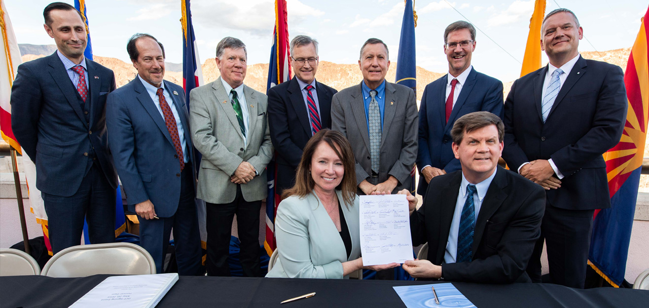
Signing ceremony for the Colorado River upper and lower basin Drought Contingency Plans. Back Row Left to Right: James Eklund (CO), John D’Antonio (NM), Pat Tyrell (WY), Eric Melis (UT), Tom Buschatzke (AZ), Peter Nelson (CA), John Entsminger (NV), Front Row: Brenda Burman (US), and from DOI – Assistant Secretary of Water and Science Tim Petty. Photo credit: Colorado River Water Users Association
With each passing, snowless day, Denver extends its new record of the latest date at which the first measurable snow falls, busting through the old record of Nov. 21, set in 1934.
Climatologists are watching as the record climbs, estimating Denver’s dry spell could last until early December. But that’s not nearly as worrisome as the lagging snowpack levels in southwest Colorado, they say, specifically in the Sangre de Cristo, San Juan and San Miguel mountains.
Colorado needs an above-average snowpack year to start recovering from a dry summer this year and last year, Climatologist Becky Bolinger of Colorado State University said. Without that snowpack, water levels along the parched Colorado River will likely remain low…
“We’re not off to a very good start,” Russ Schumacher, another CSU climatologist and director of the Colorado Climate Center said.
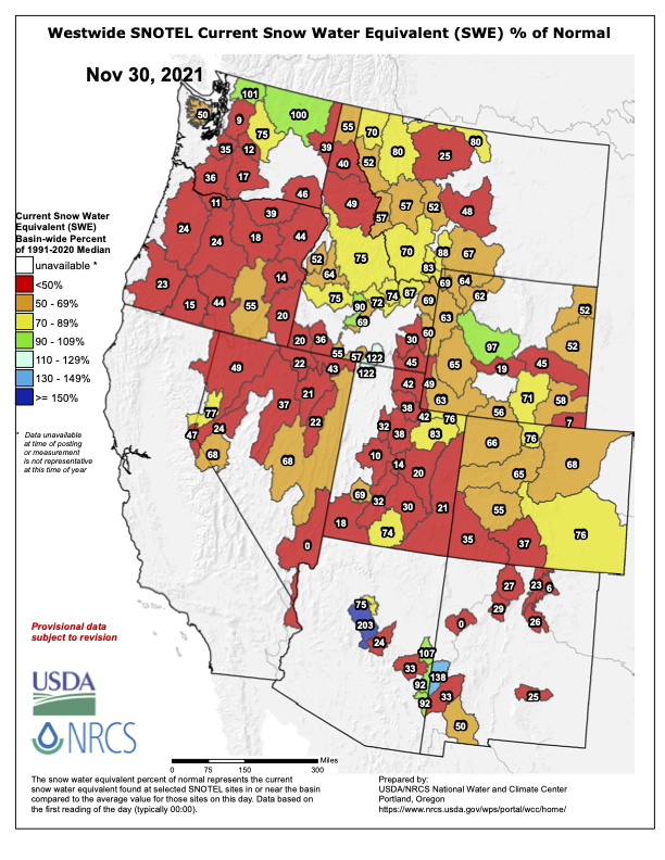
Data collected by the U.S. Department of Agriculture’s Natural Resources Conservation Service shows that snowpack around Alamosa sits at 37% of normal levels. Further west, around Durango, snowpack sits at 34% of normal levels.
Mountains further north are faring better, the data shows. Snowpack around Ouray and Gunnison is 61% of normal. Snowpack around Aspen and Glenwood Springs is 72% of normal.
The gap between current conditions and normal snowpack is concerning, Bolinger said, but it’s also early in the season. Peak snowpack levels don’t come around until mid-April, and between now and then the difference will shrink as storms pass through…
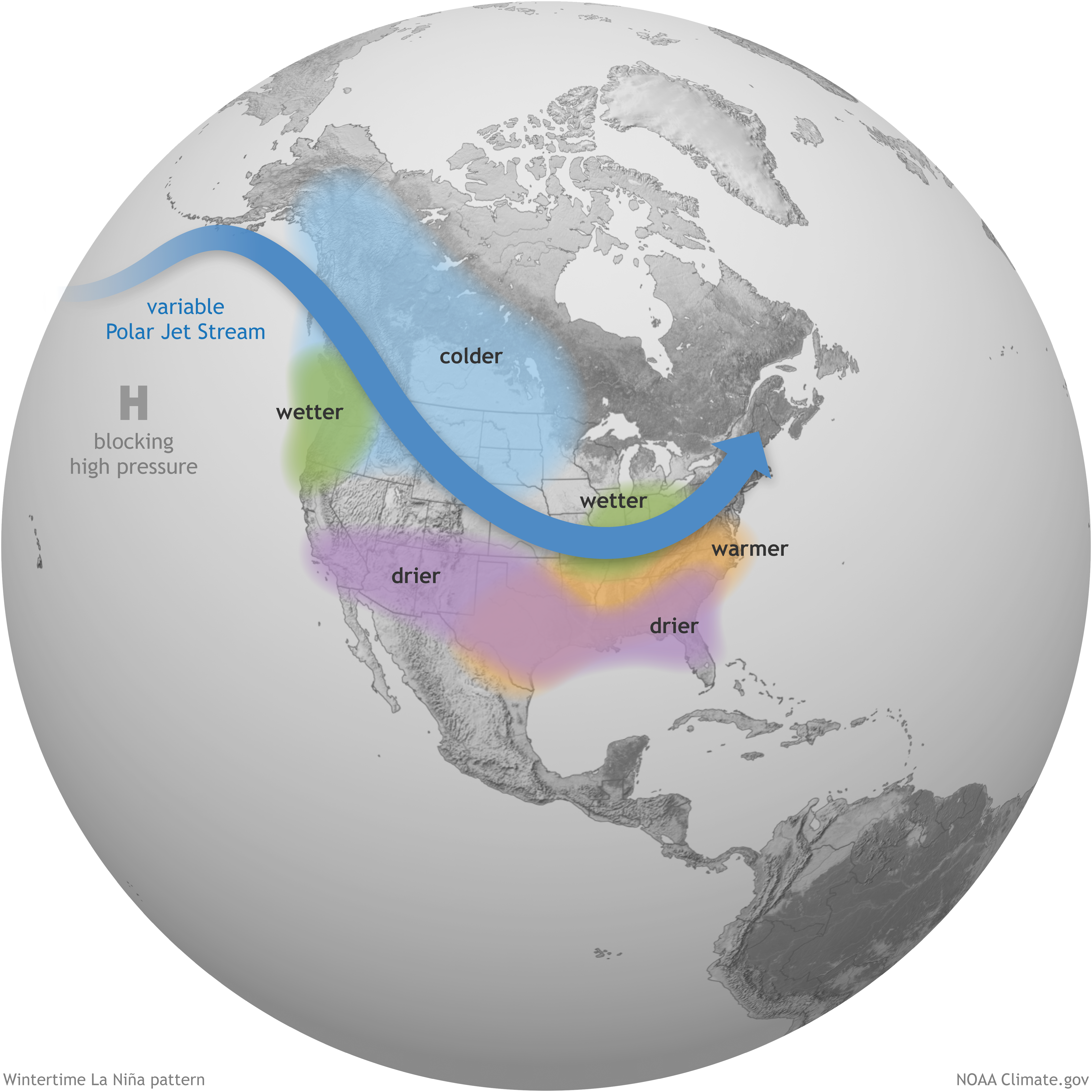
Schumacher said he expects snow to accumulate better in the northern portion of the state this winter while the southwest is more likely to remain drier and warmer…
Basically, La Niña years typically translate to a good supply of winter storms in Colorado’s northern mountains, Schumacher said…
If La Niña conditions persist, Schumacher said he’s worried about a dry winter. Plus, what little moisture might fall during that time could also be lost as warmer temperatures melt snow prematurely and it’s absorbed by the dry ground, he said.
La Niña intensifies the average atmospheric circulation—surface and high-altitude winds, rainfall, pressure patterns—in the tropical Pacific. Over the contiguous United States, the average location of the jet stream shifts northward. The southern tier of the country is often drier and warmer than average. NOAA Climate.gov illustration.