Updated Colorado River 4-Panel plot thru Water Year 2022 showing reservoirs, flows, temperatures and precipitation. All trends are in the wrong direction. Since original 2017 plot, conditions have deteriorated significantly. Brad Udall via Twitter: https://twitter.com/bradudall/status/1593316262041436160
Rising temperatures have sucked more than 10 trillion gallons of water out of the Colorado River Basin between 2000 and 2021.
“Water in western Colorado is not a partisan issue,” said Andy Mueller, the executive director for the Colorado River District. “We have some of the most liberal counties in America, but we also have some of the most conservative counties in America, and yet when they come together — their representatives who employ me — 90% of the time they agree on water policy issues. And it is the one area in today’s really divided political discourse where we see some united discussion.”
A new study out of UCLA shows the Colorado River has lost 10% of its water since the 1950s due to rising temperatures. Along parts of the Colorado, that loss is due to lessened snowpack as the area becomes more arid, but in others it’s due to evaporation as the temperatures cause the water to change to a gas more quickly.
At its Aug. 24 meeting, the Pagosa Area Water and Sanitation District (PAWSD) Board of Directors heard a presentation from Carol Malesky of Stantec on the rate study Stantec is performing for the district. Malesky explained that the rate study being presented to the board is the first part of the study Stantec is working on and that the study aims to evaluate what the district’s water and wastewater funding needs will be over the next 10 years…
She stated that the water and wastewater funds were analyzed as separate utilities, which she noted is a “sound” management practice, and that the study attempts to mini- mize impacts on PAWSD customers…
Following further discussion of the details of the CIF calculation, Malesky explained that, if PAWSD does nothing, water rate revenue will increase at the speed of growth from just below $5 million in 2024 to approximately $5.95 million in 2032. She noted that this growth in revenues would be eclipsed by the revenue demands for the district, with the water fund projected to fall below the reserve requirement in 2027 and to go into the negative in 2028…
Malesky then presented the pro-
posed water rate changes, with a 6 percent increase for 2023, 3 percent annual increases between 2024 and 2027, 3.5 percent annual increases between 2028 and 2030, and no increases between 2031 and 2032. She stated that these increases would take an average monthly water bill for 6,000 gallons of water from $54 in 2023 to $60.74 in 2027 to $67.35 in 2030.
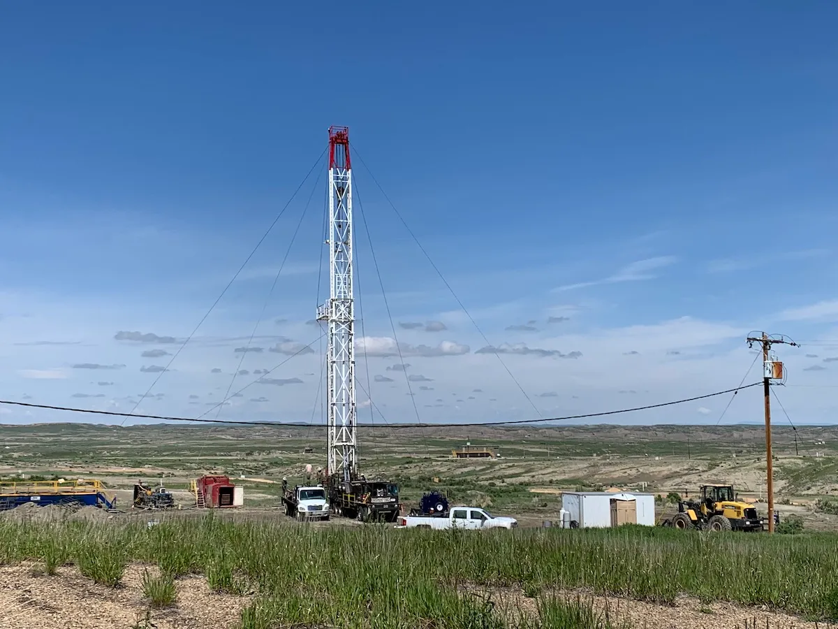
Crews set up a workover rig June 3, 2022, in the Salt Creek oil field where CO2 from ExxonMobil’s Shute Creek facility was injected for enhanced oil recovery. (Dustin Bleizeffer/WyoFile)
Backed by the promise of billions in federal dollars, energy companies are lining up to accept an invitation by Wyoming officials to collect industrial sources of carbon dioxide and pump it deep underground.
Essentially, the vision is to build a new low-carbon energy industry that scrubs the planet-warming gas from fossil fuels, keeping those fuels in the energy mix and simultaneously helping to address the climate crisis in a way that pays dividends to developers and the state.
Wyoming, according to Gov. Mark Gordon and other state officials, is primed to launch the industry. Not only has the state spent years testing its subterranean capacity to permanently store carbon dioxide, it has devoted more than a decade to building a legal and regulatory framework to win the federal government’s approval. Only Wyoming and North Dakota have won primacy over the federal program to permit such activities.
Now, the state’s top environmental regulator is considering the first in what many expect to be a wave of permit applications to drill the deep wells necessary to launch the new industry.
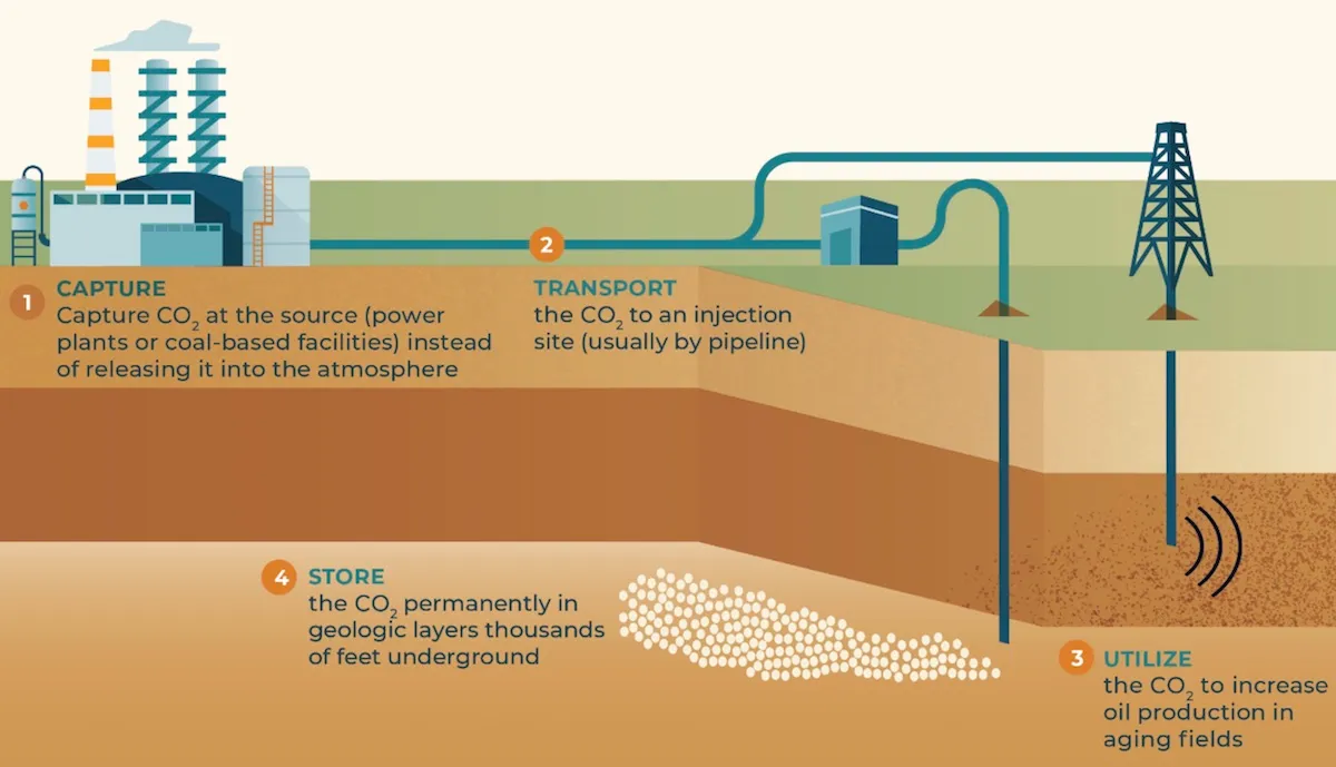
This schematic depicts how carbon dioxide from industrial sources might be collected for geologic sequestration. (Wyoming Department of Environmental Quality)
“Since 2010 [Wyoming has] been working on how to ensure this particular program could get off the ground and be protective of the environment with a lot of the risks that are involved with these kinds of projects,” said Lily Barkau, natural resources program manager at the Wyoming Department of Environmental Quality.
The agency is soliciting public comments on three carbon dioxide injection well permit applications submitted by Frontier Carbon Solutions. Two more “Class VI” permits are under review at the agency, but not yet ready for public feedback.
Sequestering CO2
Industry and regulatory officials eagerly note that pumping carbon dioxide underground isn’t fantasy. For decades, oil and gas developers have pumped the gas into oilfield formations to squeeze out more oil. Wyoming even has a “backbone” carbon dioxide pipeline that delivers the gas from southwestern and central Wyoming to multiple oilfields in the northeast corner of the state and into Montana.
While Wyoming still hopes to expand “enhanced oil recovery” via carbon dioxide injection, officials are also eager for companies to pump the gas deeper underground into saline formations. Here, at depths of 10,000 to 15,000 feet, carbon dioxide — compressed into liquid form — can be pumped and stored permanently, according to state and industry officials.
Assurances that the gas will remain underground are based on seismic surveys and deep geologic testing conducted by the U.S. Geological Survey and the University of Wyoming School of Energy Resources.
There are skeptics, however, and many questions about the logistics of deep carbon dioxide “sequestration,” as well as whether all of the public resources invested are justified.
Skepticism and questions
So far, capturing carbon dioxide from industrial smokestacks — be they attached to trona processing plants, cement factories or coal-fired power plants — hasn’t proven economical at large scale. However, industry officials point to the federal 45Q tax credit — which was expanded under the Inflation Reduction Act — for vastly improving the economics of carbon capture and storage.
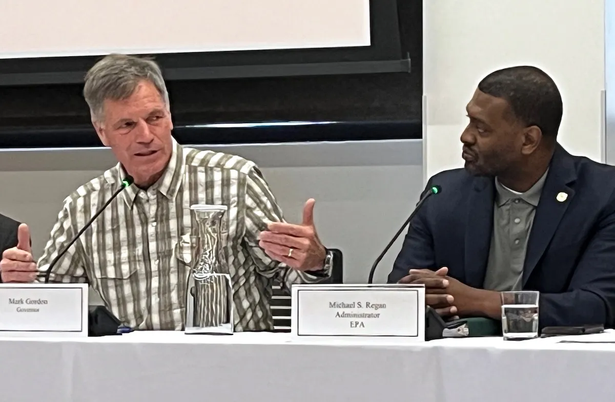
Gov. Mark Gordon and U.S. Environmental Protection Agency Administrator Michael Regan met with University of Wyoming School of Energy Resources officials Aug. 9, 2023 in Laramie. (Dustin Bleizeffer/WyoFile)
Until industrial facilities in the southwest region of the state — including in corners of Colorado and Utah — are fitted with carbon capture, Frontier Carbon Solutions plans to collect its carbon dioxide from a “direct air capture” project still in development.
Other questions remain:
How will facilities such as direct air capture farms get carbon-free power without sprawling renewable energy development on sensitive landscapes?
How much will it cost to safely manage highly saline water displaced by carbon dioxide in deep geologic formations?
And, is all the time and public resources merely a distraction from proven renewable energy and the declining costs of installing wind and solar energy?
“Billions of dollars have been wasted trying to prove that this technology is real,” Wenonah Hauter, executive director of Food & Water Watch, told the Associated Press in May. “And all we have to show for it are a series of spectacular failures.’’
Projects under review
Texas-based Frontier Carbon Solutions is a partner in the Sweetwater Carbon Storage Hub project in southwest Wyoming. The effort is part of the federal CarbonSAFE Initiative led by the University of Wyoming’s School of Energy Resources, which won $40.5 million in support from the U.S. Department of Energy. UW and Frontier Carbon Solutions will contribute another $10.1 million to the project for a total of $50.6 million, according to DOE and university officials.
The “storage hub” will have a minimum storage capacity of 50 million metric tons of carbon dioxide over the life of the project — about 20 years, according to Frontier Carbon Solutions. For context, Wyoming’s annual carbon dioxide emissions from industrial fossil fuel consumption — excluding motor vehicle pollution — was 54.6 million metric tons in 2021, according to the U.S. Energy Information Administration.
The company is seeking three permits under the Wyoming Department of Environmental Quality’s Underground Injection Control program. Public comment closes Oct. 19.
Click here for more information about the company’s permit applications. Comments can be submitted electronically via DEQ-online portals for each of the three permits: permit 242, permit 243 and permit 244. Comments may also be submitted by mail to: Ms. Lily Barkau, P.G., Groundwater Section Manager, Wyoming Department of Environmental Quality, Water Quality Division, 200 West 17th Street, 2nd Floor, Cheyenne, WY 82002.
DEQ will also hold a public hearing on the Class VI well permits, with dates yet to be announced. If the permits are approved, the company will still have to submit more information from initial drilling activities before DEQ can grant Frontier Carbon Solutions a permit to actually inject carbon dioxide, Barkau said.
Tallgrass Energy is also seeking a Class VI injection well permit for its Eastern Wyoming Sequestration Hub in Laramie County. That permit is not yet up for public comment. However, the U.S. Bureau of Land Management is seeking public comment regarding the company’s application for rights-of-way on federal surface in Laramie County.
This diagram depicts how CO2 is injected deep underground for geologic storage. (U.S. Department of Energy)
Public comment has been extended to Oct. 10. More about the project and how to comment can be found on the BLM’s project website.
Tallgrass was awarded $4.1 million for the project from the Wyoming Energy Authority in 2022, which the company will match in full, according to the agency. The grant comes from a $10 million legislative appropriation for carbon capture, storage and utilization projects.
First round of carbon dioxide injection permitting
The state won authority over the program after more than a decade of legislation to establish a legal and regulatory framework to allow for the geologic storage of carbon dioxide.
That framework includes settling the question of who owns the underground “pore space” where carbon dioxide will be stored. The state declared it belongs to the surface estate, which clarifies who gets paid for use of the pore space and who is liable. The state also set out to appease potential developers by giving them an opportunity to transfer their liability for carbon dioxide injections to the state if they meet post-closure requirements intended to protect water and human health, according to Barkau.
Wyoming, with primacy over the federal Class VI injection well permitting program, can shave years off the permitting process, Barkau said. And that makes Wyoming an attractive place to launch carbon dioxide storage projects.
“I think we’ve been able to prove that if the operator is willing to work collaboratively, it can be done in a very expedited time frame and still meet all of the rules and regulations and be protective of human health and the environment,” Barkau said.
When State Climatologist Russ Schumacher presented a preview of the Climate Change in Colorado assessment update to a conference audience in late-August in Steamboat Springs, he said the statewide annual temperature has warmed by 2.9 degrees Fahrenheit since 1895 and could warm by 5.5 degrees total by 2050.
“Observations in the past decade have only affirmed the long-term trends as described in the 2014 report, more warming everywhere, in all seasons,” Schumacher presented in his take-home messages.
“The observed warming alone is already imposing reductions on snowpack, soil moisture and stream flows,” Schumacher said. “Some climate extremes and hazards have already become more frequent and intense due to warming: heat waves, drought, wildfires. Heat waves, droughts and wildfire will worsen with the additional warming. Heavy and extreme precipitation and flooding are likely to worsen as well.”
Precipitation trends and future precipitation change are less clear and certain, but the early 21st century will be drier than late 20th century, the state climatologist noted. Snow, soil moisture and streamflows are “very likely to decline further,” reported Schumacher, the director of the Colorado Climate Center and professor in the Colorado State University atmospheric science department.
Schumacher’s presentation was part of the annual summer Colorado Water Congress hosted in Steamboat. He told the audience of water professionals and guests that scientists have a “very high confidence in change” that evaporative demand in Colorado will continue to be higher and a “high confidence in change” that summer soil moisture will continue to lower and runoff timing will be earlier. Scientists have a “medium confidence in change” that annual stream flow and spring snowpack will continue to lower in the future.
Two Colorado Democrats on Thursday joined local governments and environmental groups in urging the federal Bureau of Land Management to undertake a full review of the proposed expansion of an oil-train terminal in eastern Utah.
The operator of the Wildcat Loadout Facility, located along existing rail lines near Price, Utah, has petitioned the BLM to expedite approval of an expansion that would more than triple its current capacity. The terminal is currently used to export limited amounts of crude oil from Utah’s Uinta Basin, which must be trucked out of the region and then loaded into tank cars to transported by rail to refineries along the Gulf Coast — a route that runs directly through Colorado.
The terminal’s expansion from a capacity of 30,000 barrels to 100,000 barrels per day is viewed by environmental groups as a possible interim or backup measure in relation to the Uinta Basin Railway, the multibillion-dollar public-private partnership that aims to build a new 88-mile railroad to connect the basin to the national rail network. The railway project is on hold after a federal appeals court last month ordered regulators to better analyze the “downline” risks the increased oil-train traffic would pose to Colorado.
U.S. Sen. Michael Bennet and Rep. Joe Neguse of Lafayette, who have also spoken out against the Uinta Basin Railway, cited similar concerns about the proposed Wildcat Loadout expansion in a letter to BLM Director Tracy Stone-Manning. Though more limited in scope than the projected 350,000-barrel-per-day capacity of the proposed railway, the facility’s expansion is expected to result in a substantial increase in oil-train traffic through western and central Colorado.
“A train derailment that spills oil in the Colorado River’s headwaters would be disastrous to our state’s water supplies, wildlife habitat, and outdoor recreation assets, and the broader Colorado River Basin,” Bennet and Neguse wrote. “In addition, an accident on the train line further increases wildfire risk at a time when the West already faces historically dry conditions.”
Following a permit application submitted earlier this year by the Wildcat facility’s operator, the BLM has initiated proceedings for an “environmental assessment” of the proposed expansion under the National Environmental Policy Act. Such analyses are much more abbreviated than environmental impact statements for large projects, which can involve years of study and public feedback.
Echoing calls from Colorado’s Eagle County and more than a dozen environmental groups, Bennet and Neguse urged the BLM to conduct a full EIS process instead.
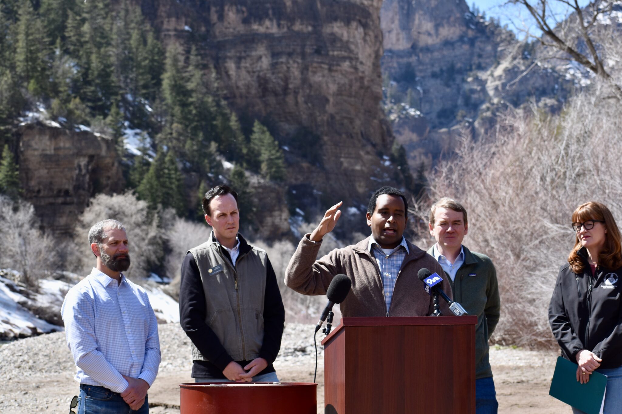
From left, Glenwood Springs Mayor Jonathan Godes, state Sen. Dylan Roberts, U.S. Rep. Joe Neguse, U.S. Sen. Michael Bennet and Colorado House Speaker Julie McCluskie participate in a press conference near Interstate 70 at the confluence of Grizzly Creek and the Colorado River to voice opposition to the Uinta Basin Railway project, April 7, 2023. (Chase Woodruff/Colorado Newsline)
A full review is especially necessary, they argued, in the wake of last month’s halting of the Uinta Basin Railway by the D.C. Circuit Court of Appeals, which ruled that the federal Surface Transportation Board had violated NEPA requirements by failing to adequately analyze the railway’s environmental risks. Eagle County and five environmental groups had sued the agency to overturn the STB’s December 2021 approval of the project.
“In light of the court’s decision, the BLM should not repeat the STB’s mistakes, and instead conduct a robust environmental review,” wrote Bennet and Neguse. “The BLM cannot adequately account for potential harm from increased oil shipments through Colorado with an EA, given its lower requirements for public involvement and environmental analysis.”
“We urge BLM to prepare a full EIS that accounts for the full risks of the Wildcat Loadout expansion to Colorado’s communities, water supplies, and environment,” the letter concludes.
Heavy rainfall associated with Hurricane Idalia brought damaging winds and flooding centered along its path. Idalia moved from the Gulf of Mexico inland along the northeastern Gulf Coast of Florida and continued northeastward through south-central and east-central Georgia, slightly inland from the South Carolina Coast, then across southeastern North Carolina before moving into the open waters of the northwestern Atlantic Ocean. A solid swath of heavy rains were observed in a band from the eastern Florida Panhandle northward through middle Georgia, interior eastern South Carolina, and southeastern North Carolina as far north as the lower Outer Banks. Between 4.5 to 10.0 inches of rain fell solidly along this swath of land, but rainfall totals dropped off rapidly to the west and east of the main band.
Farther west, a surge of tropical moisture pushed northward into the southwestern U.S., continuing northward across the Great Basin, Intermountain West, and adjacent Rockies into adjacent Canada. Heavy rainfall fell in a broken pattern over this general area, with the highest amounts reported across interior southeastern California, over much of the middle Colorado River Basin, and across scattered areas farther north. The heaviest amounts outside the lower Colorado River Basin fell on higher elevations and over areas where precipitation was enhanced by orography, as is typical.
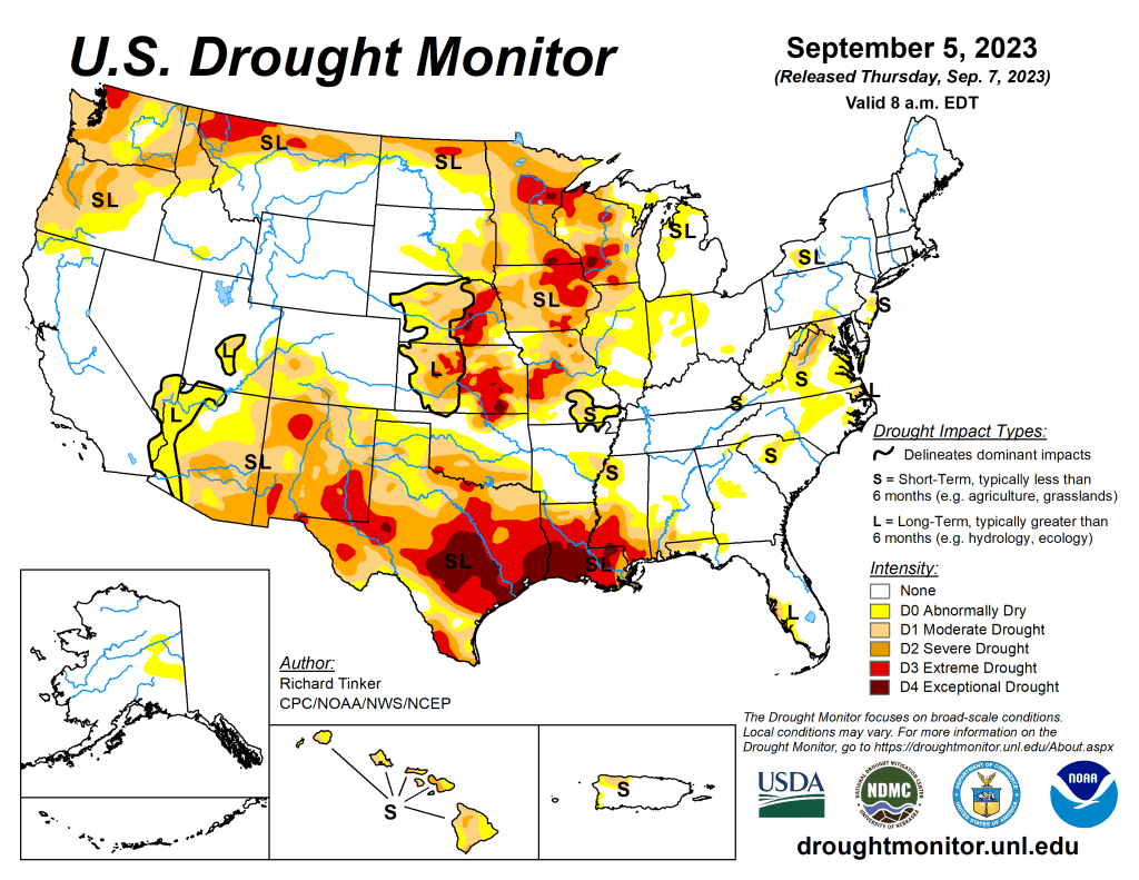
Most of the Nation, however, endured a hot and drier-than-normal week, including most areas of drought. Temperatures averaged 5 to 10 deg. F accompanied deficient precipitation over a large area from the Rockies to the Appalachians and central Gulf Coast Region, prompting drought intensification over large parts of the Upper Mississippi Valley, the Central States, and the southern tier of the country west of the Florida Panhandle. Improvement was limited to the band of heavy precipitation from Hurricane Idalia, and in scattered locales affected by the tropical moisture surge in the Desert Southwest, from southeastern Utah to central Arizona westward toward central California. According to the U.S. Department of Agriculture (USDA), the coverage of topsoils short or very short of moisture increased by 6 percent this past week, now covering 58 percent of the contiguous 48 states. This is the greatest coverage at this time of year in more than 9 years, the prior record in that short interim being just over 50 percent in 2020…
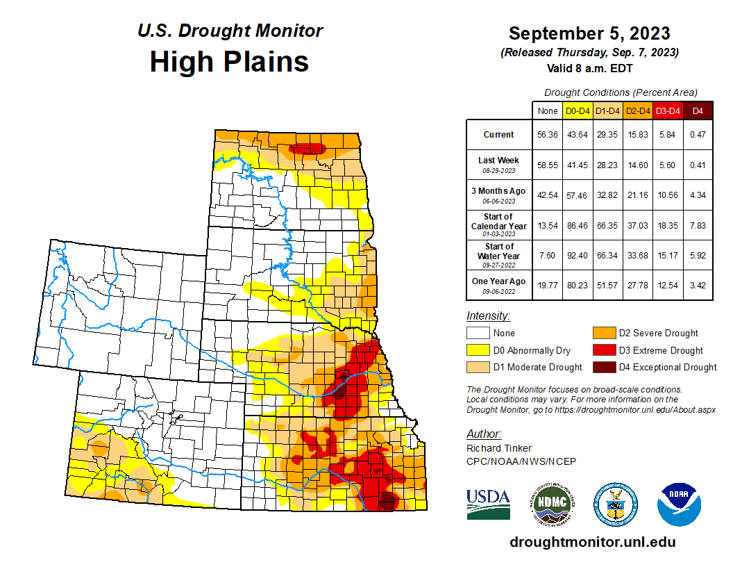
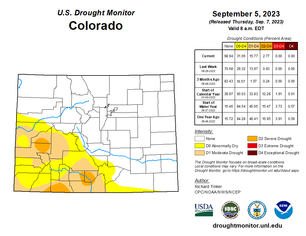
Conditions vary markedly from southeast to northwest here. Similar to western sections of the Midwest Region, Kansas and Nebraska in the southeastern High Plains region are largely covered by drought, including significant expanses of D2 to D3 conditions, with new or expanded D4 (exceptional drought) noted in a few locations. Farther west and north, conditions are much more favorable. To the north and west of central Nebraska, dryness and drought are restricted to the eastern and northern Dakotas, and southwestern Colorado. As in other parts of the Nation’s midsection, agricultural drought stress is palpable, and on the rise. Across Kansas, 40 percent of soybeans are in poor or very poor condition, as are 33 percent of the corn crop, 29 percent of sorghum, and 47 percent of rangelands. Across Nebraska, about one quarter of all the aforementioned crops are in poor or very poor condition. Still, this region did not see the degree of deterioration observed in the Midwest Region, with significant worsening most notable in central and eastern Kansas…
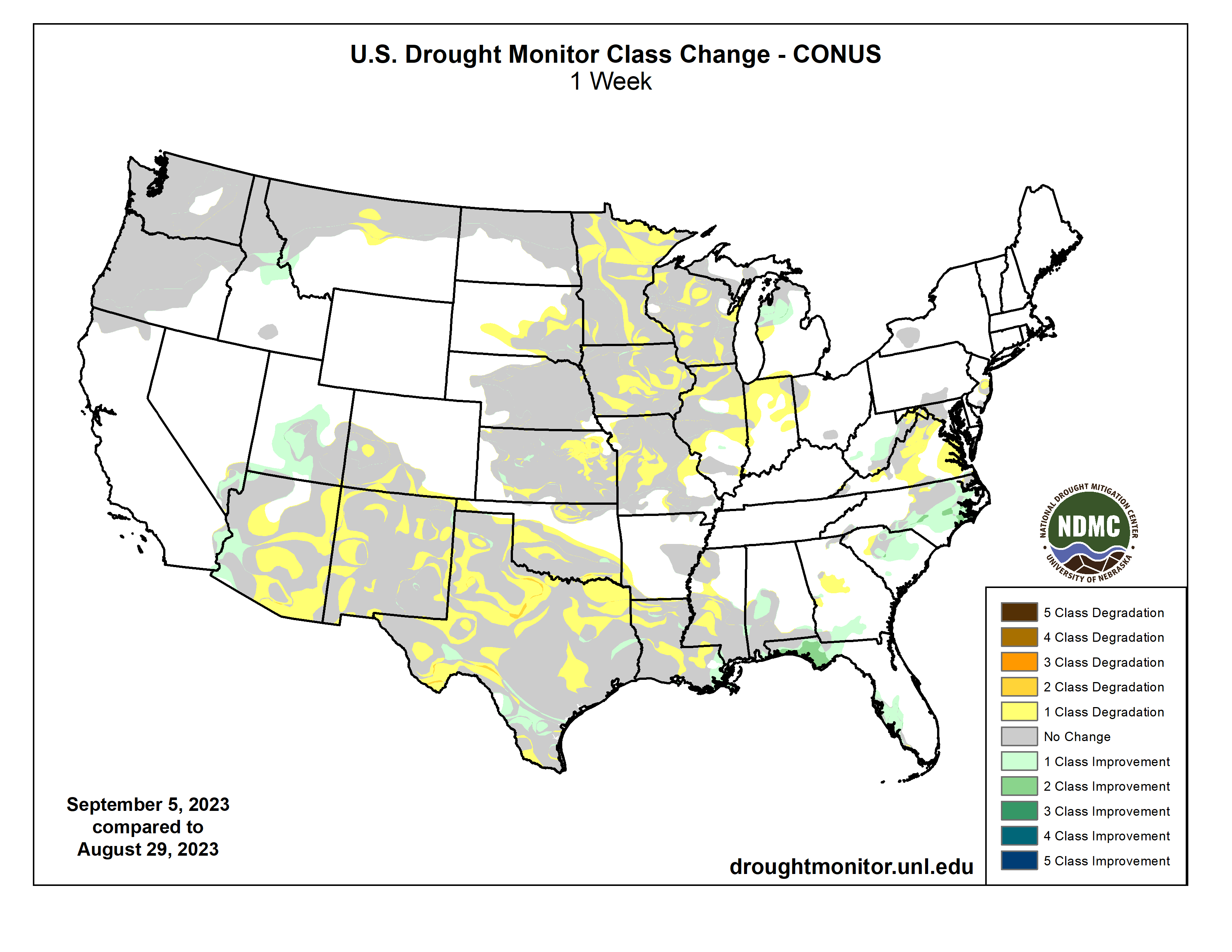
Colorado Drought Monitor one week change map ending September 5, 2023.
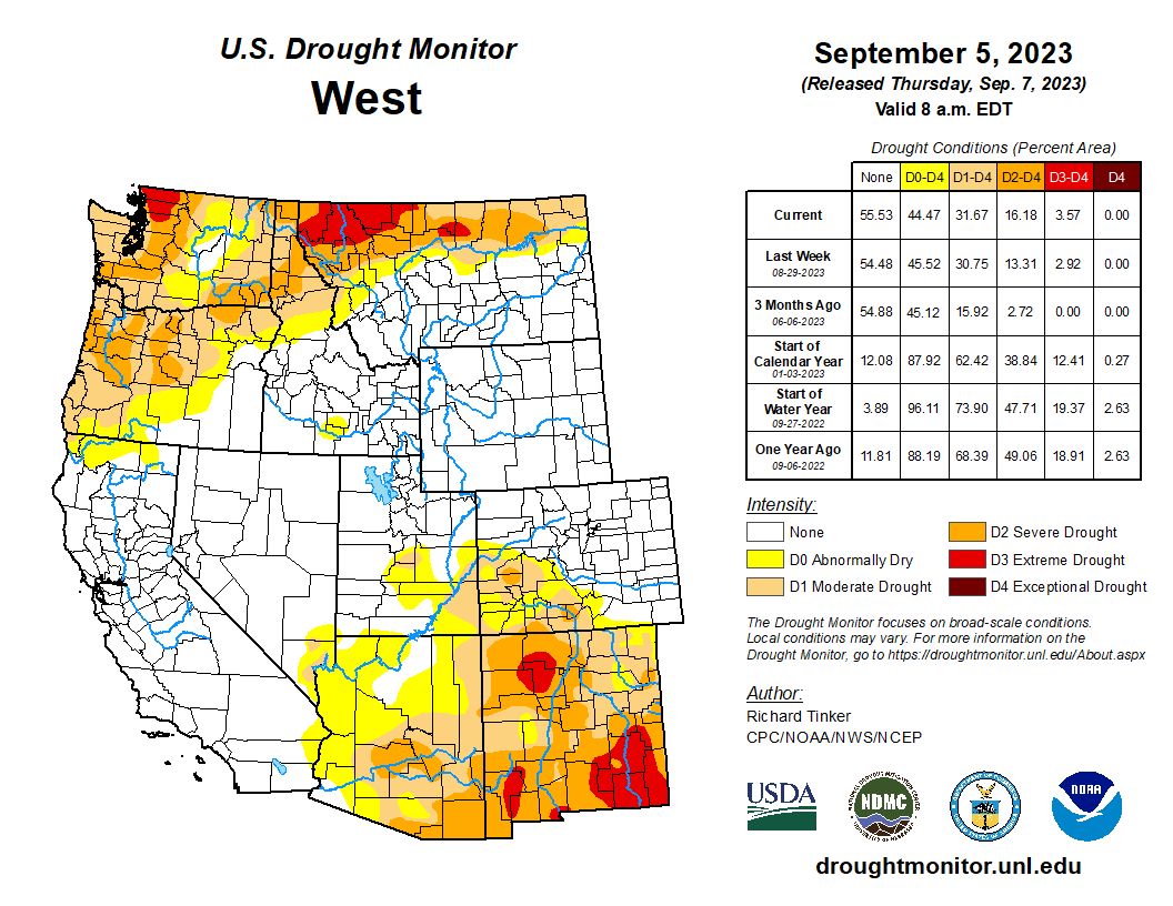
Monsoon rains remained subpar across eastern Arizona, New Mexico, and southwestern Colorado, prompting a continued slow deterioration in dryness and drought there. With the monsoonal wet season winding down during September, the odds for heavy precipitation episodes declines, and thus the prospects for significant relief from the intensifying dryness and drought become progressively worse. Dryness and drought also cover large parts of Washington and Oregon as well as the northern tiers of Idaho and Montana. Some deterioration was noted in north-central Montana, but farther west, conditions were essentially unchanged in northern Idaho and the Pacific Northwest…
Brutally hot and dry weather again this week kept dryness entrenched across Texas, southern Oklahoma, Louisiana, and southern Mississippi. For the past 2 months, temperatures averaged 4 to 8 deg. F above normal from most of the Four Corners States eastward through most of Texas and Louisiana, and across southern Mississippi. A solid swath of extreme to exceptional drought (D3-D4) is now entrenched from central Texas eastward through most of Louisiana and southern Mississippi, expanding slightly northward as well. Outside the large area of solid D3-D4 conditions, conditions generally deteriorated where dryness was antecedent or on the cusp of developing, and remained essentially unchanged elsewhere. In contrast, Tennessee and most of Arkansas remained free of any systemic dryness. According to the USDA, the cotton crop has not fared well this summer, suffering through the persistent hot and rain-free weather. Almost 80 percent of the Oklahoma cotton crop is in poor or very poor condition, as is 61 percent of Texas cotton. Peanuts, sorghum, soybeans, and rice planted in Texas, Louisiana, southern Oklahoma, and southern Mississippi were also being stressed by from heat and lack of rainfall, although the proportion in poor condition or worse is considerably lower. In addition, deteriorating pastures and rangelands are stressing livestock. As of early September, 72 percent of Texas rangelands, 63 percent of Louisiana pastures, and almost 40 percent of Mississippi pastures were in poor or very poor condition…
Looking Ahead
According to the Weather Prediction Center (WPC), the next 5 days (September 7-11, 2023) will bring some much-needed rainfall to the parched central Plains. Over 0.5 inch is forecast from parts of Oklahoma and the Texas Panhandle northward through Nebraska, with 1.5 to locally 3.0 inches anticipated in part of central Kansas. Moderate to heavy precipitation is also anticipated from the southern Appalachians and adjacent foothills northeastward through the mid-Atlantic and Northeast. At least 1.5 inches is expected from the mountains of northwestern Virginia northeastward through most of the Northeast and New England. The heaviest amounts are expected from central Pennsylvania northeastward through interior southeastern New York, where totals could top 4 inches. Eastern Florida could also receive moderate to locally heavy precipitation, generally 0.5 to locally 2.0 inches. A broad area covering most of the Plains and the Lower Mississippi Valley are expecting several tenths of an inch of precipitation, as are most locations from the Appalachians and eastern Gulf Coast Region eastward to the Atlantic Seaboard. Most other places might see light precipitation, but little or none is expected across the Far West, most of the Rockies, southern Texas, the southern High Plains, the Middle Mississippi and Lower Ohio Valleys, And parts of the interior Deep South. Hot weather is expected to accompany subnormal rainfall totals along the southern tier of the country from southernmost California eastward through the central Gulf Coast Region, as has been the case much of the summer. Daily maximum temperatures are expected to average 5 to 9 deg. F above normal there. In contrast, milder than normal temperatures are expected to displace the heat that has recently affected parts of the Nation’s Midsection, with readings expected to average 3 to 7 deg. F below normal across much of the region from the central High Plains eastward across the Middle Mississippi and Ohio Valleys.
The Climate Prediction Center’s 6-10 day outlook (valid September 12-16, 2023) favors a similar pattern. Odds favor above-normal temperatures from the South Atlantic Region westward across the southern tier of the Contiguous 48 states, over most areas from the Rockies westward, and the northern Plains. Meanwhile, below-normal temperatures are favored across a large swath from the south-central Plains eastward through most of the Mississippi Valley, the Upper Southeast, the Appalachians, the Atlantic Piedmont, the Mid-Atlantic, and the lower Northeast. There are enhanced chances for surplus precipitation across the central and southern Rockies, much of the central and southern Plains, the southern half of the Mississippi Valley, the Ohio Valley, the interior Southeast, the Appalachians, the mid-Atlantic, and the Northeast. In contrast, drier-than-normal weather is favored across most of the Great Lakes, the northern tiers of the Plains and Rockies, the northern Intermountain West, and the Pacific Northwest, as well as across the Florida Peninsula.
US Drought Monitor one week change map ending September 5, 2023.
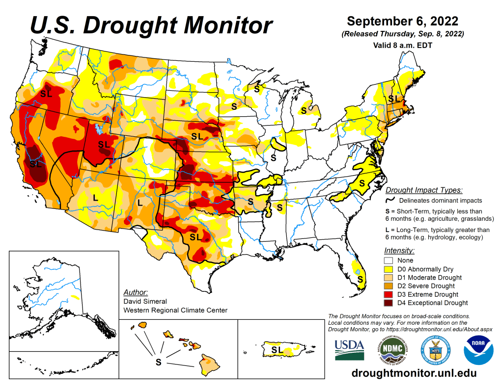
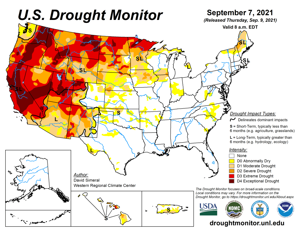
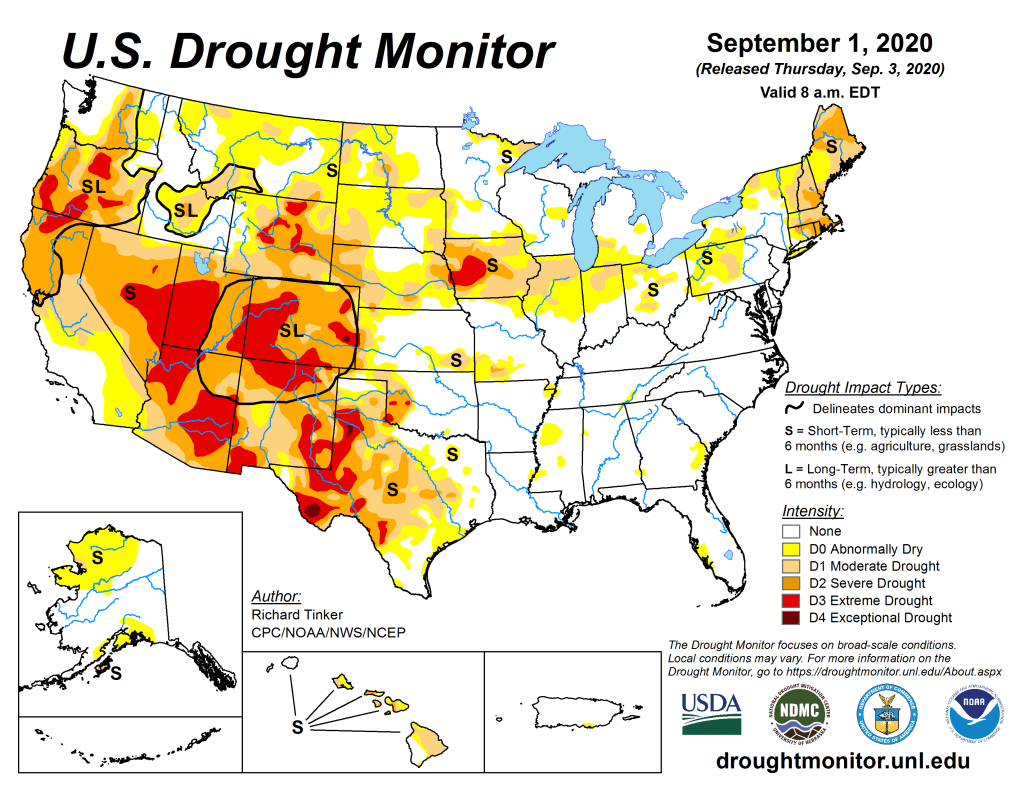
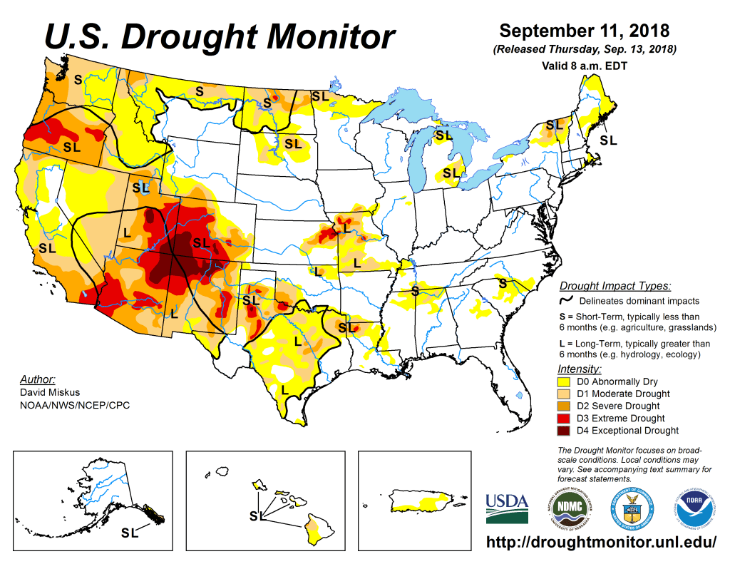
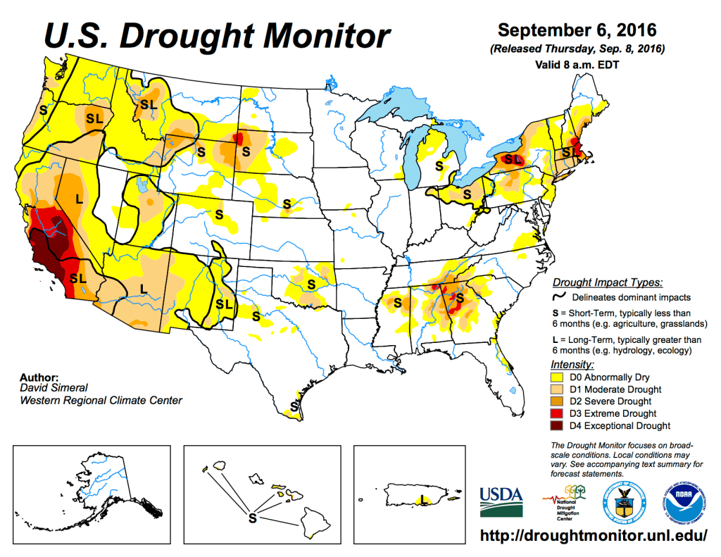
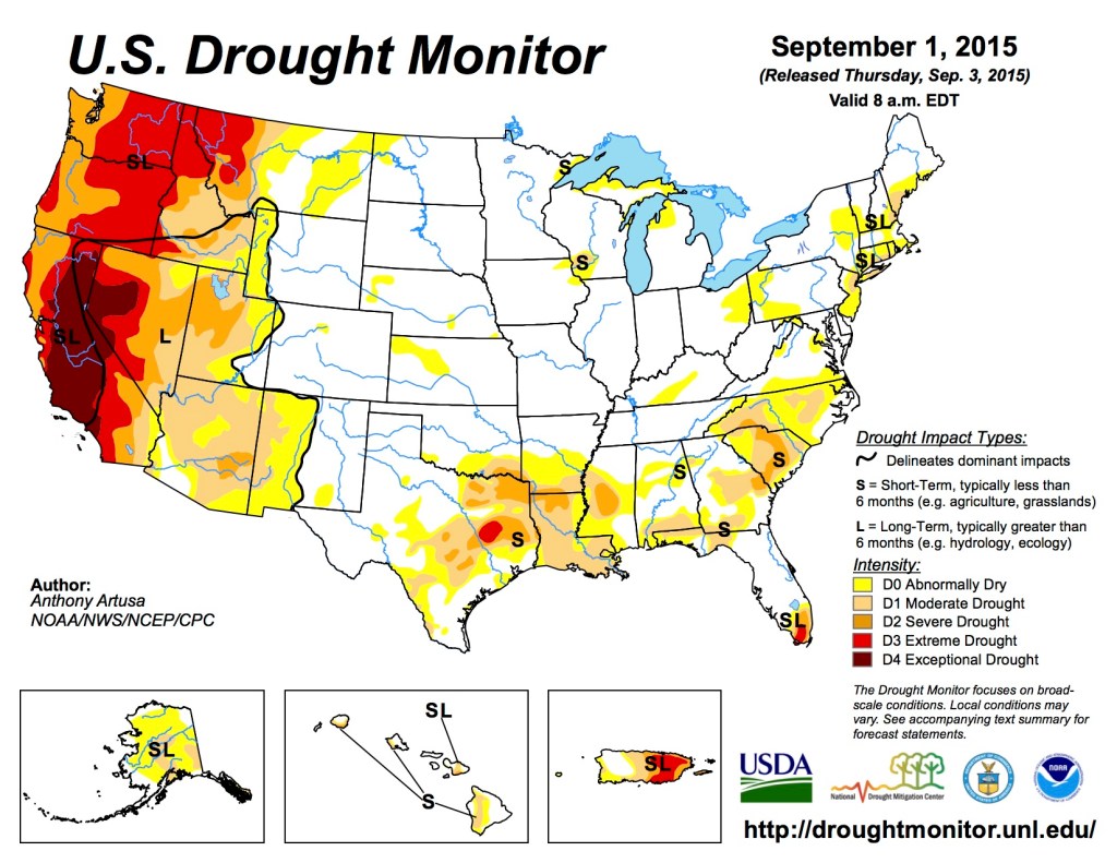
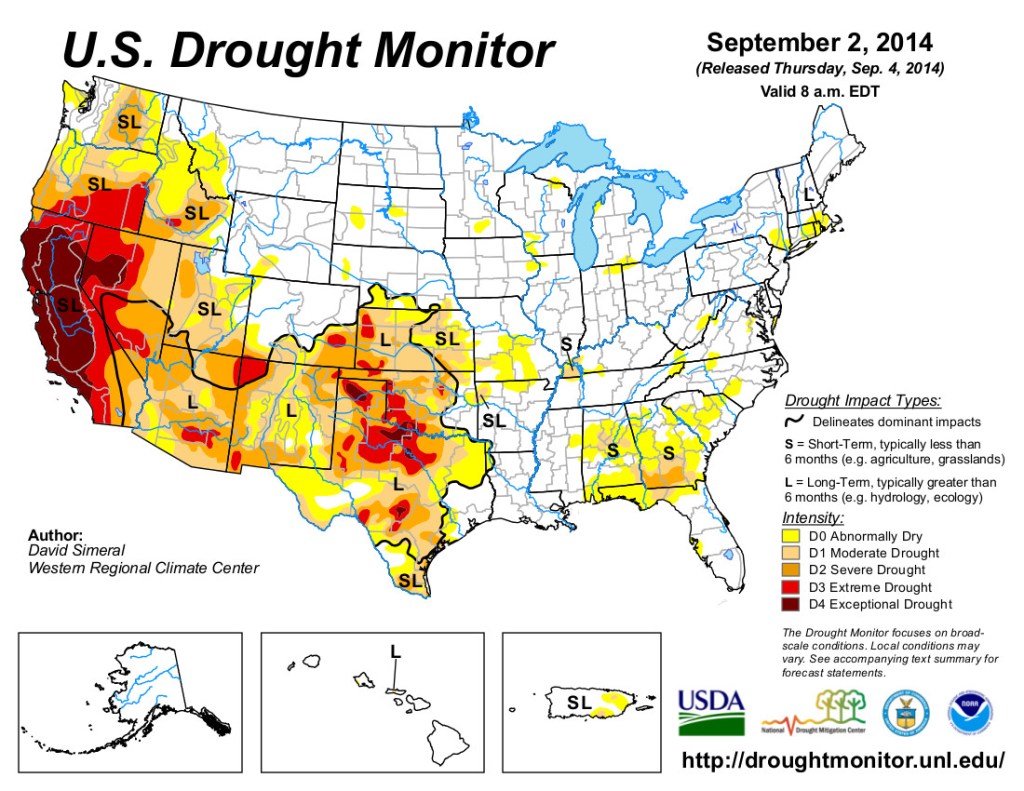
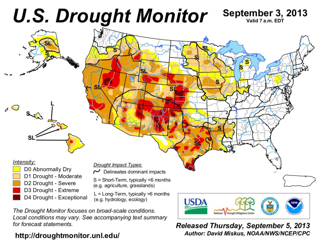
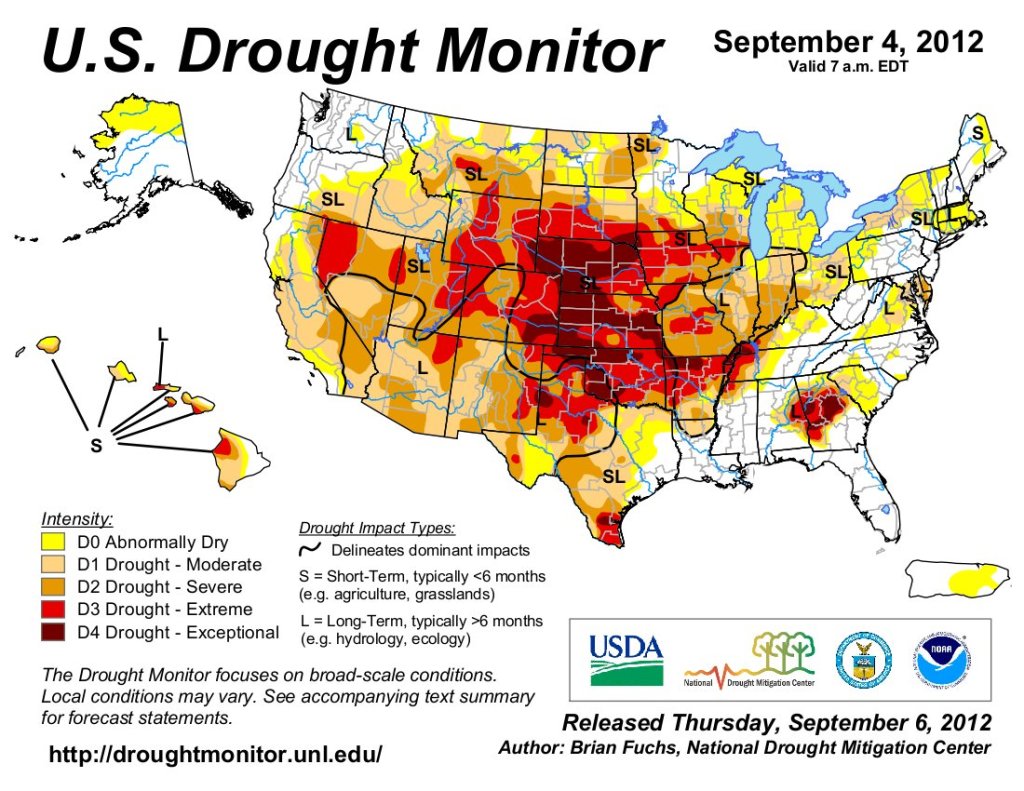
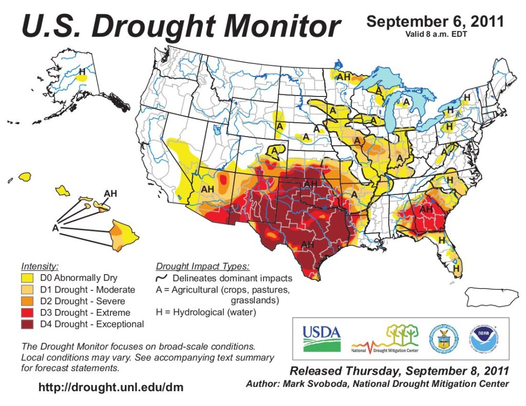
Just for grins here’s a slideshow of early September US Drought Monitor maps for the past few years.
I hope you’ll excuse my irreverence in showing the image above. If you haven’t noticed, ‘what’s real’ versus what we wish were real is what a lot of our discourse is about these days, and not just along the Colorado River. Denial is more than just a river in Egypt.
But moving on – I concluded the last post with a discussion of the first real break the First Peoples of the arid lands got after being forced onto reservations that were far too small for their timeless lives as hunter-foragers (requiring as much as a square mile or two per person in the arid lands). The U.S. Supreme Court decreed in 1908, in Winters v. The United States, that when the federal government reserved western land for any purpose (removed it from private-sector development), it also implicitly reserved enough water to carry out the purpose of the reservation.
For the First Peoples put on dryland reservations, the ‘Winters doctrine’ meant enough water had to be reserved to ‘civilize’ the First Peoples, primarily via irrigated farming. Quite a lot of water, in other words – enough reserved, with seniority to the date of the reservation’s creation, to throw a little panic in the hearts of the conquering Second People who, by the turn of the century, were already realizing the water supply was not really infinite.
But the Court said nothing in Winters about how the First Peoples – then still struggling just to maintain their cultural identities under a heavy-handed federal policy of forced assimilation – might go about obtaining their entitlement of water. And more to the point, with no developed economy of their own: how to turn that ‘Winters water’ into real water flowing onto the land and into their communities.
Given the supposedly benevolent and paternalistic trust relationship established in their treaties with the federal government, the First Peoples were aware that the ‘Great Father’ held their implied water rights in trust for them, just as the feds held the reservation in trust for them. So it seemed reasonable to presume that the government would be bound by the trust’s fiduciary responsibilities to help them do such basic things as determining how much water the Winters doctrine gave them, and helping them plan for the development of the water.
But while the Winters decision itself was not openly contested, the Bureau of Indian Affairs, the Bureau of Reclamation and other Interior Department agencies did not jump eagerly into implementing it; they instead argued that there was nothing explicit in the treaties requiring them as federal trustees to help in assessing and developing the implicit Winters rights. This position was quite explicitly – as it were – affirmed just this past June, in the decision on a suit that the Navajo Nation began more than a decade ago against the Department of Interior, but which ended up before the Supreme Court as Arizona v. The Navajo Nation. The Supremes essentially absolved the federal agencies of any obligation not explicitly stated in the original reservation treaties – even though most of the treaties never got really specific about the trustee’s fiduciary obligations to the tribes. Had the current Supreme Court majority been deciding the Winters case in 1908, one suspects the whole issue of First People reserved water rights would never have made it out of the courtroom; the Fort Belknap Reservation treaty considered in the Winters decision said nothing explicitly about water rights reserved for the reservation.
The Supremes’ 5-4 decision against the Navajo plea this summer did not, however, go so far as some of the reporting in major media suggested. It did not, for example, really ‘dash the hopes of the Navajo Nation for more running water,’ as was reported in the L.A. Times, suggesting the federal government would henceforth deny water to the reservation.
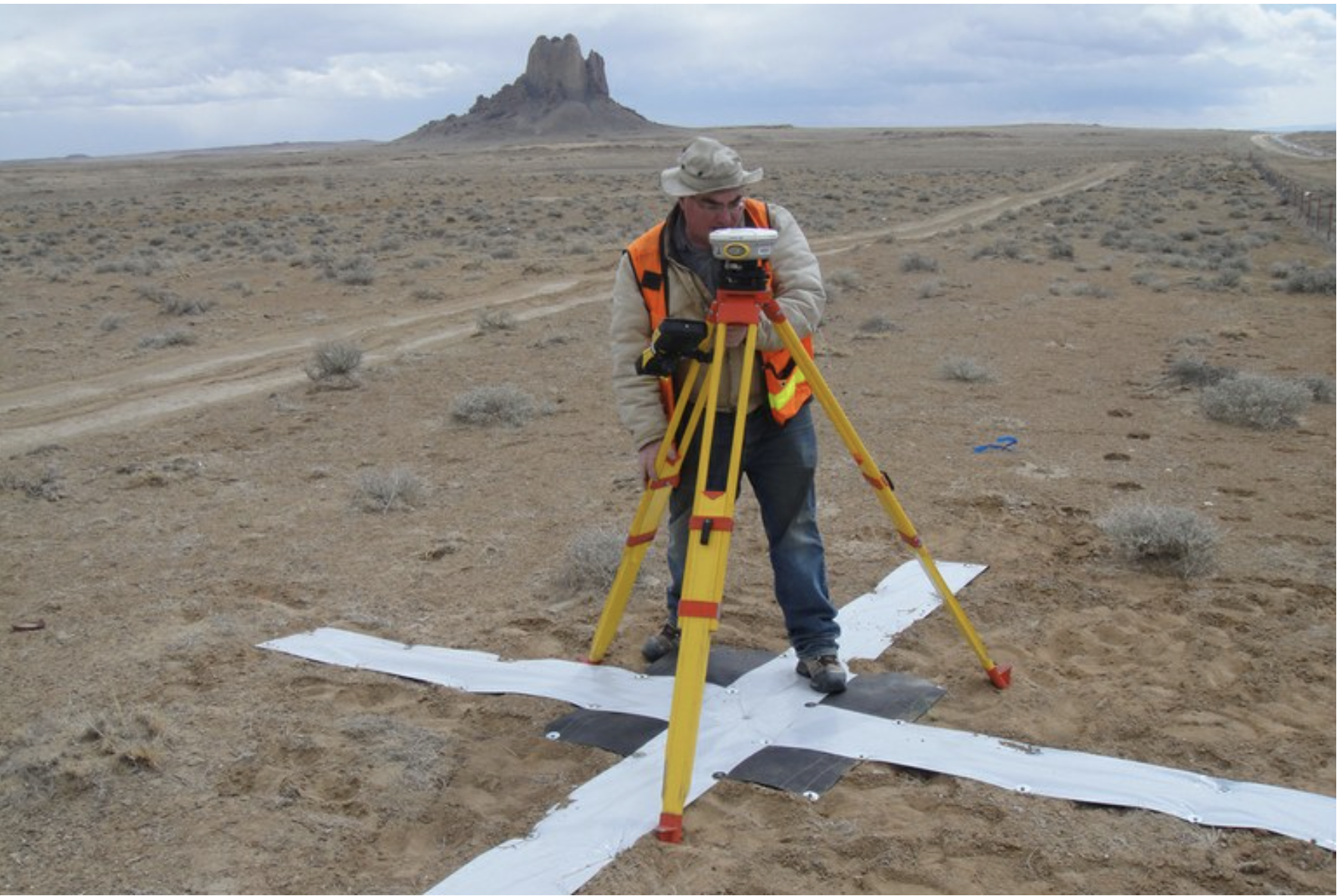
Survey work begins in 2018 for the Navajo-Gallup Water Supply Project on the Navajo Nation. Photo credit: U.S. Bureau of Reclamation
In fact, while the Court was considering the case, the U.S. Bureau of Reclamation was plugging away on a multi-billion dollar 300-mile set of pipelines and pumps from the San Juan River in northern New Mexico as far south and west as Gallup, and eventually into Arizona and the Navajo capital in Window Rock, Arizona, bringing reliable and sustainable domestic water to numerous Navajo communities en route. In exchange for that project, the Navajo People will give up some of their still unquantified water rights – just as they did back in the 1960s when the Bureau undertook the Navajo Indian Irrigation Project, to irrigate 110,000 acres of reservation land. (There will be more about the NIIP somewhere down the line: an interesting story in itself.)
These water projects for the Navajo move slowly – some of the planned NIIP irrigation system is still not completed sixty years later, and the anticipated completion of the pipeline project has been pushed back from 2024 to 2029. But the feds have in fact exercised some of their presumed fiduciary responsibility to help bring running water to the Navajo – even though the Supremes just said they have no explicit legal obligation to do so.
But the feds are still reluctant to provide what the Navajo most want – and have been requesting for decades: knowledge of how much water they actually have ‘reserved,’ in order to do their own water planning for whatever is left. The longest, most articulate and most interesting part of the Arizona v. Navajo Nation decision is Justice Gorsuch’s dissent against the conservative majority he usually joins. In addition to a thorough history of the relationship between the United States and the Navajo Nation from the beginning, he explores the big gray zone between the explicit letter of the law and the often more implicit spirit of the law. He all but accuses his conservative colleagues of fussy pettiness in their insistence on explicit water-development instructions for the government in treaties that often predated formal water law in the West.
Native America in the Colorado River Basin. Credit: USBR
The Navajo People are not alone in this ambiguous situation; most of the First Peoples in the Colorado River region who tried to get an answer on how much water is ‘reserved’ for their use, encountered the same ambiguity and reluctance from the federal government that had claimed the water and land in trust for them.
Basically this is not so much residual anti-Indian bias, as it is the First Peoples caught in the middle of a perpetual American tussle over the prerogatives of individual states in the more federated than united states. The ‘first-come-first-served’ appropriation law for water use evolved from the bottom up in all of the arid-land states from the time they were territories, and with a clear bias toward protecting existing users. Water law thus came to be developed and administered at the state level – a prerogative guarded jealously by each state. Only interstate water disputes and problems involving federal lands (like the Winters case) went directly to the federal court system, often straight to the U.S. Supreme Court as the trial court.
Readers can thus imagine the consternation caused by the Supreme Court’s assertion of federal reserved water rights for any reservation of land that required water to fulfill the purpose of the reservation; this meant large quantities of water effectively removed from the state-administered appropriation systems – a huge wild card dropped in their already complicated water games. For organizations like the federal government that tend to kick controversial cans of worms down the road as far as possible, this meant putting off federal-versus-state showdowns like quantifying First People water rights.
This particular situation was, in the way of governments, clarified through adding further complexity in 1952, with an amendment to the section of the United States Code that gives the federal government ‘sovereign immunity’ against being sued for its actions. The ‘McCarran Amendment’ – by Nevada Senator Pat McCarran – waived that federal immunity for situations involving the states’ adjudication and administration of water rights. The federal government, in other words, would have to submit its senior reserved rights to state adjudication and administration; this would give all other water users impacted by the use of the reserved water the opportunity to oppose that use, and even to sue the federal government if their concerns were not addressed.
This established the state courts as the place where the First People water rights would have to be ultimately quantified and adjudicated. There are two ways in which the Peoples go about that. One way was to get their own reasonable estimates of their ‘civilizing’ needs, based on ‘practicably irrigable land,’ domestic and industrial needs to develop a ‘modern life,’ and go to court with that claim. Interior Department agencies will support them without taking the lead, trust notwithstanding. But depending on the quantity desired, it is a slow process, averaging well over a decade and with some tribal claims going on for two or three decades. And the ultimate decree is seldom what was asked. The Hopi People went through the court system, but withdrew their claim when the court offered them only a quarter of their claim.
And when the court process is over, as one tribal leader put it, what you have is ‘paper water,’ and the People are still faced with the challenge of turning the adjudicated amount into water flowing in ditches and pipes.
The other alternative for the tribes is a negotiated settlement: tribal leaders take their estimates of the Winters water rights they could reasonably expect to eventually get from the courts, and sit down in a mediated palaver with other water users, large and small, that are either already using the People’s water (free) or want to be using it in their own future, and they all see what can be worked out so some dependable tribal rights are shoehorned in without serious damage to existing (potentially junior) users. The People can lease or even sell some of their water from federal projects to other parties, in order to get the wherewithal to build systems for putting the rest of their water to work. They can trade water rights for projects (as the Navajo did for their pipeline project). They can try to work out joint systems for moving water around for different users. Plans can be made for sharing shortages in bad times rather than asserting seniority. Everyone involved can usually pare back existing uses and future needs a little (and is aware that eventually they will probably have to). Tribal settlements have even traded some of the tribe’s water for things not directly related to water, like a Yavapai Nation settlement near Tucson that gave up some water for $23 million federal funds for the Nation’s community development fund. Settlements obviously get very complicated, and embrace moves the courts would never tolerate. But in the end, the People have a settled water right and some of the wherewithal to develop the water. The bird in the hand that’s worth two in the bush. Depending on the state, settlements can be ratified by the courts, the legislature or Congress.
Some settlements are harder to obtain than others. A number of tribes, including the Navajo and Hopi, have to negotiate with big mining companies; growing cities like Phoenix, Tucson, Las Vegas can be hard negotiators. And most of the basin nations have to deal with a really difficult state, Arizona.
Arizona has a reason for being a difficult party in negotiations: 22 of the 30 First People reservations in the Colorado River region are entirely or partially in Arizona, and the downside of state administration of water rights makes each state responsible for tribal claims within the state. Fourteen of the Nations have settled rights for almost 1.9 million acre-feet, which, were they all acknowledged with seniority, would constitute two-thirds of Arizona’s total allotment under the Colorado River Compact and Law of the River; seven others (including the Navajo), are still trying to work their way through court and settlement processes, and would probably take care of the other third.
Arizona has responded to this situation by making it as hard as possible for the First Peoples to ascertain their Winters rights – and then to actually develop them. The big Bureau of Reclamation San Juan-Gallup pipeline project stops at the New Mexico-Arizona border, until the Navajo People have come up with a settlement or court decree the state finds acceptable, and the state has an arsenal of strategies for making that difficult – part of the reason the Navajo People wanted the Supreme Court to make establishing their total Winters rights a responsibility of the Interior Department. For those wishing to look at this more deeply, the July 2023 High Country News (issue 55:7) has an excellent set of articles, assembled by their staff and the ProPublica investigative journalists.
Map credit: AGU
The other Colorado River Basin states are of course happy to let Arizona grapple with this alone, although in a parallel intelligent and generous universe, it would probably be acknowledged as everyone’s problem. But we begin with western state boundaries that, for the most part, bear no relationship to any geographic reality – then give the individual geographically irrelevant states the duty of administering first-come-first-served water rights on a river that mostly ignores state boundaries, despite the fact that all the states have been mandated to respect each other’s prior appropriations from the river. We further complicate this tangle by dividing the river into two basins, essentially two rivers: one river required to supply a set amount of water to the other river, irrespective of how much water the upper river receives naturally.
If there is a beam of light in this morass of management murk, possibly lighting a way to a more intelligent future, it might be the First Peoples plugging away through their creative settlement palavers to get a little water by giving a little, rather than (futilely) asserting their reserved senior rights. That may be the shape of a functional future; but it will be hard to bring that kind of open negotiation to a system whose foundation law is the fiercely guarded first-come-first-served philosophy.
Next post, I want to look at some First People stories of life along the river, not old stories, but stories from the 20th century – which is where the Colorado River region still seems to be, culturally, economically and politically, as the past year has shown in Colorado River management decisions. Only the climate is really in the 21st century.
Wheat fields along the Colorado River at the Colorado River Indian Tribes Reservation. Wheat, alfalfa and melons are among the most important crops here. By Maunus at English Wikipedia, CC BY-SA 3.0, https://commons.wikimedia.org/w/index.php?curid=47854613
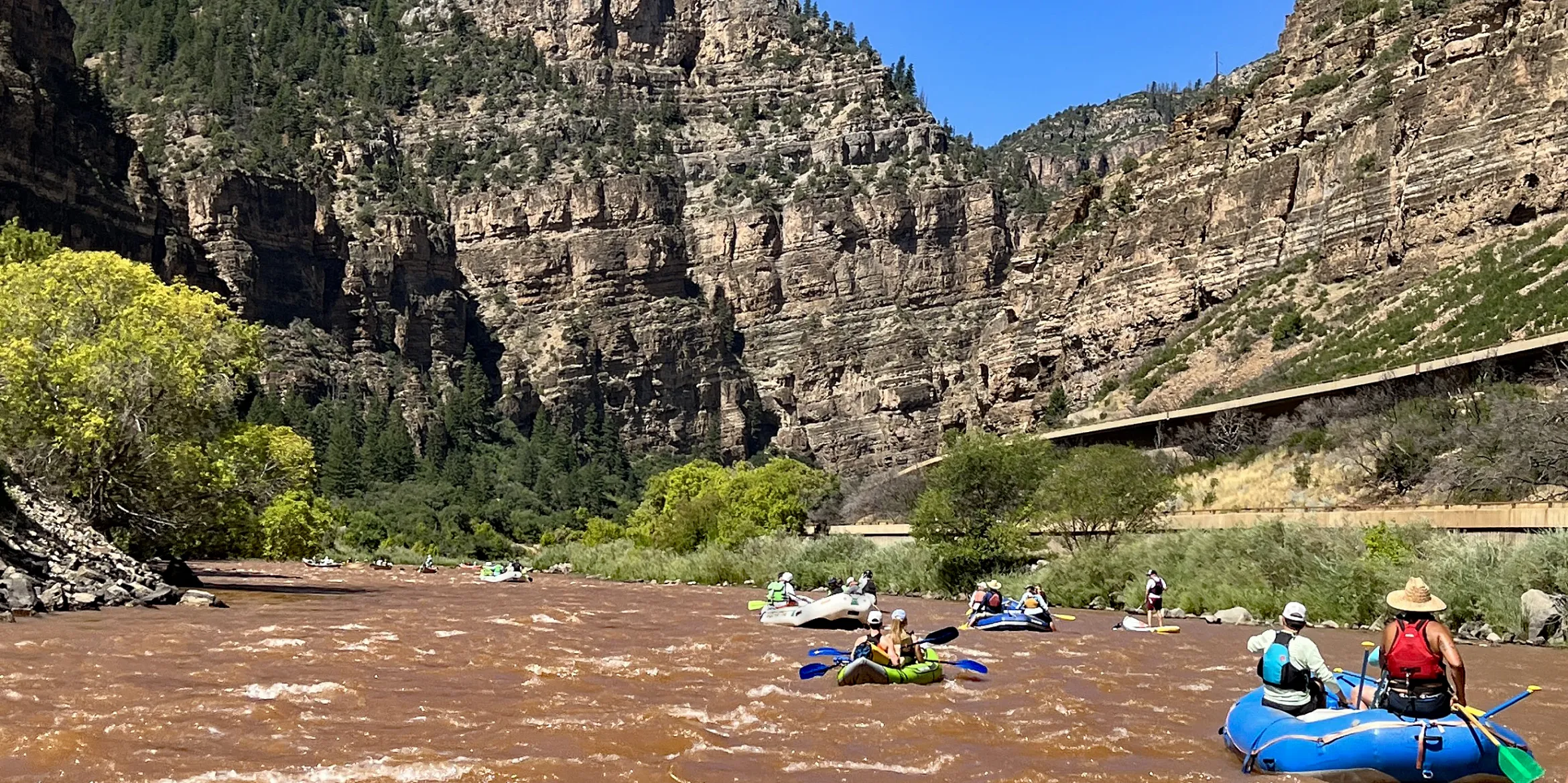
Close to 30 boats floated the Colorado River through Glenwood Canyon on Aug. 26 as part of a flotilla protesting the Uinta Basin Railway. The event turned celebratory after the Aug. 18 ruling from the U.S. Court of Appeals that overturned the Federal Surface Transportation Board’s 2021 approval of the project. CREDIT: AMY HADDEN MARSH/ASPEN JOURNALISM
Uinta Basin Railway (UBR) opponents floated a portion of the Colorado River on Aug. 26 to celebrate a setback to the UBR. Organized by two citizen groups — Colorado Rising and 350 Roaring Fork — a flotilla of about 30 boats and 100 activists put in at Grizzly Creek in the Glenwood Canyon and landed at Two Rivers Park in Glenwood Springs for a rally and picnic. The flotilla was originally planned as a protest to draw attention to the river and what would happen if a train carrying waxy crude derailed in the Glenwood Canyon.
“We’re not fighting a train. We’re not fighting increased train traffic. We’re a rail town,” said former Glenwood Springs Mayor Jonathan Godes, who is now a City Council member and who emceed the rally. “We’re fighting a train that is full of toxic, waxy crude. To think that five trains, two miles long, every day would not derail in one of the most difficult, sensitive places on the entire line is crazy.”
The Colorado River is the lifeblood for local communities and provides water to 40 million people across the western U.S. and parts of Mexico. The proposed UBR — an 88-mile line that would connect oil fields in the Uinta Basin to the national rail network near Price, Utah, in order to access Gulf Coast refineries — would increase the amount of waxy crude shipped east by rail to between 130,000 to 350,000 barrels per day. The federal Surface Transportation Board (STB) approved the UBR in December 2021, which was followed by two separate lawsuits — one filed by the Center for Biological Diversity (CBD) on behalf of four other conservation groups, and another by Eagle County. They were consolidated in February 2022. On Aug. 18, U.S. Court of Appeals for the District of Columbia Circuit Judge Robert L. Wilkins overturned the STB’s decision, transforming the planned flotilla from a protest to a celebration. Five Colorado counties and five municipalities along the national railway — the proposed route for eastbound Uinta Basin waxy crude — signed on to an amicus brief in support of Eagle County in October, making the Aug. 18 decision a victory across the state.
Ted Zukoski, CBD attorney, told Aspen Journalism that the STB and the U.S. Fish and Wildlife Service (FWS), whose flawed biological opinion (BiOp) informed the STB’s decision, must go back to the drawing board. “The existing approvals from the STB and FWS are null and void,” he said. “The UBR has been knocked back a number of steps.”
A CBD news release summarized Wilkins’ ruling by stating that the STB “violated the National Environmental Policy Act [NEPA] by failing to fully analyze the railway’s potential harm to the climate, wildlife, the Colorado River and people, including environmental justice communities along the Gulf Coast.” Key findings show a mixed bag of what counted as a violation and what did not.
According to the ruling, NEPA violations include ignoring the risk to endangered fish in the Colorado River and failure to take a hard look at upstream and downstream impacts of oil production, accident data and downline wildfire risk. The court’s discussion of the UBR’s impacts from production in the Uinta Basin and the downstream impacts on communities near refineries continues a line of precedent and keeps federal agencies accountable, said Zukoski.
“When federal agencies are the on/off switches for climate impacts, air pollution impacts, surface impacts of wildlife habitat, they can’t say, as the [STB] did here, ‘Oh, no, not our problem. We don’t control who develops oil in the Uinta Basin. We don’t know where the oil is going. We’re just approving the railway,’” he said. “The court saw through that.”
In the December 2021 decision, STB Chair Martin Oberman cast the sole dissenting vote, stating that “the environmental impacts outweigh the transportation merits.” Oberman’s opinion questioned his colleagues’ evaluation of the downstream impacts of the UBR and the overall contribution to climate change. He also cited the financial viability of the project given volatile oil prices and the shifting fossil fuel industry.
Wilkins found that the STB violated its own rail policies by looking at the UBR’s economic benefits while ignoring the full significance of the UBR’s environmental costs. He did not uphold plaintiffs’ claims about failure to address landslide risks, violation of the National Historic Preservation Act, downline impacts on biological resources, land use and recreation, or increased noise and potential impacts to the Tennessee Pass rail line.
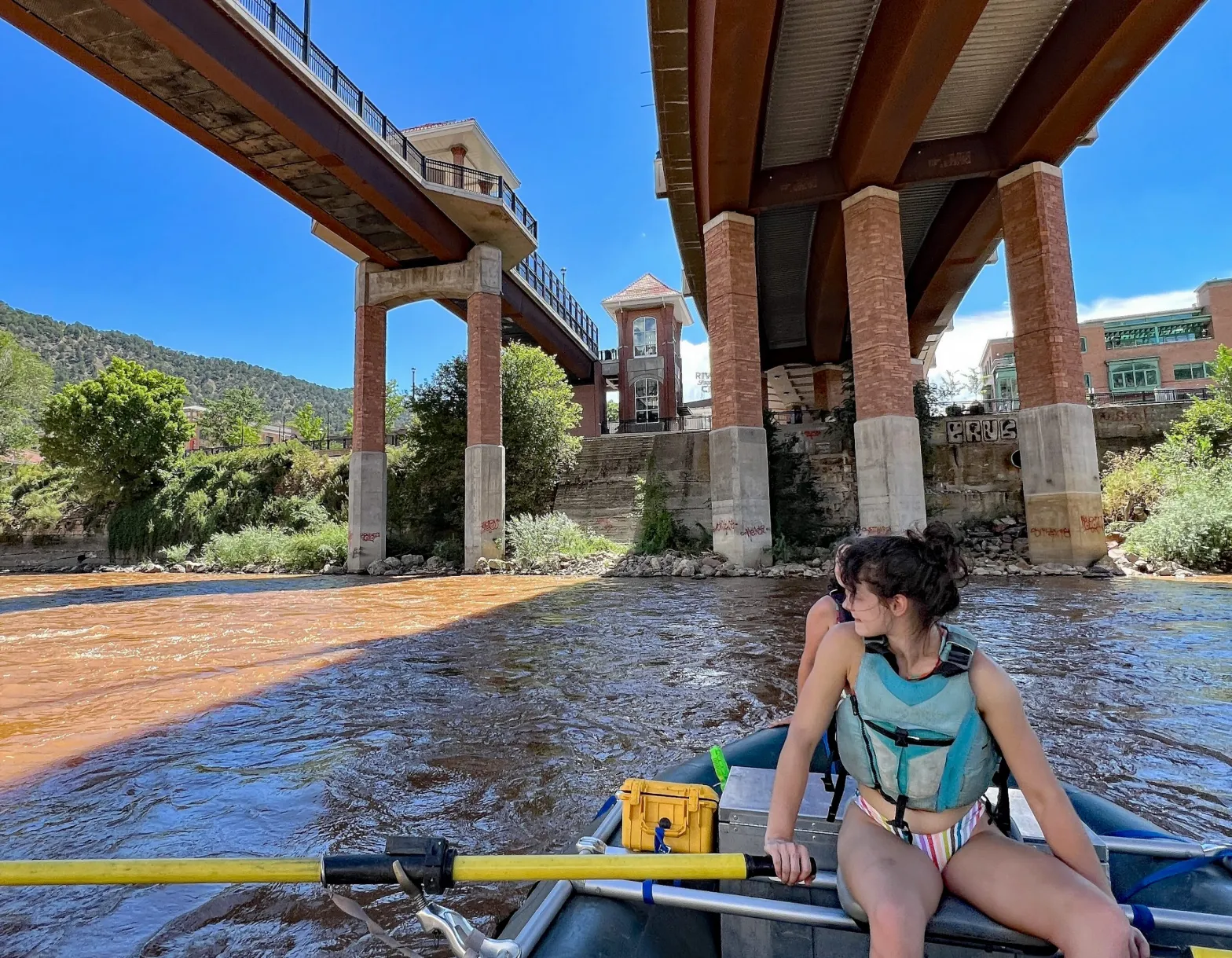
A raft of activists protesting the Uinta Basin Railway, captained by Christina Rivera, floats the Colorado River under the Grand Avenue Bridge in Glenwood Springs as part of a flotilla protesting the Uinta Basin Railway on Aug. 26.
CREDIT: AMY HADDEN MARSH/ASPEN JOURNALISM
Glenwood Springs pleased with outcome
Glenwood Springs City Attorney Karl Hanlon, who worked on the amicus brief in support of Eagle County, told Aspen Journalism that the circuit court opinion was a “huge, huge win,” particularly for the process. “There were things that [the court] did accept and things that they didn’t,” he said. “But at the core of it, NEPA requires a more detailed analysis than [the STB] did. You can’t just sort of gloss over it and rubber-stamp a NEPA process.”
Hanlon said the money and time that Glenwood Springs and other towns spent working on the amicus brief was well spent. “I think [the ruling] lays out three really big areas,” he said. “Quantifying the reasonably foreseeable upstream and downstream impacts from increased drilling in the Uinta Basin on vegetation and special status species, the increased oil train traffic along the UP line, and the issue of environmental justice on the Gulf Coast.”
According to a 2018 feasibility study conducted as part of the EIS, most of the refineries equipped for Uinta Basin waxy crude are in MIssissippi and Louisiana, including Marathon Petroleum in Garyville, Louisiana. On Aug. 25, a massive fire at that refinery, caused by a leaky naphtha tank, produced a plume of black smoke and forced nearby evacuations. “This is the kind of harm the Uinta Basin Railway will worsen by pouring billions of gallons of crude per year into Gulf Coast refineries,” said Zukoski. “And the kind of harm that the D.C. Circuit Court of Appeals explicitly held that the [STB’s] EIS failed to take a hard look at.”
Hanlon is satisfied with the ruling and how comprehensive it was. He said it’s a win for those who work on conservation and environmental issues. “I think it affirms the rules that we all thought we were operating under, right? That these agencies have to take these analyses seriously,” he said.
Godes added that he’s proud of the stance that many Colorado communities have taken. “We are in a really good space with a recent victory,” he said at the rally. “We have a lot of support. This flotilla is proof of that. All of the neighboring communities and jurisdictions, save for Garfield County, have come out against this.”
Boaters approach the Grand Avenue Bridge in Glenwood Springs as part of a flotilla protesting the Uinta Basin Railway on Aug. 26. The event turned celebratory after an Aug. 18 ruling from the U.S. Court of Appeals, District of Columbia Circuit that overturned the Federal Surface Transportation Board’s 2021 approval of the project.
CREDIT: AMY HADDEN MARSH/ASPEN JOURNALISM
What’s next?
Aspen Journalism reached out to the Seven County Infrastructure Coalition, the quasigovernmental engine behind the UBR, for comment on the ruling. In an official email statement, Melissa Cano, strategic communications coordinator for Jones and DeMille Engineering, said the UBR team is not giving up.
“While we disagree with the D.C. Circuit Court’s recent decision, we respect the authority of the U.S. Court of Appeals,” the statement said. “We firmly believe that the railway’s environmental impact statement (EIS) contains appropriate and thorough analysis of the highlighted concerns, as it stands today. Nonetheless, we are ready, willing and capable of working with the U.S. Surface Transportation Board to ensure additional reviews and the project’s next steps proceed without further delay. We look forward to bringing this railway to the basin in a safe and cost-effective way to enable economic stability, sustainable communities and an enriched quality of life to Utahns and beyond.”
Zukoski said there are strategies the SCIC could use as result of the Wilkins ruling, including an appeal to the U.S. Supreme Court. “But they are better off just saying, ‘Well, now we have a roadmap from the courts on what we need to fix. Let’s go fix it.” He added that the “fix” would be, more or less, a do-over. “They’re going to need approval from the STB again,” he said.”They’re going to need to go through a supplemental environmental impact statement process and get a new biological opinion from the FWS that looks at the spill risk to endangered fish.”
Hanging in the balance are the September 2022 lawsuit against the U.S. Forest Service (USFS) decision to allow construction of the UBR through an inventoried roadless area (IRA); the expansion of the Wildcat Loadout Facility near Price, which would allow an increase in production, storage and transport of Uinta Basin crude regardless of the success or failure of the UBR; and the use of Private Activity Bonds (PAB) issued through U.S. Department of Transportation to fund the UBR. The City of Glenwood Springs wrote a letter to U.S. Transporation Secretary Pete Buttigeig in early August against the use of PAB bonds and requesting a meeting this month. “It would be incredibly precedent-setting if we ever started allowing our tax dollars to be utilized by a private corporation for their profit and their shareholders,” Godes said at the rally. “It doesn’t benefit Colorado and it doesn’t benefit this country.”
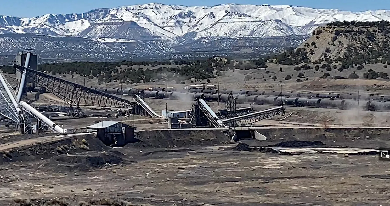
The Wildcat Loadout Facility, near Price, Utah, stores and transports Uinta Basin crude.
CREDIT: COURTESY PHOTO BY JOHN WEISHEIT
USFS suit undecided
The USFS approved construction of the UBR in July 2022 through 12 miles of an IRA in Utah’s Ashley National Forest. Prior to the approval, CBD and other conservation groups sent a letter to USFS Chief Randy Moore, urging him to reject the Ashley National Forest’s application. But Moore refused, stating, “By definition, a railway does not constitute a road under the Roadless Rule.”
In September 2022, CBD, Living Rivers, Sierra Club and Utah Physicians for a Healthy Environment filed suit in D.C. Circuit Court of Appeals. Zukoski told Aspen Journalism at the time that the argument goes beyond whether a railroad is a road. “We raised many issues, including a failure of the Forest Service to consider the impact on roadless values,” he said. That case has not been briefed.
Legal documents show that the court on April 24 granted an abeyance request by the USFS, the Seven County Infrastructure Coalition and the Uinta Basin Railway, temporarily suspending court proceedings until the Eagle County suit was decided. The original request shows that the USFS Record of Decision used portions of the same EIS and FWS BiOp that were used in the STB approval and that a decision in favor of Eagle County could make moot the USFS case.
On Aug. 18, the court requested that all parties involved in the suit file motions to govern future proceedings by Sept. 18. “The order suggests that the parties come up with a plan, or competing plans, for resolving the case in light of the decision in the Eagle County case,” said Zukoski. “So, it’s up to the parties to address that decision and seek further relief on the USFS decision. We’ll have to do that by Sept. 18.”
The outcome could also be compromised by the fact that federal approval no longer exists and that construction of the UBR cannot begin until all approvals are finalized. “One potential path forward is that the USFS voluntarily takes some action, such as withdrawing the ROD, and then one or more of the parties files a motion to dismiss the case,” said Zukoski. “Another potential outcome is the USFS believes that it can continue to litigate the case on the merits and we proceed to briefing.”
the location of the Wildcat Loadout Facility near Price, Utah is shown on this map.
CREDIT: FROM GOOGLE MAPS
Wildcat workaround
Meanwhile, Uinta Basin oil producers are upping their game. Utah’s output of crude oil has more than doubled in the past four years. Most of the state’s crude comes from Carbon, Daggett, Duchesne, Rich, Summit and Uintah counties — all within the Uinta Basin. Utah state Division of Natural Resources statistics show that Uinta Basin oil production has increased from a total of 31 million barrels per year in 2020 to 45.3 million in 2022. In the first five months of 2023, nearly 20.1 million barrels have come out of the ground.
Several loadout facilities currently transfer Uinta Basin oil from trucks to rail cars bound for California and the Gulf Coast. More and more tanker trucks are carrying crude over winding, two-lane highways from Myton to loadout facilities near Price, Helper, Ogden and Salt Lake City. Wildcat is one such facility near Price.
The Bureau of Land Management is considering a request from Coal Energy Group 2 to expand the capacity of the existing Wildcat Loadout Facility (WLF) to 100,000 bpd from 30,000 bpd. The project would add tank farm facilities, loading and unloading and other operations on about 13 acres of the existing right of way.
Zukoski said there are two theories about Wildcat. “One is that it’s a workaround. It’s a way to take advantage of high oil prices now,” he said. “The other is that it’s basically a proof-of-concept exercise.” The SCIC needs to show investors that there is a market for Uinta Basin crude. Mark Hemphill, who is with Rio Grande Pacific, in 2019 told the Utah Division of Oil, Gas and Mining that a minimum of 130,000 bpd would need to come out of the basin to support the UBR. But without the UBR, the increase in production has been impossible due to caps on Salt Lake City refineries and no way to transport that much crude to other refineries. Wildcat could be a way out of the financial catch-22 that has been dogging the UBR. “If industry can show a significant boost in Uinta Basin oil production and proof that refineries will take that crude, they can take it to investors,” said Zukosky. “They’re in it to make money. That’s what this whole thing is about, and they’re just trying to figure out how to do it.”
The BLM needs to decide what kind of National Environmental Protection Act (NEPA) analysis is best for the WLF expansion. ”Actions are analyzed in an EA [environmental assessment] if they are not categorically excluded, not covered in an existing environmental document, and not normally subject to an EIS,” Angela Hawkins, public affairs officer for Utah BLM, said in an email. “The EA is used to determine if the action would have significant impacts. If that is the case, then BLM would need to prepare an EIS.”
Glenwood Springs, Eagle County and conservation groups, including CBD, would prefer an EIS. Over the summer, they informed the BLM of their concerns in separate letters. CBD public lands senior campaigner Deeda Seed said in the conservation groups’ letter that the ruling in the Eagle County case “demonstrates that BLM has a duty to disclose all of the environmental harms the Wildcat Loadout Project would cause, and makes clear that BLM must weigh those harms in evaluating whether the project is in the public interest.” Zukosky told Aspen Journalism that WLF’s maximum capacity would be less than one-third of the UBR’s top capacity of 350,000 bpd. “So, presumably the upstream and downstream impacts would be reduced,” he said. ”But since they didn’t look at those [in the EIS or FWS BiOp), they have to go look at them for this project.”
Colorado state Sen. Lisa Cutter spoke out against the Uinta Basin Railway at a rally at Two Rivers Park in Glenwood Springs on Aug. 26. Cutter represents SD-20, which is in Jefferson County and includes parts of Arvada and Lakewood. CREDIT: AMY HADDEN MARSH/ASPEN JOURNALISM
Meanwhile, Colorado state Sen. Lisa Cutter (D-Senate District 20) told Aspen Journalism at the Aug. 26 rally that the state legislature has begun to take a look at rail-transport issues. She’s on the Interim Transportation Legislative Review Committee that has been meeting over the summer. One of the ideas they talked about was enhanced rail safety. But this, too, is in its initial phase.
“It’s not drafted yet, but we’re looking at several provisions,” she said. “Maybe training people along the route, training first responders, maybe having more people on board, more hazardous material specialists on board.” She figures if toxic materials are going to be transported by rail through the state, safeguards must be in place. “We’re not threatening Colorado, our forests, our water, our recreation, our hearts,” said Cutter, whose district includes Jefferson County and parts of Arvada and Lakewood. “I mean, this is the most important thing to me — the mountains, the forests and the way we live here in Colorado.”
Cutter is not sure why Colorado Gov. Jared Polis remains silent on the issue. Asked what she had to say to him about it, she replied that she knows he cares about the Colorado way of life. “Please lend your voice should the opportunity become available,” she said. Aspen Journalism has not yet received a statement from the governor’s office.
For now, citizens from Grand County to Glenwood Springs are celebrating the recent, hard-won success. But Godes urged Polis, a Democrat, and U.S. Rep. Lauren Boebert, a Republican who represents many of the communities that would be impacted by increased crude oil transport out of the Uinta Basin, to clarify their positions on the issue. Godes wonders if Boebert’s silence on the issue is a tacit objection to the UBR. “Congresswoman Boebert is not against it,” he said. “But she has not come out in support of this and that’s a victory.”
This May the Biden Administration gave the final go-ahead for the SunZia transmission line, which is designed to carry power from wind facilities in New Mexico to a major grid hub in the Phoenix area. The approval — which came after 17 years of review — is being hailed as a major win for clean energy because it will enable the Southwest grid’s dastardly solar “duck curve” to be tamed by wind power, not dirty natural gas generation.
The National Audubon Society also considers SunZia a case study for designing and siting clean energy infrastructure in a way that does the least harm to birds and other wildlife. It seems at first glance like a win-win situation. And in some ways and places it is. But there’s at least one loser here, and that’s the San Pedro River valley in southern Arizona, which will be traversed by the line. Now the San Carlos Apache Tribe, the Tohono O’odham Nation, and Archaeology Southwest are standing up for the cultural and natural landscape of the valley by disputing the Bureau of Land Management’s environmental review and approval of the project.
SunZia was first proposed nearly two decades ago by the Southwest Power Group to carry electricity generated at its proposed natural gas plant in Bowie, Arizona, to the Phoenix area where it could tie into lines continuing westward. When the gas plant plan languished, developers saw opportunities further to the east, in windy central New Mexico, where a lack of transmission capacity has left potential wind farms “stranded.” They expanded the SunZia proposal to enable the development of New Mexico wind that could be sold to Arizona or California utilities (Salt River Project, which serves most of metro Phoenix, was an investor in the line). This shift garnered the support of clean energy boosters like Western Resource Advocates and helped get the Obama administration’s support and final approval in 2015.
But it still had to get the go-ahead from the states. New Mexico regulators hesitated because of strong opposition from conservationists due to the proposed route’s potential impact on migratory birds. Also, the line would cross a portion of the White Sands Missile Range, making the Pentagon “uncomfortable.” So, in 2020, SunZia said it would reopen the NEPA process in order to reroute the line around wildlife refuges and the missile range, and it tracked migratory bird paths to determine where the line could cross the Rio Grande with the least impact. That alleviated most concerns — and gained the blessings of Southwest Audubon. New Mexico gave its approval clearing the way for the feds to do the same.
Unfortunately, the process didn’t work as well in Arizona. There, sovereign Indigenous nations and conservation groups have attempted to get SunZia to reroute the line away from the fragile, biodiverse San Pedro River, because it would endanger birds and other wildlife and potentially damage culturally significant sites. But that didn’t seem to faze Arizona regulators, who tend to be more amenable to such projects and less responsive to environmental concerns than their New Mexican counterparts, and they unanimously approved the project. That removed any incentive for SunZia to reroute the line in Arizona as it had done in New Mexico. The BLM’s preferred route remained alongside the San Pedro River, despite protests from the tribal nations and conservationists.
The BLM issued its final decision this spring, which included the contested San Pedro River route. That sparked the dispute accusing the BLM of failing to properly address the project’s impacts to historic properties and failing to engage in meaningful government-to-government consultation with the tribes.
Audubon Southwest acknowledged the shortcomings in the process and the routing problem, but maintained their support because they felt the developer’s plan to mitigate impacts by, say, altering the placement and height of towers or using helicopters to avoid building new roads, is sufficient to minimize habitat loss or fragmentation. Besides, they say, climate change is a bigger threat to birds and people and the San Pedro River than a transmission line.
It’s clear that averting more calamitous effects of climate change will require cleaning up the power grid, even as it expands to accommodate more people and more electric cars, appliances, and other gadgets. It won’t be easy. The grid is a huge machine that was built up over the last seven decades to move power from giant coal-fired plants and enormous hydropower dams to faraway cities and states. Since then, the way we use and generate electricity has evolved dramatically, and it will need to continue to change in order to slash greenhouse gas emissions and other pollution. This must include small-scale, distributed generation and energy storage and microgrids. We can and should blanket every warehouse, big-box store, parking lot, irrigation canal and home with solar panels. And, perhaps more importantly, we as a society need to learn to become more energy-efficient, using less power even as we electrify everything.
Even that won’t be enough, however. Utility-scale wind and solar installations will also be necessary, as will the long-distance transmission lines needed to carry the energy they generate, such as TransWest Express (which is under construction and will carry wind power from Wyoming to the California grid) and SunZia. These are massive undertakings, and undoubtedly will affect the natural and cultural landscapes, views, habitats, and wildlife.
As Audubon’s recent Birds and Transmission report points out, there are ways to build these projects while also minimizing the impacts. Doing so requires collaborating with and, more importantly, listening to stakeholders and their concerns. And it requires flexibility on the agencies’ and developers’ part. More than that, it requires avoiding “carbon tunnel vision” and a tendency to forget about on-the-ground impacts when focusing solely on tackling climate change.
It appears that in the SunZia case, both the BLM and the developers were afflicted with this tunnel vision and were unable to see the harm the project would inflict on the San Pedro River and the people who consider it sacred. In his protest letter to the BLM, San Carlos Apache Tribe Chairman Terry Rambler wrote:
“This Valley … one of the ‘Last Great Places’ in America, is the fragile core for the largest expanse of unfragmented land in the Southwest, an area that includes the southern half of the San Carlos Apache Reservation. At least as importantly, the Valley is the home to more than 60 landforms named and remembered in our Apache language. The Valley also hosts thousands of localities having religious, cultural, historical, and archaeological importance to Apache, O’odham, Hopi, and Zuni peoples.”
Does that sound like the place you’d want massive transmission towers and high-voltage lines slashing through — even with a great mitigation package? Probably not. What’s most aggravating is that there was a reasonable alternative route: along the I-10 and Highway 70 corridor. The biggest impact there would have been to motorists’ views.
This year we bid farewell to two lost frogs, the Chinese paddlefish, a plant from New Hampshire, and many others.
Last July scientists in Texas announced some surprising news: They had rediscovered an oak tree species previously believed to be extinct. Until then the last known Quercus tardifolia tree was believed to have died more than a decade earlier. But lo and behold, one more tree was discovered in Big Bend National Park, meaning the species wasn’t extinct after all.
The rest of the news wasn’t as good: That lone tree isn’t doing so well. It’s been burned by fire and shows signs of a fungal infection. Scientists say it’s in need of “immediate conservation.”
This situation isn’t that atypical in the world of wildlife conservation, where species that have avoided extinction in the Anthropocene still need dramatic support. A recent study found that more than half of all known endangered species require targeted recovery efforts if they’re to avert “human-induced extinction.”
If that doesn’t happen, we’re going to lose more species — a lot of them. Despite rediscoveries like the oak tree in Texas, the world is still losing biodiversity at dangerously high rates. In 2022, scientists announced that they had given up efforts to find dozens of long-lost species, including two frogs, one of the world’s biggest fish, an orchid from Florida, a grass from New Hampshire and many others.
And those are just the ones we know about. Another 2022 study warned about the threat of “dark extinction,” the loss of species science has never even identified as having existed in the first place. By conservative estimates, millions of species are yet to be discovered, identified and named, and most are at risk of disappearing before that ever happens as humanity continues its relentless expansion. And if we don’t know they exist, we can’t do anything to save them.
So let’s take a moment to talk about the ones we do know that we’ve lost, to remember their names, to add them to the Book of the Dead, and to use their lessons to prevent others from suffering the same fate. We’ve compiled dozens of stories of extinction from the past year, including species that have been declared lost after many decades of looking, other species that have vanished from key ranges of their habitat, and others that are now extinct in the wild and exist only in captivity.
But before we get to those names, let’s take a lesson from the Endangered Species Act here in the United States — a law that turns 50 this year. Virtually every species that has been protected under the Act has had its extinction prevented. Some were added to the list too late, and they died out as a result. Many are still hanging on by a thread, but active conservation efforts are preventing them from disappearing any further. Many have recovered — most recently two plants from the Channel Islands — and more are likely to do so in the future. That is the ultimate lesson of the extinction crisis: It’s preventable if we work hard enough.
Chinese paddlefish (Psephurus gladius) — The declared extinction of this iconic fish shouldn’t come as a surprise to anyone. Last seen in 2003, these massive beasts — who reportedly reached up to 23 feet in length — were already on the decline due to overfishing and habitat degradation before the Gezhouba Dam was built in 1981. That dam cut off their migration route in the Yangtze River and doomed the species. People have been looking for them ever since but, given their gigantic stature and the fact that no one has spotted any in that time, the species was declared extinct this past year. As the only member of its genus, the Chinese paddlefish’s extinction represents the loss of an entire evolutionary line.
Yangtze sturgeon (Acipenser dabryanus) — An extinction in the making, or recovery on the cusp? Either of those could be the fate of the Yangtze sturgeon. No mature fish have been seen in the wild in years, and the species was declared extinct in the wild this year by the IUCN. Ongoing captive-propagation efforts have produced tens of thousands of young sturgeon, who are released annually into the Yangtze River, but so far that hasn’t paid off in terms of wild reproduction. The species initially declined due to a long list of threats, including overfishing, shipping, dams, pollution and other habitat degradations, and few of those dangers have faded. Those same threats affect all other sturgeon species: Two-thirds are now critically endangered.
Florida govenia (Govenia floridana) — This large orchid, native to Everglades National Park in Florida, was mistakenly identified as another species when it was first discovered in 1957. That delay in recognition probably doomed it. At the time of discovery, only 25 plants existed. Poaching probably quickly wiped them out before they could be protected. The IUCN declared the species extinct in 2022, decades after its last verified sighting in 1964.
Sharp-snouted day frog (Taudactylus acutirostris) — Gone in the blink of an eye. It took just five years for this once-common Australian amphibian species to decline and ultimately disappear, probably due to the deadly chytrid fungus, which is causing frog extinctions all around the world. Last seen in 1997, the day frog was declared extinct this past year following two decades of extensive searches.
Mountain mist frog (Litoria nyakalensis) — Another Australian frog, another probable victim of the chytrid fungus. This one was last seen in 1990, and extensive searches have failed to prove it still exists.
Rare orchid. Photo: Denise Molmou via Kew Gardens
Saxicolella deniseae — Known from a single waterfall in the Republic of Guinea, this herb appears to have gone extinct after its only habitat was flooded during construction of a hydroelectric dam.
Raiatean ground partula snail (Partula navigatoria) and Garrett’s tree snail (P. garrettii) — These species from French Polynesia were nearly eaten into extinction by the notorious, carnivorous rosy wolf snail, an invasive species around the planet. The last live animals were found and brought into a captive-breeding program in the early 1990s. A reintroduction program began in 2016 at a site that (unfortunately) was later found to contain another predatory invasive species, the New Guinea flatworm. Pending the success of future reintroductions, these species have been assessed as extinct in the wild, joining other snails from French Polynesia in that purgatory-like category.
Jaguarundi (Herpailurus yagouaroundi) in the United States — One of the major regional extinctions on this year’s list. The jaguarundi, a small feline, was last officially seen in the United States — the northernmost part of its range — in 1986. In 2022 a major 18-year study reported no evidence the species still exists in the country and declared it ripe for reintroduction efforts.
Beilschmiedia ningmingensis — This tree was last seen in China in 1935, in an area that has long since been converted to agriculture and plantations. China already considered it extinct; the IUCN added it to the list of extinct species this year after extensive recent surveys.
Coote’s tree snail (Partula cootei) — Last seen in French Polynesia in 1934, this snail probably disappeared slowly as it hybridized with another introduced species. Researchers assessed it as extinct in 2017, but the information wasn’t published or added to the IUCN Red List until this past year.
White-handed gibbon. Photo: Bernard Dupont (CC BY-SA 2.0)
White-handed gibbon (Hylobates lar) and northern white-cheeked gibbon (Nomascus leucogenys) — China formally declared both these primates extinct in the wild within their borders this past September, at least a decade after they were last seen in the country. Researchers blamed “human activities” (including hunting, deforestation and the pet trade) for their disappearance. Each species still exists in other countries in Southeast Asia, although the white-handed gibbon is endangered, and the northern white-cheeked gibbon is critically endangered.
Dugong (Dugong dugon) in China — These gentle manatee relatives, who are considered “vulnerable to extinction” through most of their range, have all but disappeared from China, another major extirpation for the country this year. A paper published in July declared dugongs “functionally extinct” in Chinese waters, meaning some of them still exist there but not enough to form a healthy population. This, according to researchers, represents “the first reported functional extinction of a large vertebrate in Chinese marine waters” and serves as a “sobering reminder” of the threats faced by other species.
Poecilobothrus majesticus — What little we know about this long-legged fly from the United Kingdom stems from a single male specimen collected on the Essex coast in 1907. Scientists didn’t taxonomically name it until 1976, and a 2018 report on UK flies of the Dolichopodidae family concluded that it was probably extinct, as “one would have expected them to have been encountered by now.” The IUCN added it to the Red List as extinct this past year.
Luciobarbus nasus — This fish was known from just a single river system in western Morocco, where it hasn’t been seen since 1874. Pollution from a nearby city may have done it in, but that remains unclear. Here’s the good news though: After years of scientific debate, this species has now been reclassified into four species, with three of them remaining in existence (and one of those endangered).
Chott el Djerid barbel (Luciobarbus antinorii) — When you use too much water, don’t expect fish to stay alive much longer. That’s what happened in Tunisia, where this rare fish disappeared sometime around the 1990s or 2000s. It was listed under the IUCN Red list as a data deficient for many years but was declared extinct in 2022.
Syzygium humblotii — This tree, a member of the myrtle family, hasn’t been seen in about 130 years. It grew in Mayotte, an overseas department of France located in the Indian Ocean between Madagascar and Mozambique, in an area that has since been degraded by farms, livestock and other nonnative species. Searches over the past three decades have failed to turn up signs of its existence, so this year the IUCN declared it extinct.
Kalanchoe fadeniorum — Relatives of this long-lost Kenyan plant are grown as houseplants around the world. This species isn’t as lucky. Known from just one site, it hasn’t been seen since 1977. The areas surrounding where it grew aren’t very well surveyed, so scientists are hedging their bets and calling it “extinct in the wild.”
Heenan’s cycad (Encephalartos heenanii) — Every member of this plant genus (commonly referred to as bread trees or bread palms) is endangered due to overcollection, sometimes for food, sometimes for traditional medicine, sometimes just to own them. Previously listed as critically endangered, Heenan’s cyad was reassessed as extinct in the wild in 2022 due to “persistent pressure from plant collectors.”
Giant Atlas barbel (Labeobarbus reinii) — Although this Moroccan fish was last seen in 2001, it was listed on the IUCN Red List as “vulnerable to extinction” for several years. Well, that prediction has come true: This year the IUCN declared it extinct. It was known from just one small stretch of river that suffered from pollution and runoff from a nearby city, as well as a dam that separated populations. These factors undoubtedly affected the fish, but the exact reason for its extinction remain unknown.
Abrolhos painted button quail. By Grahame Bowland, CC BY 3.0, Link
Abrolhos painted button-quail (Turnix varius scintillans) — This Australian bird subspecies is known from just three islands. Now it’s down to two. The population on North Island in the Houtman Abrolhos Archipelago has been “eaten out of house and home” by introduced invasive species, which degraded the habitat. Researchers spent nearly 13,000 nights camera trapping the island between 2018 and 2021 and concluded in a 2022 paper that the bird no longer exists there. The quail is considered one of the five Australian species most likely to face extinction in the coming years, so this extirpation represents a major blow for its conservation.
Cystophora — Not one extinction, but many? A 2022 paper declares several species of this algae genus “functionally extinct” along the coast of southern Australia. At least seven species are reportedly now absent from the warmest edges of their historical range. The causes of their decline and disappearance are not known, but the paper cites slightly likely impacts from “gradual warming, marine heatwaves and rapid urbanization.”
Smooth slender crabgrass (Digitaria filiformis var. laeviglumis) — Known from a single park in Manchester, New Hampshire, this rare plant was last seen in 1931. The New Hampshire Natural Heritage Bureau declared it extinct this past June. Other varieties of the crabgrass species still exist in neighboring New England states, but this version was unique and is now considered lost.
Mollinedia myriantha — This Brazilian tree has a sad history. It was discovered in [1892], then lost for 123 years. A sole individual tree was rediscovered in 2015, but fieldwork conducted in the following years found that the lonely tree had died. Researchers officially declared it “critically endangered, possibly extinct” this past year. The same paper warns that the genus faces a wide range of threats and many species remain unassessed, meaning they too could soon face extinction.
Irrawaddy dolphin. Dan Koehl, CC BY 3.0, via Wikimedia Commons
Irrawaddy dolphin (Orcaella brevirostris) in Laos — The last individual of this species in Laos was found dead on Feb. 15. It had been injured by being caught in fishing gear — it escaped, but only after receiving injuries that left it unable to hunt. Irrawaddy dolphins remain in other countries, but the species is endangered, and its loss in Laos represents a major population gone.
And 562 more? — Proving an extinction is never easy — it’s easier to see something than it is to not see something. But many species have gone unseen for decades, and while scientists still look for them every year, hope begins to dwindle after a time.
Is it time to give up hope for 562 lost species? That’s the question raised by a paper published this May, which examines long-unseen species listed on the IUCN Red List. It identifies 137 amphibians, 257 reptiles, 38 birds and 130 mammals that have not been seen for at least 50 years and asks if that half-century of no sightings means they’re extinct. Maybe, maybe not. We need to be prepared for that possibility, but the paper suggests this analysis actually provides something positive: a way to prioritize geographic “hotspots” where scientists can target their searches for long-lost species.
In other words, let’s find these lost species while there’s still time.
The consultant with UnderstandAG — which uses the tagline restoring soil, profits, farms and futures — conducted a water infiltration test in the field that after 10 minutes showed very little water soaking into the hard soil. That is because, for one reason, the field had no armor, or a soil cover of plant residue on the surface. Soil cover is one of the six key elements for building healthy soil that the landowners and ranchers learned about during the all-day Soil Health Field Day on Aug. 15.
“Hay producers might be better off in the long term if they left a 3 or 4-inch stubble of hay, which would help generate a more healthy soil system and by maintaining a continuous living root or ground cover,” said Lyn Halliday, board president of the Routt County Conservation District, which organized the free workshop.
Halliday explained that healthy soils act like a sponge helping to absorb and contain moisture. Low soil moisture can cause plants to stop growing or dry out and may provide fuels for wildfires. On the other hand, when soil moisture content is high, fires have more difficulty in igniting, burning and spreading rapidly.
In the next demonstration area on the property, Fuchs showed with an infrared thermometer the 30-40 degree difference in temperatures of healthy soil versus compacted, poor soil. When Fuchs took a reading of 143 degrees on bare soil, he stopped to take a photo of the startling results because, he said, at 140 degrees, good soil bacteria die. He pointed out a soil temperature study that showed at 130 degrees, 100% of moisture is lost through evaporation and transpiration. At 100 degrees, 15% of moisture is used for plant growth and 85% is lost…
The conservation district recently released a “Routt County Landowner Toolkit for Building Drought, Wildfire and Soil Health Resiliency,” that is online at RouttCountyCD.com. The toolkit includes links to helpful resources with the goal of inspiring county landowners and ranchers to adapt to changing conditions that affect the land and daily practices of farming and ranching. The toolkit points out the best management practices for agriculture include reducing or eliminating tillage, nurturing the living organic components of soils, promoting diversification of soil flora and fauna below ground and plants above ground, creating pollinator habitat, diversifying rotations including grazing, and reducing wind erosion by establishing wind breaks.
Ralph Parshall squats next to the flume he designed at the Bellevue Hydrology Lab using water from the Cache la Poudre River. 1946. Photo Credit: Water Resource Archive, Colorado State University, via Legacy Water News.
The Colorado Division of Water Resources (CDWR) met Wednesday, Aug. 9, to go over and develop water measurement rules for Division 7. According to its water administration Web page, the Division of Water Resources (DWR) “has focused on measurement rules in recognition of the importance of measuring both surface water and groundwater diversions. DWR is now beginning a formal effort to develop measurement rules in Division 7 by conducting stakeholder meetings in Southwestern Colorado in late July and early August.”
The rules are based off of the rules appointed in Division 6. The CDWR is “in charge by law to make sure the people that divert water off the river according to their water rights, or pump water out of the ground do it according to their water right and … don’t injure other people” said Kevin Ryan, state engineer for the CDWR, at the Aug. 9 stakeholder meeting. Injury is used to describe when someone’s water flow is negatively impacted by an upstream user.
Jimmy Buffett performing in January 2008. By Chief Mass Communication Specialist Michael W. Pendergrass – This file was derived from: US Navy 080128-N-3235P-221 Recording artists Jimmy Buffett, right, and Mac Macnally, a member of the.jpg, Public Domain, https://commons.wikimedia.org/w/index.php?curid=3899111
[Jerry Jeff] Walker introduced Buffett to the music community in Miami, then did the same for him in Key West. Buffett said discovering the Florida Keys “changed my life.” Settling into Key West, he worked as second mate on a fishing charter while playing barrooms at night. Buffett soaked up stories from dope dealers, smugglers, hippies and hustlers who all acted as a collective muse for the singer-songwriter, planting the seeds for a singular music career and business empire based on living a white-sand-and-margarita-filled version of the American dream…
A storyteller who specialized in tales of beach bums, burnouts and small-time hustlers, Buffett chronicled coastal life with a light touch and an affectionate sense of humor. Developing a sun-bleached spin on country-rock that he’d wryly dub “gulf and western,” he first drifted into the mainstream with the easy-rolling “Come Monday” in 1974 but it was 1977’s “Margaritaville,” his lone Top 10 hit, that provided the foundation for the rest of his career…
Born in Pascagoula, Miss., on Christmas Day 1946, James William Buffett had wanderlust in his blood. His grandfather James Delaney Buffett captained a steamship, and his father served in the Army Corps of Engineers before raising his family in the gulf town of Mobile, Ala. Enamored of his grandfather’s stories of the sea, Buffett spent his childhood buried in books; his love of the sea and books remained lifelong. His love of music arrived later, when he learned how to play guitar while attending Auburn University. He hoped the instrument would help him meet girls…
“Margaritaville” entered the National Recording Registry in 2023. When asked by Rolling Stone in 2019 how he’d like to be remembered, he replied, “‘He had a good time and made a lot of people happy’ would be good.”
Vegetation smolders in the aftermath of a tropical fire. Credit: NOAA
Click the link to read the article on the NOAA website:
August 23rd, 2023
Key Findings
GFDL-ESM4.1, a fully coupled global climate and carbon cycle model which can account for the simultaneous effect of fires, water stress, and plant competition, was used to analyze recent trends and future projections of tropical forest biomass and fire carbon emissions.
The results showed a possibility of abrupt response of Amazonian carbon stocks to unmitigated future climate change.
Up to 40% of Amazon forests may begin to convert to savanna before mid-century under high greenhouse gas emission scenarios.
Results reveal the importance of complex nonlinear responses to projected warming and drying over the Amazon and the urgent need to research postfire recovery and its representation in Earth System Models.
Tropical forests buffer climate change impacts by acting as a major sink for anthropogenic carbon emissions, which is essential to slowing down the buildup of atmospheric CO2. However, the response of tropical forests to more frequent weather extremes and long-recovery disturbances like fires remains uncertain. Analyses of field data and ecological theory raise concerns about the possibility of the Amazon crossing a tipping point, leading to catastrophic tropical forest loss. In contrast, climate models consistently project an enhanced tropical sink.
The authors bring these two bodies of work together by analyzing recent trends and future projections of tropical forest biomass and fire carbon emissions using GFDL-ESM4.1, a fully coupled global climate and carbon cycle model. Experiments with this model accounted for the simultaneous effect of fires, water stress, and plant competition.
The results showed a heterogeneous response of Amazonian carbon stocks. GFDL-ESM4.1 simulates a distinct response of forest carbon stocks across the tropical biome and among climate change scenarios. The model concurs with observations in predicting a larger forest biomass in the Paleotropics (tropical areas of Africa and Asia) than in the Neotropics (tropical Americas) under current climate conditions. Projection experiments suggest that climate change will exacerbate regional differences in tropical forest biomass.
Under low emission scenarios, enhanced productivity due to CO2 fertilization promotes increases in forest biomass that lasts until the end of the century. Under high emissions, positive trends reverse after 2060, when simulated fires prompt forest loss that results in a 40% decline in tropical forest biomass by 2100. Projected fires occur under dry conditions associated with El Niño Southern Oscillation and the Atlantic Multidecadal Oscillation, a response observed under current climate conditions, but exacerbated by an overall decline in precipitation. Following the initial disturbance, grassland dominance promotes recurrent fires and tree competitive exclusion, which prevents forest recovery. EC-Earth3-Veg, an Earth System Model (ESM) with a dynamic vegetation model of similar complexity, projected comparable wildfire forest loss under high emissions but faster postfire recovery rates.
The terrestrial biosphere component (LM4.1) of GFDL-ESM4.1 simulates vegetation dynamics by following the fate of individual demographic cohorts of multiple, competing vegetation types, including tropical trees and grasses. Realistic patch dynamics emerge through the simulation of multiple tiles within each grid cell and subgrid scale disturbances like fires. The outcome of height-structured competition among vegetation types and fires results in a mosaic of patches (tiles) with varying degrees of tree dominance, ranging from pure grasslands to forests through savanna landscapes.
These results reveal the importance of understanding complex nonlinear responses to climate change impacts and the urgent need to research postfire recovery and its representation in ESMs. The resilience of tropical forests to climate-induced disturbances should be reassessed. This study demonstrates the importance of taking action to reduce carbon emissions to prevent tropical forest degradation.
Mauna Loa is WMO Global Atmosphere Watch benchmark station and monitors rising CO2 levels Week of 23 April 2023: 424.40 parts per million Weekly value one year ago: 420.19 ppm Weekly value 10 years ago: 399.32 ppm 📷 http://CO2.Earthhttps://co2.earth/daily-co2. Credit: World Meteorological Organization
Pine River Marina at Navajo Reservoir. Photo credit: Reclamation
From email from Reclamation (Susan Novak Behery):
September 1, 2023
The upcoming forecast is warmer and drier than average, and forecast flows in the critical habitat reach are steadily decreasing. For this reason, the Bureau of Reclamation has scheduled an increase in the release from Navajo Dam to 800 cubic feet per second (cfs) for tomorrow, September 2nd, at 4:00 AM.
Releases are made for the authorized purposes of the Navajo Unit, and to attempt to maintain a target base flow through the endangered fish critical habitat reach of the San Juan River (Farmington to Lake Powell). The San Juan River Basin Recovery Implementation Program recommends a target base flow of between 500 cfs and 1,000 cfs through the critical habitat area. The target base flow is calculated as the weekly average of gaged flows throughout the critical habitat area from Farmington to Lake Powell.
Colorado won’t be buying up agricultural water rights to reduce water use and help stabilize the Colorado River, according to a briefing top river officials provided state lawmakers last week.
Rebecca Mitchell, Colorado’s representative on the Upper Colorado River Commission, reassured lawmakers that the state would not buy agricultural water rights from growers as part of any program to reduce Colorado River water use within the state.
Asked by Rep. Barbara McLachlan, D-Durango, whether the state wants to permanently acquire water from agriculture, Mitchell responded with an emphatic “No … We don’t have our eyes set on agricultural [water] rights.”
She also emphasized that whatever policies Colorado considers “should focus on making our own state stronger… We need to do this to protect Colorado.”
Mitchell’s comments came at a meeting of the legislature’s Water Resources and Agriculture Review Committee Aug. 23 in Steamboat Springs, held during the Colorado Water Congress Summer Conference.
The Colorado River, despite a bountiful water year thus far, has been mired in a 23-plus year drought, believed to be the worst in at least 1,200 years, and it is witnessing alarming reductions in flows due to climate change and overuse.
Last year lakes Powell and Mead, the river’s largest reservoirs, dropped to historic lows and federal officials ordered all seven Colorado River Basin states to permanently reduce water use by 2 million acre-feet to 4 million acre-feet annually.
This summer critical negotiations on how to continue to operate the river beyond 2026, when current operating guidelines expire, have begun. Mitchell said it was critical the new federal operating guidelines change the way water is released from lakes Powell and Mead. “Operations at Lake Powell and Lake Mead must respond to actual hydrology [how much the river produces] and available water supply.” She noted that currently, in eight out of 10 years, more water leaves Lake Powell than comes in.
As the crisis on the river continues, Colorado water users, growers and lawmakers have been asking for more clarity and more assurances on how the state intends to protect their water interests and help stabilize the giant river system.
Because agriculture uses roughly 80% of the Colorado River’s supplies, a major focus across the seven-state basin is on how to reduce agricultural water use while maintaining farm economies and food production.
Earlier this year a new federal program, known as the System Conservation Pilot Program (SCPP), launched, but it received little interest from Colorado growers.
It used federal funds to provide incentives to Upper Basin irrigators to temporarily reduce their use of Colorado River water.
Chuck Cullom, executive director of the Upper Colorado River Commission, the agency that represents Colorado, New Mexico, Utah and Wyoming on Colorado River issues, said the idea was “to demonstrate that the Upper Basin has the tools to manage water uses and to take actions necessary to live within the means of the river.”
But the results so far have been disappointing, with low farmer participation and only 2,700 acre-feet of water conserved. Cullom said there is no commitment yet to run the SCPP again in 2024.
Rep. Marc Catlin, R-Montrose, asked how it might be improved. Cullom said the program would need to operate differently, including starting earlier, developing different pricing policies, and providing more clarity on the program’s purpose and scope, among other things.
Sen. Dylan Roberts, D-Avon, asked what additional tools could help agriculture engage in more conservation? Based on feedback he has received from water users, Cullom suggested expanding investments in irrigation efficiency infrastructure—such as canal lining, sprinkler drip systems, center pivot irrigation—and growing alternative crops.
Key to maintaining ownership of water, under Colorado law, is to demonstrate it is being used. Some growers fear that if they reduce use through conservation techniques, their water rights could be taken from them.
Roberts asked Mitchell if Colorado should consider a recently enacted Arizona law that protects agricultural water users who invest in greater efficiencies from losing their water rights. She thought the state already offered those protections “at some level” and would get back to the committee to see if they could be expanded.
Roberts said it would be a good idea “if we could give them assurances in law that they won’t lose their water rights just because they tried to be more efficient.”
Larry Morandi was formerly director of State Policy Research with the National Conference of State Legislatures in Denver, and is a frequent contributor to Fresh Water News. He can be reached at larrymorandi@comcast.net.
Map of the Colorado River drainage basin, created using USGS data. By Shannon1 Creative Commons Attribution-Share Alike 4.0