Click on a thumbnail graphic to view a gallery of drought data from the US Drought Monitor website.


Click the link to go to the US Drought Monitor website. Here’s an excerpt:
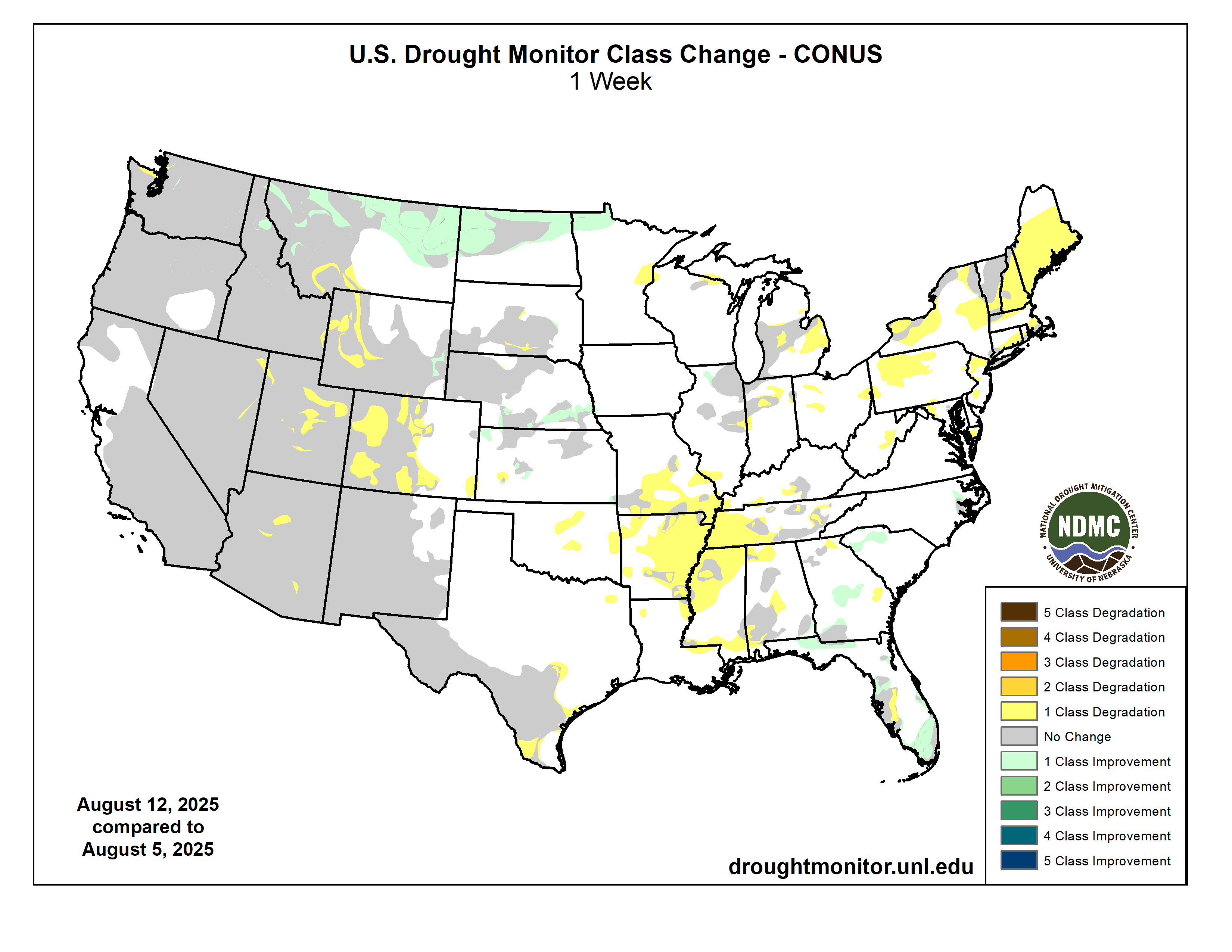
This Week’s Drought Summary
Intensifying short-term rainfall shortages led to expanding and intensifying dryness and drought over much of the Lower Mississippi Valley, Ohio Valley, Tennessee Valley, Northeast, and parts of the Deep South, southern Plains, central Arizona, and the central Rockies. Meanwhile, a second consecutive week with moderate to heavy precipitation led to areas of improvement in the South Atlantic States from the Carolinas through Florida, across northern reaches of the Rockies and Plains, and over parts of the central Great Plains. The heaviest amounts (8 to 11 inches) doused areas in southeast Wisconsin from central Washington and Ozaukee Counties southward through much of north and central Waukesha and Milwaukee Counties. Meanwhile, 6 to 8 inches were dropped on a broader section of southeast Wisconsin as well as a few patches across southeast South Dakota, the Carolinas Piedmont and adjacent southern Appalachians, the coastal Carolinas, north-central Florida, the central Florida Peninsula, and interior southeast Florida…
High Plains
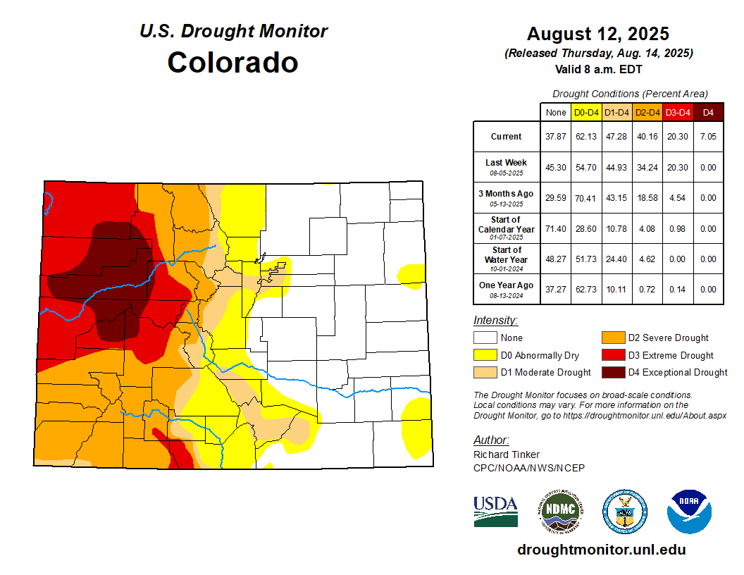
Rainfall varied in intensity across the High Plains Region once again this week, with abundant rainfall amounts falling on much of North Dakota, southern Nebraska, and some spots in Kansas leading to improved conditions. Some improvement was also noted in part of the southeast Wyoming High Plains. Meanwhile, less precipitation kept dryness and drought approximately unchanged across South Dakota, and allowed for areas of intensification for the second consecutive week in central and western parts of Colorado and Wyoming. A sizeable swath of northwestern Colorado deteriorated into exceptional drought (D4), and D2 to D3 conditions expanded in other areas over and near the higher elevations in western parts of the High Plains Region. Since early July, USDA indicated that the proportion of topsoils short or very short of moisture increased from 20 to 32 percent in Colorado, and from 52 to 63 percent of Wyoming. In Colorado, 19 percent of the corn crop is in poor or very poor condition (up from just 1 percent in early July) while in Nebraska, one-third of the oat crop is in poor or very poor condition (up from 5 percent in early July)…

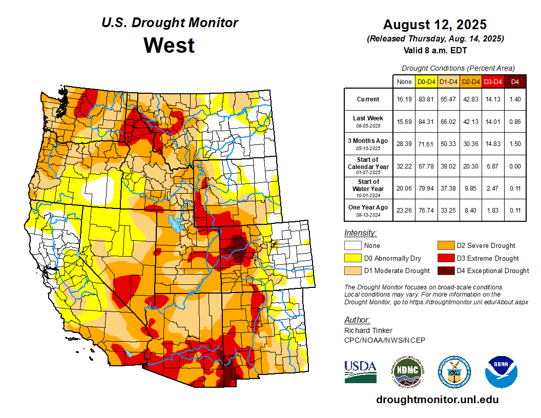
West
Heavy precipitation (one to locally multiple inches in most areas) prompted significant areas of improvement across northern and part of western Montana as well as portions of northern Idaho. Farther south, a few weeks of deficient monsoonal rainfall and above-normal temperatures prompted deterioration in D1 to D3 conditions across southwestern Montana, several swaths across Utah, and a few areas in Arizona and eastern Nebraska. In addition, conditions deteriorated from moderate to severe drought (D1 to D2) in part of northwestern Washington. In other parts of the West Region, dryness and drought was unchanged compared to last week. Outside the northern tier of the Region, very little precipitation was reported outside several tenths to about an inch in southeastern Arizona. The proportion of rangelands in poor or very poor condition increased in the last 5 weeks from 32 to 49 percent in Utah, from 22 to 44 percent in Washington, and from 10 to 34 percent in Idaho. Over half of the Washington spring wheat crop is in poor or very poor condition compared to just 17 percent in early July. During this period, the proportion of Montana spring wheat in poor or very poor condition increased from 37 to 47 percent. USDA also indicated that 53 percent of the Washington barley crop is in poor or very poor condition, compared to just 14 percent in early July…
South
Patches of moderate to heavy rain were observed over southernmost Louisiana and adjacent Texas, much of the Red River (south) Valley, the southern Texas Panhandle, and the northern tier of Oklahoma. Other areas saw scattered to isolated showers that did not markedly improve any extant dryness. Similar to conditions in adjacent Mississippi, above-normal precipitation earlier in the summer ebbed beginning in early July, and significant short-term rainfall deficits have accumulated over the past several weeks although multi-month precipitation totals are generally near or above normal. In conjunction with hot summertime conditions, this has led to quickly-depleting surface moisture over much of Tennessee, Arkansas, and portions of Louisiana. As a result, D0 conditions have been introduced and expanded rapidly. Farther west, less widespread short-term moisture deficits led to several patches of new D0 this week in western Arkansas, Oklahoma, and northeastern Texas. Farther south and west, some D0 and D1 expansion was noted in Deep South Texas, but dryness and drought were essentially unchanged across New Mexico and the remainder of Texas. USDA indicated that short or very short topsoil moisture covered 60 percent of Tennessee and 80 percent of Arkansas (up from 18 and 39 percent, respectively, in early July). The proportion of the Tennessee cotton crop in poor or very poor condition increased from 12 percent in early July to 26 percent last week…

Looking Ahead
From August 14 to 18, heavy rain (2 to locally 5 inches) is forecast in the higher elevations and coastal sections of Washington and Oregon, and also from the eastern Upper Mississippi Valley through much of the Great Lakes. At least several tenths of an inch of rain, with isolated totals near 2 inches, in areas commonly affected by the late summer and autumn monsoon in the Southwest and higher elevations of central Colorado. Similar amounts are anticipated in the Lower Mississippi Valley, Gulf Coast states, interior Southeast, South Atlantic States, coastal Northeast, northern Plains, eastern Great Lakes, and lower elevations of Washington and western Oregon. Light to locally moderate amounts potentially approaching an inch are expected in the Ohio Valley and scattered locations across the Rockies. Meanwhile, little or no precipitation is forecast across California, the Great Basin, the northern Rockies, the central and southern Plains, and the Middle Mississippi Valley. The National Hurricane Center is forecasting Tropical Storm Erin to move northwestward while strengthening into a major hurricane by the end of the period. Most guidance keeps the system east of the Bahamas and the East Coast, but there is a lot of uncertainty in any forecast hurricane track 3 to 5 days in advance. Rough surf and high waves may impact the East Coast and the Bahamas even if the storm stays well out to sea. Generally above-normal should prevail from the Appalachians westward through central and northern sections of the Plains and Rockies, as well as the coastal Northeast. Temperatures should average closer to normal over the Southeast, the mid-Atlantic, and southern portions of the Plains and Rockies. Cooler than normal weather should be confined to the Great Basin and West Coast States.
The Climate Prediction Center’s 6-10 day outlook (valid August 19-23, 2025) features significant uncertainty in the precipitation outlook. Odds for above-normal precipitation exceeding 40 percent are found in much of southern Arizona and the northern High Plains, and nowhere else. There are, however, fairly broad areas with slightly enhanced chances (33 to 40 percent) for wetter than normal wetter; specifically, from the portions of the Southwest typically affected by the late summer and autumn monsoon through the central and northern High Plains, and the northern Great Plains. Similar odds favoring above-normal precipitation also prevail across the southern Great Plains, the Lower Mississippi Valley, the interior Southeast, the Carolinas, the mid-Atlantic, and the coastal Northeast. Wetter than normal weather is also slightly favored across the northern half of Alaska. Meanwhile, odds lean towards below-normal rainfall in the Northwest and the northern Intermountain West, the Great Lakes, and the St. Lawrence Valley and adjacent New England. Drier than normal conditions are also favored along the southern tier of Alaska while near-normal amounts are expected across Hawaii. Meanwhile, warmer than normal weather is favored over the western half and southeastern quarter of the Contiguous United States, with odds reaching 60 to 80 percent in the central and northern High Plains, the Rockies, and the Florida Peninsula. Unusually warm weather is also favored across the southern half of Alaska, and Hawaii. Subnormal temperatures are favored over the eastern Great Lakes, mid-Atlantic, and Northeast.