Click the link to read the article on The Denver Post website (Elise Schmelzer). Here’s an excerpt:
August 15, 2025
Drought and long, hot summer days are sucking Western Colorado’s rivers dry, parching farm fields and fueling the massive wildfires proliferating across the region. A chunk of northwestern Colorado in the last week plunged into exceptional drought — the most dire category recorded by the U.S. Drought Monitor. The swath of affected land represents 7% of the state and covers most of Garfield and Rio Blanco counties, as well as parts of Moffat, Mesa, Delta, Routt and Pitkin counties…Exceptional drought is expected to occur once every 50 years, [Russ] Schumacher said. So far this summer, the afternoon monsoon rains that provide relief have been largely absent from the Western Slope. The higher-than-normal temperatures and a lack of rain have sapped the rivers in the Western half of Colorado. Streamflows statewide are at only half of the median recorded between 1991 and 2020, according to National Water and Climate Center data. The lack of water has limited fishing and rafting opportunities, reduced agricultural irrigation and threatened river environments…Nearly half of Colorado is experiencing some level of drought, according to new data released Thursday by the U.S. Drought Monitor. More than 1.4 million people live in that drought-impacted area, which encompasses the entire western half of the state, parts of metro Denver and some areas of southern Colorado…
This summer has been one of the driest on record for the state’s critical Colorado River basin, similar to 2018 and 2021, said Calahan of the Colorado River District. Drought in those years made the Colorado River look more like a creek than a river and prompted a 120-mile-long fishing ban on its mainstem…Streamflow in the basin is worst on its western flank and best on its eastern side near the headwaters, he said…The [Colorado River] district is speaking weekly with irrigators across the region to best divvy up the water that remains. Low flows are being supplemented by releases from reservoirs…A lack of water in the Eagle River near Vail prompted local water authorities to warn of a potential coming water shortage. Flows on the river near Avon were about half of normal — and the third-lowest recorded on the stream gauge’s 26-year record, said Siri Roman, the general manager of the Eagle River Water and Sanitation District…Thirteen of the 14 stream gauges with historic data in the Upper San Juan basin were reporting flows below or extremely below normal on Wednesday. The Animas River in Durango was flowing at 153 cubic feet per second — a fraction of the median of 499 cfs for the day across 113 years of data, and close to the historic low for that date of 137 cfs…Several stream gauges in the basin were recording record daily lows, like the San Juan River in Pagosa Springs and on Vallecito Creek…On the opposite side of the state, the Yampa River basin, too, is struggling. The river above Stagecoach Reservoir was flowing at less than half of the 36-year median.
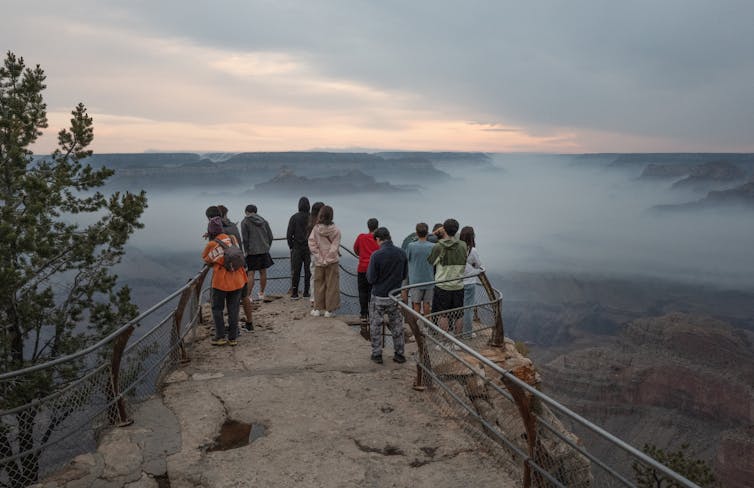
As wildfire crews battled the Dragon Bravo Fire on the Grand Canyon’s North Rim in July 2025, the air turned toxic.
A chlorine gas leak had erupted from the park’s water treatment facility as the building burned, forcing firefighters to pull back. The water treatment facility is part of a system that draws water from a fragile spring. It’s the only water source and system for the park facilities on both rims, including visitor lodging and park service housing.
The fire also damaged some of the area’s water pipes and equipment, leaving fire crews to rely on a fleet of large water trucks to haul in water and raising concerns about contamination risks to the water system itself.
By mid-August, Dragon Bravo was a “megafire,” having burned over 140,000 acres, and was one of the largest fires in Arizona history. It had destroyed more than 70 structures, including the iconic Grand Canyon Lodge, and sent smoke across the region.
A National Park Service worker assesses a split in an exposed section of the Grand Canyon’s fragile water lines in 2014. The water pipeline, installed in the mid-1960s, feeds water from Roaring Springs, located approximately 3,500 feet below the North Rim. Grand Canyon National Park via Flickr
Wildfires like this are increasingly affecting water supplies across the U.S. and creating a compounding crisis that experts in water, utilities and emergency management are only beginning to wrestle with.
A pattern across the West
Before 2017, when the Tubbs Fire burned through neighborhoods on the edge of Santa Rosa, California, most research on the nexus of wildfire and water had focused on issues such as drought and how climate change effects ecosystems.
The Tubbs Fire destroyed thousands of buildings and also melted plastic water pipes. After the fire, a resident’s complaint about the taste and odor of tap water led to the discovery that the fire’s damage had introduced contaminants including benzene, a carcinogen, into parts of the public water system.
It quickly became obvious that the damage discovered at the Tubbs Fire was not unique.
In southern Oregon, the 2020 Almeda Fire damaged water pipes in buildings, leaving water to flow freely. That contributed to low system pressure just when people fighting the fire needed the water.
Water meters and pipes are vulnerable to damage during a fire. Andrew Whelton/Purdue University, CC BY
In Colorado, the 2021 Marshall Fire burned through urban water lines, damaging six public drinking-water systems along with more than 1,000 structures in the Boulder suburbs. All six systems lost power, which in some cases led to a loss of water pressure, hampering firefighting.
As firefighters worked on the Marshall Fire, water system operators raced to keep water flowing and contaminants from being transported into the water systems. But tests still detected chemical contamination, including benzene, in parts of the systems a few weeks later.
Then, in January 2025, the Los Angeles fires supercharged concerns about water and wildfire. As firefighters raced to put out multiple fires, hydrants ran dry in some parts of the region, while others at higher elevations depressurized. Ultimately, over 16,000 structures were damaged, leading to insured losses estimated to be as high as US$45 billion.
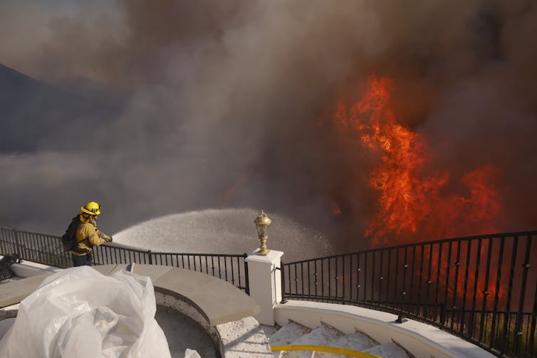
Water supplies are crucial to fighting fires. In cities, fire crews like this one battling the Palisades Fire in Los Angeles in January 2025 can often rely on hydrants. But water systems can lose pressure and potentially the power to run their pumps during fires. AP Photo/Etienne Laurent
Water infrastructure is not merely collateral damage during wildfires – it is now a central concern.
It also raises the question: What can residents, first responders and decision-makers reasonably expect from water systems that weren’t designed with today’s disasters in mind?
Addressing the growing fire and water challenge
While no two water systems or fires are the same, nearly every water system component, ranging from storage tanks to pipelines to treatment plants, is susceptible to damage.
The Grand Canyon’s Roaring Springs system exemplifies the complexity and fragility of older systems. It supplies water to both rims of the park through a decades-old network of gravity-fed pipes and tunnels and includes the water treatment facility where firefighters were forced to retreat because of the chlorine leak.
Many water systems have vulnerable points within or near flammable wildlands, such as exposed pump houses that are crucial for pulling water from lower elevations to where it is needed.
A stand pipe at Zorthian Ranch in Altadena, Calif., failed during the January 2025 fire there, making it even more difficult for Alan Zorthian to fight the flames sweeping across his property. He used a pump drawing water from a swimming pool to try to fight the flames, but numerous structures were destroyed. Myung J. Chun/Los Angeles Times via Getty Images
In addition, hazardous materials such as chlorine or ammonia may be stored on-site and require special considerations in high fire risk areas. Staff capacity is often limited; some small utilities depend on a single operator, and budgets may be too constrained to modernize aging infrastructure or implement fire mitigation measures.
As climate change intensifies wildfire seasons, these vulnerabilities can become disaster risks that require making water infrastructure a more integral part of fighting and preparing for wildfires.
Prioritizing fire-resistant construction, better shielding of chemicals and, in some cases, decentralizing water systems can help protect critical facilities, particularly in high-risk zones. Having backup power supplies, mobile treatment systems and alternate water sources are essential to provide more security in the face of a wildfire.
Emergency command protocols and interagency coordination are most effective when they include water utilities as essential partners in all phases of emergency response, from planning to response to recovery. Fire crews and water operators can also benefit from joint training in emergency response, especially when system failure could hinder firefighting itself.
Longer term, protecting upstream watersheds from severe fire by thinning forests and using controlled burns, along with erosion control measures, can help maintain water quality and reduce water pollution in the aftermath of fires.
Smaller and more isolated systems, particularly in tribal or low-income communities, often need assistance to plan or implement new measures. These systems may require technical assistance, and regional support hubs could support communities with additional resources, including personnel and equipment, so they can respond quickly when crises strike.
Looking ahead
The Dragon Bravo Fire isn’t just a wildfire story, it’s also a water story, and it signals a larger, emerging challenge across the West. As fire seasons expand in size and complexity, the overlap between fire and water will only grow.
The Grand Canyon fire offers a stark illustration of how wildfire can escalate into a multifaceted infrastructure crisis: Fire can damage water infrastructure, which in turn limits firefighting capabilities and stresses water supplies.
The question is not whether this will happen again. It’s how prepared communities will be when it does.
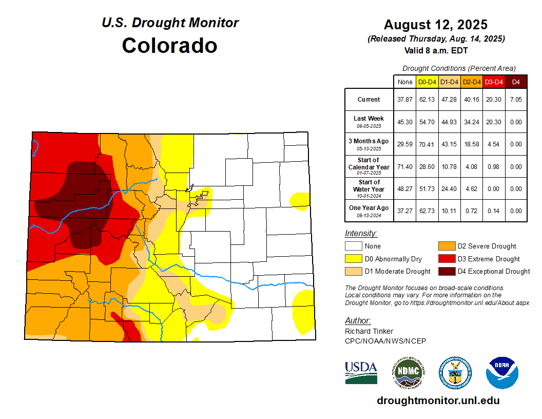
The latest US Drought Monitor (released August 14) highlights big changes to the current drought situation in western Colorado, including the introduction of “exceptional” or “D4” conditions to some locations. Exceptional drought represents the most severe category of drought and is frequently tied to widespread hydrologic and agricultural impacts.
Colorado Drought Monitor map August 12, 2025.
Historical context and current impacts
Exceptional drought hasn’t been seen in Colorado since May 2023, when a very small fraction of the southeast corner of the state (Baca County) was classified under such conditions. And the last time that exceptional drought conditions were realized in the western half of the state was nearly four years ago in October 2021, when parts of Moffat County were included in the D4 category. The current exceptional drought area covers a larger fraction of the state than either of those two recent examples (roughly 7% of it) and includes portions of Moffat, Routt, Rio Blanco, Garfield, Eagle, Pitkin, Gunnison, Delta, and Mesa counties.
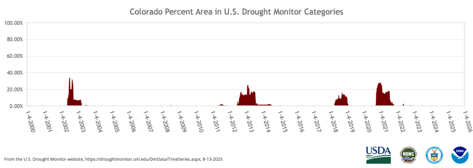
Colorado’s “high and dry” climate makes it no stranger to drought, and some part of the state will be experiencing some degree of drought at any nearly any given time. However, long-livedexceptional drought tends to be rarer. Since the inception of the US Drought Monitor, there have been four widespread and persistent periods of exceptional drought, with the most recent being 2020-2021.
Time series showing the percent of Colorado that has been classified under D4 or exceptional drought conditions from 2000-present.
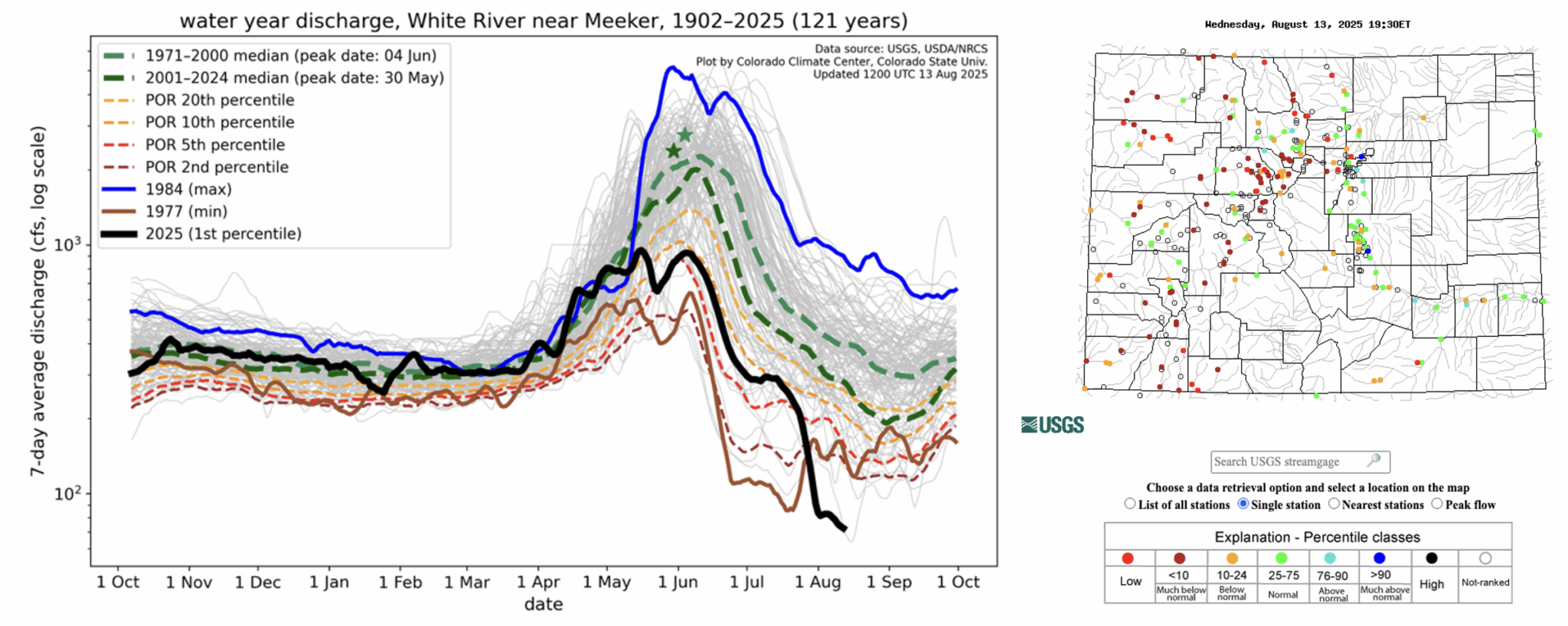
Current impacts to water, soils, and vegetation in the most drought-afflicted areas help capture the current severity of the situation. For example, streamflow along the White River at Meeker is in the 1st percentile among its 121-year record, and current flow is very close to the station’s all-time record low. Many other streamgauge sites, including those along the Yampa, Colorado, Animas, and Dolores rivers, show streamflow below the 10th percentile, indicating well below-normal flow conditions.
Left: Hydrograph showing 7-day averaged streamflow for 2025 (black line) compared to previous years and various percentiles for the White River near Meeker. Right: USGS streamgauge sites in Colorado. [Source: USGS]
The multiple wildfires currently burning across western Colorado are evidence that there is stress on vegetation and soils in the drought-afflicted areas. This includes the Lee Fire (near Meeker, CO), which at over 127,000 acres is now firmly Colorado’s fifth-largest wildfire on record. Satellite-based drought products show severe vegetation stress and soil moisture percentiles below the 5th percentile, further confirming that surface conditions are extremely dry in western Colorado.
Left: Active wildfires and perimeters across western Colorado. Data are from August 14. [Source: NIFC] Right: Vegetation Drought Response Index valid August 10. [Source: NDMC/USGS]
How did we get here? A look back at Water Year 2025
With only about a month and a half left in Water Year 2025, it is worth looking back at how the drought landscape has changed in Colorado since last October. Water years run from October 1 to September 30 and are designed to capture the movement of water from the time that streamflows are generally at their minimum (in the fall), through the build up of the water supply as snowpack during the winter, to the annual runoff in the spring and summer. Keeping track of drought and precipitation over the course of a water year is helpful for tracking and managing water resources.
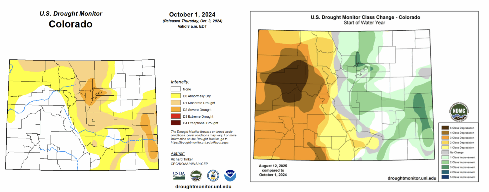
At the start of the Water Year 2025, nearly everywhere west of the Continental Divide was drought-free, while the Front Range, Urban Corridor, and parts of the Eastern Plains were experiencing moderate to severe drought conditions. That pattern has switched in many ways, with most areas east of the Divide now currently drought-free, while nearly everywhere west of the Divide is being impacted by at least D1 drought conditions. The class change map comparing the drought monitor at the start of Water Year 2025 to the current drought monitor highlights this shift well:
Left: US Drought Monitor from October 1, 2024. Right: US Drought Monitor class change map from October 1, 2024 compared to the latest US Drought Monitor (August 12, 2025).
The current drought in western Colorado did not immediately unfold at the onset of the new water year. In early winter, drought was largely avoided in this area in part thanks to a major snowstorm in early November (refresh your memory with our blog post here). That event brought drought relief to much of the Eastern Plains and gave an early boost to the winter snowpack for most of the rest of the state.
However, the snow largely ceased across southern Colorado in December and January, and substantial high country snowpack deficits became apparent by the end of February, with the snowpack in several basins standing at only ~2/3rds of average. At the beginning of March, most of southwestern Colorado and the lower elevations of the West were experiencing D1-D2 drought conditions according to the US Drought Monitor.
While the state’s northern river basins were spared from significant snowpack deficits for most of the winter, March and April ended up being drier than normal. For this part of Colorado, the spring months are typically the wettest on average, and they are crucial months for amassing snowpack to accommodate warm season water needs (in the form of runoff). While deficits remained in better shape compared to southern Colorado’s basins, snowpack peaked earlier than normal across much of the state. This below-average winter snowpack has undoubtedly played an important role in the current drought situation across the western half of the state.
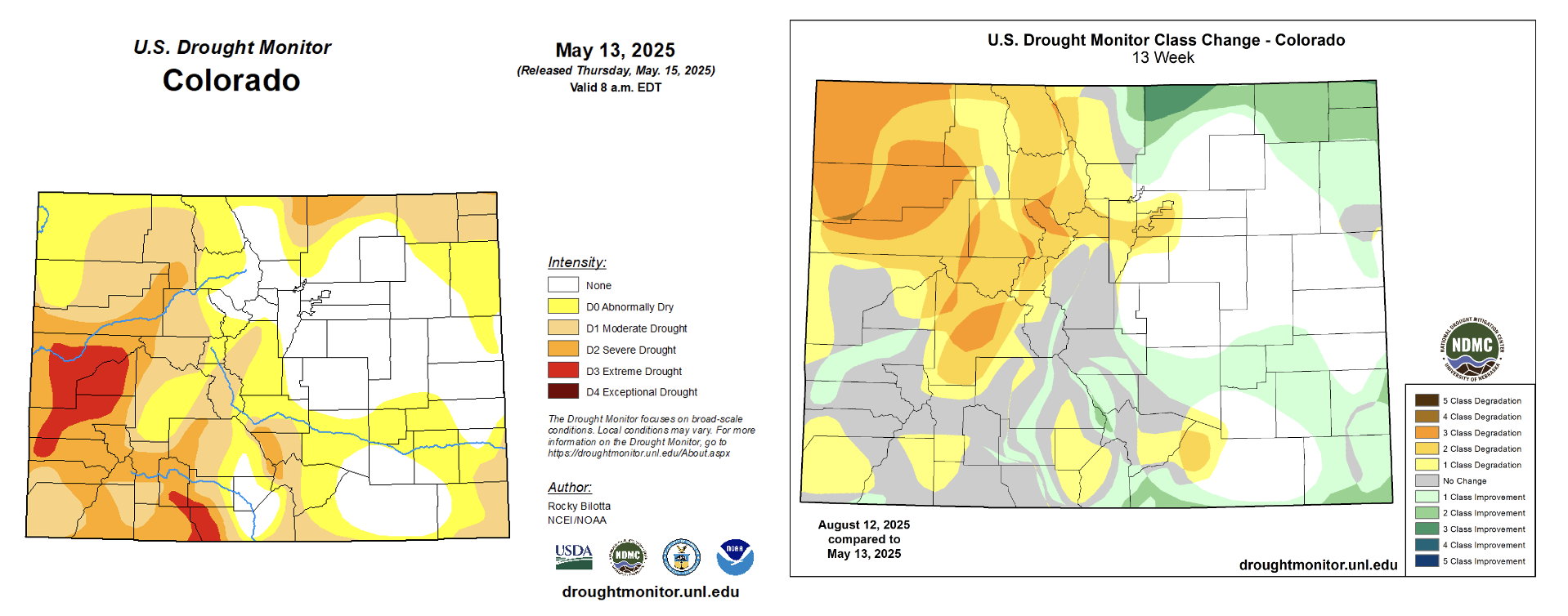
This brings us to mid-May—the last time we wrote a blog post about drought. By that time, most areas west of the Continental Divide were experiencing some level of drought, including D3 or “extreme” drought conditions over parts of the West Slope and San Juans. Aside from a decent precipitation event in early June, conditions in western Colorado have been abnormally hot and dry. Northwest Colorado has seen some of the quickest drought development in the state, with some locations going from D0-D1 conditions in Mid-May to D3-D4 conditions just three months later. June-July 2025 was among the top-10 hottest and driest on record for most of that area.
Left: US Drought Monitor from May 13, 2025. Right: US Drought Monitor class change map from May 13, 2025 compared to the latest US Drought Monitor (August 12, 2025).
While areas east of the Divide saw some drought development in the spring as well, much of that was alleviated thanks to widespread and persistent thunderstorm activity throughout the summer. This regular rainfall has also continued to help ward off major drought development (though some locations that have missed out on recent precipitation, such as the Denver Metro, have begun to slip back into drought conditions). Locations west of the Divide have not been as fortunate. These areas typically benefit from the North American Monsoon (NAM), which (when active) provides increased moisture and precipitation throughout July and August. The lack of relief from the NAM combined with the below-average snowpack from last winter have brought us to the current drought situation.
What can we expect in the coming weeks/months?
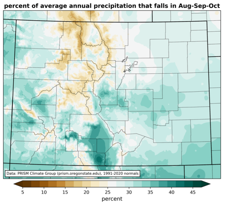
First, let’s briefly talk precipitation climatology (stay tuned for more on this in an upcoming blog post). For much of the West Slope, August-October tends to be the time of year that this area receives its greatest amounts of precipitation. Seeing that we’re only about halfway through August, there is plenty of time remaining in this wetter time of year. However, this seasonality does not guarantee “drought-busting” precipitation, nor should we expect our weather patterns to perfectly follow climatology.
Percent of average annual precipitation that falls between August-October. [Data from PRISM]
Still, there is a little hope in the medium-range outlook for precipitation in the western half of the state. The 8-14 day precipitation outlook from the NOAA Climate Prediction Center suggests elevated chances for above-average precipitation towards the end of the month, with the greatest likelihood spanning the western and central parts of the state. At the same time, above-average temperatures are expected to persist over this time frame, which could work against precipitation driven drought relief (warmer temperatures are connected to increased evaporative demand, or potential water loss from the Earth’s surface).
8-14 day precipitation (left) and temperature (right) outlooks from the NOAA Climate Prediction Center, issued August 13.
Looking even further ahead, the Climate Prediction Center 3-month outlook (August-October) that was released in mid-July does not inspire much optimism for drought relief as we head into fall. Their predictions call for elevated chances of below-normal precipitation across most of Colorado. Additionally, it is becoming increasingly likely that La Niña conditions will develop in late fall to early winter. While there is some evidence that La Niña favors wetter conditions over parts of north and central Colorado during the winter months, it favors overall drier conditions statewide, especially during the fall (though the correlations between ENSO phase and precipitation are relatively weak compared to other locations).
(Left) seasonal precipitation outlook for August-October and (right) El Niño Southern Oscillation (ENSO) probabilities through May 2026. [Source: NOAA Climate Prediction Center]
To summarize: poor snowpack during the winter teed up western Colorado for drought heading into summer, and the dry, hot conditions over the past few months have exacerbated conditions. These factors have lead to the widespread extreme to exceptional drought conditions that are currently depicted in the US Drought Monitor. There are a couple reasons to remain optimistic about precipitation in following weeks and months, but many uncertainties remain, and *a lot* of precipitation will be needed to alleviate drought conditions in western Colorado.