President Trump’s war on energy: If we’re in an energy emergency, why kill the cleanest, best, and fastest growing sources? — Jonathan P. Thompson (LandDesk.org)

The Route 66 Solar Energy Center near Grants, New Mexico. Jonathan P. Thompson photo.

Click the link to read the article on The Land Desk website (Jonathan P. Thompson):

August 25, 2025

🌵 Public Lands 🌲

During both the Obama and Biden presidencies, Republicans and the fossil fuel industry often accused the administration of waging a “war on energy.” It was a demonstrably false allegation. The most either of the Democrats did to attack the energy industry was to incrementally increase common sense regulations and environmental protections, which apparently did little to hamper energy development. The so-called shale revolution, when “fracking” opened up huge new reserves of tight oil and gas, began under Obama, and truly came to fruition under Biden, when domestic oil and gas production reached new record highs. Meanwhile, Biden’s Interior Department approved dozens of utility-scale solar and wind and long-delayed transmission projects on public lands.

But now the Trump administration is, in fact, waging a very real war on energy — renewable energy, that is, namely wind and solar power. They’ve frozen and even clawed back funds for projects, killed federal clean energy tax credits, subjected wind and solar projects on public lands to heightened reviews, and eliminated wind energy leasing areas off Oregon’s coast. And they’ve done it all as America is supposedly gripped by an “energy emergency.”

Now, the Interior Department has gone even further with a new order that threatens to kill all new renewable power development on federal lands. I know there are some readers out there who might applaud this, since so many of our public lands are not suited for sprawling utility-scale solar or wind developments. But this order — deceptively and cynically titled, “Managing Federal Energy Resources and Protecting the Environment” — would potentially replace proposed wind and solar projects with coal or uranium mines and/or power plants, oil and gas fields, or other non-renewable energy projects.

The order requires land management agencies, when reviewing proposed solar or wind energy projects, to consider “a reasonable range of alternatives that includes projects with capacity densities meeting or exceeding that of the proposed project.”

Capacity density is basically the amount of energy a project can generate per acre. According to the Interior Department’s calculations (we’ll get to the flaws there in a moment), the capacity density (megawatts/acre) for various power sources are:

  • Advanced nuclear reactor: 33.17 MW/acre
  • Combined cycle gas plant: 5.4 to 24.42 MW/acre (depending on configuration)
  • Gas combustion turbine: 2.13 to 4.23 MW/acre
  • Ultra-supercritical coal plant w/out carbon capture: .69 MW/acre
  • Geothermal: .16
  • Solar PV w/ battery storage: .04
  • Onshore wind: .01
  • Offshore wind: .006

In other words, wind and solar are the big losers, taking up far more space to generate the same amount of electricity as, say, a nuclear plant. According to the new order, this raises the question of “whether the use of federal lands for any wind and solar projects is consistent with the law.”

This isn’t a new argument: The specter of “renewable energy sprawl” has long been wielded to push back against solar and wind development. And certainly the amount of space a project takes up should be one of many considerations in whether to permit it. But should it really have more weight than the amount of damage the project would inflict? How about pollutants emitted per megawatt, or amount of harm to people, the climate, and the environment per megawatt? Is there consideration for the fact that there is a lot of space between the turbines within a wind facility that is minimally affected? And why doesn’t their chart include hydroelectric, which has the lowest capacity density of all?

Also, the Interior Department’s calculations are a bit fishy, or at least incomplete. They say they are based on a 2023 Sargent & Lundy report commissioned by the Energy Information Administration. The report is not on capacity density, but rather the costs of building and operating various power generating technologies. When determining the acreage of the nuclear and fossil fuel plants, they do not take into account the land required for fuel production, which can be extensive.

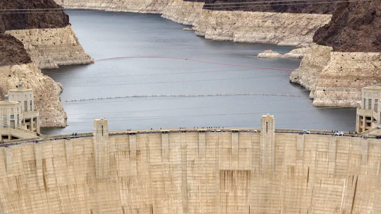
The supercritical coal plant referenced in the report, for example, would require a mere 600 acres. Yet, the Four Corners coal plant in northwestern New Mexico — along with its associated Navajo Mine (current mining areas as well as reclaimed areas), Morgan Lake, and coal combustion waste disposal facilities — covers (and wrecks) some 15,000 acres. That acreage will continue to grow for as long as the plant operates, since the mine and waste dumps will continue to expand. Compare that to the 2,400 acres covered by the nearby San Juan solar plant.

I’d also argue that if the goal is to get the most energy out of every acre of public land (which is a silly goal, but whatever), then they should figure in the amount of energy the proposed project consumes. Coal mining and oil and gas drilling require large amounts of electricity and petroleum (along with human labor, which is also a form of energy), as does transporting coal and gas by train and pipeline. Uranium enrichment, which is necessary to produce reactor fuel, is extremely power-intensive.

None of this really matters to Interior Secretary Doug Burgum, however. That’s because he knows we’re not really in an “energy emergency,” and that it is merely a fabricated excuse to give more handouts and regulatory relief to his fossil fuel-industry buddies and to get revenge on Trump’s political opponents by punishing cleaner energy sources.

Proposed utility-scale solar and wind facilities on public lands should by all means be scrutinized and subjected to the same reviews as any other projects, contrary to what the Abundance faction might believe. The projects should be denied if their impacts outweigh the benefits, with bonus benefit-points for solar or wind projects that displace or replace coal or natural gas generation.

But judging the projects based on a virtually meaningless metric is not only spiteful, unfair, and stupid, but it also will needlessly hamper the fight against health-harming pollution and climate change. And that’s simply irresponsible, at best. [ed. emphasis mine]

⛏️ Mining Monitor ⛏️

Speaking of fake energy emergencies … In May, the Bureau of Land Management completed its environmental review and approval of the Velvet-Wood uranium mine in Utah’s Lisbon Valley in just 11 days. The rush, sans public input, ostensibly was necessary to get the mine online quickly to address the supposed uranium shortage.

The mine’s proponent, Anfield Resources, apparently doesn’t share the Trump administration’s sense of urgency. At the end of April, the Utah Division of Oil, Gas, and Mining asked Anfield for more information on its application to commence large mining operations, which was deemed technically incomplete. Anfield has yet to respond. The company is also not rushing forward to get state approval for its water treatment plant permit or to reopen its Shootaring Mill near Ticaboo, where the Velvet-Wood’s uranium would be processed.

In other words, the fast-tracked permitting was merely a ruse, intended to bypass environmental regulations and public input, not to expedite the project, itself.

***

Photo-illustration of the Animas River a few days after the spill from the air. Jonathan P. Thompson photo and illustration.

It’s the tenth anniversary of the Gold King Mine blowout that affected the Animas and San Juan rivers in Colorado, New Mexico, and Utah. A few folks have asked if I’m going to write anything about it — since I did write a book about it — but I don’t think there’s much more to say, really.

The Gold King Mine continues to drain acidic, heavy metal-laden water — though it is being treated before it’s released into the watershed — and neighboring mines continue to do the same (though they aren’t being treated). Superfund designation hasn’t been the boon to water quality that some hoped for, nor did it stigmatize Silverton as many feared it would (property values continue to soar into the unreachable zone).

While the event did bring more attention to the problem of abandoned mine sites (even though the Gold King wasn’t technically abandoned when it blew out), and injected “acid mine drainage” into the public’s vocabulary, it hasn’t led to mining law reform or any widespread effort to address the issue. That said, Congress finally did pass a Good Samaritan bill, that might clear the way for volunteer groups to do some additional cleanup without being sued for it. Still, they need funding, and that’s in short supply these days.

If you’d like to read more on it, check out this piece by Peter Butler. And you can check out past stories in the Land Desk for more information (links below, but they are behind the paywall). Better yet, go down to your local bookstore and buy River of Lost Souls.

On Superfund and the Gold King, 9 years later — Jonathan P. Thompson

Wonkfest: Sunnyside Gold King Settlement, explained — Jonathan P. Thompson

Gold King documents and map unearthed — Jonathan P. Thompson

This image was taken during the peak outflow from the Gold King Mine spill at 10:57 a.m. Aug. 5, 2015. The waste-rock dump can be seen eroding on the right. Federal investigators placed blame for the blowout squarely on engineering errors made by the Environmental Protection Agency’s-contracted company in a 132-page report released Thursday [October 22, 2015]

An image of the Sharp Fire near Cahone, Colorado, from the Benchmark fire lookout. Source: Watch Duty.

🥵 Aridification Watch 🐫

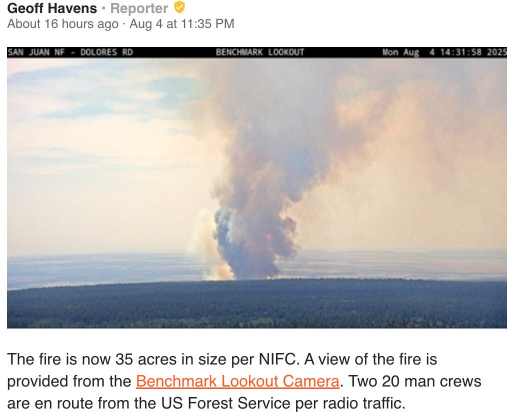
Fire season is really heating up, along with the summer temperatures. The relatively dry spring was followed by higher than normal temperatures in July and zero to minimal precipitation in many places, turning low- and mid-elevation forests to kindling. Officials working the Leroux Fire west of Paonia said the relative humidity was just 2%, contributing to rapid fire growth.

The Leroux blaze was just one of many new starts on Colorado’s Western Slope over the last several days. The Sharp Canyon Fire north of Cahone, Colorado, grew rapidly to 400 acres on Monday, forcing evacuations, but it seems to have quieted down overnight. The Lee and Elk fires in Rio Blanco County blew up to 13,000 and 7,700 acres, respectively, over a couple of days. The Middle Mesa Fire east of Navajo Reservoir and just south of the Colorado-New Mexico line grew to 2,500 acres as of Monday night.

Meanwhile, the Dragon Bravo Fire on the Grand Canyon’s North Rim has lived up to its name, reaching 126,445 acres as of Tuesday morning with only 13% containment a month after it ignited.

The situation is probably going to get worse before it gets better. The National Weather Service has issued red flag warnings for parts of Nevada, Utah, Colorado, and Wyoming, with extreme heat warnings in parts of Arizona and southern California. The mercury in Moab is expected to reach 100° F or more every day this week, and there’s no significant rainfall in sight.

As the Colorado River slowly dries up, states angle for influence over future water rights

Lake Mead, impounded by Hoover Dam, contains far less water than it used to. Kevin Carter/Getty Images

Sarah Porter, Arizona State University

The Colorado River is in trouble: Not as much water flows into the river as people are entitled to take out of it. A new idea might change that, but complicated political and practical negotiations stand in the way.

The river and its tributaries provide water for about 5 million acres of cropland and pasture, hydroelectric power for millions of people, recreation in the Grand Canyon, and critical habitat for fish and other wildlife. Thirty federally recognized Native American tribes assert rights to water from the Colorado River system. It is also an important source of drinking water for cities within the Colorado River Basin, including Phoenix, Tucson and Las Vegas, and cities outside the basin, such as Los Angeles, San Diego, Salt Lake City, Denver and Albuquerque.

The seven Colorado Basin states have been grappling with how to deal with declining Colorado River supplies for a quarter century, revising usage guidelines and taking additional measures as drought has persisted and reservoir levels have continued to decline. The current guidelines will expire in late 2026, and talks on new guidelines have been stalled because the states can’t agree on how to avoid a future crisis.

In June 2025, Arizona suggested a new approach that would, for the first time, base the amount of water available on the river’s actual flows, rather than on reservoir level projections or historic apportionments. While the proposal has been praised as offering “a glimmer of hope,” coming to agreement on the details presents daunting challenges for the Colorado Basin. https://public.tableau.com/views/ColoradoRiverBasin/ColoradoRiverbasin?:language=en-US&:sid=&:redirect=auth&:display_count=n&:origin=viz_share_link&:showVizHome=no&:embed=true

The Colorado River Compact

The 1922 Colorado Compact divided the 250,000-square-mile Colorado River Basin into an Upper Basin – which includes parts of Colorado, New Mexico, Utah and Wyoming, as well as the northeastern corner of Arizona – and a Lower Basin, encompassing most of Arizona and parts of California and Nevada. The compact apportions each basin 7.5 million acre-feet of water from the river each year. An acre-foot of water is enough to cover 1 acre in water 1 foot deep, which amounts to approximately 326,000 gallons. According to a 2021 estimate from the Arizona Department of Water Resources, 1 acre-foot is sufficient to supply 3.5 single-family households in Arizona for one year.

Anticipating a future treaty with Mexico for sharing Colorado River water, the compact specified that Mexico should be supplied first with any surplus available and any additional amount needed “borne equally” by the two divisions. A 1944 water-sharing treaty between Mexico and the U.S. guarantees Mexico at least 1.5 million acre-feet of Colorado River water annually.

The compact also specified that the Upper Basin states of Colorado, New Mexico, Utah and Wyoming “will not cause the flow of the river … to be depleted below an aggregate of 75,000,000 acre-feet for any period of 10 consecutive years.”

The Lower Basin states of Arizona, California and Nevada contend that this provision is a “delivery obligation,” requiring the Upper Basin to ensure that over any 10-year period, a total of at least 75 million acre-feet flows to the Lower Basin.

By contrast, the Upper Basin states contend that the language merely creates a “non-depletion obligation” that caps their collective use at 7.5 million acre-feet per year in times when additional use by the Upper Basin would cause less than 75 million acre-feet to be delivered to the Lower Basin over a 10-year period.

This disagreement over the compact’s language is at the heart of the differences between the two basins.

Snow sits on steep rocky slopes.
Snowfall in Western mountains, including the Flatirons outside Boulder, Colo., is the primary source of water for the Colorado River Basin. AP Photo/Thomas Peipert

A small source area

Nearly all of the water in the Colorado River system comes from snow that falls in the Rocky Mountains in the Upper Basin. About 85% of the Colorado Basin’s flows come from just 15% of the basin’s surface area. Most of the rest of the basin’s lands are arid or semi-arid, receiving less than 20 inches of precipitation a year and contributing little to the flows of the Colorado River and its tributaries.

Rain and snowfall vary dramatically from year to year, so over the course of the 20th century, the Colorado Basin states – with the assistance of the U.S. Bureau of Reclamation, the agency of the Department of the Interior responsible for operating federal water and power projects in the U.S. West – developed a complex system of reservoirs to capture the extra water in wet years so it could be available in drier years. The most notable reservoirs in the system are Lake Mead, impounded by Hoover Dam, which was completed in 1936, and Lake Powell, impounded by Glen Canyon Dam, completed in 1966.

Over the past 25 years, the quantity of water stored in Lake Mead and Lake Powell has declined significantly. A primary driver of this decline is a lengthy drought likely amplified by climate change: One study estimated that the region may be suffering its driest spell in 1,200 years.

But human errors are also adding up. The Colorado Compact’s original negotiators made unrealistically optimistic assumptions about the river’s average annual flow – perhaps knowingly. In their book “Science be Dammed,” Colorado River experts Eric Kuhn and John Fleck document how compact negotiators willfully or wishfully ignored available data about the river’s actual flows. Kuhn and Fleck argue the negotiators knew it would be decades before demand would exceed the river’s water supply, and they wanted to sell a big vision of Southwestern development that would merit massive federal financing for reservoirs and other infrastructure.

In addition, the current Colorado River system accounting does not factor in the roughly 1.3 million acre-feet of water lost annually from Lake Mead due to evaporation into the air or seepage into the ground. This accounting gap means that under normal annual releases to satisfy the apportionments to the Lower Basin and Mexico, Lake Mead’s water level is steadily declining.

Stabilization efforts

The seven Colorado River states and Mexico have taken significant steps to stabilize the reservoirs. In 2007, they agreed to new guidelines to coordinate the operations of Lake Mead and Lake Powell to prevent either reservoir from reaching catastrophically low levels. They also agreed to reduce the amount of water available to Arizona and Nevada depending on how low Lake Mead’s levels go.

When the 2007 guidelines proved insufficient to keep the reservoir levels from declining, the Colorado Basin states and Mexico agreed in 2019 to additional measures, authorizing releases from Upper Basin reservoirs under certain conditions and additional cuts to water users in the Lower Basin and Mexico.

By 2022, projections for the reservoir levels looked so dire that the states started negotiating additional near-term measures to reduce the amount of water users withdrew from the river. The federal government helped out, too: $4 billion of Inflation Reduction Act funding has helped pay the costs of water-conservation measures, primarily by agricultural districts, cities and tribes.

These reductions are real. In 2023, Arizona, California and Nevada used only 5.8 million acre-feet of Colorado River water – their lowest combined annual consumption since 1983. The Lower Basin’s total consumption in 2024 was slightly higher, at 6.09 million acre-feet.

People stand on a boat looking at a body of water and mountains beyond.
Lake Powell, a key Colorado River reservoir, holds only one-third as much water as it is designed to contain. Rebecca Noble/Getty Images

A new opportunity?

With the 2007 guidelines and additional measures expiring in 2026, the deadline for a new agreement looms. As the Colorado River states try to work out a new agreement, Arizona’s new proposal of a supply-driven approach offers hope, but the devil’s in the details. Critical components of that approach have not been ironed out – for instance, the percentage of the river’s flows that would be available to Arizona, California and Nevada.

If the states can’t agree, there is a chance that the secretary of the Interior, acting through the Bureau of Reclamation, may decide on his own how to balance the reservoirs and how much water to deliver out of them. That decision would almost certainly be taken to court by states or water users unhappy with the result.

And the Lower Basin states have said they are fully prepared to go to court to enforce what they believe to be the Upper Basin’s delivery obligation, which, the Upper Basin has responded, it is prepared to dispute.

In the meantime, farmers in Arizona’s Yuma County and California’s Imperial County cannot be sure that in the next few years they will have enough water to produce winter vegetables and melons for the nation. The Colorado River Basin’s municipal water providers are worried about how they will meet demands for tap water for homes and businesses. And tribal nations fear that they will not have the water they need for their farms, communities and economies.

Sarah Porter, Director of the Kyl Center for Water Policy, ASU Morrison Institute for Public Policy, Arizona State University

This article is republished from The Conversation under a Creative Commons license. Read the original article.