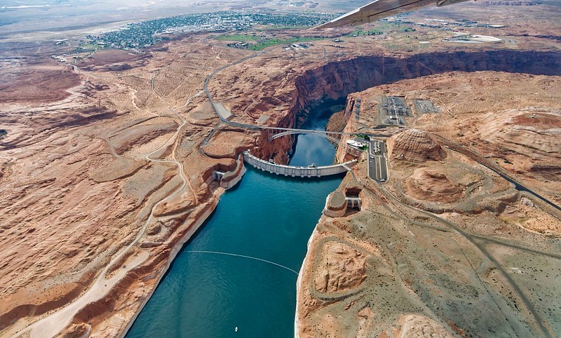
Glen Canyon Dam just upstream from Lee’s Ferry where the Upper Basin ends and the Lower Basin begins. Colorado, New Mexico, Utah and Wyoming, which make up the Colorado River’s upper basin, launched the System Conservation Pilot Program late last year, offering money to farmers and others willing to forgo their water use this year. So far the program has struggled, with few people applying. The granted applications amount to less than 2% of the smallest amount of water federal officials hope to save throughout the entire Colorado River Basin. Photo credit: Simon Morris, Creative Commons
Click the link to read the article on The Denver Post website (Elise Schmelzer). Here’s an excerpt:
August 30, 2025
The likelihood of Western states reaching a consensus on a plan for the future of the Colorado River is dimming as time runs out for the negotiators tasked with dividing up the shrinking river relied upon by 40 million people.
“The path to success seems tenuous at this point,” Arizona’s negotiator, Tom Buschatzke, said in an interview this week with The Denver Post. “The discussions continue to revolve around the main issue that we’ve been struggling with for some time since these discussions started.”
The states have until Nov. 11 to tell the federal government whether they will have a deal and until Feb. 14 to submit a detailed plan. If consensus cannot be reached, the U.S. Bureau of Reclamation will implement its own plan — a scenario that would likely prompt years of expensive litigation and put complicated water management questions in the hands of judges who aren’t specialized in the issues…
Negotiators from the Lower Basin for months have argued that their counterparts in the Upper Basin must agree to mandatory usage cuts in the driest years. The Lower Basin has already made significant cuts to address the shrinking river, Buschatzke said this week…The Upper Basin states maintain that they already take water cuts every year because they are above the system’s two major reservoirs. Since they’re reliant on snowpack and precipitation, they’re forced to live within the supply of the river. Unlike the Lower Basin states, the Upper Basin has never used its entire legal allotment, while the Lower Basin for years used more water than the river supplied and depleted water supplies stored in Mead and Powell, the basin’s negotiators have said…
The potential path forward.
Negotiators continue to discuss a concept that would base the amount released from the system’s two major reservoirs on the amount of water flowing in the river, rather than the decades-old system that bases releases on water levels at Lake Powell and Lake Mead. The negotiators spoke publicly last month about the concept, which some hailed as a potential breakthrough in negotiations. But optimism around that concept has faded. Mitchell said it was unclear whether an agreement could be reached around the framework. Buschatzke said major sticking points remained, like what percentage of the flow each basin should receive.
Udall/Overpeck 4-panel Figure Colorado River temperature/precipitation/natural flows with trend. Lake Mead and Lake Powell storage. Updated through Water Year 2024. Credit: Brad Udall
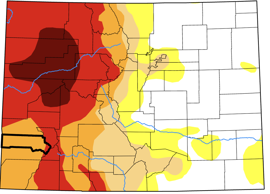
Current drought conditions across the state of Colorado, with San Miguel County outlined in black, as of Aug. 26. The Town of Telluride implemented outdoor water restrictions on Monday, Aug. 25, due to ongoing drought conditions and limited water availability locally. (Map courtesy of the U.S. Drought Monitor)
The Town of Telluride implemented outdoor water restrictions beginning Monday, Aug. 25, due to ongoing drought conditions and limited water availability locally. All water utility customers for the Town of Telluride, including Lawson Hill, Hillside and Sunnyside, are required to follow an irrigation schedule, with outdoor watering only permitted on Mondays, Wednesdays and Fridays. Watering must take place between 7 p.m. and 8 a.m. Irrigation systems should be set to 70-75% of normal water use, and all exterior water features must be turned off. No users are permitted to truck in additional water…Additionally, restaurants and businesses should serve water only upon request, and people are requested to fix any leaks immediately. Water audits and monitoring of water bills for excessive use can also help people regulate their use. Property owners who have landscaping that has been installed since spring 2024 can apply for additional permission to water. The public works department will review variances for new or modified landscaping on a case-by-case basis…
Although monsoonal rains have recently brought some moisture to the local area, it is still very dry. On the Western Slope, drought conditions remain dire, with several zones in northwestern Colorado in the category of ‘exceptional’ drought. Exceptional is the most severe category of drought and is often linked to hydrologic and agricultural issues.
“The ongoing lack of precipitation has been to blame for that, and it was very hot last week,” Allie Mazurek, engagement climatologist at the Colorado Climate Center, told the Daily Planet. “We have an elevated wildfire risk.”
[…]
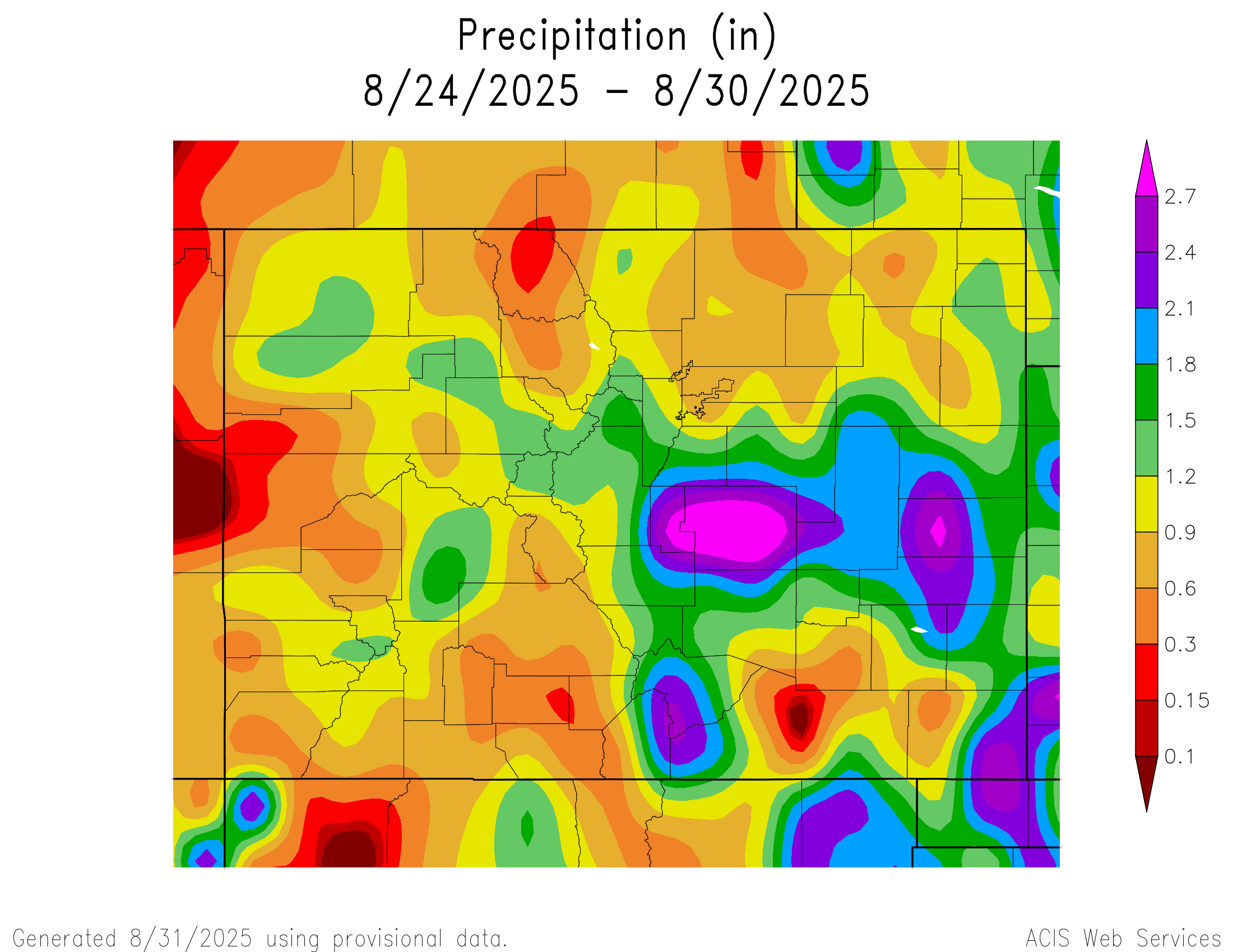
Over 7% of Colorado remains under exceptional drought, and 1.86 million people are experiencing some type of drought, according to the most recent data from the U.S. Drought Monitor, published on Aug. 28. Exceptional drought typically happens about once every 50 years, although parts of Colorado also experienced exceptional drought in 2023. San Miguel County is faring slightly better than much of the Western Slope, although all of the county is under at least severe drought, and the eastern edge is under extreme drought…
Locally, the San Miguel River, measured at the Placerville gauge, ended up at 62% of normal total streamflow volume for the April through July period, and the Uncompahgre River at Ridgway Reservoir was at 66%. The Animas at Durango was also at 62% of median, and the Dolores was at 52%. Some of these streamflows are historical lows…This year’s observed streamflow for the Dolores and Animas is only in the ninth percentile out of more than 100 years of observation…For the most current information on Telluride’s Water Conservation Program, visit bit.ly/totwater or follow @townoftelluride on social media.
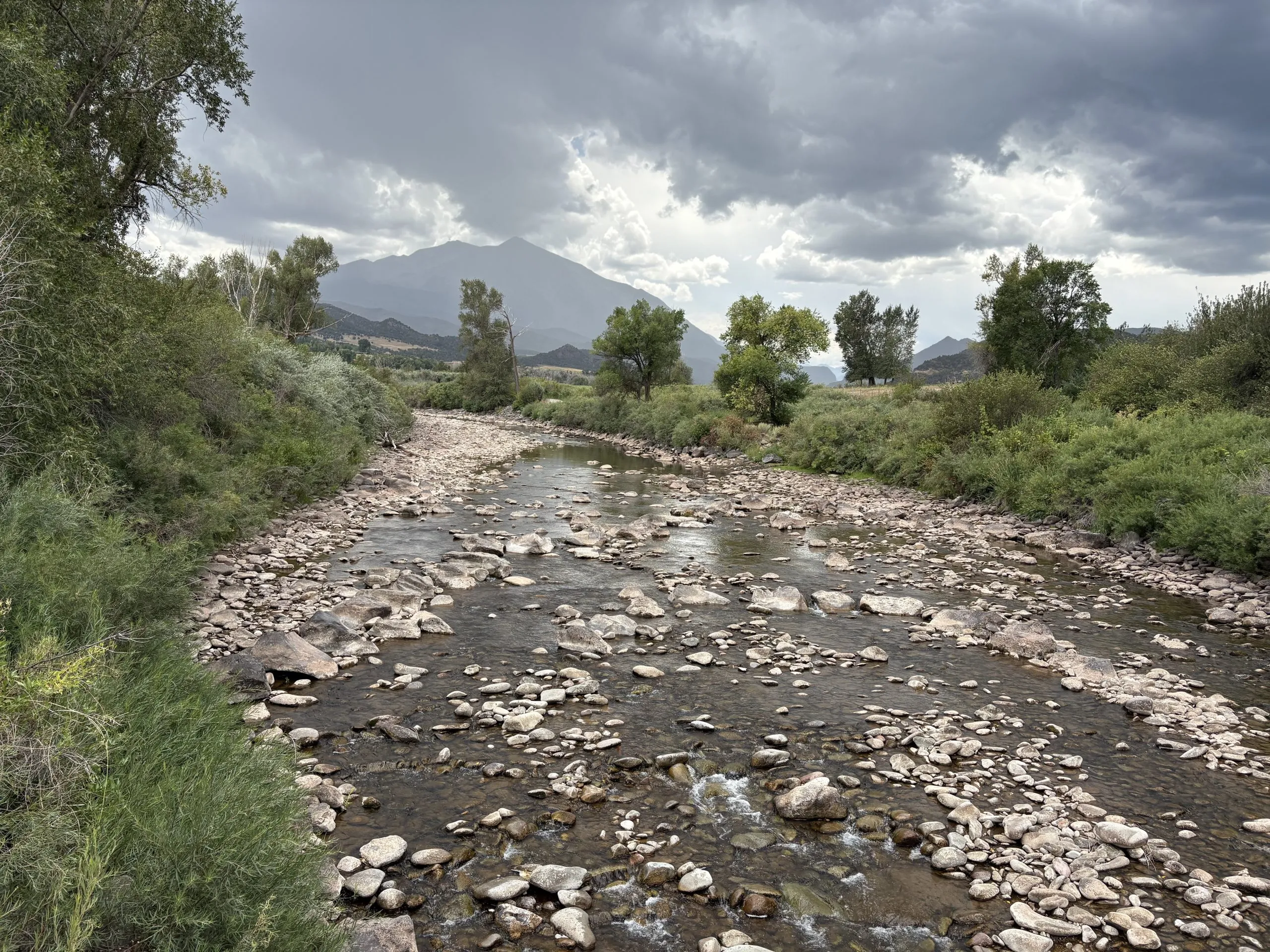
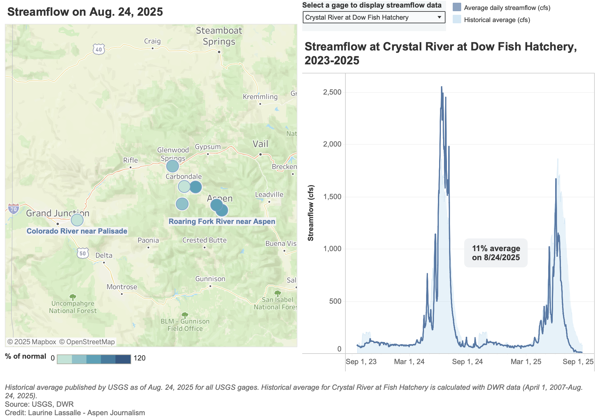
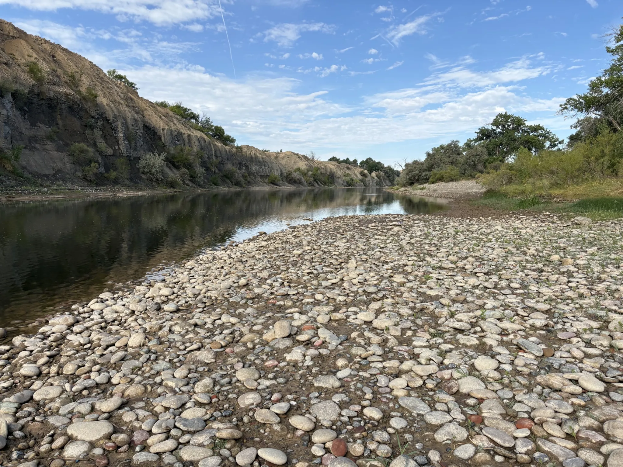
The Crystal River was running under 8 cfs on Aug. 24, 2025. This section of river is downstream of big agricultural diversions and ditches owned and maintained by the Town of Carbondale. CREDIT: HEATHER SACKETT/ASPEN JOURNALISM
Streamflows on the Western Slope have plummeted over the last month, sending water managers scrambling to boost flows for endangered fish and ranking it among the driest years in recent history.
According to the Natural Resources Conservation Service, the Roaring Fork River basin ended the month of July at 28% of average streamflows. The Colorado River headwaters was at 42% of average; the Gunnison River basin was at 34% of average and rivers in the White/Yampa/Green River basin in the northwest corner of the state were running at 24% of average. Prior to this week’s rains, the Crystal River near the Colorado Parks and Wildlife fish hatchery was running at 7.5 cfs, or 10% of average.
“We’ve been seeing pretty widespread well-below-normal flows across the entire upper Colorado River basin due to extremely dry conditions starting back in December,” said Cody Moser, a senior hydrologist with the Colorado Basin River Forecast Center.
For most of August, the Crystal River near fish hatchery was running at less than 15 cfs. These extremely low conditions plus water temperatures above 71 degrees Fahrenheit, prompted CPW to implement on Aug. 15 a full-day voluntary fishing closure on the Crystal from mile marker 64 on Highway 133 to the confluence with the Roaring Fork. This section of the Crystal is downstream from big agricultural diversions and ditches owned and operated by the town of Carbondale.
The upper Roaring Fork River and its tributaries are also suffering the consequences of low flows. On Aug. 25 the Colorado Water Conservation Board placed a call for the minimum instream flow on a seven-mile section of the Roaring Fork through Aspen, between Difficult and Maroon creeks. The call was released the next day after rain boosted flows above the 32 cfs minimum amount.
The CWCB is the only entity in the state allowed to hold instream flow water rights, which are intended to preserve the natural environment to a reasonable degree. It’s not uncommon for the CWCB to place calls for this stretch in late summer and it did so in other years, including 2012, 2018, 2020, 2021 and 2022.
Low flows have also affected recreation at the North Star Nature Preserve, a popular area for paddle boarders east of Aspen. On July 24, Pitkin County implemented a voluntary float closure — asking people to launch at South Gate instead of Wildwood — which occurs when the river falls below 60 cfs.
“At low water levels, users are at risk of touching bottom, which could damage the riparian habitat and would be considered trespassing,” a Pitkin County official said in an email.
Before this week’s rainfall, the Roaring Fork above Aspen hovered around 30 cfs.
Streamflows across the Western Slope are often at some of their lowest points of the year during the late summer and early fall when snowmelt has waned and irrigators are still drawing from streams. But this summer’s lack of precipitation and low soil moisture were the main drivers of dry streams. Much of the Western Slope is in extreme or exceptional drought, according to the U.S. Drought Monitor.
“The biggest factor is the dry spring conditions and layered on top of them a much drier than normal summer,” said Peter Goble, assistant state climatologist. “We will be watching those base flows but also soil moisture levels as we go into fall and early winter to see if those pick back up.”
Dry soils that suck up snowmelt before it makes it to streams can mean a normal snowpack translates into below-normal runoff.
This section of the Colorado River at the boat launch near Corn Lake dipped to around 150 cfs in lake August. Known as the 15-mile reach, this stretch of river should have at least 810 cfs to meet the needs of endangered fish. CREDIT: HEATHER SACKETT/ASPEN JOURNALISM
Stressed out fish
Another area hard hit by low flows is the 15-mile reach of the Colorado River between Palisade and the confluence with the Gunnison River. The chronically dry section is home to multiple endangered fish species and is downstream from some of the biggest agricultural diversions from the Colorado River in the state. Each year water managers work together to time voluntary releases from upstream reservoirs to boost late-season flows for the fish.
But even with many entities working with the Upper Colorado River Endangered Fish Recovery Program, a 2022 memo from the U.S. Fish and Wildlife Service found that during the irrigation season of dry years, flows did not meet the 810 cfs target 39% of the time.
This year, flows have not been above 810 cfs since July 9. And although flows in the 15-mile reach have been climbing since Aug. 23, — up to about 650 cfs on Aug. 27 — nearly all the water in the reach before this week’s rain was attributable to upstream reservoir releases specifically intended for endangered fish. Without releases for the recovery program, flows in the 15-mile reach could have dipped as low as 30 to 50 cfs.
“From my standpoint it’s amazing how a dry year just makes it really hard to get down even a third of that flow target,” said Bart Miller, healthy rivers director with Western Resource Advocates. “It’s a challenging time for water users, but a super challenging time for fish. For the fish it’s a huge stressor.”
This map shows the 15-mile reach of the Colorado River near Grand Junction, home to four species of endangered fish. Map credit: CWCB
This year there was about 29,175 acre-feet earmarked for endangered fish, according to a presentation by program staff. But by Sept. 1 nearly all this water was scheduled to be used up. The nonprofit Colorado Water Trust has stepped in to lease an additional 5,000 acre-feet out of Ruedi Reservoir. The water is owned by the town of Palisade, the Colorado River Water Conservation District and QB Energy. The releases of about 100 cfs are projected to begin Aug. 27 and continue through mid-October, said Danielle Snyder, a water resources specialist with the Colorado Water Trust.
“This particular stretch is very critical for the health of the ecosystem,” Snyder said. “We saw a lot of benefit for both the community and the environment and we thought this would be a great opportunity given we have the capacity and funds to provide water to that region.”
The CWCB will also lease an additional 2,350 acre-feet for fish flows.
Locally dwindling streamflows have big implications downstream. Projections released earlier this month from the U.S. Bureau of Reclamation show the nation’s two largest reservoirs — Lake Powell and Lake Mead — continuing to drop. Lake Powell could drop below the level needed to make hydropower by late 2026. As proof of how dry the month of July was across the basin, inflow to Lake Powell was just 12% of normal.
One bright spot in an otherwise bleak forecast is that parts of the Western Slope are finally seeing some relief from the hot and dry summer with rain this week. But it probably won’t be enough to make up for the months-long lack of precipitation.
“We have been dry for six-plus months so I don’t imagine it will have a significant impact long term, but it’s nice to finally see some precipitation in the forecast and observed over the last day or two,” Moser said.