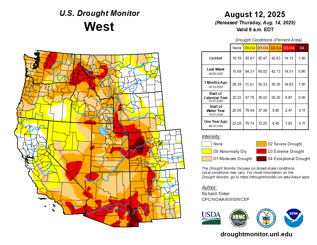
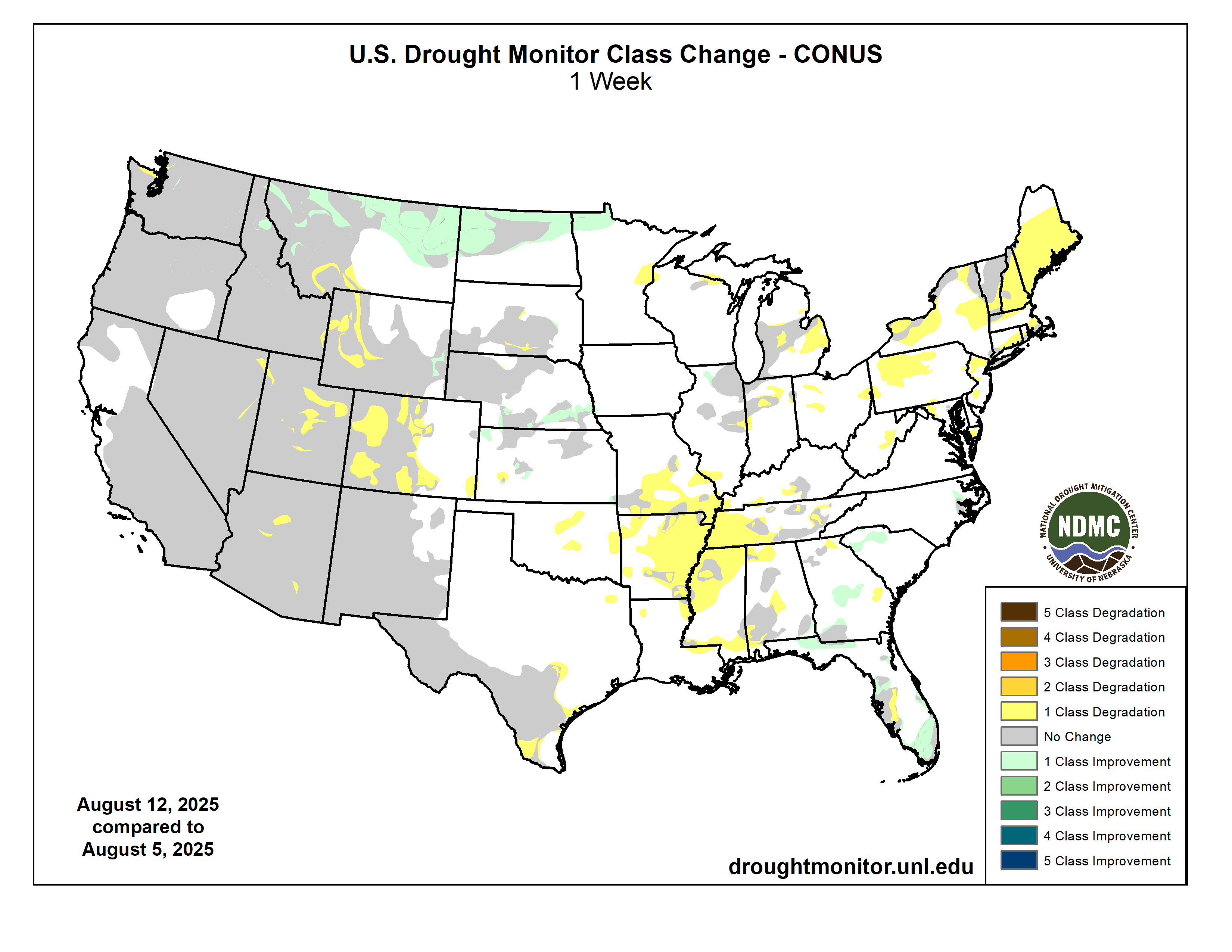
Intensifying short-term rainfall shortages led to expanding and intensifying dryness and drought over much of the Lower Mississippi Valley, Ohio Valley, Tennessee Valley, Northeast, and parts of the Deep South, southern Plains, central Arizona, and the central Rockies. Meanwhile, a second consecutive week with moderate to heavy precipitation led to areas of improvement in the South Atlantic States from the Carolinas through Florida, across northern reaches of the Rockies and Plains, and over parts of the central Great Plains. The heaviest amounts (8 to 11 inches) doused areas in southeast Wisconsin from central Washington and Ozaukee Counties southward through much of north and central Waukesha and Milwaukee Counties. Meanwhile, 6 to 8 inches were dropped on a broader section of southeast Wisconsin as well as a few patches across southeast South Dakota, the Carolinas Piedmont and adjacent southern Appalachians, the coastal Carolinas, north-central Florida, the central Florida Peninsula, and interior southeast Florida…
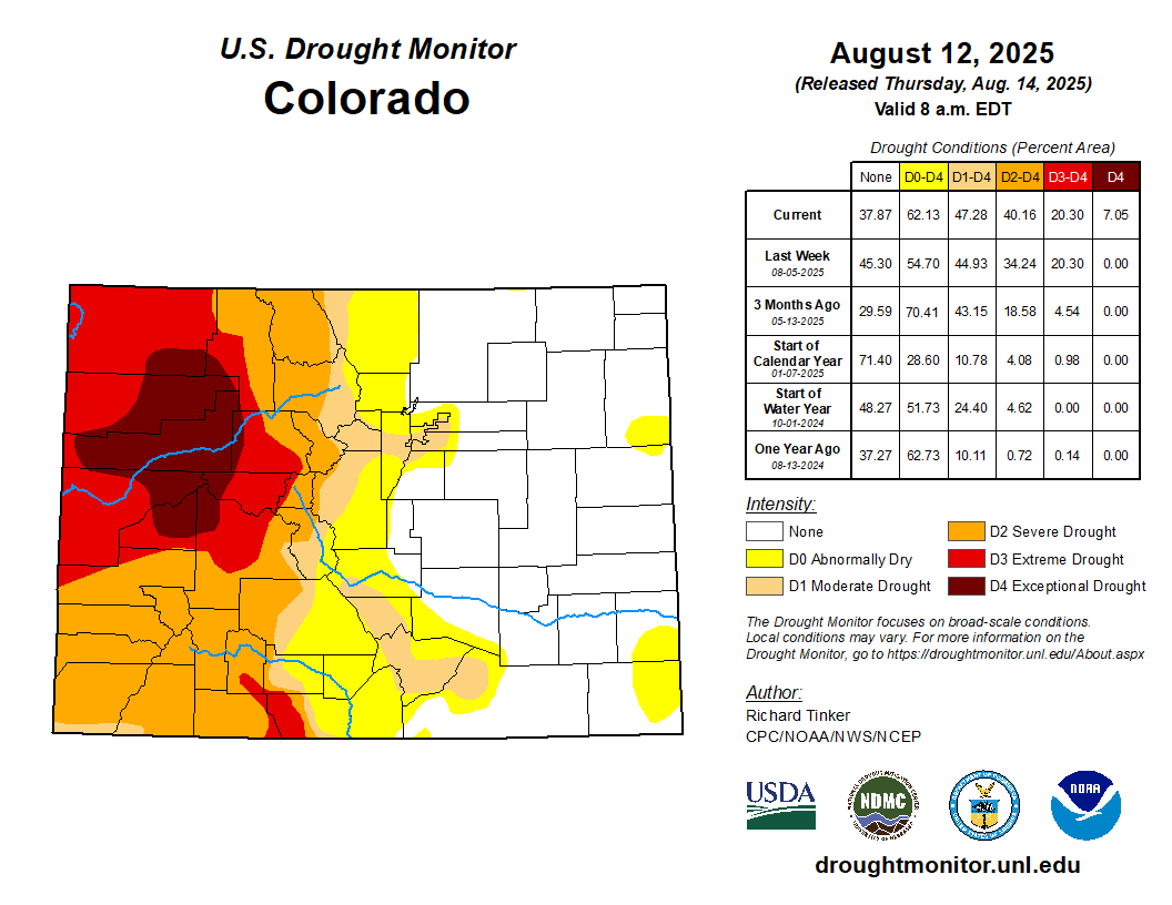
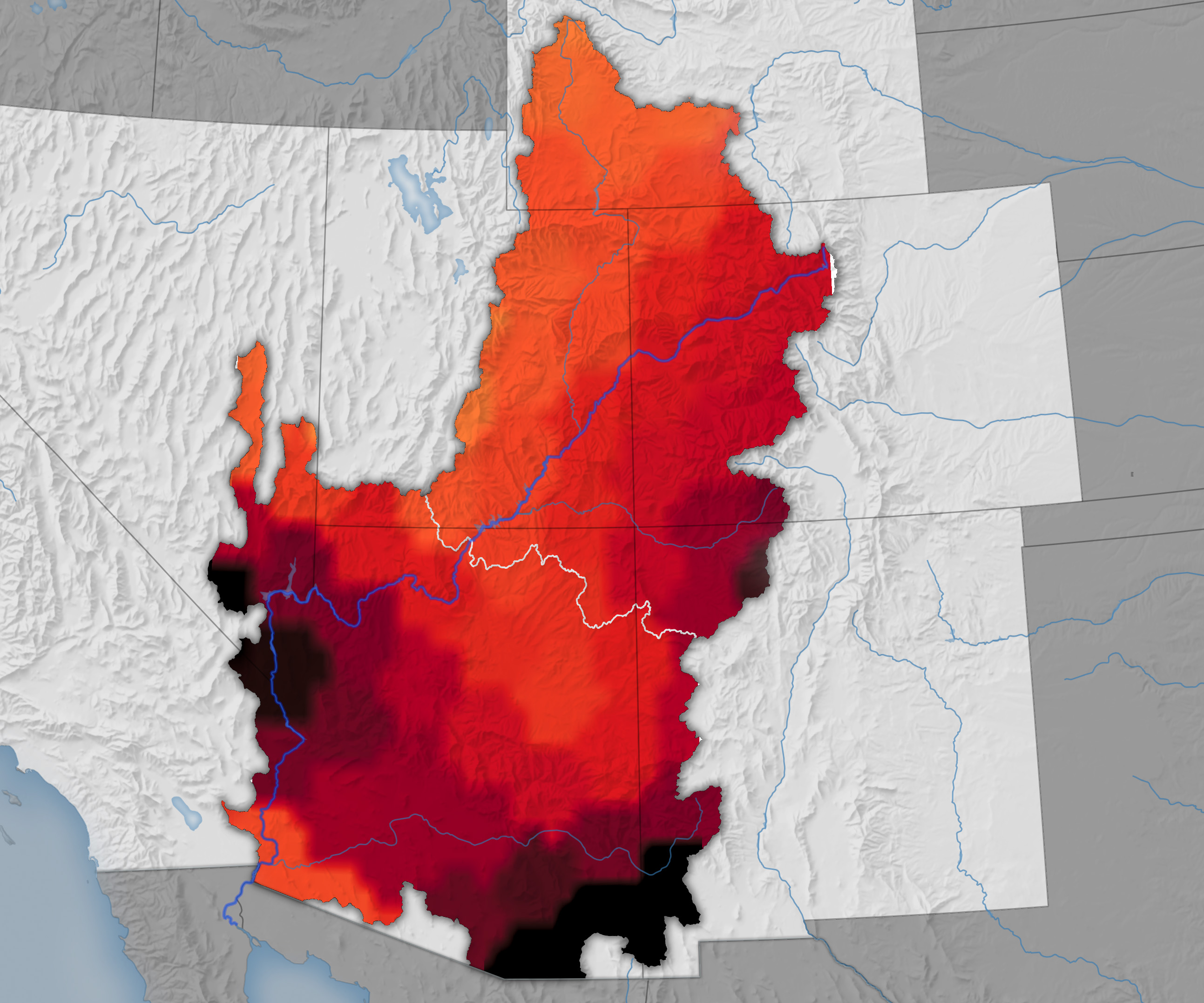
Rainfall varied in intensity across the High Plains Region once again this week, with abundant rainfall amounts falling on much of North Dakota, southern Nebraska, and some spots in Kansas leading to improved conditions. Some improvement was also noted in part of the southeast Wyoming High Plains. Meanwhile, less precipitation kept dryness and drought approximately unchanged across South Dakota, and allowed for areas of intensification for the second consecutive week in central and western parts of Colorado and Wyoming. A sizeable swath of northwestern Colorado deteriorated into exceptional drought (D4), and D2 to D3 conditions expanded in other areas over and near the higher elevations in western parts of the High Plains Region. Since early July, USDA indicated that the proportion of topsoils short or very short of moisture increased from 20 to 32 percent in Colorado, and from 52 to 63 percent of Wyoming. In Colorado, 19 percent of the corn crop is in poor or very poor condition (up from just 1 percent in early July) while in Nebraska, one-third of the oat crop is in poor or very poor condition (up from 5 percent in early July)…
Colorado Drought Monitor one week change map ending August 12, 2025.
Heavy precipitation (one to locally multiple inches in most areas) prompted significant areas of improvement across northern and part of western Montana as well as portions of northern Idaho. Farther south, a few weeks of deficient monsoonal rainfall and above-normal temperatures prompted deterioration in D1 to D3 conditions across southwestern Montana, several swaths across Utah, and a few areas in Arizona and eastern Nebraska. In addition, conditions deteriorated from moderate to severe drought (D1 to D2) in part of northwestern Washington. In other parts of the West Region, dryness and drought was unchanged compared to last week. Outside the northern tier of the Region, very little precipitation was reported outside several tenths to about an inch in southeastern Arizona. The proportion of rangelands in poor or very poor condition increased in the last 5 weeks from 32 to 49 percent in Utah, from 22 to 44 percent in Washington, and from 10 to 34 percent in Idaho. Over half of the Washington spring wheat crop is in poor or very poor condition compared to just 17 percent in early July. During this period, the proportion of Montana spring wheat in poor or very poor condition increased from 37 to 47 percent. USDA also indicated that 53 percent of the Washington barley crop is in poor or very poor condition, compared to just 14 percent in early July…
Patches of moderate to heavy rain were observed over southernmost Louisiana and adjacent Texas, much of the Red River (south) Valley, the southern Texas Panhandle, and the northern tier of Oklahoma. Other areas saw scattered to isolated showers that did not markedly improve any extant dryness. Similar to conditions in adjacent Mississippi, above-normal precipitation earlier in the summer ebbed beginning in early July, and significant short-term rainfall deficits have accumulated over the past several weeks although multi-month precipitation totals are generally near or above normal. In conjunction with hot summertime conditions, this has led to quickly-depleting surface moisture over much of Tennessee, Arkansas, and portions of Louisiana. As a result, D0 conditions have been introduced and expanded rapidly. Farther west, less widespread short-term moisture deficits led to several patches of new D0 this week in western Arkansas, Oklahoma, and northeastern Texas. Farther south and west, some D0 and D1 expansion was noted in Deep South Texas, but dryness and drought were essentially unchanged across New Mexico and the remainder of Texas. USDA indicated that short or very short topsoil moisture covered 60 percent of Tennessee and 80 percent of Arkansas (up from 18 and 39 percent, respectively, in early July). The proportion of the Tennessee cotton crop in poor or very poor condition increased from 12 percent in early July to 26 percent last week…
Looking Ahead
From August 14 to 18, heavy rain (2 to locally 5 inches) is forecast in the higher elevations and coastal sections of Washington and Oregon, and also from the eastern Upper Mississippi Valley through much of the Great Lakes. At least several tenths of an inch of rain, with isolated totals near 2 inches, in areas commonly affected by the late summer and autumn monsoon in the Southwest and higher elevations of central Colorado. Similar amounts are anticipated in the Lower Mississippi Valley, Gulf Coast states, interior Southeast, South Atlantic States, coastal Northeast, northern Plains, eastern Great Lakes, and lower elevations of Washington and western Oregon. Light to locally moderate amounts potentially approaching an inch are expected in the Ohio Valley and scattered locations across the Rockies. Meanwhile, little or no precipitation is forecast across California, the Great Basin, the northern Rockies, the central and southern Plains, and the Middle Mississippi Valley. The National Hurricane Center is forecasting Tropical Storm Erin to move northwestward while strengthening into a major hurricane by the end of the period. Most guidance keeps the system east of the Bahamas and the East Coast, but there is a lot of uncertainty in any forecast hurricane track 3 to 5 days in advance. Rough surf and high waves may impact the East Coast and the Bahamas even if the storm stays well out to sea. Generally above-normal should prevail from the Appalachians westward through central and northern sections of the Plains and Rockies, as well as the coastal Northeast. Temperatures should average closer to normal over the Southeast, the mid-Atlantic, and southern portions of the Plains and Rockies. Cooler than normal weather should be confined to the Great Basin and West Coast States.
The Climate Prediction Center’s 6-10 day outlook (valid August 19-23, 2025) features significant uncertainty in the precipitation outlook. Odds for above-normal precipitation exceeding 40 percent are found in much of southern Arizona and the northern High Plains, and nowhere else. There are, however, fairly broad areas with slightly enhanced chances (33 to 40 percent) for wetter than normal wetter; specifically, from the portions of the Southwest typically affected by the late summer and autumn monsoon through the central and northern High Plains, and the northern Great Plains. Similar odds favoring above-normal precipitation also prevail across the southern Great Plains, the Lower Mississippi Valley, the interior Southeast, the Carolinas, the mid-Atlantic, and the coastal Northeast. Wetter than normal weather is also slightly favored across the northern half of Alaska. Meanwhile, odds lean towards below-normal rainfall in the Northwest and the northern Intermountain West, the Great Lakes, and the St. Lawrence Valley and adjacent New England. Drier than normal conditions are also favored along the southern tier of Alaska while near-normal amounts are expected across Hawaii. Meanwhile, warmer than normal weather is favored over the western half and southeastern quarter of the Contiguous United States, with odds reaching 60 to 80 percent in the central and northern High Plains, the Rockies, and the Florida Peninsula. Unusually warm weather is also favored across the southern half of Alaska, and Hawaii. Subnormal temperatures are favored over the eastern Great Lakes, mid-Atlantic, and Northeast.
US Drought Monitor one week change map ending August 12, 2025.
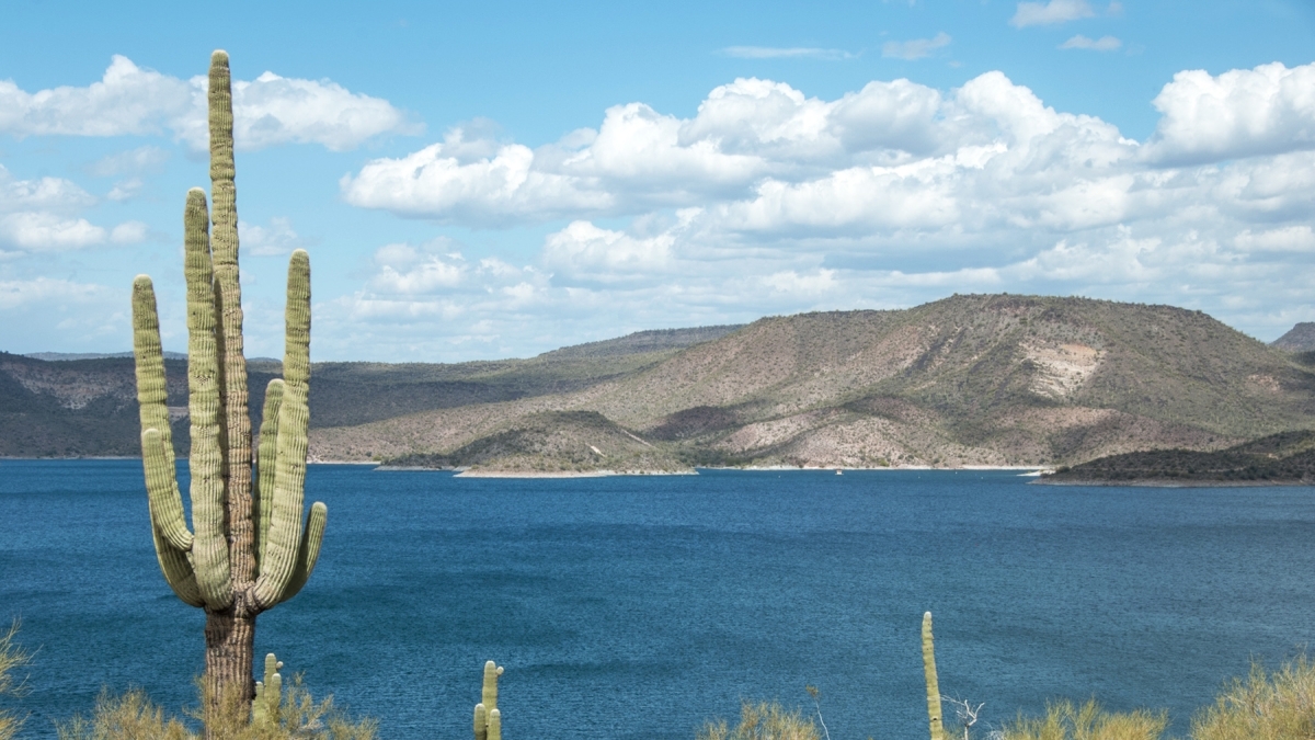
Lake Pleasant (pictured), located north of Phoenix, serves as the Central Arizona Project’s water storage reservoir, as well as being a popular recreational amenity. Water shortages are impacting Colorado River basin reservoirs such as Lake Mead in Nevada and Lake Powell, which stretches across northern Arizona and southern Utah. Environmental changes throughout the Southwest are presenting challenges to maintaining flows. Photo courtesy of Central Arizona Project
Arizona is about to enter a new era when it comes to water rights and distribution.
The state’s main source of surface water — the Colorado River — has been dwindling as a result of climate change and increased water demand.
That means less water for approximately 40 million people in two countries, seven states and 30 Native American tribes. And the rules that govern how states face water cuts are set to expire on Dec. 31, 2026.
The seven states involved have struggled to reach an agreement regarding the future of these cuts. But whatever the outcome may be of negotiations or potential litigation between these seven states, experts say that Valley residents face significant water risks, including:
Arizona could lose up to 40% of its water supply.
The Central Arizona Water Project could be significantly cut and would deliver less water.
The reuse of water will become paramount to the state, including turning wastewater into drinking water.
One Arizona State University expert says not to panic but be prepared to open your wallet.
Rhett Larson, the Richard Morrison Professor of Water Law at ASU’s Sandra Day O’Connor College of Law, estimates water prices could significantly increase in some parts of the Valley if Arizona cannot come to an equitable and sustainable agreement with the other six states on how to share in decreased flows of the Colorado River.
“Arizona is not running out of water. We are running out of cheap water,” said Larson, who is also a senior research fellow with the Kyl Center for Water Policy at ASU’s Morrison Institute for Public Policy. “This means not just higher water rates, but also difficult choices on economic trade-offs — for example, higher food prices due to less water for agriculture but lower housing prices with more water for residential growth.”
ASU News spoke to several water policy scholars to get a behind-the-scenes look at how the seven states are working together on the new agreement, what are some viable options in case of a shortfall, and what Arizona’s future looks like when it comes to its most precious resource.
Udall/Overpeck 4-panel Figure Colorado River temperature/precipitation/natural flows with trend. Lake Mead and Lake Powell storage. Updated through Water Year 2024. Credit: Brad Udall
A ticking clock
Over the past century, the Colorado River’s flow has declined by about 20%. With rising temperatures and declining Rocky Mountain snowpack, scientists have predicted flow reductions of up to 30% by mid-century.
The seven states within the Colorado River basin are under increasing pressure to develop long-term management strategies, as the existing agreements are set to expire at the end of 2026. A significant challenge lies in managing the persistent drought while balancing the requirements of stakeholders, including agricultural interests, urban water consumers, environmental needs and Indigenous rights holders.
In response to a prolonged drought, diminishing storage capacities and increasing demands for Colorado River water, the secretary of the interior issued a directive in May 2005 for reclamation to formulate enhanced strategies aimed at optimizing the coordinated management of the reservoirs within the Colorado River system.
On April 23, 2007, all seven states signed an interim agreement that memorialized the consensus recommendation to the secretary. Those rules have remained in place for the last 18 years, but the flow of recent events demand dramatic action.
“There’s no way that this ends without lower water supplies in Arizona,” Larson said. “Even the best-case scenario means that Arizona will have to make do with less water.”
However, Larson said there’s been progress as of late. He said there is a proposal on the table where the upper basin states would shift the way the water is measured to align more closely with reality.
“There have been some promising breakthroughs, but it could also collapse into litigation,” said Larson, who is representing Arizona in the agreement.
“There’s a decent chance the states of the basin will sue each other in the United States Supreme Court, and who knows how that will play out?” he said.
Options on the table
If the seven Colorado River basin states can’t come to an agreement by the deadline, Arizona does have other water options. Some are legal, some are logistical and some are long shots. And they all come with a price tag.
“Trends are pointing to the fact that the Colorado River is becoming drier and I think it would be safe to say that the Central Arizona Project won’t be as large a provider of water as at present,” said Enrique Vivoni, ASU’s Fulton Professor of Hydrosystems Engineering in the School of Sustainable Engineering and the Built Environment and the director of the Center for Hydrologic Innovations. “So, if that’s the case, it means Arizona will have to start thinking about replacing that water supply. That would require investments.”
Vivoni, whose research focuses on hydrology and water resources, said Arizona has several water augmentation options at its disposal. They include groundwater extraction, water desalination, reservoir expansion, wastewater reclamation and interbasin transfers from other areas.
All these options require complex agreements and investments.
For example, Vivoni said groundwater extraction would require major investment in infrastructure, such as new wells and pipelines to bring water supplies to existing systems. The desalination option could involve paying to build a plant in Mexico in exchange for a portion of their Colorado River water. Expansion of Arizona’s Bartlett Reservoir capacity will require raising the dam to retain more Verde River water.
“All of these options require capital expenses and large operations and maintenance costs on an annual basis,” Vivoni said. “It’s going to require some hard choices. There will be some winners and some losers, and it’s going to require some behavioral changes by individuals, residents, communities, industry and cities.”
By measuring the gravitational pull of water for more than two decades, NASA satellites have peered beneath the surface and measured changes in the groundwater supplies of the Colorado River Basin for years 2015 to 2024. Credit: NASA
Pressure on groundwater
In addition to the costs of tapping groundwater, ASU researchers recently reported that the state’s unseen groundwater losses have been great as well.
Karem Abdelmohsen, Jay Famiglietti and colleagues used orbiting satellites to measure changes in groundwater from 2002 to 2024 in the Colorado River basin, in comparison to losses in streamflow and reservoir storage.
The satellite study found that groundwater depletion accounted for more than half of the total water storage loss in the upper Colorado River basin and more than two-thirds of losses in the lower Colorado River basin, which is greater than the losses in lakes Powell and Mead.
“The rate of depletion has actually accelerated over the last decade,” said Famiglietti, science director for ASU’s Arizona Water Innovation Initiative.
With less access to water from the Colorado River, demand for groundwater will grow. Famiglietti said that the effectiveness of groundwater management varies across the Colorado River basin states, leaving the resource open to overexploitation.
Cautious optimism abounds
If the seven states don’t come to an agreement soon, one possible scenario is that the secretary of the interior would make unilateral decisions on cuts and deliveries. Such actions would likely lead to lawsuits challenging the secretary’s authority to do so.
“Not having a consensus agreement in place means we could go from relative certainty about the conditions of shortage to total uncertainty,” said Kathryn Sorensen, who oversees the research efforts of the Kyl Center for Water Policy, serves as a professor of practice at the Watts College of Public Service and Community Solutions and contributes to the Global Futures Laboratory. “What we don’t want is someone making those decisions for us.”
That lack of certainty could lead to many drawbacks, according to Sarah Porter, director of the Kyl Center for Water Policy.
“Being in the dark about this situation could lead to higher (water) prices,” Porter said. “It could also lead to a disruption in economic development and the state’s prosperity. Not having clarity regarding how much water will be available over the long term could impact the state’s ability to attract industry. If there’s too much uncertainty about our long-term water supplies, then we’re not a good bet for investment.”
But water scarcity is not a new issue for Arizona. The state has a history of managing limited resources for collective benefit.
And that’s reason for hope as the state faces these current challenges.
“If you look at the history of water management in the Phoenix area, it’s a story of adaptation and overcoming obstacles and finding ways to be innovative,” Sorensen said. “We know how to do more with less, and we’re good at it.”
We’re also good at problem-solving and finding solutions, Porter said.
“I’m very optimistic about our water future because we’ve had over 100 years as a seven-state basin to figure out solutions,” Porter said. “I’m also optimistic because I’ve seen how creative and dedicated Arizona municipal water managers are — they’re resourceful, prepared and have their short- and long-term plans in place.
“I think there’s going to be water to help us enjoy a good quality of life and a thriving economy for central Arizona for a long time.”
ASU News reporter Joe Rojas-Burke contributed to this article.
Map of the Colorado River drainage basin, created using USGS data. By Shannon1 Creative Commons Attribution-Share Alike 4.0
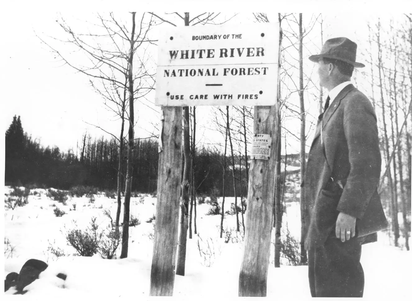
An undated historic photo shows the U.S. Forest Service ranger near the Mount of the Holy Cross. Before the turn of the 20th century, public lands lacked formal protection. “Nowhere has the strength and vitality of America been better reflected in the last 100 years than in the evolution of the National Forest System,” a forest official wrote in 1990. CREDIT: U.S. FOREST SERVICE
Editor’s note: This story is part two of a three-part series examining the notion of public lands, both in the United States and in our region. Part one looks at the earliest expressions of the commons in territories that would become the United States. Parts two and three look at the history and legacy of what is now the White River National Forest.
The evolution of the White River National Forest (WRNF) in just over a century mirrors the settlement of the American West — from an unregulated, free-for-all wilderness to strategically managed industrial tourism and sustainable, extractive industries. As the WRNF formed, it refined its management purview over user groups as they expanded from traditional timber and ranching to the ski areas, recreation sites and wilderness terrain that define the forest today.
Beginning with its original designation as a forest reserve in 1891, forest management was besieged by militant factions that argued against any management at all. This was an era when user groups included homestead farmers, fiercely independent ranchers and opportunistic loggers. Shrill denunciations and blatant noncompliance often occurred with these original land claimants who argued that public lands should be designated for those who came first and that its uses should be for what was best for them alone. Only as the forest adapted to changing times and needs did the multiuse mandate create opportunities and protections for all.
A prime example was Fred Light, a traditional rancher in the Roaring Fork Valley from the 1880s who at first resented the overlay of federal control over lands where he and other ranchers had grazed their cattle with no oversight and no fees. Light later came to appreciate the forest as it protected his interests from other users who threatened to overrun grazing lands, usurp water from the range or, in other ways, impinge on grazing entitlements. Light’s shift in temperament and his eventual willingness to follow forest regulations reflected a growing, if reluctant, acceptance that management principles are essential for all forest users to ensure equal access to the public commons.
Light’s transformation spread to other users as complexities arose around the need for sustainability. As a result, the forest mission grew into the broader interpretation of what is the best and highest use for all. This egalitarian approach required a deep and pragmatic exploration of values and resources that led to accommodating conflicting interests.
In the early days of the WRNF, however, forestry officials were immersed in countless disputes and occasional violent conflicts. Rangers were harassed, beaten and fired upon as they performed their duties according to the evolving directives of forest administrators. Juggling over the ensuing decades the utilitarian and esoteric aspects of this remarkably diverse topography of mountains, valleys, meadows, forests and rock-and-ice alpine splendor has required scientifically based and diplomatically advanced regulations to avoid the impacts of overgrazing, timber clear-cutting, mining, overcrowded recreation and other issues yet to surface.
Through it all, the WRNF remains public land — 2.3 million acres (3,593.75 square miles) of the most visited national forest in the United States, stewarded by rangers trained with the necessary skills of backwoodsmen, diplomats, defenders, peacemakers, resource managers and ecologists.
The story of the WRNF is therefore a weave of time and place, and of a people for whom the forest is both an economic lifeblood and a battleground for conservation and preservation. For many, the forest is a place of sacred, cherished, iconic and legacy landscapes in which any and all visitors may experience and celebrate the power and splendor of pristine nature.
The White River Plateau Timber Land Reserve, the second federal forest reserve to be created, came into existence in 1891 and has evolved into the White River National Forest we know today as the most visited national forest in the country. Its management purview reflects two centuries of tension between exploitation and preservation for the greater good. CREDIT: U.S. FOREST SERVICE
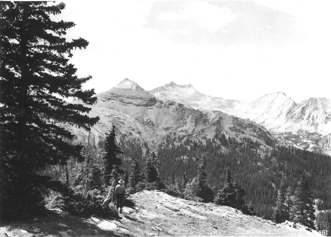
Snowmass Mountain is shown in a historic U.S. Forest Service photo. The architecture of the White River National Forest was determined by vast and nearly incomprehensible geologic forces that shaped the mountain landscapes we see today. CREDIT: U.S. FOREST SERVICE
Public lands with no protection
In a foreword to Justine Irwin’s unpublished manuscript “White River National Forest: A Centennial History,” Thomas Hoots, the WRNF supervisor in 1990, led off with a crucial observation: “Before the turn of the century, the public lands were without a protector.” The national commons was being plundered and exploited by whoever got there first. Such was the opportunism that was rampant during the fever of westward expansion marked by Manifest Destiny and a willful disregard to impose limits on human agency.
This land hunger was described the following way by Gifford Pinchot, chief of the U.S. Forest Service from 1898 to 1910 and one of America’s original wise use conservationists: “There is no hunger like land hunger, and no object for which men are more ready to use unfair and desperate means than the acquisition of land.”
Pinchot led a growing advocacy for conservation of national resources against great odds as they lobbied for protection of federal lands from the unbridled influences of capitalistic greed.
Richard A. Ballinger, secretary of the interior from 1909-11, clearly defined a prevailing view: “You chaps who are in favor of this conservation program are all wrong. In my opinion, the proper course to take with regard to [the public domain] is to divide it up among the big corporations and the people who know how to make money out of it.”
Thanks to those with clearer vision for a public lands legacy for America, the world and for future generations, Ballinger’s idea did not come to fruition. And yet such has been the message from the transactional Trump administration as the monetization of public lands offers yet again the potential for financial gain.
Thirty-five years ago, Hoots described a different ethic: “The nation’s leadership recognized this dilemma and so began the long climb towards public land and resource management as we know it today. Nowhere has the strength and vitality of America been better reflected in the last 100 years than in the evolution of the National Forest System.”
Gifford Pinchot portrait via the Forest History Society
The WRNF is an integral part of that system. It is also a stellar example of a forest that has withstood numerous threats and, despite many compromises toward achieving the multiple-use mandate, has retained the conservation principles that has made it one of the most successful stories of land management in the United States. “The strength of our nation,” concluded Hoots on the centennial of the WRNF, “demands nothing less of the stewards of these public resources.”
Federal forest management dates to 1876 when Congress created the office of special agent in the U.S. Department of Agriculture to assess the quality and conditions of forests in the United States. In 1881, the department expanded the office into the Division of Forestry. A decade later, Congress passed the Forest Reserve Act of 1891, authorizing the president to designate public lands in the West into what were then called “forest reserves.”
Enter what would become the White River National Forest, the preliminary boundaries of which were drawn on federal maps under the direction of administrators in Washington, D.C. These long-distance planners for a realm of national treasures gazed over mountainous regions whose value they could only speculate, but which they reasoned were valuable in ways other than extractive, fast-buck profits measured only in capital gains for the few.
Responsibility for these reserves fell under the Department of the Interior until 1905 when President Theodore Roosevelt transferred their care to the Department of Agriculture’s new division: the U.S. Forest Service. Pinchot led this agency as its first chief, charged with caring for the newly renamed public commons.
The WRNF was created as the White River Plateau Timber Land Reserve on Oct. 16, 1891, by President Benjamin Harrison. This reserve was the second oldest in the newly conceived forest system, after a reserve established east of Yellowstone National Park, which two decades earlier became the country’s first national park. The WRNF would become the largest forest in Colorado when, in 1945, it absorbed the Holy Cross National Forest, created as a reserve in 1905. This newly defined national forest was a priority because it was being exploited with unsustainable resource extraction. It soon earned a place of immeasurable importance in the mosaic of public lands designated across the rugged western United States.
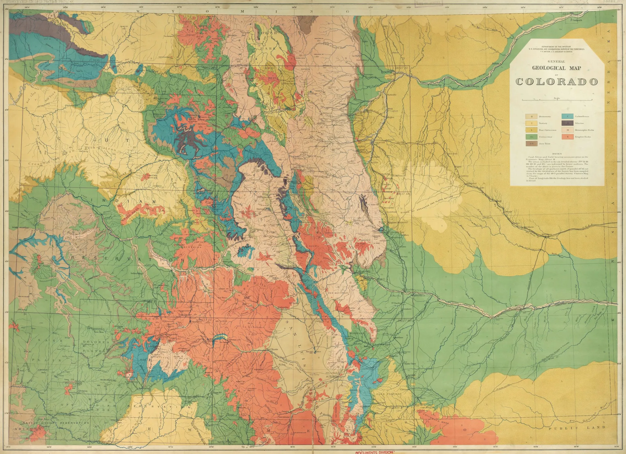
A geologic map of Colorado, produced by the survey team led by Ferdinand Hayden in 1873-74, helped draw prospectors to the mountains. CREDIT: DENVER PUBLIC LIBRARY
Nature laid the foundation
The architecture of the WRNF was determined by vast and nearly incomprehensible geologic forces that shaped the mountain landscapes we see today. Precambrian granite is the bedrock that was heaved up, twisted, broken, eroded and later covered with beds of sandstone and, later still, covered with an inland seaway that stretched from Mexico to Canada.
That seaway propagated plant and marine life-forms that speak to a far-different climate and ecology than today and that would eventually, under enormous pressure, form into huge coal deposits. This Cretaceous Seaway then gave rise to new landscapes as several major uplifts shed the accumulated water into major river systems and began building the mountain peaks rising from the bedrock floor. The uplifting, some from magma upwelling, brought metals and minerals to the surface where they were dissolved in super-heated groundwater and conveyed in solution into bedrock faults and fissures where they precipitated out at concentration. This formed the veins that gold and silver miners would later extract through labyrinthine tunnels and shafts.
Glaciation sculpted the finishing touches on the landscape by paring mountains into ragged escarpments and precipitous arêtes, and gouging deep U-shaped valleys where glacial runoff cut deeper still in the V-shaped drainages that we see today. Nature’s work is never complete, and so the mountains and valleys continue to be formed by erosion and an almost immeasurable continued uplifting from energies emanating from Earth’s depths.
Then biology stepped in and established an overlay of life, the flora and fauna that we see today inhabiting the niches where they are genetically suited to proliferate and thrive. These are the desert scrublands, grassy meadows, mixed forests and lichen-covered alpine terrain comprising a half-dozen life zones and multiple ecosystems that give the WRNF the diversity that characterizes a healthy and vibrant ecology.
The forest is home to one of the largest mule deer herds and one of the largest elk herds in the nation, as well as bighorn sheep, mountain goats, black bears, mountain lions, snowshoe hare, marmot, porcupine, badger, marten, ground squirrels and chipmunks, hundreds of bird types, and thousands of plant species in a veritable Garden of Eden of biodiversity.
But the human stories are what capture our imaginations, as noted in Irwin’s WRNF Centennial History; the people of the forest have differed greatly in their relationship to it: “Some have loved her, some have abused her, some have hated her, but all have made her what she is today.”
A map shows the route of the 1776 Dominguez-Escalante expedition, led by two Spanish priests trying to find a way from Santa Fe to California. They reached Utah Lake before turning back, becoming the first Europeans to explore a vast portion of what would later become Colorado and Utah. CREDIT: WIKIMEDIA COMMONS
The first Europeans
The first Europeans to visit the region of the WRNF and enter the traditional homelands of the native Utes were Spanish Franciscan friars Fray Silvestre Velez de Escalante and Fray Francisco Atanasio Dominguez. The two explorers and their party left Santa Fe on an ambitious exploratory mission to find an overland route to the Roman Catholic mission in Monterey, in what later became California. They ventured into the Western wilderness in July 1776, the same year the American colonies declared independence from British rule.
After traversing what is now northern New Mexico and southwest Colorado, the party traveled north, eventually passing through the Paonia area and Muddy Creek. They met the Colorado River near Divide and Mamm creeks along the Grand Hogback, a diagonal sawtooth range near Silt and New Castle. With Ute guides, they crossed the White and Green rivers, making it as far as what is now known as Utah Lake along the Wasatch Front, where they encountered a thriving indigenous community. With winter approaching, the party turned back toward Santa Fe and faced starvation as they struggled to cross the Colorado River at a location now flooded by Lake Powell, but all made it back alive.
The Louisiana Purchase of 1803 opened the door to more exploration, this from the east where a few adventuresome parties reached Colorado’s Front Range. The towering Rockies were considered too severe an obstacle to pass through, except for freelancing traders and trappers who knew no bounds and no limits in their pursuit of trade and beaver pelts.
A French trapper, Antoine Robidoux, was perhaps the first Anglo to trap in the White River in 1825, harvesting beaver pelts from Trappers Lake on the north side of the Flat Tops. The Yampa Valley, to the north, became widely visited by mountain men such as Jim Bridger, Kit Carson and Jedediah Smith.
John Fremont, an Army officer and explorer, took part in an 1845 journey that crossed Tennessee Pass from the Arkansas River basin and then followed the White River into Utah. Credit: Wikimedia Commons
The seizing of Texas from Mexico in 1836 by Sam Houston stretched the promising Western U.S. boundaries, inviting more visitation as manifest destiny became a divine entitlement for Western settlement and provided a God-given mandate to force out native peoples and exploit the land and its many resources.
In 1845, John Fremont, guided by Carson, crossed Tennessee Pass from the Arkansas Valley and along the White River to Utah. With the announcement that gold had been discovered in California, streams of fortune-seekers flowed west through Colorado, many of whom recognized the grazing potential of verdant mountain valleys well-watered by rolling streams and rivers. After striking out on California gold, some returned to what would, in 1876, become Colorado to farm and raise cattle. The discovery of gold along Cherry Creek, near today’s Denver, made Colorado a hot new prospect in 1859, popularizing this mostly unmapped territory.
The next year, 1860, Capt. Richard Sopris, for whom Mount Sopris is named, prospected the Roaring Fork Valley with a party of 14. In journals, it was mentioned that they stopped to take in the soothing waters of Yampa Hot Springs at today’s Glenwood Springs. The Homestead Act was passed by Congress in 1862, encouraging more western migration and providing a relief valve for growing national tensions during the Civil War.
Official U.S. survey teams were sent west to report on resources and tribal relations. Foremost among them was John Wesley Powell, a Civil War veteran who had lost his right arm in the Battle of Shiloh, but it didn’t impede him from exploring the Green, Yampa, White and Colorado rivers. By the early 1870s, cattlemen began grazing their herds in Brown’s Park and the Meeker area in what would become northern Colorado.
As permanent settlements became established, some officials in the federal government became aware that Western lands had no protective management. They garnered congressional funding for a particularly seasoned survey team under the leadership of Ferdinand Vandeveer Hayden, who would later win acclaim for surveying Yellowstone. Hayden’s 1873-74 visits to the Gunnison Country, the Roaring Fork Valley and the White River produced maps that would later draw hordes of mining prospectors into Ute lands in the late 1870s.
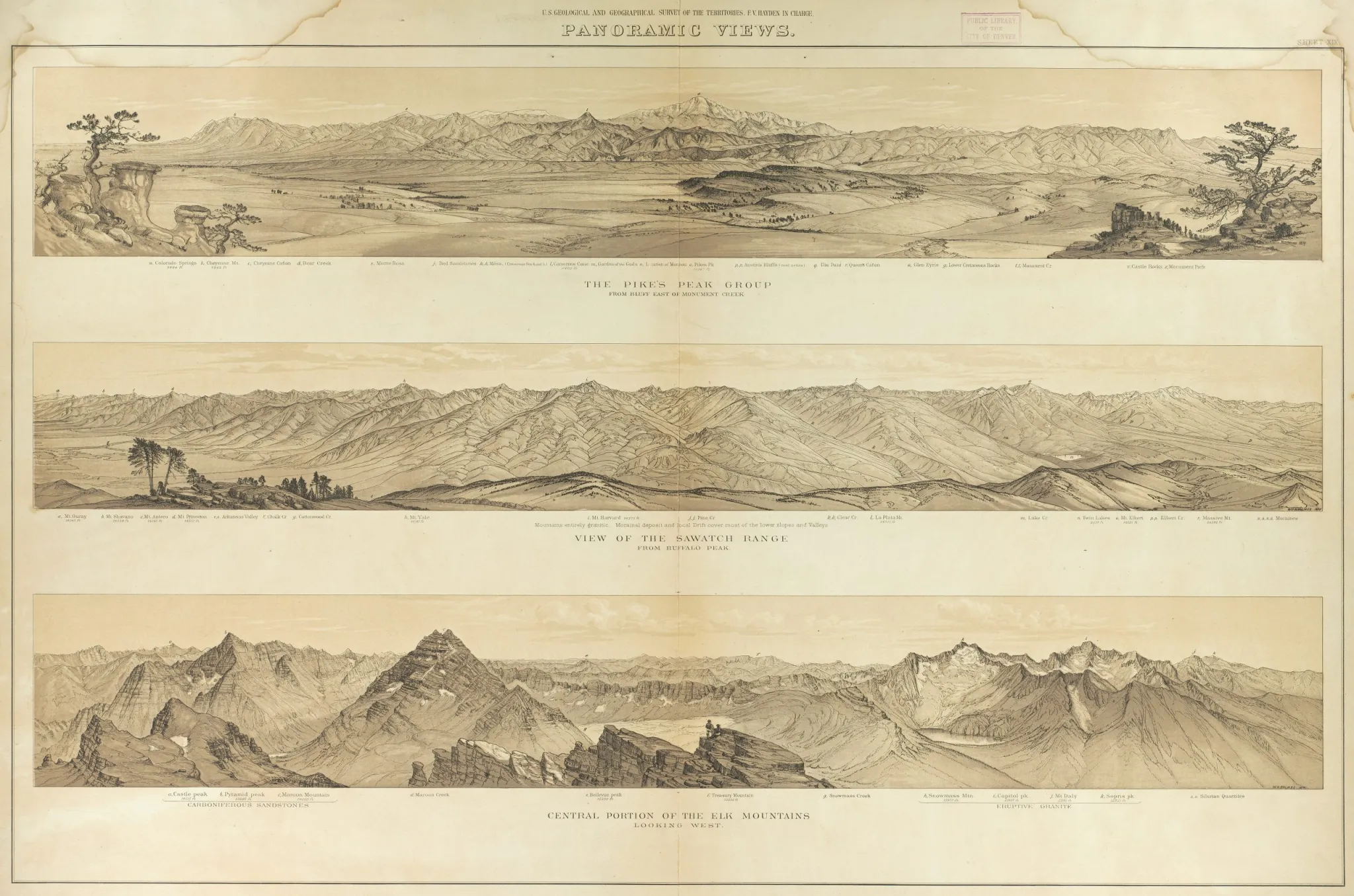
The Hayden Survey produced detailed drawings of multiple mountainscapes across Colorado, including these depictions of Pikes Peak, the Sawatch Range and Elk Range. CREDIT: DENVER PUBLIC LIBRARY
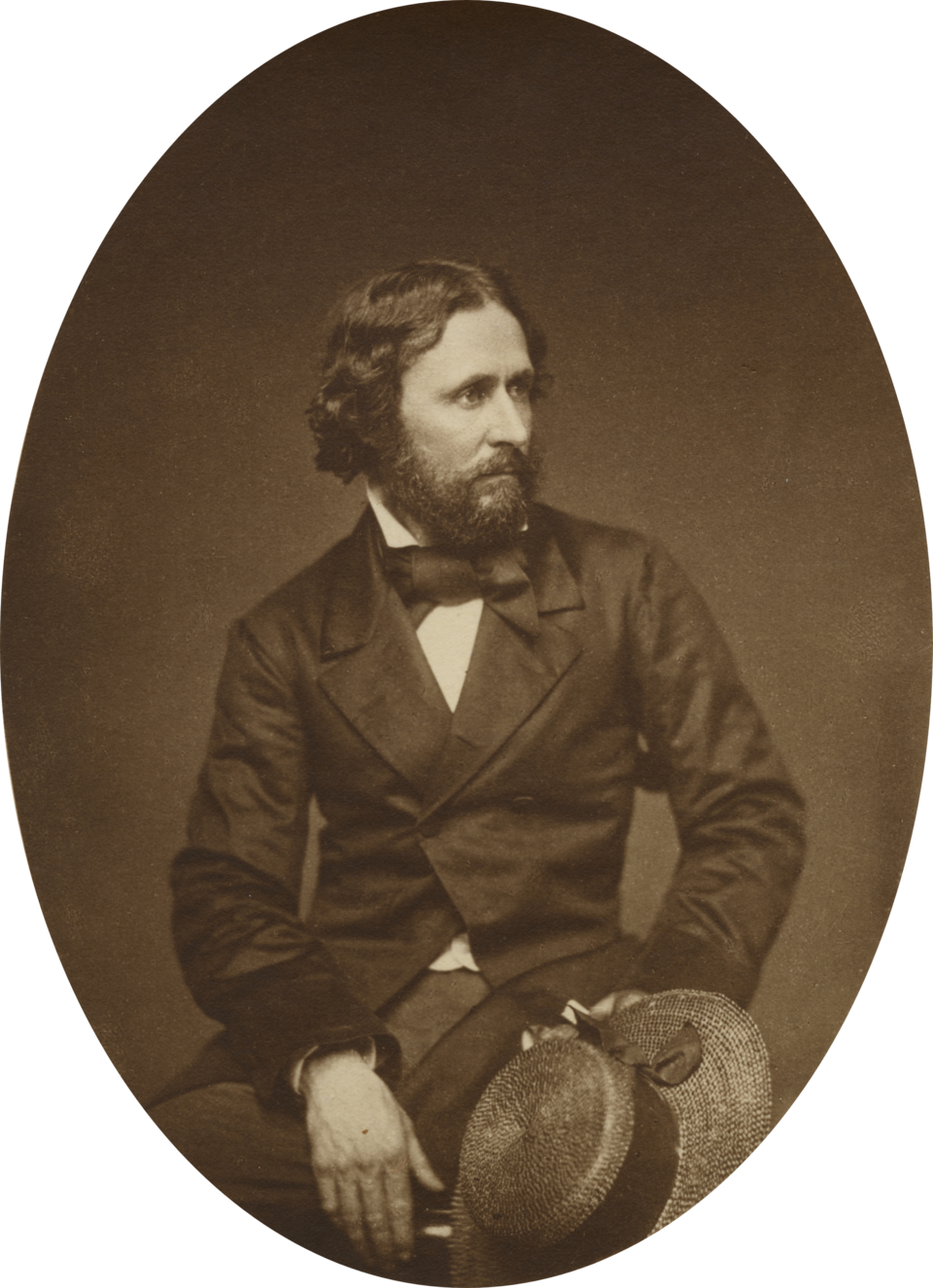
Hayden and his “Rover Boys,” including renowned photographer and artist William Henry Jackson and geographer Henry Gannett, for whom the highest peak in Wyoming is named, summited, triangulated, mapped and named most of the major peaks that we know and climb today. The scientific acumen that this team provided was monumental in their understanding of geology, flora and fauna. Hayden correctly referred to the Elk Mountains as an example of an “eruptive range” and a “geologic jumble” for the upheavals he recognized. Described as “tall, slender, with soft brown hair and blue eyes,” Hayden, a consummate geologist, was given a nickname by the Utes that translated to “crazy man who runs around picking up rocks.”
A letter from Rover Boy J.T. Gardner to his daughter in New York state characterized what must have been a crowning moment in history to witness a pure wilderness: “We are in full tide of successful career camping almost every night at 11,000 or 12,000 feet and climbing peaks 14,000 feet and over, their tops overlooking crested ridges and grand rock-walled amphitheaters where old glaciers were born, I cannot tell you how I am enjoying this wonderful region. … What a sweet sight. … The terrible grandeur around me here where life is represented by the grim bears crawling along the edges of perpetual snow fields or the mountain sheep scaling the shattered crags.”
In a later letter, Gardner described the party’s discovery of Mount of the Holy Cross where a horizontal ridge and vertical couloir form a snow-filled cross. “We are undoubtedly the first who have ever reached this peak. I do not feel in the least over-fatigued and am very well and strong.” Enduring an early-winter storm, Gardner wrote: “On this climb I wore four heavy shirts and a thick buckskin coat. The snow blew so that I had to wear spectacles to protect the eyes.”
Hayden spent 20 days nursing a sick member of the party at the base of Mount Sopris while his party explored the Crystal River Valley, with Jackson photographing it all. Unfortunately for history, Jackson’s load-bearing mule stumbled and fell into the Crystal River, breaking the glass plate negatives. All photographic documentation from that portion of the survey was lost.
Nonetheless, Hayden’s Atlas of Colorado was published by the U.S. Department of the Interior in 1877, featuring six finely drawn resource maps identifying forests, pastures, croplands, and regions of coal, gold and silver. These geologic maps became a spur for treasure-seekers eager to flood into Ute lands. And there lay the age-old conflict between European trespass on the Western Slope of Colorado still controlled by the Utes under treaties, later broken, that were doomed at keeping the peace.
This story, and Aspen Journalism’s ongoing coverage of challenges facing local public lands, is supported by a grant from the Fund for Investigative Journalism.