Click on a thumbnail graphic to view a gallery of drought data from the US Drought Monitor website.


Click the link to go to the US Drought Monitor website. Here’s an excerpt:
This Week’s Drought Summary
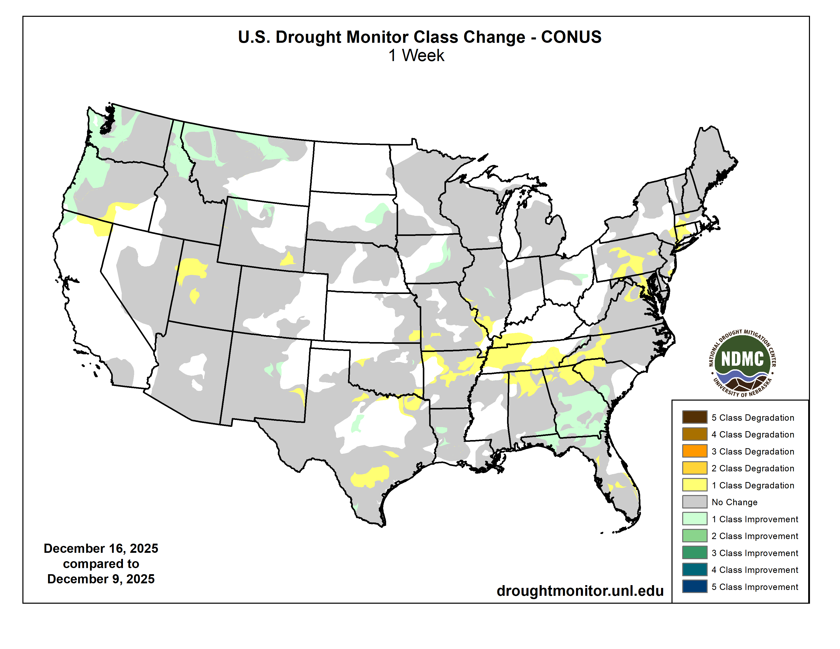
This week, temperature and precipitation patterns varied sharply across the country. Temperatures were generally warmer in the West and colder in the east, with much of the Cascades and Rocky Mountains running well above normal while the Midwest experienced much colder-than-normal conditions. Multiple Pacific storm systems brought widespread precipitation to the Pacific Northwest and northern Rockies, falling as rain at lower elevations and snow in the mountains; however, despite recent snowfall, snowpack remains below normal for mid-December. East of the Rockies, precipitation was more limited and uneven, and where it did occur across the northern Plains and Midwest, it often fell as snow. As a result, drought conditions improved mainly across parts of the Pacific Northwest and northern Rockies. Additional localized improvements occurred in parts of the Southeast, where lingering benefits from rainfall in prior weeks continued to support soil moisture and streamflows. In contrast, areas farther south and east that missed meaningful precipitation saw conditions persist or worsen. Across portions of the southern Plains, lower Mississippi Valley, Ohio Valley, Mid-Atlantic, and Northeast, continued precipitation deficits and declining streamflows led to degradations. In the Midwest, colder temperatures limited precipitation to fall as snow, slowing hydrologic response and resulting in mostly localized changes…
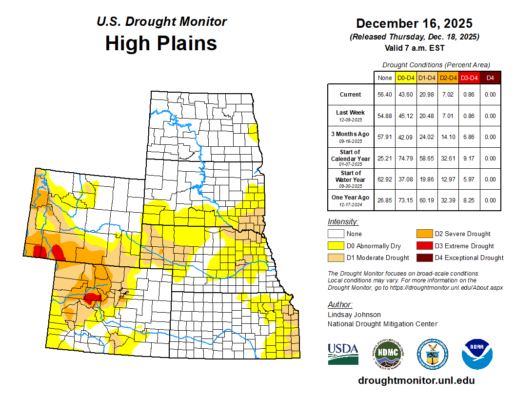
High Plains
The High Plains remained largely unchanged this week. Areas of less than one inch of precipitation fell across some areas of the Dakotas and northeastern Wyoming. In east-central South Dakota, this precipitation led to minor improvements with the removal of some abnormal dryness (D0). Nebraska, Colorado, and most of Kansas remained unchanged. In southeastern Kansas along the Kansas-Missouri border, hydrologic deficits led to further deterioration and the expansion of moderate drought (D1). In southeastern Wyoming, frequent strong winds and above-normal temperatures combined with continued lack of precipitation contributed to further degradation and the expansion of moderate drought (D1)…
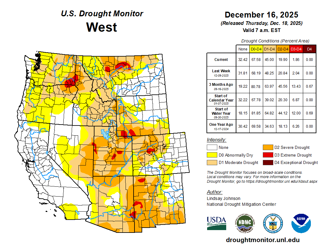
West
Across the West, drought changes were mainly determined by precipitation. In Washington and northern Oregon, multiple Pacific storm systems, associated with atmospheric river moisture, brought widespread precipitation to the Pacific Northwest. Precipitation fell mainly as rain at lower elevations and snow in the mountains, contributing to ongoing flooding in parts of western Washington and supporting widespread one-class improvements along the coast and nearby interior areas. Since the end of November, snowpack in the Cascades has slightly improved, though snow water equivalent (SWE) values remain below normal for this time of year, particularly where warmer temperatures limited snow accumulation. Across central and southern Oregon and into northern California, conditions show rapid short-term drying. [I spoke with Jeff Deem (Airborne Snow Observatories Inc.) at the Colorado River Water Users Association conference last week and he said that he flew over Lake Tahoe recently and there was NO SNOW.] However, last-minute (Dec. 15-16) rainfall of 1 to 2 inches along Oregon’s coast was enough to bring improvements where it fell while the areas that missed out on the precipitation saw abnormal dryness (D0) expanded.
In the Northern Rockies, repeated precipitation supported one-class improvements across northern Idaho and northwestern Montana. Lower elevations experienced rain or mixed precipitation, while higher elevations received snow, leading to SWE improvements in northern and central Idaho and western Montana. Despite this week’s precipitation, much of Idaho’s snowpack remains below normal with SWE at 70 percent of normal, while snowpack across western and central Montana showed the greatest improvement, with SWE near or above 90 percent of normal for this time of year. Farther east and south across central and western Montana, more widespread precipitation supported a swath of one-class improvements.
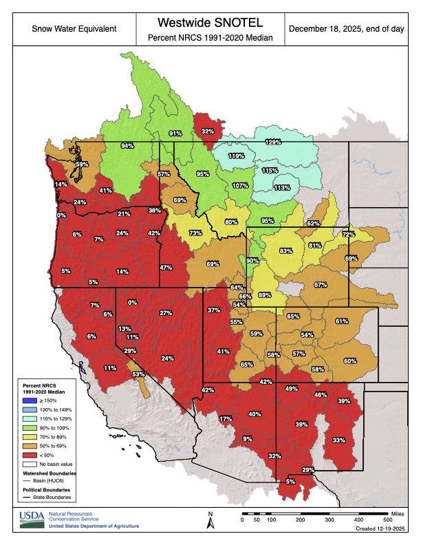
Across the central Rocky Mountains of Wyoming and Colorado, conditions were more mixed. Portions of the north-central Rockies received enough snowfall to lead to localized improvements, with SWE in some headwater areas approaching near-normal early-season levels. Elsewhere, c. Across much of western and central Utah, SWE remains below 50 percent of normal, supporting one-class degradations in north-central and central Utah. In the Southwest, localized changes were made in New Mexico, with improvements in central New Mexico where longer-term precipitation from earlier periods continued show hydrologic improvement, while precipitation deficits led to the expansion of moderate drought (D1) in the southeast part of the state…
South
Drought conditions across the South generally worsened this week, as limited precipitation did little to improve the growing moisture deficits. Louisiana and some areas of Mississippi saw some improvements due to precipitation, including the removal of severe drought (D2) in west-central Louisiana. In Texas and Oklahoma, ongoing precipitation deficits led to further expansion of abnormally dry (D0) and moderate drought (D1) conditions. In south-central Texas, longer-term hydrologic stress continued and intensified with the expansion of severe (D2) and extreme drought (D3). Across Arkansas and Tennessee, despite cooler than normal temperatures, dry conditions continued to worsen with growing precipitation deficits, drying soils, and decreasing streamflows leading to the expansion of abnormal dryness (D0) and moderate drought (D1)…

Looking Ahead
According to the National Weather Service’s 5-day (Dec. 18-23) quantitative precipitation forecast, the heaviest precipitation is forecast across the West, particularly along the Pacific Northwest coast and into northern California, where widespread totals may exceed 5 inches in some areas. Additional moderate to heavy precipitation is expected across the Cascades and into parts of the northern Rockies, with totals generally ranging from 1 to 4 inches. Lighter but still notable precipitation is forecast to extend eastward into portions of the central Rockies and the northern Plains. Across the central and eastern U.S., precipitation is expected to be more scattered and generally lighter. Portions of the Midwest, Ohio Valley, Southeast, and Gulf Coast may receive light to moderate precipitation, generally ranging from 0.5 to 2 inches. Farther east, a band of precipitation is indicated along parts of the East Coast, with locally higher amounts possible from the Southeast into the Mid-Atlantic and portions of the Northeast. Overall, the forecast highlights a wetter pattern in the West and more limited, variable precipitation across much of the central and eastern U.S.
The Climate Predictions Center’s 6 to 10 day temperature outlook (Dec. 22–26) shows an increased likelihood of above-normal temperatures across much of the central and southern U.S., extending from the West Coast through the Plains and into the Southeast. The highest probabilities for above-normal temperatures are centered over the southern Plains and Southwest, with much of the interior West, Rockies, and central Plains also favored to be warmer than normal. Near-normal temperatures are indicated across parts of the Pacific Northwest and the Great Lakes. Below-normal temperatures are most likely across portions of the Northeast, particularly northern New England, while Alaska shows a strong signal for below-normal temperatures across much of the state. Hawaii is favored to see above-normal temperatures during the period. In terms of precipitation, the 6 to 10 day outlook indicates an increased likelihood of above-normal precipitation across much of the West, including California, the Pacific Northwest, and parts of the Great Basin and northern Rockies. Near- to above-normal precipitation probabilities also extend into parts of the interior West. In contrast, below-normal precipitation is favored across much of the central Plains, lower Mississippi Valley, Southeast, and Florida, with the strongest signal centered over the southern Plains and Gulf Coast region. Near-normal precipitation probabilities are indicated across parts of the Great Lakes and Northeast, while Alaska shows mixed signals, with below-normal precipitation favored in southern portions and near-normal conditions elsewhere.