Click on a thumbnail graphic to view a gallery of drought data from the US Drought Monitor website.


Click the link to go to the US Drought Monitor website. Here’s an excerpt:
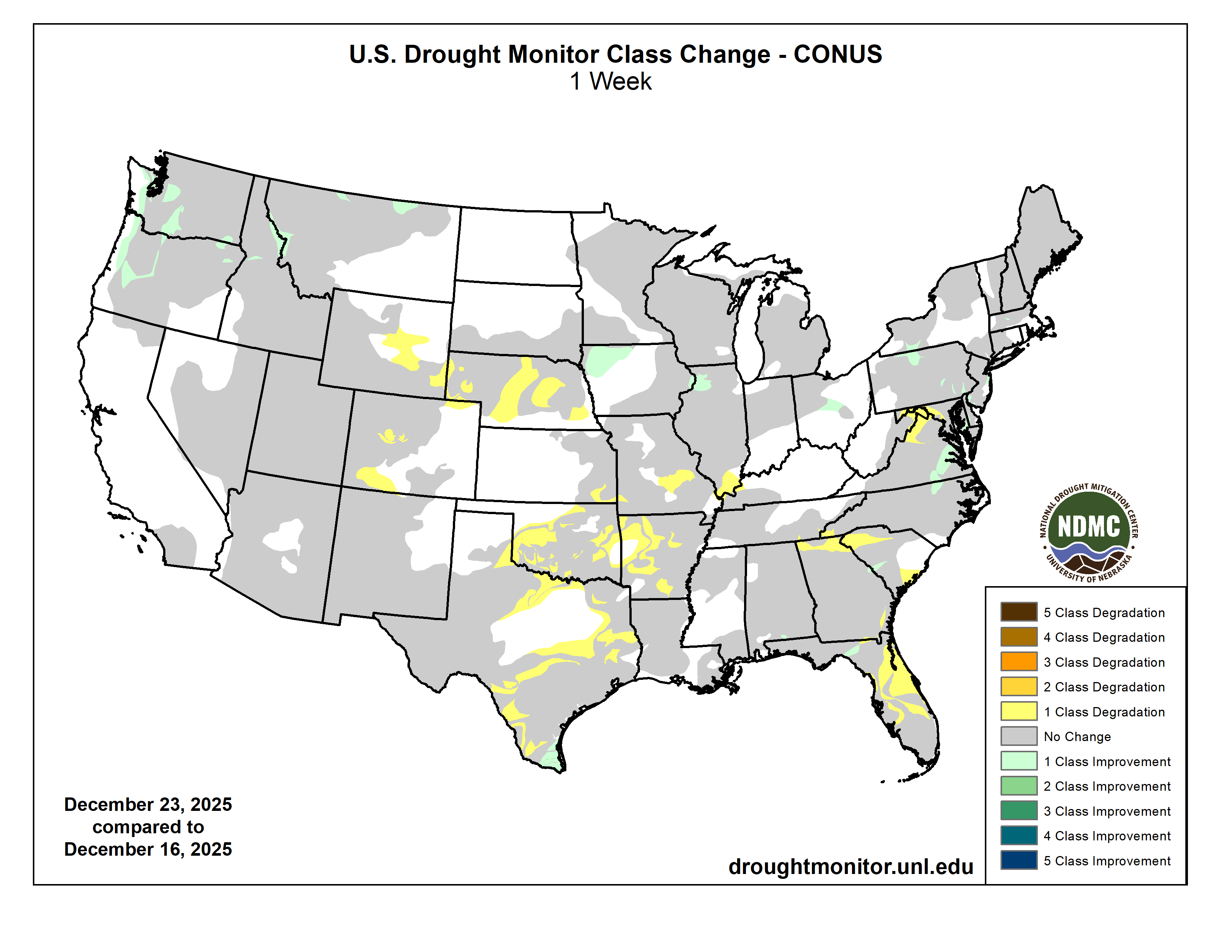
This Week’s Drought Summary
During the last 7-days, strong anomalous ridging over the Aleutians and troughing over the Gulf of Alaska promoted northerly flow across Alaska, leading to below-normal temperatures and little snowfall. Downstream, an unusually strong ridge dominated the flow across the contiguous United States. Between the northeastern Pacific trough and this ridge, strong onshore flow and atmospheric river activity promoted copious amounts of precipitation across the Pacific Northwest, though above-normal temperatures kept snow elevations higher than normal and limited the ability of this precipitation to substantially build early season snowpack across the Cascades, northern Sierras, and northern Rockies. Little to no precipitation was observed across the Southwest through the Plains under the anomalous ridge, and much above-normal temperatures promoted degradations of drought depictions for portions of the Rockies, Great Plains, and the lower to mid-Mississippi Valley. Across the East, an active northern stream saw the development of several storm systems which brought widespread precipitation across portions of the South, the Tennessee and Ohio Valleys, and the Northeast. Warming temperatures across the region caused much of this precipitation to fall as rain, melting much of the snowpack built during the previous week in the process. This precipitation led to some modest improvements to drought and abnormal dryness, though more widespread drought reductions were limited due to frozen soils and streams across New England, and groundwater conditions that are slower to respond to precipitation across the mid-Atlantic region. Dry conditions and above-normal temperatures led to degradations across much of Florida…
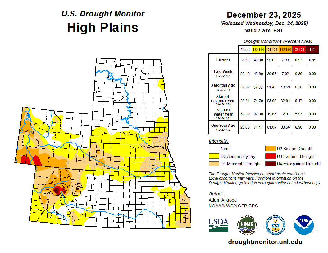
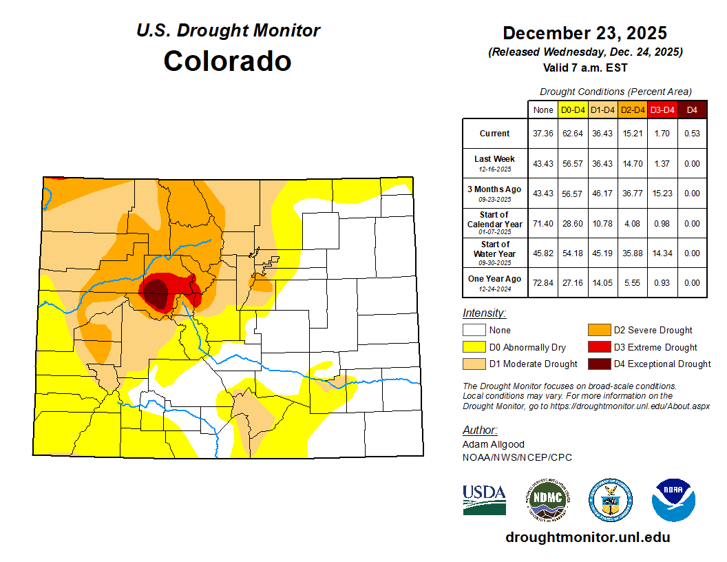
High Plains
A lack of snow cover, much above-normal temperatures, and periods of strong winds led to an unusual amount of winter degradation across the High Plains region.D2 expanded across western Nebraska, with expansions of both D1 and D0 occurring across central and eastern parts of the state, where precipitation was generally less than 0.2 inch equivalent, and high temperatures soared as high as the 70s. A small area of D1 expanded across southeastern Kansas, and across Colorado, D4 was introduced to Eagle and Pitkin Counties. D0 expanded across the Plains of Wyoming, where warm temperatures, strong winds, and a record lack of snow cover promoted worsening impacts. Drought depictions remained unchanged across the Dakotas, where soils and streams have largely frozen for the winter…

West
Across the West, a series of atmospheric river events brought copious amounts of precipitation to the Pacific Northwest, with Washington and the northern Rockies continuing to be pounded, and precipitation extending further south later in the period to blanket western Oregon and northern California, which had missed out on heavy precipitation during AR events earlier in the month. While the repeated bouts of heavy precipitation continue to ease lingering drought conditions west of the Cascades, the picture is a bit more mixed at higher elevations. Temperatures during the period ranged above-normal, keeping snow elevations higher than average, which prevented the much above-average precipitation from building up substantial snowpacks in the Cascades and northern Sierras. In fact, SWE values remain below 50-percent of average across the Cascades, northern Sierras, Blue Mountains, and the Bitterroot Range, though conditions have started to improve across the remainder of the Northern Rockies. While not an immediate drought concern during the winter months, a lack of snow cover could present problems during the Spring and Summer melting season, and additional precipitation along with colder temperatures are needed to recover the snowpack conditions during this wet season. Based on these considerations, D1 and D0 were reduced along the western front of the Cascades and across small portions of the Intermountain West, but drought conditions were maintained across the higher elevations. A small area of D0 reduction was made across northern Montana, where recent storminess brought improvements to 30- and 60-day SPI values…
South
Following another week of subnormal precipitation, and with temperatures ranging above-normal, the South saw further drought degradations. A small area of heavier precipitation fell across far South Texas, resulting in reductions of D1 and D0, but drought expanded or intensified across the southern Texas plains, Hill Country, and the Piney Woods. Drought also intensified along the Red River Valley, and degradations were more widespread across the eastern two thirds of Oklahoma and Arkansas. In Arkansas, local observers continue to report drying lakes and ponds, while in Oklahoma, record warmth, strong winds, and persistently below-normal precipitation promoted expansion of D2 and D3 conditions. Across Tennessee, precipitation was more generous, and a swath of 1 inch or more fell across the central portion of the state where D0 conditions are currently in place. Despite this rainfall, 60- to 90-day precipitation levels remain below-normal, and SPI values continue to indicate dry conditions. Therefore, no improvements were made across Tennessee…

Looking Ahead
During the next few days, atmospheric river activity will continue to bring copious moisture to the West, with the focus of heavy coastal rainfall and mountain snows shifting to California. Heavy precipitation is forecast to push inland to the Great Basin and portions of the Rockies. Later in the week, as the Pacific trough moves onshore and ridging builds over the northeastern Pacific, a break in AR activity is favored through the end of Week-1. Further east, persistent ridging is forecast for the central US, leading to mostly dry conditions and much above-normal temperatures for the Plains. Across the East, a blocking ridge retrograding towards Greenland from Europe will promote backdoor front activity and cold air damming, as well as providing a focus for additional precipitation and winter storm activity. The WPC 7-day QPF forecast shows precipitation amounts exceeding an inch across most of the Northeast Region, much of which may fall as snow or a wintery mix across the mid-Atlantic. Mostly dry conditions are favored for the Southeast during Week-1, with light rain possible across the lower Mississippi Valley. During Week-2, CPC forecast indicate enhanced chances for above-normal precipitation for the western third of the CONUS, with the highest probabilities across the Southwest. A slight tilt towards above-normal precipitation extends along the northern tier to the Great Lakes region, while below-average precipitation is favored for much of the eastern seaboard. Strong anomalous ridging favors above-normal temperatures for most of the CONUS, with blocking potentially leading to below-average temperatures across the Northeast. Above-normal precipitation is favored for Hawaii, while below-normal temperatures are favored for Alaska, with drier than normal conditions expected along the southern tier of the state.