
Click the link to read the discussion on the CBRFC website:
The Colorado Basin River Forecast Center (CBRFC) geographic forecast area includes the Upper Colorado River Basin (UCRB), Lower Colorado River Basin (LCRB), and Eastern Great Basin (GB).
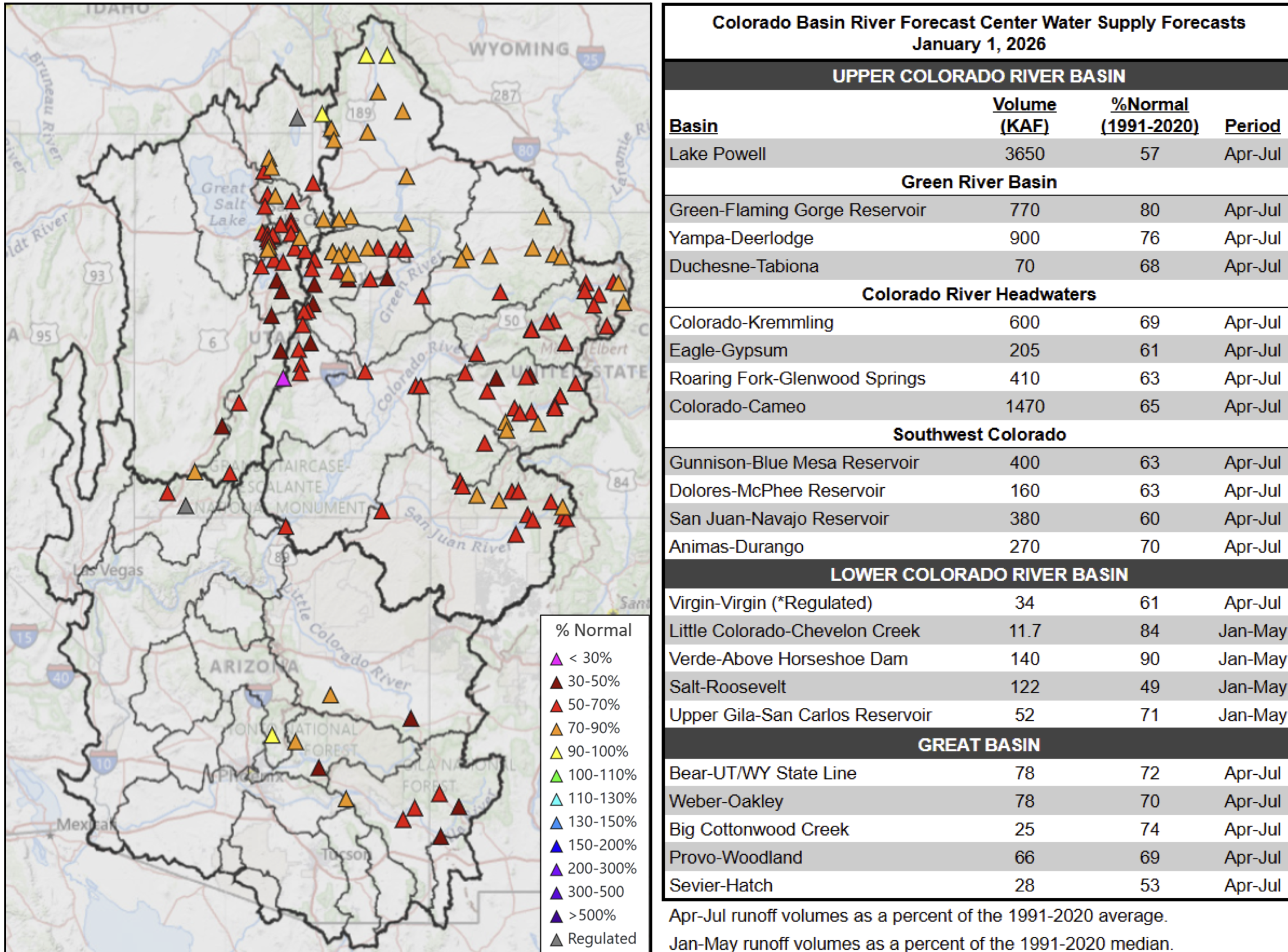
Water Supply Forecasts
January 1 water supply forecasts are generally well below normal and summarized in the figure and table below. Snowpack and soil moisture are the primary hydrologic conditions that impact the water supply outlook, while future weather is the primary source of forecast uncertainty.
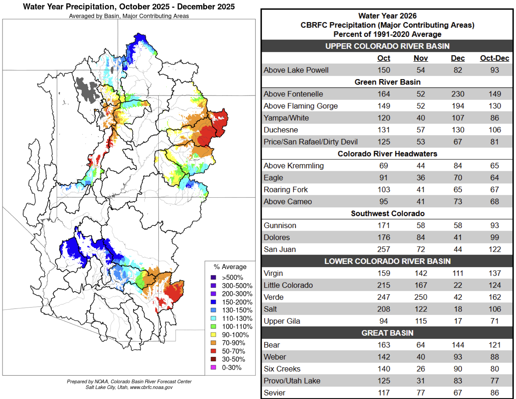
Water Year Weather
The 2025–26 winter season has thus far featured record-setting warmth and limited precipitation, driven
by a persistent high-pressure ridge over the CBRFC area. Most of the major climate sites in and around the CBRFC area experienced their warmest (e.g. Salt Lake City, Phoenix, Tucson, Las Vegas, Pocatello) — or second warmest (e.g. Flagstaff, Grand Junction, Denver) — December on record. An active northern stream riding over the ridge has delivered above average precipitation to the northern fringes of the UCRB and GB, but given the warm maritime influence, snow accumulation has remained unimpressive.
The water year as a whole tells a different story. In October, several rounds of heavy rain tied to decaying tropical storms brought record flooding to portions of AZ, southern UT, and southwest CO — making it one of the wettest Octobers on record. November brought continued above average precipitation to the LCRB, but well below average precipitation was observed elsewhere. Water year 2026 precipitation is summarized in the figure and table below.
Snowpack Conditions
UCRB January 1 snow water equivalent (SWE) conditions are highly variable and range between 35–100% of normal. Storm systems this winter have been warmer than normal with high snow levels resulting in much of the precipitation falling as rain rather than snow. SWE conditions are very poor across most of the UCRB, with numerous SNOTEL stations across western CO reporting January 1 SWE values at or near record low. The exception is the Upper Green headwaters, where SWE is near to above normal. UCRB January 1 snow covered area is around 28% of the 2001–2025 median, which is the lowest on record dating back to 2001. 1 LCRB January 1 SWE conditions are at or near record low across much of southwest UT, central AZ, and west-central NM.
GB January 1 SWE conditions are also very poor, ranging between 25–65% of normal. SWE at the majority of SNOTEL stations across UT are below the 10th percentile, with several stations reporting record low January 1 SWE. January 1 snow covered area across UT is record low at just 15% of the 2001-2025 median.1 SWE conditions are summarized in the figure and table below.

Right: CBRFC hydrologic model SWE condition summary.
Soil Moisture
CBRFC hydrologic model fall (antecedent) soil moisture conditions impact water supply forecasts and the efficiency of spring runoff. Basins with above average soil moisture conditions can be expected to experience more efficient runoff from rainfall or snowmelt while basins with below average soil moisture conditions can be expected to have lower runoff efficiency until soil moisture deficits are fulfilled. The timing and magnitude of spring runoff is impacted by snowpack conditions, spring weather, and soil moisture conditions.
Soil moisture conditions heading into the 2026 spring runoff season are below normal across most areas as a result of warmer and drier than normal weather during the 2025 water year. Water year 2025 precipitation was around 80% of average across the UCRB and GB and around 60% of average across the LCRB. The least favorable soil moisture conditions exist across central UT and the Colorado River headwaters. Soil moisture conditions across southwest CO and central AZ are exceptions, where very wet October–November weather led to improved soil moisture that is near or above average. CBRFC hydrologic model soil moisture conditions are shown in the figures below.

as a percent of the 1991–2020 average (left) and compared to November 2024 (right).
Upcoming Weather
After a cold and somewhat snowy system sweeps through the CBRFC area this week, high pressure looks to dominate the region for the foreseeable future, which will suppress any chances for significant precipitation. The 7-day precipitation forecast and the Climate Prediction Center (CPC) 8–14 day temperature and precipitation outlooks are shown in the figures below.


References
1. Rittger, K., Lenard, S.J.P., Palomaki, R.T., Stephenson, L. (2026). Snow Today. Boulder, Colorado USA. National Snow and Ice Data Center. Data source: MODIS/Terra/SPIRES.