“What makes this year so unusual is it’s been so warm for so long,” said [Russ] Schumacher, who is also a professor in the Department of Atmospheric Science at Colorado State University…
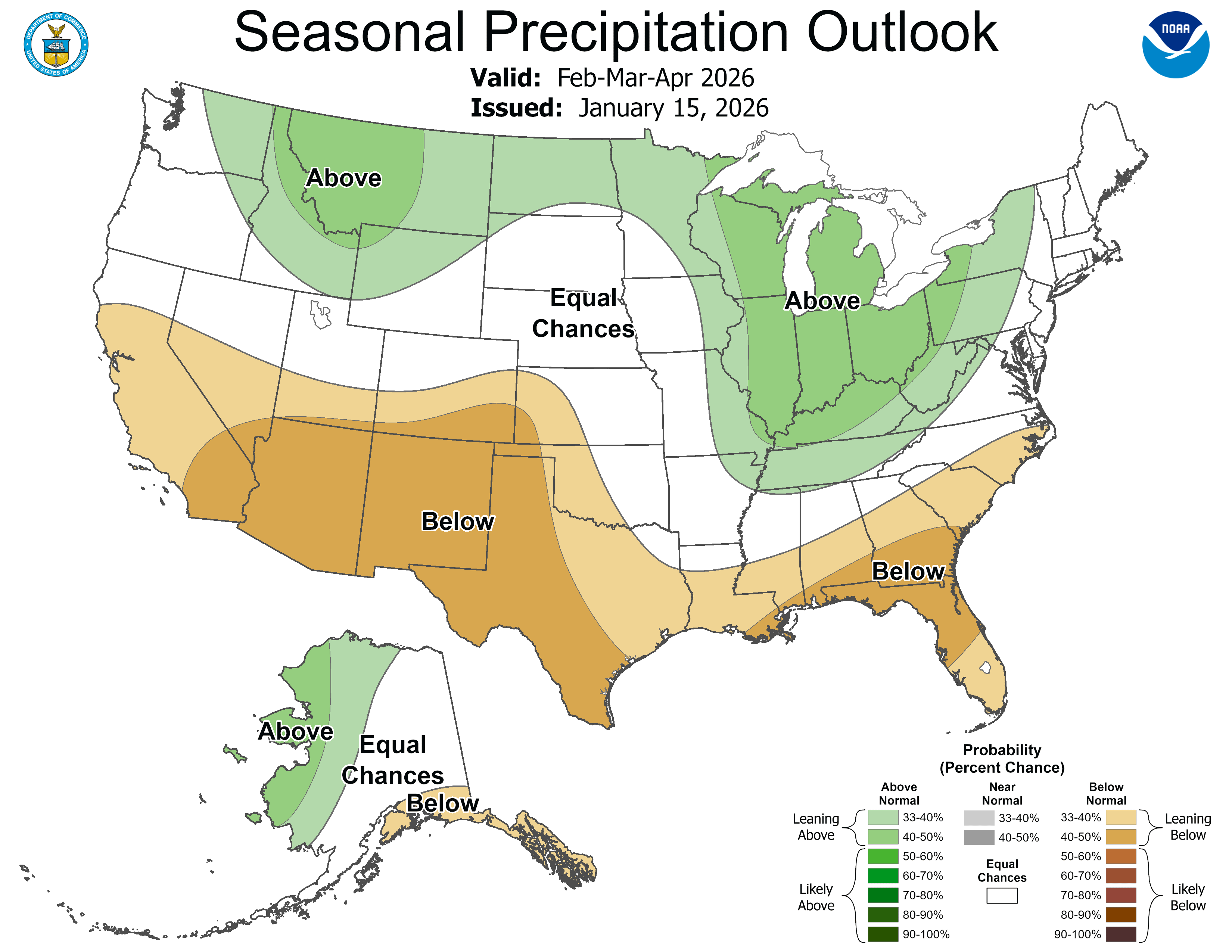
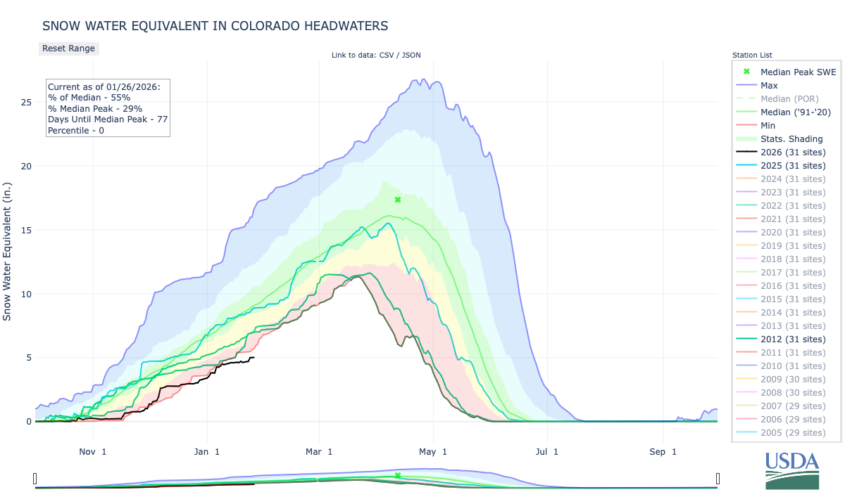
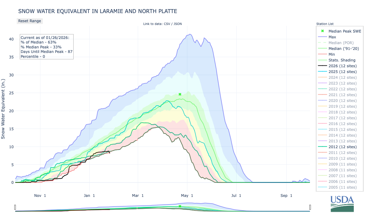
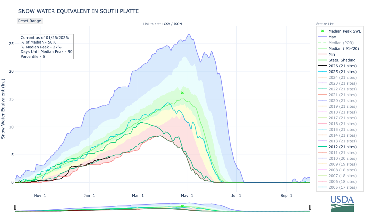
The reasons behind the rise in temperatures and the increase in dryness are fiercely debated, with a mix of focus on the impacts coming from global climate change and those that are attributable to the weather variability that has long shaped what is experienced on the ground. Globally, the 10 warmest years on record have occurred in the last decade, according to the World Meteorological Organization. The same group determined that the global average concentration of carbon dioxide in 2024 surged to the highest level since modern measurements began in 1957…According to a series of scientific studies published last year and collated by the Yale Center for Environmental Communication, researchers determined that climate change is complicit in the drying and warming of the American Southwest. The studies found emissions from the burning of fossil fuels are driving an ongoing 25-year shortfall in winter rains and mountain snows across the region. Dryness has accompanied the elevated temperatures felt by Coloradans this fall and winter, with the state tallying its 34th-driest December in 130 years of record-keeping, according to the Colorado Climate Center. Much of the state is in some level of drought, according to the U.S. Drought Monitor, though a broad swath of the Eastern Plains is not. Denver had its second-latest first accumulating snow — on Nov. 29. As of Thursday, mountain snowpack was at 56% of the median for that date, according to data collected by the U.S. Department of Agriculture’s National Water and Climate Center. The snowpack was well below the lowest level recorded at this point in the season in records that go back to 1987…
Jason Ullmann, the state engineer for the Colorado Division of Water Resources, said that despite the recent dry conditions, water storage levels across the state were in pretty good shape.
“We’re in an OK position with reservoir storage on average statewide,” he said.
But Ullmann noted that if things didn’t ramp up significantly on the storm front over the next two months or so, a different conversation could be in the offing by spring.
“It’s not time for panic — there is time for it to improve,” he said. “One of our snowiest months, March, is still to come.”
I’m having trouble accessing the SNOTEL basin-filled maps this morning and also the Yampa-White-Little Snake and State of Colorado SWE Interactive graph. I will try to update this post if things clear up in time. (Technology is great when it works!)
The Antiquities Act of 1906 was signed into law by Theodore Roosevelt, for “… the protection of objects of historic and scientific interest” through the designation of national monuments by the President and Congress. National monuments are one of the types of specially-designated areas that make up the BLM’s National Conservation Lands. Some of the earliest national monuments included Devils Tower, the Grand Canyon, and Death Valley. They were initially protected by the War Department, then later by the National Park Service. More recently, the BLM and other Federal agencies have retained stewardship responsibilities for national monuments on public lands. In fact, the BLM manages more acres of national monuments in the continental U. S. than any other agency. This includes the largest land-based national monument, the Grand Staircase-Escalante National Monument in Utah featured here. National monuments under the BLM’s stewardship have yielded numerous scientific discoveries, ranging from fossils of previously unknown dinosaurs to new theories about prehistoric cultures. They provide places to view some of America’s darkest night skies, most unique wildlife, and treasured archaeological resources. In total, twenty BLM-managed national monuments, covering over five million acres, are found throughout the western U. S. and offer endless opportunities for discovery. Photos and description by Bob Wick, BLM.
St. George, in Utah’s southwest corner, is one of the nation’s fastest growing communities. This is partly because of a nice climate, access to a major interstate, and relative closeness to Salt Lake City and Las Vegas. But it’s also because the landscape in which it sits is stunning, characterized by burnished red sandstone punctuated by dark volcanic formations and the green ribbons of the Santa Clara and Virgin Rivers, all set against the backdrop of the Pine Valley Mountains. In 2009, Congress created the Red Cliffs National Conservation Area on about 45,000 acres of BLM land just north of St. George to protect some of this landscape and its wildlife, and to offer a refuge from the burgeoning mass of humanity.
Satellite view of St. George, the southern end of the Red Cliff National Conservation Area, and the proposed highway corridor just approved by the BLM (in purple). The highway would fragment desert tortoise habitat and near-town hiking areas. Google Earth image.
But the Trump administration — and the state of Utah — have other plans. This week, the Bureau of Land Management approved Utah’s plans to build a four-lane highwaythrough the south end of the conservation area. The stated aim is to accommodate growth, reduce congestion, and speed up the car trip from one section of sprawl to another. But really it will only induce growth and more traffic, while also diminishing one of St. George’s most appealing assets.
The idea for a Northern Corridor Highway has been bantered about for a couple of decades. The proposal seemed to perish in 2016, when the BLM denied Washington County’s bid to build the road through the national conservation area. But when Donald Trump was elected president the first time, the county and the Utah Department of Transportation seized the opportunity to apply for a right of way to build a 4.5 mile, four-lane highway across a portion of the conservation area.
Red Cliff National Conservation Area. The Northern Corridor Highway would connect to the Red Hills Parkway in the mid-ground of the photo about one-third of the way in from the left. Jonathan P. Thompson photo.
In January 2021, the outgoing Trump administration’s BLM approved the right of way, even though its own analysis acknowledged that it would destroy tortoise habitat, spread invasive species, and essentially chop off the southern end of the conservation area, destroying trails and damaging the recreation experience. A large coalition of environmental groups under the banner of the Red Cliffs Conservation Coalition sued the BLM, and the agency ultimately agreed to redo the environmental analysis — finally rejecting the proposed highway at the end of 2024 and recommending an expansion of the existing Red Hills Parkway, instead.
Once Biden was out of office, however, the state and Washington County once again appealed to the feds to grant them a right-of-way, arguing that the Red Hills Parkway idea was not feasible. And since the Trump administration and Utah’s elected leaders tend to value roads and more suburban sprawl over tortoises, beauty, and the thriving desert landscape, the BLM opened the door to bulldoze more land to indulge Utah’s road fetish and to make way for yet another monument to America’s car-centric culture.
***
A couple of dispatches ago, I wrote about how curious it was that the Trump administration had yet to move to diminish or eliminate any national monuments during this second term. It may be because they are outsourcing the task to Congress.
Utah’s congressional delegation is expected to introduce federal legislation that would use the Congressional Review Act to overturn the Biden-era Grand Staircase-Escalante National Monument management plan. If the “resolution of disapproval” passes both chambers of Congress with a simple majority vote, it would erase the plan and bar the Bureau of Land Management from issuing another plan that is “substantially the same” in the future.
This wouldn’t change the boundaries of the monument, but would likely cause management of the area to revert back to the 2020, Trump I-era plan. That plan was not only less protective than the newer one, but only applied to a much smaller area, since in 2017 Trump had significantly shrunk the national monument. Revoking the current management plan, then, would leave vast areas of the monument in a sort of management limbo.
“I strongly denounce any attempt to use the Congressional Review Act to overturn the Grand Staircase-Escalante National Monument Resource Management Plan. This plan reflects years of public input, scientific research, and meaningful Tribal consultation, and dismantling it through procedural shortcuts undermines good governance, responsible land stewardship, and the protection of irreplaceable cultural landscapes,” said Autumn Gillard, Southern Paiute,Grand Staircase-Escalante Inter-Tribal Coalitionmember, in a written statement. “At this time, I urge lawmakers from both sides of the aisle to uphold the approved resource management plan from January 2025.”
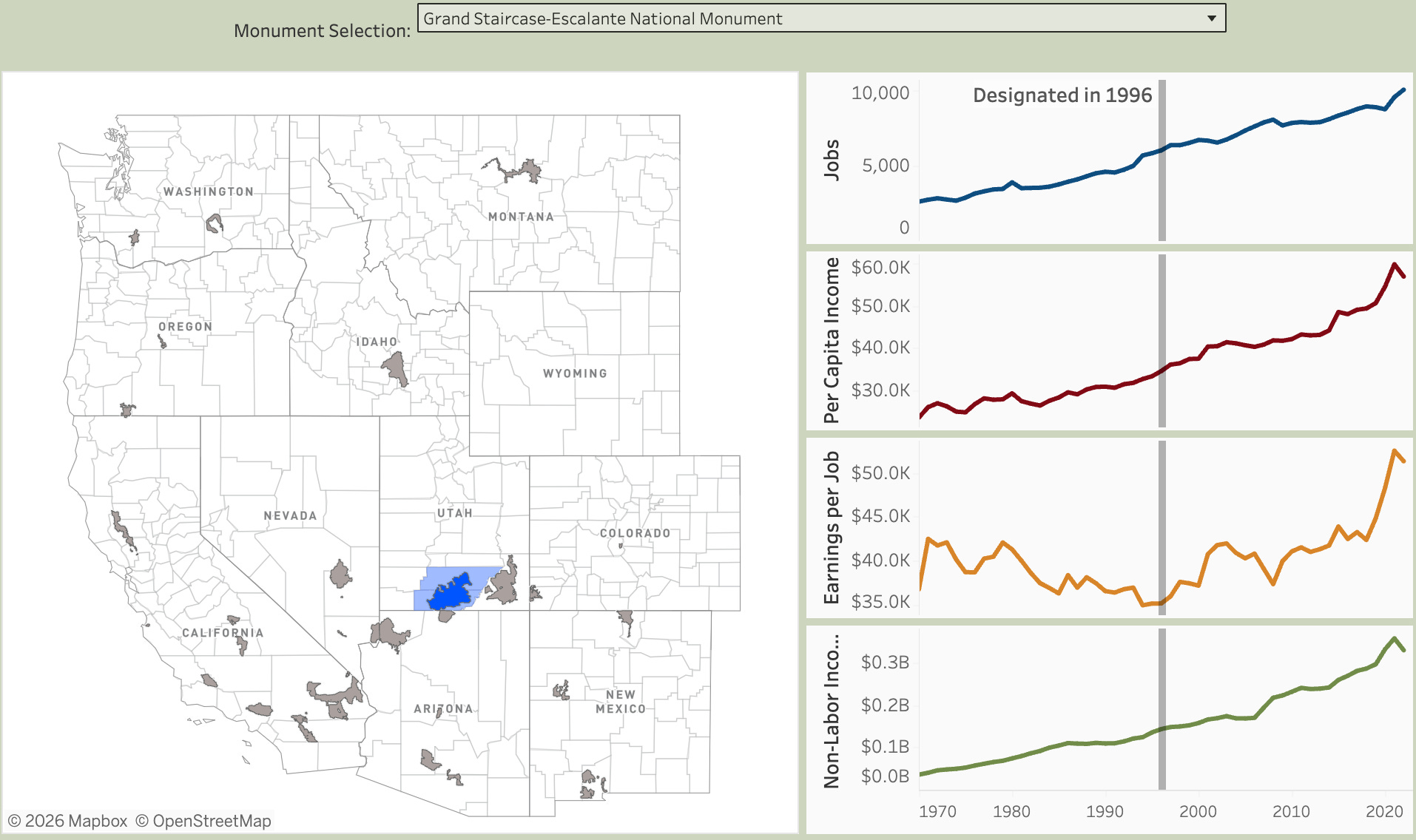
Utah officials often say they dislike new national monument designations because, in their minds, protecting land and cultural resources is bad for the economy, mostly because they block new mining and drilling. A new study shows they are wrong.
Headwaters Economics analyzed economic conditions and trends in 30 national monument gateway communities, and found that national monument designations do not disrupt local economies. They also don’t give nearby communities a substantial economic boost. “Employment and population trends continue on the same trajectory after designation,” Headwaters found, “and income growth tends to improve modestly over time.”
From Headwaters Economics’ economic performance of communities near national monuments report.
The findings match up with what one would intuitively expect. National monuments are rarely designated in areas that are currently targeted for new drilling and mining, meaning they are unlikely to affect the existing extractive economies. Meanwhile, they are often established in places that are already experiencing an increase in visitation, meaning that designation wouldn’t necessarily cause a significant jump in tourism.
Take Bears Ears National Monument, for example. It was established in 2016 on federal land in San Juan County, Utah. Both the oil and gas and uranium mining industries were (and are) active in the county. But they weren’t interested in drilling new wells or opening new mines within the monument’s boundaries. Previous oil and gas wells had mostly come up dry — drillers have found much more success in the Aneth and McElmo fields east of the monument. And the Daneros uranium mine, which is been on standby status for years, is outside the boundaries, as well. In other words, monument designation had absolutely zero effect on either industry.
Meanwhile, fears that establishing a national monument in this corner of southeastern Utah would lead to its “discovery” by the masses were overblown, simply because the internet and social media had already lured folks to the area. Indeed, part of the reason people pushed for designation was to try to get a handle on increased visitation and its impacts on natural and cultural resources.
Headwaters has a nice interactive graphic on which you can check out the economic trends around the 30 national monuments. The trends, themselves, are interesting to see: They make it abundantly clear that other factors, especially COVID-19, had a much bigger effect than any national monument designation.
The Big Data Center Buildup is accelerating. Nearly every day I get news of another proposed hyperscale facility somewhere in the West. A lot of them are not planning on connecting to the power grid, which is good for other utility users, because they won’t have to pay for associated infrastructure upgrades. But in almost every case, their proposed power sources include at least some gas-fired generation. And natural gas, i.e. methane, is not clean energy by any means.
So, while the data center boom has the potential to accelerate the clean energy transition by encouraging more solar, wind, and battery storage, it is also slowing the transition by perpetuating fossil fuel burning and even prompting construction of new fossil fuel-fired facilities.
Projects that have come onto my radar recently include:
Laramie County, Wyoming’s commissioners approved Crusoe Energy Systems’ and Tallgrass’ proposed AI data center complex near Cheyenne, despite residents’ pushback over the project’s massive scale. If this thing is built as planned, it will be ginormous, with estimated capital costs of $50 billion. That would not only include the Project Jade’s five data centers and associated structures, but also a 2,700 MW gas-fired power plant — which would be among the largest of its kind in the West. The developers plan to use a closed-loop cooling system, which is less water-intensive than conventional evaporative systems but uses more energy.
About 150 miles west of there, Power Company of Wyoming, an Anschutz Corporation subsidiary, is proposing a 2,000 MW gas generating facility in Carbon County to serve growing data center-driven power demand. These are the same folks who are building the Chokecherry Sierra Madre wind project and the TransWest Express transmission line. The controversial, 732-mile TransWest Express was originally billed as a clean-energy line that would carry Wyoming wind to California. Looks like it also will be moving fossil fuel-fired power, as well.
Residents of Surprise, Arizona, a section of Phoenix’s sprawl, are getting a little surprise of their own: A proposed data center and dedicated 700 MW natural gas plant adjacent to a residential neighborhood. Residents are not too pleased, according to a story in the Arizona Republic, and are worried about the environmental and health impacts of a gas plant and the data center. The data center would run off the gas plant for the first couple years of operation before connecting with the grid. Then the plant would serve as backup for the center as well as a “peaker” plant, meaning it is fired up during peak demand.
🫣 Correction 🙀
In this week’s Colorado River glossary and primer I inadvertently shrunk the Colorado River watershed quite significantly by leaving out two zeros. It covers about 250,000 square miles, not 2,500. Duh.
Cool Opportunity
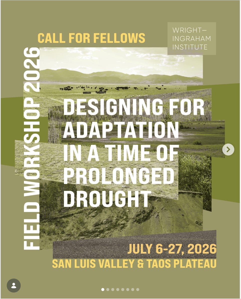
The Wright-Ingraham Institute is now taking applications for its three-week immersive fellowship for graduate students and early-career professionals in science, design, policy, the arts, and beyond. This year’s field workshop focuses is on “designing for adaptation in a time of prolonged drought,” and will be held in the San Luis Valley and Taos Plateau from July 6-27. Read more and apply here.
📸 Parting Shot 🎞️
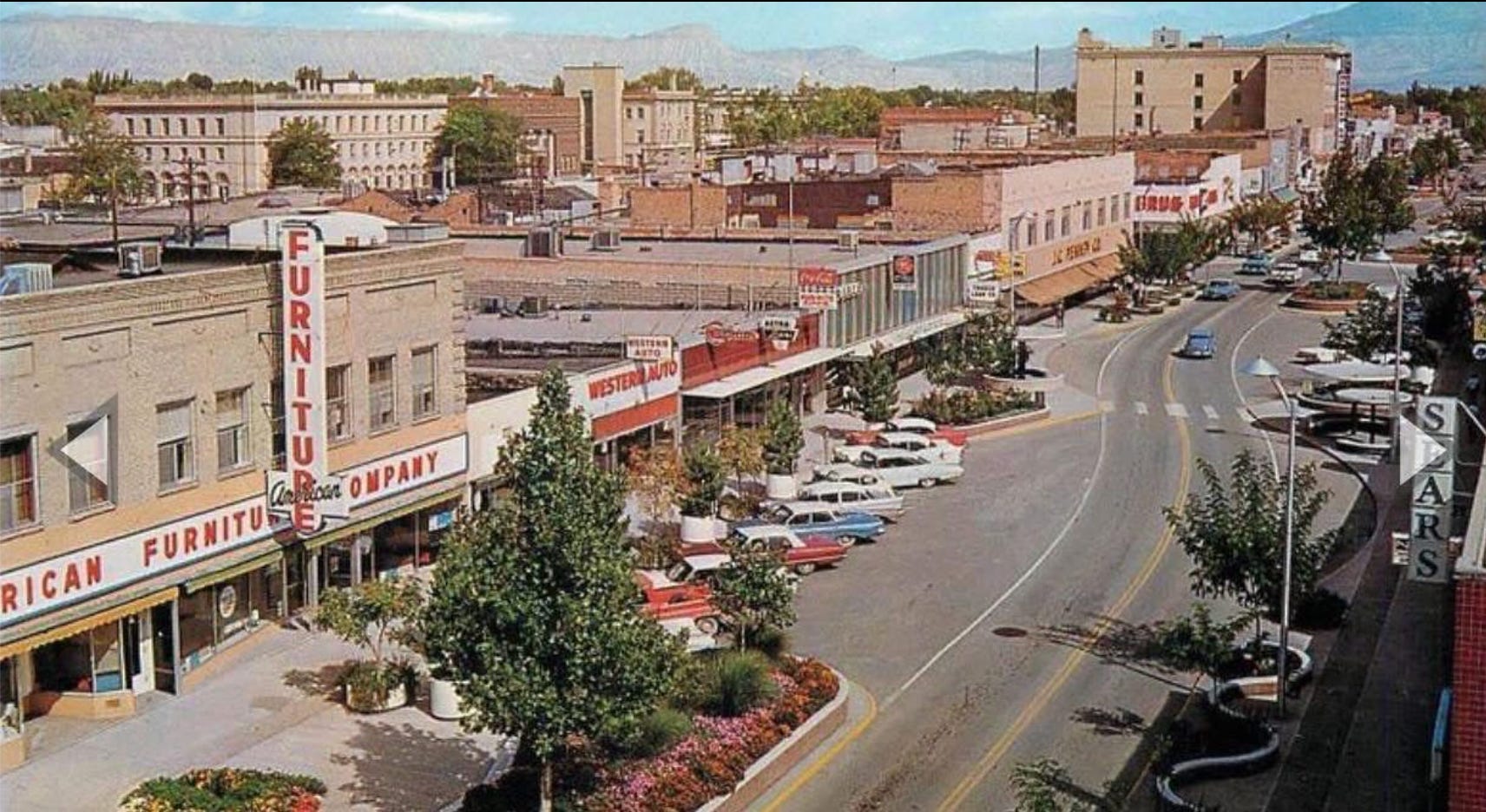
This one popped up on my Facebook feed and I just had to purloin it. It’s downtown Grand Junction in the 1960s (I believe), not long after they refashioned the main drag to make it more people-friendly. It’s funny because a lot of folks in my hometown of Durango are freaking out about a proposal to do something kind of like this, but even less radical, to its downtown. They claim that widening sidewalks and so forth will destroy the historic integrity of the streetscape. In my mind, this photo illustrates how untrue that claim is.