Click on a thumbnail graphic to view a gallery of drought data from the US Drought Monitor website:


Click the link to go to the US Drought Monitor website. Here’s an excerpt:
This Week’s Drought Summary
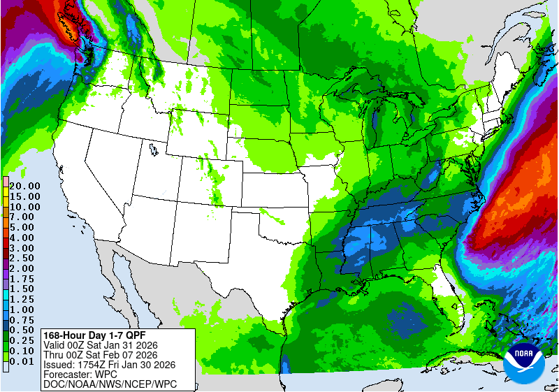
Most precipitation across the contiguous United States fell in association with a large, impactful storm system that affected a broad area from the southernmost Rockies and the southern Plains eastward across a large part of the Mississippi and Ohio Valleys, the Southeast, and the Eastern Seaboard. Winter storm warnings at one point covered about one million square miles. Heavy to excessive amounts of snow, sleet, and freezing rain were widespread throughout the region. Numerous locations across Pennsylvania, New York, and New England recorded 1 to 2 feet of snow or snow and sleet. Elsewhere, totals reached as high as 17 inches in Ohio and West Virginia; 15 inches in Oklahoma, Missouri, Illinois, and Indiana; and 1 foot in Arkansas, Kentucky, Maryland, and Delaware. Intense sleet fell farther south, overlapping the southern sections of the heavy snow area. Sleet totals topped out near 7 inches in Arkansas, Louisiana, and North Carolina; near or slightly over 6 inches fell on scattered sites across Oklahoma, Texas, Louisiana, Mississippi, Tennessee, and Maryland; and localized amounts reached 4 inches in Texas, South Carolina, North Carolina, West Virginia, and Virginia. Freezing rain fell in abundance across portions of the South, and in some areas that experienced a changeover from sleet. States with at least one site reporting 1 inch thick ice accumulation included Oklahoma, Louisiana, Mississippi, Alabama, and South Carolina while peak amounts of 0.7 to 0.8 inch were reported in Texas, Kentucky, Tennessee, Georgia, Virginia, and West Virginia. Widespread power outages and tree damage was reported in many locations that received heavy freezing rain. Liquid-equivalent precipitation totals associated with this system exceeded an inch in parts of the southernmost Rockies, in a band from eastern Texas and western Arkansas eastward through Alabama, most of Tennessee and Kentucky, the central and northern Virginias, Maryland, Delaware, New Jersey, and in scattered locations across adjacent areas, including the Northeast. Scattered areas across the southern tier of the Lower-48 recorded over 3 inches of precipitation, including central Texas, southern Louisiana and adjacent Texas, and a fairly solid band from northeastern Texas through northern Louisiana, northern Mississippi, and northwestern Alabama. Up to 10 inches fell on one patch in southwestern Louisiana, and localized amounts exceeded 4 inches in northern Mississippi and a few other scattered areas.
However, despite the extensive coverage of impactful precipitation, the storm has not yet brought about broad areas of drought relief. Improvements were made where some of the heaviest liquid-equivalent precipitation fell, including a few places where it fell in frozen form. However, Arctic air has settled into the eastern states in the wake of the storm, and in many if not most areas, the water that could eventually help ease drought conditions was locked up in accumulated frozen precipitation, and can’t provide tangible improvements to drought impacts until it has melted. In the South, this may be only a matter of a few days, and relief was depicted more quickly there than farther north, especially in the northern tier of the East where temperatures may remain below freezing for extended periods of time.
Along the northwestern and southeastern edges of the winter storm, light to moderate precipitation was recorded, with totals ranging from a few tenths to nearly an inch over the western half of Texas and from much of Oklahoma northeastward through most of Missouri, Illinois, Michigan, Indiana, Ohio and the upper reaches of the Northeast. Similar amounts were noted to the south of the heaviest precipitation, generally across portions of the Carolinas, southeastern Georgia, Florida, and the immediate central Gulf Coast.
In other parts of the Lower-48, very little if any precipitation was recorded. The single widespread and extremely impactful winter storm was responsible for almost all of the precipitation observed this week…
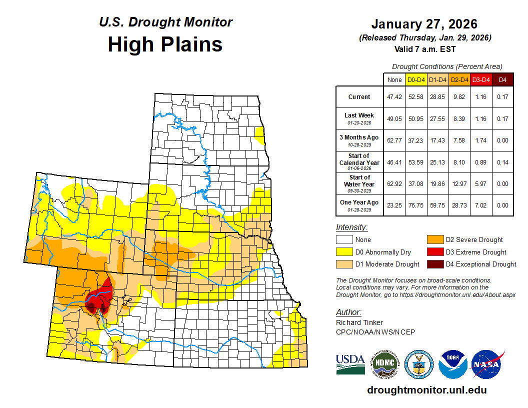
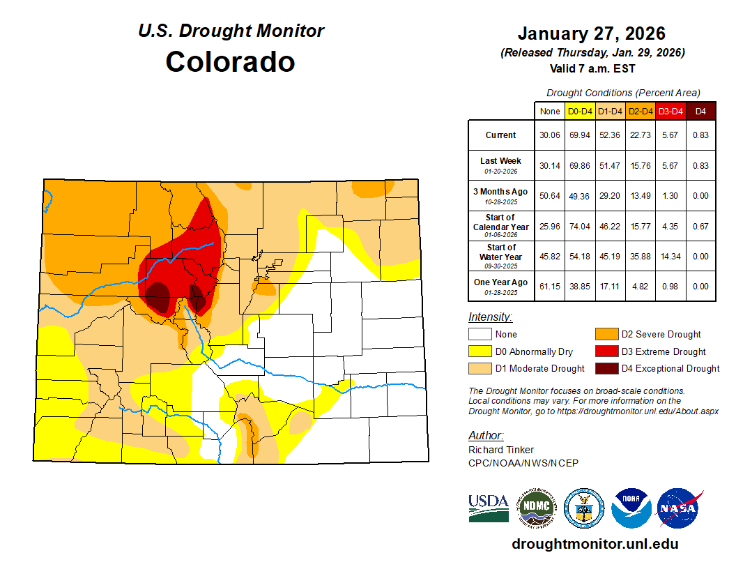
High Plains
Most of the High Plains Region was dry last week, with an amounts of a few tenths to approaching one inch fell on much of central and eastern Kansas and on scattered higher elevations in Colorado and Wyoming. Otherwise, little or nothing fell. The Region – outside the higher elevations – is climatologically cold and dry, so precipitation deficits increase very slowly, and demand is lower this time of year. Dryness and drought was essentially unchanged in most of the High Plains Region, with some scattered deterioration introduced in parts of western Colorado (to D1 or D2). Drought intensification was also introduced around the Black Hills and adjacent western South Dakota (to D0 or D1), where snowpack is deficient and slowly declining…

West
The southern fringe of the West Region was impacted by the western edge of the winter storm, resulting in over 1.5 inches of precipitation across a few patches from southeastern Arizona across southern New Mexico. Amounts exceeded 3 inches in parts of south-central New Mexico north of the Texas Big Bend. The precipitation fell mostly in liquid form in southeastern Arizona, and was sufficient to bring improvements into that area. Farther east, although amounts were a little heavier, the precipitation was primarily in frozen form, and remained unmelted. Therefore, only a few targeted improvements were introduced in a few small areas reporting the highest precipitation amounts (over 3 inches). Elsewhere, most of the Region received no measurable precipitation, with just a few tenths falling on some of the higher elevations of the Rockies. Still, there was no tangible deterioration across the Region during the dry week, in part because it followed a few weeks of relatively abundant precipitation. As a result, the Drought Monitor depiction was unchanged outside parts of the southern fringes of Arizona and New Mexico…
South
One to several inches of precipitation was widespread across most of Tennessee, Mississippi, Louisiana, central and southern Arkansas, the eastern Texas. Improvements were introduced in a number of areas, generally the areas that received the most precipitation, where much of the precipitation fell in liquid form, or where drought was already waning. To wit, some relatively broad improvements were introduced in Tennessee and to a lesser extent Mississippi. Farther west, where subnormal precipitation dates back at least several months, improvements were more targeted to the areas receiving the heaviest precipitation, especially from central Louisiana northward where precipitation remained unmelted. Despite the precipitation accompanying the massive winter storm, Many areas in a band from northern Arkansas to the Louisiana Gulf Coast recorded 8 to 10 inches less than normal precipitation over the past 90 days, with a few spots in northeastern Arkansas and east-central Louisiana recording deficits approaching 12 inches during this period. Farther west, moderate to heavy precipitation was fairly widespread in eastern Texas, with lesser amounts toward the central part of the state. Southeastern Oklahoma reported amounts similar to eastern Texas (1.5 to locally 3.0 inches), but most areas farther northwest recorded less than an inch. With much of the precipitation remaining locked up in frozen form, only a few surgical improvements were introduced in the areas with the most extreme totals in eastern Texas. A few inches of liquid-equivalent precipitation also fell farther southwest over south-central Texas. Temperatures were above freezing there at the end of the period, and the environment was beginning to respond to the moisture infusion, so somewhat more aggressive improvements were introduced there…