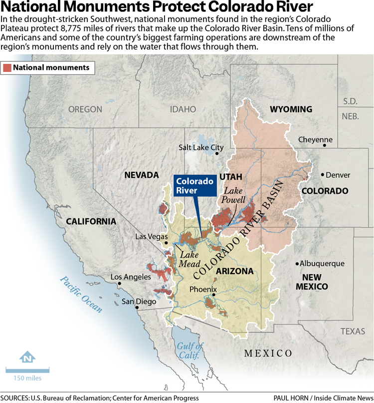
The 31 national monuments designated since the Clinton administration, which could be downsized as the Trump administration pushes to open more public lands to extractive industries, safeguard clean water for millions of Americans, according to a new analysis from the Center for American Progress.
Using geospatial data to quantify the miles of rivers and watersheds within the studied national monument boundaries, as well as the number of users who depend on that water, the report found that the water supplies for more than 13 million Americans are directly provided by watersheds within or downstream of these national monuments. About 83% of the water passing through these public lands has no other protection besides the monument designations, it found.
National monuments protect more than 21,000 miles of waterways across the U.S., nearly twice as much waterway mileage as the National Wild and Scenic Rivers System, the analysis also determined.
The report comes as the Trump administration weighs downsizing or revoking the designation of some national monuments.
In March, the Trump administration announced it would eliminate California’s Chuckwalla and Sáttítla Highlands national monuments before removing language from a White House fact sheet announcing that decision. The following month, The Washington Postreported that the administration was considering downsizing or eliminating six national monuments, and in June, the U.S. Department of Justice issued an opinion that the president has the power to rescind national monument designations, backtracking on a decades-old determination on the matter.
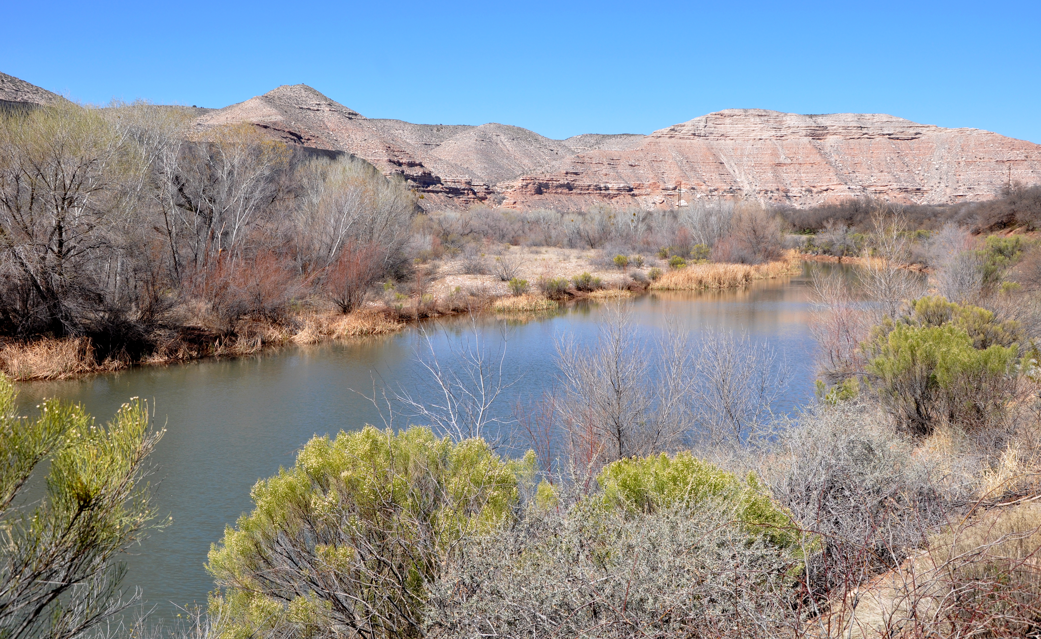
Stone and evening light, Bears Ears National Monument, Utah. Jonathan P. Thompson photo.
During Trump’s last term, Bears Ears and Grand Staircase-Escalante national monuments, established by the Obama and Clinton administrations, respectively, were shrunk to fractions of their original sizes, but they were restored by President Joe Biden after he took office.
If national monuments are downsized or eliminated, the areas surrounding a waterway will lose protections from extractive industries, including oil and gas drilling, mining and grazing. Contamination from those industries could seep into streams and, in turn, rivers. Those industries also use water, sometimes vast amounts in arid regions, further reducing the supply that flows to nearby communities. (In certain cases, some mining and grazing are already permitted on national monument lands, but the activities are limited in scale and more regulated than they are outside the monuments.)
“Landscapes and waterways go hand in hand,” said Drew McConville, a senior fellow for conservation policy at the Center for American Progress and a co-author of the report. “The clean water depends on what comes into them from natural lands … Just protecting the wet stuff itself doesn’t guarantee that you’re keeping [water] clean and durable.”
The portion of historically marginalized communities living within the watersheds of the national monuments is greater than the average for watersheds nationally, it found. Twenty-three of the monuments studied are also found in regions expected to face water shortages due to climate change in the coming decades, making the arid regions downstream even drier.
Grand Staircase-Escalante National Monument, for example, protects 2,517 miles of waterways, according to the analysis, and nearly 90% of the watersheds within the monument are expected to see declines in their water levels. The monument straddles the Upper and Lower Colorado River Basins, with the Paria and Escalante rivers flowing within its boundaries and Lake Powell, the nation’s second-largest reservoir, just to its south.
The monument is often thought of as a sparse, arid region, which it is, said Jackie Grant, the executive director of Grand Staircase Escalante Partners, a nonprofit focused on protecting the monument that has spent $11 million to protect the Escalante River watershed and all its tributaries. It remains vital to the Colorado River System, which millions of people in the Southwest rely on. Grand Staircase-Escalante helps slow water from the Paunsaugunt Plateau in Bryce Canyon National Park, much of which starts as snowpack in the park before melting and flowing downstream.
“People don’t think of water when they think of Grand Staircase-Escalante National Monument,” Grant said. “So when we can bring this view of water and how important it is to the protection of the monument, it helps us put another building block in our case for supporting the monument, because not only is it important for the animals, the native plants, the geology and the paleontology, water plays a huge role in the monument, and the monument protects the water itself.”
The Antiquities Act of 1906 was signed into law by Theodore Roosevelt, for “… the protection of objects of historic and scientific interest” through the designation of national monuments by the President and Congress. National monuments are one of the types of specially-designated areas that make up the BLM’s National Conservation Lands. Some of the earliest national monuments included Devils Tower, the Grand Canyon, and Death Valley. They were initially protected by the War Department, then later by the National Park Service. More recently, the BLM and other Federal agencies have retained stewardship responsibilities for national monuments on public lands. In fact, the BLM manages more acres of national monuments in the continental U. S. than any other agency. This includes the largest land-based national monument, the Grand Staircase-Escalante National Monument in Utah featured here. National monuments under the BLM’s stewardship have yielded numerous scientific discoveries, ranging from fossils of previously unknown dinosaurs to new theories about prehistoric cultures. They provide places to view some of America’s darkest night skies, most unique wildlife, and treasured archaeological resources. In total, twenty BLM-managed national monuments, covering over five million acres, are found throughout the western U. S. and offer endless opportunities for discovery. Photos and description by Bob Wick, BLM.
Stretching across 1.87 million acres of public land, Grand Staircase-Escalante National Monument is one of the country’s most expansive national monuments, protecting scores of wildlife as well as archeological resources in southern Utah. But a nine-billion-ton coal deposit is buried in the center of the monument along with deposits of minerals, including uranium and nickel. The Trump administration has long touted boosting the country’s coal production, and has established a pro-mining agenda this year.
“It’d be very easy to contaminate either one of those rivers if mining were to take place in the center section of the monument,” Grant said.
Margaret Walls, a senior fellow at Resources for the Future who has studied national monuments but was not part of this study, said national monuments are designated to protect cultural or historical landmarks, and it can be forgotten that they can also serve purposes like safeguarding water. Though she noted that even if monument protections are loosened, the areas remain federal lands, and their changes in status do not guarantee they will be developed.
“We don’t protect waterways the way we do land,” Walls said, “we’re going to get those water benefits by protecting the land.”
Created by Imgur user Fejetlenfej , a geographer and GIS analyst with a ‘lifelong passion for beautiful maps.’ It highlights the massive expanse of river basins across the country – in particular, those which feed the Mississippi River, in pink.
Stable isn’t good enough. Credit: Jack Schmidt/InkStain
Click the link to read the article on the InkStain.net website (John Fleck and Jack Schmidt):
January 14, 2025
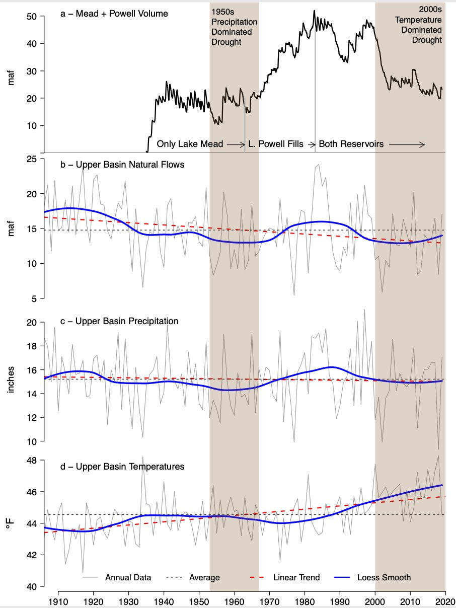
Preliminary year-end Colorado River numbers are stark. Total basin-wide storage for the last two years has stabilized, oscillating between 30 and 27 maf (million acre-feet), where storage sits at the start of 2025[1]. That is lower than any sustained period since the River’s reservoirs were built (Fig. 1). Stable is better than declining, but we did not succeed in rebuilding reservoir storage during 2024’s excellent snowpack but modest inflow. Although reservoir storage significantly increased after the gangbuster 2023 snowmelt year, we have not protected the storage gained in 2024 when inflow to Lake Powell was ~85% of normal from a 130% of normal snowpack. We can’t rely on frequent repeats of 2023; we must do better at increasing storage in modest inflow years like 2024.
Why is this happening?
Less water. Credit: InkStain
The phrase “the new normal” can be misleading, suggesting a new, more stable state for the climate. It’s not gonna be stable. But by one reasonable measure – total estimated natural flow in the Colorado River at Lees Ferry – Calendar Year 2024 was typical of the first quarter of the 21st century, with a preliminary estimate of 12.1 million acre-feet “natural flow.” Thus, the calendar year average annual natural flow at Lees Ferry between 2000 and 2024 has been 12.4 maf/yr, down from 14.3 maf for the period 1930-1999. An additional 770,000 af/yr in side inflows between Lees Ferry and Lake Mead add to the available water supply[2].
That we made the cuts needed to stabilize reservoir levels with a natural flow at Lees Ferry as low as 12.1maf would have been a substantial achievement in the wetter “before times.” Now, it’s table stakes. The most important point is that we absolutely did not rebuild storage in 2024, despite a 130 percent snowpack. We must do better in reducing total basin consumptive use.
Once again in 2024, we saw substantial water use reductions among the states of the Lower Colorado River Basin. Total U.S. Lower Basin main stem use of 6.08 maf is the lowest since 1985 (meaning the lowest since the Central Arizona Project came on line). California’s use, based on preliminary numbers published by Reclamation seems to be the lowest since 1950, and use by the Imperial Irrigation District seems to be the absolute lowest in a dataset that goes back to 1941. These are important achievements, to be celebrated.
With regard to the other two major U.S. areas of use – Lower Basin tributaries and the Upper Basin as a whole – we have no idea what 2024 consumptive use was. This is a problem. Lower Basin main stem use is quantified through Reclamation’s annual accounting reports and reported on a nearly daily basis during the course of the water year. River flows and reservoir levels across the basin are similarly reported in public, transparent ways. That’s how we’re able to provide the data you see above. Anyone can download and crunch the numbers. The general public can’t readily do that for consumptive use in the Upper Basin or Lower Basin tributaries.
As Elinor Ostrom noted in her classic book Governing the Commons, shared understanding of the resource is crucial to successful water management. Increasingly, areas of uncertainty have become contested ground, as the genuine technical uncertainties collide with the motivated reasoning of political actors across the basin. [ed. emphasis mine]
With respect to the Upper Basin, we note that the rhetoric that Upper Basin water users suffer shortages in dry years has shifted to a broader claim that Upper Basin users always suffer shortages. We quote here from the Upper Basin states’ January 2 press release: “There are acute hydrologic shortages in the Upper Basin every year – there simply isn’t enough water in any year to satisfy current needs in the Upper Basin every year. The Upper Basin has made uncompensated cuts to their water users every year for the past 24 years.” Some of the data to support this assertion was presented at the December 2024 UCRC meeting, and we look forward to a more complete and transparent accounting of these data, because these data are crucial to a robust Colorado River management discussion. The Upper Basin’s experience of “acute hydrologic shortages … every year” is exactly what John Wesley Powell described in 1878 in the first edition of The Arid Lands Report. Nothing has changed, and the challenge of agriculture throughout the watershed has been well known for 150 years. We also note that consumptive use data throughout the basin has not been integrated with the important findings of Richter et al (2024) who documented the proportion of water used by different agricultural sectors. They estimated that 55% of all Colorado River water use supplies livestock feed.
We leave a discussion of Lower Basin tributary use for another post but note that in both the cases of the Upper Basin use and Lower Basin tributary use, the numbers are entangled in the current Upper Basin-Lower Basin feud, which makes serious efforts to think about how to manage water at the Basin scale, rather than simply defending parochial interests, much more difficult. It is important that the general public not employed by a state or water agency, and therefore not beholden to local parochial interests, help the basin community as a whole navigate these technical issues.
Conclusion
The stable reservoir levels at the end of 2024, despite another year of deep Lower Basin water use reductions, should be cause for alarm. Deeper cuts are needed. But without a shared understanding of water use elsewhere in the basin, we’re flying blind.
[1] Basin-wide reservoir storage reached a peak of 29.7 maf on 13 July 2023 and was subsequently drawn down to 27.5 maf by mid-April 2024. Inflow from 2024 snowmelt rebounded basin-wide storage to 30.0 maf on 6 July 2024, and storage was subsequently drawn down to 27.4 maf by 31 December 2024. Retention of storage in Lake Mead and Lake Powell has been somewhat better during the same period. Combined storage in Lake Mead and Lake Powell peaked in mid-July 2023 at 18.0 maf, declined to 17.1 maf by mid-May 2024, increased to 18.5 maf on 8 July 2024, and was 17.3 maf on 31 December 2024. Thus, storage in the two largest reservoirs at year’s end was slightly greater than it was at its spring 2024 minimum just before storage increased when significant snowmelt reached Lake Powell.
[2] This estimate is calculated as the difference between annual flow measured just upstream from Diamond Creek in western Grand Canyon and measured at Lees Ferry.
Udall/Overpeck 4-panel Figure Colorado River temperature/precipitation/natural flows with trend. Lake Mead and Lake Powell storage. Updated through Water Year 2024. Credit: Brad Udall
October snows above Ouray, Colorado. The Red Mountain Pass SNOTEL showed the snowpack to be 103% of normal as of Jan. 2, 2025. Jonathan P. Thompson photo.
Click the link to read the article on the Land Desk website (Jonatan P. Thompson):
January 3, 2025
🥵 Aridification Watch 🐫
Happy New Year! The Land Desk had a very mellow and relaxing couple of weeks off, and I must admit that I’m struggling to get back into the old routine. And I sure as heck haven’t gotten used to writing “2025” yet. Oy.
But no matter what the calendar may say, we’re one-fourth of the way through the 2025 water year, and one-third of the way through meteorological winter. That means it’s time for a little snowpack update.
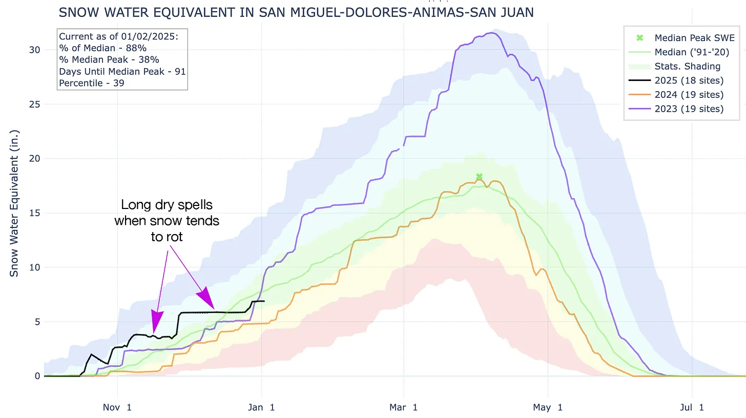
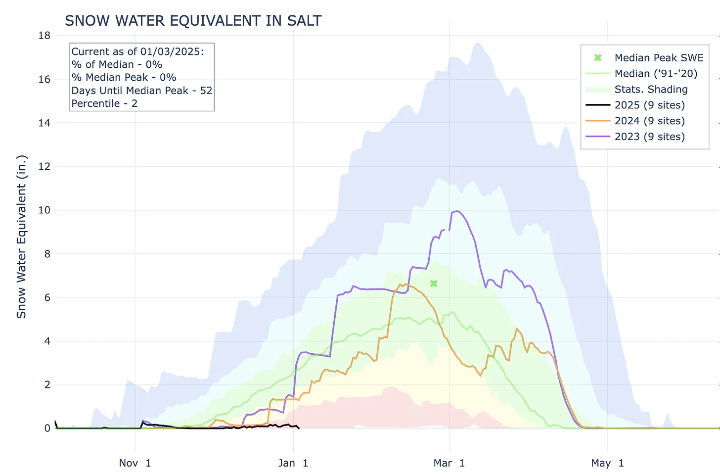
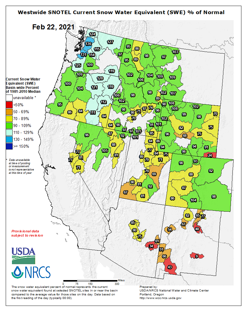
Snowpack levels in the watersheds that feed Lake Powell are just about normal for this time of year, thanks to some late-December storms across the region. But as you can see from 2023 (the purple line), there’s plenty of time left for it to be a huge snow year — or a downright crappy one if the precipitation suddenly stops. Source: NRCS.
This snow season got off to a rip-roaring start in much of the West, with some substantial high-country snowfall back in October and November. Then, as is often the case, someone turned off the big sky spigot, the clouds cleared, temperatures warmed, and the early season bounty became mid-winter middling to meager. Meanwhile, the high-mountain snow, while not necessarily melting, began “rotting.” That is, it embarked on the metamorphosis from strong, well-bonded snow, to weak, faceted, depth hoar1.
That’s a problem, because when another layer of snow falls on top of it, the weak layer is prone to failure, resulting in an avalanche. Sadly, avalanches have taken the lives of four people so far this season, all during the last couple of weeks in December. Two of the fatalities occurred in Utah and one in Nevada, all following a late December storm atop a deep, weak layer. The other one was in Idaho on Dec. 15. Two of the victims were on motorized snowbikes, one was a solo split-boarder, and another was on foot or snowshoes. Last season there were 16 avalanche-related fatalities across the West, all occurring after the first of the year.
Southwestern Colorado got some good dumps in October and November, pushing the snowpack far above average and into the 90th percentile. But a dry December brought snowpack levels down below “normal” for the 1991-2020 period. Still, this year’s levels almost mirror 2023’s, when snow season didn’t get going until January. Source: NRCS.
Meanwhile, further south, the Sonoran Avalanche Center hasn’t had much action this season, at least not of the snowy kind. Most of the Southwest has been plagued by a dearth of snowfall — and precipitation in general — following a couple good storms in October and November. Temperatures have also been well above average in the southern lowlands. Phoenix set four daily high-temperature records in December, and the average for the month was a whopping seven degrees above normal; Flagstaff was also far warmer than normal and received nary a drop of rain or snow during all of December. And Las Vegas hasn’t received measurable rainfall since it got a bit damp (.08 inches) in mid-July.
The Salt River watershed in central Arizona has received hardly any snow so far this year and continues to lag far behind the 2023 and 2024 water years. The lack of moisture and unusually high temperatures in December don’t bode well for the region’s runoff. Source: NRCS.
The Rio Grande’s headwaters also started out strong, but have dropped below normal.
Things were looking pretty grim in western Wyoming’s Upper Green River watershed until December snows pushed the snowpack almost up to normal for this time of year. The entire state was quite dry last year and it’s looking like the drought will persist there.
This does not bode well for spring streamflows, particularly in the Salt and Gila Rivers. The mountains feeding the Rio Grande also are in need of some good storms to keep that river from going dry this summer.
We can take comfort in the fact that in many places in the West, snow-season doesn’t really arrive until February or March. So this could turn out to be a whopper of a winter yet.
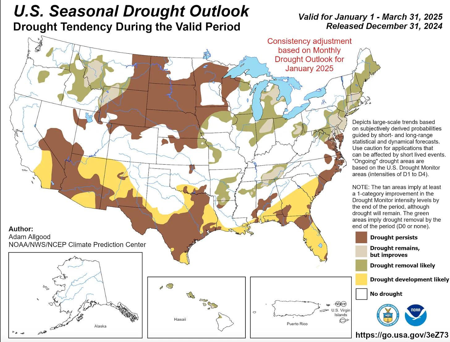
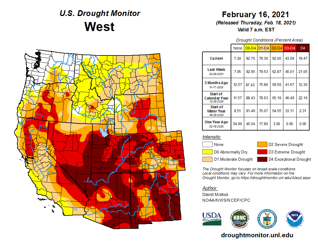
The drought situation a year ago (left) and now (right). While drought has subsided in New Mexico and the Four Corners area, it has intensified dramatically in Wyoming, Montana, parts of Idaho and a swath that follows the lower Colorado River and includes Las Vegas, which has only received .08” of precipitation since April of last year. Source: U.S. Drought Monitor.
For now it looks like there’s no relief in sight for the Southwest or the Northern Rockies.
🌵 Public Lands 🌲
Biden’s getting busy as he prepares to vacate the White House. The Los Angeles Times reports that he plans to designate the Chuckwalla National Monument on 644,000 acres of federal land in southern California, and the Sáttítla National Monument on 200,000 acres in the northern part of the state near the Oregon border. That’s what I’m talkin’ about, Joe! Now do the lower Dolores!
🦫 Wildlife Watch 🦅
The soon-to-be Chuckwalla National Monument lies south of and adjacent to Joshua Tree National Park, an area often targeted by utility-scale solar developers. That’s the sort of development that will now be banned there. Not only will cultural sites be protected, but also wildlife. A new study found that some of the Southwest’s best sites for solar overlap critical habitat for vulnerable species, including in most of southern California.
***
The U.S. Fish and Wildlife Service is seeking any information on the killing of a gray wolf in Grand County, Colorado, in summer of 2024. The wolf, 2309-OR, was part of the Copper Creek pack that was captured by wildlife officials in August, after members of the pack had made a meal out of local ranchers’ livestock. 2309-OR was in bad condition and perished in captivity; a subsequent investigation found that he died of a gunshot wound. It’s illegal to kill wolves in Colorado, not to mention immoral and just a horrible thing to do. The Center for Biological Diversity and other conservation organizations are offering a $65,000 reward for information leading to the arrest and conviction of the shooter.
📸 Parting Shot 🎞️
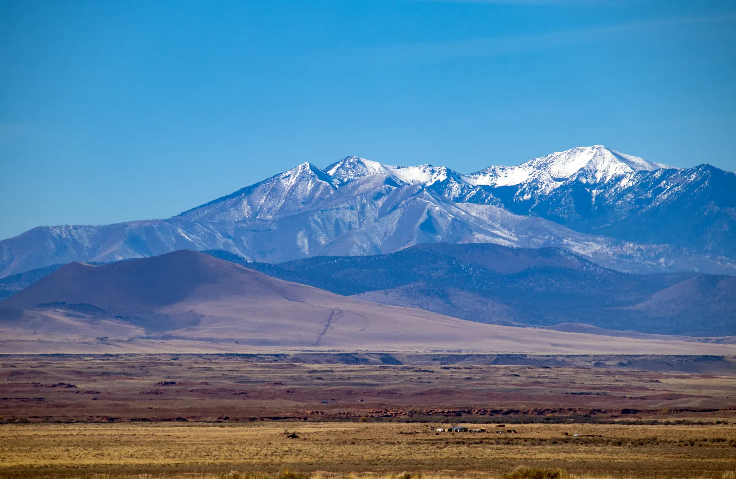
San Francisco Peaks near Flagstaff, Arizona, in mid-November. They had a bit of snow from earlier storms, but haven’t received much since. The Snowslide Canyon SNOTEL site at 9,744 feet in elevation is recording 65% of normal snow water equivalent. Jonathan P. Thompson photo.
1 Andy Gleason, snow nerd extraordinaire, explained it like this after record-high avalanche fatalities during the relatively scant 2021 snow year :
Lake Powell has been about a quarter-full. The snowpack looks strong now, but it’s anybody’s guess whether there will be enough runoff come April and May to substantially augment the reservoir. May 2022 photo/Allen Best
Click the link to read the article on the Big Pivots website (Allen Best):
October 24, 2024
Colorado River Basin states have scaled back their demands on the river. But agreement about solutions proportionate to the challenge remains distant as the 2025 deadline nears.
The story so far: Andy Mueller, the manager of the Colorado River District, the lead water policy body for 15 counties on the Western Slope of Colorado, used his organization’s annual seminar this year to call for the state to begin planning for potential curtailments of diversions. The river has delivered far less water in the 21st century than was assumed by delegates of the seven basin states when they drew up the Colorado River Compact in 1922. Might higher flows resume? Very unlikely, given what we know about climate change. See Part Iof the series and Part II.
“Having a state plan for compact curtailment has been on the table for what seems like forever, likely 2005 to 2007,” said Ken Neubecker. Now semi-retired, he has been carefully watching Colorado River affairs for several decades and has represented several organizations at different times.
Why hasn’t Colorado moved forward with this planning? When I called him to glean his insights, Neubecker shared that he believes it’s because such planning encounters a legal and political minefield.
“It’s not as simple as pre-1922 rights are protected and post-1922 rights are going to be subject to curtailment based on the existing prior appropriation system.”
Denver Water’s Moffat Tunnel diversion from the Fraser River to Boulder Creek. Most of water diverted to Colorado’s Front Range cities from Western Slope rivers and creeks have legal rights junior to the Colorado River compact. Photo/Allen Best
Front Range municipal water providers and many of Colorado’s agriculture diversions are post-1922 compact. And so are some agricultural rights on the Western Slope.
“I think everybody thinks that well, we’re on the slow-moving train and the cliff is getting closer but it’s not close enough – and there are other things that we can do to slow the train down.”
Taylor Hawes, Colorado River Program director for the Nature Conservancy via Water Education Colorado.
Taylor Hawes, who has been monitoring Colorado River affairs for 27 years, now on behalf of The Nature Conservancy, suspects that Colorado doesn’t want to show its legal hand or even admit the potential need to curtail water use in Colorado. She contends that planning will ultimately provide far more value.
“The first rule you learn in working with water is that users want certainty. Planning is something we do in every aspect of our lives, and planning is typically considered smart. It need not be scary,” she told Big Pivots. “We have all learned to plan for the worst and hope for the best.”
Colorado can start by creating a task force or some other extension of the state engineer’s office to begin exploring the mechanisms and pathways that will deliver the certainty.
“We don’t have to have all the answers now,” Hawes said. “And just because you start the process for exploring the mechanism to administer compact compliance rules doesn’t mean you implement them. It will give people an understanding of what to expect, how the state is thinking about it.”
Rio Grande near Monte Vista. Meeting Colorado’s commitments that are specified in the compact governing the Rio Grande requires constant juggling of diversions. Photo/Allen Best
Compacts have forced Colorado to curtail diversions in three other river basins: the Arkansas, Republican and Rio Grande. The Rio Grande offers a graphic example of curtailment of water use as necessary to meet compact obligations on a week-by-week basis.
The Republican River case is a more drawn-out process with a longer timeline and a 2030 deadline. In both places, farmers are being paid to remove their land from irrigation. The Colorado General Assembly this year awarded $30 million each to the two basins to bolster funding for compensation.
A study commissioned by the Nature Conservancy that involved interviews with water managers and others in those river basins had this takeaway message: “the longer (that) actions are delayed to address compact compliance, the less ability local water users have to tailor compliance-related measures to local conditions and needs and reduce their adverse impacts.”
In the Arkansas Basin, Colorado had to pay $30 million and water available to irrigators was reduced by one third.
“That’s the first lesson in how not to do compact compliance: do not wait to be sued because (then you lose) the flexibility to do stuff the right way,” said one unidentified water manager along the Arkansas River.
Neubecker points to another basin, the South Platte. Even in 1967, Colorado legislation recognized a connection between water drawn from wells along the river and flows within the river. The 2002 drought forced the issue, causing Hal Simpson, then the state engineer, to curtail well pumping, creating much anguish.
Ken Neubecker via LinkedIn
Creating a curtailment plan won’t be easy, Neubecker warns. “It could easily take 10 years. ’Look how long it took to create the Colorado Water Plan. It took a couple years and then we had an update five years later. And that was easy compared to this.”
All available evidence suggests the Colorado River Basin states are nowhere near agreement.
In August, Tom Wilmoth provided a perspective from Arizona in a guest opinion published by The Hill under the title of “Time is running out to solve the Colorado River crisis.” As an attorney he has worked for both the Arizona water agency and the Bureau of Reclamation before helping form a law firm in 2008.
“It has taken 24 years for the problem to crystalize, but less than 24 months remain to develop a solution,” he wrote. “Yet there appears to be little urgency in today’s discussion among the Colorado River Basin’s key players.”
Wilmoth said ”Deferring hard conversations today increases the risk of litigation later.” He, like all others, sees a reasonable chance it would end up before the Supreme Court – with the risk of the justices appointing a special master to adjudicate the conflict. “Its recent tendency has been to appoint individuals lacking in subject matter expertise, a troubling prospect given the complex issues at play.”
The area around Yuma, Ariz., and California’s Imperial Valley provide roughly 95% of the vegetables available at grocery stores in the United States during winter months. February 2017 photo/Allen Best
Monitoring the conversations from Southwest Colorado, Rod Proffitt sees Mueller trying to prepare people in the River District for the challenges ahead.
“I think he has tried to scare people. He is trying to get them prepared to make some sacrifices, and limiting growth is a sacrifice.”
A semi-retired water attorney, Proffitt is also a director of Big Pivots, a 501-c-3 non-profit.
Make no mistake, says Proffitt, more cuts in use must be made – and they need to be shared, both in the lower basin and in the upper basin. What those cuts need to be, he isn’t sure. Nor do they necessarily need to be the same.
For example, he can imagine cuts that are triggered by lowering reservoir levels. At a certain point, lower basins must reduce their use by X amount and upper basin states by Y amount.
The federal government has mostly offered carrots to the states to reduce consumption, a recognition of the river’s average 12.4 million acre-feet flows, far short of the flows assumed by the compact. It also has sticks, particularly regarding lower-basin use, but has mostly avoided using its authority. Instead, the lower-basin has reduced use voluntarily, if aided by the federal subsidies.
The Inflation Reduction Act and the Bipartisan Infrastructure Act, have yielded a river of money for projects in the West that broadly seek to improve resiliency in the face of drought and climate change. The seeds have been planted in many places. For example, a recent round of funding produced up to $233 million for the Gila River Indian Community in Arizona for water conservation efforts.
The federal government has also offered incentives to reduce consumption in the upper basin. The System Conservation Pilot Program ran from 2015 to 2018. The 2024 program was funded with $30 million through the Inflation Reduction Act and had hopes for conserving about 66,400 acre-feet.
The federal government, through the Bureau of Reclamation, has clear authority to declared water shortages in the lower basin. It has warned that three million acre-feet less water must be used. The lower-basin argues that the upper basin should share in some of this burden.
Grand Junction has a maze of irrigation canals but the municipal water utility gets water from a creek that flows from the Grand Mesa. Some diversions in Colordo are pre-compact, but many others occurred after 1922. This is a scene from Grand Junction. Photo/Allen Best
Should the federal government get out the stick?
“Nobody wants to apply vinegar this close to the November election,” said James Eklund when we talked in late September about the stalemate on the river.
Eklund has had a long association with the Colorado River. His own family homesteaded on the Western Slope near Colbran in the 1880s and the ranch is still in the family. He lives in Denver, though, and was an assistant attorney in the state attorney general’s office in 2009, when I wrote my first story. He later directed the Colorado Water Conservation Board, the lead agency for state policy.
For the last few years Eklund has been on his own, more or less, a water attorney now working for Sherman and Howard, a leading Denver firm, while trying to represent clients with diverse agriculture water rights.
“Litigation is a failure,” he said when I asked him about Mueller’s remarks in Grand Junction. He contends the upper basin must come to the table with more ideas about how to solve the structural imbalance between supplies and demands than it has so far. And this, he said, will involves some pain.
Creating compact curtailment will involve rule-making, though, and that will take time and effort. Echoing Denver Water’s position, he says it will divert Colorado from the more important and immediate work of helping negotiate solutions.
Eklund suspects an ulterior motive of the River District: to get the state to play its cards on what curtailment could look like so that it can begin jockeying for position.
On the other hand, he believes cutbacks should be premised on two bedrock principles: voluntary and compensated. But Eklund also says that if the situation becomes desperate enough, water will continue to find its way to cities. “The Front Range is not going to bend its knee to alfalfa plants. It’s not going to do it.”
And then, Colorado’s Constitution allows municipalities to take water. It requires compensation.
The Bureau of Reclamation has said the same thing in the lower basin. Las Vegas and other cities will not be allowed to dry up.
The Bureau of Reclamation has said that Las Vegas and other cities will not be cut off from water in the Colordo River. . Photo/Allen Best
But what if compact curtailment means making the hard decision about who doesn’t get water and does not get compensated – people like the farmers near Fort Morgan who, in 2002, had to cease pumping water?
Neubecker characterizes the position of Colorado as one of conflict avoidance. Look at where it got Neville Chamberlain, the British prime minster, in his negotiations with Hitler.
What Colorado must do is prepare for the worst-case scenario. “It’s a doomsday plan,” Neubecker says of compact curtailment. “Make the plan, involve all the people who are going to be effected by the plan, and put it on the shelf – but not too far back on the shelf, just in case you need it”
For now, water levels in the two big reservoirs are holding more or less steady.
Another winter like 2002 could trigger renewed clanging of alarm bells.
John Fleck at Morelos Dam, at start of pulse flow, used 4/4/14 as my new twitter avatar
In New Mexico, Fleck, the author, who also monitors Colorado River matters at his Inkstain blog, rejects the metaphor of the Titanic or the idea that conflict is inevitable. In 2002, California was still using 5.1 million acre-feet from the Colorado River, both for agriculture and to supply the metropolitan areas of Southern California. This was well above the state’s apportionment of 4.4 million acre-feet. “The rhetoric was that it will be a disaster to California’s economy” to return to the allocated flows.
California eventually did cut back and it has done just fine. “Everybody would prefer not to do the adaptation, but they have done it just fine. We see that over and over again in community responses to drought in the Western United States,” he said.
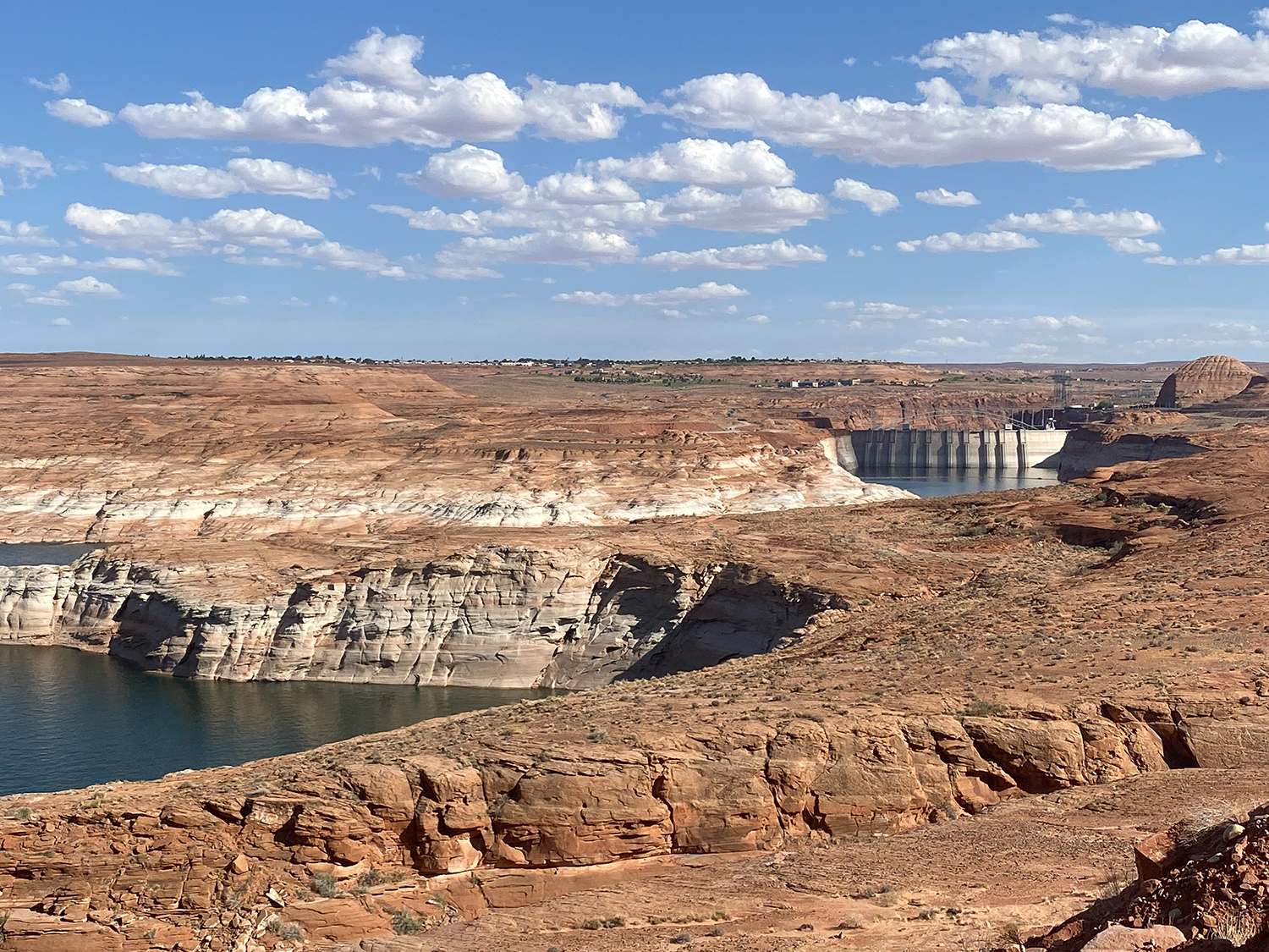
Lake Powell currently has filled to 40% of capacity, a marked improvement from February 2023, when the reservoir had fallen to 22% of capacity. Mead is at 36% of capacity. The situation is not as tense as it was two years ago. That could change in the blink of another hot, dry runoff like that in 2002.
Figure 2. Graph showing reservoir storage between 1 January 2023 and 15 October 2024, highlighting the amount of reservoir recovery during each snowmelt season and the amount of reservoir drawdown during intervening periods. Credit: Jack Schmidt/Center for Colorado River Studies
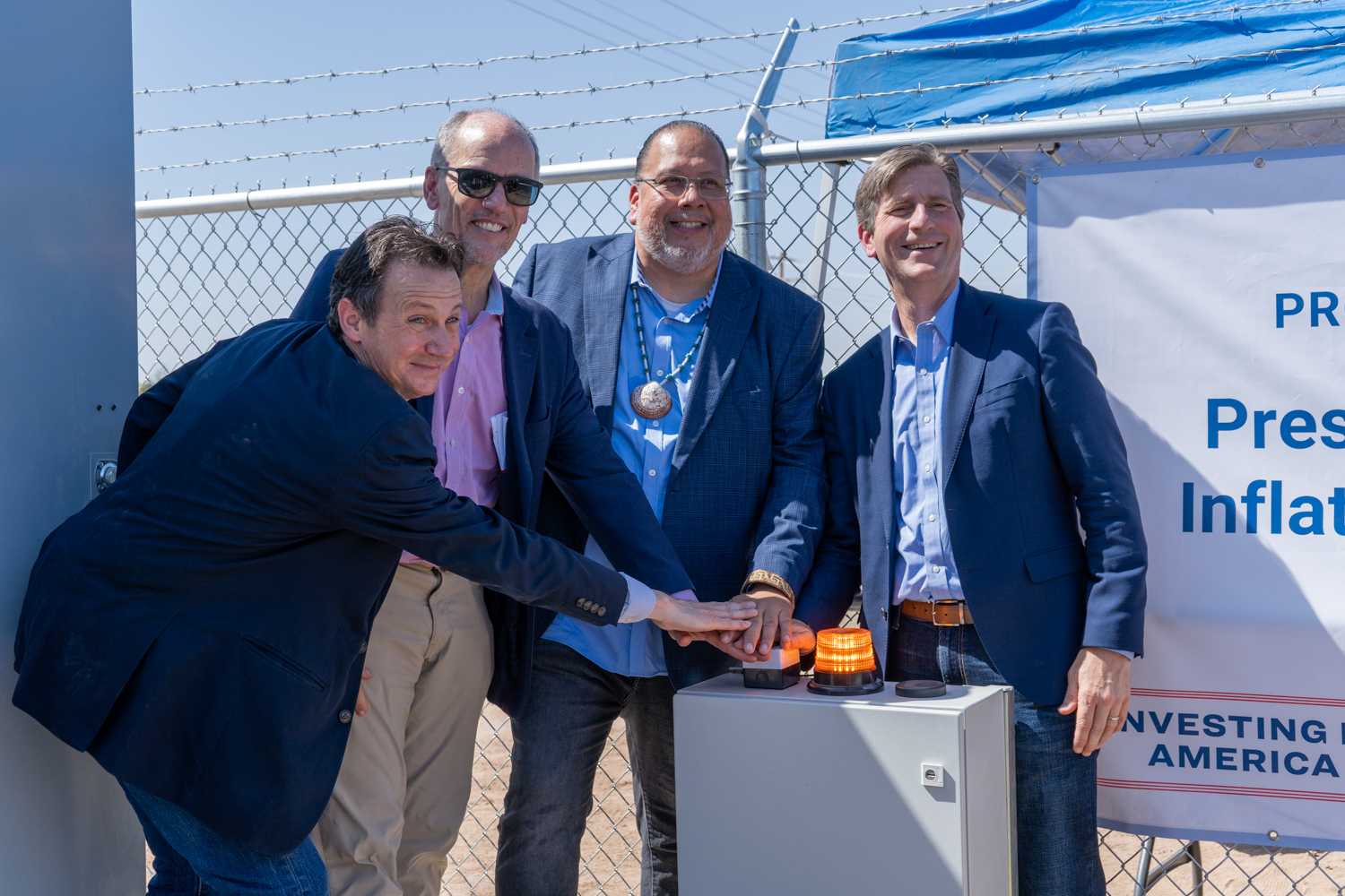
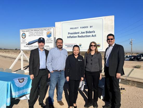
The Gila River Indian Community, alongside partners from the White House, Congress and the Bureau of Reclamation, celebrated the activation of the first power generated by the Western Hemisphere’s first-ever solar-over-canal project on Oct. 3, 2024. (Photos Courtesy of the Gila River Indian Community)
The Gila River Indian Community celebrated a historic milestone in its work to provide solutions for water conservation and renewable energy by activating the first-ever solar-over-canal project in the country.
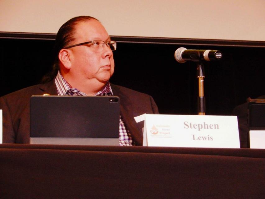
“The Gila River Indian Community is proud to be at the forefront of this groundbreaking solar-over-canal project, which not only generates renewable energy but also conserves our most precious resource — water,” Gila River Indian Community Gov. Stephen Roe Lewis said in a written statement.
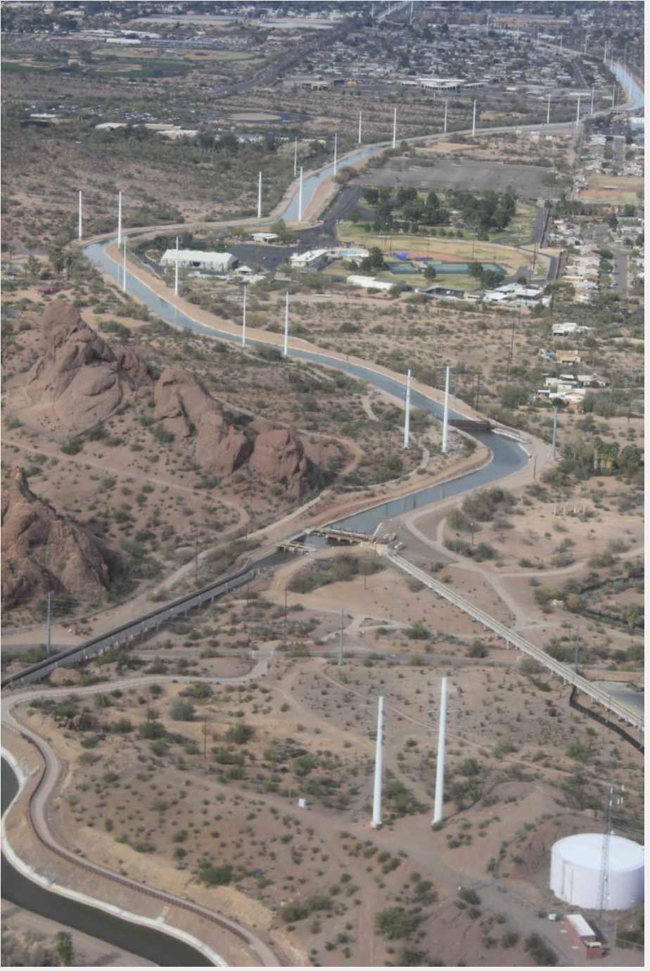
The project spans over 2,700 linear feet of the Casa Blanca Canal, which is located along Interstate 10 near Sacaton.
The tribe said the project represents a groundbreaking solution to the intertwined crises of energy, water and climate change, specifically addressing the unique needs of the Gila River Indian Community, the State of Arizona, the southwest region and the Colorado River Basin.
“This project builds on the work of our ancestors, who found innovative ways to harness our water and natural resources throughout the generations,” Lewis said.
The Gila River Indian Community held an event on Oct. 3 to commemorate activating the power of the solar project near Sacaton and hosted federal leadership: White House Senior Advisor and Assistant to the President Tom Perez, Bureau of Reclamation Deputy Commissioner David Palumbo and U.S. Rep. Greg Stanton.
The project is the first solar-over-canal initiative of its kind in the Western Hemisphere, according to the tribe, and it is setting a new standard for sustainable water and energy management.
“The Gila River Indian Community, known for its long-standing leadership in water conservation and irrigation innovation, continues to pave the way for cutting-edge solutions to the challenges of the 21st century,” the tribe stated.
The Casa-Blanca Canal Solar project is developed by the Pima-Maricopa Irrigation Project a department of the Gila River Indian Community and funding support from the Bureau of Reclamation.
The $5.6 million for the project came from President Joe Biden’s Investing in America Agenda. The tribe said the project was developed as part of the administration’s broader strategy to promote innovative renewable energy solutions and water conservation technologies.
“The Gila River Indian Community is a national leader in creating practical solutions to some of the most pressing environmental challenges we face today,” Perez said in a statement.
“This project serves as a model for communities across the country as the Administration continues to invest in America and work to build a sustainable, resilient future,” he added.
The tribe highlighted how the solar-over-canal project offers numerous environmental and operational benefits, including generating clean and renewable energy, reducing water evaporation from the canal, reducing maintenance requirements for the canal infrastructure, and contributing to the tribe’s goal of a carbon-neutral energy footprint.
The Gila River Indian Community announced that two additional phases of the project are planned, with funding and design work already in progress. The next phase involves work covering a larger portion of the irrigation system.
“Water savings here on Gila River Indian Community Land means savings for the entire Colorado River System – and in this drought, every acre-foot counts,” U.S. Rep. Greg Stanton said in a statement. “These projects show what’s possible with strong partnerships between the federal government, states and Tribal leaders.”
Audubon supports the Yavapai-Apache Nation’s water rights settlement and pending legislation, the Yavapai-Apache Nation Water Rights Settlement Act of 2024.
The Yavapai-Apache Nation and other parties in Arizona have come to a historic agreement with the settlement now before Congress. Not only will this settlement—when passed by Congress and signed by the President—ensure a reliable and sustainable water supply for the Yavapai-Apache Nation in north central Arizona’s iconic “Verde Valley,” it will preserve the Verde River and its precious habitat by reducing reliance on groundwater.
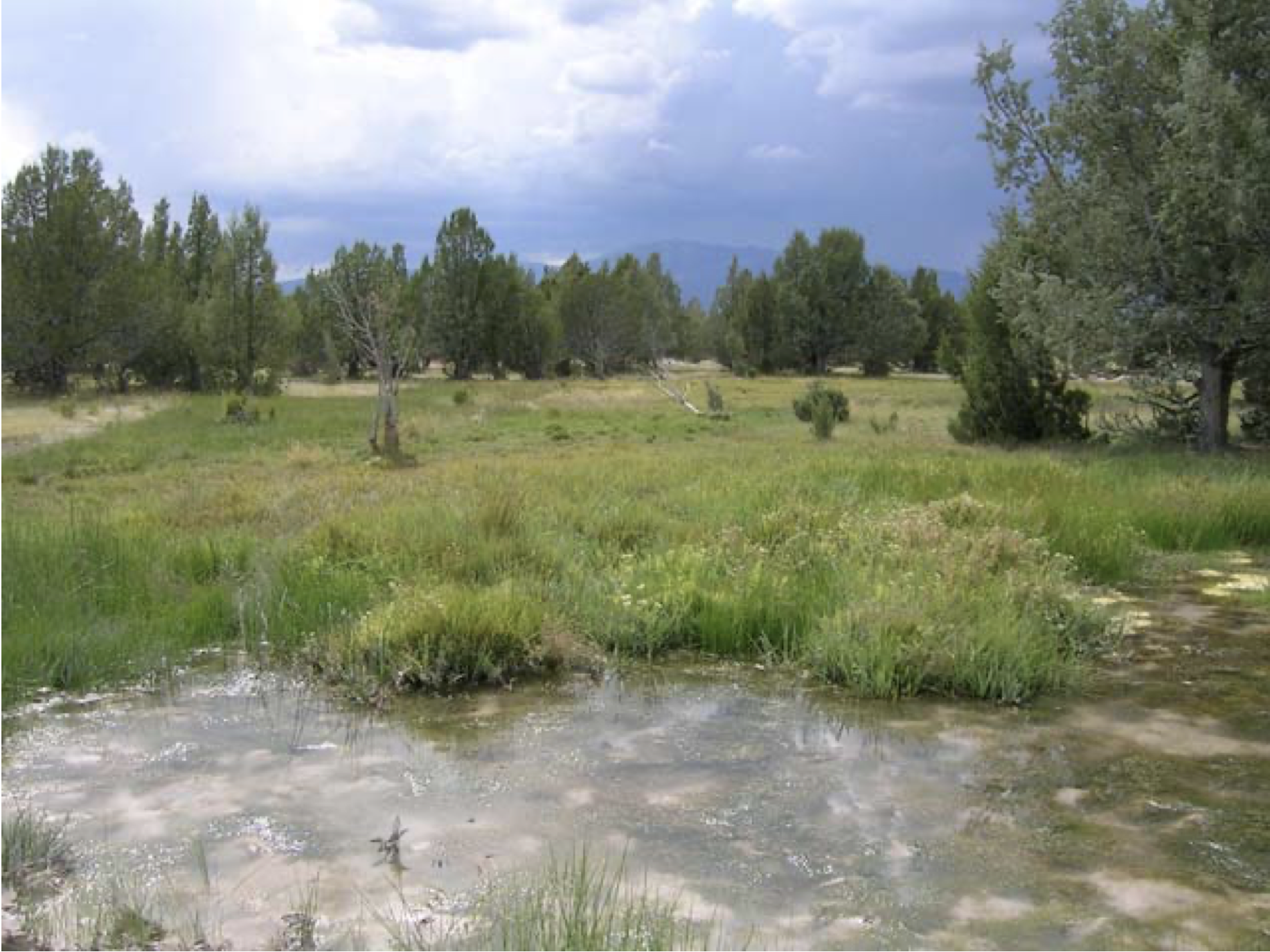
Healthy mountain meadows and wetlands are characteristic of healthy headwater systems and provide a variety of ecosystem services, or benefits that humans, wildlife, rivers and surrounding ecosystems rely on. The complex of wetlands and connected floodplains found in intact headwater systems can slow runoff and attenuate flood flows, creating better downstream conditions, trapping sediment to improve downstream water quality, and allowing groundwater recharge. These systems can also serve as a fire break and refuge during wildfire, can sequester carbon in the floodplain, and provide essential habitat for wildlife. Graphic by Restoration Design Group, courtesy of American Rivers
Within the Verde Valley, Audubon has identified four Important Bird Areas, all of which rely on healthy groundwater levels to sustain flowing rivers and streams and the rich plant life and wildlife they support. One of the many benefits of this settlement includes helping to sustain a portion of the Verde River downstream of the Yavapai-Apache Nation that was designated as a Wild and Scenic River by Congress in 1984.
The settlement is the result of innovative and creative thinking from the Yavapai-Apache Nation, Salt River Project, the Town of Camp Verde, the Town of Cottonwood, the Town of Clarkdale, and others. The settlement includes building a 60-mile water pipeline from C.C. Cragin Reservoir on the Mogollon Rim, north of Payson, increasing the capture of wastewater into sewer systems, boosting the use of reclaimed water, and the potential for regional water planning and collaboration among nearby municipalities and the Yavapai-Apache Nation.
Audubon Southwest, our regional office in Arizona and New Mexico, is also part of the Water for Arizona Coalition. In 2022, Water for Arizona outlined a vision for how to improve Arizona’s water outlook, called the Arizona Water Security Plan. One of the six key tenets is: Continue to support Tribes in resolving Tribal water issues. This settlement is a key milestone as Arizona works to improve its overall water security.
It is long past due for the Yavapai-Apache Nation to have secure and reliable water supplies, and this settlement is a monumental step forward for their growing community. Bipartisan, bicameral legislation to enact and fund the settlement is sponsored by Arizona’s Senators Kelly (D) and Sinema (I) in the U.S. Senate. Representative Schweikert (R) introduced the U.S. House bill, cosponsored by Representatives Ciscomani (R), Lesko (R), Stanton (D), and Gallego (D).
Audubon supports the passage of the settlement legislation and the provision of approximately $1 billion to ensure the project is brought to completion. As part of our support, we sent a letter to Arizona’s Congressional delegation, which you can view below.
Decades of drought and taking more water from the Colorado River than it can afford to give have put both the river and the $1.4 trillion economy it supports in jeopardy. Investing in water resilience is essential for companies operating in the region, but it requires a different approach than many are used to.
A tested and successful model can be found on the Verde River, a Northern Arizona tributary of the Salt River in the Colorado River Basin. The Verde River provides water for local farms and delivers up to 40 percent of in-state surface water for major urban locations in the Phoenix metro area. But its long-term health is at risk from withdrawals, groundwater pumping, a warming climate and drought.
Companies including Boeing, REI, Coca-Cola, Meta, Microsoft, Cox, PepsiCo, Google, Procter & Gamble, EdgeCore and Intel have partnered with groups such as The Nature Conservancy, Friends of the Verde River, National Forest Foundation and the Salt River Project to support dozens of resilience projects over the past decade in the Verde River. The Nature Conservancy (TNC) reports that over the past five years, projects spanning seven irrigation districts have saved nearly 50,000 acre-feet of water. That’s enough to support 100,000 U.S. households for a year.
These projects have focused on creating healthier streams and wetlands, reducing the risk of catastrophic wildfires and increasing the efficiency of water delivery systems. Here are some examples.
Reducing wildfire risk
An overabundance of small shrubs and trees in the Verde River’s forested headwater areas significantly increased the risk of devastating wildfires that would affect communities and regional water supplies and infrastructure. Partnerships that include agencies, nongovernmental organizations and corporate funders have scaled up projects that remove overgrowth and restore healthy forest conditions. This work has reduced fire risk, improved water availability and increased water security for the region. Corporate partners, including EdgeCore, PepsiCo, Apple, Meta and Google, were critical to the success of these projects.
“Meta’s water stewardship efforts include investing in projects that help put in place the enabling conditions for sustainable water management,” said Stefanie Woodward, water stewardship lead at Meta. “We’re proud to support projects that help to restore healthy forest conditions in the Verde and empower environmental nonprofits and communities to build long-term capacity in Arizona.”
Increasing water conservation
Outdated irrigation ditches convey water from the Verde River to farms across the middle Verde watershed. Leakage across many miles of the system increased the amount of water withdrawn from the river and made it difficult to irrigate farmland.
Multiple Verde River irrigation districts partnered with The Nature Conservancy to pipe more than 4 miles of irrigation ditch and improve water management by installing new water control structures. The work has increased water conservation and improved streamflows. Companies participating in the project include Swire Coca-Cola USA, Coca-Cola, Procter & Gamble, Meta, Coors Seltzer, Microsoft, PepsiCo, Advanced Semiconductor Materials (ASM) and Pulliam Trust.
“Together with The Coca-Cola Company, our support of conservation organizations along the Verde River aims to address the critical water challenges facing this vital ecosystem,” said Mike Bernier, director of sustainability at Swire Coca-Cola. “By funding projects like the piping of the Verde Ditch, we’re helping implement a long-term solution to reduce leakage, in turn improving water-efficiency and ensuring the sustainability of this water source for millions downstream.”
Shifting agricultural water demand
Many traditional crops in the Verde Valley are water-intensive and require significant irrigation during summer months when river flows are low. A partnership that includes Sinagua Malt, TNC and local farmers implemented an innovative program that replaced high-water-use crops, such as alfalfa, with barley, which requires less water in the summer season. The project delivered a solution that provides brewers with premium Arizona malt while improving water flows in the Verde River.
Tamarisk
Improving river flows
In addition to conservation and efficiency projects, removing invasive plant species can also improve water flows. Companies and funders including REI, Intel and Forever Our Rivers each funded work to remove invasive Arundo and Tamarisk plants from the middle Verde River and areas near the mouth of the Verde on the Salt River. These plants force out native vegetation and can use water at a higher rate. Removing them has helped restore habitat, improve biodiversity and keep more water flowing in the Verde River.
Setting the stage for success
Ready-to-fund water resilience projects that directly reinforce corporate goals are rare. Understanding the history and context for the Verde River work can help companies replicate success in other areas.
Social stronghold: Most projects in the Verde developed in areas where extensive groundwork had already been done by organizations that would later partner with corporations. Nonprofit groups and agencies spent time building relationships and credibility with landowners, agencies and partners prior to corporate investment. A foundation of social infrastructure was in place, or was positioned to expand.
Takeaway:Consider the need to support essential enabling actions such as planning, project design or outreach. It’s rare that “shovel-ready projects” are lined up in the right places and on the right timeline to perfectly align with corporate goals. Understanding and supporting pre-project strategies, including relationship building, can be essential.
Community relevance: A shared understanding of water challenges and solutions is necessary to achieve progress. There must be an overlap between community, corporate and conservation goals. On the Verde River, an analysis conducted by TNC and others of water issues, challenges and solutions helped identify areas where community interests intersected with corporate and conservation priorities.
Takeaway: Long-term, larger-scale resilience projects require significant community buy-in to succeed. Specific corporate stewardship, volume or replenishment goals should be based on a solid understanding of local priorities and context. This includes current public sentiment as well as the availability, likelihood, cost and timing of projects in a given location.
The long game: Many projects require years of preparation — for example, overhauling and improving centuries-old irrigation ditches that cross many land ownership boundaries required years of trust-building, engineering, problem-solving and fundraising. In the case of the Verde, several philanthropic organizations, including the Walton Family Foundation and the Nina Mason Pulliam Charitable Trust, provided early funding that allowed on-the-ground partners to build trust incrementally and set the stage for later success. It took 5-10 years to fully develop a pipeline of projects that could be funded and linked to corporate goals.
Takeaway: Be realistic and informed about the timeline and partnerships required for success. Corporate timelines should reflect real conditions and needs on the ground.
Setting flexible goals: Goals that rigidly define success metrics can create a scenario in which targets cannot be achieved — or where corporate goals do not address the real issues and concerns of local communities. For example, a narrow, inflexible goal such as “by 2030, our company will support projects that reduce water contaminants by at least 20 percent in all regions where we operate” will make it difficult to adapt to real conditions and needs that reflect evolving water challenges and community priorities across diverse locations.
Takeaway: Invest in multiple projects and set goals that are flexible enough to respond to local conditions, needs and context. Don’t expect a single project or narrow approach to meet both corporate water objectives and relevant regional needs.
The National Fish and Wildlife Foundation (NFWF) today announced more than $1.5 million in grants to restore, protect and enhance aquatic and riparian species of conservation concern and their habitats in the headwaters of the Colorado River and Rio Grande watersheds. The grants will leverage over $1.8 million in matching contributions for a total conservation impact of more than $3.3 million.
The grants were awarded through the Southwest Rivers Headwaters Fund, a partnership between NFWF and the U.S. Department of Agriculture’s Natural Resource Conservation Service, U.S. Forest Service, U.S. Fish and Wildlife Service, Walton Family Foundation and the Trinchera Blanca Foundation, an affiliate of The Moore Charitable Foundation, founded by Louis Bacon.
“Communities in the Southwest have grappled with challenges to the long-term sustainability of their rivers,” said Jeff Trandahl, executive director and CEO of NFWF. “These grants demonstrate how investments in stream and meadow restoration in our headwaters can increase the climate resiliency of these critical water resources while supporting the Southwest’s many unique fish and wildlife species.”
The projects supported by the six grants announced today will address a key strategy for species and habitat restoration in headwaters streams of the Colorado River and Rio Grande: restoring and enhancing riparian and instream habitat.
“Consistent with the intent of the Inflation Reduction Act, the selected restoration projects within the forests, streams and riparian areas of the National Forests in Arizona, New Mexico and southern Colorado are a significant step to maintain and improve riparian and aquatic ecosystems into the future in the face of changing climates,” said Steve Hattenbach, Deputy Regional Forester, USDA Forest Service Southwestern Region. “Streams and riparian areas are key to ensuring sufficient water to maintain the ecological integrity of watersheds that support life in the beautiful Southwest.”
NFWF’s Southwest Rivers Program was launched in 2018 to fund projects that improve stream corridors, riparian systems and associated habitats from headwaters to mainstem rivers in the Southwest. Through the Southwest Rivers Headwaters Fund, the program funds projects that produce measurable outcomes for species of conservation concern in the wetlands and riparian corridors of the headwaters regions of major southwestern rivers. In 2022, the Fund expanded from the Rio Grande watershed to include to include priority headwaters watersheds of the Colorado River Basin in Arizona, New Mexico and Utah.
A complete list of the 2024 grants made through the Southwest Rivers Headwaters Fund is available here.
C.C. Cragin (Blue Ridge) Reservoir. Photo taken March 30, 2017 by Deborah Lee Soltesz. Credit: USFS Coconino National Forest. Learn more about the C.C. Cragin (Blue Ridge) Reservoir and the Coconino National Forest.
The Yavapai-Apache Nation approved its water rights settlement June 26, which will bring new water supplies to the Verde Valley and settle the tribe’s decades-long water rights claims. The settlement is the latest after Arizona Gov. Katie Hobbs reversed a state policy that complicated tribes’ efforts to claim their rights to water. Yavapai-Apache Chairwoman Tanya Lewis said the agreement, which was negotiated with local communities, the Salt River Project, and state and federal officials will bring real “wet” water to her tribe. At the center of the settlement: constructing a pipeline from the C.C. Cragin Reservoir on the Mogollon Rim along Forest Service roads to the Verde Valley. SRP manages the reservoir and the water it holds…
In the deal, the pipeline will deliver dedicated sources of water from the Cragin Reservoir to the Yavapai-Apache Nation. It will also allow the tribe to exchange 1,200 acre-feet of its Central Arizona Project water with SRP for an additional delivery of water from C.C. Cragin in the same amount. The settlement will also confirm the Yavapai-Apache Nation’s historic irrigation rights as well as certain rights to pump groundwater, including when C.C. Cragin Reservoir levels are low. The tribe also has the right to acquire future water rights under the settlement. The Yavapai-Apache Nation will also waive, among other things, claims for damages to water rights against existing water users in the Verde River watershed and against the United States.
Brett Fleck stands by the Arizona Canal in Peoria, Ariz. on March 18, 2024. The water department he manages is focused on making sure taps keep flowing in the long term, even as Peoria’s main source of water shrinks. Alex Hager/KUNC
Click the link to read the article on the KUNC website (Alex Hager):
June 24, 2024
This story is part of ongoing coverage of the Colorado River, produced by KUNC and supported by the Walton Family Foundation. It was produced in partnership with The Water Desk, an independent initiative of the University of Colorado Boulder’s Center for Environmental Journalism.
Brett Fleck does not have an easy job. He manages water for a city in the desert. He has to keep taps flowing while facing a complicated equation: The city is growing — attracting big business and thousands of new residents every year — but its main source of water is shrinking.
Standing on the edge of a sun-baked canal with palm trees lining its banks, Fleck watched water flow into the pipes that supply the Phoenix suburb of Peoria, Arizona.
“We’re really having a complete changeover in how people view the Colorado River from a reliability standpoint,” he said.
The river, which accounts for about 60% of the city’s supply, is stretched thin. Its water is used by 40 million people from Wyoming to Mexico. Climate change is shrinking its supply, and the federal government is scrambling to boost depleted reservoirs. The Biden Administration has poured money on the problem, allocating $4 billion from the Inflation Reduction Act for Colorado River projects.
Across the seven U.S. states that use its water, that money has been used to save water in a number of ways — from patching up leaky canals to paying farmers to pause crop planting. A relatively small chunk of that money has gone to cities, but it’s being welcomed with open arms in the Phoenix metro area.
Peoria’s water department is one of seven in Arizona getting paid by the federal government to leave some of its supplies in Lake Mead, the nation’s largest reservoir. In May 2023, the Biden Administration announced it would set aside $157 million for a handful of Arizona cities and one mining company to cut back on their take from the Colorado River.
Following that money and seeing how cities are spending the federal cash reveals a major trend in Arizona’s water management.
The sun sets behind Phoenix on June 14, 2024. The city and its suburbs are attracting new residents and businesses despite shrinking water supplies. Local leaders say they have plans for expensive engineering projects that will help keep taps flowing for decades to come. Photo credit: Alex Hager/KUNC
The Biden administration framed the spending effort as “water conservation,” but Arizona’s municipal water leaders aren’t using it to make changes traditionally thought of as conservation. Instead of paying for small tweaks to water use – like encouraging residents to install low-flow showerheads or rip out their thirsty lawns – many are thinking bigger, putting their multimillion dollar checks towards billion dollar infrastructure projects that are aimed at keeping taps flowing for decades to come.
Basically, cities like Peoria are planning to engineer their way out of the problem.
“When you don’t have that reliability,” Fleck said, “You have to make additional investments for alternatives, backup supplies, etc. That’s what it really takes to make sense of the world that we live in now.”
A changing mindset
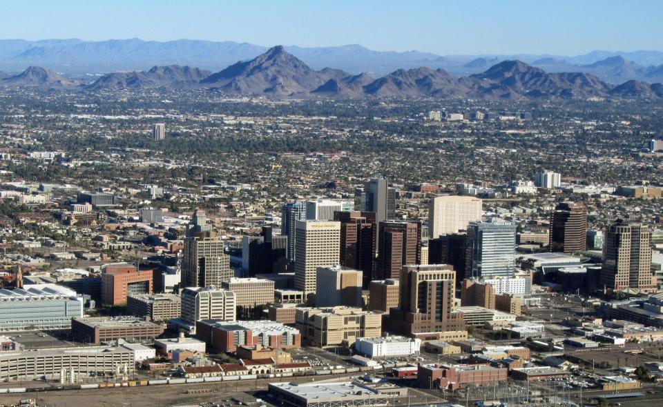
Much ink has been spilled about the future of life in Phoenix. The sprawling metro area – referred to by locals as “The Valley” – is home to about 5 million people. A booming economy and strikingly wide suburban sprawl are pushing its borders further into once-unoccupied dusty expanses in nearly every direction. Meanwhile, climate change has inspired growing skepticism about the long-term sustainability of that growth.
Scorching temperatures, which consistently peak above 110 degrees in the summer, and much-publicized threats to its major sources of water, have accelerated calls in the national media for central Arizona to pump the brakes on expansion.
But on the ground, the people that run water departments in cities and suburbs project optimism.
“We have to plan ahead and say, ‘It’s not enough to have enough water to live this year, this month, two years, or five years,” said Cynthia Campbell, a water management advisor for the City of Phoenix. “We plan for 100, and that’s the way we’ve approached it in Arizona. That, I think, is the secret sauce that keeps us sustainable.”
Downtown Phoenix viewed from City Hall on March 4, 2024. The city’s water leaders say they’re nearing the ceiling on how much water can be saved through traditional conservation, and are instead turning their eyes and budgets toward new technology that will help decrease demand for water from the Colorado River and underground aquifers. Photo credit: Alex Hager/KUNC
Campbell described shifting attitudes in Phoenix-area water management. Dwindling water supplies have, for years, forced those cities to do more with less. She explained how Phoenix uses less water now than it did two decades ago, despite significant population growth. The city mostly chalks that up to more efficient water use by homes and businesses, specifically highlighting water that was conserved through more efficient outdoor watering for lawns and plants.
But now, those practices are getting closer to the ceiling in terms of how much water they can save, and new residents keep arriving.
“At some point in time, there does have to be a recognition of the scope of the problem,” Campbell said. “You just can’t conserve your way out of it.”
That mindset has put one word on the lips of many water managers in central Arizona: augmentation.
Engineering a way to more water
The word “augmentation” has different definitions depending on who you ask, but it generally means water departments are focused on adding new water supplies, rather than just using less of the water they already have.
Peoria and Phoenix water leaders highlighted two expensive infrastructure projects that fall into the augmentation category. The first is a massive renovation of a nearby dam that would make its reservoir bigger, allowing cities in the area to store more water during wet winters.
Bartlett Dam. Photo credit: Salt River Project
The Bartlett Dam holds back a reservoir about an hour’s drive northeast of Phoenix. Over time, the reservoir has gotten shallower, as sediment in the water settles to the bottom and piles up, reducing the amount of water storage. Bartlett Reservoir and nearby Horseshoe Reservoir have lost a combined 45,000 acre-feet of their total holding capacity. By comparison, Peoria, a city of nearly 200,000 people, gets a total of 35,000 acre-feet of water delivered each year.
Because the reservoirs reach capacity more quickly, water managers have been forced to release excess water instead of storing it for dryer times. A proposed expansion of the dam would make it easier to store that water by making Bartlett Dam about 100 feet taller. Peoria and Phoenix are among 22 cities, tribes and farm districts that are interested in chipping in for the project, which is projected to cost about $1 billion.
Water is released from behind Bartlett Dam in March 2023 after a wet winter. Cities that use water stored behind the dam want to fund a $1 billion expansion of the dam to make sure that extra water can be stored instead of released downstream. Michael McNamara/Salt River Project
The dam holds back water from the Salt River, whose supplies are managed separately from the Colorado River. But increasing the amount of stored Salt River water could help cities ease up on their Colorado River reliance.
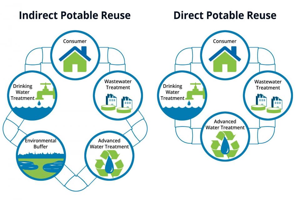
A second idea that falls into the augmentation category represents an entirely different way of “adding” water to the system, and it’s part of a regional trend: cleaning up sewage and making it drinkable again.
Metropolitan Water District’s advanced water treatment demonstration plant in Carson. (Source: Metropolitan Water District of Southern California)
Water managers refer to the practice as “advanced water purification,” or “wastewater recycling,” and it’s stirring up a lot of excitement – and big investment – in a number of places that share similar anxieties about shrinking supplies from the Colorado River.
Small cities are eyeing the expensive new technology for the future, and big ones are already putting shovels in dirt.
In Phoenix, the city council greenlit a $300 million construction project to revive a shuttered water treatment plant in the city’s far northern reaches, which officials said would lay the groundwork for installing equipment to turn wastewater into clean drinking water.
Elsewhere in the Colorado River basin, big cities are forging ahead with the practice. In the Los Angeles Metro area, the main water distributor proposed a $3.4 billion wastewater recycling facility, and has rallied hundreds of millions of dollars in support from out-of-state water agencies that could buy California’s unused Colorado River water if the new facility is a success. In Colorado, the state government passed first-of-its-kind legislation that would make it easier for cities to bring the new water treatment tech online, and some cities say they’re 3-5 years away from building it.
Beneath the surface
Phoenix-area water managers have to keep a lot of balls in the air at once. The water flowing through their pipes comes from a few sources, each with very different challenges.
The Colorado River, which mostly begins as snowmelt in the faraway Rocky Mountains, comes to the metro via the Central Arizona Project, a 336-mile canal that cuts through the desert. The Salt and Verde Rivers bring snow and runoff from a watershed that covers the colder, higher-altitude parts of Arizona. And one source starts much closer to home: groundwater.
That last water source, at least recently, has proven the trickiest to manage. Groundwater use and management have become hot-button political issues in Arizona as experts raise alarm about underground stores of water that are shrinking fast, including some that, once drained, would take generations to refill.
Water experts say all of the most pressing water issues facing Arizona cities – the shrinking Colorado River, the overtaxed underground aquifers, and work to augment existing supplies – are all smaller pieces of a bigger puzzle.
Kathryn Sorensen, a former director of Phoenix’s water department, said Colorado River shortages will probably turn up the pressure on groundwater.
“Our aquifers, while large and plentiful, are also fossil aquifers, so if we pump them out too quickly, then it’s just gone,” said Sorensen, who now researches water policy at Arizona State University. “So these types of things like advanced water purification, augmentation, additional conservation efforts, those all play into avoiding the use of those fossil groundwater supplies.”
Sorensen described the groundwater supplies – and whether or not they’re managed sustainably – as pivotally important to Arizona’s long-term future.
“If we’re going to continue to have the sort of economic opportunities we have here and the quality of life that we have here a few generations from now,” she said, “It’s really of utmost importance that we protect groundwater today.”
‘There’s not a lot of gambling going on here’
Groundwater has become the latest issue to help fuel a wave of national attention on the long-term viability of Phoenix as a place for people to live.
Articles with headlines like “How long can the world’s ‘least sustainable’ city survive?” have helped to crystalize nationwide skepticism about central Arizona’s future. In 2023, state officials put a pause on some new subdivisions because they couldn’t draw enough water from underground. The announcement launched a flurry of news coverage. The New York Times framed it as “the beginning of the end” for development around Phoenix.
In that article, Katie Hobbs, Arizona’s governor, is quoted as saying, “We are not out of water and we will not be running out of water.”
Arizona Governor Katie Hobbs speaks in Tucson, Ariz. on Mar. 13, 2024. State leaders have been forced to advocate for policies that respond to the Phoenix area’s water supply crunch while simultaneously trying to tamp down any fears that the city and suburbs might not be a good place to live and work. Photo credit: Alex Hager/KUNC
Hobbs and other leaders in the state have been forced into a bit of a juggling act. Some are trying to advocate for policies that respond to the Phoenix area’s water supply crunch while simultaneously trying to tamp down any fears that the city and suburbs might not be a good place to live and work.
Campbell, who advises Phoenix’s political leaders on water decisions, said she’s confident that people who buy a house or open a business in Phoenix will have water in the future, because those policymakers are feeling a lot of pressure to make sure growth is sustainable.
“They know that the moment there’s a crack in the armor,” she said, “The moment that we have to turn off a tap, every national media outlet will cover it, and it will have a devastating effect on our economy. So there’s not a lot of gambling going on here.”
What ‘sustainable’ growth looks like
Sustainable growth certainly weighs on the mind of water manager Brett Fleck in Peoria.
The city itself touted its status as one of the nation’s top “boomtowns,” growing by 19% in the five-year stretch between 2016 and 2021. It recently paved the way for a massive, $2 billion microchip operation. Amkor Technology’s 56-acre facility in Peoria is set to be the nation’s largest semiconductor packaging and test facility, and will likely use a massive amount of water.
“Do I think Arizona can continue to grow sustainably? As long as we continue to make the investments and plan, absolutely,” he said. “The day that we stop making those investments in our sustainability is the day that we probably shouldn’t be growing anymore.”
Fleck said his city is working with Amkor to create a system that brings recycled water to the facility, so the semiconductor operation doesn’t draw from the drinking supply.
Brett Fleck shows where Colorado River water enters the city’s water treatment facility in Peoria, Ariz. on March 18, 2024. The city has plans to build new water purification technology that will turn sewage into usable water, decreasing the strain on the Colorado River and groundwater. Photo credit: Alex Hager/KUNC
At a relatively small water treatment plant on Peoria’s western edge, the city’s water system is getting upgraded in real time and the facility is quickly expanding its footprint.
“This water reclamation facility is really the start of Peoria’s water future,” Fleck said as workers in hard hats crisscrossed the dirt expanse behind him.
Treated water from the plant could see a few fates, Fleck said. It may be pumped into underground storage, sent to the giant new microchip facility, or maybe even purified to drinking standards and sent back into pipes. The latter is probably a decade from reality.
“It’s all based on funding,” Fleck said.
Now that cities around Arizona are seeing the promise of new technology and methods to get more out of their endangered water supplies, the massive cost of those projects stands as the biggest hurdle to their implementation. Fleck said the billions of federal dollars being sent to remedy the Southwest’s water woes pale in comparison to the tens or hundreds of billions needed to build needed infrastructure.
“Unfortunately, it’s a drop in the bucket,” he said. “However, at least we’re headed in the right direction. So at least we’re making those investments, and we’re recognizing that we need to make those investments to pivot away from our very large reliance on Colorado River supplies.”
Armed with a combination of federal, state, and local money, cities all around the Phoenix area are moving in that direction. Tempe, for example, has similar plans to Peoria and plans to open a water recycling facility by 2027. Nearby Scottsdale hosts one of only three water treatment facilities in the nation that is part of a pilot program for advanced water purification, and is poised to bring it into regular use.
An uncertain future
Arizona’s city leaders say they’re doing all they can to fend off anxiety about an uncertain future for water supply. Two big factors, largely out of those cities’ hands, mean that anxiety is justified.
The first is funding. Large-scale, high-tech water projects that come with nine- or ten-figure price tags benefit greatly from federal help. The Biden Administration has spent an amount of money that one water expert called, “the largest investment in drinking water infrastructure and water supply infrastructure that we’ve seen in a generation.”
Future administrations might not be so spendy.
“Federal funding is always a dicey proposition,” said Sorensen, the ASU water researcher. “Relying on annual appropriations, it can be hinky, especially when you have to compete with other very worthy federal priorities.”
The second big cause for uncertainty is the messy, ongoing negotiation process that will result in new rules for sharing the Colorado River. The current rules for divvying up its water expire in 2026, and the people in charge of writing new ones are stuck in a heated standoff.
Those people are negotiators from the seven states that use its water. Despite their differences, they generally agree that climate change has shrunk the amount of water in the river, and states need to cut back on demand accordingly.
Tom Buschatzke (right), Arizona’s top water negotiator, sits on a panel about Colorado River management in Boulder, Colo. on June 6, 2024. Every proposed water cutback plan, even the one co-signed by Arizona itself, puts more of Arizona’s water on the chopping block than any other state. Photo credit: Alex Hager/KUNC
Their disagreements, though – sometimes rooted in century-old rivalries between states – mean that it’s not clear exactly how much water, if any, each state should lose.
But every proposed cutback plan, even the one co-signed by Arizona itself, puts more of Arizona’s water on the chopping block than any other state.
That is due to a system called prior appropriation, which serves as the bedrock of Colorado River management. In short, it means that the first person to use water will be the last to lose it in times of shortage. And when it comes to Colorado River use, Arizona sits in a more vulnerable legal position.
The canal that carries water to central Arizona from the Colorado river was authorized in 1968, and the users who depend on its water are first in line to have their water taken away when reservoirs are low.
Sorensen said that fact is a major motivator for Arizona’s water leaders to make sure they manage supplies in a sustainable way.
“We’ve known since 1968 that our water was first to be cut when there wasn’t enough to go around, and that has made us prepare very methodically for those cuts,” Sorensen said. “The pressure has certainly been turned up, but it’s pressure that’s always existed.”
Central Arizona Project map via Mountain Town News
CORRECTIONS: On June 24, we incorrectly identified the river held back by Bartlett Dam. This story has since been updated to clarify the connection between the Verde River and Salt River. On June 24, we incorrectly identified the estimated completion date of Tempe’s water recycling facility as 2025. This story has since been updated to include the correct year, which is 2027.
One of the most interesting comes from the Gila River Indian Community. (Their March 29 letter to Reclamation lays it out.) Spanning the Gila River along the southern edge of Phoenix, the Gila River Indian Community has long done a masterful job of leveraging water in defense of its sovereignty – or maybe sovereignty in defense of its water?
The water, the cattails, and the birds, are part of a complex legal tangle that led to the 2004 Arizona Water Settlements Act, which ensured Central Arizona Project water – Colorado River imports, pumped up into the Gila River Valley from the river’s main stem – to replace water stolen from the Gila River Indian Community by settlers a century before.
Access to that water has made the Community a power player in central Arizona water politics. But that water is now at risk as a result of efforts to cope with declining flows on the Colorado River. In particular, the Community views the Lower Basin States’ proposal for post-2026 river management as (my words, not theirs) an assault on their sovereignty. Here’s how they put it in their March letter to Reclamation:
Allocation of CAP water is crazy complicated, and I’m still trying to get my head around these details. But the Gila River Indian Community is essentially arguing that in the current proposal, which calls for cuts deep enough to eliminate the “structural deficit,” Arizona is essentially bargaining away the Community’s water.
So the Community has concerns with the Lower Basin proposal. But it has even greater concerns about the Upper Basin proposal, which argues that if even deeper cuts are needed, they should all fall on the Lower Basin.
The footnote to that paragraph is wonderful:
The Gila River Indian Community offers an alternative suggestion for managing Lower Basin cuts that’s super interesting. Rather than what the Lower Basin Proposal offers – essentially a negotiated who-cuts-what set of numbers based on talks among the three states – the Community suggests cuts across the Lower Basin proportionally, based on the calculation of evaporation and system losses (which we’re now supposed to shorten, apparently, as ESL):
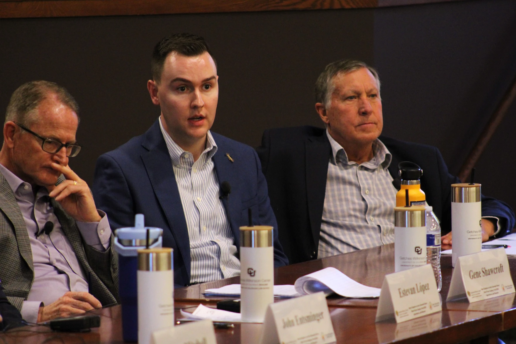
The Community’s letter includes a strong emphasis on the federal government’s trust responsibility to the basin’s 30 Tribal Sovereigns. The letter makes clear that the federal government has a legal obligation “to find alternative water supplies for tribes that will be negatively affected by the Post-2026 Operations.” As Gila River Indian Community Gov. Stephen Roe Lewis put it at this month’s Getches-Wilkinson conference in Boulder, “First peoples of this land should be the last to be cut.”
Click the link to read the article on the InkStain website (Eric Kuhn):
February 22, 2024
One of the commentors to our January 19th, 2024, blog post titled “Are We headed for the First Colorado River Compact Tripwire?” – John C. (who, by-the-way runs a very talented water resources engineering firm) raised several finer points to explore further:
The first point deals with obligations of each Basin to contribute water needed to meet U.S. obligations to Mexico under the 1944 Treaty. The second deals with the question of how to measure, and therefore manage, in the context of overall Colorado River Basin management, the use of tributary water in the Lower Basin. Both represent unresolved legal questions with enormous potential impacts on the allocation and distribution of the shrinking Colorado River – questions we have avoided dealing with by draining the Basin’s reservoirs. We no longer have that option.
The two issues have been disputed for decades. They are, of course, totally inter-related, and when one peels back the layers of each, the problems get so complicated that the only real solution may be for the Basin’s states and other stakeholders to ignore their past positions and grievances and negotiate a river management approach that works on the river we have today, even if that means changes to the foundation of the Law of the River, the 1922 Compact.
MEXICO OBLIGATION
The different interpretations of the Upper Basin’s delivery obligations to Mexico under Article III(c) are well understood throughout the Basin. III(c) says that water for Mexico should be provided from “surplus”. If there is no surplus, the Upper and Lower Basins much each provide half the necessary water. But there has never been agreement on what that language means in practice. This unresolved uncertainty has enormous implications for how much water is available to each basin in the future.
The Lower Division States take the position that there’s no current “surplus,” as defined by Article III (c), thus the Upper Division States must deliver at Lee Ferry 50% of however much water is required to be delivered under the Treaty. The annual delivery is normally 1.5 maf/year, but under either the “extraordinary drought” provision of the Treaty, or Minutes, it could be less. In 2023, it was 1.4 maf.
The Lower Division States’ position would dictate an average annual delivery of 8.25 maf/year at Lee Ferry, 7.5 maf under Article III(d) + 750,000 af under Article III(c). The 8.25 maf includes an average contribution of 20,000 af/year from the Paria River and would be adjusted for the occasional annual delivery of less than 1.5 maf. Veterans of the negotiations that led to the 2007 Interim Guidelines will recall that Arizona’s Herb Guenther always brought with him to the meetings a posterboard sign with “8.25” written on it.
Going back to the 1970 decision by the Secretary of the Interior to set the “minimum objective release” from Glen Canyon Dam at 8.23 maf/year, the Upper Division States have consistently taken the position that their annual obligation Mexico has never been formally defined and, whatever it is, it is not 750,000 af/year, every year. While they vigorously complained, they never chose to formally challenge the issue in court or in Congress, perhaps because they concluded that they couldn’t show that any of their interests were injured. Today, based on post-2000 hydrology, that dynamic may have fundamentally changed.
The basic position of each basin has not changed. If anything, because the stakes are much higher, the positions have hardened. In a December 20, 2022, scoping letter to Reclamation, Arizona’s Tom Buschatzke, and Ted Cooke, wrote: “Article III(d) and (c) prohibits the Upper Division States from depleting the flow of the river at Lee Ferry below a rolling 10-year aggregate of 75 maf plus one-half of the Mexico delivery obligation. With reduced releases from Glen Canyon Dam potentially analyzed under the SEIS, if the 10-year rolling aggregate falls below the required aggregate volume, the Upper Division States could be subject to a “Compact call” that would require a reduction in consumptive use in the Upper Basin. In footnote 1, they add “A “surplus” currently does not exist because natural flows in the Colorado River have not exceeded 16 maf in the past 10 years.” In their August 15, 2023, scoping letter, the three Lower Division States write: “The Post-2026 EIS must analyze whether alternatives are consistent with the 1922 Colorado River Compact non-depletion obligations and delivery obligations to Mexico. Alternatives should include actions necessary to ensure compliance with such obligations.”
Eugene Clyde LaRue measuring the flow in Nankoweap Creek, 1923. Photo credit: USGS
The Upper Division States are equally adamant that because of overuse in the Lower Basin, they currently have no annual obligation to Mexico under Article III(c). Note that I used the term “Lower Basin” because under the 1922 Compact, the Lower Basin includes the upper Gila River in New Mexico, where uses are small, Kanab Creek in Utah and Arizona, again uses are small, and the Virgin River, shared by Nevada, Arizona, and Utah, where uses are not small. The Virgin River is the water supply for the rapidly growing St. George area. As a state, Utah consumes the second largest amount of Lower Basin tributary water, about 150,000 af/year, albeit much less than Arizona.
In recent public presentations, Colorado Commissioner Becky Mitchell has stated that the Lower Basin’s total annual use, including tributaries and reservoir evaporation, were 10.5 maf in 2020, 10.8 maf in 2021, and 10.4 maf in 2022, far more than the Lower Basin’s compact apportionment (7.5 maf under Article III(a) plus 1.0 maf under Article III(b)). Their position is that the Lower Basin’s overuse is “surplus” water that must first be used to meet the 1944 Treaty obligations to Mexico before the Upper Division States have any obligation to Mexico, a position the Lower Division States do not agree with.
The situation is messy. As I explain below, Mitchell’s 10-plus million acre foot calculation is based on analysis that contains a hidden assumption about the correct way to measure water use, an assumption at odds with the method the Upper Basin has traditionally used to measure its own water use. But when one peels back the layers, it’s even messier. First, there is no agreement on whether the obligation of the Upper Division States to Mexico is calculated on an annual basis, a ten-year rolling aggregate basis, or something else (I’m in the something else camp). The predominant position the Upper Division States is, as mentioned in John’s comments, that the since the 1944 treaty provides for an annual delivery to Mexico (which can change), therefore, the obligation of the Upper Division States is determined annually. As can be seen by the language in the Arizona and Lower Division States letter, the Lower Basin states’ position is based on a ten-year rolling aggregate. The logic of this position is that the last sentence of Article III(c) states: “whenever necessary the States of the Upper Division shall deliver at Lee Ferry water to supply one-half of the deficiency so recognized in addition to that provided in paragraph (d).” Paragraph (d) is a ten-year requirement; does it make sense to add an annual requirement to a ten-year requirement? Further, the data necessary to determine whether a deficiency exists (and thus the obligation of each basin) would not be available until well after the water year is over.
My reading of the reports of the compact commissioners, their Congressional testimony, and the minutes of both the 1922 and 1948 suggests a third possible alternative. The negotiators of the 1922 Compact, the 1944 Treaty, and the 1948 Compact considered the surplus to be the difference between the average long-term natural flow of the river at the international boundary and 16 million acre-feet, the aggregate of the apportionments made by Articles III(a) and III(b). During the negotiations of the 1948 Compact, Colorado’s Royce Tipton and Arizona’s Charles Carson laid out the logic. Based on the comprehensive hydrologic analysis conducted by Reclamation (Appendix I of the 1947 Comprehensive Report), the estimated long-term natural flow below the confluence of the Colorado and Gila Rivers was 17.7 maf/year. Subtracting 16 maf left an average surplus of 1.7 maf, 1.5 maf for Mexico and about 200 kaf for surplus uses within the United States. Upper Division State officials argued that with this hydrology there was no deficiency. Colorado’s Tipton and Clifford Stone (its 1948 Compact Commissioner), however, did acknowledge that the location of the surplus was an important factor.
With their 1940s understanding of the river hydrology, the Upper Division States did not want the deficiency calculated either on an annual basis or a ten-year running average. They understood that in both cases, they would be required to deliver more water to Mexico than using the long-term average. Under an annual determination, there would be many years (~50%) when there was a deficiency. Under the ten-year rolling average, there would be long periods when it would be below 16 maf/year and there would be a deficiency (the 1930s drought period for example) but provided the long-term average was more than 17.5 maf/year, there would be no deficiency. Tipton also made the point that in the future, the construction of additional storage reservoirs (like Lake Powell) would effectively “equate” the river. Today’s problem with this approach is that in the 1940s, the basin’s water managers assumed a level of “stationarity” (future river flows can be predicted by what happened in the past) that because of climate change does not exist today.
An additional problem we have today is the calculation of the deficiency is based on the natural flow at the international border with Mexico, not Lee Ferry. Note that the Arizona letter states, “natural flows in the Colorado River have not exceeded 16 maf/year.” That statement is very likely true, but there are no data to back it up. Unlike Lee Ferry, there are no recent calculations of annual natural flows at the international border. There is no Colorado River system natural flow database. The existing database includes natural flows to Lee’s Ferry, but downstream to the Imperial Diversion Dam, Reclamation acknowledges that they have little confidence in these data and much of it is not based on reconstructed natural flows. Importantly, the existing natural flow database does not include the Gila River system.
The last widely published estimate of natural flows at the international border was completed by the Bureau of Reclamation nearly eighty years ago (Appendix I). These data were used during the 1944 Treaty ratification hearings and, to a lesser extent, by the 1948 Compact negotiators. Appendix I shows an average natural flow at the border of 17.72 maf/year. At Lee Ferry, it was 16.41 maf/year (based on1898-1943). Assuming a similar relationship between the flows today, from 2000-2023 the estimated natural flow at the border, including the Gila, would be approximately 13.5 maf/year (12.44/16.41 x 17.72). Note, because of climate change, which appears to have a greater impact on the southern tributaries of the Colorado River system, the relationship may no longer be reasonable.
Gila River watershed. Graphic credit: Wikimedia
Updating the natural flow database to include the Gila River has been suggested by Upper Division State officials, but Arizona has historically objected. Clearly this would not be an easy task and there would be large uncertainties, especially estimating with any certainty natural losses on the Colorado River below Hoover Dam and on the Gila River from the Phoenix area to Yuma under today’s climatic conditions.
LOWER BASIN TRIBUTARY USE
The Gila River is also the central subject of John C.’s second comment that Arizona, California, and Nevada should be concerned that including mainstem consumptive uses, tributary consumptive uses (including those in Utah and New Mexico), reservoir evaporation, and maybe system losses, the Lower Basin total consumptive uses exceed its compact apportionment of 8.5 maf/year. Alternatively, Lower Basin tributary consumptive uses far exceed 1.0 million acre-feet – if one believes Article III(b) was intended to only cover Lower Basin tributaries. The problem with this argument is that there is no 1922 Compact definition of “beneficial consumptive use” (the “commodity” the Compact apportions). This is especially important for the Lower Basin tributaries.
There are different interpretations among the states and between the basins of how “beneficial consumptive use” should be defined and therefore measured. Each has a strong legal argument in its favor. But their approaches result in vastly different numbers, and as my co-author John Fleck has written, “There’s not enough water for all the lawyers to be right.”
Article VI of 1948 Compact defines and provides a method measuring compact apportionments for the Upper Basin. The 1964 decree in Arizona v. California defines how to measure the mainstem apportionments made to the Lower Division States under the 1928 Boulder Canyon Project Act. Since the 1963 decision did not interpret the 1922 Compact and there is no Lower Basin Sub-Compact, there is no accepted or defined method for measuring 1922 Compact apportionments on the Lower Basin tributaries (and arguably the entire Lower Basin). The methods used by the 1948 Compact and the 1964 Decree are very different. The 1964 Decree uses the concept of “diversions minus return flows.” It comes from the language of the Boulder Canyon Project Act. Stream losses and reservoir evaporation from Hoover Dam to the points of diversion are not considered a use, but rather a limitation on the available supply.
September 21, 1923, 9:00 a.m. — Colorado River at Lees Ferry. From right bank on line with Klohr’s house and gage house. Old “Dugway” or inclined gage shows to left of gage house. Gage height 11.05′, discharge 27,000 cfs. Lens 16, time =1/25, camera supported. Photo by G.C. Stevens of the USGS.
Source: 1921-1937 Surface Water Records File, Colorado R. @ Lees Ferry, Laguna Niguel Federal Records Center, Accession No. 57-78-0006, Box 2 of 2 , Location No. MB053635.
The 1948 Compact approach for defining and measuring consumptive use under Article VI is based on what was referred to as the “stream depletion” theory. Consumptive uses for the Upper Basin and for the individual states are measured as the net impact of man-made depletions on the natural (AKA virgin) flow of the Colorado River at Lee Ferry using the “input-output” method. The 1948 Compact gives the UCRC the authority to change the method by unanimous approval. The UCRC has instructed its staff to identify an alternative to the input-output method, so this may happen soon. Article VI was one of the most debated and carefully written articles in the 1948 Compact. The negotiators had a clear objective in mind. They wanted to carefully define how to measure compact apportionments so that water made available for consumption through “salvage by use” would not count as compact apportioned use.
The issue of salvaged water was a major dispute among the basin states in the 1940s and 1950s. Simply put, salvaged water is water made available for use by the reduction of natural losses caused by the development of the river. The best example of salvage by use is Arizona’s Gila River. As the Gila River and its two major tributaries, the Salt and Verde Rivers, leave the rim country upstream of Phoenix, they have a combined average natural flow of over 2.0 maf/year (2.3 according to the 1947 report). As the river flows to its confluence at Yuma, in its natural state it loses about 1.0 maf/per year. By diverting and using the entirety of Gila River’s waters upstream, these losses are eliminated. Thus, Arizona can consume a million af/year more water than what the Gila River contributes to the natural flow of the Colorado River system. Under the “stream depletion” theory, which was favored by Arizona and the Upper Division States, Arizona is only charged for a million acre-feet of 1922 Compact apportionment. Under California’s “diversions minus return flows” theory, also favored by Nevada, all 2+ maf/year of Arizona’s Gila River consumptive use would be charged as 1922 Compact apportionment.
The Upper Basin adopted the stream depletion theory during an era when the states were competing for every acre-foot possible. They thought could benefit by 400,000 -600,000 af per year. Simply put, in years when the water was physically available, the Upper Basin could consume 7.9 – 8.1 maf/year while only depleting the natural flow of the river at Lee Ferry by 7.5 maf/year (their compact apportionment). The negotiators never contemplated that 75 years later, the water available to the Upper Basin would be far less than 7.5 maf.
During the negotiations of the 1948 Upper Basin Compact, the decision to use the stream depletion theory was thoroughly debated. Wyoming’s legal advisor, W. J. Wehrli, warned the other states that using this definition would benefit the Lower Basin far more than the Upper Basin. Additionally, he noted that it could reduce the amount of surplus water under Article III(c), potentially increasing the obligation of the Upper Division States to Mexico. Wyoming ultimately fell in line and agreed to the Article VI definition. During the Congressional debate over the authorization of the Central Arizona Project, Upper Division State officials (primarily Tipton and Stone) testified in favor of the stream depletion theory, arguing that the negotiators of the 1922 Compact intended this method to measure apportionments. Note, the compact does not include a definition of “beneficial consumptive use,” they made their case based on an analysis of the minutes and the use of the term “depleted” in Article III(d).
The structural deficit refers to the consumption by Lower Basin states of more water than enters Lake Mead each year. The deficit, which includes losses from evaporation, is estimated at 1.2 million acre-feet a year. (Image: Central Arizona Project circa 2019)
The Upper Division States make a rhetorically powerful public argument that in the face of climate change, overuse in the Lower Basin is the central problem in the Colorado River Basin that must be solved to reach a sustainable future where water use, and the available supply are in balance. The argument is that when mainstem uses, reservoir evaporation, system conveyance losses, and tributary consumptive uses (in Arizona, Nevada, New Mexico, and Utah) are added together, the Lower Basin’s total use exceeds ten maf/year, perhaps as high as eleven maf/year. The Lower Basin’s compact apportionment, however, is only 8.5 maf/year (perhaps 7.5 maf/year depending on how Article III(b) is interpreted), resulting in an overuse of at least 1.5 maf/year. Such an overuse has major policy implications:
If the Lower Basin is overusing its compact entitlement, why should the Upper Basin, which is using far less than its apportionment, reduce its uses to help bring the system into balance?
Should the Lower Basin’s overuse be considered “surplus” water under Article III(c)? If so, should this surplus water be delivered to Mexico before the Upper Division States have any obligation to deliver half of the deficiency to Mexico?
These two questions have implications for Mexico, if the Lower Basin is overusing its compact apportionment, why should Mexico reduce its annual use?
The problem with the Upper Basin’s argument is that it’s based on the diversions less return flow theory. If the Lower Basin’s uses are calculated based on the stream depletion theory – the methodology the Upper Basin adopted in its own 1948 Upper Basin Compact, uses may not be greater than 8.5 maf/year.
Stream Depletion
Diversions less Return Flows
Mainstem uses (a)
6.6 maf/year
6.6 maf/year
Reservoir Evaporation (b)
0.5 maf/year
0.86 maf/year
System Losses (c)
0
0.45 maf/year
Tributary Uses (d)
1.2 maf/year
2.2 maf/year
Total
8.3 maf/year
10.1 maf/year
Explanation:
a) Mainstem uses (deliveries from Hoover Dam) are very similar under both theories. Almost all mainstem uses are either fully consumptive or located low in the system. The average mainstem use by the Lower Division States over the last five years (2019-2023) is approximately 6.6 maf/year.
b) Under diversions less return flows the 0.86 maf/year is the average evaporation (2017-2021) from the December 2023 Reclamation study. Under the stream depletion theory, reservoir evaporation is calculated as surface evaporation less the natural losses in the inundation area that would have occurred had the reservoir not been built. This is how evaporation on Lake Powell is calculated. I estimated natural losses as .36 maf/year.
c) The 0.45 maf/year is from the December 2023 Reclamation study. Under the stream depletion theory, system losses are offset by salvaged water. As a practical matter, we have no idea how much salvaged water is currently generated on the mainstem below Hoover Dam, but we do know that the channel is much smaller today than it was before development. In 1945 during the Mexican Treaty ratification hearings, Colorado’s Royce Tipton estimated the number to be 400,000 af/year. I’ll assume they offset.
d)Under diversion less return flows, tributary uses are 2.2 maf/year, the latest data from the 2001-2005 Consumptive Uses and Losses and Report. Under the stream depletion theory, it’s reduced by 1.0 maf/year, the estimated salvage on the Gila River from the 1947 study. Because of climate change, losses today may be greater, but no data are available.
Thus, using the diversions less return flows theory, the Lower Basin is clearly using more than 8.5 maf/year, but under Upper Basin’s own stream depletion theory, it is not. Since the 1922 Compact neither defines nor prescribes a way to measure “beneficial consumptive use,” the basic question – “is the Lower Basin overusing its compact apportionment?” simply cannot be answered. [ed. emphasis mine]
These disputes also point to the fundamental flaw with the states’ talking point that the 1922 Compact, the 1948 Upper Basin Compact, and the Mexican Treaty will serve as the foundation of the post-2026 operating rules. There is no agreement on what they say or mean. As the states continue their discussions with the goal of agreeing on a state proposal, they need to consider addressing the disputed compact issues in a straight-forward manner. Leaving these critical uncertainties for future generations to handle (like we have in the past) is no longer possible and asking the Supreme Court for a resolution will likely make matters worse, not better.
Critical minerals for the clean energy transition are abundant in the Southwest, but the dozens of mines proposed to access them will require vast sums of water, something in short supply in the desert.
One by one, leaders from across Arizona gave speeches touting the importance of water conservation at Phoenix City Hall as they celebrated the announcement of voluntary agreements to preserve the declining Colorado River in November.
“The two largest foreign-based multinational mining companies in the world intend to construct the massive Resolution Copper Mine near Superior,” said Etpison, the vice chairman of the San Carlos Apache Tribe. “This mine will use, at a minimum, 775,000 acre feet of groundwater, and once the groundwater is gone, it’s gone. How can this be in the best interests of Arizona?”
The question is one the state and the Southwest must answer. Mine claims for the elements critical to the clean energy transition are piling up from Arizona to Nevada to Utah. Lithium is needed for the batteries to store wind and solar energy and power electric vehicles. Copper provides the wiring to send electricity where it will be needed to satisfy exploding demand. But water stands in the way of the transition, with drought playing into nearly every proposed renewable energy development, from solar to hydropower, as the Southwest debates what to do with every drop it has left as the region undergoes aridification due to climate change and decades of overconsumption.
Mining opponents argue the proposals could impact endangered species, tribal rights, air quality and, of course, water—both its quantity and its quality. Across the Southwest, the story of 2023 was how water users, from farmers in the Colorado River Basin to fast-growing cities in the Phoenix metropolitan area, needed to use less water, forcing changes to residential development and agricultural practices. But left out of that conversation, natural resource experts and environmentalists say, is the water used by mining operations and the amount that would be consumed by new mines.
The San Carlos Apache Tribe has fought for years to stop Resolution’s proposed mine. It would be built on top of Oak Flat, a sacred site to the Apache and other Indigenous communities, and a habitat of rare species like the endangered Arizona hedgehog cactus, which lives only in the Tonto National Forest near the town of Superior. The fate of the mine now rests with the U.S. District Court in Arizona after the grassroots group Apache Stronghold filed a lawsuit to stop it, arguing its development would violate Native people’s religious rights.
But for communities located near the mine and across the Phoenix metropolitan area, the water it would consume is just as big of an issue.
Throughout the mine’s lifespan, Resolution estimates it would use 775,000 acre feet of water—enough for at least 1.5 million Arizona households over roughly 40 years. And experts say the mine would likely need far more.
“By pumping billions of gallons of groundwater from the East Salt River Valley, this project would make Arizona’s goal for stewardship of its scarce groundwater resources unreachable,” one report commissioned by the San Carlos Apache Tribe reads. In one hydrologist’s testimony to Congress, water consumption was estimated to be 50,000 acre feet a year—about 35,000 more than the company has proposed drawing from the aquifer.
The Resolution copper mine isn’t the only water-intensive mining operation being proposed. Many of what the industry describes as “critical minerals,” like lithium and copper, are found throughout the Southwest, leading to a flurry of mining claims on the region’s federally managed public lands.
“Water is going to be scarcer in the Southwest but the mining industry is basically immune from all these issues,” said Roger Flynn, director and managing attorney at the Western Mining Action Project, which has represented tribes and environmental groups in mining-related lawsuits, including the case over Oak Flat.
President Ulysses S. Grant signed the bill into law as a way to continue the country’s development westward, allowing anyone to mine on federal lands for free. To do this, all one needs to do is plant four stakes into the ground where they think there are minerals and file a claim. Unlike other industries that make use of public lands—such as the oil and gas industry—no royalties are paid for the minerals extracted from the lands owned by American taxpayers.
Flynn referred to mining as the last of the “Lords of Yesterday”—a term coined by Charles Wilkinson, a long-time environmental law professor at the University of Colorado who died earlier this year—referring to the industries like oil and gas drilling, ranching and logging that were given carte blanche by the federal government to develop the West after the Civil War and push Indigenous populations off the land. All of those industry regulations have changed, Flynn said, except mining.
That’s led mining to be viewed as the top use of public lands by regulators who give it more weight than conservation or recreational activities, he said.
“You don’t have to actually demonstrate that there are any minerals in a mining claim, you don’t have to provide any evidence that there is a mineral there at all,” said John Hadder, the executive director of Great Basin Resource Watch, an environmental group based in Nevada that monitors mining claims. “You can just be suspicious—and there’s a lot of suspicion going around.”
Most of Nevada is completely reliant on groundwater, an increasingly scarce resource. Without water, companies hunting critical minerals can’t mine, Hadder said, so they look to acquire water rights from other users, typically by buying up farms and ranches, changing the economics and demographics of a community. When the mines are developed, they can impact local streams, groundwater levels and the quality of the water as toxins seep into aquifers and surface supplies over the years. Now, with the clean energy transition gaining traction, there’s a new mining boom, prompting increasing concerns over how local ecosystems will be impacted. In Nevada alone, there are more than 20,000 mining claims related to lithium, the biggest of which are, of course, drawing controversy.
A large-scale evaporation pond at the Silver Peak lithium mine on Oct. 6, 2022. The evaporation process can take a year and a half to complete. (David Calvert/The Nevada Independent)
Now, Canada-based Rover Metals is looking to drill a lithium exploration project near the Ash Meadows National Wildlife Refuge, a wetland habitat in Nevada near the California border that supports a dozen endangered and threatened species and is one of the most biodiverse places on the planet, which environmentalists call “the Galapagos of the desert.”
“Nevadans almost more than any other state have had to wrestle with the availability or lack thereof of water for development for its entire history,” said Mason Voehl, the executive director of the Amargosa Conservancy, an environmental group that has helped lead the push to protect the refuge. “This is sort of compounding that already really complex challenge.”
Long-term drought and dwindling Colorado River supplies have Phoenix urgently pursuing highly treated sewage as a drinking water supply. Source: Wikimedia Commons
Phoenix, Southern California betting on purified sewage to fill drinking water needs.
After more than two decades of drought, water utilities serving the largest urban regions in the arid Southwest are embracing a drought-proof source of drinking water long considered a supply of last resort: purified sewage.
Water supplies have tightened to the point that Phoenix and the water supplier for 19 million Southern California residents are racing to adopt an expensive technology called “direct potable reuse” or “advanced purification” to reduce their reliance on imported water from the dwindling Colorado River.
“[Utilities] see that the river is overallocated, and they see that the climate is changing,” said Kathryn Sorensen, former director of Phoenix Water Services Department. “They’re looking at this and understanding that the river supply is highly variable and extremely uncertain in the future.”
The Colorado River that sustains nearly 40 million people and more than 4 million acres of cropland across seven states is shrinking because of climate change and overuse. The river’s flows have declined approximately 20 percent over the past century, and a more than two-decade drought that began at the turn of this century has pushed the system to its limits.
With so much at stake, cities dependent on the river are strengthening water conservation measures and pursuing new sources of water with urgency.
Phoenix is quickly advancing plans to purify its wastewater for household use in the expectation of state regulators’ approval.
The city’s water agency is drafting blueprints, securing funding and crafting communication strategies to assure customers that drinking recycled water is safe and necessary in the face of prolonged droughts and climate change.
Communities in California could see major advances in wastewater reuse in the near future. State regulators on Dec. 19 unanimously approved groundbreaking rules that will allow cities for the first time to pipe highly purified sewage water directly into drinking water supplies.
“This will help the state live up to commitments to reduce our dependency on the Colorado River,” the State Water Resources Control Board chair Joaquin Esquivel said before casting his vote of approval.
Metropolitan Water District of Southern California, which relies on the Colorado River for about 20 percent of its supply, is hoping to launch one of the state’s first direct potable reuse projects. It has plans well underway to build one of the world’s largest wastewater purification plants and expects to release the project’s environmental review next year.
“We can’t be dependent on hydrology, we have to manage our own fate,” said Adel Hagekhalil, Metropolitan’s general manager. “The future is about recycling and reuse.”
At full scale, Metropolitan’s plant would produce 150 million gallons of purified water each day, enough for roughly 400,000 Southern California households.
On Shaky Ground
Finding a new local, reliable water supply is critical for Arizona as more than a third of its water comes from the over-committed Colorado River. The search has become more pressing in recent years as Arizona has sustained cuts to its river supply.
Adel Hagekhalil
Under a drought deal with other states that rely on the river, Arizona this year took a 21 percent reduction – or about six times the amount of water the city of Tucson uses annually – with another round of cuts looming next year.
The inconsistent river supply is a major concern for Phoenix, the state’s most populous city and its capital. Though Arizona farmers and tribes bore the brunt of the recent Colorado River reductions, there’s a chance future cuts will be spread to cities under the next set of river operating rules that take effect in 2027. The revisions are under negotiation by the federal government, Mexico, tribes and the seven Western states that use the river.
The Phoenix metropolitan area has grown rapidly over the last 23 years despite the drought, augmenting its river supply with groundwater. But the underground stores alone won’t sustain the region. Groundwater is also in great demand. Earlier this year Arizona Governor Katie Hobbs halted new permits for homes planned in areas of the state where groundwater is the only source of potable water.
“I will not bury my head in the sand, cut corners, or put short-term interests over the state’s long-term economic growth,” Hobbs said of her decision last June.
A Drought-Proof Source
Phoenix, the nation’s fifth-largest city, believes it can replace some of what it draws from the Colorado River and pumps from underground by recycling water that’s flushed down sinks, showers, toilets and washing machines.
Starting clockwise from the consumer, the diagrams illustrate the conventional (left) and new (right) methods of treating wastewater to drinking water standards. Source: Wikimedia Commons
The allure of direct potable reuse or “advanced water purification,” is its ability to quickly get highly treated wastewater into the drinking water supply. The method treats wastewater through a three-step purification process involving membrane bioreactors, reverse osmosis and ultraviolet light disinfection and adds it to a drinking water source without going through an environmental buffer.
The method also promises to be energy efficient. A 2021 study found that putting recycled water directly into the water supply requires far less power than long-distance water transfers or seawater desalination.
A more widely used water recycling method known as “indirect potable reuse” requires treated wastewater to first go through an environmental barrier such as an aquifer where it is filtered naturally through layers of sand and gravel. The water is then pumped from the ground and treated again before entering the drinking water supply.
Orange County pioneered the technology in the early 1970s to increase its drinking water supply and replenish aquifers along the Southern California coast as a barrier to seawater intrusion. The county water district operates the world’s largest plant of its kind.
Direct potable reuse has been used sparingly in parts of rural Texas, but Phoenix is looking to do it on a mass scale. And the city is wasting little time: The Phoenix City Council recently committed $30 million toward retrofitting a shuttered water recycling operation for advanced purification, even though Arizona regulators have yet to finalize rules for the technology.
Nazario Prieto, assistant director of Phoenix’s wastewater division, said the closed Cave Creek Reclamation Plant in north Phoenix is a perfect candidate for direct potable reuse as it’s near a facility that treats Colorado River water. A short pipeline could connect the two plants, allowing the recycled product to be blended with the Colorado River supply.
“This is going to play a big role in our water resources portfolio, especially with the uncertainty on the Colorado River,” Prieto said. “Water’s precious here in the desert and this is a sustainable resource that keeps coming to us in the form of wastewater.”
Phoenix is also exploring the construction of a larger, regional wastewater plant to serve Scottsdale, Tempe, Glendale, Mesa and other cities in the metropolitan area. A regional plant would be able to treat up to 80 million gallons of effluent per day and if built to full capacity, the regional and Cave Creek plants combined could supply about 20 percent of Phoenix’s yearly potable water needs.
The Arizona Department of Environmental Quality expects to issue final direct potable reuse rules by the end of 2024 and begin accepting applications for permits in 2025. It estimates recycled water could stream out of taps as soon as 2027.
Rendering of Phoenix’s proposed Cave Creek direct potable reuse project. Source: City of Phoenix
The massive wastewater recycling plant proposed for Southern California cities has also gained momentum in recent years due to dry conditions across its two key water sources, the Sierra Nevada and the Colorado River Basin. And Southern California is getting some funding help from its neighbors.
Water agencies in Arizona and Nevada are helping to pay for Metropolitan’s project in exchange for to-be-determined slices of Metropolitan’s Colorado River supply. The proposed plant would be built in Los Angeles and could produce up to 150 million gallons of potable water a day, enough to serve more than 500,000 households.
California’s newly adopted rules on direct potable reuse are expected to take effect in April, following a review by the state Office of Administrative Law. From there, Metropolitan would be able to present its plans to the state water board for approval.
The Yuck Factor
Water agencies are moving swiftly to bolster their scarce Colorado River supplies with recycled water, but first, they must convince customers and politicians that drinking water originating from sewage is safe and worth the treatment cost.
Overcoming the so-called “yuck factor” could be a challenge for some utilities, though a recent direct potable reuse survey by the Arizona Department of Environmental Quality found an appetite for the technology. A strong majority — 70 percent of respondents — said they would be “very likely” or “somewhat likely” to drink recycled wastewater. Some of the more skeptical responses included, “It sounds miraculous, but I would be suspicious,” “How will it taste?,” and “Is it safe for pregnant women?”
Phoenix’s Prieto said the city is crafting a public relations blueprint and giving presentations about the technology to a variety of different business and community groups. He said the initial response has been mostly positive.
“Some people thought we were already doing [direct potable reuse],” he said. “We’re hopeful that we can gain the public’s support and that they will see its safe and the best quality water provided anywhere in the city.”
Beer is another tool being used to overcome the yuck factor.
Lucrative craft beer competitions have been held in Arizona that require participants to use recycled wastewater, while Pima County has created a mobile trailer that treats effluent on site at breweries and provides clean water for brewing. Several Arizona and California breweries are now selling beer made with wastewater.
Kathryn Sorensen
Once Arizona and California approve direct potable reuse regulations, water suppliers will have to figure out how to fund the technology.
Phoenix estimates its Cave Creek project will cost approximately $300 million and that a larger regional plant could cost more than $2 billion.
The final price tag for Metropolitan’s project could top $4 billion by the time it’s finished. Both water suppliers are hoping to tap into state and federal grants to offset some of the cost to their ratepayers.
Major cities are likely to become the first adopters of the technology, but the goal is for rural towns to eventually implement it as well.
Recycled water could be a solution in areas that are burdened by poor groundwater quality or those that don’t have access to surface water. The Arizona Department of Environmental Quality said interest in the technology has broadened to smaller cities.
While adopting the recycling technology isn’t cheap, creating a new water source that alleviates pressure on both the Colorado River and aquifers may be priceless.
“It’s one of the biggest and most important tools,” said Sorensen, who is now director of research at the Kyl Center for Water Policy at Arizona State University. “It is absolutely critical to our water future.”
Know someone who wants to stay connected to water in the West? Encourage them to sign up for Western Water and follow us on Twitter, LinkedIn, Facebook and Instagram.
Click the link to read the article on the Department of Interior website:
Projects funded from President Biden’s Investing in America agenda will generate renewable energy, increase water efficiency
December 8, 2023
The Biden-Harris administration today announced $5.65 million from President Biden’s Investing in America Agenda for the Gila River Indian Community in Arizona to construct and install solar panels over the Casa Blanca Canal. Acting Deputy Secretary Laura Daniel-Davis and Bureau of Reclamation Commissioner Camille Calimlim Touton celebrated the investments with the Gila River Indian Community today.
“President Biden’s Investing in America agenda is unlocking resources for new and innovative ways to combat the climate crisis, including simultaneously generating renewable energy and increasing water efficiency,” said Acting Deputy Secretary Laura Daniel-Davis. “In partnership with local stakeholders, the Interior Department will continue to invest in essential water infrastructure projects that mitigate the worst impacts of climate change and invest in communities across the country.”
“We look forward to working with the Gila River Indian Community on this novel idea to conserve water and generate renewable energy with funding from President Biden’s Inflation Reduction Act,” said Reclamation Commissioner Touton. “Reclamation is working hard on projects that support water conservation and energy efficiency. This project will help inform similar projects to better understand their impacts and make that information publicly available so that we can all understand the scale and corresponding benefits they provide.”
Solar panels placed over canals have the potential to create several significant benefits, including:
Generating renewable energy;
Reducing evaporation losses of the canal;
Increasing efficiency and production of solar panels because of the cooling effect of the water beneath the panels;
Creating land savings for open space and agricultural use;
Reducing facility maintenance by mitigating algae and/or aquatic plant growth; and
Reducing the energy footprint and carbon emissions required to operate and maintain the facility.
The Department of the Interior’s Bureau of Reclamation will work with the Gila River Indian Community to cover 2,782 linear feet of the Casa Blanca canal with approximately 2,556 solar panels. The solar panels are expected to generate 1.31 megawatts of clean energy, providing 2.26 million kilowatt-hours of annual electricity to the Gila River Indian Community. This pilot will serve as a five-year study period and provide important information for future solar projects over canals and for the Gila River Indian Community as they seek to include solar panels over 18.5 miles of canal.
President Biden’s Investing in America agenda represents the largest investment in climate resilience in the nation’s history and provides much-needed resources to enhance Western communities’ resilience to drought and climate change. The Inflation Reduction Act made available $25 million for the design, study and implementation of projects to cover water conveyance facilities with solar panels. Today’s announcement is the first award of this funding, with more expected in the coming months.
Through the Bipartisan Infrastructure Law, Reclamation is also investing $8.3 billion over five years for water infrastructure projects, including rural water, water storage, conservation and conveyance, nature-based solutions, dam safety, water purification and reuse, and desalination. Over the first two years of its implementation, Reclamation selected 372 projects to receive almost $2.8 billion.
This funding is also advancing President Biden’s Justice40 Initiative, which aims to ensure that 40 percent of the overall benefits of certain climate, clean energy, and other federal investments flow to disadvantaged communities marginalized by underinvestment and overburdened by pollution.
As we near the end of another impactful year, we are delighted to present our 2023 Annual Report, titled “Power of Progress.” This report embodies our focus on delivering results with a commitment to diverse and equitable outcomes for communities across the North American West.
Inside our 2023 Annual Report, you’ll learn how our more than two decades of work restoring and reconnecting communities to the Colorado River Delta is now a proposed state park that protect as much as 85,000 acres from the U.S.-Mexico border to the Upper Gulf of California for generations to come. Our $4.3 million partnership with California Water Boards promises to reshape the lives of more than 200,000 people in Mexicali and Calexico and improve water quality in the New River. Our award- winning program Growing Water Smart has expanded from Colorado and Arizona into California and along the U.S.-Mexico border to provide tools for the Colorado River communities to address the worst drought in modern history. Our One Basin initiative has assessed the water needs of 19 Tribal Nations, setting the stage for accessing much-needed capacity building partnerships. The Santa Cruz River Program’s three decades of restoration have revitalized the river, drawing diverse communities to a thriving ecosystem. In Tucson, volunteers collected 11,000 pounds of trash during river cleanups, turning these events into vibrant community celebrations.
Your support has been instrumental in these accomplishments. As the year ends, consider making a meaningful year-end gift to continue powering our progress and inspiring positive change.
Thank you for being a part of the Sonoran Institute’s journey and mission.
Romancing the River – I am aware, as you are probably aware, that when I title these posts ‘Romancing the River,’ I am talking about the life work of the kinds of people who do not usually think of themselves as ‘romantics,’ or of their water-related work as ‘romancing the river.’
Engineers, lawyers, politicians, managers, career bureaucrats, scientists – they all see themselves as rational beings just doing what must be done to rationalize a random force of nature, to put the river to beneficial use feeding, watering, powering and even entertaining us. That’s‘romancing the river’? It’s almost an insult to call these serious public servantsromantics, a term which resonates with most people today as not really very serious, just ‘love stories’ – so unserious it’s hardly worth them answering me when I call them romantics (which they don’t); easier for them to just dismiss me as some kind of nut (which they might).
“New plot using the nClimGrid data, which is a better source than PRISM for long-term trends. Of course, the combined reservoir contents increase from last year, but the increase is less than 2011 and looks puny compared to the ‘hole’ in the reservoirs. The blue Loess lines subtly change. Last year those lines ended pointing downwards. This year they end flat-ish. 2023 temps were still above the 20th century average, although close. Another interesting aspect is that the 20C Mean and 21C Mean lines on the individual plots really don’t change much. Finally, the 2023 Natural Flows are almost exactly equal to 2019. (17.678 maf vs 17.672 maf). For all the hoopla about how this was record-setting year, the fact is that this year was significantly less than 2011 (20.159 maf) and no different than 2019” — Brad Udall
So let me try again to explain myself – and why I believe it is neither criticism nor praise to suggest that the army of engineers, lawyers, politicians, career bureaucrats, scientists who have remade the Colorado River have been ‘romancing the river.’ It is a perspective to get up on the table and think about, as we find ourselves at a kind of still point: trying to figure out how to go forward from a century of river development that has ended uncomfortably close to a systemic collapse. It is hard to see 2022-23 as anything other than that, and we’ve only been temporarily reprieved with a wet winter and Biden’s infrastructure bucks giving us time to figure out how to do better for the future.
A stopover during Powell’s second expedition down the Colorado River. Note Powell’s chair at top center boat. Image: USGS
My thinking on this started with the book, mentioned here in posts more than a year ago, by Frederick Dellenbaugh, who came right out and said it in his title: The Romance of the Colorado River. Dellenbaugh, remember, first encountered the Colorado River as seventeen-year-old, in a boat with Major John Wesley Powell, on the scientist’s second trip down the canyons of the river in 1871-2.
Major Powell was better prepared and more experienced on that second trip, and actually able to accomplish some scientific work rather than just trying to survive. But for young Dellenbaugh, it was a big eye-opening experience – life-shaping, really: he spent the rest of his life exploring other unknown parts of the still-wild West, and collecting the stories of other adventurers.
He published The Romance of the Colorado River in 1902, thirty years after his formative trip with Powell – and the year the federal Reclamation Service was created as a branch of the U.S. Geological Survey, within 20 years the organization orchestrating the river’s development.
Dellenbaugh pulled no punches in describing his sense of the river and the challenge it represented. After noting in his introduction that ‘in every country, the great rivers have presented attractive pathways for interior exploration—gateways for settlement,’ serving as ‘friends and allies’ – he launches into his impression of the Colorado River:
THE GRAND CANON,
LOOKING EAST FROM TO-RO-WEAP
From “Exploration of the Colorado River of the West and Its Tributaries” By J. W . Powell, 1875
‘By contrast, it is all the more remarkable to meet with one great river which is none of these helpful things, but which, on the contrary, is a veritable dragon, loud in its dangerous lair, defiant, fierce, opposing utility everywhere, refusing absolutely to be bridled by Commerce, perpetuating a wilderness, prohibiting mankind’s encroachments, and in its immediate tide presenting a formidable host of snarling waters whose angry roar, reverberating wildly league after league between giant rock-walls carved through the bowels of the earth, heralds the impossibility of human conquest and smothers hope.’
There’s Dellenbaugh’s ‘romance of the river’ – an adventure story of rising to meet a challenge, a call to action to overcome obstacles. A veritable dragon refusing to be bridled? Impossible? Prohibiting encroachment? Smothering hope? We would see about that!
And while it’s not a conventional love story, passion is involved, the kind that can turn on a dime between love and hate. We loved the presence of water in a dry land – but the water was fickle at best, destructive at worst. Every farmer trying to irrigate from its two-month flood that turned into a trickle when they most needed it knew that love-hate relationship; it became the century-long (thus far) story of a strong and ornery people testing some new-found technological strength through picking a fight with a strong and ornery protagonist: we would teach the river to stand in and push rather than cutting and running.
Dellenbaugh was not the only one turning it into a romantic adventure. When the Colorado River Compact had been hammered out in 1922, the Commission Chair and Commerce Secretary Herbert Hoover announced that ‘the foundation has been laid for a great American conquest.’ In a 1946 report cataloging all the possible developments for the Colorado river’s upper tributaries, the Bureau of Reclamation carried forward Dellenbaugh’s assessment in its subtitle: ‘A Natural Menace Becomes a National Resource.’ These were the official public perceptions guiding our relationship with the Colorado River.
For three-quarters of the century that followed publication of Dellenbaugh’s Romance, America embraced that romantic challenge, answering the call to conquest, taking on those obstacles, not just individually but as a national project, a big last step in the ‘Winning of the West.’ And fueled by the power unleashed by buried carbon fuels, we were ready for the fight; it was the Early Anthropocene, and it was our planet to reform.
Graphic via Holly McClelland/High Country News.
Remarkable things were done to the river as a result. The ‘veritable dragon’ has been broken and bridled for commerce and ‘utility everywhere.’ Its breaking and taming for commerce and utility is so massive that it practically requires the satellite view to take it in – the vast new ‘desert delta’ where the waters of the former desert river are spread from Phoenix and Tucson on the east, around through large squared-off green agricultural developments spotted with towns and cities, through the Imperial and Coachella valleys to Los Angeles and San Diego on the west…. And that’s just downriver; upriver are the tunnels through the mountains, taking water from the headwaters into the Platte, Arkansas, Rio Grande Basins, and into the Great Basin itself – how long will it be before Anthropocene math calculates that there might be enough water left in the Green River to move some through the Central Utah Project workings to help recharge the Not-So-Great Salt Lake?
For me, the ‘utility’ that cements the idea that this has been a big romantic adventure is the way we have kept significant reaches of river ‘wild’ enough for industries replicating Dellenbaugh’s formative adventure. Slipping onto the tongue and into the thrashing maw of Lava Falls, it is still easy to imagine a ‘veritable dragon,’ and millions of people from all over the planet come out of the Grand Canyon having relived Dellenbaugh’s romantic adventure.
But at the same time…. We also have to face some things that are less to be celebrated. Which brings me to Mary Austin again, another writer of the southwestern deserts mentioned here before, and her skeptical observation on Arizona’s ‘fabled Hassayampa,’ an intermittent tributary of the Gila River west of Phoenix, ‘of whose waters, if any drink, they can no more see fact as naked fact, but all radiant with the color of romance.’ Phoenicians have been drinking from the Hassayampa for a century now, wrapped up in the romance of the happy golden years in green and sunny places – and the underlying standard American romance of great wealth to be harvested fulfilling such romantic dreams.
But the ‘naked facts’ don’t go away just because we don’t want to see them, and there’s a kind of cosmic irony in the fact that, right where the Hassayampa flows into the Gila (when it’s actually flowing), two big developments, Buckeye and Teravalis, have been shut down at least temporarily on further development because they can’t present evidence of a hundred-year water supply. (See this post last spring.)
The mayor of Buckeye, Eric Orsborn, who also owns a construction business, is not discouraged by this. ‘My view is that we’re still full steam ahead,’ he said in an article in The Guardian. ‘We don’t have to have all that water solved today…. What we need to figure out is what’s that next crazy idea out there’ for bringing in a new water supply. An idea under consideration currently is a desalinization plant down in Mexico on the Gulf of California, and a pipeline to bring the desalted water a couple hundred miles uphill to central Arizona. Crazy, and very expensive – but we’ve been saying in Colorado for decades now, as though it were a mother truth, ‘Water flows uphill toward money.’
But other naked facts have also been dimming the radiance of the Anthropocene conquest of the Colorado River. Water users have been coping for half a century with water quality issues stemming from using water over and over to irrigate alkaline soils. We also didn’t really know – and some states continue to refuse to acknowledge – how much water would be lost to evaporation from big reservoirs, hundreds of miles of open and unlined canals, and flood or furrow irrigation on subtropical desert lands. About a sixth of the river is vaporized annually.
The basic explanation for why CO2 and other greenhouse gases warm the planet is so simple and has been known science for more than a century. Our atmosphere is transparent to visible light — the rainbow of colors from red to violet that make up natural sunlight. When the sun shines, its light passes right through the atmosphere to warm the Earth.
The warm Earth then radiates some of its energy back upward in the form of infrared radiation — the “color” of light that lies just beyond red that our eyes can’t see (unless we’re wearing infrared-sensitive night-vision goggles). If all of that infrared radiation escaped back into space, the Earth would be frozen solid. However, naturally occurring greenhouse gas molecules, including not just CO2 but also methane and water vapor, intercept some of it — re-emitting the infrared radiation in all directions, including back to Earth. That keeps us warm.
When we add extra greenhouse gases to the atmosphere, though, we increase the atmosphere’s heat-trapping capacity. Less heat escapes to space, more returns to Earth, and the planet warms.
But the biggest, most unforeseen collateral fact diminishing our conquest of the river is the turbulence we’ve wrought in the climate – increasingly an unignorable ‘naked fact.’ All the heavy technology and concrete we’ve invested in controlling the river, as well as all the technology of daily living that depends on burning carbon fuels, not to mention the methane from livestock and human waste – all our gaseous carbon emissions have increased the heat-holding capacity of the atmosphere, which in turn increases the heat energy driving our weather systems. We’ve seen this just this past year: how that changing balance can result in ‘atmospheric rivers’ of vapor forming over the ocean and dumping huge snowpacks when it condenses over the mountains – but then being back on the ‘abnormally dry’ edge of drought within a few months of the day-to-day water-sucking aridification that is the shape of the future.
So we Anthropocenes have conquered the river, bridled the dragon – but as we saw in the previous post here, we lost a full third of the river as the collateral consequences, unforeseen or just ignored, of the conquest. And all responsible prognosticators project that we will lose maybe another sixth of the river by mid-century to our drying out of the planet.
There are a number of ways to look at this. One would be to say, like Eric Orsborn, okay, there have been setbacks, but we can’t stop now; we need to finish the job. And he is far from the only Phoenician saying that. The state has a governor now and a Water Resources Department who know when it’s time to call a halt, but the state also has a Water Infrastructure Finance Authority charged with creating new water supplies for the state. The Mexican desal plant and megamile pipeline is just one idea in WIFA’s portfolio of possibilities; the old unkillable idea of bringing water over from the Missouri or Mississippi Rivers is still on their list.
‘Those are big, audacious ideas, but I don’t think any are off the table,’ WIFA director Chuck Podolak told The Guardian. ‘We’re going to seek the wild ideas and fund the good ones.’ The romance of conquest throbs on; Hoover Dam was a wild idea a century ago, so why stop now?
A water policy analyst at Arizona State University, Kathryn Sorensen, toldThe Guardian that ‘the degree of [Buckeye’s] success will depend on the degree to which people are willing to pay for those more expensive solutions. But it’s absolutely feasible. We pave over rivers, we build sea walls, we drain swamps, we destroy wetlands, we import water supplies where they never would have otherwise gone. Humans always do outlandish things, it’s what we do.”
There is diminishing enthusiasm today, however, for the romance of conquest; dwellers in the megacities are increasingly reluctant to embrace higher water bills in order to finance more growth, more people, more traffic, longer lines everywhere – San Diego is an example today. The same is true for urban/suburban water conservation; there is a romantic appeal to helping one’s city by conserving in an emergency situation, a drought period or a maintenance shutdown; but conservation-in-perpetuity just to make more water available for growth lacks that romantic appeal.
For many of us, the ‘romance of the river’ has probably shifted 180 degrees over the past half century to a belated appreciation for the ‘natural river’: the Colorado River that once flowed to the ocean in a two-month flood and watered a beautiful wild delta, the river that would flow through a resurrected Glen Canyon if the dam were taken down, et cetera. This eco-rec perspective nurtures the belief that the world would be a better place if we would ‘just stop digging’ and leave it to nature to heal itself from our efforts. This idea has the ‘radiant color of romance’ for many of us, but it also has its underlying naked facts – not least of which are nature’s extreme remedies for a swarming species overpopulating its resource base.
I tend to think, myself, that, yes, we can’t stop now with our tinkering and meddling; we are all too deeply into this love-hate relationship with nature. Just as we will continue to thwart nature with vaccines against its leveling pandemics, we will continue to try to keep passable water in the pipes and faucets, on the fields, and in the recreational reaches for an ever-growing population because that is who we are; it’s what we do.
The Central Arizona Project canal cuts through Phoenix. Arizona has made deals with the Gila River Indian Community to leave some of the tribe’s Colorado River water in the canal for urban use. Photo by Ted Wood/ Water Desk
The climate-driven shrinking of the Colorado River is expanding the influence of Native American tribes over how the river’s flows are divided among cities, farms and reservations across the Southwest.
The tribes are seeing the value of their largely unused river water entitlements rise as the Colorado dwindles, and they are gaining seats they’ve never had at the water bargaining table as government agencies try to redress a legacy of exclusion. Photo credit: Ted Wood/The Water Desk
Western Water in-depth: Tribes hold key state-appointed posts for first time as their water rises in value
The climate-driven shrinking of the Colorado River is expanding the influence of Native American tribes over how the river’s flows are divided among cities, farms and reservations across the Southwest.
The tribes are seeing the value of their largely unused river water entitlements rise as the Colorado dwindles, and they are gaining seats they’ve never had at the water bargaining table as government agencies try to redress a legacy of exclusion.
The power shift comes as the federal government and seven states negotiate the next set of rules governing the river that flows to nearly 40 million people and irrigates more than 4 million acres of farmland.
The tribes stand to hold outsized sway in those discussions. Altogether, they hold rights to more water than some of the states in the Colorado River Basin, which stretches from Wyoming to Mexico. Tribes such as the Navajo Nation, Gila River Indian Community and Jicarilla Apache Nation also hold some of the most senior rights to the water, giving them first dibs on the precious flows before cities like Phoenix and Los Angeles.
But most tribes haven’t been using their full allotment because they lack the infrastructure to put their water to use or because their water rights remain unsettled.
Large volumes of water meant for the tribes flow downstream and are captured, stored and used by cities and farms that have far more developed networks of canals, pumps, reservoirs and water treatment plants. The water not used by tribes has helped to slow the decline of major reservoirs like Lake Powell and Lake Mead and spur growth in the arid Southwest.
Now, tribes are poised to use more of their water, straining an already oversubscribed river system that has been pushed to its limit by more than 20 years of sustained drought.
While some water users in Arizona, Nevada and Mexico are facing a third straight year of water cuts, tribes with ironclad water rights are reaping record amounts of federal infrastructure funding under the Biden administration.
“Downstream users have built a reliance on tribes and their unused or unsettled water,” said Lorelei Cloud, vice chair of the Southern Ute Indian Tribe in southwest Colorado. “But our tribe plans to fully develop our water to support our economic development and the resiliency of our people.”
Lorelei Cloud, member of the Southern Ute Indian Tribe’s tribal council. (Source: Water Education Foundation)
Once an afterthought, Basin tribes are gaining recognition and bargaining power. In the past five years, the tribes have seen significant advances:
Thirsty water users in states like Arizona and New Mexico are leasing water from tribes or paying them to leave water in the system.
The federal government began engaging directly with tribes alongside state representatives on the river’s future operating rules.
Some Basin states for the first time appointed tribal leaders to important negotiating posts.
“Tribes are very cognizant that [their unused water] is being used by others,” said Anne Castle, the federal appointee to the Upper Colorado River Commission and former assistant Interior Department secretary for water and science. “Political will has been shifting toward greater recognition of the need to address these inequities and to ensure that tribal rights and interests are protected in these ongoing discussions that are going to result in changes to the way the Colorado River operates.”
A Major Power Shift
For over a century, compacts, treaties, laws and drought plans were hatched among the federal government, Mexico and the seven Western states that use the river: Wyoming, Utah, Colorado, New Mexico, Arizona, Nevada and California.
Missing from the decision-making tables were Basin tribes that hold rights to nearly a quarter of the river’s water.
In recent years, however, tribes have increasingly inserted themselves into broad discussions over the river’s management through a series of groundbreaking studies and water-sharing deals with Basin states.
The power shift can be traced back to at least 2018 when the Interior Department’s Bureau of Reclamation and a tribal consortium known as the Ten Tribes Partnership issued a study that for the first time tried to quantify the Basin tribes’ current and likely future water uses.
Native America in the Colorado River Basin. Credit: USBR
A 2021 update by the Getches-Wilkinson Center for Natural Resources, Energy and the Environment at the University of Colorado Boulder, found that tribes hold rights to 3.2 million-acre feet or approximately 22 to 26 percent of the Basin’s average annual water supply. It also estimated the yet-to-be-settled amount of tribal water claims at 400,000 acre-feet. That’s more than the entire state of Nevada is allotted in a year.
The quantification made the enormity of the tribes’ water shares explicit and strengthened their bargaining power as the Lower Basin states and federal government were scrambling to devise a new system of water cuts. Guidelines for operating Lake Powell and Lake Mead were proving insufficient and the Basin states were locked in tense negotiations over new drought rules.
Discussions were particularly thorny for Arizona because, unlike California and Nevada, much of its allotted river water is reserved for tribes with land in the state. Under pressure to take significant water cuts, the state pitched a proposal that the Gila River Indian Community said could reduce the amount of water set aside for the tribe.
After the tribe threatened to sue, Arizona negotiated a deal to pay the tribe $60 million in exchange for 500,000 acre-feet of water through 2026. The state also paid the Colorado River Indian Tribes (CRIT) to leave some of its water in Lake Mead.
Jason Hauter
“The Gila River Indian Community really forced itself into that [negotiation] process,” said Jason Hauter, a water attorney and tribal member. “It ended up taking a leadership role because it had the most water at stake.”
The 2019 deal marked a turning point: The federal government and states have since routinely offered to pay tribes to conserve water and sought their advice on the shrinking river’s future.
In 2021, the Gila River Indian Community and CRIT agreed to preserve up to 179,000 acre-feet of water under the deal known as the 500+ Plan, a move that cushioned the blow of water cuts to urban and agricultural users in central Arizona.
Earlier this year, the Gila River Indian Community agreed to conserve up to 40 percent of its river allocation each year through 2025 in exchange for up to $150 million from the federal government. It also received money for a new pipeline to deliver recycled wastewater across the reservation for irrigation, which will further reduce its reliance on Colorado River water.
“Time and again, the Gila River Indian Community has demonstrated its deep commitment to strengthening our water future in the face of historic drought,” Arizona Sen. Kyrsten Sinema said in a statement.
An innovative deal is also underway in the Upper Basin, as the Jicarilla Apache Nation is leasing nearly half of its annual river share to bolster New Mexico’s water supply and increase San Juan River flows to benefit endangered fish. Previously, the tribe leased the water supply to coal-fired power plants that are now facing closure.
Celene Hawkins, who heads The Nature Conservancy’s engagement with Basin tribes, said the Jicarilla-New Mexico deal could serve as a model for other multi-benefit water deals in the Upper Basin. The conservancy helped the two sovereign governments negotiate and implement the 10-year program, which released its first batch of water in June to support endangered Colorado pikeminnow and razorback sucker populations.
“It was the first time that we have seen an Upper Basin tribal nation and a state work together in this way,” said Hawkins, who advises the Water and Tribes Initiative, a group dedicated to enhancing tribal water resources. “Water leasing is a super-critical tool in the bigger toolbox that we’re going to need to handle the drought and water stress that’s hitting the Basin.”
Gaining Seats at the Table
It remains an uphill fight, but tribal nations are starting to gain ownership in the management of the Colorado River. Tribal members now hold a variety of positions at key agencies that decide river policy and for the first time are included in Basin-wide planning sessions.
“Attitudes have changed as we have progressed as a society, so generally there is more inclusion,” Hauter said.
Last year, Utah designated a tribal seat on its Colorado River negotiating board. The inaugural appointee, Paul Tsosie, an attorney and a member of the Navajo Nation, previously served as the Interior Department’s Indian Affairs head of staff.
This year, Colorado appointed Cloud of the Southern Ute Indian Tribe as the first tribal member of the Colorado Water Conservation Board. And last March, California appointed Jordan Joaquin, president of the Fort Yuma Quechan Indian Tribe, to its Colorado River board.
Paul Tsosie. Photo credit: Water Education Foundation
The federal government is also doing more to court tribal perspectives under Interior Secretary Deb Haaland, the first Native American cabinet secretary.
The federal Bureau of Reclamation this past summer held a pair of brainstorming sessions open to all Basin tribes and states. Some participants cast the meetings as “groundbreaking” and an important show of transparency from the federal government.
“They were historical meetings,” said Crystal Tulley-Cordova, principal hydrologist with the Navajo Nation. “Tribes had the opportunity to be able to engage in ways that haven’t occurred before.”
Reclamation officials say the meetings will continue as Basin water users negotiate a replacement for Colorado River operating guidelines that expire at the end of 2026.
Hauter, the Gila River Indian Community member and Water and Tribes Initiative advisor, said tribes historically have found out about new water policies after they became final. He said Reclamation’s “Federal-Tribal-State” meetings will give tribes insight into what the governments are considering and a rare chance to present their own solutions for the over-tapped river system.
The top negotiators for California, Nevada and Arizona echoed Hauter’s point, saying they look forward to continued collaboration with Basin tribes.
“Successful management of the Colorado River will depend on the support and participation of the tribes,” they wrote in a recent letter to Reclamation.
Reclamation officials declined to be interviewed for this story but issued a statement saying the federal government “continues to value the input of the tribes and stakeholders … and will continue to host meetings with this group throughout the post-2026 process.” The agency anticipates publishing a draft of its long-term river management strategies by the end of 2024, with a final plan approved in early 2026.
Drought Forces Change
Basin states and the federal government are paying more attention than ever to tribal water use. Federal tribal reserved water rights were recognized in the 1908 landmark Winters v. United States decision, in which the Supreme Court held that when the government established reservations for tribes it implicitly reserved water rights for them.
A canal delivers Colorado River water to the Gila River Indian Community south of Phoenix. Photo by Ted Wood/Water Desk
Resolved tribal water claims are included in the Colorado River allocations for the states in which reservations are located. For example, the Gila River Indian Community’s 653,500 acre-feet comes out of Arizona’s annual river share.
The effects of climate change – longer, more severe droughts, more extreme hot spells and more variable precipitation – are placing a premium on tribal water. The annual amount of reserved water is often more than some tribes can use. Tribes are rarely paid for what they can’t or don’t use. Their unused reserves stay in the river system, enriching users downstream.
Over the past two decades, dry conditions have cut flows from the Colorado River’s main tributaries, but water use across the Basin hasn’t dropped equally. The unused tribal water helped keep a stable supply for some of the river’s largest users. The cushion, however, is vanishing as demand outstrips supply: Average flows in the Upper Basin have already dropped 20 percentover the past century and increased tribal water use seems inevitable.
Meanwhile, water cuts have become a reality in Mexico and the Lower Basin states.
Reclamation declared water shortages on the river for the first time in 2022 and again in 2023. Though much of the Basin recorded above-average snowfall last winter, the agency said cuts will continue next year for Arizona, Nevada and Mexico. With talks beginning on new river operating rules, there’s growing agreement among federal and state negotiators that an even more rigorous system of cuts needs to be implemented.
Castle, who chairs the interstate commission representing Utah, Colorado, Wyoming and New Mexico, said Basin states are more concerned about the possibility of tribes maximizing their supply than they were in 2007 when the current set of guidelines was adopted.
“There’s a significant chunk of water that the tribes control that is not yet used and is a potential addition to the problem,” Castle said. “So, trying to get ahead of that problematic situation is part of the motivation.”
The 2018 Tribal Water Study estimated the Upper Basin tribes were using 670,000 acre-feet a year, or just 37 percent of their total reserved and settled rights. Castle said the commission is vetting those numbers with tribes and states to get a clear picture of how much more water tribes might develop in the coming years.
Infrastructure Problems Linger
For tribes, putting their Colorado River water to beneficial use remains a difficult proposition.
Those who have gone through the arduous process of settling and quantifying their water claims often lack the infrastructure for diverting water to farms, businesses and homes on rural reservations. Moreover, a range of laws and bureaucratic hurdles restrict how and where a tribe can use its water.
Much of the irrigation infrastructure and technology on the Southern Ute Reservation in Colorado is antiquated. The channel on the right looks much as it did in the 1950s photo on the left. Source: Tribal Water Study Basic projects, like expanding a water treatment plant or installing a new drinking water pipeline, can advance at a glacial pace, as tribes must deal with a variety of different federal agencies to get them approved. Even when funding is available, it can be difficult to launch projects as tribes often lack the resources to navigate the various regulations, fees and environmental reviews. Credit: Water Education Foundation
Basic projects, like expanding a water treatment plant or installing a new drinking water pipeline, can advance at a glacial pace, as tribes must deal with a variety of different federal agencies to get them approved. Even when funding is available, it can be difficult to launch projects as tribes often lack the resources to navigate the various regulations, fees and environmental reviews.
On the Navajo Nation reservation, which stretches across more than 17 million acres in Arizona, New Mexico and Utah, approximately 30 percent of families live without tap water and rely on bottled or hauled supplies.
Cloud, who serves on the leadership team for the Water & Tribes Initiative, said her Southern Ute Indian Tribe uses only a quarter of its reserved water because of shoddy infrastructure. Most of the tribe’s farmers rely on a federally built system more than a century old with broken diversion structures, leaky canals and clogged ditches.
“The federal government says they don’t have the funding to fix their own infrastructure,” Cloud said. “We can’t use the water if the infrastructure is failing.”
The underutilized water supply gets chalked up as a missed economic opportunity. A North Carolina State University study this year found Western tribes collectively lose hundreds of millions of dollars each year due to their unused water.
Some of the Ute Indian Tribe’s irrigation system is in poor condition, as shown here on the Uintah Canal east of Salt Lake City. Source: Tribal Water Study
Outstanding tribal water rights claims continue to complicate matters. Nearly a dozen of the 30 federally recognized tribes in the Basin have at least partially unsettled claims.
To tap into its reserved water, each tribe must negotiate with the state or states where it has land to quantify the size of its share. This process averages 22 years and can cost tribes millions of dollars in legal and consulting fees. There is an additional layer of federal oversight, as Congress must sign off on deals made between states and tribes.
Expediting the outstanding claims, most of which are in Arizona, is in the best interest of Basin water users as talks intensify over a new set of river guidelines, Castle said.
“It’s a burden on everybody to have this unquantified amount hanging out there,” she said.
Tribes as Part of the Solution
Tribal leaders and experts say being involved in the crafting of the next set of river management rules could benefit Basin tribes in a variety of ways, including compensation for their unused water.
Hauter, of the Gila River Indian Community, said one potential solution would involve paying tribes to not develop or increase their water use for a set period. These “forbearance” deals would suspend a portion of a tribe’s allotment and continue to allow non-tribal users to use the water.
The Gila River, a major tributary of the Colorado River, flows through the Gila Box Riparian National Conservation Area, east of Safford, Arizona. Photo by Ted Wood/Water Desk
Joaquin, president of the Fort Yuma Quechan Indian Tribe in California, said forbearance deals like the one the tribe negotiated with California water agencies in 2005, generate income for tribes for badly needed drinking water infrastructure and reduce the risk of new draws on the river.
“This is an opportunity that should not be squandered,” Joaquin said in a recent letter to Reclamation officials.
Additional support for tribal water infrastructure may also be on the horizon. By being in the same meeting rooms, tribal leaders will be able to convey the scope of their drinking water problems to the federal government and states’ top negotiators.
“It’s a straight-up issue of equity for American citizens,” Castle said.
While the federal Bipartisan Infrastructure Law provided a “groundbreaking” amount of money for fixing and building new drinking water systems, Castle said tribes need additional assistance getting their projects shovel-ready. More money would help tribes with the design, engineering, permitting and other pre-construction stages.
With the demand for tribal water increasing across the Basin, tribes could press to level the playing field when it comes to profiting from their unused water.
Federal laws enacted more than a century ago, decades before any Southwest state was established, effectively bar tribes from sending water off their reservations. Marketing water to non-tribal users requires congressional approval, a difficult task to achieve for even the most well-resourced, politically connected tribe.
CRIT got the nod from Congress earlier this year to market some of its allotted Colorado River supply off-reservation. It plans to use the revenue to make its water delivery systems more efficient.
Streamlining the process would allow tribes to find new ways to share their water with farmers or cities.
The states and the federal government could also find new ways to support investment in tribal lands. Peter Culp, an attorney specializing in Western water law and policy, said tribes often do not have the means to undertake projects that could help reduce erosion, water pollution and wildfire risks.
“We need to think more broadly to solve the problem we face,” Culp said. “We’re not going to address the declining [water supply] without thinking about the significant investments that need to be made in tribal lands.”
Tribes entering the negotiations want the federal government and the states to give serious consideration to their visions for managing a shrinking river they have relied on for time immemorial.
“[Drought] is opening the eyes of people whose thoughts have been very restrictive of tribal water and haven’t wanted tribes at the table,” Cloud said. “This is an opportunity for us to be part of the solution.”
Know someone who wants to stay connected to water in the West? Encourage them to sign up for Western Water and follow us on Twitter, LinkedIn, Facebook and Instagram.
Map of the Colorado River drainage basin, created using USGS data. By Shannon1 Creative Commons Attribution-Share Alike 4.0
WASHINGTON – The Biden-Harris administration today announced next steps in the Administration’s efforts to protect the stability and sustainability of the Colorado River System and strengthen water security in the West. The Department of the Interior’s Bureau of Reclamation released a revised draft Supplemental Environmental Impact Statement (SEIS) as part of the ongoing, collaborative effort to update the current interim operating guidelines for the near-term operation of Glen Canyon and Hoover Dams to address the ongoing drought and impacts from the climate crisis.
In order to protect Glen Canyon and Hoover Dam operations, system integrity, and public health and safety through 2026 – at which point the current interim guidelines expire – an initial draft SEIS was released in April 2023. Following a historic consensus-based proposal secured by the Biden-Harris administration in partnership with states – which committed to measures to conserve at least 3 million-acre-feet (maf) of system water through the end of 2026 enabled by funding from President Biden’s Investing in America agenda – Reclamation temporarily withdrew the draft SEIS to allow for consideration of the new proposal.
Today’s revised draft SEIS includes two key updates: the Lower Basin states’ proposal as an action alternative, as well as improved hydrology and more recent hydrologic data. The release of the revised draft SEIS initiates a 45-day public comment period.
“Throughout the past year, our partners in the seven Basin states have demonstrated leadership and unity of purpose in helping achieve the substantial water conservation necessary to sustain the Colorado River System through 2026,” said Deputy Secretary Tommy Beaudreau, who led negotiations on behalf of the Administration. “Thanks to their efforts and historic funding from President Biden’s Investing in America agenda, we have staved off the immediate possibility of the System’s reservoirs from falling to critically low elevations that would threaten water deliveries and power production.”
“The Colorado River Basin’s reservoirs, including its two largest storage reservoirs Lake Powell and Lake Mead, remain at historically low levels. Today’s advancement protects the system in the near-term while we continue to develop long-term, sustainable plans to combat the climate-driven realities facing the Basin,” said Reclamation Commissioner Camille Calimlim Touton. “As we move forward in this process, supported by historic investments from the President’s Investing in America agenda, we are also working to ensure we have long-term tools and strategies in place to help guide the next era of the Colorado River Basin.”
Key Components of Revised Draft SEIS
Reclamation conducted updated modeling analyses using June 2023 hydrology for the No Action Alternative, Action Alternatives 1 and 2 from the initial draft SEIS, and the Lower Division proposal. The results of that modeling indicate that the risk of reaching critical elevations at Lake Powell and Lake Mead has been reduced substantially. As a result of the commitment to record volumes of conservation in the Basin and recent hydrology, the chance of falling below critical elevations was reduced to eight percent at Lake Powell and four percent at Lake Mead through 2026. However, elevations in these reservoirs remain historically low and conservation measures like those outlined by the Lower Division proposal will still be necessary to ensure continued water delivery to communities and to protect the long-term sustainability of the Colorado River System.
Based on these modeling results, Reclamation will continue the SEIS process with detailed consideration of the No Action Alternative and the Lower Division Proposal. The revised SEIS designates the Lower Division Proposal as the Proposed Action. Alternatives 1 and 2 from the initial SEIS were considered but eliminated from detailed analysis.
Historic Funding from Investing in America Agenda
President Biden’s Investing in America agenda is integral to the efforts to increase near-term water conservation, build long term system efficiency, and prevent the Colorado River System’s reservoirs from falling to critically low elevations that would threaten water deliveries and power production. Because of this funding, conservation efforts have already benefited the system this year.
This includes eight new System Conservation Implementation Agreements in Arizona that will commit water entities in the Tucson and Phoenix metro areas to conserve up to 140,000-acre feet of water in Lake Mead in 2023, and up to 393,000-acre feet through 2025. Reclamation is working with its partners to finalize additional agreements. These agreements are part of the 3 maf of system conservation commitments made by the Lower Basin states, 2.3 maf of which will be compensated through funding from the Inflation Reduction Act, which invests a total of $4.6 billion to address the historic drought across the West.
Through the Bipartisan Infrastructure Law, Reclamation is also investing another $8.3 billion over five years for water infrastructure projects, including water purification and reuse, water storage and conveyance, desalination and dam safety.
To date, the Interior Department has announced the following investments for Colorado River Basin states, which will yield hundreds of thousands of acre-feet of water savings each year once these projects are complete:
$281 million for 21 water recycling projects that are expected to increase annual water capacity by 127,000 acre-feet annually;
$71 million for 32 drought resiliency projects to expand access to water through groundwater storage, rainwater harvesting, aquifer recharge and water treatment;
$50 million over the next five years to improve key water infrastructure and enhance drought-related data collection across the Upper Colorado River Basin; and
The process announced today is separate from the recently announced efforts to protect the Colorado River Basin starting in 2027. The revised draft SEIS released today would inform Reclamation’s ongoing efforts to set interim guidelines through the end of 2026; the post-2026 planning process advanced last week will develop guidelines for when the current interim guidelines expire.
Updated Colorado River 4-Panel plot thru Water Year 2022 showing reservoirs, flows, temperatures and precipitation. All trends are in the wrong direction. Since original 2017 plot, conditions have deteriorated significantly. Brad Udall via Twitter: https://twitter.com/bradudall/status/1593316262041436160
WASHINGTON — The Biden-Harris administration today announced next steps in the formal process to develop future operating guidelines and strategies to protect the stability and sustainability of the Colorado River system and strengthen water security in the West. The guidelines under development would be implemented in 2027, replacing the 2007 Colorado River Interim Guidelines for Lower Basin Shortages and the Coordinated Operations for Lake Powell and Lake Mead, which are set to expire at the end of 2026.
The Department of the Interior’s Bureau of Reclamation published the Proposed Federal Action and a Scoping Summary Report related to Colorado River Basin operations post-2026. The Scoping Report, which was supported by a 60-day public scoping period, will inform the post-2026 operating guidelines. This planning process is separate from ongoing efforts to protect the Colorado River Basin through the end of 2026.
These steps to protect the Colorado River Basin now and into the future will leverage the historic investments being deployed through President Biden’s Investing in America agenda to help increase water conservation, improve water efficiency, protect critical environmental resources, and prevent the Colorado River system’s reservoirs from falling to critically low elevations that would threaten water deliveries and power production. These actions form a key pillar of Bidenomics and represent the largest investment in climate resilience in the nation’s history. They provide pivotal resources to enhance the resilience of the West to drought and climate change, including to protect the short- and long-term sustainability of the Colorado River System. Through the Bipartisan Infrastructure Law, Reclamation is investing $8.3 billion over five years for water infrastructure projects, including water purification and reuse, water storage and conveyance, desalination and dam safety. The Inflation Reduction Act is investing an additional $4.6 billion to address the historic drought, including by funding water conservation efforts across the Colorado River Basin.
“President Biden’s Investing in America agenda has deployed historic investments as we’ve worked collaboratively with states, Tribes and communities throughout the West to find consensus solutions in the face of climate change and sustained drought,” said Deputy Secretary Tommy Beaudreau. “As the Department works with those partners to stabilize the Colorado River in the short-term, we are also committed to ensuring the long-term sustainability of the Basin for decades to come based on the best-available science and with robust input from stakeholders across the West.”
The Colorado River Basin provides essential water supplies to approximately 40 million people and 30 Tribal Nations, nearly 5.5 million acres of agricultural lands, and habitat for ecological resources across parts of several Western states (including Arizona, California, Colorado, Nevada, New Mexico, Utah and Wyoming) and Mexico. But prolonged drought, driven by climate change and coupled with low runoff conditions in the last several years, resulted in historically low reservoir levels at Lake Powell and Lake Mead.
The post-2026 planning process builds on the Biden-Harris administration’s ongoing efforts to protect the Colorado River Basin. Earlier this year, Administration leaders brought together stakeholders from across the Basin to build a consensus for water conservation efforts through the end of 2026, enabled by investments from the President’s Investing in America agenda. By the end of October, the Department will issue a draft Supplemental Environmental Impact Statement to revise the December 2007 Record of Decision, which will set interim guidelines through the end of 2026. The post-2026 process being advanced today will develop guidelines for when those interim guidelines would expire.
“The Colorado River Basin has come together over the past year to create a consensus path in the short term that now allows us to focus on the future. Today’s next steps for post-2026 planning helps continue the momentum between all stakeholders across the Basin on what the future operations of this critical system will look like,” said Reclamation Commissioner Camille Calimlim Touton. “As the range of alternatives is developed, Reclamation is committed to a collaborative, inclusive and transparent process with our partners, stakeholders and the public.”
To date, the Interior Department has announced the following investments for Colorado River Basin states, which will yield hundreds of thousands of acre-feet of water savings each year:
$281 million for 21 water recycling projects that are expected to increase annual water capacity by 127,000 acre-feet annually
$71 million for 32 drought resiliency projects to expand access to water through groundwater storage, rainwater harvesting, aquifer recharge and water treatment
$50 million over the next five years to improve key water infrastructure and enhance drought-related data collection across the Upper Colorado River Basin
Eight new System Conservation Implementation Agreements in Arizona that will commit water entities in the Tucson and Phoenix metro areas to conserve up to 140,000-acre feet of water in Lake Mead in 2023, and up to 393,000-acre feet through 2025
Post-2026 Planning Process
The post-2026 process is a multi-year effort that will identify a range of alternatives and ultimately determine operations for Lake Powell and Lake Mead and other water management actions, potentially for decades into the future. Using the best-available science, Reclamation will develop a draft environmental impact statement (EIS) that will analyze how future operational guidelines and strategies can be sufficiently robust and adaptive to withstand a broad range of hydrological conditions and ultimately provide greater stability to water users and the public throughout the Colorado River Basin.
The completed draft EIS is anticipated by the end of 2024 and will include a public comment period. Reclamation anticipates a final EIS will be available in late 2025, followed by a Record of Decision in early 2026.
As part of Reclamation’s robust and transparent process to gather feedback, three virtual public webinars were held during the scoping period. Reclamation also engaged Basin stakeholders via stakeholder briefings; the formation of a new Federal-Tribes-States working group; two meetings of the Integrated Technical Education Workgroup; and individual communications.
While the post-2026 process will determine domestic operations, the Biden-Harris administration is committed to continued collaboration with the Republic of Mexico. It is anticipated that the International Boundary and Water Commission will facilitate consultations between the United States and Mexico, with the goal of continuing the Binational Cooperative Process under the 1944 Water Treaty.
This May the Biden Administration gave the final go-ahead for the SunZia transmission line, which is designed to carry power from wind facilities in New Mexico to a major grid hub in the Phoenix area. The approval — which came after 17 years of review — is being hailed as a major win for clean energy because it will enable the Southwest grid’s dastardly solar “duck curve” to be tamed by wind power, not dirty natural gas generation.
The National Audubon Society also considers SunZia a case study for designing and siting clean energy infrastructure in a way that does the least harm to birds and other wildlife. It seems at first glance like a win-win situation. And in some ways and places it is. But there’s at least one loser here, and that’s the San Pedro River valley in southern Arizona, which will be traversed by the line. Now the San Carlos Apache Tribe, the Tohono O’odham Nation, and Archaeology Southwest are standing up for the cultural and natural landscape of the valley by disputing the Bureau of Land Management’s environmental review and approval of the project.
SunZia was first proposed nearly two decades ago by the Southwest Power Group to carry electricity generated at its proposed natural gas plant in Bowie, Arizona, to the Phoenix area where it could tie into lines continuing westward. When the gas plant plan languished, developers saw opportunities further to the east, in windy central New Mexico, where a lack of transmission capacity has left potential wind farms “stranded.” They expanded the SunZia proposal to enable the development of New Mexico wind that could be sold to Arizona or California utilities (Salt River Project, which serves most of metro Phoenix, was an investor in the line). This shift garnered the support of clean energy boosters like Western Resource Advocates and helped get the Obama administration’s support and final approval in 2015.
But it still had to get the go-ahead from the states. New Mexico regulators hesitated because of strong opposition from conservationists due to the proposed route’s potential impact on migratory birds. Also, the line would cross a portion of the White Sands Missile Range, making the Pentagon “uncomfortable.” So, in 2020, SunZia said it would reopen the NEPA process in order to reroute the line around wildlife refuges and the missile range, and it tracked migratory bird paths to determine where the line could cross the Rio Grande with the least impact. That alleviated most concerns — and gained the blessings of Southwest Audubon. New Mexico gave its approval clearing the way for the feds to do the same.
Unfortunately, the process didn’t work as well in Arizona. There, sovereign Indigenous nations and conservation groups have attempted to get SunZia to reroute the line away from the fragile, biodiverse San Pedro River, because it would endanger birds and other wildlife and potentially damage culturally significant sites. But that didn’t seem to faze Arizona regulators, who tend to be more amenable to such projects and less responsive to environmental concerns than their New Mexican counterparts, and they unanimously approved the project. That removed any incentive for SunZia to reroute the line in Arizona as it had done in New Mexico. The BLM’s preferred route remained alongside the San Pedro River, despite protests from the tribal nations and conservationists.
The BLM issued its final decision this spring, which included the contested San Pedro River route. That sparked the dispute accusing the BLM of failing to properly address the project’s impacts to historic properties and failing to engage in meaningful government-to-government consultation with the tribes.
Audubon Southwest acknowledged the shortcomings in the process and the routing problem, but maintained their support because they felt the developer’s plan to mitigate impacts by, say, altering the placement and height of towers or using helicopters to avoid building new roads, is sufficient to minimize habitat loss or fragmentation. Besides, they say, climate change is a bigger threat to birds and people and the San Pedro River than a transmission line.
It’s clear that averting more calamitous effects of climate change will require cleaning up the power grid, even as it expands to accommodate more people and more electric cars, appliances, and other gadgets. It won’t be easy. The grid is a huge machine that was built up over the last seven decades to move power from giant coal-fired plants and enormous hydropower dams to faraway cities and states. Since then, the way we use and generate electricity has evolved dramatically, and it will need to continue to change in order to slash greenhouse gas emissions and other pollution. This must include small-scale, distributed generation and energy storage and microgrids. We can and should blanket every warehouse, big-box store, parking lot, irrigation canal and home with solar panels. And, perhaps more importantly, we as a society need to learn to become more energy-efficient, using less power even as we electrify everything.
Even that won’t be enough, however. Utility-scale wind and solar installations will also be necessary, as will the long-distance transmission lines needed to carry the energy they generate, such as TransWest Express (which is under construction and will carry wind power from Wyoming to the California grid) and SunZia. These are massive undertakings, and undoubtedly will affect the natural and cultural landscapes, views, habitats, and wildlife.
As Audubon’s recent Birds and Transmission report points out, there are ways to build these projects while also minimizing the impacts. Doing so requires collaborating with and, more importantly, listening to stakeholders and their concerns. And it requires flexibility on the agencies’ and developers’ part. More than that, it requires avoiding “carbon tunnel vision” and a tendency to forget about on-the-ground impacts when focusing solely on tackling climate change.
It appears that in the SunZia case, both the BLM and the developers were afflicted with this tunnel vision and were unable to see the harm the project would inflict on the San Pedro River and the people who consider it sacred. In his protest letter to the BLM, San Carlos Apache Tribe Chairman Terry Rambler wrote:
“This Valley … one of the ‘Last Great Places’ in America, is the fragile core for the largest expanse of unfragmented land in the Southwest, an area that includes the southern half of the San Carlos Apache Reservation. At least as importantly, the Valley is the home to more than 60 landforms named and remembered in our Apache language. The Valley also hosts thousands of localities having religious, cultural, historical, and archaeological importance to Apache, O’odham, Hopi, and Zuni peoples.”
Does that sound like the place you’d want massive transmission towers and high-voltage lines slashing through — even with a great mitigation package? Probably not. What’s most aggravating is that there was a reasonable alternative route: along the I-10 and Highway 70 corridor. The biggest impact there would have been to motorists’ views.
Leaders of several tribes say they continue to be left out of key talks between state and federal officials, and they are demanding inclusion as the Biden administration begins the process of developing new rules for dealing with shortages after 2026, when the current rules are set to expire.
Gila River Indian Community (GRIC) Gov. Stephen Roe Lewis advocates early engagement of tribes in the decision-making process. (Source: Water Education Foundation)
“They’ve met, they’ve discussed, they’ve made decisions that we only find out afterwards,” said Gov. Stephen Roe Lewis, leader of the Gila River Indian Community in Arizona. “And the 30 tribes — and I’ve heard this from my fellow tribal leaders — they are very frustrated by that, especially as we look at a post-2026 process moving forward.”
During the upcoming talks, Lewis said he and other Native leaders want to see the federal government include representatives of the 30 tribes whenever they convene a meeting with all seven states. He said this approach wouldn’t stop state representatives from meeting among themselves. Lewis raised the concern at a conference in Boulder, Colo., last week, saying that as work begins on a post-2026 plan, “it’s no longer acceptable for the U.S. to meet with seven basin states separately, and then come to basin tribes, after the fact.” He said when leaders of the tribes met with Interior Secretary Deb Haaland last year, she made a commitment “that we would be at the table when these highest-level decisions were being made.”
[…’
The Interior Department said the process of developing new rules to replace the 2007 guidelines will involve “robust collaboration” between the seven states, tribes, other stakeholders and Mexico…For the next two months, until Aug. 15, the Interior Department and the U.S. Bureau of Reclamation will accept comments from the public on how the existing rules should be changed to “provide greater stability to water users and the public throughout the Colorado River Basin.”
All American Canal Construction circa. 1938 via the Imperial Irrigation District. The 80-mile long canal carries water from the Colorado River to supply nine Southern California cities and 500,000 acres of farmland in the Imperial Valley where a few hundred farms draw more water from the Colorado River than the states of Arizona and Nevada combined
Click the link to read the article on the Inside Climate News website (Wyatt Myskow and Emma Peterson, June 17, 2023):
The price of water is rising across the Southwest as utilities look to cover the cost of the increasingly scarce resource, the infrastructure to treat and distribute it and the search for new supplies.
PHOENIX—Across the Southwest, water users are preparing for a future with a lot less water as the region looks to confront steep cuts from the Colorado River and states are forced to limit use to save the river. Farms are being paid to not farm. Cities are looking to be more efficient and find new water supplies. And prices are starting to go up.
In Phoenix, the city’s Water Services Department is preparing to increase residents’ monthly water bills starting this October if the hike is approved by the city council. The city isn’t alone. Water providers throughout the entire Colorado River Basin have raised water rates, or are preparing to, to compensate for increasing costs of infrastructure repairs and water shortages along the river. Inflation is driving up the costs of resources to treat and deliver water to customers, and other additional fees are planned to incentivize conservation.
The issue is economics 101, said Casey Wichman, an assistant economics professor at Georgia Institute of Technology and a university fellow with Resources for the Future who studies water pricing. Providers along the basin are coming to terms with the diminishing supply in the river and the infrastructure that needs to be repaired or replaced, largely driven by the rapid growth in population. All of those drive up costs, he said.
“The cheapest way to build new supply is just to get your customers to use less.” To do that, he said, water utilities often turn to raising rates, making the need to incentivize conservation another driver of the increasing price of water.
Finding new water sources and getting people to conserve more is becoming increasingly important as the Southwest grapples with climate change and looks to shore up its supply.
“We have a lot of people living in areas where the water supplies just aren’t there,” Wichman said.
Arizona released a report this month showing the Phoenix metropolitan area was over-drafting the region’s groundwater and announced that moving forward, no new development would be allowed if it relied on groundwater. Throughout the Valley, cities like Phoenix and Tempe are introducing drought contingency plans. Further cutbacks of Colorado River water, particularly in the Lower Basin, which consists of Arizona, California and Nevada, are unavoidable.
The region has experienced more than 20 years of drought and decades of overallocation. Arizona’s supply from the Colorado River has already been extensively cut back, and under a proposal from the river’s Lower Basin states introduced last month and supported by the Biden Administration, the states would agree to cut an additional 3 million acre feet of water over the next three years to prevent Lake Mead and Lake Powell, the nation’s two largest reservoirs, from falling to levels that wouldn’t allow electricity generation at the Hoover and Glen Canyon dams, or the river stops flowing past the dams altogether.
Aerial photo – Central Arizona Project. The Central Arizona Project is a massive infrastructural project that conveys water from the Colorado River to central and southern Arizona, and is central to many of the innovative partnerships and exchanges that the Gila River Indian Community has set up. Public Domain, https://commons.wikimedia.org/w/index.php?curid=326265
In recent years the Central Arizona Project, a 336-mile-long system that delivers Arizona’s allocation of Colorado River water to around 80 percent of the state’s population, has seen a nearly 25 percent cut in the amount of water that flows through its canal.
The price CAP charges is derived from how much it costs to deliver the water to where it needs to go, said Chris Hall, CAP’s assistant general manager for administration and finance. If less water is being delivered to the state, the price of each gallon will go up.
“We’re spreading that cost over fewer acre feet. It’s really just that simple,” he said. “It doesn’t have anything to do with us having to do any major retrofits to accommodate less deliveries or change our business operations in a meaningful way. It’s just less water.”
This year, the cost of an acre foot of water, enough for about three homes for a year, is $217. Next year it will be $270. By 2028, CAP is expecting the price to rise to $323.
“Water in the Southwest is still, especially in Arizona, relatively affordable,” Hall said. CAP’s goal, he said, is ensuring rates go up in a way that is stable.
Rates Have Long Been Too Low, Experts Say
Among the biggest expenditures in water utility infrastructure are pipelines. In order to fund their repairs and replacements, utilities will have to raise the price of water. Many experts believe that is long overdue, and that water rates haven’t been high enough to keep up with the large investments required to keep infrastructure in acceptable condition.
The City of Phoenix has over 7,000 miles of utility pipelines that deliver water to companies and households. The average water pipe will last 70 to 75 years in Arizona, but a large portion of them are reaching that age where they need to be replaced. While these pipes are built to last using what, at the time of any given pipeline’s construction, are enormously expensive and durable components, corrosion takes place over time and the pipe can crack, introducing contaminants into the drinking water system.
“It is a matter of water quality and water reliability,” said Kathryn Sorenson of Arizona State University’s Kyl Center for Water Policy.
Utility companies and elected officials are reluctant to raise prices, she said, which underfunds these vital investments. Other experts believe water prices across the country are historically low, and increases are inevitable.
“Water is remarkably cheap for the value it provides to individuals and how we can’t sustain life without it,” said Wichman, the assistant economics professor.
But raising rates isn’t a simple task, he said. Cities like Phoenix have a much larger customer base to spread the increased costs over, he said, but rural communities tend to just eat the costs or not increase rates at the pace needed.
Wichman said residents feel the same way about higher water rates as they do higher taxes: They’re not big fans.
At a May public meeting regarding the proposed increase in Phoenix’s water rates, residents were skeptical of the proposal. “I want the city to be a lot more creative in how they search for funds to help cover some of these costs other than just putting it on the backs of the ratepayers,” said Jeff Spellman, a West Phoenix resident, who also questioned how the city would make sure the parts of the city most affected by climate change—like his—get the help they need to confront it.
Residents on fixed incomes, like Spellman, have expressed concern over water increases and how they will affect their lives, as well. “My pension isn’t going up by almost 40 percent like these rates are,” he said.
Higher water rates tend to have a greater impact on people in low-income communities, who generally have less efficient appliances and households with more members, resulting in more use, Wichman said.
He said that utilities often adopt complicated rate structures designed to recover costs, promote conservation and keep fees affordable, but those are all very different, and often contradictory, goals. “Those tend to not work that well,” Wichman said.
There are no laws capping how much municipal utilities can charge per month for water, just some that require it be reasonably priced. The Arizona Corporation Commission, however, has a strict rate-making process, Sorenson said, that is taken very seriously.
Cutbacks, Inflation and Conservation Spike Rates
For providers in Arizona that get water from the Colorado River, the costs are beginning to add up.
Starting this October, Phoenix customers could see a 6.5 percent increase—roughly $2 for the average user per month—with another 6.5 percent increase next March and a final 13 percent increase in 2025. Phoenix Water Services will also impose a water allowance on customers to promote conservation, resulting in a $4 increase each month should customers use more than what is allotted to them.
For Phoenix, the rate increases were born out of trying to find a way to signal to residents how much water they were using, said Water Services director Troy Hayes. The city currently has a flat rate for water until a customer uses a certain number of gallons.
“If you use water below that, your bill doesn’t change,” Hayes said. “So they can go up and go down as long as they stay below that amount. They just don’t have really a concept of the amount of water they’re using.”
Many believe raising water rates is the best, and perhaps the only way to disincentivize citizens from overusing their allotments.
“Back in the 1970s, something like 75 to 80 percent of single-family homes in Phoenix had majority turf or lush landscaping, that number today is down to nine percent,” Sorenson said.
A canal delivers water to Phoenix. Photo credit: Allen Best
She believes a huge amount of that change is directly related to Phoenix charging more in the summer months for water than winter months, giving a direct price signal that people will pay attention to.
The cost of raw water has gone up 35 percent in recent years, according to the city, but it’s not just the price of water itself driving the change. Inflationary pressures are having big impacts, too, with the chemicals to treat the water to drinkable standards rising by 136 percent.
Measures to reduce the demand on the river and overtaxed aquifers are forcing cities to invest hundreds of millions of dollars to find new sources of water, whether from desalination, agreements with tribal governments, recycling more wastewater or finding new untapped groundwater resources. Those costs, water utility directors and city staff have said, will force utilities to raise rates in the future to pay for the new sources of water.
The pressures from inflation are not isolated to Arizona, though.
Colorado Springs Utilities raised rates by 5 percent at the beginning of the year to address inflation and infrastructure projects. The utility created a separate fund supported by a new fee to purchase other water rights and infrastructure, according to Jennifer Jordan, a spokesperson for the utility. Denver also raised its rates this year.
California has also implemented fees for years to discourage overuse, which is expected to increase.
Throughout the Colorado River Basin, it’s been a wet winter. There is great snowpack in the Rocky Mountains, where the Colorado River and many of its tributaries begin. And in Arizona, the Salt and Verde Rivers benefited from the above average winter precipitation. This spring, Phoenix Valley residents received a beautiful reminder that there is a river running through the heart of the region—the Salt River, or Rio Salado.
The river, which is typically dry due to damming and water demands in the Valley, has been flowing through the Salt River Pima-Maricopa Indian Community and the cities of Mesa, Tempe, and Phoenix since late March. The Nina Mason Pulliam Rio Salado Audubon Center sits on the south bank of the river, just two miles south of downtown Phoenix.
Spring flooding used to be a regular occurrence before dams were built in the 1900s on the Verde and Salt Rivers. Indigenous communities have thrived in the region for millennia thanks to these rivers. Spring floods benefit the ecosystem by hydrating the soil, germinating riverside plant seeds, replenishing groundwater, and attracting birds like Great Egrets and Green Herons.
Here are some questions asked and answered about the Salt River/Rio Salado:
Why is the Salt River flowing now?
The Salt River Project (SRP) manages the Salt and Verde reservoir systems that bring water into the Phoenix region. This winter created an impressive snowpack that resulted in a special occurrence—the SRP reservoirs filled up to near-capacity. In early March, to prepare for spring’s rising temperatures and increasing snowmelt, SRP began releasing water—from the Verde River through Bartlett Dam and on the Salt River through Roosevelt Dam—to create additional storage capacity within the reservoirs to safely capture the upcoming snowmelt and river runoff.
How much water has flowed down the river so far?
According to SRP, more than 700,000 acre-feet of water from the Salt and Verde Rivers has been released from their reservoirs downstream. This has meant there is enough water to flow to the Gila River, and the Gila River has rejoined with the Colorado River near Yuma. One acre-foot of water can provide for approximately 3.5 Arizona households per year.
Will the Salt River flow like this every time we have a wet winter?
It depends. When there is more water than the reservoir systems can hold, SRP has to release water into the riverbed (yay!). SRP is also planning infrastructure projects to raise the height of Bartlett Dam to increase the water storage capacity in Barlett Reservoir. This will capture and store more water on the Verde River, for delivery to water users. This could also mean less water released downstream into the Salt River, depending on rain and snowfall amounts.
Will this wet winter bring us out of drought?
While this winter provided relief to our short-term drought conditions in Arizona and throughout much of the Colorado River Basin, it would take many years of greater-than-average snow and rainfall to recover from the record-breaking megadrought we are experiencing. To stabilize Lake Mead and Lake Powell, we need to use less water.
What can we do to support birds, people, habitat, and rivers?
We can turn towards our waterways—by reinvesting and revitalizing key stretches of rivers with habitat restoration projects to bring back the trees and plants that once thrived, creating not only habitat, but green spaces, bike paths, and community amenities as well.
We can also manage groundwater throughout all of Arizona. Right now, in more than 80% of the state (outside of the “Active Management Areas”), a landowner can drill a well and pump unlimited amounts of groundwater, even if it causes declines in or dries up neighboring wells; even if it leads to the depletion of a nearby community’s water supplies; and even if the pumping depletes the water flowing in connected rivers.
Where can I enjoy the Salt River near downtown Phoenix?
You can visit the Rio Salado Audubon Center at no cost. Located along the Rio Salado Habitat Restoration Area, you can use the accessible trails. Come experience native plants and wildflowers, wildlife like racoons and beavers, and of course, birds—more than 200 species of birds have been sighted along the area. Blue-gray Gnatcatchers and Abert’s Towhees are frequent visitors to the Rio Salado Audubon Center.
We are grateful for years like this one when we see the Salt River come back to life. And while we don’t expect years like this all that often, it reminds us of the importance of rivers, lakes, and steams—for people and birds.
Watch the recent local news coverage of the flowing Salt River / Rio Salado near the Nina Mason Pulliam Rio Salado Audubon Center:
Following a visit to the Gila River Indian Community, Deputy Secretary of the Interior Tommy Beaudreau, Senior Advisor to the President and White House Infrastructure Implementation Coordinator Mitch Landrieu, and Deputy Bureau of Reclamation Commissioner David Palumbo announced up to $233 million in historic funding and conservation agreements to help the Gila River Indian Community and water users across the Colorado River Basin protect the stability and sustainability of the Colorado River System. They were joined by federal, state, local and Tribal leaders.
The visit is part of the Biden-Harris administration’s Investing in America tour to highlight the opportunities that the Bipartisan Infrastructure Law and Inflation Reduction Act are creating. Combined, these laws represent the largest investments in climate resilience in the nation’s history and provide unprecedented resources to support the Administration’s comprehensive, government-wide approach to make Western communities more resilient to drought and climate change.
“Through the Bipartisan Infrastructure Law and Inflation Reduction Act, we have historic, once-in-a-generation investments to expand access to clean drinking water for families, farmers and Tribes,” said Deputy Secretary Beaudreau. “In the wake of record drought throughout the West, safeguarding Tribal access to water resources could not be more critical. These types of agreements will support Tribal communities through essential water infrastructure projects and support water conservation in the Colorado River System.”
“Water is a sacred resource and crucial to ensuring the health, safety and empowerment of Tribal communities,” said Deputy Commissioner Palumbo. “The Bureau of Reclamation is hard at work to support projects that have long awaited this kind of funding — projects that are integral to protecting the Colorado River System and the communities that rely on it. By working together, we can ensure the longevity of the basin.”
The Gila River Indian Community will receive $50 million in funding from the Inflation Reduction Act via the Lower Colorado River Basin System Conservation and Efficiency Program, which will help finance a system conservation agreement to protect Colorado River reservoir storage volumes amid persistent climate change-driven drought conditions. This conservation initiative will result in nearly 2 feet of elevation in Lake Mead for the benefit of the Colorado River System. The agreement also includes the creation of up to 125,000 acre-feet of system conservation water in both 2024 and 2025, with an investment of an additional $50 million for each additional year. This is among the first allocations for a system conservation agreement from the Lower Colorado River Basin System Conservation and Efficiency Program.
In October 2022, the Department announced the creation of the Lower Colorado River Basin System Conservation and Efficiency Program to help increase water conservation, improve water efficiency, and prevent the System’s reservoirs from falling to critically low elevations that would threaten water deliveries and power production.
In addition, the Department announced $83 million for the Gila River Indian Community’s Reclaimed Water Pipeline Project to expand water reuse and increase Colorado River water conservation. The project will provide a physical connection of reclaimed water to Pima-Maricopa Irrigation Project facilities. When completed, the project will provide up to 20,000 acre-feet annually for system conservation with a minimum of 78,000 acre-feet committed to remain Lake Mead. Funding for the pipeline project comes from the Bipartisan Infrastructure Law and annual appropriations.
The Bipartisan Infrastructure Law including $8.3 billion for Reclamation water infrastructure projects over five years to advance drought resilience and expand access to clean water for families, farmers and wildlife. The investment will repair aging water delivery systems, secure dams, complete rural water projects, and protect aquatic ecosystems. The Inflation Reduction Act is investing another $4.6 billion to address Western drought.
More information on the Administration’s all-of-government effort to support the Colorado River Basin is available via a White House fact sheet.
Gila River. Photo credit: Dennis O’Keefe via American Rivers
Click the link to read “Arizona tribe will receive millions in federal payouts for water conservation” on the KUNC website (Alex Hager). Here’s an excerpt:
The Gila River Indian Community will conserve 125,000 acre-feet of water and receive $50 million from the Inflation Reduction Act in exchange. The tribe has the option to do so again in 2024 and 2025, receiving another $50 million in each additional year. That water will stay in Lake Mead, the nation’s largest reservoir, where historically-low water levels threaten hydropower production within the Hoover Dam, and have raised concerns about the reservoir’s long-term ability to provide water to millions of people in cities such as Phoenix, Las Vegas and Los Angeles. Those payments would break down to $400 per acre-foot of water…
The tribe will also receive $83 million from the Bipartisan Infrastructure Law to expand water reuse efforts. It will fund a reclaimed water pipeline that, when completed, will add up to 20,000 acre-feet annually for system conservation with a minimum of 78,000 acre-feet committed to remain Lake Mead…Sarah Porter, director of the Kyl Center for Water Policy at Arizona State University, cautioned that funding sent to the Gila River Indian Community is not necessarily indicative that the federal water conservation program is working at a broader level.
“It doesn’t say as much as we might hope,” Porter said, “Because this program is competing with current commodity prices. I have asked a few growers who have the opportunity to participate if they will, and it’s clear that the high price of different agricultural commodities is getting in the way. The Gila River Indian community is in a unique position to participate.”
[…]
Current guidelines for the Colorado River are set to expire in 2026, and states are expected to negotiate a new set of rules for how it’s shared. As climate change shrinks supplies, state and federal governments have assembled a patchwork of short-term conservation agreements to chip away at demand and prevent catastrophe before then.
There’s a bit of a lull in the multiple conversations up and down the Colorado River Basin, with some positions staked out, while the Bureau of Reclamation initiates an ‘emergency environmental impact statement’ to ascertain, supposedly by late summer, what resolution it will either accept from the seven Basin states, or impose on the states, to reduce consumptive use throughout the Basin by two million acre-feet or more.
All of this is of course being covered in the mainstream media as a ‘water war,’ in their constant efforts to pump any cultural exchange up to a ‘let’s you and him fight’ situation. To call cultural negotiations a ‘war,’ even noisy negotitions among parties with interests at stake, both trivializes the terrible nature of ‘war’ and casts the exchange in an often exaggerated aspect of belligerent violence.
Arizona Navy photo via California State University
If you want to read about a Colorado River water war – fictional of course – pick up a copy of The Water Knife by Paolo Bacigalupe. Or if you like the comic opera version of a Colorado River water war, find an account of the 1934 incident when Arizona’s governor called out the Arizona National Guard to go occupy the site where California was beginning construction of Parker Dam and its Colorado River Aqueduct. Once you’ve got that warlust out of your system, come back to where the seven states and the feds are working on negotiated solutions, to avoid war.
Meanwhile, back in Central Arizona…. In my January 4 post on this site, I wrote about one of my favorite tributaries of the Colorado River, ‘the fabled Hassayampa’ in central Arizona, the waters of which, according to desert writer Mary Austin, will cause anyone who drinks to ‘no more see fact as naked fact, but all radiant with the color of romance.’
I opined much earlier here that there were probably more Colorado River tributaries than just that one which had that effect on those drinking from them, as evidenced by the extent to which the naked facts have obviously been left shivering in the dark as the development and management of the entire river has galloped along on the winged steeds of a romantic optimism. A romantic optimism that 6,000 years of both history and prehistory suggest should probably be taken carefully into the desert regions of the world, if at all – as, yes, Major John Wesley Powell tried to say 130 years ago, before he was booed off the stage at an Irrigation Congress pep rally around the turn of the century.
The earlier post was about the fact that the lower Hassayampa River Basin has been in the news as the site of a yet another proposed major new real estate development, Teravalis, in the desert west of Phoenix. If built out, Teravalis would add another 300,000 people to the 5 million already in the Phoenix metropolitan area. It would be competing with an already booming development just to its south in the same basin, the city of Buckeye (see its billboard above), which has gone from a farm village of 6,500 in 2000 to over 100,000 today. Here’s a map that gives you the general lay of the land in the Phoenix area:
The Hassayampa River bed is at the far left, north to south, with no surface flow; a small desert river keeps most of its water underground in the sand, gravel and cobble that protect it from the desert sun. The larger Salt River runs right to left through Phoenix, to its confluence lower center with the Gila River coming up from the south. The proposed Teravalis development lies just west (left) of the White Tank Mountains in the lower Hassayampa Basin. All the little green squares there are agricultural land, mostly irrigated now from groundwater.
But, as noted in the earlier post, Teravalis is temporarily on hold until it can prove that it controls enough water for a 100-year supply, most of which would be groundwater from the Hassayampa Aquifer. At that time, the Arizona Department of Water Resources was reportedly conducting a study of the aquifer, the results of which would also impact the future growth of Buckeye.
As it turns out, that study was already completed, last year! But then-Governor Doug Ducey decided not to release it, apparently under T.S. Eliot’s caution that ‘human kind cannot bear very much reality.’ The new governor Katie Hobbs has released the report, which concludes that, if the proposed development in the west valleys occurs, there will be a cumulative shortfall near the end of the hundred years of more than four million acre-feet of water.
‘I just think there was a lack of real honesty with the people of Arizona about the situation we’re in,’ Governor Hobbs said in an interview for a National Public Radio story. But at the same time, she said she doesn’t think it is necessary at this point to put the brakes on future development. ‘I think if we don’t really address these issues head on, look at the reality of the situation with water, look at how quickly we’re growing, then we will get to that point.’
This is, recall, part of the water supply in a river system whose managers have said at least two million acre-feet in consumptive use have to be cut in the very near future to save the water supply, which drives farmers and cities alike to pumping more groundwater from aquifers, with less renewable water to recharge the aquifers. When groundwater is pumped from an aquifer and not recharged fairly quickly, the ground begins to compress and close up the often tiny spaces from which the water has been drawn; the surface subsides, and the rechargable part of the aquifer disappears, generally forever. Parts of the Salt-Gila river system have already experienced subsidence of a dozen feet or so.
We should also note that a ‘100-year water supply’ depending mostly on groundwater is not necessarily a ‘renewable water supply.’ If the recharge rate is less than the withdrawal rate, it is still water-mining.
But the developers are relatively unfazed by the report. Buckeye Mayor Eric Orsborn, who also owns a construction company, told NPR that the report will help his city in its future water planning. Construction can continue now because the existing development has proved its 100-year supply. And for other developers: ‘I don’t think we want to shut off all of the growth trying to figure out the solution for all the growth. We can do this in an incremental approach.’
The plan to increase the water supplies is basically to go out into the region and look for water to import from other basins. The 100-year rule only applies in the metropolitan corridor; in ‘rural’ Arizona there are still no limits on groundwater pumping. At the extreme, there has been talk of building a big desalinization plant in Mexico and piping the water to Central Arizona – a fantastically expensive idea with current technology. But this is now, that will be then, and who knows what might be possible then? The beat goes on.
The developers, realtors, construction companies and community boosters that make up the growth economy of the Southwest say, of course, that the people are coming, so we have to keep on building for them; we can’t just shut them all out because we aren’t certain how much water we’ll have a hundred years down the road! That the people will keep on coming is undoubtedly true to some extent, but – do we have to keep luring them into the desert with promises of green oases? Looking at Buckeye’s billboard at the beginning of this post, should we maybe consider some ‘truth in advertising’ measures?
For example: how about making the entire growth industry, realtors to builders, do what tobacco purveyors have to do now. Make them put on billboards, brochures and advertisements like Buckeye’s, in letters large enough to read with the naked eye, warnings like these:
SITTING OUTSIDE ON THE LAWN IN XX% OF PHOENIX’S SUMMER DAYS WILL KILL YOU IN X HOURS FROM EXTREME HEAT
or
LAWNS LIKE THE ONE PICTURED ARE NOW ILLEGAL FOR RESIDENCES
or
THIS IS A DESERT WITH STRESSED ENERGY RESOURCES, AND YOU MIGHT DIE HERE IF AIR CONDITIONING FAILS
Just a thought. Next post, we’ll take a gingerly look at appropriation law, and muse on how, or if, it can still function in a situation where there’s nothing left to appropriate.
On a day in late May [2022] wildfire smoke obscures the throat of an ancient volcano called Shiprock,. Ute Mountain Ute farming and ranching operation in the southwestern corner of Colorado. Photo credit: Allen Best/Big Pivots
A warm breeze slips down from Sleeping Ute Mountain, stirring fields of alfalfa and corn across the Ute Mountain Ute Tribe Farm & Ranch Enterprise in the arid flats of southwestern Colorado. The state-of-the-art farm, with its ultra-efficient drip irrigation, satellite-guided tractors, and sought-after Bow & Arrow brand of non-GMO cornmeal, is an intense source of pride for the 2,000-member Ute Mountain Ute Tribe. It’s also an important income source for its 553,000-acre reservation in the Four Corners Region, where Arizona, Colorado, New Mexico, and Utah meet.
In normal times, the enterprise employs several dozen tribal members and distributes more than $1 million in paychecks annually. But these are not normal times. The epic Southwest drought, whose severity has been fueled by climate change, has hit the farm hard. Today, it scrapes by on just 10 percent of the water normally flowing along a clay canal from the McPhee Reservoir. As a result, corn harvests have been cut by 75 percent, and half of the 50-person workforce, mostly tribal members, were laid off. Overall, the tribe lost an estimated $4 million to $6 million in the last year alone. Now, longtime general manager Simon Martinez squeezes everything he can from a drop of water. “We can’t do any more than that,” he says.
To the Ute Mountain Ute, grappling with its water supply is an ongoing challenge. Despite having senior water rights dating back to 1868, when the Kit Carson Treaty created the reservation, the tribe received none of its rightful water for decades as non-Native settlers dammed rivers and diverted flows. And like many tribes across the Southwest, it still struggles to properly quantify and settle some of the water claims already validated by a long stream of court decisions. Even when tribes have been able to secure their water rights, they have often lacked the expensive infrastructure for getting it to their reservations, which means their water gets used, without payment, by non-native groups. And whenever states have wrangled over distribution of Colorado River Basin water, as they have during this drought, Native Americans were generally left out of the conversation.
But more recently, that’s begun to change.
View of Native American (Ute) scout party on horseback; they cross the Los Pinos River, La Plata County, Colorado; three men have rifles, one a pistol; all wear moccasins, fringed leggings, blankets, shirts, and braided hair; four have feathers in hair; all horses have bridles and saddles. Photo credit: Poley, H. S. (Horace Swartley) via Denver Public Library
The Southwest drought has actually led to a push by tribes to address long-standing water supply issues and with good reason: Of the 30 Colorado River Basin tribes, 22 already have federally recognized rights to about a quarter of the river’s water. Some, such as the Ute Mountain Ute, still have claims awaiting settlement, which means that the percentage of water going to tribes is likely to climb. Most of the claims date back to the creation of their reservations in the 19th century, making tribes among the river’s most senior claim holders as well as some of the most historically judicious users. Given those facts, their inclusion in shaping ongoing water policy is essential to both advancing environmental justice and to facing the ongoing effects of climate change on the region.
It’s time for Native Americans to be part of that discussion, says Ute Mountain Ute Chairman Manuel Heart. “But we need to prioritize our own needs first, our water use and future endeavors, and then we can work in partnership. We are willing to help out areas where we can and create a better management plan.”
The water crisis and the Colorado Basin
Certainly, the stakes could not be higher for the troubled Colorado River Basin. The 246,000-square-mile watershed typically provides water for more than 40 million people across seven western states and supports a $15 billion agriculture industry. But its storage reservoirs, Lake Mead and Lake Powell, are currently at 27 and 25 percent of capacity, respectively. That’s a historic low. If the drought continues and they get much lower, water simply won’t flow out, creating a situation known as “dead pool.” That would also shut down hydroelectric generators currently providing enough power for 2.5 million homes.
Members of the Colorado River Commission, in Santa Fe in 1922, after signing the Colorado River Compact. From left, W. S. Norviel (Arizona), Delph E. Carpenter (Colorado), Herbert Hoover (Secretary of Commerce and Chairman of Commission), R. E. Caldwell (Utah), Clarence C. Stetson (Executive Secretary of Commission), Stephen B. Davis, Jr. (New Mexico), Frank C. Emerson (Wyoming), W. F. McClure (California), and James G. Scrugham (Nevada)
CREDIT: COLORADO STATE UNIVERSITY WATER RESOURCES ARCHIVE via Aspen Journalism
In a way, many of the basin’s fundamental water problems can be traced straight back to the 1922 Colorado River Compact, which first defined how river water would be shared between the states and shaped much of the federal infrastructure funding that followed. Tribes were not included in this negotiation nor was it clear how much water they were guaranteed. (That came later via a U.S. Supreme Court decision.) The apportioning of the river was also based on the overly optimistic premise that nearly 20 million acre-feet of water would flow through it each year. (An acre-foot is enough to cover an acre of land in one foot of water.) In reality, average river flows hovered around 15.2 million acre-feet, dropping down to 12.5 million feet as the drought took hold two decades ago.
Colorado River Allocations: Credit: The Congressional Research Service
Since then, the region’s water needs have continued to increase along with its population. Arizona, California, Nevada, and New Mexico—all primarily dependent upon an already over-allocated Colorado River—are home to some of the nation’s fastest-growing counties.
Then, there are the impacts of climate change. The drought has generated the driest two decades in the region in at least 1,200 years, and experts estimate that 42 percent of its severity can be attributed to human-related causes. This has led to increased wildfires and changing weather patterns, which have, in turn, impacted culturally vital plants. It’s an unsustainable situation that now has states wrangling over agonizing water cuts.
“Everybody’s realizing that we’re all at risk,” says Sharon Megdal, director of the University of Arizona Water Resources Research Center. “If Lake Mead goes down to dead pool, and water can’t flow, it doesn’t matter what the priority of the Yuma farmers is. It doesn’t matter what the priority of the Imperial Irrigation District farmers is. We’re all in this together. And that includes the tribal communities.”
A call for change
Tribal leaders have had to fight for their inclusion. For the first time, in 2019, they played a central role in crafting the Colorado River Basin Drought Contingency Plans, which prescribed a series of water cuts among most of the states the river serves. But then the U.S. Bureau of Reclamation (BOR), which oversees the river, ordered states and tribes to reach another agreement by August 15 of this year, with a goal of conserving up to four million more acre-feet. In response, 14 of the Basin Tribes stated they were largely not consulted in the ongoing process—yet again. The deadline passed without an agreement. And, on October 28, the U.S. Department of the Interior (parent agency to the BOR) announced that it could soon impose its own cuts on the states.
That failure to reach a consensus illustrates how broken the old system is, says Jay Weiner, a water attorney for southeastern Arizona’s Quechan Tribe and a leadership team member of the Water & Tribes Initiative, which works to expand tribal policymaking influence. “Everyone has realized that the historical arrangements are not working. It has compromised the river and fundamentally needs to be rethought.” [ed. emphasis mine]
Devising new approaches has been the work of groups like the Ten Tribes Partnership, a coalition led by Chairman Heart that recently participated in an annual conference of the high-powered Colorado River Water Users Association. Tribes also created the Colorado River Basin Tribal Coalition as a strategy forum. And last year, the consortium known as the Inter Tribal Council of Arizona (ITCA) signed a memorandum with the BOR to ensure participation in river management negotiations. In a statement, ITCA President Bernadine Burnette called the agreement a “historic step toward protecting the significant water rights and entitlements of ITCA member tribes.” More recently, the Colorado Basin Tribes sent a letter to the U.S. Secretary of the Interior, Deb Haaland—the first Indigenous person to serve as a cabinet secretary—seeking to further clarify tribal involvement. “Our perspective, which is undoubtedly shared by others in the basin, is that we should all be working together as soon as possible,” the letter stated.
Aside from proper involvement, there is the traditional Indigenous reverence for water that holds lessons for an increasingly thirsty Southwest. Some, such as the Ute Mountain Ute, use extremely efficient farming methods, from computerized irrigation systems to water-stingy pivot sprinklers. Others, such as the Gila River Indian Community near Phoenix, demonstrate how wise use of water can result in habitat restoration, highly effective groundwater recharge programs, and a revival of water-related cultural practices. Today, that wisdom is needed more than ever.
Gila River watershed. Graphic credit: Wikimedia
Still, it’s too soon to know whether the tribes’ guidance will be honored, according to Heather Tanana, a member of the Navajo Nation, and an assistant professor at the University of Utah’s S.J. Quinney College of Law. In an e-mail, she writes that the tribes are “being very vocal about the need and expectation for tribal inclusion going forward. But what does actual tribal involvement mean and look like? I don’t think we quite know yet.”
There are already examples of how that process has yielded mixed results. For instance, in recent years, several tribes have agreed to help the region by leasing a portion of their water allocations to non-Indigenous users. In 2021, the Gila River Indian Community and the Colorado River Indian Tribes also agreed to help bolster Lake Mead by leaving a combined 179,000 acre-feet of their allocations in the reservoir. But the Gila River Indian Community reversed course in August after states failed to meet the BOR deadline for agreeing to more cuts. Gila Governor Stephen Roe Lewis told reporters that his tribe “has been shocked and disappointed to see the complete lack of progress” in reaching a larger agreement. Then last month, incentivized by potential funds from the Bipartisan Infrastructure Law, the tribe announced that it would conserve its supplies, thereby freeing up some of its water to help maintain Lake Mead.
Of course, there are still tribes fighting just to resolve and protect their water rights. In November, the Supreme Court agreed to hear a case involving the Navajo Nation and its claims of the right to divert water from the Colorado River. The ruling will have huge ramifications for community members and their ability to access safe drinking water.
Acknowledging a history of betrayal, and building a better future
The work of these tribes to assert their influence is, at its most basic level, an attempt to correct a legacy of injustice.
Almost every issue they face is rooted in racist government policies that forcibly drove them off their ancestral lands and onto reservations, which are now proven to be more climate vulnerable. Then they were given water rights that were largely ignored for decades. They got no support to develop infrastructure to access that water, even as the federal government lavished funds on non-Indigenous water projects throughout the basin, heavily subsidizing those interests while delaying water rights negotiations.
The effects still linger. Many, such as the Ute Mountain Ute, have no way of getting their water to their reservations due to the very high costs of building delivery canals and installing pumps. On the nearby Southern Ute Indian Reservation, 15 percent of residents pay to have tanks of water hauled to their houses, while 40 percent of tribal members on the 27,000-square-mile Navajo Nation still lack running water in their homes.
North American Indian regional losses 1850 thru 1890.
Some restitution is finally coming, thanks to the Bipartisan Infrastructure Law. It will inject $13 billion into tribal communities to begin addressing these deficits. The measure also includes $2.5 billion for water delivery infrastructure and $1.7 billion to fulfill Indian water rights settlements. Hopefully, the money will help at least 12 of those tribes—including the Ute Mountain Ute—finalize their water claims. And thanks to revenue from tribal casinos and gas and oil royalties, most of the tribes are able to hire top-notch water attorneys to ensure a proper resolution.
Still, the fact that they even have to fight for their water rankles Tanana. “It’s not like the tribes all of a sudden had those rights,” she says. “We’re still catching up from historic racism underlying systems of bureaucracy.”
It’s a lot to overcome. Nonetheless, Chairman Heart hopes the newfound appreciation for tribal rights will bring his people the water they need, for sustenance and for their souls. “Water is from our creator,” he says. “For human beings, for the animals that roam the lands, whether they are four-legged, two-legged, fish or plants, water is life.”
Click the link to read the article on the Grist website (Jake Bittle). Click through for the photography and video:
This story is part of the Grist seriesParched, an in-depth look at how climate change-fueled drought is reshaping communities, economies, and ecosystems.
For Anje Duckels, Florida was home. Duckels, 41, was born in the Sunshine State; her family had lived there for generations. But housing prices in Fort Myers just kept rising, so she and her wife decided to find somewhere cheaper to raise their three children. Duckels volunteered to help restore a rural estate with a small farmhouse in the Willcox Basin of southeast Arizona, near the U.S.-Mexico border. After a few years in the area, they bought the property, which was located in a Cochise County neighborhood called Kansas Settlement.
Calling the Willcox Basin “remote” would be an understatement: 2,000 square miles of sand and scrub, strewn with crop fields and lined with dusty single-lane roads, it’s nothing like the subdivided coastal paradise that Duckels was used to. Most residents live at least 30 minutes from the closest store or gas station. Many live several miles from their nearest neighbor. In most of the county there are no public services or utilities. The most famous housing development in local history was a land-fraud scam that marketed empty desert tracts to gullible northerners — a sham version of snowbird refuges like the one where Duckels had grown up.
The day the family moved to Kansas Settlement, they lost their water. When Duckels turned on the faucet, she heard a spitting noise, but nothing came out. It didn’t take long to find the source of the issue: The aquifer beneath her house had dropped below the bottom of her well. The pump was pulling on dry dirt. Duckels soon learned that many of her neighbors had lost water as well, and they’d found themselves forced to haul in jugs of water on their pickup trucks or else pay thousands of dollars to drill their wells deeper.
“Not only was our well dry, but pretty much everybody in this area has a well that was dry, or going dry, or had been dry and had to be re-drilled,” Duckels told Grist.
In times of crisis, people tend to look for a villain. It didn’t take long for Duckels to find one: Surrounding her property on all sides are farms owned by a massive dairy operation called Riverview. Over the previous decade, the Minnesota-based company had gobbled up more than 50,000 acres in Cochise County to build an expansive network of farms and feedlots, according to High Country News, which has covered Riverview and the local opposition it has engendered extensively. The dairy’s wells were far deeper than the one on Duckels’ property, and she assumed the firm was sucking all the water out from beneath her.
Riverview is hardly the only reason for the area’s water crisis — the desert aquifers had never been very robust, and a climate-change-fueled drought had made the area drier than ever — but Riverview and other large farms growing nuts and alfalfa are by far the area’s largest water users. Duckels started to look at the irrigated fields around her with fear and resentment.
“That Riverview man is literally going to try to starve us out of water,” Duckels told me, referring to the Riverview board member who runs the company’s operations in the area. “I hope every single property he owns is set on fire by someone. I hope that someone salts his ground so that nothing grows.”
Duckels’ neighbors all feel the same way. The mounting water crisis has created a groundswell of anger in the Willcox Basin. Libertarian-minded locals who might once have kept to themselves have banded together against the dairy and other large nearby farms, channeling their frustration over dry wells into a political battle against big agriculture. Interviews with almost two dozen residents in the area paint a picture of a once-sleepy community that has erupted into turmoil: Residents have shown up at public meetings to shout at Riverview representatives, sparred in comment wars in local Facebook groups, and flown rogue reconnaissance flights over dairy facilities.
The growing water shortage is driving freedom-loving denizens of the Willcox Basin to a radical solution: state regulation. In two weeks, basin residents will vote on whether to establish new restrictions on large groundwater wells, the first such referendum in state history. If voters approve the new rules, it would constitute a sea change in Arizona water politics. Not only would it be one of the first times a rural community has voted to restrict its own water usage, but it would also be a rare example of rural voters succeeding in limiting the power of large-scale agriculture.
The backlash may portend a broader political shift in the arid U.S. West. Farms are by far the largest water users in the region, and rural communities from California to Texas are watching these operations suck the water from beneath their homes. Places like Cochise County have relied on agriculture as an economic anchor, but the water crisis is drawing battle lines between rural populations and the large agricultural firms that sustain them.
“Back in the day, we used to get a lot more rain, and the theme with water was: If it’s not affecting you personally, nobody’s really gonna care,” said Esteban Vasquez, a lifelong Cochise County resident who has managed local water systems. “Now that people actually see it happening, the conversation has opened. It’s something that has hit close to home.”
Unlike the sprawling Phoenix suburbs 200 miles away, Cochise County remains mostly an undeveloped desert, almost as rural today as it was when the first prospectors and miners arrived to dig for copper more than a century ago. Most residents who spoke with Grist said they moved to the area because they wanted solitude and privacy, even if that meant roughing it. In a county where the population density is a quarter of the national average, they often see more rattlesnakes than people.
“People have to be a little bit courageous or at least ambitious,” said Christian Sawyer, who moved out to the area a few years ago in search of a quiet place where he could pursue various creative projects. “It’s people who want to do their own thing, build their own house, farm their own crops. It’s this kind of back-to-the-land libertarianism, with a bit of a hippie-type of mentality as well.”
Cochise County has a unique “opt-out” permitting system, which allows people who own more than four acres of land to build structures without having to submit to a county building inspection. This has enabled some unorthodox abodes: Some residents have built houses with composting toilets, walls made out of volcanic rock, and frames made out of straw bale.
If the absence of local regulations made Cochise County an attractive retreat for loners and libertarians, it also made it an ideal target for large farms. There have long been small cotton and alfalfa operations in the county, but over the past ten years a number of large conglomerates have moved in to grow nuts and alfalfa; several vineyards have opened as well. The growers needed a place where they could pump water with no restrictions whatsoever, and the Willcox Basin fit the bill.
These conglomerates could afford to dig groundwater wells that are much deeper than standard residential wells, giving them a de facto monopoly on the region’s aquifers. Producers have also snapped up land in unregulated localities elsewhere in the state — like the town of Kingman, where a Saudi-backed company grows alfalfa for export back to the Middle East, and Hyder, where a conglomerate called Integrated Ag has invested $90 million to grow Bermuda grass.
Riverview made the biggest splash in the Willcox Basin. Starting around 2014, the company built or bought out several separate dairy operations in the area to the tune of $180 million, beginning in Kansas Settlement and spreading out from there. With operations in five states and hundreds of thousands of cows, Riverview is one of the largest dairy firms in the country. In other states the company has been accused of muscling out family farmers by flooding local milk markets and then underpaying desperate farmers to buy them out and swallow up their acreage.
Much of the land Riverview bought had already been used for farming, but the firm dug dozens of new wells at depths of more than 1,000 feet and pumped millions of gallons of water to grow food for its large herd of heifers. State records show that Riverview owns more than 600 wells in Cochise County. The majority were drilled before the company arrived, but the wells that Riverview drilled in recent years are by far the deepest, with some of them reaching more than 2,000 feet into the earth — so deep that the water is hot from proximity to the earth’s crust. This year alone, the company has bought or drilled at least a dozen thousand-plus-foot wells.
Arizona Rivers Map via Geology.com.
Unlike other aquifers that are fed by rivers and streams, the aquifers in the Willcox Basin depend on rainfall alone for replenishment, so they have always been vulnerable to depletion during drought. But it wasn’t until large operations like Riverview moved in that residents started to notice their water disappearing. Groundwater accretes underground in basins, so if one user pumps a lot of water from a deep well, they can cause water to drop for other wells even several miles away. The best way to visualize this is to imagine two or three straws stuck in the same milkshake; the straw that plunges down deepest will get the last of the milkshake, even as the ones positioned higher end up coming up dry.
“The amount of groundwater pumping has increased exponentially because of what’s been happening with this dairy. And as that has happened, people’s wells have gone dry,” said Kathy Ferris, a research fellow at Arizona State University’s Kyl Center for Water Policy. Ferris was one of the architects of Arizona’s landmark 1980 groundwater law, which limited underwater pumping in the state’s main population centers.
“I think we know what the problem is,” she added. “It’s not rocket science.”
A 2018 report from the state water department found that groundwater levels declined by at least 200 feet between 1940 and 2015 in the parts of the Willcox Basin with the most agricultural pumping — and that was before Riverview moved in. An Arizona water official who spoke to High Country News last year said the rate of decline has increased since the dairy arrived.
Other farming-heavy regions across the West are seeing similar stress on their aquifers from unrestricted agricultural pumping and an ongoing megadrought. California has recorded 1,287 dry well reports across the state this year, a 50 percent increase since 2021. One town in the Golden State’s Central Valley may run out of water altogether by the end of the year. The massive Ogallala Aquifer that runs from Nebraska to Texas has also shown signs of severe stress in recent years.
In the Willcox Basin, the groundwater crisis began in the immediate vicinity of Kansas Settlement, but it’s since spread out across the county as Riverview and other large farms expand farther out and draw from new sections of the aquifers that run through the county. The crisis has even started to affect the town of Willcox itself, one of the only incorporated settlements in the area, which is ten miles from Riverview’s operations. Esteban Vasquez spent five years helping manage the town’s water system, and he told Grist that even the town’s deep municipal wells were seeing stress as a result of agricultural pumping.
“There’s seriously something going on down there,” he said. “We were dropping about nine feet a year. People used to think that since we were miles away [from the dairy], that wasn’t really going to affect us and our aquifers, but it was only a matter of time.”
When Vasquez left his job with the town of Willcox and started working for a company that manages small water systems across the county, he encountered the same dry well crisis everywhere he went. According to High Country News, at least 100 wells in the basin went dry between 2014 and 2019.
The proliferation of water issues has cast a pall over the area, making life darker and more difficult for all those who live there. Everyone knows someone whose well has gone dry, or who’s had to deepen their well, or who’s taken to hauling water rather than try to find it on their own property. Many of the haulers are elderly people who live on fixed incomes and can’t afford to invest in wells, so they haul water instead, filling up jugs at a water facility in Willcox and driving them back home multiple times a week. In a county where the median household income is just 70 percent of the national figure, options for those who suddenly find themselves without water are limited.
Even for those who still have water, the effects of the crisis are all too visible. In some parts of the basin, the overpumping of underground aquifers has led to the emergence of fissures in the ground that are dozens of feet deep, some of which have split apart roadways and forced local officials to close them for weeks. Dozens of people have left areas like Kansas Settlement over the past few years after losing water and finding themselves saddled with worthless properties. Vasquez said he knows at least 20 people who’ve left the county due to the recent water issues; Duckels gave a similar estimate.
“A lot of people have abandoned their houses,” said Duckels. “You drive up and down our streets over here. You can see houses that are just decrepit, because the people have literally just had to leave their investments to rot.”
Even as the water crisis grew for years, many locals didn’t understand the scale of the problem. Because the population of the basin is so spread out, many people were not totally aware of the growth of agribusiness in the area. Opposition to megafarms was initially limited to just a few committed locals.
Julia Hamel, who lives about six miles north of the town of Willcox, was one of those people. She refers to dairy owners as “crooked bastards” and sees their expansion as part of a campaign to force out longtime residents like herself.
“These folks at the dairy have forced out families that have been there five generations,” she said of Riverview. “They can’t sell their land because no one wants it without water. Meanwhile [the dairy has] bought miles and miles of land. We’re the ones who get tromped on.”
About ten years ago, as a dairy company called Feria was expanding its operations in the Willcox Basin, Hamel and two of her friends decided to go on offense. They piloted a small plane from a nearby hangar to conduct aerial reconnaissance on Feria’s feedlots, looking out for potential health code violations. Hamel’s friends photographed large ponds she said were full of urine, as well as burning piles of manure, both of which she could smell from miles away. They tried to show the photos to local representatives, but nothing came of it. A few years later, Riverview acquired Feria. (Riverview representatives did not respond to Grist’s multiple requests for comment.)
Stunts like these were rare, but in recent years more people have come over to Hamel’s side. The local “Willcox chit chat” Facebook group has exploded with debates over how much of the responsibility for dry wells can be pinned on agriculture, with many residents blaming Riverview. Vandals have defaced some of the dairy’s signage, and residents have shown up at county meetings to berate public officials for supporting the dairy.
Anje Duckels said she’s concerned that violence will erupt in the area if water supplies continue to drop.
“You get people who see their moms cry because they’re too old to mortgage their house to pay for another well,” said Duckels. “These people are gonna get desperate and crazy. These people are frightening, they’re poor, and they’ve got weapons.”
Ironically, one major demonstration of this outrage was a pressure campaign against a proposal to actually increase local water access. In the years after Riverview arrived, a group of county politicians started to push for the creation of a municipal water district that could ease the burden on individual wells. Rather than having everyone pump water on their own property, the new district would pump water from a deep communal well and pipe it out to households.
But many residents view the proposed district with suspicion or outright hostility — not because they think it wouldn’t deliver water, but because it is supported by Riverview. Gary Fehr, a member of Riverview’s board of directors and grandson of the dairy’s founder, is one of the lead organizers behind the effort.
The water district doesn’t advertise its association with Riverview, and vice versa. But Peggy Judd, a member of the Cochise County Board of Supervisors and a supporter of the water district, told Grist the district wouldn’t have been possible without Fehr and Riverview, which she said has helped finance outreach efforts and donated office space for the endeavor.
“The power and the brainpower behind the district is the dairy, and they’re keeping it quiet. But if we didn’t have them, we wouldn’t have that gift,” she said.
As a result, many locals consider the water district part of a ploy to make the entire Willcox Basin dependent on Riverview for water access. Rumors have swirled that Fehr is laying the groundwork to build a massive new suburban development in the area: First he’ll dry out everyone’s wells, the logic goes, and then he’ll create a new water district to support the residents of his planned community.
At a series of public meetings about the water district earlier this year, numerous residents cast blame for the crisis on Riverview, suggesting the dairy couldn’t be trusted to solve a problem it had allegedly created.
“The only reason we’re here today is because our water table is going down, and the biggest single reason that water table is going down is because of agricultural pumping,” said one.
“Neighborliness is one of our values in this valley, and good neighbors don’t suck their neighbors’ wells dry,” he added to laughter and applause.
For the moment, the water district project appears to have stalled amid local opposition; the volunteer committee hasn’t held a meeting since June. Fehr did not respond to Grist’s requests for comment.
Even as residents of the Willcox Basin have spurned the dairy’s proposed water district, many have embraced a far more radical solution: strict regulations on groundwater usage. Decades of anti-regulation sentiment have given way to an unprecedented grassroots campaign for restrictions on new groundwater wells. These restrictions could jeopardize the future growth of industrial farming operations like Riverview.
Groundwater movement via the USGS
When Arizona lawmakers drafted the state’s landmark 1980 groundwater law, they were trying to solve an over-pumping problem that had begun to threaten development around the major cities of Phoenix and Tucson. Because most of the state’s population lived in these metropolitan areas, lawmakers focused on slowing new well drilling in urban rather than rural areas. The 1980 bill established so-called “active management areas,” or AMAs, in those two cities, as well as in the agriculture-heavy county that lay between them.
For four decades now, farms and large subdivisions in these areas have been subject to stringent limits on how much groundwater they can pump. Outside these three counties, however, unlimited pumping remained fair game. People in areas like Cochise County didn’t want restrictions on their water, and the potential for overdraft in many of Arizona’s more remote regions was less immediate.
“We knew that there are areas of the state where problems are worse than other areas,” said Ferris, the water expert who helped craft the law. However, “in many rural areas, they just said, ‘go away.’ They didn’t want regulation. They didn’t want us to be managing their groundwater.”
But buried within the 1980 law was a provision that allowed for the possibility that rural communities might change their mind: If residents of a groundwater basin gather enough signatures, the law allows them to propose a ballot question about whether to establish an AMA. If the ballot question wins a majority vote, the state then appoints a committee to supervise groundwater in the basin. The committee can impose restrictions on new irrigation activity, capping the amount of land in the basin that is fed by groundwater.
The proviso has never been used — until now.
In Cochise County, a local librarian and textile artist named Bekah Wilce learned about the clause a few years ago. She had started to worry about the impact of agricultural pumping on her town, Elfrida, which sits in the water basin adjacent to the Willcox Basin. Wilce’s husband, an independent journalist, started to talk with Arizona’s state water department about how large water users could be regulated. Those conversations led him to the 1980 statute, and to the clause allowing communities to form their own AMAs.
Wilce soon got involved with a group of local groundwater activists known as the Arizona Water Defenders. The group had been looking for a solution to the dry-well problem for a few years, and Wilce pitched them on gathering signatures for an AMA ballot question, something that had never been tried in Arizona before.
When Wilce first started working on the AMA campaign, her neighbors warned her that it would be a long shot. Cochise County residents tend to be quite conservative — Donald Trump carried the county by 20 points in the 2020 election — and many are averse to the very idea of regulation. So Wilce was surprised that she and her fellow volunteers had no trouble getting enough signatures. In fact, they submitted 250 more signatures than they needed to get an AMA vote on the ballot — not just in the Willcox Basin but also in the neighboring Douglas Basin, where Wilce lives. Wilce told Grist that the massive growth of big agricultural interests in the area has woken up people who might not have engaged in the past.
“It’s true that it’s a fairly conservative area — and even those on the left side of the spectrum don’t really want a lot of government interference — but I do think we see the need for common-sense limits,” she said. “The dairy has been in place now for a number of years, and people have become increasingly concerned. It’s just been this snowballing tragedy, so there’s this fear.”
The scale of support for the AMA has also surprised Vasquez, the former water systems manager, who said he’s been trying to warn locals about groundwater for years without success.
“I feel like nobody really cared about water before,” he told Grist. “Water conservation was the last thing I felt in people’s minds when it came to this community. So when the AMA got a lot of positive backing behind it, I’m thinking to myself, ‘Well, that’s crazy, because everybody that I’ve talked to beforehand didn’t give two shits about water.’”
The campaign has deepened the fault lines between farmers — including many small-scale growers unaffiliated with larger newcomers like Riverview — and the rest of the county’s residents. Now that the AMA question is on the ballot, the state has paused all new irrigation in the area until the election, freezing the growth of local agriculture. It isn’t clear how strict the AMA’s ultimate restrictions would be: Should the ballot question pass, the state will appoint a committee that will study the aquifers in the basin and decide what kinds of pumping need to be curbed. Individual households wouldn’t be subject to restrictions, since their wells are too small to meet the legal threshold for regulation, but family farmers might face limits on future growth, and they would need to go through a permitting process to drill new wells. The largest operations would likely be unable to expand at all.
Jacob Collins, a fourth-generation alfalfa farmer who lives just southeast of the town of Willcox, said that the region’s farming community is very worried about new limitations on water usage. Collins farms about 360 acres in total,and there’s a chance an AMA might place a ceiling on the amount of land he can irrigate.
“There’s a lot of fear surrounding a loss of water in the valley, and there’s a lot of fear [about] having our water controlled by an outside entity that isn’t here,” he told Grist. “If we want the valley to continue to be farmable, we do have to do our best to make sure that we’re not using more water than we need, [but] there’s not really anything farmers can do to make a drought not happen.”
These sentiments in the local farming community have led to a backlash against the pro-AMA campaign. A group called Rural Water Assurance, which was co-founded by the president of the county farm bureau, has put up billboards by the Interstate urging a ‘no’ vote on the ballot question. The Willcox Facebook group has seen a proliferation of posts warning of draconian water restrictions. Rural Water Assurance even filed a lawsuit against the Douglas Basin AMA effort in June, alleging that the signatures the group had collected were invalid. A court dismissed the lawsuit in August, finding that the plaintiffs had “wholly failed to demonstrate any legal basis” for the challenge.
Wilce feels confident the AMA vote will pass in the Willcox Basin, and a large chunk of the county’s most engaged voters seem to be on her side. If the outlook for the AMA campaign is bright, though, the outlook for the county’s groundwater is far darker, regardless of which way the vote goes next month.
Even the most stringent regulations might not save people like Duckels from having to leave the valley. At its strongest, the AMA can restrict almost all new pumping, but it can’t order current users to stop drawing water, which means Riverview would get grandfathered in. The dairy wouldn’t be able to expand its operations any further, but it could keep withdrawing water at its current rates. And the groundwater levels in the basin will likely keep dropping.
“You’re just trying to stop the hemorrhaging,” said Ferris.
The depletion of area aquifers will make life harder and harder for people like Duckels. More residents will have to haul water, or spend tens of thousands of dollars to dig new wells, or walk away from their homes and move somewhere else. In the absence of a water district like the one proposed by Riverview, there will be more new dry wells every year, and more people leaving the area. Plus, new limitations on large groundwater pumping will deter new farms and businesses from moving to the county, further sapping its already sluggish economy.
The irony, according to Ferris, is that the dairy can always move somewhere else if it loses water access. There’s a lot of land in the United States, and it’s a lot easier to move cows around than people. The absence of water regulations in the Willcox Basin has allowed Riverview to run down the clock on the area’s future, and the new political backlash against these companies is arriving too late to change that trajectory. Even if residents manage to stymie Riverview, there’s no guarantee the community will survive.
“Industrial ag moved into that basin, and industrial ag can move out of that basin. But everybody else is kind of stuck,” Ferris told Grist. “They’re living there, they invested their livelihood there, and I think the potential outlook is really grim. I think, unless something changes, it becomes a ghost town.”
Click the link to read the article on the WUNC website (Kirk Siegler). Here’s an excerpt:
SIEGLER: It’s not? Kmiec says there are two big reasons why. The first is aggressive conservation, like water recycling. Tucson uses the same amount of water as it did in the 1980s, yet it’s added 200,000 more people.
KMIEC: It’s all about adaptation and making sure you – the water that you use, particularly in the desert, is for what you need.
SIEGLER: But the other even bigger reason why Kmiec isn’t up all night worrying…
KMIEC: Because we’ve banked more than 5 1/2 years of excess Colorado River water in these aquifers already.
SIEGLER: You can think of it like a secret reservoir hidden underneath this vast Sonoran desert with its blazing sun and saguaro cactus.
KMIEC: It looks like about a 40-acre basin, the one we’re standing next to.
SIEGLER: This basin is mostly dried dirt, with occasional stocks of green grass from recent monsoons – not exactly what you picture when you think of a city’s water plant, though another basin in front of us does have some water.
KMIEC: We fill these large reservoirs up. They look like small lakes. But what’s actually happening is the water is slowly going down and percolating into the aquifer and turning into groundwater.
In an effort to keep water levels in Lake Mead from declining at a drastic rate, the City of Phoenix announced that it will leave an additional 14,000 acre-feet of Colorado River water in the lake this year.
Mayor Kate Gallego and members of the Phoenix City Council approved the move on July 1 as part of the 500+ Plan, an organized effort among various entities to stop the lake’s decline by conserving 500,000 acre-feet a year.
GET THE MORNING HEADLINES DELIVERED TO YOUR INBOX
“In this time of extreme drought, it is not easy to convince governments to leave water behind,” Gallego said in a press release. “However, I believe we are all acutely focused on what it will take to help Arizona communities thrive for the long term. In Phoenix, that means we make reasonable sacrifices now, to ensure we can continue to welcome people who want to live here, as well as the businesses that want to set up shop here.”
The City of Phoenix made its first contribution to the 500+ Plan in January, and with the July 1 action, it will have contributed a total of 30,000 acre-feet.
By leaving water in Lake Mead, the City of Phoenix will receive about $7.8 million in funding from the Central Arizona Water Conservation District, the press release stated. The funds will be placed in the city’s Water Revenue Fund to help purchase water from other sources and fund conservation programs.
The Gila River Indian Community, the City of Tucson, the City of Phoenix and other communities across the region, and the state, have agreed to be part of the solution by making their own contributions.
The 500+ plan aims to add 500,000 acre-feet of additional water to Lake Mead both this year and in 2023 by supporting and funding actions to conserve water across the Lower Colorado River Basin, according to the Gila River Indian Community.
An acre-foot is the amount of water necessary to flood one acre of land to a depth of one foot, the City of Phoenix stated. That equals about 326,000 gallons, or enough water for three single-family homes in the Phoenix metro area.
Gallego thanked Gila River Indian Community Gov. Stephen Roe Lewis for his leadership in bringing stakeholders together.
In December 2021, Lewis signed two agreements with the United States Bureau of Reclamation stating that the Gila River Indian Community would conserve over 129,000 acre-feet of its Colorado River water entitlement in 2022 to keep Lake Mead from falling to critically low levels.
“It is also true that cities and Indian communities cannot solve this issue on our own,” Gallego said in a written statement. “We need to see proportional action across sectors – particularly agriculture, which uses 70% of available Colorado River water.”
Water users in Phoenix consume 30% less water per capita than they did 30 years ago, according to the City of Phoenix, even as the city has experienced massive population growth over the same period.
“We need that conservation trend to continue,” Gallego said. “But as the drought stretches on, we are constantly looking for ways to be even better stewards of our most precious resource.”
SUPPORT NEWS YOU TRUST.
Arizona Mirror is part of States Newsroom, a network of news bureaus supported by grants and a coalition of donors as a 501c(3) public charity. Arizona Mirror maintains editorial independence. Contact Editor Jim Small for questions: info@azmirror.com. Follow Arizona Mirror on Facebook and Twitter.
Written and sung by young people who live and play along the Gila River, in Southwest New Mexico, this video is a plea to protect the Gila River for future generations. Give a listen, then go to http://www.wildgilariver.org to learn more.
Footage courtesy of the movie Hearts on the Gila-HeartsontheGila.com
Gila River. Photo credit: Dennis O’Keefe via American Rivers
Arizona monsoon cloud with lightning striking the beautiful Sonoran desert in North Scottsdale. Photo by James Bo Insogna. Title: Arizona Monsoon Thunderstorm. Taken on August 15, 2016. Used under a Creative Commons license.
Click the link to read the article on the Circle of Blue website (Keith Schneider). Here’s an excerpt:
What’s happening in the million-dollar homes of Rio Verde Foothills, one of the Phoenix metropolitan region’s choice places to live, is a future shock “buyer beware” scenario certain to be replicated over the next several decades in many other Arizona communities contending with urgent water constraints.
Bridges across the Tempe Town Lake on the Salt River in Tempe, Arizona. Tempe Beach Park in the foreground, and the building with HOPE on it at 350 W Washington St across the river. By Dicklyon – Own work, CC BY-SA 4.0, https://commons.wikimedia.org/w/index.php?curid=65090199
Another View
About 50 miles south, another scenario of 21st century Arizona is taking shape. The nearly 23,000-member Gila River Indian Community is modernizing: adding to its group of casinos, preparing to expand its irrigated farm acres, and elevating its influence in Arizona’s politics and economy. It’s doing so by virtue of one of the most secure and abundant water supplies in Arizona and the entire Southwest.
Following decades of brutal discrimination and abuse by white settlers and state authorities during which the two Gila River tribes’ rights to their historic water supply were not honored, Congress approved an agreement between the United States and the State of Arizona that essentially guarantees tribal access to 653,500 acre-feet of water per year…
…from previous statements by tribal leaders and in interviews with state water authorities, it is clear that the Gila River Indian Community, or GRIC, is using its abundant water to build a new age of wealth and influence on the 372,000-acre reservation south of Phoenix. GRIC is constructing a federally-financed irrigation network to increase farming operations to 75,000 ancestral acres from the current 35,000. It negotiated lucrative agreements to lease water to Phoenix, Chandler, and other communities. It is also marketing water that it stores in aquifers to willing suburbs and subdivision builders interested in long-term leases.
Since 2016, GRIC has played a central role in storing over 370,000 acre-feet of water in Lake Mead, plus 130,000 more acre-feet this year to keep lake levels high enough to prevent a water shortage declaration more dire than the one the federal government issued last August. GRIC received $274 per acre-foot from the state and federal governments. In short, ample and secure water supply is the basis of the community’s plan to rebuild the vitality of its 8,000 year-old desert civilization that was ruined in the 20th century…
Arizona’s Future Water Shock
The water-abundant and thriving Gila River Indian Community amounts to one bookend scenario of Arizona’s 21st century condition. The other bookend is the arid Rio Verde Foothills, where government decisions and meteorological disruptions trap residents in a water-related crisis that heat and drought aggravated, and state law did not anticipate.
In 1980, Arizona enacted an innovative groundwater management program intended to ensure adequate reserves of water for rapid home development and expansive population growth by designating four regions from Prescott to Tucson as Active Management Areas. (Santa Cruz, the fifth AMA, was carved out from the Tucson AMA in 1994.) The program included two important exemptions, however: its provisions did not apply to groundwater withdrawals outside of the AMAs. And within the AMA boundaries, owners of private wells that pumped less than 35 gallons per minute — in other words, many of the wells drilled for the state’s exploding residential real estate markets — did not come under state oversight.
In 1995, the law set in place a consumer protection measure to require developers building subdivisions in AMAs with six or more homes to assure buyers that their houses had a 100-year supply of water. But the requirement did not apply for residential construction projects with less than six homes. Builders constructing individual homes, or clusters of five homes or less in an AMA, avoided the 100-year water requirement. Outside the AMAs, groundwater safeguards did not apply, creating what amounted to a home construction free-for-all.
Little more than 40 years after the statute was enacted and less than 30 years after the 100-year assured water supply rules were adopted, the subdivision and private well waivers have resulted in Rio Verde’s emergency. They also influenced a boom in home construction that has caused — and continues to cause — thousands of wells to fail inside and outside of AMAs. It is clearer by the day that, without significant strengthening, the state’s water management program is becoming increasingly irrelevant. The emergence of serious instances of water shortage from Kingman in the north, to the Chino Valley north of Prescott, to Cochise County in Arizona’s southeast has prompted civic campaigns for reform. They have yet to attract sufficient legislative support.
That seems certain to change. And soon, because of climate change.
Ranking and time evolution of summer (June–August) drought severity as indicated by negative 0–200 cm soil moisture anomalies. Maps show how gridded summer drought severity in each year from 2000–2021 ranked among all years 1901–2021, where low (brown) means low soil moisture and therefore high drought severity. Yellow boxes bound the southwestern North America (SWNA) study region. Time series shows standardized anomalies (σ) of the SWNA regionally averaged soil moisture record relative to a 1950–1999 baseline. Black time series shows annual values and the red time series shows the 22-year running mean, with values displayed on the final year of each 22-year window. Geographic boundaries in maps were accessed through Matlab 2020a.
This year alone, the latest scientifically respected studies reveal a number of disconcerting findings. The megadrought that has Arizona in its tightening grip is the worst in 1200 years. Climate change is responsible for at least 40 percent of the decline in Colorado River water supplies. And the Southwest, like other desert regions, is getting steadily hotter, drier, and more dangerous. Though future weather conditions are always difficult to accurately predict, a worst-case scenario for Arizona looks like this: Population growth stops. Residents start to migrate in droves away from the stifling hot and dry state. Home values collapse. The state enters an era of relentless decline. By 2060, according to several published projections, extreme heat and water scarcity could make Phoenix one of the continent’s most uninhabitable places.
It’s not much of a reach to conclude that Arizona is at the intersection of two paths to the future. By mid-century it will be a model of desert dwelling resiliency. Or it will be a weakened civilization that is starting to waste away…
Taken as a whole, the data mean that Arizona’s share of the Colorado River will likely shrink to less than half the current 2.8 million acre-feet allotment. Arizona will rely much more heavily on its finite groundwater reserves to support population growth, residential construction, and new business starts that state officials continue to encourage. And though Arizona has stored over 13 million acre-feet of water underground to supplement supply during years of water shortage, never since statehood in 1912 has Arizona encountered such a long and deep period of water scarcity that science predicts will grow steadily more severe…
This year, the governor proposed establishing a new state agency, the Arizona Water Authority, to pursue new supplies and also asked the Legislature for $1 billion more, framing the request around the need to build a desalination plant, perhaps in Mexican waters, to produce 250,000 acre-feet a year.
Other ideas for securing Arizona’s water supply — regulating groundwater use in rural areas, metering private water wells, increasing use of recycled wastewater, restricting natural grass lawns, and imposing land use and urban design requirements to collect and store stormwater — haven’t reached nearly the same level of clarity and legislative purpose.
There’s a reason for that. Regulatory changes in water policy and practice are some of the steepest cliffs in Arizona’s political landscape. Any proposal judged by lawmakers to challenge property rights, raise costs, and impede growth is dead on arrival in the Legislature. Such proposals generate powerful winds of opposition in the executive offices of home builders, chambers of commerce, and every other economic development agency.
Monsoon storm near Tucson 2021. Image credit: Roberto (Bear) Guerra/High Country News
FromThe High Country News (Jessica Kutz, September 17, 2021):
When I moved to Tucson from western Colorado in the fall of 2019, I knew the weather would be warmer than I was used to. But the summer that followed turned out to be the hottest on record. I waited for the promised monsoon to cool things down, but that relief never came. Instead, I sweltered in my swamp-cooled duplex.
Then, in mid-June this year, the monsoon season finally began. When the first rains hit, my partner, a Tucson resident for more than a decade, ran out into the street in our neighborhood to frolic in the torrent. As he pranced under dim streetlights, I worried that this storm would be like last year’s — the only rain of the season. What if it was the last monsoon ever? Given our increasingly unpredictable world, I decided to embrace the moment. I ran out, letting the rain soak through my clothes as a rush of water stormed down the street, my feet and ankles submerged in a dirty deluge.
By July, the rain was making regular appearances. It was around that time that I first read about the Southwest Monsoon Fantasy Forecasts, an online game where people cast their monsoon predictions. That month turned out to be the wettest on record. It rained 8 inches in Tucson — the largest amount since the city started keeping track in the 1890s — a tremendous amount compared to the previous year’s 1.62 inches, and even to the yearly average, which is around 6 inches. Intrigued by how erratic the seasons seemed to be — and delighted by the prospect of winning a $400 backyard weather station that could track everything from wind speed to solar radiation — I decided to give the fantasy forecast a try.
I created a username, joining the ranks of other amateur forecasters with imaginative monikers like “mesquite nerd” and “weather geek.” It was easy to log my guess for the month of August. Each city has its own page, with a bar graph depicting the median and mean rain totals, giving a sense of the usual rainfall. I moved a thick yellow line across the graph, contemplating my best estimates for El Paso, Flagstaff, Tucson, Phoenix and Albuquerque. Should I move the line closer to the right, showing how much I hoped for more rain? Or settle for a more conservative estimate? I imagined other weather enthusiasts across the West doing the same, attempting to make sense of a seasonal weather pattern that doesn’t seem to make sense much. I fiddled with my calculations for August and eventually settled on 1.8 inches, the median guess for Tucson. I didn’t believe our monsoon luck would continue past July.
But August surpassed expectations again, with nearly 4 inches of rain. I was off, badly off, with my conservative estimate. It was worth it, though: The Tucson Mountains suddenly looked like a scene from Jurassic Park, with rocky slopes giving way to verdant valleys. What was brown and dry was now lush and green, and weeds flourished in the sidewalk cracks in the middle of August. Mesquite trees begin taking over my patio, and the mosquitos, which multiplied with the rain, eagerly dined out on my arms. But the rain brought problems of its own: While this year’s outsized monsoon storms were welcome, they were often accompanied by dangerous flooding that overwhelmed the desert arroyos and washes. Flash-flood notices lit up our phones all summer long in what an announcer at a local indie-movie theater called “a symphony of storm alerts.”
OVER THE PAST DECADE, the University of Arizona’s Climate Assessment for the Southwest program (CLIMAS) has hosted an entertaining podcast about local weather systems. And in recent years, there’s inevitably an episode where the usual hosts, Michael Crimmins and Zack Guido, researchers and professors at the University of Arizona, have a back-and-forth about their monsoon predictions. It was that dialogue that inspired them, along with fellow researcher and producer Ben McMahan, to create the monsoon game. “(We wanted) to find new ways of talking about the monsoon that engaged the public, because we know how it’s the single season that captivates the attention of people,” said Guido.
For Crimmins, it was also an excuse to indulge his obsession with the monsoon rains. He says his moods are dictated by the season; during last summer’s “nonsoon,” he cycled through all five stages of grief. “It’s kind of like an emotional thing in that I go up and down with the dewpoint temperature,” he told me. He spends his days alternating between checking his fancy home weather station — which is similar to the prize that was being offered — and, when he’s out, scanning his phone to see if any storms are developing. “I even got it to show up on my smartwatch,” he said incredulously. “That’s not normal.”
The game’s main purpose is to educate residents about our regional weather systems. “It’s not so much that we think people have some innate ability to know what the weather is going to be,” Guido explained. “But we do think the act of thinking about weather and climate is a very useful exercise for a whole bunch of reasons.” Monsoon game players are more likely to take their curiosity a step further, researching the region’s historical precipitation patterns and trying to deepen their understanding by comparing their own weather hunches to the scientific data.
The monsoons are something that affect us all, whether we realize it or not, because they influence the regional temperatures — and, for those of us with swamp coolers, they either intensify or reduce our personal experience of humidity and heat. “It’s kind of like soccer or fútbol for Latin Americans,” Guido said. “It’s the thing that everybody can talk about, and that everyone loves to talk about and you can kind of find common ground.”
The Southwest’s monsoon is driven by a complex host of factors. But at its most basic level, it forms when the land warms up at a different rate than the Pacific Ocean does, causing the wind direction to shift and allowing moisture to travel north from Mexico. Most of the monsoon rains are actually concentrated in Mexico. In the Southwest, we’re on the periphery of the weather pattern. But that still covers a lot of territory: The monsoon season extends all the way up to Colorado and Utah and influences weather across the entire West. Various factors, including the air pressure system known as the Four Corners High and the amount of moisture in the air, aligned this year to give us a “good” monsoon. “Wherever that high-pressure system is, is really, really important,” Crimmins said. “If it is above Arizona and New Mexico, then that moisture is pushed back into Mexico.” This year, it was positioned just right.
That’s why, Guido said, it’s harder than people think to connect extreme seasons — like this year’s remarkably good monsoon, say, or last season’s terribly dry one — to climate change. The dramatic differences between the two seasons represent an anomaly; it’s more likely that future changes from year to year will tend to be much subtler. “There’s so much variability that we would need long records, and highly dense records, to be able to find the trends in them. And we just don’t have that,” he said. “We know that we’ve altered the amount of energy within our system, and we know that has an effect on the climate system because the climate system is about moving energy around,” he said. There’s a reason the 2021 report of the Intergovernmental Panel on Climate Change avoids making definitive statements about the future of the Southwest’s monsoon. “It’s a $10 million question,” Guido said.
Throughout the rainy months of summer, for McMahan, the game provoked a kind of internal conflict between his desire to win the competition and the region’s desperate need for precipitation. “I want it to rain a certain amount, but then I kind of want it to stop raining, but I actually don’t want it to stop raining,” he said when we spoke in August. “That cursing kind of talk is not acceptable about the monsoon.”
As of press time, my own guesses have me ranked at 144th place. By mid-September, Tucson’s monsoon season was already the third wettest on record. More than 12 inches of rain has fallen since June. Who could have predicted that?
Jessica Kutz is an assistant editor for High Country News. We welcome reader letters. Email her at jessicak@hcn.org.
Gila River. Photo credit: Dennis O’Keefe via American Rivers
FromYale 360 (Jim Robbins). Click through for Ted Wood’s photo gallery:
The Gila was once a vibrant desert river, providing a lifeline for the riparian habitat and wildlife that depended on it in the U.S. Southwest. But population growth, agricultural withdrawals, and, increasingly, climate change have badly diminished the river and threaten its future.
The confluence of the tiny San Pedro River and the much larger Gila was once one of the richest locales in one of the most productive river ecosystems in the American Southwest, an incomparable oasis of biodiversity.
The rivers frequently flooded their banks, a life-giving pulse that created sprawling riverside cienegas, or fertile wetlands; braided and beaver-dammed channels; meandering oxbows; and bosques — riparian habitats with towering cottonwoods, mesquite and willows. This lush, wet Arizona landscape, combined with the searing heat of the Sonoran Desert, gave rise to a vast array of insects, fish and wildlife, including apex predators such as Mexican wolves, grizzly bears, jaguars and cougars, which prowled the river corridors.
The confluence now is a very different place, its richness long diminished. A massive mountain of orange- and dun-colored smelter tailings, left from the days of copper and lead processing and riddled with arsenic, towers where the two rivers meet. Water rarely flows there, with an occasional summer downpour delivering an ephemeral trickle.
On a recent visit, only a few brown, stagnant pools remained. In one, hundreds of small fish gasped for oxygen. An egret that had been feeding on the fish flew off. The plop of a bull frog, an invasive species, echoed in the hot, still air.
Gila River watershed. Graphic credit: Wikimedia
The Gila River, which was listed by the advocacy group American Rivers in 2019 as the nation’s most endangered river, drains an enormous watershed of 60,000 square miles. Stretches have long been depleted, largely because of crop irrigation and the water demands of large cities. Now, a warmer and drier climate is bearing down on ecosystems that have been deprived of water, fragmented, and otherwise altered, their natural resilience undone by human activities.
Other desert rivers around the globe — from the Nile to the Tigris and Euphrates to the Amu Darya in Central Asia — face similar threats. Efforts are underway to restore some integrity to these natural systems, but it is an uphill battle, in part because desert rivers are more fragile than rivers in cooler, wetter places.
Last year was the second-hottest and second-driest on record in Arizona, where heat records are frequently broken. The last two years have seen fewer desert downpours, known locally as monsoons, an important source of summer river flow.
“We’re dealing with a rapidly changing climate that is becoming, overall, more dry and varied and warmer,” said Scott Wilbor, an ecologist in Tucson who studies desert river ecosystems, including the San Pedro. “We are in uncharted territory.”
Born of snowmelt and springs in the mountains of southern New Mexico, the Gila is the southernmost snow-fed river in the United States. It was once perennial, running 649 miles until it emptied into the Colorado River. As the climate warms, scientists predict that by 2050 snow will no longer fall in the Black and Mogollon ranges that form the Gila’s headwaters, depriving the river of its major source of water.
“We’re seeing a combination of long-term climate change and really bad drought,” said David Gutzler, a professor emeritus of climatology at the University of New Mexico. If the drought is prolonged, he said, “that’s when we’ll see the river dry up.”
The Gila River as it nears the Florence Diversion Dam in Arizona was almost dry by May this year. Photo credit: TED WOOD via Yale 360.
The same scenario is playing out on the once-mighty Colorado, the Rio Grande, and many smaller Southwest rivers, all facing what is often called a megadrought. Some research indicates that a southwestern U.S. megadrought may last decades, while other scientists fear the region is threatened by a permanent aridification because of rising temperatures.
Worldwide, said Ian Harrison, a freshwater expert with Conservation International, “pretty much where there are rivers in arid areas, they are suffering through a combination of climate change and development.”
Like the Gila, many of these rivers have high degrees of endemism. “Life is often highly specialized to those particular conditions and only lives on that one river, so the impacts of loss are catastrophic,” he said.
Rivers everywhere are important for biodiversity, but especially so in the desert, where 90 percent of life is found within a mile of the river. Nearly half of North America’s 900 or so bird species use the Gila and its tributaries, including some that live nowhere else in the U.S., such as the common blackhawk and northern beardless tyrannulet. Two endangered birds, the southwestern willow flycatcher and yellow-billed cuckoo, live along the Gila and its tributaries, including the San Pedro and the Salt.
Desert rivers, of course, make life in the desert possible for people, too. Growing crops in the perpetual heat of the desert can be highly lucrative, especially if the water is free or nearly so thanks to subsidies from the federal government. Agriculture is where most of the water in the Gila goes.
A vermillion flycatcher perched near the Gila River in Safford, Arizona. Photo credit: TED WOOD via Yale 360
This spring, photographer Ted Wood and I made a journey along the length of the Gila, from the headwaters in New Mexico to west of Phoenix. In most of Arizona, the Gila is dry. Where it still flows, I was impressed by how such a relatively small river, under the right conditions, can be so life-giving. The trip brought home what desert rivers are up against as the climate changes, and also how much restoration, and what types, can be expected to protect the biodiversity that remains.
Our journey began at the river’s source, where Cliff Dweller Creek spills out of a shady canyon lined with Gambel oak in Gila Cliff Dwellings National Monument. The creek is barely a trickle here. Above the creek, ancestral Puebloans, known as Mogollon, once lived in dwellings wedged into caves, making pottery and tending vegetable gardens. The Mogollon abandoned these canyons in the 15th century, perhaps done in by an extended drought.
From inside a Mogollon cave, I looked out at rolling hills, covered with ponderosa pine, pinyon and juniper trees. The green-hued water gains volume where three forks come together near here. Historically, the mountain snow melts slowly each spring, providing high steady flows through April and May. Flows slow to a trickle in June. In July and August, monsoons pass through and, along with frontal systems, cause flash flooding and a rise in water levels.
Flooding is a “disturbance regime,” not unlike a forest fire, that rejuvenates aging, static ecosystems. A healthy river in the mountains of the West is one that behaves like a fire hose, whipping back and forth in a broad channel over time, flash flooding and then receding, moving gravel, rocks, logs and other debris throughout the system. A flooding river constantly demolishes some sections of a river and builds others, creating new habitat — cleaning silt from gravel so fish can spawn, for instance, or flushing sediment from wetlands. A river that flows over its banks, recharges aquifers and moistens the soil so that the seedlings of cottonwoods, mesquite trees and other vegetation can reproduce. Along healthy stretches of the Gila, birds are everywhere; I spotted numerous bluebirds in the branches of emerald green cottonwoods.
Gila Cliff Dwellings National Monument New Mexico, an ancestral Puebloan ruin at the headwaters of the Gila River. Photo credit: TED WOOD via Yale 360
The riparian ecosystem that lines the 80 or so miles of the New Mexico portion is largely intact because of the protections afforded by federal wilderness areas, the lack of a dam, and the river’s flow not being completely siphoned off for farming. This is an anomaly in a state that has lost many of its riparian ecosystems. “This is the last free-flowing river in New Mexico,” said Allyson Siwik, executive director of the Gila Conservation Coalition.
The future of the New Mexico stretch of the river is uncertain because of the possibility of more water withdrawals and the loss of snowpack. “We’ve seen flows in the last 10 years lower than we’ve ever seen,” Siwik said. This year, she said, set an all-time low on the river, with flow less than 20 percent of normal.
Undammed, the Gila River through New Mexico still floods, refreshing the Cliff-Gila valley, which contains the largest intact bosque habitat in the Lower Colorado River Basin. The valley is home to the largest concentration of non-colonial breeding birds in North America. The river is also a stronghold for threatened and endangered species, such as nesting yellow-billed cuckoos, the Gila chub, Chiricahua leopard frogs and Mexican garter snakes all live there.
At odds with efforts to keep the Gila wild are plans by a group of roughly 200 long-time irrigators in southwestern New Mexico. Each summer they divert water from the Gila to flood-irrigate pastures, which de-waters stretches of the river. The irrigators have been trying to raise money to build impoundments to take even more of their share of water, but so far have been unsuccessful, in part because of opposition from conservation groups.
Severe drought this spring combined with water overuse resulted in the drying of the Gila River in eastern Arizona and the death of the fish population. Photo credit: TED WOOD via Yale 360
Cattle are another threat to the river’s biological integrity here — both unfenced domestic cattle and feral cows. Cattle break down riverbanks, widen the stream and raise water temperatures. They eat and trample riparian vegetation, causing mud and silt to choke the flow, and destroy habitat for endangered species. The Center for Biological Diversity recently sued the U.S. Forest Service to force the agency to take action.
“We’re in a cow apocalypse,” said Todd Schulke, a founder of the Center for Biological Diversity. “They are even in the recovered Gila River habitat. It’s just heartbreaking.”
As the river enters Arizona, the riparian ecology remains largely intact, especially in the 23 miles of the Gila Box National Riparian Area. Here, 23,000 acres of bosque habitat is in full expression, with thick stands of cottonwoods, velvet mesquite trees and sandy beaches. It is one of only two national riparian areas in the country set aside for its outstanding biodiversity; the other is on the San Pedro River.
As the river leaves the riparian area, it undergoes a striking change: massive cotton farms near the towns of Safford, Pima, and Thatcher, first planted in the 1930s, cover the landscape. The dried, brown stalks of harvested cotton plants stand in a field, bits of fluff on top. Growing cotton in the desert — which uses six times as much water as lettuce — has long been seen as folly by critics, made possible only by hefty federal subsidies.
Farmers in Safford, Arizona, pump groundwater near the Gila River to irrigate their fields. Photo credit: TED WOOD via Yale 360
Much of the flood pulse ecology is lost here, as the river is diverted or subject to groundwater pumping. Instead of flooding, the river cuts deeper into its channel, lowering the water table, which many plants can no longer reach. The cottonwood stands and other riparian habitats have disappeared. “You want the groundwater within five feet of the ground, but it’s mostly 8 to 12 feet,” said Melanie Tluczek, executive director of the Gila Watershed Partnership, which has been doing restoration here since 2014.
It is a harsh place for new planting. The river is dry in long stretches. Tamarisk, a pernicious invasive tree also known as salt cedar, needs to be cut down and its stumps poisoned to prevent regrowth. Small willows and Fremont cottonwoods have been planted on barren desert ground. Wire cages over infant trees keep elk, beaver and rabbits from gobbling them up.
Meanwhile, tamarisk grows prolifically, slurping up water, changing soil chemistry and the nature of flooding, robustly outcompeting natives, and increasing the risk of wildfire.
“If you can do restoration here, you can do it anywhere,” Tluczek said. She said the Gila Watershed Partnership has removed 216 acres of tamarisk along the river and planted 90 acres with new native trees. But the Gila here will never look like it did. “We can’t restore the past,” Tluczek said. “We’re going to see a floodplain that has more dryland species and fewer floodplain species.”
The Coolidge Dam in Arizona forms the San Carlos Reservoir, which is now at historic lows. Photo credit: TED WOOD via Yale 360
Downstream, the Coolidge Dam forms a giant concrete plug on the Gila. Built in the 1920s by the federal government, it was the result of irrational exuberance about the amount of water on the Gila and meant to supply farmers with water. Today, however, the reservoir is usually dry. Built to hold 19,500 acres of water, this year the water in the lake covered just 50 acres.
From here to Phoenix and on to the Colorado, water only occasionally flows in the Gila. Yet even the small amount of water that remains is vital to wildlife. “Where there has been water near the surface, animals smell it and will dig down in the sand in the riverbed to free it up,” Wilbor said. “You set up a camera and it’s like an African watering hole, with species after species taking turns to come use the water.”
Will the Gila River through most of Arizona to the Colorado ever be restored to a semblance of the biological jewel it once was? The chances are slim. But two pioneering efforts have brought back elements of the desiccated river.
In 2010, Phoenix completed a $100 million, eight-mile restoration of the long-dewatered Salt River where it joins the Gila and Agua Fria rivers at Tres Rios. Fed by water from the city’s sewage treatment plant across the road, this constructed complex includes 128 acres of wetlands, 38 acres of riparian corridor, and 134 acres of open water. It is thick with cattails and other vegetation, an island of green around a lake amid the sere surrounding desert.
Ramona and Terry Button run Ramona Farms on the Gila River Indian Community, where some water allocated to the tribe is being released into the Gila. Photo credit: TED WOOD via Yale 360
On the nearby Gila River Indian Community, meanwhile, home to the Pima — or the name they prefer, Akimel O’othham, the river people — is something called a managed area recharge. The Akimel O’othham, who share their community with the Maricopa, are believed to be the descendants of the Hohokam, an ancient agricultural civilization with a vast network of irrigation canals that was largely abandoned centuries ago. The Akimel O’othham continued to farm along the Gila in historic times until their water was stolen from them in the late 19th century by settlers who dug a canal in front of the reservation and drained it away.
After a century of the Akimel O’othham fighting for their water rights, in 2004 the Arizona Water Settlement Act provided the tribe with the largest share of Colorado River water from the Central Arizona Project, a share larger than the city of Phoenix’s allotment. The tribe is now water-rich, using much of that water to restore its tribal agricultural past, though with modern crops and methods.
Last year, some of the Colorado River water was released into the Gila to be stored in an underground aquifer and used to create a wetland.
Both of these projects, at Tres Rios and at the reservation, have created oases in a harsh desert landscape, bringing back an array of birds and wildlife, and — in the case of the Akimel O’othham — helping revitalize the cultural traditions of these river people.
“We’re not going to have rivers with native species in the Southwest unless we can protect and restore these systems,” especially with a changing climate, Siwik said. “Protecting the best, restoring the rest — or else we lose these systems that we need for our survival.”
The controversial Gila River diversion project has entered a “closeout” phase.
With no discussion, the New Mexico Interstate Stream Commission on Wednesday approved several line item transfers within the New Mexico Entity of the Central Arizona Project’s 2021 budget, as well as a closing budget for the 2022 fiscal year to pay for a final annual financial audit of the group.
The N.M. CAP Entity’s executive director, Anthony Gutierrez, addressed the ISC before it voted unanimously to approve the two items.
“I know this has been a long process,” he said. “Our members and myself were disappointed with not being able to develop AWSA water, but we certainly respect the decisions that the commission has made in the past few months.”
Gutierrez acknowledged that one of those decisions “was to discontinue the budget for the New Mexico CAP Entity,” which paid for, among other things, his salary. It also covered Entity attorney Pete Domenici’s fees, for which $139,500 was originally budgeted this fiscal year.
Gila River. Photo credit: Dennis O’Keefe via American Rivers
FromThe High Country News [May 13, 2021] (Sharon Udasin):
Through partnerships and exchanges, the community is ensuring that its members have long-term access to their own resources while helping solve broader water supply problems.
A riverbed that has been parched since the end of the 19th century — a portion of the historic lifeblood of the Gila River Indian Community — is now coursing again with water, luring things like cattails and birds back to its shores.
“You add water and stuff just immediately starts coming back naturally. Birds have returned and it’s just such a different experience,” says Jason Hauter, an attorney and a community member. “It’s amazing how much has returned.”
The revival of this small segment of the 649-mile (1045-kilometer) Gila River, which has served the tribes that make up the Gila River Indian Community — the Akimel O’odham (Pima) and the Pee-Posh (Maricopa) — for roughly 2,000 years, was an added benefit of a grassroots infrastructure overhaul, known as “managed aquifer recharge,” or MAR, which aimed to restore the local groundwater basin. The MAR project has not only secured a water supply for local agriculture, but it has also generated a stable source of income and strengthened the community’s ties to tradition.
“The land started to heal itself, reinvigorate itself,” says Governor Stephen Roe Lewis, who recently began his third term as leader of the Gila River Indian Community.
Hauter credits Lewis and his colleagues for ensuring that community members have long-term access to their own resources while helping solve broader water supply problems in the region through innovative partnerships and exchanges with neighbors.
“They are very thoughtful about future generations, but they also recognize they live in this larger community and that you have to collaborate,” Hauter says. “Encouraging your neighbors to have good water practices, but also helping your neighbors, is good water policy.”
A particularly longstanding claim to water rights
The ins and outs of water management and usage in the West are complex. In a region where every drop is important, questions about water — such as who gets what, how it’s moved from one place to another, and who pays for it — are vital to communities’ capacity to survive and thrive. These decisions are often based on century-plus-old legal doctrines that don’t always fit neatly into a modern, warming world — or address longstanding disregard for Native American tribal nations’ rights.
Western U.S. states adhere to legal doctrines called “prior appropriation” — sometimes referred to as “first in time, first in right” — linked to the mid-19th century Gold Rush and the Homestead Act, through which miners and farmers were able to claim and divert water sources for “beneficial use” — defined by activities such as irrigation, industry, power production and domestic use. A 1908 Supreme Court case ruled that the federal decision to establish Native American reservations inherently meant there would be sufficient water for those reservations. The priority date for water rights on these reservations therefore had to match the date of establishment, meaning that many tribal nations’ water rights took precedence over those of most existing users. During the past few decades, these nations have largely opted for settlements with the relevant federal, state and private bodies, rather than entering extensive and costly litigation to recover their water rights.
These settlements allow tribal nations to take part in the competitive markets that have long ruled water in the West. These markets involve things like selling water rights, getting money for helping mitigate drought and accruing “credit” from the Arizona Water Banking Authority by storing water in underground basins administered by the Arizona Department of Water Resources.
One such pivotal settlement came in 2004: To resolve tribal water rights claims, Congress passed the Arizona Water Settlement Act, which allocates a set amount of water each year to the Gila River Indian Community, drawing that water budget from a variety of sources in Arizona. The community had a particularly longstanding claim to water rights due to its two-millennia history of farming, curtailed when miners and white settlers began diverting water following the Civil War. The governor’s late father, Rodney Lewis, devoted his career as Gila River Tribal Attorney to fighting for a just water settlement.
“It was the theft of our water, so this was a generational historic struggle to regain our water,” Lewis says. “We were and we still are historically agriculturalists, farmers. Our lineage, our ancestors were the Huhugam. And the Huhugam civilization had pretty much cultivated the modern-day Phoenix area in central Arizona.”
Screen shot from episode of “Tom Talks” April 2020.
“They were master builders,” he adds, referring to complex water systems and canals that he says rivaled those of the Nile Valley.
As more and more nations regain control of their water resources, they are securing a critical provision for the long-term financial prosperity of their people and protection of their lands.
Mutually beneficial partnerships
As often occurs in tribal water rights settlements, the 2004 agreement served to restore the Gila River Indian Community’s claims to the river and its tributaries without displacing the descendants “of those who committed the original sin,” says Hauter, a partner at the law firm Akin Gump Strauss Hauer & Feld, which currently serves as outside counsel for the Community.
Toward that end, Hauter says, “really, what’s provided is an alternative supply.”
That alternative supply comes from the Central Arizona Project (CAP), an infrastructural behemoth that conveys about 1.5 million acre-feet (1.85 billion cubic meters; one acre-foot is about 326,000 gallons) of water from the Colorado River to central and southern Arizona each year. Serving as the single largest renewable water supply for the state of Arizona, the 336-mile (540-kilometer) system was authorized by then-President Lyndon B. Johnson in 1968, soon after which construction by the Bureau of Reclamation began. Three years later, the Central Arizona Water Conservation District — a multi-county water district — formed to repay the federal government for the project’s costs and oversee regional water supply.
Aerial photo – Central Arizona Project. The Central Arizona Project is a massive infrastructural project that conveys water from the Colorado River to central and southern Arizona, and is central to many of the innovative partnerships and exchanges that the Gila River Indian Community has set up. Public Domain, https://commons.wikimedia.org/w/index.php?curid=326265
Through the 2004 settlement, the Gila River Indian Community has the single largest CAP entitlement — bigger than that of the city of Phoenix — at 311,800 acre-feet (385 million cubic meters), Hauter explains. Finding mutual benefit in helping quench the thirst of the surrounding region, the community entered into various water exchanges and leases that delivered about 60,000 acre-feet (74 million cubic meters) to Phoenix and other municipalities annually and left about 250,000-acre-feet (308 million cubic meters) for its own purposes, according to Hauter.
But this sudden surplus from the CAP actually posed a problem.
Pumping water from the project, community members understood, would eventually become prohibitive due to water transport and associated electricity costs. The Lower Colorado River Basin Development Fund, managed by the U.S. Department of Interior, covers the Fixed OM&R (operation, maintenance and replacement) for certain Arizona tribes with settlements, but funding is only projected to last until 2045, Hauter explains.
The community was using only about 50,000 acre-feet (62 million cubic meters) for irrigation purposes, leaving about 200,000-acre-feet (247 million cubic meters) unused, Hauter says. Because any unused CAP water can be remarketed by the state, Arizonans began counting on the community to not use its full share.
With the legal guidance of Hauter and his team, the community launched a strategic venture to store, share and sell much more of its CAP water in 2010.
This photo shows an outline from 1903 of where Theodore Roosevelt Dam would be built as part of the Salt River Project.
The first such partnership occurred with former water supply rival the Salt River Project, the name of the utilities responsible for providing most of Phoenix’s water and power. Had the community decided to enter litigation to recover its water rights, rather than settling, the Salt River Project could have faced enormous supply losses.
But the former rivals instead became partners, after identifying that the Salt River Project’s underground storage facility (USF), the Granite Reef Underground Storage Project, was an ideal place to store a portion of the CAP allocation the Gila River Indian Community was not currently using. The partnership has enabled the Salt River Project to withdraw water from storage — while maintaining a “safe yield,” or making sure any water that is taken from aquifers is replenished. In return, the community has gained long-term storage credit, Hauter explains. Such storage credit enables the holder to bank CAP water and, when necessary, recover the water for future use.
The community also stores water in groundwater savings facilities (GSF), including one operated by the Salt River Project and another south of the Gila River operated by the Maricopa Stanfield Drainage District. While a USF physically stores water in the aquifer through direct recharge, a GSF is an “indirect” recharge facility that uses CAP water instead of pumping local groundwater.
In what Hauter described as an “in lieu” agreement, the community provides the operators of these GSF facilities with a renewable water supply — another portion of its CAP allocation — and so reduces the Salt River Project and Maricopa District’s need to extract groundwater. In return, the community gets storage credit for the water that can remain in the ground.
“Everything we needed was at the river”
While these external collaborations bolstered the resilience of the community, as well as that of the arid surrounding region, Gila River residents only really saw the revival of their long-lost local waterway when community leaders launched a homegrown storage initiative. Recognizing the value in keeping some unused CAP resources at home, they chose to establish a network of managed aquifer recharge (MAR) sites. This type of underground storage allows for the free flow of water from a naturally permeable area, such as a streambed, into an aquifer, as opposed to “constructed recharge” sites that involve injecting water into percolation basins by means of a constructed device.
Creating a balance of water that’s taken from aquifers and water that replenishes aquifers is an important aspect of making sure water will be available when it’s needed. Image from “Getting down to facts: A Visual Guide to Water in the Pinal Active Management Area,” courtesy of Ashley Hullinger and the University of Arizona Water Resources Research Center
In order to implement these plans, the Gila River Indian Community came to an agreement with Arizona to acquire state regulatory permits for the MAR projects, despite the fact that tribal nations have sovereign control over water management. As a result of this decision, the community has been able to market long-term storage credits in a sort of environmentally friendly banking system that allows more groundwater to stay in the ground.
“They realized they could get multiple benefits from deciding to have their project permitted per the Arizona regulations,” says Sharon Megdal, director of The University of Arizona Water Resources Research Center.
“They voluntarily chose to abide by the regulations for storage and recovery and therefore come under the whole credit accrual and accounting system,” she continues, stressing that not only can credits be used to recover water when needed in the future, but they can also be purchased by outside entities, which creates a revenue stream for the community. “That’s really exciting.”
Three MAR facilities are already operating on the reservation today: MAR-5, the Olberg Dam underground storage facility, permitted in 2018; MAR-1B, the Cholla Mountain underground storage facility, permitted in 2020; and MAR-6B, a western and downstream expansion of MAR-5, which came online a few months ago. Construction of MAR-8, located downstream from MAR-5, will be complete in a few years, according to Hauter.
“You add water and stuff just immediately starts coming back naturally. … It’s amazing how much has returned,” says Jason Hauter. The “managed aquifer recharge,” or MAR, projects have allowed the Gila River Indian Community to achieve river and riparian restoration. Photo credit: Darryl L. Montgomery
Hauter adds that it was only while planning the initial MAR-5 site that community members envisioned the riparian restoration program that served “to recreate the river,” allowing cattails and other plants to blossom and enabling community members to create baskets and traditional medicines. Although the idea of restoring the river was secondary to the storage plans, Hauter says that its flow is intrinsic to the community’s culture.
“The tangible benefit for most members is really having the river back to some degree,” Hauter adds. “It wasn’t something the settlement intended to accomplish, but the settlement gave the community the tools to make it happen.”
Lewis and his father, who had already retired at the time, used those tools to see the first MAR site to fruition. The Lewises and their colleagues understood the benefit in adopting innovative methods for accumulating water at their future storage site.
“He truly saw the MAR-5 as a living testament to our historic tie to the Gila River,” the governor says, adding that his father considered the facility an opportunity to “return the flow of the river.”
With the revived river flow, the riparian habitat quickly began blossoming, including 50 documented species of birds within the first year of MAR-5’s operations, Lewis says. An interpretive trail now weaves through the once arid wetland, providing educational signposts and offering sacred cultural spaces for spiritual practice, Lewis explains. Elders are now taking advantage of the plants and silt available to engage in traditional basket weaving, medicine making and pottery, he adds.
“They still remember the river sometimes flowing and the smell of the water,” Lewis says.
In recent years, before the opening of the MAR-5 site, the channel filled with water only in particularly wet seasons involving floods or heavy snowpack upstream, according to Lewis.
“Everything we needed was at the river,” he adds. “That was our lifeblood.”
Continuing to plan for a drought-ridden future
In conjunction with the opening of the MAR facilities, the community cemented a pivotal agreement in 2019 with the Central Arizona Groundwater Replenishment District (CAGRD), a groundwater replenishment entity operated by the Central Arizona Water Conservation District. Through this agreement, CAGRD leases 18,185 acre-feet (22 million cubic meters) of the community’s CAP water and stores the majority of that water in the MAR sites, while receiving long-term storage credits in return from the Arizona Water Banking Authority. Only if the MAR facilities are full is CAGRD allowed to store the leased water elsewhere, Hauter explains.
Alongside the MAR projects, the community has also been rehabilitating existing wells and building new ones in order to create a backup supply for agricultural use when Gila River flow is minimal. Well water is less expensive than CAP water, since wells can recharge naturally during storms — so much so that such events collectively add at least 100,000 acre-feet (123 million cubic meters) to the community’s annual water supply, according to Hauter.
The community took additional steps to reroute its CAP supplies after the federal government and the seven Colorado River Basin States implemented their drought contingency plans, meant to elevate water levels in Lake Mead, in 2020. As part of that regional effort, Hauter explains, the Community is providing a total of at least 200,000 acre-feet (247 million cubic meters) of water to be stored in Lake Mead from 2020 to 2026, when the drought contingency plans expire. For its contribution, the Community gets money through the Arizona Water Bank and the Bureau of Reclamation.
Only through the community’s creative collaborations and homegrown projects has so much of its CAP entitlement been able to help replenish Lake Mead, Hauter says. Today, the community has reduced its CAP water usage for irrigation to 15,000 acre-feet (19 million cubic meters) per year, while its CAP water storage capacity in the MAR projects is up to about 40,000 acre-feet (49 million cubic meters) per year. After construction of MAR-8 is complete, total CAP water use for storage and irrigation will reach about 75,000 acre-feet (93 million cubic meters), Hauter says.
As the community’s leaders continue to plan for a drought-ridden future, they are evaluating whether it will be necessary to use more of its CAP allocation for their own needs. At the moment, much of the reservation’s agriculture involves water-intensive crops like alfalfa, feed corn and cotton. An overhaul of the farming infrastructure, according to Hauter, would require “changing attitudes about how food is grown” and incorporating more efficient technologies, as well as encouraging farming among younger people.
Overall, Hauter says, “it’s an exciting future for the community, and it will be interesting to see what happens in the next 20 or so years.”
Lewis is confident that the community’s agricultural tradition will remain strong, particularly due to the younger generation’s concerns for social justice, equity and environmental issues.
“We want to provide opportunities for our community members to re-engage in any way in our agricultural heritage,” he says. “We’ve always been innovators, going back to the Huhugam with their amazing engineering.”
In addition to the commercial company Gila River Farms, which is owned by the tribe and employs community members, Lewis says that local family farms continue to thrive. Lewis also says that “there’s a big push” for young people to obtain degrees in agro-business, hydrology, water engineering and other relevant fields that will provide them with a livelihood while working for their community — a place that has become even more special to them during the pandemic year.
“It’s a public health emergency that we’ve been going through,” Lewis adds. “But at the same time, I think this is an opportunity where you see a lot [of] our younger generation that are wanting to learn who it is to be from the Gila River Indian Community.”
“A total win-win”
While the MAR projects and the larger water exchange deals serve to safeguard the community’s water supplies, Hauter says he’s uncertain as to whether neighboring tribal nations could replicate this model. Other tribes, he explains, might have different agricultural interests or economic concerns, as well as varying geological and hydrological conditions.
In Megdal’s opinion, at least one aspect of the community’s strategy could be replicable regardless of geography: the strategic accrual and marketing of long-term storage credits in permitted recharge facilities. The Gila River Indian Community has diversified its portfolio of storage credit and sales through “multiple vehicles,” she explains, including its MAR projects, the Salt River Project partnership, and its transfer of credits to CAGRD.
“They are able to meet their objectives including having riparian benefits and river benefits and sell the credits — because the credits are then recovered elsewhere … For them, it’s like a total win-win,” Megdal says, adding that she considers the community’s achievements to be “a bellwether project.”
Already, she says, the Tucson-region Tohono O’odham Nation has begun selling some credits to CAGRD. Acknowledging that the two cases involve varying geological and legislative circumstances, Megdal stresses that the Gila River Indian Community has demonstrated the benefits of the storage and credit accrual system.
“These long-term storage credits are the most marketable part of the water system,” Megdal says. “It’s an emerging market, and the Gila River Indian Community has emerged as a key leader in that market.”
“I see this example of a tribal nation entering voluntarily into an intergovernmental agreement with the state so that all the parties can develop these mutually beneficial exchanges or marketing transactions in a voluntary way,” she adds. “It’s really a notable innovation.”
Sharon Udasin is a Boulder-based journalist, with specialties in environment, water and energy.
This article, produced jointly by California Health Report and High Country News, is part of a collaboration that also includes the Institute for Nonprofit News, Center for Collaborative Investigative Journalism, Circle of Blue, Columbia Insight, Ensia, New Mexico In Depth and SJV Water. It was made possible by a grant from The Water Desk, with support from Ensia and INN’s Amplify News Project.
This story was supported by a grant from The Water Desk, with support from Ensia and the Institute for Nonprofit News’s Amplify News Project.
A recent trio of storms that provided significant moisture to many parts of San Juan County has brought the snowpack up to near normal in the mountains of southwest Colorado for the first time all season.
But it did little to make a dent in the drought that has plagued the area for the last year and a half.
According to the U.S. Department of Agriculture’s summary for the San Miguel, Dolores, Animas and San Juan river basins, the snowpack stood at 89% of normal and 84% of average on Feb. 19. That was a significant step up from just 10 days earlier, when those figures were near 60% and falling rapidly.
Sharon Sullivan, a meteorologist for the National Weather Service bureau in Albuquerque, said those figures were buoyed by storms that left 4 to 5 inches of snow in parts of Farmington, Aztec and Bloomfield from Feb. 12 through Feb. 16.
West Drought Monitor February 16, 2021.
But anyone who takes this as a sign that the drought has been chased away would be well advised to curb his or her enthusiasm. According to the U.S. Drought Monitor, most of San Juan County remains locked in exceptional drought, the worst classification. That includes all but the southwest corner of the county, which is characterized as being in extreme drought, the second-worst category, or severe drought, the third-worst category in the five-tier drought system…
The outlook for significant additional moisture is not promising. Sullivan said the long-range forecast calls for above-average temperatures and below-average precipitation in the area.
San Juan County residents may find some small consolation in the fact that conditions are even worse in other parts of the state. According to the drought monitor, 54.2% of the state is characterized as being in exceptional drought — a condition that can lead to the closure of federal lands for fire precautions, the implementation of burn bans by local governments, the encroachment of bears on developed areas, a change in flight patterns by migratory birds and the absence of surface water for agricultural use, leading farmers to rely on wells.
The state’s southeast corner has been hit the hardest, with two counties — Eddy County and Chaves County — entirely in exceptional drought, and four others — De Baca, Curry, Roosevelt and Lea counties — having only small slivers of their territory escaping that designation. Additionally, most of Lincoln and Torrance counties are in exceptional drought.
Colorado Springs Collection System via Colorado College.
The 25 reservoirs in the Colorado Springs Utilities network of water storage, still have several years of water stored. Another dry year could take a toll.
Snowpack started slow in December and January. “February 1st we were looking at snowpack averages maybe 75 to 78% of average,” said [Kalsoum] Abbasi. In the two weeks since then multiple snowstorms helped make up for low totals. Numbers in the water basins important to Colorado Springs are now at or just below normal. It’s certainly a relief to see those numbers go up the past couple of weeks.”February is when data tracking for the Colorado snow season officially begins. It is off to a good start, but the numbers have to be maintained with more storms through May.
With a proposal in Santa Fe threatening its very existence, the New Mexico Entity of the Central Arizona Project — the group that was formed in 2015 to build the ultimately unsuccessful Gila diversion project — is having to defend the role it could play when it comes to administering the more than $80 million in the N.M. Unit Fund.
The massive pot of money is destined to be spent, per the 2004 federal Arizona Water Settlements Act, either on a New Mexico Unit,” i.e., a surface water diversion, or on other water utilization alternatives to meet water supply demands in the Southwest Water Planning Region of New Mexico.”
Since the Entity’s diversion project was put down last summer, the second option is now on the table, and the diversion group wants a say in who and what gets funded.
Ultimately, how that $80 million is spent — and it may only be spent on projects within the counties of Luna, Hidalgo, Catron and Grant — is determined by the New Mexico Interstate Stream Commission in consultation with the Southwest New Mexico Water Study Group or its successor,” according to the 2004 law. But whether the N.M. CAP Entity is the true successor” to the original study group is debatable, according to the Entity’s opponents.
The argument in favor
Rolf Schmidt-Petersen, executive director of the ISC, has repeatedly stated that the Entity is the successor organization, and should be considered the consultant group” that will help vet water projects for future funding.
The New Mexico CAP Entity has documentation designating it as the successor to the Southwest New Mexico Water Study Group,” Schmidt-Petersen wrote in a Feb. 3 analysis of HB 200 that was requested by Legislative Finance Committee Fiscal Analyst Caitlyn Wan. Further, the New Mexico CAP Entity has been receiving funding from the NMISC, in part, as the successor to the Southwest New Mexico Water Study Group.”
The Entity’s executive director, Anthony Gutierrez, told the Daily Press that, in addition to state and federal law, the Entity’s documentation” consists of the records from the past 17 years of the succession from the original group.”
Schmidt-Petersen has argued that the Entity is an ideal foundation on which to build a four-county stakeholder group — something like the Eastern New Mexico Water Authority, the board of which is composed of representatives from two counties, several municipalities and Cannon Air Force Base, and which oversees the Eastern New Mexico Rural Water System. In his vision, Schmidt-Petersen sees the Entity as nearly tailor-made to identify important water projects in the four counties.
Its members are representatives from the four-county region of southwest New Mexico,” Schmidt-Petersen noted in his analysis: That is, designated representatives from Catron, Grant, Hidalgo, and Luna counties; the cities of Deming and Lordsburg; [the] village of Santa Clara” — although Lordsburg’s representative hasn’t attended a meeting in months, and Santa Clara’s representative hasn’t attended a meeting in years — the Hidalgo Soil and Water Conservation District, San Francisco Soil and Water Conservation District, Grant Soil and Water Conservation District; and Fort West Irrigation Association, Gila Farm Irrigation Association, Gila Hot Springs Irrigation Association, and Upper Gila Irrigation Association all sit on the N.M. CAP Entity Board.”
The ISC itself sits on the Entity’s board as a nonvoting member, but ultimately the state agency approves any Unit Fund allocations. Whether any other stakeholders will eventually join — the town of Silver City is conspicuous in its absence — remains to be seen.
The argument against
New Mexico is divided into 16 water planning regions. Does the N.M. CAP Entity best represent the four-county area that makes up the Southwest Planning Region?
The Entity’s critics say no, and argue that the agriculture-centric membership of the Entity also lacks the expertise and motivation to serve as a water planning group for the region.
Although the state ended diversion planning last June, the Entity continues to prioritize development of a Gila diversion,” Allyson Siwik, executive director for the Gila Conservation Coalition, said in a statement.
The Center for Biological Diversity’s Todd Schulke told the Daily Press that, without a diversion to build, the Entity’s mission is forfeit, according to his group’s legal interpretation, because the 2004 federal law only mentions the N.M. CAP Entity in relation to building a diversion to capture surface water allocated to New Mexico in the settlement — not as having any role in determining how settlement money might be spent on non-unit” projects.
“Worse than silent, the New Mexico CAP Entity is mentioned elsewhere in the AWSA [only] in conjunction with N.M. Unit provisions,” Schulke said. That Congress did not specify the N.M. CAP Entity in Section 212(i) when it specified the N.M. CAP Entity in many other places demonstrates that Congress didn’t presume the N.M. CAP Entity would be the ‘successor’” to the Southwest New Mexico Water Study Group.
In the AWSA, the N.M. CAP Entity is defined as “the entity or entities that the state of New Mexico may authorize to assume responsibility for the design, construction, operation, maintenance, and replacement of the New Mexico Unit.”
Beyond Thunderdome
A bill now pending in the state Legislature, HB 200, titled ※Water Trust Board Projects and N.M. Unit Fund,” goes even further and, in a move that has the Entity’s members crying foul, proposes canceling the diversion group’s role entirely by striking it from the state statute governing the N.M. Unit Fund and handing over the successor role” to the New Mexico Water Trust Board — an entity that has no representation from the four-county region, but has had plenty of experience vetting water projects for funding since it was created in 2001.
The bill now has three co-sponsors in addition to District 50 Rep. Matthew McQueen, who originally introduced the legislation: District 17 senator and Senate President Pro Tem Mimi Stewart, District 36 Rep. Nathan Small and District 28 Sen. Siah Correa Hemphill.
Were HB 200 to be signed into law, the ISC would still retain authority over which projects are ultimately funded.
In a resolution adopted during its special meeting Wednesday, the Entity took its stance in opposition to the legislation…
At Wednesday’s special meeting, Howard Hutchinson, who represents the San Francisco Soil and Water Conservation District on the Entity, and who will testify when the House Agriculture and Water Resources Committee meets to discuss the bill Saturday, went further still, arguing that the whole purpose” of the 1968 Colorado River Basin Project Act and the subsequent 2004 Arizona Water Settlements Act ※is diversion and storage for New Mexico water users.”
2020 has been a tough year for some of the Colorado River basin’s long-planned, most controversial water projects.
Proposals to divert water in New Mexico, Nevada and Utah have run up against significant legal, financial and political roadblocks this year. But while environmental groups have cheered the setbacks, it’s still unclear whether these projects have truly hit dead ends or are simply waiting in the wings.
The watershed’s ongoing aridification, with record-breaking hot and dry conditions over the last 20 years, and lessened federal financial support for large-scale water projects is adding more pressure on projects that attempt to divert water to fast-growing communities or slow the purchase of agricultural water supplies.
Gila River. Photo credit: Dennis O’Keefe via American Rivers
Gila River watershed. Graphic credit: Wikimedia
In New Mexico, a “solid plan” fails to materialize
Introduced in 2004, when Arizona settled tribal water rights with the Gila River Indian Community, the diversion was billed as a way to provide much needed water supplies for four, mostly rural New Mexican counties.
“The most recent plan was to build this diversion in the Cliff-Gila Valley,” Paskus said. “And to provide water to irrigators,” like farmers and ranchers.
What propelled the project forward was a federal subsidy to cover some of the costs associated with planning and building. Thorny questions over the project’s total cost, its eventual operation and the financial burden of those who would receive the water were present from the start, Paskus said, but the idea of leaving federal dollars unspent kept the effort alive for more than a decade.
“But there was never a really solid plan of how it would be built, or how it would be paid for,” she said. [ed. emphasis mine]
Failure to come up with a plan finally sank the proposal in June this year. The New Mexico Interstate Stream Commission, which had thrown its weight behind the project five years earlier, voted to stop spending money on environmental reviews related to the diversion. Roughly $17 million had already been spent on engineering plans and consultants over the years…
A similar drama played out in Nevada earlier this year. For decades water providers in Las Vegas have pursued a $15 billion plan to pump groundwater from northern Nevada, and pipe it 300 miles south to the fast-growing metro area in the Mojave Desert…
The Southern Nevada Water Authority, the agency pushing for the pipeline, hit legal hurdles this past spring. Just as the coronavirus pandemic was taking hold, a judge denied some water rights associated with the project. A month later the water authority chose not to appeal and tabled the pipeline altogether…
This $2+ billion project would pump 28 billion gallons of water 2,000 feet uphill across 140 miles of desert to provide just 160,000 residents in Southwest Utah with more water. Graphic credit: Utah Rivers Council
Litigation threat puts Utah pipeline on notice
Rising costs have long been at the heart of criticism over the Lake Powell pipeline, a proposal to spend upwards of $2 billion to build a 140-mile water pipeline from the beleaguered Colorado River reservoir to rapidly expanding communities in southwest Utah.
But you can now add political and potential legal troubles to the mix of factors that could put the pipeline’s future in question. And seeing the successes in other parts of the Southwest are giving Utah’s environmental advocates hope that it too can be derailed completely.
“The state of Utah is proposing to divert Colorado River water down the Lake Powell pipeline simply to use more of its water rights out of the Colorado River,” said Zach Frankel, director of the Utah Rivers Council, one of the groups opposed to the pipeline.
But opposition to the pipeline doesn’t end with environmentalists. Political pressure from other users on the river is slowing it down. In September, in the midst of a new environmental review from the Bureau of Reclamation, every other state that relies on the river besides Utah teamed up to say the project has too many unresolved issues to move forward…
Brad Udall: Here’s the latest version of my 4-Panel plot thru Water Year (Oct-Sep) of 2019 of the #coriver big reservoirs, natural flows, precipitation, and temperature. Data goes back or 1906 (or 1935 for reservoirs.) This updates previous work with @GreatLakesPeck
The lesson here, according to Paskus, is that many of these proposals rely on outdated ideas about our relationship to water in the arid West, and that plans will have to change as the region warms.
“This current megadrought began in the mid-1990s. So if you do the calculations, 25 years now,” said Dr. Kevin Murphy, researcher of Hydro-climatology at Arizona State University.
Megadroughts can run 10 to 30 years. Dr. Kevin Murphy from ASU looked at tree ring records and found our current one.
“This has been the most severe megadrought over 1,000 years; that’s what we found by looking at the records,” said Dr. Murphy.
A drought like this can put a significant stress on our water supply.
“The Salt River Project was formed in 1903. It was a direct result of the severe drought that occurred between 1898 and 1905,” said Charlie Ester, Water Manager for SRP. That project has kept the water supply flowing into the Valley ever since…
The Salt and Verde rivers rely on mother nature to keep them replenished, with 75 percent of the water coming from our winter storms.
In a major victory for one of the Southwest’s last major free flowing rivers, the New Mexico Interstate Stream Commission voted 7-2 on Friday to end work on the Environmental Impact Statement for the Gila River diversion. The threat of the diversion spurred American Rivers to name the Gila America’s Most Endangered River® of 2019.
“This is a resounding victory for last year’s Most Endangered River and one of New Mexico’s greatest natural treasures. We applaud our partners for their years of work and the Interstate Stream Commission for recognizing the value of the free-flowing Gila River,” said Bob Irvin, President and CEO of American Rivers.
The Gila River Diversion has long been a contentious, wasteful proposal, that would have devastated New Mexico’s last major wild river. Partners including the Gila River Indian Community, Gila Conservation Coalition, Upper Gila Watershed Alliance and Center for Biological Diversity have been vital to the effort to stop the diversion.
Flowing out of the nation’s first Wilderness Area, the Gila River supports outstanding examples of southwestern riparian forest, cold-water fisheries and a remarkable abundance of wildlife. The Gila River is important to Indigenous peoples who have lived in southwestern New Mexico for thousands of years. Many cultural sites are found along the Gila River and throughout the watershed.
Gila River Indian Community (GRIC) Gov. Stephen Roe Lewis advocates early engagement of tribes in the decision-making process. (Source: Water Education Foundation)
“Our people have lived on the banks of the Gila River in Arizona for thousands of years, and we have watched our River dwindle through overuse in the Upper Valley,” said Governor Lewis of the Gila River Indian Community, located in Arizona on the banks of the Gila River. “We have known for decades that our River is in danger, so we were pleased to partner with American Rivers in the fight to protect the River. The action by the New Mexico Interstate Stream Commission to end funding for the proposed Gila River diversion is a significant victory in our common fight to protect the Keli Akimel, as we call the River in our language. Hopefully, with this decision, we can put this wasteful proposal behind us for good. Our fight to protect the Gila will never be over, but this is a resounding victory and I want to thank our partner, American Rivers, for all their hard work in helping to bring this about.”
The diversion could have dried up the Gila River, impacting fish and wildlife and the local outdoor recreation and tourism economy. The diversions and infrastructure would have harmed critical habitat for seven threatened or endangered species. Declining groundwater levels caused by the diversion and new groundwater pumping would have threatened the cottonwood-sycamore-willow bosque, some of the last remaining intact riparian forest in the Lower Colorado River Basin.
Now that the diversion proposal is dead, the commission will have the opportunity to re-allocate nearly $70 million to more river-friendly, shovel-ready, local water supply projects benefitting tens of thousands of residents across Southwestern New Mexico, including infrastructure improvements in Deming, Lordsburg, Silver City, and greater Grant County.
In a 7-2 vote Thursday morning, the New Mexico Interstate Stream Commission declined to further fund the National Environmental Policy Act process for the controversial proposed Gila River diversion project in southwestern New Mexico.
The decision to stop work on the federally required environmental impact statement effectively prevents the New Mexico Entity of the Central Arizona Project, otherwise known as the N.M. CAP Entity, from pursuing its proposed development of 14,000 acre-feet of Gila River water under the terms of the 2004 federal Arizona Water Settlements Act. Any project that seeks to develop the AWSA water or use money from the New Mexico Unit Fund — the monetary component of the settlement — is required to complete an environmental impact statement as part of the process.
The move also portends a major policy shift regarding how the remaining $70 million in settlement funds will likely be spent, with the focus moving to so-called “non-Unit projects,” such as municipal and regional water supply projects.
As part of his beat, Geoffrey Plant of the Silver City Daily Press covers water issues, including the proposed diversion of the Gila River that has garnered interest across New Mexico and the nation. In his conversation with correspondent Laura Paskus, Plant looks ahead to irrigation season given New Mexico’s drought conditions. He also talks about the release of a draft environmental impact statement concerning the proposed Gila River diversion and how the local community has responded to a bill introduced by New Mexico Sens. Tom Udall and Martin Heinrich that would designate the Gila River and parts of its watershed as Wild and Scenic.
Portions of the Gila River would be designated as “wild and scenic” under legislation unveiled [May 12, 2020] by New Mexico’s two U.S. senators…
The measure would cover more than 400 miles (644 kilometers) of the Gila River, San Francisco River and numerous creeks. It also calls for expanding the boundaries of the Gila Cliff Dwellings National Monument by transferring management of less than a square mile (1.8 square kilometers) from the U.S. Forest Service to the National Park Service.
The legislation comes as the U.S. Bureau of Reclamation and the New Mexico Interstate Stream Commission gather comments on an environmental review of a proposal to divert and store some of the water.
Environmentalists have been pushing for years to stop any kind of diversion along the Gila, suggesting that siphoning water from the river would end up being a costly boondoggle. Supporters say the project is vital to supplying communities and irrigation districts in southwestern New Mexico with a new source of water as drought persists.
The legislation unveiled by Sens. Tom Udall and Martin Heinrich aims to protect the area’s beauty and wildlife by maintaining the river’s “free-flowing nature.” The Democrats say the measure would preserve private property and water rights as well as irrigation and water delivery obligations, grazing permits and public access.
The senators first floated a draft in February, saying they wanted to hear from landowners, outdoor enthusiasts, local officials and others. Changes include protecting existing uses and language to ensure planned projects like broadband infrastructure development can continue.
Additional protections were included for property owners to prohibit non-voluntary condemnation of land, and a section was added to allow restoration projects even if river values are affected, as long as water quality, habitats and species are protected.
Udall called the Gila an irreplaceable treasure…
Heinrich said protection under the federal Wild and Scenic Rivers Act would be fitting as the landscapes and ecosystems shaped by the Gila and its tributaries inspired the establishment of the nation’s first wilderness area nearly a century ago.
There are nearly 125 miles (200 kilometers) of river segments in New Mexico already designated under the act. Those include parts of the Rio Grande, Rio Chama, Pecos River and the Jemez River.
The fight over the Gila has been percolating for years.
Under the Arizona Water Settlements Act of 2004, New Mexico is entitled to 14,000 acre-feet of water a year, or about 4.5 billion gallons. State officials opted to build a diversion system, as that alternative opened the door to more federal funding.
However, state water officials missed a deadline in December to have an environmental review completed and approved by the federal government in order to free up additional funding.
Plans to build a diversion dam on the Gila River in southwestern New Mexico have hit another snag. The Interior Department has denied a state entity an extension to receive $56 million in diversion construction funds.
The New Mexico Central Arizona Project Entity still has nearly $70 million in the New Mexico Unit Fund for a Gila diversion and regional water projects. But the loss of more federal money means less infrastructure, and less water that could be diverted from the river. In 15 years, the state has spent nearly $15 million planning for a diversion.
Under the Arizona Water Settlements Act of 2004, the CAP Entity had until the end of this month to receive a federal record of decision on environmental impact statements to obtain $56 million.
CAP Entity Executive Director Anthony Gutierrez and lawyer Pete Domenici Jr. visited Washington, D.C., in October to petition for an extension.
Timothy Petty, Interior’s assistant secretary for water and science, informed the state of the decision on Dec. 20.
Petty said in a letter that New Mexico’s “slow pace of progress” on the diversion plans showed a “lack of urgency” for delivering water to rural communities.
“Even today, a feasible project with necessary funding and contractual commitments has not been identified to enable project success,” he wrote. “It’s a disappointment this project, that would bring critical water supplies to rural communities in New Mexico, has faced such scrutiny and a lack of support from the State of New Mexico.”
Several alterations to the diversion plans were made as recently as July. The changes slashed project cost estimates by about $83million but also reduced the amount of water that could be diverted from the Gila.
Hoover Dam from the Arizona Powerhouse deck December 13, 2019. As John Fleck said in a Tweet, “Friends who have the keys showed us around this afternoon.” Thanks USBR.
Here’s a report from Andrew Davey writing for Nevada Today. Click through and read the whole article, here’s an excerpt:
Around this time last year, Commissioner Brenda Burman delivered this ultimatum to CRWUA attendees: “Close isn’t done, and we are not done. Only done will protect this basin.” This year, as in just yesterday, Burman said, “It was truly remarkable to have the divergent interests of the basin forge a compromise and make the difficult agreements to complete the DCP.”
And unlike last year, when Burman urged officials from across the Colorado River Basin to finish the DCP already, this year she urged patience on matters like renegotiating the 2007 agreement that turned Lake Mead into a sort of regional water bank. On that, Burman declared, “It’s not yet time to take up that task.”
Yet despite Burman’s more relaxed approach, some at CRWUA want to see more “fierce urgency of now”. While the DCP successfully fended off the threat of federal water rations, and while Upper Colorado River Basin snowpack is currently running 15% above average, ongoing legal concerns and the ever escalating threat of climate change may yet upend the delicate peace that the DCP has ushered in for now…
While Burman voiced confidence in the states’, municipal water agencies’, and Native American tribal authorities’ ability to cooperate, some of these very local officials were voicing notes of warning and caution. Shortly after Burman’s presentation on the main stage, Southern Nevada Water Authority (SNWA) Director of Water Resources Colby Pellegrino noted their use of data from the U.S. Geological Survey and UNLV’s Center for Business and Economic Research (CBER) showing less Colorado River water for everyone to work with in the next 50 years.
As Pellegrino described this challenge, “It’s a pretty severe stress test for our water resource portfolio.” Pellegrino then noted how SNWA and the larger community have already been rising to this challenge with conservation programs like outdoor watering schedules and turf removal. As Pellegrino put it, “There’s significant water savings to be achieved by changing the mindset of how we use it.”
Later in the day, I caught up with Pellegrino to talk some more about her presentation and the challenges that lie ahead for her agency and the entire region. When asked how SNWA plans to handle those future challenges, she replied, “Conservation is still right here, under our noses, the quickest and most cost effective way.”
[Friday], it was Interior Secretary David Bernhardt’s turn to make news here in Nevada. And make news he did, as Bernhardt announced the federal government will launch an early start of its review of the 2007 Interim Guidelines (as in, the 2007 agreement that launched the ICS program to manage the Lower Basin’s water supply).
Soon after his main floor presentation, Bernhardt spoke with reporters about this and other pressing water issues. On his announcement to jump-start review of the Interim Guidelines, Bernhardt said, “We have an opportunity right now. We have the people in place. We might as well build on the success we have here.”
So what can we expect in this review? And for that matter, what kinds of future changes might we expect in federal oversight of the Colorado River? When I asked Bernhardt whether he’d take into account climate science and the changing needs and consumption patterns of the increasingly urban American Southwest, he replied, “I’ve never taken a position of what we need to tell a city or county what they need to do.”
Yet as Bernhardt’s discussion with reporters continued, the conversation occasionally veered into other environmental matters. And when a couple reporters asked about the proposed oil and gas leases on public lands that have run into local opposition, including right here in Nevada, in the Ruby Mountains outside Elko and in parts of Lincoln County that supply drinking water for Mesquite, Bernhardt declared, “The president was clear when he ran for office what his policy is on energy. He supports an ‘all of the above’ approach.” Bernhardt also suggested these leases are required by federal statute, even though the Obama administration took a more cautious and targeted approach toward such fossil fuel extraction on public lands…
Funny enough, one of my takeaways from my conversation with SNWA’s Colby Pellegrino on Thursday was that regardless of what becomes of the long-fought pipeline plan, SNWA has enough water available to keep the Las Vegas region going for the next 50 years. Also, I noticed that regardless of the Trump administration’s curious comments on climate change and “all of the above” approaches to water infrastructure and fossil fuels, SNWA officials recognize the clear and present danger of climate change, and they’re already acting on it.
And it may not just be SNWA doing this. Even as Trump appointees are skirting around acknowledgement of climate science, fossil fuel pollution, ongoing regional tensions, or the reality of urban and suburban growth in the Colorado River Basin, federal civil servants continue to collect data, analyze trends, and manage the water we all share. We’ll talk more about that next week.
Still, there’s a rather large gap between the rhetoric and overarching policies of the Trump administration and the promises of strong climate action that U.S. Senators Elizabeth Warren (D-Massachusetts) and Bernie Sanders (I-Vermont), former Vice President Joe Biden, and the other 2020 Democratic presidential candidates are providing. And yet, we don’t hear as much about the Colorado River and our fragile water supply as you’d expect considering their environmental and geopolitical importance. Yet no matter how much we ignore it, all we have to do is glimpse at Lake Mead to remember how important it truly is to our very livelihood.
U.S. Bureau of Reclamation Commissioner Brenda Burman told federal, state and local water managers that abiding by the promises they made will be crucial to ensuring that more painful cuts aren’t required…
“We need to be proud of what we’ve done,” Burman told hundreds at the annual Colorado River Water Users Association conference at a Las Vegas Strip resort, while also warning of “tougher challenges in the future.”
Arizona, Nevada and Mexico will start taking less water from the river Jan. 1 under a drought contingency agreement signed in May. It followed lengthy negotiations and multiple warnings from Burman that if the seven states didn’t reach a deal, the federal government, which controls the levers on the river, could impose severe water restrictions.
California would voluntarily cut water deliveries if reservoir levels keep falling at the river’s largest reservoir, Lake Mead…
Cuts will most affect farmers in Arizona. The Central Arizona Project will stop storage and replenishment operations and cut water for agricultural use by about 15%. The agency gets more than half of Arizona’s entitlement of water from the Colorado River…
The drought contingency plan is a voluntary agreement to use less water than users are allowed, and its success is measured at the surface level of Lake Mead, behind Hoover Dam east of Las Vegas.
The agreements are designed to prevent a more drastic drought-shortage declaration under a 2007 pact that would cut 11.4 percent of Arizona’s usual river water allocation and reduce Nevada’s share by 4.3 percent. That amount of water, combined, would serve more than 625,000 homes.
California would reduce its Colorado River use by about 6 percent.
Due to a relatively wet winter, Lake Mead is now 40% full and Lake Powell, an upstream reservoir, is at 53% capacity, Bureau of Reclamation spokeswoman Patricia Aaron said. A year ago, Lake Powell was 43% full, and Lake Mead was at 38%…
Water managers have called the last 20 dry years a drought, but climate researchers warn the river will continue to carry less water in coming years.
“Respected climate scientists have conservatively estimated declines in river flows of 20% by the middle of the 21st century and 35% by the end of the century,” researchers Anne Castle of the University of Colorado Law School and John Fleck of the University of New Mexico wrote in a study released in November.
The report refers to a “structural deficit” under which states and Mexico are promised more water than the river usually carries and encourages the seven states to clarify rules for handling future shortages.
Brad Udall: “…latest version of my 4-Panel plot thru Water Year (Oct-Sep) of 2019 of the #coriver big reservoirs, natural flows, precipitation, and temperature. Data goes back or 1906 (or 1935 for reservoirs.) This updates previous work with @GreatLakesPeck
One proposal…a diversion to run more water to farms in the Cliff-Gila Valley, has persisted to this year, and the deadline for its review by the Bureau of Reclamation is looming. Opponents argue the diversion will reduce the Gila from a trickle to a dry streambed, as it is in Arizona, where Phoenix and Tucson siphon so much water the Gila runs dry for nearly 300 miles. But there’s staying power to the notion that with a diversion will come more opportunity, more investors, more entrepreneurs, more business — plus more security in the face of climate change.
After all, arid Western cities and towns need more water. And diversion boosters say the water can be stored and utilized without significantly compromising river ecology. Plus, once that unencumbered New Mexico Gila water crosses the state border, Arizona uses it up anyway. Might as well get your fair share.
Both sides come back to the same point: This work is about what to leave the next generation. Those fighting for a free-flowing Gila, though, are doing so, for the first time in decades, without Salmon, who died in March at age 73 after a bout of pneumonia. His death came at a moment when it seemed the combined forces of Gila advocates’ work and a shifting political climate would put an end, at last, to the battle that he fought for half a lifetime. What happens this year could secure the fate of the river as forever wild, or forever changed. It’s a choice about what the next generation will need most: more water, or more wild…
The Gila River pours from its namesake wilderness area, its path dictated by rock walls before it fans out over polished stones where the canyons relent. It threads downed trees and churns past hot springs. Nothing out here competes with the moon and stars, so the Milky Way runs its own strong current across the night sky.
Hike the surrounding plateaus covered in pine trunks blackened by wildfires and knots of pinyon and juniper, and the river is invisible. “The one thing about the Gila is that you can’t really see it until you’re on it,” said Cherie Salmon, Dutch’s widow. “Once you get down in the canyons, you get the real flavor of it, and it’s those very canyons where, if you dam a river, they’re gone.”
In 1968, the bill that authorized the Central Arizona Project, which today funnels Colorado River water to Phoenix and surrounding areas, also permitted New Mexico to pull 18,000 acre-feet of Gila water. The first proposal was the Hooker Dam, which was to sit just inside the Gila National Forest boundary and would have backed up the river into the Gila Wilderness. Conservationists were aghast at the idea of the country’s first wilderness area, set aside in 1924, being violated with a reservoir. They were offered a string of buoys across the water to mark the wilderness boundary so motorboats wouldn’t cross it. People were unappeased. The dam idea languished another 14 years, then died.
But the bill authorizing it allowed for the Hooker “or suitable alternative.” “That ‘suitable alternative’ language was really critical, and haunts us to this day,” Schulke said. Next up, in the 1980s, was the Connor Dam proposal to pour concrete 20 miles downstream, in Middle Box Canyon.
The impact of a dam can be difficult to comprehend. So while Connor was still being debated (some locals, Salmon included, spelled it “Conner”), Salmon packed up and started for the headwaters of the Gila River, beginning a 200-mile journey from its highest tributaries and ending in Arizona. At some point, he swapped his hiking boots for a canoe, and added to the load both his dog Rojo and a nameless tomcat, who’d been water-tested when Salmon plunged the cat into a reservoir and raced him back to shore…
On a Tuesday in early September, blue jeans, button-up shirts, and cowboy boots abounded at the Grant County Administration Center in Silver City. The occasion was a meeting of the New Mexico Central Arizona Project Entity, the organization working to secure the additional Gila water allocated to the state in the 1968 Central Arizona Project legislation. Two people stood for the public comment period that kicks off the meeting, both voicing objections to the money being spent on a diversion when it could be funneled to projects that improve water efficiency and conservation.
Entity chair Darr Shannon had a simple counter: “If we’re not allowed to divert some of this water, then Arizona continues to get it all, and they become wealthier and wealthier as time goes by.”
The current framework stems from the federal 2004 Arizona Water Settlements Act, which for the first time allocated money for any diversion or storage project to serve the 60,000 people in four rural counties in southwestern New Mexico. It also adjusted New Mexico’s share to 14,000 acre-feet of water (if downstream commitments to the Gila River Indian Community are met), a figure lower than the original 1968 allocation, but still a significant increase to what farmers are currently able to funnel off the river for irrigation via homemade dams. The state was promised $100 million from the federal government — two-thirds of it for water conservation projects, and one-third for the construction of a diversion.
Since New Mexico was first allocated its share of Gila water in 1968, some 900,000 acre-feet of water entitled to southwest New Mexico has run downstream to Arizona, Vance Lee, vice chair of the New Mexico Central Arizona Project Entity, told the state legislative finance committee last September.
“At a time when other regions of the state are struggling to get enough water to meet their needs and in consideration of potential future needs of water in our arid southwest corner of the state, it only takes a little common sense to realize that, if we have the available water and we have the funds to develop it, that we keep every legally available drop of water in New Mexico,” the bullet points of Lee’s comments to the state finance committee read. (Multiple members of New Mexico CAP entity, including executive director Anthony Gutierrez, declined requests for an interview.)
Roughly $14 million of the $66 million the feds initially allocated for water conservation projects has been spent on planning the diversion. If New Mexico were freed from pursuing a diversion, the rest of that money could be spent on other water conservation projects to serve broader swaths of the region, rather than just the cluster of farmers near the river. But in that case, the state would forgo the $34 million originally earmarked for diversion construction.
Per the 2004 legislation, the Bureau of Reclamation must sign off on a diversion plan by the end of 2019, but the Entity’s legal counsel, Pete Domenici, Jr. — whose father ushered the Arizona Water Settlements Act as a U.S. senator for New Mexico — has asked Reclamation for an extension. As late as July, in the midst of the environmental reviews required under the National Environmental Policy Act, the plan was still shifting, shedding storage ponds and small dams.
“My opinion is, we’ve got to have control of our own destiny, and control of the water,” said Joe Runyan, who serves on the CAP Entity and runs a farm at the end of one of the ditches the diversion would feed. Then, he said, “when we go to the table with the rest of the people on the Colorado River, we’ve got a little leverage.”
If New Mexico had access to more water, maybe that would bring growth to this sleepy valley, the thinking of diversion proponents goes. And, while the first 4,000 acre-feet diverted from the river would go to farmers, the remaining 10,000 could go to municipalities or industry.
“I just think it’s a pretty good idea,” Runyan said of the diversion. “To me it would be totally irresponsible to deny the future generation in New Mexico access to that 14,000 acre-feet.”
Look southwest from a promontory at the edge of the Mogollon Mountains, and the Gila River lays down a dense ribbon of cottonwoods, their emerald color bleeding into the surrounding irrigated fields and pastures spotted with cattle, horses, and, occasionally, goats. That shade fades out to tan hills knotted with mesquite, pinyon, and yucca topped with towering blossoms. The river supplies agricultural fields, the lifeblood for small farming communities that don’t seem to have a tighter hold on the place than by their fingernails. The towns of Cliff and Gila consist of a few loosely clustered houses, a gift shop, a post office, and a café…
I was observing this scene with Schulke and Allyson Siwik, the Gila Conservation Coalition’s executive director. The pair donned broad-brimmed hats and lightweight, pale, long-sleeved shirts — standard-issue defense against the desert sun — and narrated the landscape. On the far horizon, where the Gila River drops into the Middle Box, is where the Connor Dam would have flooded habitat for some 300 species of birds on a list of boggling biodiversity where the mountains meet desert. The ditches through the floodplain are rimmed in green, a corridor of habitat for the endangered southwestern willow flycatcher and yellow-billed cuckoo. Cuckoos spend winter in Central or South America, but have such fidelity to their nest sites that a single pair was tracked returning to the same tree by the river in repeat years. Where the river flattens and slows into riffles, loach minnow like to tuck in. The Gila trout seeks out the bubblier, faster moving sections.
“This area is the only place in the Lower Colorado River Basin that still has its full complement of native fish,” Siwik said.
Some of the river’s bends, even from miles away, are visibly dry. That’s in part because the monsoon that typically refills it in the mid-summer months has been absent, but also because of “push-up” dams farmers create by bulldozing small earthen walls in the river. The proposed diversion would replace these mud and rock dams, which the river eventually breaks down, with concrete, and take from one spot four times as much water as what’s currently withdrawn in three push-up dams. Taking more water from one place, Schulke and Siwik worry, would increase both the length of dry stretches and their duration, which could devastate aquatic and riparian species and the rest of an ecosystem that relies on flooding rivers to recharge nutrients and groundwater and sprout seeds.
Looking upstream from that same ridge, the Gila River vanishes into peaks where ponderosas shade clusters of lupine and penstemon. Up there, the Gila’s no placid irrigator — it’s a wild mountain river whose rapids form a 40-mile classic stretch of whitewater. That’s if you can catch it; some years, the river is runnable by raft, kayak, or canoe for just a few days during spring snowmelt, then maybe again in late summer or early fall if the monsoon comes. Search and rescue crews are routinely called by stranded hikers who underestimate the swiftness and depth of the water, the steepness of the cliffs around it, and the remoteness of their undertakings in a national forest that covers 3.3 million acres, 792,584 of which are federally designated wilderness…
With the canyons safe from a dam, the fight now is less about the landscape and more about the water itself. The cropland the diverted water would reach currently grows pasture grass, a low-cost, drought-tolerant, low-maintenance crop. Whether any farmers in the valley could afford to purchase water made available through the diversion, however, trends toward speculation. That’s in part because the water doesn’t come free and clear: For every acre-foot of Gila water New Mexico diverts, the state would have to pay Arizona to purchase a corresponding amount of Colorado River water.
With the water, though, might come entrepreneurs, people who want to build greenhouses and grow produce. Runyan, the farmer on the CAP Entity committee, said that among the 10 farmers on the Gila Farm Irrigation Association, he’s “heard from some members” that they would plant additional winter crops, including winter wheat, oats, peas, turnips or garlic.
But if farmers switch to high-value crops to cover the cost of more expensive water, those crops would rely on a constant supply of water, and former Interstate Stream Commission chair and career engineer Norman Gaume said that’s not a guarantee. During eight of the last 81 years, he said, there wouldn’t have been enough water in the Gila to divert. In short, he said, “the [environmental impact statement] says there’s dependable water, but there’s not.”
Climate change has already reduced winter snowpack that feeds this river, and research from the Intergovernmental Panel on Climate Change estimates that, perhaps as early as mid-century, the Gila will cease to be a snowpack-fed river.
“The desert mountain areas of the Southwest are ground zero for climate change, and the Gila is evidence of that,” said Sinjin Eberle, communications director and executive producer with American Rivers, which named the Gila the most endangered river of 2019 due to the diversion proposal. “How I think about it is, do we have to dam and divert every river that we have, and do we have to dam and divert every tributary that we have, just because it happens to be wild? … The Gila is too valuable to continue slicing away at it.”
Governor Michelle Lujan Grisham announced during her campaign last year she planned to abandon the diversion, and vetoed state funding for it. But the New Mexico Central Arizona Project Entity has enough federal funds to continue its work, and the state’s members of the Interstate Stream Commission have not yet moved to halt the diversion. If the diversion proceeds, Eberle said, it would be met with a legal challenge.
Just 37 percent of the 246 longest rivers in the world flow freely their entire length, and most of those are confined to the remote regions of the Arctic, Amazon, and Congo basins, according to research published earlier this year in Nature. Only 23 percent of those run without impediment all the way to the ocean…
In the western United States, a rare few show what a river can do when left to its own: the Yellowstone in Montana, the John Day in Oregon, all three forks of the Salmon in Idaho, and the Yampa in Colorado. The Yampa came perilously close to a dam during the 1950s. But still, on spring days after a snowy winter, you can paddle down the dam-moderated and appropriately emerald Green River into Echo Park, where the Yampa comes in strong, its surge seeming to shove the Green’s water back upstream. Progress slows to a drift as the muddy Yampa water appears like blossoms underneath the clearer Green’s flows.
What we are beginning to understand is that ecosystems work like tapestries, and that losing one river is like pulling at a thread. It can unravel the whole system, taking with it a curtain filled with birds, insects, fish, frogs, snakes, coatis, wolves, coyotes, and jaguars. That the native fish remain in the Gila river is testament to this particular weave holding, and that here, the systems still function largely as they have for thousands of years, which is rare enough to consider guarding well, or so goes the point Salmon and the advocates he mentored have long been making…
“[Aldo] Leopold,” he continued, “says wilderness is the raw material out of which we’ve hammered the artifact we call civilization, so to save a portion of that country is probably the most fundamentally conservative thing you can do. In other words, saving the Gila is a patriotic act.
This article first appeared on New Mexico In Depth and is republished here under a Creative Commons license.
The Gila River winds through many lands before and after it enters Arizona, including the territory of some Native American tribes that historically have relied on the water for their homes and their crops. One of those, the San Carlos Apache Tribe, has thrown shade on any future New Mexico Unit diversion by virtue of their refusing to be a party to virtually any aspect of the project, or its affiliated agreements.
The 2004 federal Arizona Water Settlements Act was intended to address the fact that some communities — particularly Native American communities — had long been on the short end of the stick when it came to water rights. The Central Arizona Project, known as the CAP, is a major diversion of Colorado River water that began supplying water to Phoenix and Tucson in the late 1980s — but it is only an outsized example of diversions that impacted downstream communities in southern Arizona over the years.
Four New Mexico counties are also included in the settlement legislation: Catron, Grant, Hidalgo and Luna. As a result, the New Mexico Unit of the Central Arizona Project was created, making available millions of dollars from the settlement. Farmers and landowners in southwestern New Mexico banded together to form the New Mexico Entity of the Central Arizona Project aiming to spend that money.
Should the N.M. CAP Entity proceed with their plan to divert up to 14,000 acre-feet of water from the Gila and San Francisco rivers, a rarely discussed sticking point lies ahead for the project. The AWSA that provides the money for the project includes by reference what is called the Consumptive Use and Forbearance Agreement, or “CUFA,” a deal among the federal government and downstream users of the Gila River.
Before the N.M. CAP Entity could start diverting water — should the project come to fruition — there are requirements that it must satisfy, most of which revolve around the San Carlos Reservoir, operated by the Bureau of Indian Affairs on San Carlos Apache tribal land. Most of the water users in that area and downstream signed on to the CUFA in 2005 and 2006, and are therefore guaranteed exchange water, or “credits,” for lost water resulting from the diversion upstream.
“The CUFA is a complex document,” said Dominique Work, a lawyer with the N.M. Interstate Stream Commission. “One requirement is that New Mexico can’t start diverting water unless there is at least 30,000 acre-feet in the San Carlos Reservoir at the beginning of each year.”
Even when the reservoir has 30,000 acre-feet in it at the beginning of the year, sometimes the water quality is poor, which is also a sticking point. The 22 water users that signed on to the CUFA agreed to forgo the right to sue over water quality or quantity.
But in a glaring exception, the San Carlos Tribe did not sign on to the agreement. They have also refused to allow a pipeline — as part of the AWSA — to be built on their land.
“The pipeline would provide water from farmers in the Safford, Arizona, area,” as part of the water settlement, Work said. “The farmers were given $15 million in the AWSA to build that pipeline. They built it until they got to the land boundary of the tribe, and the tribe said, ‘You aren’t building that on our reservation.’ So there is a means to get the water — and that is a prerequisite.”
Since the tribe has both refused to complete the project and refused to sign the CUFA, it is debatable whether their water needs would be met by the half-built pipeline.
Work asserted that the “mechanism is satisfied” for getting the tribe the water it is due. But it appears that the tribe — which Entity Director Anthony Gutierrez points out “only get[s] 6,000 acre-feet of water per year from the reservoir” — apparently wants their water to come from the Gila River. And that raises water quality issues.
Stephanie Russo Baca, staff attorney at the Utton Transboundary Resources Center at the University of New Mexico School of Law, isn’t so certain that San Carlos wouldn’t have standing to sue. She interprets the AWSA as giving the tribe the right to litigate against the Entity and whoever else it feels is culpable for low water quality.
“The Arizona Water Settlements Act states that the United States — on behalf of the San Carlos Apache Tribe — or the tribe itself can assert any claim against any party, including any claim for water rights, injury to water rights, or injury to water quality,” she said. “Even though the San Carlos Apache Tribe is a non-signatory to the CUFA, this does not preclude them from asserting their rights.”
On July 2, the New Mexico Central Arizona Project (CAP) entity that oversees projects using federal money in the New Mexico Unit Fund slashed several components from the proposed Gila River diversion. The cuts reduced the project’s price tag by about $83 million, but also the amount of water that could be diverted and used for irrigation.
It’s the latest in a decades-long saga of how federal money should be spent on water projects in the southwest corner of the state.
Joe Runyan is the CAP entity representative from the Gila Farm Irrigation Association in the Cliff-Gila Valley. He said the Gila diversion project had been “dramatically minimized” since its beginnings, making it cost-effective and beneficial to farmers and other water users in the region.
“It would be irresponsible for us not to give future generations access to this water,” Runyan said. “We should be at the table when it comes to accessing Colorado River water. The next generation will be glad we did.”
Gila diversion supporters say the diversion project will improve regional agriculture and provide a sustainable water supply for rural areas during drought. But years of back-and-forth between the CAP entity, the Interstate Stream Commission and the Bureau of Reclamation – and a looming federal deadline – have prevented much progress toward that goal.
Opponents argue the diversion is expensive and will benefit only a few irrigators at great detriment to the region’s environment.
“There’s no hope of this project on its merits, but unfortunately we live in a time when merits don’t always matter,” [Norman] Gaume said at a New Mexico Wildlife Federation lecture in Albuquerque this past week. “The whole thing is upside down. It’s just a mess, and a shame.”
New Mexico’s entire congressional delegation and Gov. Michelle Lujan Grisham, who are all Democrats, oppose the diversion.
Commission members are appointed by the governor. Lujan Grisham hasn’t yet had the opportunity to make an appointment, but in April she did veto $1.7 million in funding requested by the ISC for Gila diversion planning and design. She also promised to end the project in her October 2018 water plan published during her campaign.
Gaume said if Lujan Grisham appoints a new Interstate Stream Commission, the Gila diversion will likely die, and the federal funds would still be available for smaller water conservation projects. But at this point, the ISC and CAP are moving forward with a business plan…
“The heart of this proposed action (the Gila diversion) is to use and preserve water for New Mexico that otherwise would be lost to Arizona, and has been for 50 years,” said CAP lawyer Pete Domenici Jr. “Our response to public officials who speak against this will suggest that they are doing something unprecedented by letting water go to a neighboring state.”
An economic analysis prepared by a federal consultant for Reclamation as part of the June draft environmental impact statement says the diverted water could support high-value, “thirsty” crops for farmers.
Those crops include lavender, hemp, potatoes, pecans and grapes. Many farmers in the region currently grow lower-value crops like alfalfa and cotton.
Revenue from the new crops might offset the estimated high price for farmers to access the diverted water. But the latest project changes won’t be able to be divert and store as much water, so that original crop revenue estimate likely won’t be as high.
Four project sites on the Gila could divert as much as 14,000 acre-feet (4.6 billion gallons) annually to four counties in southwest New Mexico: Catron, Grant, Luna and Hidalgo. That’s enough water to supply about 57,000 Albuquerque homes in a year…
Fourteen native fish species live in the Gila River basin, including the endangered Gila trout. The endangered southwestern willow flycatcher bird, loach minnow and the northern Mexican garter snake also call the river home…
The Interstate Stream Commission will visit proposed Gila diversion sites in August.