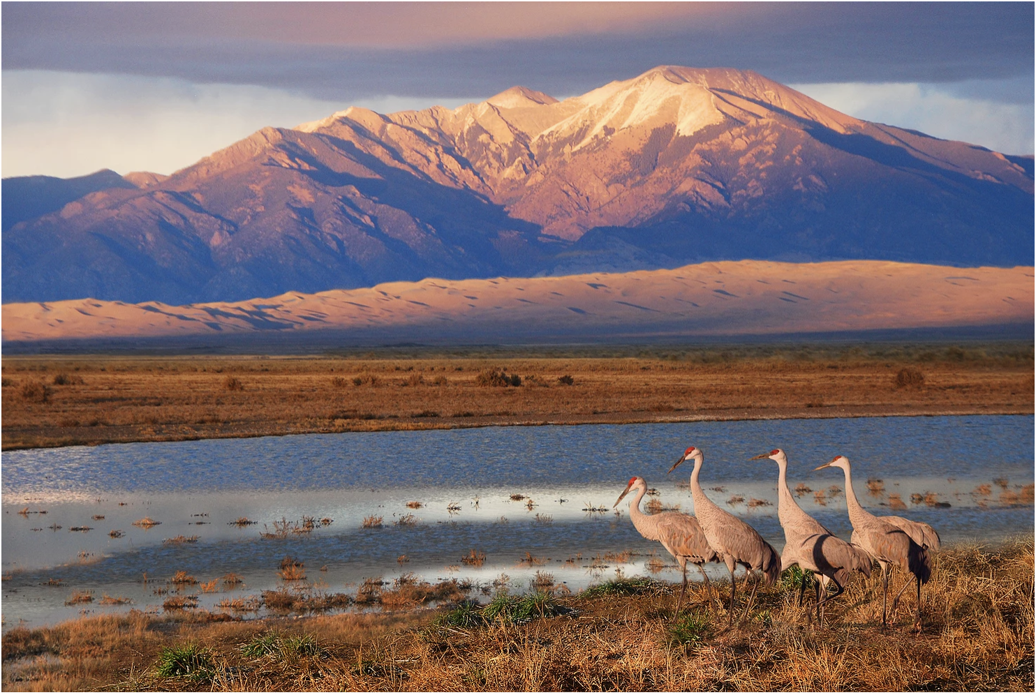
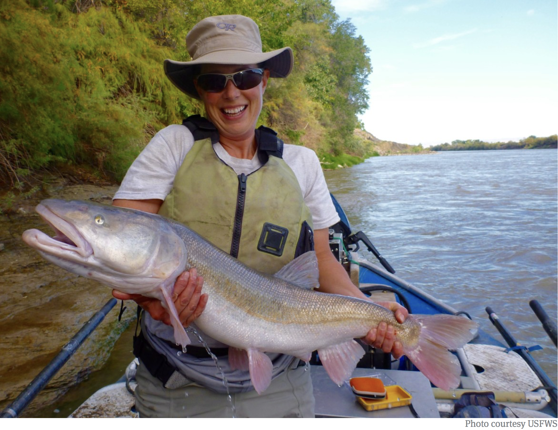
Supermoon over the San Luis Valley August 11, 2022. Photo credit: Chris Lopez/Alamosa Citizen
From the “Monday Briefing” newsletter from the Alamosa Citizen:
The new year likely will bring a new amended Plan of Water Management for irrigators in Subdistrict 1 of the Rio Grande Water Conservation District. The subdistrict’s board of managers in December approved a new amended plan that ties the allowable groundwater pumped to the natural surface of water of the property. This is a huge change that values snowpack, and if there isn’t any, irrigators can expect to pay a handsome fee to get surface water from a neighbor. The plan will get a hearing and vote before the Rio Grande Water Conservation District on Jan. 17. If approved there, as is likely, the amended Plan of Water Management then gets filed with Colorado Division of Water Resources for its blessing, or not.
We frequently note the activity of farmers in Subdistrict 1 because it is the subdistrict that pulls from the unconfined aquifer of the Upper Rio Grande Basin and is under state watch to reduce its groundwater pumping to recover water flows in the unconfined aquifer. It’s also the Valley’s most lucrative corridor for irrigated agriculture, and as such, the bellwether for farming in the Valley. The amended Plan of Water Management is a way for farmers in the subdistrict to try to stay in business while making gains in recovering the unconfined aquifer. More to come in 2023.
BKW Farms is a model for what sustainable water consumption and conservation can look like in the heart of Arizona’s Sonoran Desert | Photo: Sinjin Eberle
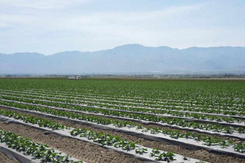
Brian Wong has a lot on his shoulders. A third-generation farmer, Wong grows crops — including nearly extinct heritage grains like white Sonora wheat — on 4,500 acres in the heart of the parched Sonoran Desert, about 25 minutes northwest of Tucson, Arizona. Bakeries, restaurants, breweries, and flour mills as far away as Minnesota and Florida rely on his grain to sustain their own businesses.
Wong’s BKW Farms is among the 80 percent of the state’s agricultural producers that rely on the Colorado River to irrigate their crops. And with the Colorado at precariously low levels, his family business faces its largest challenge in nearly 85 years. “We have a great understanding of and place great importance on water,” Wong says. “Water is something you need in almost every aspect of agriculture. Everything we grow is irrigated. We need to have a water source to put on the crops so we can continue growing food.”
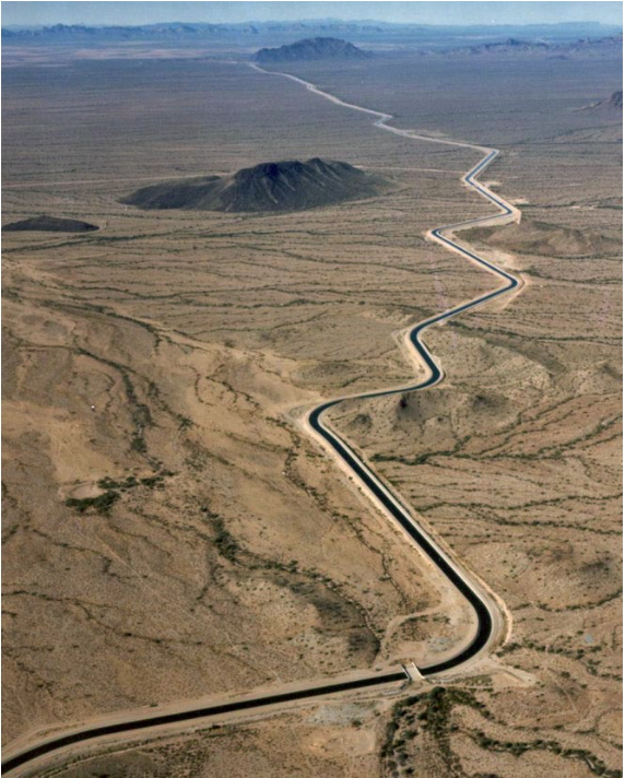
The Central Arizona Aqueduct delivers water from the Colorado River. Photo credit: U.S. Bureau of Reclamation
All of the water irrigating Wong’s farm arrives via the Central Arizona Project (CAP), a 336-mile canal system that shuttles Colorado River water to customers throughout the state. Altogether, the Colorado irrigates 5 million acres of farm and ranch land across seven Southwestern states and Mexico. It supplies 40 million people with drinking water and supports a $1.4 trillion economy.
But climate change, extreme drought, and explosive population growth are taking an enormous toll on the river. The Colorado and its two largest reservoirs, Lake Powell and Lake Mead, dwindled to calamitously low levels in 2022, forcing the U.S. Department of the Interior to declare, for the first time in history, a Tier 1 Water Shortage. The declaration triggered deep cuts in the volume of Colorado River water delivered to Arizona, Nevada, California, and Mexico. Arizona agriculture took the biggest hit because CAP is on par to get 30 percent less water from the shrinking river. Even deeper restrictions will go into effect in 2023, with cities and Tribes shouldering more of the brunt.
Alongside farmers like Wong, American Rivers is urgently working together with partners at utilities, municipalities, and conservation groups to fix the massive imbalance between demand and a shrinking Colorado River.
Colorado River, AZ | Photo by Fred Phillips
From working with ranchers to restore habitat in the river’s headwaters, to encouraging municipalities to use less and eliminate unnecessary uses of valuable Colorado River water, to working on new guidelines for long-term management of the river, American Rivers is involved in decisions that span 1,700 miles of the Colorado River, from its headwaters in Colorado to its delta in Mexico.
“The hard truth is, there just isn’t enough water to go around for everyone,” Wong says.
We have to learn to live with a smaller Colorado River. Wong says the way forward is by partnering with advocates like American Rivers, who work with policymakers and stakeholders to elevate stories and shape water-management strategies into the future.
The bottom line is that “I” doesn’t work. We all rely on rivers, and water, and their continued existence. Our future demands that we invest boldly and immediately in strategies that will work — and that will build for all of us the kind of future we want for our children.
Click the link to read the article on the KUNC website (Rae Solomon). Here’s an excerpt:
“The yields are off,” [Ruben] Richardson explained. “We’re a little bit short of water. This soil – you have to water a bunch every day to maintain it.” He had to use a lot more water in his fields than usual this year, just to produce any crop under drought conditions. That water was delivered by 58 center pivot sprinklers, across Richardson’s fields of irrigated corn and sugar beets. The sprinklers were fed, in turn, by 45 high-capacity wells pumping groundwater out of the Ogallala Aquifer, far below the ground…
Ogallala Aquifer. Credit: Big Pivots
Picture a bathtub. But this bathtub has a very rocky, jagged bottom. When you pour in the water, the tub doesn’t fill evenly. Instead, it forms pools of different sizes within the crags and pits of that rocky floor. Now imagine that bathtub is huge: 175,000 square miles huge. It stretches across 8 stations, from South Dakota all the way down to Texas, including parts of eastern Colorado. Also, the whole thing is deep underground. That is the Ogallala Aquifer. A vast, but uneven reserve of freshwater stored under the earth. The people who live on top of the aquifer pump it out of the ground. More than 90 percent of Ogallala water is used for agriculture, and that water transformed the high plains dust bowl of eastern Colorado into highly productive farmland.
But according to Meagan Schipanski, an associate professor at Colorado State University and Co-Director of the Ogallala Water Coordinated Agriculture Project, the aquifer has its limits. The water has been over-allocated for decades. The current drought is exacerbating the shortage. “That water is a nonrenewable resource,” Schipanski said, “we’re going to use it faster than it can recharge itself.”
The hydrology and terrain of the aquifer is highly variable, making it difficult to generalize about just how much water has been depleted. But across northeastern Colorado, on average the aquifer is down about 30% from where it started before groundwater irrigation became widespread in the mid 20th-century.
Interior celebrates the 200th anniversary of diplomatic relations between 🇲🇽 and 🇺🇸 at @CRWUA_water to honor the crucial role of the U.S. International Boundary Waters Commission and Comisión Internacional de Límites y Aguas entre México y Estados Unidos – Sección Mexicana in ensuring the equitable and sustainable use of the Colorado River for the benefit of us all. Photo credit: Tanya Trujillo’s Twitter Feed
Click the link to read the article on the KUNC website (Alex Hager). Here’s an excerpt:
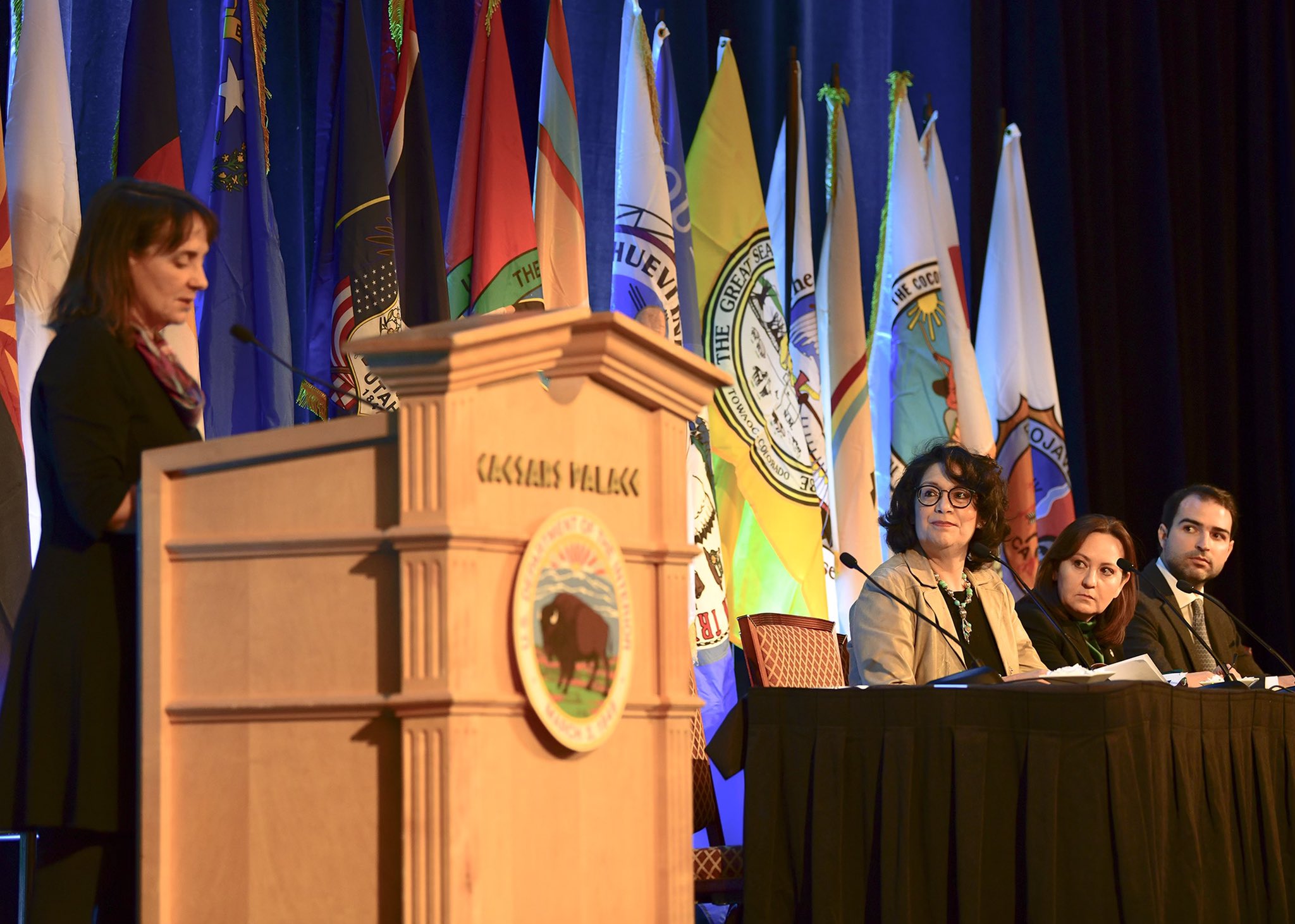
The most powerful policymakers in the arid Southwest spent three days in Las Vegas, reviewing the grim state of a river that supplies 40 million people from Wyoming to Mexico. Federal and state authorities emphasized the need for collaboration to avert catastrophe, but have been reticent to make sacrifices during negotiations over plans that would reduce demand for water. This year marked the 76th meeting of the Colorado River Water Users Association and the event’s first ever sold-out attendance. Journalists, scientists, farmers and city officials packed the conference center at Caesar’s Palace to watch water managers hash out the river’s future in the public eye.
“There’s no substitute for being face-to-face,” said John Entsminger, general manager of the Southern Nevada Water Authority, which supplies Las Vegas. “It’s a lot easier to talk a little smack, call some people some names, when you’re not looking them in the eye.” […]
The current guidelines for the river are set to expire in 2026, and states are largely focused on coming up with new ones before that deadline. A century-old agreement governs how water is allocated across the arid Southwest, Meanwhile, some experts suggest that agreement, the Colorado River Compact, should be replaced to meet the modern demands of a region with sprawling fields of crops and booming urban populations.
“I think there is some heavy optimism that hopefully everyone will come to something that we can all agree on,” said Becky Mitchell, director of the Colorado Water Conservation Board, the state’s top water policy agency. “But it is going to take real cuts to everyone.”
Updated Colorado River 4-Panel plot thru Water Year 2022 showing reservoirs, flows, temperatures and precipitation. All trends are in the wrong direction. Since original 2017 plot, conditions have deteriorated significantly. Brad Udall via Twitter: https://twitter.com/bradudall/status/1593316262041436160
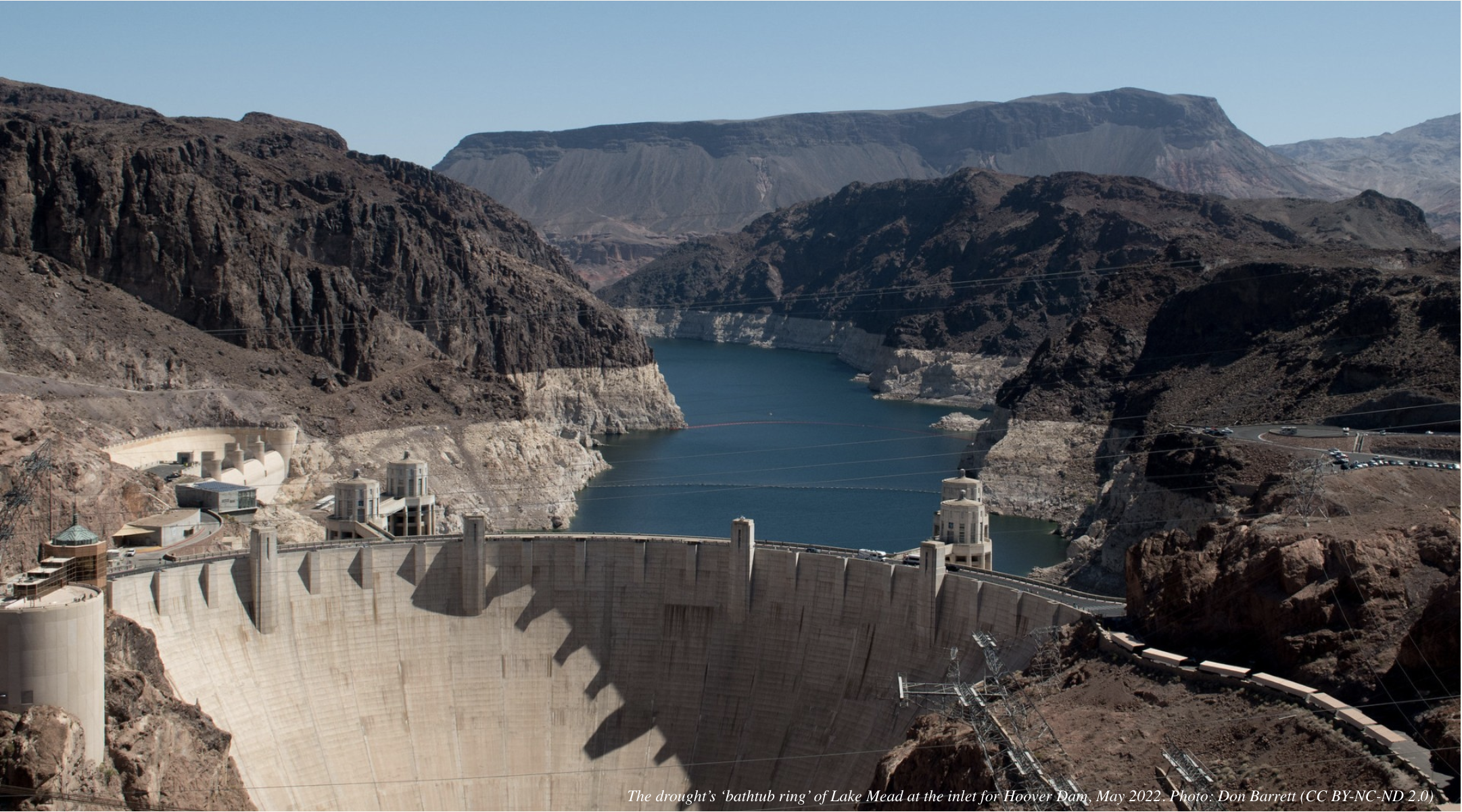
Hoover Dam’s intake towers protrude from the surface of Lake Mead near Las Vegas, where water levels have dropped to record lows amid a 22-year drought. (Source: Bureau of Reclamation)
Water authorities in the Western U.S. don’t have a crystal ball, but rapidly receding reservoirs uncovering sunken boats and other debris lost in their depths decades ago give a clear view of the hard choices ahead.
If western states do not agree on a plan to safeguard the Colorado River — the source of the region’s vitality — there won’t be enough water for anyone.
Water managers, researchers, agricultural producers and others from across the drought-stricken river basin met in Las Vegas last week for the Colorado River Water Users Association annual convention to face hard truths about the state of the river and historically-low levels of its biggest reservoirs.
Two decades of drought and poor planning have caused the river’s biggest reservoirs — Lakes Mead and Powell — to drop to their lowest collective volume since they were filled. [ed. emphasis mine]
“Time is not on our side. Hydrology is not on our side. That’s the frightening reality,” said Rebecca Mitchell, director of the Colorado Water Conservation Board. The hydrology “is going to force us to do something because we will have no other choices. Every day that passes this problem gets harder and harder to solve.”
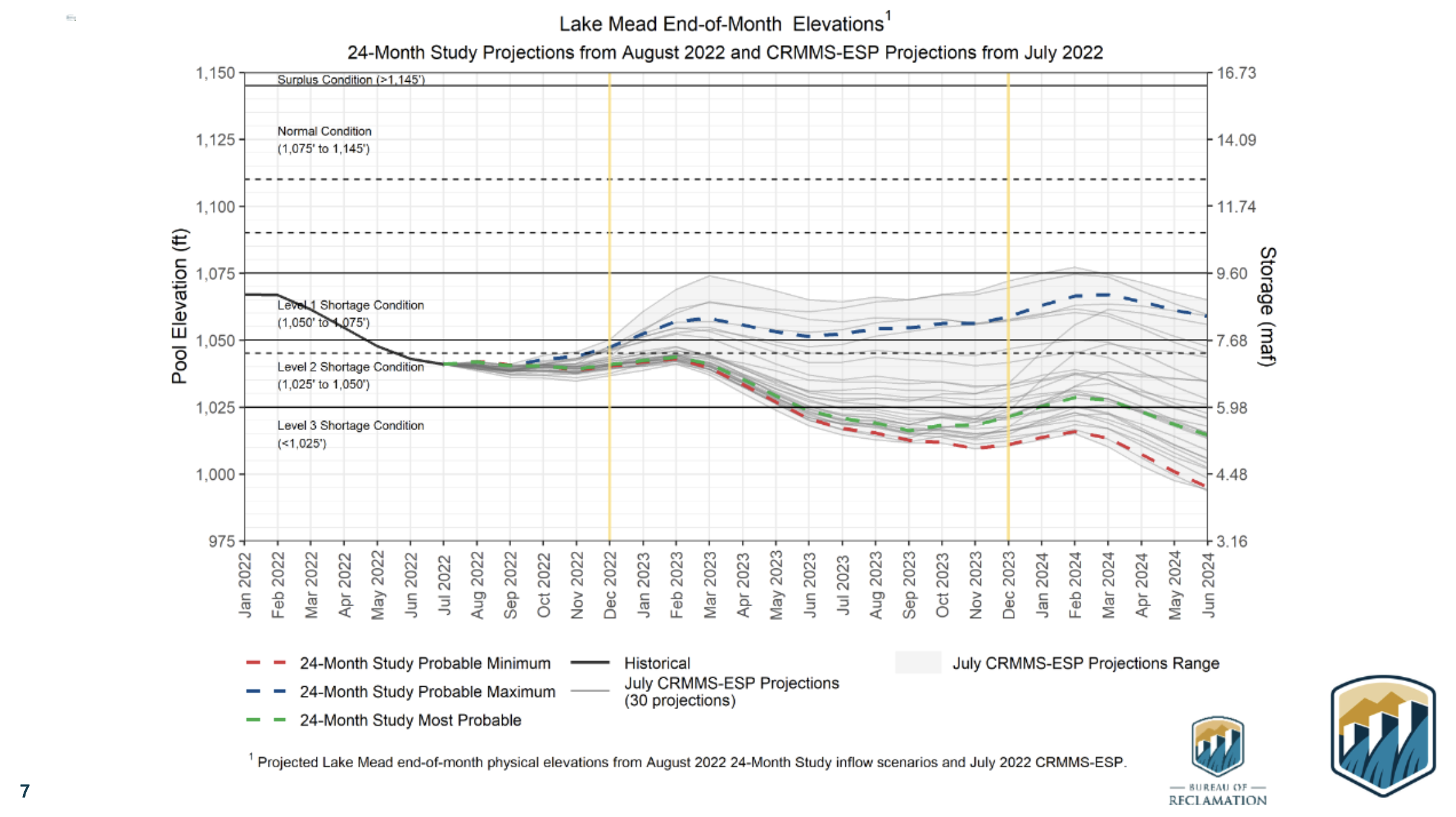
Water storage in Lakes Mead and Powell is at a fraction of what it was two decades ago, and could drop below what’s needed to generate power as soon as next year, said water experts.
To put it in perspective, this winter both reservoirs were about a quarter full. In December 1999, Lake Powell was at 88% capacity, and Lake Mead was at 96% capacity, according to analysts.
Lower basin states faced their first-ever federally declared water shortage, which directs how much states can draw from the Colorado River in 2021. Deeper cuts were subsequently declared this year.
Water experts say more water cuts for lower basin states – including Nevada – are likely in 2024 due to even lower water levels.
Even further restricting water allocation “doesn’t mean the lakes won’t go lower than that,” said Ted Cooke, the general manager for the Central Arizona Project.
If nothing is done, there is a real possibility water levels in both reservoirs will drop so low in the next two years that water will no longer flow downstream to the 40 million people in the West who rely on the Colorado River.
Colorado Water Conservation Board Executive Director and commissioner to the Upper Colorado River Commission Becky Mitchell, center, speaks on a panel with representatives of each of the seven basin states at the annual Colorado River Water Users Association conference in Las Vegas Thursday. The UCRC released additional details of a water conservation program this week.
CREDIT: HEATHER SACKETT/ASPEN JOURNALISM
Faulty numbers and an over-allocated river
At the center of discussions last week was one of the most important legal documents governing how the river’s waters are shared: the 1922 Colorado River Compact, which allocated 7.5 million acre-feet for each basin, based on a faulty model that assumed the river system could supply 15 million acre-feet annually.
Today, officials acknowledge only 12.4 million acre-feet flows from the river each year, meaning western states will have to agree on massive cuts to their water supply for the sake of the river — a politically perilous decision.
Despite clear evidence of diminishing water supplies over the past century, not much has changed in terms of how states allocate and use water.
But those in charge are starting to understand that western states are getting to a tipping point that will force them to adjust their attitudes and change their consumption habits.
In June, Bureau of Reclamation Commissioner Camille Touton issued an ultimatum to states: Develop a plan to save 2 million to 4 million acre-feet of water by next year — roughly one-fifth of the water currently allocated to states—or the federal government will step in.
During a panel discussion at last week’s convention in Las Vegas, representatives for the seven western states who rely on the Colorado River said reaching a compromise will be their collective priority for the next six months.
They agree that the longer it takes to stabilize the river and conserve the water needed to keep the river functional, the more likely reservoir levels will continue to plummet, leaving states with fewer and fewer options.
Water managers also agree that about 75% of future water cuts will need to come from lower basin states — including Nevada — to reach reductions large enough to protect critical elevations in the reservoirs.
Lower basin states — Nevada, Arizona, and California — use nearly all their 7.5 million acre-feet Colorado River allocation compared to the 4.5 million acres-feet used by the upper basin states, said water managers.
“Yes, the lower basin will have to take the lion’s share of the reductions,” said John Entsminger, the general manager of the Southern Nevada Water Authority. “I’m a big believer in the law, I’m a big believer in food security, but I’m an even bigger believer in math.”
Nevada uses only a small share of the river’s water and has made great strides in conservation, but Arizona and California are still far from a deal. Both states will need to make painful reductions and incur massive expenses to stabilize their water use, say water experts.
Just last week, all of Southern California was declared to be in a drought emergency by the Metropolitan Water District, the main water supplier for Los Angeles county.
Lower basin states argue that upper basin states — Colorado, Wyoming, Utah, and New Mexico — also need to make a firm commitment to lower their water use.
Officials for the U.S. Bureau of Reclamation warned that aridification, the long-term shift to a drier climate, means even less snow runoff is making it to the river each year.
“It’s really hard to come up with solutions” based on who has priority water rights, said Tom Buschatzke, director of the Arizona Department of Water Resources. If cities in lower-basin states “wipe out every drop of their water, it’s still not going to stabilize the system,” said Buschatzke.
The upper basin has committed to looking into the feasibility of cutting back their water use — a move critics say amounts to “planning to make a plan.”
Upper basin states have not released an estimate of how much water they are able or willing to cut. However, the Upper Colorado River Commission says they are slowly taking steps to create a management plan with potential water cuts.
“We live within the means of the river every day,” said Becky Mitchell, the director of the Colorado Water Conservation Board. “What we like to do is under-promise and over-deliver, and make sure if there is a number out there it is a number that can actually be achieved.”
Reservoirs in upper basin states are currently providing what amounts to 19% of their annual water usage to Lake Powell, based on a 2019 drought response agreement.
“Those releases have had significant impacts, huge impacts on the local communities,” Mitchell said. “What you’re asking for is a big ask. We are willing to look at this, but we also need to look at the impacts at the same time.”
Water managers representing the four upper basin states released details of a temporary conservation plan last week.
One critical component of the plan is the reauthorization of the System Conservation Pilot Program, a program that paid water users to reduce their use, with the goal of implementing it by the summer.
It’s unclear how much water the pilot program will successfully conserve as a voluntary and temporary solution. The original program saved about 47,000 acre-feet of water at a cost of about $8.6 million over the four years.
“The System Conservation Pilot Program is called a pilot program for a reason,” said Gene Shawcroft, general manager of the Central Utah Water Conservancy District. “We believe we will learn a lot from that. We believe that it can easily be transitioned into a management plan.”
‘This is going to be painful’
Brandon Gebhart, the top water official in Wyoming, said previous conservation programs that depend on voluntary cuts were not as effective as water managers had hoped, but a recent shift in mentality among water users could make the difference.
Another change that could make the difference is the nearly $4 billion set aside for the Colorado River that would allow the Bureau of Reclamation to pay users to voluntarily forgo water use.
“There are positives. The funding that is coming in provides opportunity. It provides the ability to change,” said Mitchell, the director of the Colorado Water Conservation Board.
Still, water managers say the federal government will need to invest even more money into the river.
“If you look at the federal investment in Florida, after one hurricane they got an order of magnitude more federal assistance than the entire Colorado basin is getting in the face of this crisis,” said Entsminger, the Southern Nevada Water Authority general manager.
Western states will need all the assistance they can get to find ways to run their economies with less water, and time is running out.
A recent survey by the American Farm Bureau Federation found that more than 650 farmers in 15 Western states saw a 74% reduction in harvests, and 42% switched crops due to the drought.
It took Western states five years to agree on a short-term five year plan to address the region-wide drought that is set to expire in 2026, said Entsminger.
“We don’t have five months to come up with an operation plan for 2023,” Entsminger said. “It’s time to set aside the talking points and get real.”
Climate change has shrunk the river’s flows roughly 20% in the past two decades, and scientists predict they will shrink nearly 10% more with each additional degree of temperature rise.
“We have to move quickly and we’re committed to that,” said Mitchell. “We need to accept the situation we’re in and we need to reduce demands. All of us, every sector, every state, every water user. There isn’t any other way.”
“We have to accept that we can not cling to our entitlements or allocations. If they are not there none of it matters,” Mitchell continued. “Folks in the room have to be willing to let us make hard decisions, because this is going to be painful.”
Nevada Current is part of States Newsroom, a network of news bureaus supported by grants and a coalition of donors as a 501c(3) public charity. Nevada Current maintains editorial independence. Contact Editor Hugh Jackson for questions: info@nevadacurrent.com. Follow Nevada Current on Facebook and Twitter.
Updated Colorado River 4-Panel plot thru Water Year 2022 showing reservoirs, flows, temperatures and precipitation. All trends are in the wrong direction. Since original 2017 plot, conditions have deteriorated significantly. Brad Udall via Twitter: https://twitter.com/bradudall/status/1593316262041436160
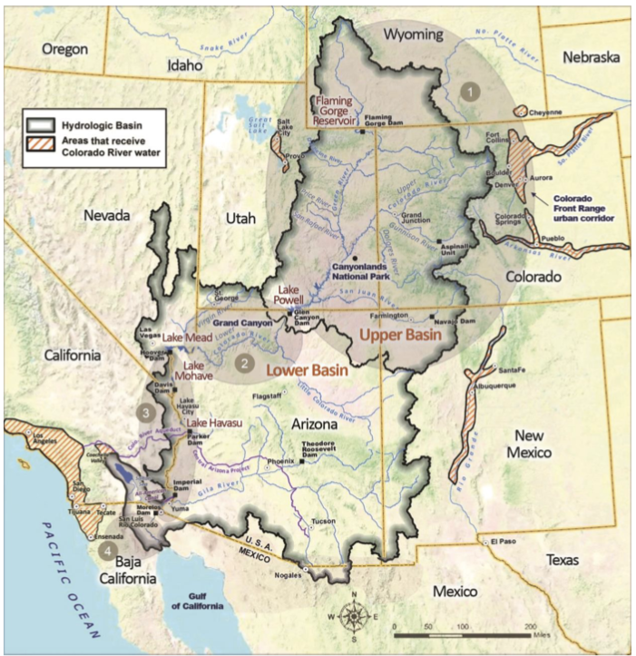
Enough gallivanting around the Mississippi Basin and its rivers; back to the troubled and troublesome Colorado River, currently experiencing its worst dry spell since around 800 CE. The Colorado Rivers, I should maybe say, since for all practical (human) purposes the river is now managed in a quasi-de jure way as two river basins under the Colorado River Compact and subsequent ‘Law of the River’ actions: an Upper Colorado River and a Lower Colorado River.
Previously here, I’ve been exploring the Colorado River Compact at its centennial, in what is certainly the worst year in its century. Here are some things I came up with in that exploration, that I don’t think are getting enough attention in our efforts to search our own souls and the soul of the river in the desert as we try to figure out where we are going from here:
1. The Colorado River Compact is not the ‘foundation of the Law of the River.’ The foundation of the Law of the River is the appropriation doctrine: the body of law that bases the right to use the water of the river and its basin (groundwater too, now) primarily on the seniority of use. First come, first served, for any economically beneficial use for as long as the use continues. Appropriations law is basically a powerful growth engine.
The Colorado River Compact, and all the subsequent laws, treaties, acts of Congress, and other consensual agreements involving the river thus become efforts to deal with the consequences of applying a powerful growth engine to an erratic and relatively modest river – and they fall short to the extent that they too cautiously circle around (or just ignore) the problem of a body of law encouraging unlimited demand on a limited resource.
2. The Compact could not do what its creators set out to do, so they settled for an expedient resolution to facilitate development of the River. The Compact was created because Euro-Americans wanted to control a rambunctious river whose erratic flows made it hard to use for civilized pursuits. But the growth logic of the foundational Law of the River (the appropriation doctrine) made six of the seven Colorado River states fear the pace of development of the seventh state, California, if the river were controlled; California could conceivably lay claim to most of the river’s water before the other states really got settled.
The six states thus wanted an ‘overlay’ to the unconstrained law of appropriation that would assure each state of enough water to meet their own future needs at their own pace. Unfortunately, they did not have – could not have had in the 1920s – enough solid information of what their reasonable future needs were. So they settled for an expedient resolution; they divided the river into two basins, above and below the uninhabited canyon region; each basin was given a little less than half the estimated flow of the river to develop, with the upper river basin committed to deliver a fixed amount of water to the lower river basin (75 million acre-feet over any ten-year period).
Eugene Clyde LaRue measuring the flow in Nankoweap Creek, 1923. Photo credit: USGS
3. Mistakes were made. Much has been made of the fact that the Compact commissioners selected an estimated flow of 15 million acre-feet of water to divide between the two basins, well above what has been proven to be a more realistic estimate of an average annual river flow of 13 million acre-feet by E.C. LaRue and some other Geological Survey scientists. It was, however, well below the optimistic 16.8 million acre-feet estimate by the Bureau of Reclamation.
It was also an ebulliently optimistic time in America – the advent of the Anthropocene, when we thought we were on the verge of freedom from the stodgy limitations of nature. The commissioners acknowledged that they did not have enough information to accurately divide the waters of the river seven ways, and were content to leave that task ‘to the hands of those men who may come after us, possessed of a far greater fund of information.’ We now know that they should have listened to the USGS scientists, but it is easier and kind of superior to tsk-tsk as ex post facto Monday morning quarterbacks, than it is to acknowledge and understand – maybe even regret the loss of – the spirit of the times when the mistake was made.
The Compact commissioners have also been faulted for ‘leaving the Indians out of the Compact.’ That is not entirely accurate; what they said was that ‘Nothing in this compact shall be construed as affecting the obligations of the United States of America to Indian tribes.’ But what was the obligation of the United States to the Indian tribes?
On the one hand, in 1908 the U.S. Supreme Court had decided, in a case involving an Indian reservation in Montana, that when the federal government reserved public lands for any specific purpose, such as an Indian reservation, that it also implicitly reserved enough water to carry out that purpose. In the case of an Indian reservation, this meant enough water to teach the Indians to be farmers rather than hunter-foragers – meaning irrigation water, in the West.
But on the other hand, when the Compact was created in the early 1920s, the federal government was aggressively pursuing the ‘soft genocide’ of forced assimilation. Between 1900 and 1925, the number of Indian youth essentially kidnapped into ‘Indian Boarding Schools’ swelled from around 20,000 to more than 65,000. The official policy was ‘kill the Indian to save the man.’ The Compact commissioners were all white professionals receiving mixed messages from the government, and might be expected to think, even hope (river gods forgive them), that any Indian water claims might fade away if government policy succeeded – which it didn’t, no thanks to federal Indian policies before or since. And a reserved water obligation for the reservations remains an untransacted and pending commitment.
So yes, the Compact kicked some cans down the road, that it’s now time to pick up and deal with. But no one seems to be saying anything about a much larger and more consequential Compact mistake…
4. Dividing a desert river basin into two river basins is not a good idea. It worked – sort of (Arizona didn’t accept it) – as a temporary fix to break the logjam of not knowing enough to make an equitable seven-way division of the waters. What made the two-basin Compact work at all, sort of, was the fact that, until the construction of Glen Canyon Dam, the river itself, flowing unconstrained past Lees Ferry, kept the water supply (nearly all from the Upper River Basin) united with the growing water demand (mostly in the Lower River Basin).
But once the big dam near Lees Ferry was in place, the supply-demand distribution became a management problem that gradually succumbed to bad power politics. The Bueau gave the Lower River Basin its Compact allocation and more, regardless of growing water supply problems upriver, and the Upper River Basin developed a large supply of justifiable but unproductive resentment. The Compact, which confused ‘equitable’ with ‘equal’ in its division between two basins, is broken by the dam that turns it into two rivers, one supplying the other in ways both unequal and inequitable. It’s not the ‘structural deficit’ per se, but the refusal to address it, that breaks the Compact.
So – what can we do?How do we muddle forward from where we are now? No one is asking me, but of course I have some thoughts….
First and foremost, we should reunite the two river basins into one squabbling river basin (with transbasin extensions). Drop the expedient Compact solution of two river basins – a mistake perpetrated by subsequent ‘Law of the River’ measures, and finally fatal when the Colorado River Storage Project Act enabled building a wall – literally – between the two river basins.
This reunion would have to start with a consensual seven-state agreement – a new compact, if you will, to execute the task deemed impossible in 1922: a seven-state division of the river’s use. After a century of development, this has been achieved, de facto, and equitably enough. The lower river basin states get the consumptive use of almost twice as much water as the upper river basin, but they spread it over far more people and quite a bit more (and more productive) ag land.
This will not be easy, of course – but nothing ever is in the Colorado River region. California and Arizona have gotten so used to using ‘undeveloped upper river basin water’ that they’ve forgotten that that ‘surplus’ hasn’t existed for decades. They think the ‘structural deficit’ is an act of God about which nothing can be done, rather than just the consequence of their growing on borrowed water, a loan now being called in. But the hardest part for the lower river basin will come when the firm numbers for present use apportionments by state all have to be converted into percentages of the diminishing whole river – which the upper river basin states have already been doing, living closer to the vagaries of a desert river. The upper river states will no longer have to fear a call from the lower basin states, so long as they stay within their apportioned percentage of what’s there.
The real reunion of the basins into one river might begin when those in the lower river basin acknowledge that the water supply for the river’s desert lands comes mostly from snowfall in mountains in the river’s headwaters. This suggests that the downriver users of a desert river should accept some responsibility for the maintenance and improvement of the river’s mountain headwaters, their water supply. And those in the upper river basin would need to acknowledge the need for that help, especially if it is financial.
‘Maintenance and improvement’ of the water supply? Can we ‘improve’ the water yield from a river’s headwaters? An undigested fact about the mountain headwaters of the Colorado River Basin is the scientists’ consensual estimate that somewhere around 90 percent of the precipitation that falls over the river basin does not make it into the river. It either returns fairly quickly to the heavens as water vapor, or soaks into the ground to be transpired by trees, grasses and other plants back into the atmosphere. Scientists estimate that as much as a third of the precipitation that falls is lost through sublimation in the high headwaters: snow and ice being vaporized by sun and wind without even turning into water first.
Some quantity close to another third of the precipitation is transpired through the forests that form a broad band around the headwaters reaches of the river. Contrary to Forest Service founder Gifford Pinchot, the forests are not ‘father’ to the rivers that work their way through the forests; the forests are just some of the first major ecosystems that depend on the river’s water for their life. We love and need the forests, and they do provide shade and shelter for the snow that makes it through the trees to the ground – but they also drink a lot of water (more as the ambient temperatures increase), and not always for their own betterment; the density and age of forests we have protected from cleansing fires result in the consumption of a lot of water by big old forest trees not really getting enough to be healthy.
Those forests are almost entirely managed by the U. S. Forest Service, management that must include the long-term health and well-being of the forest itself rather than just short-term commodity production. But are there ways to manage a healthy forest that maximizes the Forest Service’s 1897 organic act charge ‘to secure favorable conditions of water flows,’ as well as (or instead of) the charge ‘to furnish a continuous supply of timber’?We don’t really know, because the Forest Service has not paid as much attention to optimal water management as it has to optimal timber management. We do know, however – for one example – that timber managers favor denser stands to produce tall trees with less branchiness, but that density increases the amount of snow intercepted by trees, which increases snow loss through sublimation.
To even learn how to maximize water yield from the headwaters’ rocks, ice and forests will require experimentation, trying things out, and it will require creative scientists and lots of boots on the ground that the perpetually under-funded Forest Service cannot afford. If, however, all forty million users of the Colorado River’s water thought of themselves as part of the whole river’s watershed, top to bottom, they might be willing to pony up a pittance for the health and vitality of the headwaters that produces their water. This is already happening to a modest extent; some of the big dogs in the Lower River Basin – the Metropolitan Water District, the Southern Nevada Water Authority, the Central Arizona Project – are contributing funding to a cloud-seeding project in the river’s headwaters, to increase snowfall from selected storms. That is a beginning.
And the next steps? Well, at some point, we have to descend into the cellar foundation of the Law of the River, and figure out how to adapt the frontier instincts of the appropriations doctrine to a civilization of 40 million. As Tom Buschatzke, Arizona’s Director of Water Resources said, just last week at the meeting of the Colorado River Water Users convention: ‘The single biggest roadblock to solving the problem of stabilizing the river is the priority system.’
There will be more on this imagined reuniting of the two rivers and their basins. Stay tuned.
Updated Colorado River 4-Panel plot thru Water Year 2022 showing reservoirs, flows, temperatures and precipitation. All trends are in the wrong direction. Since original 2017 plot, conditions have deteriorated significantly. Brad Udall via Twitter: https://twitter.com/bradudall/status/1593316262041436160
WHEN you’re working on an enormous issue like water – in this case how to recover the Upper Rio Grande Basin and the two aquifers of the San Luis Valley – you have to stretch your mind to find new approaches.
The idea that groundwater pumped to irrigate crops could be restricted through a conservation easement is one of those moments when something that’s never been tried bubbles to the top and provides a new way to look at an urgent problem.
On Nov. 8, Valley farmer Ron Bowman signed the first-ever groundwater conservation easement to restrict the use of groundwater on his nearly 1,900-acre ranch in Mosca. The commitment also set a timeline for Subdistrict 4 of the Rio Grande Water Conservation District to purchase the ranch for $2.6 million, a deal it will be looking to close in 2023 with a loan from the Colorado Water Conservation Board.
The subdistrict’s acquisition of the entire ranch not only saves groundwater from being pumped, but importantly helps Subdistrict 4 achieve its sustainability requirements for the confined aquifer as well as offset stream depletions to nearby San Luis Creek from groundwater pumping that occurs in Subdistricts 4 and 5.
“How the law is written and works, we’ll hold those water rights and they’ll still be water rights but we won’t pump them ever again,” said Chris Ivers, program manager for Subdistrict 4 and one of the architects of the deal. “That protects those water rights from being abandoned and somebody else coming in and saying ‘Because these water rights have been abandoned, I can pump water over here.’ So we’re holding their place in line but saying, you can’t pump this water, this is our water to pump.”
Bowman’s groundwater pumping has accounted for about 10 percent of that being pumped by irrigators across Subdistrict 4. The farm has been operating with 12 center-pivot irrigation circles, growing mostly forage crops including some alfalfa.
“If by discontinuing irrigation on my farm, it means that my neighbors may be able to keep their multigenerational farms in their families, then it feels like the right thing to do,” Bowman said. He and his wife, Gail, purchased the property about five years ago.
The reduction in groundwater pumping and the fact the water is being placed in a conservation easement so it’s never pumped again creates a new way for the Rio Grande Water Conservation District and the state agencies and nonprofit land trusts it partners with to address depletion in the aquifers.
“The nice thing about a groundwater conservation easement is each one can be tailored to that property,” explains Sarah Parmar, director of conservation at Colorado Open Lands.
Parmar has been instrumental in helping create a framework for the groundwater conservation easement that Bowman entered into. She credits Cleave Simpson, the general manager of the Rio Grande Water Conservation District and state senator representing the Valley’s six counties, with the initial brainstorm.
From there it was getting other smart water people in the room, like Heather Dutton, manager of the San Luis Valley Water Conservancy District; local farmers Sheldon Rockey and Nathan Coombs; and state division engineer Craig Cotten to lend their expertise to determine if groundwater could be placed in a conservation easement.
The concept also went through a rigorous exercise with water attorneys to determine the legality of such a move, and Colorado Open Lands and the Rio Grande Headwaters Land Trust in Del Norte lent support to the project. There was also the matter of figuring out how to appraise the land given the new construct of groundwater being placed in an easement as part of a sale.
Over 20 years ago conservation easement work began to grow in the San Luis Valley largely with the establishment of the Rio Grande Headwaters Land Trust, which was formed primarily out of concern for the surface water provided by the Rio Grande and its tributaries,” Colorado Opens Lands noted. “Now through this new application of a conservation easement on the Valley’s groundwater resources, the land trust community in the Valley is reinforcing its commitment to supporting the community in protecting its most precious resource: water.”
More common in the Valley are announcements of land conservation easements, where a portion of agricultural land is placed in an easement to prevent future development and preserve the land as a natural habitat.
Now water managers like Simpson have figured out that groundwater can also be placed in a conservation easement, which creates a new way for farmers to think about their operations as they continue to reduce the amount of water they use to farm to meet the state’s groundwater pumping rules.
“We are used to keeping water rights in irrigation through conservation easements, so it feels wrong to intentionally dry a farm, but by drying this particular farm, we are ensuring that the other farms in the subdistrict are sustainable and we ensure that this groundwater stays in the aquifer and out of the hands of anyone who might want to try to move it outside of the basin,” said Parmar.
Other approaches to a groundwater conservation easement may be different, she said. Instead of a farmer putting all the groundwater in a conservation easement as Bowman did, maybe only a portion of it is conserved through an easement and the rest continues to be used for crop production.
“Our hope is to work with landowners across subdistricts to avoid the state stepping in to shut off wells,” said Parmar. “I am continually amazed by the willingness of farmers and ranchers to step up to the challenge and grateful to work with irrigators like Ron Bowman, who want to be part of the solution.”
Water users are urgently trying to keep Lake Powell on the Utah-Arizona border from dropping to a point where Glen Canyon Dam can no longer generate electricity. (Source: Bureau of Reclamation)
First off here’s the link to the Colorado River Water Users Association 2022 Conference Twitter Fest.
Speaking at a conference in Las Vegas, federal officials told water managers from the seven states that rely on the river that they will weigh immediate options next year to protect water levels in depleted reservoirs, and that the region must be prepared for the river to permanently yield less water because of climate change.
“The hotter, drier conditions that we face today are not temporary. Climate change is here today and has made it likely that we will continue to see conditions like this, if not worse, in the future,” said Reclamation Commissioner Camille Calimlim Touton.
“The basin is seeing its worst drought in 1,200 years, and there is no relief in sight. And perhaps this is what it will be in the future,” Touton said.
Lake Mead and Lake Powell, the nation’s two largest reservoirs, are now nearly three-fourths empty, and water levels are set to continue dropping. The latest government estimates show there is a risk that Lake Mead could reach “dead pool” levels in 2025, at which point the river would no longer flow past Hoover Dam, cutting off water for California, Arizona and Mexico. That grim scenario has given urgency to the search for solutions, as officials from states, water agencies, tribes and the federal government consider options for water cutbacks on a scale never seen before.
Updated Colorado River 4-Panel plot thru Water Year 2022 showing reservoirs, flows, temperatures and precipitation. All trends are in the wrong direction. Since original 2017 plot, conditions have deteriorated significantly. Brad Udall via Twitter: https://twitter.com/bradudall/status/1593316262041436160
At this morning’s [December 14, 2022] Upper Colorado River Commission (UCRC) meeting held in concert with the Colorado River Water User’s Association (CRWUA) Conference, the Commission formally released a Request for Proposal re-initiating a System Conservation Pilot Program (SCPP) beginning spring 2023. The Program aims to reduce consumptive use through temporary, voluntary, and compensated measures across the Upper Division States and allocates up to $125 million for the re-initiation with the potential to increase in scale. This action implements the first element of the UCRC’s 5-Point Plan released in July 2022.
Colorado River District General Manager Andy Mueller responded that a program of this scale and speed poses as much risk and opportunity as a Demand Management program, therefore it is critical how the program is implemented.
“It is vital to the health of our communities and our agricultural industry that the River District have a decision-making role in this program, consistent with past implementation of a previously-authorized System Conservation Pilot Program, and we want to thank Commissioner Mitchell for her commitment to recognize the River District’s role in that effort,” Mueller said.
Commissioner Mitchell provided a written commitment stating that “in the event the source of the water and the place of beneficial use of a prospective applicant’s SCPP project is located within the boundaries of the District, enrollment in the SCPP will be subject to approval of the application by both the Colorado Water Conservation Board (CWCB) and the District.”
In Commissioner Mitchell’s own release today, she stated, “We must continue to live within the means of what the river provides year to year and we ask others to do the same. This is the only way the system will continue as we know it into the future.”
Water users are urgently trying to keep Lake Powell on the Utah-Arizona border from dropping to a point where Glen Canyon Dam can no longer generate electricity. (Source: Bureau of Reclamation)
Colorado Commissioner Becky Mitchell emphasized that the most impactful thing that can be done to manage the Colorado River System is to reduce uses in dry years. Colorado achieves this through strict administration of water rights based on hydrology—in 2021, administration impacted water use on over 203,000 acres within the Colorado River Basin in Colorado. Collectively, preliminary data from the UCRC shows that the Upper Division States used 25% less water in 2021 than in 2020 due to constraints on the physical and legal availability of water. “We must continue to live within the means of what the river provides year to year and we ask others to do the same. This is the only way the system will continue as we know it into the future,” said Commissioner Mitchell.
At its meeting, the UCRC released a pre-solicitation for request for proposals for participation in the System Conservation Pilot Program, a large-scale program involving temporary, voluntary, and compensated reductions in consumptive use across the Upper Division States. Conserved system water could help mitigate the impacts of drought in the Upper Basin.
The UCRC also announced progress on the interstate Demand Management feasibility investigation and released a summary report of the study detailing key findings of the interstate investigation. This report will help inform next steps in Colorado’s Demand Management investigation, which will continue into 2023. More information on Demand Management is available at the CWCB website.
The Upper Division States will also consider additional releases from upstream reservoirs pursuant to the Drought Response Operations Agreement, in addition to the 661,000 acre-feet previously committed. The Commissioners emphasized the need to maintain the benefits of this water in Lake Powell.
U.S. Bureau of Reclamation Commissioner Camille Touton (left) alongside members of the Upper Colorado River Commission at the 2022 Colorado River Water Users Association Conference on December 14, 2022 in Las Vegas, Nevada. Photo by Jerd Smith
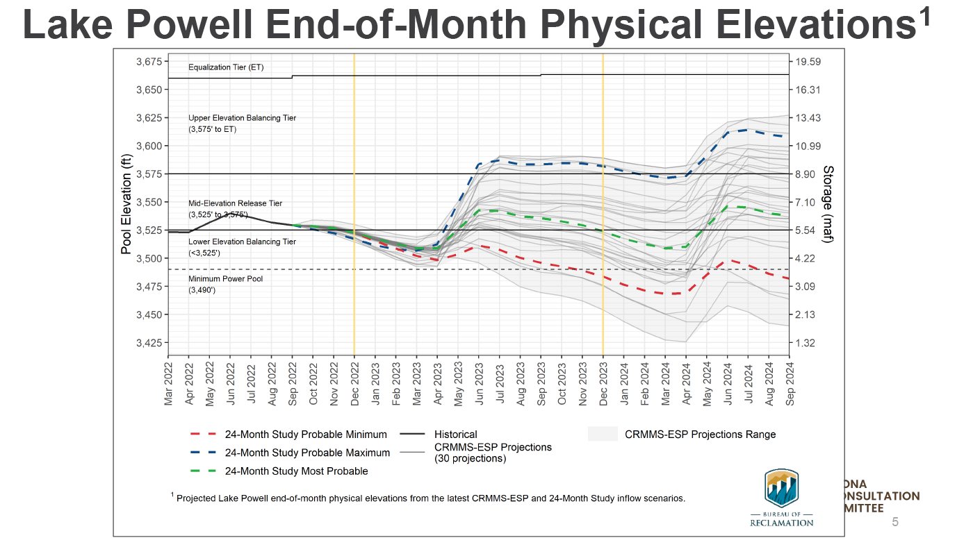
As the Colorado River crisis deepens, a new federal analysis of flows into Lake Powell shows that they will continue to plummet through 2025, before beginning to recover.
James Prairie, a hydrologic engineer for the U.S. Bureau of Reclamation, said flows are likely to be just 24% of average this year, making it unlikely under various planning scenarios that Powell will have enough water for the Upper Basin states of Colorado, New Mexico, Utah and Wyoming to meet their legal commitment to deliver a minimum of 7 million acre-feet of water to the Lower Basin. That amount is already reduced from the historical delivery obligation due to low flows on the river.
The news comes as more than 1,300 of the river’s most powerful water users gather this week in Las Vegas for the Colorado River Water Users Association Conference, the largest annual confab on the river.
This year it has sold out for the first time in its history, according to Crystal Thompson, communications manager at the Central Arizona Project, a major user of Colorado River water and a conference organizer.
In the water world, stream and reservoir measurements are based on what’s known as the water year, which begins Oct. 1. Prairie said Upper Basin flows in water year 2023 are expected to be just 24% of average. In 2024 they are likely to improve, reaching 58% of average, before rising to 61% of average in 2025.
But because Lake Powell is so low — it’s just 23% full with roughly 5.5 million acre-feet of water stored right now — it won’t be able to recover enough water to keep those releases going, Prairie said. And that means that users across the seven-state Colorado River Basin will see more dramatic cutbacks in their water supplies to try to protect remaining supplies in both Lake Powell and Lake Mead, farther downstream.
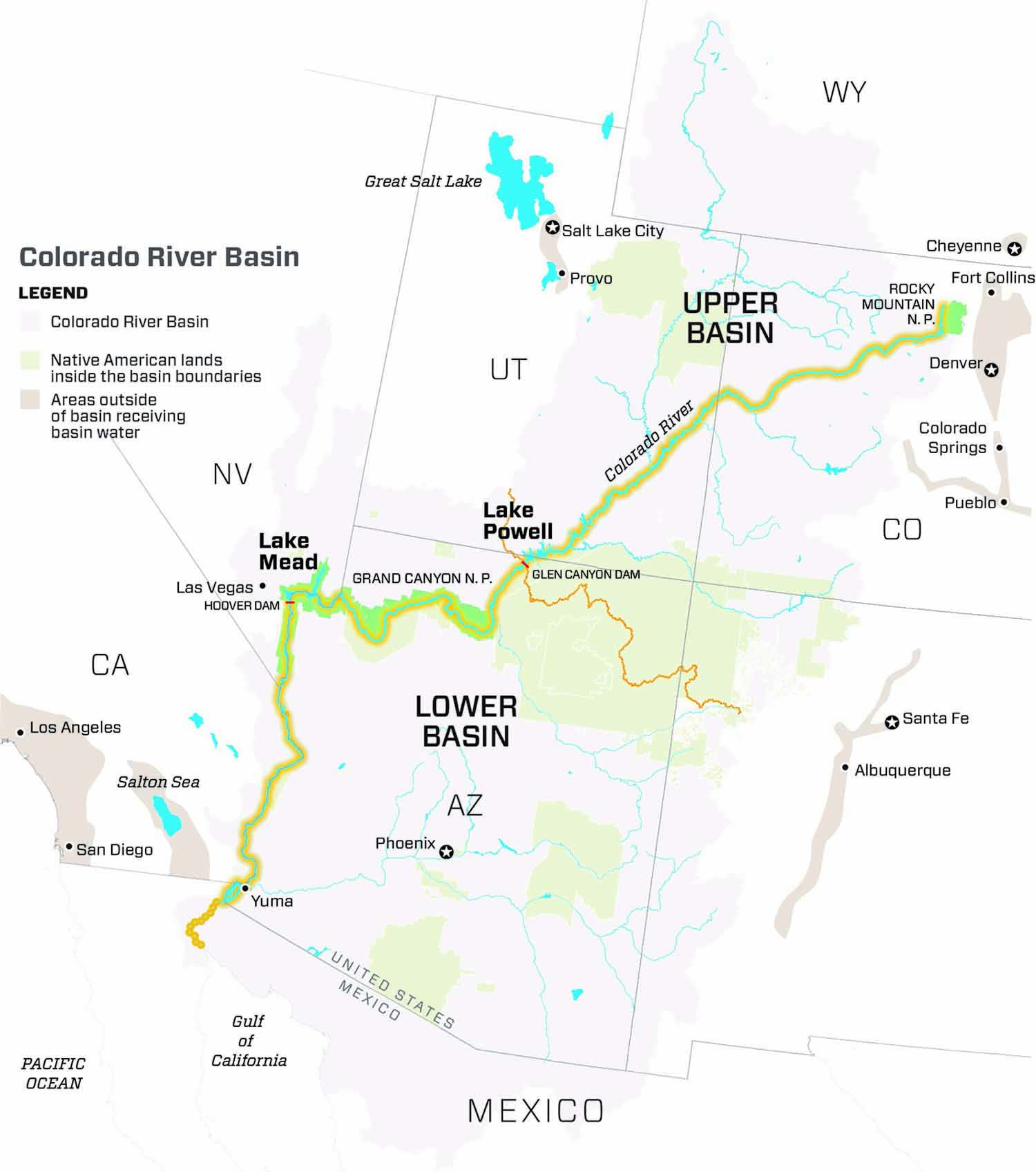
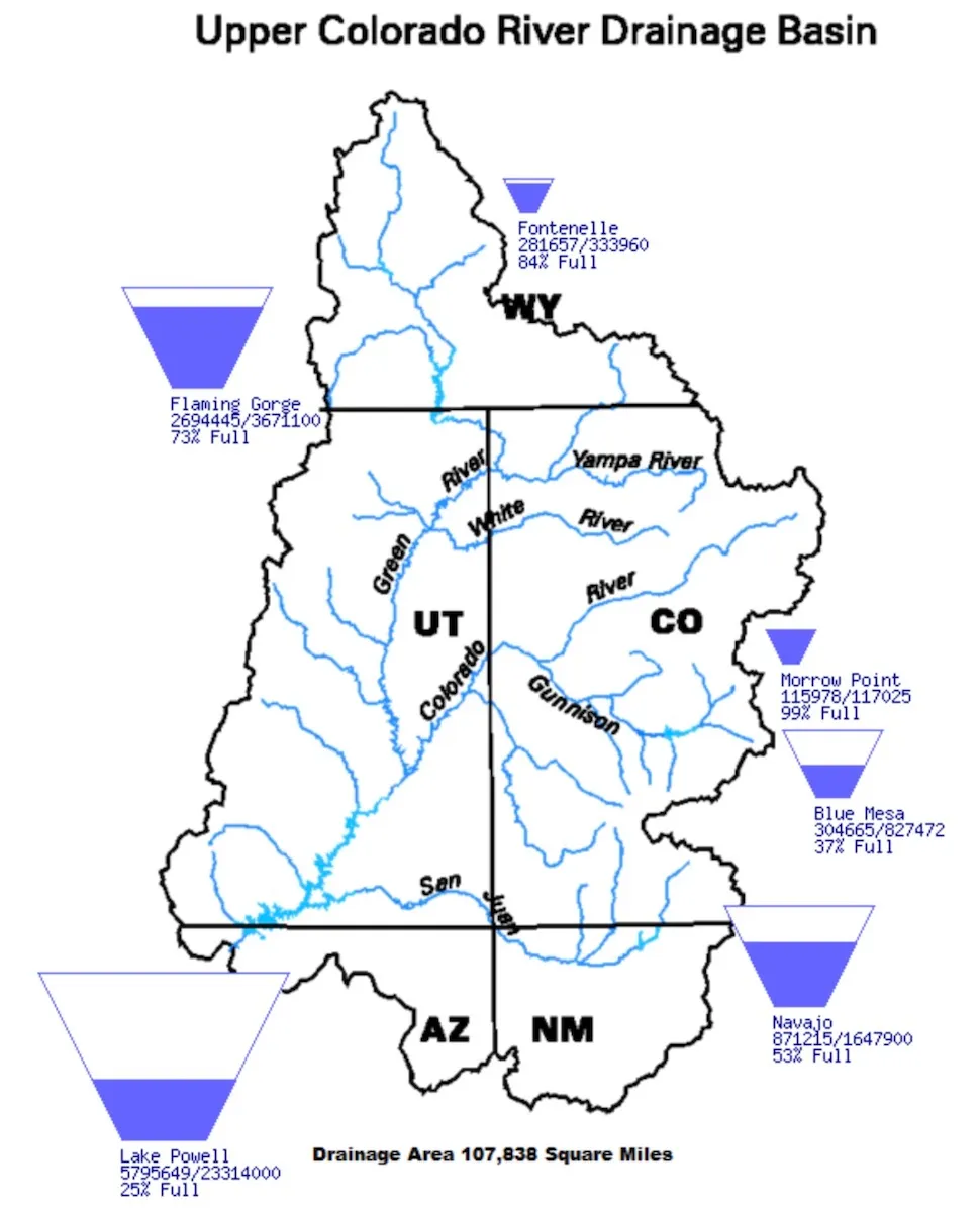
The basin, mired in a drought believed to be the worst in 1,200 years, is divided into two regions. The Upper Basin includes Colorado, New Mexico, Utah and Wyoming, while the Lower Basin covers Arizona, California and Nevada.
Colorado River Basin. Credit: Chas Chamberlin
During a meeting of the Upper Colorado River Commission held Wednesday during the confab, hundreds packed a conference room to hear the reports. The commission works to ensure the Upper Basin states receive their allocation of Colorado River Water and that they meet their obligations to send water to the Lower Basin.
“We all know that we are gathering here today in a time of unprecedented crisis in the basin,” said Anne Castle, a Colorado water attorney who President Biden appointed to serve as federal chair of the commission in September 2022.
“We all know we have a huge imbalance between supply and demand and we also know we don’t have much time to correct it,” Castle said.
Last summer U.S. Bureau of Reclamation Commissioner Camille Touton ordered the states to figure out how to reduce water use by 2 million to 4 million acre-feet, but no agreements have been reached, leaving the possibility that the federal government will decide how to make the cuts.
Touton urged water users to continue working together to find a solution to the crisis.
As lakes Powell and Mead have dwindled, all seven states have had to get by with less water and federal forecasts indicate that is likely to be the case for several more years.
In Colorado, major cutbacks have already occurred.
Becky Mitchell, director of the Colorado Water Conservation Board who also represents Colorado on the Upper Colorado River Commission, said the state has already had to temporarily dry up thousands of acres of irrigated farmland because of the crisis.
Mitchell said the state used 25% less Colorado River water in 2021 than it did in 2020 because of the drought.
Critical negotiations among the states are underway to reach a consensus on how to slash water use enough to keep Lake Powell full enough to continue producing power.
“The gap is big enough that no one basin, no one state, no one sector of the economy can solve it alone,” Castle said.
“The real enemy here is not another basin, or another state or alfalfa or golf courses. It is climate-change-induced lower flows. It’s not an enemy that we can defeat. It is one that we have to learn to live with,” she said.
Jerd Smith is editor of Fresh Water News. She can be reached at 720-398-6474, via email at jerd@wateredco.org or @jerd_smith.
Updated Colorado River 4-Panel plot thru Water Year 2022 showing reservoirs, flows, temperatures and precipitation. All trends are in the wrong direction. Since original 2017 plot, conditions have deteriorated significantly. Brad Udall via Twitter: https://twitter.com/bradudall/status/1593316262041436160
Upper Colorado River basins. (The border of Wyoming and Colorado is mislabeled.) (U.S. BOR)
Click the link to read the article on the KUNC website (Alex Hager). Here’s an excerpt:
As climate change continues to shrink the Colorado River’s largest reservoirs, a group of four states that use its water are set to lay out plans to reboot a conservation program. The Upper Colorado River Commission – comprised of Colorado, Utah, Wyoming and New Mexico – plans to announce details of an extended “System Conservation Pilot Program” through which water users could be paid to cut back on their use. The soon-to-be-launched program aims to use a pool of $125 million from the Inflation Reduction Act for payouts to “mitigate the impacts of long-term drought and depleted storage,” according to presentation slides obtained by KUNC…The new program is an extension of a previous effort. An earlier pilot program ran from 2015 through 2018. Designed to serve as a proof of concept, the UCRC distributed more than $8.5 million as a part of that program and conserved an estimated 47,207 acre-feet of water…
The 2023 program would allocate considerably more money than the prior iteration if the UCRC gets approval from Congress to extend the program. The proposed Colorado River Conservation Act authorizes the program to continue until 2026. The Bureau of Reclamation would also need to sign off on the use of $125 million in federal funds. The money will come out of $4 billion from the Inflation Reduction Act that was set aside for Colorado River projects.
Chuck Cullom, executive director of the Upper Colorado River Commission, said his agency is still sorting out how much money it will offer water users on a per-acre-foot basis in exchange for cuts, and does not have a target for a total amount of conservation. The Upper Colorado River Commission is slated to release its first request for proposals on December 14, with a deadline in February. Then each participating state, and the UCRC will be able to review each water-saving proposal, setting higher payout values on a case-by-case basis. Cullom said the intent of such a review is to discourage profiteering, a nagging concern of programs that pay water users to cut back.
Studies of the 2015 pilot program found that lingering uncertainties still surround programs that pay farmers for temporarily fallowing their fields to conserve water. Questions about pricing, soil health, monitoring and ensuring that conserved water reaches the beleaguered Colorado River reservoirs remain unanswered…Cullom said the Upper Colorado River Commission expects to make a formal announcement about 2023 system conservation plans in Las Vegas. The commission will hold a meeting during the Colorado River Water Users Association annual conference, a yearly meeting of policymakers, scientists and water users that has been under increasing scrutiny as the region’s supply-demand imbalance teeters towards crisis levels.
Hoover Dam’s intake towers protrude from the surface of Lake Mead near Las Vegas, where water levels have dropped to record lows amid a 22-year drought. (Source: Bureau of Reclamation)
Chorus of experts warn climate change has rendered old assumptions outdated about what the Colorado River can provide, leaving painful water cuts as the only way forward
When the Colorado River Compact was signed 100 years ago, the negotiators for seven Western states bet that the river they were dividing would have ample water to meet everyone’s needs – even those not seated around the table.
A century later, it’s clear the water they bet on is not there. More than two decades of drought, lake evaporation and overuse of water have nearly drained the river’s two anchor reservoirs, Lake Powell on the Arizona-Utah border and Lake Mead near Las Vegas. Climate change is rendering the basin drier, shrinking spring runoff that’s vital for river flows, farms, tribes and cities across the basin – and essential for refilling reservoirs.
The states that endorsed the Colorado River Compact in 1922 – and the tribes and nation of Mexico that were excluded from the table – are now straining to find, and perhaps more importantly accept, solutions on a river that may offer just half of the water that the Compact assumed would be available. And not only are solutions not coming easily, the relationships essential for compromise are getting more frayed.
With the Compact’s shortcomings and the effects of climate change and aridification becoming as clear as the bathtub ring around Lake Mead, previous assumptions of how much water the river can provide and the rules governing how it gets divvyed up must be revised to reflect the West’s new hydrology. One thing is certain among experts and Colorado River veterans: Water cuts are in the short-term and long-term forecast for major cities such as Los Angeles, Las Vegas and Phoenix, as well as farmers from Colorado’s West Slope to growers in California’s Imperial Valley near the Mexican border.
“You don’t have any other arrow in your quiver right now except to reduce use,” Pat Mulroy, former general manager of the Southern Nevada Water Authority, told a gathering of Colorado River water interests this fall. “There are no other arrows.”
Updated Colorado River 4-Panel plot thru Water Year 2022 showing reservoirs, flows, temperatures and precipitation. All trends are in the wrong direction. Since original 2017 plot, conditions have deteriorated significantly. Brad Udall via Twitter: https://twitter.com/bradudall/status/1593316262041436160
The River’s Changing Math
Predicting the amount of water the Colorado River can provide in a given year has always been a challenge. The river’s flow is famously erratic, dictated by the size of the often-fickle Rocky Mountain snowpack and other variables such as soil moisture and changes in temperature.
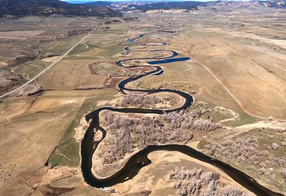
Flows in the White River (pictured above) and other Upper Basin tributaries have declined dramatically over the last 20 years, a trend experts warn will worsen as the West becomes hotter and drier. (Source: The Water Desk)
The old expectations of the Compact signers is giving way to a new reality on the river. Over the last century, the river’s flows in the Upper Basin have dropped by 20 percent. Scientists have pinned warming temperatures as the main cause of the disappearing flows and predict the trend will worsen as the Upper Basin, source of most of the river’s water, becomes even hotter and drier.
Water users have been able to counter previous dry spells by relying on the river’s main reservoirs. But after more than two decades of drought, both Lake Mead and Lake Powell are only about one-quarter full. The reservoirs’ rapid declines have forced the Bureau of Reclamation to order unprecedented water cuts to Arizona and Nevada. Mexico is taking similar cuts under binational agreements. And Reclamation has warned more severe actions are needed to prevent the collapse of the Colorado River system.
The Compact signatories, relying on data from a small but abnormally wet time period, estimated the river’s annual average natural flow in the Upper Basin to be about 18 million acre-feet. The figure, they asserted, was enough to cover 7.5 million acre-feet of water in perpetuity for the Upper Basin states of Colorado, New Mexico, Utah and Wyoming, and 7.5 million acre-feet for the Lower Basin states of Arizona, Nevada and California. They also agreed that any water committed to Mexico would be supplied equally by the two Basins. Native American tribes, who now legally hold substantial rights to the river’s water, were barely mentioned.
Brad Udall, Colorado State University climate researcher, said it’s becoming harder and harder for the river to meet the promises outlined in the Compact and the accompanying set of agreements, laws and court cases referred to as the Law of the River. He warned dozens of water managers and policy experts at a recent Water Education Foundation Symposium that climate change caused by greenhouse gas emissions is rapidly and permanently shifting precipitation trends in the Basin.
“It’s not a drought, it’s not temporary, it’s aridification,” said Udall. “Additional 1 degree Celsius or more warming by 2050, Lee Ferry flows in 9 million acre-feet are possible. Every important trend line [is] heading in the wrong direction, notably our reservoirs, but all the science trends as well.” [ed. emphasis mine]
Data from recent decades shows it’s becoming uncommon for the river to meet the benchmark used to craft the Compact. Estimated annual flows at Lee Ferry, a key dividing point between the Colorado River’s Upper and Lower Basins, have surpassed 18 million acre-feet just four times since 1991, while the river’s average flow since 2000 has been 12.3 million acre-feet.
“If we’re taking out more than comes in, it is really simple math that the reservoirs are going to continue to decline,” said Rebecca Mitchell, director of the Colorado Water Conservation Board, the state’s water management agency.
The federal government may reduce releases from Glen Canyon Dam (pictured above) in 2023 by an unprecedented 2-3 million acre-feet, a move that would trigger severe cuts in the Lower Basin. (Source: Bureau of Reclamation)
Mitchell was among nearly 200 state and regional water managers, farmers, tribal leaders and other water interests from the seven Basin states, along with key federal and Mexican officials, who attended the Foundation’s biennial Colorado River Symposium in late September to mark the Compact’s 100th anniversary and to discuss the risks and challenges ahead for the iconic Southwestern river.
Discussions were sometimes sobering and sometimes tense, underscoring the growing risks to a river depended upon for drinking water by 40 million people and for irrigation of more than 4 million farmland acres across the Basin. An undercurrent of the discussions was whether Basin interests can avoid taking their differences to court – a prime motivation behind creating the 1922 Compact. Despite the occasional sharply worded airing of differences between Upper and Lower Basin interests, there was broad acknowledgement that action is needed to keep the river system functioning.
Reclamation Commissioner Camille Calimlim Touton was among those urging water interests throughout the Basin to continue working collaboratively toward solutions and she provided a broad outline of actions that federal officials are preparing to take in 2023 – including reducing water releases from Lake Powell and Lake Mead – to keep the river from crashing.
“The actions we choose to take over the next two years,” Touton told participants, “will define the fate of the Colorado River for the next century.”
Living Within New Means
Though the Colorado River’s annual yield has shrunk in the 21st century, demand for its diminishing supply hasn’t, creating a glaring math problem for Basin water managers. In a system where every drop of water is already allocated, the specter of an 11 million acre-foot river — or worse — is forcing users to prepare for a drier future.
The Colorado River Compact divided the basin into an upper and lower half, with each having the right to develop and use 7.5 million acre-feet of river water annually. (Source: U.S. Geological Survey via The Water Education Foundation)
One agency that has been actively finding ways to stretch its river supply is Southern Nevada Water Authority, which serves more than 2 million people in the Las Vegas area. The agency has updated its modeling and long-range planning to reflect the river’s changing hydrology.
John Entsminger, the authority’s general manager, said computer models are sending a direct warning that the Lower Basin will end up with only a slice of the 7.5 million acre-feet per year outlined in the Compact. After accounting for evaporation and system losses, he said, it’s probable the Lower Basin and Mexico will have much less water to split.
“It is incumbent upon the Lower Basin to come up with a plan to live within its 7 million acre-feet release from Lake Powell probably forever going forward and hope it’s not less than that,” said Entsminger.
Like Nevada, Arizona is already feeling the pinch from the latest round of federal water cuts. So far, the two states and Mexico have shouldered most of the pain.
In 2022, Arizona is using approximately 2 million of its 2.8 million acre-feet Colorado River allocation, according to state officials The state’s agricultural industry is taking the hardest hit, including one rural county that fallowed more than 50 percent of its farmland for lack of irrigation water.
“We’re already seeing huge pain, and with an 11 million acre-feet [river] that pain’s just going to continue to grow,” said Tom Buschatzke, Arizona Department of Water Resources director.
Lees Ferry, located 15 miles downstream of Glen Canyon Dam is the dividing line between the upper and lower Colorado River basins. Photo/Allen Best
The widening gap between supply and demand is also having an impact above Lee Ferry, where inflows into Lake Powell continue to fall below historical average. Water from Powell is critical for helping the Upper Basin meet its commitment under the 1922 Compact to deliver water to the Lower Basin.
Representatives from the Upper Basin states say they have collectively cut their annual consumptive river use from 4.5 million acre-feet to approximately 3.5 million acre-feet over the last three years. Over the same period, they argue, the Lower Basin has done little to reduce its own consumptive use. Similar to Arizona, Upper Basin farmers also have been on the receiving end of water cuts.
The Ute Mountain Ute Tribe has fallowed the majority of its farmland in southwestern Colorado while in Wyoming, more than 100,000 acres of farmland were cut off from surface water for most of August because of low stream flows in the Upper Basin.
“That equates to about 100,000 acre-feet of [diverted Colorado River water] a month…that’s a third of our average irrigated use,” said Brandon Gebhart, Wyoming State Engineer.
The Upper Basin states have proposed a five-point plan built around paying farmers to reduce water consumption. Though it doesn’t require mandatory cuts for water users, proponents say the success of the plan hinges on whether the Lower Basin agrees to leave more water in Lake Mead.
“I think we need to recognize that the uses are far outweighing what Mother Nature is providing and that is primarily not in the Upper Basin,” said Mitchell with the Colorado Water Conservation Board.
California In the Spotlight
California’s use of the river has been a sore point among others in the Colorado River Basin. California, the largest user of Colorado River water, has been spared from water cuts so far due to its senior priority rights and has been using its full 4.4 million acre-feet entitlement in 2022. Groups in both the Upper and Lower Basins say the state must significantly reduce its use to prevent the river system’s collapse.
The Salton Sea (pictured above ) straddles the Imperial and Coachella valleys and has long been a sticking point in Colorado River deals. But the federal government recently committed up to $250 million for restoration efforts at the sea. (Source: Water Education Foundation)
California water agencies and state officials have pushed back on criticism that they aren’t doing enough to help buoy the shrinking reservoirs.
Peter Nelson, chairman of the Colorado River Board of California, argued California delayed the current crisis by enacting voluntary deals that pay farmers not to plant their fields, transfer water to urban users or make their systems more water efficient.
“In the Lower Basin, since the last seven years or so, we’ve stored 1.5 million acre-feet of water in Lake Mead as Intentionally Created Surplus water,” said Nelson, who farms in the Coachella Valley. “That has enabled the lake levels at Lake Mead to stay high enough to stay out of shortages and benefit other states in the Basin.”
Though the state is using its full share amid another bitterly dry year on the Colorado River, California water managers say they are not dismissing the fact that the river is overprescribed and that future cuts are needed. But they warn that the state’s farmers shouldn’t be made the scapegoat for all the Basin’s water problems.
For example, cutting off water to farmers in the Imperial Valley may help solve one crisis but simultaneously cause another, said Henry Martinez, general manager of the Imperial Irrigation District. Agriculture overwhelmingly drives Imperial County’s economy, he said, so fallowing would lead to major job losses in a region already prone to high poverty and unemployment rates.
“You can devastate the whole industry by making the wrong cutbacks at the wrong time. There has to be consideration also as to how to prop up or maintain the economy of the region, otherwise you go from a very poor area to devastating even furthermore the economy,” said Martinez.
In response to Reclamation’s call this summer for river users to voluntarily conserve 2 million to 4 million acre-feet of water in 2023 to protect Lake Mead and Lake Powell, Imperial Irrigation District and other California agencies on Oct. 5 proposed a plan that would save 400,000 acre-feet — 9 percent of California’s river allocation — each year between 2023 and 2026.
Earlier this month, the Department of the Interior approved the deal, committing $250 million from the Inflation Reduction Act to kickstart the conservation plan and support Salton Sea restoration efforts. As a result of water conservation efforts and a long-term transfer of farm water from the Imperial Valley to urban San Diego, the sea has been shrinking, exposing more lakeshore to winds that blow hazardous, lung-choking dust into the region.
California’s offer has received mixed reviews throughout the Basin: Some have applauded the proposal and called it an encouraging first step from the river’s biggest user, but others have cast it as an underwhelming opening gambit.
Wade Crowfoot, California Natural Resources Agency Secretary, said the Basin must continue negotiating and taking advantage of federal aid earmarked for Western drought relief to spur water conservation.
“As challenging and as tense as this is, I think that there’s a real opportunity and that failure is not an option,” said Crowfoot. “Everybody understands we have to figure this out and we have some resources at our disposal.”
“We can’t be caught flat-footed.”
In June, Reclamation Commissioner Touton told a U.S. Senate panel that unless an emergency conservation deal was reached by river users in 60 days, the federal government would have to take unilateral action to prevent the system’s demise.
Bruce Babbitt, former Interior secretary and Arizona governor. (Source: Water Education Foundation)
But the deadline passed without a deal and there was no immediate federal response, causing water users to wonder whether repercussions were coming. With little progress on a watershed-wide conservation plan, some Colorado River veterans contend the federal government should take a direct role in facilitating negotiations.
“I think Reclamation is going to have to get some key players in the room, probably including Mexico, and really get down to the brass tacks of leveraging and what needs to be done,” said Tom Davis, general manager of the Yuma County Water Users’ Association. “We need to save this patient’s life in the next 24-36 months.”
Touton’s demand that the Basin states cut 2 million to 4 million acre-feet caught them off guard, said Bruce Babbitt, former Interior secretary and Arizona governor. Since the announcement, Babbitt said, the states have essentially been “stumbling around” in the absence of a well-defined negotiation framework.
Babbitt likened the current situation to the one 100 years ago, when the states’ negotiations on how to split the Colorado River had also stalled before President Warren Harding tapped Herbert Hoover to guide the talks. Babbitt told the September symposium there are important lessons to be taken from the structured discussions at Bishop’s Lodge, just outside of Santa Fe, N.M., that ultimately led to the formulation of the 1922 Compact.
“What finally emerged out of that in terms of process at Bishop’s Lodge is something that I think we need to reflect on because we’re going to have to put together a workable framework,” Babbitt added.
Federal officials contend there isn’t a leadership void.
David Palumbo, Reclamation’s deputy commissioner of operations, said Reclamation is preparing a suite of actions — including reducing releases from Lake Powell in 2023 — to prevent a scenario where water can’t flow out of the system’s main dams.
“If we need to release less than 7 million acre-feet [from Glen Canyon Dam] … if that hydrology is not there, we’re going to have to do something to avoid the crash and we’re going to be prepared to do that,” said Palumbo. “We can’t be caught flat-footed.”
Water users are urgently trying to keep Lake Powell on the Utah-Arizona border from dropping to a point where Glen Canyon Dam can no longer generate electricity. (Source: Bureau of Reclamation)
With talks between the states and tribes at a standstill, Interior Secretary Deb Haaland on Oct. 28 announced the federal government is considering deviating from operating rules established in 2007 and 2019 to handle water shortages on the river.
During recent public briefings, federal officials have indicated that Lake Powell releases may be slashed by 2 to 3 million acre-feet annually to keep the reservoir from reaching a point where it could no longer generate electricity or deliver water downstream.
Meanwhile, Reclamation is now offering Lower Basin water users up to $400 per acre-foot of conserved water over the next three years, part of the $4 billion in drought relief funding secured through the Inflation Reduction Act. In addition, at least $500 million will be reserved for water conservation and efficiency projects in the Upper Basin.
Some Colorado River veterans, including Colby Pellegrino, deputy general manager of resources for the Southern Nevada Water Authority, are urging Reclamation to focus the federal drought relief on actions that will not just temporarily halt Lake Mead’s decline, but permanently change water use habits.
“We should be using that money to fundamentally change the way we do everything in this Basin to use the least amount of water possible,” she said.
Considering the scope of the damaging economic, social and ecosystem impacts that would flood the Basin if Lake Mead or Lake Powell were to reach dead pool, others argue Congress should get more involved. One idea, outlined in a policy paper presented at the Symposium by the Foundation’s 2022 Colorado River Water Leaders class, is a biennial program that would provide federal funding for programs that would reduce system demand and encourage more frequent discussions between the states, tribes and other water users in the Basin.
Congress has enacted similar regional programs in recent decades, including in the Florida Everglades, the Chesapeake Bay and the Great Lakes. A stable source of federal funding can create permanent, multi-benefit solutions, said Brenda Burman, former Reclamation commissioner who will take over as general manager of the Central Arizona Project in 2023.
“Whether it’s biennial or yearly, I think we need to be looking at a Colorado River Basin program,” she said.
Tribes Gain a Say
Unlike previous deals, the federal government and states say they are committed to figuring out how to share Colorado River water while acknowledging the sovereignty and water needs of Native American tribes.
Lorelei Cloud, member of the Southern Ute Indian Tribe’s tribal council. (Source: Water Education Foundation)
Many Basin tribes, which hold legal rights to about a quarter of the river’s water, are hoping to upgrade their infrastructure and fully develop their water rights. As the tribes assert their water rights, the amount of water available to states with junior rights like Arizona or Nevada may shrink. After fighting legal battles to secure their rights to the river — 12 Basin tribes still have unresolved water rights claims — tribes aren’t eager to halt the progress they’ve made in bringing water to their communities and farms.
Lorelei Cloud, a member of the Southern Ute Indian Tribe’s tribal council, said the tribe’s unused river water simply flows by its Colorado reservation to be used by others downstream. She reiterated that unused tribal water, which gets treated as “surplus water”, is a vanishing luxury the rest of the Basin won’t soon be able to bank on.
“Tribes don’t get compensated and have never been compensated for our unused tribal water, especially the water that’s sitting in Lake Powell and Lake Mead,” said Cloud.
Decrepit water infrastructure among other issues prevents the Southern Ute from being able to use its full river allocation as it is, so Cloud added that the tribe is unlikely to cut back its water use even if the river continues to shrink.
“When tribes start to develop their water, what are you all going to do?” Cloud asked the Symposium crowd. “Because that water is ours. We’re in Colorado, so we’re going to get our water first.”
While the tribes have been historically excluded from and considered an afterthought in Colorado River negotiations, there are signs that the balance of decision-making power is shifting. Congress is providing billions of dollars in funding in the Bipartisan Infrastructure Law and the Inflation Reduction Act to help tribes across the country improve their drinking water and water delivery systems.
At the September Symposium, both federal and state officials echoed the need for tribes to be included at the bargaining table.
“Tribes across the Basin will also continue to play a vital role,” said Interior Secretary Haaland, the first Native American to serve as a cabinet secretary. “Indian tribes have water rights, and not only are they deeply affected by the drought, but they have been and will be invaluable partners in finding solutions.”
Other Challenges
Before considering any major changes to the river’s guiding principles, water managers will have to ensure that the country of Mexico is included in the process.
Mexico, already dealing with water shortages in several of its northern cities, is taking cuts to its river supply in 2022 and 2023 under binational agreements. Tensions over sharing the Colorado River have traditionally waxed and waned but the neighboring countries have been able to reach a series of water management agreements in recent decades.
Members of the International Boundary and Water Commission (IBWC), which oversees boundary and water issues between the U.S. and Mexico, said they are confident the two countries can continue communicating and building on previous partnerships.
“I feel that we’re going to go very far and be able to identify what we need to solve the issues along the U.S.-Mexico border,” said Maria-Elena Giner, the U.S. commissioner to the IBWC.
Thus far, talks regarding the river’s future have focused on limiting impacts to cities, farms and tribes. But reserving enough water to ensure the Basin’s fish and wildlife survive the drought is another thorny task water managers are wrangling with.
Environmental groups and other nongovernment organizations argue they are key river partners that can bring myriad resources and ideas to the brainstorming process.
“When the system is not sustainable, it’s not resilient and the environment loses. It’s the one that gets sacrificed first,” said Taylor Hawes, The Nature Conservancy’s Colorado River program director. “Finding solutions that do not sacrifice the environment, that do not look at the environment as a sacrificial lamb, need to be part of our collective path forward.”
Meanwhile, new rules that would require Lower Basin users to account for water lost in large reservoirs to evaporation or leaky water delivery infrastructure are in the works. Currently, Upper Basin states are charged for evaporation losses but the Lower Basin is not.
Federal officials estimate as much as 10 percent of the river’s flow evaporates annually, including more than 1 million acre-feet from the Lower Basin. The federal government has announced it may change the evaporation accounting practices by the end of 2024, meaning the Lower Basin could take a significant cut to its share.
“In these serious times, we need to take the overdue step of assessing how to account for those losses throughout the Basin. This is another tough reality that we must work together to address,” Haaland said.
As water managers attempt to navigate the river’s mounting crises, they can turn to a variety of recent success stories for inspiration.
Pat Mulroy, a senior fellow at the University of Nevada, Las Vegas’ Boyd School of Law and the former longtime general manager of the Southern Nevada Water Authority, is an advocate for extensively rethinking how the Colorado River is managed. (Image: University of Nevada, Las Vegas’ Boyd School of Law)
Cities such as Phoenix, Los Angeles and Las Vegas have shown the ability to decouple water demand from population growth. Restoration efforts at the long-neglected Salton Sea are producing positive results. An innovative water sharing deal is providing economic benefits to the Jicarilla Apache Nation as well as water security for New Mexico and increased river flows for endangered species of fish.
These beneficial programs and decisions — in a refreshing twist from a river history dominated by men — are being crafted with the input of women in high-ranking positions, creating hope on a river in dire straits.
Instead of court battles that could lead to a federal judge taking over management of the Colorado River, water users need to negotiate with open minds as they chart a path for the lifeline that means so much to so many, said Mulroy, former head of the Southern Nevada Water Authority. To cut through the paralysis that has bogged down negotiations, everyone will have to show the courage to deviate from old agreements and assumptions and prepare for cuts.
“We’re talking about a body of law and a structure we’ve lived with predicated on 17 to 18 million acre-feet,” Mulroy said, “and a reality that has 9 to 11 million acre-feet in the river – the two don’t mesh.”
Did you know that 50% of urban water is used outdoors? Most of this water is used to irrigate “non-functional” turf – meaning the only use is for aesthetics that could be achieved through other, lower water use means. One of the most impactful solutions WRA is driving helps municipalities, homeowners, and other property owners replace unnecessary, thirsty grass and lawns – also called “turf” in policy arenas – with low-water alternatives, such as native grasses and plants, trees, and shrubs.
THE BENEFITS OF REPLACING NON-FUNCTIONAL GRASS
Saves residents money. Lower water use means lower water bills and reducing the likelihood that utilities will need to invest in costly new water projects to meet demand.
Supports healthy ecosystems. Native landscaping supports local wildlife, pollinators, and the environment while better reflecting the landscapes around them. They can also reduce urban air pollution from lawn mowing and improve stormwater quality by reducing pesticide and fertilizer applications.
Uses less water and keep more water in rivers. Reducing water use at the municipal level takes pressure off our rivers and streams.
Increases water security and resilience to climate change. Improving water conservation will help communities adapt to lower water supplies.
SWAPPING TURF FOR LOW-WATER LANDSCAPING WILL PROTECT COMMUNITIES’ WATER SUPPLIES
The rivers that sustain our communities and environment – from the Colorado to the Rio Grande and the Gunnison to the Gila – are overtaxed due to climate change, multi-year drought, and decades of overuse. Additionally, as flows in the Colorado River and water levels in major Western reservoirs become further depleted – Lake Powell and Lake Mead, the largest reservoirs in the region, are at their lowest levels on record – there is a high likelihood in the coming years that the Colorado River system will collapse, generating a crisis across the West.
This means that local municipalities have a real water security problem. Water demand in communities across the region already outpaces available supply, and this only will get worse as climate change intensifies. WRA is developing and implementing innovative policies and programs that help communities live within their water means while getting rivers back into balance.
WHY NON-ESSENTIAL TURF?
While Western states are among the driest in the country, irrigated turf – think lush, green lawns – has been ubiquitous in many communities across the region, from front yards to sprawling office parks to roadway medians. Much of this grass is not used but requires a large amount of water. In fact, non-functional landscape irrigation makes up more than half of water use in the West. In Colorado, where I live, outdoor water use accounts for 38% of all municipal demand each year. Most of this outdoor water use is dedicated to landscaping and irrigated grass. With the growing impacts on the Colorado River, this is water the region cannot afford to waste.
Replacing grass and lawns is a key part of increasing community resilience to climate change, improving water security, and adapting to a present and future with less water. In other words, turning the sprinklers off will help cities keep the taps on. While many municipalities have had success conserving water through strategies such as requiring low-flow toilets and showers and more water-efficient home appliances, further conservation is needed in the urban sector.
Outdoor water conservation is particularly important because, unlike indoor water use, outdoor water is largely consumptive, meaning it evaporates or is used by the plant and cannot be reused down the line. Switching from grass to low-water plants is the next low-hanging fruit that will help municipalities stretch increasingly limited water supplies over the coming decades.
Additionally, one of the best parts about replacing thirsty grass is that anyone can play a role: An individual homeowner, a large business, a city, or an entire state. By swapping a traditional lawn with drought-proof landscaping, we can help save 50% or more in outdoor water use.
GRASS REPLACEMENT IS IN HIGH DEMAND
As more local communities seek opportunities to replace high-water use grass, WRA is designing, advocating for, and implementing policies and programs to support their efforts. In 2022, WRA helped develop legislation creating the first state-wide turf replacement program in Colorado and advocated for a similar program in Utah. These voluntary programs will ensure every property owner in the state can access financial resources to replace their lawn with drought-tolerant, sustainable alternatives. We’re also supporting municipalities, like the city of Aurora in Colorado, with crafting effective local water-saving ordinances that meet their unique needs, such as banning new golf courses or restricting lawns in new developments. This builds on WRA’s years of work helping municipalities integrate water into land use planning, ensuring that growth and development are efficient and water smart.
The region is moving in the right direction on lawns. A growing number of Western water providers are creating and advocating for programs that encourage their customers to swap underutilized grassy areas for waterwise landscaping. In Colorado, 22 utilities — including Castle Rock and Fort Collins — provide customers with rebates for replacing water-thirsty plants with low- or no-water alternatives. In Utah, more than a dozen municipalities participate in the Flip Your Strip program, which encourages residents to remove park-strip grass in their front yard and replace it with waterwise landscaping. The Southern Nevada Water Authority (SNWA), which serves Las Vegas and other areas of the state, has perhaps the most successful lawn replacement program in the country. SNWA’s cash for grass program has saved nearly 467,000 acre-feet of water, which is 167,000 acre-feet more than the amount of Colorado River water that the entire state of Nevada has the right to use each year. SNWA shows that, when implemented at large scale, grass replacement efforts can serve as vital water supply infrastructure — the same as pipes, tanks, and reservoirs.
WHAT CAN WATERWISE LANDSCAPING LOOK LIKE WHERE YOU LIVE?
WRA envisions a future where Western communities showcase beautiful native landscaping reflective of our region that provide all the benefits of grass with a fraction of the water. To be sustainable, communities will need to reflect the water and climate reality we now have, as well as the open spaces that surround them.
Replacing non-functional grass with waterwise landscaping will look different across our states and communities. In Arizona, a grassy highway median could be transformed with saguaros and beargrass. In Colorado, a front lawn could have pops of color with purple gayfeather, yellow rabbitbrush, and blue flax. In New Mexico, orange sunset hyssop and green agave could grow alongside a small, low water buffalo grass lawn in a backyard. Drought-resistant landscaping that occurs naturally in the Western region encompasses an extraordinary range and depth of plants, trees, shrubs, and other flora, from native grasses to fields of wildflowers to large shade trees, that mirror the unique ecosystems of each state.
Turf replacement. Photo credit: Western Resource Advocates
There is still, however, a role for grass in our communities. Playgrounds, parks, sports fields, and reasonably sized backyards all provide valuable benefits and should be prioritized. These types of spaces provide important community functions. Replacing all non-functional grass allows communities to better maintain turf spaces that are meant for all to enjoy. Replacing or reducing the size of lawns creates an opportunity to prioritize limited water for trees. A healthy tree canopy is vital to combat urban heat island, reduce power bills, and shade yards, which further reduces water needs for plants.
When it comes to the impacts of drought and climate change on the Colorado River, replacing lawns and non-functional grass must happen alongside other large-scale conservation efforts, such as boosting use of recycled water and enabling water from retired coal plants to flow back into rivers. Major water users throughout the basin, including agricultural producers, will also need to do their part to reduce use through a variety of temporary and permanent means.
WHAT’S NEXT FOR TURF REPLACEMENT IN THE WEST
Western communities need to do more – and faster – to improve their water security through expanding turf replacement programs and promoting waterwise landscaping. WRA is instrumental in supporting local governments by:
Pushing for additional, local lawn replacement policies and programs while increasing funding for current statewide programs in Colorado and Utah;
Partnering with municipalities to develop local ordinances, local codes, and improved land use and water planning to reduce non-functional turfgrass in new development and redevelopment;
Partnering with water utilities to develop and expand grass replacement programs;
Providing input on state water plans to make sure they include and prioritize grass replacement in urban conservation efforts;
And encouraging more waterwise training and certification opportunities for landscape and irrigation professionals.
In addition to doubling down on grass replacement programs and policies across the West, important shifts are needed to ensure success. First, programs need more dedicated funding. Lawn replacement programs, particularly at the municipal level, are incredibly popular but quickly run out of funding. States, municipalities, and water utilities need to set aside adequate funds for these programs so anyone who is interested can participate and programs can scale to maximize their impact. Water providers, city planners, and local elected officials interested in financing programs can find resources in WRA’s white paper: Financing the Future: How to Pay for Turf Replacement in Colorado.
Additionally, landscaping professionals should focus more training and industry knowledge around caring for native and low-water plants, while ensuring there is plant availability to meet growing consumer demand. Although more residents are converting their thirsty lawns to waterwise gardens, we still have a long way to go in transforming our landscapes and we need everyone involved. Increasing financial incentives, providing additional support, and offering educational resources for homeowners and other property owners will go a long way.
THE WEST NEEDS A WATERWISE FUTURE
In the face of climate change and a growing population, communities across the West must do more to make every drop of water count. Swapping underutilized and high-water-use grass is a key part of the solution with multiple benefits, from increasing water security and reducing water bills to supporting healthy, flowing rivers. States and municipalities must prioritize creating and growing lawn replacement programs in urban areas to improve their climate resilience and protect water users.
If you want to see more waterwise landscaping opportunities in your community, take action! You can contact your local elected officials, like city council members and state representatives, as well as your water utility to tell them you want more lawn replacement programs where you live. You can also help protect rivers while showing your neighbors what a waterwise garden can look like by transforming your own lawn. There are many resources to help you get started, depending on where you live, including:
Subsidized water cultivated the West, but this required becoming increasingly profligate with the region’s scarcest resource
The West uses too much water. For such a simple problem, the obvious solution — use less — lies frustratingly out of reach.
That inability to change may seem hard to understand, but the root of the problem becomes clearer if we consider the role of the West in the historical development of the United States:
The purpose of our system of “free water” — heavily subsidized water for irrigation — was to provide opportunities to settlers.
The frontier has served an important function in the Euro-American imagination since before there was a United States. For historians of the American West like me, the significance of the frontier has been at the center of our field for more than a century. Thomas Jefferson made the most notable case for westward expansion, prescribing it to relieve the social and political pressures that were building up as eastern populations grew and fought over limited resources. By the mid-1800s policymakers believed his ideal of yeoman homesteaders and their patchwork of farms was the Manifest Destiny of the United States’ exceptional democracy.
But that ideal never made it all the way across the continent. It ran into a problem right around the 100th meridian, west of which there wasn’t enough rainfall for agriculture.
Agriculture would require irrigation. A lot of it.
Hayfield message to President Obama 2011 via Protect the Flows
To solve this problem, the United States formed the Reclamation Service (the precursor to the Bureau of Reclamation) just over a decade after the frontier closed in 1890. While the federal government wasn’t quite powerful or rich enough, at the time, to construct many major irrigation projects, the Service provided a signal of the nation’s commitment to investing in the West as a site for settlement. It was too important a project to leave to private irrigation companies and too much work for individual homesteaders. As historian Donald Pisani put it in his book Water and American Government, “Federal reclamation was the last stage of Manifest Destiny.”
With the New Deal, the Bureau of Reclamation came into its own: Hoover Dam, completed in 1935 as the world’s largest dam, served as a symbol for the country’s ability to conquer nature.
Progressives championed desert reclamation at the turn of the century, but the federal government’s willingness to build infrastructure and give water away on extravagantly lenient terms was just as appealing for conservatives after World War II. Even Barry Goldwater, while courting the libertarians of the nascent New Right, advocated for the federally funded Central Arizona Project in his home state so that farmers could grow cotton in the Sonoran Desert.
That’s the defining contradiction of life in the West: “Government,” in Western parlance, was and is the stuff of restrictions, even when it’s the government that underwrites ever-popular sprawl.
While some made fortunes off this deluge of government spending, the enrichment of a few landowners was not the policy objective. Rather, the purpose of all the free water was to retain the West as a “safety valve,” a place of refuge for those who wanted to avoid the taxes and regulations of the East. But to accommodate growth without limits as the population boomed, the region would need to heighten the contradictions and become increasingly profligate with its scarcest resource.
Agriculture was once the means for permanent settlement of the arid West, and it continues to drive water consumption today. Around 80% of Colorado River water goes toward agriculture. About half of that is directed toward alfalfa hay that feeds cattle, an extremely inefficient way to provide calories for humans.
AZ must reduce water usage by 21% — and smaller cuts are needed in NV and Mexico — to avoid a “catastrophic collapse” of the Colorado River, the U.S. govt says.
The area is facing its worst drought in 1,200 years — now ongoing for 23 years — largely due to the climate crisis. pic.twitter.com/2n8gUy1eKV
Agricultural water rights are some of the oldest in the West, and water law here revolves around seniority. Yet even if there were a ready legal pathway to divert water away from alfalfa fields, the fact remains that the apparatus for western water delivery was simply not built with a regulatory lever. The underlying imperative to grow without limits would inevitably lead back to a state of crisis.
Consider St. George, Utah. The fastest growing metropolitan area in the country consumes almost no agricultural water, yet its lawns and golf courses quickly suck up its scarce water supply. The city, a popular destination for retirees, is expected to double in population by 2050. Officials now find themselves struggling to find sources of water for the surge in residents. What is quickly becoming a crisis for humans is also creating additional pressure on other species such as the endangered woundfin and Virgin River chub.
Pine Valley Mountains with St. George, Utah in the foreground. By Óðinn – Own work This image was created with Hugin., CC BY-SA 2.5 ca
The system’s deference to ideology over pragmatism is clear when it comes to the Basin’s 30 Native American Tribes. Collectively, they control about 20% of the water rights in the Colorado River system, yet many of those rights consist of “paper water.” They’re unrealized due to a lack of infrastructure. Building the necessary water projects for the Tribes would not only cost money but also push the system past the point of collapse. The very viability of the free water system depends on a de facto denial of the water rights of Indigenous nations, just as broken treaties facilitated the “free land” policy of the 19th century.
Free water was destined to run out eventually. Facing this problem in the West will be difficult, considering that politics and culture have worked in tandem for so long to keep “government” out of government-subsidized water. It’s unclear whether the system can be retrofitted with an off switch and whether the necessary governments can work together to do so before the Colorado River system crashes.
So how do we move forward? Ending the current subsidies seems the most commonsense solution — as well as the most unlikely to gain political traction.
Another possible solution: commodities trading. The classic solution for an imbalance of supply and demand is to introduce markets. Yet applying this approach to western water faces logistical challenges and can do little about longstanding problems of equity.
Still, the problem is big enough that all interventions may be necessary. Perhaps these first two ideas can be implemented. And perhaps we can think bigger.
One way forward is for the government to recognize the inherent worth of natural waterways, rejecting the premise that all fresh water must be consumed. Giving legal rights to ecosystems is the goal of the rights of nature movement, which has had some success across the world and even in the U.S. West. The organization Save the Colorado helped the communities of Ridgway, Nederland, and Grand Lake in Colorado pass resolutions recognizing the intrinsic rights of their watersheds. I’m part of an organization, Save Our Great Salt Lake, that’s exploring a similar strategy.
Wherever the future leads, the aridification of the American West will have consequences not just for those living here, but for the entire country.
It’s conceivable that westerners will adapt more readily to a drier climate than the rest of the nation will adapt to the loss of a region that functions as a safety valve. At any rate, we’re approaching the end of an era in which water was taken for granted. Just as human beings physically depend on water, our policies and conversations need to align with the water cycle.
A new turf replacement program, set to roll out in Colorado in 2023, will pay to convert some of the grass in urban areas and residential yards into more water-efficient landscaping. This is the first time the State of Colorado has dedicated funds expressly to turf replacement. It’s an important step to increase water conservation and get it closer to where it needs to be, said state officials and conservation leaders at a confab earlier this month. But this version of cash for grass will be just one of many tools — and maybe not the most influential one — that will transform landscaping in the state in response to climate change and reduced water availability.
As climate change, drought, and crisis on the Colorado River intensify, outdoor water use and nonessential turf become increasingly important targets for water conservation. Today, 40% of Colorado’s municipal and industrial water use goes toward outdoor irrigation.
“Water conservation is critical. We’re talking about how we can build the landscapes of tomorrow, today,” said Russ Sands section chief of water supply planning for the Colorado Water Conservation Board (CWCB) in kicking off the Colorado Landscape Summit on November 9. More than 150 people attended, either online or in person, this first-ever landscape summit hosted by the CWCB at Metro State University in Denver. “Outdoor turf removal is a really critical part of this discussion.”
The outdoor water-saving conversation has been gaining momentum in Colorado. The state legislature passed House Bill 1151 in June 2022, requiring the CWCB to develop a turf replacement program that will provide incentives for replacing nonessential irrigated turf with more water-wise landscaping. According to the bill, examples of nonessential turf include medians, land adjacent to open spaces, stormwater detention basins, commercial or industrial properties, portions of residential lawns, and more. The new law also came with an allocation of $2 million to finance the program.
Now the agency is working to set up that grant program, with details expected this spring and applications set to open sometime after July 2023. Local governments, special districts, nonprofits, and tribal nations will be eligible to apply, and individuals interested in receiving funds may be able to work with those entities to access the money.
But the program’s $2 million in initial funds won’t stretch far or transform the state’s turf on its own, said Peter Mayer with Water Demand Management, or WaterDM, an engineering consulting firm.
“The amount of money being spent in Colorado is ultimately nothing compared with what’s being spent in a single year in southern Nevada or southern California,” Mayer said.
After subtracting staffing and administration costs, some $1.5 million will remain for incentives to transform landscapes. That money is expected to be distributed in two cycles of $750,000 over two years, with the majority funneled into existing local turf replacement programs. For the program to continue beyond 2025, Colorado will have to find additional funding. However, though not specifically set aside for turf replacement, the CWCB’s Water Plan Grants and Water Supply Reserve Fund Grants may also be used to fund turf replacement work.
In August 2022, some public water providers and cities who rely on water supplies from the Colorado River Basin, including Aurora Water, Denver Water and Pueblo Water, signed a Memorandum of Understanding committing to reduce per capita water use. On November 15, additional water providers and agencies signed on, bringing the total to more than 30 entities across the West. The MOU says each of the water providers will introduce a program to reduce the amount of “non-functional turf grass by 30% through replacement with drought- and climate-resilient landscaping, while maintaining vital urban landscapes and tree canopies that benefit our communities, wildlife and the environment.” Details about how this will be accomplished have not yet been released.
Colorado is hoping to maintain those same qualities with its turf replacement program, said Sands.
But there’s still a lot to learn about how much savings Colorado can expect from turf replacement, what level of incentives are necessary to encourage participation, and what other potential costs and benefits there may be.
The state is trying to learn from neighbors with large-scale programs. The Southern Nevada Water Authority, which provides water to Las Vegas and surrounding cities, has been collecting data on its turf replacement program for almost 25 years, providing a helpful resource for Colorado officials.
Since the late 1990s, the authority has converted about 4,600 acres of turf, saving 467,000 acre-feet of water, at a cost of around $285 million. The average landscape conversion through the authority’s program resulted in a 19% to 21% reduction in water use. Among other findings, participation in the authority’s program correlates with the scale of the incentives – when cash incentives increase, participation increases.
Colorado should expect about one-third of the water savings that Nevada has seen, said Doug Jeavons, managing director with BBC Research, a firm that served as the CWCB’s water economy specialist in working on the 2019 Technical Update to the Colorado Water Plan. That is because of cooler temperatures and the fact that we don’t water turf year-round here, which means a lower starting point for outdoor water use and therefore less potential savings from turf replacement.
“Lower [water] savings basically means less favorable economics for a property that wants to participate in this program,” Jeavons said. In other words, it will take a property in Colorado more time to see the cost savings that result from reduced water bills due to their landscape conversion than it does in Nevada.
Economics aren’t the only reason to convert a property’s turf to water-wise landscaping. A 2018 Alliance for Water Efficiency study on landscape transformation found that most customers aren’t happy with their landscaping and 69% of all respondents have already considered taking out their lawns, said Mayer, who led the study.
“There’s just not enough [state] money to buy [out] all the landscapes [to transform them from grass to water-wise vegetation] so we have to do the work ourselves toward changing the market and shifting the culture,” Mayer said. “We have to create a new Colorado landscape ethos of less water use, minimizing outdoor water use.”
According to Mayer, incentives aren’t the only way to encourage that change. Codes, ordinances, regulations, land use planning and zoning, water bills, and ultimately education and culture change all play a role, he said. But while making those changes, it’s important to minimize any unintended negative impacts, maintain the tree canopy, minimize the heat island effect, and transform landscapes in an equitable way.
To date, 22 turf replacement programs exist across Colorado, and many other utilities have water conservation programs that target outdoor irrigation.
Colorado Springs Utilities offers a turf replacement rebate and works to incentivize customers to update their landscaping, shifting to plants that can thrive on 12 inches of irrigation per year or less, said Julia Gallucci, the water conservation supervisor for the utility. The city is also focusing on retrofitting parks and public areas where people can see examples of different types of water-wise landscaping.
Colorado’s West Slope communities are also looking to reduce outdoor water use, but face different challenges.
Some residents in the Roaring Fork Valley, for instance, use untreated water for outdoor irrigation that is not metered through the utility, complicating conservation efforts. “We have raw water supplies so it’s difficult to put in outdoor water restrictions because a neighbor might be pulling water from a ditch, so there’s confusion,” said April Long manager of the Ruedi Water and Power Authority. “I think we still need to do some work on changing expectations.”
Meanwhile, the City of Aurora, which offers a grass replacement incentive, upped the ante. In August 2022, the city passed an ordinance that restricts turf in new developments. The city no longer allows “non-functional,” cool weather turf to be installed at new development projects, redevelopment, or at new golf courses. The installation of turf is also banned from medians, curbsides and residential front yards.
“The key is to not put turf in in the first place,” said Tim York, water conservation supervisor for the City of Aurora. In developing its ordinance, Aurora engaged developers and community members. “You want them to get involved because it’s the right thing to do, not because we told them to do it.”
Caitlin Coleman is a contributor to Fresh Water News and is editor of Water Education Colorado’s Headwaters Magazine. She can be reached at caitlin@wateredco.org.
Cover of the NBS report, released at COP27. Credit: White House
Click the link to read the article on the NOAA website (Genie Bey):
At COP27 in Egypt, the Biden-Harris Administration released the Nature-Based Solutions Roadmap, an outline of strategic recommendations to put America on a path that will unlock the full potential of nature-based solutions to address climate change, nature loss, and inequity. This marks the first time the U.S. has developed a strategy to scale up nature-based solutions. The report was developed in response to President Biden’s Executive Order 14072, which recognizes the importance of forests and other nature-based solutions to tackle the climate crisis and strengthen communities and local economies. Led by the Council on Environmental Quality, the Office of Science and Technology Policy, and the National Climate Advisor, the report was developed in consultation with numerous agencies, and identifies key opportunities for greater deployment of nature-based solutions across the Federal government.
The Roadmap calls on expanding the use of nature-based solutions and outlines five strategic areas of focus for the federal government: (1) updating policies, (2) unlocking funding, (3) leading with federal facilities and assets, (4) training the nature-based solutions workforce, and (5) prioritizing research, innovation, knowledge, and adaptive learning that will advance nature-based solutions. Genie Bey, Zac Cannizzo, Chelsea Combest-Friedman, Bhaskar Submaranian, and Lisa Vaughan represented NOAA’s Climate Program Office as contributors to this report and the accompanying resource guide.
A new report from the Center for Western Priorities finds that bills to protect over 16 million acres of public land in the West are currently languishing in Congress. Protecting these landscapes would bring the nation closer to achieving the goal of conserving 30 percent of public lands and waters by 2030, a scientifically-driven priority backed by the Biden administration.
Despite incredibly strong and enduring support for conservation actions, worsening partisan gridlock has caused progress on conservation to grind to a halt. Over the decade from 2000 to 2010, Congress protected 9.5 million acres of lands through legislation. The next decade, from 2011 to 2021, Congress protected just 3.3 million acres, one-third of what had been protected the previous decade. This has not been for a lack of effort—many bills have been introduced and several have passed the House, some of them multiple times, only to stall out in the Senate.
This report, titled Languishing Lands, details a selection of landscapes that have been proposed for protection, including the greater Grand Canyon region and the Great Bend of the Gila in Arizona, the Ruby Mountains in Nevada, Castner Range in Texas, and the Owyhee Canyonlands in Oregon. The President has a clear opportunity to deliver for the communities that have worked hard to craft broadly-supported proposals, and should not hesitate to exercise the authority that the Antiquities Act gives him for exactly this purpose.
Center for Western Priorities Policy Director Rachael Hamby said the following:
“Westerners overwhelmingly support public lands conservation and are eager to see President Biden take action to protect iconic landscapes across the West. This report shows that broadly-supported and popular conservation proposals are falling victim to gridlock in Congress.
“Communities, tribes, scientists, and lawmakers have worked tirelessly on all of these conservation proposals, and they deserve to see these sites and landscapes protected after years or even decades of persistent effort. President Biden has the power to bypass our dysfunctional Congress and protect millions of acres that are currently at risk of mining, drilling, and other forms of degradation. There’s no time to wait.”
The Weaver Ditch as it winds through Sopris Park in Carbondale. While the ditch is an amenity for the community, the water in the ditch comes directly out of the Crystal River, which is often stressed from lack of water. Some Carbondale residents irrigate their lawns and landscaping with the town’s ditches, like the Weaver Ditch, that flow through town. A new unified outdoor watering standard would not apply to those who use ditch water, but they still are encouraged to comply. CREDIT: HEATHER SACKETT/ASPEN JOURNALISM
In an effort to unify the Roaring Fork watershed, a local agency has developed valley-wide outdoor watering standards that its board members hope will be adopted by municipal water providers.
Last week the Ruedi Water and Power Authority board, which is made up of representatives from local towns and counties, gave its unanimous support to a set of unified permanent watering standards. The standards are focused on time of day and day of week for outdoor watering and would apply to any residential or commercial customer receiving municipal water from the city of Aspen, town of Basalt, town of Carbondale, city of Glenwood Springs, Snowmass Water & Sanitation District and Mid-Valley Metropolitan District.
The proposed schedule would limit outdoor watering to between 6 p.m. and 9 a.m. three days a week. Properties with odd-numbered addresses could irrigate on Wednesdays, Fridays and Sundays; even-numbered properties could water on Tuesdays, Thursdays and Saturdays. No outdoor watering would be allowed on Mondays. Water providers could still enact more stringent restrictions depending on local conditions in their areas; the standards are intended to be a new baseline.
“If we can make this change, the idea that (watering restrictions) change from year to year to year will go away,” said Rachel Richards, Aspen City Council and RWAPA board member. “It’s going to be much easier and less expensive than having to tell people every year what the rules are this summer.”
The new watering standards were developed with the help of a project accelerator grant from WaterNow Alliance, which according to its website is a network of water leaders advancing climate resilient water strategies, and Boulder-based environmental advocacy group Western Resource Advocates. Outdoor watering of lawns and landscaping is often the largest water use category for local water providers; for the city of Aspen, outdoor irrigation represents about 70% of total water use.
The proposed schedule would result in water savings because watering would happen during the coolest periods of the day, peak demands would be reduced and one day a week of no watering would allow storage to be refilled, according to a memo from WaterNow Alliance and WRA.
“The three-day-per-week schedule is relatively easy to communicate to residents and other water users and it can be easily programmed into all types of irrigation controllers,” the memo reads.
The valley-wide watering standards were an outgrowth of the regional water efficiency plan, said RWAPA Executive Director April Long.
“We learned from the providers that were part of that plan that they still really needed some unified messaging about outdoor water use,” Long said. “We realized we don’t even have common ground to tell people exactly what to do because we have so many drought stages, and restrictions implemented in different ways. We actually need some baseline standards so we can provide a common message that’s not confusing for all of our residents.”
There are some exceptions to the standards. Outdoor watering can still occur any time of day with a handheld hose or drip irrigation. And those who irrigate with water from a ditch, like many residents in the town of Carbondale, are not subject to the standards, but are encouraged to comply.
The standards lay out penalties for violation, including a written warning for a first violation, and fines increasing to $500 for a fourth violation. But proponents will focus solely on an education campaign for the first season before issuing warnings or fines.
The next step is for Long to present the watering standards to each of the participating municipalities and get them approved by elected officials.
Ted Cooke and Tom Buschatzke: Photo credit: Arizona Department of Water Resources
Arizona’s water leaders on Friday, November 4, 2022, outlined the state of negotiations over delivery cutbacks to stabilize the Colorado River system.
Even as the days tick ever closer to the start of the 2023 water year, they reported, the Colorado River States and the Department of the Interior appear to have made scant progress toward an outcome that would leave between the 2-4 million acre-feet that the system needs to keep from descending to unstable levels.
Speaking about the on-going discussions among the states about conservation contributions, Arizona Department of Water Resources Director Tom Buschatzke conceded that “there was no certainty that we would get to even 1 million acre-feet (MAF).”
Director Buschatzke and Central Arizona Project General Manager Ted Cooke made their presentation to the Arizona Reconsultation Committee, the organization of water users and providers from across Arizona that helps develop an Arizona perspective on new long-term management guidelines for the Colorado River that are expected to go into effect before the end of 2026.
As a result of existing agreements, Arizona will leave 592,000 acre-feet of its 2.8 MAF allocation – 21 percent – in Lake Mead in 2023 to help keep the reservoir from descending to critical levels.
Including mandatory and voluntary contributions from a variety of in-state sources, Arizona will have left roughly 840,000 acre-feet in the troubled reservoir in 2022.
As reported by Buschatzke and Cooke, the states are struggling to come up with a plan to secure equitable voluntary commitments to conserve the additional 2-4 MAF.
Bureau of Reclamation Commissioner Camille Touton announced earlier this year that the system needed to conserve that stunning amount of water in Lake Mead and Lake Powell to avoid potential catastrophe. The Bureau’s efforts since then have focused on winning voluntary contribution commitments from the states. The ARC co-chairs said the discussions have not proved fruitful thus far.
Buschatzke also described one of the more under-appreciated issues facing the Colorado River system: The ability of Glen Canyon Dam to funnel water downstream if water levels in Lake Powell descend below the eight power-producing intake valves.
Below those eight massive valves are just four “bypass tubes” that, comparatively, are “basically four garden hoses” compared to the eight intake valves.
Much of the discussion at the ARC meeting focused on one of the more controversial long-term options for dealing with chronic overuse of Colorado River water – creating a system that assesses users for system losses due to evaporation, seepage and other losses. Accounting for those losses, said Buschatzke, “will go a long way” toward getting to the 2-4 MAF needed to protect the system.
“Everyone… diverting water should own a piece of that evaporation and system loss,” said Buschatzke. [ed. emphasis mine]
The Director acknowledged that winning support for such an accounting among users and providers in Arizona, much less among the other states, “is not a certainty.”
The back of Glen Canyon Dam circa 1964, not long after the reservoir had begun filling up. Here the water level is above dead pool, meaning water can be released via the river outlets, but it is below minimum power pool, so water cannot yet enter the penstocks to generate electricity. Bureau of Reclamation photo.
When Cheyenne’s municipal water board approved a deal in October to supply up to 14,500 acre-feet of water over 15 years for a proposed gold mine west of town, attorneys insisted on inserting a clause in the contract. It retained the right to cut water deliveries if the city itself has to curtail its water use due to the Colorado River crisis.
“The majority of our water comes from the Colorado River [basin] and if that call [requiring upstream users to cut consumption] comes in, we’re in big trouble,” Cheyenne Mayor Patrick Collins said.
About 70% of the city’s municipal water supply originates 150 miles west in the Little Snake River drainage, a part of the Colorado River Basin. A complex “trans-basin” system of pumps, tunnels and pipelines transports the water under the Continental Divide in the Medicine Bow Routt National Forest to the city.
Cheyenne’s legal claims to the Colorado River Basin water were appropriated from 1954 to 1982 — making it a relatively new user in the system. If there is a curtailment, it would be applied to the newest or most “junior” appropriations, then work back in time to the 1922 Colorado River Compact. That means, depending on how far back in time a curtailment extends, 70% of the city’s water supply could be shut off — an action that could come as soon as 2028 if hydrological conditions keep trending for the worse, according to the Wyoming State Engineer’s office.
This map depicts Cheyenne’s municipal water supply system, which funnels in water from the Little Snake River Basin. (Cheyenne Board of Public Utilities)
“If we lose 100% of our Colorado River Compact water, we’re upside down,” Collins said, adding that about 80,000 people rely on the city’s municipal water system. “We wouldn’t have enough water to meet our current needs.”
For now, Cheyenne, Baggs, Rock Springs, Green River, Pinedale and a handful of other towns that depend on water from the Little Snake and Green River basins in Wyoming are assessing where they stand in the pecking order of appropriated water rights in the event of a curtailment. Although municipalities make up a small percentage of Wyoming water users under the Colorado River Compact and associated laws, their legal claims to the water are among the most vulnerable.
First in time, first in right
If the Upper Colorado River Basin Commission issues a curtailment for Wyoming, it would not necessarily force all water users subject to the compact to close their spigots completely.
There’s no curtailment priority in terms of use — whether it’s irrigation for cattle and alfalfa fields, water consumed for cooling at the Jim Bridger coal-fired power plant or water piped to homes for domestic use. Instead, a curtailment would be applied based on the first-in-time, first-in-right water appropriations doctrine: Those who gained their water appropriation latest in time would be the first ordered to shut off their water.
For example, if the state had to curtail 100,000 acre-feet of water — approximately one-sixth of its annual Colorado River Basin consumptive water use — the state engineer would begin with the newest appropriations and work back in time until the 100,000 acre-feet of consumptive water use curtailment was met.
Shauna Gray and her dog, Lula Mae, paddle at Rob Roy Reservoir July 31, 2022. The reservoir is part of a trans-basin water system that supplies water to Cheyenne. (Dustin Bleizeffer/WyoFile)
If, let’s say, that required turning off all Colorado River Basin water appropriations back to 1970, that would choke off all water appropriated since then — whether for industrial, municipal or agricultural use. The cities of Rock Springs and Green River, which share a municipal water system that serves some 39,000 residents, would lose access to 75% of their Green River water appropriation. The towns would still be allowed to tap the 4,343-acre-feet-per-year appropriation they secured in 1928 and the 2,895-acre-feet-per-year appropriation that predates the 1922 compact. The rest — 75% — was appropriated in 1971 and after.
This type of variable vulnerability applies to many Colorado River Basin water users with appropriated rights that were obtained at different times. The exact order for how a curtailment would be applied is well documented and under continual review, according to the state engineer’s office.
Small straw, big vulnerability
Agriculture accounts for 83.7% of Wyoming’s consumptive use of water in the Colorado River system, according to the SEO. Municipal water use accounts for about 2.8% — or 3.3% if you include rural domestic water use. Industry — trona facilities, coal power plants, oil and natural gas processing — make up most of the remaining 13%.
Approximately 70% of agricultural irrigation water rights in Wyoming were appropriated before 1922. Those pre-1922 appropriations are not subject to the Colorado River Compact and cannot be shut off under a curtailment. The pre-1922 protection applies to all Colorado River Basin water users.
A majority of Colorado River Basin water appropriations held by Wyoming municipal water authorities, however, are post-1922. That means some 125,000 urban Wyoming residents and businesses are vulnerable to a curtailment.
Given the curtailment clause in Cheyenne’s water contract, gold mine developer Gold King Corp. is shopping around to secure alternative water resources, according to Mayor Collins. The city of Cheyenne — as well as Green River, Rock Springs and others — are doing the same.
“There is the possibility that we would not be able to collect any water from the Little Snake System if [a] curtailment call goes below 1954,” Cheyenne Board of Public Utilities Administrator Brad Brooks told WyoFile. “We are looking for additional water to mitigate this possibility and planning for the worst case that our Little Snake water will not be available.”
Green River and Rock Springs are in the same boat. Their joint municipal water system collects 100% of its water from the Green River and its tributaries to serve some 39,000 residents in and around the two cities. Only 10% of their Colorado River Basin water appropriations pre-date the 1922 compact.
Green River. (Google Earth)
Although the cities don’t rely on the full volume of their legal claims to Colorado River Basin water, the time to plan for supplemental water sources is now; 2028, the year Wyoming might first see a curtailment, isn’t far away, Green River/Rock Springs Joint Powers Board General Manager Bryan Seppie said.
“Understand, [a curtailment] probably isn’t a one-year event,” Seppie told WyoFile, adding that much depends on what Mother Nature has in store. “We’ve got to secure other water resources to serve as replacement water if [a curtailment] were to happen. Conservation is a tool, but with these types of curtailments, conservation is not going to get you out of it.”
Backup water
Part of the Gold King deal provides Cheyenne’s Board of Public Utilities approximately $5 million in fees that would help cover the cost to expand Cheyenne’s groundwater capacity. The city’s water board is also seeking up to $10.5 million in grants from the Wyoming Water Development Commission for its Borie wellfield expansion project. The expansion would add approximately 3,300 acre-feet of water per year to the city’s water portfolio, according to the board.
That would boost Cheyenne’s non-Colorado River Compact water source portfolio to 9,900 acre-feet per year. But the city would still be in trouble in the event of a curtailment because its average annual use is about 14,000 acre-feet.
“We are actively pursuing possibilities” for additional water resources, Brooks of the city’s BOPU said.
Anglers try their luck on the Green River at Seedskadee National Wildlife Refuge on Sept. 27, 2022. (Dustin Bleizeffer/WyoFile)
Expanding groundwater capacity, however, isn’t an affordable option for Rock Springs and Green River, according to Seppie. Instead, the cities are looking to those in the state with pre-1922 appropriations to share some water.
The federal System Conservation Program pays water users to curb consumption. Congress recently re-appropriated funding for the program, while the Inflation Reduction Act includes some $4 billion for efforts to modernize Colorado River Basin infrastructure and water management practices. Another $8.3 billion from the bipartisan Infrastructure law is available to address water and drought challenges throughout the U.S.
The SCP is an attractive option, Seppie said, for both ag irrigators and municipalities. Ag irrigators who volunteer for the program can use payments to upgrade their irrigation systems to waste less water.
“It’s a voluntary thing. It’s preemptive, and it’s benefiting the entire system,” Seppie said. “We haven’t gotten to a point where we’re having those discussions [with city officials]. But we have somewhat of a timeframe; 2028 is not all that far off.”
Residents and visitors spend time in Aspen’s Wagner Park on Sept. 28, 2020. Visitation and lodging unit occupancy rates are two variables that influence Aspen’s demand for treated water, 70% of which is used to water outdoor spaces such as parks and gardens, according to city officials. CREDIT: NATALIE KELTNER-MCNEIL / ASPEN JOURNALISM.
Since 2017, the city of Aspen’s water use has remained steady, illustrating the difficulty of reducing consumption through voluntary conservation measures amid continued growth and the effects of climate change.
According to numbers provided by city staff, total metered accounts for water use between 2017 and 2021 hovered between 800 million and 900 million gallons per year coming from the city’s treated-water system. Aspen’s system serves about 3,960 customer connections in the city’s urban-growth boundary.
2019 — a wet year — saw the lowest use in the data set, down to 828,650,350 gallons, or about 2,543 acre-feet. (An acre-foot is the amount of water needed to cover an acre of land to a depth of 1 foot and can typically meet the annual needs of one or two families.)
Despite the COVID-19 pandemic, which closed or limited many businesses, stores, restaurants and government facilities, the year 2020 saw water use rise 7.7% from 2019 to about 2,739 acre-feet. Water use then dropped 4.7% in 2021 to about 2,612 acre-feet.
Water use is very seasonal in Aspen as outdoor watering represents about 70% of the city’s total annual water use, according to Tyler Christoff, the city’s director of utilities.
In July and August 2021, residential use was seven times as much as in the offseason month of April. And residential use in the summer months was five times greater than that in January.
2022’s June-September irrigation season recorded the second-lowest total water use since 2017, with about 1,546 acre-feet, after 2019’s 1,523 acre-feet. Summer residential use dropped by 3.3% from last year.
Each year, about half of Aspen’s treated-water use is residential, which includes both indoor water use and outdoor lawn and landscaping watering, and one-fourth of the total water consumption is commercial. Multifamily units, irrigation and city facilities account for the rest.
Aspen’s water use also tracks closely with local drought conditions, with drier years seeing more water use. For example, water use was down in 2019, when Pitkin County did not experience drought conditions during the irrigation season until September, according to the U.S. Drought Monitor. Water use was up the following year, when Pitkin County experienced increasingly severe drought conditions as the summer went on, reaching extreme drought by mid-August. With more rain over the past two summers, water use was lower than in 2020.
The past several years of steady water use have shown that despite a much-praised water-efficient landscape ordinance designed to limit water use in redevelopment, smart meters, a tiered rate system that charges big water users more and year-round Stage 2 water restrictions, getting some customers to change their behavior, especially when it comes to outdoor watering, is challenging.
“I think (outdoor use) is not as well understood from a conservation perspective,” Christoff said. “It’s not a water use that you are directly interacting with on a daily basis. Most irrigation is automated. It just kind of occurs, and that creates an inherent kind of disconnection.”
But Christoff said the fact that Aspen’s water use has remained mostly flat while the number of taps and fixtures has increased is a win. According to numbers in Aspen’s 2015 Water Efficiency Plan and numbers provided by Christoff, Aspen’s equivalent capacity units (ECUs) have gone from 17,300 in 2014 to 17,853 in 2021, about a 3.2% increase, creating more demand on the system. One ECU is equivalent to a one-bedroom, one-bathroom home with a fully equipped kitchen.
“I really think it’s a positive thing that we have stayed relatively steady despite more fixtures, more use, more visitation, more building, all of those things,” Christoff said. “That’s really a credit to our conservation program and our community understanding that the resource is finite and wise use of it is really important.”
Aspen aims to use enhanced conservation to address some of its projected water shortages in the future. According to Aspen’s Integrated Water Resource Plan, enhanced conservation could be used to decrease indoor water use by 12% and outdoor use by 25% by the end of 2070. But it also said the yield from enhanced conservation is uncertain because it depends on customers’ behavioral changes. Hotter temperatures from climate change are also predicted to increase outdoor watering demand.
Aspen’s IWRP, which was completed last November by consultant Carollo Engineers, lays out Aspen’s projected water shortages for 50 years under future climate change and growth scenarios. Under the worst-case scenario — where climate change increased outdoor watering by 25% and a 1.8% growth rate that pushed Aspen’s total population (including seasonal residents) to almost 68,000 people, with only modest conservation — Aspen’s total water demand could be 9,281 acre-feet by 2070. The worst shortfalls under those conditions could occur in two consecutive dry years and be about 2,300 acre-feet total over the course of both years, according to the IWRP. The report offers six portfolios of water-source combinations to make up the shortfall, including a potential 5,820-acre-foot reservoir that was estimated to cost $400 million in 2021 dollars.
Christoff said that although the 25% figure is aggressive, he believes it’s attainable and pointed to the city’s water-efficient landscaping ordinance as one path to getting there. Aspen’s landscaping standards, enacted in 2017, set an upper limit for water use for any project — including landscaping, grading and construction — that disturbs 1,000 square feet and more than 25% of a property. (The ordinance is also triggered by a redevelopment of 50% or more of an existing structure.) That limit is set at no more than 7.5 gallons per square foot per season. Redevelopment and new development must meet certain criteria for soil, plant material and irrigation systems, and must submit a report from a third-party certified landscape-irrigation auditor.
Christoff said there have been 87 projects permitted so far under the water-efficient landscape ordinance. The city’s goal is to save 37 acre-feet each year with the ordinance by 2050. Christoff said of the 87 projects permitted, only about 10 are complete and have passed final inspection, so he could not put a number on how much water had been saved so far.
“We still need a few more years of projects working through the process to start being able to really quantify these savings,” he said in an email.
Aspen’s 2015 Water Efficiency Plan had a goal of reducing demand in 2035 by almost 600 acre-feet per year relative to what demands were projected to be without implementation of the water-efficiency program. Christoff said city staff feels like they are on track to meet this conservation goal.
“Our Water Efficiency Plan provides an outline and roadmap for these efforts,” he said in an email. “If we are able to successfully follow our plan and continue to see community support, we believe we will hit our targets.”
Some Western Slope cities have focused in recent years on getting a handle on outdoor watering because it is what is known as “consumptive” use. For residents on a municipal water system, with indoor water use such as showering, washing dishes and flushing toilets, the water goes down the drain and to the wastewater-treatment plant, where it’s cleaned and released back to the river. The vast majority of indoor water use is “non-consumptive.”
But with outdoor watering, lawns, shrubs, trees and soil absorb most of the water; it depletes the waterway from which it comes.
Since 2012, the Eagle River Water & Sanitation District, which provides water to the Vail area, has focused its conservation efforts solely on outdoor use.
“We don’t need to worry about indoor water; it goes back to the river,” said Diane Johnson, communications and public affairs manager for the district. “We just need to concentrate on outdoor water use, so that’s what we’ve done. Lawn watering is our first target.”
As climate change increases temperatures and lengthens the growing season, some of the water savings through efficiency and conservation programs may be wiped out. Water use during drought years, such as 2020, remained stubbornly high in Aspen. And a review of Bureau of Reclamation data by Colorado River experts suggests that water use throughout the upper basin is greater in dry years and less in wet years. If the water isn’t falling from the sky, people tend to take more from the rivers.
Residences among largest water users
If Aspen wants to reduce overall water use, it will have to address the largest water users, including residences with lots of outdoor watering.
“Conservation from the highest water users could have the largest impact on overall water use reductions,” the IWRP reads.
According to the IWRP, two single-family residences were in the top 10 individual water users in 2018, alongside Aspen’s biggest hotels, apartment complexes and city facilities. The two residences — which the city does not identify — were the seventh- and eighth-biggest water users, using 6.5 million gallons (nearly 20 acre-feet) and 5.8 million gallons (nearly 18 acre-feet) of water, respectively. The seventh-biggest water user used 1.4 million gallons (about 4.3 acre-feet) per ECU.
According to the IWRP, much of this high water use may be attributed to outdoor use. About 70 of more than 2,500 single-family residential accounts show water use of more than 1 acre-foot per year per ECU.
Christoff said city staff reach out to these large users with the offer of a free irrigation audit to assess their water use. Smart metering that lets staff and residents check their water use in real time also helps people better understand where they may be wasting water or have a problem such as a leak. But reducing use among Aspen’s biggest users, especially single-family homes, has been challenging.
Since 2005, Aspen has had a four-tiered billing structure in which properties that use more water pay a higher rate. But this doesn’t result in a reduction in water use for some customers, particularly those wealthy Aspenites who can afford to pay more.
“There are customers within our service territory where a financial disincentive is not a disincentive to them,” Christoff said. “Some customers, regardless of how high that third and fourth tier rates are, they are still going to use that amount.”
This concept is known as price inelasticity, where demand stays the same, despite fluctuating prices, said Lindsay Rogers, a water policy analyst with Western Resource Advocates who has worked with the city of Aspen on water projects.
“Customers who receive a pricey water bill, it might not motivate them to reduce outdoor water demand,” Rogers said. “That’s a challenge because that’s one of the biggest tools that municipal utilities have to encourage water conservation.”
Participants in a working group who helped shape Aspen’s IWRP said the city may be leaning too much on pricing to drive water conservation and cautioned that it may have a disproportionate impact on lower-income residents, while not creating a sufficient disincentive for other residents to reduce water use. The same group also ranked outdoor watering of lawns and landscaping as among the lowest priorities during a drought.
Aspen’s municipal code allows for fines or a municipal summons for chronic water-wasters who violate water restrictions. Stage 2 water restrictions, which have been in effect since September 2020, include the following: an even/odd day outdoor watering schedule depending on address; no watering between 9 a.m. and 5 p.m. except from a handheld hose or drip irrigation system; no outdoor watering of sidewalks, driveways or patios; and other restrictions.
But, according to Christoff, city staffers have never issued a fine or summons, although they have contacted property owners by email or letter. Aspen prefers education over enforcement, Christoff said.
“We talk to a number of water providers around Colorado, and across the board for the most part, folks either don’t have the staff capacity or inclination to enforce it,” Rogers said. “A lot of people just don’t want to be water cops.”
Other cities have had success
Several municipalities in the Colorado River basin have been able in recent years to decouple water use from population growth. That means that water use decreases even as population increases. The Eagle River Water & Sanitation District and Upper Eagle Regional Water Authority have decreased overall water use by 6% while the number of single-family equivalent units increased by 25% since 2002.
Although water use has seen years of ups and downs, Aspen’s IWRP shows that since 1995, overall demand is generally increasing and is projected to continue increasing.
Some Front Range cities, which take a portion of the water from the Colorado River basin through transmountain diversions, have also seen some success with their conservation programs. Aurora, for example, has seen its population rise by 46% over the past two decades, but the amount of water it has distributed has decreased by 9%, according to numbers provided by the city.
But it hasn’t been easy, according to Aurora Water General Manager Marshall Brown. There is a limit to voluntary measures. Developers didn’t take advantage of a program that offered a credit for tap fees for water-efficient landscaping. And not many customers signed up for a $3,000 turf-replacement rebate.
“Going into this year, we said we’ve really got to ramp this up,” Brown said. “We’ve got to tie economics more directly to what we are doing is one of the lessons we learned. And we’ve got to come up with literally code restrictions because we couldn’t get much progress with voluntary stuff.”
Aurora was among a group of municipalities that signed a memorandum of understanding in August committing to reducing nonfunctional turf grass by 30%. Aurora City Council last month passed an ordinance that prohibits turf for aesthetic purposes in all new development and redevelopment, and in front yards. Turf in backyards is limited to 45% of the space or to 500 square feet, whichever is smaller.
“We know we will see results from that,” Brown said.
This home is part of the City of Aurora’s water-wise landscape rebate program. Aurora City Council last month passed an ordinance that prohibits turf for aesthetic purposes in all new development and redevelopment, and front yards. Photo credit: The City of Aurora
A draconian approach
Las Virgenes Municipal Water District provides water to several exclusive and gated enclaves of Southern California such as Calabasas and Hidden Hills. Like Aspen, the area is home to many wealthy residents who may not be as sensitive to water price hikes. The district made headlines this year when it began installing flow-restrictor devices on the homes of water wasters — those who used 150% or more of their monthly water budget four or more times.
The flow restrictors make it so that if more than one person in the home or more than one appliance is using water at the same time, it will come out as an annoying trickle. But the real goal of the restrictors is to stop the functioning of outdoor irrigation systems, which account for about 70% of residents’ water use, according Michael McNutt, the water district’s public affairs and communications manager.
“It’s a great way to get a wake-up call to those individuals who just consistently abuse how much water they use,” McNutt said. “People have got to get the message. We provide the water and we educate and we provide tools, and if they are not going to control how much water they use, we will do it for them until they get the point.”
Water managers say increasing conservation can be challenging, in part, because residents are resistant to change. Thirsty green lawns have been part of American culture and an aesthetically pleasing symbol of prosperity for a long time. But as climate change and drought continue to rob the West of water, that attitude needs to change, McNutt said.
“The barrier I’m seeing is evolving that mindset into something where I can have climate-appropriate landscaping throughout my property and I’m going to look at that and find that just as aesthetically beautiful as a green lawn,” he said. “Green lawns are going to be a thing of the past.”
Although Christoff said there is currently little appetite among Aspen’s elected officials for more-aggressive monitoring of residents’ water use, tools such as the flow restrictor could be part of the city’s future, especially as climate change pushes water utilities to do more with less.
“I think stuff like that is absolutely on the plate,” he said. “That’s not, as a water manager, where I’m looking to go, but as the resource becomes more in demand or more scarce, those drastic-type measures might come more to the forefront.”
Aspen Journalism is supported by the city of Aspen’s community nonprofit grants program.
Aspen Journalism covers water and rivers in collaboration with The Aspen Times. For more information, go to http://www.aspenjournalism.org.
Coachella Valley Water District (CVWD) Board of Directors took action to execute an agreement with the U.S. Bureau of Reclamation (USBR) to conserve Colorado River water by curtailing replenishment at its Thomas E. Levy Groundwater Replenishment Facility (Levy) for the remainder of 2022.
Understanding the need for action, the board also approved submittal of two proposals to USBR to participate in the Lower Colorado Conservation and Efficiency Program (LC Conservation Program) for up to three calendar years (CY 2023 through 2025) with combined conservation up to 35,000 acre-feet per year (af/yr) between the two voluntary, temporary, and compensated programs listed below. Under the agreement, conserved water would be reimbursed at $400 per acre-foot (af).
Program 1: The Colorado River Water (CRW) Conservation Program seeks to enroll canal water users who can demonstrate a reduction in water use. The CRW Conservation Program was previously approved by CVWD’s Board in June to be administered under the 500+ Plan, but due to external issues with funding partners delayed the program’s implementation. Under the revised program, participants will be paid up to $340/af if they are enrolled for the maximum duration of three years.
Program 2: The Thomas E. Levy Replenishment Facility (TEL) Recharge Curtailment Program (TEL Curtailment Program) will conserve between 25,000 and 35,000 af/yr. The TEL Curtailment Program would be used to supplement the CRW Conservation Program. For example, if the CRW Conservation Program can achieve 10,000 af/yr of water reduction, the TEL Curtailment Program would provide 25,000 af/yr to achieve a total water reduction of 35,000 af/yr. It is contemplated that deliveries to other replenishment facilities could be curtailed as part of this effort to better manage the impacts of the reduced deliveries to only one facility.
“Although delivering water to the Levy Facility is important for CVWD’s groundwater management, temporarily suspending delivery to the facility will allow CVWD to achieve the goal of contributing materially to the River,” said CVWD General Manager Jim Barrett. “CVWD is fortunate to have a diversified water portfolio available to meet the needs of our local communities.”
Discussions are ongoing on what additional demand management actions within CVWD’s service area might be taken to help offset the reduction in recharge at the Levy facility. The water conservation regulations enacted by the State in June required all urban water suppliers to implement conservation actions under Level 2 of their Water Shortage Contingency Plan (WSCP), which are meant to reduce demand up to 20%. Based on recent groundwater production by CVWD and other urban water suppliers, successful implementation of Level 2 actions could offset suspending delivery to the Levy facility for the remainder of CY 2022.
“California water agencies are working in real time to build on previous water-saving actions and conserve significant volumes of water each year beginning in 2022 through 2025. We are eager to partner with the Bureau of Reclamation to enable reductions in water use. California calls on our basin partners to join us in finding ways to preserve the health of the Colorado River,” said CVWD Board Director and Chair of the California Colorado River Board, Peter Nelson.
CVWD is well positioned to do its part to conserve water as the conditions worsen on the Colorado River. CVWD has historically taken steps to increase water efficiency on its canal system and to store water for future dry years.
Major conservation actions taken by CVWD include:
Investment in its irrigation delivery system to minimize system losses through the use of pipes and also metering 100% of properties served.
Use of drip irrigation in about 60% of CVWD’s service area, which allows the average water application to be less than 3.8 acre feet per acre.
Lining of a 49-mile section of the Coachella Canal saves 132,000 af/yr.
Lining of the remaining 35-mile section of Coachella Canal (in conjunction with San Diego County Water Authority (SDCWA) and San Luis Rey Band of Indians), saves 26,000 af/yr (which is transferred to SDCWA).
CVWD’s federal Colorado River water order is 399,000 af for 2022, which is about 9% of the state’s allocation. About 260,000 af of this is delivered to local farms, and the balance is delivered for environmental mitigation, groundwater replenishment, large landscape irrigation, and for use by other agencies.
Coachella Valley Water District is a public agency governed by a five-member board of directors. The district provides domestic and irrigation water, agricultural drainage, wastewater treatment and reclamation services, regional stormwater protection, groundwater management and water conservation. It serves approximately 113,000 residential and business customers across 1,000 square miles located primarily in Riverside County, but also in portions of Imperial and San Diego counties.
Click the link to read the post on the Inkstain website (John Fleck):
Colorado River political and policy discourse is tangled right now around an increasingly unhelpful set of questions. They involve process: Should the federal government step in and impose cuts? Should the Lower Basin states, especially Arizona and California, do more to save themselves? Should we pay farmers to fallow? How much? Should the Upper Basin contribute more cuts? What about environmental flows – will the cuts we need to make endanger our ESA coverage under the MSCP?
WHAT ABOUT MY WATER?
These are all worthy questions, but our entanglement with them avoids the largest and most important question: In a future with less water, what will this engineered hydraulic landscape of irrigated farms and cities look like? What do we want it to look like?
If you’re in Las Vegas or Phoenix or Los Angeles or San Diego (or Albuquerque!), the details of which path we’re on matter, but the larger question is unchanged. You’ll have to learn to live with less Colorado River water, and you’ll succeed at that. Your city will be less green, but you’ll have enough for cooking and cleaning and brewing your morning coffee.
If you’re in Yuma or Imperial or Palo Verde, the details of which path we’re on matter, but the larger question is unchanged. We’ll still get all the yummy melons and lettuce we love (and are willing to pay for), and there will be a lot less alfalfa grown in the deserts of the Lower Colorado River.
I’ve got a far longer blog post brewing on the hard drive, as I begin to work through the details of what a “Colorado River system crash” might look like, which is the seed for the project occupying my thinking right now. We need some sense of what the alternative is to the process the Department of the Interior has launched, the process that triggered Jake Bittle’s call and my flamboyant quote, the attempt to get things back on the rails and create an orderly approach to envisioning our desired future and acting on it.
I may never post it.
“Reservoirs fucking empty” is bait to folks’ limbic systems. It wasn’t a slip. I chose my words with care. But “fight or flight” may not be what we need right now. We need to understand that we can do this – that the key to our future is not winning a fight with Arizona/California/the Feds/the Upper Basin/the farmers/the cities over who gets what’s left, but rather envisioning a future in which we all figure out how to survive and even thrive with less water.
Brad Udall: Here’s the latest version of my 4-Panel plot thru Water Year (Oct-Sep) of 2021 of the Colorado River big reservoirs, natural flows, precipitation, and temperature. Data (PRISM) goes back or 1906 (or 1935 for reservoirs.) This updates previous work with @GreatLakesPeck. Credit: Brad Udall via Twitter
This story is part of the Grist seriesParched, an in-depth look at how climate change-fueled drought is reshaping communities, economies, and ecosystems.
In theory, the federal government can unilaterally cut water deliveries from the Colorado River’s two main reservoirs, Lake Powell and Lake Mead, which release more than 2 trillion gallons of water to farms and cities across the Southwest each year. In reality, this has never happened: Previous cuts have always been negotiated between the federal government and the seven states that use the river.
Late last week, however, the federal government sent its strongest signal yet that it is willing to single-handedly impose water cuts on the Colorado for the first time in history, as the U.S. West stares down the consequences of a climate-change-fueled megadrought that has parched the river.
The Department of the Interior, the federal agency that manages water in the Colorado River basin, announced on Friday that it would look into changing the rules for how it operates Lake Powell and Lake Mead, which are located in southern Utah and southern Nevada, respectively. This would pave the way for the department to impose sharp cuts on major water users in Arizona, Nevada, California, and Mexico, which receives water pursuant to a 1944 treaty.
In effect, the letter is a formal warning to the river states, telling them that if they fail to make the major cuts necessary to prevent the reservoirs from bottoming out, the feds won’t hesitate to unilaterally cut their water deliveries to do so.
The Interior Department said in its Friday letter that it would conduct an environmental review before changing the rules to impose new cuts on the states. This will give states one more chance to come up with their own voluntary reductions before the government enacts its own. According to John Fleck, a professor of water policy at the University of New Mexico, the upshot of all this is that unprecedented water reductions are all but guaranteed next year.
“Whether those cuts are imposed by a government action, or voluntary action by the states, or the fact that the reservoirs are fucking empty, they will happen,” he told Grist.
The new review comes after months of tense negotiations between the federal government and the seven basin states: California, Colorado, Utah, Wyoming, New Mexico, Nevada, and Arizona. Earlier this year, as water levels in Lakes Powell and Mead fell to historic lows, officials at the Interior Department’s Bureau of Reclamation ordered states to reduce their water consumption. The Bureau wanted a total reduction of between 2 and 4 million acre-feet — roughly a third of all water usage on the river.
The states have not even come close to meeting that goal. Major water users in California, which is the thirstiest of the seven states by far, agreed last month to cut water withdrawals by about 400,000 acre-feet, a decision that will have major implications for the agriculture-heavy Imperial Valley as well as the Los Angeles metro area. Arizona has reduced its Colorado usage over the past two years in compliance with pre-existing drought restrictions from the feds. The four states that comprise the river’s “upper basin” — Colorado, Utah, New Mexico, and Wyoming — have not announced any concrete steps to cut their water usage.
Meanwhile, the outlook for the river’s two main reservoirs has continued to worsen. As runoff from melting snow in the northern Rocky Mountains works its way down through the Colorado River’s tributaries and into the river’s mainstem, the Bureau of Reclamation stores this water in Lake Powell, which sits on the border of Utah and Arizona. The Bureau then releases some of this water further down the river to Lake Mead in Nevada, and then further on to water users in the Southwest.
The ongoing, two-decade drought has reduced overall precipitation and evaporated more Rockies snowmelt before it can reach the river, which has reduced inflow into both reservoirs. They now sit three-quarters empty, and the most recent federal projections show that they could each decline below a critical threshold in the next two years. In the worst scenarios, it’s possible that the reservoir dams might cease to generate hydropower, or that the water level in the reservoirs would fall lower than the pipes that release it from the dams. This would make it impossible for the Bureau to move water through the river system.
The Interior Department’s Friday announcement brought home the gravity of the situation, albeit in somewhat bureaucratic language.
“The Department currently lacks analyzed alternatives and measures that may be necessary to address such projected conditions,” wrote Tommy Beaudreau, the department’s deputy secretary. He added that the conditions “pose unacceptable risks” to the river system, and that a solution needs to be “expeditiously developed.”
The federal government technically has the authority to make changes to the amount of water it releases from the reservoirs without consulting the states, but it has never had to test that authority: the current shortage guidelines were the product of a yearslong negotiation process between the Interior Department and the states. The feds are now threatening to alter that agreement on their own, and the Interior Department’s announcement helps lay the groundwork for such an intervention. If the government does modify its guidelines, it could set a new threshold for when to stop releasing water from Lakes Powell and Mead, imposing deeper and earlier cuts than states have endured so far. The review process puts the feds on firmer legal footing in case a state water user sues over the new reductions.
The losers in such a scenario would be the lower basin states — California, Nevada, and Arizona — which rely on water that the government releases from Lake Mead, as well as Mexico, where decades of overuse caused the river delta to disappear during the twentieth century. The states use the bulk of this water for agriculture, but a significant share also flows to major cities. The upper basin states draw water from the river before it reaches the reservoir, so they would be insulated from changes to the reservoir rules.
The government’s review won’t conclude until next summer, but new rules could take effect immediately, which means painful new cuts may arrive in the Southwest as the region’s farmers are preparing for peak growing season.
During the Fourth Quarterly General and Enterprise Meeting of 2022, the Board of Directors approved $195,293 for four new Community Funding Partnership projects. In less than two years of operation, the Community Funding Partnership has supported over 60 projects and awarded over $5.6 million to benefit West Slope water, according to Amy Moyer, Director of Strategic Partnerships.
Two of the most recent board-approved projects represent critical steps forward in accurately forecasting water supplies in the Colorado River Basin.
The Airborne Snow Observatory (ASO) Snow Mapping in the Roaring Fork and Fryingpan Watersheds, and the Roaring Fork Basin – Evaluation of Soil Moisture for Water Planning will increase the precision, reliability, and understanding of snowpack and soil moisture measurements, respectively.
According to the project summary provided by the Aspen Global Change Institute (AGCI) in its application, “In the Colorado River Headwaters Basin in 2021, a March snowpack of around 91% of average translated into only 54% of average streamflow by end of June (data from NRCS), contributing to severe deficits in the water supply and creating challenges for water managers.”
Devices such as SNOTel (snow telemetry) sites have been used for decades to measure snowpack levels. The data gathered from SNOTEL sites combined with 30-year climate averages predict how much water will likely end up in the river after the snow melts. While the sites accurately reflect snow conditions in a localized area, they are limited in scope and struggle to account for variability between drainages within the same river basin. Soil moisture measurement stations are even more sporadic across the River District’s fifteen counties. The data and analyses gathered by ASO and AGCI will create a more comprehensive picture of the overall health of the snowpack and its transition to streamflow by leveraging new technology and real time measurements.
A large part mission of the Colorado River District is to ensure that policymakers and water managers have accurate and up-to-date data and modeling. Over 65% of the Colorado River’s natural flow originates within the District’s fifteen counties making decision-support tools a critical need for water managers across the West.
Funded Projects
Airborne Snow Observatory Snow Mapping in the Roaring Fork and Fryingpan Watersheds – Water Year 2023
Project Applicant: Airborne Snow Observatory, Inc. Approved Amount: $75,000 Location: Eagle, Pitkin Counties
Initially a program within NASA, Airborne Snow Observatory, Inc. (ASO) is a Colorado Public Benefit Corporation that combines state-of-the-art remote sensing tools with snowpack modeling and fast data processing to deliver snow measurements of high accuracy, high resolution, and full-watershed coverage. The proposed project will support ASO snow mapping flights during winter/spring 2023 in the Upper Fryingpan and Roaring Fork watersheds. This project will provide an unparalleled inventory of the mountain snowpack that supplies the majority of runoff in the Roaring Fork River system.
Roaring Fork Basin – Evaluation of Soil Moisture for Water Planning
Project Applicant: Aspen Global Change Institute Approved Amount: $60,293 Location: Garfield, Pitkin Counties
The Aspen Global Change Institute manages the Roaring Fork Observation Network (also known as iRON) to collect and share data on soil moisture, climate, and ecology in the Colorado River headwaters basin. The iRON program centers around data collected by ten stations at different elevations and ecosystem types across the Roaring Fork Watershed. This project responds to a community need to better understand how soil moisture data can be effectively leveraged to better understand the relationship between snowpack, soil moisture, and streamflow in Western Colorado and beyond.
GVIC ML 260 Lateral Piping Project
Project Applicant: Grand Valley Irrigation Company Approved Amount: $40,000 Location: Mesa County
The Grand Valley Irrigation Company owns and operates the ML 260 lateral, which includes a 3,540-foot stretch that remains an open, trapezoidal ditch comprised of aging concrete. The project will pipe the remaining portion of the lateral resulting in a completely enclosed system. Piping will greatly reduce maintenance, such as monthly silt and root removal and concrete work to patch the ditch, while improving flows by eliminating silt deposition. Additionally, piping will prevent approximately 153 tons of salt from entering the Colorado River and reduce seepage losses that are currently estimated at 45 AF per year.
Increased pressure on the Fryingpan River due to growing population, recreation, and climate change has led to the need for strategic management of Ruedi Reservoir to ensure long-term ecological health and viability of the fishery. Maintaining minimum winter flows at 60-70 cfs increases ecological resiliency through mitigating the formation of anchor ice, which can negatively impact macroinvertebrate community function and diversity. Roaring Fork Conservancy, along with Colorado Water Trust, will partner with the Colorado Water Conservation Board and local entities to fund the release of 25 cfs from Ruedi Reservoir to supplement winter flows on the Fryingpan River. The Fryingpan River, a Gold Medal Stream, hosts thousands of anglers a year. Based on a 2015 Economic Impact study, the river accounts for over $3 million in economic output.
The 2022 State of the Birds report presents data on changes in bird populations across habitats of the United States in the past five decades. These changes are shown for the groups of breeding species that are most dependent on each habitat and for which long-term monitoring data are available.
Population rebounds of waterfowl show that when investments in habitat conservation are made, we can bring birds back. At the same time, continuing declines in other habitats show the critical need to restore ecosystems under stress.
The Birds of Conservation Concern (BCC) list, mandated by law and updated by the U.S. Fish and Wildlife Service, identifies 269 migratory nongame bird species that, without additional conser- vation actions, are likely to become candidates for listing under the Endangered Species Act.
In this report, scientists with the Road to Recovery initiative have identified 70 Tipping Point species from the BCC and/or state lists of Species of Greatest Conservation Need. These birds have lost half or more of their populations in 50 years and are on a trajectory to lose another half in the next 50 years—or they already have small remaining populations and face high threats, but lack sufficient monitoring data (see page 16).
The following pages highlight the plight of birds in each habitat, with the pronounced declines of Tipping Point species shown in red, for species with sufficient data.
In addition to summaries of trends, this report also highlights conservation opportunities and successes in each biome, as examples of how actions that benefit birds create healthier environments for people and all life that depends on these shared habitats.
Western public lands are habitat for aridland birds: This map shows the cumulative range for 30 aridland bird species in North America, with the vast majority of that range falling within the boundaries of federal and state public lands. Source: Aridland bird data from Bird Conservation Regions, Bird Studies Canada and NABCI. Public lands map from GISGeography.com.
Click the link to read “More Than Half of U.S. Birds Are in Decline, Warns New Report” on the Audubon website (Margo Rosenbaum):
The Rufous Hummingbird, Greater Sage-Grouse, Pinyon Jay, and 67 other birds in the United States are teetering on the edge of disaster, having lost at least half of their populations in the past 50 years. A report released today [October 12, 2022] by North American Bird Conservation Initiative (NABCI) calls these birds “Tipping Point” species, on track to lose another 50 percent of their populations in the same time frame if conservation efforts do not improve.
Since 2009, NABCI has published a report every few years to track the health of breeding birds in habitats across the nation over the past five decades. The State of the Birds 2022 report for the United States focuses on the wane of bird populations across every habitat except wetlands. Among the groups in the fastest decline are grassland birds, such as Bobolinks and Mountain Plovers, which have shown a total 34 percent loss. Lesser Yellowlegs, Whimbrels, and other shorebirds aren’t far behind with populations down by 33 percent. Despite the dire situation, the report also emphasizes the success of 40 years of concerted wetland conservation: Waterfowl and waterbirds have surged 34 percent and 18 percent, respectively.
While some duck, goose, and swan populations are exploding, more than half of all U.S. bird species are dwindling. Without further efforts to restore ecosystems under stress, the report paints a grim future for birds in a nation where climate-intensified natural disasters and human-caused habitat loss and degradation continue to worsen. The report’s authors call on decision-makers to learn from the accomplishments of wetland restoration to save birds and boost climate resilience in other ecosystems.
“Protecting wildlife and biodiversity is something that everybody should be concerned with,” says Peter Marra, a 2022 State of the Birds science committee member and director of the Earth Commons at Georgetown University Institute for Environment and Sustainability. “Once we save birds, we’re going to save a lot of other species that we share the earth with.”
This year, 33 organizations and agencies, including the National Audubon Society, contributed to the report using data from five sources: the North American Breeding Bird Survey, the Christmas Bird Count, the Waterfowl Breeding Population and Habitat Survey, International Shorebird Surveys, and the American Woodcock Singing-ground Survey.
Compiling data from these reports, the authors illustrate how birds act as indicators of the overall health of the environment, informing policymakers and the public of vital conservation needs. “We really can’t respond or meet the challenges we’re facing to protect a healthy environment for us and for other species unless we really know the state that it’s in,” says co-chair of the report’s science committee, Amanda Rodewald, also the director of the Center for Avian Population Studies at the Cornell Lab of Ornithology.
The 2022 State of the Birds report is the first overall assessment of the nation’s birds since a 2019 Science study indicating the United States and Canada have lost more than 3 billion birds in the past 50 years. “We’re basically watching the process of the sixth mass extinction,” says Marra, who is a co-author of the 2019 paper.
Swift conservation action can bring at-risk birds back from the brink of extinction. The report emphasizes the necessity of these efforts for 90 “On Alert” bird species, which lack Endangered Species Act listings but have lost half or more of their breeding populations in the past 50 years. Within this group, the 70 Tipping Point species are further identified as potentially losing half or more of their populations in another five decades. While there’s a range of urgency within this group, many of these birds are the next likely candidates for listing under the Endangered Species Act, which Rodewald calls “the last-ditch effort” to save a species. “We don’t want to get to the point of having to list species.”
Identifying Tipping Point birds allow conservation efforts to begin before a listing is necessary. “Why should we wait for them to get closer to extinction?” Marra says. “We need to figure out the problem much sooner than that.”
Nicole Michel, National Audubon’s director of quantitative science, points to the report’s emphasis on the success of waterfowl and waterbirds in recent decades as proof that conservation efforts work. It “gives us hope that we can similarly take action to reverse declines of other species, including these Tipping Point species,” she says.
Underscoring such achievements can create tangible motivators but should not drive complacency, says Mike Brasher, co-chair of the report’s science committee and senior waterfowl scientist for Ducks Unlimited Inc. The American Black Duck, for example, is rebounding after a long decline, but not all waterbirds and ducks have healthy populations—Mottled Duck, Black Scoter, and King Eider are listed as Tipping Point species.
“Although waterfowl populations have fared better than other birds or other bird groups, they’re not out of the woods by any stretch of the imagination,” Brasher says. “The threats, and potential threats, facing them are intensifying.”
In habitats across the world, birds face challenges caused by climate change and human actions, such as expanding agriculture, unsustainable forest management, and introduced species. “Climate change is already impacting birds, and especially moving forward, it’s going to increasingly be a major, major threat to bird populations,” Michel says.
NABCI’s U.S. report comes on the heels of the equally distressing State of the World’s Birds published separately by Birdlife on September 29. This year’s report shows how close to half of the world’s bird species are decreasing and “the risk of species going extinct is escalating,” says Lucy Haskell, science officer for the world report. The United States is eighth globally for the greatest number of threatened species.
Despite the alarming findings of both reports, the authors remain hopeful. Advances in research and engagement of community scientists provide researchers with more information than ever before. Estimated at 45 million strong in the United States alone, a global “army of bird watchers” provides a steady stream of new data and insights, Haskell says.
Well-studied and found in nearly every habitat, birds are excellent biodiversity indicators—barometers for the planet’s well-being. Responsive to environmental changes and with population trends mirroring other wildlife, “birds also tell us about the solutions needed to prevent this biodiversity crisis,” Haskell says.
Given the widespread declines, both reports emphasize that proactive conservation across habitats and species will build a healthier environment for animals and people. “It’s not just about birds, right?” Rodewald says. “There are so many reasons to engage in conservation actions because they benefit all people.”
The drought’s bathtub ring of Lake Mead at Hoover Dam May 2022. Photo: Don Barrett CC-BY-NC-ND-2.0
Click the link to read the article on the KUNC website (Luke Runyon). Here’s an excerpt:
An analysis compiled by the Southern Nevada Water Authority estimates the total amount of water lost in the river’s lower reaches. If implemented in its current form, the proposal would translate to significant cutbacks for users in Nevada, Arizona and California. The agency’s staff presented the analysis to representatives from the seven U.S. states that rely on the beleaguered Colorado River for drinking and irrigation water supply. Federal officials were also present at the Manhattan Beach, California meeting held in the third week of October. Farmers and cities in the river’s Lower Basin states of California, Arizona, and Nevada have never had to fully account for the amount of water lost to evaporation, or to leaky infrastructure, also called transit losses. About 1.5 million acre-feet of water is lost to evaporation and other losses each year, according to the Southern Nevada Water Authority analysis. That’s more water than the state of Utah uses from the river annually…
September 21, 1923, 9:00 a.m. — Colorado River at Lees Ferry. From right bank on line with Klohr’s house and gage house. Old “Dugway” or inclined gage shows to left of gage house. Gage height 11.05′, discharge 27,000 cfs. Lens 16, time =1/25, camera supported. Photo by G.C. Stevens of the USGS.
Source: 1921-1937 Surface Water Records File, Colorado R. @ Lees Ferry, Laguna Niguel Federal Records Center, Accession No. 57-78-0006, Box 2 of 2 , Location No. MB053635.
The analysis examines where water loss occurs downstream of Lee’s Ferry in northern Arizona to the northern boundary of the U.S.-Mexico border. Both the U.S. and Mexico rely on the river. The analysis divides the river into five reaches, and includes the large reservoirs in the Lower Basin — Lake Mead, Lake Mohave and Lake Havasu. The analysis then calculates which states and which users within each state could be cut back to account for the overall basin-wide loss. Users upstream, like the Southern Nevada Water Authority, carry a lesser burden than those downstream, as users upstream are not reliant on downstream infrastructure and reservoirs to deliver their water supplies. Those users further downstream on the river, like California’s Imperial Irrigation District, would face the highest volume of potential cutbacks, factoring in their placement on the river and their volume of overall use, according to this analysis. There is no set standard to account for these losses, [Colby] Pellegrino said, and this initial analysis is meant to get the conversation started as a potential model for how to divvy up the cuts among users…
Using the Southern Nevada Water Authority’s methods, the river’s big users could be staring down significant cuts to their supplies to account for evaporative and transit loss. To achieve the total savings of 1.5 million acre-feet per year, the analysis assigns cutbacks of 509,508 acre-feet on the Imperial Irrigation District, 190,474 acre-feet on the Central Arizona Project system, and 110,464 acre-feet to the Metropolitan Water District of Southern California, with the rest being contributed by dozens of other smaller users. Mexico, which is able to store some of its river water in American reservoirs because of binational agreements, is by treaty not required to share in transit losses. But if the country were to share in additional reductions related to evaporation and transit loss, the country’s total could be 333,040 acre-feet per year when considering its total uses and its placement as the river’s final user, according to the analysis.
Upper Colorado River basins. (The border of Wyoming and Colorado is mislabeled.) (U.S. BOR)
Accounting for evaporation has become a rallying cry from users in the river’s Upper Basin states of Colorado, Wyoming, Utah and New Mexico and a tension point in ongoing negotiations. Those states already use a system to track losses and are charged for them in their basin-wide accounting. Upper Basin water managers say the current system is unfair.
Brad Udall: Here’s the latest version of my 4-Panel plot thru Water Year (Oct-Sep) of 2021 of the Colorado River big reservoirs, natural flows, precipitation, and temperature. Data (PRISM) goes back or 1906 (or 1935 for reservoirs.) This updates previous work with @GreatLakesPeck. Credit: Brad Udall via Twitter
As collaborative work continues across the Colorado River Basin to address the ongoing drought crisis, the Department of the Interior today announced expedited steps to prepare new measures that, based on current and projected hydrologic conditions, are needed to improve and protect the long-term sustainability of the Colorado River System. To address the serious operational realities facing the System, the Bureau of Reclamation is initiating an expedited, supplemental process to revise the current interim operating guidelines for the operation of Glen Canyon and Hoover Dams in 2023 and 2024 in order to provide additional alternatives and measures needed to address the likelihood of continued low-runoff conditions across the Basin.
“The Interior Department continues to pursue a collaborative and consensus-based approach to addressing the drought crisis afflicting the West. At the same time, we are committed to taking prompt and decisive action necessary to protect the Colorado River System and all those who depend on it,” said Secretary Deb Haaland. “Revising the current interim operating guidelines for Glen Canyon and Hoover Dams represents one of many critical Departmental efforts underway to better protect the System in light of rapidly changing conditions in the Basin.”
Reclamation will publish a Notice of Intent (NOI) to prepare a Supplemental Environmental Impact Statement (SEIS), which will include proposed alternatives to revise the December 2007 Record of Decision associated with the Colorado River Interim Guidelines. The 2007 Interim Guidelines provide operating criteria for Lake Powell and Lake Mead, including provisions designed to provide a greater degree of certainty to water users about timing and volumes of potential water delivery reductions for the Lower Basin States, and additional operating flexibility to conserve and store water in the system.
A high desert thunderstorm lights up the sky behind Glen Canyon Dam — Photo USBR
The NOI outlines that, in order to ensure that Glen Canyon Dam continues to operate under its intended design, Reclamation may need to modify current operations and reduce Glen Canyon Dam downstream releases, thereby impacting downstream riparian areas and reservoir elevations at Lake Mead. Additionally, in order to protect Hoover Dam operations, system integrity, and public health and safety, Reclamation may need to also modify current operations and reduce Hoover Dam downstream releases.
“We are taking immediate steps now to revise the operating guidelines to protect the Colorado River System and stabilize rapidly declining reservoir storage elevations,” said Reclamation Commissioner Camille Calimlim Touton. “Today’s action brings new ideas and necessary measures to the table as we consider alternatives to revise operations to better protect Colorado River System in the near term while we also continue to develop long-term, sustainable plans that reflect the climate-driven realities facing the Colorado River Basin.”
As described in the NOI, this SEIS will analyze alternatives including:
Framework Agreement Alternative: This alternative would be developed as an additional consensus-based set of actions that would build on the existing framework for Colorado River Operations. This alternative would build on commitments and obligations developed by the Basin States, Tribes and non-governmental organizations as part of the 2019 Colorado River Drought Contingency Plan (DCP) Authorization Act.
Reservoir Operations Modification Alternative: This alternative would be developed by Reclamation as a set of actions and measures adopted pursuant to Secretarial authority under applicable federal law. This alternative would also consider how the Secretary’s authority could complement a consensus-based alternative that may not sufficiently mitigate current and projected risks to the Colorado River System reservoirs. [ed. emphasis mine]
No Action: The No Action Alternative will describe the continued implementation of existing agreements that control operations of Glen Canyon and Hoover Dams. These include the 2007 Interim Guidelines and agreements adopted pursuant to the 2019 DCP. Intensive ongoing efforts to achieve water conservation actions in the Basin are underway through a number of programs, including the recent Inflation Reduction Act. Implementation and effectiveness of these efforts will inform the assessment of existing operations and agreements.
Lake Mead end of month elevations 24-month Study August 2022.Lake Powell end of month elevations 24-month Study August 2022.
The action announced today builds on steps announced in August 2022 as part of Reclamation’s release of the Colorado River Basin August 2022 24-Month Study, as well as additional actions announced in September 2022 to reduce water consumption across the Basin in light of critically low water supplies and dire hydrological projections.
The Department also recently announced new drought mitigation funding opportunities to provide reliable, sustainable and equitable water and power supplies across the Basin. A newly created Lower Colorado River Basin System Conservation and Efficiency Program, funded with an initial allocation through the Inflation Reduction Act, will help increase water conservation, improve water efficiency, and prevent the System’s reservoirs from falling to critically low elevations that would threaten water deliveries and power production. The Inflation Reduction Act includes $4 billion in funding specifically for water management and conservation efforts in the Colorado River Basin and other areas experiencing similar levels of drought.
The NOI announced today to address immediate challenges does not interfere with Reclamation’s separate process for determining post-2026 Colorado River Operations.
Members of the public interested in providing input on the SEIS can do so through December 20, 2022, per instructions in the FederalRegister that will be published in the coming days.
Map credit: AGU
Click the link to read “Feds want the ability to cut back on Colorado River reservoir releases over the next two years” on the KUNC website (Alex Hager). Here’s an excerpt:
On Friday, the Interior Department began the process of revising existing guidelines for water management in the Colorado River basin. The river, which supplies 40 million people across the Southwest, is strained by a supply-demand imbalance and will likely shrink further due to climate change. The Bureau of Reclamation, which manages dams at those reservoirs, filed a Notice of Intent Friday to propose changes to water releases. An upcoming Environmental Impact Statement will contain the details of those changes. The Bureau’s plans will tweak river management rules drawn up in 2007 in response to declining reservoir levels at that time. Those rules, known as the “Interim Guidelines” were meant to last until 2025. These potential changes to water released from the dams will join a patchwork of temporary reductions and conservation agreements that have been deployed to pull the basin back from the brink of catastrophe. Ongoing dry conditions brought on by warming temperatures have worsened beyond the expectations of many water managers, and steady demand is sapping the shrinking supply. States that use water from the Colorado River are due to rewrite management guidelines by 2026, when the current set expires…
These tweaks are pitched as a means of making sure water can pass through Glen Canyon Dam normally. Dropping water levels in Lake Powell have threatened hydropower production at the dam, which supplies electricity to roughly 5 million people across seven nearby states. Lower levels mean lower power output, and if levels drop so low that air enters the hydroelectric turbines, they could be damaged.
Beyond hydropower worries, some have raised concern that water from Lake Powell may soon be unable to pass through rarely-used pipes in its dam at a sufficient rate, jeopardizing the flow of water to millions of people who depend on it downstream. The lowest set of pipes — which would serve as the only exit route for water once levels fall past 3,430 feet in elevation — are not big enough to carry sufficient water for the Upper Basin states of Colorado, Wyoming, Utah and New Mexico to satisfy their legal obligation. Lake Powell was at 3,529 feet at the end of September.
Lake Mead, which stores water for the Lower Basin states of California, Arizona and Nevada, is filled with water released from Lake Powell. Because of that, any changes at Lake Powell would be felt at Lake Mead and the section of Colorado River between the two, which primarily flows through Grand Canyon National Park. Reclamation says it may modify releases at the Hoover Dam, which holds back Lake Mead, “in order to protect Hoover Dam operations, system integrity, and public health and safety.”
The back of Glen Canyon Dam circa 1964, not long after the reservoir had begun filling up. Here the water level is above dead pool, meaning water can be released via the river outlets, but it is below minimum power pool, so water cannot yet enter the penstocks to generate electricity. Bureau of Reclamation photo.
Click the link to read “New push to shore up shrinking Colorado River could reduce water flow to California” on The Los Angeles Times website (Ian James). Here’s an excerpt:
With water levels dropping at Lake Powell, the Interior Department said operators of Glen Canyon Dam may need to release less water, which would affect flows in the Grand Canyon and accelerate the decline of Lake Mead. In order to protect public health and safety and the integrity of the system, the department said releases from Hoover Dam may also need to be reduced — which would shrink the amounts of water flowing to California, Arizona and Mexico…
The Interior Department has the authority to step in and unilaterally impose larger cuts. But federal officials appear to be pushing for a consensus on shrinking the water take from the river rather than dictating reductions in ways that could further inflame tensions or lead to legal fights. This approach increases the pressure on the states to come up with a deal in the coming months or face federal intervention.
“The Interior Department continues to pursue a collaborative and consensus-based approach to addressing the drought crisis afflicting the West,” Interior Secretary Deb Haaland said in a news release. “At the same time, we are committed to taking prompt and decisive action necessary to protect the Colorado River System and all those who depend on it.”
Click the link to read “Feds start the clock on a plan that could deepen cuts on drought-stricken Colorado River” on the AZCentral.com website (Brandon Loomis). Here’s an excerpt:
The Interior Department and its dam managers at the Bureau of Reclamation said Friday they will complete an environmental review of options for keeping water in Lake Mead and Lake Powell, both of which in recent years have sped toward the point of losing hydropower production or even failing to flow through their respective dams. Reclamation already has reduced supplies to Arizona and Nevada based on operating guidelines approved in 2007. Those rules for shortage management have proved insufficient to halt plunging storage levels. They expire in 2026 and must be replaced by then, but the government’s announcement makes clear that emergency action is needed even sooner…
What happens to the reservoirs now also depends on how much snowpack the Rocky Mountains can pile up this winter to melt next spring. If the weather is especially poor, with flows less than half their long-term average over the next couple of years, the government’s projections now find worst-case scenarios that could dry up the river below Lake Mead before 2026, cutting off those who use the river in Arizona, California and Mexico. The Grand Canyon’s stretch of river is also at risk if Lake Powell continues to sink toward Glen Canyon Dam’s outlets.
“Reclamation is not going to let the states call its bluff any longer and realizes that the existing 2026 deadline is too far in the distance,” said Kyle Roerink, executive director of the Great Basin Water Network, a conservation group.
Doling out cuts from the river is complicated by 100 years of law and regulation meant to set how much water each of seven states can take. Arizona typically gets about a third of its total supply from the river, but has had to reduce its 2.8 million-acre share by 512,000 acre-feet, and will lose 80,000 more next year under terms of the 2007 guidelines.
Members of the Colorado River Commission, in Santa Fe in 1922, after signing the Colorado River Compact. From left, W. S. Norviel (Arizona), Delph E. Carpenter (Colorado), Herbert Hoover (Secretary of Commerce and Chairman of Commission), R. E. Caldwell (Utah), Clarence C. Stetson (Executive Secretary of Commission), Stephen B. Davis, Jr. (New Mexico), Frank C. Emerson (Wyoming), W. F. McClure (California), and James G. Scrugham (Nevada)
CREDIT: COLORADO STATE UNIVERSITY WATER RESOURCES ARCHIVE via Aspen Journalism
Click the link to read “New US plan could lead to federal action on Colorado River” on the Associated Press website (Felicia Fonseca and Kathleen Ronayne). Here’s an excerpt:
The public has until Dec. 20 to weigh in on three options that seek to keep Lake Mead and Lake Powell from dropping so low they couldn’t produce power or provide the water that seven Western states, Mexico and tribes have relied on for decades. One of the options would allow the Interior Department’s U.S. Bureau of Reclamation to take unilateral action, as it threatened this summer when it asked states to come up with ways to significantly reduce their use beyond what they have already volunteered and were mandated to cut…
The announcement comes more than four months after Reclamation Commissioner Camille Touton told Congress that water use must be cut dramatically as drought and overuse tax the river — an essential supply of water for farmers, cities and tribes in the U.S. West, as well as Mexico. The seven states that tap the river failed to reach Touton’s August deadline and have been working ever since to reach a compromise. It now appears unlikely a grand deal will be reached. In the meantime, the bureau has offered up billions in federal money to pay farmers and cities to cut back. But Interior’s new action marks the first time it’s taking a clear step toward imposing its own, mandatory cuts. The agency anticipates changes to the conditions at which water shortages are declared in the river’s lower basin. Lake Mead and Lake Powell were about half full when the 2007 guidelines were approved and are now about one-quarter full.
The new rules approved by the town council last week prohibit lawns in front yards and limit lawns in backyards to 500 square feet. Castle Rock estimates that the limits on lawns could reduce outdoor water use 50% once the community is fully built out, according to the town’s website.
Mrs. Gulch’s Blue gramma “Eyelash” patch August 28, 2021.
The community is eliminating future front yard lawns in part to help encourage the acceptance of alternative landscaping that can thrive in a drier climate, he said.
Water stored in Colorado’s Denver Basin aquifers, which extend from Greeley to Colorado Springs, and from Golden to the Eastern Plains near Limon, does not naturally recharge from rain and snow and is therefore carefully regulated. Courtesy U.S. Geological Survey.
Castle Rock relies heavily on nonrenewable groundwater aquifers and it is working to transition to other sources, according to the town website.
Theodore Roosevelt and John Muir at Glacier Point. They would eventually disagree on the concept of conservation. By Underwood & Underwood – This image is available from the United States Library of Congress’s Prints and Photographs division under the digital ID cph.3g04698. See Commons:Licensing for more information., Public Domain, https://commons.wikimedia.org/w/index.php?curid=3517191
Here’s Part 1 of George Sibley’s “Romancing the River” series. In this post George describes the conditions in the Colorado River Basin that led the states to negotiate the Colorado River Compact. Click the link to read the article on the Sibley’s Rivers website (George Sibley):
You have probably heard that this is the centennial year for something called the Colorado River Compact – possibly spoken of or written about in the reverential tones usually reserved for Biblical material. The foundation, the cornerstone, et cetera, for something called, with equivalent solemnity, ‘The Law of the River.’
We will spend some time here on the Colorado River Compact because it is an important document – but not necessarily a document that deserved to exist unaltered and unamended in a kind of hallowed state for a century. Something like our U.S. Constitution in that regard – which has been amended, although not in all the places where it most needed it. But the authors of both documents would be horrified to see their work regarded as sacred texts.
This first post focusing on the Compact will explore why a river compact was even necessary in the development of the Colorado River.
It may come as a surprise to some of you, but the development of the Colorado River was considered to be a conservation project. We remember Theodore Roosevelt as ‘the Father of American Conservation’ – a title he certainly earned for the vast amount of the public domain that he removed from the great American giveaway of land and resources that dominated in the 19th century; he set aside 230 million acres to be developed as national forests, parks and monuments, all kept in the public domain – five times more than any president before or since.
Beyond that, however, other aspects of his conservation vision were quite different from today’s concept of conservation, which emphasizes reduced use of resources, long-term sustainability and the preservation or restoration of natural conditions. For Roosevelt and his conservationist sidekick Gifford Pinchot, conservation meant using the resources we have but using them wisely, without waste.
‘The first great fact about conservation’ said Pinchot, ‘is that it stands for development… In the second place conservation stands for the prevention of waste.’ A third principle was that conservation had to be for ‘the greatest good for the greatest number for the longest time’ – an ominous concept for the remnants of the Agrarian Counterrevolution, watching the flow of people from the countryside into the growing industrial cities.
Roosevelt showed no fear in trust-busting too-big corporations, but when it came to conservation there were easier battles to wage than those against those exploiting minerals, timber, grass and any other lucrative resource that could be more or less legally taken with no requisite sense of public responsibility or sustainability.
There was, for instance, the wastefulness of nature itself (and nature had no army of lawyers defending its wastefulness at the turn of the century). Conservationists today lament that the Colorado River no longer flows into the ocean; but by the tenets of Rooseveltian conservation, freshwater running in an unusable flood through a potentially productive desert and ‘wasted to the ocean’ was a terrible waste.
Thus reclamation was conservation; the Reclamation Service was created in 1902 to address that waste, helping farmers put the river to beneficial use on the land. But, as was observed in a previous post (July 5, 2022), the real problem was not digging the ditches to carry water to the land; the problem was the source of water for the ditches – a wild river that ran huge silty ditch-clogging flows early in the growing season but then had very little water for finishing crops late in the growing season.
This was waste, by Rooseveltian standards, and the Reclamation Service, looking hungrily at all the rapidly emerging new technology for potentially changing the geological face of the planet, wanted to get to work controlling the Colorado River and storing its floods for rationalized use throughout the year. Before work developing the river could begin, however, other problems had to be worked out that had nothing to do with the physical challenges.
This map shows the Colorado River Basin and surrounding areas that use Colorado River Water, with four regions delineated, based on the degree to which flow is regulated and the channel physically manipulated. The dividing line for the upper and lower basin is Lee Ferry near Glen Canyon Dam.
CREDIT: CENTER FOR COLORADO RIVER STUDIES
The Colorado River wandered through or between seven states – Arizona, California, Nevada, Utah, Wyoming, Colorado and New Mexico – and all of them depended to some extent on the Colorado River and its tributaries as a major source of surface water for all needs. Given the interstate nature of the river, the federal government would have to have at least overseen the development of the river, assuring some degree of equity among the states. And there was the further fact that only the federal government could muster the upfront financial resources for such a set of projects, with a long payback period.
But the seven states all wanted a strong voice in how the river would be developed, and they were quite uncomfortable with the idea of the federal government as the principal operator of their river and water supply. There continued to be a level of mistrust, especially among the agrarians, against the centralized government.
Another problem lay in the fact that all seven of those states distributed the right intrastate to use surface water from the public domain through the appropriations system discussed in the last post (July 18, 2022): in every watershed in each state, use of the water resource was distributed on a ‘first come, first served’ basis; water users could take as much water as they could actually put to use, but their right to use that water was based on their seniority; in a water shortage, those with the oldest water rights got their water first; if they were being shorted by upstream users with junior rights, they could place a ‘call’ on the river, and the junior users would have to let some or all of their water flow past their headgate to fill the seniors’ decrees.
This became complicated within each state when water users in the larger watersheds, composed of all smaller upstream watersheds, wanted priority for the larger watershed administered in all the upstream watersheds too. For example, the Redlands Water and Power Company far down in the Gunnison River Basin had a 1905 decree for 670 cubic feet per second, and wanted to be able to place a call in a water-short year on all junior users in the entire Gunnison Basin, all the way up to the headwaters tributary watersheds. You could be a senior user in your own local watershed, but a junior in the larger more regional watershed. Compilation and administration of all of these rights required a great deal of organization from the state engineer through major hydrologic divisions down to the local districts – the kind of work for which the computer was invented. But for most of a century it was all recorded and maintained in rooms full of ledgers and paper.
But given the willy-nilly nature of state boundaries in the West – almost totally devoid of any geographic or hydrologic sense – a question rose that no one wanted to ask or answer: would the states ‘sharing’ a river have to respect and abide by each other’s prior appropriations? Would ranchers in the headwaters of the Green River in Wyoming be subject to a call on the river from the Imperial Valley in California a thousand miles away?
Colorado River “Beginnings”. Photo: Brent Gardner-Smith/Aspen Journalism
The headwaters states found it perfectly logical from their perspective to argue that each state should be able to develop intrastate any and all water within its boundaries. Downstream states with no rivers rising within their boundaries, on the other hand, felt that priority of rights should be enforced in a basin-wide way, top to bottom.
Laramie and Poudre Tunnel inlet October 3, 2010.
Addressing the question was finally unavoidable when, in 1915, Colorado tried to put to use all of the water in a small tributary of the Laramie River in the North Platte River Basin – water which was already being used in Wyoming with water rights granted there. The question of who owned the right to use the water went directly to the U.S. Supreme Court, where it was argued and re-argued several times, but finally in 1922 the Supremes issued their judgment: states with appropriation doctrines sharing an interstate river would have to honor each other’s prior appropriations on that river.
This resolution to another problem among the seven Colorado River states. Every state was growing early in the 20th century, and wanted to continue to grow. (Nevada can be exempted at that time: its development was almost entirely over on the Sierra Nevada side of the state. Las Vegas then was just a small ranching village with some depressed mineral prospectors.)
But the growth was not happening evenly among the states, or within them. The headwaters areas above 7000 feet elevation in the upstream states were growing slowly at best; they were still dealing with the bust of the gold and silver boom, and tended to be losing population. Areas below that elevation, where soil and access to water were conducive to agriculture, were booming. The Montrose-Delta-Mesa County corridor in the Gunnison River basin, for example, doubled its population in those two decades – undoubtedly assisted by the Reclamation Service’s Gunnison Tunnel project (see last post), and a big federal irrigation project in the Grand Valley. Denver and a number of other cities outside the river’s natural basin also doubled their population, and were looking seriously at tapping into the Colorado River’s mountain tributaries.
But while these states were doubling their population in those two decades, the population of Southern California quintupled. And to water that growth, the City of Los Angeles in 1905 reached more than 200 miles out into the southern Sierras to the Owens River valley. Farmers and ranchers in the valley signed over their water rights for what they believed was to be a local Reclamation Service project, but the rights ended up in the hands of the city, which constructed a 230-mile gravity-flow aqueduct that brought most of the Owens River to the Los Angeles Basin. The deceptive way in which many of the water rights were obtained caused an outcry that resonated throughout the remaining agrarian culture nationally. President Roosevelt finally weighed in on the situation: he stated his disapproval of the deception – but then came down on the city’s side: it was the greatest good for the greatest number.
The other six River Basin states watched that situation unfold, and realized that if the federal government answered California’s pleas to take on the task of controlling the river, California might appropriate so much of it that the other states, growing more slowly, might have nothing to use for their eventual development. And the Owens Valley project could become a model for the growing cities to dewater some of their mountain valleys. The alternative to losing access to their river would be a ‘seven-state horserace,’ with each state striving to put as much water under decree as possible, as quickly as possible – not exemplary of orderly growth and development.
The only way to resolve these multiple dilemmas – other than the unacceptable resolution of just turning it all over to the federal government – was through a seven-state compact that would establish some process for the equitable distribution of the consumptive use of the river’s waters.
Members of the Colorado River Commission, in Santa Fe in 1922, after signing the Colorado River Compact. From left, W. S. Norviel (Arizona), Delph E. Carpenter (Colorado), Herbert Hoover (Secretary of Commerce and Chairman of Commission), R. E. Caldwell (Utah), Clarence C. Stetson (Executive Secretary of Commission), Stephen B. Davis, Jr. (New Mexico), Frank C. Emerson (Wyoming), W. F. McClure (California), and James G. Scrugham (Nevada)
CREDIT: COLORADO STATE UNIVERSITY WATER RESOURCES ARCHIVE via Aspen Journalism
So Congressional permission for an interstate compact was secured, and in January of 1922, governor-appointed representatives from the seven basin states gathered in Washington with a federal representative as chair: Herbert Hoover, then the Secretary of Commerce. This was six months before the Supreme Court rendered its judgment on interstate prior appropriations in Wyoming v. Colorado, but the handwriting was on the wall there.
Next post: grinding the sausage for the seven-state Colorado River Compact….
Click the link to read the article on Nevada’s only statewide nonprofit newsroom the Nevada Independent website (Daniel Rothberg):
In between the towns of Pioche and Caliente, pumps draw water from underground aquifers to irrigate crops. The water is heavy, and running those pumps depends on electricity — a lot of it.
For years, these Lincoln County farms received all of their energy from power generated miles away at Hoover Dam, which holds Lake Mead. But less water in the reservoir has meant less low-cost hydropower for rural towns, forcing them to purchase more expensive power in energy markets.
Lincoln County is not alone. Power from Hoover Dam — and other Colorado River dams — is delivered to about five million people across the Southwest. Many of the customers buying this power are small rural electric nonprofit utilities, tribal nations and local government agencies.
“Water is obviously a super important issue and deserves to be talked about,” said Dave Luttrell, general manager of Lincoln County Power District No. 1. “But sometimes I feel, as probably the most hydropower-dependent utility in the Southwest, and a small one at that, kind of the lone wolf out here saying ‘We need to pay attention to hydropower production.’”
Residents in Lincoln County and other rural communities across the state might not get their water from the Colorado River. Yet many rural communities rely on power created by the massive dams — from Wyoming to California — that hold back Colorado River water.
Many rural towns get their power from customer-owned cooperatives. Unlike investor-owned private utilities, rural co-ops operate as nonprofits and help bring energy to remote areas.
Over the past two decades, Lake Mead has dropped to historic lows amid a prolonged Colorado River drought, worsened by a warming climate. The crisis is now so severe that states across the Southwest are facing difficult negotiations over painful water cuts needed to stabilize Lake Mead, Lake Powell and an interconnected system of reservoirs along the Colorado River.
Even with Lake Mead at 28 percent capacity, Hoover Dam can physically continue to produce some hydropower. If Lincoln County is “lucky” next year, Luttrell said, it will get 60 percent of its Hoover Dam power allocation. But if the reservoir continues falling toward “dead pool” — the point at which no water can pass the dam — that slice of the pie will grow even smaller.
“Hydropower is not coming back,” Luttrell said. “The days of Lincoln County Power getting 100 percent of its need from hydropower are in the rearview mirror, and they’re never coming back.”
The immediate future, he and others said, is going to be one of less low-cost hydropower. And small rural utilities, with fewer resources than large investor-owned utilities, are looking for ways to adapt. There are solutions, but they can be expensive. And in some cases, these rural communities and tribal nations are feeling the shortage doubly hard.
With less hydropower, utilities have had to purchase more expensive power on the open market, where prices can peak to extremely high levels on hot days. Simultaneously, their contracts with the federal government, which sells the hydropower, keep them on the hook for fixed fees used to operate and maintain dams — as well as fund fish recovery programs on the Colorado River.
“You pay for what you don’t get, and you go buy more expensive stuff to replace it,” Luttrell said.
These contracts are signed with an important, if little known, federal agency: the Western Area Power Administration. The Department of Energy agency, known as WAPA, helps funnel power from the Colorado River’s dams to rural utilities and tribal communities across the West.
“The drought in the West is one of our largest concerns,” WAPA spokesperson Lisa Meiman said. “Each one of our projects is working with their customers to identify the best path forward.”
In Nevada, WAPA sells power to the Colorado River Commission, which in turn distributes the water to rural co-ops and other buyers. WAPA also contracts with the Nellis Air Force Base, the Nevada National Security Site, and four tribal communities: the Las Vegas Paiute Tribe, the Ely Shoshone Tribe, the Duckwater Shoshone Tribe and the Yomba Shoshone Tribe. But exactly where this hydropower comes from can vary, making the contracting very complicated.
Some have contracts to get their power from the Colorado River Storage Project, upstream of the Hoover Dam. The project includes Glen Canyon Dam, which holds back Lake Powell, a reservoir that fell below a critical threshold this summer. Others get their power from Hoover Dam. And some buy electricity from power plants at Parker and Davis dams downstream.
The terms of the contracts vary depending on where power is purchased, but in general, WAPA operates as an at-cost organization, Meiman said. About 95 percent of its funds come from the revenues generated off of power and transmission sales. That means it charges customers for expenses including operations and maintenance, investments and environmental compliance.
The structure seems to work when the water is there, even in cases where there are small shortages. Yet unprecedented water shortages on the river have strained the system, especially for customers who have generally seen an increase in hydropower rates. And it raises major questions about the future, with grim water forecasts for Lake Mead and Lake Powell.
Lake Powell, just upstream from Glen Canyon Dam. At the time of this photo, in May 2021, Lake Powell was 34% full. (Ted Wood/The Water Desk)
Upstream of Hoover Dam, for instance, costs for the Glen Canyon Dam and other projects are split among water and power customers. Right now, about 75 percent of the costs are borne by power users. Irrigators, for the most part, are expected to pick up the rest of the tab. But a provision in federal law says that power revenues could cover costs “beyond the irrigators’ ability to pay.” As a result, Meiman said, power revenues pay for about 90 percent of the upstream infrastructure.
Fixed costs are only one part of the equation. Less hydropower generation has a cascade of consequences. Energy experts stress that hydropower brings reliability to the grid in the West, especially when demand peaks in the summer. Power revenues have additionally helped to pay for environmental programs, including two recovery programs aimed at restoring fish species, including the humpback chub, bonytail chub, pikeminnow and razorback sucker.
For utility managers like Mendis Cooper, these impacts are hardly theoretical. Cooper, who leads Overton Power District No. 5, said most rural electric co-ops are operating without the flexibility that a big power provider might have. That means higher hydropower costs — and the need for replacement power — often have a large impact on rates, which are then passed along to rural businesses and farmers who are already operating on tight margins.
“All of us that are rural utilities are all not-for-profit,” he said. “We don’t have margins. We don’t have margins from previous years that we can carry over to make up for these types of things.”
Hydropower, Cooper said, accounts for about one-quarter of the power used by the Overton Power District, which serves the Moapa Valley, the Moapa Band of Paiutes and Mesquite. To mitigate an increase in rates, the power district can defer capital projects, but only for so long.
“Our rates keep going up and up,” he said.
The future — and what happens next — comes down to water. Cooper, who also serves as president of the Colorado River Energy Distributors Association, said he is watching the negotiations and efforts to stabilize Lake Mead, which sits just outside of Overton.
“We’ve seen this coming,” Cooper said of the water shortages. “We’ve seen the lake levels drop over the last 20 years. But it’s still amazing that something that big can go down that fast.”
In addition to buying replacement power on the open market, some rural electric utilities are looking for long-term alternatives to fill the gaps created by the drought. Lincoln County, for instance, has been working closely with Sen. Catherine Cortez Masto (D-Nevada) to help fund a multi-phase solar project, according to Luttrell, who runs the local utility.
“We feel like we’ve got to solve this problem ourselves,” Luttrell said.
Once built, the solar project could cover about half of the power district’s customer demand. Luttrell said Lincoln County is working with rural co-ops in Arizona to source some of its power from natural gas when neither hydropower nor solar is available. Similarly, the Overton Power District recently signed a contract to install a solar plant, hoping to offset the loss in hydropower.
Still, Cooper warns: “We cannot replace that role hydropower plays on the entire grid.”
The hydropower challenge “means that these utilities have to be creative,” said Carolyn Turner, executive director of the Nevada Rural Electric Association. Efforts to bring more power online, she noted, could be aided by the Inflation Reduction Act, which allows non-taxable entities, such as local governments, schools and nonprofit utilities, to take advantage of solar energy credits.
As more rural utilities grapple with this issue, a looming question remains — what role should the federal government play in replacing lost hydropower and preparing for a drier future? By law, the only power source WAPA markets is hydropower, Meiman said.
But, she added, the agency is working closely with the Bureau of Reclamation, which manages water along the Colorado River, to find long-term solutions and to make the current operations more efficient. Already, WAPA has pushed for changes to when water is released at dams, as it is more beneficial for power customers if water is released at times of peak electricity demand.
Today, Lincoln County has a population of about 4,500 residents, and farming is a key part of its economy. Bevan Lister, an irrigator, a county commissioner, and the president of the Nevada Farm Bureau, has watched Colorado River water use over the past three decades.
For farms that rely on groundwater, the electricity that drives their pumping can make up about 15 to 20 percent of the budget. The power district, Lister added, has done a good job of managing costs in the past. But he said that irrigators are looking at more expensive electricity rates next year.
Farming in Nevada, he said, “has a lot of challenges, both climate wise and cost wise. So any time those costs are increased, it challenges the viability of [farming] businesses.”
Water on the Colorado River, Lister argued, “has to be managed in a different way” to keep the reservoirs stable, and he said hydropower remains an important part of the equation.
“Hydroelectric power is extremely valuable to the agricultural industry, both in Lincoln County and across the West,” Lister said. “Dependable and cost-efficient electrical systems provide for a tremendous amount of our agricultural production in the West.”
The “power of place:” For years, renewable developers have looked to the Great Basin and Mojave Desert as prime land to site energy projects. The Public Utilities Commission of Nevada docket list is increasingly filled with notices of new developments. Many of these would go on public land, managed by the federal government. Where these projects go matters a great deal. The sprawling projects can conflict with sensitive habitats, migration corridors, recreation areas, culturally significant land and competing uses, including grazing rights and mineral claims.
Last week, The Nature Conservancy released a regional report looking at renewable project siting, and what it would take to avoid the most sensitive landscapes and ecosystems. The takeaway: It can be done, but it will require planning. The Los Angeles Times’ Sammy Roth took a look at the report in his newsletter earlier this month and what it might mean for the energy transition.
The federal government is launching a program to pay irrigators for conserving a portion of their Colorado River water. But will prices be enough of an incentive to move the needle? More from KUNC’s Alex Hager, who writes that “the funding represents a rare infusion of federal money for a climate change-fueled crisis that is plaguing the Southwest’s water supply.”
“We end up referring them out and sending them hundreds of miles out of their way just to get care that we should be able to provide here.” That’s a quote from Serrell Smokey, the chairman of the Washoe Tribe of Nevada and California in a recent story published by Kaiser Health News. Reporters Julie Appleby and Jazmin Orozco Rodriguez look at the ways in which wildfires, made worse by climate change, are affecting health care where access is limited.
Just how many mines are needed for the energy transition? That’s a question that Jael Holzman of E&E News looks at in a piece this week. This is a must-read for understanding the potential impact of the energy transition in mining-friendly jurisdictions, including Nevada.
Where the Las Vegas pipeline stands: Las Vegas Review-Journal reporter Colton Lochhead and photojournalist Ellen Schmidt produced an important story about the proposed Las Vegas pipeline now that the project has been shelved — and the relief it’s brought to eastern Nevada.
The AssociatedPress‘ Scott Sonner looks at the similaritiesbetween a case involving a rare toad in Dixie Valley and a landmark Endangered Species Actcase.
A newly created funding program is geared toward supporting initiatives that may help allow agricultural operations to adapt to reduced water supplies. The Colorado Ag Water Alliance effort will support the design and implementation of drought resilience and innovative water conservation projects with agricultural water users and water managers, the alliance says…
The alliance received more than $190,000 from the Colorado Water Conservation Board, a state agency, for the new funding program. Greg Peterson, the board’s executive director, said in an interview that additional funds came from groups such as the Nature Conservancy, the Colorado Master Irrigator program, the Colorado Cattlemen’s Association and the Colorado Association of Conservation Districts. The funding is intended to support development and implementation of innovative solutions to address ongoing drought and water-security issues in the state, according to a recent news release from alliance.
Satellite photo of the Great Salt Lake from August 2018 after years of drought, reaching near-record lows. The difference in colors between the northern and southern portions of the lake is the result of a railroad causeway. The image was acquired by the MSI sensor on the Sentinel-2B satellite. By Copernicus Sentinel-2, ESA – https://scihub.copernicus.eu/dhus/#/home, CC BY-SA 3.0 igo, https://commons.wikimedia.org/w/index.php?curid=77990895
Utah House Speaker Brad Wilson on Thursday announced that the Weber Basin and Jordan Valley water conservancy districts will send an additional 30,000 acre feet of water to the lake, above and beyond what they’re otherwise expected to let loose. The Weber Basin Water Conservancy District, one of several water providers around the state, serves Weber County and taps into the Pineview Reservoir, among others…Moreover, Wilson unveiled plans to seek creation of a new public-private venture called Utah Water Ways, which would be overseen by a coalition of Utah business leaders who would spearhead grant programming and a publicity campaign to save water. It’s modeled after the Utah Clean Air Partnership, or UCAIR, focused on fighting air pollution by involving the broader public…
The 30,000 acre feet in extra water coming from the two water conservancy districts, to be released over the coming winter, is just a fraction of what the lake needs to get back to normal. But Wilson, a Kaysville Republican, hopes for more such allocations and said fixing the problem will require numerous incremental measures…Meantime, the Utah Water Ways initiative, which sprang from Wilson’s office, will require passage of enabling legislation when lawmakers meet in the 2023 session early next year. But he’s already organized a coalition of partners to aid in the process and provide funding. They are Rio Tinto, the mining group; Intermountain Healthcare, the nonprofit health care provider; Zion’s Bank; Ivory Homes; and the Larry H. Miller Co., a consortium of companies.
Board supports permanent ban of grass that is not regularly used for recreation, other purposes
With drought and climate change stressing water availability, the Metropolitan Water District is taking steps to eliminate an all-too-common sight in Southern California that uses up valuable water resources – ornamental grass that serves no recreational or community purpose – grass known as non-functional turf.
Metropolitan’s Board of Directors last Tuesday (Oct. 11) adopted a resolution that strongly recommends cities and water agencies across Southern California pass ordinances permanently prohibiting the installation and irrigation of non-functional turf. The board’s call is largely directed at both existing and new commercial, industrial and public properties, as well as HOAs, rather than residential properties. It does, however, call for local regulations that don’t allow installation of non-functional turf in new home construction.
“More than half of all water used in Southern California is used outdoors for irrigation, much of it for grass that is not walked or played on or used in any meaningful way. Sustaining ornamental grass is not a good use of our precious water resources,” Metropolitan General Manager Adel Hagekhalil said.
Metropolitan has for more than a decade incentivized residents and businesses to replace their grass lawns with more water-efficient landscaping. That turf replacement program, which today offers a base rebate of $2 per square foot of grass replaced, has directly resulted in the removal of more than 200 million square feet of grass, saving enough water to serve 62,000 homes annually. In addition, a recent study found that for every 100 homes that converted their yards using a Metropolitan rebate, an additional 132 nearby homes were inspired to convert their own grass without receiving a rebate to help fund the projects. This “multiplier effect” more than doubled the value of Metropolitan’s $351 million investment in making Southern California more sustainable.
“Through our turf rebate and California Friendly® and native plant gardening education programs, we’ve jumpstarted the movement to change the landscape of Southern California. But we must do more,” Chairwoman Gloria D. Gray said.
“We are experiencing unprecedented drought conditions in California and on the Colorado River – straining both of our imported water supplies. And the reality of climate change means that these alarming conditions are likely to become more common and more severe. We need to find ways to permanently live with less water,” she added.
California is in the midst of the driest three years on record, resulting in the lowest-ever deliveries from the State Water Project, which on average supplies 30 percent of the water used in Southern California. The constraints on that supply have left 6 million people in the region without enough water to meet normal demands, requiring unprecedented mandatory conservation.
On the Colorado River – Southern California’s other principal imported water supply – a decades-long drought has left the system’s reservoirs at their lowest-ever levels. The federal government has responded with a call for immediate and dramatic cutbacks in water use.
Elimination of non-functional turf is becoming an increasingly valuable tool to quickly and permanently decrease water use. In response to California’s drought, the State Water Resources Control Board issued an emergency regulation temporarily banning the irrigation of non-functional turf with potable water from June 2022 to June 2023. And in August, Metropolitan joined urban water agencies across the Colorado River Basin to sign a Memorandum of Understanding committing to reducing non-functional turf.
“We need to permanently reduce the amount of water used on non-functional turf. That is why we are calling on cities and agencies to adopt relevant ordinances that will work with the particular circumstances of their communities,” Hagekhalil said. “At the same time, Metropolitan will continue providing cash incentives so that grass is not simply paved over, rather it is replaced with water-efficient landscaping to ensure our trees continue thriving and our communities remain beautiful and ecologically diverse.”
The resolution approved Tuesday specifically calls for cities and agencies to pass ordinances that permanently: prohibit the use of potable water to irrigate non-functional turf in existing and new non-residential properties; prohibit the installation of non-functional turf in non-residential and new residential properties; and require the removal of all non-functional turf in non-residential properties by a certain date. Non-functional turf is defined as specific kinds of grasses irrigated by potable water that are not regularly used for human recreational purposes or for civic or community events.
Weather forecasters consider September the start of “meteorological fall.” And even without the fancy term, most of us think of the month as the unofficial kickoff to autumn.
School starts, football season is underway, and temperatures begin a welcome cool down.
Well, about that last part: September is not as cool as it used to be.
A car thermometer registers another hot September day. Photo credit: Denver Water.
And that means customers are watering their yards later into the year, creating more demand for water and making things trickier for Denver Water’s water supply managers.
Just recall the way September started this year, with a string of days in the mid-to-upper 90s, including back-to-back 99-degree days in the Denver area. (Denver Water’s downtown weather station hit 100.)
In fact, as 9News meteorologist Chris Bianchi reported on Twitter, Denver broke a record for number of 90-degree days (10) in a single September this year.
A wave of heat-related records were broken across the West this year, including here in the Denver metro area. Image credit: Chris Bianchi via Twitter.
The phenomenon was also well-documented by 9News meteorologist Cory Reppenhagen in his Sept. 5 report on how unusual heat records in Denver notched during September’s first week are part of the metro area’s rising September heat trend.
All told, toasty Septembers appear to be one more element of a changing and warming climate.
A screenshot from a Sept. 5, 2022, report by 9News meteorologist Cory Reppenhagen about September’s changing weather patterns in the Denver metro area. Image credit: 9News meteorologist Cory Reppenhagen.
“We have a pretty good idea of what water demand in the summer months will look like, but September is becoming a wild card,” said Nathan Elder, the utility’s water supply manager.
“We have seen higher demand and increased reservoir releases in recent Septembers,” he added. “But we also know we can see snow during the month, which makes planning for the month and setting up winter operations difficult.”
Additionally, Elder said, warmer fall temperatures can dry soil in the collection system, which means more snow is needed the following winter to fill reservoirs.
“This is a trend we are really keeping our eye on because it can have significant impacts on water supply late in the season and going into the next spring,” Elder said.
One other challenge tied to warmer Septembers: a longer fire season, such as in 2020, when the state’s two largest-ever fires exploded late in the year, including the East Troublesome Fire that roared through Grand Lake in mid-October.
Dillon Reservoir is Denver Water’s largest reservoir. It sends water to the Front Range via the 23-mile-long Roberts Tunnel under the Continental Divide. Photo credit: Denver Water.
Some numbers that tell the story:
– Denver Water is seeing more demand for water in September. Last year, demand was about 30 million gallons per day above the 30-year average. In 2022, the volume was 15 million gallons over the same average. The difference between the two years can be attributed to the fact that precipitation in 2022 was closer to normal and 2021 was drier.
– September 2022 was Denver’s third-warmest on record, at an average of 69 degrees, surpassed only by 2015 and 2019, according to National Weather Service data highlighted by Bianchi, the 9News meteorologist.
– Flows in the Roberts Tunnel, which delivers water from Dillon Reservoir to the Front Range, are rising in September, with 260 cubic feet per second seen in recent years versus the long-term average of 160 cfs. That’s a sign Denver Water needs to send more water to the metro area to meet the higher September demand.
That doesn’t mean, however, that Denver Water is pulling more water from its West Slope reservoirs. In fact, overall water movement through the Roberts Tunnel over the course of a year is flat, as lower winter demand and tunnel shutoffs have helped balance out that September bump.
Warmer-than-normal temperatures during the day and at night raise the overall average temperature of the month. Image credit: Chris Bianchi via Twitter.
Overall, September reservoir releases across the system have been higher than average in recent years, a sign that Denver Water must rely more on storage to meet higher late-summer demand.
Cheesman Reservoir on the South Platte River system serves as one example, with average September releases during the last five years of 286 cfs versus the longer-term average of 211 cfs.
Denver Water’s records show September is warming at a higher rate than any other month during the watering season. And Reppenhagen’s reporting found that “September (weather) is changing the most out of all the months, warming by 1.5 degrees compared to the previous 30-year period of record.”
As Reppenhagen points out, warmer Septembers are extending the summer growing season, a development that he notes was predicted by some of the earliest computer modeling examining the effect of rising carbon dioxide in the atmosphere.
Denver Water customers are using more water later in the year as Septembers warm. Photo credit: Denver Water.
That is borne out by water use.
Outdoor demand in September has grown about 23% when comparing the recent-five year stretch of 2017-2021 to the period between 2000 and 2016. In the same five-year span, September use has only been 3% below June levels.
From a practical standpoint, warmer Septembers make work tougher for Denver Water’s planners.
When that extra pull on reservoirs in September is combined with lower soil moisture, it means the utility has to lean even harder on the winter months to provide enough snowpack to fill reservoirs the following spring.
The shift also means planners are relying less on historical water demand models and focusing far more on data from more recent years to get a better idea of how much water Denver Water customers will need in September.
Overall, Denver Water customers have been good at conserving. Demand is generally flat or even declining during most months of the year. September is an outlier: as noted above, the five-year average for the month is actually on the rise.
Adjusting your sprinkler control system to account for weather and the time of year can save water. Cooler nights send a signal to your landscape that it’s time to wrap things up for the winter and it doesn’t need as much water. Photo credit: Denver Water.
But a reminder to customers: Even with a warmer September, the need for outdoor watering declines because nighttime is cooler, and grass can get by with less water.
As Denver Water takes many steps to adapt to a warming climate, it will incorporate these late-summer temperature increases into its many-faceted approach to ensure it can supply the Denver region with water.
In the shorter term, Elder has a more visceral suggestion: “September should be kicked out of fall,” he said. “Move it permanently to summer.”
The global water crisis threatens U.S. national security and prosperity. Water insecurity endangers public health, undermines economic growth, deepens inequalities, and increases the likelihood of conflict and state failure. Strong water, sanitation, and hygiene services, finance, governance, and institutions are critical to increasing resilience in the face of global shocks and stressors, such as the COVID-19 pandemic and climate change.
The 2014 Water for the World Act requires that USAID and the Department of State deliver a whole-of-government Global Water Strategy to Congress, beginning in 2017 and refreshing it every five years until 2032 (see the 2017 Global Water Strategy). The 2022 strategy will operationalize the first-ever White House Action Plan on Global Water Security that Vice President Kamala Harris launched in June 2022.
Strategic Objectives
Under this strategy, the U.S. government will work through four interconnected and mutually reinforcing strategic objectives:
– Strengthen sector governance, financing, institutions, and markets;
– Increase equitable access to safe, sustainable, and climate-resilient water and sanitation services, and the adoption of key hygiene behaviors;
– Improve climate-resilient conservation and management of freshwater resources and associated ecosystems; and
– Anticipate and reduce conflict and fragility related to water.
New Priorities
This strategy advances new priorities, such as:
– Going beyond community-managed services for a comprehensive, professionalized, and scalable approach;
– Prioritizing local leadership of water and sanitation systems and services;
– Integrating climate resilience to respond to the growing threat that climate change poses to water security; and
– Increasing coherent implementation across humanitarian, development, and peacebuilding contexts.
The Colorado River is a source of irrigation, hydropower and drinking water for 40 million people in seven Western states. Source: The Water Desk via the Water Education Foundation
Spending should focus on long-term solutions for water security, write foundation executive director Caryl M. Stern and Phoenix Mayor Kate Gallego
The Western United States is experiencing the worst megadrought in more than 1,200 years, impacting everything from water supplies in major cities to the survival of farms vital to the nation’s food supply.
Navigating this crisis requires that we treat it as a long-term challenge we adapt to and manage, not a short-term issue we attempt to fix.
The recently signed Inflation Reduction Act (IRA) directing billions of dollars to ongoing drought and water shortages in the Colorado River basin creates an historic opportunity to improve water security in the region for generations.
Success requires that we set an objective and transparent funding process that prioritizes permanent, shared conservation solutions over temporary political expediency.
The same day that the IRA was signed into law, the U.S. Bureau of Reclamation announced major, mandatory cuts to the amount of water Arizona, Nevada and Mexico can draw from the Colorado River.
These cuts follow another recent directive for basin states to develop a plan to reduce water use from the river by an additional 2 to 4 million acre-feet per year. For context, Arizona’s entire annual share from the Colorado River is 2.8 million acre-feet.
Change of this magnitude requires fundamentally rethinking how we manage water and resources in the basin. Put more plainly: the systems that have brought us to this point – often the result of water agreements brokered behind closed doors – will not be enough.
Every water user, regardless of their state or historic legal entitlement, will need to be part of the solution.
The good news is that we have resources.
The IRA allocates $4 billion for Western drought and $20 billion for climate-smart agriculture throughout the nation. Coupled with the $8.3 billion for Western water issues in the Infrastructure Investment and Jobs Act, this funding can make the difference between the river’s long-term sustainability or eventual collapse – if we invest it wisely and transparently.
The IRA itself does not offer specific or detailed guidance for how federal dollars should be spent. To have the impact needed, the Bureau of Reclamation must set clear and publicly vetted criteria for evaluating projects.
At a time when states are in tense negotiations to determine how to make difficult cuts to their water use, transparency is essential. It will also ensure that funding isn’t allocated for political gain and instead supports projects with the greatest long-term, shared benefit.
Objective criteria for evaluating projects should prioritize multiyear water conservation efforts. Investing in nature-based solutions can protect, restore and sustainably manage existing water systems.
– reconnecting floodplains and rivers to naturally regulate floodwaters;
– managing forests to reduce wildfires; and
– helping farms switch to more drought-tolerant, higher value crops.
Funded at scale, projects like these can create more a sustainable water supply in basin states for decades to come.
The criteria established by the Bureau of Reclamation should also include a deliberate focus on communities that have been disproportionately impacted by drought, climate change, and water shortages.
Households in tribal nations are 19 times more likely than white households to lack indoor plumbing. Despite having the oldest water rights in the basin, they have historically been left out of key water decision-making bodies and need to have a seat at the table.
As the economic and population centers of the West, cities like Phoenix should have a prominent and direct role in decisions affecting the drinking water for millions of residents and the industries that support our national economy and national security, such as semiconductor and medical device manufacturing.
Cities, along with irrigation districts and other water suppliers, must be able to apply for funding directly and be evaluated by the same transparent criteria so resources quickly get where they are needed most.
The Colorado River basin is facing unprecedented risk, but we also have unprecedented resources. Managed effectively, we have a once-in-a-generation opportunity to provide a safe and secure water supply for decades to come.
Click the link to read the article on The Denver Post website (Saja Hindi). Here’s an excerpt:
The Aurora City Council tackled several water issues Monday night, giving the final stamp of approval to the mayor’s proposal that would prohibit cool-weather grass for new golf courses and reduce the amount of grass in new developments. The City Council had to vote on the proposal again, despite passing it last month, because of a typo in the first reading that required the additional vote. The ordinance aimed at conserving water dictates where and how much “cool-season turf” or grasses, including Kentucky bluegrass and Fescue, can be placed in new developments. Ornamental water features would also be banned…In addition to eliminating the use of cool-season turf on new golf courses, the ordinance removes turf in residential front yards, curbside or median landscape areas, multifamily and commercial landscape areas that are not active recreation areas and spray irrigation in medians. It restricts using the grasses to 45% or 500 square feet of backyards, whichever is less…Site plans approved before Jan. 1, 2023, would be exempt from the new rules. Additionally, alley-load areas where small backyard sizes don’t allow for the installation of turf can have either 45% or 500 square feet, whichever is less, of front-yard turf.
The City Council also approved on Monday night a resolution supporting a “water conservation memorandum of understanding” among Colorado River Basin Water providers…In the memorandum, Aurora pledged to continue water conservation programs, introduce a new program to reduce nonfunctional turf by 30% (with a full plan brought forward next year), increase water and recycling programs and collaborate with other water users in the Colorado River Basin. But agriculture will have to be part of the solution because “we could turn off water in every state in the basin, every municipality, and it wouldn’t address the issue. It’s agriculture,” Council member Dustin Zvonek said.
Water Education Foundation Inaugural ColoradoRiver Water Leaders class with their suggested 2026 operating guidelines for the river basin. Photo credit: The Water Education Foundation
Our inaugural 2022 Colorado River Water Leaders class completed its six-month program with a report outlining key policy recommendations for managing the Colorado River after existing operating guidelines expire in 2026.
The class of 13 up-and-coming leaders included engineers, lawyers, resource specialists, scientists and others working for public, private and nongovernmental organizations from across the river’s basin. The class had full editorial control to choose its recommendations.
Class members presented their recommendations at the Foundation’s biennial Colorado River Symposium, an invitation-only event in Santa Fe, N.M., whose audience included key water managers, state and federal officials, tribal leaders and other interested groups from throughout the Colorado River Basin.
The biennial Colorado River Water Leaders program is modeled after our California Water Leaders program, which allows participants to deepen their knowledge on water, enhance individual leadership skills and prepare participants to take an active, cooperative approach to decision-making about water resource issues. Leading experts and top policymakers served as mentors to class members. Our next Colorado River Water Leaders class will be in 2024.
Among the Colorado River Water Leaders’ key recommendations:
– Improve the planning process through increased frequency, communication and engagement with water interests
Brad Udall: Here’s the latest version of my 4-Panel plot thru Water Year (Oct-Sep) of 2021 of the Colorado River big reservoirs, natural flows, precipitation, and temperature. Data (PRISM) goes back or 1906 (or 1935 for reservoirs.) This updates previous work with @GreatLakesPeck. Credit: Brad Udall via Twitter
– Establish a more holistic approach to systems management that balances water use with available supply and inflows that provides flexibility and allows the system to recover and build resilience.
Colorado River Allocations: Credit: The Congressional Research Service
– Leverage the political power of the Colorado River Basin to push Congress for large-scale, predictable federal investment.
Colorado River “Beginnings”. Photo: Brent Gardner-Smith/Aspen Journalism
– Incorporate the environment in the next round of Colorado River operating guidelines.
Secretary of the Interior Deb Haaland and National Park Service (NPS) Director Chuck Sams today celebrated the transfer of approximately 9,362 acres of the Medano Ranch from The Nature Conservancy (TNC) to Great Sand Dunes National Park. The acquisition was made possible through funding from the Land and Water Conservation Fund (LWCF). This enhancement of the national park will allow for more holistic management as a connected landscape and provides long-term protection areas that contribute to the formation of the dune field.
“Great Sand Dunes and The Nature Conservancy have built a model for collaboration that will help guarantee that future generations have access to this special place,” said Secretary Haaland. “This acquisition underscores the central role that locally led conservation efforts play in the Biden-Harris administration’s America the Beautiful initiative and our ongoing efforts to conserve, connect and restore public lands and waters.”
Great Sand Dunes National Park was established as a national monument in 1932 and redesignated as a national park and preserve in 2000 to protect the tallest dunes in North America for current and future generations. The dunes are the centerpiece in a diverse landscape of grasslands, wetlands, forests, alpine lakes and tundra. Last year, more than 603,000 visitors came to experience the singular dunes and starry skies,and learn about the cultural history. In 2021, park visitors spent an estimated $41.3 million in local gateway regions while visiting Great Sand Dunes National Park & Preserve, supporting more than 530 jobs.
“The lands being transferred to the Park contain important springs and wetlands that support a rich diversity of life,” said Great Sand Dunes National Park Superintendent Pamela Rice. “This acquisition marks an important step toward completing the plan for Great Sand Dunes National Park that was established in 2004.”
“We are excited to complete this project and add to the spectacular Great Sand Dunes National Park,” said Nancy Fishbein, director of resilient lands for The Nature Conservancy in Colorado. “Protecting the Medano-Zapata Ranch and contributing to the creation of the national park are among the most significant successes in the history of TNC in Colorado.”
Currently, TNC operates a bison herd on the ranch property through a permit from NPS. This operation will continue for up to seven years following the current acquisition while TNC determines future plans for their conservation herd. TNC will continue to own and manage the 20,000-acre Zapata property that is adjacent to the national park.
This acquisition continues a long-standing partnership between NPS and TNC to expand Great Sand Dunes. TNC purchased the Medano-Zapata Ranch in 1999 and soon after developed the plan to transfer some of the acquired land for the creation of Great Sand Dunes National Park. In November 2000, the Great Sand Dunes National Park and Preserve Act passed, which more than quadrupled the size of Great Sand Dunes. Since that time, TNC has worked collaboratively with NPS to manage the inholdings with the hope that the additional parcels would eventually be transferred to the Park. Approximately 12,498 acres of the Medano Ranch lie within the boundaries of Great Sand Dunes National Park; TNC plans to transfer the remaining 3,192 acres in the future.
The LWCF was established by Congress in 1964 to fulfill a bipartisan commitment to safeguard natural areas, water resources and cultural heritage, and to provide recreation opportunities to all Americans. The Great American Outdoors Act authorized permanent funding of LWCF at $900 million annually to improve recreational opportunities on public lands, protect watersheds and wildlife, and preserve ecosystem benefits for local communities. The LWCF has funded $4 billion worth of projects in every county in the country for over 50 years.
Secretary Haaland also visited Browns Canyon National Monument in Chaffee County, Colorado. The Secretary met with local leaders as well as Bureau of Land Management and Colorado Parks and Wildlife staff to discuss how the 2015 national monument designation has helped strengthen the local economy and elevated the area as a magnet for outdoor recreation. They also highlighted recent fire management strategies that have led to reduced wildland fuels in Chaffee County and surrounding areas in the Arkansas River Valley region.
Sandhill Cranes West of Dunes by NPS/Patrick Myers
Q: Why are we in this situation, with the Colorado River and its reservoirs shrinking so quickly?
A: Truth is, we saw this coming. We use more water than the river provides. The only reason we got away with it for so long was because the reservoirs were full when the climate’s shift to hotter temperatures and reduced river flows began 22 years ago. We did not reduce the amount of water we used until recently, and it has not been enough in the face of drought exacerbated by climate change.
Brad Udall: Here’s the latest version of my 4-Panel plot thru Water Year (Oct-Sep) of 2021 of the Colorado River big reservoirs, natural flows, precipitation, and temperature. Data (PRISM) goes back or 1906 (or 1935 for reservoirs.) This updates previous work with @GreatLakesPeck. Credit: Brad Udall via Twitter
Q: What happens if we stick with the status quo?
A: If we keep doing what we’re doing, and take water out of the reservoirs—not because it’s wise but because the law allows it—our system as we know it would crash. Water could not be released from Lakes Powell or Mead. A “Day Zero.” This is bad for ALL water users in the Colorado River basin.
There is also the dreadful possibility of no water flowing through the Grand Canyon, or through the Lower Colorado River along the Arizona-California border. That would mean no Colorado River water for tens of millions of people, including numerous sovereign Tribes. No Colorado River water for drinking, bathing, or growing crops, and no water for essential habitats, birds, and other wildlife.
Q: Why does this matter for birds?
A: A future without a running Colorado River would impact 400 bird species including California Condors, Bald Eagles, Southwestern Willow Flycatchers, and countless fish species and other wildlife that reside in and migrate through the Colorado River basin. The Colorado River Delta alone provides habitat for 17 million birds during spring migration and 14 million in the fall, from American White Pelicans and Double-breasted Cormorants to Tree Swallows and Orange-crowned Warblers.
And because the Delta acts as a “bottleneck” for migrating birds—meaning concentrations of bird populations are significantly higher inside its geographical boundaries than outside of them—changes to water availability or habitat in the Delta could have outsized impacts on tens of millions birds. These impacts could be seen on a global scale.
Environmental water delivery in the Colorado River Delta is timed during the late spring and summer to help native trees germinate. The cottonwood seeds were evident. Photo: Jennifer Pitt/Audubon
Q: Water users need to reduce use by 2-4 million acre feet for 2023, and possibly for 2024 and 2025, according to the U.S. Bureau of Reclamation (USBR). How will the seven Colorado River Basin states (Arizona, California, Colorado, Nevada, New Mexico, Utah, and Wyoming), Tribes, other water users, and the federal government agree to the water reductions necessary to stabilize the river and reservoir system?
A: The short answer: we don’t know.
A deadline set by USBR came and went this past August. It’s unclear whether the seven states and water users will reach their own agreement on how to use less water, if federal officials will decide, or, likely the worst-case scenario, if the courts will be the ultimate decision-makers. In the past, the states, Tribes, and other water useres have managed to come up with agreements on how they will use less. Presently, the Upper Basin states (CO, NM, UT, and WY) have agreed to reopen a program that pays water users to use less water. They have also agreed to examine how releases of water stored behind dams in the Upper Basin can help stem the decline of downstream reservoirs such as Lake Powell. The trouble now is water levels are dropping so quickly in our two largest reservoirs—Lake Powell and Lake Mead—and water managers as a whole have not been able to come to agreements fast enough.
All water users could agree to use less. That means cities, farms, and businesses could all agree to reduce the amount of water they use so that the difficult task of stabilizing the system is distributed more evenly.
Q: Why aren’t we all doing that right now—using less?
A: Presently, the Upper Basin states use far less water than the Lower Basin States. Upper Basin states have agreed to reopen a program that pays water users to use less water, and have agreed to release water stored behind dams in the Upper Basin, all to help stem the decline of Lake Powell. However, the Upper Basin States should not—and cannot—shoulder the crisis alone.
Part of the reason more water users are not cutting back is because of the current way water is managed. Water management in the Colorado River Basin is based on a seniority system of water rights. First come, first served. This means those with junior rights would have their water reduced completely before a senior water rights holder would see their water reduced at all. While this has been the way the system has operated for more than 100 years, it is wearing thin in the face of 20+ years of drought and a shrinking river.
In the 1960s, Arizona accepted junior priority rights on a portion of its Colorado River water in exchange for federal funding for the Central Arizona Project (or CAP, the 336-mile long canal that delivers Colorado River water to the central, populous parts of the state). As such, Arizona has stepped up and taken water cuts, sooner than originally anticipated. That’s a good thing. But if Arizona is forced to bear the entire shortage burden in the Lower Colorado River Basin, the impacts to millions of people, including vulnerable communities, will be considerable.
In the face of a shifting climate—reduced snowpack in the mountains due to hotter temperatures and thirstier, drier soils, resulting in less water in rivers—previous efforts to reduce use and save water in Lake Mead, such as the Drought Contingency Plan and the 500+ plan, have not been enough to prevent the Colorado River system from crashing.
Q: What are specific ideas for using less water and improving the outlook of this dire situation?
A: We could pay people to use less water as well improve the health of the ecosystems and watersheds on which we all rely. Recent federal legislation such as the Inflation Reduction Act allocates $4 billion across the West to do just that. We want to see wise use of this funding—through multi-year agreements and durable projects that reduce water use and improve the health of our rivers and watersheds.
How will we get there?
– Upgrade on-farm irrigation methods and equipment to grow crops on less water.
– Provide incentives for farmers to shift from water-thirsty crops like cotton and alfalfa to drought-tolerant crops like guayule and sorghum.
– Restore degraded meadows and streams to allow for more water retention in the mountains.
– Forest management to prevent catastrophic wildfires. Burned watersheds degrade water quality and erode soils, impairing the ability for the watershed to function properly.
– Increase the reuse of water. Wastewater can be captured, purified, and reused for outdoor irrigation, groundwater recharge, river restoration, or even drinking water.
– Boost water conservation efforts from cities and businesses, through eliminating unnecessary grass; upgrading plumbing; saving water on outdoor landscaping; and industrial cooling water efficiency upgrades.
– Deploy funding to mitigate the impacts of less water flowing into affected communities and to improve habitat. Funding should prioritize multiple benefit projects and move beyond one-year water deals.
There is also plenty of work to do just within the state of Arizona to improve our water outlook. We must do everything we can to use the water we do have as wisely as possible. Audubon and our partners in the Water for Arizona Coalition developed the Arizona Water Security Plan, which outlines six critical steps the state of Arizona could take to get our own water house in order.
Q: What should we be watching out for in Arizona?
A: Given the circumstances, with less Colorado River water coming into Arizona, some may want to rely more heavily on groundwater and weaken existing laws that protect it in the populous parts of the state. Weakening existing groundwater protections just so Arizona can continue to grow without changing how we use and manage water would be irresponsible and short-sighted. We should be closely watching the next legislative session to ensure that doesn’t happen.
Furthermore, Arizona has failed to pass meaningful groundwater protections in the rural parts of the state where none currently exist. We cannot allow Arizona’s rural groundwater to meet the same fate as the Colorado River–especially as rural leaders plead for change. For the benefit of all people in the state, lawmakers must allow rural communities to protect their groundwater supplies. And the better we manage all of our water resources, the more credible a partner Arizona is with other states in ongoing Colorado River negotiations.
Colorado River Allocations: Credit: The Congressional Research Service
The state has neither the legal right, nor inclination, to preemptively curtail water use in the ongoing Colorado River crisis, according to Chris Brown, senior assistant attorney general for the state engineer’s water division. Only a determination by the Upper Colorado River Commission can result in a water curtailment order for Wyoming users subject to the Colorado River Compact, he said.
The earliest a curtailment order might happen, in Brown’s estimation, is 2025, if drought conditions persist and Colorado River flows at Lees Ferry downstream of Lake Powell in Arizona fall below a certain threshold. If that happens, the Wyoming State Engineer’s Office will implement water restrictions.
“The way things are going, it’s coming,” Brown told a crowd of more than 100 at the Sublette County Public Library in Pinedale Tuesday afternoon.
Exactly when and how much water Wyoming might be asked to conserve due to the Colorado River crisis depends on myriad factors — none more important, from a legal standpoint, than Wyoming’s obligation to the Colorado River Compact, according to Brown. And that “ends at Lees Ferry,” he said.
Chris Brown of the Wyoming Attorney General’s Office discusses the implications of the Colorado River Compact with water users in Pinedale Sept. 27, 2022. (Dustin Bleizeffer/WyoFile)
Wyoming and the other upper Colorado River Basin states — Utah, Colorado and New Mexico — are obligated to send 7.5 million acre-feet of water to Lees Ferry annually, on a running 10-year average. Modeling by the federal Bureau of Reclamation suggests flows could fall below the threshold by 2025 or 2028. Much also depends on how the BOR regulates flows out of Lake Powell, Brown said.
Ultimately, all seven Colorado River Basin states — along with the federal government, tribes and Mexico — have much to negotiate. Meantime, the state engineer’s office is initiating conversations with irrigators, municipalities and industrial water users about how they can use less water and still meet their needs. Voluntary and compensated conservation measures — backed by $4 billion from the Inflation Reduction Act — will be key to minimizing disruptions when there is a curtailment order, Brown said.
“How can you do more with less water?” Brown asked the Pinedale audience. “And what can we do to help you do your work with less water?”
Who’s vulnerable
In the event of a curtailment, Wyoming is only held responsible for its actual use, which averages about 600,000 acre-feet of water annually. Irrigated agriculture accounts for nearly 84% of the state’s consumptive use, according to the engineer’s office.
Other water users are also considered vulnerable, however, including trona processing plants, coal-burning power plants and municipalities. The City of Cheyenne, for example, relies on a water collection system that diverts otherwise Colorado River Basin-bound water for 70% of its municipal water supply. These water users are among some of the most “junior” in the pecking order of water rights, and therefore could be among the first ordered to reduce consumption.
A pump pulls water from the Green River at a Sweetwater County-managed recreation area Sept. 27, 2022. (Dustin Bleizeffer/WyoFile)
Water rights in Wyoming are appropriated within the first-in-time, first-in-right doctrine. The earlier a water right was obtained, the more senior, the later are most junior. A curtailment order would be applied to those with the most junior water rights and work back in time until the curtailment volume is met. However, the Colorado River Compact, struck in 1922, does not apply to those with water rights appropriated before 1922. No matter how much water Wyoming might be asked to curtail under the compact, it would only apply to those with water rights adjudicated after 1922, according to Brown.
One audience member asked Brown, “What if you’re one of the [junior] water rights holders and everything you have is going to get cut — are we just SOL?”
“You could be SOL,” Brown answered.
However, the Interior Department is expanding existing programs, and initiating new ones, to support trading, buying and leasing water allocations to encourage balance among users. Another irrigator at the meeting, George Kahrl, said he’s interested in forgoing some of his normal water use to help those with more junior rights — for compensation.
Ideally, those who benefit monetarily from voluntarily reducing their water use will invest that money into more efficient operations so they can maintain their agriculture operations with less water, Brown said.
Wyoming ag operators need assurance that that’s how such programs will actually work out, Rep. Albert Sommers (R-Pinedale) said. “I don’t know what those programs are or what they’re going to pay for, but we have to [maintain agricultural production] or we’re going to get hurt.”
Sunset on the Colorado River at Silt September 2022. Photo credit: Allen Best/Big Pivots
Click the link to read the article on the Big Pivots website (Allen Best):
We really would rather be getting news about another Super Bowl triumph or the end of the 55-year drought in Denver Nuggets championships. But the Colorado River is rapidly nearing total disfunction. It is the story du jour.
Rivers and streams on Colorado’s Western Slope chattered excitedly with runoff during mid-September after several days of rain, softening landscapes that had turned sullen after another hot summer.
The water was a blink of good news for a Colorado River that needs something more. It needs a long, sloppy kiss of wetness.
Hard, difficult decisions have almost entirely lagged what has been needed during the last 20 years of declining reservoir levels and rapidly rising temperatures. Hope has lingered stubbornly. After all, every batter has slumps. And maybe next winter and spring it will snow hard and long in Colorado, source of 60% of the river’s water, instead of getting unseemly warm come April and May, as has mostly been the case.
This glass half-full hopefulness has left the two big reservoirs, Mead and Powell, at roughly 25% of capacity. To prevent worse, the smaller savings accounts near the headwaters – Navajo Reservoir in New Mexico, Blue Mesa in Colorado, and Flaming Gorge on the Utah-Wyoming border – have been pilfered. Little remains to be tapped.
Even threats from the Bureau of Reclamation this year failed to spur definitive action. “We can’t keep doing this,” said Andy Mueller, general manager of the Glenwood Springs-based Colorado River Water Conservation District, a major water policy agency for the Western Slope.
Difference from average temperature in the top 300 meters (~984 feet) of the tropical Pacific between June 7 and August 1, 2022. A deep pool of cooler-than-average water (blue) spread eastward and will continue rising to the surface in coming months, feeding the current La Niña. Animation by NOAA Climate.gov, based on data from NOAA Climate Prediction Center.
Recently at the River District’s annual seminar in Grand Junction, Brendon Langenhuizen offered no hope for recovery this coming year. It will be the third La Nina in a row, he pointed out, likely producing above-average temperatures and hence below-average precipitation.
Even so-so precipitation comes up as something less. Yampa River Valley snowpack last winter was 84% of average; runoff lagged at 76%. The Gunnison River watershed figures were even worse; snowpack of 87% yielding runoff of 64%.
Dry soils have sopped up moisture, and then there is the heat. The last 12 months have been among the six warmest years in the last century in Colorado, said Langenhuisen, a water rights engineer. Summer rains the last two years have helped. Still, the reservoir levels drop, the seven basin states so far unable to agree on cuts that would match demand with supply.
It’s tempting to accuse the states of being caught up in century-old thinking. After all, they nominally operate under provisions of the 1922 Colorado River Compact. They have taken steps but they insufficiently acknowledge the shifting hydrologic reality. Instead of delivering an average 20.5 million acre-feet, as the compact assumed, the river has delivered 13 million acre-feet in the 21st century. In the last few years, it’s been worse yet, about 12 million acre-feet.
How low can it go? Mueller talked about learning to live within 9 million acre-feet, as some climate scientists have warned may be necessary. Climate scientists have built up some credibility as their forecasts have been, if anything, a tad conservative.
A scientist I talked with in Grand Junction suggested potential for an even starker future. What if the river delivers just 7 million acre-feet a year for the next two or three years?
One of my acquaintances, a county official on the Western Slope, recently confided weariness with the now familiar narrative of “drought, dust, and dystopia” on the Colorado River. Understood. We all want to see the Broncos and Avs win. More instructive may be the Denver Nuggets, who are now in a 55-year championship drought.
We will need to sort through what grasses we want and can afford, both in residential settings and in pubic areas, such as Colorado Mesa University, above. That will extend to grasses grown to feed livestock. Top, the Colorado River at Silt, Colo. on Sept. 17. Photo/Allen Best
Jim Lochhead, chief executive of Denver Water, likens the situation on the Colorado River to a bank account that has been drawn down. “And we’re looking at a zero balance with no line of credit,” he said this week at the Colorado Water Center conference in Fort Collins.
What is needed? From a perspective in Colorado, Lochhead argues for a stronger, more assertive federal role. Lochhead was for many years a lawyer based in Glenwood Springs who represented Colorado in river issues.
Map credit: AGU
Everybody that depends upon Colorado River water from northeastern Colorado to Los Angeles and San Diego will have a role, he says. Denver for example, wants to crowd out grass from medians and incentivize turf removal.
Lower-basin states use about twice as much as the upper basin states, and there the cuts must be more radical. Lochhead wants to see the federal government, through the Bureau of Reclamation, more assertively force the lower-basin states to make those hard decisions. Federal authority over water entering Lake Mead has been upheld by the U.S. Supreme Court, he points out, and he suggests the agency may use that power after the November election.
The broad theme will be reducing water used for low-value grasses. That takes in suburban lawns but also the water-greedy grasses grown for livestock, including corn and alfalfa. Hard choices, but they must be made. What more warning do we need?
Brad Udall: Here’s the latest version of my 4-Panel plot thru Water Year (Oct-Sep) of 2021 of the Colorado River big reservoirs, natural flows, precipitation, and temperature. Data (PRISM) goes back or 1906 (or 1935 for reservoirs.) This updates previous work with @GreatLakesPeck. Credit: Brad Udall via Twitter
At a conference in Santa Fe, federal officials outlined steps they are taking to respond to critically low reservoirs in the Colorado River basin.
The Interior Department is preparing now in case next year is another hydrological dud.
Officials are setting up the paperwork for releasing even less water from Lake Powell than anticipated. According to operating guidelines, 7 million acre-feet will flow out of the reservoir in 2023. If water levels recede to the point that hydropower generation is endangered, Interior could throttle back those releases, as it did this year.
Interior is also studying structural modifications that would allow for the release water from Powell when the reservoir is low, a move that environmental groups in the basin have called for.
The Colorado River flows through fields of crops in Southern California. New water conservation plans from the Bureau of Reclamation could use money from the Inflation Reduction act to pay farmers and ranchers to temporarily pause some water use, an effort to boost levels in the nation’s largest reservoirs. Photo credit: Ted Wood/The Water Desk
Click the link to read the article on the KUNC website (Alex Hager). Here’s an excerpt:
The U.S. Bureau of Reclamation announced new measures in response to the ongoing dry conditions, unveiling plans to use a chunk of the $4 billion it received as part of the recently-passed Inflation Reduction Act. That money will be used for what the agency refers to as “short-term conservation,” to remove water-intensive grass in cities and suburbs, and to upgrade aging canals. A detailed breakdown of that spending has not yet been released. Multiple sources close to the situation told KUNC that the bulk of Reclamation’s $4 billion will go to projects in the Colorado River basin, with the majority going to “system conservation.” That could include buying water from the agriculture sector to boost water levels in the nation’s largest reservoirs. That funding will likely be doled out as part of a voluntary program in which farmers and ranchers can make a pitch to the federal government, offering to pause growing in exchange for payments of $300 to $400 per acre-foot of water, sources told KUNC. Those payments are expected to be temporary, mainly focused in the river’s Lower Basin states, and may someday give way to more permanent, higher-value federal payments in exchange for water…
Reclamation previously tested system conservation efforts in a pilot program that ran from 2014 to 2019, but has not implemented similar water buybacks at large scale since. Earlier this year, states in the river’s Upper Basin urged the federal government to revive system conservation work.
“I personally have a hard time believing that we’re going to see a massive change in reservoir levels as a result of system conservation by itself,” Koebele said. “This might be sort of a program that helps states establish their own programs for longer term system conservation. That said, we’re in such a dire situation that almost anything in the short term can help.”
Kimery Wiltshire, president of Confluence West, a group of water leaders around the region, said she was struck by the words “seek” and “encourage” that Reclamation used in regards to water conservation, adding that voluntary measures would not do much, especially if payouts to growers are relatively low. By comparison, a group of farmers near Yuma, Arizona recently proposed a water conservation plan in which they would be paid about $1500 per acre-foot of water saved, according to Axios.
“Unfortunately, I don’t think that what they’re proposing is going to get us to where we so desperately need to go, very quickly,” Wiltshire said. “Frankly, what Interior really can’t do a whole heck of a lot about is getting to the underlying causes. We don’t have the demand management that we need. We’re consuming too much water. We need to go to significantly less thirsty crops than what we’re growing right now.”
Colorado River Allocations: Credit: The Congressional Research Service
Click the link to read the article on the WUNC website (Kirk Siegler). Here’s an excerpt:
SIEGLER: It’s not? Kmiec says there are two big reasons why. The first is aggressive conservation, like water recycling. Tucson uses the same amount of water as it did in the 1980s, yet it’s added 200,000 more people.
KMIEC: It’s all about adaptation and making sure you – the water that you use, particularly in the desert, is for what you need.
SIEGLER: But the other even bigger reason why Kmiec isn’t up all night worrying…
KMIEC: Because we’ve banked more than 5 1/2 years of excess Colorado River water in these aquifers already.
SIEGLER: You can think of it like a secret reservoir hidden underneath this vast Sonoran desert with its blazing sun and saguaro cactus.
KMIEC: It looks like about a 40-acre basin, the one we’re standing next to.
SIEGLER: This basin is mostly dried dirt, with occasional stocks of green grass from recent monsoons – not exactly what you picture when you think of a city’s water plant, though another basin in front of us does have some water.
KMIEC: We fill these large reservoirs up. They look like small lakes. But what’s actually happening is the water is slowly going down and percolating into the aquifer and turning into groundwater.
Helms Ditch Headgate. Photo credit: Colorado Water Trust
Here’s the release from the Colorado Water Trust (Alyson Meyer Gould, Bill Fales and Marj Perry):
On the 13th of September, 2022, Cold Mountain Ranch, with compensation from Colorado Water Trust, is boosting streamflows in the Crystal River, which is suffering from low flows during this hot and dry summer. This is the first year of implementation in a second pilot program with Colorado Water Trust and Cold Mountain Ranch to add flow to the River during dry years. The agreement compensates the Cold Mountain Ranch owners, Bill Fales and Marj Perry, for leaving their irrigation water in the Crystal River when it needs it most.
The Crystal River drops out of the Elk Mountains near Marble and flows north to its confluence with the Roaring Fork River in Carbondale. The river supports a number of traditional ranching operations as well as towns, recreationalists, and fish populations. Cold Mountain Ranch relies on the Crystal River to irrigate grass meadows that support its cow-calf operation. Under the agreement, the Water Trust monitors flows in the river. When flows fall to 40 cubic feet per second (cfs) in August and September, the ranch may voluntarily decide to cease diversion from the Crystal River in August through October. Colorado Water Trust determines the amount of water left in the natural stream and then pays the ranch $250 per cfs per day for up to 20 days each year. Once streamflows reach 55 cfs in the River (based on a 3-day rolling average), payments cease, but should flow again drop below 55 cfs, diversions can stop again and compensation resume. The pilot agreement can restore up to 6 cfs in the Crystal River.
In 2018, Colorado Water Trust and Cold Mountain Ranch signed a similar three-year pilot agreement that ended in 2020. Unfortunately, within this initial three-year period, Colorado Water Trust and Cold Mountain Ranch were unable to run the project. In 2018, the Crystal River’s flows were too low to implement the agreement – there was not enough water available to result in significant benefits instream. In 2019, the river was high enough to avoid triggering the agreement during the timeframe of the agreement. Although it flirted with the low flow trigger in the late fall, the timing was out of range for the agreement. And in 2020, because of dry and hot conditions and impacts to their hay crop, Colorado Water Trust’s partners at Cold Mountain Ranch needed to use as much water as possible to maximize their late season production and keep their ranching operation sustainable.
Colorado Water Trust and Cold Mountain Ranch’s initial three-year pilot agreement was the first crack at a highly customized, market-based solution that works for agriculture and rivers on the Crystal River, and offered lessons for the renewal and re-tooling of that initial agreement. In this new contract, the partners tried to account for drier years and changing climatic conditions, as well as the economic needs of the Ranch. The changes include a $5,000 signing bonus to support agricultural operations, additional payment and flexibility for coordination, and extending potential coordination into October.
“Although we certainly wish conditions were wetter, we are excited for a chance to run the program. On one hand it enables an active, family-owned ranching operation to use its water rights portfolio in a new and flexible way. On the other hand, it keeps water in the river when it is most in need. It checks the boxes for the definition of a win-win solution,” Alyson Meyer Gould, Staff Attorney, Colorado Water Trust.
The legal and technical framework created by Colorado Water Trust and informed by local interests and support from Lotic Hydrological, has the potential, if successful, to have far-reaching implications. In the end, it brings environmental benefits to the river without affecting enrolled ranches’ long-term sustainability. Thus, the project will support both people and the environment.
The Water Trust would like to thank Cold Mountain Ranch, Public Counsel of the Rockies, the Roaring Fork Conservancy, Lotic Hydrological, WestWater Research, the Colorado River Water Conservation District, Pitkin County, Colorado Cattlemen’s Agricultural Land Trust, Bonneville Environmental Foundation, the Aspen Skiing Company Environment Foundation, Catena Foundation, and the stakeholders of the Crystal River Management Plan for making this project possible.
Click the link to read the article on the Mother Jones website (Stephanie Mencimer). Click through and read the whole article, here’s an excerpt:
Found nowhere else in the world, the native razorback has occupied the waterways of the Colorado River basin for at least 3 million years, one reason why Olsen says they’re known as the “dinosaurs” of the Colorado. Known as “detritivores,” the bottom-feeding fish were once an important part of the river’s food chain because they nosh on dead plant and animal matter that might otherwise build up and cause disease while returning essential nutrients to the ecosystem. The fish have adapted to the harsh monsoon-to-drought cycles of the desert rivers that flood with melted mountain snowpack in the spring and are parched in the late summer. Razorback suckers can grow up to three feet long, 80 pounds, and live for 50 or 60 years. But such geriatric monster fish are rare in the wild today.
The native fish have not fared so well over the past century since humans began trying to make the western desert bloom by damming the Colorado and its tributaries, a watershed that was once one of the most biologically diverse in North America. “They’re a bellwether for the health of the entire river ecosystem, from Wyoming to the Gulf of California,” says Taylor McKinnon, senior public lands advocate at the nonprofit Center for Biological Diversity…
The US Fish and Wildlife Service first listed the razorback as endangered in 1991, and the species would be extinct in the Upper Basin but for the hatchery program, which was established in 1996 as part of the Upper Colorado River Endangered Fish Recovery Program and is funded by the US Fish and Wildlife Service. The program has been successful enough that last year, FWS proposed downlisting the razorback from “endangered” to merely “threatened” under the Endangered Species Act. But the extreme mega-drought of the past two years makes that proposal seem wildly optimistic…
Meanwhile, the biggest ongoing threat to the Colorado’s endangered fish is other, nonnative fish. Only 12 fish are native to the Upper Colorado River Basin, Breen says. But now more than 50 species compete in the rivers. Many that were intentionally introduced to promote sport fishing are highly predatory in a way the razorback and others have not evolved to survive…The recovery program spends more than $2 million a year trying to eliminate the non-native fish from the Green River and elsewhere in the system—a move that is not always popular with local anglers who like to fish for the bass. “For the record: I love smallmouth bass,” says Breen. “I grew up fishing for smallmouth bass in the Midwest. But that’s where they’re supposed to be. Bass are very predacious, and they’re not supposed to be in that river.”
Green River BasinMap of the Colorado River drainage basin, created using USGS data. By Shannon1 Creative Commons Attribution-Share Alike 4.0
Buschatzke and Cooke named Environmental Leaders of the Year
Wednesday’s [September 14, 2022] online presentation of the Arizona Capitol Times’ “Morning Scoop on Water Issues in Arizona” served up an hour-long assessment of how the State’s water supply is faring during the current, epic drought conditions.
Some of the news, like that from Leslie Meyers, the newly appointed Associate General Manager & Chief Water Resources Executive for Salt River Project, included refreshing good news. The in-state SRP water supply is in good shape, she reported.
But, as anticipated, most of the Morning Scoop discussion focused on the strained Colorado River system. The Morning Scoop panelists – including ADWR Director Tom Buschatzke and Central Arizona Project General Manager Ted Cooke – could report very little that could be considered upbeat.
ADWR Director Buschatzke reported that declines in the system will continue because “we are still using more water than is going into Lake Mead.”
The Director noted, however, that “we have done many good things” in recent years, including the Drought Contingency Plan of 2019, the 500+ Plan of 2021 and other conservation measures. “And while they have not stabilized the system, we would have been in much worse shape if we had not done those things.” [ed. emphasis mine]
The situation on the Colorado River system, nevertheless, is dire.
Credit: USBR
“We’re heading into, essentially, a crisis period.”
Without the 2-4 million acre-feet of needed conservation identified by Bureau of Reclamation Commissioner Camille Touton in June, “we could see as early as 2024 Lake Mead and Lake Powell falling to elevations in which the ability to move water past (Hoover Dam and Glen Canyon Dam) could be compromised.”
Buschatzke made his online comments with an image of the Colorado River flowing through the Grand Canyon behind him.
“If you think about the background of my picture, the Grand Canyon, if you can’t move water past Glen Canyon Dam, you would have no water in the Grand Canyon. Think about what that would mean.”
Credi: USBR
CAP General Manager Cooke gave an assessment of the current capacity of the two big reservoirs – both at a quarter of their capacity with just 13 million acre-feet of storage – a small fraction of the 50 million acre-feet of total capacity.
“We’re about a year away from not being able to move water past those two dams,” said Cooke.
Terry Goddard, chairman of the Central Arizona Water Conservation District, welcomed the nearly 300 viewers in front of a virtual background photo of Lake Mead’s notorious “bathtub ring” – a reminder of the crisis enveloping the Colorado River system.
The ring, he noted, “is a grim reminder of how far that lake has fallen in a very short time.”
Credit: USBR
Goddard registered disappointment that the Department of the Interior in mid-August failed to announce actions to protect the river system from potentially catastrophic storage declines in its primary reservoirs. He recalled that, in June, the Bureau of Reclamation had vowed that if the Colorado River States failed to agree to voluntarily conserve between 2-4 million acre-feet, in addition to the already planned cuts, the federal government would act to protect the system.
Goddard observed that when the states failed to find agreement, “something much bigger was supposed to happen” in addition to the announcement of the planned cutbacks. “But it didn’t,” he said. “They blinked.”
Also on the panel, was Joe Gysel, President of the private water-provider, EPCOR USA.
Arizona Capitol Times’ “Morning Scoop on Water Issues in Arizona” can be found below:
This is a follow-up to our May Morning Scoop about Water issues in Arizona. In this session we will explore what has changed in the past few months, the current outlook and then dive into some solutions that are being examined. Credit: Arizona Capitol Times
Earlier in September, the Capitol Times announced the recipients of its annual “Leaders of the Year in Public Policy.”
Each year, the Capitol Times recognizes leaders who have contributed to the growth of our state.
According to the Cap Times, “These are the people and groups that hunker down each day to find ways to improve the quality of life of Arizona’s citizens.”
The awardees will be recognized at an awards luncheon at noon. on Sept. 27 at the Phoenix Art Museum. They will also be profiled in a special edition of the Arizona Capitol Times.