Left Out to Dry: Wildlife Threatened by #ColoradoRiver Basin #Water Crisis — The Revelator #COriver #aridification

The drought’s ‘bathtub ring’ of Lake Mead at the inlet for Hoover Dam, May 2022. Photo: Don Barrett (CC BY-NC-ND 2.0

Click the link to read the article on The Revelator website (Tara Lohan):

Lost in much of the coverage of the region’s water woes is the ecological crisis caused by prolonged drought, climate warming and development.

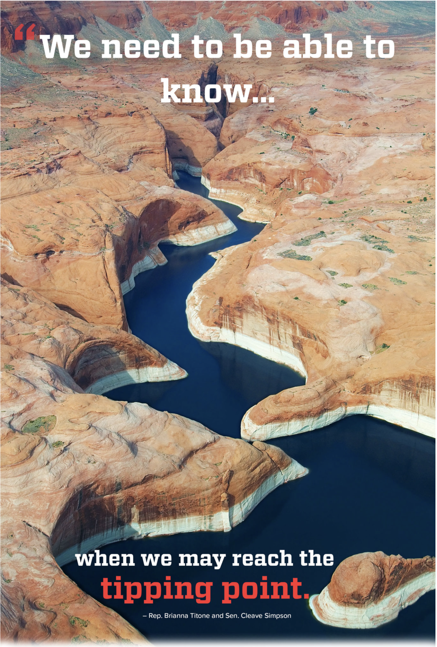
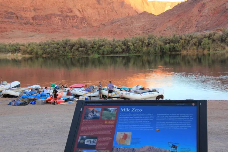
In the Colorado River basin, our past has come back to haunt us.

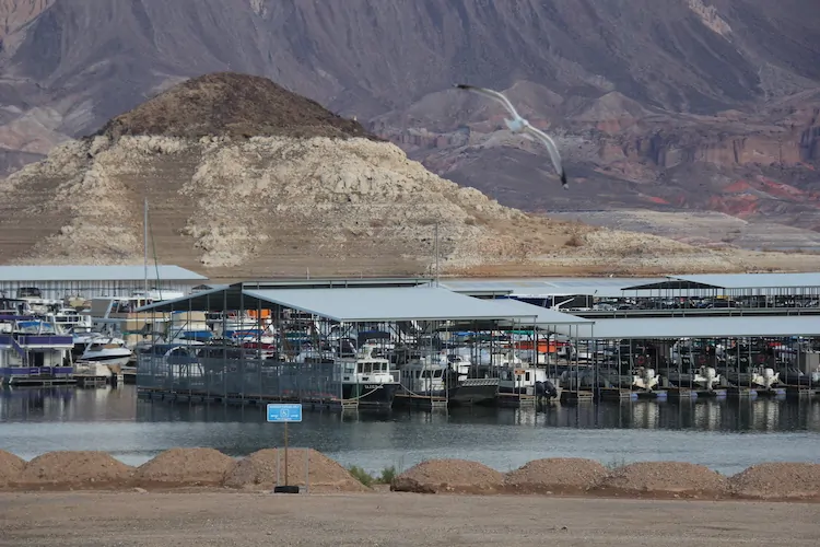
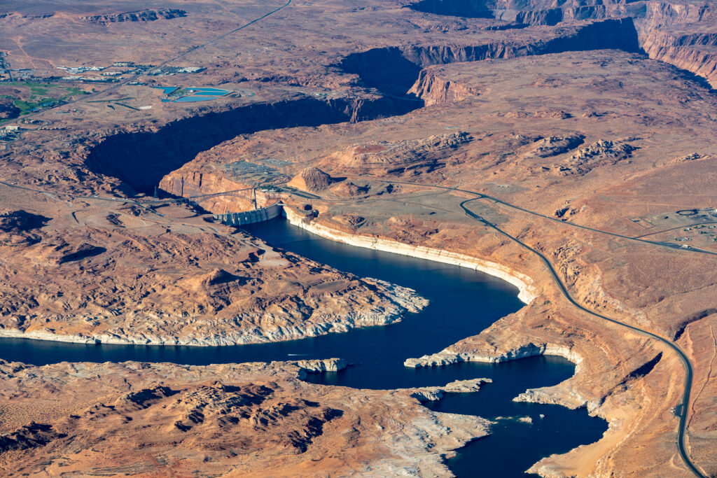
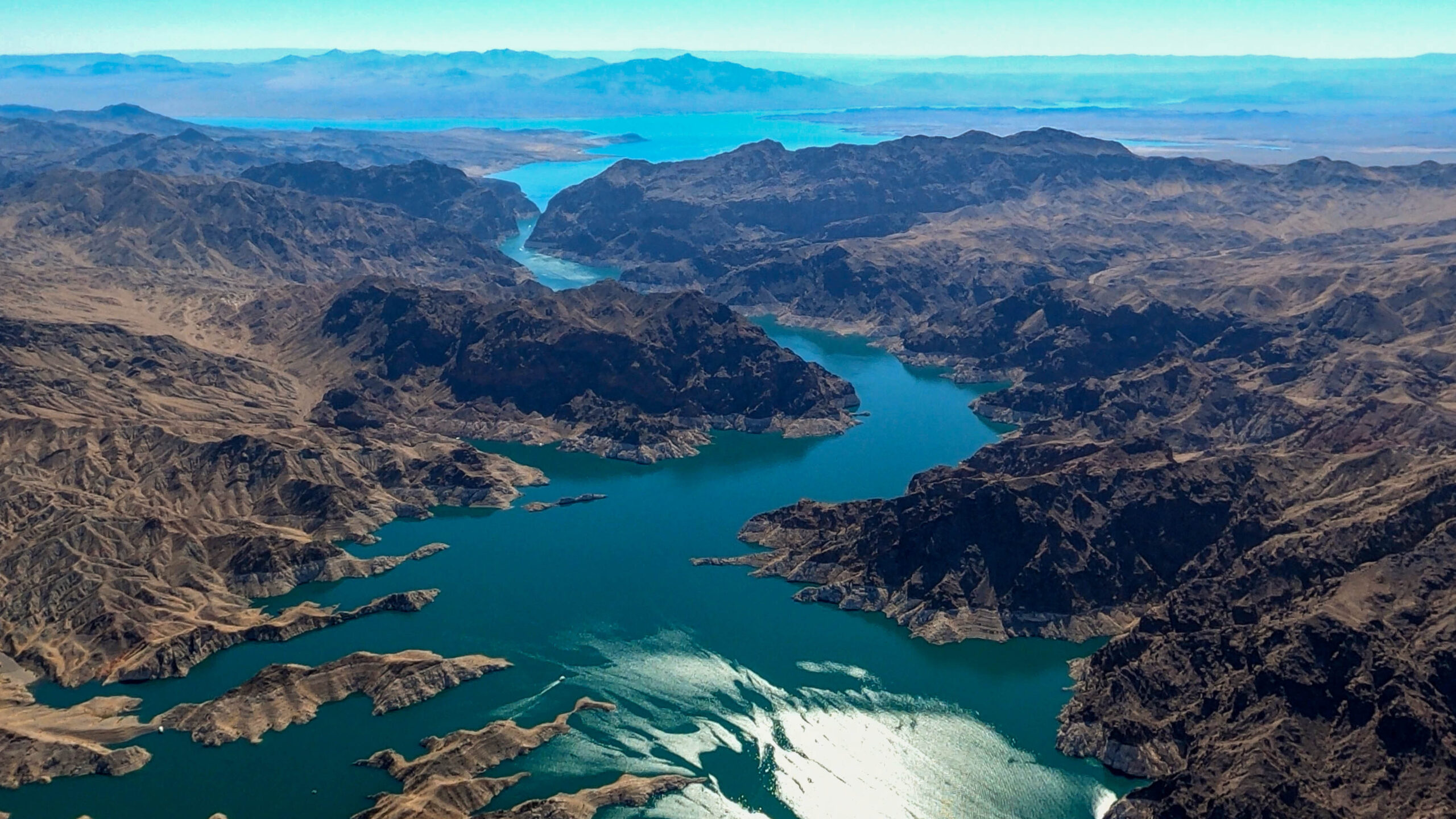
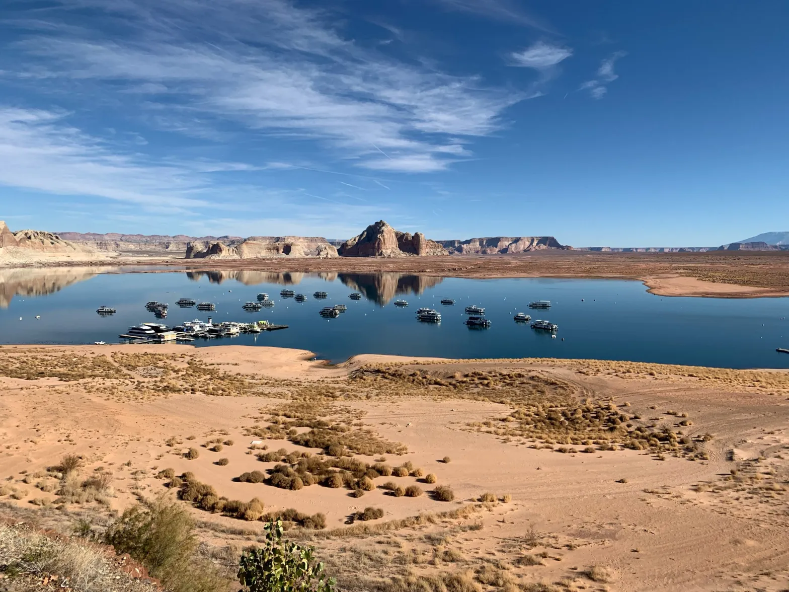
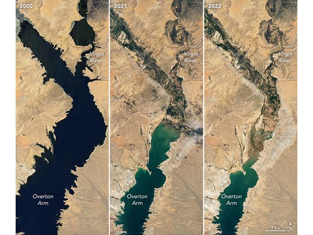
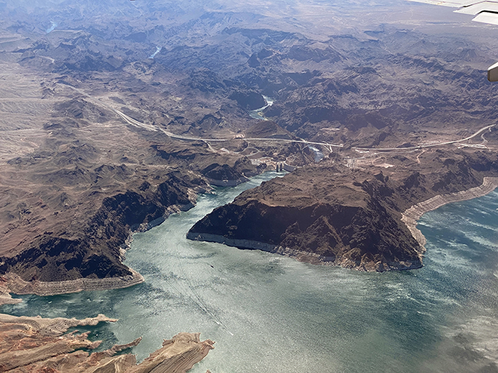
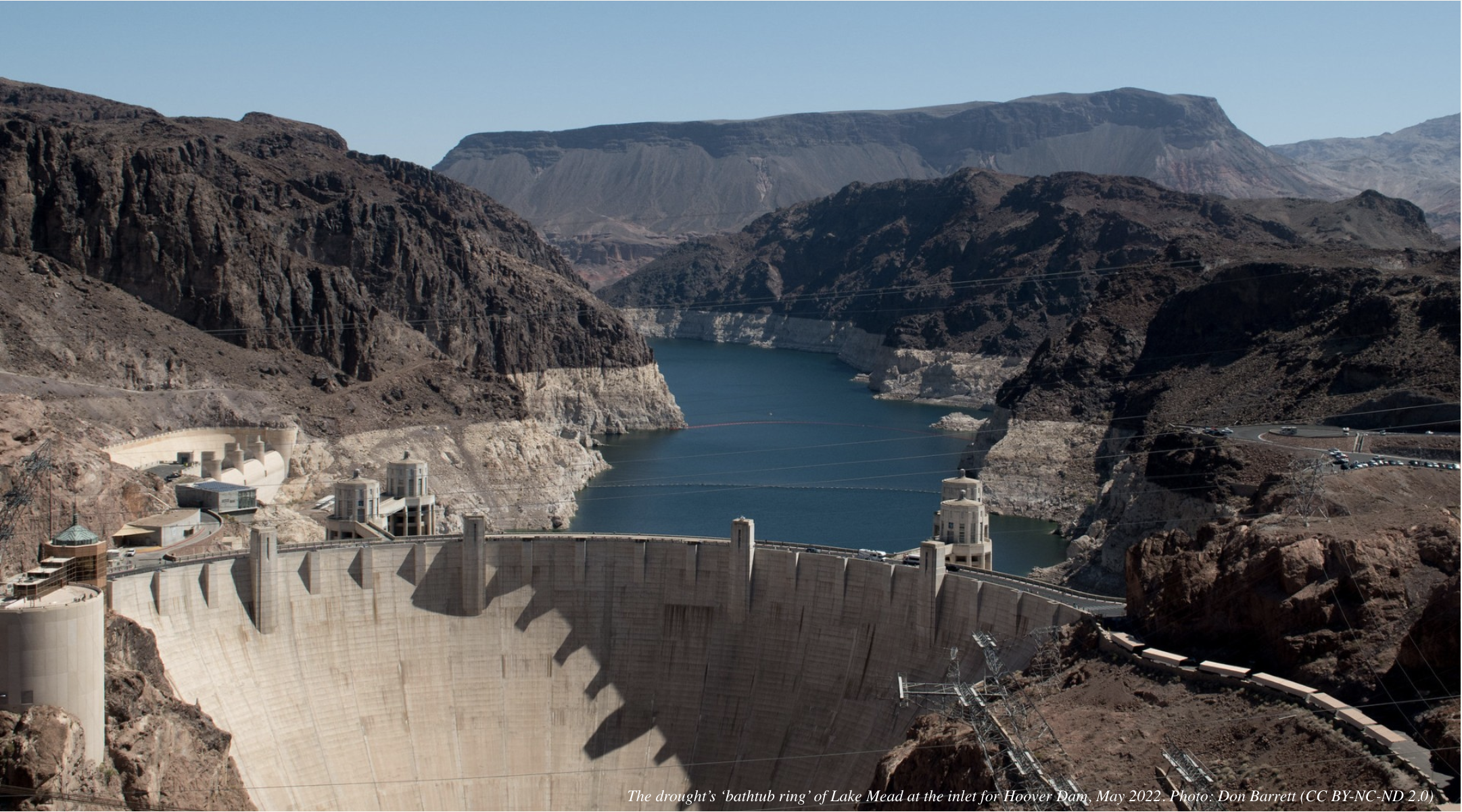
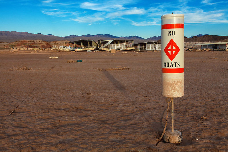
We’re not just talking about the dead bodies emerging from the drying shoreline of Lake Mead. The river’s water crisis has caused the nation’s two biggest reservoirs to sink to historic lows.

It’s a problem of our own making — in more ways than one.

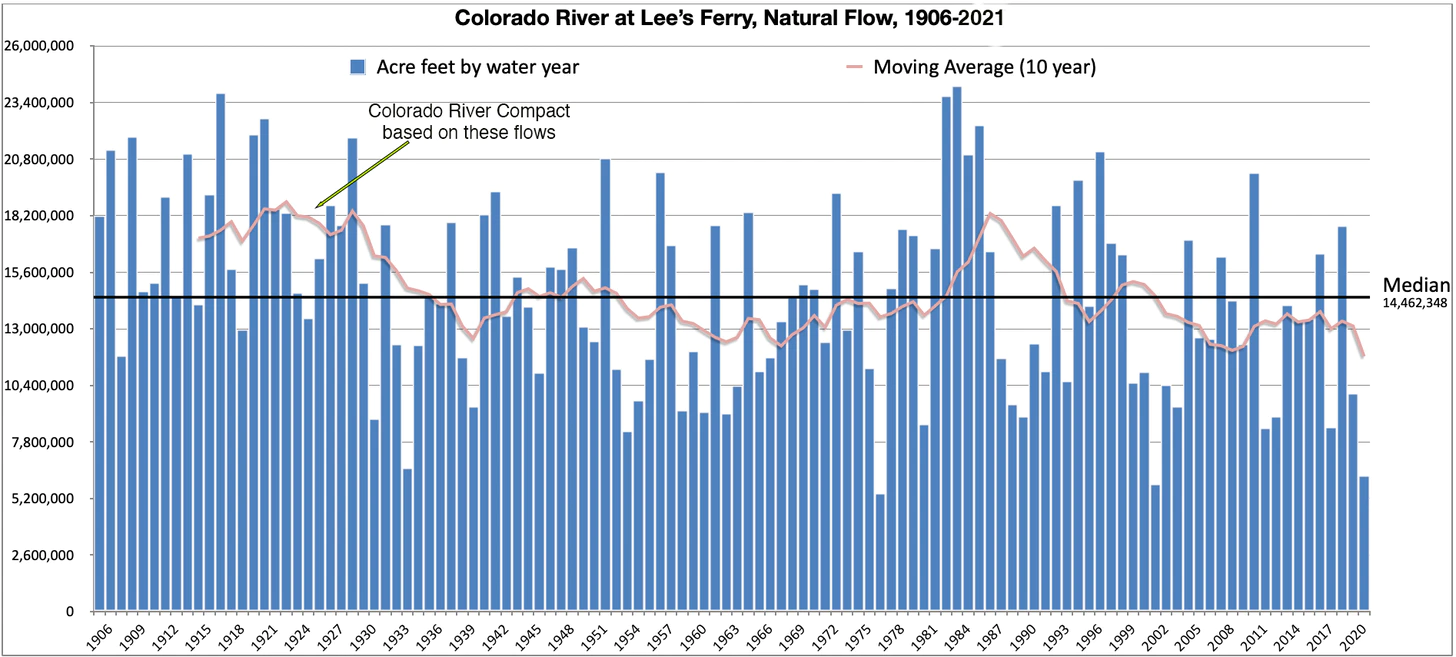
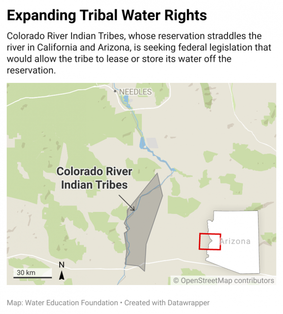
The Colorado River Compact, signed a century ago, overallocated the river’s water. Experts have long warned that nature can’t continue to deliver the water that the government has promised to farms, cities and towns.

A drying West, warmed by climate change, has now made that shortage impossible to ignore.

Brad Udall: Here’s the latest version of my 4-Panel plot thru Water Year (Oct-Sep) of 2021 of the Colorado River big reservoirs, natural flows, precipitation, and temperature. Data (PRISM) goes back or 1906 (or 1935 for reservoirs.) This updates previous work with @GreatLakesPeck. Credit: Brad Udall via Twitter

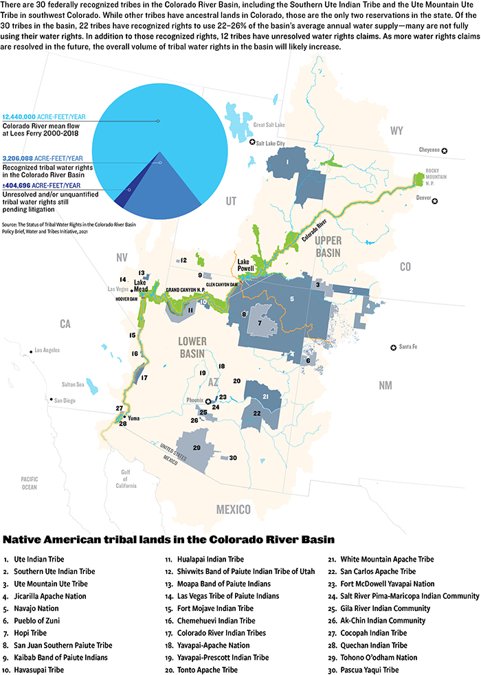
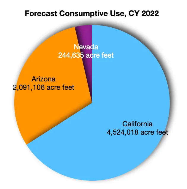
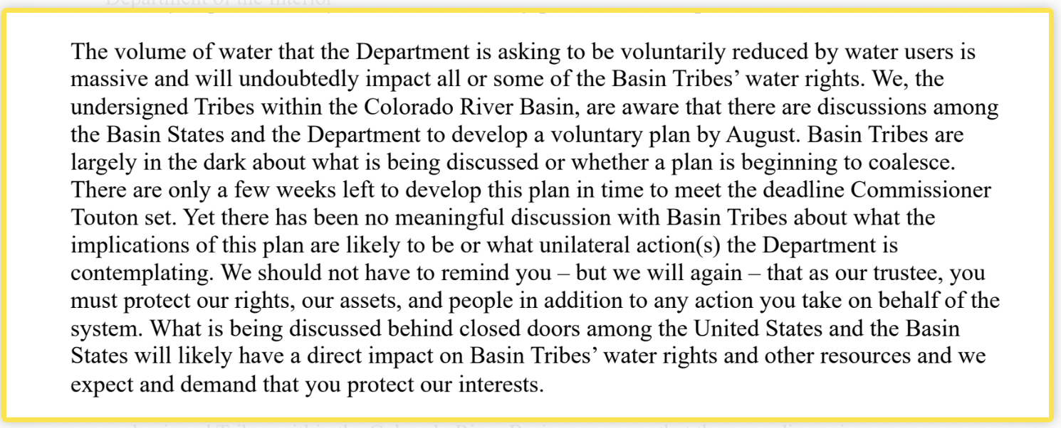
For years demand has outstripped natural flows on the river, and some states and Tribes have already taken cuts to their allocations. Additional conservation measures were expected as the seven U.S. states that share the river — Colorado, New Mexico, Utah, Wyoming, Arizona, California and Nevada — have been working on hammering out a new deal. The region’s more than two dozen federally recognized Tribes have also been fighting for a seat at that table and a hand in the river’s management. But the deadline for a revised agreement between all the parties came and went this summer with no resolution in sight.

To say there’s a lot at stake would be an understatement.

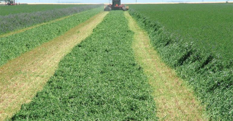
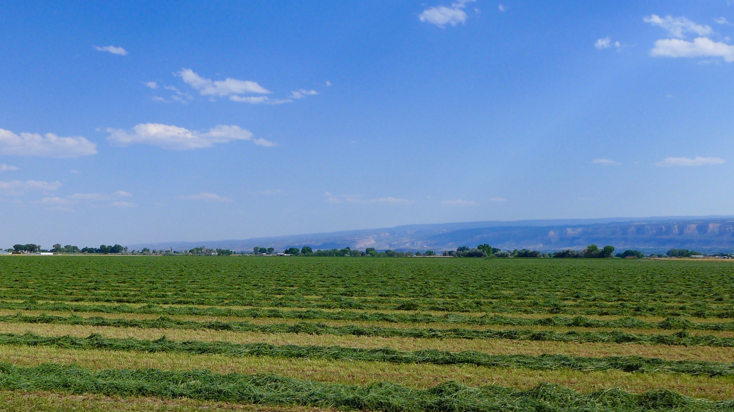
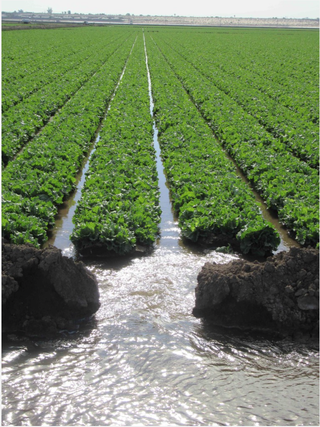
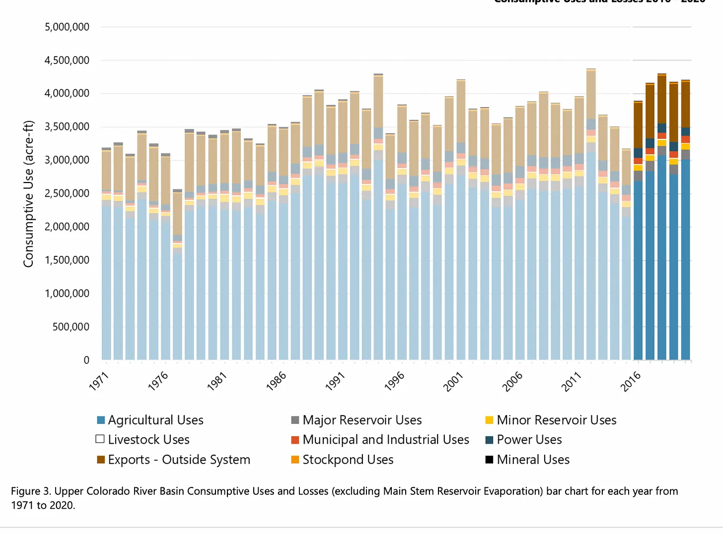
Some 40 million people rely on the 1,400-mile-long river in the United States and Mexico, including in many of the West’s biggest cities. It also greens 5 million acres of irrigated agriculture.

But that’s come at a cost. Long before cities and industrial farms emerged, the river supported diverse mountain and desert ecosystems, providing refuge and resources for countless animals and plants.

Many of those species now struggle to survive the cumulative pressures from drought, climate warming and human developments. And they remain an overlooked part of the region’s water crisis…

Hot Drought

A lot can happen in two decades.

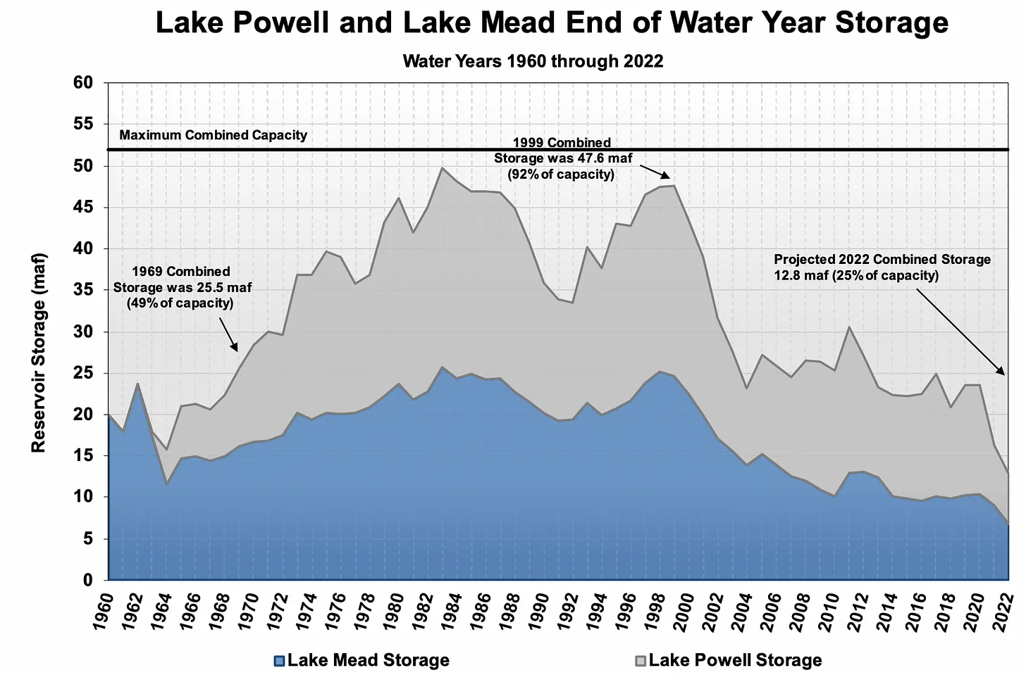
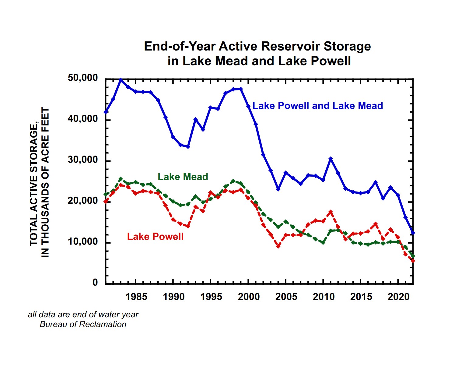
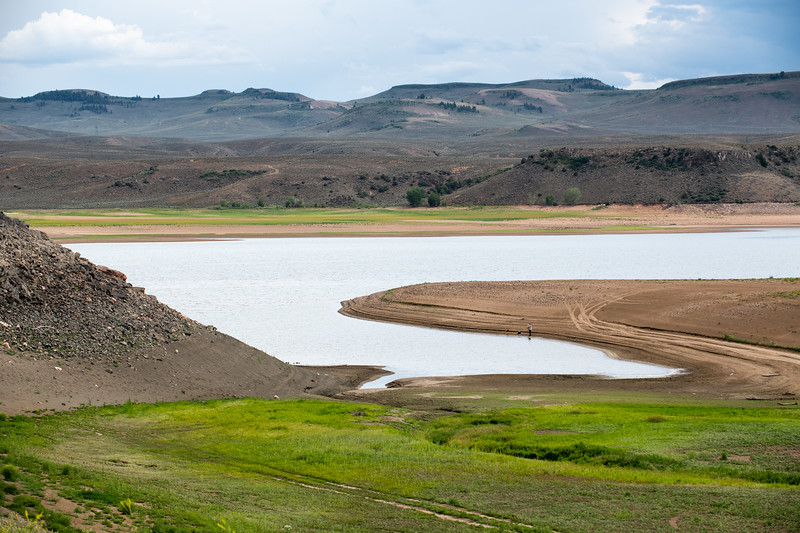
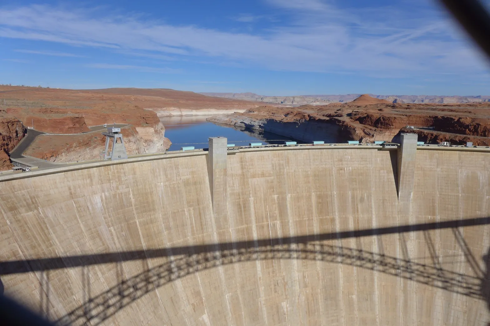
In 2000 Lake Mead and Lake Powell, which help manage water supplies along the Colorado, were nearly full. Today they’re both hovering just above one-quarter capacity — the lowest ever since being filled.

Echo Bay Marina in the Lake Mead National Recreation Area, 2014. Photo: James Marvin Phelps (CC BY-NC 2.0)

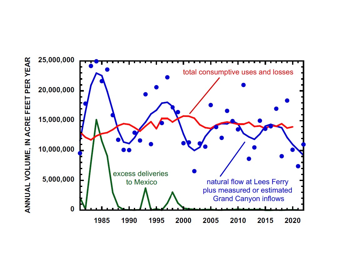
In the intervening 20 years the Colorado River basin has seen a prolonged drought that’s now believed to be the driest period in the region in the last 1,200 years. River flows have fallen 20% compared to the last century’s average.

And it’s not just from a lack of precipitation. Researchers attributed one-third of that reduced river flow to climate change. Warming temperatures increase evaporation, as well as evapotranspiration by plants. So even when the Rocky Mountains do receive snow or rain, less of that runoff makes it to the Colorado River and its tributaries.

CO2 trend: This graph shows the monthly mean abundance of carbon dioxide globally averaged over marine surface sites since 1980. (NOAA Global Monitoring Laboratory)

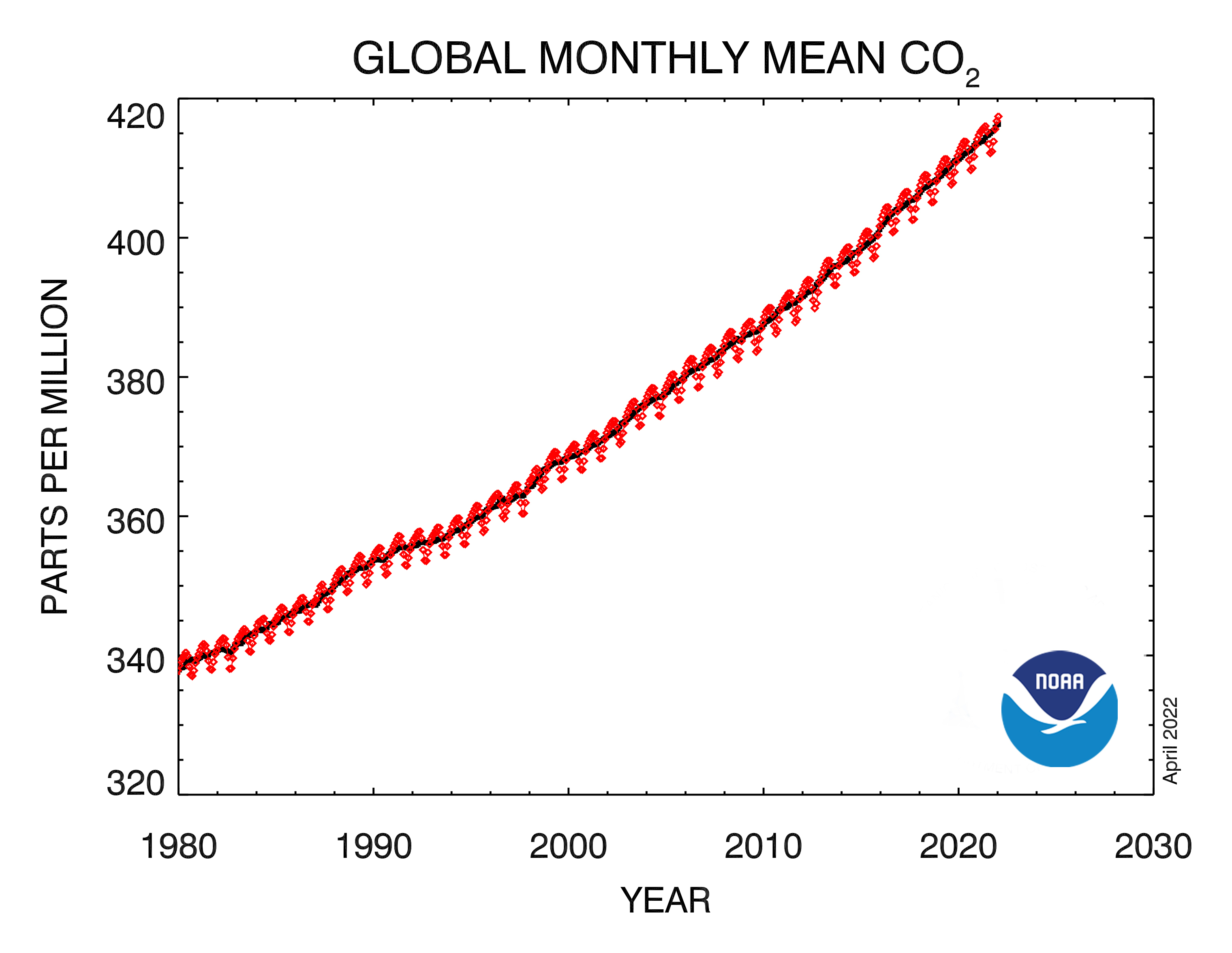
Experts say we’ll see more of these so-called “hot droughts” as the climate continues to warm. The basin is expected to see a five degree-Fahrenheit jump by 2050. That will make things not just hotter but drier. If we don’t dramatically cut greenhouse gas emissions, the Colorado’s flow could drop 35% to 55% by the end of the century.

Years ago the region’s prolonged drought was dubbed a “megadrought,” but some of the region’s top scientists say “aridity” may be a better term. That means that the combination of warming and drying will be much more permanent.
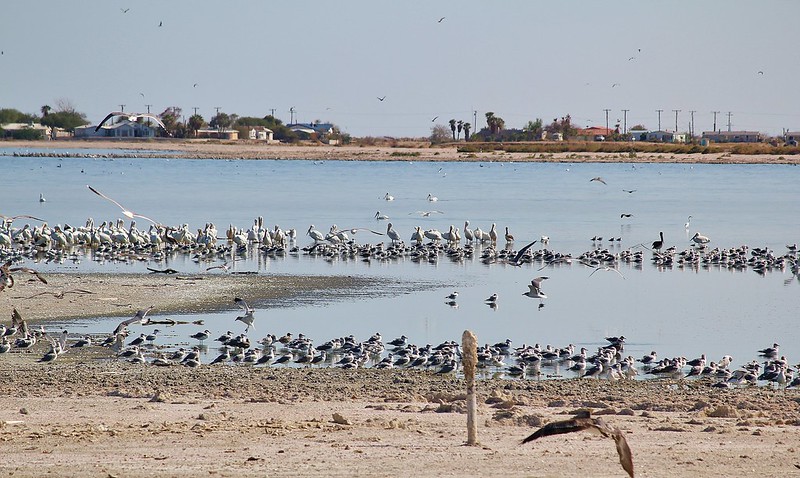
Aridity and Animals

The region’s ecosystems — and those who live in them — are feeling the heat.

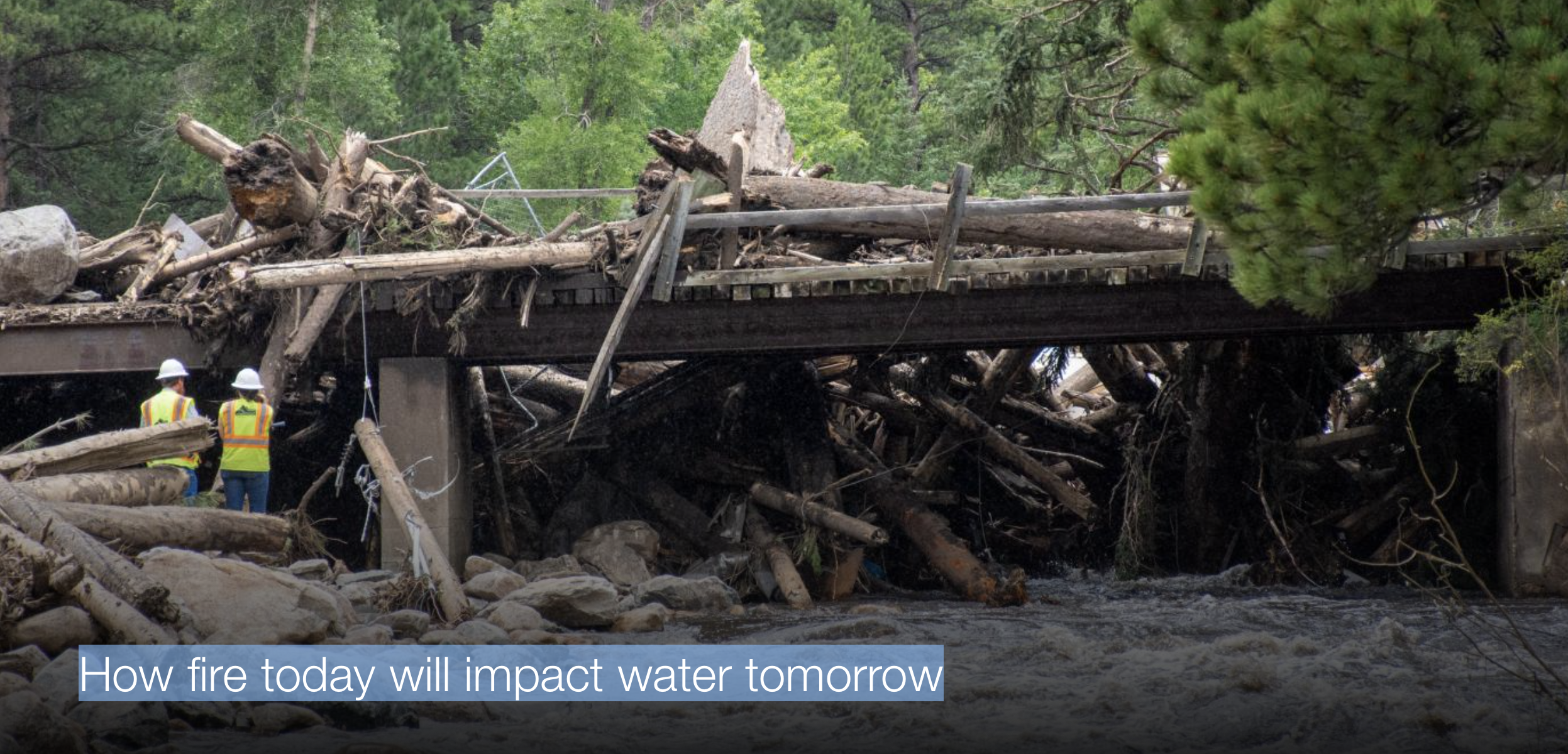
“Climate warming is just hammering this basin, and part of what we see in addition to the water disappearing is this protracted wildfire season,” says Jennifer Pitt, the Colorado River program director for Audubon, the bird-conservation organization. “The fires are more intense and cover ever-larger landscapes, that in turn has the possibility to severely impact the health of the watershed.”

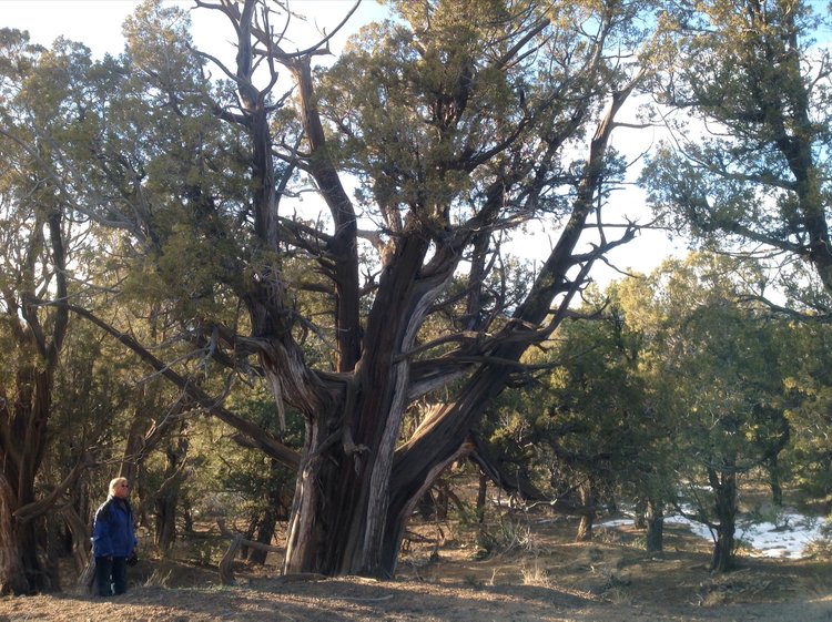
Millions of trees have also been lost to insects and disease exacerbated by drought, including along riverbanks, where less shade is warming streams. Many desert plants, like ocotillos, Washington fan palms and Joshua trees, are also declining from warming temperatures, less precipitation and thirstier animals.

Across the region streams and springs are drying up, too, leading to declines in populations of aquatic amphibians, fish and insects that make up the base of the food chain.

“We haven’t seen any entire species go extinct yet,” says Michael Bogan, an assistant professor in the School of Natural Resources and the Environment at the University of Arizona. “But if you project this into the future, that’s certainly something we’re worried about.”

His concern includes the fate of endangered desert pupfish and Gila topminnows.

“They used to be present in large river systems, but the changes in the habitat and the introduction of non-native fishes have basically excluded them from all of those large historic habitats,” he says. “Now the only refuge where they can survive is these smaller habitats — these headwater streams and springs — and those are the exact types of places that are disappearing now.”

Birds are at risk, too, a recent study found. The researchers visited areas of the Mojave Desert that had been studied in the previous century and found that, on average, the sites lost 43% of their species. The main driver, they believe, is decreased precipitation from climate change.

Birds who live in the desert already endure harsh conditions, but climate change could push them past tolerable limits, causing lethal hyperthermia or dehydration. A lack of water can also cause reduced fitness and or force birds to skip a breeding cycle.

We already see this happening with burrowing owls. A study by researchers from the University of New Mexico looked at how increasing air temperature and aridity affected the species.

Burrowing owls. Photo: Wendy Miller (CC BY-NC-ND 2.0)

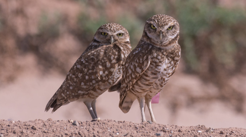
Between 1998 and 2013 the birds at their study area in New Mexico experienced a decline in the number of young that left the nest and a precipitous 98.1% drop — from 52 breeding pairs to just one.

The researchers associated the declines with the effects of decreased precipitation and increased temperature. “An increasingly warm and dry climate may contribute to this species’ decline and may already be a driving force of their apparent decline in the desert Southwest,” they concluded.

Mammals aren’t immune to the changes, either. Another recent study found grave threats to pronghorn across the region. Their models predicted that half of the 18 populations they studied would disappear by 2090.

A decrease in water supply affects animals’ health but can also cause behavioral changes that could put them in harm’s way. If animals need to move outside their normal range in search of declining food or water, it could lead to more interactions with predators or more human-wildlife conflicts, especially if animals look for resources in more urbanized areas.

Fewer sources of water also force a greater number of animals to congregate at the remaining watering holes. Experts say this increases the risk of disease outbreaks like the one that happened in 2020 along the Pacific flyway in California and Oregon, when 60,000 birds crowded into sparse wetlands perished from avian botulism.
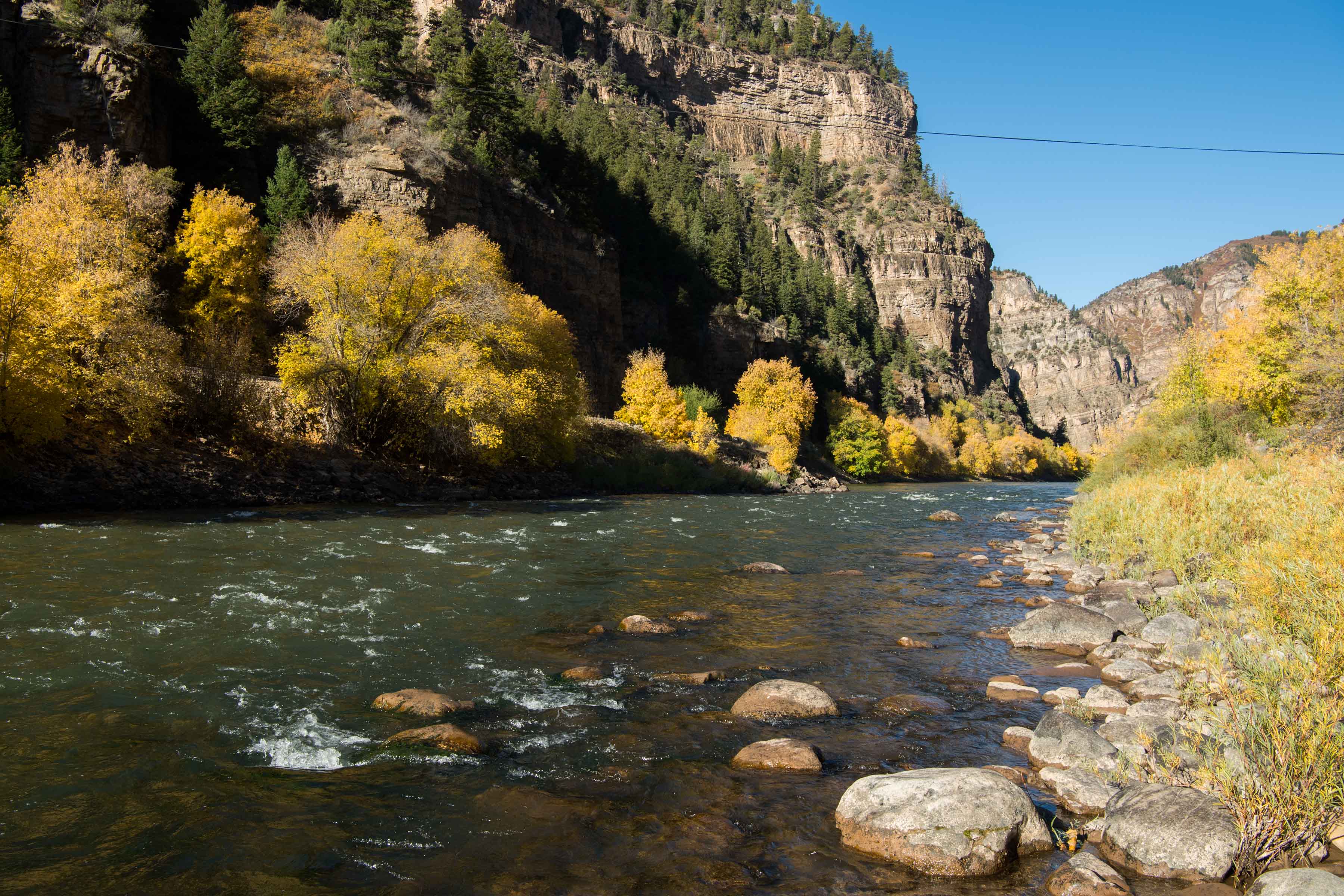
An Altered River

Many of the most severe ecosystem impacts currently affecting the Colorado basin predate the 20-year drought.

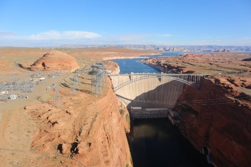
Hoover Dam’s construction in 1936, followed by the building of Glen Canyon Dam 30 years later, dramatically altered river’s flow, blocked sediment that creates riparian habitat, and changed the temperature of the river…

Glen Canyon Dam on the Colorado River. Photo: Simon Morris (CC BY-ND 2.0)

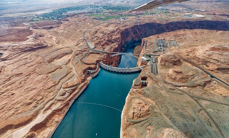
Today the 360 miles between the two dams, which include the Grand Canyon, have become “a river that’s managed to pool-to-pool,” says Pitt. “There’s not much flowing river once you get below Hoover Dam.” That’s caused a loss of riparian forest, which supported birds and other wildlife, and pushed four native fish — humpback chub, bonytail chub, Colorado pikeminnow and razorback sucker — to the brink of extinction.

“There’s concern for quite a number of species because of the historically altered river flow,” says Pitt.

Colorado River Delta via 2012 State of the Rockies Report

It also decimated 1.5 million acres of wetlands downstream at the Colorado River Delta in Mexico.

“For most of the last 50 years, the river has not flowed to the sea,” says Pitt. “An untold wealth of wildlife disappeared off the map because of the desiccation of that landscape.”

Compounding Problems

Development, dams and water diversions along the Colorado, along with today’s drought and climate warming, have pushed many species to the razor’s edge. Some are barely hanging on.

Humpback chub

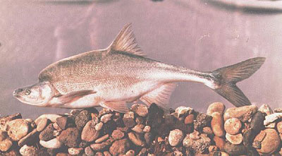
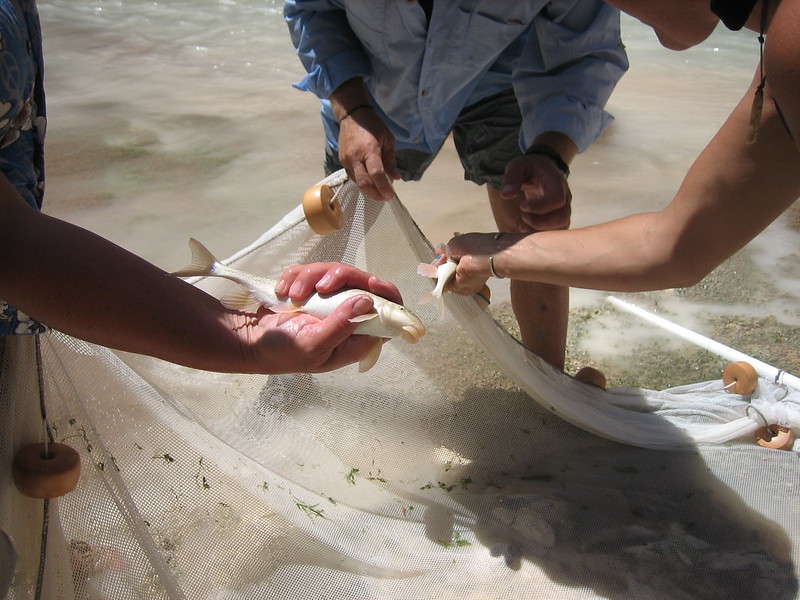
Of particular concern right now are humpback chub, which suffered after Glen Canyon Dam’s construction. Managers have spent decades trying to recover the fish — with some recent success.

But now the species faces a new threat: non-native largemouth bass — a voracious predator of humpback chub — who thrive in the warmer water that’s being released from the diminished reservoir.

In June researchers detected the fish downstream of Glen Canyon Dam, in the same habitat where humpback chub numbers were finally improving.

“The National Park Service is really worried that if those populations of non-native fish get established in the Colorado River downstream from Glen Canyon Dam, that could be catastrophic for the humpback chub,” says Pitt.

Echo Bay Marina in the Lake Mead National Recreation Area, 2014. Photo: James Marvin Phelps (CC BY-NC 2.0)

The situation is emblematic of the larger ecological consequences stemming from our river management.

“How we manage the dams and the water levels is directly affecting the ecology of the Colorado River itself,” says Bogan.

And while that imperiled ecology may not be the headline news regarding the Colorado River crisis, its significance shouldn’t be understated.

Millions of people visit the Grand Canyon each year to peer over the canyon’s lip and glimpse the Colorado’s path through the ancient towering walls. They come, too, to see California condors, bald eagles and southwestern willow flycatchers — all of whom could disappear if the river does.

The loss of plants and animals across the basin is also a loss of cultural resources for the region’s Tribes.

And as the river declines, so does everything around it…

Worse Before It Gets Better

As states work to deal with shortages of water from the Colorado River, there’s a chance that things could get worse before they get better.

One concern is an overdrafting of groundwater, particularly in Arizona, which legally bears the brunt of shortages on the Colorado and has many areas where groundwater pumping is not regulated.

That can leave groundwater-dependent springs and streams at risk of drying.

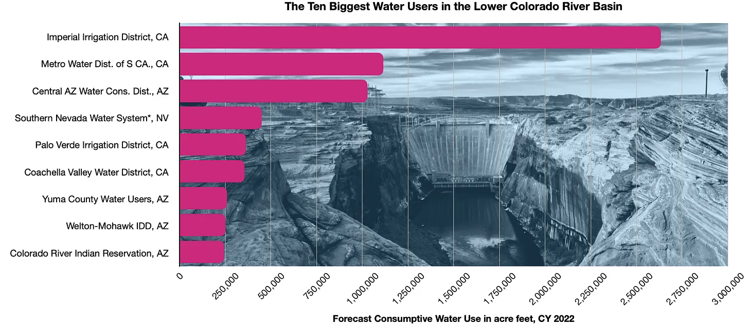
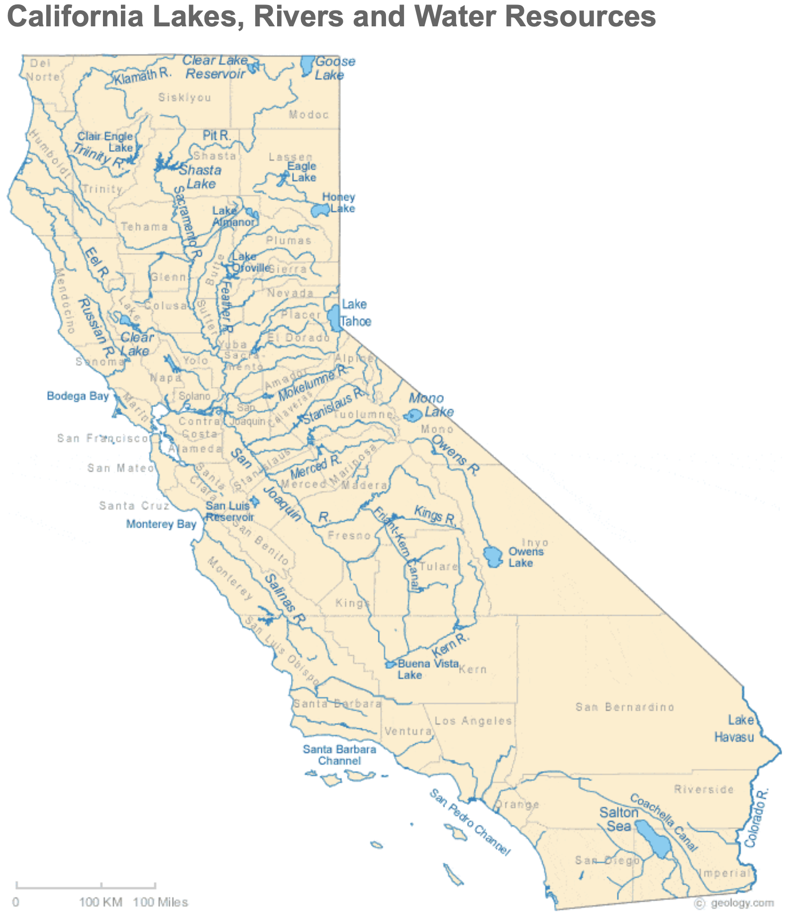
Another area of concern is California’s Salton Sea — the famously saline lake in the desert fed now only through agricultural runoff from the neighboring irrigation districts. One of those is the Imperial Irrigation District, which gets the biggest chunk of California’s Colorado River allotment. As the region attempts to work out a new plan to decrease water use, there’s pressure on the agency to fallow some of its 475,000 acres, but that would also mean less runoff making it to the Salton Sea.

Burrowing owls. Photo: Wendy Miller (CC BY-NC-ND 2.0)

“The Salton Sea is some of the only remaining habitat for migrating water birds and shorebirds in interior California,” says Pitt. “The Central Valley was that habitat once upon a time, but has been completely developed. So it’s a critical habitat for many species.”

It’s also a public health threat. As winds sweep across the drying lake, particles of dust and pollution are swept into neighboring communities where residents suffer from high rates of asthma and respiratory problems.

“The answer is not that we can’t reduce any water use from the Imperial Irrigation District,” she says. “As uses of water are reduced in irrigated agriculture that drains to the sea, there needs to be mitigation.”

A plan, that includes habitat restoration and dust mitigation suppression projects, created decades ago to do just that has been slow to get off the ground. It needs to “ramp up quickly to protect wildlife and to protect public health,” she says.

The Path Forward

There is some good news.

Minute 323 environmental section signing. Photo credit: Colorado River Water Users Association

Agreements between Mexico and the United States in the past decade have enabled “pulse flows” of water to flow downstream to repair a small amount of the lost wetland habitat in Mexico’s California River Delta. And in the desert, fortunately, a little can go a long way.

“We’re seeing improvements in both the number of bird species detected there and the populations of those species,” says Pitt. She’s optimistic that the two governments will continue to support that environmental program in the future.

It’s an idea that could help upstream habitat as well.

“I think really the most important thing that’s being done at both the state level and at the local level is trying to get dedicated flows in streams that are explicitly for the conservation of aquatic species,” says Bogan. Although right now, because of the complexities of water rights, that work is limited and usually local in scope.

“But it’s something that at least has given me a little bit of hope,” he says.

Another strategy, says Pitt, is “natural distributed storage,” which means restoring wetlands and high-elevation meadows to slow water down as it runs across the landscape. That can help recharge groundwater and provide moisture to soil and plants.

“The more moisture we’re keeping around the less vulnerable these areas are to fire,” she says. “It will have an incredible wildlife benefit because those meadows are rich habitat.”

It’s akin to the work that beavers do naturally, but people can replicate.

“It sounds small if you look at it on one little creek,” she says, “but if we can start to see it implemented across the upper basin, I think it could really scale up to make a difference.”

With the cumulative impacts of human development and climate change adding up, Pitt says we should look to the federal government and states to make sure that Endangered Species Act programs are supported to help protect and restore habitat for the dozens of already at-risk species in the basin. This means going beyond supplementing the number of endangered wild fish with hatchery-raised fish, which is the current management strategy.

And of course, the region still needs to grapple with how it allocates and manages the Colorado River’s water. Pitts says she’d like to see a greater role for Tribes in that process and the inclusion of adequate water to maintain healthy ecosystems.

“Environmental water needs to be recognized as part of our objectives for water management,” says Pitt.

“It’s both extremely challenging at this moment because there’s so much less water available to carve up between users,” she says. “But it’s a moment to really rethink how we do things.”

#Maybell project addresses problems for irrigators, boaters, fish — @AspenJournalism

The Maybell Ditch headgate in the lower left pulls water from the Yampa River for irrigation. A major reconstruction project will fix the diversion structure to create better passage for fish and boats. CREDIT: HEATHER SACKETT/ASPEN JOURNALISM

Click the link to read the article on the Aspen Journalism website (Heather Sackett):

The Maybell Ditch is the largest diversion on the Yampa River and irrigates about 2,500 acres of grass and alfalfa in northwest Colorado. But the remote and antiquated headgate, along with a hazardous diversion structure and 18 miles of nearly flat canal, create problems for irrigators, boaters and endangered fish alike.

Now the Maybell Irrigation District and The Nature Conservancy are working together on an ambitious project to rehabilitate and modernize the historic structure with the goal of improving conditions for all the water users on this stretch of river. So far, TNC has secured about $3.5 million in funds for the project, which it hopes can begin next summer.

Yampa River Basin via Wikimedia.

The Yampa River flows from the Flat Tops Wilderness, through the city of Steamboat Springs, then turns west and eventually joins with the Green River in Dinosaur National Monument. Along the way it turns the semi-arid landscape of Routt and Moffat counties into a ribbon of green, irrigated meadows.

In recent years the Yampa has started experiencing issues that have long been a part of other river basins like over-appropriation, calls and water shortages.

“That reach has seen declines in water levels over time with drought and long-term climate impacts,” said Jennifer Wellman, TNC project manager. “(The Maybell Ditch project) was one of those that rose to the surface where we could hopefully work with the water users to have a greater impact in that basin … . That whole reach is really special, and it warrants more water if it’s available, especially during the low flow periods.”

This map shows the 18 miles of the Maybell Ditch, which irrigates land with water from the Yampa River. The Nature Conservancy is planning an overhaul and modernization of the headgate and diversion structure.

Challenges for irrigators, boaters, fish

Maybell Irrigation District manager Mike Camblin said historically some ranchers couldn’t get their full amount of water unless the ditch, which was constructed in the 1890s, was running full blast.

“We had one field where if the ditch wasn’t full, they couldn’t get it wet because there wasn’t enough elevation to it,” he said. “It was too flat.”

That meant more water was being sent through the ditch as “push water” to make sure flows make it to dry fields. It also meant more water was flowing back into the Yampa River at the end of the approximately 18-mile-long ditch, known as tailwater. If there’s too much tailwater, that can mean a ditch is taking more out of the river than it is able to use, a no-no according to the state Division of Water Resources.

A first round of improvements to the ditch added a liner to reduce seepage and check structures, which slow the flow of water. Those measures only partially addressed the issues.

The project that is now being proposed is much more extensive and involves reconstructing the diversion and modernizing the headgate, which controls the flow of water from the river into the ditch. By fixing a grade control structure — essentially arranging boulders in mid-stream that push up the water in the river upstream of the headgate — it creates more elevation to allow gravity to move water into the ditch, which should reduce the need to push water. It will also smooth out a passage for both fish and boats.

The twin, circular headgates of the Maybell Ditch are rusted, antiquated and must be open and closed manually. A modernization project includes plans to make it possible to operate the headgate remotely.CREDIT: HEATHER SACKETT/ASPEN JOURNALISM

Remote location

The twin, circular, century-old headgates are rusted and hard to operate.

“There’s no way those things are easy to adjust,” said Erin Light, Division 6 engineer at the state Division of Water Resources. “Quite frankly, if the water commissioner had to adjust it, I don’t think he or she could. We would have to rely on (the irrigation district) to do that, which is not preferred.”

The remote location of the headgate — a three-mile round trip hike down the rugged Juniper Canyon off an already-remote dirt road — is a challenge for the district. When all the headgates on the ditch are opening and closing according to the differing schedules and water needs of the irrigators, it can be hard to coordinate the manual operation of the main headgate. The new headgate will be automated and controlled remotely.

“That’s a four- or five-hour deal by the time you drive up there, walk up there, adjust it and drive home,” Camblin said. “The automation on that will be huge. As far as management, it will be our biggest tool.”

But construction won’t be easy. Heavy equipment can’t make it down to the river along the ditch and will have to access the diversion using newly constructed roads on Bureau of Land Management land. The BLM considers the ditch a cultural resource and project proponents will have to be careful to avoid impacts to it.

Western Colorado Area Manager for JUB Engineers Luke Gingerich explained the complexities of the project on a site visit in July.

“They are going to have to create a couple miles of nice road to get in,” Gingerich said. “It will be a large disturbance and we’ve got to come back and make sure we return this as close as we can to the condition it was in before.”

According to Camblin, it was the federal Upper Colorado River Endangered Fish Recovery Program that first pushed the district to take a look at where it could manage its water better. That stretch of river is designated critical habitat for species of endangered fish. Water is released out of the upstream Elkhead Reservoir for the fish, and the new automated headgate will allow the Maybell Ditch to more easily let that water flow past it, to get to where it’s needed.

The Maybell Ditch diversion, located in Juniper Canyon in northwest Colorado, takes water from the Yampa River to irrigate hay fields. The Nature Conservancy is fundraising for a project that would overhaul and modernize the diversion structure and headgate.CREDIT: HEATHER SACKETT/ASPEN JOURNALISM

Boon for boaters

The diversion reconstruction project will also be a boon for boaters. River advocacy nonprofit Friends of the Yampa said in a letter of support for the project that the Maybell Diversion is the most significant barrier for safe, passable recreation along a 200-mile stretch of the Yampa River. Boaters often have to get out to portage the rapid formed by the diversion structure. The new diversion will create a boat passage, connecting two sections of boatable river.

At July’s site visit, recreation and education coordinator for Friends of the Yampa Kent Vertrees said he’s grateful for the collaboration between the agriculture, recreation and environmental water users.

“As a recreation person, I’ve said all along we get the dregs of all the other water users,” Vertrees said. “We rely on agriculture more than anyone to make sure there’s water in the river. It’s really great, our partnerships in northwest Colorado.”

But that partnership was a bit of a hard sell at first, Camblin said. Some Maybell Ditch irrigators were skeptical about a project spearheaded by an environmental group. Tensions can sometimes run high between irrigators, who take water out of rivers, and environmental groups, who want to leave water in rivers. Camblin said the district held several meetings between irrigators and TNC to assure water users their water rights or how they manage their ranch wouldn’t be threatened.

“One of our goals we talked about when we started this was, we wanted to show people the agriculture community can work with groups they don’t normally work with,” Camblin said. “We are hoping other ag communities say, ‘Hey, you know what? Some of this stuff is possible. I might have to reach across the table to make it work but this will be a beneficial project to so many people.’”

The headgate and diversion reconstruction could come with a hefty price tag and TNC is still fundraising for what could end up costing more than originally thought due to supply chain interruptions and inflation. The project has secured almost $3.5 million so far, nearly $2 million of which comes from a Bureau of Reclamation WaterSMART grant. The Colorado Water Conservation Board has contributed about $1 million so far; the Colorado River Water Conservation District will give $500,000; $40,000 will come from the Yampa River Fund and the irrigation district is also contributing money and in-kind resources. However, the total final price tag remains unknown and is likely to be higher than what’s already been secured. Wellman said some of the additional funding needed will also come from the National Resources Conservation Service.

Aspen Journalism covers water and rivers in collaboration with The Aspen Times. This story appeared in the Sept. 11 edition of The Aspen Times.

Renewable Natural Resources Foundation Round Table: The Challenges of Allocating #ColoradoRiver Water – Hot 20-year #drought and soaring populations #COriver #aridification

Brad Udall: Here’s the latest version of my 4-Panel plot thru Water Year (Oct-Sep) of 2021 of the Colorado River big reservoirs, natural flows, precipitation, and temperature. Data (PRISM) goes back or 1906 (or 1935 for reservoirs.) This updates previous work with @GreatLakesPeck. Credit: Brad Udall via Twitter

Click the link to read the article on the Renewable Natural Resources Foundation website (Stephen Yaeger):

Senior water and climate research scientist at Colorado State University and one of the authors of the National Climate Assessment. Photo credit: Colorado State University Water Institute

Brad Udall, a Senior Water and Climate Research Scientist at Colorado State University, spoke at a virtual meeting of the RNRF Washington Round Table on Public Policy on March 9, 2021. He discussed the imbalance between water supply and demand in the Colorado River basin, how climate change is exacerbating the issue, and the ongoing renegotiation of the river’s management guidelines.

Introduction and Background

The Colorado River basin extends into seven states (Wyoming, Colorado, Utah, Arizona, New Mexico, Nevada, and California) as well as Mexico, along with the land of 29 Native American tribes. The American portion of the basin represents 8% of the area of the lower 48 states. Altogether, about 40 million people, including the populations of all major cities in the Southwestern U.S., rely on the Colorado for some portion of their water supply. The river is used heavily for municipalities as well as agriculture, with about 4.5 million acres of irrigated land in the basin.

The water supply in the river is often measured by the water levels in its two major reservoirs, Lake Mead and Lake Powell. These are the two biggest reservoirs in the U.S. In order to maintain sustainable levels in these two reservoirs over a long time period, withdrawals from the river must equal the supply being provided by the river’s flow. This was the case in 2000, when the combined contents of the reservoirs were over 90% full. Since then, their water level has dwindled to less than 50% due to a “structural deficit” – demand for the river’s water consistently outpacing supply. This is due in large part to the fact that over the past 20 years, the basin has been experiencing its worst drought on record. The flow of the river has decreased from ~14.75 million acre-feet (maf) to ~12.4 maf. Even before the drought began, water demand was high in the basin; since about 1990, it has not reliably reached the ocean.

While the current situation in the watershed is usually described as a drought, a lack of precipitation is really only half the story. Regional temperature increases, exacerbated by climate change, have also had a significant impact on the reduction of water availability. Udall noted that evaporative losses will only become more severe as climate change worsens. The Southwest is already one of the quickest-warming areas of the country, a trend that is expected to continue. The risk of multidecadal droughts will also continue to drastically increase in coming decades. The 2000-2018 period was the second-driest 19-year period in the basin since 800 AD. While this is partially attributed to natural variation, researchers have said that 50% of the decrease in soil moisture can be attributed to anthropogenic climate change. Climate change has turned what would likely be a moderate drought into an extreme, historic drying event. Aridification and heating, along with reduction in precipitation, are causing drastically drying conditions in a river basin that tens of millions of people rely on for their water.

Historical Management of the River

In 1922, to fully allocate use of the river’s water, the basin states agreed to the Colorado River Compact. This agreement still serves as the basis for the Law of the River, which is the set of rules for the river’s allocation and management. In response to the “hot drought” happening since 2000, new modifications to the Law of the River have been necessary to prevent the reservoirs from becoming depleted. The first of these, called the Colorado River Interim Guidelines, went into effect in 2007. These guidelines set out a series of complicated rules for how Lakes Powell and Mead are operated, allowing different quantities of water to be released from them when they are at certain elevations. They constrain use of water when the reservoirs are low. One innovative structure used to accomplish this is “intentionally created surplus,” which allows parties in the lower basin to store their water in a sort of “bank account” in Lake Mead.

Around 2013, it was becoming clear that persistently dry and hot conditions were rendering the 2007 Interim Guidelines insufficient. A new agreement was necessary. As a result, two new “Drought Contingency Plans” (DCPs) for the Upper and Lower Basins were adopted in 2019. Early in 2021, for the first time, drought conditions in the river reached the point where the DCPs’ provisions were activated. Udall noted that these agreements made some progress toward making the river’s use more sustainable but were not a permanent solution.

Future Management of the River

Udall finished his presentation by discussing future prospects for sustainably managing the river in these drying conditions. In 2026, the 2007 Interim Guidelines and DCPs expire. The seven basin states, 29 tribes, Mexico, and the federal government have already begun the multi-year process of renegotiating a new set of guidelines which will be adopted in 2027. The following are some central considerations for a successful new agreement described by Udall.

The Upper Basin’s “Delivery” Obligation

Among the problems that stakeholders are aiming to resolve is the nature of the Upper Basin’s delivery obligations. There is a clause in the original Colorado River Compact that says that the Upper Basin shall not allow the flow of the river to decline below 75 maf every ten running years. However, it is not clear if this obligation is really a “delivery” obligation or if it is a “non-depletion” obligation. If it is a delivery obligation, that means that the entire reduction of flow coming from the Upper Basin due to climate change falls on the Upper Basin to solve. Clearly, this was not the intent of this clause in the original 1922 compact, and the Upper Basin states are making this argument.

Graphic credit: Chas Chamberlin/Water Education Colorado

Tribal Issues

Native American tribes are expected to have a much more significant role in the renegotiation of the Interim Guidelines than they have had in previous decision-making processes for management of the river. There are 29 tribes in the basin. Altogether, they have a right to control about 20% of the basin’s water. This right derives from a 1908 Supreme Court decision which issued the “Winters Doctrine.” This doctrine said that when the federal government creates a reservation of land for a tribe, implicit in that reservation is a water right.

However, tribal interests were still left out of the 1922 compact, and many of their rights remain unquantified. Even in the 21st century, the tribes in the basin were not invited to participate in the 2007 Interim Guidelines negotiations or the 2012 Basin Study. The 2019 DCPs were an important development in the inclusion of tribes in river management discussions after their needs and rights had been historically ignored. For the first time, these 29 distinct tribes were acting collectively and were included in the planning process. The DCPs were also the first time that a tribe agreed to accept a monetary payment in exchange for using less than their full water right. Inclusion of tribal interests in the renegotiation of the Interim Guidelines is expected, and will be essential to the new agreement’s success.

The Structural Deficit

Fundamental to the dilemma faced by basin stakeholders in this renegotiation process is the “structural deficit.” This is, quite simply, an imbalance between the supply of and demand for water in the basin. Since 2000, demand has outpaced supply. Demand reductions are challenging because once a water user has access to a supply of water, it is difficult to get them to relinquish it. The supply-side is more challenging to address. In the absence of cooler temperatures and more precipitation ­– conditions increasingly unlikely as climate changes — it is difficult to create more supply. It is easier to change consumption patterns than it is to change the hydrology of the river. Without demand reductions in the Upper and Lower Basins, there is a high probability that the amount of water in the reservoirs will continue to fall.

Udall referenced a recent study that found that the Upper Basin’s water demand is unsustainably high. Despite this finding, parts of the Upper Basin actually want to increase their demand, which in the face of declining flows is an issue that will need to be addressed in the negotiation process. Demand Management measures, by which water users can voluntarily accept money in exchange for reducing their water consumption, will likely be part of the solution in the Upper Basin but caps on demand may also be necessary to ensure that the delivery obligation is fulfilled.

In the Lower Basin, the Central Arizona Project diverts water from the Colorado River into Arizona, providing water for an area including the cities of Phoenix and Tucson. As a part of the original agreement that permitted this project, it was agreed that if there ever was a shortage of water in the basin, Arizona would bear the brunt of demand reductions. Demand reductions will likely be necessary in the Lower Basin but Udall noted that it would be difficult in practice to mandate that they all come from Arizona. Solving this dilemma will be a part of the new Interim Guidelines negotiations. One method that may be used is to begin charging evaporative losses to state water budgets in proportion to their use. Currently, evaporation is being charged to nobody, which is a part of the overuse problem.

Guidelines for Successful Renegotiation

Udall also identified other steps that can be taken by stakeholders to work toward a successful new set of interim guidelines. First, he emphasized the importance of good science. Realistic climate and hydrological modelling are necessary to inform the negotiations. Udall noted that many of the models being used by watershed states are overly optimistic with regard to future hydrology. Beginning the negotiations with inaccurate presumptions about the future of the watershed are setting the new agreement up for failure. While the renegotiation is a political process, it needs to be informed by most accurate scientific information possible.

Because the structural deficit is a basin-wide issue, Udall advocated for the use of a combined metric that adds the quantity of water in Lakes Mead and Powell. This would be a more accurate way to gauge water shortages because the water in the reservoirs individually is less important than the total quantity between them when informing the management of the entire river basin. He also said that using clear language in negotiations is critical. For instance, one should never inaccurately say that the Colorado River Compact itself is being renegotiated. It is only the Interim Guidelines that are being replaced; the Compact remains the foundation for the river’s allocation.

The renegotiation process is more than just a group of stakeholders sitting around a table, working out a plan for the river. It is a series of large and small meetings, some more formal than others. Since not everything is negotiated in official sessions, there is room for behind-the-scenes discussion while also maintaining transparency. During the round table’s Q&A session, Udall mentioned that river management issues under discussion will be reported by many talented journalists, who will bring transparency to the process for interested parties.

Ultimately, the process of renegotiating the Interim Guidelines requires a balancing of political, economic, environmental, and societal values. Climate change is the defining issue of our time, and it is at the center of these water issues in the American West. While one can easily become disillusioned by political processes, especially in the realm of climate and environmental issues, Udall ended on a note of optimism. While the solutions are not all clear, there are good relationships among stakeholders, which will form a solid foundation for successful negotiations.

– Stephen Yaeger, RNRF Program Manager

The PowerPoint Udall used during his presentation can be found here.

In his presentation, Udall referenced a series of studies about the climate and hydrological conditions of the Colorado River. They can be found at the following links:

Increasing influence of air temperature on upper Colorado River streamflow

The twenty‐first century Colorado River hot drought and implications for the future

On the Causes of Declining Colorado River Streamflows

Unprecedented 21st century drought risk in the American Southwest and Central Plains

Large contribution from anthropogenic warming to an emerging North American megadrought

Colorado River flow dwindles as warming-driven loss of reflective snow energizes evaporation

When is Drought not a Drought? Drought, Aridification, and the “New Normal”

Alternative Management Paradigms for the Future of the Colorado and Green Rivers

Colorado River “Beginnings”. Photo: Brent Gardner-Smith/Aspen Journalism

Data Mega-Dump: Alfalfa (Part II) — @Land_Desk #ColoradoRiver #COriver #aridification

Hayfield in Orderville, Utah, irrigated with water from the East Fork of the Virgin River, a Colorado River tributary. Jonathan P. Thompson photo.

Click the link to read the article on the Land Desk website (Jonathan P. Thompson):

By now you may have heard that the Colorado River is in trouble, as are the 40 million or so people who rely on it and all the people (and livestock) that eat the crops it irrigates. It’s not the only Western river facing a crisis: The situation on the Klamath is dire and the Rio Grande pretty much dried up this summer, its demise delayed by an abundant monsoon.

The problem is simple: The collective water users are consuming more water than is actually in the river and its tributaries; that is, they are pulling about 14 million acre feet each year out of a river that only has about 12 million acre feet of water in it. And consumption continues to hold steady even as the river continues to shrink, drawing down reserves to a critically low level. 

Or to put it in the possibly more relatable terms of a household budget: Spending is remaining constant even as the household income shrinks. The household is running a deficit, in other words, which is rapidly emptying the savings accounts (Lakes Mead and Powell). And, on top of that, the household has outstanding debts (to tribal nations whose senior water rights have yet to be developed, honored or even quantified). The accountants have tapped into retirement accounts (Upper Basin reservoirs such as Flaming Gorge and Blue Mesa) and imposed temporary cuts (Tier 1 and 2a Shortages) to shore up the savings accounts, but it isn’t enough. 

Spending must be dramatically and permanently slashed to better-than-sustainable levels, now, to avert crisis, allow the household to start building back its savings—and, finally, to settle those outstanding debts. 

Which is why Bureau of Reclamation Commissioner Camille Calimlim Touton told the collective water users in the Colorado River Basin states that they needed to figure out how to cut 2 million to 4 million acre-feet of consumption, per year. That’s a whopping amount (Arizona’s total use is less than 2.8 million acre-feet per year). And it may not even be enough. The lower end of those cuts will just about solve the deficit spending, but it won’t be adequate to build up the savings or to settle outstanding debts. If climate change continues to shrink the river even 4 million acre-feet may not be enough. 

So, we—the Colorado River users—must make huge cuts. And that means the biggest users of water (the biggest spenders, to go with our earlier analogy) are going to have to play a major part. The biggest user is agriculture and the thirstiest crop is hay, alfalfa in particular. For High Country News’s Landline I wrote about alfalfa and the need to grow less. This Data Dump is intended to provide some more data to support and supplement that piece. Some of it you’ve seen in previous Data Dumps, but some of it will be new. 

But first, a note: I’m not making value judgments here, nor am I “vilifying” a particular crop, as one reader suggested. I’m not saying that alfalfa is somehow less valuable or more wasteful than almonds, or golf courses, or even your daily shower. Remember that alfalfa not only feeds beef cattle, but also dairy cattle (I can’t find reliable stats on how much alfalfa goes to beef vs. dairy—if anyone knows, please tell me!). So if you eat cheese or butter or ice cream, all of which are high on my list of yummy foods, you’re probably eating alfalfa. Nor am I saying that we need to fallow alfalfa fields instead of drying up golf courses or anything else (if it were up to me golf courses and turf lawns would be banned long before alfalfa, and canals covered with solar panels before alfalfa fields).

Cuts are going to have to come from across the board and across every sector. It’s just that as the biggest water user in the Colorado River Basin, alfalfa must play a part (it’s just math). And according to federal agricultural data, farmers are growing less alfalfa in the Colorado River Basin than they were five years ago. That is certainly a beginning. 

Now, on to the numbers. For reference: 1 acre-foot = 325,851 gallons. Most of the stats come from the U.S. Bureau of Reclamation and the U.S. Department of Agriculture’s Farm Service Agency, National Agricultural Statistics Service, Foreign Agriculture Service and Census of Agriculture.

“Natural Flow” is a calculation of how much water would flow in the Colorado River without any withdrawals or reservoir evaporation. In other words, it’s the amount of water available for use. The 1922 Colorado River Compact assumed that there would be at least 15 million acre feet running past Lee’s Ferry. Over the last two decades it’s averaged in the 12 MAF to 13 MAF range—and falling. Source: USBR
For the life of me, I cannot find a more updated version of the breakdown of consumptive uses in the entire Colorado River Basin. The USBR has Consumptive Use and Losses reports for the Upper Basin up to 2020 (see below); and “accounting reports” for the Lower Basin, which break use down by irrigation district, but not sector. So I’m relying on this. (If any readers have more up to date breakdowns, send them my way!). Total consumptive use has dropped to between 13 million and 14 million af and agriculture continues to use the lion’s share of the water. Source: USBR.

2 million to 4 million acre-feet Amount of additional cuts—on top of those already made this year and last year under the emergency shortage declarations—Colorado River water users need to make to bring consumption in line with water supplies. That’s enough to fill 1.8 million to 2.2 million Olympic-size swimming pools; or 222,222 Kim Kardashians-worth (see data point below).

244,635 acre-feet Amount of Colorado River water Nevada is forecast to use this year, nearly all of which goes to Las Vegas and neighboring cities. The state’s water users withdraw about 450,000 acre feet from Lake Mead, but then return about 230,000 acre-feet in the form of treated wastewater via the Las Vegas Wash.

39 Number of golf courses in Las Vegas

459 acre-feet Average annual water used to irrigate a golf course in the Southwest, according to the U.S. Golf Association. 

300 Number of golf courses in Arizona, according to Golf Arizona.

921 Number of golf courses in California.

3.18 million gallons per acre (9.76 af) Amount of water needed per year to keep grass alive in the Mojave Desert. That’s about twice as much as what alfalfa requires.

13,455 square feet Size of an Olympic-size swimming pool, which holds 1.8 acre feet of water.  

600 square feet Maximum size of a swimming pool in Las Vegas’ new building code, which SNWA says will save 32 million gallons of water over the next decade. 

470 square feet Average size of a Las Vegas residential swimming pool, but some are over 3,000 square feet. 

2.2 million Approximate number of residential swimming pools of all sizes in the seven Colorado River Basin states.

232,000 Gallons of water over the maximum limit Kim Kardashian used at her L.A. property in June (about .7 acre-feet). If she were to continue that rate of excessive use she’d consume about 9 acre-feet per year—or twice as much as alfalfa.

145 million gallons Daily consumptive water use of power plants in Colorado River Basin states, which amounts to about 162,000 acre-feet per year. 

Okay, those numbers are there to give some perspective, and to show that, yes, golf and lawns and soccer and football fields and coal power plants and Los Angeles celebrities use a bunch of water. And now let’s look at alfalfa:

This is the breakdown of water use for the Upper Basin (Colorado, Utah, Wyoming, New Mexico) only. Agriculture guzzles the lion’s share of the water, as you can see. You may also notice that the Upper Basin uses less water than California, alone. That may seem unfair, but it’s how the Colorado River Compact was set up: The Upper Basin states aren’t guaranteed a set amount, they just get what’s left over after delivering 7.5 MAF per year to the Lower Basin. Lately that has not been very much. USBR.
The Imperial Irrigation District is by far the biggest single water user on the Colorado River, consuming about 850 billion gallons per year, nearly all of which is used for agriculture in the Imperial Valley. As much as one-third of that water was used to irrigate alfalfa, based on 2017 USDA agriculture census figures. *This figure for the Southern Nevada Water System does not account for Las Vegas Wash return flows, which are subtracted from this amount (to arrive at a net total of about 245,000 af). USBR.

2 to 6 acre-feet
Amount of water needed annually to irrigate an acre of alfalfa, depending on location and climate. In Colorado’s San Luis Valley alfalfa consumes about 2 acre-feet per year, while in California’s Imperial Valley it can be a bit more than 6 acre-feet annually. Most other places fall somewhere in between.

4.1 million Acres of irrigated agricultural land in Utah, Arizona and Colorado in 2017.

2.7 million Acres of irrigated agricultural land in those three states planted with alfalfa and other hay crops.

3 million Acres of irrigated agricultural land in Western states (including the Colorado River Basin) planted with alfalfa grown for forage (hay), grazing or seed in 2022.

18,000 acres Amount of land planted with alfalfa in in San Juan County, New Mexico, in 2022, all of which relies on water from Colorado River tributaries for irrigation.

76,070 acres Amount of land planted with alfalfa in the San Luis Valley in Colorado in 2022. Fields here are irrigated with water from the Rio Grande, which dried out in Albuquerque this year.

85,795 acres Amount of land planted with alfalfa in Imperial County, California, this year, consuming as much as 510,000 acre feet of Colorado River water—more than twice as much as the entire Las Vegas metro area’s yearly consumptive use. Imperial County has come to be known as the hottest county in the nation.

139 Number of Imperial County farms on which more than 500 acres of alfalfa was grown in 2017.

88,252 acres Amount of land planted with alfalfa this year in Maricopa County, Arizona, home of Phoenix.

90,000 acres Amount of photovoltaic solar panels needed to equal the generating capacity of Diablo Canyon nuclear power plant, according to a 2021 MIT/Stanford study.

1.73 million metric tons Amount of hay shipped overseas via San Francisco and Los Angeles ports in 2021. This amounts to 50 million gallons of water, according to rough calculations based on 240 lbs of water/ton of hay.

$880 million Value of last year’s hay exports from Colorado River Basin states.

$450 million Value of that hay that went to China. 

$73 million Value shipped to Saudi Arabia.

75% Portion of Utah’s Colorado River use consumed by agriculture in 2018.

446,000 acre-feet Estimated amount of water that evaporates annually from major Upper Basin reservoirs, including about 359,000 acre-feet from Lake Powell.

Water crisis sinks to new level — Metropolitan State University of #Denver #ColoradoRiver #COriver #aridification

The Colorado River bridge on the Utah State Route 95 at Hite, Utah. Panorama stitched from 7 portrait format images. Photo credit: Christian Mehlführer via Wikimedia Commons

Click the link to read the article on the Metropolitan State University of Denver website (Mark Cox):

The Biden administration has given Western states a deadline to tackle the escalating emergency.

The Colorado River’s literal race to the bottom hit another low last month.

As the waterline dropped farther and shortages hit dire new levels, the Biden administration announced unprecedented cuts, giving Colorado and six other Western states 60 days to reach an agreement on how to radically reduce their water use.

There is good reason for such urgency. Last month, the U.S. Bureau of Reclamation imposed the first-ever Tier 2 water restrictions — a “break glass” emergency measure that was unthinkable even a few years ago.

The latest stark cuts mean that Arizona, Nevada and Mexico next year will see their shares of Colorado River water drop by 21%, 8% and 7%, respectively. And there are likely even more grueling restrictions ahead.

“People need to understand how important the Colorado River is for all of us,” said Elizabeth McVicker, Ph.D., J.D., a Management professor at Metropolitan State University of Denver who was instrumental in creating the One World One Water Center (OWOW). “It provides drinking water for 40 million people across seven states, fuels many major cities and generates electricity for 5 million households. If it fails, we all fail.”

The Colorado River meanders through ranch land near Kremmling on Aug. 17, 2021. Choked by chronic overuse, a 22-year drought and the effects of climate change, the Colorado River’s flow has declined by nearly 20% this century. Photo credit: Denver Water.

Standoff among states

The crux of the current problem? Neither Upper Basin states (Colorado, Wyoming, Utah and New Mexico) nor Lower Basin states (California, Nevada and Arizona) want to make further water cuts — they each think the other side should make more sacrifices.

In essence, they are like seven people arguing over who gets the biggest bite of an ice-cream sandwich as it melts away before them.


RELATED: Water wars come to Colorado


However, McVicker sees glimmers of light. “Personally, I’m optimistic that the states will ultimately make progress because there’s a growing awareness that without serious action, we’ll all lose,” she said.

(Left to right) John McClow, Rebecca Mitchell, Gene Shawcroft, Tom Bucshatzke at the Colorado Water Congress 2022 Annual Summer Conference. Photo credit: Heather Sackett/Aspen Journalism

Unsurprisingly, she points out, state politicians are rattling their sabres and fighting their respective corners. “But we are seeing more meaningful collaboration between on-the-ground water agencies,” she added, “and that’s what counts.”

Climate consequences

It’s no mystery how we got here. The U.S. is caught up in a historic 23-year megadrought. Our mountain snowpack is rapidly diminishing. Extreme heat is evaporating more water off the top of the great reservoirs. And unprecedented signs of depletion are seemingly everywhere.

Around the Lake Powell reservoir, a white “bathtub ring” outlines the recent steep water loss.


RELATED: Where did all the water go?


At Lake Mead, once-sunken boats have risen from the depths like ghoulish tombstones. Last month, receding waters in Texas revealed 113 million-year-old dinosaur tracks.

“We reached this point much more quickly than anyone thought,” McVicker conceded. “Most people thought it would be several more years before we reached Tier 2 status, but then it came along all at once.”

Students with answers

The urgency of the U.S. water shortage has long been recognized at MSU Denver, which runs a range of pioneering water-studies courses, including via the OWOW Center and a noncredit option via Innovative and Lifelong Learning. And many MSU Denver students are rolling up their sleeves to tackle an issue that will likely be around for their entire adult lives.

MSU Denver Computer Science major Victor Lemus Gomez presented a policy to lawmakers that proposed water loss audits as a way to plan for the future. Photo by Alyson McClaran

This summer, Victor Lemus Gomez took part in a Colorado fellowship program designed to give policymaking experience to STEM students. He created a proposal urging water providers to conduct water-loss audits, which would help state leaders plan better for the future. And the best part? He got to deliver it personally.

“It was such a privilege to present my policy proposal directly to lawmakers,” he said. “It gave me a firsthand look at the hard work and urgency that our state elected officials bring to this fight.”

Also in the fellowship program was fellow student Claire Sanford, who focused her efforts on water-wise landscaping. “It’s so important for water conservation,” she said. “Using native plants empowers people to tackle climate change while simultaneously lowering their water bills and encouraging biodiversity.”

Equally important, she said, it gives Coloradans a chance to connect with beautiful native landscapes that flourished in these same spaces centuries ago. “It’s always exciting to see people interacting with regionally appropriate plant life,” she said, “and it makes me feel hopeful for the future.”

Water waste

Tackling this imminent crisis will necessarily mean improving the efficiency of U.S. agriculture, which accounts for 80% of the Colorado River’s water use. But that’s a tall order, given that there is so much waste, leakage and, sometimes, plain poor judgment.

“Right now, our desert-based farmers are using billions of gallons of American water to grow crops such as cotton and hay for export to competitor countries like Saudi Arabia and China,” McVicker said. “Where is the sense in that?” The whole agricultural industry, she argues, needs to take a strong look at itself.

MSU Denver Environmental Science major, Claire Stanford, observes native plants and water wise landscaping at Botanical Gardens in Denver. Photo by Alyson McClaran

For a better example of how to do things, McVicker points to Aurora, where a new city proposal seeks to eliminate “nonfunctional turf” in almost all new developments, including residential lawns, medians and commercial properties. “They are taking real, concrete action and standing up for the simple idea that we have to preserve to thrive,” she said.

Persuading Coloradans to adopt a more responsible approach is also at the core of Sanford’s fellowship work. “People are awestruck when I show them how our native plants have complex root systems up to 5 feet deep, as opposed to the shallow Kentucky bluegrass,” she said. “These plants are literally rooted in our tradition, so we should be using them much more.”


RELATED: Lawn of the dead


One positive side effect of the ongoing crisis has been that the water industry is growing fast and increasingly becoming a realistic career choice for students. Smitten by the water bug himself, Gomez is encouraging others to explore potential opportunities in this fascinating field.

“Water is one of those critical elements that encompasses every aspect of our lives,” he said. “And the great courses at MSU Denver offer a pathway into a field of study that isn’t just fascinating and rewarding — it can also bring about real social change.”

#Colorado #Water #Conservation Board studying possible expansion of Bear Creek Lake — CBS Colorado

Following heavy rains which fell mid-September 2013 in Colorado, the pool elevation at the Bear Creek reservoir rose several feet. At 4 a.m., Sept. 15, the reservoir pool elevation surpassed its previous record elevation of 5587.1 feet, and peaked at a pool elevation of 5607.9 ft on Sept. 22, shown here. Bear Creek Dam did what it was designed to do by catching the runoff and reducing flooding risks to the hundreds of homes located downstream.

Click the link to read the article on the CBS Colorado website (Ben Warwick). Here’s an excerpt:

The Colorado Water Conservation Board, Army Corps of Engineers and City of Lakewood partnered on a study to examine gaps in water supply and demand, as part of the Colorado Water Plan. The study looked at several different scenarios to forecast and address water supply gaps through the year 2050. The South Platte Basin, which serves the Denver metro area, Northern Colorado, and the northeastern plains, is projected to have a gap anywhere between 509,000 acre-feet and 835,000 acre-feet per year. 

The CWCB and Army Corps of Engineers chose Bear Lake because it has an existing dam and provides an opportunity to store more water at what the group calls a more reasonable cost. The study is examining whether an expansion can decrease the supply/demand gap, possible impacts to flood control, and environmental and recreational impacts. 

If deemed feasible, funding for expansion and enhancement of recreational areas and open space would be a large part of the project. 

There is no set timeline for the project. The feasibility study is ongoing.

#Water #conservation efforts to thwart #drought delusional — The Boulder City Review #ColoradoRiver #COriver #aridification

Alfalfa harvest via the Western Farm Press.

Click the link to read the guest column on the Boulder City Review website (Rod Woodbury). Here’s an excerpt:

Over the last two decades, however, the river has generated average flows of only 12.3 million acre-feet annually, a huge shortfall despite serious municipal conservation and reuse efforts. Southern Nevada has led the way in those laudable efforts. Despite adding 750,000 to our population since 2000, we’ve somehow managed to cut consumptive use by 26 percent due to aggressive conservation and recycling programs. Still, it’s not nearly enough. Global warming and the megadrought are projected to continue, which means river flows and lake levels will keep plummeting without drastic policy changes. We’re now only 90 feet above the “dead pool” level at which Hoover Dam will cease generating electricity.

And it’s no longer alarmist to prophesy that it could happen within our lifetime or even the next decade. That’s why the federal government recently issued its first-ever shortage declarations, reducing Nevada, Arizona and Mexico’s collective allocations by over 700,000 acre-feet annually, then tasking the seven river states to create a collaborative plan cutting an additional 2-4 million acre-feet annually next year.

So, here’s where I get brutally honest, which always seems to get me in big trouble. But I’ll say it anyway. Nevada isn’t the problem. If we were feeling generous, Nevadans could permanently donate back our entire annual allocation and it wouldn’t even make a dent. River flows would still be woefully insufficient to supply current uses and Lake Mead would still be rapidly draining. Of course, just because Nevada isn’t the problem doesn’t mean we can’t be part of the solution. Southern Nevadans should continue our conservation and recycling efforts, even if only to set an example and because it’s the right thing to do. But we need to stop pretending that eliminating more Clark County lawns, reducing the size of more (Las) Vegas golf courses and swimming pools, or even recycling all 1 million gallons of Boulder City’s daily wastewater will somehow solve the systemic river and lake problems. It won’t. Nevada amounts to nothing more than a statistical rounding error in the riverwide problem, and absolutely nothing Nevadans do to better conserve or recycle is going to change that…

Domestic water use also isn’t the problem. Nor are golf courses and resorts. If we completely wiped out the residential populations of Nevada, Utah, Wyoming and New Mexico, for instance, drying up millions or acres of turf and water features in the process, the lake would still be dropping.

Let’s be honest. Desert agriculture is the real problem source. It uses approximately 80 percent of the Colorado River’s water to irrigate 15 percent of the nation’s farmland, producing a high percentage of winter fruits and vegetables. In fact, 20 percent of the entire Colorado River system’s output is channeled across the desert to a few wealthy landowners in California’s once-arid but now-productive Imperial Valley. And growers of cattle feed like alfalfa are by far the biggest river water consumers. So, if we really want to solve our Colorado River problem, then desert agriculture either needs to evaporate out of existence like the water it uses or become vastly more efficient. The best way to ensure that happens is to let the market dictate price. Make agriculture, commercial and industrial users pay for every drop they use, sending it to the highest bidders. With the market in control, we’ll be shocked how quickly irrigation ditches get lined with concrete, recycling projects ramp up and the lake start rising again.

Brad Udall: Here’s the latest version of my 4-Panel plot thru Water Year (Oct-Sep) of 2021 of the Colorado River big reservoirs, natural flows, precipitation, and temperature. Data (PRISM) goes back or 1906 (or 1935 for reservoirs.) This updates previous work with @GreatLakesPeck. Credit: Brad Udall via Twitter

Concerns about water rise as #ColoradoRiver negotiations continue — The Rocky Mountain Collegian #COriver #aridification

Colorado River Allocations: Credit: The Congressional Research Service

Click the link to read the article on the Rocky Mountain Collegian website (Ivy Secrest):

Dry, hot air settles over a small suburb in Fort Collins. The heat pushes residents indoors to crank the air conditioning, and the constant spurt of sprinklers is the only sound breaking the midday silence. This is a common occurrence of exceptional waste that may need to become a scene that only exists in memory, especially for states like Colorado.

Colorado has been experiencing drought conditions on and off for decades. And combating the issue of water scarcity in the region has been a priority for the states that rely on Colorado’s water resources.

“As a headwater state, we’re a really critical location in terms of the different rivers that originate in Colorado,” said Melinda Laituri, professor emeritus in ecosystem science and sustainability at Colorado State University.

One of these rivers is the Colorado River, the sixth-longest river in the country, which serves nearly 40 million people. It’s a critical resource for the Southwest United States and Mexico.

“The lower basin and the southern half of the upper basin had been in drought for 22 years,” said Steven Fassnacht, a snow hydrologist and professor at CSU. 

Governor Clarence J. Morley signing Colorado River compact and South Platte River compact bills, Delph Carpenter standing center. Unidentified photographer. Date 1925. Print from Denver Post. From the CSU Water Archives

 The Colorado River Compact of 1922 has been a focus, as the rights established in the compact are being renegotiated to protect the river. [ed. this statement is not correct, no renegotiation of the Compact is in the works.]

A lot of this water access is dependent on snowpack. From the flow of the Colorado River to ground water resources, snow is integral to water access, and Colorado is simply not getting the amount it used to. 

“From the mid ’30s to the mid ’70s, the snowpack was actually increasing,” Fassnacht said. “And since then, the trend has been a decrease in the snowpack.” 

This is particularly concerning when resources are used to manufacture snow for skiing or water lawns that aren’t beneficial to local ecosystems. The larger ecological impacts Colorado has been facing, like fires and excess use of resources, have to be considered. 

The aftermath of July 2021 floods in Poudre Canyon, west of Fort Collins. (Credit: Colorado Parks and Wildlife)

“If you burn the hillside, then you really increase the likelihood that you’re going to have rainfall causing erosion,” Fassnacht said. “You’ve got a lot of sediment that ends up in the river. Ash is terrible for the water treatment plants.”

Think of what it would mean to have ash in your drinking water or even just damaging water treatment facilities. This reality means the way we interact with water may have to drastically change in order to protect it. 

“We have the expectation that we can go to the tap and turn it on and water will be there,” Laituri said. 

Even using your sprinklers in the middle of the day or overusing natural resources by running your AC all of the time can have serious impacts on water resources and the ecosystems they serve. 

“It comes down to education too because not everyone is a watershed scientist,” said Eric Williams, president of the Watershed Science Club at Colorado State University.

Williams said lawns and developers should concern the public in regard to water use.

“I think if we want to point the finger at something, it should be all of these lawns that we have,” Fassnacht said. “I’m not saying let’s get rid of every last piece of lawn, but let’s be a lot more strategic.” 

This is not a new idea. Nevada has begun to remove lawns, and the City of Fort Collins has an initiative to encourage xeriscaping, the replacement of lawn with local plants that fare better in drought conditions. Participating in these programs and educating yourself, Williams said, are some of the best ways to get involved. However, the average citizen can’t simply stop watering their lawn and expect the drought to no longer exist. 

“I don’t know if this can be really driven at the individual level,” Laituri said. “Yes, it makes us feel good to do things that we feel are contributing. … Will that be enough? It’s the larger water users that are going to have to really come to the table.”

We cannot continue to live in a world wherein wealthy citizens and major celebrities can abuse their water allocations while others go without access to clean water at all. The issue of water scarcity is an elaborate entanglement of social justice and environmental concern, meaning the resource must first be treated like a necessity before it can be allocated for luxury. 

Native American lands where tribes have water rights or potential water rights to Colorado River water. Graphic via Ten Tribes Partnership via Colorado River Water Users Association website.

“There’s 30 federally recognized (Indigenous) tribes across the lower basin that should have access to water, and many other reservations actually don’t have running water,” Laituri said. “Assuring that they have access to that resource is part of this conversation.”

Indigenous groups were not included in the Colorado River Compact, and as some of the most prominent advocates of water rights, they have a lot to contribute to the conversation.

Indigenous groups are not the only population to be considered as water rights are negotiated. Laituri emphasized new populations coming to Fort Collins should be considered. 

Laituri said if we want to conserve water, we need to consider the state’s capacity when developing. We need to consider if we can house more people and if it’s responsible to continue this growth in population. 

While the concerns around the river are complex and still not fully understood, that doesn’t mean action isn’t being taken. And it doesn’t mean there aren’t any solutions. 

“Please be curious,” Williams said. “No question is (a) dumb question.” 

Reach Ivy Secrest at life@collegian.com or on Twitter @IvySecrest

#ClimateChange Is Ravaging the #ColoradoRiver. There’s a Model to Avert the Worst — The New York Times #COriver #aridification #ActOnClimate #KeepItInTheGround

This irrigation canal helps support the Yakima Basin’s $4.5 billion agricultural industry. Photo credit: Washington Department of Ecology

Click the link to read the article on The New York Times website (Henry Fountain). Here’s an excerpt:

…a decade ago, the water managers of the Yakima Basin tried something different. Tired of spending more time in courtrooms than at conference tables, and faced with studies showing the situation would only get worse, they hashed out a plan to manage the Yakima River and its tributaries for the next 30 years to ensure a stable supply of water. The circumstances aren’t completely parallel, but some experts on Western water point to the Yakima plan as a model for the kind of cooperative effort that needs to happen on the Colorado right now…

Representative Melanie Stansbury, a New Mexico Democrat who worked on the Yakima Basin and other water issues for years before being elected to Congress in 2021, said the plan “represents the best of a collaborative, science-based process.”

[…]

Climate change and recurring drought had wreaked havoc with the water supply for irrigation managers and farmers in the Yakima Basin, one of the most productive agricultural regions in the country. Conservationists were concerned that habitats were drying up, threatening species. Old dams built to store water had blocked the passage of fish, all but eliminating the trout and salmon that the Indigenous Yakama Nation had harvested for centuries. In droughts, water allocations to many farms were cut. Years of court fights had left everyone dissatisfied, and a proposal in 2008 for a costly new dam and reservoir that favored some groups over others had not helped. Ron Van Gundy, manager of the Roza Irrigation District at the southern end of the basin, went to see Phil Rigdon, director of the Yakama Nation’s natural resources division. The two had been battling for years, largely through lawyers. They both opposed the dam, but for different reasons…

The two met, and eventually other stakeholders, joined them in developing a plan for better management of the river. After several years of give-and-take, the result was the Yakima Basin Integrated Plan, a blueprint for ensuring a reliable and resilient water supply for farmers, municipalities, natural habitats and fish, even in the face of continued warming and potentially more droughts. A decade into the plan, there are tens of millions of dollars’ worth of projects up and down the river designed to achieve those goals, including canal lining and other improvements in irrigation efficiency, increasing reservoir storage, and removing barriers to fish.

Created by Imgur user Fejetlenfej , a geographer and GIS analyst with a ‘lifelong passion for beautiful maps,’ it highlights the massive expanse of river basins across the country – in particular, those which feed the Mississippi River, in pink.

Hedging our #water bets — @BigPivots

Las Vegas Lake Mead intake schematic, courtesy SNWA.

Click the link to read the article on the Big Pivots website (Allen Best):

Las Vegas in 2007 bet on declining reservoir levels in the Colorado River. The bet is now paying off. Municipal water providers in Colorado have started tightening the spigot for landscaping. That move is also wise — but overdue?

Lake Mead’s receding waters have exposed sunken boats, dead bodies and more. But the wisdom of a bet placed in 2005 by Las Vegas has also been revealed.

The Southern Nevada Water Authority draws 90% of its water for a population of 2.3 million from Lake Mead. It had two intake pipes, one higher and one lower in the reservoir.  Reservoir levels have dropped precipitously since 2002 when the Colorado River delivered just 3.8 million acre-feet of flows. The 1922 compact among Colorado and the seven other basin states assumes more than 20 million in annual flows.

Las Vegas bored a third tunnel, this one coming up from the bottom of the reservoir. The far-sightedness of that and other investments totaling $1.3 billion was revealed in April when reservoir levels dipped below what was needed for the highest intake pipe. Depending upon the Colorado River, Las Vegas had wisely hedged its bet.

The front of the Steamboat Springs municipal building has been xeriscaped to consume less water. Top photo, Lake Mead floats boats below the now-infamous bathtub ring in December 2021. Photos/+Allen Best

Drought combined with the aridification produced by warming temperatures have upset the cart in the Colorado River Basin. Apples are rolling everywhere. The easy, visual way of telling that story is of the widening bathtub rings in the giant reservoirs of the Colorado River. Mead and Powell are respectively 73% and 74% empty.

But the most important story will be in how demand gets cut in Colorado and the six other basin states. The onus is on California, Arizona, and Nevada —particularly California, which for years into the drought to slurp too generously given the emerging climate realities.

Colorado and other upper basin states have lived within their compact-apportioned means. But here, too, changes are underway, because the water just is not there. Farms and ranches, which still consume upward 85% of water in Colorado, will have to be part of the story. So will the still- growing towns and cities.

Changes can be seen most prominently in those places on the edge, including Denver’s fast-growing suburbs of Aurora and Castle Rock. They’re redefining acceptable landscapes in the semi-arid West. Sprawling lawns resembling those of the rain-soaked eastern states are on their way out.

In Aurora, Colorado’s third largest city at nearly 400,000 residents, the city council last week approved regulations sharply limiting turf grasses on golf courses and new homes. Residential lots will be limited to 45% or 500 square feet of the yard, whichever is less, for grass. Within that limit are other limits. No more Kentucky blue-grass. Other varieties use less water

Elected officials in Castle Rock, a city of 80,000 people that expects to fully fill out its britches at 142,000 people, in early September review similar regulations. “Coloradoscape” is what Castle Rock calls its recommended landscapes. For homes, 500 square feet is tiny, smaller than some bedrooms. For new yards, it will be the max. Mark Marlow, director of Castle Rock Water, says city leaders began meeting with stakeholders, including homebuilders, in November.

Marina at Lake Mead. Photo credit: Allen Best/Big Pivots

Facing ‘dead pool’ risk, #California braces for painful #water cuts from #ColoradoRiver — The Los Angeles Times #COriver #aridification #LakeMead #LakePowell

Brad Udall: Here’s the latest version of my 4-Panel plot thru Water Year (Oct-Sep) of 2021 of the Colorado River big reservoirs, natural flows, precipitation, and temperature. Data (PRISM) goes back or 1906 (or 1935 for reservoirs.) This updates previous work with @GreatLakesPeck. https://twitter.com/bradudall/status/1449828004230664195

Click the link to read the article on The Los Angeles Times website (Ian James). Click through for the photo gallery, here’s an excerpt:

Managers of districts that rely on the Colorado River have been talking about how much water they may forgo. So far, they haven’t publicly revealed how much they may commit to shore up the declining levels of Lake Mead, the nation’s largest reservoir.But state and local water officials say there is widespread agreement on the need to reduce water use next year to address the shortfall. Without major reductions, the latest federal projections show growing risks of Lake Mead and Lake Powell approaching “dead pool” levels, where water would no longer pass downstream through the dams. Though the states haven’t agreed on how to meet federal officials’ goal of drastically reducing the annual water take by 2 million to 4 million acre-feet, the looming risks of near-empty reservoirs are prompting more talks among those who lead water agencies…

Though [Tanya] Trujillo and [Camille] Touton have stressed their interest in collaborating on solutions, they have also laid out plans that could bring additional federal leverage to bear. Their plan to reexamine and possibly redefine what constitutes “beneficial use” of water in the three Lower Basin states — California, Arizona and Nevada — could open an avenue to a critical look at how water is used in farming areas and cities. How the government might wield that authority, or tighten requirements on water use, hasn’t been spelled out. The prospect of some type of federal intervention, though, has become one more factor pushing the states to deliver plans to take less from the river…

Because most water rights fall under state law, developing a new definition of “beneficial” would be complicated and could lead to lawsuits, Larson said. What might qualify as “waste” would also be hard to pin down, he said, because “one person’s waste is another person’s job.”

[…]

Arizona and Nevada are calling for a look at “wasteful” water use as a way of prodding large California agencies like the Imperial Irrigation District to agree to substantial cutbacks, [Rhett] Larson said. It’s an indirect way, he said, for the two states to send a message that “California, your agriculture needs to be more efficient.”

The #ColoradoRiver’s alfalfa problem: Growing less hay is the only way to keep the river’s #water system from collapsing — @HighCountryNews #COriver #aridification

A hayfield near Grand Junction, irrigated with water from the Colorado River. Under demand management pilot programs, the state could pay irrigators to fallow fields in an effort to leave more water in the river. Photo credit: Brent Gardner-Smith/Aspen Journalism

Click the link to read the article on the High Country News website (Jonathan Thompson):

The West has an alfalfa problem.

It’s time for hay farmers to come to the Colorado River water-conservation table  

In June, Bureau of Reclamation Commissioner Camille Calimlim Touton told the Colorado River Basin states that they needed to reduce water consumption by 2-to-4 million acre-feet — or as much as 30% of the seven states’ total use — to save the system from collapsing. It was an enormous ask, unprecedented in scope, and probably the first time a Reclamation official’s words ever went viral.

A few weeks later, I stood on a dusty trail in Page, Arizona, looking out at Glen Canyon Dam and wondering whether such huge cuts were even possible, without, say, shutting off every irrigation canal into California. And how could the states possibly manage such a huge reduction while also fulfilling their legal obligation to deliver an equally large amount of additional water to the 30 tribes in the Colorado River Basin?

Part of the answer lay right in front of me: The trail I was hiking followed the edge of the local golf course, an emerald green carpet on the parched red earth. I wondered how much water you could save by cutting off every golf course in the West. Then I started ticking off other water-saving measures

– Tear up the turf lawns;

– Shut down water-guzzling coal power plants;

– Drain private swimming pools, and ban new ones;

– Shut off those Las Vegas fountains*;

– Halt new housing growth;

– Make water recycling the norm;

– Plug the leaks in water-distribution systems;

– Ban water-guzzling data centers in arid areas;

– Structure water rates in a way that discourages waste;

And put water-flow restrictors on LA-area celebrities’ homes to keep them from wasting water.

Surely that would do it. Especially the last item, given that Kim Kardashian was just busted for using 232,000 gallons more than she was supposed to — and doing so in just one month. (Sylvester Stallone was equally guilty.) But when I sat down to tally up the savings all this added up to, I still came up short. Way short.

459 acre-feet
Average annual water used to irrigate a golf course in the Southwest, according to the U.S. Golf Association. (1 acre-foot = 325,851 gallons)

300
Number of golf courses in Arizona, according to Golf Arizona

145 million gallons
Daily consumptive water use of power plants in Colorado River Basin states, which amounts to about 162,000 acre-feet per year. 

Now, 2 million acre-feet is a huge amount of water: enough to fill more than 1 million Olympic-size swimming pools. To get to Touton’s upper goal, you’d need to drain 2.2 million monster-sized pools. Hell, you could shut off every water tap in Las Vegas, and you’d still come up 2-million-swimming-pools’-worth short — or about 1 trillion gallons. In fact, you could halt all municipal water consumption in the Colorado River Basin — dry out Phoenix and Tucson lawns, deprive Los Angeles and Denver of showers and toilet flushing — and it still wouldn’t be quite enough.

“There’s not 2 million acre-feet of municipal use within the Lower Basin (Nevada, California and Arizona) and probably just above that if you look basin-wide,” said Colby Pellegrino, a deputy general manager of the Southern Nevada Water Authority in an executive roundtable in August. “To think this problem can just be solved by cities just is wrong,” she continued. “Agriculture has to step up to the table.” 

But I come from a long line of western Colorado farmers, and my instinctive reaction to this kind of talk is: Them’s fighting words! We Upper Basin folks learn early on about “first in time, first in right,” and that if you don’t put all of your allotted water on your fields, it’ll run downstream to overflow Las Vegas’ lavish fountains, the swimming pools of Phoenix and Hollywood celebrities’ private forests. The notion of “buying and drying” farms so the cities can keep growing is anathema. 

2.6 million acre-feet
Amount of Colorado River water California’s Imperial Irrigation District is expected to consume this year, most of which goes to agriculture. 

244,635 acre-feet
Amount of Colorado River water Nevada is expected to consume this year. That’s less than half the amount of water that evaporates off of Lake Mead each year. 

75%
Portion of Utah’s Colorado River use consumed by agriculture in 2018.

But once I calmed down, I realized that Pelligrino has a point. See, if you want to cut water consumption, you have to tackle the biggest water users. And the biggest user of Colorado River water, by far, is not lawns, not Vegas golf courses (mostly irrigated by recycled wastewater), not the Bellagio fountain, not even Kardashian or Stallone. It’s agriculture, which historically has accounted for up to 80% of all consumptive water use in the Colorado River Basin. Not only do crops need more water than houses, but in most cases, farmers have senior rights to the bulk of the water. And of all the crops grown in the region, alfalfa and hay fields collectively are the thirstiest. 

That’s not just because alfalfa uses a lot of water, though it does — about 1.5 million gallons per acre per year, rivaled only for thirstiness by almonds and pistachios. It’s also because so much of the West’s agricultural land is devoted to growing alfalfa. Colorado, Utah and Arizona farmers irrigated about 4.1 million acres of crops in 2017, and nearly half of those acres were in alfalfa. The Colorado River Basin’s largest single water consumer is the Imperial Irrigation District in Southern California, which draws some 2.6 million acre-feet from the river each year, nearly all of which goes to crops. About one-third of the district’s irrigated acreage is devoted to alfalfa, which annually consumes at least 400,000-acre feet of Colorado River water — more than Nevada’s entire allotment. 

3 to 6 acre-feet
Amount of water needed annually to irrigate an acre of alfalfa. The amount is greater in hotter, drier climates. 

3 million
Acres of irrigated agricultural land in Western states (including the Colorado River Basin) planted with alfalfa grown for forage (hay), grazing or seed in 2022. 

$880 million
Value of hay shipped overseas last year from Colorado River Basin states, most of which went to China, Japan and Saudi Arabia.

If the Rocky Mountains’ winter snowpack is like a huge reservoir that feeds the Colorado River system, then the alfalfa fields stretching from western Colorado to Southern California comprise a sort of anti-reservoir, sucking up a good portion of the water in order to feed beef and dairy cattle in the U.S., China, even Saudi Arabia. If you were to stop filling up the alfalfa anti-reservoir, or fallow all of the alfalfa fields in the Colorado River Basin, you’d come up with Touton’s desired cuts and then some fairly quickly. It’s simple math. 

Which is not to say doing so would be pretty, painless, politically palatable or even possible. Buying and drying up small farms en masse would threaten rural economies and cultures. Many farmers grow alfalfa or other hay as a side crop — it’s reliable, relatively easy to care for, provides multiple harvests during the long growing season and gains value during drought. If farmers were forced to get rid of their hay, their operations might no longer be viable, and the cost of beef and dairy products would certainly go up. Gone would be the experience of rolling down the windows on a summer’s eve and inhaling the poignant aroma of a freshly cut field. Gone the bucolic sight of the long sunset shadows cast by the bales — all replaced by patches of dusty, noxious-weed-breeding ground or yet more residential sprawl.

Most of us can probably agree that farms should not be dried to allow cities to grow heedlessly, or to allow urban folks to water big lawns or enable Kim Kardashian to do whatever the heck she does with all that water. In the past, Phoenix’s sprawl has gobbled up citrus groves and cotton fields, and Colorado’s Front Range cities have bought and fallowed distant farms to accommodate houses and lawns. That, too, must stop. The goal here is not to transfer the water from farms to cities, but from farms and cities back to the river itself — or, rather, to the rivers, plural. The Klamath River in southern Oregon and Northern California is in crisis as well, and the Great Salt Lake is rapidly shrinking. Alfalfa fields are a primary culprit in both cases.

So, banning alfalfa is not the answer. But piping Mississippi River water over the Rockies or building billion-dollar, energy-intensive desalination plants to enable farmers to continue dumping water on hundreds of thousands of acres of cattle fodder is simply insane. It’s time for agriculture, and especially Big Alfalfa, to step up and give up a portion of its water either by becoming more efficient, switching to less water-intensive crops or fallowing more fields. The growers will be compensated: Congress just authorized $4 billion in the Inflation Reduction Act for that very purpose.

Industrial-scale farmers are currently growing and irrigating some 85,000 acres of alfalfa in California’s Imperial Valley. Cover all of that land with solar panels instead, and you’d save desert land from industrialization, generate enough power to replace Glen Canyon Dam’s hydroelectricity output several times over — and maybe even stave off the Colorado River’s collapse. 

Additional #water cuts could be coming to Yuma, #AZ farmers, threatening supply of leafy greens — Fresh Plaza #ColoradoRiver #COriver #aridification

A field of produce destined for grocery stores is irrigated near Yuma, Ariz., a few days before Christmas 2015. Photo/Allen Best – See more at: http://mountaintownnews.net/2016/02/09/drying-out-of-the-american-southwest/#sthash.7xXVYcLv.dpuf

Click the link to read the article on the Arizona’s Family website (Briana Whitney). Here’s an excerpt:

The water cuts made by the Bureau of Reclamation to the Colorado River that will affect Pinal County farmers will not affect Yuma farmers. Still, the bureau said there needs to be millions more cuts to the water, and Yuma farmers may take the brunt of it. The big picture problem: Yuma provides 90% of the nation’s leafy greens like lettuce and spinach during the winter months, and now that could be at risk. Anybody who’s driven from the desert of the Valley to the San Diego beaches passes through the stretch of agricultural land along Interstate 8: Yuma, Arizona. “It is a climate that isn’t really replicated anywhere else in the world in terms of how we can grow and how long we can grow and what we can grow,” said Chelsea McGuire, Director of Government Relations with the Arizona Farm Bureau…

This month the Bureau of Reclamation announced Colorado River water cuts to farms in Arizona amid the drought. That didn’t affect Yuma farms, but something else could. “That’s not kind of where the bureau stopped. They said earlier before they announced the Tier 2A that we’re going to need an additional 2-4 million acre feet to stay in the river to avoid a crash, a catastrophic situation,” McGuire said. McGuire said the Yuma farmers came up with a plan for the Bureau of Reclamation — their farmers are willing to take a one-acre foot of water less per acre. That would total about 925,000-acre-feet in water cuts, a significant chunk but well below that 2-4 million number set by the bureau.

“They’ve basically come to the determination that that’s as much as they can take and still stay in business and keep producing,” McGuire said.

So, all these numbers, what does that mean for you at the grocery store? “The most basic consequence is that we’re going to see significant decreases in availability and significant increases in price,” McGuire said. “We can buy romaine lettuce any time of year in the stores, it’s grown in different places, but we can access it. That may not be the case anymore.”

How to build a pollinator garden — USFWS

A hummingbird clearwing moth visits a wild bergamot flower.

Click the link to read the article on the USFWS website (Mara Koenig):

Careful planning is essential to creating a successful pollinator garden. Follow these easy steps to make sure you have everything covered before you make your investment.

Choosing your location

While flowering plants can grow in both shady and sunny locations, consider your audience. Butterflies and other pollinators like to bask in the sun and some of their favorite wildflowers grow best in full or partial sun with some protection from the wind.

Identifying soil type and sunlight

Take a look at your soil – is it sandy and well-drained or more clay-like and wet? You can turn over a test patch or check out the soil mapper for your county to learn more. Your soil type and the amount of sunlight it gets will help determine the kinds of plants you can grow.

Choosing your plants

Research which varieties of milkweed and wildflowers are native to your area and do well in your soil and sunlight conditions. Native plants are the ideal choice, because they require less maintenance and tend to be heartier. Find a nursery that specializes in native plants near you – they’ll be familiar with plants that are meant to thrive in your part of the country. It’s essential to choose plants that have not been treated with pesticides, insecticides or neonicotinoids. You’ll also want to focus on selecting perennials to ensure your plants come back each year and don’t require a lot of maintenance.

Remember to think about more than just the summer growing season. Pollinators need nectar early in the spring, throughout the summer and even into the fall. Choosing plants that bloom at different times will help you create a bright and colorful garden that both you and pollinators will love for months!

Seeds vs. plants

Once you’ve identified your plant species, you’ll need to decide whether to use seeds or start with small plants. While both are good options, your choice will depend on your timeline and budget. Seeds are more economical, especially for larger gardens, but will require more time. If you’re using seeds, plan on dispersing them the fall or late winter ahead of your summer growing season. This gives the seeds time to germinate. Nursery-started plants cost more, but will generally give you a quick return on your investment and bring pollinators into your yard during the same growing season.

Planting your garden

Purple prairie clover, purple coneflower and yellow coneflower in a native pollinator garden at Horicon National Wildlife Refuge in Wisconsin.

When you’re ready to start planting, you’ll need your seeds or plants along with essentials like gardening tools to break the soil as well as extra soil or compost and mulch.

Prepping your garden

If you’re converting an existing lawn, you’ll need to remove grass and current plant cover and turn your soil to loosen it up. If you’re planning on using raised beds or containers, there are a lot of pre-made options available, as well as simple designs to build your own. No matter where you decide to plant your garden, you’ll want to add nutrient-rich compost or soil to improve the success of your garden.

Planting your seeds or flowers

When you’re using seeds, keep in mind that they will need time to germinate, so fall and late winter are ideal times to get started. In the fall, disperse seeds and cover with soil. In the late winter, scatter seeds over the snow. The sun will heat up the seeds and help anchor them into the snow. The melted snow provides moisture that will help the seeds germinate.

If you’re starting with small plants, make sure you follow frost guidance to avoid putting your plants in too early. Dig holes just big enough for the root system, then cover and reinforce the roots with soil or compost. Add mulch to reduce weed growth.

Wait, watch, water and weed

It may take some time, but you will eventually see butterflies and other pollinators enjoying your garden. Make sure to weed and water your garden to keep it healthy. Keep in mind that it may take a couple seasons for milkweed to start producing flowers.

We wish you the best of luck with your pollinator garden. Thank you for making a difference for butterflies, bees and other pollinators!

Click for a larger view.

There’s a water crisis. Why do we still have lawns? — The Washington Post #aridification

Click the link to read the article on The Washington Post website (Dan Zak). Here’s an excerpt:

An American dream meets a changing landscape

The planet has accelerated its revolt against us and still we tend our lawns, one part of Earth we can control. Society falters, resources dwindle and, still, lawns…

“It contributes nothing,” says M.J. Veverka about her lawn, which she’s watered and weeded and mowed for 31 years — and for what? The lawn is static, nonfunctional, tedious. Last year Veverka filled in her backyard pool, removed the surrounding lawn and enlisted Mattei’s company to turn the space into an oasis of native plants, a “homegrown national park,” in the words of a grass-roots movement for regenerating biodiversity. Veverka so loves the backyard — which is now an evolving work of horticultural art and a functioning component of the surrounding ecosystem — that she wants to do the same thing with her front yard.

Forty million acres: The entire state of Georgia couldn’t contain America’s total lawnage. And we pour 9 billion gallons of water on landscapingevery day, according to the Environmental Protection Agency. Meanwhile the Southwest United States is enduring a megadrought; the past two decades constitute its driest period since the year 800. California Gov. Gavin Newsom declared a drought state of emergency in October. In a world thirsty for water, lawns are a sneaky siphon…

But lawn has become a liability — or in some cases an asset, on the condition of its removal. California’s main water utility is paying customers between $2 and $5 for each square foot of living turf that they remove. Last year Nevada outlawed certain types of lawn; rather, the state legislature prohibited the use of water from the dribbling Colorado River to feed certain types of “nonfunctional turf,” which in southern Nevada slurps up to 12 billion gallons of water every year (more than 10 percent of the state’s usage of the river). The law created a committee to sort “functional” turf from “nonfunctional”; discussions were had about how to categorize “pet relief” areas and “wedding lawns at golf courses.”

Business as usual for the #ColoradoRiver — Writers on the Range #COriver #aridification

Lake Powell, upstream from Glen Canyon Dam. At the time of this photo in May, 2021, Lake Powell was 34% full. (Ted Wood/Water Desk)

Click the link to read the article on the Writers on the Range website (David Marston):

It seemed inevitable that the dwindling Colorado River would be divvied up by the federal Bureau of Reclamation. On June 14, BuRec gave the seven states in the Colorado River compact just 60 days to find a way to cut their total water usage by up to 4 million acre-feet. No plans emerged.

But surprisingly, BuRec’s August 16 press release imposed no new cuts on states, instead affirming cuts mandated under 2007 and 2019 agreements. Nevada and Mexico took minor losses and Arizona emerged as the first big loser.

BuRec said Arizona must cut 592,000 acre-feet “because of the concession it made back in 1968 to California to get the Central Arizona Project online,” says University of Wyoming law professor Jason Robison. That concession meant the 1.4 million acre-feet capacity of the Central Arizona Project has junior water rights. In a shortage — like now — the Central Arizona Project, except for tribal water rights, could be cut to zero, a blow to cities and agriculture.

Here’s a question the Upper Basin states seem inclined to ask: If the 1922 Colorado River Compact parceling out the river’s water is the law, shouldn’t California face major cuts? After all, California’s huge allotment of 4.4 million acre-feet lately equals the entire consumption of the four Upper Basin states, and its allotment is also junior to almost 1 million acre-feet of tribal water.

Graphic credit: Chas Chamberlin/Water Education Colorado

Thanks to a 1931 seven-party agreement, California established a pecking order of priority for each of its water users. Massive districts such as Palo Verde and the Imperial Valley have priority over the Metropolitan Water District, which brings drinking water to 19 million people in Los Angeles and Southern California. The state has a structure, but no plan for serious savings.

For the Upper Basin states, says University of Wyoming Law professor Jason Robison, “It’s more nuanced. But there’s significant federal authority to run those (BuRec) Upper Basin reservoirs,” though none are very large.

Where might other water cuts be found? Colorado’s 1876 constitution ranked municipal water over agriculture, making it tough to dry up cities like Colorado Springs or Aurora, even though their water rights are junior. But residents might see incentives for tearing out lawns, along with programs for water reuse and much higher water rates.

In rural Colorado, there isn’t much water available to conserve. The largest irrigation district in the Upper Basin, the 500,000 acre-feet Uncompahgre Valley Water Users Association, already took a150,000 acre-feet cut this year because of a light snowpack.

“The runoff just isn’t there,” says General Manager Steve Pope.

Pope, as well as many others in agriculture, views a desert city like Phoenix — which grew on the false promises of reliable water — as an existential threat to farming communities.

“Are we going to water a field that produces some sort of a crop, or do we water a golf course or a median?” asks Pope. “What’s the benefit of a lawn?”

What the federal government can’t touch for now is any Upper Basin irrigation project created before the signing of the Colorado River Compact in 1922. In Colorado, a spreadsheet compiled by the state’s Division of Water Resources tells what projects, by date, risk losing water. Some Western slope irrigators are vulnerable because the water rights they’re using were bought by municipalities only recently, intending them for future growth.

Many Colorado irrigators on private ditches are lucky to have so-called “perfected” rights dating from the late 1800s. To snag water from these irrigators, it’s likely to be all carrot and no stick. But rather than taking payments for not irrigating, says Pope, “we would be more concerned with system efficiency and improvements.”

The Inflation Reduction Act provides $4 billion to Colorado River water users for just this kind of conservation. Meanwhile, Colorado is the only Upper Basin state that seriously tested paying irrigators to fallow their land or reduce irrigation by half. But ceasing to irrigate farms involves risks. After a couple of dry years hay fields can bounce back, landowners report, but anything more than that leaves bare dirt and dust in the air.

For now, BuRec seems to be following its plans and hoping for the best, which means emergency cuts might be drastic. As John Weisheit of Utah-based Living Rivers sees it, BuRec made a mistake when it told the seven Basin states of the Colorado River to find 2 to 4 million acre-feet to do without.

“The cuts,” he says, “should go even deeper, up to 6 million acre-feet. The need is to that point.”

Dave Marston is the publisher of Writers on the Range, writersontherange.org, an independent nonprofit dedicated to spurring lively conversation about the West.

Replacing Your Lawn — CSU Extension #Pueblo County

Photo credit: CSU Extension Pueblo County

Click the link to read the article on the CSU Extension Pueblo County website (Sherie Shaffer):

We have been getting a lot of questions lately from homeowners wanting to replace their lawns with more water wise, and beneficial plants. This is a fantastic trend, seeing as how water is a very limited resource, and that lawns do not have much to offer to our native pollinators.

If lawn replacement has been on your mind, here are some things to think about. The first thing to consider is, how much of your lawn are you actually using? Looking into lawn replacement does not have to mean getting rid of all lawn but reducing your lawn to the areas that are being used. Children use lawns to run and play, as do pets. Keeping lawn areas that are being used is great, but if you have lawn areas that are not being used, you may want to consider replacing them with something else.

Once you identify areas of lawn that you would like to replace, the next step is getting rid of the lawn. There are a few options. One option is to cover the areas of undesired lawn with a thick layer of newspaper or cardboard for about 2 months. This will suffocate the lawn and kill it leaving you with a blank slate. You can also till the area several times over a period. A quicker, albeit less environmentally friendly way of getting rid of the lawn would be to use a nonselective herbicide. If you go this route, be sure to read the label and follow all instructions. Never apply herbicides to flowering plants being visited by pollinators (such as dandelions) and avoid spraying when it is windy or over 80° F to avoid drift, which could harm desirable plants.

Once the lawn is gone, I would suggest looking into getting a soil test. If you are going to put in the effort to plant something new and beautiful, you may as well see what is going on in your soil and what you can do to make it optimal for your new plants. If you don’t want to get your soil tested, you can simply add some plant-based compost and mix it in with the native soil. This will help with soil texture, which will improve drainage and moisture retention.

Now for the exciting part, what should you plant?? If you want to keep the same type of look as your lawn, you can go for a groundcover plant. Creeping thyme, Veronica, creeping jenny, sedum, or oregano are some low growing options that you can investigate. A whole list of water wise groundcovers can be found here: https://extension.colostate.edu/topic-areas/yard-garden/xeriscaping-ground-cover-plants-7-230/.

You can also plot out some garden beds that have annual and perennial flowers. CSU Extension has many plant lists if you need some inspiration on what to plant. You can start browsing here: https://cmg.extension.colostate.edu/gardening-resources/online-garden-publications/flowering-herbaceous-plants-flowers-ground-covers-and-ornamental-grasses/.

The Master Gardener help line is open Mondays, Wednesdays, and Fridays from 9 am to 11 am and 2 pm to 4 pm if you would like to seek further advice on replacing your lawn from a trained volunteer.

Major municipal #water providers across #ColoradoRiver Basin announce commitment to significant reductions in water use — @DenverWater #COriver #aridification

[

Map credit: AGU

Click the link to read the article on the Denver Water Website:

Large water providers from across the Colorado River Basin announced today a commitment to substantially expand existing efforts to conserve water, reduce demands and expand reuse and recycling of water supplies.

The agreement includes water providers in both the upper and lower basins of the Colorado River, stretching from Colorado’s Front Range to Las Vegas and Los Angeles. The providers invite other utilities in the basin to join in the commitment to increasing water-use efficiency and reducing the demand for water.

The agreement comes amid a two-decade drought on the river that affects 40 million people who rely on it for drinking water, agriculture, power production, landscape irrigation, recreation and more. Demands for water in the basin have exceeded available supply, reducing storage levels in lakes Mead and Powell to critically low levels.

The water providers are outlining their commitments in a Memorandum of Understanding that was delivered to Bureau of Reclamation Commissioner Camille Touton today. Some providers have committed to pursuing the MOU’s intent while awaiting final approval through their various governing boards.

“We are developing prudent municipal water conservation actions that every community that relies on the Colorado River should be using,” water providers said in the letter to Touton. Moving forward, “We will describe the steps our organizations will take now and codify our commitment to continued effort as we work to ensure our river and the communities it serves continue to thrive. We sincerely hope our commitment to action inspires other stakeholders that share the river to do the same.”

Specifically, the agreement will focus on several key areas as pathways to cutting water use, including:

  • Develop programs to replace non-functional or passive cool weather turf grass (grass that serves primarily a decorative role and is otherwise unused) with drought- and climate-resistant landscaping, while maintaining vital urban landscapes and tree canopies where appropriate.
  • Increase water reuse and recycling programs where feasible.
  • Continue and expand conservation and efficiency programs to accelerate water savings.
  • “Achieving the protection storage volumes needed to preserve water and hydropower operations within the Colorado River basin cannot be met by a singular country, basin, state, or water use sector,” continued the letter to BOR. “While municipal water use represents only a small fraction of total Colorado River water use, progress begins with one and then many until we are all moving in the same direction.”

    While not all the conservation strategies under consideration may make sense for each community, utilities say the agreement demonstrates the commitment that municipal water providers have not only to coordinating and collaborating on strategies to conserve and manage water demands, but to also help protect the Colorado River system.

    Links to the letter to the BOR, the MOU and a support letter from the Southeastern Colorado Water Conservancy District.

    Quotes from signatories to the BOR letter:

    “The water supply challenges we are facing on the Colorado River are accelerating at an alarming pace. Everyone who relies on the Colorado River must take bold and immediate action to reduce their use on this vital water source,” said Adel Hagekhalil, general manager of the Metropolitan Water District of Southern California. “This agreement represents our commitment to working with our municipal partners on the river to come up with innovative, collaborative approaches to better manage our Colorado River supplies and promote a more sustainable future for our communities.”

    “With climate change and aridification affecting the entire Basin, improving the health of the Colorado River system requires a swift and collective effort of all water users — in all sectors — to reduce water use and implement actionable strategies, policies and programs to protect this vital resource and balance water supplies with demands,” said John Entsminger, Southern Nevada Water Authority general manager.

    “Climate change and overuse of the Colorado River have put us squarely within the crisis we long saw coming. The bottom line now: We all need to work on solutions, no matter our individual impacts on river flows,” said Jim Lochhead, CEO of Denver Water. “While we have long been a conservation leader, Denver Water has consistently said it is prepared to do even more, and the commitments contained in this agreement reflect our readiness to take further important steps to keep more water in the Colorado River Basin.”

    “Water issues in the arid west are accelerating,” stated Aurora Water General Manager Marshall Brown. “Aurora is embracing these conservation pathways through Colorado’s largest potable reuse system, an aggressive turf replacement rebate program and a new ordinance that prohibits nonfunctional turf in new developments. We’re doing what needs to be done to ensure a reliable water supply for our community in unpredictable times and we challenge other municipalities to do the same.”

    “Colorado Springs Utilities is committed to conservation programming that ensures a clean, reliable water supply for years to come. Building on our customers’ successful 41% reduction in per capita use since 2001, we continue to pursue and implement water efficiency and reuse initiatives that support our vibrant community and make wise use of this valuable resource,” said Colorado Springs Utilities CEO Aram Benyamin.

    “The Southeastern Colorado Water Conservancy District supports the efforts of the Upper Colorado River Commission (UCRC), the State of Colorado, and municipal and agricultural water providers in the basin, to collaborate in bringing the system into balance,” said Jim Broderick, executive director of the district.

    No firm new deadline for #ColoradoRiver basin states’ #conservation plans — KUNC #COriver #aridification

    This page features images and footage shot with a GoPro camera during a pilot-only Lighthawk flight above Lake Mead and Hoover Dam, along the Colorado River near Las Vegas, Nevada July 29, 2020. Photo credit: The Water Desk

    Click the link to read the article on the KUNC website (Luke Runyon). Here’s an excerpt:

    The seven states that rely on the river blew past an August 16 deadline without a plan to conserve 2 to 4 million acre-feet of water. They were given that task by officials with the Bureau of Reclamation and from within the Interior Department. The agency’s models show that amount is what is necessary to keep the river’s biggest reservoirs — lakes Mead and Powell — from reaching critical levels.

    “Our common deadline is as soon as possible,” said Tanya Trujillo, the Interior Department’s assistant secretary for water and science, on Thursday. “While we’re working on those shorter term efforts, we’re also at the same time trying to continue working on those longer term strategies.”

    Federal officials announced they would be implementing a series of water cutbacks for Arizona, Nevada, and Mexico in 2023. Those cuts were previously agreed to under the 2019 Drought Contingency Plan and the 2007 Interim Guidelines.

    In a statement, the Bureau of Reclamation said it would be considering “other operational actions to establish flexibility” in the river’s Upper Basin and Lower Basin operations at facilities the agency owns and operates, but didn’t elaborate further on what those actions might be.

    Protected pastures: New tax incentives boost interest to #conserve private lands — The #Durango Telegraph

    Ancient juniper at Weaselskin, La Plata County. Photo credit: KeepItColorado.org

    Click the link to read the article on the Durango Telegraph website (Jonathan Romeo):

    A year after being passed, a new state law that increases the financial benefits of conservation easements has reinvigorated efforts, at unprecedented rates, of people who want to protect their land from development.

    In Colorado, a conservation easement is a voluntary agreement with a property owner in which the owner agrees to limit development on the land for the preservation of scenic views, wildlife habitat and watersheds, among other values that benefit the public. While an agreement to limit development can devalue the full potential of a property, in return, the property receives a tax advantage. One such recent success story is a property known as “Weaselskin,” south of Durango on Florida Mesa, just off Highway 550. For years, the property owner, Jennifer Thurston, tried to get the land placed under a conservation easement, but the 50% tax credit just didn’t make the deal financially feasible. But the passage of HB 1233 pushed the project over the finish line. Now, 180 acres of farmland and piñon-juniper forest, an area critical for wildlife and home to untold numbers of Native American ruins, is protected under a conservation easement. And, the move is just the first of a multi-phase project to protect the larger Weaselskin property.

    “We could have quit or stopped,” Thurston said. “But I said, ‘I will do this.’ Hopefully, we’ll serve as a model to show other property owners conservation easements can happen and not feel like you’re giving away the value of the land in the process.”

    A vital role

    In the late 1990s, Colorado started offering conservation easements, recognizing private lands play a vital role in the protection of open space and ecologically important areas, and to promote the heritage of Colorado’s rural landscape. But it wasn’t until the early 2000s that it became more popular as an option for preservation…Conservation easements, too, can take many forms. In 2016, the James Ranch family placed the bulk of its 420-acre property in the Animas Valley into a conservation easement to ensure the property continues to provide local meat and produce. In 2021, more than 700 acres northeast of Durango were conserved, mainly to protect the city of Durango’s water supply. And most recently, a Native American ruin site called Haynie, northeast of Cortez, received the designation. But the one common (and required) theme to properties that qualify for a conservation easement: they must have some public benefit quality…

    But it’s not just the tax credit that’s persuading them. More than ever, landowners are feeling a sense of urgency to protect open space amid the influx of people moving to Colorado and extreme development pressures in the wake of the pandemic. James Reimann, conservation director for Montezuma Land Conservancy, which covers Dolores, Montezuma and western San Miguel counties, said he’s received six calls in just the past two weeks…Much like in La Plata County, [James] Reimann said landowners in his region want to protect their farms or ranches from development. Some hope to pass the land onto their children or the next generation. Others simply want to conserve the landscape for views or wildlife habitat.

    Colorado River crisis continues — @Land_Desk #ColoradoRiver #COriver #aridification #conservation

    Lake Mead at Hoover Dam, January 2022. Jonathan P. Thompson photo.

    Click the link to read to read the article on The Land Desk website (Jonathan Thompson):

    THE NEWS: “Today [August 16, 2022] is a very important day for the Colorado River Basin. We are facing unprecedented challenges.” So said Tanya Trujillo, Assistant Secretary for Water and Science at the Interior Department, at an Aug. 16 press conference, setting the stage for the federal government to dive in and mandate drastic water use cuts to stem a crisis on the Colorado River. Instead, Interior Department officials merely dipped their toes into the diminishing waters, which is my weak, metaphorical way of saying that they stopped well short of making the draconian cuts, even though the states blew by a deadline to do it themselves.

    Graphic credit: The Land Desk

    THE CONTEXT: On Nov. 9, 1922, the seven Colorado River Basin states (without any input from the dozens of tribal nations in the Basin) signed onto the Colorado River Compact, which divvied up the river’s waters between the Lower Basin (Arizona, California, Nevada) and the Upper Basin (Colorado, Wyoming, Utah, New Mexico). At the time the signers believed an average of 16.4 million acre feet (maf) of water flowed through the river naturally each year, giving 15 maf for the states to divide up (the extra would go to Mexico).

    The Upper Basin states would allow an average of 7.5 maf per year (75 maf every ten years) to flow to the Lower Basin, theoretically allowing the Upper Basin states collectively to withdraw the same amount. The Upper Basin divided their share up by percentages, with Colorado getting the most (51.75% or 3.9 maf), New Mexico getting the least (11%, or 840,000 acre feet), and the others falling in between. Down south California got 4.4 maf; Arizona 2.8 maf; and Nevada 300,000 acre feet.

    From the 2018 Tribal Water Study, this graphic shows the location of the 29 federally-recognized tribes in the Colorado River Basin. Map credit: USBR

    Although the 30 tribal nations in the Basin were not included in negotiations, the Compact does specify that the agreement does not affect the substantial tribal water rights recognized by the 1908 Winters v. United States Supreme Court decision. That means the tribes’ share of the water would come from the states’ portions.

    Over time it became more and more clear that there wasn’t nearly as much water in the river as folks previously believed. Sure, during good years (the 1980s), there could be as much as 25 million acre feet flowing into Lake Powell. But the next year flows might plummet to 10 maf. At first this wasn’t a problem. The reservoirs, acting like big, murky savings accounts, were doing their job. During good years the river deposited water into the accounts and built up enough savings to get the states through several bad years, when the states could draw down their savings, allowing the Upper Basin States to pull out their allotted amount while still sending 7.5 maf downstream.

    But there was a problem—two of them, really. First, the river started shrinking. In 1999 the Colorado River Basin entered the driest 23 year period on record, with the dry years getting dryer and outnumbering the wet years, which weren’t as wet as they once were. Yet the collective users of the water didn’t curb consumption during lean years. Instead, they actually used more water—far more than the skies and the river delivered, thereby depleting the savings accounts known as Lakes Powell and Mead.

    Lake Powell now is only 27% full (and dropping), the Basin’s storage system is at 34% of capacity, and both Lake Powell and Lake Mead are in danger of losing hydropower production capacity—which leads to all sorts of other problems—in the next couple of years if conditions don’t improve or the users don’t make substantial cutbacks. Last year a Tier 1 shortage was declared, requiring Arizona to cut its Colorado River withdrawals by just over 500,000 acre feet, and water managers took additional measures to prop up Lake Powell. That wasn’t enough.

    That’s why, on June 14, Bureau of Reclamation Commissioner Camille Calimlim Touton called on the Colorado River Basin states to come up with 2 to 4 million acre feet in additional cuts within 60 days—or else. The deadline came and went days ago, and the states reportedly are nowhere near the necessary targets. Utah hasn’t even withdrawn its proposal to suck additional water out of the system via the proposed Lake Powell pipeline.

    “… the last sixty-two days produced exactly nothing in terms of meaningful collective action to forestall the looming crisis,” wrote the Southern Nevada Water Authority’s John Entsminger in a strongly worded letter to the Interior Department. “The magnitude of the problem is so large that every single water user in every single sector must contribute solutions to this problem regardless of the priority system.” Entsminger essentially begged the feds to step in and turn off some taps. (Read the whole letter by clicking the tweet below).

    But if that was the sort of decisive action that some observers expected and hoped for in [August 16, 2022’s] press conference, they went away disappointed. The Interior Department promised “urgent action” yesterday. But when reporters asked the officials whether or not they were actually mandating cuts, Touton said they were “starting the process” and emphasized the need for a “consensus solution,” but remained vague as to what any of that means.

    That’s not to say the feds are doing nothing. They will implement Tier 2a restrictions on the Lower Basin states, meaning Arizona will have to cut withdrawals by an additional 80,000 acre feet (they are already down 512,000 af under Tier 1 cutbacks1) and Nevada by 25,000 acre feet. Of course, that’s not anywhere near the 2 million to 4 million that’s needed. Also, the Bureau of Reclamation will continue to limit releases from Glen Canyon Dam to 7 maf (rather than the previous 7.5 maf) and will probably release more water from upstream reservoirs to shore up Lake Powell’s water levels.

    Meanwhile, they will continue to work with the states and tribes to come up with a solution. Time’s running out. “Without prompt, responsive actions,” Trujillo said, “the Colorado River will face a future of uncertainty and conflict.”

    Note that this graph is only for the Upper Basin consumptive use and losses.

    For more data on consumption see this post from The Land Desk

    Among those who will be disappointed in the lack of drastic cuts on the Colorado will be … Powellheadz? Yeah, the Lake Powell fan club (the best description of Powellheadz I could come up with) teamed up with the Blue Ribbon Coalition, a motorized off-road advocacy group, to call on all seven Colorado Basin states to significantly reduce withdrawals beginning next year. The goal? Refill Lake Powell (and Mead) to improve recreation. Seriously.

    I guess you could say this is the antithesis to the Drain Lake Powell/Fill Mead First movement. Last week the groups released their policy proposal entitled, “Fill Lake Powell: The path to 3,588.” That number refers to the minimum surface level of the reservoir at which most boat ramps are usable and recreation is prime. That would mean raising the surface of the reservoir about 55 feet from the current level. To get there, the report finds, would require cutting water consumption by about 4 million acre feet per year, beginning ASAP.

    Hmmm… Well. Okay. So, the states can’t even seem to come up with 1 million acre feet to cut in order to keep the entire Colorado River system from collapse, but they’re going to come up with 4 million acre feet so that folks can put their motorboats in the lake? Good luck with that!

    NOTE: Arizona’s the biggest loser during shortages thanks to the Colorado River Basin Project Act of 1968. Congress agreed to pay for the Central Arizona Project, which carries water from the Colorado River across the desert to Phoenix and Tucson. In exchange, Arizona agreed to subordinate its water rights to California’s in times of shortage.

    New water cuts announced by feds after #ColoradoRiver Basin states miss deadline for agreement — #Colorado Newsline #COriver #aridification

    Credit: The Congressional Research Service

    by Chase Woodruff, Colorado Newsline
    August 17, 2022

    Federal officials on Tuesday moved to implement a series of emergency cuts to water use in the Colorado River Basin, after seven Western states missed a deadline to come up with a plan to do it on their own.

    The cuts announced by the U.S. Bureau of Reclamation include reductions in annual releases from Lake Mead, the nation’s largest reservoir, where water levels have been dropping precipitously amid a severe, 23-year-long “megadrought” driven by climate change. To prevent levels from dropping further, water allotments from Lake Mead to Arizona, Nevada and the country of Mexico will be reduced between 7% and 21% for 2023.

    The Bureau of Reclamation, which is overseen by the Department of the Interior, said it “will continue to seek consensus support” among water users in the seven Colorado River Basin states — Colorado, New Mexico, Utah, Wyoming, Nevada, Arizona and California — for substantial further cuts to offset projected shortages.

    GET THE MORNING HEADLINES DELIVERED TO YOUR INBOX

    SUBSCRIBE

    “Every sector in every state has a responsibility to ensure that water is used with maximum efficiency,” Tanya Trujillo, the Interior Department’s assistant secretary for water and science, said in a statement. “In order to avoid a catastrophic collapse of the Colorado River system and a future of uncertainty and conflict, water use in the Basin must be reduced.”

    Lake Mead is on the border of Nevada and Arizona. The Colorado River headwaters are located in Colorado.

    In June, Bureau of Reclamation officials gave states a 60-day deadline to commit to cuts for 2023 before the federal government stepped in. The four “Upper Basin” states — Colorado, New Mexico, Utah and Wyoming — responded last month with a five-point plan that did not include any mandatory cuts, maintaining instead that the bulk of reductions should come from the Lower Basin, which uses nearly twice the amount of water as the Upper Basin.

    Certain Upper Basin interests are holding the Bureau of Reclamation hostage at this point.

    – Kyle Roerink, executive director of the Great Basin Water Network

    Last-minute negotiations reportedly held in Denver last week failed to produce a broader agreement between Upper and Lower Basin states.

    While facing the urgent need for short-term cuts, the seven states are also engaged in high-stakes negotiations over the future of the 100-year-old Colorado River Compact ahead of the 2026 expiration of its current Drought Contingency Plan. Forty million people in the Western U.S. rely on water supplies from the Colorado River, where flows have been diminished significantly by a climate-driven megadrought that scientists say is more severe than any dry spell the region has experienced in at least 1,200 years.

    Rebecca Mitchell, director of the Colorado Water Conservation Board, said in a statement Tuesday that the Upper Basin states had “met the moment” with their plan, which centers on voluntary pilot projects aimed at improving water conservation.

    “Our focus now turns to implementation, including additional conservation efforts to maximize efficiency in all sectors,” Mitchell said. “However, this plan is ineffective without action in the Lower Basin. This will require leadership from the Department of the Interior through the Bureau of Reclamation, and bold action across the Basin.”

    In a press release, however, the conservation group Utah Rivers Council faulted the Upper Basin states for failing to commit to reductions, calling their plan “a nothingburger letter designed to evoke the appearance of cutting water, while actually cutting no water whatsoever.”

    “Certain Upper Basin interests are holding the Bureau of Reclamation hostage at this point,” Kyle Roerink, executive director of the Great Basin Water Network, said in a statement. “They have called the Bureau’s bluff time and again. Nothing has changed with today’s news — except for the fact that the Colorado River system keeps crashing.”

    SUPPORT NEWS YOU TRUST.

    DONATE

    Colorado Newsline is part of States Newsroom, a network of news bureaus supported by grants and a coalition of donors as a 501c(3) public charity. Colorado Newsline maintains editorial independence. Contact Editor Quentin Young for questions: info@coloradonewsline.com. Follow Colorado Newsline on Facebook and Twitter.

    #ColoradoRiver #water Twitter posts August 16, 2022

    #Colorado State University and Colorado University researchers set course for innovations in #conservation to protect Colorado’s #water supply — @ColoradoStateU

    Via Colorado State University: https://www.colorado.edu/today/2022/08/01/report-outlines-emerging-technologies-improve-colorado-water-management

    Click the link to read the article on the Colorado State University website (Griffin Moores):

    The report, Emerging Technologies to Improve Water Resource Management in Colorado, was triggered by the passage of HB21-1268. This empowered experts at the Mortenson Center in Global Engineering at CU Boulder and CSU’s Colorado Water Center, in partnership with the Irrigation Innovation Consortium, also hosted at CSU, to address a critical question: How can we use tools to better understand and conserve our water resources to address the most pressing needs across the state?

    An ongoing megadrought in the western United States is stressing Colorado’s water resources. In July 2021, Lake Powell, which is fed by the Colorado River, reached its lowest level since it was filled in 1969.

    To help focus the conversation around water conservation, support the efforts of legislators and spur innovation, the research team interviewed dozens of water experts statewide and surveyed nearly one hundred stakeholders across industries. The researchers assessed technologies like remote sensing, telemetry, digital water transaction platforms including blockchain, and advanced aerial observation platforms, such as high-altitude balloons and drones.

    Their findings not only provide valuable insights to water conservation professionals, legislators and industry professionals looking to overcome barriers to tech adoption, but the report also paints a picture of how people in communities across the state could benefit from understanding the challenges around water management.

    “Public perceptions … are integral to water management projects and can influence which projects receive funding,” write the researchers. “Studies consistently find that policymakers’ actions reflect public preferences and opinion.”

    Drawing from real world successes

    Beyond learning from statewide experts, the researchers also looked across the West for success stories. Their collection of case studies ranged from CSU’s educational efforts promoting irrigation conservation to a watershed management dashboard that optimizes economic and agricultural decisions in Southern Colorado, as well as advanced aerial observations using micro-balloons, comprehensive snowpack monitoring and more.

    “The expansion of the immersive educational programs covered in this report, such as the Master Irrigator and Testing Ag Performance Solutions programs, provide producers with the knowledge to better understand the science behind these advanced technologies, access to incentives to help them adopt these technologies, and the development of a peer network to help them operate these advanced water management systems in a cost effective manner,” said John Tracy, director of the Colorado Water Center.

    “A consistent theme when discussing these challenges was a desire to promote community and statewide collaboration in water management throughout Colorado.”

    Learn more about the findings.

    Southern Nevada #Water Authority chief criticizes inaction on #LakeMead water — The Las Vegas Review-Journal #COriver #ColoradoRiver #aridification

    John Entsminger at the Colorado River Water Users Association Annual Conference December 15, 2021.

    Click the link to read the article on the Las Vegas Review Journal website (Colton Lochhead):

    John Entsminger, general manager of the water authority and Nevada’s top Colorado River negotiator, sent a letter to Interior Secretary Deb Haaland and other officials within the Department of Interior criticizing the lack of progress made during negotiations over recent weeks.

    “Despite the obvious urgency of the situation, the last sixty-two days produced exactly nothing in terms of meaningful collective action to help forestall the looming crisis,” Entsminger wrote. “The unreasonable expectations of water users, including the prices and drought profiteering proposals, only further divide common goals and interests. Through our collective inaction, the federal government, the basin states and every water user on the Colorado River is complicit in allowing the situation to reach this point.

    “We are at the stage where basin-wide every drop counts, and every single drop we are short of achieving two to four million acre-feet in permanent reductions draws us a step closer to the catastrophic collapse of the system, as well as draconian water management practices to protect health and human safety that we have successfully staved off in the past through cooperation,” the letter says.

    The letter comes two months after Bureau of Reclamation Commissioner Camille Touton told the seven Colorado River basin states — Nevada, California, Arizona, New Mexico, Utah, Colorado and Wyoming — to come up with a plan to use between 15 percent and 30 percent less water from the river next year, or risk the federal government deciding those cuts on its own. Those talks have fueled growing tensions between the states, further exposing the political divides between the lower basin states of Nevada, Arizona and California, where most of the Colorado’s waters are consumed, and the upper basin states that have historically stayed below their legal entitlements…

    Entsminger said the proposal with the largest impact that he saw on the table came out to less than 1 million acre-feet in cuts — a proposal he said wasn’t actually firm and yet was still far short of the 2 million to 4 million acre-feet that Reclamation is calling for.

    “I feel like we never really got started in a meaningful way,” Entsminger said of the negotiations. “The entire two months between the commissioner’s Senate testimony and today, I didn’t see what I would consider any realistic proposals put on the table to help stabilize the system.”

    The upper basin states — Wyoming, Colorado, Utah and New Mexico — submitted a plan to the federal government in mid-July, but that proposal contained no mandatory reductions in water use for those states.

    Opinion: The Coming Crisis Along the #ColoradoRiver — The New York Times #COriver #aridification

    Colorado River “Beginnings”. Photo: Brent Gardner-Smith/Aspen Journalism

    Click the link to read the guest article on the New York Times website (Daniel Rothberg). Here’s an excerpt:

    …overuse and climate change have contributed to its reservoirs drying up at such a rapid rate that the probability of disastrous disruptions to the deliveries of water and hydroelectric power across the Southwest have become increasingly likely. Now the seven states that depend on the river must negotiate major cuts in water use by mid-August or have them imposed by the federal government.

    Those cuts are merely the beginning as the region struggles to adapt to an increasingly arid West. The rules for operating the river’s shrinking reservoirs expire in 2026, and those seven states must forge a new agreement on water use for farmers, businesses and cities.

    What’s worse, all of this is happening in a region that is one of the fastest growing in the United States, even as the signs of an impending crisis become more pronounced. Outside of Las Vegas, Lake Mead, the nation’s largest reservoir by volume, fed by the Colorado and three smaller tributaries, is nearly three-quarters empty and at its lowest level since April 1937, when it was first being filled. The 22-year downward trend is “a stark illustration of climate change and a long-term drought that may be the worst in the U.S. West in 12 centuries,” according to NASA’s Earth Observatory program.

    A century of agreements, contracts and contingencies known as the Law of the River are meant to settle who gets water in times of scarcity. But this framework overestimates the availability of water; the legal rights to water held by the river’s users exceed the amount that typically flows into it. The law is also untested in key areas — for instance, the exact terms by which states along the upper reaches of the river must send water downriver for the states there to get their full allocation. All of this has created a great deal of uncertainty, and it’s hard to say how the federal government will go about reducing water allotments, if it comes to that.

    As a result, the Colorado River is hurtling toward a social, political and environmental crisis at a pace that surpasses the Law of the River’s ability to prevent it. In a world of less water, everyone who uses the river must adjust.

    Inevitably, every water user, from large irrigation districts to sprawling cities, has an argument for why it should not be cut. Arizona and California, which draw most of the water from Lake Mead, along with Nevada, make up the Lower Colorado River Basin. Their interpretation of the rules differs from how the Upper Basin states of Colorado, New Mexico, Utah and Wyoming see it. Together, those Upper Basin states use less water than their allotments allow but are eyeing more. The onus of any cuts, they argue, should fall on the downstream states. But federal officials have made clear they expect all states and users to compensate for the shortage.

    How We Got Into This Mess on the #ColoradoRiver — InkStain #COriver #aridification

    Click the link to read the article on the InkStain website (Jack Schmidt, John Fleck, and Eric Kuhn):

    On the eve of the release of the US Bureau of Reclamation’s August Colorado River reservoir forecasts – freighted with meaning this month because of Reclamation’s ultimatum to the states about the need to cut water use – we look back at the last four decades of water-supply management to pose the central question:

    How did we get into this mess? Our answer in brief:

    When the Colorado’s flow was up, we used it all.

    When it was down, we drained the reservoirs.

    The river’s natural flows have been down for a long time.

    And during the few stretches of somewhat higher flows, we did not significantly refill the reservoirs.

    A FAILURE TO SET WATER ASIDE FOR THE FUTURE

    Colorado River water use outpacing supply. Graph by Jack Schmidt, Utah State University

    Operating year to year, it is easy to get lost in the river’s annual ups and downs, and the immediate desire to get water to farm fields and cities – THIS YEAR! NOW!

    But the longer view, based on the best available data, makes clear our mistakes during the past 20 years. Since the year 2000, the blue line in the graph above has spent little or no time above the red line. That is water use outpacing supply.

    The result – the most recent three consecutive dry years have left us with headline-clear problems:

  • Reservoir storage is 66 percent less than it was in 2000.
  • Reclamation is concerned about the structural integrity of the river outlets at Glen Canyon Dam that will be continuously needed if Lake Powell falls below the minimum power pool elevation.
  • Las Vegas’s old water supply intakes – and dead bodies! – are emerging from the Lake Mead mud.
  • 21ST CENTURY COLORADO RIVER WATER USE HAS EXCEEDED SUPPLY BY 1.2 MILLION ACRE FEET PER YEAR

    The graph’s nuances are worth noting.

    Blue dots represent each year’s total natural water supply – the sum of the natural water yield of the entire Upper Basin and of the many springs and tributaries that flow into the Colorado River in the Grand Canyon. This natural supply, not considering the Gila, Bill Williams, or Virgin Rivers, averaged 12.8 maf/yr (million acre feet per year) in the 21st century, 23% less than the average between 1981 and 1999.

    To help visualize longer-term trends and cycles, we statistically smoothed the data to create the blue line, which more clearly shows the longer-term ups and downs of the Colorado River’s flow. The smooth line makes clear the wet periods of the 1980s and 1990s, and the deep droughts of the early 2000s and of today. Importantly for our current mess – the “wets” of the 21st century were not as wet, and the “drys” were drier, than those of the late 20th century.

    The red line – total basin water use and reservoir evaporation loss (not including uses and losses in the Gila, Bill Williams, Virgin, or Little Colorado watersheds) – crept up through 2000 as the Central Arizona Project finally grew into the paper water allocations of the 20th century Law of the River.

    Total consumptive uses and losses, including treaty deliveries to Mexico, peaked in 2000 at ~15.8 maf and were reduced during the next 2 years. Thereafter, average basin-wide consumptive uses and losses remained ~14.2 maf/yr between 2003 and 2020, and individual years were consistently within 4% of the average of that period. Throughout the 21st century, total Upper Basin uses and losses were ~30% of the basin-wide total.

    Sustained consumptive uses and losses that exceed the natural supply can only be sustained by draining the reservoirs – but only so long as there is available water in the reservoirs. Thus, it is no surprise that the 21-year average (2000-2020) rate of water consumption and losses that exceeded the natural supply by ~1.2 maf/yr led to today’s crisis.

    There were a few opportunities to rebuild reservoir storage, especially in 2005, 2008, 2009, 2011, 2017, and 2019, but a decades’ long water consumption rate that exceeds natural supply is unsustainable. The reservoirs are now mostly drained.

    THE FAILURE TO REFILL

    The reservoirs’ decline. Graph by Jack Schmidt, Utah State University

    The history of water storage, described in the two graphs, has gone like this:

  • The reservoirs were brim full in the mid-1980s and lots of water passed through the delta to the Gulf of California
  • Reservoirs were somewhat depleted in the late 1980s and early 1990s when basin-wide consumption exceeded natural supply, but the reservoirs refilled in the late 1990s due to three years when supply greatly exceeded consumption (1993, 1995, and 1997). Thus, the reservoirs were relatively full in 2000 when the Millennium Drought began.
  • Reservoir storage greatly decreased thereafter when the natural supply was never greater than 11.7 maf/yr (2001) and was as low as 6.39 maf/yr (2002).
  • Reservoir storage stabilized at a new lower level thereafter when there were a few wetter years between 2006 and 2011. The last relatively wet year was 2019, but our continued use of large quantities of water was such that this sequence of somewhat wetter years was not used to rebuild reservoir storage.
  • Natural supply has been especially low between 2020 to 2022, averaging 9.4 maf/yr, which is far less than the basin-wide consumptive uses and losses that are approximately 14 maf/yr (we note that basin-wide consumptive use data are not available for 2021.)
  • Thus, today’s crisis – two decades of low natural supply, including some short, very dry periods, cannot sustain consumption and losses that exceed the natural supply and that have not significantly changed since 2003.

    POLICY IMPLICATIONS

    What are the policy implications of this analysis?

  • There has been a natural cyclicity of somewhat wetter and somewhat drier years, but the recent wet periods, when the reservoirs might have been refilled, have not been as wet as in the 1980s and 1990s.
  • The recent dry period that we are experiencing today since 2020 is comparable to the dry period of 2000-2005.
  • Reductions in consumptive water use and losses mandated by Commissioner Touton will need to remain in place through the end of the present very dry cycle and well into any future wetter cycle in order to rebuild reservoir storage.
  • The call for an immediate reduction of 2-4 maf/yr in consumptive uses and losses is an unprecedented reduction in relation to the pattern of use in the watershed since 2003.
  • Anything less than sustained reductions of the scale demanded by Touton’s ultimatum risks crashing the system – certainly if we get another year or two of very low runoff from the Rocky Mountains.
  • AN EXPLANATION OF OUR METHODOLOGY

    The present water-supply crisis is a simple mass balance problem and we sought to describe this mass balance in the simplest way – averaging for the entire watershed

    How did we consider inflows?

  • We used Reclamation’s estimates of natural flow at Lees Ferry, including the provisional data that are available for 2022. We used ~40 years of data.
  • We estimated inflows downstream from Lees Ferry that flow into Lake Mead based on the difference between USGS measurements made at Lees Ferry at the upstream end of the Grand Canyon and near Peach Springs, just upstream from Diamond Creek at the downstream end of the Grand Canyon. These data are available for 1990-2021, and we used the average for the 1990s as the estimated inflows of the 1980s. We used the average for the 2010s as the inflow in 2022. These data include inflows from the Paria and Little Colorado Rivers.
  • We added these two data sets as the available natural supply available for water users. We did not consider the natural inflow of the Virgin, Bill Williams, or Gila River because these rivers, with only rare exceptions like year 2005, are fully depleted and considered the sole domain for use by the Lower Basin states. Note that 2001-2005, Lower Basin use of these three tributaries was 2.2 maf/yr (the last years for which these data are available).
  • How did we estimate consumptive uses and losses?

  • We used Reclamation’s Consumptive Uses and Losses reports and Water Accounting reports
  • For the Upper Basin, we used revised and peer reviewed data prior to 1995 and provisional data 1996 to 2020. Data for 2021 are not available.
  • For the Lower Basin, we used Colorado River system summaries prior to 2005.
  • For the Lower Basin, we used Water Accounting reports 2006-2021.
  • We assumed that Lower Basin mainstem reservoir evaporation 2006-present was same as the average for 2001-2005 (1.1 maf/yr).
  • We only considered Treaty deliveries to Mexico as a use, and large surplus flows of the 1980s and 1990s were assumed to have passed to the sea.
  • We assumed that the uncertainty of all values was 2 or 3 significant digits and rounded off our calculations accordingly.

    THE AUTHORS

  • Jack Schmidt is Janet Quinney Lawson Chair in Colorado River Studies, Center for Colorado River Studies, Watershed Sciences Department, Utah State University
  • John Fleck is Writer in Residence at the Utton Transboundary Resources Center, University of New Mexico School of Law; Professor of Practice in Water Policy and Governance in UNM’s Department of Economics; and former director of UNM’s Water Resources Program.
  • Eric Kuhn is retired general manager of the Colorado River Water Conservation District based in Glenwood Springs, Colorado, and spent 37 years on the Engineering Committee of the Upper Colorado River Commission. Kuhn is the co-author, with Fleck, of the book Science Be Dammed: How Ignoring Inconvenient Science Drained the Colorado River.
  • Credit: The Congressional Research Service

    Flowing funds: #Climate bill (Inflation Reduction Act) contains $4 billion to combat #drought on #ColoradoRiver — The #Aspen Times #COriver #aridification #ActOnClimate

    Photo shows the Colorado River flanked by fall colors east of Glenwood Springs, Colorado. Photo credit: USBR

    Click the link to read the article on The Aspen Times website (John LaConte). Here’s an excerpt:

    When the U.S. Senate passed the Inflation Reduction Act on Sunday, Western legislators breathed a sigh of relief after feeling victorious in an effort to see funding included for the Bureau of Reclamation to combat drought in the Colorado River Basin. U.S. Senators Michael Bennet, D-Colo., Catherine Cortez Masto, D-Nev., and Mark Kelly, D-Ariz., announced the agreement, which could see billions go toward “voluntary system conservation projects that achieve verifiable reductions in use of or demand for water supplies or provide environmental benefits in the Lower Basin or Upper Basin of the Colorado River,” over the next few years, according to the bill text.

    The announcement comes amid one of the hottest summers on record for the Colorado River, which saw temperatures hit 75 degrees Fahrenheit near Dotsero in July. That’s a full 5 degrees higher than the temperatures deemed safe for fishing, and full-day voluntary fishing restrictions were placed on the river in Eagle County.

    Brad Udall: Here’s the latest version of my 4-Panel plot thru Water Year (Oct-Sep) of 2021 of the Colorado River big reservoirs, natural flows, precipitation, and temperature. Data (PRISM) goes back or 1906 (or 1935 for reservoirs.) This updates previous work with @GreatLakesPeck.

    Andrew Mueller, the general manager of the Colorado River Water Conservation District in Glenwood, also testified at the hearing, telling the committee that the flows of the Colorado River have been 20% below average over the last 22 years….an original draft of the bill did not contain any money to combat drought in the Colorado River Basin. Bennet started advocating for drought money to be added to the bill, a source close to the negotiations told the Vail Daily, and found support from Sen. Kyrsten Sinema, D-Ariz., along with Kelly and Cortez Masto. The result is a $4 billion package that will flow through states and public entities like water conservation districts and tribes in an attempt to enact both short-term and long-term solutions for drought in the West.

    In the past, similar efforts have allowed conservation groups like Trout Unlimited to access funds for habitat work through the Bureau of Reclamation, and the climate bill passed by the Senate on Sunday also calls for funds to be used for “ecosystem and habitat restoration projects to address issues directly caused by drought in a river basin or inland water body.”

    West Slope #water managers ask: What authority do the feds have? — @AspenJournalism #ColoradoRiver #COriver #aridification

    Houseboats on Lake Powell on Dec. 13, 2021, near Wahweap Marina, where the quarter-mile-long boat ramp is unusable due to low water levels. The Bureau of Reclamation Commissioner has said 2 to 4 million more acre-feet of conservation is needed to protect the system, leaving water managers wondering what authority the feds have over upper basin water projects. CREDIT: HEATHER SACKETT/ASPEN JOURNALISM

    Click the link to read the article on the Aspen Journalism website (Heather Sackett):

    Projects with Reclamation ties could be at risk

    As the deadline approaches for the seven Colorado River basin states to come up with a plan to conserve water, some Colorado water managers are asking what authority the federal government has in the upper basin and which water projects could be at risk of federal action.

    U.S. Bureau of Reclamation Commissioner Camille Touton sent water managers scrambling when she announced in June that they had a 60-day window to find another 2 to 4 million acre-feet of water to conserve or the federal government would step in to protect the system. With many reservoirs, transbasin diversion systems and irrigation projects in Colorado tied in one way or another to the Bureau of Reclamation, some are asking if the water in these buckets could be commandeered by the feds to make up the shortfall.

    “I think that there’s probably a good argument that the Secretary (of the Interior) has some authority under those projects,” said Eric Kuhn, Colorado River author and former Colorado River Water Conservation District general manager. “The projects on the Western Slope and in the upper basin states that are owned by the federal government and are ultimately under the authority of the Secretary of the Interior, those are the projects at risk.”

    There are many dams and reservoirs across Colorado that are tied to the Bureau of Reclamation’s 20th century building frenzy to impound water and “reclaim” arid regions through irrigation. On the Western Slope, some of the well-known projects include the Fryingpan-Arkansas Project (Ruedi Reservoir), Dallas Creek Project (Ridgway Reservoir), the Dolores Project (McPhee Reservoir), Paonia Reservoir, the Grand Valley Project, the Silt Project (Rifle Gap Reservoir), the Uncompahgre Project (Taylor Park Reservoir) and more.

    In general, the local entities like conservancy districts, irrigators and municipalities who use the water are responsible for repaying the Bureau for the cost of the project. But the infrastructure is owned by the Bureau of Reclamation. Some projects are operated by Reclamation and some are operated by a local entity. Many also have a hydropower component.

    “I think each project operator is having to look at their contractual obligations with the Bureau and their attorneys are going back over those with a fine tooth comb to see if the arm of the Bureau can reach up through Lake Powell and into the upper basin states,” said Kathleen Curry, a rancher and Gunnison County representative on the Colorado River Water Conservation District. “All of the upper basin projects are going to need to look real hard at what authority the Bureau has.”

    Last year Reclamation made emergency releases out of Blue Mesa, Flaming Gorge and Navajo reservoirs to prop up Lake Powell. In this instance their authority was not questioned since these reservoirs are, along with Lake Powell, the four initial reservoirs of the Colorado River Storage Project. They store what’s called “system water,” which is used specifically to help the upper basin meet its delivery obligations to the lower basin.

    But water managers still don’t know exactly what, if anything, Reclamation is allowed to do with the water contained in other reservoirs with Reclamation ties.

    The crest of the dam across the Fryingpan River that forms Ruedi Reservoir, which can hold 102,373 acre-feet of water. Some Western Slope water managers are asking what authority the Bureau of Reclamation has over water projects with Reclamation ties in the upper basin.
    CREDIT: PHOTO: COURTESY OF BUREAU OF RECLAMATION

    No answers from officials

    At the River District’s third quarterly board meeting in July, board members repeatedly tried to pin down answers from federal and state officials without much luck.

    Montrose County representative and state Rep. Marc Catlin asked state engineer Kevin Rein where he stood on whether the Bureau of Reclamation could make reservoirs with Reclamation ties release water downstream to Lake Powell to meet the 2 to 4 million acre-feet conservation goal.

    “If the Bureau of Reclamation comes into the state of Colorado and says it wants to move water… down to Lake Powell, what’s the state engineer going to do?” Catlin asked. “Are those water rights under state law or federal law?”

    Rein did not know the answer.

    “I’m not sure what authority — this is not one of those rhetorical ‘I’m not sure,’ I really am not sure — what authority the Bureau of Reclamation would have to induce a federal project with state water rights to release them to get to Powell,” Rein said.

    Later in the meeting, Katrina Grantz, the Bureau of Reclamation’s Upper Colorado Basin Assistant Regional Director, gave a presentation and took questions from board members. Curry asked if changes could be proposed to the operation of projects within the 15 counties represented by the River District with federal ties to get closer to the 2 to 4 million acre-feet. Grantz side-stepped the question.

    “At this point we are not looking at specific locations,” she said. “I would turn it around and say: Are there areas where you locally think there might be areas to conserve?”

    River District General Counsel Peter Fleming said the authority of the feds in the upper basin is untested. This is partly because the upper basin has dozens of small Reclamation projects as well as thousands of individual water users on private ditch systems that are not affiliated with the federal government. Colorado has generally been left alone to administer this complex system of water rights under the state doctrine of prior appropriation, which means older water rights get first use of the river.

    The lower basin, in contrast, has only about 20 diversions — and only six or so big ones — from the Colorado River. And each entity that uses water from Lake Mead has to have a contract with Reclamation, meaning the federal government is directly involved with water deliveries.

    “The reason I think these issues are untested is historically the secretary’s role in the upper basin has been different than the secretary’s role in the lower basin,” Fleming said. “It’s much more hands-off. The difference in river administration is huge.”

    Fleming said that the River District does not have advice for its water users on the situation, other than to reiterate the upper basin stance that the responsibility to come up with the 2 to 4 million acre-feet lies overwhelmingly with the lower basin.

    “At the end of the day I think there will be a big effort to try to resolve things through agreement and I believe the secretary will exercise her authority to the greatest extent she can without triggering litigation,” Fleming said.

    Water managers may not have to wait long to get some clarity. The deadline for the states to come up with a conservation plan before the feds take action to protect the system is fast approaching. The upper basin states, through the Upper Colorado River Commission, have put forward a 5 Point Plan, which lays out actions they say are designed to protect the reservoirs.

    Amee Andreason, public affairs specialist with the Bureau of Reclamation, said officials may answer the question of federal authority in the upper basin at a media event on Aug. 16 that coincides with the release of the August 24-month study, which lays out reservoir operations for the following water year.

    If the feds end up curtailing uses in the lower basin, it could set a precedent that would strengthen the argument that they can do the same in the upper basin, Kuhn said.

    “That’s one I think is the elephant in the room,” he said. “The fact that the River District board was asking about authorities tells you people are thinking about it.”

    This story ran in the Aug. 4 edition of the Sky-Hi News.

    Tribal sovereigns complain of being left out of #ColoradoRiver negotiations — @JFleck at Inkstain #COriver #aridification

    From the 2018 Tribal Water Study, this graphic shows the location of the 29 federally-recognized tribes in the Colorado River Basin. Map credit: USBR

    Click the link to read the article on the InkStain website (John Fleck):

    In a July 22 letter, the leaders of 14 Colorado River Basin Tribal governments complained to the U.S. Department of Interior about being left out – again – of the current negotiations around short terms Colorado River cutbacks:

    Colorado River Basin Tribes express concern about lack of access to summer 2022 negotiations (p. 1)

    View the entire document with DocumentCloud

    At this point, a voluntary “2 to 4 MAF of additional #conservation” #ColoradoRiver deal by August 16, 2022 seems out of reach — @JFleck at Inkstain #COriver #aridification

    Colorado River “Beginnings”. Photo: Brent Gardner-Smith/Aspen Journalism

    Click the link to read the article on the Inkstain website (John Fleck):

    Janet Wilson had a helpful story yesterday in the Desert Sun about California’s negotiations over its piece of the looming Colorado River cutbacks. Its bottom line is that California – the state with the largest Colorado River allocation – is talking about kicking in 500,000 acre feet of water. Or maybe it’s really just 400,000 acre feet of water – as the Metropolitan Water District of Southern California’s Bill Hasencamp told her, paraphrased, the negotiations are fluid and numbers could change.

    A reminder of what Reclamation Commissioner Camille Touton told senators just seven weeks ago:

    4 million acre feet is obviously out of reach. It always was.

    But if Wilson’s numbers about California’s contributions are right – and she’s a good reporter, we have every reason to believe they’re in the ballpark – 2 million acre feet of additional conservation is beyond the grasp of a voluntary deal as well.

    The arithmetic is straightforward.

    The Upper Basin has said “not our problem“.

    Nevada’s share of the river is so tiny that its contribution is couch cushion change, a rounding error.

    That leaves, in round numbers, 1.5 million acre feet of water to come out of Arizona just to get to Touton’s bottom line number for additional conservation. That would require completely drying up the Central Arizona Project canal. (CAP is taking 1.031maf this year, and averaged ~1.4maf over the previous fives years). I’m frequently surprised by Arizona, but it seems unlikely that they’ll agree to a voluntary deal that dries up the CAP canal. If that’s where we end up, Arizona’s best alternative to a negotiated agreement will be to just make the feds do it, make them take the heat. (Worth noting that FiveThirtyEight has Arizona Democrat Mark Kelly slightly favored to hold his seat. Water politics is high stakes politics.)

    Combine that with the reality that Arizona’s Native American communities, major water rights holders, have complained that they’ve been cut out of this entire process, according to a July 22 letter just surfaced.

    I can imagine creative accounting that might allow everyone to grin through their teeth and count water moved down to Lake Powell from Flaming Gorge and other Upper Basin reservoirs as part of the 2 million. That’s pretty clearly not what Touton called for in June. It’s not “additional conservation”. But it might create some space for a face-saving deal.

    Whether that would be enough to protect us from dead pool is another question.

    A REMINDER OF THE STAKES

    The Bureau of Reclamation’s most recent “minimum probable” model runs show Lake Powell dropping below power pool – unable to generate electricity, and forced to move water through bypass tubes that Reclamation has made clear it does not trust – by October 2023.

    Under that same scenario, Lake Mead drops to elevation 992 feet above sea level over the next 24 months.

    (Trust me, having to type a Lake Mead elevation level without having to use a comma made me clench.)

    At that point, a lack of water will make massive cuts a self-executing reality. We’ve drained our buffer. You can’t use water that doesn’t exist.

    The #ColoradoRiver Compact and the future of green spaces — #Colorado State University #COriver #aridification

    nd the proliferation of green spaces. Credit: Colorado State University

    Click the link to read the article on the Colorado State University website (Corinne Neustadter):

    This year marks the 100th anniversary of the Colorado River Compact, an innovative and influential legal agreement among seven U.S. states that governs water rights to the Colorado River. In recognition of this anniversary, the Colorado State University Libraries will be spotlighting a series of stories in SOURCE about the ripple effects of this 100-year-old document on diverse people, disciplines and industries in 2022.

    Previous stories in this series include: How Colorado water history shapes the science of snow and why Western river compacts were innovative in the 1920s but couldn’t foresee today’s water challenges.

    One hundred and fifty two years ago, Colorado Agricultural College’s first buildings sat among sagebrush and prairie grasses. As the campus grew, its center became enshrined in a green meadow ringed by elms, a space now known as the iconic Oval.

    Today, Colorado State University’s green spaces are woven into the tapestry of campus life – from the Intramural Fields to Monfort Quad, they serve as informal parks for students and faculty alike to revel in the beauty of the Front Range.

    A western campus shaped by urban ideals

    These spaces speak to the larger power of the designed landscape in American life. Popularized by the public park movement and Frederick Law Olmsted’s layout of suburban landscapes in the late 1800s, large, green public spaces provided serene outdoor recreation in cities after the Industrial Revolution.

    “The democratic nature of large, open spaces on the East Coast was brought with people as they moved West,” said CSU landscape architecture professor Lori Catalano. “It was a way of creating central green spaces that were shared, but the plants and ideas migrated from a humid climate in the East to the semi-arid climate in the West.”

    As a growing land-grant institution, CSU’s adoption of the green aesthetic instilled the idea of parks as public spaces accessible to all.

    Though the Oval’s first elms were planted in 1881, it wasn’t until 1919 that it became the center of campus, soon after Fort Collins’ City Park was established. These spaces signified how far green spaces had spread from their wealthy urban roots and democratized access to parks in northern Colorado.

    “As humans, plants, and animals moved west, they modified the landscape,” Catalano said. “Alfred Crosby’s concept of ecological imperialism helps explain how emigrants moved westward with a variety of diseases, plants, and animals co-creating an environment that reinforced the presence of open grassy fields with trees.”

    After World War II, green spaces were adopted into front lawns by middle-class residents seeking a taste of luxury. CSU’s own green aesthetic bloomed as it grew. Spaces like the Monfort Quad, the Intramural Fields and the Lagoon complemented new architecture while creating new outdoor spaces for students between classes.

    Green oases in the prairie

    “Traditionally on campuses, buildings are grouped to create a series of outdoor rooms,” Catalano said. “Aesthetically, people and students expect large areas of green lawns with trees – they don’t expect it to look like prairie.”

    In the American West, these green landscapes live on and signal the continuing legacy of centuries-old ecological imperialism, but they contrast with the region’s naturally dry, beige prairies. CSU’s green spaces remain a central part of its identity and help unify landscapes without sacrificing flexibility and durability – which is critical for a campus that has thousands of students traverse its grounds during the school year.

    “College campuses are used a lot like parks and need a surface that is flexible and durable,” Catalano said. “Grass is very durable, as it can tolerate students walking over it, (playing) frisbee, picnicking, whereas our native grasses that require less water cannot tolerate that level of compaction.”

    Lawns are also simpler to maintain compared to native plants – all that’s required is mowing, fertilizing, and watering. But throughout the American West, green lawns contrast with dry, semi-arid landscapes and may not survive a resource-scarce future.

    “If campus reflected the natural landscape of Fort Collins, we’d see grasslands with Cottonwood trees and peach leaf willows along waterways,” Catalano said. “Visually, lawns hold a cultural power. They look good, they’re green … it’s what we know and what makes us comfortable.”

    What will green spaces look like in the future?
    With an unprecedented mega-drought in the Colorado River Basin, some states have challenged the ubiquity of green lawns.

    In Las Vegas, authorities started paying people to remove their irrigated lawns in the 1980s, and the program has been largely successful in curbing residential water use. As of 2021, any “non-functional” lawns are banned in Las Vegas to conserve water, reflecting how Nevada’s lower allocation of Colorado River water is already stretched thin.

    In Colorado, House Bill 22-1151, which was signed into law this past April, requires the Colorado Water Conservation Board to create a statewide program with $2 million in funding to incentivize replacing grass with “water-wise” landscaping.

    But, according to Catalano, changing how people understand and perceive the landscape can prove daunting.

    “It takes a lot of will and intention to make a commitment to changing the landscape,” she said. “We could incentivize it, but one challenge is, the price of water is relatively inexpensive – it takes someone who’s passionate and intentional about it to be enticed by incentives, because there’s not a huge financial gain. It’s a little like solar – we all want it, but how much are we willing to pay for it?”

    Curbing water usage through changing landscape aesthetics will be necessary to ensure the long-term health of the Colorado River Basin.

    In June, the U.S. government declared that the basin must cut its water usage by 2 to 4 million acre-feet or risk federal intervention. Meanwhile, CSU researchers found that most streams flowing through the Denver parks system only exist because of runoff sprinkler water. Reducing water consumption through limiting green lawns, then, could prove effective.

    Though CSU’s campus design now seems set in stone, its history reflects a century of cultural changes that have cultivated tree-lined avenues, sprawling fields and verdant quads. A long cry from Old Main set atop rolling plains, the future of these unifying spaces will be influenced by the state of the Colorado River Basin and pending water shortages.

    “Landscapes are often unseen, undervalued, and not understood. When people can’t see or don’t understand the processes and systems involved in creating and maintaining landscapes, it is difficult for them to value making a change,” she said. “When we begin to see and value alternative landscapes that require less water, reducing the dominance of lawns is possible.”

    Upper #ColoradoRiver leaders push back against federal ask for #conservation — KUNC #COriver #aridification

    Click the link to read the article on the KUNC website (Luke Runyon). Here’s an excerpt:

    State engineer Kevin Rein oversees the state’s water rights system. In a meeting with the Colorado River District board on Jul. 19, Rein assured members he would not be mandating conservation among their municipal, industrial and agricultural users. The district covers 15 counties in Western Colorado.

    “There is nothing telling me to curtail water rights. There’s nothing telling me that I should encourage people to conserve,” Rein said…

    Colorado officials have argued the blame for the river’s supply-demand imbalance rests with California, Arizona and Nevada. Some doubt the federal government’s authority to demand the states use less water. The 1922 Colorado River Compact, a document that inflated available water within the entire basin, apportioned 7.5 million acre-feet of water to the river’s Upper and Lower Basins, respectively. In recent decades Lower Basin uses have exceeded that amount, while Upper Basin uses have remained below the apportionment.

    “We’re way under our allocation of 7.5 million acre-feet a year,” Rein said. “So what does that mean? ‘We need to conserve.’ To me, that means that we don’t change our administration at the state engineer’s office.”

    Rein said he has mandated water use reductions in other Colorado watersheds under the compact administration legal process. But the Colorado River has avoided that fate so far, he said. Without a solid legal basis, Rein said his hands are tied.

    “If you have a beneficial use for water and you have a right to water and the right is physically and legally available, then I would encourage people to use your water right. It’s a public resource. It’s a property right. It’s part of our economy. It’s part of your livelihood,” Rein said.

    “Somebody might tell me I’m wrong someday, but right now, I don’t see a legal basis for asking people to curtail,” Rein said…

    Colorado River District general manager Andy Mueller said he wanted to know how the federal government was planning to tighten how it accounts for water use in the Lower Basin, including evaporation from reservoirs, a longtime complaint of Upper Basin leaders.

    “It is extremely frustrating to see system water utilized for the benefit of the three Lower Basin states and us taking a hit for it. And now we are for the first time, frankly, about to be injured by it,” Mueller said.

    Upper Basin leaders have resisted calls for specific amounts of conservation on the Colorado River. In a plan released last week, the four Upper Basin states — Colorado, Wyoming, New Mexico and Utah — instead call for the reinstatement of a conservation program that paid farmers to forgo water supplies, first tested in 2014.

    A #ColoradoRiver Glossary: Jargon Explained — Circle of Blue

    Colorado River “Beginnings”. Photo: Brent Gardner-Smith/Aspen Journalism

    Click the link to read the article on the Circle of Blue website (Brett Walton):

    These are perilous times in the troubled Colorado River basin, a make-or-break moment in which some of the nation’s fastest growing and most arid states begin to reckon with a drier future.

    The next month will be especially intense.

    Several weeks ago, in the face of another paltry runoff forecast, the Bureau of Reclamation issued an ultimatum to the basin’s seven states: to keep key reservoirs Mead and Powell from crashing, develop a plan by mid-August to conserve 2 million to 4 million acre-feet of water in the next year — or the Bureau would make the cuts as it sees fit.

    Those are astounding figures. On the higher end, that amount of conservation is one-third of the Colorado’s recent annual flow. It’s also about as much water as California is allocated from the river.

    The plan’s due date coincides with the publication of a highly anticipated and consequential Bureau of Reclamation report. The so-called 24-month study — tentatively scheduled for August 15 — determines how much water Mead and Powell will release in 2023. It also determines how much water Arizona, California, Nevada, and Mexico, which shares the basin, will be required to forgo next year.

    Discussions about the Colorado River can resemble a doctor’s visit: filled with technical jargon, unfamiliar acronyms, and the anxiety that comes from incomplete understanding.

    This glossary is an attempt to demystify the language. It outlines key terms and phrases and their context — so as the basin chatter heats up you can keep your DCP and DROA actions straight and know who’s taking ICS.

    Map credit: AGU

    Upper/Lower Basin

    In terms of law and management, the Colorado River basin is split in two.

    The upper basin states are Colorado, New Mexico, Utah, and Wyoming (plus a tiny sliver of Arizona that is essentially Navajo Nation land). The lower basin is Arizona, California, and Nevada. Separate agreements bring Mexico into the mix.

    Las Vegas Lake Mead intake schematic, courtesy SNWA.

    Dead Pool

    All reservoirs have limits. Dead pool, an evocative term, is the ultimate limit. It’s the point at which water can no longer be released downstream because a reservoir falls below its lowest outlet pipe.

    For Lake Mead, dead pool is elevation 895 feet. For Powell, 3,370 feet.

    Today, the reservoirs are at 1,040 feet and 3,536 feet, both at about 27 percent of full capacity.

    Even at dead pool some water might remain in the reservoir, but it can’t flow without extraordinary assistance. Las Vegas, in a proactive step, invested $1.3 billion in an intake pipe and low-elevation pumping station that allow the city to draw water from Mead when the reservoir is at dead pool.

    Lake Powell’s Glen Canyon Dam is used to produce hydropower that is delivered over a 17,000-mile transmission grid, reaching six states and 5 million people. Photo courtesy Western Area Power Administration.

    Minimum Power Pool

    A second limit for a reservoir, minimum power pool refers to the water level required to generate hydropower.

    This is the level near the location of the penstocks. Penstocks are the pipes that move water from the reservoir to the power-generating turbines.

    For Powell, minimum power pool is 3,490 feet. The Bureau of Reclamation is attempting to prevent Powell from dropping below this level.

    For Mead, minimum power pool is 950 feet.

    Natural Flow is an estimate of how much water would have naturally run past Lee’s Ferry if there were no dams or diversions upstream. It is calculated using the actual flow, historic flows, and upstream consumptive uses. Bureau of Reclamation modeling is complete to 2019; I extrapolated 2020 and 2021 based on Lake Powell inflows. The 1922 Colorado River Compact gave 7.5 million acre feet to the Upper Basin, 7.5 MAF to the Lower Basin, and (in the ‘40s) 1.5 MAF to Mexico, based on early 1900s observations. As the graph above shows, the average flows dropped below that level a decade later and stayed there aside from a brief respite in the 1980s. Source: USBR

    Operational Neutrality

    The Bureau of Reclamation took an unprecedented step in May, announcing that it would reduce releases from Powell to Mead this year by 480,000 acre-feet.

    The move helped keep Powell above minimum power pool. But it came with a worrisome side effect for the lower basin states: less water sent downstream to Mead.

    They have good reason to worry. Depriving Mead of that water meant a greater likelihood of a more severe shortage tier for the lower basin next year. Mead, in fact, has plummeted this year, falling 21 feet since April.

    The states and the feds agreed to a work-around. To maintain “operational neutrality” the shortage tiers for next year would be calculated as if the 480,000 acre-feet had been released to Mead. In other words, on paper the water is in Mead…but in reality it sits upstream in Powell.

    Every bit of water matters these days. Currently one foot of elevation change in Mead is equal to about 70,000 acre-feet. So the 480,000 acre-feet held back in Powell corresponds to roughly 6.8 feet in Mead.

    How long will this shadow accounting be in place? Becki Bryant, a Reclamation spokesperson, told Circle of Blue that the agency is discussing that matter with the states. They hope to reach an agreement by the publication of the August 24-month study.

    24-Month Study

    The name explains its purpose. Published every month, this Bureau of Reclamation study projects reservoir elevations in the Colorado River basin for following 24 months.

    The pivotal edition is the August study, which sets the operating conditions for the reservoirs for the next year. Here’s how it works:

    Reclamation looks at the projected elevations of Mead and Powell at the beginning of the upcoming year. Their elevations determine how much water flows from Powell to Mead. There are complex charts that describe the scenarios and dictate the decision.

    In turn, Mead’s elevation determines if the lower basin states are in a shortage tier, which requires water supply cuts from the river.

    Images from the NASA Earth Observatory released in early July focused on the northern arm of Lake Mead and its decline from 2000 until now. As western states are being asked for solutions to keep Lake Mead and Lake Powell from hitting critical low points, there is more talk about what it would take to pump water from the Mississippi River to western states as well. (Image courtesy of NASA Earth Observatory)

    Shortage Tiers

    When Mead drops below certain elevations, the lower basin states and Mexico must reduce their withdrawals from the river.

    The shortage tiers have evolved as the basin’s water supply imbalance has become more pronounced.

    The initial tiers were set in 2007, in what are known as the interim guidelines. The tiers were updated in 2019 in the DCP. What’s that, you ask?

    Colorado River drought contingency plans signing ceremony in May 2019. Photo: U.S. Bureau of Reclamation

    DCP

    Short for drought contingency plan, the DCP was approved by the basin states and the federal government in 2019.

    The DCP updated the shortage tiers by increasing the amount of water cuts that lower basin states would take as Mead drops. For the first time, California agreed to take cuts, but not until Mead drops below 1,045.

    In 2022, the lower basin is in a Tier 1 shortage. Arizona is taking most of the cuts.

    What about the upper basin? Those states signed DROA…

    Lees Ferry, located 15 miles downstream of Glen Canyon Dam is the dividing line between the upper and lower Colorado River basins. Photo/Allen Best

    DROA

    Short for drought response operations agreement, this is the upper basin’s portion of the DCP. It outlines actions that the upper basin will take to preserve water levels in Powell.

    Arizona Rivers Map via Geology.com.

    Shortage Tier 2A

    One of two possible shortage tiers for 2023. This tier occurs when the August 24-month study projects that Mead will be between 1,050 feet and 1,045 feet on January 1 of the following year.

    Mead is on the cusp right now. Alan Butler, a Reclamation hydraulic engineer, said on July 13 that Mead is projected to be at elevation 1,045.9 feet in January, after accounting for operational neutrality.

    If a 2A tier is declared, Arizona continues to take the largest cut. It would forgo 592,000 acre-feet, about four-fifths of the total cuts shared by the lower basin and Mexico.

    California Rivers via Geology.com

    Shortage Tier 2B

    This is the other possible outcome, which would take place if Mead is projected to be between 1,045 feet and 1,040 feet.

    In this tier, California takes its first shortage cuts. Though Arizona, having to cut 640,000 acre-feet, would still feel the most pain, California would be required to cut 200,000 acre-feet.

    These shortage tier numbers do not include Reclamation’s mandate for 2 million to 4 million acre-feet of additional savings, nor do they include the 500-plus plan.

    Aerial photo – Central Arizona Project. The Central Arizona Project is a massive infrastructural project that conveys water from the Colorado River to central and southern Arizona, and is central to many of the innovative partnerships and exchanges that the Gila River Indian Community has set up. Public Domain, https://commons.wikimedia.org/w/index.php?curid=326265

    500-Plus Plan

    An agreement from lower basin states to conserve an additional 500,000 acre-feet in 2022 and 2023 beyond what was required in the Tier 1 shortage declaration for 2022. The states and federal government contributed $200 million combined, money that will pay water users to leave their allocations in Mead.

    Brad Udall: Here’s the latest version of my 4-Panel plot thru Water Year (Oct-Sep) of 2021 of the Colorado River big reservoirs, natural flows, precipitation, and temperature. Data (PRISM) goes back or 1906 (or 1935 for reservoirs.) This updates previous work with @GreatLakesPeck.

    Protection Volumes

    When Reclamation ordered the basin states to plan for 2 million to 4 million acre-feet in additional conservation, Camille Touton, the agency’s leader, said it was to protect “critical levels” in Mead and Powell.

    What are those critical levels? Reclamation analyzed two scenarios. But the conservation mandate was derived from the scenario that keeps more water in the reservoirs.

    That scenario is Mead above 1,020 feet and Powell above 3,525 feet. The “protection volumes” are the 2 million to 4 million acre-feet needed to preserve the reservoirs above those thresholds.

    Filtration pipes at Metropolitan Water District of Southern California’s wastewater recycling demonstration plant. (Source: Metropolitan Water District of Southern California)

    ICS

    An acronym that stands for intentionally created surplus, which acts like a savings account in Mead.

    Lower basin water users can accrue ICS when they undertake conservation projects that permanently reduce consumption. Combined, the lower basin states have just accumulated shy of 3 million acre-feet of ICS credits stored in Mead.

    Some of that water will be drawn this year. Metropolitan Water District of Southern California, a large wholesale agency, anticipates taking 175,000 acre-feet of ICS, according to spokesperson Bob Muir. This is to offset reduced allocations from the State Water Project, a canal system that moves water from north to south in California.

    Multistate Project Focused on Protecting One of Nation’s Largest Aquifers — USDA

    Aerial view of irrigated and non-irrigated fields in eastern Colorado. Photo by Bill Cotton, Colorado State University

    Click the link to read the release on the USDA website (Margaret Lawrence):

    Rapidly dropping reservoir levels in the West are capturing national media attention, but the nation’s underground aquifers are also under threat.

    The Ogallala aquifer is one of the world’s largest fresh water resources. Communities and agriculture in eight states in the High Plains region of the country rely on it.

    Ogallala Aquifer States

  • Colorado
  • Kansas
  • Nebraska
  • New Mexico
  • Oklahoma
  • Texas
  • South Dakota
  • Wyoming
  • Most water pumped from the Ogallala aquifer is used by agriculture, the chief driver of the region’s economy. Decades of pumping from the Ogallala aquifer continue to reduce the groundwater table faster than it can be recharged from precipitation.

    Through an Agriculture and Food Research Initiative Water for Agriculture Challenge Area grant, USDA’s National Institute of Food and Agriculture (NIFA) funded a multiyear Coordinated Agriculture Project (CAP) to address the challenges faced by the Ogallala aquifer. NIFA is committed to addressing agricultural water quality and quantity needs even as it works to improve the nation’s surface and groundwater resources via climate-smart agriculture, forestry and renewable energy.

    Producers, groundwater management district leaders, researchers, and graduate students met on a regular basis to focus on and share updates about the project team’s work. Photo by Amy Kremen, CSU

    “Multiyear, multistate CAP projects like Ogallala Water funded over five years with $10 million in federal dollars allow for the development of partnerships and networks at the regional, state and local levels,” said Kevin Kephart, deputy director of NIFA’s Institute of Bioenergy, Climate and Environment. “This results in greater awareness of the issue and fosters the adoption of practical, profitable approaches to maintain an economy based on agriculture while extending the aquifer’s life.”

    The project boasted a 70-member interdisciplinary team from 10 universities in six states.

    The long-term goal of the Ogallala Water Coordinated Agriculture Project focused on ways to optimize the use of groundwater to support food production and rural communities.

    Jim Dobrowolski, national program leader for NIFA’s Division of Environmental Systems, said Ogallala Water was laser-focused on extending the aquifer’s utility for irrigated agriculture.

    “They spent five years working towards a solution to what many people consider the greatest management challenge in the nation today,” he added.

    According to Dobrowolski, the project’s partnership with local, state, and federal agencies—including USDA’s Natural Resources Conservation Service (NRCS) and Agricultural Research Service (ARS)— contributed to its overall success.

    “Ogallala Water cooperated with USDA-NRCS’s Ogallala Aquifer Initiative and USDA-ARS’s collaborative Ogallala Aquifer Program with Texas A&M University, along with state water agencies, local water and irrigation districts, and farmers,” Dobrowolski said. “The team improved understanding about how to manage water to be successful at achieving voluntary and mandatory water use goals through multidisciplinary field research and outreach programs, as well as by studying farmers decisions and outcomes.”

    Colorado State University (CSU) scientist Meagan Schipanski, who served as the project leader, said the Ogallala Water CAP built new collaborations across institutions and disciplines.

    Dr. Erin Haacker (Assistant Professor, Earth & Atmospheric Sciences, University of Nebraska-Lincoln) and Dr. Sumit Sharma (Assistant Extension Professor, Oklahoma State University), during their time as postdoctoral researchers on the Ogallala Water team, helping share the project’s research and outreach materials at the 2018 Governor’s Conference on the Future of Water in Kansas in Manhattan, Kansas. Photo by Amy Kremen, CSU.

    “Our team made important research discoveries at the individual producer level, regional level and multistate level,” she said. “For example, the group made improvements to freely available irrigation scheduling tools by integrating soil moisture sensors and short-term weather forecast data to improve water use efficiency. At the regional level, the team developed MOD$$AT, a modeling program that can evaluate potential hydrologic and economic impacts of real-world policy and management scenarios.”

    Learn more about MOD$$AT and how it is helping farmers make better irrigation decisions here.

    In addition to their research efforts, the Ogallala Water CAP team ensured their research reached producers and others through Extension outreach efforts.

    The team supported the development of new — and expanded the use of — innovative programs, including Master Irrigator and Testing Ag Performance Solutions (TAPS). These tools are influencing management decisions on hundreds of thousands of acres in the High Plains. A multistate network of Extension professionals was formed to share successes and challenges in groundwater-dependent areas of the High Plains, California, and the Mississippi Delta region. Additionally, two summits led by the team in 2018 and 2021 forged strong diverse stakeholder networks of individuals and groups working across the region that are learning from each other’s success in encouraging improved water management.

    Schipanski’s CSU colleague, Amy Kremen, said the team’s work has been critically important to finding ways to address the challenges facing the Ogallala aquifer.

    “The Ogallala Water CAP team has identified how water managers in this semi-arid production area can benefit from flexible state policies and access to state and federal programs that reward groundwater stewardship,” said Kremen. “Some possibilities include voluntary collective commitments to limit pumping, new limited irrigation crop insurance options, and programs that help producers prioritize profitability and water use productivity over maximizing yield.”

    Schipanski and Kremen agree that commitments from individual producers, as well as state and federal policymakers, are needed to extend the life of the aquifer while supporting agriculture and rural communities in the High Plains.

    The Ogallala aquifer, also referred to as the High Plains aquifer. Source: National Oceanic and Atmospheric Adminstration

    Big #Water Pipelines, an Old Pursuit, Still Alluring in Drying West — Circle of Blue

    The Second Los Angeles Aqueduct Cascades, located in Sylmar, just east of the I-5 Freeway near Newhall Pass, in the San Gabriel Mountains foothills of the northeastern San Fernando Valley. The Cascades are the terminus of the Los Angeles Aqueduct, which brings water 338 miles (544 km) from the Owens Valley to Los Angeles. Construction of the aqueduct began in 1908 and completed in 1913. The cascades are a Los Angeles Historic-Cultural Monument (HCM #742), a California Historical Landmark (#653), and a Historic Civil Engineering Landmark. By Los Angeles (talk · contribs) – Own work, CC BY-SA 3.0, https://commons.wikimedia.org/w/index.php?curid=4882240

    Click the link to read the article on the Circle of Blue website (Brett Walton):

  • As the region’s climate becomes drier, more pipelines are being proposed despite the economic and climate risks.
  • Pipelines that are advancing the fastest are rural and tribal projects backed by federal funding.
  • The proposals echo a century of large-scale water engineering that ushered in the modern era in the American West.
  • Across the country’s western drylands, a motley group of actors is responding to the region’s intensifying water crisis by reviving a well-worn but risky tactic: building water pipelines to tap remote groundwater basins and reservoirs to feed fast-growing metropolitan areas, or to supply rural towns that lack a reliable source.

    Government agencies, wildcat entrepreneurs, and city utilities are among those vying to pump and pipe water across vast distances — potentially at great economic and environmental cost. Even as critics question the suitability of the water transfers in a new climate era, supporters in California, Colorado, New Mexico, Utah, the federal government, Indian tribes, and other states are prepared to spend billions on water-supply pipelines.

    Lake Powell Pipeline map via the Washington County Water Conservancy District, October 25, 2020.

    The pipelines range in length from several dozen miles to several hundred and the largest are intended to transport tens of millions of gallons per day. Among these is the 140-mile Lake Powell Pipeline, a roughly $2 billion project that aims to deliver 86,000 acre-feet (28 billion gallons) each year to Washington County, in Utah’s southwest corner.

    Not all the projects are cut from the same cloth. Because of the daunting expense, lengthy permitting process, and legal battles, projects with federal backing have a leg up. The infrastructure bill signed by President Joe Biden last November includes $1 billion for rural water supply projects in the western states. Many of these projects, including one in progress in eastern New Mexico, were authorized more than a decade ago.

    The infrastructure bill also includes $2.5 billion for tribal water rights settlements, which typically include a water-supply component. The Navajo-Gallup water pipeline, now under construction in northwest New Mexico to supply the Navajo Nation, Jicarilla Apache Tribe, and the city of Gallup, is part of the San Juan River water rights settlement.

    Owens Valley

    The current batch of pipeline proposals traces its lineage to a century of engineering and building mammoth water supply projects that ushered in the modern era of the American West. State and federal canals snake the length of California. Los Angeles bullied its way into the Owens Valley in the 1910s, eventually siphoning the valley’s water through an aqueduct. A few years later, San Francisco reached into Hetch Hetchy Valley for a reservoir and pipeline. The Central Arizona Project, which broke ground in the 1970s, was built to lift 1.5 million acre-feet of water — almost 500 billion gallons a year — more than a half mile in elevation along its 336-mile course to supply Phoenix and Tucson. In Colorado, at least 11 major projects pierce the Rockies, transferring water to the high-growth Front Range. States west of the 100th meridian would not have been able to attract millions of residents or develop their commercial and agricultural sectors without these water projects.

    As the region’s climate becomes drier, more diversions are being proposed despite the economic and climate risks. Large-scale engineering retains its appeal and pipeline options are doggedly pursued by state and local agencies, and a band of self-styled water entrepreneurs.

    Potential Water Delivery Routes. Since this water will be exported from the San Luis Valley, the water will be fully reusable. In addition to being a renewable water supply, this is an important component of the RWR water supply and delivery plan. Reuse allows first-use water to be used to extinction, which means that this water, after first use, can be reused multiple times. Graphic credit: Renewable Water Resources

    Renewable Resources, a firm backed by former Colorado Gov. Bill Owens, wants to pump groundwater from the San Luis Valley to Front Range cities that are mushrooming with new subdivisions. A competing outfit, Water Horse Resources, is led by Aaron Million, who has dreamed for more than a decade of piping more Colorado River water to the Front Range. The potential water source for Water Horse is some 500 miles away: Flaming Gorge Reservoir, which straddles Wyoming and Utah. Another Front Range project in the Fort Collins area envisions a pair of new reservoirs and an 80-mile pipe network that extends to 15 communities. Called the Northern Integrated Supply Project, it is still waiting on an key federal permit.

    In New Mexico, meanwhile, supporters of the Agustin Plains scheme wish to export 54,000 acre-feet of groundwater per year from a high desert basin to communities along the Rio Grande, some 60 miles to the east. The state engineer rejected the permit in 2018, but the applicant is appealing.

    Southwest Utah is another epicenter of contested water diversions. The most recent came to light in April, when Escalante Valley Partners filed an application with the state Division of Water Rights for more than 50,000 acre-feet of groundwater per year for export. The water, more than 44 million gallons a day, would come from 115 wells drilled between 1,000 and 5,000 feet deep in Beryl-Enterprise, a basin where the state has restricted use of shallow groundwater due to over-extraction.

    In the same area, the Central Iron County Water Conservancy District is championing the $260 million Pine Valley Water Supply project, currently being reviewed by the Bureau of Land Management for a right-of-way permit. If approved, the district would construct 66 miles of pipeline to access groundwater in neighboring Beaver County.

    The most expensive water project in southwest Utah is a proposed 140-mile pipeline to Lake Powell. Critics contend that Lake Powell and the Colorado River that flows into it cannot handle any more diversions. The Bureau of Reclamation, which manages Powell and is reviewing the pipeline application, is already taking emergency action to augment the shrinking reservoir, holding back more water than usual and releasing extra supplies from reservoirs higher in the watershed.

    Zach Renstrom is the general manager of the Washington County Water Conservancy District, the pipeline project’s chief beneficiary. The basic logic of today’s water manager is not so different from an investment adviser: manage risk through a portfolio of investments. Critics assert that Washington County residents, though use has declined from its very high early 2000s peak, still consume more water than almost any community in the U.S. and that water conservation practices should be sufficient. But Renstrom defends the need for another water source — even a very expensive one, with an overall price tag of about $2 billion — because Washington County’s single source right now is the Virgin River.

    “Especially as someone who looks at climate change very seriously and believes in climate change and knows we need to account for that, to make sure the next generation has the tools that it needs to deal with those issues, I think we need to build these large water infrastructure projects,” Renstrom told Circle of Blue.

    Utah officials are also pursuing a project in the state’s northern reaches to send water from the Bear River, the main tributary of the shrinking Great Salt Lake, to communities some 90 miles distant along the Wasatch Front. The state does not anticipate needing the project for several decades.

    Map of the Mississippi River Basin. Made using USGS data. By Shannon1 – Own work, CC BY-SA 4.0, https://commons.wikimedia.org/w/index.php?curid=47308146

    Those projects are miniscule compared to calls to divert eastern rivers like the Mississippi. An undertaking like that — which has legal, technical, environmental, and economic hurdles so enormous as to be implausible today, water experts say — echo even more grandiose and farfetched schemes that were proposed in the 1960s: engineering fantasies like the North American Water and Power Alliance, a continental-scale replumbing of North America’s watersheds, which never advanced much farther than the Parsons Company’s drafting board.

    Few of these projects have secured all required permits and fewer still have broken ground. But it is often the case that designs that look appealing in sketches fold when they collide with real world obstacles.

    One of the biggest obstacles is supply, says Denise Fort, a professor emerita at the University of New Mexico. Do these areas hold enough water to support more diversions?

    Nearly a decade ago, Fort co-authored a report with the Natural Resources Defense Council on the proliferation of pipeline proposals in the western states. In reviewing that report today, Fort told Circle of Blue that the findings still hold true.

    “Many of the pipeline projects under consideration today are dramatically different from those constructed in the past, in terms of sustainability of water supplies, available alternatives, costs, environmental impacts and energy use,” the report concluded. “The communities and agencies that are considering these projects would be well served by a careful analysis of the implications of these important choices.”

    Construction of the Monument Valley waterline extension, which was funded by The Indian Health Service and the U.S. Department of Housing and Urban Development. The pipeline provided 128 homes with water. Another water project, the Western Navajo Pipeline, has been on hold for at least 10 years.
    Photo credit: U.S. Environmental Protection Agency

    Fort said that, in many cases, pursuit of these pipelines is an attempt to continue a water-consuming lifestyle in a region that can no longer support the burden of that demand. Scientists expect the flow of the Colorado River to decline by 9 percent with each degree Celsius that the planet warms.

    “We know what the future is, it’s coming,” Fort said. “And so we can’t continue to act as though it’s just a cyclical thing, and the water will reappear. We know that it will not.”

    Fort believes that instead of sticking more straws into a shrinking pool, municipalities should seriously consider reallocating water from agriculture, which uses the lion’s share of the region’s supply. Instead of growing alfalfa for export, that water could be directed to cities. This approach is not without controversy and requires careful crafting — rural communities, in some cases, have resisted “buy and dry,” preferring leases that do not permanently sever water from land.

    But such a move is what El Paso is banking on. The largest city in West Texas has spent $220 million since 2016 to purchase 70,000 acres of ranch land about 90 miles east, in Dell City. Crucially, the land comes with water rights. Today, El Paso leases the land for farming. But in several decades the city plans to pipe the water beneath those fields to its residents.

    At the foundation of these debates about pipelines are competing views of the American West.

    One school of thought is that water follows growth. “I think it’s much cheaper to take the water to the people than move people to the water. You disrupt a lot less lives that way,” Todd Adams, deputy director of the Utah Department of Natural Resources, told the Utah Water Summit last October.

    Great Basin wetland. Photo credit: The Great Basin Water Network

    The other view is one of conservation and restraint, championed by people like Kyle Roerink, the executive director of the Great Basin Water Network, a group that advocates against transferring water out of its natural basin.

    “There is a suburban Manifest Destiny mindset throughout the region that I think is antithetical as it relates to the amount of resources that are available,” Roerink told Circle of Blue.

    Looking at the history of pipeline projects and water transfers in the West, Roerink worries about unintended financial and environmental consequences if the current contenders move ahead. In the arid Great Basin, which covers much of Nevada and Utah, he is particularly attuned to dry soils if groundwater-dependent basins are depleted. It’s not an unheard of risk. To offset environmental damage in the Owens Valley from its aqueduct, the Los Angeles Department of Water and Power has spent $2.5 billion in ratepayer funds to suppress dust storms.

    Many of the biggest projects were built in an era of minimal environmental review and major government subsidy. Those conditions have changed, one of many reasons why mega-projects like diverting the Mississippi River westward are implausible, even fanciful.

    Of the pipeline projects currently under construction, most are not fanciful. Most are like the Eastern New Mexico Rural Water System — smaller in scale and federally supported.

    Congress authorized the 140-mile project in 2009 and is contributing 75 percent of the cost. The rest is coming from local partners, which include four communities in Curry and Roosevelt counties.

    The project received $177.4 million from the federal government this year and $30 million from the state government. If funding in future years comes in as expected, construction should be completed in six to eight years, Orlando Ortega, the administrator of the Eastern New Mexico Water Utility Authority, told Circle of Blue.

    Ogallala Aquifer. Credit: Big Pivots

    The project is a federal priority because the partner communities are all served by groundwater from the depleting Ogallala aquifer. At some point, the water will run out. The pipeline is designed to bring surface water from the state-owned Ute Lake.

    Like all western water supply projects, there are questions about the long-term availability of Ute Lake as the region dries.

    “We are very sensitive to drought conditions, and would certainly be cutting back on our reservation, if needed,” Ortega said.

    Brett Walton

    Brett writes about agriculture, energy, infrastructure, and the politics and economics of water in the United States. He also writes the Federal Water Tap, Circle of Blue’s weekly digest of U.S. government water news. He is the winner of two Society of Environmental Journalists reporting awards, one of the top honors in American environmental journalism: first place for explanatory reporting for a series on septic system pollution in the United States(2016) and third place for beat reporting in a small market (2014). He received the Sierra Club’s Distinguished Service Award in 2018. Brett lives in Seattle, where he hikes the mountains and bakes pies.

    Public can inform future management of the #ColoradoRiver — #Arizona Public Radio #COriver #aridification

    Water levels in Lake Mead have dropped to historic lows over the past year, triggering a shortage declaration on the Colorado River. Some of the frameworks that govern how the river is managed are set to expire in 2026. As states and stakeholders negotiate the next management framework, tribal nations want to make sure they have a seat at the table. Photo by Jeffrey Hayes / Flickr

    Click the link to read the article on the Arizona Public Radio website (Melissa Sevigny). Here’s an excerpt:

    Several key pieces of the rules that govern the Colorado River Basin are set to expire in 2026, including guidelines for dealing with drought and water shortage. The U.S. Bureau of Reclamation has asked for the public’s input on what should come next. KNAU’s Melissa Sevigny spoke about the opportunity to shape the Southwest’s future with University of New Mexico water policy expert John Fleck.

    Who is at the table for these negotiations?

    That’s actually such a great question, because it’s not entirely clear. The states—the appointed representatives that each governor appoints on behalf of each of the seven Colorado River Basin states—and then representations of the federal government …. But, there is a strong desire, on the part of a lot of people, and I count myself among those groups, to recognize the fact that tribal communities are sovereign nations [within] the basin that have been traditionally excluded from these processes…and then as a practical matter, major water users within the states also participate either formally at the negotiating table, or if you can imagine a metaphorical meeting room, standing round the back whispering in the ears of the people sitting at the table.

    What questions should we be asking about what comes next?

    Someone, somewhere is going to be using less water than they are now, a lot less water…But the question is, how do we apportion those cutbacks? Do the states in the Lowe Basin which have been using by far the most water, and arguably overusing, like folks in Arizona, do they have to cutback more deeply?…Do the states in the Upper Basin agree, we need to share the pain and cut back as well?…So there’s really a lot of tension. And then the most interesting tension is broad and spans the entire basin, which is, to what extent are the cutbacks going to be felt in agricultural irrigation communities?…There’s no way around there’s going to be less irrigated agriculture going forward as a result of climate change and drought and the reality that we’ve pretty much drained the reservoirs as far as we can, but the question of how you apportion those cuts and who takes bigger cuts, and who gets compensated for giving up water, perhaps, those are the kinds of questions that are going to be on the table…

    Comments can be submitted until September 1 by emailing CRB-info@usbr.gov. More information can be found in the Federal Register.

    Colorado outlines its plan for how the state will deal with #water shortages worsened by #ClimateChange and population growth — #Colorado Public Radio #ActOnClimate

    Click the link to read the article on the Colorado Public Radio website (Michael Elizabeth Sakas). Here’s an excerpt:

    Colorado’s water leaders have released an updated blueprint detailing how the state will manage and conserve water supplies as climate change and population growth strain the system in unprecedented ways

    In the years since, continued warming, poor snowpack and low river flows have devastated available water supplies for farmers and ranchers. The reservoirs on the Colorado River, which starts in the mountains of Colorado and supplies more than 40 million people in the West with water, have hit critically low levels in the last year. The emergency has prompted the federal government to step in and demand the use of less Colorado River water…

    The new analysis in the draft version of the new Colorado Water Plan, which was written by a team overseen by the Colorado Water Conservation Board, finds that cities, towns and industries in Colorado could be short 230,000 to 740,000 acre-feet of water annually by the year 2050 — enough water, depending on different drought and climate scenarios, to supply between 500,000 and 1.5 million homes. As the state faces warmer temperatures and less water, analysis in the draft plan finds that statewide water use in towns, cities and industries will climb between 35 percent and 77 percent by 2050…

    The plan calls on leaders of Colorado’s nine river basins — known as roundtables — to identify local needs and projects that the Colorado Water Conservation Board can fund. Right now, about 1,800 such projects have been identified, a running list in various stages of readiness that comes with a hefty price tag: about $20 billion in funding to be fully completed. Some of the proposed projects include building new reservoirs and expanding old ones, watershed improvements, environmental restoration projects and infrastructure improvements.

    The pie chart shows how much water each sector uses in Colorado, as well as how much water originating here leaves the state.
    CREDIT: COURTESY COLORADO WATER PLAN

    #Water worries mount in #ColoradoRiver Basin as new #conservation plan due date draws near — The #Montrose Press #COriver #aridification

    Blue Mesa Reservoir is the largest storage facility in Colorado in the Upper Colorado River system. Prolonged drought and downriver demand is shrinking the reservoir. Credit: Tom Wood, Water Desk

    Click the link to read the article on The Montrose Press website (Katharhynn Heidelberg). Here’s an excerpt:

    Bureau of Reclamation Commissioner Camille Touton in June 14 remarks to the U.S. Senate said the ongoing drought has put the Colorado River Basin at “the tipping point.” According to published reports, she also called on the basin states to reduce water use by 2 million to 4 million acre feet over the next 18 months and told the states to come up with a plan to do so in the next 60 days…

    State Rep. Marc Catlin, a Colorado River District board member, is alarmed by the timeline — 60 days from Touton’s request is in mid-August.

    “Historically, we haven’t been able to decide the shape of the table in 60 days,” Catlin said of talks between the basin states. “I really think what we’re looking at is more of what the water plan will be in water year 2023.”

    […]

    BuRec is attempting, under drought response actions announced May 3, to boost storage in Powell by about 1 million af by next April. Flaming Gorge Reservoir will release 500,000 af, as called for by the drought contingency plan. Additionally, BuRec is reducing Glen Canyon Dam’s annual release volume from 7.48 million af to 7 million af.

    A #ColoradoRiver tribal leader seeks a voice in the river’s future–and freedom to profit from its #water — @WaterEdFdn #COriver #aridification

    Click the link to read the article on the Water Education Foundation website (Nick Cahill):

    Western Water Q&A: CRIT chair Amelia Flores says allowing tribe to lease or store water off reservation could aid broader Colorado River drought response and fund irrigation repairs

    Amelia Flores, chairwoman of the Colorado River Indian Tribes. (Source: CRIT)

    As water interests in the Colorado River Basin prepare to negotiate a new set of operating guidelines for the drought-stressed river, Amelia Flores wants her Colorado River Indian Tribes (CRIT) to be involved in the discussion. And she wants CRIT seated at the negotiating table with something invaluable to offer on a river facing steep cuts in use: its surplus water.

    Wheat fields along the Colorado River at the Colorado River Indian Tribes Reservation. Wheat, alfalfa and melons are among the most important crops here. By Maunus at English Wikipedia, CC BY-SA 3.0, https://commons.wikimedia.org/w/index.php?curid=47854613

    CRIT, whose reservation lands in California and Arizona are bisected by the Colorado River, has some of the most senior water rights on the river. But a federal law enacted in the late 1700s, decades before any southwestern state was established, prevents most tribes from sending any of its water off its reservation. The restrictions mean CRIT, which holds the rights to nearly a quarter of the entire state of Arizona’s yearly allotment of river water, is missing out on financial gain and the chance to help its river partners.

    Flores, as CRIT’s tribal chair and the first woman to hold that post, is leading her tribe’s effort to persuade Congress to allow the tribe to lease or store its water off reservation lands like tribes in Arizona and other Colorado River Basin states with congressionally approved deals already can. If Congress grants the request by CRIT, Flores said, the tribe would offer water to aid struggling Arizona farmers and cities as well as wildlife restoration sites throughout the Lower Basin. The bill is pending in a U.S. Senate committee.

    CRIT is comprised of members from four distinct ethnic groups, the Mohave, Chemehuevi, Hopi and Navajo tribes, and has set its sights on having a voice in renegotiation of operating guidelines for the Colorado River, which must be renewed by 2026. Flores contends the tribe has proven itself as a valuable partner by recently leaving water in Lake Mead to alleviate shortages. She hopes CRIT will finally have a voice in determining the river’s future, unlike previous negotiations that were crafted without tribal input.

    In an interview with Western Water, Flores explains CRIT’s cultural ties to the Colorado River, the proposed legislation and the need for tribes to play larger roles in the upcoming renegotiations.

    WESTERN WATER: You refer to the tribes as Aha Makhav, or people of the river. Can you talk briefly about the tribe’s historical relationship with and its cultural ties to the Colorado River?

    AMELIA FLORES: Our creator Mataviily created first the stars and the planets and then after he created the animals, he created the people. To go along with that, he created the river and laid aside the lands for us to live off of. This is in our clan songs. The clan songs followed the river from Avii Kwa’ame north of Laughlin, and the Newberry Mountain Range. That is our sacred mountain to the Mohave people. And not only to the Mohave, but to the other tribes along the river. I can’t leave out the mountains. The mountains are very sacred to the Mohave people and they all have names. As stewards of the land and of the river, our identity is in the land and the water. We are the river.

    WW: In December of 2020, you were elected by a wide margin to become the first female chair of the Colorado River Indian Tribes. What inspired you to run for the position and, as you said after the election, break the glass ceiling?

    FLORES: It goes back to me serving the tribal membership for 29 years as the library archivist. And during that time I was mentored by the Mohave elders, and these were male elders, about the history and the culture of our tribe. The knowledge they passed on was inspiring and I think that is part of me wanting to serve on the tribal council level. And so, it was just moving on to the next level (to become CRIT chair). Also, the passion that I have to serve and help my people is another part that inspired me to continue working for my people.

    With the trust and the support of the people, I was elected. It was their support and their vote that broke the glass ceiling, not me. I can provide a woman’s voice to the decisions and to the government.

    WW: Under your leadership CRIT is pursuing federal legislation that would allow it to lease or store some of its Colorado River water off the reservation. How would the bill benefit the tribe and how does it fit into broader efforts to share water across the entire Lower Colorado River Basin?

    FLORES: The CRIT Resiliency Act didn’t happen overnight. Our past tribal councils had been looking at how we could get more benefit out of, and authority over, our water. Over at least the last 20 years other tribes in Arizona started getting their settlements. With their settlements, they’re able to lease their water that they use from the Colorado River.

    Agriculture is the main economic venture on CRIT’s reservation, where a range of crops like alfalfa, cotton and sorghum thrive in the rich soil along the banks of the Colorado River. (Source: CRIT)

    WW: Looking ahead, what sort of role might CRIT and other tribal groups play in the discussions about the next set of river operating guidelines, which must be finalized by the year 2026? What are some of CRIT’s main priorities heading into these renegotiations?

    FLORES: I can only speak for CRIT, not for the other tribes. But we all should play equal roles to the states in these discussions. Each tribe is vital and for so long we’ve been left out of the discussions, we’ve been left out of when plans are developed. With the drought and given the conditions [on the river], we are now being invited to the table, which has been a wake-up call for the Bureau of Reclamation and the United States. We’re all sovereign, we all have our own water rights. But ultimately the United States has its obligations to protect our resources and that’s not only water but other resources, like land for the individual tribes.

    I think we need to remain vigilant. We need to hold the Bureau of Indian Affairs and the federal government to their policies. And I believe through negotiation and being at the table, we have a better chance of holding them accountable. We don’t ever want to go back to 10 years, even five years ago when we weren’t consulted.

    WW: What is your greatest concern with the Colorado River, especially given the drought?

    FLORES: My concern is that there’s a risk the Colorado River could stop flowing if the megadrought continues. Although we would be the last to be cut, it would greatly impact our tribal government and our services to the people. It would impact our environment and the habitat preservation we have going on at the Ahakhav Preserve. I’m hanging on to hope that we have a change in our climate, but there’s a possibility that no water could be flowing along the banks of the river.

    WW: CRIT in recent years has participated in the 2019 Drought Contingency Plan and done things like fallow farmland in order to help avoid shortages elsewhere in the Lower Colorado River Basin. Do you think the federal government and the other river users will recognize and credit CRIT’s cooperation and actions during the renegotiation process?

    FLORES: Oh yes. With the 200,000 acre-feet of water that we’ve already left in Lake Mead, I don’t think they could overlook us anymore and what we have contributed. And we are now in a relationship with the Arizona Department of Water Resources and also CAP. So in developing those relationships over the years they see us as a vital part of saving the river.

    ‘Unprecedented is now the reality’ — The Gunnison Country Times #GunnisonRiver #ColoradoRiver #COriver #aridification

    Click the link to read the article on the Gunnison Country Times website (Bella Biondini). Here’s an excerpt:

    Speaking before the Senate Committee on Energy and Natural Resources on June 14, Bureau of Reclamation Commissioner Camille Calimlim Touton warned that water users along the Colorado River must slash their usage by as much as one-fourth by the end of next year to “help preserve and protect power pool” at Glen Canyon and Hoover dams — both of which produce hydropower for millions across the region. Touton said Reclamation has seen similar patterns across every major basin in the West — hydrologic variability, hotter temperatures, dry soil — leading to earlier snowmelt and low runoff. Coupled with the lowest reservoir levels on record, “there is so much to this that is unprecedented,” she said.

    “But unprecedented is now the reality,” Touton said…

    “It is in our authority to act unilaterally to protect the system, and we will protect the system,” she said.

    When looking to reduce usage by 4 million acre-feet, John McClow, general counsel for the Upper Gunnison River Water Conservancy District, said the answer is obvious. The Upper Basin states, situated at the headwaters of the Colorado River, have continued to take involuntary shortages each year, dependent on ebb and flow of rain and snowmelt.

    “We haven’t got anything to give,” he said. “They’ve had perfect control of their supply ever since Hoover Dam was built. Their system is a lot easier to operate, you just turn on the tap … We don’t have those resources in the Upper Basin.”

    […]

    UCRC Executive Director Chuck Cullom said he believes both the Upper and Lower basins need to contribute to a solution.

    “I think the Upper Basin has taken significant efforts and suffered significant pain,” Cullom said. “There is more that can be done. Most of the work going forward should come from the area where there’s significant water use. And that’s, again, downstream.”

    Cullom said although he is optimistic water users, tribes and the federal government can negotiate a plan within the 60-day window, emergency releases in 2021 and Touton’s call for more water reflects that the existing rules have been exhausted.

    “Now that we’ve depleted the storage, the only choice is to adapt,” he said.

    Pipelines? #Desalination? Turf removal? #Arizona commits $1B to augment, #conserve #water supplies — AZCentral.com #ColoradoRiver #COriver #aridification

    Arizona Rivers Map via Geology.com.

    Click the link to read the article on the AZCentral.com website (Brandon Loomis). Here’s an excerpt:

    The Colorado River’s precipitous decline pushed Arizona lawmakers to deliver Gov. Doug Ducey’s $1 billion water augmentation fund — and then some — late Friday, their final night in session.

    Before the votes, the growing urgency for addressing the state’s oncoming water shortage and the long timeline for approving and building new water projects nearly sank the legislation. Just over a week after the federal government warned that the seven states that use the Colorado must make major new cutbacks by next year, Democrats held out until they got an additional $200 million commitment for water conservation, which they argued could help Arizonans much faster than the costlier seawater desalination plan that the governor has touted. Some of the water importation schemes that had been discussed would require multiple billions of dollars and interstate or international partnerships, making this three-year investment effectively a fund for down payments for big-ticket pipes or treatment plants. The water conservation measures, such as grants to help cities reduce turf grass, could be cheaper…

    One after another, a bipartisan stream of legislators picked up a microphone in a two-day blitz for the package to say that spending to plug the emerging holes in Arizona’s water supply was critical to the state’s future. They eventually passed it as Senate Bill 1740 with just one dissenter in each chamber.

    Take a bow ‘Use Only What You Need,’ you’re in the hall of fame!: @DenverWater’s decadelong campaign played pivotal role in creating culture of #conservation in the metro area — News on Tap

    Click the link to read the article on the Denver Water website (Cathy Proctor):

    Do you know you should “Use Only What You Need”?

    If yes, then you’re familiar with Denver Water’s decadelong campaign, launched a few years after the 2002 drought, that urged customers to reduce the amount of water they used in their everyday lives.

    Denver Water’s decadelong Use Only What You Need campaign found humor in conservation. Photo credit: Denver Water.

    The occasionally cheeky campaign showcased images like a park bench with only room for one person, water from a broken sprinkler head cascading onto a giant billboard and suggestions for using less water — like showering with a friend.

    And it worked. By the time the campaign — created by Denver’s Sukle Advertising & Design — ended in 2015, water use by Denver Water’s customers had dropped 22% compared to usage before the drought.

    The “Use Only What You Need” campaign has been recognized repeatedly over the years for its effectiveness and memorability, and on May 17 the Out of Home Advertising Association of America inducted it into the OBIE Hall of Fame, a group dominated by advertising campaigns backed by national and international brand names.

    See how one Denver Water employee transformed his northwest Denver yard to make it more attractive and use less water.

    “Denver Water’s signature orange box asking customers to ‘Use Only What You Need’ became advertising legend in the Denver metro area,” said Jim Lochhead, Denver Water CEO/Manager.

    “In a light-hearted and at times outrageous way, the campaign led the charge for our conservation programing where we had a critical call to action: Reduce water use by 22%. Eight years after achieving that goal, Use Only What You Need has remained a one-of-a-kind catchphrase that has continued to help Coloradans embrace a culture of conservation, which is so vital in the arid West where water is such a precious resource.”

    Tip for using less water? Showering with a friend was part of a conservation campaign that reduced water use among Denver Water customers by 22% compared to usage before 2002. Photo credit: Denver Water.

    Out-of-home advertising is visual advertising outside of the home, such as billboards, indoor and outdoor signs, ads on bus shelters or benches, in airports or train stations, and in a stadium or movie theater.

    Previous OBIE Hall of Fame winners include the insurance company Geico (2021), entertainment giants The Walt Disney Co. (2007) and Universal Studios (2019), brewer MillerCoors (2018) and technology company Apple Inc. (2005).

    Get simple strategies to save water inside and outside your home.

    Competition for the 2022 Hall of Fame award put Denver Water up against international heavyweights — and household names — Google, Netflix, Procter & Gamble Co., Pepsi and Samsung.

    In the 30-year history of the OBIE Hall of Fame awards, Denver Water’s award is only the second time a regional brand has won the judges’ nod. The first was the San Diego Zoo in 1995.

    “This is one of the highest creative honors in our industry, and we are immensely proud to be recognized by OAAA and our peers,” said Mike Sukle, owner of Sukle Advertising & Design.

    “Creating and managing the campaign for a decade shaped how we approach every campaign we create. It cemented our philosophy that work must be both smart and creative to generate exceptional results. And while mass media including out of home was critical, the campaign spread almost as much through word-of-mouth. Our audience became our media. That’s an important lesson for all brands. And if you can make people like you, they may also listen to you,” he said.

    The campaign encouraged customers to take a hard look at how much water they — and their lawns — truly needed. Photo credit: Denver Water.

    Anna Bager, president and CEO of the association, called Denver Water’s campaign “truly brilliant and entertaining.”

    “Denver Water has achieved legendary out-of-home status with a sustained level of creative excellence over many years. Their commitment to the ‘Use Only What You Need’ headline came to life in a seemingly endless number of creative solutions,” she said.

    And while Denver Water’s message that water is precious and should be used wisely hasn’t changed, the utility’s campaign around water has evolved into a simple main message: Water is everything.

    Denver Water’s latest campaign focuses on what water brings to our lives under the tagline “Life Is Better With Water.” Image credit: Denver Water.

    Using the tagline “Life Is Better With Water,” the utility’s current campaign with Denver advertising agency Pure Brand celebrates the importance of water as a precious resource in our everyday lives and one that plays a vital role in Colorado’s unique lifestyle.

    “It’s about elevating the value of water in our daily lives. Together, we all can help create a ripple effect that ensures our Colorado lifestyle continues for generations to come,” said Kathie Dudas, manager of brand and marketing at Denver Water.

    Investing In #Pollinator #Conservation Through Urban Agriculture — Xerces Society

    Click the link to read the article on the Xerces Society website (Stefanie Steele):

    Xerces’ conservation efforts span across many different types of landscapes, and the organization has long been interested in expanding upon work being done in urban settings. To support those goals, my position was created: Pollinator Conservation Specialist for Urban and Small Farms in Historically Underserved Communities. Through this work, we strive to bridge the gap between pollinator habitat efforts in urban and agricultural areas.

    Like many others on Xerces’ pollinator team, I also work closely with the Natural Resource Conservation Service (NRCS) as a partner biologist. Based in Michigan, I will work with the greater Detroit and Flint metro areas to provide education and technical assistance on their conservation programs, including through monitoring, establishing, or expanding habitat for pollinator insects, beneficial predatory invertebrates, and soil invertebrates.

    As a new member of the Detroit community, my top priority in beginning this work is to listen and learn from the people who have been on the ground working on urban ag and community food systems. It is so important to understand the existing urban ag and conservation efforts here, to work towards developing genuine connections and building trust, and have conversations on how the pollinator and biodiversity conservation work of Xerces and NRCS can support existing efforts.

    In my short time here, I am quickly learning how many wonderful local organizations and urban farms have already adopted pollinator habitat into their work, and many more are excited to develop new habitats. However, much of the community here has been marginalized and historically excluded from conservation efforts. So, having open conversations on what habitats can look like in their spaces, how we may work together to incorporate pollinator habitat needs into other urban conservation efforts (such as storm water management or soil pollution remediation), and how we can work together to achieve their long-term goals will be important for integrating our work in a collaborative way.

    Community gains from urban agriculture initiatives

    The Detroit area is a unique model in the development of urban agriculture. Understanding the history of the city will not only better inform us on the land use, but also the impact that the changing landscape has had on the people living here. When the automotive industry established in the city, Detroit saw a large increase in population. However, after the industry moved out of the city, many of the more affluent community members left with them. Detroit became less financially stable and social tension was high amongst the community. As a result, an increasing number of properties across the area became vacant (homes, schools, businesses) and often left communities isolated.

    This also created or expanded food deserts, further limiting access to nutritious foods. Community members have since been working with the city and legislature to revitalize many vacant lots as community gardens and small urban farm sites. These sites grow crops to feed the local community, but there are other driving factors of urban agriculture:

  • Community development and job growth
  • Food sovereignty, production, and nutrition
  • Beautification and reduction of blight
  • Sustainability
  • Education and skills training
  • Biodiversity conservation through corridors and islands of habitat
  • Combating heat islands
  • Perennial pollinator habitat seen at Tricycle Urban Ag Farm (Photo: Nancy Lee Adamson, Xerces Society).

    These urban farm sites act as excellent learning opportunities and demonstrations of the importance of biodiversity. Our society’s agricultural demand has developed to rely on European honey bees, but small urban agriculture areas offer a great opportunity to learn about other beneficial insects that are often overlooked. These beneficial insects include native solitary bees, who are often smaller than honey bees and are particularly efficient pollinators of our native plants. Predatory and parasitoid wasps are often underappreciated and are valuable in the garden as they can act as great natural biological control of other invertebrates that you may consider “pests”. Urban areas are also important for invertebrate diversity because they have been shown to help foster corridors and islands of habitat for wildlife.

    Native solitary bee. Photo: The Xerces Society / Rich Hatfield

    Exciting things are also happening on a national level with the start of a new US Department of Agriculture (USDA) Office of Urban Agriculture and Innovative Production. With this new office, diverse committees are being formed across the country to assist urban farmers through a variety of programs, technical support, and funding for their operations, including conservation practices. The Biden administration is also reinvesting in the People’s Garden Initiative (PGI), which recognizes the value of collaborative, community driven, local food production (e.g. urban farms, community gardens, school gardens).

    A community garden in Omaha, NE (Photo: Jennifer Hopwood, Xerces Society).

    Xerces is working closely with the Office of Urban Ag and the People’s Garden to support the creation of demonstration habitats with PGI urban farm partners across the U.S. At the same time, NRCS Chief Terry Cosby has committed to step up work on supporting historically marginalized communities and urban agriculture. Xerces will work closely with NRCS to support pollinator conservation in other urban ag settings, such as New York City, Philadelphia, and Minneapolis.

    There are many exciting possibilities to work in support of both pollinators and urban agriculture. I look forward to working with these communities more, learning from and supporting their efforts, and sharing my passion for pollinators.

    Stefanie Steele
    Pollinator Conservation Specialist for Urban and Small Farms in Underserved Communities and NRCS Partner Biologist

    Stefanie is the Pollinator Conservation Specialist for Urban and Small Farms in Underserved Communities and a NRCS Partner Biologist in the Upper Midwest – Detroit, Michigan area. Through this work, she provides technical assistance, planning, and education on incorporating pollinator and other beneficial invertebrate habitat in small urban agricultural areas and community gardens in historically excluded communities. Her work supports projects including the Xerces Habitat Kit Program, People’s Garden Initiative, and NRCS Conservation Programs through the USDA Farm Bill.

    Farming for pollinators — USDA/Xerces Society

    Honeybees are important pollinators, an ecosystem service that is not always adequately accounted for in traditional markets. Image credit: Marisa Lubeck, USGS.

    Click for a larger view.

    Click for a larger view.

    Click on the link to access “Native Understory Forbs and Grasses for Pollinator and Insect Utilization in Southeastern Longleaf Pine Ecosystems on the Natural Resources Conservation Service website.


    Click on the link to access “Great Basin Pollinator Plants Native Milkweeds” on the Natural Resources Conservation Service website.

    Reclamation welcomes public input on development of future #ColoradoRiver operations during historic #drought #COriver #aridification

    Photo shows the Colorado River flanked by fall colors east of Glenwood Springs, Colorado. Photo credit: USBR

    Click the link to read the release on the Reclamation website (Peter Soeth):

    The Bureau of Reclamation today published a Federal Register notice to assist in its efforts to develop future Colorado River operating provisions. Several decisional documents and agreements that govern the operation of crucial Colorado River facilities, Lake Powell and Lake Mead, and the management of Colorado River water will expire at the end of 2026. The notice seeks specific input on how to foster meaningful participation by all stakeholders in preparation for beginning the National Environmental Policy Act process to develop post-2026 operating approaches for the Colorado River, and operating strategies to address post-2026.

    “In my testimony last week, I stressed the need for a quick response and action from across the basin to reduce water use and protect the sustainability of the Colorado River system,” said Commissioner Camille Calimlim Touton. “As we focus on these short-term response actions, we also clearly recognize the importance of simultaneously planning for the longer-term to stabilize our reservoirs before we face an even larger crisis.”

    The publication of this notice is not the start of the NEPA process but is a tool to seek input and encourage brainstorming and input before the formal initiation of the NEPA process.Reclamation is targeting an early 2023 start for the NEPA process to develop post-2026 operating guidelines.

    “We want to hear from everyone who has a stake in this basin. We intend to develop our next operating rules in an inclusive, transparent manner, relying on the best available science,” said Senior Water Resources Program Manager Carly Jerla. “We’re seeking input to foster a meaningful participation of Colorado River partners and stakeholders and to gather ideas and strategies for the post-2026 operations that should also be considered in the NEPA process.”

    The notice asks for specific suggestions on the process and the substance of how best to analyze future operations and what those operations should include. It also highlights the changing circumstances in the Colorado River Basin since 2007, including declining hydrology, drought and low-runoff conditions impacted by a warmer, changing climate, inclusivity in Colorado River decision-making and the need for continued operational alignment and partnership with the Republic of Mexico.

    Specific documents and agreements that expire at the end of 2026 include the December 2007 Colorado River Interim Guidelines for Lower Basin Shortages and Coordinated Operations for Lake Powell and Lake Mead, among other essential management documents, both within the United States as well as international agreements between the United States and Mexico under the 1944 Water Treaty.

    The Colorado River Basin is experiencing a 22-year drought and low runoff conditions, and reservoirs within the basin are at historic low levels. There are extensive impacts throughout the Colorado River Basin, including water for homes and crops to the generation of electricity that supports everything we do.

    While continuing to work with its partners to mitigate the impacts of this 22-year drought, Reclamation is focused on the next phase of Colorado River operational decision-making.

    To help explain the process and answer questions, Reclamation is hosting two webinars:

    July 12 at 10 a.m. MDT
    Click here to join the meeting
    Or call in (audio only)
    +1 719-733-3211,,100899510#
    Phone Conference ID: 100 899 510#

    July 14 at 10 a.m. MDT
    Join on your computer or mobile app
    Click here to join the meeting
    Or call in (audio only)
    +1 202-640-1187,,795497392#
    Phone Conference ID: 795 497 392#

    The public input period ends September 1, 2022.

    To learn more about the operations on the Colorado River, please visit https://www.usbr.gov/ColoradoRiverBasin/.

    Battling #ClimateChange with #solar, #hydro and a shifting fleet Denver Water is cutting its carbon footprint, while preparing for a drier, hotter future — News on Tap #ActOnCLimate

    Click the link to read the article on the Denver Water website (Todd Hartman):

    Denver Water sits on the front lines of climate change.

    Rising temperatures, long-term drought and less dependable snowpack are all making the job of providing water to 1.5 million people tougher.

    Denver Water’s administration building is powered by solar panels. Photo credit: Denver Water.

    In response, the utility is preparing for a future with a less consistent water supply for its customers, through innovations including greater efficiency, One Water and new storage projects such as the Gross Reservoir expansion.

    Learn more about how the Gross Reservoir Expansion Project makes us more resilient in the face of climate change with greater water security.

    The utility also is moving aggressively to cut its own carbon footprint, striving to meet goals for producing renewable energy and reducing dependence on energy sources tied directly to warming temperatures.

    In 2020, Denver Water met an organizational goal for “net zero” annual energy consumption. That’s a fancy way of saying it produced as much or more energy than it consumed, and that its energy was generated using carbon-free sources: hydropower and solar power.

    To be precise, the utility produced roughly 1.5 million more “kilowatt-hour equivalents” than it used in 2020.

    The utility’s solar power panels and hydropower generators produced enough clean energy to account for not only its electricity use but also the natural gas it uses for heat. Natural gas burned to supply heat is an energy category that’s not always factored into “net zero” calculations, but Denver Water made a point of including it to create a stretch goal for its effort.

    Denver Water’s solar panels generated more than 1 million kilowatt hours of electricity in 2020. Photo credit: Denver Water

    “Several years earlier, we had set a goal to hit ‘net-zero’ as a benchmark for our sustainability efforts,” said Kate Taft, Denver Water’s sustainability manager. “Hitting that in 2020 was the result of a lot of focused, dedicated work across the organization and represents an important milestone in the utility’s long history of environmental progress.”

    Net-zero is a big deal in the era of climate change.

    Learn more about how Denver Water has leaned into the challenge of climate change and how its work to track emissions has been recognized by outside experts.

    Many major corporations are striving to attain the status, including companies such as Coca-Cola and General Motors. Many companies and governments have set net-zero goals for 2030 and 2040, for example.

    Denver Water got there sooner. Though, to be sure, Denver Water benefits from — wait for it — water in this endeavor.

    Water spills from Williams Fork Reservoir in 2019. The power of moving water is a major source of emission-free electricity for Denver Water. Photo credit: Denver Water

    Hydroelectric power is generated at seven locations in Denver Water’s 4,000-square-mile collection area. That includes power generated at reservoirs but also at places like Roberts Tunnel, where the energy of water moving downhill through a tunnel that traverses the Continental Divide creates electricity.

    All told, Denver Water’s hydropower operations generate about 65 million emission-free kilowatt-hours per year. That translates to about the amount of electricity consumed by 6,000 homes for a year.

    While Denver Water generated hydropower for decades and is continuing to look for additional opportunities to generate power from moving water, including at its Northwater Treatment Plant currently under construction near Golden, the addition of solar power to its renewable energy portfolio is more recent.

    At the utility’s newly redeveloped Operations Complex, completed in 2019, solar power panels on the roof of the Administration Building and atop parking structures generated more than 1 million kilowatt hours of electricity in 2020. That offset the Administration Building’s use with more than 300,000 kilowatt-hours to spare.

    Crews install solar panels on top of Denver Water’s administration building in 2019. Photo credit: Denver Water

    That’s extra clean electricity that can go back into the grid for use by others.

    And in Denver Water’s new sustainability goals issued in 2021, the utility set a new target for itself: to increase its capacity to generate renewable energy by 1 megawatt and to reduce its greenhouse gas emissions by 50% from a 2015 baseline.

    How much is that 1 megawatt? Roughly, it would be like adding another solar array about the size of the one at the Operations Complex. Or, like adding the hydropower capacity that now exists at Strontia Springs Reservoir, situated 6 miles up Waterton Canyon southwest of Denver.

    Even as it works to add more green power, Denver Water may not always be able to meet its net-zero goal, at least in the short term.

    That’s because maintenance projects at times take hydroelectric facilities off-line or reduce their capacity. For example, for the next five years, Gross Reservoir will generate less power because its storage space for water will be cut by about one-third while a dam-raising project proceeds.

    Students learn about the hydroelectric plant at Hillcrest water storage facility in southeast Denver. Hydroelectricity at Hillcrest and six other sites is key to the utility’s ability to meet its net zero energy goals. Photo credit: Denver Water

    However once that project is completed, and the capacity of the reservoir is tripled, the location is expected to be a greater source of clean energy, increasing its production capacity by nearly 15% compared to its capacity before the project.

    In 2021, too, Denver Water fell short of its goal due in part to work on the hydroelectric facility at Roberts Tunnel. Work to upgrade the hydro facility at the tunnel kicked off in 2019.

    Finally, while Denver Water focuses on offsetting electricity and heat generated by fossil fuels such as coal and natural gas, its net-zero calculations don’t currently count gasoline burned by its fleet vehicles or propane needed at some remote sites.

    “As we make a long-term shift to cleaner energy sources, there will be bumps in the road,” Taft said. “We still, inevitably, will depend on more traditional sources at times and in certain locations. But we are relentlessly pushing to generate more of our own green energy and cut emissions associated with natural gas, coal and vehicles.”

    Learn more about how Denver Water has constructed a low-energy heating and cooling system and its long history of environmental stewardship.

    As part of its effort to cut emissions, Denver Water is beginning the long transition to electric fleet vehicles.

    The utility already has six Ford F-150 hybrid trucks and hopes to test the use of some all-electric pickups in 2023, pending supply chain challenges.

    And as the utility continues to look at other electric vehicle options, it is partnering with analysts at Drive Clean Colorado and Xcel Energy’s Fleet Electrification Advisory Program to help guide the process.

    “Getting this right will take time and a constant push forward,” said Brian Good, Denver Water’s chief administrative officer. “But it is the right thing to do. We are a water utility, and providing reliable, safe, clean water isn’t possible without protecting the natural environment from which it flows.”

    Race is on for #ColoradoRiver basin states to conserve before feds take action: #Colorado’s contribution to keep system from crashing remains unclear — @AspenJournalism #COriver #aridification #GetchesWilkinson2022

    This photo from December 2021 shows one of the intake towers at Hoover Dam. Federal officials said basin states must conserve 2 to 4 million acre-feet to protect reservoir levels in 2023. CREDIT: HEATHER SACKETT/ASPEN JOURNALISM

    Click the link to read the article on the Aspen Journalism website (Heather Sackett):

    As water experts gathered this week for an annual conference in Boulder, it was with the sobering knowledge that despite everything they have done so far, it is still not enough to keep the Colorado River system from crashing.

    Federal officials this week made the earth-shaking announcement that the seven basin states must quickly conserve an enormous amount of water and threatened unilateral action if they do not. U.S. Bureau of Reclamation Commissioner Camille Touton, testifying at a U.S. Senate hearing on drought on Tuesday, said an additional 2 to 4 million acre-feet of conservation was needed just to protect critical reservoir levels in 2023.

    Department of Interior Assistant Secretary for Water and Science Tanya Trujillo reiterated this position in a talk at Thursday’s Conference on Natural Resources at the University of Colorado Law School. She said the federal government has the responsibility and authority to take action to protect the system and the infrastructure if the states can’t reach an agreement on their own.

    “We are facing the growing reality that water supplies for agriculture, fisheries, ecosystems, industry and cities are no longer stable due to climate change,” Trujillo said. “Our collective goal is to be able to very quickly identify and implement strategies that will stabilize and rebuild the system so we don’t find ourselves constantly on the brink of a crisis.”

    Houseboats on Lake Powell on Dec. 13, 2021, near Wahweap Marina, where the quarter-mile-long boat ramp is unusable due to low water levels. Federal officials have threatened unilateral actions to prop up levels in the nation’s largest reservoirs and protect the Colorado River System.

    Worsening conditions

    Over the past year, water managers have implemented measures to keep water levels from falling below critical thresholds for hydropower production in the nation’s two largest reservoirs, including a plan for holding back water in Lake Powell, emergency releases from upstream reservoirs, and a much-celebrated plan to save 500,000 acre-feet in Lake Mead.

    The actions taken in the 2022 Drought Response Operations Plan will add about 1 million acre-feet, or 16 feet of elevation, to Lake Powell.

    But these actions are not enough.

    “It’s buying us a bit more time, but not much,” said James Prairie, the upper Colorado basin research and modeling chief for the Bureau of Reclamation.

    Prairie kicked off the conference by sharing numbers from the Bureau’s June 24-month study, which predicted that 2022 will be another anemic year for spring runoff into Powell at just 55% of average. Total Colorado River system storage stands at about 35% full; last year at this time it was about 42% full. In March, Lake Powell dipped below a critical threshold of 3,525 feet, just 35 feet above the minimum level needed to generate hydropower for millions of people in the southwest.

    The announcement of what one water expert dubbed the “2-to-4-million-acre-foot challenge” overshadowed many of the conference’s planned topics and left some presenters scrambling to change their talks or at least their tone. Debating the finer points of the Colorado River Compact, which divided the waters between the upper and lower basin states and marks its 100th anniversary this year, all of a sudden took a backseat.

    “Everything has changed beneath our feet with Commissioner Touton’s announcement Tuesday,” said author and conference moderator John Fleck.

    Touton gave the states until Aug. 16 to figure out a path to conservation before Reclamation would take unilateral action to protect the system. That’s when Reclamation’s August 24-month study comes out, which lays out a plan for how the agency will operate its reservoirs in the coming year.

    Glen Canyon Dam in Page, Ariz., forms Lake Powell. It’s still unclear how Colorado would participate in a federally mandated plan to conserve 2 to 4 million acre-feet water to protect the Colorado River system.
    CREDIT: HEATHER SACKETT/ASPEN JOURNALISM

    Upper basin contribution

    Federal officials made it clear that conserving the 2 to 4 million acre-feet is the responsibility of all seven basin states: Colorado, Utah, New Mexico, Wyoming, Nevada, California and Arizona. But they were not prescriptive about how to do it or how the shortages should be shared; that’s for the states to figure out among themselves.

    “Do we have any specific recipe in mind? The short answer is no, we don’t have a formula already pre-baked and pre-worked,” Trujillo said. “We are likely going to be in a situation of doing things we have never done before.”

    How Colorado will conserve is unclear, especially since the state’s exploration of a demand management program that would have paid water users to cut back has been shelved for now. The program proved a hard sell, especially for some agricultural water users who questioned why Colorado should send water to prop up Lake Powell and fix a problem that is caused by what they say is over-use in California, Nevada and Arizona.

    The compact divided the flows of the Colorado River equally between the upper and lower basin at 7.5 million acre-feet each. But the upper basin has never come close to using its full allocation, while the lower basin, by some estimates, uses more than 8.5 million acre-feet. Meanwhile, climate change and a two-decade-long drought have diminished river flows basin-wide in the 20th century by about 20%; scientists say about one-third of that loss can be attributed to warmer temperatures.

    Chuck Cullom, the executive director of the Upper Colorado River Commission, said that while all seven states share the resource of the Colorado River and have an obligation to contribute to conservation, most of the water savings should come from the lower basin.

    “Everyone needs to participate, but the vast majority of the effort needs to come from the lower basin because that’s where the preponderance of the uses are,” he said.

    Upper basin water managers point to the emergency releases of 161,000 acre-feet last year from Blue Mesa, Flaming Gorge and Navajo reservoirs as a way they have responded to the crisis. But that decision was made unilaterally by Reclamation and is not the same as conservation.

    Colorado’s commissioner to the UCRC and head of the Colorado Water Conservation Board Rebecca Mitchell did not give specific examples of where Colorado could increase its water conservation, but said the state will continue to work with other basin states, the federal governments and tribal nations to find solutions.

    “Colorado water users are on the front lines of climate change,” Mitchell said in an emailed statement. “We are continuing to work closely with our federal and state partners across the basin to address water shortages.”

    Fleck ended Thursday’s session by striking an emotional tone that captured the mood in the room. We are at a moment of reckoning and realizing the West of the future will look much different than it does now, he said.

    “We are in a moment of grieving,” he said. “The tools we developed were not enough.”

    This story ran in the June 17 edition of the Vail Daily.

    These five people could make or break the #ColoradoRiver — The Los Angeles Times #COriver #aridification

    The All American Canal carries water from the Colorado River to farms in California’s Imperial Valley. Photo credit: Adam Dubrowa, FEMA/Wikipedia.

    Click the link to read the article on the Los Angeles Times website (Sammy Roth). Here’s an excerpt:

    Alex Cardenas. J.B. Hamby. Jim Hanks. Javier Gonzalez. Norma Sierra Galindo. There’s a good chance you’ve never heard of them. But with the Colorado River in crisis, they’re arguably five of the most powerful people in the American West. They’re the elected directors of the Imperial Irrigation District, or IID, which provides water to the desert farm fields of California’s Imperial Valley, in the state’s southeastern corner. They control 3.1 million acre-feet of Colorado River water — roughly one-fifth of all the Colorado River water rights in the United States.

    And if you live in Southern California — or in Phoenix, Las Vegas, Denver or Salt Lake City — the future reliability of your water supply will depend at least in part on what IID does next…

    That’s because the Colorado River has been over-tapped for a century — and now climate change is making things worse, sharply reducing the river’s flow. Lake Mead is just 28% full, its lowest level ever. Lake Powell is at 27%. A federal official said this week that the seven states dependent on the river — including California — will need to cut their water use between 2 million and 4 million acre-feet next year to avoid outright catastrophe at the two major reservoirs…

    Those kinds of cutbacks almost certainly won’t be possible without IID’s help. And that help is not guaranteed.

    The Imperial Valley’s landowning farmers have fought bitterly to protect their senior water rights — hence the importance of the five individuals whose campaigns they fund, and whose actions they closely scrutinize. In 2002, for instance, the IID board voted down a proposal to sell lots of Colorado River water to San Diego County. Under pressure from the George. W Bush administration, they eventually reversed themselves — a move that invited the wrath of farmers, with long-lasting political consequences. As recently as last year, IID didn’t participate in a deal between California, Arizona and Nevada agencies to leave more water in Lake Mead. Two years earlier, the district sued to block a similar agreement known as the Drought Contingency Plan.

    Colorado River drought contingency plans signing ceremony in May 2019. Photo: U.S. Bureau of Reclamation

    Starting a water-wise garden that glows in hot, dry conditions: In 2021, #Denver-area Garden In A Box customers planted 100,000 sq. ft. of low-water gardens instead of grass — News on Tap

    Click the link to read the article on the Denver Water website (Jay Adams):

    Do you recognize these plant names? Moonbeam coreopsis. Autumn joy stonecrop. Blonde ambition.

    They may not be well known among most homeowners, but they are examples of water-wise plants gaining popularity in Colorado every year.

    Water-wise plants mostly rely on what Mother Nature provides, requiring either no additional water or only a few inches during the growing season.

    Plant Select, which promotes low-water plants that thrive in Colorado’s climate, describes this plant as an “impressive, highly ornamental form of Western native grass with tall, upright stems.” We think it lives up to its name: Blonde Ambition. Photo credit: Denver Water

    The plants are an alternative to thirsty Kentucky bluegrass and thrive in Colorado’s semi-arid climate. Water-wise plants also offer additional benefits such as low maintenance and added color. Many also attract birds, bees and butterflies.

    Denver Water promotes water conservation efforts in customers’ yards and encourages them to learn about incorporating water-wise plants into their landscapes.

    Check out stories and advice from Denver Water customers who have added Garden In A Box kits to their landscapes.

    Good sources of information include Resource Central, which offers the popular Garden In A Box program, and Plant Select, which promotes plants that need less water and thrive in the high plains and Rocky Mountain regions.

    Elie Zwiebel and his partner, Laura, stand in front of their home in Denver’s Athmar Park neighborhood showing off results of their Garden In A Box. Photo credit: Denver Water

    Resource Central

    Since 2012, Denver Water has regularly supported Resource Central, a nonprofit organization based in Boulder that promotes water conservation programs.

    One of its programs, Garden In A Box, offers a variety of water-wise plants along with plant-by-number garden designs from landscape professionals. The kits also come with information about the care and maintenance needs of the plants.

    A Garden In A Box, after a few years, will delight homeowners and those who pass by. Photo credit: Denver Water

    Customers can choose from gardens with names like “Naturally Native” and “Painted Shade,” indicating the kind of plants in each garden and the type of conditions they thrive in.

    Programs like Garden In A Box are important to Denver Water because among its customers, outdoor water use accounts for about 50% of single-family residential water use. Converting a section of lawn into a water-wise garden is one way to reduce a home’s outdoor water footprint.

    “Garden In A Box started in 2003 and we’ve sold more than 41,000 kits through fall 2021,” said Elisabeth Bowman, conservation engagement manager at Resource Central.

    “Interest in the gardens has grown every year in the metro area so we’re happy to see so many people looking for water-wise landscapes.”

    Between 2003 through 2021, Resource Central estimates it’s helped plant 3.1 million square feet of low-water landscapes, saving 228.6 million gallons of water over the lifetime of the gardens sold to customers across the Front Range.


    A homeowner near Denver’s City Park removed grass from his front yard and planted a Garden In A Box. Photo credit: Denver Water

    Denver Water pays Resource Central more than $15,000 a year to set up four garden pickup events in Denver every spring, so customers who live in and near Denver Water’s service area don’t have to go far to get their gardens.

    More than 10,000 gardens have been sold to Denver-area residents since 2014.

    Garden In A Box offers water-wise plants and professional designs in each kit. Image credit: Resource Central

    “Denver Water is a huge partner for us, the support they provide makes it easy for Denver residents to pick up their kits. Over 1,000 of our gardens go to Denver residents every year,” said Melanie Stolp, manager of Resource Central’s Garden In A Box and its water efficiency Slow the Flow programs.

    And the results of the customers’ purchases are amazing.

    Just take a look at Resource Central’s 2021 numbers for Denver Water:

  • 1,834 Garden In A Box kits sold to customers who live in Denver and the surrounding suburbs of Centennial, Edgewater, Greenwood Village, Lakewood, Littleton and Wheat Ridge.
  • 100,000 square feet of low-water gardens planted, according to Resource Central’s estimates.
  • 9.5 million gallons of water saved over the lifetime of those new gardens, according to Resource Central’s estimates.
  • A Resource Central employee loads a Garden In A Box kit during the spring 2021 pickup event. Photo Credit: Denver Water

    “The Garden In A Box program helps people start small, converting a section of the lawn from turf to low-water plants,” said Jeff Tejral, Denver Water’s former water efficiency manager who guided the partnership with Resource Central.

    “It helps people learn about these plants, how to care for them and the beauty they can bring to their home. From there, they often convert more sections of grass to water-wise landscapes.”

    Customer surveys indicate about two-thirds of Garden In A Box buyers have little or no experience with water-wise plants, according to Tejral.

    The Garden In A Box kit comes with a plant-by-number guide for a landscape designed by professionals using water-wise plants. Photo credit: Denver Water

    That’s why each garden comes with a guide that helps customers through the planting and early years of the garden’s life.

    Gardens have been sold in the spring and typically sell out quickly. Resource Central continues to increase the number of kits available each year to meet the growing demand. The organization has also conducted a fall sale for about four years and in 2021 increased its offerings by 35%.

    Plant Select helps gardeners find water-wise plants that thrive in Colorado and the retailers that sell them. See their Top 10 plants from 2020.

    The fall 2021 sale sold out. Another fall is planned for 2022.

    Bowman encourages anyone interested in purchasing a Garden In A Box to check out Resource Central’s website and sign up for their newsletter.

    A Garden In A Box kit planted in southeast Denver’s Hampden neighborhood. Photo credit: Denver Water

    In addition to Garden In A Box, Resource Central also offers other water conservation programs through its water utility partners, including:

  • Lawn Removal Service program.
  • Slow the Flow consultations to improve water efficiency inside and outside.
  • Free webinars on water-wise landscaping held in the spring.