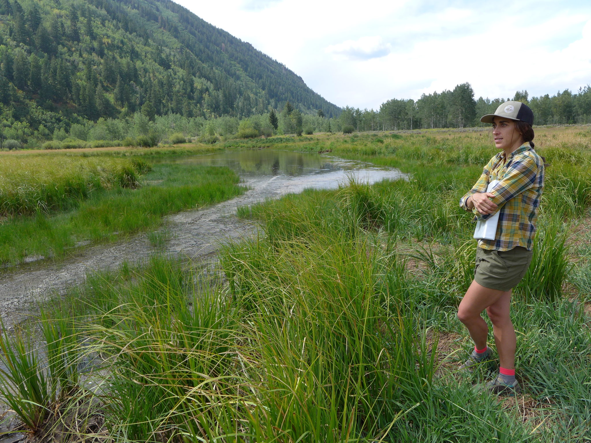
Liza Mitchell, a natural resource planner and ecologist with Pitkin County, stands near the wetlands on the North Star Nature Preserve on Aug. 26. A restoration project aims to keep water in the fen, which is habitat for many kinds of wildlife, including ducks, plovers and moose. Photo credit: Heather Sackett/Aspen Journalism
Colorado Parks and Wildlife (CPW) is pleased to announce the Colorado Wildlife Habitat Program (CWHP) 2022 Request for Proposals (RFP). The CWHP is a statewide program that supports CPW’s mission by offering funding opportunities to private or public landowners who wish to protect wildlife habitat on their property, and/or provide wildlife-related recreational access to the public.
The CWHP is an incentive-based program that funds conservation easements, public access easements, and fee title purchases to accomplish strategic wildlife conservation and public access goals.
Funding for the 2022 cycle is approximately $11 million and is made possible by revenue generated from the sale of the Habitat Stamp, hunting and fishing licenses, and through CPW’s partnership with Great Outdoors Colorado (GOCO).
To Apply
The landowner or a third party representative must complete application forms which address one or more of the following CPW’s 2022 funding priorities:
Public access for hunting, fishing, wildlife viewing
Big game winter range and migration corridors
Protecting habitat for species of concern (specifically those Species of Greatest Conservation Need, as identified in the Colorado Parks and Wildlife Statewide Action Plan)
Riparian areas and wetlands
Landscape-scale parcels and parcels that provide connectivity to conserved lands
2022 funding preferences include working farms and ranches and properties adjacent to wildlife crossings. Application materials will be available on Monday, June 13, 2022 here: https://cpw.state.co.us/cwhp.
All proposals must be received by 5 p.m. on Thursday, October 13, 2022.
Completed applications are to be emailed to: Wildlife.RealEstateProposals(at)state.co.us.
Applicants will receive a confirmation email acknowledging receipt.
The CWHP funds conservation easements held by CPW or qualified third parties. Third parties may submit a proposal on behalf of the landowner and applications must be signed by the landowner(s). It is strongly recommended that applicants contact the CWHP manager before submitting an application.
Additional Information
CPW recognizes that maintaining wildlife-compatible agriculture on the landscape is an important benefit that can be achieved through conservation easements and land management plans. All conservation easements funded through the CWHP will require a management plan. The plan must be agreed upon by the landowner and CPW prior to closing, and may include provisions for the type, timing, and duration of livestock grazing, recreational activities, and overall management of wildlife habitat.
Landowners are encouraged to develop a clear vision for the future of the property prior to submitting a proposal. Proposals are scored and ranked through a rigorous review process to evaluate strategic conservation impacts, biological significance, public benefits, and project feasibility. Local CPW staff can help describe the wildlife and habitat values accurately. Local CPW office contact information may be found here: https://cpw.state.co.us/learn/Maps/CPW_Areas.pdf.
Initial funding recommendations will be deliberated in March 2023. Final decisions on which projects will move forward is expected to be determined at the Parks and Wildlife Commission’s May 2023 meeting.
All conservation easement properties are required by law to be monitored annually. Third Party conservation easement holders will be required to submit to CPW copies of the annual monitoring report for each conservation easement funded through the CWHP.
Public access is not required for all conservation easement projects, but compensation is available for granting wildlife-related public access to CPW. Landowners are welcome to submit proposals for projects where the sole purpose is to provide hunting or fishing access through a public access easement, without an associated conservation easement.
Under Colorado law, terms of the transaction become a matter of public record after the project is completed and closed. Additionally, it is important for CPW and major funding partners to provide accurate information to the public regarding the CWHP’s efforts to protect vital habitats and provide hunting and fishing access opportunities. Applicants should be aware that after a project has closed, information about the transaction, including funding amounts, may be used by CPW for internal planning and public information purposes.
All CWHP real estate transactions are subject to an appraisal and an appraisal review to verify value. Applicants are strongly encouraged to consult their legal and financial advisors when contemplating any real estate transaction associated with the CWHP.
Contact Information
For additional information about the CWHP or application process, please contact: Amanda Nims, CWHP Manager
Colorado Parks and Wildlife, Real Estate Section 6060 Broadway
Denver, CO 80216
(303) 291-7269
Amanda.nims@state.co.us
Click the link to read the article on The Aspen Times website (Carolyn Sackariason). Here’s an excerpt:
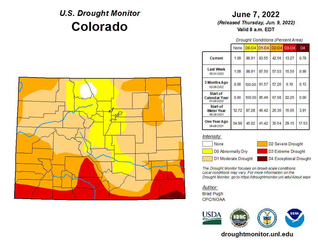
For the third year in a row, the city of Aspen will continue to be under stage two water restrictions due to elevated drought conditions in Pitkin County. The U.S. Drought Monitor last month elevated Aspen and Pitkin County from abnormally dry to moderate drought conditions, according to Steve Hunter, the city’s utilities resource manager.
Map credit: The High Plains Regional Climate Center
Not only has the area experienced above-normal temperatures and below normal precipitation, Aspen started this spring with below average soil moisture. What that means is that drier soils will infiltrate snowmelt runoff reducing the amount reaching the streams, according to Hunter…
The city’s drought response committee has recommended in a staff memo to Aspen City Council that the municipality remain in stage two water restrictions, which it has been since the fall of 2020.
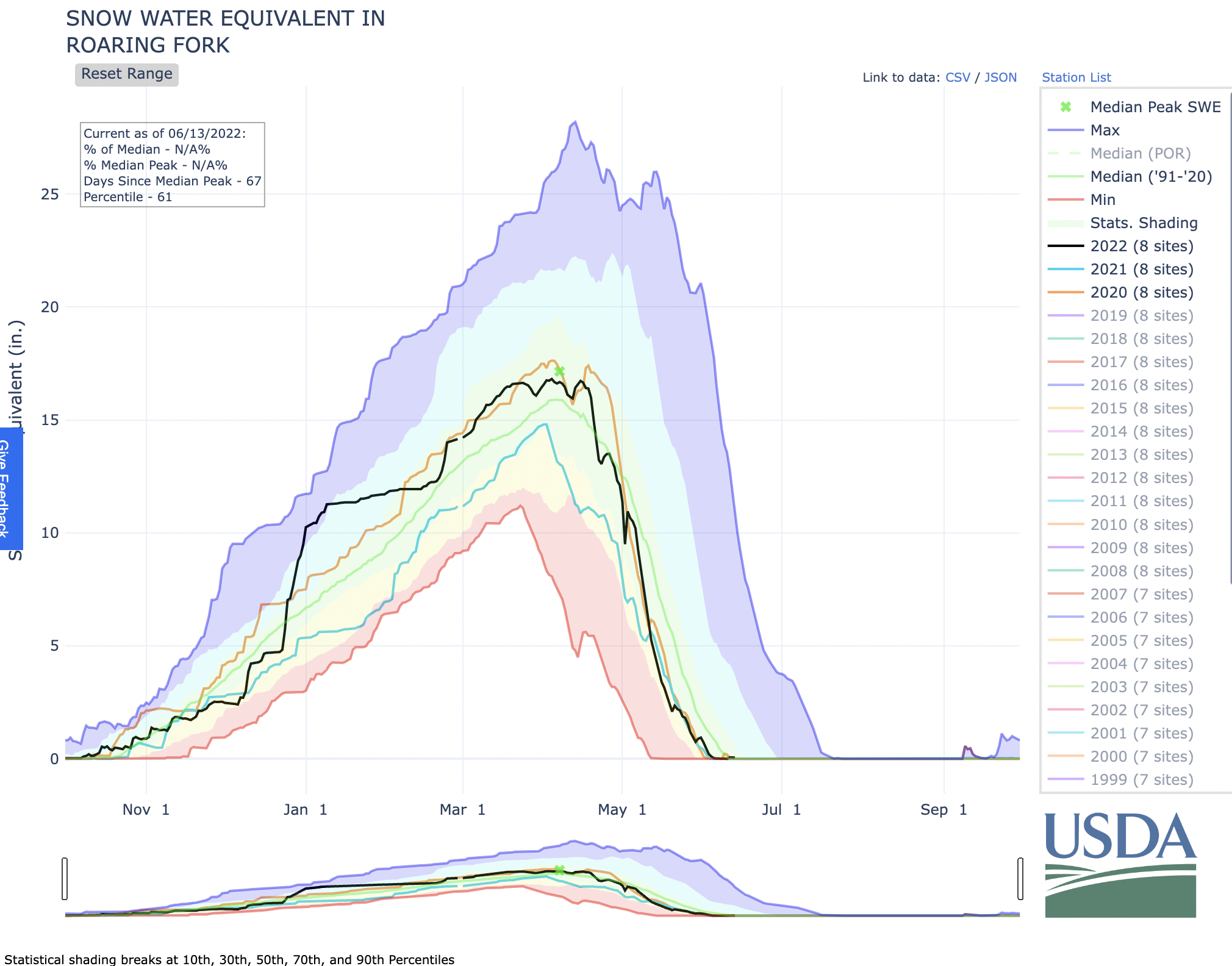
The 2021-22 snowpack was average to slightly above average for the Roaring Fork watershed as Western Colorado saw above average temperatures and below average precipitation in April and May, which have accelerated snowmelt, according to Hunter. Stream flows in the Roaring Fork watershed are estimated to be from 45% to 80% of average, and most rivers are predicted to have a smaller and earlier peak than normal.
As summer is typically a time of higher water use (and higher monthly bills), Denver Water wants to remind customers that making changes to indoor and outdoor water use can help save water and save money.
“The best way to save money on your water bill is to become more efficient at using water,” said Jeff Tejral, a former water efficiency manager at Denver Water.
Denver Water and the Environmental Protection Agency’s WaterSense program have several resources available to help save water and money.
From fixing leaks inside and outside to turning off the water when brushing your teeth, some of the following water-saving ideas are free or inexpensive and can be done quickly. Others, like revamping your landscape or replacing appliances, may require a more long-term approach.
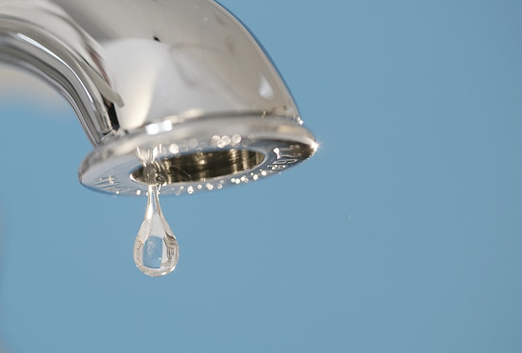
A constantly dripping faucet won’t only drive you crazy but it will freak Mother Nature out, too. Even a small faucet leak can waste up to three gallons of water each day. Photo credit: Delta Faucet
Fixing leaks indoors
Across the U.S., Americans waste about 1 trillion gallons of water every year through water leaks and spend about 10% of their water bill on wasted water, according to the EPA.
“If you’ve got a leak, you are spending money on water that you’re not even using,” Tejral said. “Leaking toilets are often the biggest culprits for water waste. Some leaks are almost undetectable, while others are easy to spot.”
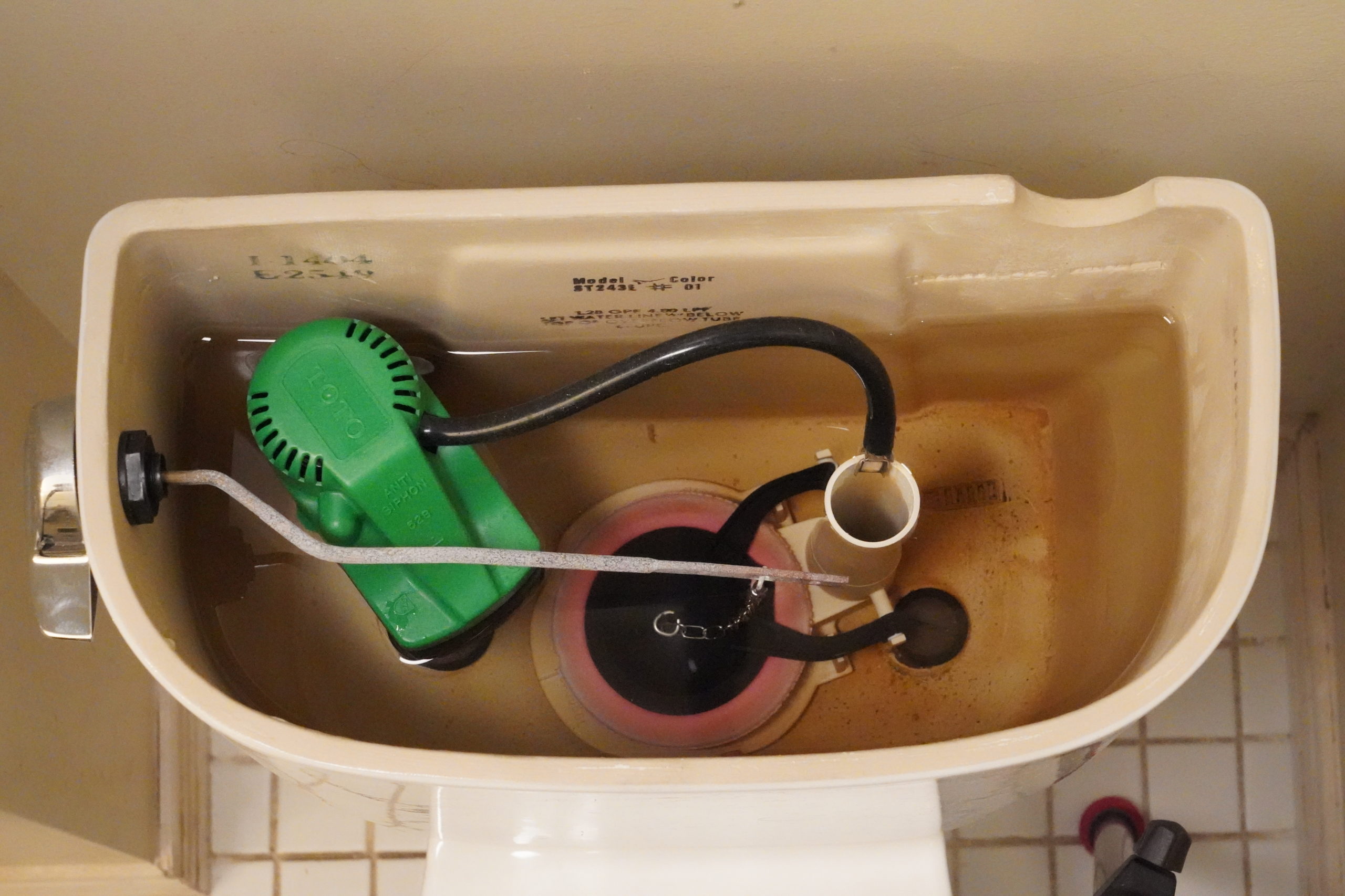
The biggest cause of toilet leaks are worn-out flappers. These are the rubber parts that seal off the tank from the bowl. Over time, the flappers decay and allow water to slowly leak into the bowl.
This toilet has a small, almost undetectable leak through its pink, circular flapper on the bottom of the tank. Some leaks can be detected by listening to hear if water is coming into the tank after it’s done filling. Photo credit: Denver Water.
Another common cause of leaks is a float arm that is not set properly, causing water to constantly flow down the overflow/refill tube.
The EPA reports that an average leaking toilet can waste about 200 gallons of water every day.
For Denver Water customers, a leak of 200 gallons per day can add around $415 per year on your water bill.
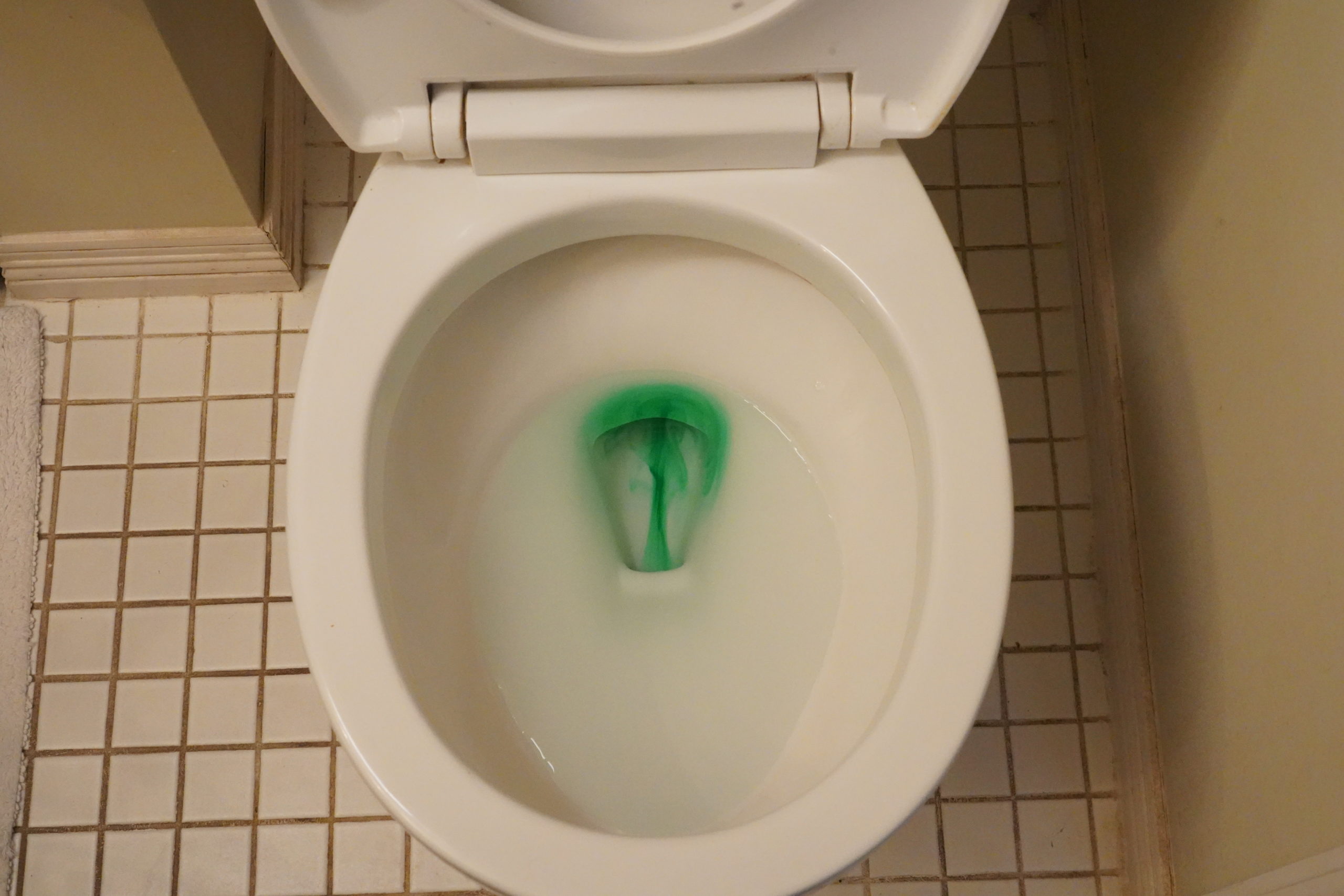
Listen to hear if the toilet continues to run after a flush. Or, drop dye tabs or a few drops of food coloring into the toilet tank. If there is a leak, color will show up in the bowl after a few minutes depending on the size of the leak. Just make sure to flush after the test to prevent stains.
Fixing flappers and float arms are relatively simple and inexpensive repairs. Replacement parts can be found at hardware and home improvement stores and there are many resources online to help guide you through the fix.
Placing a few drops of food coloring in a toilet’s tank will leak into the bowl if there is a leak in the flapper. Photo credit: Denver Water.
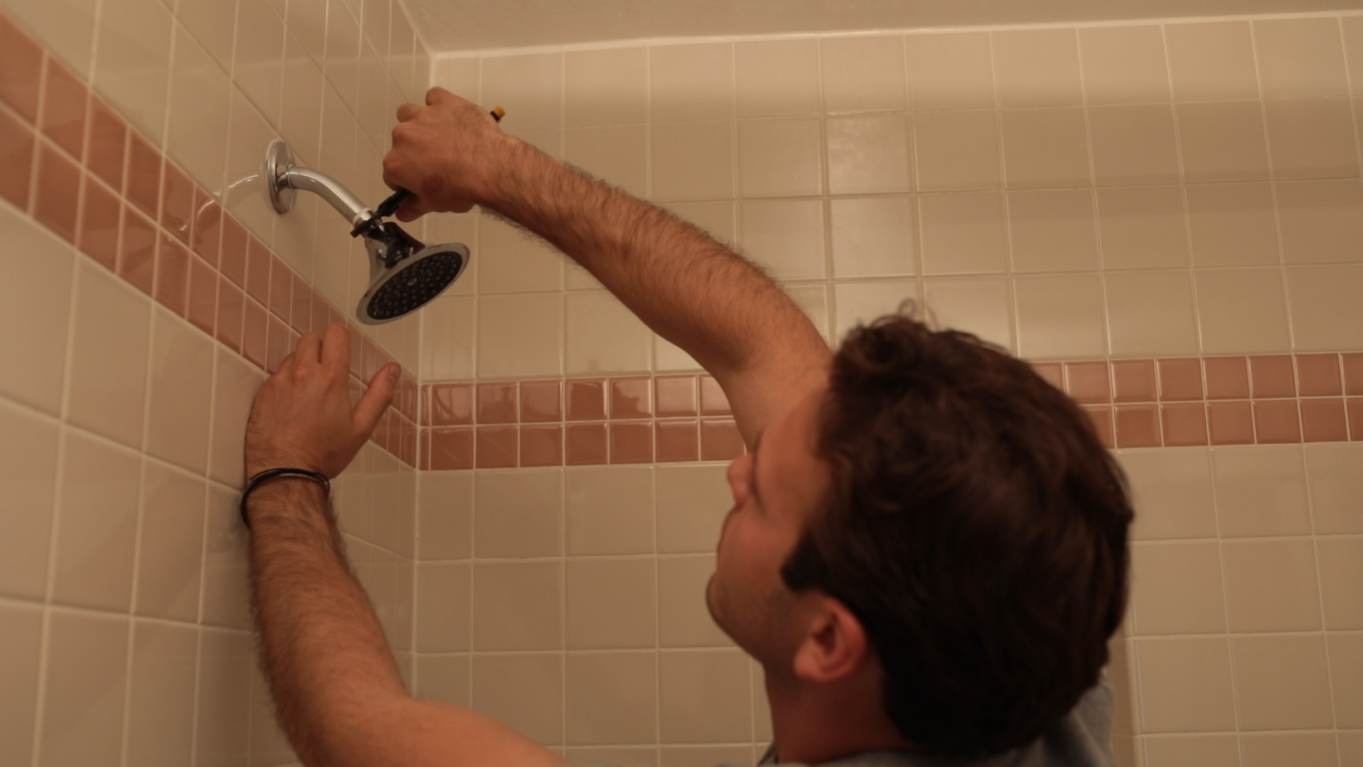
In addition to checking toilets for leaks, Tejral also suggests inspecting all water sources in your home, including faucets, showers, and water supply lines for dishwashers, washing machines, swamp coolers and ice machines.
Denver Water has tips for conducting a self-audit of your home’s plumbing on its website.
And remember, small leaks can add up over time. A leak of 10 drops per minute can waste 300 gallons of water per year.
Not only can these leaks again add to your water bill, they can damage your home.
Fixing leaks outdoors
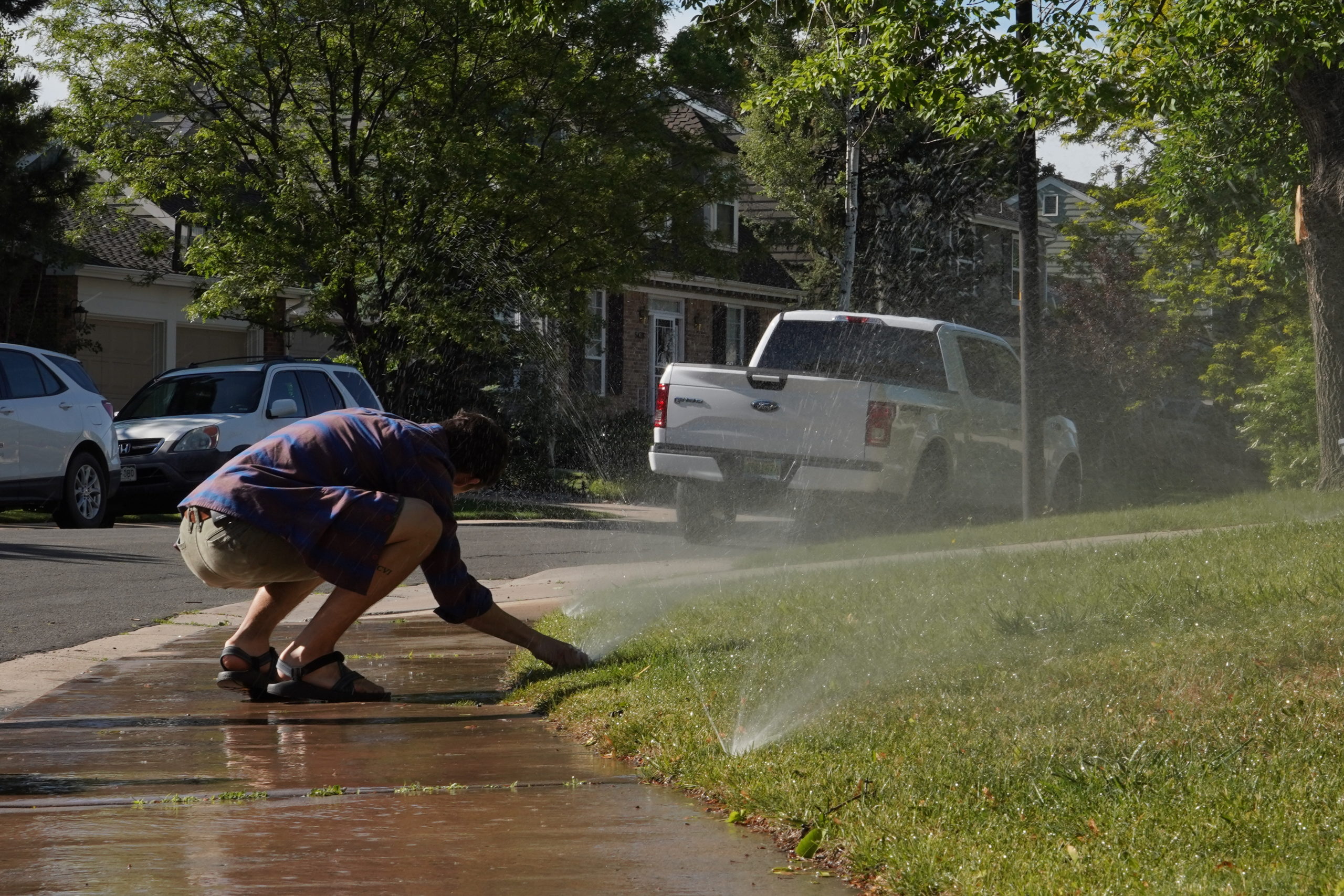
Spring is a great time to inspect your irrigation system and outdoor hoses for leaks as you turn the system on in preparation for the summer irrigation season. Be sure to wait until it warms up to turn on the system, the last freeze in the metro area is typically around May 4, according to the National Weather Service.
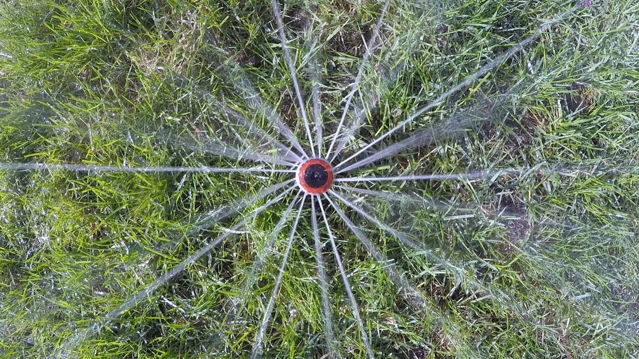
Inspecting your sprinkler throughout the watering season is a good way to spot problems. Photo credit: Denver Water.
Outdoor water leaks can be found in sprinkler heads, pvc pipes, backflow preventers, irrigation system valves, sprinkler heads and drip systems. Not only do leaks raise your water bill, they lower the performance of your entire sprinkler system.
Let’s run the math on how leaks can hit you in the wallet.
Irrigation system experts say it’s not uncommon for a sprinkler zone to leak one gallon per minute. If you run that zone for 18 minutes, three times per week, that’s 216 wasted gallons of water per month and roughly an additional $1.22 on your Denver Water bill.
If there are similar leaks on multiple sprinkler zones in your yard, and those leaks continue all summer and over many years, that’s a lot of wasted water that adds onto your utility bill.
And if you use a manual sprinkler, remember to check your hose connections for leaks too.
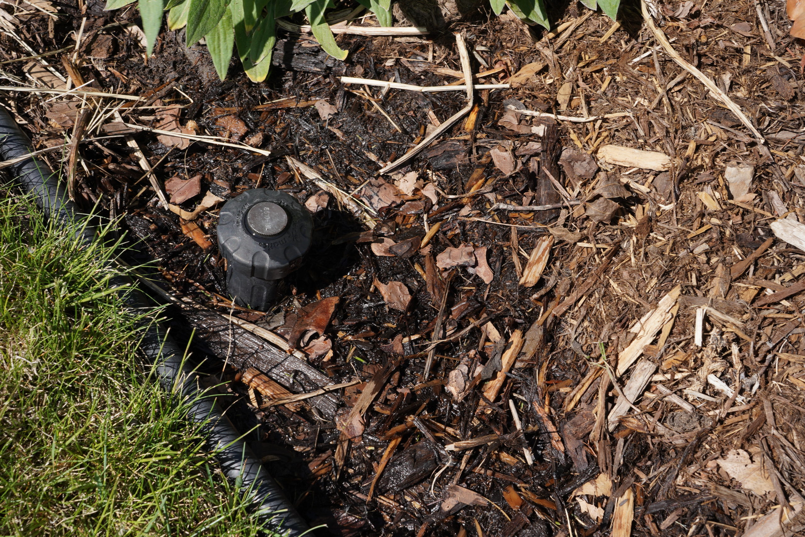
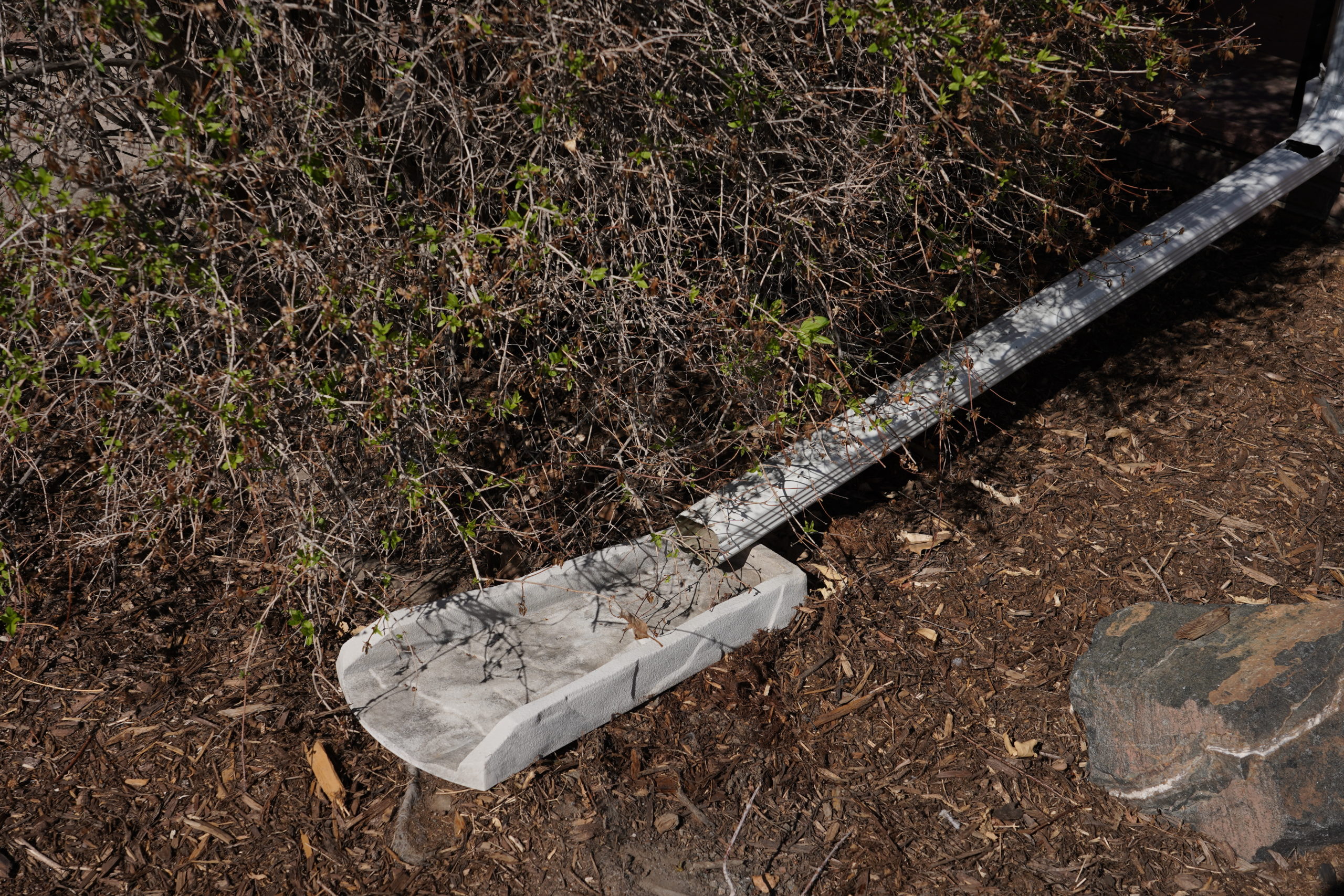
Wet areas around sprinklers can be a sign of a leak in a supply line or connection underground. Photo credit: Denver Water.
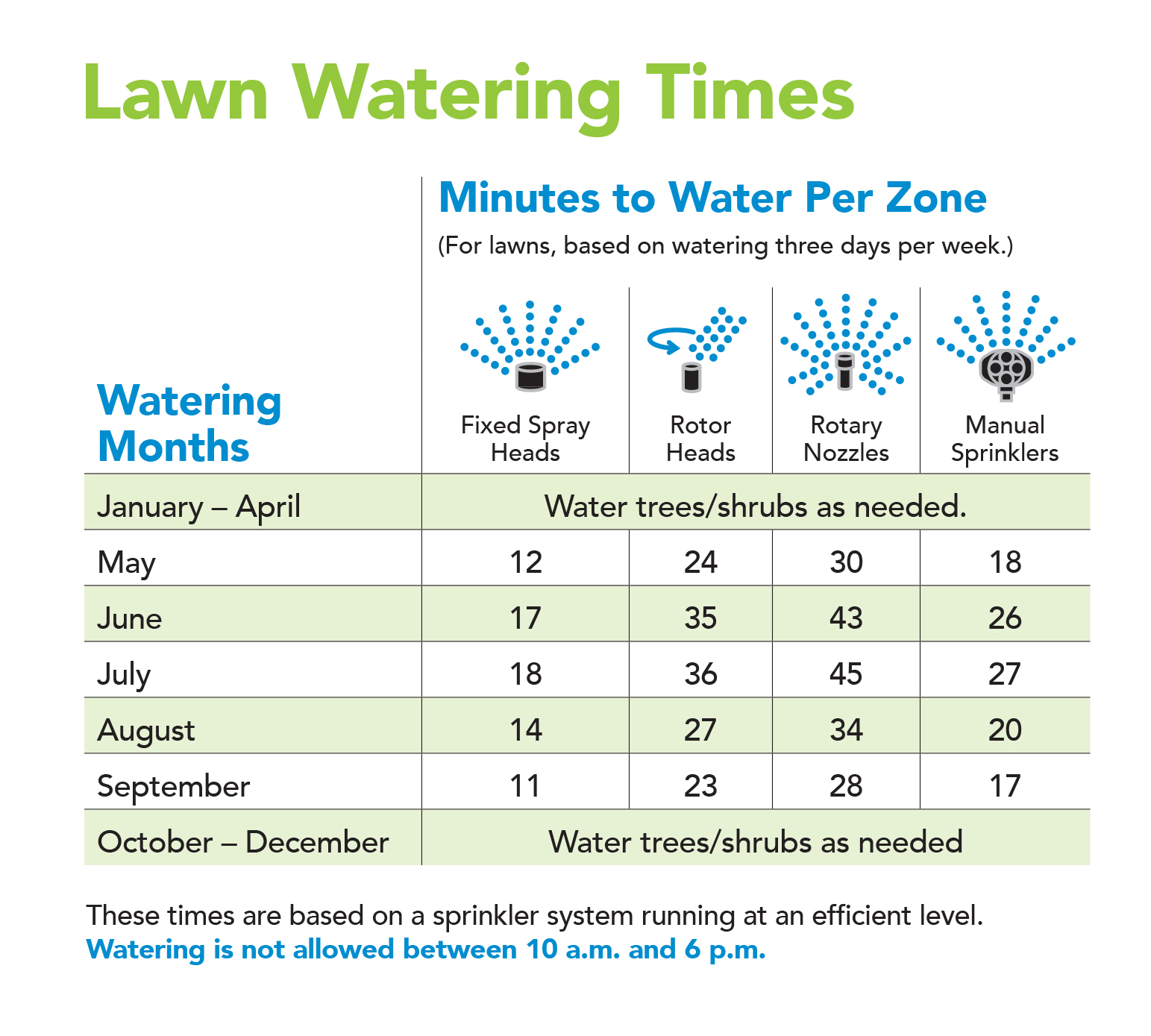
Watering rules can save you money
The EPA reports that 50% of water put on lawns nationwide is lost due to wind, evaporation and runoff caused by inefficient irrigation methods.
“The summer watering rules are in effect from May 1 through Oct. 1. They can really help customers save money by encouraging them to water efficiently,” Tejral said. “We see a lot of inefficiencies with sprinkler systems and small problems that can add up.”
One basic rule is to water between 6 p.m. and 10 a.m. This avoids watering in the heat of the day when water can be lost to evaporation before it ever lands on the grass.
It is also best to avoid watering when it’s windy, so water doesn’t blow off your yard.
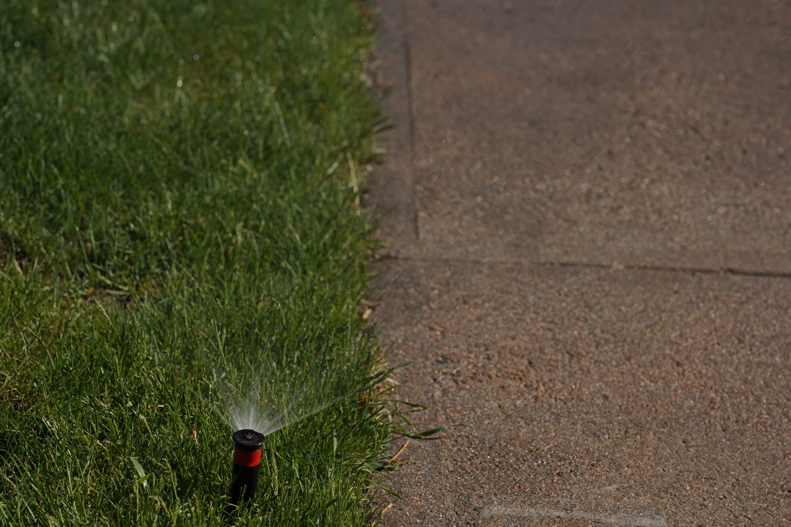
Also, check to make sure sprinklers are not aiming onto the street, driveway or sidewalk.
Homeowners should also check the weather forecast and look for rainy days when they can skip irrigating and let your lawn soak up Mother Nature’s rain.
Check to make sure your sprinklers aren’t accidentally watering the sidewalk or street. Photo credit: Denver Water.
Setting the control clock
The watering rules can help your lawn by providing guidelines for how long to run sprinkler zones based on various types of sprinklers. Denver Water recommends watering only two or three days per week.
Tejral reminds homeowners to check their irrigation system’s control clock throughout the watering season, avoiding the “set it and forget it” approach.
Common problems with control clocks include sprinklers going off in the middle of the day, zones not running for an appropriate length of time and run times that are not adjusted during the watering season as weather conditions change.
roperly programming your irrigation control system will improve the efficiency of your sprinklers and improve the health of your yard. Photo credit: Denver Water.
“Understanding your control system is one of the most important things you can do to make sure you are watering efficiently and not wasting water,” Tejral said.
Tejral also recommends setting controllers to “cycle and soak.”
This means splitting the total run time for each sprinkler zone in half. For example, instead of running each zone for 18 minutes all at once, run each zone for nine minutes and then wait a bit before running the same zone for another nine minutes.
“Cycle and soak practices give the ground more time to absorb water like a sponge,” Tejral said. “If the sponge is full, it can’t absorb any more water. The ground works the same way.”
When customers do not follow these guidelines, they often think using more water is the best way to get a greener yard. But that often adds to the bill and does not help the grass.
“Cycle and soak” is a watering technique used to break up sprinkler run times to give water time to soak into the ground. Photo credit: Denver Water.
Another tip is to monitor each sprinkler zone because some zones need less water than others.
For example, grass in a backyard that has several trees will need less water than grass in a front yard with no trees that is in the full sun all day.
The watering rules also provide guidance for adjusting sprinkler zone run times throughout the watering season. Less water is needed in May and September, when the weather is cooler, than in June, July and August, when the weather is warmer.
Avoid overwatering
A common mistake that leads to higher water bills is overwatering the yard when brown spots or dry areas appear.
“Often, homeowners see brown spots and immediately think they need to run their sprinklers longer, when in fact the brown spots could be due to a variety of problems,” Tejral said.
Sprinkler-related reasons for brown spots include heads that have sunk into the ground, broken heads, sprinklers that are not aimed properly, water pressure issues and poor coverage. Doing a visual inspection when the sprinklers are running is a good way to spot problems.
Some problems can be easily fixed.
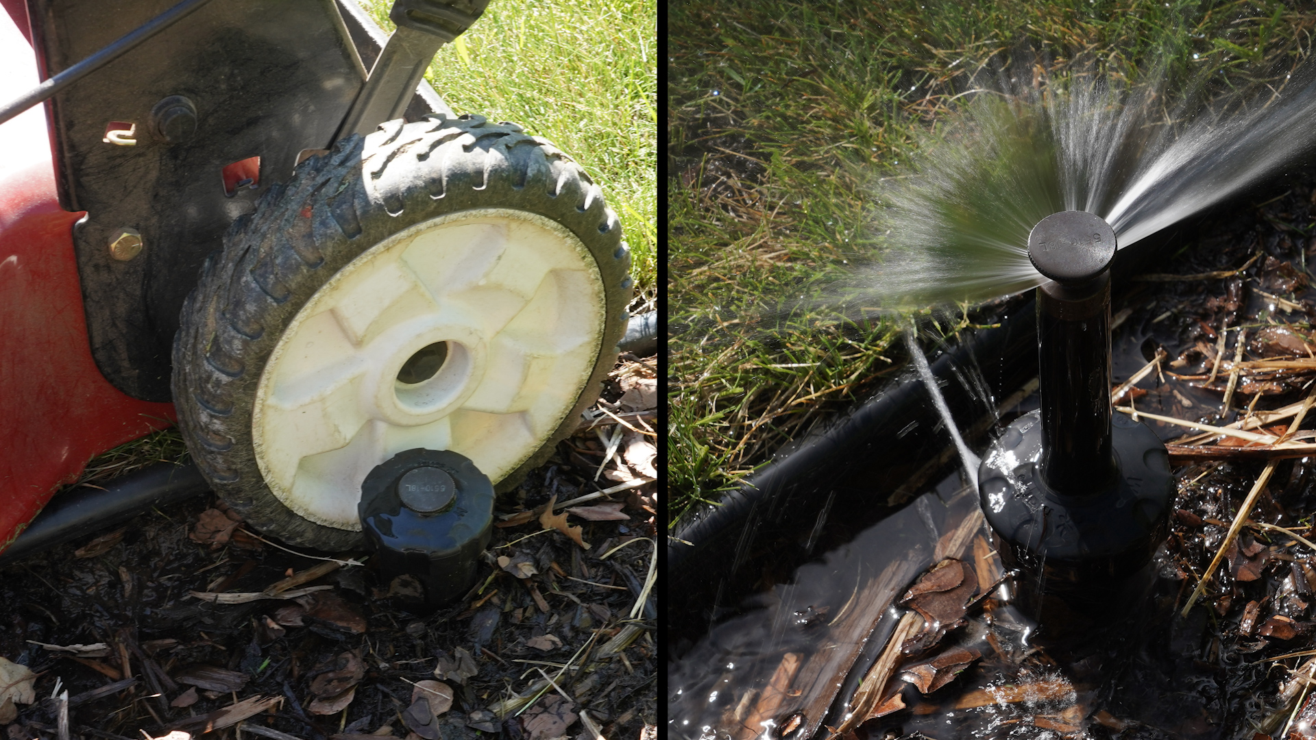
Note the leak on the sprinkler after it’s hit by a lawnmower. Photo credit: Denver Water.
“Plastic sprinklers can crack in the winter and break easily in the summer if they’re hit by lawnmowers or stepped on, so it’s important to check them throughout the summer,” Tejral said.
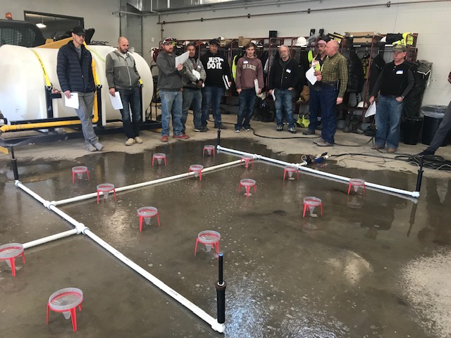
A comprehensive approach to checking how much area your sprinklers are reaching is to do a catch can test.
This involves spreading cups across each sprinkler zone to see if water from the sprinklers is dispersing evenly and reaching target areas.
Tejral says if you are a customer with a water bill that is over $200 per month during the irrigation season or if you are considering installing or retrofitting your irrigation system, you may benefit from hiring a professional who has earned their Qualified Water Efficient Landscaper certification.
Landscape and irrigation professionals take part in Qualified Water Efficiency Landscape certification training at Castle Rock Water in February 2020. Photo credit: South Metro Water Supply Authority.
A list of certified landscape and irrigation experts can be found on the QWEL website. The experts provide a number of services including sprinkler system audits, water efficient irrigation system designs, water-saving landscape designs and installation. Services are provided for residential and commercial customers.
“A QWEL certified professional may cost money up front, but the savings will add up over time,” Tejral said. “A water efficient landscape will also hold up better in times of drought.”
WaterSense also provides links to qualified professionals.
Landscape change
Changing the kind of lawn and landscape you have in your yard also can reduce water use.
If you want a different look for your yard, consider different types of turf grass or other landscape changes.
Mrs. Gulch’s Blue gramma “Eyelash” patch August 28, 2021.
“Kentucky bluegrass requires more water,” Tejral said. “Homeowners who like the look of grass but are open to something different can look at buffalo grass, blue gramma and fescue.”
Tejral said it is a good idea to evaluate your outdoor living needs every year and determine if grass is the best fit.
Hardscapes, patios, vegetable gardens and shrubs may be more practical and require less water than grass.
The owners of this home in Denver created a diverse backyard with with a mixture of grass, shrubs and patio space. Photo credit: Denver Water.
Rebates
Denver Water offers rebates for customers interested in reducing water use indoors and out.
Rebates are available for some high-efficiency toilets, smart irrigation controllers and high-efficiency sprinkler heads. Be sure to check the Denver Water website for details about which models qualify for rebates.
High-efficiency rotary spray heads deliver water at a slower rate to give water more time to soak into the ground. They also provide a stream of water that is more likely to fall to the ground compared to a spray head that sends out a mist of water that can be swept away by the slightest wind.
High-efficiency sprinklers deliver water in streams and at a slower rate than fixed-spray head nozzles. Photo credit: Denver Water.
Replace old fixtures and appliances
While many water-saving fixes are free or relatively inexpensive to do, the EPA says the average family can save 13,000 gallons of water annually by investing a bit more to save money down the road.
When buying new appliances and fixtures, purchase products that carry an Energy Star or WaterSense label, an indication that the product uses less energy or water compared to products that don’t carry those labels.
This includes washing machines, dishwashers, showerheads, faucets, toilets, irrigation controllers, sprinkler parts and more.
Installing WaterSense fixtures reduces water consumption and saves money on water bills. Photo credit: Denver Water.
High-efficiency shower heads use about 1.75 gallons per minute compared to older ones that use 2.5 gallons per minute.
Replacing an older washing machine with an Energy Star model can save 30 gallons to 40 gallons per load.
Newer dishwashers can save 3,870 gallons of water annually.
Replacing faucet aerators is an easy way to save water at home. Photo credit: Denver Water.
Replacing faucet aerators is another way to save money and water.
New aerators for bathroom sinks dispense just half a gallon of water per minute compared to older ones that use around 1 gallon to 1.5 gallons per minute.
The TAVA Waters community in southeast Denver shows how advancements in technology allow water efficiency products to save money and water without loss of performance.
Crews from Ecosystems install 2,500 high-efficiency toilets at the Tava Waters community in Denver in 2017. Photo credit: Denver Water.
Other easy changes
There are other simple actions that don’t cost anything to do but will save money on your water bill.
These include taking shorter showers and turning off the water when brushing teeth.
Running dishwashers and washing machines when they are full is another way to save water.
You can also use a spray nozzle with a shut-off handle when washing the car or cleaning windows and patios.
Directing downspouts to landscapes is another way to help plants without increasing water consumption.
Even small amounts of extra rainwater add up over a season and can help keep trees and shrubs healthy. Just make sure the water drains toward the landscape and not toward the home’s foundation.
Aiming downspouts away from the house and onto landscapes is a good way to take advantage of rain and snowmelt. Photo credit: Denver Water.
Another free tip to improve your lawn’s health is to make sure you don’t mow the grass too low.
Lawn experts at Colorado State University’s Extension office recommend keeping your grass height at 2.5 to 3 inches to make it more resistant to heat, drought and insects.
And remember to cover up your pool or spa when not in use, this prevents water loss due to evaporation.
Billing
Denver Water encourages customers to review their monthly water bills. Unusually high bills could indicate a leak.
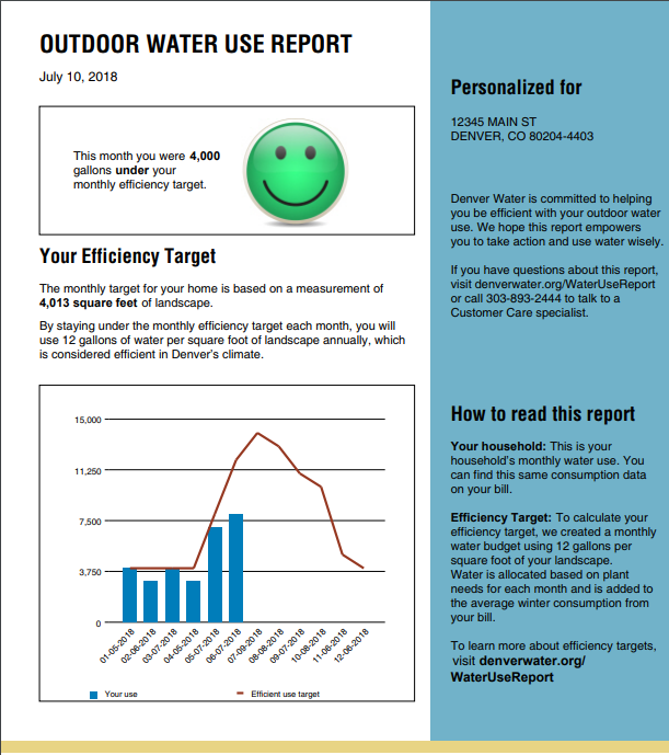
Customers should also watch their email for Denver Water’s summer watering efficiency reports.
The monthly report, sent June through October, shows if you are using water efficiently. If you want this report, make sure your Denver Water account is updated with your email or call Customer Care at 303-893-2444 to sign up.
Denver Water sends out water efficiency reports to customers during the summer watering season. Image credit: Denver Water.
Develop a plan
While there are a wide range of ideas, Tejral said it’s perfectly OK to start small, or to make a plan that takes on manageable changes that will help save water in your home and landscape.
The key to saving money, watering efficiently and having a healthy landscape is to develop a plan either by yourself or with a professional. Photo credit: Denver Water.
“Many of these ideas save small amounts of water, but when you combine them, it can add up and result in significant savings,” Tejral said. “The good news is that saving water at home not only helps lower water bills, it also creates healthier lawns while reducing the impact on rivers and streams in the mountains where we collect our water.”
For this story, the cost of water lost through leaks is based on $5.69 per 1,000 gallons, the average cost of water for Denver Water residential customers, both those inside and outside the city. The amount of money saved by changes suggested in this story are general amounts, as individual monthly bills include a range of factors that were not part of the calculations in this story.
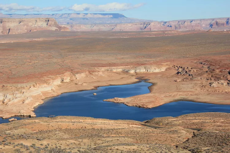
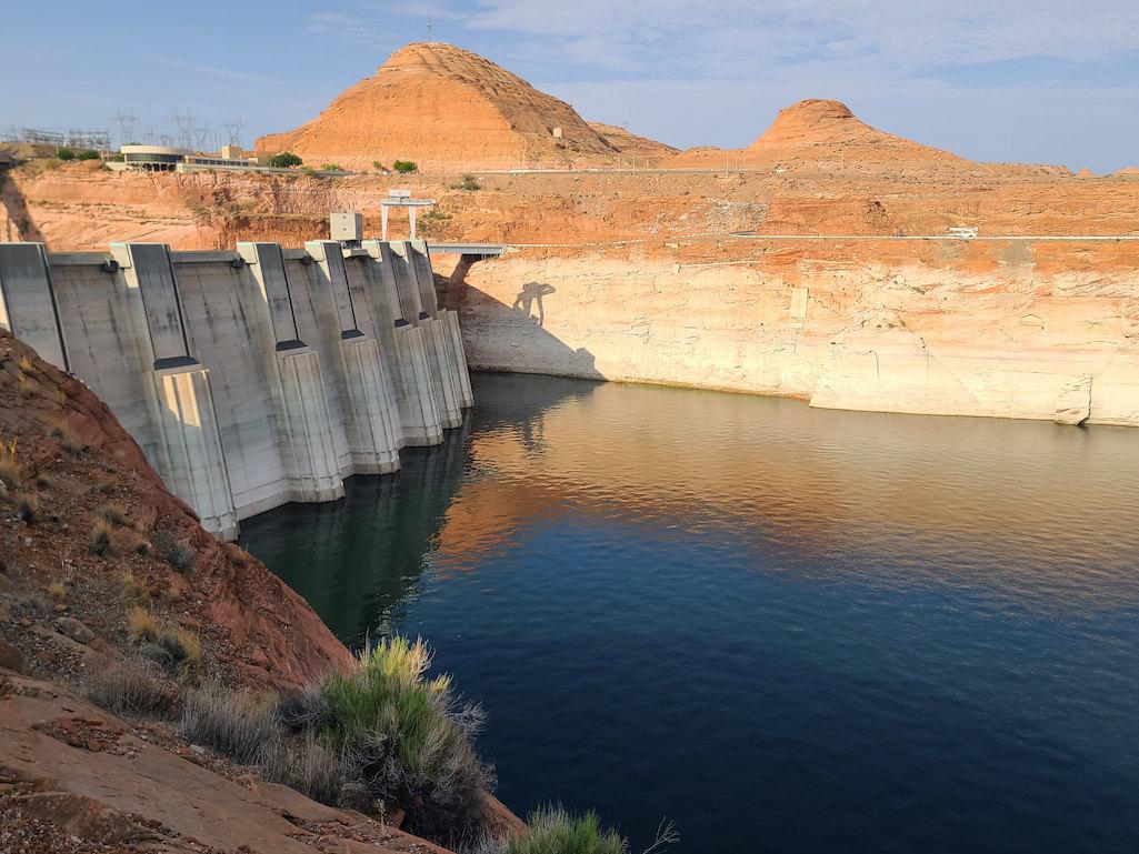
Nook on Lake Powell. Photo credit: Allen Best/Big Pivots
Click the link to read the article on the Big Pivots website (Allen Best):
So I’m off to Glen Canyon, to prowl in the innards of that concrete beast, which looks ever more like the hydraulic equivalent of a mastodon since the waters of Lake Powell keep dipping, dipping, dipping – now sitting at 3,527.7 feet above elevation.
Powell is a tad over 25% full.
My mission has to do with the loss of hydroelectric generation. I began thinking about this six or seven years ago, and now it seems we’re on the cusp, although as many have lately noted, the hydro generation has already dropped off significantly. Powell is 37 feet above that minimum power pool level. The Bureau of Reclamation earlier in May announced it will release less water to the lower basin states from Powell, to keep water levels up. It’s getting harder and harder to make the hydraulic empire of the American Southwest work as designed.
Now comes what one Colorado River expert describes as a “huge” declaration. Bruce Babbitt, the governor of Arizona from 1978 to 1987 and secretary of Interior during the Clinton presidency, says it’s time for a more substantial rethinking of the Colorado River Compact, single most important agreement governing the Colorado River.
“While I once thought that these aridification scenarios were kind of abstract and way out in the future, I don’t think that anymore,” Babbitt said in an interview with the Los Angeles Times’ Ian James.
“It’s absolutely urgent that we start thinking now, while there’s time, about how we adjust the compact, the regulations, the necessary reductions, in the most careful way so that we limit the damage, which can really be extreme.”
Climate change models had predicted a warming Southwest. The resulting aridification – as opposed to the more ephemeral drought – has been well documented in the 21st century. This winter provides yet another example of at least modestly good snows followed by a runoff substantially below average. As the dry winds blow and the temperatures warm, the moisture gets sucked up, instead of going downstream.
I mused about this after a Thanksgiving trip to Santa Fe that included a side trip to the Bishop’s Lodge, site of the 1922 crafting of the Colorado River Compact among the seven basin states. Their assumptions were badly misaligned with hydrologic reality, as became increasingly evident in the 20th century.
Still, the conventional wisdom has been that the compact was difficult to achieve during a time of assumed plenty. Why would anybody want to open it up now? There was just too much risk, too much potential for inviting paralyzing acrimony.
Instead, in a new era of cooperative, water managers in the 21st century has created end-around agreements. The most recent iteration of end-around is the 2019 Drought Contingency Plan. It is being followed by another such plan, to be ready by 2026, requiring harder decisions, more compromises, greater recognition of the water supplies that are little more than half of that were assumed 100 years ago.
More will be needed, said Babbitt.
“We can no longer just kind of muddle along. We really have to think big, because we’re going to have to create a new regulatory framework. And it doesn’t mean that we have to start over from scratch,” Babbitt told the LA Times.
“The Colorado River Compact has worked for 100 years. But there is now a future scenario in which the fixed delivery obligation — from the Upper Basin states at Lees Ferry to California, Arizona and Nevada — simply doesn’t work.”
In this, Babbitt alludes to a clause in the compact, Article III(d), which requires Colorado and other upper-basin states to not cause the river to flow less than 75 million acre-feet over the course of every 10 years. But what if the river is only producing 9 million acre-feet?
Does that mean Denver can’t divert water? Or the Colorado Big-Thompson? Even in Fort Morgan, people drink Colorado River water.
We’re in for a rude reckoning still in Colorado, regardless of how this shakes out on the Colorado River Compact. New landscaping I see in Arvada, where 72% of water comes from the Colorado River Basin, fails to recognize this future. Hurrah for the mayor of Aurora, Mike Coffman, who said it’s time to ban new turf golf courses – just as Las Vegas has decided.
But the language of the compact might be interpreted to say that the Colorado, Utah, Wyoming and New Mexico will absorb nearly all the reality of climate change. Babbitt is saying no, it shouldn’t be.
This interview reverses what Babbitt said in an op-ed published in the Arizona Republic in July 2021. “We have not reached that point,” he said of reconsidering the compact.
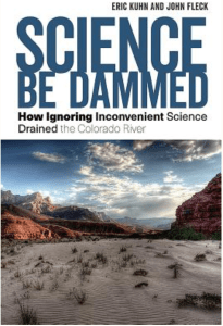
Babbitt may have been responding to a paper written by Eric Kuhn, the former general manager of the Colorado River Water Conservation District, and several others, including Jack Fleck, a New Mexico-based writer and co-author with Kuhn of a book called “Science be Dammed.”
“Our basic argument is that climate change has undermined the basic purpose of the compact – an ‘equitable division’ of the use of the waters of the river between the two (upper and lower) basins,” Kuhn explained to me by e-mail.
“I’m surprised (and pleased) how quickly a revered figure like Governor/Secretary Babbitt has come to the conclusion as well. My optimistic view remains that we’re looking at a collective interpretation of the compact that if climate change, not Upper Basin depletions, is the reason that the upper basins can’t meet the 75 million acre-feet every 10 years, there is no compact violation. The chance of a formal amendment to the compact ratified by seven state legislatures and Congress is still very remote.”
I’ll be closely watching where this conversation goes. It would be a huge pivot for the Southwest.
Eugene Clyde LaRue measuring the flow in Nankoweap Creek, 1923. Photo credit: USGS via Environment360
Gov. Jared Polis on Monday signed two bills into law that are aimed at conserving a precious and dwindling resource in the state: water. For the bill signings, the governor traveled to the San Luis Valley, an important agricultural region where farmers face mounting challenges from extreme drought driven by climate change.
Republican Sens. Cleave Simpson of Alamosa and Jerry Sonnenberg of Sterling, plus Reps. Dylan Roberts, an Avon Democrat, and Marc Catlin, a Montrose Republican, sponsored the first bill, Senate Bill 22-28. It puts $60 million of federal COVID-19 relief money into a new “groundwater compact compliance and sustainability” fund to help finance projects that reduce groundwater use in the Rio Grande and Republican river basins.
GET THE MORNING HEADLINES DELIVERED TO YOUR INBOX
Such projects might include efforts to “buy and retire” wells used for irrigation as well as portions of irrigated farmland, with the goal of restoring water to underground aquifers and helping the communities meet deadlines to reduce their water use. The Colorado Water Conservation Board can allocate money from the groundwater fund based on recommendations from the boards of directors for the Rio Grande Water Conservation District and the Republican River Water Conservation District.
“The timing of the availability of federal dollars and the growing sense of urgency in both basins created a unique opportunity that will serve both of these communities well,” Simpson told the Alamosa Citizen in April.
The other bill Polis signed, House Bill 22-1316, provides millions of dollars for construction projects approved by the Colorado Water Conservation Board. The bill’s legislative sponsors included Reps. Karen McCormick, D-Longmont, and Catlin, along with Sens. Kerry Donovan, D-Vail, and Simpson. Among the local and regional projects funded are:
$3.8 million for the Platte River Recovery Implementation Program. By increasing water flows through the central Platte River habitat area — which stretches across northern Colorado, Wyoming and Nebraska — the project is aimed at improving conditions for the interior least tern, pallid sturgeon, piping plover and whooping crane.
$2 million to support the state’s efforts to comply with the Republican River compact, which was first negotiated between Colorado, Kansas and Nebraska in the early 1940s. The compact governs the three states’ use of the water resources in the Republican River basin, which begins on the plains of eastern Colorado and flows through northwest Kansas and eastern Nebraska.
$500,000 for the Arkansas River Decision Support System. The Arkansas River DSS project involves collecting data on characteristics like climate and groundwater in the Arkansas River basin, which covers the southeast quadrant of the state, and analyzing the data to help inform future decisions about water use.
Polis, a Democrat, signed both bills into law at the Rio Grande Water Conservation District offices in Alamosa. According to a statement from Polis’ office, the governor then joined state and national officials in the nearby town of Center to champion a major development for the San Luis Valley’s potato industry.
The U.S. recently began exporting potatoes — including those grown in the Valley — to new regions in Mexico under an agreement reached late last year between the two countries. Previously, potato exports were limited to a 16-mile border zone.
“This agreement, paired with the critical work the Valley is doing to protect and conserve our water, will make a major positive difference for our farmers, meaning more money in the pockets of hardworking Coloradans,” Polis said in a statement. “Colorado is strategically positioned to lead the nation in potato exports to Mexico.”
Colorado sent its first shipment of potatoes to Mexico under the new agreement last week, according to the statement.
SUPPORT NEWS YOU TRUST.
Colorado Newsline is part of States Newsroom, a network of news bureaus supported by grants and a coalition of donors as a 501c(3) public charity. Colorado Newsline maintains editorial independence. Contact Editor Quentin Young for questions: info@coloradonewsline.com. Follow Colorado Newsline on Facebook and Twitter.
Last week, [a Colorado online daily] ran an opinion piece about the dwindling Colorado River and what role agriculture may or may not play in helping to shore it up. It was written by Don Schwindt, a Cortez, Colorado, farmer, and Dan Keppen, Executive Director of the Family Farm Alliance. Along with praising a Southwestern Colorado dam, they argue that agriculture is important and “must be protected by ensuring water remains on-farm.”
They go on to say:
“Now, the narrative in some recent media coverage is even more troubling. For some, the current severe drought provides a platform to advocate taking water from farmers to make more available for cities and the environment.
“The hydrology of the West may be changing, but that should not drive hasty decisions. Agricultural water cannot be simply viewed as the default “reservoir” to meet other growing water demands.”
They are referring to “demand management,” which can include encouraging farmers to plant less thirsty crops, to increasing efficiency, to paying farmers to stop watering their fields and leave the water in the river (either buying water rights and permanently transferring them, or leasing them when needed on a temporary basis).
As I read the piece, I was struck less by the arguments, which were fairly predictable, than by my reactions to the arguments. One sentence would have me scoffing, the next nodding in agreement, and another both nodding and snorting derisively. That’s not because I’m insane. It’s because these issues—the “Law of the River,” agriculture’s role in culture and ecosystems, and the Colorado River system—are complicated as all get out. And that sometimes means that the only workable solutions to the growing problems on the river are not always vary palatable. I like farmers, for example, but I also like rivers and the fish in them. It’s getting more and more difficult to have both.
The following is an attempt at a Data Dump response of sorts to the column.
The Colorado River is facing a serious supply-demand imbalance. A century ago, when the framers of the Colorado Compact got together to divvy up the river’s waters, they made a few mistakes. First, and most egregious, they didn’t include tribal nations in the negotiations, despite the fact that tribes are sovereign nations and collectively are entitled to first rights to all the water in the river. That was just wrong. Second, they overestimated the amount of water in the river, which in some ways was an honest screw up, given the records they had to work from. And, third, they parceled out too big a portion of the water they thought was in the river, leaving too small of a buffer in case their calculations were off (they were).
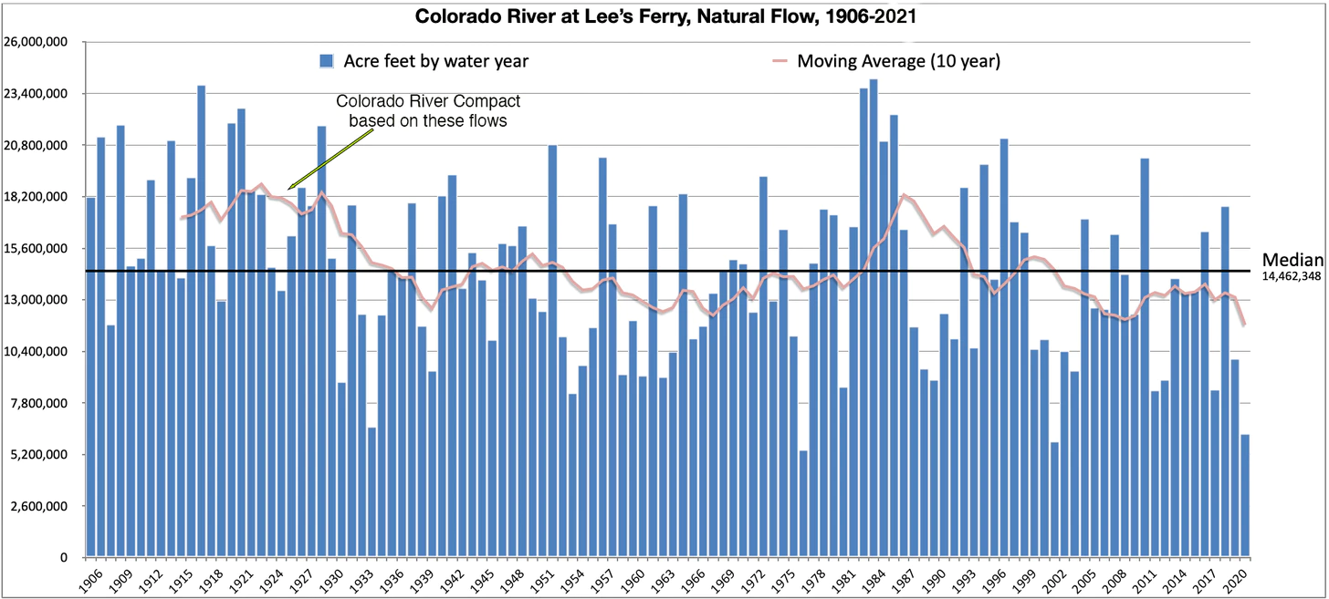
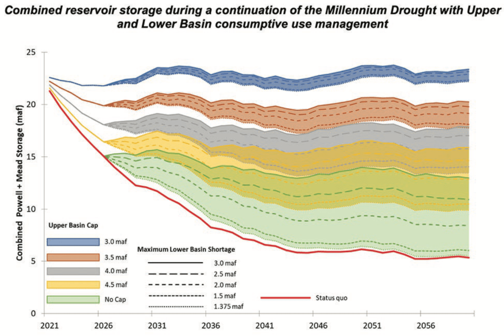
Natural Flow is an estimate of how much water would have naturally run past Lee’s Ferry if there were no dams or diversions upstream. It is calculated using the actual flow, historic flows, and upstream consumptive uses. Bureau of Reclamation modeling is complete to 2019; I extrapolated 2020 and 2021 based on Lake Powell inflows. The 1922 Colorado River Compact gave 7.5 million acre feet to the Upper Basin, 7.5 MAF to the Lower Basin, and (in the ‘40s) 1.5 MAF to Mexico, based on early 1900s observations. As the graph above shows, the average flows dropped below that level a decade later and stayed there aside from a brief respite in the 1980s. Source: USBR
The result: The river is over-allocated, and would be even if climate change were not a factor. So, supply was already lagging behind demand two decades ago, when the Southwest entered the megadrought in a dramatic way (i.e. 2002, the year of our desiccation). Now the supply is diminishing while demand holds steady, which is rapidly drawing down Lakes Powell and Mead (and other reservoirs). With those huge water “banks” at a critically low level, the Colorado River Basin is at its breaking point. Demand must be slashed, quickly and significantly.
While overall demand on the Colorado River trended upward from 1970 to the late 1990s, it plateaued when the region entered the current megadrought. Although this data only goes to 2010, the plateau has pretty much held. But at over 14 MAF per year, demand is significantly higher than what the river has supplied most years. Note that more water is lost to reservoir evaporation than is sent to Mexico. Source: USBR Colorado River Basin Water Supply and Demand Study.
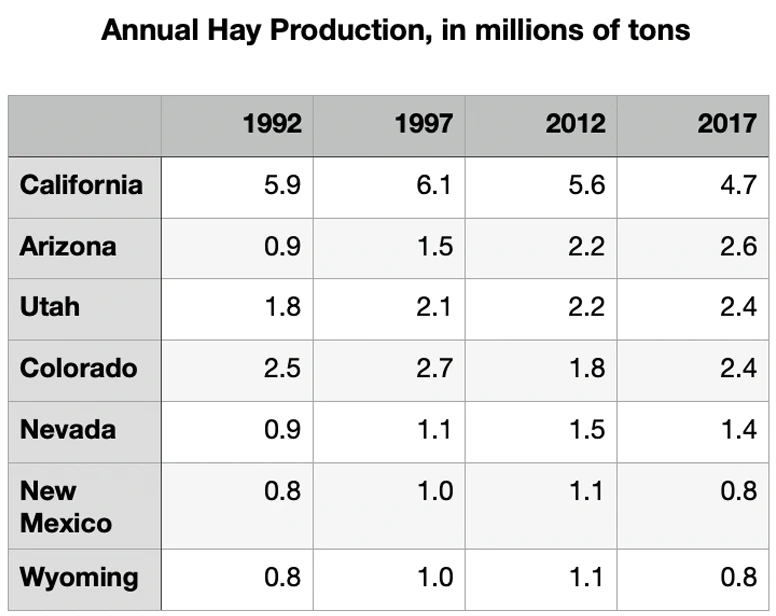
The logical way to make big cuts in consumption is to go to the biggest consumers. And the biggest user of Colorado River water, by far, is not lawns, not golf courses, not the Bellagio fountain in Vegas. It is agriculture: all of those orchards, cornfields, alfalfa fields, ranches, and so on. It’s true in the Upper Basin, in the Lower Basin, and in each state except Nevada, which uses virtually all of its relatively minuscule portion of the river to keep Las Vegas from shriveling up and dissolving back into the desert.
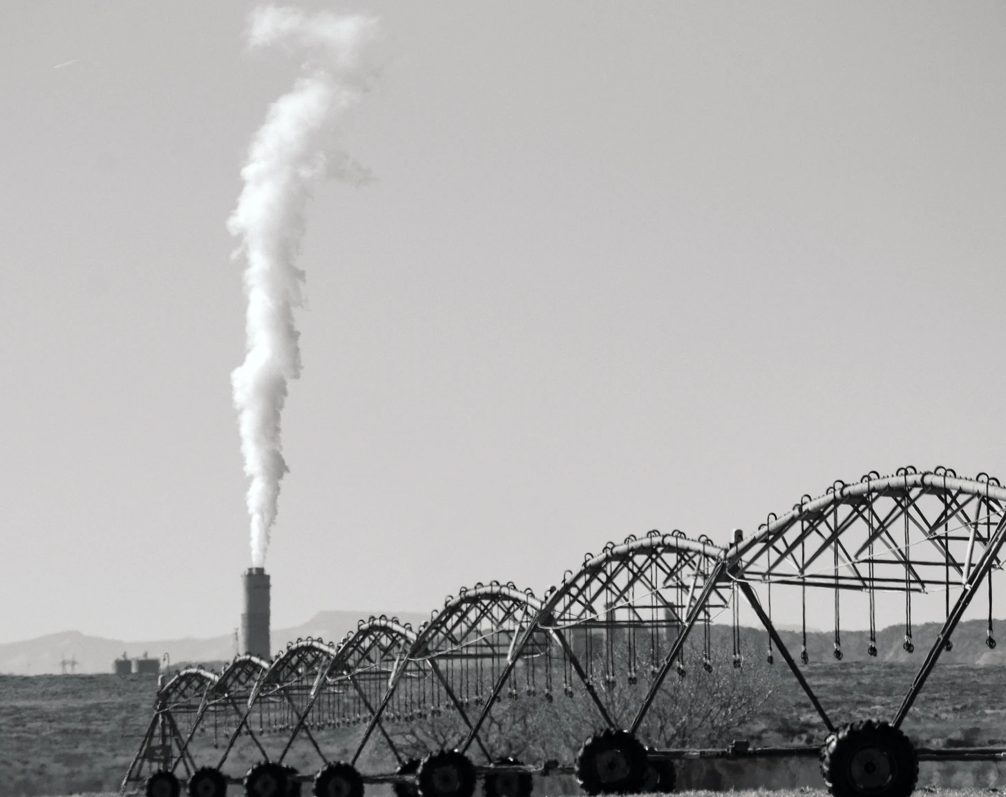
Please visit this post at http://LandDesk.org to see larger, higher resolution images. Note that in New Mexico energy takes up a relatively large share of water. This is mostly for the coal-fired power plants in the Four Corners region, which use billions of gallons of water each year for cooling, steam-generation and other purposes. In some cases, some of this water is returned to the river, but the San Juan Generating Station—scheduled to close this year—is a zero-discharge facility, meaning all of its water use is “consumptive.” Source: USBR.
Farms’ outsized water guzzling may seem surprising, especially since residential development has been gobbling up farmland in recent decades and ag makes up a smaller and smaller portion of these states’ economies. But crops need water in the arid West and, besides, the farmers tend to have most of the water rights. And Western water law and custom encourage folks to use all of the water they have a right to, conservation be damned—the motto, “use it or lose it,” is pounded into many a Western irrigator’s head: Take all of the water to which you’re entitled and then some, whether you need it or not, or else it might end up on your neighbor’s field or, God forbid, flow back into the river!
Montezuma Tunnel entrance.
Schwindt/Keppen write, in reference to diverting Dolores River water onto the farms of Southwest Colorado’s Montezuma Valley:
“The valley’s irrigated ecosystem also improved, further enhancing critically important environments for wildlife and generating other cultural benefits. Irrigated agricultural lands provide groundwater storage, open space, and riparian habitat and wildlife corridors. They also serve as important buffers between public wildlands and expanding urban and suburban areas.”
And it’s true, kind of. It’s a stretch to say irrigation enhances the existing ecosystem, but it certainly creates its own, new ecosystems which can be quite vibrant and beautiful. Leaky ditches are especially good at feeding new wetlands, willows, cattails, cottonwoods, and birds and other wildlife. But what irrigation bestows on previously arid landscapes, it takes from once wild rivers. That is especially true on the Dolores, where in the late 1800s irrigators began diverting its waters out of the Dolores River watershed and into the San Juan River watershed, meaning the runoff did not go back into the river. That essentially dried the lower Dolores right up.
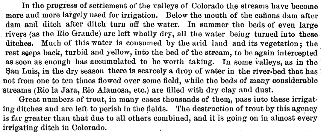
The same was happening all over the region. In the late 1880s ichthyologist David Starr Jordan surveyed area rivers. Here’s what he observed, not about the Dolores, specifically, but about the general state of streams in Colorado at the time:
Via The Land Desk.
But then came the Dolores Project, McPhee Dam and Reservoir, which Schwindt and Keppen say “put water in the dry Dolores riverbed.” Well, no, not really. What it did is take water out of the river during spring runoff and then release some of it later in the year into the riverbed that had been dried out by irrigation diversions.
The dam started impounding water in 1983, in the midst of a string of unusually wet years. During that era, the dam did its job. The current irrigators got a more stable supply of water. The Ute Mountain Ute Tribe got both drinking water from the project as well as enough to irrigate a major agricultural enterprise near the toe of Ute Mountain, providing much needed economic development. The Town of Dove Creek receives water from the project as do the formerly dryland farmers, allowing them to diversify their crops. And still the year-round flows below the dam were enough to build and sustain a cold-water fishery for trout in the first dozen or so miles below the dam and a habitat for native fish below that. In some ways the dam had set the stage for a win-win-win situation.
The Dolores River shows us what’s at stake in the fight to protect the American West — Conservation Colorado
Until it didn’t. That riverbed below the dam? It’s dry more years than not. Last year farmers had to fallow some or all of their fields. The Ute Mountain Ute Tribe received only about 10 percent of its usual irrigation water, forcing it to fallow fields; the Town of Dove Creek faced the prospect of losing its drinking water supply altogether; and releases from the dam for the lower river were cut to 10 cubic feet per second, a mere trickle. For several consecutive weeks in June and July the river gauge at Slickrock registered zero. Fish died off, boating has been nearly non-existent most years, and the dearth of high spring water has allowed tamarisk and Russian olive to proliferate.
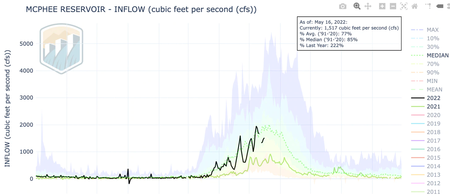
This spring’s flows on the Dolores River above the dam have actually been somewhat healthy, peaking out (rather early) at nearly 2,000 cubic feet per second.
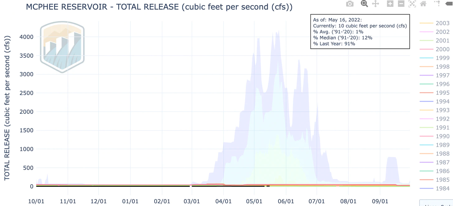
And yet virtually none of that is making it past the dam (yes, that flat black line at the bottom represents releases. It’s at about 7.5 cubic feet per second, a mere trickle, and water managers say they will increase it to a whopping 25 cfs later this year, which is about enough to float a stick):
And even with good flows and low releases, Dolores Project irrigators are expected to get only 18% of their allocation this year. That’s up from 10% last year, but still. The dam isn’t doing the job it’s meant to do, which is to insulate users from drought. And yet, Schwindt and Keppen say the solution is not to try to reduce demand, but rather to “seriously assess projects that enhance water supplies.” They and the Farm Alliance suggest forest restoration, as well as building more water storage, i.e. dams. That won’t be enough.
Anyway, back to demand management. I think most of us can agree that farms shouldn’t be dried to allow cities to grow heedlessly, or to allow urban folks to water big lawns or keep parks green. And we can also all agree that everyone needs to manage their own demand, from the coal power plants to cities and towns to ski areas. Cities need to enhance efficiency and incentivize conservation by banning lawns, structuring water rates to discourage waste, requiring water-efficient appliances in new homes, and limiting growth. Reusing treated wastewater should be the norm. Coal plants should be shut down. Data centers, which can use as much as 1 million gallons of water per day, probably shouldn’t be sited in water-scarce areas (i.e. the Southwest).
But as the consumption graphs above make clear, all of that will only go so far. Agriculture is the biggest consumer of water, so demand management in that realm will also pay the highest dividends. This doesn’t necessarily mean fallowing vast tracts of farmland. It might just mean irrigating more efficiently, plugging leaks on ditches, or switching to less water-intensive, more nutritionally dense crops. Land Desk readers will probably know what I’m saying: Maybe plant a little less alfalfa, instead of more of it!
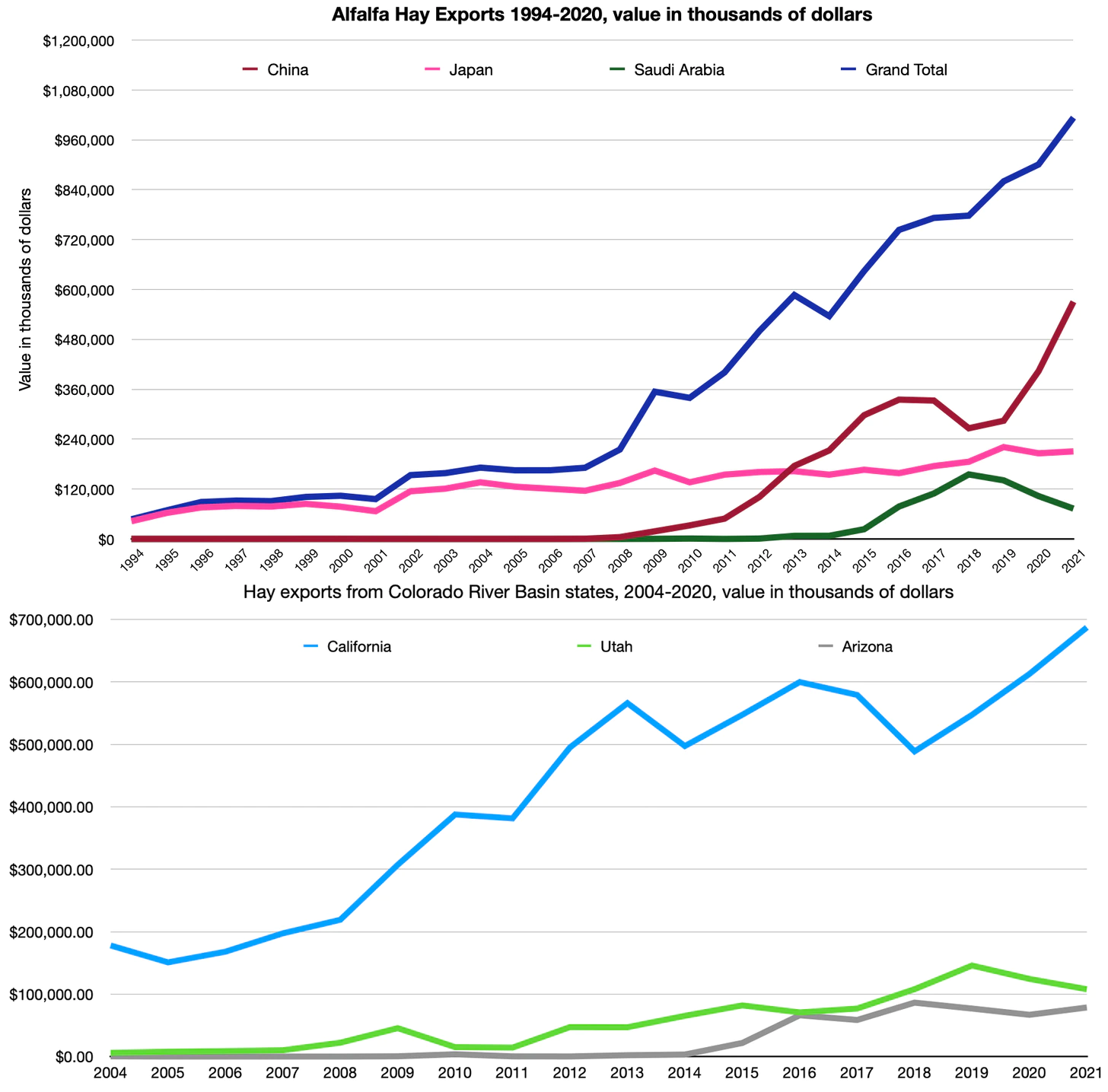
I know, I know, we need that alfalfa to feed the cows to make our cheeseburgers. I get it. But here’s the thing: A lot of that alfalfa is going overseas.
In other words, we are exporting our increasingly scarce Colorado River water—in the form of hay bales—to China, Saudi Arabia, and Japan. I think the agriculture industry can probably handle a little bit of demand management.
Bruce Babbitt, former secretary of the Interior and Arizona governor, said modifying the Colorado River Compact was not necessary for long-lasting solutions in 2019 but has now acknowledged the need. (Source: Water Education Foundation)
Former Interior Secretary Bruce Babbitt, who oversaw management of the river under President Clinton, said it’s become clear that the 1922 Colorado River Compact should be revamped to adapt to the reduced amount of water that is available as global warming compounds the 22-year megadrought in the watershed. Babbitt said that a few years ago, he had thought the seven states could get by while leaving the agreement unchanged. But the Colorado River Basin has been drying out so rapidly with rising temperatures, he said, that the pact should be updated to allow the states to proportionally scale back their water use to deal with what scientists describe as the aridification of the West.
Brad Udall: Here’s the latest version of my 4-Panel plot thru Water Year (Oct-Sep) of 2021 of the Colorado River big reservoirs, natural flows, precipitation, and temperature. Data (PRISM) goes back or 1906 (or 1935 for reservoirs.) This updates previous work with @GreatLakesPeck.
“While I once thought that these aridification scenarios were kind of abstract and way out in the future, I don’t think that anymore,” Babbitt said in an interview with the Los Angeles Times. “It’s absolutely urgent that we start thinking now, while there’s time, about how we adjust the compact, the regulations, the necessary reductions, in the most careful way so that we limit the damage, which can really be extreme.”
[…]
Babbitt said problems in the Colorado River Compact include how it was written, based on assumptions of much larger flows, and how certain provisions become unworkable under such dry conditions…One big reason they no longer work, Babbitt said, is that the century-old agreement includes a provision requiring the Upper Basin states to deliver 7.5 million acre-feet per year to the Lower Basin, the largest share of which goes to California. The Upper Basin states face future scenarios in which they would be required to make huge and disproportionate reductions in water use, Babbitt said.
Colorado River “Beginnings”. Photo: Brent Gardner-Smith/Aspen Journalism
The Colorado General Assembly adjourned its 2022 session on May 11. Among the water bills that passed, four share a common theme—funding. A rare confluence of new revenue sources led to strong bipartisan support of bills dealing with groundwater compact compliance and sustainability, state water plan projects, wildfire mitigation and watershed restoration, and urban turf replacement. A bill designed to strengthen Colorado’s water speculation laws failed.
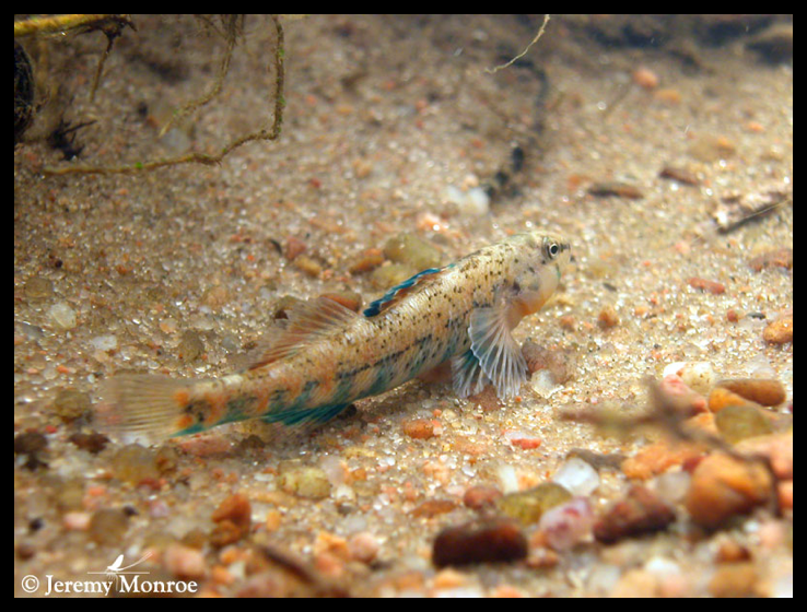
An orangethroat darter, one of the nine remaining native fish species in the Arikaree River. Photo: Jeremy Monroe, Freshwaters Illustrated.
Groundwater compact compliance and sustainability
Senate Bill 28 creates a Groundwater Compact Compliance and Sustainability Fund to help pay for the purchase and retirement of wells and irrigated acreage in the Republican and Rio Grande basins in northeast and south-central Colorado. It appropriates into the fund $60 million in federal American Rescue Plan Act (ARPA) revenue that had been transferred into the state’s Economic Recovery and Relief Cash Fund. The Colorado Water Conservation Board (CWCB) will distribute the money based on recommendations from the Republican River Water Conservation District and the Rio Grande Water Conservation District, with approval by the state engineer. These are one-time dollars that must be obligated by the end of 2024; if not spent by then, they will be used to support the state water plan.
The bill seeks to reduce groundwater pumping connected to surface water flows in the Republican River to comply with a compact among Colorado, Kansas and Nebraska. It will also help meet aquifer sustainability standards required by state statute and rules in the Rio Grande Basin, home to the San Luis Valley. To achieve those goals, 25,000 acres of irrigated land must be retired in the Republican Basin, and 40,000 acres in the Rio Grande, by 2029. If the targets are not met, the state engineer may have no choice but to shut down wells without compensation.
Water sustains the San Luis Valley’s working farms and ranches and is vital to the environment, economy and livelihoods, but we face many critical issues and uncertainties for our future water supply. (Photo by Rio de la Vista.)
Sen. Cleave Simpson, R-Alamosa, general manager of the Rio Grande Water Conservation District, noted that agricultural production coming out of the two basins benefits the overall state economy, not just the local communities. “The state has some skin in the game,” he said, and the availability of ARPA revenue “presented a once-in-a-lifetime opportunity” to support the districts.
Simpson emphasized that neither district is looking for a handout. The Republican has already assessed its water users over $140 million since 2004 to retire irrigated land and purchase or lease surface and groundwater to meet Colorado’s water delivery obligations. The Rio Grande district has taxed its farmers nearly $70 million since 2006 to take irrigated land out of production and has cut groundwater pumping by a third. Simpson requested $80 million from the Economic Recovery Task Force and, by demonstrating the interconnectivity between the state and local economies and the commitment already shown by the districts—along with strong bipartisan support from legislators—was able to secure the $60 million appropriation.
State water plan projects
Each year the Colorado General Assembly considers the CWCB’s “projects bill,” which, among other things, has included appropriations from CWCB’s Construction Fund to support grants for projects that help implement the state water plan in recent years. The funding source for those grants is different this year, with gambling revenue from Proposition DD, which the electorate passed in 2019, becoming available for the first time. Proposition DD legalized sports betting and levied a 10% tax on sports betting proceeds, with the majority of that revenue going into the Water Plan Implementation Cash Fund.
House Bill 1316 appropriates $8.2 million from the fund for grants to help implement the state water plan; $7.2 million of that amount is from sports betting revenue. Rep. Marc Catlin, R-Montrose, said, “This is the first appropriation of funds from Proposition DD … and it looks like it’s starting to grow into what we had hoped.”
The bill also appropriates $2 million to CWCB from its Construction Fund to help the Republican River Water Conservation District retire irrigated acreage. Rod Lenz, district president, said the district has doubled its water use fee on irrigators but that “we’re in need of short-term funding while we wait for that rate increase.” The $2 million in state revenue will help the district meet its 2024 interim target of retiring 10,000 acres of the 25,000 acres necessary to comply with the Republican River Compact by 2029. This is on top of the funds the district will receive from Senate Bill 28.
A forest fire next to the Bitterroot River in Montana. UCLA-led research revealed that larger fires tend to be followed by larger increases in streamflow. | Photo by John MacColgan/Creative Commons
Wildfire mitigation and watershed restoration
Like Senate Bill 28, House Bill 1379 takes advantage of ARPA revenue by appropriating $20 million from the Economic Recovery and Relief Cash Fund for projects to restore, mitigate and protect watersheds from damage caused by wildfire-induced erosion and flooding. Testimony on the bill in the House Agriculture, Livestock & Water Committee emphasized how investing mitigation dollars now helps avoid spending even more on very expensive recovery efforts later.
The bill allocates $3 million to the Healthy Forests and Vibrant Communities Fund to help communities reduce wildfire risks by promoting watershed resilience. It moves $2 million into the Wildfire Mitigation Capacity Development Fund for wildfire mitigation and fuel reduction projects. And $15 million goes to CWCB to fund watershed restoration and flood mitigation projects, and to help local governments and other entities apply for federal grants under the Infrastructure Investment and Jobs Act related to water and natural resources management.
Mrs. Gulch’s Blue gramma “Eyelash” patch August 28, 2021.
Turf replacement
While most of the focus at the Capitol in reducing water use has been on agriculture through retiring irrigated farmland, House Bill 1151 elevates urban turf replacement in importance. The bill requires CWCB to develop a statewide program to provide financial incentives for residential, commercial, institutional and industrial property owners to voluntarily replace non-native grasses with water-wise landscaping. It appropriates $2 million in general funds to a newly created Turf Replacement Fund and authorizes local governments, nonprofits and other entities to apply to CWCB for grants to help finance their programs. Landscape contractors, to whom individuals can apply for money to replace their lawns, are also eligible.
Rep. Catlin pointed out that “50% of the water that comes from the tap and goes through the meter and into the house is used outside.”
“We’re building ourselves a shortage,” he warned, “by continuing to use treated water for irrigation.” Rep. Dylan Roberts, D-Avon, added, “For too long the Western Slope and the Eastern Plains have borne the brunt of water conservation … but this is a bill that will give the tools to metro areas for them to play their fair part in this problem that is our drought.”
WAM bought this 57-acre parcel as part of a $6 million deal in January 2020, leading some to suspect the company was engaging in investment water speculation. WAM’s activity in the Grand Valley helped prompt state legislators to propose a bill aimed at curbing speculation. CREDIT: BETHANY BLITZ/ASPEN JOURNALISM
Investment water speculation
Senate Bill 29 was an attempt to strengthen protections against investment water speculation, defined as the purchase of agricultural water rights “with the intent, at the time of purchase, to profit from an increase in the water’s value in a subsequent transaction, such as the sale or lease of the water, or by receiving payment from another person for nonuse of all or a portion of the water.” It was aimed at curbing outside investors who may have little or no interest in agriculture from using the water right to maximize its value as the price of water increases during drought. It authorized the state engineer to investigate complaints of investment water speculation and, if found, to levy fines and prohibit the buyer from purchasing additional water rights for two years without the state engineer’s approval.
The 2021 interim Water Resources Review Committee recommended the bill, but it was never viewed as more than a “placeholder.” Sen. Kerry Donovan, D-Vail, a co-sponsor of the bill, expressed her disappointment that the bill did not generate more engagement between the water community and policymakers. “I was certainly hopeful that by having a bill we would force conversation,” she said, “but it did not result in having some forthright ‘let’s get around a table and hammer this out.’” Members struggled with trying to balance concerns over speculation with protecting property rights. Sen. Don Coram, R-Montrose, the other co-sponsor of the bill, emphasized, “We are certainly not trying to take a farmer’s or rancher’s ability away from selling that water. In many cases that is their 401K, their retirement.”
Opposition from water user groups in the Senate Agriculture & Natural Resources Committee sent a clear message: Existing legal requirements provide the necessary safeguards to address water speculation. Travis Smith, representing the Colorado Water Congress, said what’s needed is “having more voices, taking more time.”
Senate Bill 29 was amended to strike the language in the bill and refer the issue to interim study. Sen. Jerry Sonnenberg, R-Sterling, who was chairing the committee, expressed his frustration: “We have an ineffective water group that won’t have a conversation with lawmakers anymore. When they have a bill they just take a position and quit working with people.”
With that said he carried the bill over for further consideration, effectively killing it since this was the last committee meeting of the year. It’s unclear whether the issue will be studied this interim since it’s an election year and fewer committee meetings will be held.
Larry Morandi was formerly director of State Policy Research with the National Conference of State Legislatures in Denver, and is a frequent contributor to Fresh Water News. He can be reached at larrymorandi@comcast.net.
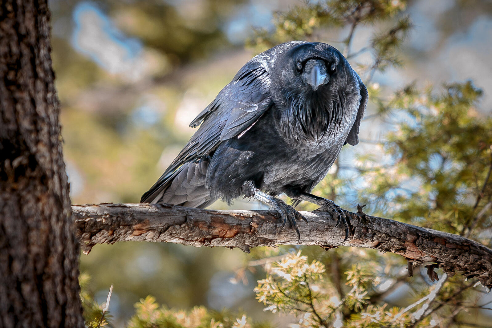
Common Raven. Photo: Doug Kliewer/Audubon Photography Awards
Click the link to read the call to action on the Audubon website (Jennifer Pitt):
The Colorado River Basin is inching ever closer to “Day Zero,” a term first used in Cape Town, South Africa when they anticipated the day in 2018 that taps would run dry. Lakes Powell and Mead, the Colorado River’s two enormous reservoirs, were full in 2000, storing more than four years of the river’s average annual flow. For more than two decades water users have been sipping at that supply, watching them decline. Long-term drought and climate change is making this issue potentially catastrophic.
Today the entire Colorado River reservoir storage system is 2/3 empty.
Moreover, federal officials project that within two years, the water level in Lake Powell could be so low that it would be impossible for water to flow through the dam’s turbine intakes. When that happens, it’s clear the dam will no longer generate hydropower, but it’s also possible the dam will not release any water at all. That’s because the only other way for water to move through the dam when the water is low is a series of outlet tubes that were not designed, and have never been tested, for long-term use.
What happens if little to no water can be released from Lake Powell? Water supply risks multiply for everyone who uses water downstream. That includes residents of big cities like Las Vegas, Phoenix and Los Angeles, and farmers and ranchers in Arizona, California and Mexico who grow the majority of our nation’s winter produce, as well as numerous Native American tribes. Some of these water users have alternative supplies, but some—including Las Vegas residents, Colorado River tribes and most farmers—do not. Day Zero for these water users might not happen immediately as Lake Mead, the reservoir fed by Lake Powell still has some water in it. But without flows from upstream to replenish it, Lake Mead would also be at risk of no longer being able to release water.
There is also the river itself. Think of it—no water flowing through the Grand Canyon. No water flowing in the Colorado River for hundreds of miles downstream from Hoover Dam. That’s an ecological disaster in the making for 400 bird species and a multitude of other wildlife, exceeding the 20th century devastation of the Colorado River Delta.
In recent days, state and federal officials have announced plans to address the immediate crisis. These plans will help, but only to avert the immediate danger looming over the basin for the current year. They do nothing to decrease the unrelenting risks of Colorado River water supplies and demands out of balance, because all they do is move water from one place to another. The federal plan to reduce water releases from the Glen Canyon Dam will help this year, as Lake Powell will hold onto water that would otherwise have flowed downstream to Lake Mead. Notably, Lower Basin water users will calculate their uses as if the water was in Lake Mead anyway, delaying deeper cuts and further depleting the reservoir. The Upper Basin states also plan to release additional water from Flaming Gorge reservoir upriver in Wyoming to increase the inflow into Lake Powell. This too will help Powell, but it will reduce the supply in Flaming Gorge reservoir. The plan acknowledges this supply may not be recovered unless and until storage at Lake Powell considerably improves. Both of these plans will move water and help protect the Glen Canyon Dam’s operations in the near-term.
Moving water does not address the fundamental challenge in the Colorado River Basin and does not offer any real certainty for water users or the river itself in any corner of the basin. Colorado River water demands exceed supplies. Audubon knows that fundamentally, because we work on restoring habitat in the Colorado River Delta, where the river has not flowed regularly for half a century. With major reservoirs only one third full, plans that continue to drain them are not sustainable plans.
Brad Udall: Here’s the latest version of my 4-Panel plot thru Water Year (Oct-Sep) of 2021 of the Colorado River big reservoirs, natural flows, precipitation, and temperature. Data (PRISM) goes back or 1906 (or 1935 for reservoirs.) This updates previous work with @GreatLakesPeck.
Climate change is drying out the Colorado River. In the last two decades, the river’s flow has been 20 percent less than the average flow recorded in the 20th century. Hoping for a rainy season won’t fix this. Today’s water supply conditions are likely to be among the best we see over the coming decades.
What’s needed now, urgently, is for federal and state water managers to work, in partnership with tribes and other stakeholders, to take the steps necessary to build confidence in the enduring management of the Colorado River. This will require focus and dedicated resources to develop and implement plans that put water demands into balance with supplies. That means moving beyond year-to-year reactions to imminent risks to engage in planning that promotes water conservation. Water conservation means using less water, preferably managed in a way that both respects our system of water rights and supports society’s 21st century values, including economic stability for urban and rural communities, allowances for Native American tribes to realize benefit from their water rights, and reliable water supplies for nature.
People and birds rely on the Colorado River, and Audubon will continue to work with partners to advocate for and implement solutions. We know what works. Water conservation pilots implemented throughout the basin and across municipal and agricultural sectors have been successful. Investments in infrastructure upgrades have durably made water uses more efficient, and investments in habitat restoration have benefited ecosystems and the birds that rely on them. Flexible water sharing mechanisms have modernized water uses while protecting legal water rights and helped Tribes secure benefits. There is no time like the present to begin implementing these solutions at scale. They should be the foundation for new rules for how we use and protect the Colorado River.
Colorado River “Beginnings”. Photo: Brent Gardner-Smith/Aspen Journalism
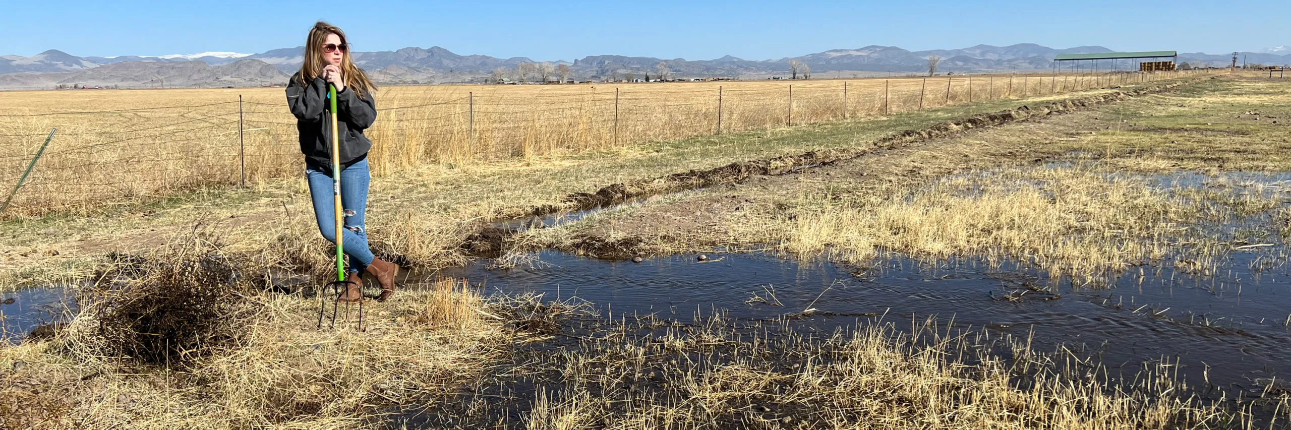
Subdistrict 1 Program Manager Marisa Fricke clears paths for water to flow onto land the subdistrict owns. The property is one of the subdistrict’s investments in recharging the aquifer. Photo credit: The Alamosa Citizen
MOTHER Nature will determine how much groundwater pumping occurs in ag-rich Subdistrict 1 of the Rio Grande Water Conservation District under a new plan of water management making its way to the state for approval.
The subdistrict and its parent Rio Grande Water Conservation District have been under pressure to bring the unconfined aquifer of the Upper Rio Grande Basin to a sustainable level or face curtailment of wells. The San Luis Valley has two aquifers – one unconfined and one confined.
In the draft of its new plan, which is the fourth amendment to the subdistrict’s Plan of Water Management, Subdistrict 1 members spell out the situation with the unconfined aquifer:
“Although the Subdistrict successfully remedied injurious depletions to senior surface water rights caused by groundwater withdrawals from Subdistrict Wells, it has not been successful in achieving and maintaining a Sustainable Unconfined Aquifer. This Plan is intended to address the now-apparent deficiencies of the previous Amended Plans of Water Management and adopts new means needed to achieve a Sustainable Unconfined Aquifer.
“The Subdistrict realizes that if more restrictive steps are not taken to achieve a Sustainable Unconfined Aquifer, the State Engineer will, at some point, be unable to approve a future Annual Replacement Plan, resulting in the curtailment of Subdistrict Wells. State Engineer denial of an Annual Replacement Plan could result in the curtailment of all Subdistrict Wells, causing severe negative impact on the agricultural economy of the Subdistrict and the San Luis Valley as a whole.”
The board of managers for Subdistrict 1 gave final approval to the plan on Tuesday. It now goes to the Rio Grande Water Conservation District Board for consideration. If approved there, it would be submitted to the Colorado Department of Water Resources and State Engineer Kevin Rein for review and approval.
“A lot of hard work has gone into this from everyone involved,” said Subdistrict 1 Board President Brian Brownell. “It’s been a struggle. Overall this is the best plan we could come up with.”
The amended plan relies on covering any groundwater withdrawals with natural surface water or the purchase of surface water credits.
The subdistrict is asking the state for 20 years to make the plan successful in recovering the aquifer, with a goal to restore 40,000 to 50,000 acre-feet a year over that 20-year period to bring the unconfined aquifer to a sustainable level.
TO get there the plan calls for a 1-to-1 augmentation, meaning for every acre-foot of water used, an acre-foot has to be returned to the unconfined aquifer through recharging ponds.
“Our pumping will be adjusted to whatever climate brings us,” said ex-officio board member Mike Kruse.
If the Valley experiences wet periods, groundwater pumping in Subdistrict 1 can match it. If the Valley continues with the persistent drought it has experienced over the past 20 years, groundwater pumping in the subdistrict will reflect the dryness.
“This plan takes into account the climate. That’s the beauty of it,” Kruse said
The predicament of the depleted unconfined aquifer is the result of the state granting too many well permits for groundwater pumping decades ago, now coupled with decades of drought going back to 2002.
“The state has to bear some responsibility,” said Subdistrict 1 board member James Cooley. “It isn’t all our fault.”
Subdistrict 1 Program Manager Marisa Fricke said the subdistrict had been making progress toward meeting the state’s goals with the unconfined aquifer up until 2018, when a particularly dry year hit the Valley. A wet 2019 brought some relief to the aquifer, but the subdistrict lost the progress it made after back-to-back dry years in 2020 and 2021, and now so far 2022.
The change in climate, said Brownell, has been the biggest factor in working to restore the unconfined aquifer. “It’s nothing anybody could have foreseen and that is why we’re addressing it.”
“This concept we have is probably the only way we can address climate,” said Subdistrict 1 Board Member Jake Burris. “With this plan we’re living within our means.”
Based on modeling conducted by Willem Schreuder, president of Principia Mathematica in Denver, there is a high level of confidence among farm operators that the new plan will succeed in meeting the state’s requirement of a sustainable unconfined aquifer. The earliest the amended plan would take effect is for the 2023 irrigation season.
Some farm operators in Subdistrict 1 are filing their own augmentation plans with the state Division 3 Water Court in lieu of joining a new amended plan by the conservation district.
Renewable Water Resources, in its discussions with Douglas County, has tried to use the unconfined aquifer condition in Subdistrict 1 to further its case by approaching farmers with buyouts for their water rights. The RWR water exportation proposal is not in Subdistrict 1, but that hasn’t stopped RWR from trying to leverage the situation to their advantage, telling Douglas County that farmers in the Valley are facing imminent widespread water well curtailments, which isn’t the case.
Douglas County Commissioner Abe Laydon made it a point in his recent visit to the San Luis Valley to bring up well shut downs as a reason why Douglas County could help the Valley by investing in Renewable Water Resources and buying out farmers and establishing a Valley-wide community fund.
A state Senate bill offered by Sen. Cleave Simpson, who also works as general manager of the Rio Grande Water Conservation District, would help address the strategy of retiring groundwater pumping wells in all the Valley’s subdistricts. If adopted – the proposed legislation has cleared major committee hurdles – the Compact Compliance Fund would make available at least $30 million to the Rio Grande Basin to help with groundwater sustainability measurements and would offer the Rio Grande Water Conservation District another pot of money to execute its strategies.
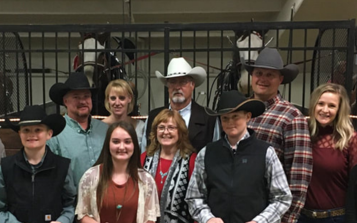
Front row (left to right): Ryan, Adyson, Shelley, and Jack Pankey. Back row: Justin, Shea, Keith, Kevin, and Sarah Pankey. Photo credit: Sand Country Foundation
The Pankey family’s resilience was put to a test when a wildfire burned nearly half of their ranch in 2018. Among the devastating impacts of the fire was livestock and wildlife could no longer drink from ponds because they were covered in ashes.
Keith and Shelley Pankey raise beef cattle with their sons, Kevin and Justin and their families, in Moffat and Routt counties. They have a history of doing right by their land. Following the fire, they cleaned the ponds and aerially reseeded native grasses on 900 acres in the fire’s path. It’s not the first time investing in conservation practices has paid off for this family and the landscape they share with livestock and wildlife.
Keith’s great grandfather homesteaded an area of high desert known as Great Divide. The Pankeys are still able to graze cattle in the drought-prone region from spring through fall thanks to improved water distribution and rotational grazing systems.
They replaced windmill-powered wells with solar pumps. New water storage tanks and nearly three miles of natural flow pipelines were also added. By expanding the number of watering stations (from six to 12) the Pankeys increased their ability to properly graze cattle while creating wildlife habitat across the ranch.
Precipitation, range conditions, and animal performance all impact how the Pankeys plan pasture rotations and stocking rates. They analyze pasture rotations to determine which areas benefit from early, middle or late season grazing. They’ve also found that some areas benefit from longer or shorter periods of grazing, while others benefit from being grazed twice in the same season.
When cattle widely disburse themselves, the Pankeys find that grass recovers at a faster rate, and taller grass is left behind when the cattle are rotated to another pasture. The ranch’s wildlife populations have greatly increased thanks to rotational grazing and the improved water system. By working with neighbors to control noxious weeds, desirable grasses have become dominant across the ranch.
Pankey Ranch borders Colorado’s largest Greater sage-grouse lek, a breeding ground for this declining species. The Pankeys hosted Colorado State University students to study grasses, insects, and Greater sage-grouse habitat in the Great Divide range. Their study was helpful in determining which conservation practices to adopt. The Pankeys fenced off a large area around a natural spring to provide cover. They also equipped water storage tanks with overflows that provide water and prolonged green vegetation to encourage production of insects that grouse chicks consume.
The Pankeys are involved with a large-scale conservation effort led by Trout Unlimited to stabilize Elk Head Creek’s riparian corridor. They have installed rock toe and erosion control mats, and reseeded stream banks to prevent erosion. Hundreds of willow trees have been planted in corridors to preserve wetlands and fish habitat. Less erosion in the creek means cleaner water downstream in the Elk Head Reservoir and Yampa River. This family’s leadership in raising awareness of the creek’s impaired health, and commitment to on-the-ground conservation practices, is inspiring other landowners to follow suit.
The Pankeys also provide public hunting opportunities on their land. In 2011, they obtained a conservation easement on their Routt County property through the Colorado Cattlemen’s Agricultural Land Trust to ensure future agricultural uses on the land. As a longtime volunteer with the Moffat County Fair, Keith shares his land ethic and conservation practices with youth, neighbors and the general public.
Click the link to read “Pankey Ranch’s conservation efforts earn attention from Colorado Cattlemen’s Association” on the Craig Press website (Amber Delay). Here’s an excerpt:
According to the Colorado Cattlemen’s Association, the Leopold Award was created in honor of renowned conservationist Aldo Leopold to recognize farmers, ranchers and forestland owners who inspire others with their voluntary conservation efforts on private, working lands…
The Pankeys will be presented with the award June 13 at the Colorado Cattlemen’s Association Convention in Colorado Springs…
To mention a few who have contributed in addition to Trout Unlimited were: The National Resources Conservation Services, Colorado Parks and Wildlife, U.S. Fish and Wildlife Service, the City of Craig, The Yampa-White-Green-Basin Roundtable and The Lower Colorado River Habitat Partnership Program.
Upper Colorado River Endangered Fish Recovery Program
Click the link to read the release on the Reclamation website (Robert Manning):
The Bureau of Reclamation today submitted its initial spend plan for fiscal year 2022 funding allocations authorized in the Bipartisan Infrastructure Law to the U.S. Congress. This spend plan represents a blueprint for how Reclamation will invest in communities to address drought across the West as well as greater water infrastructure throughout the country. Reclamation will be provided $1.66 billion annually to support a range of infrastructure improvements for fiscal years 2022 through 2026.
“The Bipartisan Infrastructure Law is the largest investment in the resilience of physical and natural systems in American history,” said Assistant Secretary for Water and Science Tanya Trujillo. “Reclamation’s funding allocation for 2022 is focused on developing lasting solutions to help communities tackle the climate crisis while advancing environmental justice.”
“The Bureau of Reclamation serves as the water and power infrastructure backbone for the American West. The law represents a once-in-a-generation opportunity to improve our infrastructure while promoting job creation,” said Reclamation Commissioner Camille Calimlim Touton. “The funding identified in this spend plan is the first-step in implementing the Bipartisan Infrastructure Law and will bolster climate resilience and protect communities through a robust investment in infrastructure.”
The FY 2022 spend plan allocations include:
$420 million for rural water projects that benefit various Tribal and non-Tribal underserved communities by increasing access to potable water.
$245 million for WaterSMART Title XVI that supports the planning, design, and construction of water recycling and reuse projects.
$210 million for construction of water storage, groundwater storage and conveyance project infrastructure.
$160 million for WaterSMART Grants to support Reclamation efforts to work cooperatively with states, Tribes, and local entities to implement infrastructure investments to increase water supply.
$100 million for aging infrastructure for major repairs and rehabilitation of facilities.
$100 million for safety of dams to implement safety modifications of critical infrastructure.
$50 million for the implementation of Colorado River Basin drought contingency plans to support the goal of reducing the risk of Lake Mead and Lake Powell reaching critically low water levels.
$18 million for WaterSMART’s Cooperative Watershed Management Program for watershed planning and restoration projects for watershed groups.
$15 million for Research and Development’s Desalination and Water Purification Program for construction efforts to address ocean or brackish water desalination.
$8.5 million for Colorado River Basin Endangered Species Recovery and Conservation Programs.
Detailed information on the programs and funding provided in the Bipartisan Infrastructure Law, the FY 2022 BIL Spend Plan and materials from recent stakeholder listening sessions are available at http://www.usbr.gov/bil.
American Dipper, Lolo National Forest, Montana. Photo: Troy Gruetzmacher/Audubon Photography Awards
Click the link to read the article on the Audubon website (Caitlin Wall):
In March, Congress passed and President Biden signed a federal spending bill that will fund the government through September 30, 2022. Overall, the funding is a win for conservation and provides helpful increases for programs that address climate change, build community resilience, and protect birds and wildlife. Compared with four years of drastic funding cuts implemented from 2016-2020, this bill sets the stage for a positive trend in federal funding for the environment.
One bright spot is the (at least) $1.25 million included for Saline Lakes science, a key Audubon priority. In addition to this startup funding, Audubon is hopeful that Congress works to pass the bipartisan Saline Lake Ecosystems in the Great Basin States Program Act and additional appropriations for this critical assessment and monitoring program.
For the Colorado River, the spending bill is a bit of a mixed bag. The Cooperative Watershed Management Program received only $5 million, which is a slight increase over the $4.25 million it received last year, but far below our request of $20 million. However, this program received a huge boost in the Infrastructure Investment and Jobs Act (IIJA)—$200 million over five years. And the relatively new Aquatic Ecosystem Restoration Program received only $100,000 in Fiscal Year (FY)22, but will benefit from $250 million over five years in IIJA funding. These programs fund multi-benefit projects that support rivers, wetlands, communities, and water users and we are hopeful they continue to receive additional funding in future years. Audubon urges Congress to continue boosting annual funding for programs like these. Coupled with the historic amounts of funding in the IIJA, the river is receiving an influx of funding over the next few years to address the ongoing drought and water challenges.
Yuma desalting plant. Photo credit: USBR
We were also pleased to see that funding for the operation of the Yuma Desalting Plant was prohibited by the omnibus bill. Audubon remains opposed to the operation of the Yuma Desalting Plant, and encourages Congress to continue prohibiting appropriations for this purpose, as it would decimate irreplaceable bird habitat in the Colorado River Delta, particularly in the Ciénega de Santa Clara. And, the Lower Colorado River Basin received $25 million to implement the Drought Contingency Plans (DCP); this critical funding is in addition to $250 million in the IIJA, pointing to ongoing interest in ensuring these plans are implemented effectively.
For the Department of Agriculture, several important conservation programs were fully funded (meaning they received no cuts)—these include the Regional Conservation Partnership Program (RCPP) and the Environmental Quality Incentives Program (EQIP). RCPP promotes innovative regional approaches to improve the health of working landscapes and rivers with partner-driven, multi-benefit projects. EQIP promotes the voluntary application of land use practices to maintain or improve the condition of natural resources, including grassland health, water quality, and wildlife habitat. Both of these helps support overall watershed health and build the resilience of these ecosystems.
The Salton Sea is a major nesting, wintering and stopover site for about 400 bird species (Source: California Department of Water Resources)
Finally, the FY22 spending bill included Congressionally Directed Spending projects (previously known as earmarks) for the first time in many years. Audubon supported numerous project requests, and was pleased to see $2.546 million for a Salton Sea Research Project, secured by Representative Vargas. And, Representative Stanton secured $1.841 million for the Tres Rios project in Arizona, which Audubon also supported.
Audubon looks forward to the implementation of this funding for on-the-ground conservation activities, habitat restoration projects, and community resilience efforts. Federal dollars are critical to addressing climate change and the ongoing Western drought and aridification. Protecting watersheds protects people and birds, particularly in the West.
Looking ahead, President Biden released his FY23 budget on March 28, which initiated the appropriations process for the rest of this fiscal year. While the budget is only a statement of priorities and Congress will decide the actual spending amounts, Audubon was pleased to see investments for clean energy research, a civilian conservation corps, and equity initiatives to help historically marginalized communities.
The budget appropriates $1.4 billion for the Bureau of Reclamation, which oversees the West’s major waterways. This funding would include $2.254 million for the Cooperative Watershed Management Program and $500,000 for the Aquatic Ecosystem Restoration Program. Audubon urges Congress to fully fund these programs at $20 million and $15 million, respectively. Audubon also supports a full $5 million for the Saline Lakes science program at USGS, to build upon the initial investment made last year. We will be working with our partners to support other conservation programs and projects for FY23, and help continue this positive trend in funding.
Audubon urges the Administration and Congress to continue increasing funding amounts for programs that restore habitat, build community resilience, combat climate change and its devastating effects, and protect the places that people and birds need.
We write to you today, on behalf of our organizations and tens of thousands of supporters across the American West, to express extreme concern over Renewable Water Resources’ proposal to develop a groundwater pumping project in the San Luis Valley that would then export water to the Colorado Front Range. This project represents a serious threat to the water security of the San Luis Valley and to the plant, wildlife, and human communities that depend on this water source. As downstream neighbors we have grave concerns over the cascading effects of this project throughout the entire Rio Grande Basin, and we urge the Commission to reject this proposal.
The Rio Grande Basin cannot afford for any water to be exported out of the Valley.
This project would be the first pipeline built in the San Luis Valley with the intent to export water. But the idea of taking water out of the San Luis Valley for use in other basins is not new. Renewable Water Resources’ proposal is the most recent in a string of such schemes that began in the 1980s. Similar proposals have been decidedly shut down by Colorado courts, which have noted the adverse effects these proposals would have on the aquifer and to surface water rights. In fact, surface waters in the Valley have been recognized as over appropriated since the early 20th century, meaning every drop that flows through the Valley and more is promised to someone. It is incredibly clear that the San Luis Valley has no water to spare.
Sandhill Cranes West of Dunes by NPS/Patrick Myers
Exporting water from the San Luis Valley will threaten hope for a sustainable aquifer.
In addition to surface waters, groundwater is also over appropriated in the Valley. We have serious concerns over the effects of the proposed pumping on overall groundwater levels and their impacts to surrounding wetlands and streams. Of particular concern are potential effects to the Great Sand Dunes National Park and Preserve and the Baca National Wildlife Refuge. Farmers in the Valley are already working together and making sacrifices to reduce water demand through the sub-district project, which was created following decades of drought conditions. This voluntary project facilitates farmers within the Valley combining efforts to ensure groundwater levels are maintained. Renewable Water Resources’ proposal undermines years of this difficult work. The demands for water and challenges associated with allocating it equitably will only increase as the impacts of climate change continue to intensify, this proposal will make an already challenging situation worse and undo years of community-driven efforts to find solutions.
Rio Grande and Pecos River basins. Map credit: By Kmusser – Own work, Elevation data from SRTM, drainage basin from GTOPO [1], U.S. stream from the National Atlas [2], all other features from Vector Map., CC BY-SA 3.0, https://commons.wikimedia.org/w/index.php?curid=11218868
Exporting water from the San Luis Valley will have consequences for the entire Rio Grande Basin.
The concerns over this project expand beyond the San Luis Valley. The project also has the potential to threaten the downstream communities and the environment in the Rio Grande Basin for thousands of miles. The Rio Grande Compact and the 1944 treaty with Mexico define how much water must flow from the Rio Grande’s headwaters in Colorado to New Mexico, Texas and Mexico. As a headwaters state, Colorado has a significant responsibility to its neighbors and it is keenly felt downstream when those responsibilities are ignored. For example, during the twentieth century, Colorado consumed more water than it was allotted under the Compact and subsequently accrued a nearly one-million-acre-foot debt to downstream states. This overuse had consequences to downstream communities, agricultural production, and ecosystems. It resulted in lawsuits that ultimately ended with the U.S. Supreme Court requiring Colorado to repay this debt over time. Luckily for Colorado, a wet period of hydrology that filled downstream reservoirs triggered a provision of the Compact that forgave the prior debt and wiped the slate clean for better management going forward. With projected precipitation regime shifts under climate change, we are unlikely to see such a wet period again.
The water challenges we are facing within the Rio Grande Basin make it painfully obvious that a repeat of this situation would be catastrophic for water users across all three states and Mexico. We must think more holistically about the river systems on which we all depend. The San Luis Valley is an integral part of the Rio Grande Basin, a river that runs nearly 1,900 miles and sustains municipal and irrigation uses for more than six million people and two million acres of land across three states and two countries. We urge the Commission to not further complicate this situation by taking vital water from the San Luis Valley and threatening it and others’ water futures.
The communities of the San Luis Valley are working to address their water scarcity challenges in collaborative and inclusive ways. Although there is still much work to do to create a sustainable aquifer and healthy Rio Grande for people and the environment, Renewable Water Resources’ proposal flies in the face of these efforts. Please do the right thing for the communities within the San Luis Valley and those that depend on the water, also vital downstream, by rejecting this ill-advised project.
Lemon Dam, Florida River. The Florida River is Durango’s main water source, but the city can pull from the Animas River when needed. Because of water shortages and a prolonged drought, city officials are looking at using water stored in Lake Nighthorse
Durango faces a different scenario than many other municipalities that rely on large water reservoirs for their supplies, he said. When a municipality saves a gallon of water, for example, that water stays right there in its reservoir until it is needed. But Durango “lives on the flow” of the Animas and Florida rivers, Biggs said. On one hand, the city isn’t reliant on reservoirs that may be in short supply of water. But on the other, if the rivers are short on supply because there isn’t enough runoff, the city’s only choice is to clamp down on restrictions and wait out the shortage, he said…
Lake Nighthorse and Durango March 2016 photo via Greg Hobbs.
The city is looking into installing a pipeline that would connect Lake Nighthorse to the College Mesa water-treatment facility, Mayor Kim Baxter said, which would allow Durango to take a more proactive approach to drought management and mitigation.
Deep Creek, which flows from Hahns Peak down into Steamboat Lake in North Routt County, is being considered for an instream flow water right by the Colorado Water Conservation Board. Colorado Water Conservation Board/Courtesy photo
This process offers a streamlined approach to water transactions to benefit the environment on streams throughout the state. We invite water rights owners to explore options to use their water rights for streamflow restoration purposes.
Voluntary water sharing arrangements or voluntary acquisitions of senior water rights, on a temporary or permanent basis, can help restore flows to rivers in need, sustain agriculture, and maximize beneficial uses of Colorado’s water.
The Request for Water Process has several goals:
To invite voluntary water offers from willing water rights owners to benefit streamflows
To provide a user-friendly mechanism for water rights owners to explore working with CWCB and the Colorado Water Trust on water acquisitions and transactions that will benefit the natural environment
To streamline transaction processes and utilization of resources
To facilitate implementation of Colorado’s Water Plan objectives
To add flows to river segments in need while coordinating with agricultural and other water uses
This Process is confidential, completely voluntary and open to all water right owners, including agricultural, municipal, industrial, or other users.
PRELIMINARY OFFERS OF WATER ARE DUE JUNE 30, 2022.
Leprino Foods headquarters in North Denver April 22, 2020.
Click the link to read the article on the 303 Magazine website (Ellie Sullum). Here’s an excerpt:
Every year, the U.S. Environmental Protection Agency (EPA) honors companies nationwide for significant progress in pollution prevention This year, the EPA awarded four Colorado-based companies for their contributions to the state’s sustainability efforts…
Taco Star
A Thornton staple, family-owned Taco Star now has four locations in the Denver Metro Area. The Colorado fast-food chain updated its infrastructure to feature LED lighting, low-flow sink aerators and sustainable commercial refrigerators. Refrigeration is the leading source of energy misuse, making Taco Star’s transition a vital step towards energy conservation within Colorado’s sustainability work. Overall, Taco Star’s activities have contributed to an annual cost savings of $4,695, 32 metric tons of carbon dioxide equivalent avoided and 13,000 gallons of water conserved…
Leprino Foods Company
Based in [Denver], Leprino Foods Company is a leading dairy manufacturer. With over 5,000 employees in multiple locations, they specialize in producing mozzarella cheese and popular dairy products. Conventional dairy production is a leading polluter industry. To reduce the company’s footprint, Leprino Foods installed sustainable equipment to limit greenhouse gas and water use. They also implemented cleaning and production process improvements to lower waste brine…By overhauling its equipment and systems, the company modeled water conservation processes for others in the industry to follow…
Management and Engineering Services
Headquartered in Longmont, Management and Engineering Services LLC provides business consulting services. They specialize in consulting with government agencies and private companies that operate on public lands. Over a three-year span, the company installed water reduction equipment, stopped stocking disposable office products and implemented renewable energy throughout the building. They also promoted a bike-to-work program and provided bicycles for employees. Through their efforts to improve Colorado’s sustainability, Management and Engineering Services embodies the purpose of their own work in environmental business solutions.
Learn more about the 2021 EPA Region 8 Pollution Prevention (P2) Award Program here.
Click the link to read the article on the Moab Sun News website (Science Moab). Here’s an excerpt:
In the desert, few issues are as crucial as water. As a historic megadrought continues in the West, water usage is at the top of mind for many scientists. Hydrologists can help us understand how and when to enact new water policies. In this week’s column, Science Moab highlights important messages from conversations with hydrologists, speaking with Eric Kuhn, Jack Schmidt, Brian Richter, and Arne Hultquist.
Science Moab: Are we bound by water usage policies enacted years ago? If nature can’t sustain those, what then?
Eric Kuhn: One hundred years ago, we had some flexibility because the river was not very well-used. Today, not a drop of the Colorado River reaches the Gulf of California, so we don’t have that luxury. The way I look at it is: we legally allocated water based on an assumption that this river system had about 20 million acre-feet. Today, we think it’s more like 13, and it might be less in the future with climate change. Predictions and models show that increasing temperatures are going to reduce flows to the Colorado River. The drama is not how much water we’re going to have in the future — we know it’s going to be less. The drama is how we’re going to decide who gets less water, and when…
These turbines at Lake Powell’s Glen Canyon Dam are at risk of becoming inoperable should levels at Powell fall below what’s known as minimum power pool due to declining flows in the Colorado River. Photo courtesy U.S. Bureau of Reclamation.
Science Moab: At the start of 2021, Lake Powell was at 41% of its capacity. Why should we be so concerned that Lake Powell levels continue to fall to all-time lows?
Brian Richter: Lake Powell serves three really important benefits. One is that it generates hydropower from the Glen Canyon Dam, which provides electricity throughout the southwestern United States. Two, Lake Powell is important for tourism, which is impacted by falling water levels. But by far the biggest concern is that if Lake Powell drops by another 85 feet — and for reference, the lake level dropped by more than 30 feet in 2020 — then the lake will drop below the hydropower outlets, so all the electricity production out of Glen Canyon Dam will stop. But even worse is that it will become physically impossible to move enough water into the Lower Basin states to provide for their water needs.
Colorado transmountain diversions via the State Engineer’s office
Construction workers build a single family home in Castle Rock. The community needs new surface water supplies to reduce its reliance on non-renewable groundwater. Credit: Jerd Smith
Castle Rock’s building boom has barely slowed over the past 20 years and its appetite for growth and need for water hasn’t slowed much either.
The city, which ranks No. 1 in the state for water conservation, will still need to at least double its water supplies in the next 40 years to cope with that growth. It uses roughly 9,800 acre-feet of water now and may need as much as 24,000 acre-feet when it reaches buildout.
With an eye on that growth and the ongoing need for more water, Douglas County commissioners are debating whether to spend $10 million in federal American Rescue Plan Act funding to help finance a controversial San Luis Valley farm water export proposal.
Thirteen Douglas County and South Metro regional water suppliers say they have no need or desire for that farm water, according to Lisa Darling, executive director of the South Metro Water Supply Authority. [Editor’s note: Lisa Darling is president of the board of Water Education Colorado, which is a sponsor of Fresh Water News]
“It is not part of our plan and it is not something we are interested in,” said Mark Marlowe, director of Castle Rock Water. “We have invested hundreds of millions of dollars in our long-term plan and we are pursuing the projects that are in that plan. The San Luis Valley is not in the plan.”
Renewable Water Resources, a development firm backed by former Colorado Gov. Bill Owens and Sean Tonner, has spent years acquiring agricultural water rights in the San Luis Valley. It hopes to sell that water to users in the south metro area, delivering it via a new pipeline. In December, RWR asked the Douglas County commissioners for $10 million to help finance the $400 million plus project.
Tonner did not respond to a request for comment for this article, but he has said previously that the water demands in south metro Denver will be so intense in the coming decades, that the San Luis Valley export proposal makes sense.
Opposition to the export plan stems in part from concern in the drought-strapped San Luis Valley about losing even a small amount of its water to the Front Range. But RWR has said the impact to local water supplies could be mitigated, and that the proposed pipeline could help fund new economic development initiatives in the valley.
Stakes for new water in Douglas County and the south metro area are high. In addition to demand fueled by growth, the region’s reliance on shrinking, non-renewable aquifers is putting additional pressure on the drive to develop new water sources.
Denver Basin Aquifer System graphic credit USGS.
Marlowe and other water utility directors in the region have been working for 20 years to wean themselves from the deep aquifers that once provided clean water, cheaply, to any developer who could drill a well. But once growth took off, and Douglas County communities super-charged their pumping, the aquifers began declining. Because these underground reservoirs are so deep, and because of the rock formations that lie over them, they don’t recharge from rain and snowfall, as some aquifers do.
At one point in the early 2000s the aquifers were declining at roughly 30 feet a year. Cities responded by drilling more, deeper wells and using costly electricity to pull water up from the deep rock formations.
Since then, thanks to a comprehensive effort to build recycled water plants and develop renewable supplies in nearby creeks and rivers, they’ve been able to take pressure off the aquifers, which are now declining at roughly 5 feet per year, according to the South Metro Water Supply Authority.
The goal among Douglas County communities is to wean themselves from the aquifers, using them only in times of severe drought.
Ron Redd is director of Parker Water and Sanitation District, which serves Parker and several other communities as well as some unincorporated parts of Douglas County.
Like Castle Rock, Parker needs to nearly double its water supplies in the coming decades. It now uses about 10,000 acre-feet annually and will likely need 20,000 acre-feet at buildout to keep up with growth.
Parker is developing a large-scale pipeline project that will bring renewable South Platte River water from the northeastern corner of the state and pipe it down to the south metro area. Castle Rock is also a partner in that project along with the Lower South Platte Water Conservancy District in Sterling.
Redd said the San Luis Valley export plan isn’t needed because of water projects, such as the South Platte Water Partnership, that are already in the works.
“For me to walk away from a project in which we already have water, and hope a third party can deliver the water, just doesn’t make sense,” Redd said.
The costs of building two major pipelines would also likely be prohibitive for Douglas County residents, Redd said.
“We would have to choose one. We could not do both.”
Steve Koster is Douglas County’s assistant planning director and oversees new developments, which must demonstrate an adequate supply of water to enter the county’s planning approval process.
Koster said small communities in unincorporated parts of the county reach out to his department routinely, looking for help in establishing sustainable water supplies.
He said the county provides grants for engineering and cost studies to small developments hoping to partner with an established water provider.
“All of them are working to diversify and strengthen their water systems so they are sustainable. Having a system that encourages those partnerships is what we’re looking at,” Koster said.
Potential Water Delivery Routes. Since this water will be exported from the San Luis Valley, the water will be fully reusable. In addition to being a renewable water supply, this is an important component of the RWR water supply and delivery plan. Reuse allows first-use water to be used to extinction, which means that this water, after first use, can be reused multiple times. Graphic credit: Renewable Water Resources
Whether an RWR pipeline will play a role in the water future of Douglas County and the south metro area isn’t clear yet.
Douglas County spokeswoman Wendy Holmes said commissioners are evaluating more than a dozen proposals from water districts, including RWR, and that the commission has not set a deadline for when it will decide who to fund.
Jerd Smith is editor of Fresh Water News. She can be reached at 720-398-6474, via email at jerd@wateredco.org or @jerd_smith.
Lake Powell boat ramp at Page, Arizona, December 17, 2021. Photo credit: Allen Best/Big Pivots
Click the link to read the article on the Salt Lake Tribune website (Zak Podmore). Here’s an excerpt:
The reservoir could drop below the level needed to generate power at the Glen Canyon Dam this year if other ways of increasing the elevation of the lake aren’t used
…water managers in Colorado announced last week that they will stop exploring one proposal to prop up the rapidly depleting levels in Lake Powell. The plan — known as demand management — would compensate farmers and ranchers for voluntarily stopping irrigation on a temporary basis, sending water that would have been used for agriculture to the reservoir. A drought contingency plan developed in 2019 by Utah, Colorado, New Mexico and Wyoming identified demand management as one method that could be used to keep the water level in Lake Powell above 3,525 feet in elevation, around a quarter of its capacity, in order to protect electricity generation. The four-state demand management proposal was met with suspicion by agricultural interests, according to Anne Castle, a senior fellow at the University of Colorado Law School who previously worked on Colorado River issues under the Obama administration. Skeptics of the plan feared it could “wipe out irrigated agriculture” in parts of the river basin and fundamentally alter rural economies, Castle said at a recent University of Utah symposium hosted by the Wallace Stegner Center. She said those fears were “not unfounded” and “they would have to be dealt with in an equitable demand management program.”
[…]
Utah still supports a four-state demand management program, said Amy Haas, executive director of the Colorado River Authority of Utah, but it is also prepared to move forward with water conservation pilot projects and potentially pursue a smaller-scale demand management program on its own. She pointed to Utah’s investments in water measuring infrastructure, studies looking at switching to crops that require less water and other programs…
The Bureau of Reclamation recently announced that it is studying modifications to the Glen Canyon Dam that would allow for power generation at lower water levels. That could include installing turbines on bypass tubes that are located below the current hydropower intakes…
But Brad Udall said finding the political will and leadership at federal and state levels to permanently reduce demand is difficult.
“My biggest fear,” Udall said, “is that it’s easier to let the system crash than it is to find the painful solutions that are needed.”
He defined a system crash as letting the two largest reservoirs in the U.S. — Lake Mead and Lake Powell — empty because of an inability to respond to declining flows. Udall added there have been incremental, positive solutions implemented in the basin over the last two decades, but he said future solutions have to be “more than incremental” to deal with the crisis.
Brad Udall: Here’s the latest version of my 4-Panel plot thru Water Year (Oct-Sep) of 2021 of the Colorado River big reservoirs, natural flows, precipitation, and temperature. Data (PRISM) goes back or 1906 (or 1935 for reservoirs.) This updates previous work with @GreatLakesPeck.
On an average day, 25 people move to Douglas County. Each one needs to drink, shower, water their lawn and wash their dishes. The full impact of that growth is difficult to see, but it’s easy to understand: more people need more water. And in a county where thousands of homes rely on a limited supply of underground aquifers, water providers are constantly working to shift to more sustainable resources before they run out.
Denver Basin Aquifer System graphic credit USGS.
Some aquifers buried under Douglas County have lost two to six feet in depth of water. Local water providers have noticed their supply wells aren’t producing like they once did.
“It’s like sucking water out of the bathtub with a straw,” said Rick McLoud, water resources manager for Centennial Water & Sanitation. “There’s only so much water in the bathtub and the sooner you suck it out with a straw, the sooner it will be gone.”
[…]
To meet those demands, water providers are planning a mix of conservation efforts, wastewater projects and new infrastructure for renewable resources of water. The county government is also looking at how to bring in more water and is considering spending a portion of their $68 million in federal funds from the American Rescue Plan Act on the issue.
‘Overreliance on groundwater’
As Douglas County’s development has surged since the 1990s, many of the largest communities such as Parker and Castle Rock have relied on groundwater to fill residents’ bathtubs and sinks, said State Engineer Kevin Rein…Groundwater from aquifers makes up about 65% of the water used by Parker Water and Sanitation, which is the provider for Parker and parts of Lone Tree and Castle Pines, and by Castle Rock Water. Centennial Water uses about 20% groundwater. Those ratios can change depending on drought conditions…
Douglas County sits on a layer of several aquifers, including the Arapahoe, Denver, Dawson and the Laramie-Fox Hills aquifers. Most major water providers use the water in the Arapahoe and Denver aquifers, which reach depths of 1,700 and 600 feet beneath the ground, respectively…
Under Douglas County’s guidelines for development in unincorporated areas, only the western part of the county is not allowed to rely on their groundwater for development, said Steve Koster, assistant director of planning services for the county. Those communities must provide either a renewable water source or use groundwater from the eastern part of the county. Koster said the county is not actively looking at requiring or incentivizing developers to instead look for renewable resources of water…
Parker Water and Sanitation is working on a project that will partner with a water conservancy district in Sterling, a town in eastern Colorado, to capture unused water during high runoff years from the South Platte River there and store it to pipe back to the town. The project won’t impact existing water rights and won’t allow buy-and-dry of nearby agriculture, Redd said. In order to meet Parker’s projected water demands, the project will need to be complete by 2040, Redd said. That project would get Parker Water to 75% renewable water and would provide water for more than 300,000 people in Douglas County, including in Parker, Castle Rock and portions of Castle Pines and Lone Tree, according to a project proposal. Castle Rock Water is a partner on that project.
Over the next 20 to 30 years, Castle Rock plans to invest about $500 million in renewable water projects including new pipelines, additional storage and water rights. Marlowe said the reason they spread out those projects over time is to keep rates for their customers down. By 2050, Castle Rock plans to move to 75% renewable and by 2065 have a 100% renewable system for wet or average years.
Dominion Water and Sanitation, which serves about 1,200 homes in Sterling Ranch, plans to be 90% renewable by 2040. Sterling Ranch is slated to add about 11,000 more homes to their community in that same time period at a rate of 450 homes per year. Dominion also plans to include about 700 other existing homes from smaller communities to their service area soon. Right now, Dominion is 100% renewable but is set to drill wells in the Cherokee Ranch area to blend some groundwater into their system, making it more drought-resistant, Cole said. They are also planning to build a river intake on the South Platte River and a wastewater treatment facility, which will provide at least 1,600 acre-feet of water per year to Sterling Ranch…
Castle Rock plans to incorporate programs in the coming years that encourage more efficient utilities and lawns that don’t require heavy irrigation. At the statewide level, a bill being considered by the legislature this session would pay residents up to $2 per square foot to rip out their irrigated turf and replace it with less thirsty alternatives. Sterling Ranch has focused on a program they call “demand management” that allows residents to have a live look at their water usage and bills…Their community also has banned the use of bluegrass, a type of turf that demands lots of water. Instead they offer a variety of drought-resistant plants for landscaping…
A view of public lands around the Sangre de Cristo Mountains and just south from the area Renewable Water Resources has proposed a wellfield for water exportation. Photo credit: Alamosa Citizen
As the commissioners consider how to approach the issue, $68 million in federal funds has the potential to aid in addressing the water demands of a growing community. One proposal for the money, which the commissioners have dedicated six two-hour meetings to discussing, would pump about 22,000 acre-feet of water per year to Douglas County from the San Luis Valley. Renewable Water Resources, the private company proposing the project, says that’s enough for 70,000 houses. The project has been met with ire from many in the valley, though, as multiple water conservation districts and elected officials there have said they don’t have enough water to spare and it would damage their agriculture-based economy…So far, all the major water providers in Douglas County have said they are not interested in using the water from the RWR proposal. Darling says that’s in part because many providers have already heavily invested in other projects…
Commissioners have also heard presentations from Parker Water, who asked them to consider using about $20 million of the federal funds to help their South Platte River project, and Dominion, who asked for help funding their regional wastewater plant in partnership with Castle Rock Water and the Plum Creek Reclamation Authority.
Click the link to read the article and view the video on the 9News.com website (Janet Oravetz and Courtney Yuen). Here’s an excerpt:
The city is considering a first of its kind ordinance that would restrict the use of cool weather turf in new developments and new golf courses beginning next year. According to the city, Aurora averages just 15 inches of precipitation each year, and said that cool weather turf typically requires “substantial watering” to survive. Outdoor usage accounts for roughly 50% of water usage annually in Aurora, according to the city…
Turf means any cool season species, variety or blend, including but not limited to Kentucky bluegrass and Fescue, according to the city. In general, it would include those with an annual irrigation water requirement greater than about 9.3 gallons per square foot.
The ordinance, if passed, would prohibit turf for aesthetic purposes only, but would allow it in new developments “in active or programmed recreation areas.” Those are defined as an area with a primary function of sport field but can also accommodate secondary functions, including but not limited to non-organized sporting events, cultural activities and organized social gatherings. The ordinance will prohibit turf in common areas, medians, curbside landscape and front yards. For backyards, turf would be restricted to 45% of the yard, or 500 square feet, whichever is smaller.
Vail has begun methodically removing grass from its parks from areas that serve little purpose, partly with the goal of saving water. Buffehr Creek Park after xeriscaping. Photo: Town of Vail
Click the link to read “Say ‘goodbye’ to grassy yards – [Aurora] may implement heavy restrictions on turf” usage on OutThereColorado.com (Spencer McKee). Here’s an excerpt:
According to Aurora Water, about half of the city’s outdoor water usage is due to people watering their ‘turf,’ with turf being defined as ‘cool weather’ grass species, such as Kentucky bluegrass. This ‘turf’ is the type of grass that is specifically addressed in the proposal, with the goal of the suggested change being to limit overall outdoor water usage amid the city’s continued growth…
The changes would take effect next year, if the proposal is approved.
A group of Valley farmers announced in a press release that they have come together to create the Sustainable Water Augmentation Group (SWAG), an alternative to Rio Grande Water Conservation District, Subdistrict 1.
“It is no secret that we are at a critical moment for the future of the San Luis Valley, as drought deepens, climate change intensifies, and the unconfined aquifer’s water level continues to drop at a dangerous rate. Decisive action is required now before the aquifer runs dry and the way of life for the 46,000 residents of the San Luis Valley, where agriculture is the driving economic force is threatened,” the release stated.
The San Luis Valley has a mostly unconfined aquifer and is subject to many variables including drought. A confined aquifer is surrounded by rock and clay pieces which confine it to an area and make it less at risk for loss, but an unconfined aquifer is exposed and can be impacted more severely by outside factors. A confined aquifer is found deep beneath the ground, while an unconfined aquifer is just below the ground level…
The Rio Grande Water Conservation District, Subdistrict 1 covers much of the San Luis Valley area. According to the Subdistrict 1 Plan of Water Management, “The goals of the Subdistrict are to cause groundwater levels in the Unconfined Aquifer of the Closed Basin to recover, and then to maintain a sustainable irrigation water supply in the Unconfined Aquifer with due regard for the daily, seasonal and longer-term demands on the aquifer and to protect senior surface water rights and avoid interference with Colorado’s obligations under the Rio Grande Compact. To achieve these goals, reducing and managing overall groundwater consumption is essential.” The group of farmers behind SWAG disputes the effectiveness of the plans in place and proposed by Subdistrict 1.
“Despite making little progress towards sustainability with the fee-based model, Subdistrict No. 1’s Board of Managers is now poised to vote on raising the over-pumping fee from $150 to $500 per acre-foot. That’s a 233% increase on top of a 386% increase over the past decade. While this plan may work for some producers, it is not a viable option for the members of SWAG who have paid these ever-increasing fees only to see reduced yields and declining water levels in the aquifer. It is clear the status quo is unsustainable for the farmers of the Valley, nor the aquifer that we rely on for our water. We simply do not have the time to double down on a one-size-fits-all fee-based approach,” SWAG stated in the release.
The SWAG press release included an answer to the ongoing water crisis in the Valley.
“SWAG has entered into an agreement to purchase and retire approximately 4,500 acres, irrigated by wells, that have historically consumed an average of 5,678 acre-feet per year from the unconfined aquifer at a cost of over $35 million. If real progress towards sustainability is not made, the sad truth is that SWAG members’ wells are subject to the very real threat of forced curtailment; whether by the State of Colorado if the subdistrict cannot prove its plan for sustainability will work; or by the Subdistrict itself through ever-increasing fees for pumping which would punish those water users who rely on their decreed water rights for their wells, or the absence of water at their wellheads due to the overuse of the unconfined aquifer. The only way to solve this threat and ensure the future vitality of the Valley is to work together to find solutions which work for everyone. We need more options to promote conservation, not less. SWAG’s augmentation plan is one of those options, and we hope that other members of the community make your voices heard before it is too late,” SWAG concluded.
Click the link to access the report on the Lincoln Land Trust website (James N. Levitt and Chandni Navalkha):
As communities worldwide make protecting the climate a priority, land trusts and conservancies of all sizes and capacities are seeking greater clarity in how to address climate change through land conservation and stewardship. Policy makers and decision makers are considering how to address climate-related impacts in communities, states, and regions. Funders and donors are seeking to invest in projects and initiatives which offer durable, lasting solutions for reducing carbon emissions and improving climate resilience.
This report—written by James Levitt, a global expert and educator in land conservation, and Chandni Navalkha, an international leader in sustainable management of land and water resources—offers numerous case examples of successful initiatives along with the following guidance for stakeholders in the private and public sectors looking to boost the potential of civic organizations to implement natural climate solutions:
Empower civic-sector initiatives that are creative and ambitious in scope and scale.
Invest in initiatives with clear strategies and measurable impact.
Aim for broad collaborations.
Share advanced science, technologies, and financial engineering techniques.
Support initiatives that are built to last, able to adapt, and ready to replicate.
About the Authors
James N. Levitt is the Director of the International Land Conservation Network and leads the Sustainably Managed Land and Water Resources goal area’s Cambridge-based team at the Lincoln Institute of Land Policy in Cambridge, Massachusetts. He is also a Fellow at the Harvard Forest, Harvard University, in Petersham, Massachusetts. In addition, he holds an ongoing Fellowship at Highstead, a non-profit organization advancing land conservation in New England. Levitt focuses on landmark innovations in the field of land and biodiversity conservation, both present-day and historic, that are characterized by five traits: novelty and creativity in conception; strategic significance; measurable effectiveness; international transferability; and the ability to endure. He has written and edited dozens of articles and four books on land and biodiversity conservation. He has also lectured widely on the topic in venues ranging from Santiago, Chile to Stockholm, Sweden. Among his current efforts, Levitt plays an instrumental role in the effort to advance the mission of the International Land Conservation Network (ILCN), which is to connect organizations around the world that are accelerating voluntary private and civic sector action to protect and steward land and water resources. Levitt is a graduate of Yale College and the Yale School of Management (Yale SOM). He was named a Donaldson Fellow by Yale SOM for career achievements that “exemplify the mission of the School.”
Chandni Navalkha is the Program Manager for Land Conservation Programs within the Department of Planning and Urban Form, where she works on projects to advance and accelerate the enduring protection of land and water resources worldwide. Prior to joining the Lincoln Institute, Chandni was a fellow with the Sri Lanka Program for Forest Conservation, conducting research on the impacts of conservation on local livelihoods near the Sinharaja World Heritage Site. Chandni has worked for organizations in North America, Latin America, and South Asia supporting urban, peri-urban, and rural communities involved in voluntary land and resource conservation, and earlier in her career worked in change management for private and public sector organizations as a consultant with Accenture.
Colorado could soon have a program that would pay property owners to get rid of one of the largest water uses for Western Slope water providers: grass.
The drafters of House Bill 1151 say it is aimed at efficient water use and would increase communities’ resilience to drought and climate change, reduce the sale of agriculture water rights to meet increased demand in cities, and protect river flows. Sponsors are asking the program to be funded with $4 million from the general fund. The bill’s next stop is the House Appropriations Committee.
Colorado would be following in the footsteps of other states that take water from the dwindling Colorado River by expanding these so-called “cash for grass” programs. Some Colorado municipalities and water providers already have lawn buy-back programs; the bill could increase the incentives they give to customers.
Vail has begun methodically removing grass from its parks from areas that serve little purpose, partly with the goal of saving water. Buffehr Creek Park after xeriscaping. Photo: Town of Vail
According to bill sponsor Rep. Dylan Roberts, who represents Routt and Eagle counties, nearly 50% of the water used between the municipal and industrial sectors goes to the outdoor watering of non-native turf grasses.
“That’s not the type of activity we should be doing in our state when we are facing such a drought,” he said. “If this bill can help incentivize folks to make the right decision about water conservation in their community, that’s a win.”
The future site of Steamboat Lake is shown here in 1949. The barn pictured was owned by the Wheeler family, one of several families who ranched the land before it was bought by brothers John and Stanton Fetcher. John Fetcher proposed the construction of Steamboat Lake, which was built in 1967 and funded by the operators of Hayden power station and the Colorado Division of Parks and Outdoor Recreation. Photo via Bill Fetcher and Aspen Journalism
Landowners in Colorado could play a major role in President Joe Biden’s efforts to conserve 30% of the nation’s undeveloped lands by 2030, and make money at the same time.
Jay Fetcher’s family has been ranching cattle since 1994. He said when his family looked into the idea of a conservation easement for their property near Steamboat Springs, his father was immediately sold.
He did not want to see the land developed for the service industry; he wanted it to remain land that produced food…
The family’s decision to conserve the land for ranching caught on, and led to Fetcher founding the Colorado Cattlemen’s Agricultural Land Trust…
Conservation efforts also are seen as critical for protecting clean-water supplies, especially during times of severe drought. Melissa Daruna, executive director of the group Keep it Colorado, said some strategies already under way could provide a path for communities across the West.
The May Ranch near Lamar, Colo., has never been plowed. Photo/Ducks Unlimited via The Mountain Town News
She pointed to local stakeholders on the Eastern Plains outside Pueblo who are taking the lead to reckon with current and future impacts of a warming climate…
In 2008, lawmakers allowed the donated value of the land set aside for conservation to be considered a state tax credit which can be resold to Colorado taxpayers with outstanding tax burdens.
“So all of a sudden, I do an easement, I can sell the value of that easement to a Colorado taxpayer,” said Fetcher. “And I get a check in my pocket. You know, we’re not going to develop the land anyway, but all of a sudden I get paid for not doing it.”
Douglas County Commissioners should not move forward with Renewable Water Resources’ (RWR) request to utilize American Rescue Plan Act (ARPA) stimulus funds to export water from the northern San Luis Valley (SLV). The RWR proposal would significantly impact the economy, environment, and culture of the San Luis Valley, a unique region home to Great Sand Dunes National Park and Preserve and three national wildlife refuges, which collectively attract more than 600,000 visitors annually to the SLV. The SLV cities, farmers, and residents universally oppose the RWR proposal. The project would result in the “buy and dry” of agriculture, which has led to the devastation of other rural communities in Colorado.
As conservation organizations, we represent thousands of hunters and anglers in Colorado. Healthy wildlife habitats are necessary to sustain wildlife populations, and wetlands, riparian corridors, and mesic areas are critical in our arid state. The proposed RWR project would impact fish and wildlife habitats on multiple fronts. Groundwater and surface water resources in the SLV are connected, with aquifers sustaining streamflow, which supports habitat for cold-water fisheries. Therefore, removing water from the aquifers could negatively affect aquatic ecosystems important to the region. For example, the proposed wellfields of 22 to 25 groundwater pumping wells for the RWR project would neighbor the Baca National Wildlife Refuge, potentially impacting the wetland and aquatic ecosystems that support breeding and feeding grounds of migratory birds and waterfowl. Baca is also home to the state’s most viable population of Rio Grande Chub, a state species of concern. Other potentially affected species include the Rio Grande Cutthroat Trout and Gunnison Sage Grouse. The RWR proposal would also require the dry-up of 20,000 irrigated acres in the valley. Impacts to irrigated agriculture in the SLV resulting from the RWR project would also negatively affect fish and wildlife since most of the SLV’s wetlands occur on private property and are sustained through irrigation and water delivery.
Potential Water Delivery Routes. Since this water will be exported from the San Luis Valley, the water will be fully reusable. In addition to being a renewable water supply, this is an important component of the RWR water supply and delivery plan. Reuse allows first-use water to be used to extinction, which means that this water, after first use, can be reused multiple times. Graphic credit: Renewable Water Resources
The RWR plan runs contrary to the Colorado Water Plan. The plan, which guides state water planning and policy, establishes a conceptual framework for guiding negotiations around new transbasin diversion projects, including developing adequate measures to reduce socio-economic and environmental impacts on the basin of origin, which the RWR fails to accomplish meaningfully. The Colorado Water Plan also strongly condemns the practice of “buy and dry,” which has led to significant socio-economic and environmental impacts in rural communities and instead supports alternative approaches such as investments in conservation and smart land-use planning.
More cost-effective strategies exist, including investments in water conservation and water recycling/reuse. And there is no surplus water in the SLV to export. The SLV aquifers are over-appropriated and climatic trends point to less available water. Therefore, the RWR proposal presents a likely expensive, unpopular, and risky approach to meeting the growing water needs of Douglas County.
Denver Basin Aquifer System graphic credit USGS.
Our organizations recognize that Douglas County is growing and reliant on an unsustainable groundwater resource. We encourage Douglas County to use the federal funds to make needed investments to address water supply needs in a way that prioritizes local water supplies, promotes conservation, and creates jobs for the community rather than siphoning these funds to a speculative and costly water export proposal that will have significant impacts on rural Coloradans and the unique environment of the San Luis Valley.
Theodore Roosevelt Conservation Partnership
Trout Unlimited
National Wild Turkey Federation
Colorado Backcountry Hunters and Anglers
Colorado Wildlife Federation
Alexander Funk is the director of water resources and senior counsel at the Theodore Roosevelt Conservation Partnership.
Satellite photo of the Great Salt Lake from August 2018 after years of drought, reaching near-record lows. The difference in colors between the northern and southern portions of the lake is the result of a railroad causeway. The image was acquired by the MSI sensor on the Sentinel-2B satellite. By Copernicus Sentinel-2, ESA – https://scihub.copernicus.eu/dhus/#/home, CC BY-SA 3.0 igo, https://commons.wikimedia.org/w/index.php?curid=77990895
Click the link to read the article on The Deseret News website (Amy Joi O’Donoghue). Here’s an excerpt:
A committee of Utah lawmakers on Friday unanimously approved a measure that would infuse $40 million worth of solutions into helping the ailing Great Salt Lake.
HB410, sponsored by House Speaker Brad Wilson, R-Kaysville, facilitates a process that ultimately awards the money to an eligible conservation organization tasked with improving flows to the lake, boosting the health of its watershed and raising money through public and private partnerships. Wilson’s district covers half of the Great Salt Lake and Antelope Island…
Under the measure, eligible applicants would be required to have knowledge and experience of the Great Salt Lake and its watershed and wetlands, experience with Utah water laws and a history and ability to attract funding for land and water conservation projects.
Wilson’s bill also emphasizes a need for upstream conservation work to improve the health of the lake.
The successful applicant would establish the trust as a private nonprofit organization or as an agreement between two or more conservation organizations. Applicants have to apply within 60 days of the law taking effect, and by 90 days, the Utah Division of Forestry, Fire and State Lands, in coordination with the Utah Division of Water Quality will rank them and make a selection.
Mrs. Gulch’s Blue gramma “Eyelash” patch August 28, 2021.
Click the link to read the article from Denver Water:
Arapahoe County is embarking on a water conservation project this winter at its Administration Building in Littleton to improve the county’s water efficiency.
The project will transform a 3-acre field of Kentucky bluegrass into a native, prairie grass field capable of surviving on the water Mother Nature provides in the semi-arid climate of Colorado’s eastern plains. The change will save the county 1.5 million gallons of water each year.
A 3-acre expanse of Kentucky bluegrass on the west side of the Arapahoe County Administration Building in Littleton will be converted into a field of prairie grass in 2022. Photo credit: Arapahoe County.
As the need to address the climate crisis grows ever more urgent, land conservationists are taking meaningful action to reduce carbon in the atmosphere and protect natural systems from the unavoidable impacts of a warming planet.
Our new Policy Focus Report documents how land trusts and conservancies are developing and implementing creative, nature-based strategies to address climate change around the globe, from the Great Plains of the United States to the high-altitude wetlands of Ecuador.
In this report, we document a dozen case examples that demonstrate how conservation organizations can help to mitigate and adapt to a changing climate.
Click the link to read the article on American Rivers (Fay Hartman):
Across the southwest, water is an essential, often scarce resource that communities rely on for their ways of life. In south-central Colorado, the Rio Grande, its tributaries and the water flowing underground supports communities across the San Luis Valley, an 8,000 square-mile high elevation desert that sees less than seven inches of precipitation per year. Water ties generations of people and communities together across the Valley. Married by shared ethics of caring for land and water, everyone across the San Luis Valley depends deeply on the Rio Grande – for their livelihoods, the rich diversity of wildlife and outdoor activities, and a deep connection to the rich history of people who have come before them.
Rio Grande River, CO | Photo By Sinjin Eberle
To help tell the story of the San Luis Valley, the interdependent nature of the people, the river and water flowing below their feet and the threats facing the Valley’s way of life, American Rivers developed Groundswell on the Rio Grande, an interactive ESRI Story Map that illustrates the connection between people, communities and water.
In developing the Story Map, we had the pleasure of engaging with a wide cross-section of people that rely on and appreciate the Valley’s waters for different reasons. Whether we talked to a rancher, small business owner, recreation advocate, retired bus driver, brewer or water manager, it was clear how important the Valley, and the Valley’s water is to them. Water undeniably touches everyone in the Valley, but it is the threats to the rivers and aquifers that bring communities together to fight for their water.
San Luis People’s Ditch March 17, 2018. Photo credit: Greg Hobbs
This time of winter, as temperatures dip below freezing, minds can wander to white sand beaches and blue ocean waters, or summer plans for warmer days on mountain rivers and lakes. Two local fishing outfitters are offering a way to escape to those destinations through movies and a party, with all proceeds headed toward projects that benefit the Uncompahgre River.
RIGS Fly Shop (https://fishrigs.com/) in Ridgway and Telluride Angler (https://tellurideangler.com/) are celebrating all things fly fishing with an array of short films from destinations around the world, all while raising awareness and funds to support projects on the Uncompahgre River Watershed. Ticket sales for “A Benefit for the Uncompahgre River – 2022 Fly Fishing Film Tour” at the Ouray County 4H Events Center in Ridgway on Saturday, March 19 will fund sustainable recreation efforts of the nonprofit Uncompahgre Watershed Partnership (UWP).
“This benefit will be critical to funding sustainable recreation planning and projects along the Uncompahgre River. Donations and support from the local community are key for UWP to become successful with obtaining grant funding,” said UWP Sustainable Recreation Coordinator Dan Chehayl.
Sponsors are providing prizes, such as a Yeti cooler with custom art and fishing gear, to win in a variety of ways at the event. Ouray Brewery is donating beer, which will be sold to raise more funds for watershed projects. Food will also be available.
“The film festival is going to be a fun event this year. We’ll have some great films to watch and beer from Ouray Brewery. I’m really excited about an auction item we have up for grabs: a white Yeti Tundra 45 adorned with Em Yardley’s custom artwork!” added Chehayl.
The 16th annual Fly Fishing Film Tour upholds the national event’s tradition of firing up outdoor adventurers for the season ahead. The 2022 film lineup features locations including Costa Rica, Maryland, Belize, Louisiana, Alabama, Australia, Colombia, Colombia, and beyond. Audiences can view the incredible energy of a cicada hatch in action, follow a legendary spear fisherman across the endless atolls of Belize, watch as a mother passes her passion for fishing down to the next generation, and explore the history of one of the most legendary tarpon fisheries in the world at Casa Mar.
In addition to local sponsors, RIGS Fly Shop and Telluride Angler, the film tour’s national sponsors are Costa, Yeti, Simms Fishing, Trout Unlimited, Scientific Anglers, Ross and Abel Reels, Nokian Tyres, Adipose Boatworks and Oskar Blues Brewing. The local beer sponsor is Ouray Brewery.
Fresh Tracks prairie landscape in southeast Colorado. Photo credit: Colorado Open Lands
From email from Colorado Open Lands:
Colorado Open Lands is excited to once again partner with the Southern Plains Land Trust (SPLT) to add additional protections on the shortgrass prairie of southeast Colorado! SPLT’s mission is to preserve these lands for the native species – both plant and animal – that thrive on them. The Fresh Tracks easement combines several parcels owned by SPLT into one 2,559-acre addition to their wildlife preserve holdings. It also represents COL’s first easement in Baca County, bringing our total counties served to 50 out of 64!
Fresh Tracks is home to species great and small, including mountain lion, mule deer, pronghorn, Colorado Species of Special Concern ferruginous hawk and swift fox, and Colorado Threatened Species burrowing owl, as well as the rare Colorado green gentian plant.
Click the link to read an article from KRDO (Spencer Soicher):
House Bill 22-1151 is described as a way to “incentivize water-wise landscapes” by “creating a state program to finance the voluntary replacement of irrigated turf.
The bill also said it would reduce the sale of agricultural water rights in response to increased demand for municipal water use.
If passed, people across the state would receive a dollar for every square foot of non-natives grass they get rid of.
Glen Canyon Dam August 2021. The white on the sandstone reflects where the water level once was. Dropping levels at Lake Powell are forcing a reduction in outflows from the Glen Canyon Dam. Photo credit: USBR
As the crisis on the Colorado River continues, the U.S. Bureau of Reclamation and the four Upper Basin states—Colorado, New Mexico, Utah and Wyoming—have drawn up a proposed framework called the Upper Basin Drought Response Operations Plan. The framework would be used by water managers to create plans each year, as necessary, to maintain Lake Powell water levels.
The effort to keep Lake Powell healthy is critical to ensuring hydropower production from its turbines is maintained and to protect the Upper Basin states from violating their legal obligation to send Colorado River water to Arizona, California and Nevada, the Lower Basin states.
Whether the new plan will be activated this year is uncertain. During a webinar about the working draft on Jan. 28, Rod Smith, an attorney with the U.S. Department of Interior, described this year’s early winter weather as a yo-yo. “December was excellent,” he said, “but January was kind of blah.”
Lake Powell’s water levels were successfully stabilized last year after a series of major emergency water releases from reservoirs in Utah and Colorado. Lower Basin states also cut water use.
Graphic credit: Chas Chamberlin
Modeling last year had found a nearly 90% probability that Powell levels in 2022 would fall below the elevation of 3,525, triggering more emergency releases. But as of Feb. 3, water levels in Powell were almost 6 feet above that elevation.
Much can change between now and April, when Reclamation and the states hope to complete the framework.
Last year’s disastrous runoff — the snowpack was roughly 85% of average but the runoff was 32% of average — surprised everyone, and ultimately forced the emergency releases from Blue Mesa and Flaming Gorge, two of three federal dams operated by the agency upstream of Powell. Reclamation also operates Navajo, the reservoir located primarily in New Mexico, whose waters can also be used to boost levels in Powell, subject to other limitations.
The proposed framework identifies how much water from the three reservoirs is available for release to prop up levels in Powell, but only after operations at Powell itself have been managed to best maintain levels of 3,525 feet or above. To slow the decline, Reclamation is holding back 350,000 acre-feet of water in Powell that it would normally release during January-April.
The agency plans this year to release 7.48 million acre-feet from Powell to flow down the Grand Canyon to Lake Mead.
Smith emphasized that the releases from Blue Mesa and other Upper Basin reservoirs will be subordinate to the many preexisting governance mechanisms on the Colorado River, including treaties, compacts, statutes, reserve rights, contracts, records of decision and so forth. “All that stays,” said Smith.
Taylor Park Reservoir
This can get complicated. For example, some water from Taylor Park Reservoir, near Crested Butte, can be stored in Blue Mesa but is really meant for farmers and other users in the Montrose-Olathe area. That water is off-limits in this planning.
Navajo Reservoir, New Mexico, back in the day.. View looking north toward marina. The Navajo Dam can be seen on the left of the image. By Timthefinn at English Wikipedia – Transferred from en.wikipedia to Commons., Public Domain, https://commons.wikimedia.org/w/index.php?curid=4040102
Navajo Reservoir releases can get even more complicated. Water was initially identified last summer for release from the reservoir to help replenish Powell, but then delayed. Reasons were identified, including temperatures of the San Juan River downstream in Utah. But feathers were ruffled, as was revealed during the Colorado River Water Users Association meeting, held in Las Vegas in December. Tribes were consulted only belatedly.
Now, the draft framework language specifies the need for consultation with tribes. Water in Navajo Reservoir is owned by both the Jicarilla Apache and Navajo. To be considered are diversions to farmers but also to Gallup. “Getting this right, particularly in the operational phase, will be critical,” said Smith.
How might this affect ditch systems in Colorado? “There will be timing issues of when the extra water comes down, but in terms of whether there are any direct impacts to a ditch authority operating under its own decree, there should not be,” said Michelle Garrison, senior water resource specialist with the Colorado Water Conservation Board, during the webinar. “We don’t expect any disruption to other water users because of this.”
[…]
“You can help make the best of a bad situation by having any drought operation releases benefit other things on the river, including benefits to threatened and endangered fish species while potentially producing more hydropower revenue [used in part to support endangered fish recovery programs],” said Bart Miller, water program manager for Western Resource Advocates.
But Miller and others also note that Reclamation’s draft framework represents a short-term solution to a festering long-term problem.
Brad Udall: Here’s the latest version of my 4-Panel plot thru Water Year (Oct-Sep) of 2021 of the Colorado River big reservoirs, natural flows, precipitation, and temperature. Data (PRISM) goes back or 1906 (or 1935 for reservoirs.) This updates previous work with @GreatLakesPeck.
The word drought is found everywhere in the planning documents. Colorado State University climate scientist Brad Udall insists that another word, aridification, better describes the hydrology that has left the Colorado River with nearly 20% less water in the 21st century as compared to the 20th century. Trying to reconcile 21st century hydrology with 20th century infrastructure and governance is like walking on a rail that gets ever more narrow.
“I think it’s totally appropriate to use this tool but not as a substitute for dealing with the overall imbalance between supply and demand,” says Anne Castle, a senior fellow at the Getches-Wilkinson Center for Natural Resources, Energy and the Environment at the University of Colorado Law School.
Long-time Colorado journalist Allen Best publishes Big Pivots, an e-magazine that covers energy and other transitions in Colorado. He can be reached at allen@bigpivots.com and allen.best@comcast.net.
The Morrisania Mesa Ditch runs through agricultural land south of Battlement Mesa. The ditch was part of a ditch inventory in western Colorado paid for, in part, with state grant money. CREDIT: HEATHER SACKETT/ASPEN JOURNALISM
Inventories of irrigation ditches across the Western Slope have become common in recent years and water managers say they have merit.
But there is no requirement that the individual studies — which look at things such as efficiency and opportunities for repairs and upgrades — be made public, even though they are often paid for with public money. This doesn’t sit well with some who say the public has a right to know exactly how taxpayer dollars are being spent and how one of the West’s most precious and dwindling resources is being used.
“(Agriculture) is where 80% to 90% of the water gets used, and if we were more efficient, we could leave more water in the river — that’s the bottom line,” said Ken Ransford, recreation representative to the Colorado Basin Roundtable and who also acts as Aspen Journalism’s legal adviser. “If you can’t see how 80% to 90% of the water is being used, then you will never be able to say whether you’re using water efficiently or not.”
Ditch-inventory projects have the support of many water-user groups and, in recent years, have been done in several Western Slope river basins and sub-basins: the Yampa, the Eagle and the Colorado. Agricultural groups say they are necessary to assess the needs of irrigators and connect them with resources should they want to improve and upgrade their infrastructure. Environmental organizations say they have value because the more improvements there are to irrigation efficiency, the more water that can be left in the stream to the benefit of the ecosystem.
In some ways, the issue boils down to whether one sees water as a private property right or a public resource. In Colorado, it’s both. The right to use water is treated as a private property right. People can buy and sell water rights as part of a real estate transaction and change what the water is allowed to be used for, as long as a water court approves. And to maintain a water right’s value, the water must be put to use.
But the right to use water isn’t the same as owning the resource itself, which belongs to the people of Colorado. Ransford said there’s an obligation for water users to use it responsibly and efficiently.
“To say nobody has a right to see how it’s being used when it’s a public resource, there’s a conflict there,” he said. “We all own the water. It’s a public good.”
The Bookcliff, South Side and Mount Sopris conservation districts, took part in a project to inventory some of the ditches in their boundaries. Because they are not available to the public, it’s unclear exactly which ditches were included. CREDIT: LAURINE LASSALLE/ASPEN JOURNALISM
Middle Colorado ditch inventories
In 2018, the Colorado Basin Roundtable recommended approval of a $100,000 funding request from the Book Cliff, Southside and Mount Sopris conservation districts for an agricultural water plan for Garfield County. It was part of a larger stream-management plan, undertaken by the Middle Colorado Watershed Council. The 2015 Colorado Water Plan calls for developing stream-management plans on 80% of rivers in the state.
The funding for the agricultural portion — part of an overall $330,000 budget for the plan — was approved by the Colorado Water Conservation Board, the state entity charged with protecting and developing Colorado’s water.
As part of the agricultural water plan, the conservation districts hired Rifle-based Colorado River Engineering to conduct ditch inventories, which provide water rights owners with an overall assessment of their diversion infrastructure, measuring devices and conveyance channel. The study focused on ditches that have old and large water rights — prior to the 1922 Colorado River Compact — and carry more than 10 cubic feet of water per second. The goal is for owners to use the inventory as a tool to prioritize projects on the ditches and aid in securing funding for future ditch improvement projects.
In October, the conservation districts submitted to the CWCB a final report, which includes a broad overview of the project. The 59 individual inventories completed were not included in the information submitted to the state, although each water rights owner got a copy of their own inventory. It is not clear which ditches across the three conservation districts were inventoried as part of the project.
Aspen Journalism began making inquiries about seeing the completed inventories in March, and the conservation districts made one inventory available: the study of the Schatz Ditch on Dry Hollow Creek near Silt, which irrigates 69 acres of grass pasture. The ditch has two water rights, which date to 1965, and are decreed for 2.5 cfs each.
The 44-page inventory includes information about the water rights associated with the ditch, publicly available diversion records from the state Division of Water Resources database, and many pages of historic decrees and documents associated with the ditch. It does not include names of ditch owners, water rights owners or water users.
It lists main concerns as a lack of current diversion records after 2001, overgrowth of vegetation and unstable soils near the end of the ditch. Potential treatment includes removing overgrowth, routine maintenance, lining or piping the ditch, and self-reporting diversions to the Division 5 Water Resources office.
The inventories are a good way to maintain institutional knowledge and keep track of historic ditch information when there is a change in ownership, said Emily Schwaller, manager of the conservation districts. She said the districts made the Schatz inventory available because the owner or owners gave permission for the information to be public, but she declined to disclose who the owners are.
“Our hope is that these binders are living documents that get updated and maintained by the ditch companies and owners,” Schwaller said in an email. “These inventories give the (ditch owners) a baseline of the condition of the ditch and are a start of the background of the ditch that will be used by future generations and ditch owners.”
The Schatz Ditch irrigates nearly 70 acres of land south of Silt, according to a ditch inventory by Colorado River Engineering. The ditch is one of 59 inventoried in the Middle Colorado region of western Colorado. CREDIT: HEATHER SACKETT/ASPEN JOURNALISM
CORA request denied
But neither the CWCB nor the Colorado Basin Roundtable has a policy that allows the public to have access to the inventories, even when public money is used to fund their creation.
In May, Aspen Journalism submitted a Colorado Open Records Act request to see the rest of the 59 inventories. The conservation districts denied the request, saying a federal law supersedes the state’s sunshine laws. Because the conservation districts partnered with the National Resources Conservation Service on the inventories and a federal law protects personal and geospatial information of property owners who work with NRCS, the districts said they would have to review what information could be released and redact any private information.
CORA lets the public inspect records of state and local government entities — unless inspection is prohibited by a state law or a federal statute or regulation. The 2008 Farm Bill may prohibit the release of information regarding agriculture practices.
“It’s not clear what information in the ditch inventories can and cannot be provided to the public under the 2008 Farm Bill,” said Jeff Roberts, executive director of the Colorado Freedom of Information Coalition, a nonprofit group that works to ensure the transparency of state and local governments by promoting freedom of the press and open access to government records. “The conservation districts should explain this in more detail, and the best way to do that is with an example ditch inventory and a log that describes why each redaction is required by federal law.”
After working with the boards to get a cost estimate for redacting, Schwaller on Dec. 13 provided a cost estimate of nearly $2,200 for redacting the engineering reports and almost $16,400 for the engineering reports and records. Aspen Journalism has asked Schwaller for a cost estimate for redacting the Schatz Ditch inventory to see an example of what information would be left after redacting and whether it would be worth it to pay for the rest of the documents with redactions. Schwaller had not replied to multiple requests as of press time.
Sara Leonard, director of CWCB marketing and communications, said that it would be inappropriate for the state to ask for a ditch owner’s personal information and that the state and roundtables support property rights and landowner privacy.
“The state’s role here is to provide funding and help identify the best projects, as supported by the basin roundtables,” Leonard said in an email. “We look for collective results and analysis of individual data to show the success of a project, but we don’t require individual data points as they are not needed by the state (in this case, individual ditch inventories).”
Dylan Roberts, who represents Eagle and Routt counties in the Colorado legislature and sits on the Water Resources Review Committee, said it sounds like the inventories have incredible merit and could be useful. If the state has decided to put money behind them, then the public should have access to them, he said.
“As a matter of principle, if public money is being used, there absolutely should be some level of transparency and public access to any data or information that is generated from these surveys,” he said.
An irrigation expert with NRCS talks with water users about the irrigation infrastructure on the Morrisania Mesa Ditch. Conservancy districts hope ditch inventories, which have become increasingly common in recent years, will result in improvement projects for irrigation infrastructure. CREDIT: HEATHER SACKETT/ASPEN JOURNALISM
Summary outlines ditch problems
According to the final report from the three Colorado conservation districts submitted to the CWCB in October, 59 ditches were inventoried on the section of the Colorado River and tributaries from Glenwood Canyon to De Beque. The individual inventories include a summary of the water rights, diversion records, irrigated acreage, a list of concerns, potential treatments and funding opportunities to address those concerns. This information is withheld from public view.
The report listed main areas of concern, including erosion prevention; seepage; aging infrastructure; routine maintenance; diversion/lateral structural improvements; phreatophytes, which are sometimes-invasive, water-sucking vegetation with deep roots; and bank stabilization.
According to a report produced last year as part of the Middle Colorado Integrated Water Plan on agricultural water use, engineers recommended phreatophyte removal for 71% of the inventoried structures; piping or lining ditches for 55% of them; and bank stabilization for 51%. Improvements to measuring devices were recommended for 35% of the ditches inventoried.
Though broad generalizations, these findings in the summary report and the Middle Colorado plan hint at widespread issues with the region’s irrigation ditches, headgates and canals.
“We have a huge issue with aging infrastructure here on the Western Slope,” said Jason Turner, chair of the Colorado Basin Roundtable and senior counsel with the Colorado River Water Conservation District. “There are billions of dollars’ worth of projects in the Colorado basin alone, and I bet that doesn’t even scratch the surface.”
Privacy maintained
These types of inventories have a history of being shielded from public view, even though they are paid for with state grant money.
In 2016, the Eagle County Conservation District conducted what it called an irrigation-asset inventory of 25 ditches within the district’s boundaries. It was funded with a $54,000 grant from the CWCB. Although a summary report of the findings was made public, the 25 individual binders with information specific to each ditch went to the ditch owners and were not, despite a request from Aspen Journalism under CORA. The summary said irrigators in the district were dealing with problems such as rusted, leaking and clogged culverts, unstable headgates, sinkholes and erosion.
Proponents say the promise of privacy is often key to getting irrigators to participate in these studies. Maintaining privacy is important for irrigators because they may not want to invite what they feel is unfair scrutiny — and, perhaps, criticism — of their operations.
“I think the only way these guys are going to participate in these kinds of things is if they feel like their information is not going to be shared everywhere,” Turner said. “They recognize that they own and use the lion’s share of water in Colorado, and it just seems like they feel heavily scrutinized for what they feel is their best ranching practices for their piece of property.”
The report from the inventories in the Book Cliff, Southside and Mount Sopris conservation districts said this culture of privacy is a challenge. Earning the trust of water rights owners so that they would give their permission to do the ditch inventories took additional time and was a larger factor than originally anticipated.
“Another noteworthy obstacle was obtaining permission from water and landowners to walk the ditch and develop the inventories,” the report reads. “This ranged from not having up-to-date records of owners, neighbor conflict and a general distrust in allowing outside eyes on the properties.”
This Parshall flume measuring device is being installed on a ditch on Morrisania Mesa. Ditch inventories, funded in part with state grant money, are becoming popular in western Colorado. CREDIT: HEATHER SACKETT/ASPEN JOURNALISM
Yampa River assessments
On the Yampa River, environmental organizations have acknowledged the potentially problematic lack of transparency that comes from paying for private inventories with taxpayer money and have taken steps to skirt the issue by directly funding the studies themselves. Trout Unlimited and The Nature Conservancy paid nearly $68,000 to do an assessment of diversion infrastructure on the Yampa with the goal of identifying places for multibenefit projects.
“We were aware of the Eagle River situation, but there are a bunch of reasons (that environmental groups) took the lead on the assessment,” said Brian Hodge, northwest Colorado director for Trout Unlimited and the environmental representative to the Yampa/White/Green Basin Roundtable.
Of 45 irrigation structure owners who participated in the study, 36 opted to make those reports public. The other nine chose to keep their reports confidential, citing disagreement with the structure assessment or discomfort with the process. A few structure owners did not respond to outreach after their report was delivered.
In a final report, produced by Wilson Water Group and JUB Engineering, the structures were scored based on the opportunities for improvements for four categories: current use, fish passage, recreational boating and river health. Each category had a maximum score of 5 for a total possible structure score of 20. The higher the score, the greater the opportunity for a multibenefit improvement project. The Lower Yampa reach of the river had the most room for improvement overall, with a total score of nearly 8.
Dry Hollow Creek winds its way through fields near Silt. The Schatz Ditch pulls water from Dry Hollow Creek. CREDIT: HEATHER SACKETT/ASPEN JOURNALISM
Improvement projects not publicly tracked
It is also not always clear whether these studies actually result in improvements to irrigation infrastructure, which is listed as an end goal. In some cases, neither the conservation districts nor the funding organizations keep track of how many subsequent projects come about as a direct result of the inventories.
And unless the ditch owner comes back to a granting organization, such as the roundtable, with a request for funding, there is no way to know whether ditch owners actually use the inventories to improve their operations, especially if they pay for upgrades out of their own pocket.
Turner said the roundtable would have no way of knowing unless an irrigator referenced the inventory in a subsequent grant application.
Leonard, the CWCB spokesperson, said she is not aware of anyone tracking projects that come out of the inventories.
“Again, potential projects that will likely come out of the inventory assessment will hopefully lead to multipurpose/multibenefit projects that can be supported by CWCB funding, but we don’t mandate projects as a result of investigations we fund,” she said in an email.
The report from the Book Cliff, Southside and Mount Sopris conservation districts said ditches with completed inventories have applied for funding from several different sources: the Colorado River Water Conservation District, the state of Colorado, National Resources Conservation Service, and the conservation districts’ cost-share program. Water rights owners have also hired engineering firms to complete the recommendations in the inventories and used the inventories while requesting letters of support from county commissioners, according to the districts. But conservation district representatives did not have a count of exactly how many projects have come about as a direct result of the inventories.
Eagle County Conservation District also does not have a count of projects that resulted from their 2016 inventories, but there is at least one. The Highland Meadow Estates at Castle Peak Ranch Homeowners Association in Eagle County received $25,000 in state money to improve the Olesen Ditch by installing a pipeline.
Mount Sopris Conservation District board member Cassie Cerise owns a ranch outside of Carbondale. She did not participate in the ditch inventory project, but she thinks the inventories were useful for ditch owners and she expects resulting projects to trickle out over the next few years.
“First, the issues can be identified, and second, they can find out about all the different programs that are offered as far as cost share and all the things that could help implement a fix,” she said.
The Schatz Ditch irrigates nearly 70 acres of land south of Silt, according to a ditch inventory by Colorado River Engineering. The ditch is one of 59 inventoried in the Middle Colorado region of western Colorado. CREDIT: HEATHER SACKETT/ASPEN JOURNALISM
Privacy was a roundtable topic
The issue of privacy for landowners when it comes to these ditch inventories was a topic of discussion at the Colorado Basin Roundtable meeting in October. Some said the public may be critical of how ditches are operated.
“There may be reasons why a landowner may not want the public looking at a ditch on their property,” said Carlyle Currier, a rancher in Molina who is president of the Colorado Farm Bureau and has a seat on the roundtable. “It certainly opens the door to some mischief.”
Ransford, the recreation representative to the Colorado Basin Roundtable, said that since water is a public good, there should be a public means of funding irrigation-improvement projects.
“I’ve long thought what we should do is pass a special-district kind of a tax to pay to modernize irrigation structures,” he said. “I don’t think the irrigators should have to do it. It’s expensive. But if we had a public source of funds dedicated to this, to me, that is the bigger picture.”
Some say the end justifies the means. Richard Van Gytenbeek is the environmental representative to the Colorado Basin Roundtable. In his work as Colorado River basin outreach coordinator for Trout Unlimited, one of his goals is to work on collaborative efforts with the agricultural community to keep more water in rivers. He said if the inventories can help do that by facilitating irrigation-efficiency projects, then he doesn’t have a problem with the information remaining private. Trout Unlimited often works with irrigators on projects that benefit the landowner as well as fish and stream health.
“I’ve seen some ditches that are just horrendous, and if we were able to get in there and fix them, people wouldn’t have to take out nearly as much water,” he said. “We are trying to think of ways to have (water) never leave the channel in the first place. Getting people to collaborate and cooperate, it’s the linchpin.”
Aspen Journalism collaborates with The Aspen Times on coverage of water and rivers. This story ran in the Feb. 6 edition of The Aspen Times and the Feb. 7 edition of the Vail Daily.
Sharing water with farmers in our native Arkansas River Basin is one of the ways we are meeting our water needs for the future. This innovative program provides water for Colorado Springs customers while protecting rural communities and the agricultural economy in our region.
Agricultural water sharing is an Alternative Transfer Mechansim, or ATM, and it’s one way we are diversifying our water supply portfolio. Our sustainable water plan – the Integrated Water Resource Plan (IWRP) – outlines our future needs over a 50-years planning horizon, including the need to add 15,000-25,000 acre-feet of water supply through agricultural water sharing and other ATMs.
In the past, water transfers between agriculture and municipalities primarily involved purchasing farms and transferring the associated water rights to the city. Today, balancing municipal needs with farmers’ needs involves a partnership to share the water. These partnerships range from storage cooperation to the development of perpetual 3-in-10-year lease/fallowing programs. Sometimes water becomes available when the farmer transitions to more efficient irrigation methods and needs less water to produce the same amount of crops. The farmer’s productivity per acre is preserved, while the city receives the unused water.
In essence, water sharing agreements help us and farmers manage water supplies while keeping water in agriculture and sustaining economic growth in the Arkansas Basin region.
We continue to build on the successes of our first water sharing agreements, started in 2015. In 2018. we established the Lower Arkansas Water Management Association (LAWMA) project, which provides water for Colorado Springs municipal use in five of every 10 years, while farmers in the Las Animas and Lamar areas take additional water during the other five years. We also supported LAWMA’s development of storage to help them manage the program and their supplies.
It emphasizes collaboration rather than competition for water. Both partners benefit.
It provides multiple ways to create stability for municipal supplies and agriculture.
It reduces large scale transfers and permanent removal of water from agriculture.
When working with an augmentation entity, water sharing supports the use of more efficient irrgation technology resulting in more efficient use of water.
Flood irrigation in the Arkansas Valley via Greg Hobbs
Two Bent County farmers will shift away from flood irrigation to more efficient agricultural sprinklers that circle around a center pivot. Colorado Springs will acquire the rights to use the water saved by this change…
The total cost for this acquisition is about $2 million. Additionally, the farmers will rotationally fallow their fields three years out of every ten and Colorado Springs Utilities will lease that water.
In all, it’s a small amount of water, but Benyamin said it’s the first of a series of similar deals the utility is working on as it diversifies its water supply portfolio.
Growing Front Range municipalities have, in the past, purchased water rights using what’s known as “buy and dry,” meaning that land in rural areas was often left barren and unfarmable.
Councilmember Wayne Williams, who chairs the utilities board, said that “buy and dry” has far-reaching negative effects on rural communities that results in a declining population in Colorado’s Eastern Plains…
Colorado Springs City Council approved the agreement [February 1, 2022]. Next, the city will complete the purchase and submit the permanent water transfer request to the state.
That process can take years to go through water court, but Colorado Springs Utilities staff said there’s an administrative approval process to allow the water to be immediately available for municipal use.
State officials on [January 26, 2022] announced an education campaign aimed at water conservation that emphasizes the role of individual consumers in their everyday, in-home water use.
At the bi-annual meeting of the Colorado Water Congress, Governor Jared Polis unveiled the Water ’22 campaign, a year-long, statewide initiative that aims to educate Coloradans about one of the state’s most important resources. The program encourages conservation in the face of climate change-fueled drought by asking people to take a pledge to conserve water and protect water quality in their daily lives by taking part in 22 small actions.
Polis proclaimed 2022 the “Year of Water” in Colorado, marking the 100th anniversary of the Colorado River Compact and an upcoming update to the state’s 2015 Water Plan.
“We have a shared responsibility to steward this incredible natural resource and make sure it’s there for our people, our places, our ecosystems, our industries that need it to thrive because it all starts here in Colorado with us,” he said.
Water ’22, which is being spearheaded by Water Education Colorado, lays out 22 simple things individuals can do to save 22 gallons of water a day. They include things like turning off the water while brushing your teeth, fixing leaky fixtures, watering outdoor lawns and landscaping at dawn or dusk and using phosphorus-free fertilizer. The initiative is an effort at education and engagement and is not designed to result in measurable water savings or improvements to water quality.
The campaign focuses on the voluntary actions of individual municipal water customers instead of policy changes to conserve water. And although the agriculture industry represents 86% of the state’s water use, according to numbers provided by Water Education Colorado, Water ’22 does not include ways for agriculture to conserve water.
“The main thrust of the campaign is targeting consumers at the domestic-use level,” said Jayla Poppleton, executive director of Water Education Colorado. “Our message to Coloradans is that they have a role to play. It’s up to all of us to do our part.”
According to its website, Water Education Colorado is a nonprofit organization charged with ensuring a sustainable water future by educating and engaging citizens around water. It also publishes the Fresh Water News website…
Jayla Poppleton, executive director of Water Education Colorado speaks at Colorado Water Congress at the announcement of the state’s new campaign Water ’22. The initiative is focused on individual actions and is not designed to result in measurable water savings. CREDIT: HEATHER SACKETT/ASPEN JOURNALISM
Sponsors and supporters
Water ’22 promotional materials highlight the connection between climate change, drought, wildfires and water shortages.
“The Water ’22 campaign was created to educate Coloradans about how the state’s water is one of its most important resources and to encourage conservation and protection in order to mitigate the impacts of climate change, which has led to persistent drought conditions,” reads a press release.
There is no doubt climate change is robbing the Colorado River of water and driving shortages.
Brad Udall: Here’s the latest version of my 4-Panel plot thru Water Year (Oct-Sep) of 2021 of the Colorado River big reservoirs, natural flows, precipitation, and temperature. Data (PRISM) goes back or 1906 (or 1935 for reservoirs.) This updates previous work with @GreatLakesPeck.
Scientists Brad Udall and Jonathan Overpeck showed in a 2017 paper that rising temperatures are responsible for roughly one-third of declining flows. Hot temperatures and dry soils have contributed to record-low spring runoff in recent years and the basin’s two largest reservoirs — lakes Powell and Mead — stand at less than one-third full, their lowest levels ever. In 2021, federal officials declared the first-ever shortage in the lower basin and began emergency releases from upper basin reservoirs to prop up Lake Powell and maintain the ability to make hydroelectric power…
…presenting sponsors who have contributed $10,000 to the campaign include Molson Coors Beverage Company and Boulder-based cannabis edibles company Wana Brands. It is also being funded with $35,000 of state grant money from the Colorado Water Conservation Board…
Several environmental organizations prominent in the water sector are also participating in Water ’22. Water for Colorado, which represents a coalition of groups, including The Nature Conservancy, Western Resource Advocates, Audubon Rockies and American Rivers, is supporting it as well.
Water for Colorado Communications Coordinator Ayla Besemer said things in the Colorado River basin are dire and it’s important for Coloradans to know where their water comes from and do all they can to conserve on a personal level.
“Between the destructive wildfires, the first-ever basin shortage declaration, emergency reservoir releases, and ongoing megadrought, the need to support Colorado’s fragile water resources is so urgent as to rise above one, specific donor,” she said, referring to funding from Chevron. “We trust this campaign will have a positive effect on water and Coloradans’ understanding of the current situation, aiding in collaborative efforts to confront climate change.”
Aspen Journalism covers water and rivers in collaboration with The Aspen Times. This story appeared in the Jan. 28 edition of The Aspen Times and the Craig Press, and the Jan. 29 edition of the Vail Daily and Sky-Hi News.
Some of the snowmelt flowing in the Blue River as it joins the Colorado River near Kremmling, Colo., will reach the Lower Basin states. Dec. 3, 2019. Credit: Mitch Tobin, the Water Desk
Fifteen years ago, deeply worried that a continued drought on the Colorado River would cause a crisis sooner rather than later, the seven U.S. states that share the river’s flows made a historic agreement to jointly manage reservoirs and share shortages that might arise.
The agreement, known in shorthand as the 2007 interim guidelines, is set to be renegotiated beginning this year, ahead of its expiration in 2026.
Another critical set of agreements, known as the 2019 drought contingency plans, are also being re-examined this year as the crisis on the river deepens.
“We’re about to engage in some very difficult discussions,” said Rebecca Mitchell, director of the Colorado Water Conservation Board and the state’s representative on the Upper Colorado River Commission.
Mitchell’s comments came Jan. 26 at the annual convention of the Colorado Water Congress, which represents hundreds of Colorado water users and utilities, in Aurora.
The Colorado River Basin includes the Upper Basin states of Colorado, New Mexico, Utah and Wyoming, and the Lower Basin states of Arizona, California and Nevada. It also includes 30 tribal nations and Mexico.
“One of the keys to our success is going to be that we are in line with the other basin states and the U.S. Department of the Interior, but that we are also working with other sovereigns and stakeholders to find solutions,” Mitchell said.
Mitchell and others credit the two agreements with keeping the system operational for much of the past 15 years.
“They were successful in that they slowed down the decline of the reservoirs and bought some time to see if hydrology improved,” she said. “News flash: It did not.”
Climate change, the 20-year megadrought affecting the basin, and population growth have super-charged the crisis, causing the river’s flows to decline faster than anyone anticipated, and lakes Mead and Powell to record their lowest levels since they were built, respectively, in the 1930s and 1960s.
The river system has deteriorated so quickly that last July the U.S. Bureau of Reclamation moved, within a matter of days, to begin emergency releases of water from Utah’s Flaming Gorge, Colorado’s Blue Mesa, and New Mexico’s Navajo reservoirs.
These turbines at Lake Powell’s Glen Canyon Dam are at risk of becoming inoperable should levels at Powell fall below what’s known as minimum power pool due to declining flows in the Colorado River. Photo courtesy U.S. Bureau of Reclamation.
The goal was to protect Lake Powell’s ability to produce hydropower, a green source of electricity that supplies more than 50 cities and electric companies in Colorado alone.
In addition, Lower Basin states have committed to reducing outflows from Lake Mead, a move that reduces some of the pressure on Lake Powell to the north. But few believe these actions will be enough to protect the river system as the weather forecast continues to deteriorate.
The majority of the mountain snows that feed the Colorado River fall in the Upper Basin. Although recent conditions have improved slightly, with snowpack reaching average or above average levels in the western half of Colorado, climate scientists say the runoff forecast is not matching up and attribute lower forecasts to the impact of badly depleted soil moisture caused by prolonged drought.
That has left Upper Basin state water officials wondering how much more water they will have to sacrifice to protect Lake Powell.
“The Secretary of Interior took action to release 150,000 acre-feet of water from Upper Basin reservoirs to protect Lake Powell levels. 36,000 acre-feet of that came from Blue Mesa. It left that unit at 27% full. We saw the harm that caused,” Mitchell said. “It’s difficult to think how much more we can provide.”
Lain Leoniak, an attorney and negotiator from the Colorado Attorney General’s office, said officials are hopeful that the new interim guidelines will contain a road map that hinges less on operating rules and more on weather forecasts.
Brad Udall: Here’s the latest version of my 4-Panel plot thru Water Year (Oct-Sep) of 2021 of the Colorado River big reservoirs, natural flows, precipitation, and temperature. Data (PRISM) goes back or 1906 (or 1935 for reservoirs.) This updates previous work with @GreatLakesPeck.
“We’re going to have to find a way to be responsive to extreme variability in hydrology,” Leoniak said. “We need flexibility built into any post-2026 guidelines, but we don’t want to be engaging in renegotiations every two to three years. That doesn’t work either.”
As teams from across the basin prepare to begin negotiating, Mitchell said Colorado and other Upper Basin states would push to ensure that no one state has to take on more of the burden than another, that all states, and such sovereign nations as the tribal nations and Mexico, as well as other parties, such as environmental groups, would be full participants in the negotiations.
Mitchell also said her negotiating team would push to ensure the Upper Basin states weren’t forced to give up more water than the downstream users on the system.
Under the terms of the 1922 Colorado River Compact, the Upper Basin and Lower Basin states are each entitled to 7.5 million acre-feet of water annually. But any excess water received, or left unused, in the Upper Basin flows to the Lower Basin because much of it cannot be stored here. That situation has given Lower Basin states access to surplus water over the years that they have become reliant on, a fact that Mitchell and others say has to change if the river is going to be brought into balance in this drier world.
“The compact’s intention was that we all had that equal footing. The fact that there have been states that have been able to overuse while we are using less than our apportionment … we don’t want them to get used to that overuse. We have to be focused on making sure that they adjust to what is available to them,” Mitchell said.
As the 1922 compact approaches its 100th anniversary in November, Mitchell said she was hopeful that agreements will be reached in the coming months that will help balance the river and allow it to function well for the next century.
“Hopefully people will be sitting here in 100 years saying [of the negotiators], ‘They did a good job.’”
Jerd Smith is editor of Fresh Water News. She can be reached at 720-398-6474, via email at jerd@wateredco.org or @jerd_smith.
Federal forest management dates back to 1876 when Congress created the office of Special Agent in the U.S. Department of Agriculture to assess the quality and conditions of forests in the United States. In 1881 the Department expanded the office into the Division of Forestry. A decade later Congress passed the Forest Reserve Act of 1891 authorizing the President to designate public lands in the West into what were then called “forest reserves.” Responsibility for these reserves fell under the Department of the Interior until 1905 when President Theodore Roosevelt transferred their care to the Department of Agriculture’s new U.S. Forest Service. Gifford Pinchot led this new agency as its first Chief, charged with caring for the newly renamed national forests.
New Colorado Springs homes could be surrounded by far more native grasses and flowers like penstemons and coneflowers, rather than endless seas of Kentucky bluegrass, to help preserve water.
The proposed Colorado Springs zoning code could limit the amount of grass irrigated with sprinklers around new homes to 25% of the yard, excluding areas where plants can’t grow, such as a driveway, patio or deck. The code would also encourage drought resistant and native plants. The limits on lawns would not apply to existing homes.
Putting in native plants rather than lawns would not only help conserve water but also help support native insects and birds, said Judith Rice-Jones, co-manager of the Mid Shooks Run Community Garden and a local conservation advocate…
As the U.S. urbanizes and new neighborhoods spring up with nonnative grass planted around every home it cuts into habitat and many species have to look elsewhere for food, she said. Lawns are the No. 1 irrigated crop in the country, according to NASA. In 2005, three times as many acres were dedicated to lawns compared to corn.
Instead of trying to replicate what grows easily in the Midwest, the new standards could better fit what grows naturally in town, Rice-Jones said…
Moving away from water-hungry grass is also key for the community as hundreds of thousands of new people move to the area and Colorado Springs Utilities seeks to bring in additional water from other basins to serve them. The city is already heavily dependent on outside watersheds, with up to 70% of the city’s water coming from the Colorado River basin. The river has been hit hard by drought in recent years with Lake Powell, a major reservoir for the western U.S., hitting a record low.
About 40% of total water use in Colorado Springs is used for outdoor irrigation, depending on weather. In the summer months, irrigation can make up about 60% of consumption, said Scott Winter, project manager for Utilities Water Resources and Demand Management.
The proposed landscaping rules that encourage native, drought tolerant plants are expected to be a “significant component” of future water conservation efforts, in part because the city has so much land yet to be developed, he said. For example, the 21,000-acre Banning Lewis Ranch on the city’s eastern edge that accounts for one-third of the community is largely undeveloped.
From email from the High Line Canal Conservancy (Suzanna Fry Jones):
The Canal Collaborative officially launches to formalize the new governance model, making permanent the powerful public-private partnership between 13 regional partners, including the High Line Canal Conservancy and Denver Water
Denver, CO (January 26, 2022) – The High Line Canal Conservancy today announces the public-private partnership known as the Canal Collaborative that formalizes a new partnership between 13 regional entities to preserve, protect and enhance the 71-mile High Line Canal. This powerful collaborative brings partners together in a collective impact model – working together to support the Canal’s transition from a part of Denver Water’s historic irrigation system to its new role as a 71-mile linear park and emerging stormwater management system. The newly formed Canal Collaborative formalizes roles and responsibilities for the long-term management, funding and governance of the Canal
“This Partnership was built on the premise that together we can do more for the Canal than any one entity can do alone. The deep respect for varied local perspectives, combined with the power of the community’s vision and commitment has been a winning strategy that has resulted in a common vision and new governance structure to ensure the Canal is cared for as a vital backbone of our region’s open space system for generations to come,” said Harriet Crittenden LaMair, High Line Canal Conservancy Executive Director.
To formalize the launch of the Canal Collaborative, key leaders from across the region, joined together to witness Jim Lochhead, CEO and Manager of Denver Water, owner of the Canal, sign the long-awaited Memorandum of Understanding at the first annual State of the Canal. To a virtual audience of nearly 100, key leaders presented on Canal preservation and enhancement progress achieved to date and what’s to come in the next phase of improvements and implementation of The Plan for the High Line Canal (The Plan), including $130M dedicated for improvements over the next 15 years.
“Denver Water had a century old canal that had outlived its usefulness” said Jim Lochhead, Denver Water CEO. “We wanted to transform the canal into a recreational and environmental crown jewel for the region. And with the help of a dozen partners who shared the vision, we have come together to realize that vision through the Canal Collaborative.”
This model of regional collaboration started to take shape in 2010 when, for the first time in the 140-year history of the Canal, governments, agencies and a nonprofit partner from across the region stepped forward, committing to deep collaboration that resulted in a powerful regional community driven vision plan, a framework plan and new governance structure to guide the future of our regional legacy. These successful collaborations culminated in agreements to create the Canal Collaborative, memorializing collaboration in a collective impact model for long-term sustainability ensuring The Plan becomes a reality for the people of the region to enjoy for generations to come.
“Arapahoe County has committed tremendous resources to the Canal since 2010. We’re thrilled that this new entity will bring together the various jurisdictions so we can hear from each partner and the public about the best ways to preserve and protect the High Line Canal for the future,” said Arapahoe County Commissioner Nancy Sharpe.
Over the next 15 years, the collaborative will work together to implement over $130 million of trail improvements, including improved access and safety, enhanced environmental health for the region and improved quality of experience.
Canal leaders (left to right): Chief Executive Officer Jim Lochhead, Denver Water; Board Chair Paula Herzmark, High Line Canal Conservancy; Executive Director Harriet Crittenden LaMair, High Line Canal Conservancy; Commissioner Nancy Sharpe, Arapahoe County; Open Spaces Director Shannon Carter, Arapahoe County; Chief Operations and Maintenance Officer Tom Roode, Denver Water; Council Member Kendra Black, City and County of Denver; and Deputy Executive Director of Parks & Recreation Scott Gilmore, City and County of Denver. Photos by Evan Semón Photography 720-620-6767CEO Jim Lochhead of Denver Water signing the Memorandum of Understanding to officially launch the Canal Collaborative. Photos by Evan Semón Photography 720-620-6767Canal Collaborative Memorandum of Understanding. Photos by Evan Semón Photography 720-620-6767
Vail has begun methodically removing grass from its parks from areas that serve little purpose, partly with the goal of saving water. Buffehr Creek Park after xeriscaping. Photo: Town of Vail
Todd Oppenheimer has had a 33-year career in Vail, where he serves as the landscape architect and capital projects manager. Even 20 years ago, he was designing parks with turf. Now, he’s tearing it out.
“Maybe I’m making up for past sins here,” he said in a telephone interview after the town council approved his plans for partially de-turfing—it’s not a word yet, but maybe it will be someday—the second park in the municipality. The master list calls for removing what Oppenheimer calls “non-functional bluegrass” in eight parks.
The council OK’d ripping out 53% of the turf in the more south-facing and difficult-to-irrigate part of a small park called Ellefson.
Oppenheimer claims to have coined the saying that if the only person who walks on the grass is the person pushing a lawnmower, the grass shouldn’t be there. With that adage in mind, the town three years ago replaced 25% of the grass at the Buffehr Creek Park with less water-intensive plants. Included was the strip of grass between the sidewalk and the streets.
Vail has begun methodically removing grass from its parks from areas that serve little purpose, partly with the goal of saving water. Buffehr Creek Park before xeriscaping. Photo: Town of Vail
None of this is necessarily new. Denver Water decades ago created the word “xeriscape” to push the idea of vegetation appropriate to a semi-arid environment.
Xeriscaping has yet to become a mainstream thought in landscape architecture, but it’s gaining ground, says Oppenheimer.
“People are almost forced to,” he says, “because of climate change.”
If nestled in a valley at the headwaters of a Colorado River tributary, Vail has begun to see the effects of a warming climate. Dry years have been occurring more often, the temperatures have been rising. Oppenheimer says he sees no need to choose plants for warmer climates—yet. He does see an obligation to reduce water use appropriate to a drying climate.
About 95% of water used in homes and other buildings returns to streams after wastewater treatment. But of irrigation water, he says, only 25% does.
Oppenheimer insists he can only do his part as the landscape architect for one town, but in citing new policies in Las Vegas in a recent presentation to the Vail Town Council, he’s obviously aware of a much larger story in the Colorado River Basin.
Las Vegas has been ripping out turf for well more than a decade and has recently ratcheted up incentives even more. It has used both carrots and sticks. The Southern Nevada Water Authority estimates that unused grass in Las Vegas and its suburbs soaks up about 10% of Nevada’s entire allocation of water from the Colorado River—the main source of Southern Nevada’s drinking water.
A Nevada law prohibits Colorado River water from watering nonfunctional turf by 2027.
Tightening in Vegas continues in other ways. At the Colorado River Water Users Association conference in mid-December, Colby Pellegrino, deputy general manager for resources at Southern Nevada, described new proposals to trim water use at existing golf courses and ban water for new courses. Swimming pools will be cropped in size. Attention is being focused on the water use of evaporative cooling.
At a time when water in the Southwest is becoming increasingly scarce, more than 20 streams in the region are being proposed for protective safeguards in an attempt to preserve the waterways for years to come.
For the past two decades, a prolonged drought driven by climate change has snowpack levels in the Southwest on a continual downward trend. Obviously, that’s not good – less snow means less runoff for rivers and streams, and less water available for use.
As a result, a few years ago, a coalition of environmental groups started a process to locate and identify streams in the high country of Southwest Colorado that would qualify as Outstanding Waters (OW). The designation protects defined reaches of rivers, streams and lakes that have exceptional water quality.
The thinking, environmental groups say, is saving these pristine high-alpine streams in the face of climate change and worsening drought will ensure the long-term protection of tributaries that are vital for the region’s most important rivers, such as the Animas, Dolores, Gunnison, San Juan and San Miguel – which all feed into the Colorado River…
Really special rivers
The Outstanding Waters designation was established as part of the Clean Water Act of 1972. For streams to qualify, they must meet a set of criteria based on water quality and national resource values. And, the streams also must serve as critical habitat for aquatic life and have a component of recreational value, such as fishing or river running. Once designated, the water quality in those streams must be maintained and protected from any future development or use.
The Clean Water Act, however, left it up to states to create a process and specific criteria for streams to qualify as OW. In Colorado, that job falls to the Colorado Department of Public Health and Environment. “We protect every stream in Colorado, but this is the highest level of protection,” Blake Beyea, a water standards unit manager with CDPHE, said. “And it needs to be supported by water quality data, as well as evidence it’s an outstanding resource that requires protections.”
While the designation is somewhat seldom used, as of February 2020, Colorado had an estimated 78 stream segments and bodies of water, covering 5,869 river miles, classified as OWs, mostly located within wilderness areas and national parks. The environmental groups’ proposal – which includes SJCA, Trout Unlimited, American Waters and Pew Charitable Trust, among others – would be unique in terms of the amount of streams proposed and the fact the waterways are located outside wilderness areas, mostly on Forest Service lands…
Setting a standard
Back in 2019, the environmental groups started conversations on what streams might qualify as OWs. They looked at maps for high-altitude waterways that showed the potential for pristine water quality and impeccable habitat for aquatic life, while also escaping historical impacts from uses like mining and development over the years.
In all, nearly 30 streams emerged as potential OW candidates. Then, the next step was to prove it with on-the-ground water testing, an effort led by the Durango-based Mountain Studies Institute. That process lasted two years, with samples taken four times a year from each stream. In the end, the environmental groups ultimately proposed 26 stream segments (five in the Animas; nine in Dolores; seven in Gunnison; three in San Juan; and two in San Miguel).
An OW designation does not affect water rights and would not prohibit future development in these watersheds, Gaztambide said. It would, however, establish a baseline of water quality that cannot be impacted or degraded in the face of that development. And in some circumstances, it’s not just development; the waterways are also protected from things like an increase in recreation, which can result in elevated levels of E. coli.
Essentially, uses and development can change on the landscape; the existing, high-level water quality standards cannot…
Unintended consequences
Gaztambide and the environmental groups are optimistic all the streams they’ve proposed will attain the OW designation. And indeed, there doesn’t seem to be much pushback from other water users in the region, such as agriculture and water districts.
Steve Wolff, manager of the Southwestern Water Conservation District, which represents nine counties in Southwest Colorado, said it’s unlikely the district’s board will take a stance either way for the OW designation. To date, the board has just monitored and asked questions about any possible unintended consequences the listing may have.
One potential concern, Wolff said, is what outside impacts and degradation, like rising water temperatures driven by climate change, would have on the designation and the requirement to maintain those standards. “If that happens, what does that mean from a regulatory aspect?” Wolff said. “We really don’t know yet.”
Since most of the streams are located on Forest Service lands, another question has been raised on the impacts to grazing and logging. A Forest Service representative said Tuesday “we don’t have information to share about the designation at this time” and did not provide comment for this story. Gaztambide, however, said an OW designation does not impact uses like grazing.
A critical time
Peter Butler, who serves as a consultant for SWCD and has worked on water quality issues in the region for years, said he wasn’t aware of too many issues with the OW designation in Colorado over the years. In 2009, Hermosa Creek, for instance, was designated as the first OW outside of a wilderness area or national park, and the situation hasn’t run into any problems or controversy…
To nominate nearly 30 streams in one proposal is a big project, Butler said. But OW, though rarely used, is a way to protect precious water resources at a critical time, in a way that’s more regulatory and doesn’t have to go through a political process. In June, CDPHE’s nine-person Water Quality Control Commission is expected to vote on the proposal…
Gaztambide said the designation will also protect these vital tributaries, which provide a boost of clean water to major rivers should a large event, like the Gold King Mine spill or mudslides from the 416 Fire, seriously impact water quality and threaten drinking water for downstream towns.
Douglas County Commissioners hold work session as they decide on $20 million investment
DOUGLAS County Commissioners were told [January 18, 2022] that there is ample water in the San Luis Valley that can be exported to the Front Range and were shown a preliminary wellfield design for the northern end of the Valley.
Bruce Lytle, engineer for Renewable Water Resources’s proposal to move 20,000-acre feet of water a year to Douglas County, walked the three Douglas County commissioners through the Valley’s complex two-aquifer system and left them with the idea that there is water available for exportation.
“It doesn’t sound like there’s any controversy about the water being there. The water is there,” said Commissioner George Teal.
“I would agree with that,” said Lytle.
While Teal demonstrated interest in Douglas County partnering with Renewable Water Resources, Commissioner Lora Thomas voiced opposition to exporting water from the San Luis Valley. (You can read her letter to The Citizen explaining her position HERE.) That would leave Commissioner Abe Laydon as the deciding vote on whether Douglas County spends $20 million of its federal American Rescue Plan Act money, or COVID relief funds, to push the project forward into state water court.
Laydon said he’s planning to visit the San Luis Valley, including possibly having a community forum in mid-March at Adams State, to hear from Valley residents. RWR is dangling a $50 million community fund as part of its plan, and said it would also make a “$68 million investment to pay local San Luis Valley farmers and ranchers who voluntarily wish to retire their water rights above the market rate,” said spokesperson Monica McCafferty.
Colorado State Deputy Engineer Mike Sullivan offered the Douglas County Commissioners a starkly different picture of the Valley’s water situation.
“There’s no extra water,” Sullivan said, explaining that the groundwater supply is over-appropriated and actual Upper Rio Grande Basin streamflows in decline.
State Engineer Kevin Rein told AlamosaCitizen.com in an earlier story that RWR has misrepresented Douglas County’s reliance on the “Denver Aquifer” and a “proposed rule change” from the state engineer that RWR said would drastically affect Douglas County’s reliance on the Denver Basin.
“The cumulative effect of RWR’s statements is an inaccurate portrayal of the State Engineer’s actions and the facts,” said Rein.
San Luis Valley Groundwater
While Douglas County Commissioners were going through the RWR proposal in Castle Rock, the Rio Grande Water Conservation District Board of Directors was also in session. Board members heard little encouraging news about the Valley’s aquifers heading into the 2022 irrigation season:
The unconfined aquifer is at its lowest point since January 2013, with concerns that it hasn’t recharged as it typically does when there is little irrigation happening in the Valley.
Producers in Subdistrict 5 of the conservation district will likely face another irrigation season where groundwater wells are shut down.
The Great Sand Dunes National Park experienced its fourth hottest year on record and the SNOTEL station that measures the runoff expected from Medano Creek is at 50 percent of normal for the season.
RWR’s proposal neighbors the Great Sand Dunes on the northeastern end of the Valley. Lytle, the engineer for RWR, said they expect to have 22 to 25 groundwater wells pumping, with the well depth at 2,000 feet and wells spaced a mile apart.
The San Luis Creek runs through the middle of the wellfield and Rio Alto Creek through the southwestern side. “The orientation of the project is designed to take advantage of the rim recharge coming off Sangre de Cristos,” said Lytle.
Convinced that there is water available for Douglas County, commissioners Teal and Lytle played out the scenario.
“And so it would be the water court process that determines ‘Is that water available for us?’” said Teal.
“You have to follow the rules. To me, if we follow the rules, then you can get a decree augmentation plan,” said Lytle. “Now, there’s always issues. I’ve been in water court enough to know that nothing is a slam dunk in water court.
“But obviously your best chance of success is if there’s a set of rules, and you follow those rules, then it makes it more difficult for issues to be raised relative to injury.”
RENEWABLE Water Resources has made an “inaccurate portrayal of the State Engineer’s actions and the facts” in its pitch to Douglas County to partner in exporting water from the San Luis Valley, State Engineer Kevin Rein said.
Rein, in an email response to a series of questions from AlamosaCitizen.com, said RWR misrepresents Douglas County’s reliance on the “Denver Aquifer” and how a “proposed rule change” from the state engineer would drastically affect Douglas County’s relationship with the aquifer.
“The cumulative effect of RWR’s statements is an inaccurate portrayal of the State Engineer’s actions and the facts,” Rein said.
Kevin Rein, Colorado state water engineer, explains why Colorado needs stepped-up measuring of water diversions in the North Park and other rivers in Northwest Colorado while Erin Light, Division 6 engineer, looks on during a meeting in Walden on Oct. 22. Credit: Allen Best
Rein said his office has not taken a position on the RWR proposal because the project, led by former Colorado Gov. Bill Owens, has not been formally submitted for regulatory review to the State Engineer’s Office. RWR is courting Douglas County as an investor in its efforts to export water from the San Luis Valley to Colorado’s Front Range. To move the project to formal review both by Rein’s office and state Division 3 Water Court, RWR needs to identify an end user for its effort to export water from the Valley.
The project has created an uproar, with city officials from Monte Vista the latest to blast it as a “scheme to transport our valuable water resources out of the San Luis Valley.”
“The idea that there is an abundance of water for Douglas County suburbia to continue to sprawl at the San Luis Valley’s expense is shameless,” Monte Vista officials said in a letter to AlamosaCitizen.com. The full letter is here.
Denver Basin Aquifer System graphic credit USGS.
In its pitch, Renewable Water Resources said Douglas County is overly dependent on the Denver Aquifer as its main water supply, and remaining dependent on it threatens the Denver suburb’s property values, economic growth and quality of life.
“Additionally, a proposed rule change could drastically impact Douglas County’s relationship with the Denver Aquifer,” RWR states in its pitch to Douglas County for money. “Colorado’s State Water Engineer recently urged Denver Metro water providers, including those located in Douglas County, to seek renewable sources of water other than the Denver Aquifer. This new guidance will limit the use of the Denver Aquifer and essentially maintain the Aquifer as a ‘preserve.’”
Rein, when asked about the accuracy of RWR’s statements, said, “First, as a matter of hydrogeology, there is one hydrogeologic feature known by scientists and water users as the ‘Denver Basin.’ It stretches from approximately Greeley to Colorado Springs and from the foothills to Limon. Within the Denver Basin is a layering of discrete aquifers that for administration purposes are treated as separate sources. Those aquifers, from the top layer to the bottom layer are: the Dawson Aquifer, the Upper Dawson Aquifer, the Lower Dawson Aquifer, the Denver Aquifer, the Arapahoe Aquifer, the Upper Arapahoe Aquifer, the Lower Arapahoe Aquifer, and the Laramie-Fox Hills Aquifer.
“This information is relevant because the (RWR) report states that ‘Douglas County is currently overly dependent on the Denver Aquifer as its principal water supply…’ However, I know that Douglas County municipal water suppliers and private well owners rely on nearly all of the aquifers I’ve listed, from the Dawson to the Laramie-Fox Hills. Their reliance is not on only the Denver Aquifer.
“Second, the (RWR) Report states, ‘Additionally, a proposed rule change could drastically impact Douglas County’s relationship with the Denver Aquifer.’
“The Report does not cite the claimed ‘rule change.’ For your information, the Division of Water Resources recently proposed amended Statewide Nontributary Ground Water Rules, which rules we regard as consistent with the General Assembly’s statutorily-described allocation of nontributary ground water (see SB73-213; section 37-90-137(4), C.R.S.). To my knowledge, neither RWR nor those Douglas County entities have shown evidence that the State Engineer has ever shown a different application of the General Assembly’s intended allocation. Therefore, I find no support for RWR’s claim that ‘a proposed rule change could drastically impact Douglas County’s relationship with the Denver Aquifer.’ As the State Engineer I believe that RWR should account for this claim since it appears to have no basis.
“In summary, there has been no rule change. If RWR believes the State Engineer’s long-standing application of state statute ‘drastically impacts’ Douglas County, they should also be aware that the State Engineer has not changed its application of the statute in the last 48 years. I am not aware of any evidence to the contrary.”
Renewable Water Resources said it relied on information from a January 2021 environmental law and policy alert on a call for public comment around the proposed amended statewide nontributary groundwater rules.
“Many conversations have and are taking place as to why Front Range cities and towns are going to need to depend less on the Denver Aquifer. And, why water providers in the Front Range are scrambling to find non-Denver aquifer sources,” said spokesperson Monica McCafferty. “This is a known fact in the Front Range and likely to be discussed more in the Douglas County public hearings.”
Rein had a third rebuttal to RWR when the group said in the proposal to Douglas County that Rein had recently urged Denver Metro water providers “to seek renewable sources of water other than the Denver Aquifer,” and called it “new guidance” from the State Engineer.
“I see no basis for this claim,” Rein told Alamosa Citizen. “Since 1996, the State Engineer’s Office has included notes on our correspondence to Douglas County regarding subdivision water supplies that remind the county of the non-renewable nature of the Denver Basin as a water supply. We include the same information on Denver Basin well permits that we issue. We provide this information as a courtesy since we are an agency that knows the science and administrative aspects of the Denver Basin.
“The next statement in the report states that ‘(f)or Douglas County, this ruling is an imminent and practical challenge and catalyst for necessary change.’ The basis of this statement is confusing since there has been no ‘ruling.’ The non-renewable nature of the Denver Basin is the result of hydrogeologic events that occurred millions of years ago. Allocation directives that were put in statute in 1973 reflect that nature of the Denver Basin. Nothing that the State Engineer has done has made the challenge any more ‘imminent.’
“Each of these items may seem small,” Rein said, “but the cumulative effect of RWR’s statements is an inaccurate portrayal of the State Engineer’s actions and the facts.
“I have only commented on the aspects of the letter that portray the State Engineer and our actions in a way that I believe is inaccurate. I will not comment on RWR’s opinions or judgments of Douglas County’s ongoing efforts.”
RWR also misrepresents a Dec. 2018 letter from Rein to the Rio Grande Water Conservation District, Rein said. At that time, Rein had sent correspondence to General Manager Cleave Simpson on the amended Plan of Water Management for Subdistrict 1, and the legal authority he has to curtail groundwater diversions from Subdistrict 1 wells if the conservation district isn’t making progress toward restoring the unconfined aquifer to a sustainable level as ordered by the state water court.
RWR said in its proposal to Douglas County that Rein would shut down wells in the subdistrict for a minimum of three years, boosting its project since its efforts do not rely on the unconfined aquifer.
“Regarding RWR’s reference to my December 2018 letter, if the State Engineer is put in a position of curtailing wells, it would not be ‘…so the objective of the Subdistrict 1 groundwater management plan can be achieved…’ as I read in the proposal. Rather, it would be the result of a regulatory decision that would be necessary due to the fact that the Subdistrict’s Annual Replacement Plan does not meet the objectives of the Rules and the Groundwater Management Plan. This is stated in the December 2018 letter. My letter did not address the amount of time the wells would be curtailed and I don’t know the basis of RWR’s claim that the wells would be curtailed for a minimum of three years.
“As I noted earlier, for RWR’s concept to operate, among other things, they would need to demonstrate through a detailed court approved plan that they would have no impact on the basin as a whole. That is yet to be seen.”
Threatened and endangered native fish of the Colorado River need access to the most basic of resources for recovery — adequate natural streamflow, according to new research. (Photo courtesy Nate Cathcart)
Rivers need water — a fact that may seem ridiculously obvious, but in times of increasing water development, drought and climate change, the quantity of natural streamflow that remains in river channels is coming into question, especially in the Colorado River basin. Newly published research from Utah State University poses a tough question in these days of falling reservoir levels and high-stakes urban development: whether the continued development of rivers for water supply can be balanced with fish conservation.
Historically, the Colorado River basin has been highly dynamic with a wide range of streamflow, river temperatures and large sediment loads. Native fish evolved through periods of wet and dry cycles. But water-supply development has depleted the flow of many rivers in the Upper and Lower Colorado River basins, and today’s river habitats are increasingly decoupled from the natural cycle of spring snowmelt, monsoon-season floods and intervening low flows in favor of development and for stocking nonnative sports fish.
The health and recovery of native fish species now depends largely on the public’s willingness to protect rivers that retain some semblance of a natural flow regime as freshwater conservation areas, say authors Casey Pennock, Phaedra Budy, Wally Macfarlane and Jack Schmidt of the Watershed Sciences Department in the S. J. and Jessie E. Quinney College of Natural Resources and colleagues.
“Most people who study or manage fishes know that complex habitat required by native fish is created and maintained by adequate river flows, or a natural flow regime,” said Budy. “Nonetheless, society continues to manage our desert rivers as if we think that fish don’t need water. If we continue down this path, we will watch native fishes, some of which are found nowhere else on Earth, blink off the planet.”
Graphic via Holly McClelland/High Country News.
Dams have changed the natural flow in many rivers in the Colorado River basin, but a more pressing problem is the depletion of flow such that little water remains in the channel. At a regional scale, water in the Colorado River basin is completely consumed and no water reaches the Gulf of California in most years. Even in the Upper Colorado River basin, some streams, such as the Duchesne, Price and San Rafael Rivers are nearly completely depleted of natural flow. If there is not enough flow in the river, other conservation efforts for native fish don’t really matter, say the authors.
Endangered fish recovery programs are designed not to interfere with existing or proposed future water development. The task of recovering endangered native fish populations may be an impossible goal wherever natural streamflow is declining due to a warming climate and wherever consumptive water uses are increasing, according to the authors. Despite decadeslong efforts by state, federal, tribal and private organizations, some native fish can’t maintain self-sustaining populations in the Colorado River basin today, and some species would be extinct without federal stocking programs.
“Managing for the minimum amount of water necessary to sustain native fish during dry spells is a common approach, but there are not many places where this strategy is sufficient to recover and protect native fish. We think conservation of natural flows is critical for long-term conservation of fish,” Pennock said. “In some rivers there have been attempts to recreate the benefits of natural flow with managed releases from large dams to reduce the negative downstream impacts of water development. These kinds of actions can have some localized benefit, but they are not likely to help native fish long-term or large-scale.”
Schmidt, who also directs Utah State’s Center for Colorado River Studies, stressed the importance of action.
“This study reminds us that increasing consumptive water use in an era of declining natural streamflow inevitably jeopardizes one of the Colorado River’s most distinctive attributes — its endemic native fishery,” Schmidt said. “If we care about protecting natural river ecosystems, then we as a society are going to have to care about leaving significant amounts of water in our rivers.”
If you look at a map of southeastern Yuma County, Colorado, you’ll find a bumpy blue line labeled “South Fork Republican River.” But, for the majority of the year, this channel contains little to no visible water flow.
“So, the thing is, if we were to go upstream four or five miles, there’s flow,” Deb Daniel said while driving along a dusty road, adjacent to the riverbed in what used to be known as Bonny Lake State Park. She points to a stretch of riverbed covered with invasive Russian Olive trees. “There’s so much trees grown up in that area, and it’s so filled in with silt, that (the South Fork) completely disappears.”
The Republican River basin sustained Daniel’s family’s farm when she was growing up. In 2017, the six Colorado counties relying most on this river’s basin brought almost $2 billion in agriculture sales — just under a third of the state’s total $7.5 billion production value.
“There is such joy when I see water flowing,” Daniel said. For the last 20 years, she’s watched over the river as its conservation district manager. “And on the North Fork, it flows year-round.”
The Republican River basin. The North Fork, South Fork and Arikaree all flow through Yuma County before crossing state lines. Credit: USBR/DOI
That’s up in Northern Yuma county. These two forks (and the also-barely-flowing Arikaree River in central Yuma County) are tributaries that start in different parts of northeast Colorado and combine in Nebraska to feed the main body of the river…
Water still flows for most of the Republican’s 453-mile stretch. But the North Fork is going down…
‘A losing battle’
With North Fork flows decreasing and the South Fork and Arikaree barely running, the ecosystem suffers, Colorado risks major legal trouble with Kansas and Nebraska and people who farm these plains stand to lose their livelihoods.
Center pivot sprinklers in the Arikaree River basin to irrigate corn. Each sprinkler is supplied by deep wells drilled into the High Plains (Ogallala) aquifer.
The Republican River’s water levels drop partially because water in the ground surrounding it and beneath it is being used up, mostly to irrigate farms. And, in turn, part of the reason that groundwater isn’t as replenished is because of the river’s limited water.
It’s a dynamic [Joyce] Kettelson has long been aware of, weighing the water longevity for the community against her family’s economic security…
Severe drought conditions plagued portions of Yuma County for the majority of the last two years. Parts of the county have experienced moderate drought during almost half of the last two decades.
According to the U.S. Drought Monitor, severe drought conditions often reduce river flows and harm farming operations. Yuma is the only county that all three main tributaries of the Republican River run through…
Running out of options
Most of the irrigation shuttering has to happen near the South Fork in Yuma and Kit Carson counties. Despite the river conservation district and federal government offering to pay farmers who participate, just a third of the 10,000-acre goal has been met as of Jan. 6, 2022.
A booming market for irrigated crops, like corn and wheat, over the last two years made it hard to convince farmers to exchange those profits for the irrigation-shutoff payments.
Last month, the river conservation district board voted to more than double yearly water use fees so that they could also significantly increase the amount they offer to farmers who stop irrigating around the South Fork. Several board members of the groundwater districts Midcap manages also sit on the river district board and helped make that decision.
So now, someone farming 100 acres would have to pay $45,000 to irrigate for 15 years instead of the $21,750 they paid before the fee increase. If that farmer’s land is within a mile of the South Fork and they enter the program to totally retire the land for 15 years, they would now get paid more than $67,000 instead of $52,875.
“They’ve known that they’ve needed to retire them for eight to 10 years,” Midcap said. “But the actual process of getting the fee increased has taken at least nine months.”
Part of the reason for the hold-up, several local officials told KUNC, is that the conservation board members are often farmers and ranchers themselves. So they struggle to make decisions that could hurt them and their neighbors financially…
[Note] Midcap later made a point to say that he has hope because the county can sustain itself on the remaining groundwater for at least another century…
Midcap is confident that enough irrigated acres will be shut down to keep the state in compliance with the 2024 deadline. But there’s a second deadline: another 15,000 acres must shut down by 2029. He’s less confident about that…
“But we’re between a rock and a sword. There is no other option,” said Deb Daniel, Republican River Water Conservation District manager. “If we don’t get this done, the state of Kansas could virtually force our state engineer to shut off irrigated ag in northeast Colorado, and we can’t let that happen.”
Interest in irrigation-shutoff programs has already sharply increased since the district increased the payments it offers, she added…
The actions needed to fulfill the compact, protect the river and keep the agricultural economic backbone of these communities strong can intersect, she said, but often end up at odds. There are a lot of hard decisions to be made…
She’s inspired by the producers changing their crops to ones that use less water, and by those finding ways to farm without irrigation at all. She’s helping the conservation district, county government and Colorado Parks And Wildlife working on a $40 million plan to get water flowing through the South Fork around Bonny Reservoir again.
But, Daniel admits, the river will likely never return to its former glory. At this point, it’s all just mitigating losses.
The country’s second largest potato producing region, is in its 18th year of drought in 2020. The San Luis Valley in Colorado is known for its agriculture yet only has 6-7 inches of rainfall per year. San Luis Valley via National Geographic
RWR’s proposal to Douglas County is, for an initial payment of $20 million, to build a pipeline that would bring 22,000 acre-feet of water from the San Luis Valley aquifer to the Front Range. If Douglas County agrees, the $20 million would come from ARPS stimulus money.
Struggling with water scarcity, changing climate, and aquifer depletion, San Luis Valley residents object to the proposal. A formidable group has organized around the belief that there is no water available to move outside the San Luis Valley.
Protect Our Water–San Luis Valley lists as members: 15 local water districts and entities; 22 cities and towns; 22 conservation and environmental groups; and two farm groups. On its website local governments in opposition to RWR’s proposal include the Rio Grande Water Conservation District and the Towns of Crestone and Saguache.
Despite their marketing assertions, RWR’s plan to export water from the San Luis Valley was not devised by locals nor will it benefit the entire valley.
RWR needs to find a customer like Douglas County to move its proposal forward. The plan relies on drawing water from the Upper Rio Grande Basin and exporting it to the Front Range. Without an identified end user for the exportation and sale of the water, RWR can’t file its plan in Colorado Water Court.
While the project has been in the works for some time, many questions remain unanswered.
RWR does not own municipal water rights, and RWR would need to buy wells and well rights before filing in court to convert irrigation water rights to municipal water rights.
Until recently, RWR executives asserted specifics about project locations, timetables, or costs were uncertain because they are focused on winning valley support and filing a legal case in Colorado’s water court, which could take three to five years to process. That case would help determine whether the San Luis Valley has enough water for RWR to legally export without hurting existing users.
In general, the proposal before Douglas County Commissioners reveals that RWR would build a wellfield northeast of Moffat. A pipeline would carry water north along state Highway 17, more than 1,000 feet up and over Poncha Pass to two access points along the South Platte River Basin, one at Antero Reservoir and another Elevenmile Reservoir, both in Park County.
In addition, a $50 million “community fund” would be developed under the RWR proposal to assist local communities with schools, broadband or food banks, senior services or job training. A separate pool of money, about $68 million, would pay farmers and ranchers who agree to sell their water rights, known in agriculture circles as “buy and dry.”
Those dollars will come from long-time private investors, according to Sean Duffy, a spokesman for RWR.
An agreement using stimulus money would give Douglas County access to needed water at less than half the typical rate of $40,000 to $50,000 per acre-foot, said RWR spokesman Sean Duffy…
Duffy also pointed out that both the water and economic status quo in the valley are not currently sustainable. Critics say the RWR project will only make the situation worse, while supporters argue it offers a more sustainable solution to the state’s water woes.
The San Luis Valley is described as one of the most arid regions in Colorado, receiving less than 9 inches of precipitation annually. In recent years snowfall on the Sangre de Cristos has been perceptibly less, resulting in reduced stream flows and reduced recharge of the two aquifers below the valley floor.
The shallow unconfined aquifer has been tapped with wells for crop irrigation for several generations and is over-appropriated. Below lies the confined aquifer which Renewable Water Resources believes holds a billion-acre foot of water.
That one-billion-acre foot estimate is highly disputed by local water managers, farmers and ranchers.
San Luis Valley Groundwater
Since 2012 many farms and ranches in the valley have already made self-imposed cuts in irrigation to try and prevent further depletion of the shallow aquifer. A number of subdistricts have been formed as local farmers’ only way of buying more time to solve depletions to the aquifer in their own way. Each subdistrict has until 2031 to replenish water to a predetermined level. Failure to meet those targets could result in the State Engineer’s office shutting down wells until the aquifer reaches that target through unimpeded recharge with no groundwater pumping.
RWR’s proposal is offering very similar benefits to those proposed by Stockman’s Water in 1998, a project that ultimately failed.
Stockman’s Water proposed to export at least 100,000 acrefeet annually, mitigating any water losses by offering, in exchange, 25,000 to 50,000 acre-feet of senior water rights.
Gary Boyce, the manager/ owner of Stockman’s Water, also promised a $3 million trust fund to be administered by Saguache County, and environmental benefits—more riparian and wetland habitat. Renewable Water Resources offers the potential opportunity to add over 3,000 acres to the Baca Wildlife Refuge located off of County Road T.
Cleave Simpson has met with the Douglas County Commissioners. Using federal American Rescue Plan Act funds for the RWR proposal is a twist he didn’t see coming.
“I think it’s unconscionable to use those federal dollars to diminish one community in support of another community,” he said. In addition to representing the San Luis Valley in the Colorado Senate, Simpson is the general manager of the Rio Grande Water Conservation District, which is leading the opposition to the RWR plan.
Simpson reminds us that there is a long history of legal fights over water export claims in the San Luis Valley. The Rio Grande Water Conservancy District already had money set aside to challenge the RWR proposal after the court awarded valley residents legal fees from a previous failed export case involving a developer in the 1970s, called American Water Development Incorporated.
The U.S. Bureau of Reclamation announced Friday that it plans to adjust management protocols for the Colorado River in early 2022 to reduce monthly releases from Lake Powell in an effort to keep the reservoir from dropping further below 2021’s historic lows.
As of Thursday, the nation’s second-largest reservoir — part of a Colorado River system that provides drinking water to approximately 40 million people throughout the West — sat at an elevation of 3,536 feet. That’s 27% of the reservoir’s capacity, 164 feet below full and just 11 feet above the bureau’s target elevation of 3,525 feet, designed to give a 35-foot buffer before “dead pool.” Below 3,490 feet of elevation, Lake Powell dips into a zone where the generation of hydropower by water flowing through the Glen Canyon Dam becomes unreliable.
According to a bureau news release, the modified delivery schedule will not alter the total amount of water let through Glen Canyon Dam over the course of the year but will hold back a cumulative 350,000 acre-feet between January and April to help Lake Powell recover from lows that left many boat ramps unusable at the popular recreation site last summer.
Despite a wet October giving water managers hope that the region might make some progress towards recovery amidst a 22-year drought, this past November was the second-driest on record and inflows came up 1.5 million acre-feet short of the Bureau’s projections from the previous month. When adjusted December projections anticipated Lake Powell dropping below 3,525 feet as soon as this February, the agency convened partners from the basin states, Tribes, federal agencies, non-governmental organizations and water managers to devise a new management scheme…
Scientists, however, are not sure spring runoff will materialize. In the 22nd year of regional drought, the term “aridification” is gaining traction as the better way to describe what might be a long-term drying of the American West, influenced by climate change.
“We need to be extra vigilant and careful, because we do not know what lies ahead,” said Jack Schmidt, director of Utah State University’s Center for Colorado River Studies in response to Friday’s announcement. “Looking into the future, none of us can know precisely what’s going to happen this year. We have had times when we’ve looked great at the end of February, and then had an exceptionally dry March and the snowpack evaporated.”
Schmidt was the senior author of a white paper published by a group of hydrologists last February that analyzed the future of Colorado River flows under various climate change and use scenarios. Their findings predicted that, given drying trends and a growing western population, projected basin-wide rates of water consumption could result in Lake Mead or Lake Powell running dry as soon as 2050, halting hydropower operations and negatively impacting the Grand Canyon ecosystem.
[…]
Figure ES-3. End-of-year combined Lake Powell + Lake Mead storage using hydrologic conditions sampled from the Millennium Drought (2000-2018) demonstrates the effects of a range of Upper Basin demand ‘caps’ along with a range of Lower Basin maximum shortages triggered when the combined storage falls below 15 maf. The status quo uses the 2007 UCRC Upper Basin schedule and elevation-based shortage triggers. Credit: The Center for Colorado River Studies
Wayne Pullan, regional director of the bureau’s Upper Colorado Basin, agreed [January 7, 2022] that there is uncertainty in the system…
In response to this, the agency plans to continue to monitor the basin’s hydrology and may make further adjustments to protect Lake Powell’s elevation. These could include sending additional water downstream to the reservoir from Colorado River Storage Project units at Flaming Gorge, Blue Mesa and Navajo reservoirs. Bureau officials will also continue to work with Upper Basin states on a Drought Response Operations Plan, due out in April 2022.
Schmidt, meanwhile, sees three shades of a silver lining to Friday’s doomsday-seeming announcement from the Bureau.
First, his team in February concluded that estimates of future consumptive use calculated by the Upper Colorado River Commission may be overinflated, giving the seven states that rely on this supply some additional wiggle room. If the western states learn to better live within their water means, their populations can grow without tanking the Colorado River system, they argue.
The second point, towards this end and also outlined in the February white paper, is that opportunities to stretch the supply further by improving water conservation efforts still abound. This is an argument often made by environmental groups critical of per capita water use rates in Utah’s Washington County which, by many measures, far exceed those in other similar desert communities…
Schmidt’s third note of positivity in reaction to Friday’s announcement from the Bureau is that the modified release schedule for Lake Powell actually better mirrors the natural flows of the Colorado River. Ecologists are often critical of the impact dams have on riparian environments. If we’re dealing with a situation of diminished overall flows, Schmidt says, it makes sense for artificial releases to be especially reduced in winter months when the river is lowest in its natural state.