Biden-Harris Administration Announces Next Steps to Protect the Stability and Sustainability of #ColoradoRiver Basin — Reclamation #COriver #aridification #LakePowell #LakeMead

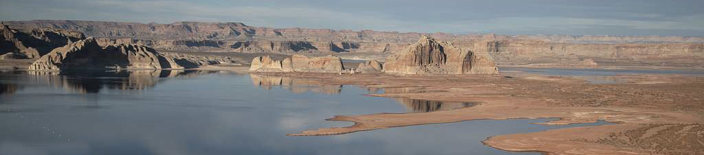
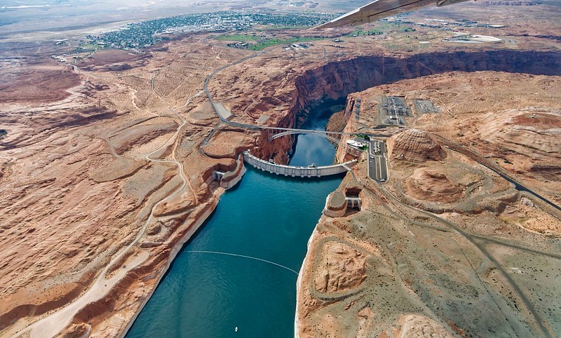
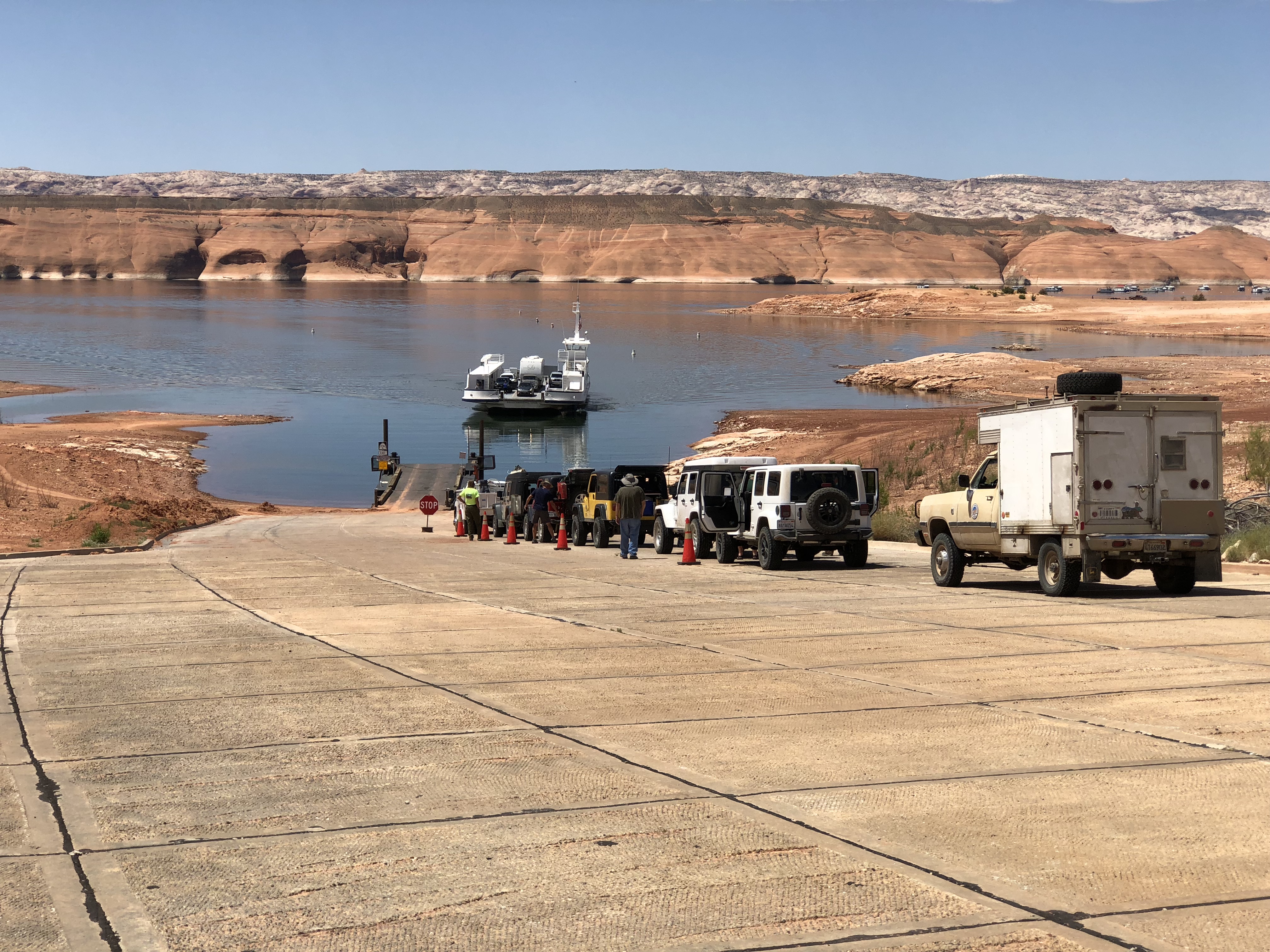
View of Glen Canyon Dam from Lake Powell. Photo credit: USBR

Click the link to read the release on the Reclamation website:

Oct 25, 2023

WASHINGTON โ€“ The Biden-Harris administration today announced next steps in the Administrationโ€™s efforts to protect the stability and sustainability of the Colorado River System and strengthen water security in the West. The Department of the Interiorโ€™s Bureau of Reclamation released a revised draft Supplemental Environmental Impact Statement (SEIS) as part of the ongoing, collaborative effort to update the current interim operating guidelines for the near-term operation of Glen Canyon and Hoover Dams to address the ongoing drought and impacts from the climate crisis.

In order to protect Glen Canyon and Hoover Dam operations, system integrity, and public health and safety through 2026 โ€“ at which point the current interim guidelines expire โ€“ an initial draft SEIS was released in April 2023. Following a historic consensus-based proposal secured by the Biden-Harris administration in partnership with states โ€“ which committed to measures to conserve at least 3 million-acre-feet (maf) of system water through the end of 2026 enabled by funding from President Bidenโ€™s Investing in America agenda โ€“ Reclamation temporarily withdrew the draft SEIS to allow for consideration of the new proposal.

Todayโ€™s revised draft SEIS includes two key updates: the Lower Basin statesโ€™ proposal as an action alternative, as well as improved hydrology and more recent hydrologic data. The release of the revised draft SEIS initiates a 45-day public comment period.

โ€œThroughout the past year, our partners in the seven Basin states have demonstrated leadership and unity of purpose in helping achieve the substantial water conservation necessary to sustain the Colorado River System through 2026,โ€ said Deputy Secretary Tommy Beaudreau, who led negotiations on behalf of the Administration. โ€œThanks to their efforts and historic funding from President Bidenโ€™s Investing in America agenda, we have staved off the immediate possibility of the Systemโ€™s reservoirs from falling to critically low elevations that would threaten water deliveries and power production.โ€

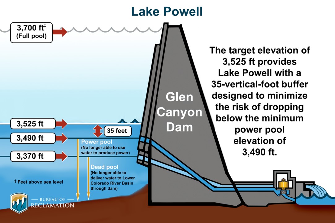
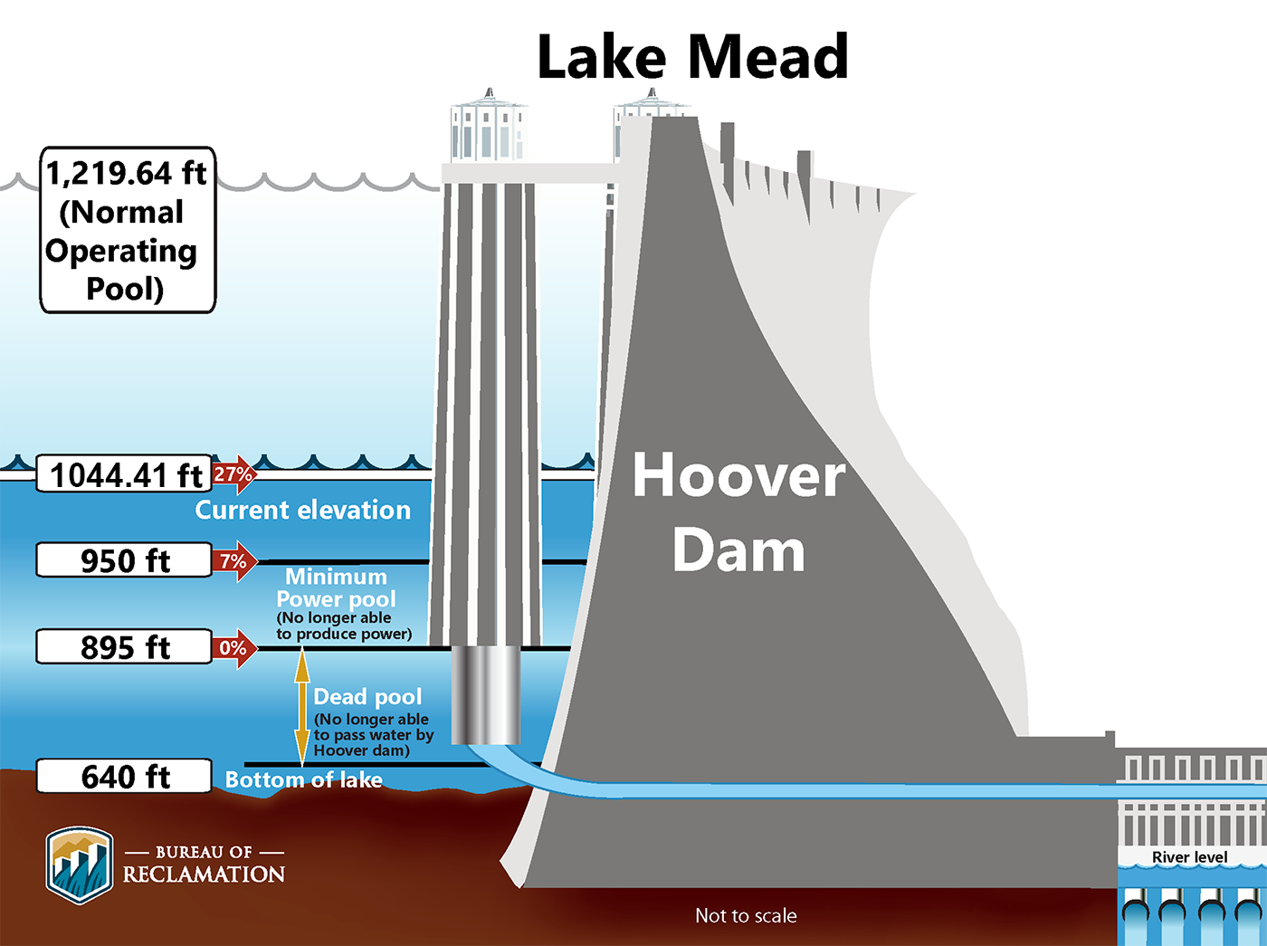
โ€œThe Colorado River Basinโ€™s reservoirs, including its two largest storage reservoirs Lake Powell and Lake Mead, remain at historically low levels. Todayโ€™s advancement protects the system in the near-term while we continue to develop long-term, sustainable plans to combat the climate-driven realities facing the Basin,โ€ said Reclamation Commissioner Camille Calimlim Touton. โ€œAs we move forward in this process, supported by historic investments from the Presidentโ€™s Investing in America agenda, we are also working to ensure we have long-term tools and strategies in place to help guide the next era of the Colorado River Basin.โ€

Key Components of Revised Draft SEIS

Reclamation conducted updated modeling analyses using June 2023 hydrology for the No Action Alternative, Action Alternatives 1 and 2 from the initial draft SEIS, and the Lower Division proposal. The results of that modeling indicate that the risk of reaching critical elevations at Lake Powell and Lake Mead has been reduced substantially. As a result of the commitment to record volumes of conservation in the Basin and recent hydrology, the chance of falling below critical elevations was reduced to eight percent at Lake Powell and four percent at Lake Mead through 2026. However, elevations in these reservoirs remain historically low and conservation measures like those outlined by the Lower Division proposal will still be necessary to ensure continued water delivery to communities and to protect the long-term sustainability of the Colorado River System.

Based on these modeling results, Reclamation will continue the SEIS process with detailed consideration of the No Action Alternative and the Lower Division Proposal. The revised SEIS designates the Lower Division Proposal as the Proposed Action. Alternatives 1 and 2 from the initial SEIS were considered but eliminated from detailed analysis.

Historic Funding from Investing in America Agenda     

President Bidenโ€™s Investing in America agenda is integral to the efforts to increase near-term water conservation, build long term system efficiency, and prevent the Colorado River Systemโ€™s reservoirs from falling to critically low elevations that would threaten water deliveries and power production. Because of this funding, conservation efforts have already benefited the system this year.

This includes eight new System Conservation Implementation Agreements in Arizona that will commit water entities in the Tucson and Phoenix metro areas to conserve up to 140,000-acre feet of water in Lake Mead in 2023, and up to 393,000-acre feet through 2025. Reclamation is working with its partners to finalize additional agreements. These agreements are part of the 3 maf of system conservation commitments made by the Lower Basin states, 2.3 maf of which will be compensated through funding from the Inflation Reduction Act, which invests a total of $4.6 billion to address the historic drought across the West.

Through the Bipartisan Infrastructure Law, Reclamation is also investing another $8.3 billion over five years for water infrastructure projects, including water purification and reuse, water storage and conveyance, desalination and dam safety.

To date, the Interior Department has announced the following investments for Colorado River Basin states, which will yield hundreds of thousands of acre-feet of water savings each year once these projects are complete:

The process announced today is separate from the recently announced efforts to protect the Colorado River Basin starting in 2027. The revised draft SEIS released today would inform Reclamationโ€™s ongoing efforts to set interim guidelines through the end of 2026; the post-2026 planning processย advanced last weekย will develop guidelines for when the current interim guidelines expire.
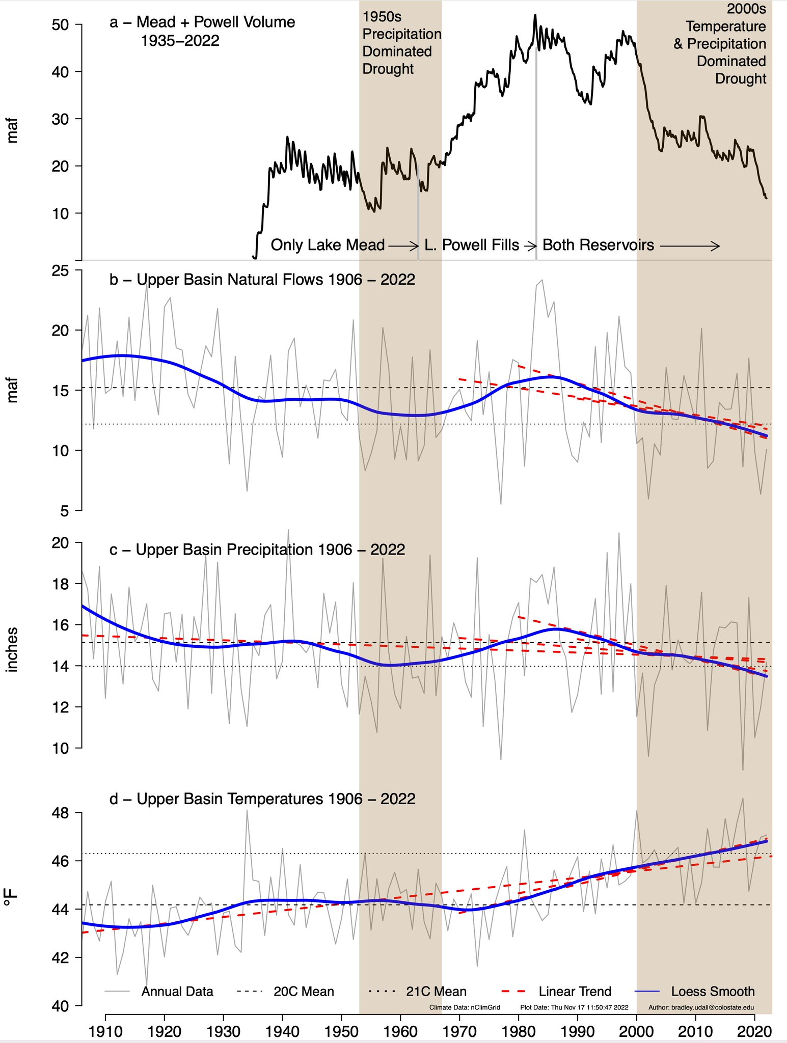
Updated Colorado River 4-Panel plot thru Water Year 2022 showing reservoirs, flows, temperatures and precipitation. All trends are in the wrong direction. Since original 2017 plot, conditions have deteriorated significantly. Brad Udall via Twitter: https://twitter.com/bradudall/status/1593316262041436160

Water Year 2023 in Context: A Cautionary Tale — Center for #ColoradoRiver Studies (Jack Schmidt) #COriver #aridification

Photo credit: Center for Colorado River Studies

Click the link to read the article on the Utah State University website (Jack Schmidt):

The end of September marked the end of Water Year 2023 (WY2023). This is a good time to take stock of the yearโ€™s runoff and to understand how much reservoir storage improved. What kind of a year was WY2023? How long will any added storage last? Can we ease our collective effort to reduce consumptive uses and losses in the basin?

In Summary

The short answer is that WY2023 was certainly a good year for runoff, reservoir inflow, and increases in reservoir storageโ€”but the same amount of inflow would have to occur for several additional years to fully recover storage to what it was in summer 1999 when the system was last full.  Such a string of high flow years has not occurred in the 21st century and is unlikely in the future.
History also warns that we should work to conserve the gains of WY2023. In notably wet WY2011, WY2017, and WY2019, extra storage that accumulated during each yearโ€™s snowmelt runoff was totally consumed in approximately two years.ย Thus, our past shows that there is potential to quickly consume the benefits of a good water year. Weโ€™ve done it before. It is imperative to keep a keen eye toward accomplishing significant reductions in water use throughout the basin to save what we have gained.ย We should not expect Mother Nature to bail us out again.
The Details

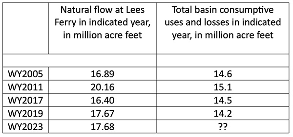
Estimates of WY2023 unregulated inflow and natural flow indicate that the yearโ€™s runoff was the second largest in the 21st century, exceeded only by WY2011. The Colorado Basin River Forecast Center estimates that the April to July unregulated snowmelt inflow to Lake Powell was 10.6 million acre feet (maf) and that the total unregulated inflow for the year was 13.4 maf. Reclamation estimates that natural flow at Lees Ferry in WY2023 was 17.7 maf (Table 1). Unregulated inflow is the estimated stream flow if little of this yearโ€™s runoff had been stored in reservoirs upstream from Lake Powell, and natural flow is the estimated flow at Lees Ferry if there were no reservoirs in the basin and no upstream consumptive uses.

Table 1. Natural flow and total basin consumptive use in the five largest runoff years of the 21st century. Total basin consumptive use includes reservoir evaporation and use by Mexico but does not include use in Lower Basin tributaries.

Data concerning reservoir storage are made available by Reclamation at their comprehensive basin-wide hydrologic data base.ย Daily water storage data are available for 46 reservoirs in the basin including all the large reservoirs and many small ones.

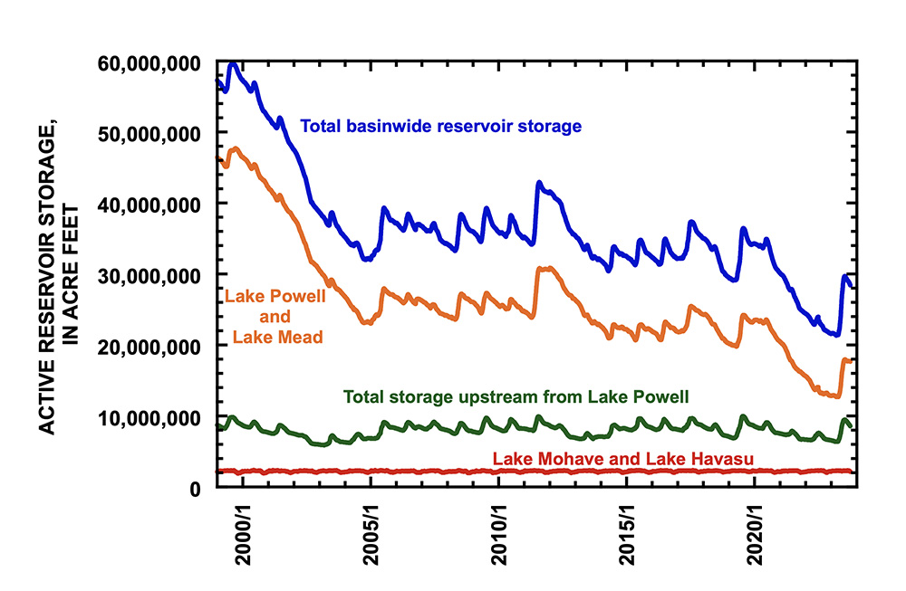
Figure 1 shows how reservoir storage changed during the 21st century. Total storage in all the reservoirs reported in Reclamationโ€™s database is shown in blue, and storage in the three different parts of the watershed are distinguished. Between 60 and 80% of all reservoir storage in the basin occurs in Lake Mead and Lake Powell (orange line). Between 16 and 32% of basin reservoir storage occurs in the many reservoirs upstream from Lake Powell (green line), and between 4 and 8% of basin storage occurs in Lake Mohave and Lake Havasu (red line) that are downstream from Hoover Dam. Graph showing daily storage contents of reservoirs of the Colorado River basin, as reported by Reclamation,
between 1 January 1999 and 30 September 2023. Data do not include reservoirs on Lower Basin tributaries.

The most striking trend in these data is that reservoir storage decreased greatly between August 1999 and October 2004 when total storage decreased by 27.4 maf and storage in Lake Mead and Lake Powell decreased by 24.5 maf. There was a small amount of recovery in storage between October 2004 and August 2019; total basin storage increased by 4.1 maf, and storage in Lake Mead and Lake Powell increased by 0.9 maf. Between August 2019 and March 2023, storage plunged again, decreasing by 14.8 maf in the entire watershed of which 11.4 maf was lost from Lake Mead and Lake Powell. These trends were described in more detail by Schmidt, Yackulic, and Kuhn (2023, The Colorado River water crisis: its origins and the future. WIREs Water).
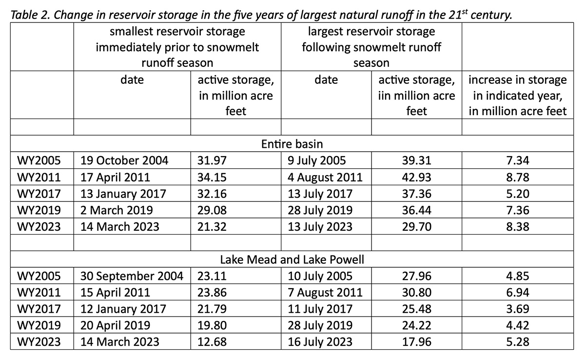
On 30 September 2023, the total storage in the watershedโ€™s reservoirs was 28.4 maf, of which 62% was in Lake Mead and Lake Powell. The storage in all reservoirs upstream from Lake Powell was 8.6 maf and comprised 30% of the total basin storage. Total basin storage in WY2023 peaked on 13 July at 29.7 maf, and the combined storage in Mead and Powell peaked on 16 July at 18.0 maf (Table 2).
How does this yearโ€™s increase in storage compare to increases in other years of large inflow? At the beginning of the WY2023 runoff season in mid-March, total reservoir storage in the basin had dwindled to 21.3 maf (Table 2), which is approximately 18 months of supply, based on the average basin-wide water consumption rate for 2016-2020. The combined storage contents of Lake Mead and Lake Powell was 12.7 maf.

Between mid-March and mid-July, total basin-wide storage increased by 8.4 maf, of which 5.3 maf accumulated in Lake Mead and Lake Powell. In comparison, the other four large runoff years of the 21stย century — 2005, 2011, 2017, and 2019 โ€“ resulted in increases in basin reservoir storage between 5.2 and 8.8 maf and increases in storage in Lake Mead and Lake Powell between 3.7 and 6.9 maf (Table 2).ย Not only was WY2023 the second largest runoff year of this century, but reservoir storage increase was also the second largest of the century.

Nevertheless, the increase in reservoir storage in WY2023 was small in comparison to the total loss in storage that had occurred since summer 1999. Between August 1999 and March 2023, the reservoir system lost 38.1 maf, and the increase in storage in WY2023 was only 22% of that amount.  It would take another 3 to 6 years of very large runoff to fully recover the basinโ€™s reservoirs to what they had been at the turn of the 21st century.

It is unrealistic to expect that the next several years will be similar to the remarkable winter of 2022-2023. No other high flow year of the 21st century was immediately followed by another high flow year. Our best hope for achieving sustainability in water supply is for the Basin States and the federal government to reach new agreements to greatly reduce basin-wide water use so that the modest recovery in reservoir storage in WY2023 might be preserved. Otherwise, our gains may quickly disappear.

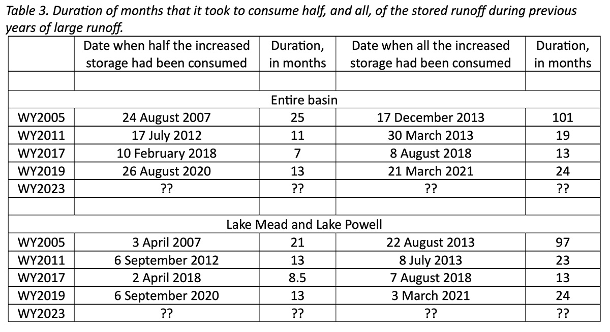
Historical data from the previous wet years of this century provide a cautionary tale about how slowly the political process responds to the opportunity provided by a wet winter. Table 3 summarizes the duration of months it took to consume the increased supply of each of the previous years of large runoff.ย Half of the supply provided by the largest inflow year of WY2011 was gone 11 to 13 months after peak storage had occurred in early August 2011; 8 to 10 months after that, all of WY2011โ€™s large runoff had been consumedย (Table 3). The historical story is the same for WY2017 and WY2019.

Since mid-July when the snowmelt season had ended, reservoir storage has begun to decline. The basinโ€™s reservoirs lost 1.3 maf of storage between mid-July and 30 September of which 0.3 maf was lost from Lake Mead and Lake Powell and 0.9 maf from the reservoirs upstream from Lake Powell. The total consumption in these 2.5 months was 16% of the โ€œbenefitโ€ of WY2023. Today, the contents of Lake Mead and Lake Powell are about the same as what they were in mid-June 2021.

A Last Thought

One strategy for maintaining a public focus on water conservation would be to widely reportโ€”every monthโ€”changes in total reservoir storage.ย The Basin States, and the basinโ€™s citizens, would benefit from knowing the rate at which we are consuming the bounty of the WY2023 supply. It would be especially useful to know the point in time when we consume half of what we gained this year.ย If we reach that point in less than a year, we would have fair warning that the political process by which we now seek to reduce water consumption is too slow. Hope for a secure and sustainable water supply must rely on nimble and adaptable strategies for reducing water consumption and saving the gains of each wet year.

Colorado River “Beginnings”. Photo: Brent Gardner-Smith/Aspen Journalism

New head of state water board (Lauren Ris) talks #conservation programs with River District — @AspenJournalism #ColoradoRiver #COriver #aridification

This hayfield near Rifle is irrigated with water from a tributary of the Colorado River. West Slope water managers say they are being left out of the process to review and approve applications of a water conservation program. CREDIT: HEATHER SACKETT/ASPEN JOURNALISM

Click the link to read the article on the Aspen Journalism website (Heather Sackett):

The newly appointed director of the state water board visited the Colorado River Water Conservation District in Glenwood Springs [October 18, 2023], and their conversation focused on a topic that has long been a concern for the district: temporary, voluntary and compensated water conservation programs.

Lauren Ris, who took over as director of the Colorado Water Conservation Board in August, replaces former CWCB director Becky Mitchell, who is turning her full attention to her position as the Colorado representative to the Upper Colorado River Commission and negotiating on behalf of the state on how to operate the Colorado River system. Ris, a water policy expert, had been deputy director of CWCB since 2017.

At the River Districtโ€™s quarterly meeting, held Wednesday, Ris talked with board members about two water conservation programs, both of which have long been contentious and critical issues for the district. In 2018, the CWCB adopted a policy statement about demand management that said it would aim to avoid disproportionate negative economic or environmental impacts to any single sub-basin or region in Colorado. Ris assured the River District that was still the case.

โ€œI donโ€™t think anything has changed about our boardโ€™s position on that,โ€ Ris said. โ€œThat has been our mantra all along.โ€

At the heart of a demand-management program would be paying Western Slope irrigators on a temporary and voluntary basis to use less water in an effort to boost Lake Powellโ€™s levels, which have fallen to historic lows as a result of overuse, drought and climate change. The participation of Western Slope agriculture is key to creating a workable program, but the River District has said propping up the Colorado River system cannot come solely at the expense of its constituents; impacts must be spread equitably across the state.

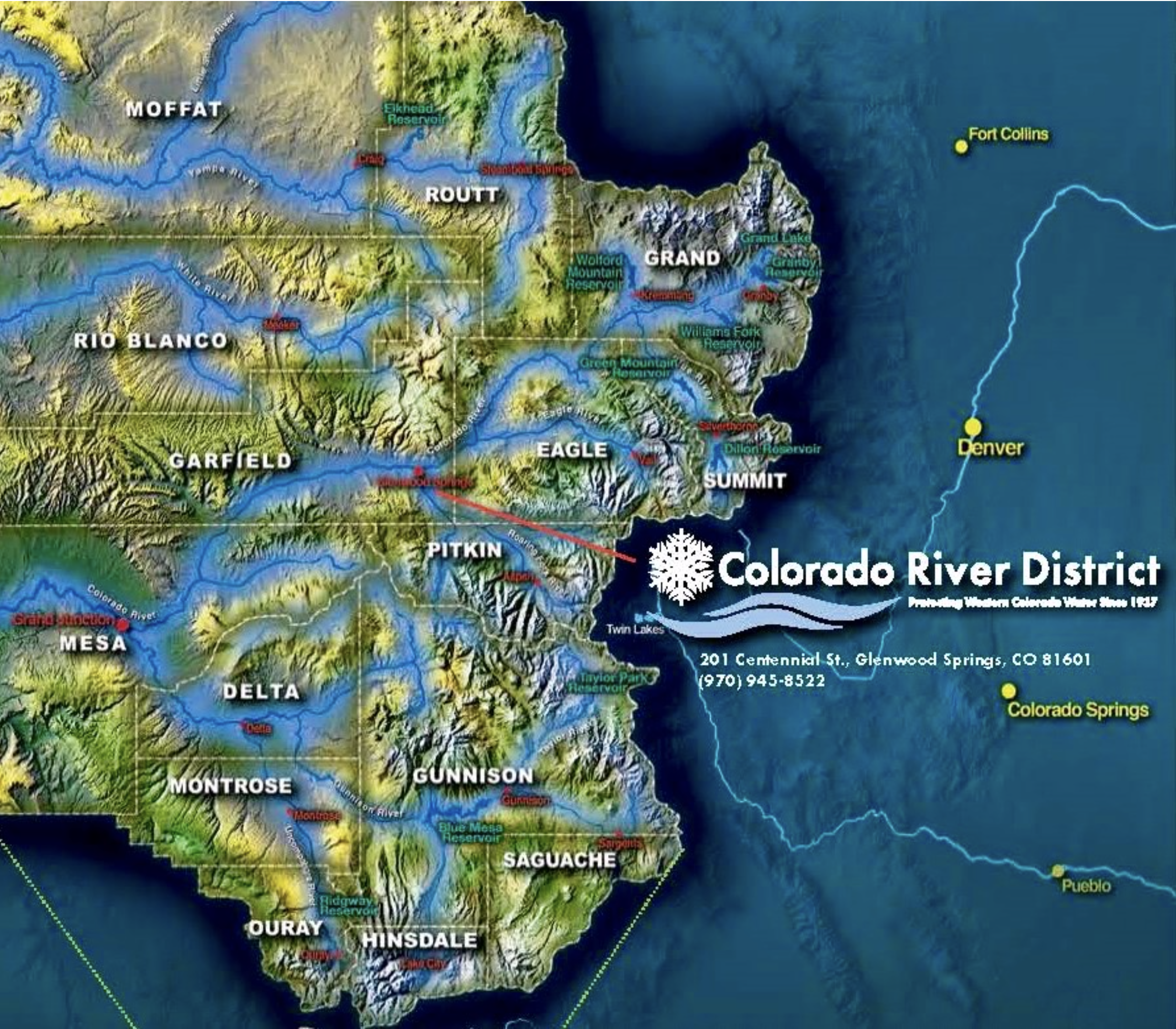
The mission of the River District, which is based in Glenwood Springs and spans 15 counties in western Colorado, is to lead in the protection, conservation, use and development of Western Slope water. Paying water users to irrigate less has long been controversial on the Western Slope, with fears that these temporary and voluntary programs could lead to a permanent โ€œbuy and dryโ€ situation that would negatively impact rural farming and ranching communities. With roughly 86% of the stateโ€™s water use in agriculture, irrigators often say they โ€œhave a target on their backโ€ when it comes to finding places to cut water use.

In 2019, the state of Colorado undertook a two-year investigation into the feasibility of a demand-management program, convening nine workgroups, but the investigation has been tabled, and so far, the state has not created a program. The River District also conducted its own parallel study of demand management.

โ€œI think itโ€™s still a question out there whether it makes sense for the state at this time with what we have available to us right now and the information we have, given everything thatโ€™s going on at the federal level, if it makes sense to pursue that,โ€ Ris said.

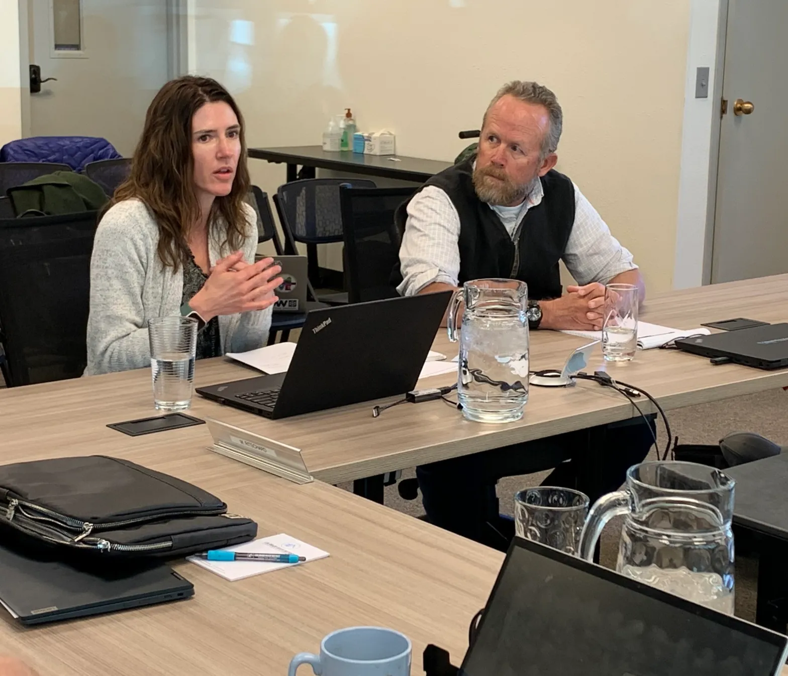
New director of the Colorado Water Conservation Board Lauren Ris and board president Greg Felt spoke to the Colorado River Water Conservation District board at its quarterly meeting in Glenwood Springs on Oct. 18. Board members had questions and concerns about two water conservation programs that could impact the West Slope. CREDIT: HEATHER SACKETT/ASPEN JOURNALISM

System conservation

Although a state demand-management program may not be on the immediate horizon, another upper basin water conservation program โ€” which is conceptually similar โ€” will take place for a second year, in 2024: system conservation. Administered by the Upper Colorado River Commission and funded by the federal Inflation Reduction Act, system conservation pays water users in Colorado, Wyoming, Utah and New Mexico to cut their water use, typically by drying up fields, for one season.

The River District had sought to have a say in the project approval process, going so far as developing its own criteria for projects within its boundaries. But in March, water managers said that the UCRC had sole authority over the program and that the River Districtย could not be involvedย in approving 2023 projects after all.

A recent studyย makes the case for River District involvement and points out what many already know: Water users in the Colorado River basin have a preference for local approaches to water conservation and do not trust formal programs run by state or federal officials โ€” such as the UCRC. But despite this evidence, there probably wonโ€™t be an oversight role for the River District in system conservation again in 2024.

โ€œIs there a role for the conservation districts to help them in that process of looking at applications?,โ€ River District board president and Eagle County representative Kathy Chandler-Henry asked Ris. โ€œWe feel like weโ€™re one level closer to the users on the ground and able to support that process.โ€

Ris replied that system conservation is being run by UCRC and that even the CWCBโ€™s role is fairly limited.

Greg Felt, CWCB chair and representative from the Arkansas River basin, accompanied Ris at the River District meeting. The CWCB will consider whether to approve system conservation again for 2024 at its November meeting. He said he does not like the idea of paying people not to farm, but the 2024 program will have a narrower scope that explores demand-management concepts and supports innovation and local drought resiliency on a longer-term basis.

โ€œWhat we were presented with was an additional layer, which was to prioritize projects that either helped enhance drought resiliency or conservation,โ€ Felt said. โ€œAll of a sudden, I saw a value there that I hadnโ€™t seen before. โ€ฆ I can get behind this because I think it will really help agriculture.โ€

Ris said that, going forward, the process would have more transparency, echoing a promise made by Mitchell.

For the 2023 program, the UCRC released few details about the individual projects. Payment amounts, the exact location of projects, names of participating ditches and information about water rights, including priority dates and decreed amounts of water, were redacted in the publicly available contracts between irrigators and the UCRC.

โ€œWeโ€™re committed to making some changes based on the feedback that we heard,โ€ Ris said. โ€œWe are planning on making as much information as possible available to interested parties. โ€ฆ We will still redact personal identifying information but are going to try and go light on the black pen.โ€

River District General Manager Andy Mueller said transparency for SCP 2024 was imperative, but he also pushed for a process to protect the districtโ€™s water users.

โ€œI know (demand management and system conservation) are two different programs, but they may potentially have the same effect inside of our state, and that is reducing consumptive use and potential injury,โ€ Mueller said. โ€œWeโ€™d love to work with you to continue to improve both protections on injury and how we address proportionality. We think those are really important to our water users. This board has voiced great concern.โ€

Ris said the CWCB shares that concern and that the two agencies should continue to talk about it as they go forward.

This story ran in the Oct. 22 edition ofย The Aspen Times.

A map showing the boundaries of the Colorado River District, and its 15 member counties

Water usage on the #ColoradoRiver is way down as the West begins planning for a future with less — CNN #COriver #aridification

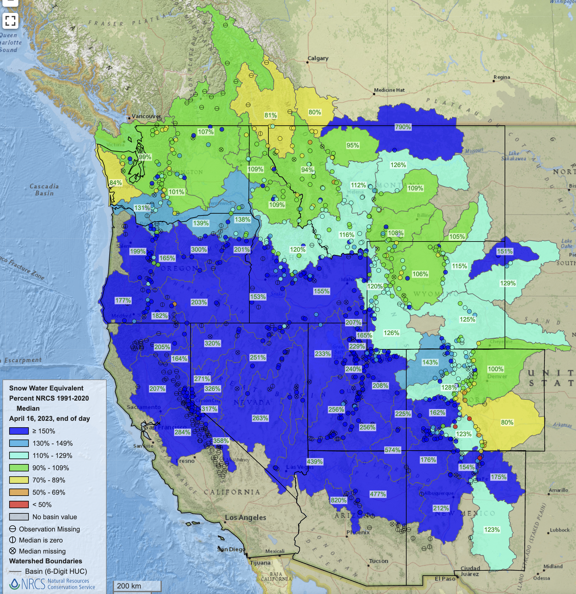
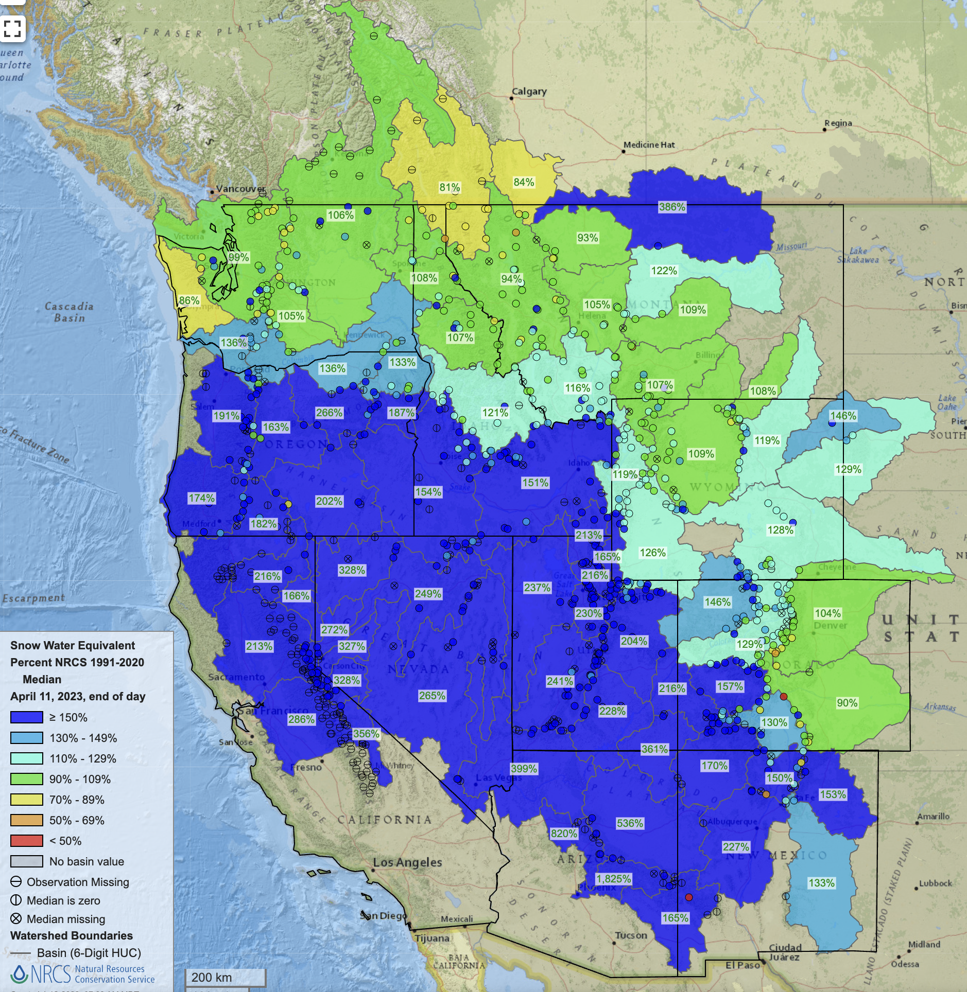
West snowpack basin-filled map April 16, 2023 via the NRCS.

Click the link to read the article on the CNN website (Ella Nilsen). Here’s an excerpt:

Aย record-breakingย winter snowpack last year halted a precipitous downward spiral on the river and raised water levels at the nationโ€™s two largest reservoirs, Lakes Mead and Powell. But something else is also at play this year โ€“ farmers, cities and Native tribes are simply using less. Arizona, California and Nevadaโ€™s usage of Colorado River water has hit new lows, state officials and US Bureau of Reclamation Commissioner Camille Calimlim Touton told CNN in an interview.

โ€œThe record conservation is already seeing its impact within the reservoirs,โ€ Touton said. โ€œItโ€™s easy to see our success within the levels of the reservoirs we manage.โ€ Lake Powell has risen 52 feet since hitting a low point in February of this year, while Mead has risen nearly 23 feet since November…

Part of the reason is last winterโ€™s blockbuster precipitation, which helped replenish levels in reservoirs across the West. In California, southern cities like Los Angeles that are normally more dependent on Colorado River waterย have been able to pullย more from its own refilled reservoirs like Lake Oroville…

[Bill] Hasencamp told CNN the three lower-basin states have only used 5.8 million acre-feet this year of the 7.5 million acre-feet they are allotted annually.

โ€œWeโ€™re pretty much at a sustainable level,โ€ Hasencamp said. โ€œIt really gives hope for the future. Despite it being a wet winter, weโ€™re going to do everything we can to reduce use and work with the feds.โ€

Updated Colorado River 4-Panel plot thru Water Year 2022 showing reservoirs, flows, temperatures and precipitation. All trends are in the wrong direction. Since original 2017 plot, conditions have deteriorated significantly. Brad Udall via Twitter: https://twitter.com/bradudall/status/1593316262041436160

The Upper #ColoradoRiver Basin Compact at 75 — John Fleck and Eric Kuhn (InkStain) #COriver #aridification

Colorado River “Beginnings”. Photo: Brent Gardner-Smith/Aspen Journalism

Click the link to read the article on the InkStain website (John Fleck):

Editorโ€™s note: Today (Oct. 11, 2023) is the 75th anniversary of the signing of the Upper Colorado River Basin Compact. The following is an excerpt from Revisiting the Upper Colorado River Basin Compact on its Diamond Anniversary, a forthcoming analysis by Eric Kuhn and John Fleck, co-authors of the book Science Be Dammed: How Ignoring Inconvenient Science Drained the Colorado River.

BY ERIC KUHN AND JOHN FLECK

The Upper Colorado River Basin Compact was signed by representatives from Arizona, Colorado, New Mexico, Utah, and Wyoming on October 11, 1948, after over two years of negotiations. It was an attempt to resolve the allocation of water among the five states, and for three quarters of a century it performed that task well.

But as we approach the middle of the third decade of the 21st century, the challenges of overallocation of Colorado River, over-appropriation of the water we have, and climate change reducing the riverโ€™s flows, the Upper Basin Compact and the extended body of rules in which it is embedded are showing their age.

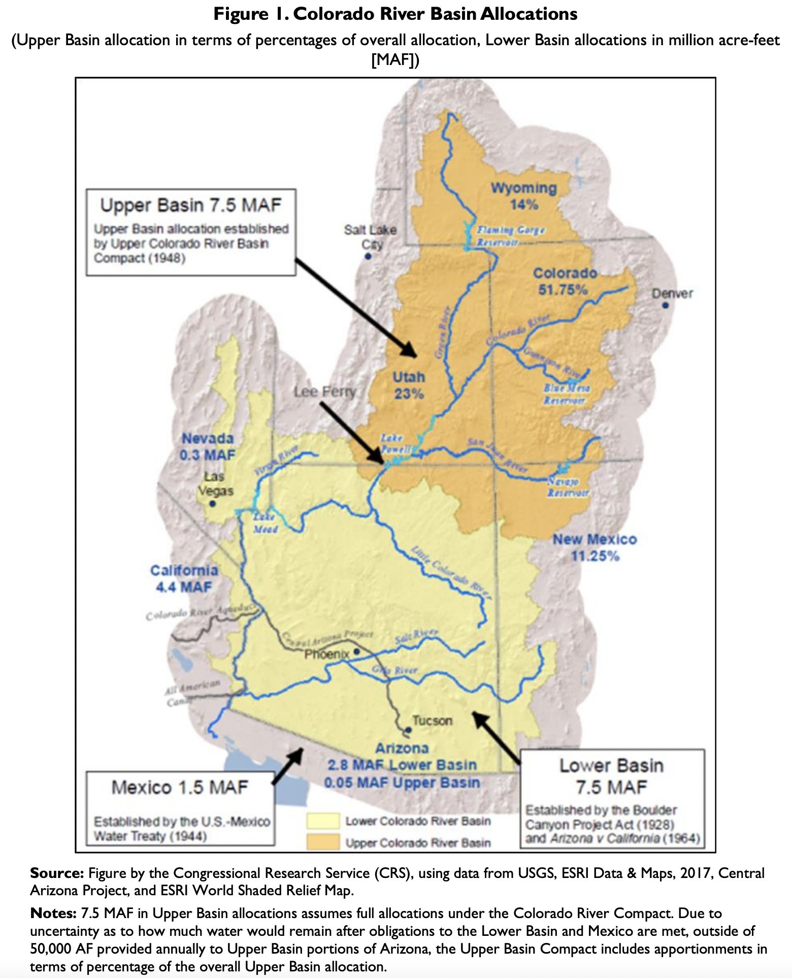
At its simplest, the Upper Basin Compact divided the water use available from the 7.5 million acre-feet per year apportioned to the Upper Basin by the 1922 Colorado River Compact. The compact accomplished two major tasks:

  • It apportioned the consumptive use of water among the Upper Basin states using percentage allocations. Colorado received 51.75%, New Mexico 11.25%, Utah 23%, and Wyoming 14% of the water available for use in the Upper Basin. Arizona received a fixed 50,000 acre-feet per year.
  • It defined the obligations of the Upper Division states (Colorado, New Mexico, Utah, and Wyoming) to deliver water to the Lower Basin at Lee Ferry to satisfy the requirements of the Colorado River Compact.

In pursuing a new set of post-2026 Colorado River Operating rules, major water agencies and state leaders have insisted that the โ€œLaw of the Riverโ€ โ€“ the suite of rules dating to the 1922 Colorado River Compact and including the Upper Basin Compact โ€“ should be a fundamental guiding principle of future river management. โ€œThe Post-2026 Operations should reside in a framework consistent with a reasonable interpretation of the Law of the River,โ€ the Central Arizona Project wrote, to cite one example among many.[1]ย But a careful review of the history of the Upper Basin Compact shows how tenuous a foundation the Law of the River provides, and how uncertain any attempt at โ€œreasonable interpretationโ€ might be, because of fundamental uncertainties about what the Law actually says.

  • When the Upper Basin compact was signed there was agreement on the definition of the โ€œwhatโ€ to which the percentage allocations apply. Water use in the Upper Basin was limited by water availability after meeting the Colorado River Compactโ€™s Lee Ferry delivery requirements. Today, because of the impacts of climate change on flows, there is no such agreement and there are claims that the intent of the compact was to provide an equal amount of water for use to each basin. This creates deep uncertainty in the actual volumes of water available to each state.
  • There is still no consensus on how to measure consumptive use basin-wide. The Upper and Lower Basins use different methods, and Lower Basin tributary use is neither well understood nor quantified. This makes managing the river system challenging.
  • The Upper Division States claim overuse by the Lower Basin based by using one measurement method, while using a different method for their own uses. There is valid dispute over these theories and methodologies.
  • Tribal water rights remain unresolved and limited in some cases by provisions aimed at preventing tribes from using their full legal entitlements.
Native America in the Colorado River Basin. Credit: USBR

In negotiating the Upper Basin Compact, the states made key decisions on critical compact issues that continue to echo through 21st century water management.

STREAM DEPLETION

Colorado River management has always suffered under controversy and ambiguity around the question of how to measure consumptive use. The Colorado River Compact did not include a definition of โ€œbeneficial consumptive use.โ€ In the century since it was signed, two competing (and conflicting) methods have been used: diversions less return flow, and stream depletion. On some scales, they may look the same. But on large enough scales, they do not, in ways that have profound implications for 21st century river management decisions.

Under the stream depletion theory, each basinโ€™s consumptive use is measured as the net reduction in natural flows caused by man-made activities. For example, the Upper Basinโ€™s consumptive use would be calculated as the amount that upstream uses deplete the natural flow of the river at Lee Ferry.

During the Upper Basin Compact negotiations, Colorado and Arizona were the main proponents of this theory. It was ultimately adopted in Article VI of the Upper Basin compact as the method for measuring consumptive use.

But the stream depletion theory is not universally used in river management today. It is, for example, used to quantify reservoir evaporation in the Upper Basin, but not the Lower Basin. It is not used to measure Lower Basin mainstream uses, where the โ€œdiversions minus return flowsโ€ method is used instead. Uses on the Lower Basin tributaries, which are included in the compact definition of โ€œColorado River Systemโ€ are currently not measured at all โ€“ using either theory.

ALLOCATING STATE WATER BY PERCENTAGES RATHER THAN ABSOLUTE AMOUNT

The Upper Basin Compact is frequently praised for state-by-state allocations based on percentages (except Arizona), rather than absolute numbers, thus avoiding the mistake in the Colorado River Compact that over-allocated the riverโ€™s water.

But modern policy discussions are unsettled on a central issue โ€“ percentage of what? On their own, the percentages are meaningless without reference to some sort of underlying total amount of water available to be shared among the states.

When negotiating the Upper Basin Compact, the statesโ€™ representatives were clear on what they intended as the basis for using the percentages. They intended to apply the percentages to the amount of water available for consumptive use in the Upper Basin after meeting what they viewed as their compact โ€œdelivery obligationsโ€ at Lee Ferry.

Updated Colorado River 4-Panel plot thru Water Year 2022 showing reservoirs, flows, temperatures and precipitation. All trends are in the wrong direction. Since original 2017 plot, conditions have deteriorated significantly. Brad Udall via Twitter: https://twitter.com/bradudall/status/1593316262041436160

Today, there is no such consensus. Climate change has altered the riverโ€™s hydrology, putting the burden of impacts on the Upper Basin. Its leaders have responded by arguing that the compactโ€™s negotiatorโ€™s intention was to equally divide the water available to each basin for use. Since climate change is causing a decline in natural flows, whatever Lee Ferry obligations the Upper Division States have must now be adjusted to reflect the new hydrologic reality.

Resolving this issue requires either litigation, negotiated settlement, or collectively agreeing on a modified approach โ€“ one that appropriately factors in climate change and maintains the benefits of the 1948 flexible percentage allocations.

TRIBAL WATER

While large Native American water needs and legal entitlements were identified before the Upper Basin Compact was negotiated, Tribal communities were excluded from the negotiations. Instead, Indian water use, which the negotiators knew was legally perfected long before 1922, was lumped into state allocations, with each state being responsible for meeting tribal needs from its share of the water. This gamble set up a potential conflict between the apportionments made by the Upper Basin Compact and the protections provided Indian rights under the Colorado River Compact.

A decade after the compact was signed, this conflict became real. In response, Upper Basin leaders took steps to limit tribal water rights and prevent full use of tribal entitlements, by inserting provisions in project authorizing legislation. The implications today are a legacy of intentional discrimination against tribes, unresolved legal questions around tribal water rights, and provisions that treat Native Americans as second-class citizens.

[1]ย Brenda Burman letter to Bureau of Reclamation, Aug. 15, 2023. See also comments by the state of Wyoming, the Salt River Project, the state of Colorado and the Upper Colorado River Commission.

Map credit: AGU

Report: Cash isnโ€™t enough to bring #ColoradoRiver Basin growers to the water #conservation table — Fresh Water News #COriver #aridification

Rancher Bryan Bernal irrigates a field that depends on Colorado River water near Loma, Colo. Credit: William Woody

Click the link to read the article on the Water Education Colorado website (Jerd Smith):

Ranchers and farmers across the Colorado River Basin, who control roughly 80% of the drought-strapped riverโ€™s flows, are reluctant to sign up for voluntary, government-funded water conservation programs for a variety of reasons identified in a new report.

Chief among them are a fear of losing their water rights, seeing their water use reduced, and engaging with far-off bureaucracies that they believe arenโ€™t qualified to help.

โ€œAgricultural Water Usersโ€™ Preferences for Addressing Water Shortages in the Colorado River Basinโ€ย is a study conducted by the Western Lands Alliance (WLA) in partnership with the Ruckelshaus Institute at the University of Wyoming in Laramie. Released late last month, it includes survey responses from more than 1,000 ranchers and farmers in six Colorado River Basin states, as well as interviews with producers. The WLA represents landowners and agricultural producers across the West.

The WLA launched the research effort to better understand how agricultural water users in the region view different water conservation efforts and what it would take to convince them to participate. Hallie Mahowald, a co-author of the report and chief programs officer at the WLA, said in a webinar in September that the landowners will be key to finding solutions to the growing shortages on the river because they control so much of its water.

โ€œWe feel it is critical to understand landowner perspective and to solicit landowner input if we are going to develop successful strategies to address Western water shortages,โ€ she said.

Updated Colorado River 4-Panel plot thru Water Year 2022 showing reservoirs, flows, temperatures and precipitation. All trends are in the wrong direction. Since original 2017 plot, conditions have deteriorated significantly. Brad Udall via Twitter: https://twitter.com/bradudall/status/1593316262041436160

The report comes as the river basin remains mired in a long-running drought that has come close to crippling lakes Powell and Mead and experiences ongoing shortages as climate change continues to sap its flows.

At the same time, hundreds of millions of dollars in federal funding is being made available to help the Colorado River Basin states better manage the river, reduce water use, and develop programs to sustain the basinโ€™s cities and farms as the region continues to warm.

Drew Bennett, MacMillan Professor of Practice in Private Lands Stewardship at the University of Wyoming in Laramie, said the survey results show a disconnect between ranchers and farmers and the agencies who are charged with overseeing Colorado River Basin water management. In fact, more than 85% of those surveyed said they did not trust the water agencies that help manage the giant river system.

 โ€œWe need to build additional trustโ€ฆit will be absolutely critical moving forward,โ€ Bennett said.

And while more than 50% of those surveyed are engaging in at least limited conservation practices, they are not interested in doing more if their water rights arenโ€™t strongly protected, if they are not adequately compensated, and if the programs arenโ€™t administered locally.

This lack of trust, the report says, โ€œmay create a barrier to gaining buy-in for new water management strategies, even if they are supported by significant funding from state and federal government agencies.โ€

The river basin spans seven states. The Upper Basin includes Colorado, New Mexico, Utah and Wyoming, and the Lower Basin includes Arizona, California and Nevada.

Researchers broke out survey responses based on which basin a grower operates in. Key findings of the report include:

  • 97% of Upper Basin growers (Colorado, New Mexico, Wyoming and Utah) and 96% of Lower Basin growers (Arizona, California and Nevada) are worried about coming shortage-related changes in water policy and new constraints on their water use.
  • Just 14% of Upper Basin growers and 13% of Lower Basin growers believe that existing water policies and management practices are adequate to address coming shortages.
  • 69% of Upper Basin and 74% of Lower Basin growers have implemented at least one water conservation practice, largely in response to local water shortages.
  • 56% of growers in both basins would engage in programs to improve their water delivery systems if funding is provided.
  • Just 8% of Upper Basin and 18% of Lower Basin growers would participate in programs that would fallow, or cease production, on the same field for multiple years.
  • And just 13% of Upper Basin and 14% of Lower Basin growers said there was a high level of trust between water users and water management agencies.

In Colorado, the Colorado Ag Water Alliance has been working to help producers use water more efficiently to prepare for future droughts and manage with less water. But CAWAโ€™s Executive Director Greg Peterson said itโ€™s a difficult task.

โ€œOur goal is to help these people survive. People [who donโ€™t farm] donโ€™t actually understand that there are few opportunities to reduce water use in an agricultural setting,โ€ Peterson said. โ€œYou might be able to reduce water use by 5% or maybe 10% without reducing yields. But itโ€™s not easy to do.โ€

Wyoming and other basin states have begun installing sophisticated new technologies that help determine how much water crops consume, known as consumptive use, and how much water runs off and returns to the river or natural environment after a field has been irrigated. This is a critical measurement because it is only the consumptive use portion of irrigation water that can be administratively โ€œsavedโ€ as water left in the river system.

Jeff Cowley is administrator for interstate streams in the Wyoming State Engineerโ€™s Office, the top water regulator in the state. Cowley is implementing new conservation technologies and working with growers who are already participating in one of the new federal programs known as the System Conservation Pilot Program.

Homing in on how much water is saved and left in the river is a complicated question whose answer differs from field to field and crop to crop. When water was plentiful, before the drought and climate change, there was enough water that this kind of precision wasnโ€™t required. But that is no longer the case.

Cowley said this new level of precision is another critical factor in working with skeptical farmers and ranchers because it provides some certainty on what impact programs could have on their water supplies.

โ€œFolks are attached to their water,โ€ Cowley said. โ€œThey are willing to try new things, but not on their own dime.โ€

And any given year, he said, โ€œthere is not a lot of room for mistakes.โ€

Fresh Water News is an independent, nonpartisan news initiative of Water Education Colorado. WEco is funded by multiple donors. Our editorial policy and donor list can be viewed at wateredco.org.

More by Jerd Smith Jerd Smith is editor of Fresh Water News. She can be reached at 720-398-6474, via email at jerd@wateredco.org or @jerd_smith.

Click here to download the report. (Bennett, D., Lewis, M., Mahowald, H., Collins, M., Brammer, T., Byerly Flint, H., Thorsness, L., Eaton, W., Hansen, K., Burbach, M., and Koebele, E. 2023.). Here’s the executive summary:

Executive Summary
The Colorado River Basin is in crisis. There is no longer enough water for all of those who depend on it. The agricultural sector is the largest water user in the Colorado River Basin, meaning that farmers and ranchers are central to both the impacts of and solutions to water shortages. Their involvement will be key to developing effective policy solutions to todayโ€™s water crisis.

We surveyed 1,020 agricultural water users throughout six states in the Colorado River Basin to understand their perspectives on the present crisis, their current water conservation practices, and their preferences for strategies to address water shortages going forward. Agricultural water users were primarily concerned about how the current situation could impact water policy, constrain irrigatorsโ€™ own water use, and constrain other agricultural water users. We also conducted qualitative research to capture preferences for local approaches to managing water and provide additional context on dynamics in the Colorado River Basin, including interviews with 12 agricultural producers and water experts and a focus group with 10 agricultural water users in Colorado.

Perhaps unsurprisingly, we found agricultural water users are already responding to water shortages. Roughly 70% of surveyed agricultural water users have already adopted one or more water conservation practices or adaptation strategies. Importantly, many would consider adopting additional practices. Despite this, few respondents participated in or were aware of formal programs to support water conservation. One exception, however, was the Natural Resources Conservation Serviceโ€™s Environmental Quality Incentives Program (EQIP). A third of respondents currently or previously participated in EQIP and an additional 37% were aware of the program. Information gathered from interviews and the focus group identified multiple burdens to participation in EQIP and similar programs, and several participants thought the benefits were not worth the effort. These insights suggest an opportunity for revisiting how formal programs meant to incentivize water conservation connect with water users.

Most survey respondents were unlikely to adopt water conservation practices as part of formal demand management or system conservation programs to address water shortages. Only one of eight practices included in the survey โ€“ enhancing water delivery systems โ€“ had a majority of respondents state that they were likely to adopt the practice. The remaining seven practices had a considerably lower likelihood of adoption. Respondents were also generally opposed to water transfers as a solution to shortages. Opposition was strongest to permanent transfers broadly, as well as to temporary transfers from agricultural to non-agricultural uses. Only temporary transfers from agricultural water users to other agricultural water users had less than 50% opposition. Major barriers to supporting water transfers included concerns about losing water rights, even in temporary transfer arrangements, as well as insufficient financial compensation. Addressing these concerns will be critical to increase participation of
agricultural water users in demand management or system conservation. Still, although support for temporary water transfers and demand management practices was low, even equivalently low participation (e.g., 10% to 20%) could help address water shortages as part of a portfolio of strategies for the Colorado River Basin.

We also documented an overwhelming preference for local approaches to managing water shortages and a trust gap with non-local agencies. This was evidenced by respondentsโ€™ preference for the local management of formal programs, such as some of the demand management and system conservation programs under consideration, as well as for the administration of funding for water conservation and other programs. Qualitative research participants communicated that strategies to address water shortages must account for the diversity of local contexts across the Colorado River Basin. These strategies could therefore be best implemented at the local level through existing delivery infrastructure and by managers with track records of success. State and federal water managers and agencies involved in program delivery should emphasize building trust with agricultural water users and gaining knowledge about unique features of local contexts. Simply providing additional funding for formal water conservation programs may be inadequate to meet the diversity of challenges across an area of 246,000 square miles. Developing opportunities for dialogue and listening can help foster relationships and improve trust among key stakeholders.

Given the importance of agriculture as the primary water user in the Colorado River Basin, proactively engaging agricultural communities will be critical to successfully managing water shortages. Understanding the perspectives and preferences of agricultural water users, as documented in this report, can help guide the development of solutions that work for producers and other users in the Basin.

Map of the Colorado River drainage basin, created using USGS data. By Shannon1 Creative Commons Attribution-Share Alike 4.0

Medians get a makeover in #Denverโ€™s Central Park: Landscape transformation set to save millions of gallons of water along busy city corridor — News on Tap

Denver Parks and Recreation is replacing the Kentucky bluegrass in four medians along Quebec Street in Denver and turning it into a prairie grass meadow. The project will save millions of gallons of water every year. Denver Water and the Colorado Water Conservation Board are helping fund the project. Learn about the project in this video

Click the link to read the article on the Denver Water website (Jay Adams):

Itโ€™s not often that a median in the middle of a street gets a lot of attention, and that makes it a perfect candidate for a landscape makeover.

For decades, the four medians separating the north and southbound lanes of Quebec Street, just south of Interstate 70 between Smith Road and Martin Luther King Jr. Boulevard, have featured 10 acres of thirsty Kentucky bluegrass.ย 

Now, the Denver Parks and Recreation department is transforming the grass fields into prairie grass meadows that will be home to a more appropriate type of ColoradoScape that needs significantly less water to thrive.

โ€œThe medians had what we call โ€˜nonfunctional grass,โ€™ which means the grass was not being used for any type of activity. That made it a perfect location for landscape transformation,โ€ said Ian Schillinger-Brokaw, a Denver Parks and Recreation urban ecology planner. 

โ€œWe were using around 9 million gallons of water every year to keep grass green that no one used, so it was really not a good use of water.โ€

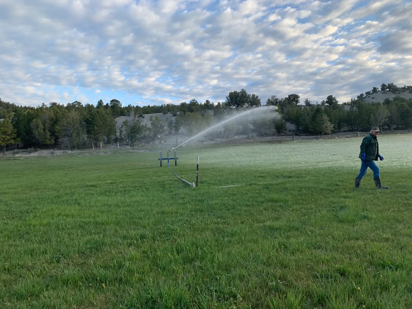
Sprinklers irrigate the old, water-intensive Kentucky bluegrass fields before the project in June 2023. The bluegrass on the Quebec Street medians required additional irrigation to stay green during the summer. Photo credit: Denver Water.

The landscape transformation project on the four medians is being done in partnership with Denver Water, which is helping to fund the work. 

The project also received money from the Colorado Water Conservation Boardโ€™s Turf Replacement Program, which uses state funds to help transform water-intensive turf into a more natural ColoradoScaped environment.

What to expect

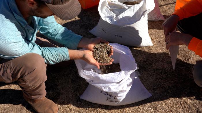
During summer 2023, the city shut off the sprinklers and let the bluegrass die. Then in September, landscape crews from Western States Reclamation planted more than 60 species of prairie grasses and wildflower seeds through the remains of the dead bluegrass. 


Learn more about ColoradoScaping at denverwater.org/Conserve.


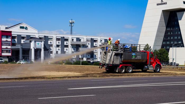
After the seeds were in the ground, workers sprayed the field with โ€œhydromulch,โ€ which is the process of spraying water mixed with small particles of wood fiber on top of the seeds, so they donโ€™t blow away or get eaten by birds.

The field will be watered over the next two to three years to help the seeds grow. Depending on the weather, some grasses will sprout this fall, while others will begin to grow next spring and summer. 

It will take roughly three years for the new plants to become established.

A tractor plants seeds across the Quebec Street medians in September. It will take about three years for the plants to be fully established. Photo credit: Denver Water.

“The field will have a variety of grasses with different heights, colors and textures and the wildflowers will provide an added boost of color,โ€ Schillinger-Brokaw said.

The wide variety of plants will help the new prairie meadows thrive in different weather conditions. For example, some grasses and flowers will do better in dry years, while others will grow better in wet years.

Workers spray hydromulch on the field after seeding. The hydromulch is a mix of water and tiny wood particles that will protect the seeds from blowing away and improve germination. Photo credit: Denver Water.

โ€œBy adding a variety of grass species, weโ€™re ensuring that each season the field will have plants that are in good shape,โ€ he said.

โ€œThe field will look very similar to some of our other parks and open spaces in the area, such as Westerly Creek and Prairie Meadows parks.โ€

Schillinger-Brokaw said the landscape will keep safety in mind by making sure plants around the corners of the medians will be shorter, so they wonโ€™t impact driversโ€™ ability to see other cars and make safe turns at the intersections.

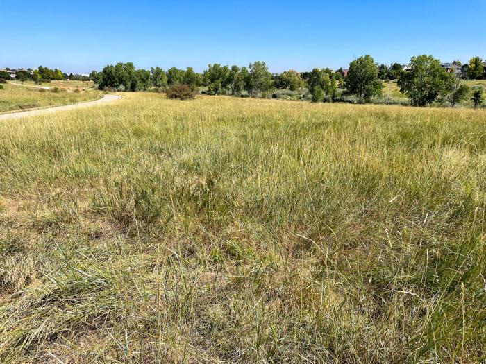
The Quebec Street medians will have a native prairie grass look similar to the landscape at Westerly Creek Park in northeast Denver. Photo credit: Denver Water.
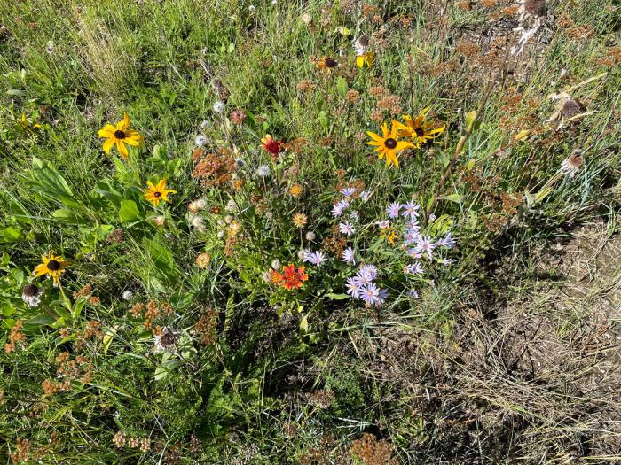
The new prairie meadow will feature a variety of wildflowers with different colors and bloom times. Photo credit: Denver Water.

Water savings

Before the landscape conversion, the field required roughly 9 million gallons of extra water every year to keep the Kentucky bluegrass green. By transitioning to a prairie meadow, the goal is to eventually stop watering the field and let Mother Nature provide all the moisture the plants need to survive, Shillinger-Brokaw explained.

The Denver Parks and Recreation department will continue to water the trees on the medians. However, by eliminating the extra irrigation that the bluegrass needed, the overall water use for the medians could be reduced by roughly 8.5 million gallons each year once the plants are established.

Carpio-Sanguinette Park near the National Western Center in Denver features native prairie grasses and wildflowers that use 70% less water than fields of water-intensive Kentucky bluegrass. Photo credit: Denver Water.

โ€œKentucky bluegrass has been used as the default form of landscaping for decades across many parts of Colorado, but it requires a lot of water,โ€ said Austin Krcmarik, a water efficiency planner at Denver Water. 

โ€œWith water being such a scarce resource across the West, itโ€™s great to see Denver Parks and Recreation switching to landscaping that fits our climate.โ€

Additional benefits

The new medians full of prairie grasses and wildflowers are an example of ColoradoScaping, which is landscaping that features low-water-use plants that thrive in our stateโ€™s semi-arid climate.

Along with water savings,ย ColoradoScapingย provides additional benefits for Denverโ€™s parks, such as:

  • Providing more resilient landscapes that can cope with extreme weather, such as drought.
  • Adding biodiversity to the city with new habitats for pollinators such as birds and bees. 
  • Establishing areas that improve stormwater drainage and improve water quality.
  • Eliminating the need for mowing the medians regularly throughout the summer.
  • Saving money on water bills that can be used for other park improvements. (The water savings on the Quebec Street project will save Denver Parks and Recreation roughly $20,000 each year.)
ColoradoScaping helps improve the biodiversity of the city. Adding new habitats in the Quebec Street medians provides โ€œfuel stopsโ€ for birds and bees as they move around the city. Photo credit: Denver Water.

Saving water across the West

Water-saving projects like the Quebec Street median turf conversion are critical because Denver Water gets half of its water supply from the Colorado River Basin, which has seen drought conditions over much of the last 23 years.

โ€œDenver Water and other utilities across the West are actively promoting and working with cities and park districts to look for areas of nonfunctional Kentucky bluegrass and see if other types of landscaping is a better fit to help save water,โ€ Krcmarik said. 

Itโ€™s In Denverโ€™s Nature

The transformation of the Quebec Street medians is an example of Denver Parks and Recreation implementing the Game Plan for a Healthy City.

The comprehensive plan serves as a roadmap to the future of Denverโ€™s park system. A key aspect is investing in the fight against climate change through conserving water, transforming landscapes, growing the urban canopy and protecting habitats.ย 

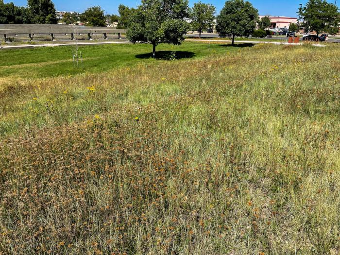
A mix of seeds from more than 60 kinds of flowers and grasses will ensure that the medians, once a bland, expanse of water-intensive Kentucky bluegrass, will be home to a wide variety of prairie grasses and wildflowers sporting different textures and colors. Photo credit: Denver Water.

As part of the plan, in April 2023, Denver Parks and Recreation changed its policy of using thirsty turfgrass, like Kentucky bluegrass, as its primary landscaping groundcover in areas with no recreational value. The Quebec Street medians are an example of how the city is using drought-tolerant and ecosystem-friendly plants instead of turfgrass.

โ€œWeโ€™re doing a lot across the city to reduce our water footprint and the Quebec Street medians project is one of the biggest landscape transformation projects weโ€™ve done,โ€ Shillinger-Brokaw said.

โ€œWe ask for patience as these new grasses grow, and weโ€™re excited to see the new look coming soon to this part of the city.โ€

For more information about landscape transformation across the city, check out Denver Parks and Recreationโ€™s Itโ€™s In Denverโ€™s Nature campaign and denverwater.org/Conserve.

Improving #resilience to #drought: Soil health project tests treatments with little water — @AspenJournalism

From left, Turnabout Ranch owner Brendan Doran, ranch hand Eric Tarala, engineer with Lotic Hydrological Jessica Mason and Roaring Fork Conservancy ecologist Andrea Tupy talk about the project site at the ranch. The ranch is one of four test sites that will receive soil treatments like aeration and biochar. CREDIT: HEATHER SACKETT/ASPEN JOURNALISM

Click the link to read the article on the Aspen Journalism website (Heather Sackett):

Local ranchers are hoping a soil health experiment will reveal clues about how they can better manage their land under dry conditions as the Colorado River basin continues to struggle under the effects of climate change and historic drought. 

Four sites are participating in the project, which is being administered by the Roaring Fork Conservancy. Each of the participating grass and alfalfa fields will have six test plots: Two are controls that get no special soil treatments; two will be mechanically aerated, which involves perforating the soil with small holes so that plant roots can better receive water and nutrients; and two will receive aeration plus a layer of carbon-rich organic matter known as biochar. 

Then, one plot from each treatment category will receive a normal amount of irrigation water and the other three will be watered only in the beginning of the irrigation season to mimic drought conditions. 

The goal is to see if the soil treatments can maintain crop yield even when fields receive less water. Scientists and engineers from the conservancy and Carbondale-based engineering firm Lotic Hydrological took grass and soil baseline samples this season and will do so again next season after the treatments and compare them. If the soil treatment techniques work and are able to be scaled up, they could be part of the solution for drought-stressed crops and ranchers throughout the state.ย 

Carbondaleโ€™s Turnabout Ranch, which gets its water from Prince Creek via the Mount Sopris Ditch, is participating in the project. Owner Brendan Doran, a ski pro at Aspen Skiing Co., says that bad snowpack conditions carry over from the winter.

โ€œBeing in skiing in the wintertime and having hard snow years, we have the same thing in agriculture,โ€ he said. โ€œAnd thereโ€™s a way to prepare ourselves for it. โ€ฆ Moving forward, we can have a better idea of how to manage things and keep the yield the same.โ€

Mike Spayd โ€” another skier-turned-first-generation-rancher who works at Aspen Highlands โ€” is participating in the project on ground he leases near his home in Missouri Heights. Junior water rights from the Spring Park Reservoir and Mountain Meadow Ditch irrigate the 90 acres of grass and alfalfa that gets a single cutting a year. 

โ€œWe are dependent on a good runoff every year to fill that water right, and drought resiliency is an important part of farming no matter what your water rights are,โ€ Spayd said. โ€œBeing able to make the most out of any water we have and develop drought resiliency is pretty important to me.โ€

Doran and Spayd use sprinkler systems to irrigate and say they want to improve the soil health of their land. The other two projects are on a Pitkin County-owned, 36-acre parcel in Emma known as the Shippee Open Space and a ranch near Basalt.ย 

Mike Spayd points out the soil health project area on ground he leases in Missouri Heights. The project is aimed at exploring ways ranchers can maintain crop yields with less water. CREDIT: HEATHER SACKETT/ASPEN JOURNALISM

More state funding scales up program

Conservancy staff are overseeing the project, which is one of 31 drought-resiliency projects across the state under the umbrella of the Colorado Ag Water Alliance (CAWA) and partially funded with a grant from the Colorado Water Conservation Board (CWCB). In addition to soil health, other projects around the state focus on growing more drought-resistant forage crops, irrigation efficiency and  livestock. 

The CWCB granted $183,700 in funding for the initial statewide program in 2022. The Pitkin County soil treatments project received $18,862, plus additional funding from The Nature Conservancy and Atlantic Aviation. The state grant money is funneled through CAWA to the conservancy and other local entities around the state that carry out the projects. 

The Roaring Fork Conservancy is a Basalt-based nonprofit that focuses on watershed science and education programs, policy, stream management and restoration. Heather Lewin, conservancy director of watershed science and policy, said water is inextricably tied to agriculture โ€” and thatโ€™s why the conservancy decided to do this project. 

โ€œWe think agriculture brings value to our community,โ€ she said. โ€œThereโ€™s local food production, economic value, open space, wildlife passage, migration corridors, stewardship. โ€ฆ As you look at the future with less water available, are there ways for a water organization like ours to partner with people on the ground to see if agriculture can stay productive and continue to provide the benefits to the community.โ€

CAWA is expanding the drought-resiliency projects for next year and is accepting applications for the 2024 season. In September, the CWCB awarded nearly $1 million in funding to scale up the program. CAWA Executive Director Greg Peterson said next yearโ€™s program funding is also coming from Front Range water providers Denver Water, Aurora Water, Northern Water, Colorado Springs Utilities and the Walton Family Foundation. 

The program is intended for projects that are small, innovative and unproven. Projects that can be scaled up and could have relevant findings for a lot of agricultural producers will be given top priority, Peterson said. 

โ€œThereโ€™s a lot of need to experiment and try out new ideas,โ€ Peterson said. โ€œYou have to be able to make sure itโ€™s not as risky financially for a farmer or rancher to try one of these projects.โ€

Doran and his wife, Sarah Willeman Doran, bought the Turnabout Ranch (formerly the Tybar Ranch) in 2021. The land needs a lot of love, he said, after years of drought and cattle grazing. His familyโ€™s vision for the 450 acres doesnโ€™t include herds of cows, but they do plan on an equestrian facility for healing work with horses, in addition to growing hay. 

โ€œOnce we get the test results back, we will be able to take the fields and make them more productive, more sustainable,โ€ Doran said. โ€œI think weโ€™re just excited to participate and keep evolving the way that our environment is evolving.โ€ย 

This story ran in the Oct. 8 edition of theย Glenwood Springs Post-Independentย andย The Aspen Times, and the Oct. 9 edition of theย Vail Daily.

Map of the Roaring Fork River drainage basin in western Colorado, USA. Made using USGS data. By Shannon1 – Own work, CC BY-SA 4.0, https://commons.wikimedia.org/w/index.php?curid=69290878

#ColoradoRiver officials to expand troubled water #conservation program in 2024 — Colorado Newsline #COriver #aridification

Confluence of the Little Colorado River and the Colorado River. Climate change is affecting western streams by diminishing snowpack and accelerating evaporation. The Colorado Riverโ€™s flows and reservoirs are being impacted by climate change, and environmental groups are concerned about the status of the native fish in the river. Photo credit: DMY at Hebrew Wikipedia [Public domain]

Click the link to read the article on the Colorado Newsline website (Robert Davis):

Colorado River officials plan to expand a conservation program next year that pays farmers and ranchers to use less water. But questions remain about some of the proposed ideas and the programโ€™s overall efficacy.

The state initially launched the System Conservation Pilot Program in 2015 as a part of a multistate effort to conserve water from the Colorado River, which provides water for millions of residents throughout seven states as well as Mexico. The effort was designed to see if conservation efforts could stabilize the water levels in critical reservoirs along the river, like Lake Powell. 

While there have been some challenges, the project is set to expand in 2024, Colorado Water Conservation Board Director Lauren Ris said during the National Community Reinvestment Coalitionโ€™s Just Economy conference in Denver on Sept. 27.ย 

Some of the changes the CWCB is planning to implement include making it easier for farmers and ranchers to apply for the federally-funded program, creating a transparent pricing mechanism, and encouraging participants to recommend new technology solutions.

These new efforts could help preserve water resources for about 40 million people across multiple states in the Southwest as they face population increases and the need to build more housing. And Colorado is in a unique position to drive that change because of its status as a headwater state, Ris said. 

โ€œWe really rely on water from mother nature. We donโ€™t have the ability to draw water from somewhere else,โ€ she added.

An unparalleled challenge

When the conservation pilot program began in 2015, concerns about the Colorado Riverโ€™s declining water levels, largely due to human-causedย climate change, were already well established. More than a decade of declining snowfall in the Rocky Mountains created record low water levels in Lake Powell and Lake Mead, which are two of the nationโ€™s largest reservoirs. They also provide water and hydroelectric power to millions of Americans.ย 

To address the issue, Colorado spent about $8.5 million to conserve 47,200 acre-feet of water between 2015 and 2018, according to data shared about the pilot program during the CWCBโ€™s board meeting on Sept. 21. Thatโ€™s roughly $180 per acre-foot. One acre-foot can support up to two households for a year. 

But then the program went dark until 2022 when water levels in the Colorado River reached historic lows. The federal government initially asked several Western states including Colorado toย reduce their water consumptionย by up to 4 million acre-feet per year before deciding to allow the states to work out their own agreement.ย 

From left, New Mexico Community Capitalโ€™s Jeff Atencio, Central Arizona Water Conservation Boardโ€™s Ylenia Aguilar, Colorado Water Conservation Boardโ€™s Lauren Ris, and CPRโ€™s Michael Sakas prepare for a panel on the Colorado River at the National Community Reinvestment Coalitionโ€™s Just Economy conference in Denver on Sept. 27, 2023. (Robert Davis for Colorado Newsline)

By June 2022, the four … Upper Basin states โ€” Colorado, New Mexico, Utah and Wyomingโ€”had put together aย five-point water conservation plan. The first point of the plan was to restart the SCPP.ย 

In December, the federal government reauthorized the program and allocated up to $125 million from the Inflation Reduction Act for the Upper Basin states to spend on water conservation efforts between 2023 and 2026. 

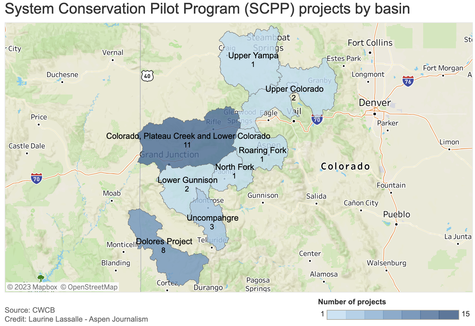
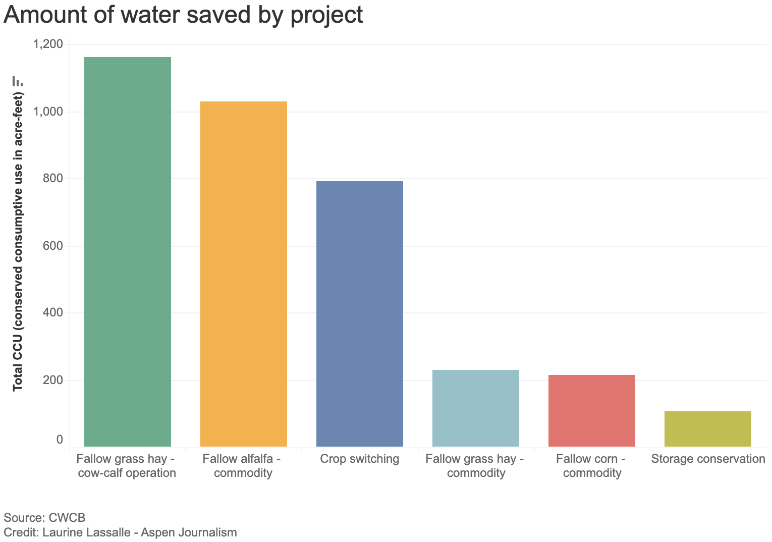
As of this month, the SCPP has supported 64 projects across the Upper Basin states and conserved about 38,000 acre-feet of water, Amy Ostidek, the water conservation boardโ€™s interstate, federal, and water section chief, said during the Sept. 21 meeting. Twenty-two of those projects were in Colorado and they conserved a total of roughly 2,500 acre-feet of water.

Conserving the future

But the programโ€™s re-launch wasnโ€™t as smooth as many had hoped, Ostidek lamented. 

โ€œGetting things kicked-off in December just wasnโ€™t tenable for water users trying to make decisions about their operations,โ€ Ostidek said. โ€œAnd, frankly, that put all of us in a crunch to do things very quickly, and maybe not as well as they could have been done if we had more time.โ€

To address these issues, the SCPP will open applications for the 2024 program starting in October. Ris said this will help provide some โ€œoperational certaintyโ€ for water users.

Another aspect that will be revised is the pricing mechanism. This yearโ€™s SCPP is paying ranchers and farmers about $150 per acre-foot of water saved, which was based on the median payments allocated under the pilot program, The Colorado Sun reported. However, ranchers and farmers have been getting paid nearly $394 per acre-foot on average. 

The program is also looking to incorporate more technology to address data and efficiency gaps in the system. Some target areas include creating drought-resilience tools and implementing conservation strategies that address the needs of rural communities along the lower Colorado River Basin, like in northern Arizona. 

โ€œAt the end of the day, the people who are most impacted by these decisions are often the most vulnerable members of our communities and the most underserved,โ€ Central Arizona Water Conservation Board member Ylenia Aguilar said.ย 

Map credit: AGU

Report: Agricultural #water user’s preferences for addressing water shortages in the #ColoradoRiver Basin — University of #Wyoming #conservation #COriver #aridification

Young farmers

Click the link to read the report on the University of Wyoming website (Drew E. Bennett, Max Lewis, Hallie Mahowald, Matt Collins, Travis Brammer, Hilary Byerly Flint, Lucas Thorsness, Weston Eaton, Kristiana Hansen, Mark Burbach, and Elizabeth Koebele). Here’s the executive summary:

The Colorado River Basin is in crisis. There is no longer enough water for all of those who depend on it. The agricultural sector is the largest water user in the Colorado River Basin, meaning that farmers and ranchers are central to both the impacts of and solutions to water shortages. Their involvement will be key to developing effective policy solutions to todayโ€™s water crisis.

We surveyed 1,020 agricultural water users throughout six states in the Colorado River Basin to understand their perspectives on the present crisis, their current water conservation practices, and their preferences for strategies to address water shortages going forward. Agricultural water users were primarily concerned about how the current situation could impact water policy, constrain irrigatorsโ€™ own water use, and constrain other agricultural water users. We also conducted qualitative research to capture preferences for local approaches to managing water and provide additional context on dynamics in the Colorado River Basin, including interviews with 12 agricultural producers and water experts and a focus group with 10 agricultural water users in Colorado.

Perhaps unsurprisingly, we found agricultural water users are already responding to water shortages. Roughly 70% of surveyed agricultural water users have already adopted one or more water conservation practices or adaptation strategies. Importantly, many would consider adopting additional practices. Despite this, few respondents participated in or were aware of formal programs to support water conservation. One exception, however, was the Natural Resources Conservation Serviceโ€™s Environmental Quality Incentives Program (EQIP). A third of respondents currently or previously participated in EQIP and an additional 37% were aware of the program. Information gathered from interviews and the focus group identified multiple burdens to participation in EQIP and similar programs, and several participants thought the benefits were not worth the effort. These insights suggest an opportunity for revisiting how formal programs meant to incentivize water conservation connect with water users.

Most survey respondents were unlikely to adopt water conservation practices as part of formal demand management or system conservation programs to address water shortages. Only one of eight practices included in the survey โ€“ enhancing water delivery systems โ€“ had a majority of respondents state that they were likely to adopt the practice. The remaining seven practices had a considerably lower likelihood of adoption. Respondents were also generally opposed to water transfers as a solution to shortages. Opposition was strongest to permanent transfers broadly, as well as to temporary transfers from agricultural to non-agricultural uses. Only temporary transfers from agricultural water users to other agricultural water users had less than 50% opposition. Major barriers to supporting water transfers included concerns about losing water rights, even in temporary transfer arrangements, as well as insufficient financial compensation. Addressing these concerns will be critical to increase participation of agricultural water users in demand management or system conservation. Still, although support for temporary water transfers and demand management practices was low, even equivalently low participation (e.g., 10% to 20%) could help address water shortages as part of a portfolio of strategies for the Colorado River Basin.

We also documented an overwhelming preference for local approaches to managing water shortages and a trust gap with non-local agencies. This was evidenced by respondentsโ€™ preference for the local management of formal programs, such as some of the demand management and system conservation
programs under consideration, as well as for the administration of funding for water conservation and other programs. Qualitative research participants communicated that strategies to address water shortages must account for the diversity of local contexts across the Colorado River Basin. These strategies could therefore be best implemented at the local level through existing delivery infrastructure and by managers with track records of success. State and federal water managers and agencies involved in program delivery should emphasize building trust with agricultural water users and gaining knowledge about unique features of local contexts. Simply providing additional funding for formal water conservation programs may be inadequate to meet the diversity of challenges across an area of 246,000 square miles. Developing opportunities for dialogue and listening can help foster relationships and improve trust among key stakeholders.

Given the importance of agriculture as the primary water user in the Colorado River Basin, proactively engaging agricultural communities will be critical to successfully managing water shortages. Understanding the perspectives and preferences of agricultural water users, as documented in this report, can help guide the development of solutions that work for producers and other users in the Basin.

Updated Colorado River 4-Panel plot thru Water Year 2022 showing reservoirs, flows, temperatures and precipitation. All trends are in the wrong direction. Since original 2017 plot, conditions have deteriorated significantly. Brad Udall via Twitter: https://twitter.com/bradudall/status/1593316262041436160

Western states vote to narrow focus of #ColoradoRiver program: #Colorado’s commissioner, Becky Mitchell, supports ‘#drought #resilency tools’ — The #Telluride Daily Planet #COriver #aridification

The Colorado River is a source of irrigation, hydropower and drinking water for 40 million people in seven Western states. Source: The Water Desk via the Water Education Foundation

Click the link to read the article on The Telluride Daily Planet website (Ashley Burton). Here’s an excerpt:

Water commissioners from Colorado, Utah, New Mexico, Wyoming are focusing on water demand management in the future of a conservation pilot program.ย The Upper Colorado River Commission met for a special meeting on Sept. 21 and heard an update regarding the System Conservation Pilot Program (SCPP)…Ultimately, the water commissioners unanimously voted to support narrowing the program in 2024 to focus on water demand management and tools for innovation and local drought resiliency. There was also emphasis during the meeting on improving upon what was learned in 2023…

Collum reviewed three options the commission had on the table for 2024. The first option was to have no program in 2024, but no commissioners spoke in favor of that option. The second option was to maximize water conservation.

Option three, unanimously favored by the commissioners, was presented during the meeting as: โ€œNarrow the 2024 SCPP to explore Demand Management (DM) Studies and Support Innovation & Local Resiliency โ€“ implement recommended SCPP improvements AND narrow project criteria towards remaining DM questions and supporting innovation & local resiliency resulting in water conservation.โ€

[…]

Updated Colorado River 4-Panel plot thru Water Year 2022 showing reservoirs, flows, temperatures and precipitation. All trends are in the wrong direction. Since original 2017 plot, conditions have deteriorated significantly. Brad Udall via Twitter: https://twitter.com/bradudall/status/1593316262041436160

โ€œ…I think when we specifically look at the change in hydrology (and) the definite need for the cuts to happen where the cuts are needed in the lower basin,โ€ Mitchell said. โ€œI really want to think about resiliency on the home front and the thing that we do being focused on building security for our own states and our own water users. And so I think when we look at the implementation with the recommended improvements and the narrow project criteria that are focused on supporting innovation and local resiliency that results in water conservation.โ€ — Becky Mitchell

Map credit: AGU

Implementation of System Conservation Pilot Program (SCPP) for Water Year 2024 — #Colorado Water Conservation Board #ColoradoRiver #COriver #aridification

Raymond Langstaff irrigates his fields outside of Rifle in May 2022. A water conservation program that pays irrigators to use less water from the Colorado River (SCPP) will be offered by the upper basin states starting in October 2023. CREDIT: HEATHER SACKETT/ASPEN JOURNALISM

From email from the Colorado Water Conservation Board (Katie Weeman):

September 21, 2023 (Denver, CO) – the Upper Colorado River Commissioners voted to implement the System Conservation Pilot Program (SCPP) for the 2024 Water Year. SCPP provides Upper Basin water users with the opportunity to participate in temporary, voluntary, and compensated water conservation. SCPP simultaneously allows the Upper Colorado River Commission (UCRC) and Upper Division States to learn from the piloted conservation efforts, expanding knowledge on aspects like monitoring, measurement, and local benefits or impacts. For water users, it provides opportunities to develop tools to build resilience and adapt to long-term drought.

The revamped SCPP integrates input from Upper Basin water users. Changes include:

  • An earlier application window, beginning in October 2023, to provide operational certainty for applicants.   
  • A transparent pricing mechanism to provide clarity to applicants.  
  • Increased education and outreach to ensure water users are fully informed.
  • Expanded information about project applications in Colorado with the opportunity to provide comment.  
  • Prioritization of projects that support innovative water conservation and development of drought resiliency tools.

โ€œWe learned a lot about SCPP last year, so this yearโ€™s revamp integrates a lot of input from Colorado water users,โ€ said Becky Mitchell, Colorado River Commissioner for the State of Colorado. โ€œSCPP shouldโ€”and canโ€”work in a way that makes sense for Colorado. The pilot program can provide flexibility for Coloradans who want or need to explore innovative conservation projects. As we continue to learn together and do what we can to be part of the solution, I continue to push for reductions where it matters most: in the Lower Division States.โ€  

 โ€œThere is no silver bullet for drought resiliency in Colorado,โ€ said Lauren Ris, Director of the Colorado Water Conservation Board. โ€œSCPP is one tool in the Stateโ€™s toolkit that we can all learn from. It can fund innovation, letting water users try something new, because they have that financial certainty. And, because itโ€™s totally voluntary, temporary, and compensated, SCPP lets Coloradans choose for themselves.โ€

At the September 21 UCRC meeting, Commissioner Mitchell strongly advocated for SCPP reforms that would be responsive to Colorado water usersโ€™ input. More information on the revamped SCPP process will be available in the coming weeks. The Congressional reauthorization for SCPP expires in Fall 2024.

Map credit: AGU

Making the switch to save #water: Prairie grasses take root in first year of landscape transformation in Arapahoe County — News on Tap #conservation

Click the link to read the article on the Denver Water website (Jay Adams):

What a difference a year makes for the front of Arapahoe Countyโ€™s Administration Building in Littleton.

Since the 1970s, the west side of the building had been covered by a 3-acre field of unused, water-intensive Kentucky bluegrass.

Recognizing the need to set a positive example regarding water conservation for the long term, in August 2022 the Arapahoe County Commissioners launched a plan to seed the field with a mix of prairie grasses in an effort to transform the bland expanse of bluegrass into a more natural ColoradoScape that will use less water.


Learn more about ColoradoScaping at denverwater.org/Conserve.


The project is part of Arapahoe Countyโ€™s broader sustainability initiative that includes reducing water consumption indoors and outdoors.

One year later, all the planning has paid off and the grasses are flourishing.

Arapahoe Countyโ€™s Administration Building in Littleton has a new ColoradoScape with its prairie grass field on the west side of the building. The transformation is a part of the countyโ€™s sustainability efforts to reduce water consumption. Photo credit: Denver Water.

โ€œWeโ€™re very pleased with how the grasses have come in and are thriving,โ€ said Lisa VanderHeyden, senior project manager of facilities and fleet at Arapahoe County. โ€œWe were lucky and got a nice boost from Mother Nature with all the rain in May and June, which really helped the grasses grow in their first season.โ€

The old field was chosen for landscape transformation because it was considered to have โ€œnonfunctional grass,โ€ which is grass that requires frequent watering from an irrigation system but is not used for activities or events.

The old Kentucky bluegrass field as seen before the transformation in 2022. The field required extensive watering to stay green and was considered nonfunctional grass because it was not used for activities or events. Photo credit: Arapahoe County.

The new field contains a mix of grasses with varying heights and textures. It resembles what the field looked like before people settled the area and started irrigating the land.

It typically takes about three years to fully establish a native grass area, in which the grasses fill in and squeeze out the weeds. Once established, the grass should be able to survive solely on the moisture provided by Mother Nature.


This is how Arapahoe Countyโ€™s ColoradoScape is going. See how it started.


Arapahoe Countyโ€™s staff will actively manage the field and the county anticipates saving approximately 1.5 million gallons of water per season due to the switch from the bluegrass.

โ€œThe field will have a very natural look and, like other prairie grass fields in the area, the colors will change depending on the amount of precipitation throughout the year,โ€ VanderHeyden said.

The field, seen here in August 2023 after it was mowed for the first time. The field, which will be mowed once a year, has a mix of native prairie grass seeds including blue grama, buffalo grass, sideoats grama, western wheatgrass, green needlegrass and sand dropseed. Photo credit: Denver Water.

Changing landscapes across the Southwest

The building is in Denver Waterโ€™s service area and is a great example of a greater push across the Southwest to reduce the amount of nonfunctional grass and help boost the struggling Colorado River, where Denver Water gets half of its water supply.

โ€œWeโ€™ve been really impressed with Arapahoe Countyโ€™s efforts to examine their nonfunctional grass areas and make water-saving changes,โ€ said Austin Krcmarik, water efficiency planner at Denver Water.

The landscape transformation in front of Arapahoe Countyโ€™s Administration Building includes a garden that features low-water-use plants designed to do well in Coloradoโ€™s semi-arid climate. Photo credit: Denver Water.

โ€œFor decades, Kentucky bluegrass has been the default landscaping option for many government buildings and now weโ€™re seeing a shift to more natural looking, water-saving ColoradoScapes.โ€

So, how do you start a new prairie grass field? Hear Arapahoe County officials discuss the project:

Creating a long-term plan

Krcmarik and Arapahoe County agree that there are a number of steps to take when doing large landscape transformation projects:

  • Check with the local water provider for ideas and resources.
  • Consult with the growing number of landscape experts who support water-saving transformations.
  • Work with landscapers who are willing to research what will work best and commit to support the transformation beyond the initial implementation.
  • Get the full support of management.
  • Think the project through, from start to finish and consider long-term maintenance.
Mature trees remain in front of the building. Arapahoe County has experimented with different types of irrigation techniques to ensure they stay healthy as irrigation to the field is reduced. Photo credit: Denver Water.
  • Inform the public about the reasons behind the landscape change.
  • Develop a plan for how to prepare the site for new seeds and plants.
  • Upgrade and/or modify irrigation systems to protect mature trees if the new landscape will use less water.
  • Develop a plan to manage weeds during the early years.
  • Choose plants that can survive without irrigation after establishment.

Denver Water and Arapahoe County are part of the Colorado Native Grass Working Group, which includes dozens of other cities, landscape and water professionals to put together a guide on best practices for installing low-water grass landscapes. You can check out their resources and sign up for their email list atย coloradonativegrass.org.

Signs point out the challenges weeds present during landscape transformation. Grasses typically take around three years to become fully established and squeeze out the weeds. Photo credit: Denver Water.

State support

The turf replacement project was awarded a grant from the Colorado Water Conservation Board for supporting the Colorado Water Planโ€™s goal of encouraging municipalities to reduce water use through landscape change.

โ€œItโ€™s been great working with Denver Water, and we appreciate their support and also the grant from the CWCB,โ€ said Anders Nelson, Arapahoe County public information officer.

โ€œWhile this is a relatively small field, we hope to learn from our work, share and improve the processes and continue to look for other opportunities to reduce our water consumption here in Arapahoe County.โ€

Mrs. Gulch’s landscape September 14, 2023. Note the freshly mowed Blue gramma area at center left.

Building soil health important for #drought, #wildfire resiliency, experts say: Landowners learn steps to long-temr soil improvements — Steamboat Pilot & Today

This field is irrigated with water from the Roaring Fork River, under a senior water right. CREDIT: BRENT GARDNER-SMITH/ASPEN JOURNALISM

Click the link to read the article on the Steamboat Pilot & Today website (Suzie Romig). Here’s an excerpt:

The consultant withย UnderstandAGย โ€” which uses the tagline restoring soil, profits, farms and futures โ€” conducted a water infiltration test in the field that after 10 minutes showed very little water soaking into the hard soil. That is because, for one reason, the field had no armor, or a soil cover of plant residue on the surface. Soil cover is one of the six key elements for building healthy soil that the landowners and ranchers learned about during the all-day Soil Health Field Day on Aug. 15.

โ€œHay producers might be better off in the long term if they left a 3 or 4-inch stubble of hay, which would help generate a more healthy soil system and by maintaining a continuous living root or ground cover,โ€ said Lyn Halliday, board president of the Routt County Conservation District, which organized the free workshop.

Halliday explained that healthy soils act like a sponge helping to absorb and contain moisture. Low soil moisture can cause plants to stop growing or dry out and may provide fuels for wildfires. On the other hand, when soil moisture content is high, fires have more difficulty in igniting, burning and spreading rapidly.

In the next demonstration area on the property, Fuchs showed with an infrared thermometer the 30-40 degree difference in temperatures of healthy soil versus compacted, poor soil. When Fuchs took a reading of 143 degrees on bare soil, he stopped to take a photo of the startling results because, he said, at 140 degrees, good soil bacteria die. He pointed out a soil temperature study that showed at 130 degrees, 100% of moisture is lost through evaporation and transpiration. At 100 degrees, 15% of moisture is used for plant growth and 85% is lost…

The conservation district recently released a โ€œRoutt County Landowner Toolkit for Building Drought, Wildfire and Soil Health Resiliency,โ€ that is online atย RouttCountyCD.com. The toolkit includes links to helpful resources with the goal of inspiring county landowners and ranchers to adapt to changing conditions that affect the land and daily practices of farming and ranching. The toolkit points out the best management practices for agriculture include reducing or eliminating tillage, nurturing the living organic components of soils, promoting diversification of soil flora and fauna below ground and plants above ground, creating pollinator habitat, diversifying rotations including grazing, and reducing wind erosion by establishing wind breaks.

As the #ColoradoRiver Declines, #Water Scarcity and the Hunt for New Sources Drive upย  Rates — Inside #Climate News #COriver #aridification

All American Canal Construction circa. 1938 via the Imperial Irrigation District. The 80-mile long canal carries water from the Colorado River to supply nine Southern California cities and 500,000 acres of farmland in the Imperial Valley where a few hundred farms draw more water from the Colorado River than the states of Arizona and Nevada combined

Click the link to read the article on the Inside Climate News website (Wyatt Myskow and Emma Peterson, June 17, 2023):

The price of water is rising across the Southwest as utilities look to cover the cost of the increasingly scarce resource, the infrastructure to treat and distribute it and the search for new supplies.

PHOENIXโ€”Across the Southwest, water users are preparing for a future with a lot less water as the region looks to confront steep cuts from the Colorado River and states are forced to limit use to save the river. Farms are being paid to not farm. Cities are looking to be more efficient and find new water supplies. And prices are starting to go up. 

In Phoenix, the cityโ€™s Water Services Department is preparing to increase residentsโ€™ monthly water bills starting this October if the hike is approved by the city council. The city isnโ€™t alone. Water providers throughout the entire Colorado River Basin have raised water rates, or are preparing to, to compensate for increasing costs of infrastructure repairs and water shortages along the river. Inflation is driving up the costs of resources to treat and deliver water to customers, and other additional fees are planned to incentivize conservation.

The issue is economics 101, said Casey Wichman, an assistant economics professor at Georgia Institute of Technology and a university fellow with Resources for the Future who studies water pricing. Providers along the basin are coming to terms with the diminishing supply in the river and the infrastructure that needs to be repaired or replaced, largely driven by the rapid growth in population. All of those drive up costs, he said.ย 

โ€œThe cheapest way to build new supply is just to get your customers to use less.โ€ To do that, he said, water utilities often turn to raising rates, making the need to incentivize conservation another driver of the increasing price of water. 

Finding new water sources and getting people to conserve more is becoming increasingly important as the Southwest grapples with climate change and looks to shore up its supply.

โ€œWe have a lot of people living in areas where the water supplies just arenโ€™t there,โ€ Wichman said.

Arizona released a report this month showing the Phoenix metropolitan area was over-drafting the regionโ€™s groundwater and announced that moving forward, no new development would be allowed if it relied on groundwater. Throughout the Valley, cities like Phoenix and Tempe are introducing drought contingency plans. Further cutbacks of Colorado River water, particularly in the Lower Basin, which consists of Arizona, California and Nevada, are unavoidable. 

The region has experienced more than 20 years of drought and decades of overallocation. Arizonaโ€™s supply from the Colorado River has already been extensively cut back, andย under a proposal from the riverโ€™s Lower Basin states introduced last monthย andย supported by the Biden Administration, the states would agree to cut an additional 3 million acre feet of water over the next three years to prevent Lake Mead and Lake Powell, the nationโ€™s two largest reservoirs, from falling to levels that wouldnโ€™t allow electricity generation at the Hoover and Glen Canyon dams, or the river stops flowing past the dams altogether.ย 

Aerial photo โ€“ Central Arizona Project. The Central Arizona Project is a massive infrastructural project that conveys water from the Colorado River to central and southern Arizona, and is central to many of the innovative partnerships and exchanges that the Gila River Indian Community has set up. Public Domain, https://commons.wikimedia.org/w/index.php?curid=326265

In recent years the Central Arizona Project, a 336-mile-long system that delivers Arizonaโ€™s allocation of Colorado River water to around 80 percent of the stateโ€™s population, has seen a nearly 25 percent cut in the amount of water that flows through its canal. 

The price CAP charges is derived from how much it costs to deliver the water to where it needs to go, said Chris Hall, CAPโ€™s assistant general manager for administration and finance. If less water is being delivered to the state, the price of each gallon will go up. 

โ€œWeโ€™re spreading that cost over fewer acre feet. Itโ€™s really just that simple,โ€ he said. โ€œIt doesnโ€™t have anything to do with us having to do any major retrofits to accommodate less deliveries or change our business operations in a meaningful way. Itโ€™s just less water.โ€

This year, the cost of an acre foot of water, enough for about three homes for a year, is $217. Next year it will be $270. By 2028, CAP is expecting the price to rise to $323.

โ€œWater in the Southwest is still, especially in Arizona, relatively affordable,โ€ Hall said. CAPโ€™s goal, he said, is ensuring rates go up in a way that is stable. 

Rates Have Long Been Too Low, Experts Say

Among the biggest expenditures in water utility infrastructure are pipelines. In order to fund their repairs and replacements, utilities will have to raise the price of water. Many experts believe that is long overdue, and that water rates havenโ€™t been high enough to keep up with the large investments required to keep infrastructure in acceptable condition.

The City of Phoenix has over 7,000 miles of utility pipelines that deliver water to companies and households. The average water pipe will last 70 to 75 years in Arizona, but a large portion of them are reaching that age where they need to be replaced. While these pipes are built to last using what, at the time of any given pipelineโ€™s construction, are enormously expensive and durable components, corrosion takes place over time and the pipe can crack, introducing contaminants into the drinking water system. 

โ€œIt is a matter of water quality and water reliability,โ€ said Kathryn Sorenson of Arizona State Universityโ€™s Kyl Center for Water Policy. 

Utility companies and elected officials are reluctant to raise prices, she said, which underfunds these vital investments. Other experts believe water prices across the country are historically low, and increases are inevitable. 

โ€œWater is remarkably cheap for the value it provides to individuals and how we canโ€™t sustain life without it,โ€ said Wichman, the assistant economics professor.

But raising rates isnโ€™t a simple task, he said. Cities like Phoenix have a much larger customer base to spread the increased costs over, he said, but rural communities tend to just eat the costs or not increase rates at the pace needed.ย 

Wichman said residents feel the same way about higher water rates as they do higher taxes: Theyโ€™re not big fans. 

At a May public meeting regarding the proposed increase in Phoenixโ€™s water rates, residents were skeptical of the proposal. โ€œI want the city to be a lot more creative in how they search for funds to help cover some of these costs other than just putting it on the backs of the ratepayers,โ€ said Jeff Spellman, a West Phoenix resident, who also questioned how the city would make sure the parts of the city most affected by climate changeโ€”like hisโ€”get the help they need to confront it.

Residents on fixed incomes, like Spellman, have expressed concern over water increases and how they will affect their lives, as well. โ€œMy pension isnโ€™t going up by almost 40 percent like these rates are,โ€ he said.

Higher water rates tend to have a greater impact on people in low-income communities, who generally have less efficient appliances and households with more members, resulting in more use, Wichman said. 

He said that utilities often adopt complicated rate structures designed to recover costs, promote conservation and keep fees affordable, but those are all very different, and often contradictory, goals. โ€œThose tend to not work that well,โ€ Wichman said.

There are no laws capping how much municipal utilities can charge per month for water, just some that require it be reasonably priced. The Arizona Corporation Commission, however, has a strict rate-making process, Sorenson said, that is taken very seriously.ย 

Cutbacks, Inflation and Conservation Spike Rates

For providers in Arizona that get water from the Colorado River, the costs are beginning to add up. 

Starting this October, Phoenix customers could see a 6.5 percent increaseโ€”roughly $2 for the average user per monthโ€”with another 6.5 percent increase next March and a final 13 percent increase in 2025. Phoenix Water Services will also impose a water allowance on customers to promote conservation, resulting in a $4 increase each month should customers use more than what is allotted to them.

For Phoenix, the rate increases were born out of trying to find a way to signal to residents how much water they were using, said Water Services director Troy Hayes. The city currently has a flat rate for water until a customer uses a certain number of gallons. 

โ€œIf you use water below that, your bill doesnโ€™t change,โ€ Hayes said. โ€œSo they can go up and go down as long as they stay below that amount. They just donโ€™t have really a concept of the amount of water theyโ€™re using.โ€

Many believe raising water rates is the best, and perhaps the only way to disincentivize citizens from overusing their allotments. 

โ€œBack in the 1970s, something like 75 to 80 percent of single-family homes in Phoenix had majority turf or lush landscaping, that number today is down to nine percent,โ€ Sorenson said.

A canal delivers water to Phoenix. Photo credit: Allen Best

She believes a huge amount of that change is directly related to Phoenix charging more in the summer months for water than winter months, giving a direct price signal that people will pay attention to.

The cost of raw water has gone up 35 percent in recent years, according to the city, but itโ€™s not just the price of water itself driving the change. Inflationary pressures are having big impacts, too, with the chemicals to treat the water to drinkable standards rising by 136 percent.

Measures to reduce the demand on the river and overtaxed aquifers are forcing cities to invest hundreds of millions of dollars to find new sources of water, whether from desalination, agreements with tribal governments, recycling more wastewater or finding new untapped groundwater resources. Those costs, water utility directors and city staff have said, will force utilities to raise rates in the future to pay for the new sources of water. 

The pressures from inflation are not isolated to Arizona, though. 

Colorado Springs Utilities raised rates by 5 percent at the beginning of the year to address inflation and infrastructure projects. The utility created a separate fund supported by a new fee to purchase other water rights and infrastructure, according to Jennifer Jordan, a spokesperson for the utility. Denver also raised its rates this year.

California has also implemented fees for years to discourage overuse, which is expected to increase. 

A lot is still unknown heading into high-stakes negotiations on the future of the #ColoradoRiver — #Colorado Public Radio #COriver #aridifcation

Bluff UT – aerial with San Juan River and Comb Ridge. https://commons.wikimedia.org/w/index.php?curid=6995171

Click the link to read the article on the Colorado Public Radio website (Rachel Estabrook). Here’s an excerpt:

Representatives from more than a dozen Indigenous tribes spoke at a CU Boulder law conference last week about their interests in the Colorado River from each of their perspectives.ย  Many of the prominent state and federal officials who manage the water attended the conference. But as they and other water authorities prepare to negotiate the riverโ€™s future, itโ€™s unclear how tribes will participate, to what degree tribes will be treated as equal sovereigns, and how their desire to use all the water they legally have rights to will be considered. Itโ€™s also unclear whether negotiators will aim for a way to make the long-term reductions in water usage that a decades-long megadrought has made necessary or whether they will propose more short-term changes.ย 

The gathering happened at a critical time: Collectively, Colorado River users have to figure out how to live with significantly less water going forward, and the federal government is forcing states to come to an agreement…

The group of tribal representatives and state water officials, along with academics who study the river, used the two-day conference for discussions about how to make their collective use of the river more sustainable over the long term…The tribes have a shared history of using the river and its tributaries over thousands of years and migrating based on water availability. In the century since the river has been dammed and diverted across seven states, each tribe has a different story about how their water rights have been denied and what they seek to change in the riverโ€™s management going forward…

Some river scholars and even people with roles in the negotiations are unclear about whatโ€™s possible as they determine longer-term allocations of the water…A lot is at stake for tribes, and each circumstance is unique…For example, Hopi Tribe council member Dale Sinquah said his people still need to have their water rights settled. Southern Ute Tribal Council Vice Chair Lorelei Cloud said the tribe wants to use water they have legal rights to in southwestern Colorado, but they donโ€™t have the infrastructure. She said about 1,000 tribal members still have to manually haul water to their homes, and the tribe hasnโ€™t been able to develop farmland…Crystal Tulley-Cordova from the Navajo Nation said her tribe couldnโ€™t rely on groundwater because of abandoned uranium mines on their land.ย Dwight Lomayesva, vice chairman of the Colorado River Indian Tribes on the border of California and Arizona, said his people would like to upgrade their farming and water infrastructure to make it more efficient, but the federal government still owns it. โ€œThe last major change in our irrigation infrastructure was made in 1942, when the United States government built some canals for the Japanese who were interned on our reservation,โ€ he said. Each needs to negotiate for themselves individually.

โ€œTo think that there’s an โ€˜Indian solution,โ€™ really dishonors that individuality and the uniqueness of each one of those tribes,โ€ said Daryl Vigil, a Jicarilla Apache water leader who used to direct a tribal partnership in the Colorado River basin.

From the 2018 Tribal Water Study, this graphic shows the location of the 29 federally-recognized tribes in the Colorado River Basin. Map credit: USBR

Deadpool Diaries: โ€œCrisis on the #ColoradoRiver โ€“ From Short-Term Solutions to Long-Term Sustainabilityโ€? — John Fleck (InkStain) #COriver #aridification

Ringside seats to the decline of Lake Mead. Credit: InkStain

Click the link to read the article on the InkStain website (John Fleck):

I learned stuff at last weekโ€™s Getches-Wilkinson Center Colorado River conference at the University of Colorado Law School.

I learned:

  • The bodacious snowpack means the chance of Lake Mead dropping below elevation 1,000 is zero.
  • We still need to cut 1.5 million acre feet of Colorado River water use, at least. We still have no plan to do that.
  • We remain at risk of river flows past Leeโ€™s Ferry dropping low enough by 2026 to trigger a legal argument about what the Upper Basin really owes the Lower Basin.
  • We have what was called a โ€œhistoric accordโ€ to reduce Lower Basin use in the short run, which muchly revolves around paying people to not use water.
  • The โ€œhistoric accordโ€ does not take any steps toward resolving longstanding tribal and environmental inequities.
  • The problem of what economist Gordon Tullock called โ€œthe transitional gains trapโ€ is a very real obstacle to moving forward on the Colorado River.

WHATEVER, LETโ€™S JUST PAY โ€™EM: THE โ€œTRANSITIONAL GAINS TRAPโ€

In a seminal 1975 paper, economist Gordon Tullock nailed the problem at the heart of the current Colorado River policy dilemmas:

Thus farmers in places like Palo Verde, Yuma, and Imperial umpty generations ago benefited from the significant subsidies from the rest of us (federal taxpayers) that enabled Lower Colorado River agriculture to flourish. The benefit of that subsidy has now been fully capitalized in the land and the structures of the communities.

As Tullockโ€™s work so clearly notes, termination of this โ€œschemeโ€ (I love his word) would โ€œlead to large losses for the entrenched interests.โ€

While thereโ€™s a lot of โ€œproperty rightsโ€ framing around our 21st century arguments about this, itโ€™s important to remember that the perfection and continued use of those water rights was enabled by massive collective action on the part of others in establishing the needed institutions, and funding and building infrastructure.

But whatever, right? Thatโ€™s where we are now, and a fatalistic attitude of โ€œletโ€™s just pay โ€™emโ€ seems to have settled over basin problem solving, at least in the short term.

IS THERE A โ€œTRANSITIONAL LOSSES TRAPโ€ TOO?

Iโ€™m definitely out over the tips of my conceptual skis here, but one of the things that was made clear at the Boulder meeting was something Iโ€™ll glibly dub โ€œthe transitional losses trapโ€: the same decisions over the last century that locked in โ€œtransitional gainsโ€ for Lower Basin farmers also locked in โ€œtransitional lossesโ€ for Native American communities dispossessed of their land and water.

In a powerful panel last Thursday afternoon, a stage full of tribal leaders one at a time talked about that dispossession. The sheer weight of their words, and the range of their concerns, was breathtaking.

Some progress has been made on this issue, especially in Arizona. But there is no escaping the reality that all that water providing โ€œtransitional gainsโ€ to Lower Basin farmers is, acre foot for acre foot, a โ€œtransitional lossโ€ for Native American communities. And now weโ€™re paying those Lower Basin farmers to not use this very same water.

I get that some of the money weโ€™re paying to reduce water use will go to Arizona and California tribes with settled water rights. But there are many tribes without settled water rights, or with rights that are settled but not yet put to use. Theyโ€™re getting nothing out of any deal to pay water rights holders not to use their water. We need to remember this fact every time we pay a non-Indian farmer not to farm.

โ€œA HISTORIC ACCORDโ€

Californiaโ€™s lead negotiator on the recently announced agreement for short term Lower Basin water use reductions, J.B. Hamby, called it a โ€œhistoric accordโ€. I have to agree, though weโ€™ll have to wait through the next many months before we have clarity on what sort of history has been made.

Itโ€™s a Lower Basin agreement, among Arizona, California, and Nevada. One of the things that was abundantly clear at the Boulder meeting was that Upper Basin states are withholding judgment until the details are fleshed out.

But itโ€™s already clear that those who negotiated the deal want our money โ€“ federal tax dollars โ€“ to solve the transitional gains trap, but not to solve any of the other problems worth talking about:

  • the Colorado River Basinโ€™s tattered environment
  • unresolved Native American water rights and other needs

As Iโ€™ve pointed out previously, with other peopleโ€™s money should come other peopleโ€™s values.

THE LEEโ€™S FERRY CONUNDRUM

My buddy/collaborator/coauthor/mentor Eric Kuhn threw up a scary slide during his talk:

The crucially nerdy backstory is in Article III(c) and (d) of the Colorado River Compact, which seem to say the Upper Basin is required to send 82.5 million acre feet every ten years. As Hamby noted, one of the premises of โ€œwe need to cut 1.5maf in the Lower Basinโ€ is that the Upper Basin continues to hit that target. Lawyers will argue forever about Article III interpretation, but Iโ€™d prefer not to hand over our management of the Colorado River to a judgeโ€™s ruling on whoโ€™s right.

ARIZONA V. CALIFORNIA

No arguments broke out over Californiaโ€™s insistence on enforcing its priority rights and pushing most of the climate change risk onto Arizona. Yay!

But the deep entanglement between this question and the transitional gains trap stuff I mentioned before isnโ€™t going away. California farmers have benefited from a โ€œproperty rightโ€ essentially created in 1968 through the use of power politics, but that property right, as Tullock would say, is now priced into the value of their assets. And weโ€™ve now set a โ€œwhatever, letโ€™s just pay โ€™emโ€ precedent (at an unprecedented scale), which does seem historic, but maybe not in a good way.

West snowpack basin-filled map April 16, 2023 via the NRCS.

ELEVATION 1,000

There were a number of mentions of the Reclamation modeling that puts the risk of Lake Mead dropping to elevation 1,000 at zero.

This is great news. It shows how the bodacious snowpack bailed us all out.

But we should remember that โ€œkeeping Lake Mead above elevation 1,000โ€ is a very low bar.

Map credit: AGU

A heck of a time for a #drought conference — @BigPivots

Leyden street and turf. Photo credit: Allen Best/Big Pivots

Click the link to read the article on the Big Pivots website (Allen Best):

Like hard rains amid the Dust Bowl, Colorado has lots of water almost everywhere now amid long-term drought. Thatโ€™s exactly the time to talk about what do as hotter and drier inevitably return.

The Colorado Water Conservation Board chose an awkward time to conduct a drought summit, launching the two-day event on the last day of May at History Colorado in downtown Denver.

It was the fourth wettest month in Denver since 1876, before Colorado was a state, and June got off to a soggy start, too. This followed one of the snowiest winters in decades in some parts of Colorado. The only part of Colorado still in drought is in the stateโ€™s southeastern corner.

The somewhat awkward timing was noted by Anne Castle, of the Getches-Wilkinson Center for Natural Resources, Energy and Environment at the University of Colorado Law School. โ€œItโ€™s perfect time to hold a drought summit,โ€ she said with intended irony.

Like others, though, she doesnโ€™t expect this wetness to last. Most of Colorado, including cities and farms east of the Continental Divide, depends upon water from the Colorado River and its tributaries, and it should be news to exactly no one that those who depend upon the largesse of that river have a serious re-reckoning underway. Too slow in some places, according to at several speakers at the conference.

Unlike last year, though, the heat is off. That is good, said Castle. โ€œWe can make better decisions when weโ€™re not right in the midst of a crisis, as long as we recognize that one winter does not solve our long-term problems.โ€

That problem is not necessarily drought, although Colorado and Southwestern states clearly have seen less precipitation in the last 20-plus years. Droughts come and go, and this one in the Colorado River Basin is the worst in at least 1,200 years. Something more is happening here, what scientists call aridification. In aridification, it can snow just as much, but warmer temperatures draw more of the precipitation into the atmosphere. At least one study found that up to 50% of the declined flows in the Colorado River could be attributed to the warming now underway.

Aridification doesnโ€™t roll off the tongue quite so easily as drought, noted Russ Sands, section chief for water supply planning at the CWCB.

Make no mistake, though. Climate change, a subject approached gingerly 20 years ago by state water officials, has become part of the conversation. Consider Greeley.

The once-smallish city located at the  confluence of the Poudre and South Platte Rivers has grown to a population of more than 110,000 residents. That is almost certainly just the beginning.

Sean Chambers, director of water and utility services for Greeley, said the city expects to need to expand its water portfolio, currently at 35,000 acre-feet, to 80,000 acre-feet by 2080. โ€œThat does not get Greeley to build-out; itโ€™s only half-way there,โ€ he said.

The city gets about 40% of its water from the Colorado River Basin.

Chambers said Greeley is starting to integrate the impacts of climate change into its planning, among them pressures on reservoirs, different times of runoff, and more watershed disruptions.

โ€œAll of these risks and challenges on the water system driven by climate change come on top of managing for growth and uncertainties around supply,โ€ he said.

As for its planning, Greeley hopes to keep ahead of hard pressures. Last year, the city gained access to an aquifer to the north of the city that it plans to manage in conjunctive fashion. It can be drawn upon when needed but also used as a storage vessel.

โ€œItโ€™s really difficult to innovate when your back is against the wall,โ€ he said during a panel discussion under a heading of โ€œstorage, conservation and innovations.โ€

Peter Mayer, a Boulder-based consultant who has worked for 30-plus years in water demand management, said conservation has worked very well in Colorado, especially in urban sectors. โ€œThat is my specialty. We started in the late 1980s and 1990s and have seen a gradual decline in per-capita use across the state.โ€

Mayer argued that this has allowed Coloradoโ€™s population to grow in a way that has been much less expensive โ€œBecause conserved water is much, much cheaper generally than (developing) new supply.โ€

Greg Fisher, who supervises conservation efforts for Denver Water, talked about the major water reductions in its service territory since 2000, which has allowed Denver to better keep water in its reservoirs. โ€œConservation really works,โ€ he said.

But there can be tensions within water agencies between programs to reduce water use and the revenue needed to pay for the infrastructure that has been installed, as described  by representatives for both Colorado Springs and Durango.

โ€œYour leaders say (conservation) is first, but in the process of setting rates, you tend to find out itโ€™s second or third,โ€ said Jarrod Biggs, from the City of Durango.

โ€œEvery councilor wants to make sure that they are saving the last drop and doing what is right for the community and regional partners. When talk gets to dollars and cents, conservation ends up being somewhat important, but it does kind of fall down that list, particularly if you have a very noisy political constituency.โ€

Castle, from the University of Colorado, who had a law practice for much of her career, pointed out the need for getting land use right, to produce urban landscapes that are less water-intensive. โ€œItโ€™s really the initial configuration of development that is the primary factor that influences future water demand,โ€ she said. We have land-use plans, master plans, comprehensive plans, subdivision improvement agreements. That is where you can deal with and incentivize water conservation and incorporate that into any new development plans.โ€

Municipal use represents only 7% of total water consumption in Colorado, said Mayer, compared to 91% for agriculture. โ€œWhat is the agriculture sector doing?โ€ he asked. He suggested the answers can be found with better measuring.

Taylor Hawes, who directs the Colorado River program for The Nature Conservancy with 26 years of experience, talked about the need to pick up the pace.

โ€œWe have lost 20% of the Colorado River supply since 2002,โ€ she said. The pace of change must accelerate to correspond with the need. โ€œThe longer we wait, the harder it gets.โ€

Allen Best is a Colorado-based journalist who publishes an e-magazine called Big Pivots. Reach him atย allen.best@comcast.netย or 720.415.9308.

Updated Colorado River 4-Panel plot thru Water Year 2022 showing reservoirs, flows, temperatures and precipitation. All trends are in the wrong direction. Since original 2017 plot, conditions have deteriorated significantly. Brad Udall via Twitter: https://twitter.com/bradudall/status/1593316262041436160

Ahead of new #ColoradoRiver talks, governments and tribes weigh in on the future — KUNC #COriver #aridification #ActOnClimate

USBR Commissioner Touton giving a diplomatic speech at Getches-Wilkinson/Water and Tribes Initiative conference, outlining the ongoing federal spending and the upcoming SEIS revisions. One big upshot from her: Thereโ€™s no reason to believe this winter wasnโ€™t a โ€œone-off.โ€ Photo credit: Kyle Roerink via Twitter: https://twitter.com/KyleRoerink1/status/1666853176299991061

Click the link to read the article on the KUNC website (Alex Hager). Here’s an excerpt:

Hot on the heels of a short-term agreement to cut back on Colorado River water use, states are looking ahead to talks about more permanent cuts. The Bureau of Reclamation, the federal agency which manages the Westโ€™s water, announced that those negotiations will formally begin next week with a notice in the Federal Register. The announcement came at an environmental law conference in Boulder, Colorado on Thursday [June 8, 2023], where scientists, state and federal governments, and tribes met at the University of Coloradoโ€™s law school…

It still remains unclear how exactly the states plan to arrive at permanent cutbacks that will likely be painful to some of the farms and cities that depend on the riverโ€™s water, which flows to tens of millions of people and a multi-billion dollar agriculture industry. Pressed for details, state leaders shared little beyond high-level ideas about the need for water conservation across all seven states that use the Colorado River…Becky Mitchell, director of the Colorado Water Conservation Board, emphasized that post-2026 guidelines need to โ€œacknowledge that climate change is real.โ€

[…]

Camille Calimlim Touton, commissioner of the Bureau of Reclamation, shared new details about the agencyโ€™s upcoming plans for water management. The agency has withdrawn its draft Supplemental Environmental Impact Statement while it reviews the proposal, and plans to arrive at a final plan โ€“ or โ€œRecord of Decisionโ€ โ€“ by the end of 2023. Reclamation has so far been tight-lipped with details about negotiations related to the 2026 deadline, but Touton said the agency will โ€œformally advanceโ€ the process for those multi-year talks starting the week of June 12. Starting the process next week, she said, will allow the agency to publish a new draft SEIS by the end of 2024…

A panel with representatives from 13 tribes spoke about the evolving role of tribes in water negotiations. Officials and attorneys spoke about their current struggles to maintain steady access to clean water, the historic aggression and exclusion that drove them away from water management and the need for tribesโ€™ input as talks continue.

Hopi tribal members collecting spring water at Yamโ€™taqa โ€“Place of ever-flowing water- (vaseyโ€™s paradise) in the Grand Canyon. Photo credit: From the Earth Studio

Although Indigenous people in the Southwest have been using Colorado River water longer than any other group in the region, they haveย largely been excludedย from discussions about how the river is shared. The 30 federally-recognized tribes that use the river control about a quarter of its flow, but most lack the money and infrastructure to use their full allotments. Tribal leaders said their millennia-long history in the region could offer lessons for the future of water management.

Thoughts on the Lower #ColoradoRiver Basin #Water Deal — Sibley’s Rivers #COriver #aridification

Click the link to read the article on the Sibley’s Rivers website (George Sibley):

A short post, to catch up on Colorado River current events. As you probably know, if you havenโ€™t been living in a media-free cave, the three Colorado River states below the canyon region have proposed another alternative plan for saving the Riverโ€™s reservoir system.

Their proposal, for answering the Interior Departmentโ€™s call for cuts of at least two million acre-feet (maf) of water annually, is to cut three maf total over the next three years โ€“ and they want 1.2 billion dollars from the federal government to execute their plan.

Their plan is basically to pay farmers to voluntarily fallow some of their land. They say they will do half of the cuts โ€“ 1.5 maf โ€“ in 2024, the remainder over the following two years. Beyond that, there are no firm details at this writing as to how much of the cuts will come from each state, how much they will be paying farmers, et cetera.

Basically, what it looks like on the surface of it, is that the Lower Basin states have countered the Bureauโ€™s four existing scenarios โ€“ two from the Bureau of Reclamation, one from California, and one from the other six River states โ€“ with an offer to do half of the minimumcuts the Bureau said we need, and they want a billion dollars to do it. What a deal.

If their plan to pay farmers to leave the water in the system sounds familiar, that may be because the four Upper Basin States tried a similar plan this year, the System Conservation Pilot Program, with a fund of $125 million from the ill-named Inflation Reduction Act. Upper Basin farmers did not rush to take up the offer. Only 88 submitted applications to participate, of which around 20 percent were rejected; the remainder will, if things work out as projected, save 39,000 acre-feet at a cost of $16 million. That is a very small piece of two million acre-feet.

The High Line Canal is an irrigation ditch built in the 1880s. Denver Water still uses the canal to deliver irrigation water to customers when conditions allow. Photo credit: Denver Water.

It has been said that farming โ€“ especially irrigated farming โ€“ is a calling, not an occupation. I have heard farmers and ranchers talk about โ€˜a working contract with the land,โ€™ and in the Upper Basin at least there seems to be something almost offensive to many farmers about the idea of being paid to not farm some of their land. Ranchers in the Upper Gunnison say it takes up to five years to bring a hayfield back to full productivity after a year of no water (or very little). Weโ€™ll see, I guess, if Lower River farmers have the same basic feelingsโ€ฆ.

A further reason for the low turnout for the Upper Basinโ€™s System Conservation Program might be that Upper Basin farmers believe โ€“ correctly enough โ€“ that the two million acre-foot โ€˜structural deficitโ€™ is not their problem and they should not be expected to exercise themselves to help deal with it. A logical enough response when working with a Compact that, as one of the Compact commissioners said, is โ€˜almost making two rivers out of one in the Colorado River.โ€™ The โ€˜Glen Canyon Wallโ€™ near Lee Ferry eliminated that โ€˜almost.โ€™ There has been no indication from the Lower River states that they would be merciful to the Upper River states, should the drought (not โ€˜causedโ€™ by the Upper States) drive the available flow past Lee Ferry below the Compact allotment; so why should the Upper River states feel empathy for the Lower Basin states?

It was reported in the national media, by the way, that the Upper Basin states have โ€˜acceptedโ€™ the Lower Basinโ€™s proposal. They have not, yet. The four Upper states merely said it was okay for the plan to be evaluated along with the other four proposals in the Bureauโ€™s โ€˜Supplemental Environmental Impact Study.โ€™

West snowpack basin-filled map April 16, 2023 via the NRCS.

All that noted โ€“ the Lower Basin proposal will probably be accepted for a variety of reasons. One reason is that the runoff from a good snowpack is probably going to give temporary relief on the reservoir levels; we should end the water year with both Powell and Mead Reservoirs higher than they were at the beginning of the year (water year is October to October), and that provides a little breathing room. (Keep in mind, though, that the Bureau first issued its major warning and challenge in 2022, saying that big reductions had to happen beginning in 2023. Now, nothing big will happen until 2024. Pray for snow next winter too.)

Another reason the proposal will probably be accepted is because if any of the other four proposals were to be chosen by the Bureau, one or more of the Lower Basin states would sue the government. There might be an element of desperation to both the gambit of promising to try to deliver only half of the requested cuts, and to the threat to sue if asked to deliver the whole 2 maf/year. The Bureau wants the Lower River region that serves a tenth of the national population and produces most of our winter fresh green stuff to cut their water use by almost one third โ€“ and do it next year. Thatโ€™s a big request, maybe an unreasonable request.

Never mind that, had the Bureau and the seven Basin states been living in the real world, they would have taken care of the โ€˜structural deficitโ€™ decades ago, with a gradual drop in Lower River use, reflecting the growth of use in the Upper River states that was eating into the so-called โ€˜surplusโ€™ that the Lower Basin had grown to depend on take care of its system losses, and also its half of the allotment to Mexico.

And a final reason why their proposal will probably be accepted? 2024 is a presidential election year, with the current administration on the line, and both Arizona and Nevada are important swing states. โ€˜Nuff said.

It will come down to whether, next year, the three Lower River states can find enough farmers and cities willing to voluntarily give up a million and a half acre-feet of water next year. Tucson and the Gila River Indians have already made commitments. Meanwhile โ€“ pray for snow next winter.

Map credit: AGU

Will #ColoradoRiver cuts create a new Dust Bowl?: Plus: A little ditty on the water-energy-water nexus — @Land_Desk #COriver #aridification

Click the link to read the article on The Land Desk website (Jonathan P. Thompson):

In the comments section of last weekโ€™s Land Desk dispatch on the Lower Basin statesโ€™ Colorado River deal, reader Ann Bond had some interesting questions/points that I figured Iโ€™d address. Iโ€™ll try to sum up Annโ€™s questions, first:

  1. What effect will fallowing thousands of acres of fields have? Will it lead to another Dust Bowl? 
  2. Is the electricity from the dams used to deliver water (e.g. to power the pumps for the Central Arizona Project)?
  3. And what purpose do the two reservoirs (Powell and Mead) serve in the system and how does that factor into the bargaining between the states?

Iโ€™ll just explore the first two today, since thatโ€™s all I have room for.

My short answer for question #1 is: I donโ€™t know. One of the problems with the deal is that very few details have been made public, so itโ€™s difficult to understand what ramifications it might have. 

But we do know that the Lower Basin states plan to come up with 3 million acre-feet of water over three years โ€” or about 1 million acre-feet per year โ€” by paying water users to slash consumption. Federal funds will be used to reimburse folks for 2.3 million acre-feet of those cuts, while state, local, or other funds will be used for the remaining 700,000 acre-feet. Itโ€™s fair to guess that a bulk of these savings will be realized by paying farmers not to irrigate their crops, since agriculture is by far the biggest user of Colorado River water, and that makes more logistical sense than paying folks not to water their lawn. So thatโ€™s a good place to start.

Iโ€™ve also read reports saying the Imperial Irrigation District, the largest single water user in the Basin, plans to give up 250,000 acre-feet per year (which will be included in the above amounts).

One of the most abundant crops in the Colorado River Basin is hay, primarily alfalfa. It is also one of the thirstiest crops. Growing one acre of alfalfa guzzles around four acre-feet of water per year, depending on location, climate and length of growing season. In Coloradoโ€™s high-elevation, cool San Luis Valley, alfalfa consumes about two acre-feet per year; in Californiaโ€™s sea-level Imperial Valley โ€” one of the hottest places in the nation โ€” the crop can require more than six acre-feet of water per year.

Since the fallowing is likely to occur in hot, dry southern Arizona and California, weโ€™ll go with the six-acre-feet-annually figure. That would mean that in order to reach the target water cuts, irrigation would have to be stopped on a total of 167,000 acres of alfalfa fields, or roughly three-fourths the size of the Salton Sea. Targeting less thirsty crops would require fallowing a larger amount of acreage. About 42,000 acres of that would be in the Imperial Irrigation District, assuming the fields they fallowed were alfalfa. For some more context: An MIT study found youโ€™d need 90,000 acres of solar panels to replace the Diablo Canyon nuclear power plantโ€™s generation.

So, yeah, itโ€™s a lot of acreage, and ceasing irrigation on that land could very well turn it into desiccated weed patches. Maybe it wonโ€™t be Dust Bowl kinda stuff for now, but it could get ugly, especially in a dry summer. In the San Joaquin Valley in California, for example, a groundwater management program (no relation to the Colorado River crisis) is forcing farmers to fallow fields, which is leading to serious dust and air quality problems

The Imperial Valley is next to the Salton Sea, where the air โ€” and residentsโ€™ lungs โ€” is already thick with dust. Fallowing all of the Valleyโ€™s alfalfa fields surely would further exacerbate the problem. At this point itโ€™s not clear where fields will be fallowed, only that some will be in California and some in Arizona (Nevada uses almost all of its Colorado River water for municipal uses in Las Vegas and surrounding communities). 

Media outlets have reported that the states plan to pay those farmers $1.2 billion from the federal Inflation Reduction Act. That would put a $521 price tag on each acre-foot of water not going onto a field. Using the 6 acre-foot per acre of alfalfa figure, that would mean an Imperial Valley farmer could get more than $3,000 per acre to not grow anything.  

Thatโ€™s not a bad deal. According to the UC Davis cropland data layer site, Imperial Valley farmers harvested 144,000 acres of alfalfa hay in 2020. They produced 1.14 million tons of alfalfa hay, valued at $200.44 million โ€” or an average of $1,391 per acre. In other words, the farmers could bring in twice the revenue for not farming than for farming their acreage.

But it would also reduce the supply of alfalfa, causing prices to increase, which would likely ripple through the beef and dairy industries, where most of that alfalfa goes. That, in turn, could eventually make its way down to the ice cream and cheese aisles at your local grocery store. 

2. The second point Ann made was that moving water from the Colorado River to fields and cities takes a lot of energy, including the power generated by the dams on the Colorado River. So when irrigators reduce their Colorado River water use itโ€™s leaving more water in the river, which can generate more energy when run through the damsโ€™ turbines, which can move more water to the fields โ€ฆ Woah, I am getting dizzy here. 

Itโ€™s a classic example of the water-energy nexus or, in this case, the water-energy-water nexus, one of my favorite topics.

Glen Canyon, Hoover, and several other dams on the Colorado River system are hydroelectric, meaning as water runs through them, it can be routed through turbines, generating power. As reservoir levels drop, so does the power generation capacity of the dam. And if the reservoir levels fall below the openings to the penstocks โ€” or tubes leading to the turbines โ€” then power production ceases altogether.

This freaks folks out in these climate changed times for good reason: The warmer it is, the more power we need to run air conditioners, and the more water irrigators need to put on their crops, meaning more power is needed to move that water. But the warmer it is, the lower the reservoirs and the less power we have. Ack!

The Central Arizona Project is one of the biggest water-moving projects on the Colorado River. Its pumps pull water from the Colorado River at Lake Havasu and move it 336 miles across the Arizona desert (in an uncovered canal, allowing massive amounts of water to evaporate), with a total elevation gain of more than 2,900 feet. That takes a buttload of energy. In fact, it takes so much power that the coal-fired Navajo Generating Station was built in large part to run the CAP pumps. 

2 million megawatthours: Annual power consumption of the Central Arizona Project pumps. 

2 million megawatthours: Annual power consumption of the five pumping stations on the Colorado River Aqueduct, which delivers water to Los Angeles and surrounding areas.

2.5 million megawatthours: Annual power output of Glen Canyon Dam in 2022

3.9 million megawatthours: Annual power output of Glen Canyon Dam in 2008

1.5 million megawatthours: Annual power output of Hoover Dam in 2022

259 million megawatthours: Californiaโ€™s annual power consumption.

The Navajo Generating Station was retired in December 2019, forcing the CAP to find power from elsewhere. Now the project gets 70% to 80% of its power from market forward and short-term purchases; 12% to 15% from the Salt River Project electric utility; 6% from Hoover dam; and 4% from a solar installation. About half the power for the Colorado River Aqueduct pumps comes from Hoover and Parker dams, with the rest coming from a mix of market purchases and hydroelectric generation within the Aqueduct system.

And then thereโ€™s the question of how much of the damsโ€™ electricity goes toward moving water around. The Western Area Power Administration markets the electricity from Glen Canyon Dam and 56 other hydropower dams. Hereโ€™s a breakdown of who purchases that power:

While only 4% goes to irrigation districts, you can assume that portions of many of the other categories go to moving water or treating it. So if the hydropower capacity of the dams were to shrink or vanish altogether, all of these customers โ€” including the water folks โ€” would have to find new sources of electricity.

#ColoradoRiver District hosts annual State of the River meeting in #Granby — Sky-Hi News #COriver #aridification

Colorado River “Beginnings”. Photo: Brent Gardner-Smith/Aspen Journalism

Click the link to read the article on the Sky-Hi News website (Kyle McCabe). Here’s an excerpt:

The river districtโ€™s Public Relations Director Marielle Cowdin spoke about the districtโ€™s work. She highlighted the Colorado Riverโ€™s crisis, saying that the increased precipitation over the last year will not save the river…Cowdin talked about the water consumption differences between the upper and lower basin states, highlighting that upper basin states make cuts more effectively because they do not have massive reservoirs like Lake Mead or Lake Powell to rely on in drier years.ย 

โ€œBetween 2020 and 2021, the four upper basin states cut our water consumption by 1 million acre-feet โ€” just on our own because the water wasnโ€™t there,โ€ Cowdin said. โ€œInstead of about 4.5 million acre-feet of water use, in that year timeframe, we only used 3.5 (million).โ€

The lower basin statesโ€™ 2020-21 consumption went up 600,000 acre-feet from their average use, Cowdin said. The annual water usage split between the states has been about 60%, or around 8.8 million acre-feet, used by the lower basin versus 30%, or around 4.4 million acre-feet, used by the upper basin, with the remaining water going to Mexico…

The next speaker, Rebecca Mitchell, theย Colorado Water Conservation Boardย director and Coloradoโ€™s commissioner to theย Upper Colorado River Commission, was the special guest at the event. She spoke about the Bureau of Reclamationโ€™s Draftย Supplemental Environmental Impact Statementย (SEIS) and news that broke about it the day of the meeting. Mitchell explained that the bureauโ€™s SEIS came after the lower basin states did not respond to the bureauโ€™s June 2022 announcement that states needed to cut 2-4 million acre-feet. That announcement, she said, was not a surprise to those working on the Colorado River…Differences between the upper and lower basin states came up several times in Mitchellโ€™s talk. She mentioned that the six-state plan, which included all states besides California, acknowledged that the upper states have shortages annually because, unlike the lower states, they do not have huge reservoirs from which to draw…On May 22, the day of the meeting, the bureau announced a pause on the SEIS. Mitchell explained that the lower basin states had presented a plan which included temporary cuts that would amount to 3 million acre-feet from 2024-26 but provided few details on how cuts would be enforced.

โ€œโ€‹โ€‹Instead of coming up with 2-4 million on an annual basis, they were like, โ€˜Hey, thereโ€™s all this money โ€ฆ we can kick the can a little bit more, and we can use this money and make some temporary changes,โ€ Mitchell said of the lower basin states.

Water vs. growth: #Colorado communities, developers struggle to juggle both: Developers look for more incentives to aid bottom line; cities, towns employ variety of strategies in face of constrained #water supplies — The #Denver Post

A small yard in Sterling Ranch, a Douglas County community that is the first in the state to undertake a rainwater harvesting project. June 27, 2022. Credit: Jerd Smith, Fresh Water News

Click the link to read the article on The Denver Post website (Judith Kohler). Here’s an excerpt:

Across the Denver area, local governments, water utilities, homebuilders and developers are employing a number of strategies to meet the demands for housing, respond to growth and strive to ensure the long-term supply of the resource essential to a future in this semi-arid region: water. Agriculture consumes the lionโ€™s share of Coloradoโ€™s water, about 90%, while municipal uses account for 7% of the total.

โ€œWhen you start off with that number, I think itโ€™s really easy for people to say, โ€˜Why does municipal water use even matter? Why are we even worried or focused on this?โ€™ Thatโ€™s a question I answer a lot,โ€ said Lindsay Rogers, a water policy analyst with Western Resource Advocates.

One response is thatย state water planners say municipalities could face a shortfall of as much as 740,000 acre-feet of waterย by 2050…

Harold Smethills, Sterling Ranch co-founder and chairman, doesnโ€™t want to see large portions of Coloradoโ€™s agricultural land dried up. Smethills, who has a ranch, leases land on the development south of Chatfield State Park to a cattle operation…No water-thirsty Kentucky bluegrass is allowed at Sterling Ranch, which has about 5,000 residents. The company worked with the Denver Botanic Gardens to identify roughly 155 different plants that use less water, many with the added bonus of attracting bees and other pollinators. The water meters in the homes tracks indoor and outdoor use and have revealed leaks when staff at the Dominion Water and Sanitation District noticed water use shoot up. Residents are also able to keep an eye on their water bills.

2023 #COleg: Governor Polis signs law expanding environmental options for home landscaping in #Colorado — CBS #Denver 7 #conservation

Turf replacement. Photo credit: Western Resource Advocates

Click the link to read the article on the CBS Denver 7 website (Katie Perkins). Here’s an excerpt:

Gov. Jared Polis has signed into law a measure that would change Coloradansโ€™ Homeowner Association rules. Around 60% of Coloradans live under a HOA, according to a press release from the governorโ€™s office. Under the newly confirmed State Senate Bill 178, homeowners can now swap their grass lawns for alternatives like turf that require less water.

Previously, state law granted an exception for an HOA to adopt design or aesthetic guidelines that apply to โ€œnonvegetative turf grass and drought-tolerant vegetative landscapes.โ€ The association was allowed to regulate the type, number and placement of drought-tolerant plants installed on a homeownerโ€™s property.

SB 23-178 states that an association’s guidelines now cannot:

  • Prohibit the use of nonvegetative turf grass in the backyard of a property
  • Unreasonably require the use of hardscape on more than 20% of the landscaping area of a property
  • Prevent a homeowner from choosing an option that consists of at least 80% drought-tolerant plantings
  • Prohibit vegetable gardens in the front, back, or side yard of a unit owner’s property

#Arizona, #California and #Nevada try to make a deal to cut #ColoradoRiver usage โ€” but is it enough? — The #Denver Post #COriver #aridification

Shadow Mountain Dam via USBR

Click the link to read the article on The Denver Post website (Conrad Swanson). Here’s an excerpt:

Those states, which make up the riverโ€™s lower basin, are reportedly close to an agreement that would cut the amount of water they draw from the waterway. Theyโ€™re racing against the clock to find an agreement before the end of the month or else the U.S. Bureau of Reclamation might make the cuts for them. But their proposed savings โ€“ reported Thursdayย by the Washington Postย โ€“ amount to half of the minimumย amount of water federal officials said the basin must save. And while the Colorado Riverโ€™s headwaters saw anย above-average snowpackย this year, that extra water only buys the West a bit more time and the boon isnโ€™t expected to last.

โ€œThe river is telling us that we havenโ€™t done enough,โ€ Jennifer Gimbel, a senior water policy scholar at Colorado State University said. โ€œItโ€™s challenging us.โ€

[…]

The proposal, which hasnโ€™t formally been proposed, would mean the Imperial Irrigation District would be conserving nearly a quarter of its water supply, spokesman Robert Schettler said. Already those measures could mean that fewer crops come out of the major farming district in southern California (the largest water user in the most water-consumptive state), lowering national supply and raising prices. Digging deeper would exacerbate those issues, he said.,,Negotiations to meet those federal requirements are fraught, pitting rural communities against urban ones and forcing a type of standoff between Arizona and California, the two largest water users on the river. Upper-basin states of Colorado, New Mexico, Utah and Wyoming offered a small effort, for their part, but water managers there are reluctant to commit further without more substantial movement from the downstream states…

Currently, the lower-basin states are nearing an agreement to conserve 3 million acre-feet over the next three years, The Washington Post reported. Thatโ€™s half of Reclamationโ€™s minimum required savings of 2 million acre-feet annually, though. And the states would want to be paid more than $1 billion from the federal government to forego that water, the Post continued, citing state and federal officials familiar with the negotiations. Massive amounts of federal money are available for conservation projects, Gimbel said. Programs are already in place to pay farmers and others to use less water and theyโ€™ve seen mixed results. But paying people, businesses and states not to use water isnโ€™t a long-term strategy, Gimbel noted. She praised lower-basin states for coming together but noted that the water saved by the prospective deal wouldnโ€™t be enough.

Updated Colorado River 4-Panel plot thru Water Year 2022 showing reservoirs, flows, temperatures and precipitation. All trends are in the wrong direction. Since original 2017 plot, conditions have deteriorated significantly. Brad Udall via Twitter: https://twitter.com/bradudall/status/1593316262041436160

#Water saved through upper-basin program unlikely to move needle in #LakePowell: Western Slope projects are small and involve agriculture — @AspenJournalism #ColoradoRiver #COriver #aridification

The Grand River Diversion Dam, also known as the โ€œRoller Damโ€, was built in 1913 to divert water from the Colorado River to the Government Highline Canal, which farmers use to irrigate their lands in the Grand Valley. GVWUA is not participating the rebooted System Conservation Program after water managers couldnโ€™t agree on how much farmers should be paid to cut back their water use. Photo credit: Bethany Blitz/Aspen Journalism

Click the link to read the article on the Aspen Journalism website (Heather Sackett);

Three of western Coloradoโ€™s biggest irrigation districts are not participating on a large scale in a federally funded program to conserve water, and the amount of water saved by the program overall wonโ€™t be enough to rescue depleted reservoirs.

The rebooted System Conservation Program was one of the legs of the Upper Colorado River Commissionโ€™s 5-Point Plan, announced in July and aimed at protecting critical elevations in Lake Powell and Lake Mead, which have fallen to record-low levels in recent years because of overuse, drought and climate change. System conservation will take place in the four upper Colorado River basin states โ€” Colorado, New Mexico, Wyoming and Utah โ€” and will pay water users to cut back. Itโ€™s being funded by $125 million from the federal Inflation Reduction Act.

The total water estimated to be saved across the upper basin for this year of the restarted, temporary and voluntary System Conservation Program is nearly 39,000 acre-feet. By comparison, Lake Powell when full holds more than 23 million acre-feet; Ruedi Reservoir, on the Fryingpan River, can hold about 100,000 acre-feet. (An acre-foot is the amount of water needed to cover an acre of land to a depth of 1 foot and can supply one to two households a year.)

Becky Mitchell, Colorado commissioner to the UCRC, said in a UCRC meeting last month that although the upper basin will do its part in response to last summerโ€™s calls from the federal government that the seven Colorado River basin states needed to conserve 2 million to 4 million acre-feet of water, the majority of that needs to come from cuts in the lower basin (California, Arizona and Nevada).

โ€œ(System conservation) will not resolve the crisis in the reservoirs,โ€ she said.

Last month the UCRC approved moving forward with executing agreements with program participants, which are still being finalized.

Although a goal of the program was to get participation across all water sectors โ€” agricultural, municipal and industrial โ€” all of the projects proposed in Colorado involve Western Slope agriculture. None of the stateโ€™s Front Range water providers, which collectively take about 500,000 acre-feet per year of the Colorado Riverโ€™s headwaters across the Continental Divide to thirsty cities and farms, are participating.

Paying water users to irrigate less has long been controversial on the Western Slope, with fears that these temporary and voluntary programs could lead to a permanent โ€œbuy and dryโ€ situation that would negatively impact rural farming and ranching communities.

Of the four upper basin states, Colorado has the largest number of projects (29) but the least amount of saved water (3,532 acre-feet). This is an indication that most of Coloradoโ€™s participants are proposing small projects. UCRC Executive Director Chuck Cullom said if the program is undertaken again, officials may consider a minimum size requirement because doing very small projects may not be worth it.

โ€œFrom a practical standpoint of the cost of monitoring and administering a verification program for that (small number of) acres may not pencil out relative to the amount of water conserved,โ€ Cullom said.

Of the 29 Colorado projects, most involve reducing water use for forage crops, according to information provided by UCRC. Eight involve fallowing grass hay as part of a cow-calf operation, saving 1,163 acre-feet of water; seven plan to fallow alfalfa and save 1,029 acre-feet; and eight propose switching to less-thirsty crops, saving 791 acre-feet.

The UCRC received 88 proposals across the four states, 72 of which met the qualifying criteria. Utah has 20 projects that meet preliminary criteria; Wyoming has 22 and New Mexico has one. The UCRCโ€™s opening offer was $150 per acre-foot of saved water, but the average compensation will probably end up being higher โ€” $434 per acre-foot, according to information provided by UCRC.

Grand Valley Water Users Association not participating

Although some water users in the Grand Valley Water Users Association participated in the original system conservation pilot program, which ran from 2015 to 2018 and conserved 47,000 acre-feet of water at a cost of about $8.6 million, they wonโ€™t be taking part this time around.

The Government Highline Canal flows past Highline State Park in the Grand Valley. CREDIT: BETHANY BLITZ/ASPEN JOURNALISM

GVWUA, whose Highline Canal delivers water to roughly 24,000 acres of farmland on the north side of the valley between Grand Junction and Mack, withdrew its application from the process after manager Tina Bergonzini said she couldnโ€™t come to an agreement on the price with the UCRC. GVWUA had rejected the concept of paying farmers based on an amount of unused water, instead proposing to pay farmers for each acre of land they took out of production.

Individual farmers would have had to apply to the program through the association, which proposed to cap total member participation at 1,000 acres and 3,000 acre-feet of water.

GVWUA was asking for between $686 and $1,306 per each acre fallowed, depending on whether farmers reduced water use during the entire irrigation season or just part of it.

Bergonzini said the price represents what it would cost to administer the program in a way that provides equity and protection; at any lower price, the funding from system conservation would not be enough to cover the extra staff and engineering costs. Cullom said his organization was unlikely to approve those costs, so GVWUA withdrew its application.

โ€œThey were not wanting to pay per acre what we had requested,โ€ Bergonzini said. โ€œThey had a line drawn in the sand and so did I.โ€

The Grand Valley Irrigation Company, which serves about 40,000 acres of farmland between Palisade and Mack, has four projects proposed within its service area, covering a total of 120 acres and 285 acre-feet of water savings.

โ€œItโ€™s not a very big amount,โ€ said GVIC Assistant Superintendent Charlie Guenther. โ€œI did hear from a handful of ag people that they didnโ€™t want to be part of this because it sounded very technical and it was government involvement. Thatโ€™s something that came up.โ€

Unlike GVWUA, individual water users within GVIC did not have to apply to the program through the irrigation company, and the companyโ€™s board did not take a stance on whether or not to support system conservation, according to Guenther.

There is just one conservation project proposed in the boundaries of the Uncompahgre Valley Water Users Association, the largest irrigation district in Western Colorado, at more than 83,000 acres of farmland in Delta and Montrose counties. The project would enroll about 33 acres in the program and would result in about 46 acre-feet of water savings.

UVWUA manager Steve Pope said the system conservation program didnโ€™t get much interest from his water users because of the timing. Bergonzini agreed.

โ€œThey didnโ€™t want to do a last-minute thing,โ€ Pope said. โ€œBy the time this thing was rolled out, these guys had already made their decisions and they were already committed for the next season.โ€

Cullom has acknowledged that there were shortcomings with the programโ€™s rollout. The UCRC unveiled details of the program in December, with an original application deadline of Feb. 1, which was later pushed to March 1 for this summerโ€™s irrigation season.

โ€œWe need to do much better when we think about how to do this in the future, if we do this in the future,โ€ he said. โ€œWe need more clarity on the data requirements, what we expect from a proposal. We need to give people more time to engage in understanding what the opportunity is and we need to start sooner. Start in the fall for an irrigation season instead of January.โ€

Conservation district concerns

The Western Slopeโ€™s two largest conservation districts โ€” the Colorado River Water Conservation District and Southwestern Water Conservation District โ€” submitted letters to the UCRC stating their concerns with the program. Mitchell had promised the districts that they could participate in the review and approval process for applications, thereby securing a measure of local control. But in March, she walked back that commitment, saying the UCRC had sole authority in the approval process.

The UCRC has released few details so far on project proposal specifics, and publicly available applications have been heavily redacted. In addition to redacting the applicantsโ€™ personal identifying information, nearly everything else has been blacked out: the precise location of projects; which streams and ditches are involved; details of the water rights involved; and how much the applicants are asking to be paid for their water.

The districts say this makes it impossible to meaningfully review them to determine whether the projects would cause injury to other water users. Their letters to the UCRC say the lack of transparency raises questions about whether public funds are being used wisely.

โ€œIn short, SWCD is very disappointed and concerned about the process that has been undertaken by the UCRC and the state of Colorado,โ€ reads the letter from Southwestern General manager Steve Wolff.

In response, Amy Ostdiek, CWCB section chief for interstate, federal and water information, said that the review process respected project proponentsโ€™ privacy and that striking a balance between transparency and privacy is an ongoing effort.

โ€œThe Colorado State Engineerโ€™s Office has been directly involved as implementation agreements and verification plans are developed to ensure no injury results from SCPP participation,โ€ Ostdiek said in an email.

She said additional information will be available when the UCRC finalizes agreements with project participants, which should happen late this month, according to Cullom.

The 39,000 acre-feet of water across the four upper-basin states will do little to boost Lake Powell. Itโ€™s the proverbial drop in the bucket. But the political value of 39,000 acre-feet may be far greater than any benefit to the nationโ€™s second-largest reservoir. The effort shows that upper-basin water managers are willing to do their part to prevent the system from crashing, but that part is small compared with the cuts they say are needed in the lower basin.

โ€œItโ€™s unlikely any system conservation stood up in the upper basin is going to move the needle,โ€ Cullom said. โ€œBut itโ€™s important for the upper basin to participate and contribute within the resources and the tools we have available, and what we are demonstrating in this process is that we do have tools, we do have resources. They are narrow in scope and small in volume.โ€

Aspen Journalism is a nonprofit, investigative news organization covering water, the environment and social justice. This story ran in the May 12 edition ofย The Aspen Times, the May 13 edition of theย Glenwood Springs Post-Independent, the May 14 edition of theย Summit Daily,ย Steamboat Pilot & Today, theย Vail Daily, the May 15 edition of theย Craig Pressย and the May 16 edition of theย Grand Junction Sentinel.

Colorado River Allocations: Credit: The Congressional Research Service

Deadpool Diaries: #ColoradoRiver Report Card, May 2023 โ€“ please tell us your plan — John Fleck (InkStain) #COriver #aridification

Graph showing increased flow this year on the Colorado River at Lees Ferry gauge. Credit: John Fleck: Utton Center University of New Mexico

Click the link to read the article on the InkStain website (John Fleck):

The Bureau of Reclamation is currently blasting water out the bottom of Glen Canyon Dam as Lake Powell rises with this yearโ€™s big snowmelt.

(The big spike is an experimental flow pulse.)

Lake Mead, as a result, is rising for the first time in a while, with the wrecked speedboats disappearing โ€“ and with it, the apparent sense of urgency about cutting our water use.

Downstream the big ag districts and municipalities are taking advantage of the wet year to put off decisions about how, in the long term, to bring water use into balance with available supply.

THE LOWER BASIN STRUCTURAL DEFICIT, CIRCA 2023

The classic Reclamation โ€œstructural deficitโ€ slide put the gap between available water and use when the Upper Basin meets its legal delivery requirement, and folks in the Lower Basin take their full allotment, at 1.2 million acre feet per year.

Under the latest official Reclamation forecast, the Lower Basin states are reducing their use by 756,000 acre feet below their nominal 7.5 million acre foot allotments. Yay for using less water! But it still falls short of the 1.2 million acre feet needed to close the structural deficit, and is far less than the amount that might be needed to refill a bit, to provide a safety cushion against a run of bad years. The only reason Lake Mead is projected to rise this year is thanks to a big snowpack and a bunch of resulting bonus water from the Upper Basin.

Here are the numbers, with officially forecast 2023 use in millions of acre feet as of May 10, 2023

2023       pct
California4.19695.4%
Arizona2.33483.4%
Nevada0.21471.3%

In other words, the pattern of Lower Basin water users putting off hard decisions about reducing their use, depending instead on Upper Basin bonus water, continues. (See โ€œHookers and Blow on the Lower Colorado Riverโ€ โ€“ this has been going on a while.)

It is possible that Lower Basin use is gonna drop more this year than the official forecast suggests, that the current talking now underway will yield more water use reductions. I keep hearing that. I keep not seeing it in the official numbers.

UPPER BASIN WATER USE REDUCTION EFFORTS

According to the Denver Postโ€™s Conrad Swanson, quoting the Upper Basinโ€™s Chuck Cullom, the Upper Basinโ€™s system conservation program hasnโ€™t come up with much water either

PLEASE TELL US YOUR PLAN

Thatโ€™s it. Thatโ€™s my ask of the Colorado River Basin leadership community.

Tell us your plan.

Inkstain will always be free, and is reader supported.

USDA, #Colorado Introduce Additional #Conservation Practice to Address Regional #Drought Concerns

Kansas River Basin including the Republican River watershed. Map credit: By Kmusser – Self-made, based on USGS data., CC BY-SA 3.0, https://commons.wikimedia.org/w/index.php?curid=4390886

Click the link to read the release on the USDA website:

 The U.S. Department of Agriculture (USDA) and the State of Colorado are continuing and strengthening their Conservation Reserve Enhancement Program (CREP) partnership to support and empower Coloradoโ€™s agricultural producers and landowners in reducing consumptive water use and protecting water quality, while conserving critical natural resources. Specifically, the newly revised Colorado Republican River CREP project, now available through USDAโ€™s Farm Service Agency (FSA) and the Colorado Department of Natural Resources, will offer producers a dryland crop production practice on eligible cropland. This option will give producers meaningful tools to continue farming as they work toward permanently retiring water rights and conserving the Ogallala Aquifer for future generations.

โ€œThis project is an example of how targeted and thoughtful federal-state partnerships can help address local natural resource concerns,โ€ said FSA Administrator Zach Ducheneaux. โ€œThe Colorado Republican River Conservation Reserve Enhancement Program (CREP) will help us meet an intertwined and complex set of challenges head-on, providing opportunities for producers to keep working lands working while reducing their water use and adapting climate-resilient agricultural practices. With the new dryland crop production practice provided through this agreement, producers with eligible land will have both the authority and access to the necessary technical assistance to successfully transition away from irrigated production while maintaining soil health and wildlife habitat. I am deeply grateful for the State of Coloradoโ€™s commitment to not just reaching an agreement but reaching the right agreement and strengthening a long-term partnership that will support Colorado producers into the future.โ€

Through the revised Colorado Republican River CREP, USDA and the State of Colorado will make resources available to program participants who voluntarily enroll in CRP for 14-year to 15-year contracts. This CREP provides participants with two ways to enroll eligible land. Producers can enroll eligible land in โ€œCP100, Annual Crop Production, Non-Irrigated.โ€ This practice transitions irrigated cropland to non-irrigated crop production and establishes complimentary wildlife habitat in and along the cropland.  Additionally, participants within the Republican River CREP project area may enroll eligible land in โ€œCP2, Permanent Native Grasses,โ€ โ€œCP4D, Permanent Wildlife Habitat,โ€ and โ€œCP23 or CP23A, Wetland Restoration.โ€  These conservation practices remove cropland from agricultural production and convert the land to an approved conservation cover.

Through both enrollment options, producers will earn an annual rental payment and cost share on eligible components of the practice.ย 

Crop residue November 4, 2021. Photo credit: Joel Schneekloth

The dryland crop production practice is unique because producers will be able to keep these lands working while they implement conservation-minded agricultural practices including no till farming, cover crop installation and wildlife-friendly harvesting.  USDAโ€™s Natural Resources Conservation Service (NRCS) will work with eligible producers to develop conservation plans which include an approved annual crop rotation, minimum crop residue requirements, and management practices that support erosion mitigation and wildlife habitat. Unlike continuous and general CRP enrollment, participants with land enrolled in the CP100 may earn additional income from crops harvested from this acreage. 

โ€œBy leveraging this CREP program, we can combine significant long-term reduction of consumptive water use and conservation-based dryland crop production when drought and water conservation resource concerns exist, as they so currently do,โ€ said Kent Peppler, FSAโ€™s Colorado State Executive Director. โ€œThis approach showcases that when we work to promote both production and conservation hand-in-hand, we have the capacity to create unique partnerships that benefit our economies, landscapes, and communities.โ€

Dan Gibbs, Executive Director, Colorado Department of Natural Resources, highlighted the positive impact this agreement will have on conservation efforts in the basin. Gibbs said, โ€œWe are excited about the outcome of this collaborative effort with the U.S. Department of Agricultureโ€™s Farm Service Agency. This agreement will help Colorado continue to advance its conservation efforts that are leading the basin toward a sustainable future in agriculture. The dryland production alternative provides more options that attract greater participation in the reduction of irrigation while helping preserve the economy and culture of the local region.โ€  

โ€œThrough partnership with DNR and USDA, Colorado farmers and ranchers will have the opportunity to continue production while focusing on conservation efforts,โ€ said Kate Greenberg, Coloradoโ€™s Commissioner of Agriculture. โ€œThis agreement dovetails with CDAโ€™s STAR Soil Health program, which helps bring financial and technical assistance to producers interested in expanding or introducing new climate smart practices into their operations,โ€ said Colorado Commissioner of Agriculture Kate Greenberg. โ€œFarmers and ranchers are experiencing first-hand the impacts of drought and climate change. Tools such as dryland CREP that focus on farmer-led solutions to healthy soils and water conservation are key to mitigating these effects in agricultural landscapes and providing producers options.โ€

Interested farmers, ranchers, and agricultural landowners are encouraged to contact FSA at their local USDA Service Center to learn more or to participate. Find contact information at farmers.gov/service-locator.

More Information

Currently, CREP has 35 projects in 27 states. In total, more than 784,800 acres are enrolled in CREP. The Colorado Republican River CREP is part of USDAโ€™s broader effort to leverage CREP as an important tool to address climate change and other natural resources challenges while expanding opportunities for producers and communities, especially those historically underserved by USDA. In December 2021,ย USDA announced improvementsย to the program as well as additional staff to support the program.ย 

USDA touches the lives of all Americans each day in so many positive ways. Under the Biden-Harris administration, USDA is transforming Americaโ€™s food system with a greater focus on more resilient local and regional food production, fairer markets for all producers, ensuring access to safe, healthy and nutritious food in all communities, building new markets and streams of income for farmers and producers using climate smart food and forestry practices, making historic investments in infrastructure and clean energy capabilities in rural America, and committing to equity across the Department by removing systemic barriers and building a workforce more representative of America. To learn more, visit usda.gov.

USDA is an equal opportunity provider, employer and lender.

A plan to pay farmers to use less of the #ColoradoRiver comes up dry — The #Denver Post #COriver #aridification

Glen Canyon Dam just upstream from Lee’s Ferry where the Upper Basin ends and the Lower Basin begins. Colorado, New Mexico, Utah and Wyoming, which make up the Colorado Riverโ€™s upper basin, launched the System Conservation Pilot Program late last year, offering money to farmers and others willing to forgo their water use this year. So far the program has struggled, with few people applying. The granted applications amount to less than 2% of the smallest amount of water federal officials hope to save throughout the entire Colorado River Basin. Photo credit: Simon Morris

Click the link to read the article on The Denver Post website (Conrad Swanson). Here’s an excerpt:

One way to save massive amounts of water from theย drying Colorado Riverย โ€” state and federal officials had hoped โ€” was to effectively buy water this year from farmers and ranchers with a $125 million conservation program. But very few are taking the offer. Or those willing to sell were turned away.

โ€œItโ€™s a comical mess,โ€ Shaun Chapoose, chairman of northeast Utahโ€™s Ute Indian Tribe, said. โ€œThey ainโ€™t fixing nothing.โ€

Colorado, New Mexico, Utah and Wyoming, which make up the riverโ€™s upper basin, launched the System Conservation Pilot Program late last year, offering money to farmers and others willing to forgo their water use this year, restarting a water-saving initiative thatย ran just a few years ago. This time around, though, the program is slated to spend twice as much to save a fifth less water, Colorado River officials say. Between the four states, 88 applications came in offering to save some water, Chuck Cullom, executive director of the Upper Colorado River Commission, said. The commission approved more than 80% of them…

If each of the programโ€™s approved applications works out as expected the upper-basin can expect to save about 39,000 acre-feet at a cost of about $16 million, Cullom said. Thatโ€™s less than 2% of the smallest amount of water federal officials hope to save. Cullom said the program came together quickly because of dire conditions on the river. That timing made it difficult for farmers to participate. And he said potential participants werenโ€™t clear on how best to apply or what kind of money they could expect in return for their water…

The concept is fairly simple. A farmer, rancher or even a city holds the rights to a certain amount of water that theyโ€™re allowed to draw from the Colorado River (or its tributaries) in a given year. The System Conservation Pilot Program had $125 million to dole out, offering them to use less. A farmer growing corn will use a certain amount of water in a typical year. But if theyโ€™re willing to grow barley instead, which might use two-thirds as much water, the state could pay them for the difference theyโ€™ve saved. Or they could offer not to grow anything, saving more water and theoretically earning even more money from the program. Expand that offer throughout each of the four upper-basin states and the hope is that enough people sign up to conserve a substantial amount of water. The more water left in the Colorado River, the higher the levels stay at lakes Powell and Mead, the more water thatโ€™s available to generate hydroelectricity, irrigate crops in Arizona and California and flow into major cities like Los Angeles, Las Vegas and Phoenix.

Map credit: AGU

Lose the turf, gain a garden: As #water resources dwindle in the U.S. west due to #drought and #ClimateChange, #Colorado residents are tossing the turf and opting instead for rain gardens. — 9News.com #conservation

Photo from the Colorado Independent.

Click the link to read the article on the 9News.com webite (Keely Chalmers). Here’s an excerpt:

More and more homeowners are doing away with a traditional turf lawn in order to conserve a lot of water.

“The average American uses 160 to 180 gallons of water per day and then here in Colorado, about half of that is used on our outdoor irrigation,” according to Jessica Thrasher withย Colorado State University.

Over the last year, she and a team of volunteers installed rain gardens across the Front Range as part of a pilot program. It’s a simple and attractive way to save not just a little but a lot of water.ย  More than 300 people applied for the program…The Colorado Water Centerย even has tutorial on its websiteย showing, step-by-step how to build your own rain garden. In addition, Colorado’s Turf Replacement program went into effect last summer. It offers funding to communities so they can replace turf in order to reduce outdoor water usage.

The Search for Solutions to #Coloradoโ€™s #Water Crisis — 5280.com

River guide John Saunders paddles a boat down the Yampa River in May 2021. Photo via Aspen Journalism

Click the link to read the article on the 5280.com website (Nicholas Hunt). Here’s an excerpt:

Study after study has shown that as the climate warms, more and more Centennial State snowmelt is lost through evaporation and other processes before it can find its way into our rivers, streams, and reservoirs. So weโ€™ll need bigger than average snowpacks each winter just to keep reservoir levels and river flows from falling furtherโ€”and unless everyone gets serious about tackling the climate crisis, thatโ€™s simply not going to happen. Oneย recent studyย from researchers at New Mexicoโ€™s Los Alamos National Laboratory found that Colorado could see a 50 to 60 percent reduction in snow within 60 years. When those same researchers used pattern recognition programs to group subregions of the Colorado River Basin by how each sector will respond to climate change, they found something disturbing: By 2080, much of western Colorado could experience aridity similar to Arizonaโ€™s…

Whatโ€™s even more alarming is that, in many ways, the future is already here. This past June, the Bureau of Reclamation, which manages the Colorado River through a network of reservoirs, announced that the seven states in the Colorado River Basin had 60 days to devise a plan to reduce the amount of river water they use annually by two to four million acre feet, as much as a third of the waterwayโ€™s annual flow…

Meanwhile, water levels are still dropping and the ripple effects of whatever compromise is reachedโ€”or isnโ€™t reachedโ€”will be felt far beyond that river basin, including in Denver, which gets much of its water from the Western Slope. There is some cause for hope, however. From new cash crops that arenโ€™t nearly as thirsty to science-fiction-worthy technology for forecasting droughts, there are ways to decrease demand and stretch supply. โ€œYou need to have as many tools in your toolbox as possible,โ€ says Greg Fisher, demand planning and efficiency manager at Denver Water. โ€œThis is Colorado. Even if you could take the drought and the Colorado River [crisis] out of the equation, weโ€™re still a water-constrained state with a growing population. People need to appreciate what water is for. Itโ€™s for life, safety, and health. I think anything beyond that is discretionary, and I donโ€™t know if weโ€™re at the point where we can afford discretionary use.โ€

Romancing the River: Is #GlenCanyon Dam an โ€˜Antiqueโ€™? — Sibley’s Rivers #ColoradoRiver #COriver #aridification

Graphic credit: Sibley’s Rivers

Click the link to read the article on the Sibley’s Rivers website (George Sibley):

Yes, that diagram again. I was chastised by readersย last weekย for using it โ€“ partly for the โ€˜Antiqueโ€™ in the diagramโ€™s title, but also for not adequately explaining what the diagram shows. I apologize for the latter. These posts tend to run long and demand a lot more of readers than the 15-second attention span for which Americans are derided. But just to keep them down to a couple thousand words or so, I find myself having to go through some things too quickly in order to get to whatever point I was aiming for. Brevity unfortunately is not the soul of my wit.

But having a sense of the structure and infrastructure of our big dams is critical to understanding what is going on along the Colorado River these days, where it is easy to confuse the river itself (which is experiencing chronic low flows but is not โ€˜drying upโ€™) with the โ€˜river management systemโ€™ (which really could dry up critical stretches of the river under the current management regime). The โ€˜river management systemโ€™ is the integrated set of physical structures along the river for storing the riverโ€™s water and distributing it to users โ€“ and the operating systems whereby those structures are managed.

The โ€˜Supplemental Environmental Impact Studyโ€™ the Bureau of Reclamation is doing now is basically an analysis of its own operating systems for the big structures on the Colorado River, and how those systems might be radically changed with an equitable distribution of impacts on humans โ€“ systems that could have been changed gradually over the past several decades, the past century even, to reflect undeniable evolving realities, both natural and cultural, but now must be done with radical surgery โ€“ the call for an almost-immediate reduction in Lower Basin uses of two million acre-feet.

This might be what life in the Anthropocene will mostly be on many fronts: learning how to live well enough with the world we have imposed on the world we found here. A recreated world where some cultural works were done naively and maybe profligately, under assumptions now needing correction โ€“ which one might hope we will learn to begin sooner rather than later โ€“ or too late, period.

Graphic via Holly McClelland/High Country News.

So it is fitting to look critically at what weโ€™ve done along the โ€˜First River of the Anthropoceneโ€™ โ€“ trying not to fall into hypocritical analysis, gnawing on the hands that feed us. And on that spectrum of critical analysis, I do need to explain, if not defend, using a diagram that calls the โ€˜plumbingโ€™ of a major element in the management system weโ€™ve imposed on the Colorado River โ€˜antique.โ€™

I will say first that I do not necessarily think of โ€˜antiqueโ€™ as a derogatory term (although that was probably intended by the creators of this diagram). If an automobile is fifty years old and still running, it qualifies for an โ€˜antiqueโ€™ license plate; thatโ€™s cool, an achievement for those who kept the car functional. I think of the word as more descriptive than judgmental: an antique is an artifact whose time is past but which reflects that time, something old but with an element of class, something that summons memories of a previous time, a time we want to remember but not necessarily carry forward.

So, being more than 50 years old at this point โ€“ is Glen Canyon Dam an antique? We can start with an examination of its โ€˜plumbing,โ€™ which says something about its life and times. (My doctor uses colonoscopies for a similar analysis.)

1983 – Color photo of Glen Canyon Dam spillway failure from cavitation, via OnTheColorado.com

One piece of plumbing not shown on the diagram is the damโ€™s spillways โ€“ two huge โ€˜drainsโ€™ up at the 3,700-foot elevation, near the damโ€™s 3,715-foot crest (for context, 583 feet above the original streambed). The purpose of the spillways is to keep the reservoir from filling to the point where it would go over the crest. Glen Canyonโ€™s spillways have only been used once, in 1983, when a very wet May and hot June caught the dam managers unaware, with the reservoir already too full to perform its flood-control function. The spillways proved to be not up to the task of getting the flood waters past the dam; the water pouring down them caused a cavitation problem โ€“ a million tiny โ€˜air-hammersโ€™ beating on the concrete with enough cumulative force to break it up. The managers knew there was a problem when large chunks of concrete, then sandstone, started washing out the bottom of the spillway outlets. That threatened the integrity of the dam itself; it was necessary to close off the spillways, lining the top of them with sheets of plywood four feet high and praying that the water would stop rising before it topped the plywood. It did stop in time, and the dam was saved. The spillways were rebuilt, hopefully resolving the cavitation problem, and have not been used since โ€“ and at this point, given the projections about climate change, it is hard to imagine the reservoir ever being that full again. The spillways alone might qualify as โ€˜antiques,โ€™ built for a river that needed them (once) but may no longer exist. (Oh great river gods, please make me eat my words!)

During the 1983 Colorado River flood, described by some as an example of a “black swan” event, sheets of plywood (visible just above the steel barrier) were installed to prevent Glen Canyon Dam from overflowing. Source: Bureau of Reclamation

For the dam managers, however, to โ€˜spillโ€™ water at all is a mark of bad management; their ideal is for every gallon of water contained by the dam to be released through openings 210 feet below the spillways, at hydropower generation level, the 3,490-foot elevation (see diagram). Those openings into the dam drop the water through pentstocks a couple hundred vertical feet to turbines in generators the size of small houses; on its way to its designated use downstream, the water generates electricity. The higher the reservoir level, the more pressure the waterโ€™s weight exerts in pushing the water through the turbines; with the reservoir at high levels, the Glen Canyon generators can produce annually up to five billion kilowatt-hours of electricity. In 2022, however, with the reservoir level only around 35 feet above the pentstock inlets, it only produced 2.6 kilowatt-hours. (Bureau figures)

The Bureauโ€™s semi-panicky call in 2022 for massive reductions in use basin-wide was based on projections forward of another couple water years like the 2020-22 period; under the current river management regime, the level of the reservoir would have dropped below the level of the pentstock intakes in a couple years, and year-round power generation would have been impossible.

The back of Glen Canyon Dam circa 1964, not long after the reservoir had begun filling up. Here the water level is above dead pool, meaning water can be released via the river outlets, but it is below minimum power pool, so water cannot yet enter the penstocks to generate electricity. Bureau of Reclamation photo.

Even if that were to happen, however, it would still be possible to move water downstream from Powell Reservoir, through river outlet works with intakes 120 feet lower down in the dam, at the 3,370-foot elevation. The river outlets there are four big pipes, each eight feet in diameter, with a total flow capacity of 15,000 cubic feet per second โ€“ when thereโ€™s a lot of water in the reservoir to push water through them. If the water pressure stayed at that level, and all four tubes worked 24/7/365, it would be possible to move around 10 million acre-feet (maf) through the dam annually and down to Mead Reservoir, roughly the amount the Bureau has been releasing from Mead for Lower Basin and Mexican use โ€“ plus the system losses for which no one has wanted to claim responsibility.

That 10 maf leaving the system at the lower end obviously becomes problematic if only 6-8 maf are flowing into the system at the upper end, as has been the recent situation. For one thing, the Bureau is not sure the outlet works can stand that kind of constant use; they are getting old, and may not have been built for constant use anyway. So if the Bureau were able to keep only three tubes running all the time, with one in maintenance mode, the amount of water that could be moved at full pressure would drop to just about the Upper Basinโ€™s Colorado River Compact commitment โ€“ 7.5 maf plus the Upper Basinโ€™s share of the Mexican obligation (750,000 af).

But as the water level in the reservoir dropped closer to the outlet works intakes โ€“ 6-7 maf inflow minus 8 maf outflow equals a storage decrease of 1-2 maf/year โ€“ the water pressure through the tubes would also drop, and below the 3,430-foot elevation, it would no longer be possible to push the full Upper Basin commitment to the Lower Basin and Mexico through the tubes.

Map credit: AGU

Worst case โ€“ if the reservoir level dropped below the 3,370-foot elevation, it would no longer be possible to move any water at all past the dam, even though there would still be just under two million acre-feet left in storage โ€“ the โ€˜dead pool.โ€™ At that point, the Lower Basin states would either have to do something completely nonconstructive like sue somebody (Upper Basin states? Interior Department? The Bureau?), or argue about which states should pay how much to Upper Basin water users to let their water (not federally controlled) flow to Powell to try to raise the level back above the 3,370-foot elevation. And most of the Upper Basin water rights junior to the Compact are not a bunch of rugged individualist farmers and ranchers; they are the big transmountain diverters โ€“ Coloradoโ€™s Front Range cities, the Santa Fe-Albuquerque corridor, the Salt Lake basin, who are already โ€˜lawyered up.โ€™

The ramshackle โ€˜Law of the River,โ€™ grounded in appropriation law and followed to the letter of the laws, would have nothing to offer to relieve that situation; it is easier to imagine Paolo Bacigalupiโ€™s โ€˜Water Knifeโ€™ war commencing.

That is an overview of Glen Canyon Damโ€™s plumbing โ€“ pretty standard for a big 20th century dam, designed to operate optimally when the reservoir is more than two-thirds full and able to maintain a full power head in releasing water through the turbines for โ€“ oh yeah, not primarily power generation, but the damโ€™s main job of providing dependable water for agricultural and domestic users downstream. A specific warning in the Colorado River Compact (IV(b)).

Now to the question: is Glen Canyon Dam an โ€˜antiqueโ€™? I think, at this point, given the prognostications for the future of the regional water supply, we could truly say that the dam was built for a different era, a different river โ€“ some of which river may have existed only in the minds of the dam builders. The โ€˜Hassayampa romance,โ€™ carried along, like Deacon Holmesโ€™ wonderful one-hoss shay, โ€˜for a century to the dayโ€™ โ€“ the day the Bureau finally abandoned its paper surplus calculations and called a shortage.

In addition to working on new river operation protocols, the Bureau now has a team working on ways to possibly modify the dam, undoubtedly at considerable cost, maybe enlarging the outlet works, maybe generating some flow of electricity through openings lower in the dam, and maybe constructing tunnels to bypass the dam entirely, leaving Mead Reservoir as the riverโ€™s major storage.

The latter concept could relieve a problem that the dam has created for โ€˜todayโ€™s riverโ€™ through the Grand Canyon: the beaches and sandbars that are essential as night stops for the billion-dollar Grand Canyon recreational boating industry are eroding away, with no replacement sand and silt getting past the dam. This is being dealt with now by occasional staged โ€˜floodsโ€™ like the one just recently: pouring 200,000-plus acre feet of water over 2-3 days down through the Grand Canyon to stir up sediment that has slumped from the beaches down into the riverbed, in hopes that it will be redeposited on a beach downstream. Ultimately this mostly just escalates the passage downstream of all the beach material with only irregular and inadequate deposits of new material from side streams. That this ultimate losing effort was done in April 2023, with Powell Reservoir under 30 percent full, but anticipating a runoff thatย mightย get it all the way up to half-full or only half-empty, depending on your psychological inclinationโ€ฆ. Thereโ€™s an underlying desperation there that is not goimng to let us look back on this period with any pleasant sense of nostalgia. But we might look back on antiquities like Glen Canyon Dam as a reminder of the consequences of operating on assumptions and standards not fully grounded in demonstrable reality.

A problem with this analysis, however, is that for better or worse, it evaluates Glen Canyon Dam out of context. To really understand why we have Glen Canyon Dam at all, it is necessary to see our riverโ€™s physical structures in the larger context of the less visible political and legal infrastructure that led us to pile five million yards of concrete (with internal plumbing) in the riverโ€™s path in that particular place. That is another great story in the evolution of this mixed bag we call America. Up next in a couple weeks; stay tuned.

Delph Carpenter’s original map showing a reservoir at Glen Canyon and one at Black Canyon via Greg Hobbs

The latest “The Splash” newsletter is hot off the presses from the #Colorado Water Conservation Board @CWCB_DNR

Updated Colorado River 4-Panel plot thru Water Year 2022 showing reservoirs, flows, temperatures and precipitation. All trends are in the wrong direction. Since original 2017 plot, conditions have deteriorated significantly. Brad Udall via Twitter: https://twitter.com/bradudall/status/1593316262041436160

Click the link to read the newsletter on the Colorado Water Conservation Board website. Here’s an excerpt:

On April 11, the Bureau of Reclamation released a draft Supplemental Environmental Impact Statement (SEIS). The SEIS is a mechanism to adjust the current operating guidelines for Glen Canyon (Lake Powell) and Hoover Dams (Lake Mead), providing tools for Reclamation to adapt to potentially dry years in the next few water years. Several news outlets, includingย The Colorado Sun,ย Politico,ย Colorado Politics, andย AP News, covered the release with commentary from CWCB experts. CWCB Director and Colorado Commissioner Becky Mitchell is seeking public input to inform Coloradoโ€™s response to the SEIS.ย Share your feedback.ย 

Are #Denver’s best practices for outdoor watering unique? Take a look at some of the advice given by #water utilities from #California to #Florida — @DenverWater

Sunrise Denver skyline from Sloan’s Lake September 2, 2022.

Click the link to read the article on the Denver Water website (Kim Ungerย Kristi Delynko):

If you have lived in Denver for a few years or longer, you probably know that the efficient way to water landscapes is to follow Denver Waterโ€™s summer watering rules, which begin every year on May 1 and run through Oct. 1.

But what about those thousands of people who have moved to the City and County of Denver in recent years?

As it turns out, they are pretty familiar with Denver Waterโ€™s rules too.

Best practices for efficient, healthy outdoor watering are not just a Denver thing. They are the same best practices youโ€™ll find utilities advocating for in California, Texas, Arizona, Illinois and Florida โ€” the states where many of Denverโ€™s newcomers came from.

How did we figure that out? We looked at federal census data (specifically the 72,490 people who moved in between 2012 and 2016) to learn which five states, and which county in each of those states, were the biggest suppliers of our recent round of new neighbors in Denver.

Then we looked at a sampling of the water providers in each of those counties to see what they advise their own customers to do.

Hereโ€™s what they all said:

  • There is no need to water when itโ€™s raining, Mother Nature can handle it. And if itโ€™s windy, it is best to hold off on watering.
  • When using a hose to wash the car, or water the lawn or trees, always use a shut-off nozzle in order to use only what you need, right when and where you need it.
  • When sweeping sidewalks and driveways, brooms are fantastic tools to use.
  • Allowing water to run off onto sidewalks or the street wastes water.
  • Watering in the cooler parts of the day, between 6 p.m. and 10 a.m., cuts down on evaporation.

So, when it comes to outdoor watering, there’s no need for a native versus transplant turf battle. Instead, let’s raise a cool glass of safe, clean tap water to everyone who knows the best way to water landscapes efficiently.

And if you need a refresher on the ins and outs of Denver Waterโ€™s annual summer watering rules, check out denverwater.org/BestPractices for more information. Youโ€™ll find all kinds of efficiency tips there for water use inside and out.

    Can a new rule fix the Bureau of Livestock and Mining?: Proposed Public Land Rule’s potential impact isn’t clear — @Land_Desk #ActOnClimate #KeepItInTheGround

    Consider me adequately freaked out. Substack now has an AI image generator, about which Iโ€™m pretty damned ambivalent, at best. But I wanted to try it out, so I asked for a picture of a cow grazing in the desert in the style of Georgia Oโ€™Keefe. This is what it came up with. On the one hand, no one would ever mistake this for an Oโ€™Keefe. On the other hand, itโ€™s not terrible or even obviously generated by a machine. Which worries me (and makes me uncomfortable about including it here, even to question the technology behind it). I did ask it to draw me a picture of Glen Canyon Dam after being blown up. It failed. And then I asked for a dam with a crack down the middle. Still didnโ€™t work. That gives me some hope that the art apocalypse isnโ€™t upon us โ€ฆ yet.

    Click the link to read the article on The Land Desk website (Jonathan P. Thompson):

    When the Interior Department issued a draft of a new Public Lands Rule, designed to โ€œguide the balanced management of public landsโ€ and put conservation on a par with other uses, like oil and gas drilling, grazing, and mining, I thought I had been transported back in time to 1976. Thatโ€™s when Congress passed the Federal Land Policy and Management Act, or FLPMA, which was supposed to elevate conservation and rid the Bureau of Land Management of the well deserved monicker: Bureau of Livestock and Mining.

    FLPMA didnโ€™t always do the job it intended: While the BLM as a whole has progressed, many of the agencyโ€™s field offices still behave as if itโ€™s the 1950s, prioritizing drilling and grazing above all other uses, regardless of what policies are handed down from Washington.

    Given that history, I wondered whether this proposed rule really amounted to more than merely โ€œrearranging the deck chairs on the Titanicโ€ as the Center for Biological Diversity put it. If it was just reiterating FLPMA policies, how could it make any difference on the ground now? I donโ€™t have the answer, but I did dig into the rule and looked at some of the details in a recent High Country News column.

    To sum it up, the rule would elevate conservation by:

    Vernal pools form in winter and spring and support many types of animals and plants. Photo credit BLM.
    • โ€ฆ applying land health standards and guidelines to all BLM-managed public lands and uses; current BLM policy limits their application to grazing authorizations. The problem is that the agency is doing a piss-poor job applying land health standards to rangelands. So how can we expect them to do any better with other lands?
    • โ€ฆ making conservation leases available to entities that seek to restore public lands or provide mitigation for a particular action. A nonprofit could lease a parcel, pay rent, and post a reclamation bond to do riparian area restoration, for example, or a solar company might lease a parcel to do some land-healing to offset its impacts to other public land.
    • โ€ฆ amending the existing Area of Critical Environmental Concern (ACEC) regulations to emphasize the areas as the primary designation for protecting important natural, cultural, and scenic resources and contributing to ecosystem resilience by protecting intact landscapes and preserving habitat connectivity. It would also establish a more comprehensive framework for identifying and evaluating these areas.

    The biggest change, then, appears to be the conservation leases. But itโ€™s still unclear exactly how theyโ€™d work or what could be done with them. In theory, someone could lease out a parcel for conservation, thereby precluding grazing or oil and gas leasing from the parcel during the lease. But what happens when the lease term ends? Josh Osher, Public Policy Director for the Western Watersheds Project, pointed out that an organization could use the leases to, say, do a regenerative grazing project, and cynically use it to lock the land into a grazing lease afterwards. He also noted that even though oil and gas drilling and mining are restricted in ACECs, grazing typically is not.

    This only reinforced my skepticism about the rule. But then I started looking at industryโ€™s reactions to the rule and I have to say, I was a little taken aback.

    Sen. John Barrasso, the Wyoming Republican, compared the bureaucrats who wrote the โ€œdecreeโ€ to the tree-spiking eco-warriors of the 1980s, while the ranching industry feels โ€œbetrayedโ€ by what it says is a plan to โ€œeradicateโ€ grazing on public lands. Say, what?!

    Chris Saeger, an advocate and consultant from Montana, gathered some more responses and sent them my way, including these gems:

    “‘[T]he administration is making a policy shift of gigantic proportions with this proposed rule by giving conservation equal footing to all other public land uses.’ – Mallori Miller, vice president of government relations for the Independent Petroleum Association of America

    “‘The rule would make conservation one of the uses on equal footing as the uses listed above [grazing, water rights, oil, gas and mining].’ – Rancher Rachel Gabel 

    “‘[W]hen BLM is analyzing projects and uses because they are mandated as a multiple use public land agency, conservation will now have as much standing as recreation, grazing, mining and other uses as outlined in FLPMA.’ – Blue Ribbon Coalition Action Alert email, titled: Proposed BLM Rule to Devastate Public Land Access

    “‘The Biden Administration has proposed significant changes to how federal lands are managedโ€ฆwith the department to issue conservation leases on par with grazing and mineral leases.’ – Rancher Cat Urbigkit

    And then thereโ€™s the reaction by Rep. Matt Rosendale, a Montana Republican. In a hearing, Interior Secretary Deb Haaland said the rule would put conservation on equal footing with other uses. Rosendale responded, rather testily: โ€œWell, theyโ€™re not supposed to be on equal footing.โ€

    Wow. Just wow. See, here I thought that conservation already was on an equal footing with drilling, mining, and so forth, as mandated by FLPMA. Obviously I was wrong! All of these folks are acknowledging that, in fact, the agency has been kowtowing to the oil and gas, drilling, and livestock industries all along while shirking their duties as stewards of the publicโ€™s land.

    In that case, this new rule might actually have some real on the ground impacts. That is if the Biden administration implements it quickly enough to insulate it from future efforts to rescind it. And if they can ensure that the new policies are implemented on a field-office level rather than sitting around moldering on some Washington D.C. desk.

    Piรฑon pine (Juniperus_occidentalis). Photo credit: Wikimedia
    Piรฑon-Juniper Watch

    Speaking of the BLM, rules, and conservation โ€ฆ Back in 2020, the Trump administration (of course) quietly enacted the โ€œPinyon-Juniper Categorical Exclusion Rule.โ€ It allowed the BLM to cut, hydro-mow, chain, or otherwise mechanically raze up to 10,000 acres of piรฑon-juniper forests without environmental review or even notifying the public. The BLM justifies these types of projects by saying they allow sagebrush to establish itself and benefit mule deer or sage grouse. They also can convert forest land into foraging land for cows.

    Of course, these brutal and violent projects destroy not only the targeted trees, but also all of the other vegetation and the cryptobiotic soils. And they harm other species that rely on them for habitat, such as the piรฑon jay.

    Thatโ€™s why Defenders of Wildlife and Southern Utah Wilderness Alliance challenged the rule in court, which in turn led to a court-approved settlement: The BLM has agreed to drop the rule. That wonโ€™t stop the projects altogether, but it will require the agency to analyze the environmental impacts before proceeding. Itโ€™s an important victory. But, to the Biden administrationโ€™s credit, it actually directed the agency to discontinue the use of the categorical exclusion rule in December.

    The very bad math behind the #ColoradoRiver crisis — Grist #COriver #aridification

    Arizona Navy photo via California State University

    Click the link to read the article on the Grist website (Jake Bittleย &ย Daniel Penner):

    California and Arizona are currently fighting each other over water from the Colorado River. But this isnโ€™t new โ€” itโ€™s actually been going on for over 100 years. At one point, the states literally went to war about it. The problem comes down to some really bad math from 1922.

    To some extent, the crisis can be blamed on climate change. The West is in the middle of a once-in-a-millennium drought. As temperatures rise, the snow pack that feeds the river has gotten much thinner, and the riverโ€™s main reservoirs have all but dried up. 

    But thatโ€™s only part of the story: The United States has also been overusing the Colorado for more than a century thanks to a byzantine set of flawed laws and lawsuits known as the โ€œLaw of the River.โ€ This legal tangle not only has been over-allocating the river, it also has been driving conflict in the region, especially between the two biggest users,ย California and Arizona, which are both trying to secure as much water as they can. And now, as a massive drought grips the region, the law of the river has reached a breaking point.

    The Colorado River begins in the Rocky Mountains and winds its way southwest, twisting through the Grand Canyon and entering the Pacific at Baja California. In the late 19th century, as white settlers arrived in the West, they started diverting water from the mighty river to irrigate their crops, funneling it through dirt canals. For a little while, this worked really well. The canals made an industrial farming mecca out of desert that early colonial settlers viewed as โ€œworthless.โ€

    Even back then, the biggest water users were Arizona and California, which took so much water that they started to drain the river farther upstream, literally drying it out. According to American legal precedent, whoever uses a body of water first usually has the strongest rights to it. But other states soon cried foul: California was growing much faster than they were, and they believed it wasnโ€™t fair that the Golden State should suck up all the water before they got a chance to develop.ย 

    September 21, 1923, 9:00 a.m. — Colorado River at Lees Ferry. From right bank on line with Klohr’s house and gage house. Old “Dugway” or inclined gage shows to left of gage house. Gage height 11.05′, discharge 27,000 cfs. Lens 16, time =1/25, camera supported. Photo by G.C. Stevens of the USGS. Source: 1921-1937 Surface Water Records File, Colorado R. @ Lees Ferry, Laguna Niguel Federal Records Center, Accession No. 57-78-0006, Box 2 of 2 , Location No. MB053635.

    In 1922, the states came to a solution โ€” kind of. At the suggestion of a newly appointed cabinet secretary named Herbert Hoover, the states agreed to split the river into two sections, drawing an arbitrary line halfway along its length at a spot called Lee Ferry. The states on the โ€œupperโ€ part of the river โ€” Colorado, Utah, Wyoming, and New Mexico โ€” agreed to send the states on the โ€œlowerโ€ end of the river โ€” Arizona, California, and Nevada โ€” what they thought was half the riverโ€™s overall flow, 7.5 million acre-feet of water each year. (An acre-foot is enough to cover an acre of land in a foot of water, about enough to supply two homes for a year.)

    This agreement was supposed to prevent any one state from drying up the river before the other states could use it. The Upper Basin states got half and the Lower Basin states got half. Simple.

    But there were some serious flaws to this plan. 

    First, the Law of the River overestimated how much water flowed through the river in the first place. The statesโ€™ numbers were based on primitive data from stream gauges placed at arbitrary points on the waterway, and they took samples during an unusually wet decade, leading to a very optimistic estimate of the riverโ€™s size. The river would only average about 14 million acre-feet annually, but the agreement handed out 15 million to the seven states.

    While the states werenโ€™t able to immediately use all this water, it set in motion the underlying problem today: The states have the legal right to use more water than actually exists in the river.

    And youโ€™ll notice that the Colorado River doesnโ€™t end in the U.S. โ€” It ends in Mexico. Initially, the Law of the River just straight-up ignored that fact. Decades later, Mexico was squeezed into the agreement and promised 1.5 million acre-feet, further straining the already over-allocated river.

    On top of all of this, Indigenous tribes that had depended on the river for centuries were now forced to compete with states forย their share of water, leading to these drawn-outย lawsuitsย that took decades to resolve.

    But in the short-term, Arizona and California struck it rich โ€” they were promised the largest share of Colorado River water and should have been primed for growth. For Arizona, though, there was a catch: The state couldnโ€™t put their water to use.

    The stateโ€™s biggest population centers in Phoenix and Tucson were hundreds of miles away from the river itself, and it would take a 300-mile canal to bring the water across the desert โ€” something the state couldnโ€™t afford to build on its own. Larger and wealthier California was able to build all the canals and pumps it needed to divert river water to farms and cities. This allowed it to gulp up both its share and the extra Lower Basin water that Arizona couldnโ€™t access. Californiaโ€™s powerful congressional delegation lobbied to stop Congress from approving Arizonaโ€™s canal project, as the state wanted to keep the Colorado River to itself.

    Arizona was furious. And so, in 1934, Arizona and California went to war โ€” literally. Arizona tried to block California from building new dams to take more water from the river, using โ€œmilitaryโ€ force when necessary.

    Arizona sent troops from its National Guard to stop California from building the Parker Dam. It delayed construction, but not for very long because their boat got tangled up in some electrical wire and had to be rescued.

    For the next 30 years, Arizona and California fought about whether Arizona should be able to build that canal. They also sued each other before the Supreme Court no fewer than 10 times, including one 1963 case that set the record for the longest oral arguments in the history of the modern court, taking 16 hours over four days and involving 106 witnesses.

    That 1963 case also made some pretty big assumptions: Even though the states now knew that the initial estimates were too high, the court-appointed expert said he was โ€œmorally certain that neither in my lifetime, nor in your lifetime, nor the lifetime of your children and great-grandchildren will there be an inadequate supply of waterโ€ from the river for Californiaโ€™s cities.

    A few years after that court case, in 1968, Arizona finally struck a fateful bargain to ensure it could claim its share of the river. California gave up its anti-canal campaign and the federal government agreed to pay for the construction of the 300-mile project that would bring Colorado River water across the desert to Phoenix. This move helped save Arizonaโ€™s cotton-farming industry and enabled Phoenix to eventually grow into the fifth-largest city in the country. It seemed like a success โ€” Arizona was flourishing! 

    But in exchange for the canal, the state made a fateful concession: If the reservoirs at Lake Powell and Lake Mead were to run low, Arizona, and not California, would be the first state toย make cuts. It was a decision the stateโ€™s leaders would come to regret.

    US Drought Monitor June 25, 2002.

    In the early 2000s, as a massive drought gripped the Southwest, water levels in the riverโ€™s two key reservoirs dropped. Now that both Arizona and California were fully using their shares of the river, combined with the other statesโ€™ usage, there suddenly wasnโ€™t enough melting snow to fill the reservoirs back up. A shrinking Colorado River couldnโ€™t keep up with a century of rising demand.

    Today, more than 20 years into the drought, Arizona has had to bear the biggest burden. Thanks to its earlier compromise decades earlier, the state had โ€œjunior water rights,โ€ meaning it took the first cuts as part of the drought plan. In 2021, those cuts officially went into effect, drying out cotton and alfalfa fields across the central part of the state until much of the landscape turned brown. Still, those cuts havenโ€™t been enough.

    This century, the river is only averaging around 12.4 million acre-feet. The Upper Basin states technically have the rights to 7.5 million acre-feet, but they only use about half of that. In the Lower Basin, meanwhile, Arizona and California are gobbling up around three and four million acre-feet respectively. In total, this overdraft has caused reservoir levels to fall. Itโ€™s going to take a lot more than a few rainy seasons to fix this problem.

    So, for the first time since the Law of the River was written, the federal government has had to step in, ordering the states to reduce total water usage on the river, this time by nearly a third. Thatโ€™s a jaw-dropping demand!

    These new cuts will extend to Arizona, California, and beyond, drying up thousands more acres of farmland, not to mention cities around Phoenix and Los Angeles that rely on the Colorado River. These new restrictions will also put increased pressure on the manyย tribes that have used the Colorado Riverย for centuries: Tribes that have water rights will be pressured to sell or lease them to other water users, and tribes without recognized water rights will face increased opposition as they try to secure their share.

    And Arizona and California are still fighting over who should bear the biggest burden of these new cuts. California has insisted that the Law of the River requires Arizona to shoulder the pain, and from a legal standpoint they may be right. But Arizona says further cuts would be disastrous for the stateโ€™s economy, and the other five river states are taking its side.

    Either way, the painful cuts have to come from somewhere, because the Law of the River was built on math that doesnโ€™t add up.

    Romancing the River: Beginning to Face Reality — Sibley’s Rivers #ColoradoRiver #COriver #aridification

    Graphic credit: Sibley’s Rivers

    Click the link to read the article on the Sibley’s Rivers website (George Sibley):

    As you no doubt already know, if you follow Colorado River news, the Bureau of Reclamation and Department of Interior have issued a โ€˜Near-term Colorado River Operations: Supplemental Environmental Impact Statementโ€™ (SEIS) analyzingย twoย alternatives for making massive cuts in the consumptive use of the Colorado Riverโ€™s waters, beginningย in 2024. The SEIS analyzes strategies for cutting use by two million-acre feet (maf)ย next year,ย with cuts up to four maf in following years if the water supply in storage continues to decline โ€“ย roughly aย thirdย of the total volume of the river as it has run since the turn of the century.

    Table of Cuts
    2025-26 cuts

    โ€‹The alternatives discussed in the SEIS will look familiar to those who have followed the river news for the pastย coupleย months; they areย similar toย the plans for large reductions created by the seven River Basin states: one plan by six of the states, the other by the seventh, California.ย One of the Bureauโ€™s โ€˜action alternativesโ€™ divides the big cuts equitably among the three states based on the size of their allotments, like the six statesโ€™ plan; the other adheres mostly to priority of water rights in dishing out the cuts, like the California plan.

    If there is anything to be learned for the future from the past, it should be noted now that this sudden dramatic need for really major cuts in consumptive use in the lower part of the river basin is the consequence of problems that could have been dealt with gradually โ€“ intelligently, one might say, far-sightedly โ€“ over at least the past 30 years, if not the whole last century since the discovery that the Colorado River Compact was based on false numbers.

    โ€‹But through the 1940s and 50s, there was a lovely sense of abundant water in the Lower Basin. The four states of the Upper Basin were considerably slower in developing than the three in the Lower Basin, so a lot of the river was still flowing freely to the desert states below the canyons and eventually being โ€˜wastedโ€™ to the ocean, then regarded as a sad end for freshwater.

    โ€‹Even before Hoover Dam was completed, the Californians, with Bureau permission, decided to borrow some of that water to grow on โ€“ with really no firm plan about what to do when the Upper Basin developed its water. They did not really know how much (or how little) water the river really carried, and the spirit of the times decreed that the engineers would figure something out to solve the problems of the future. Californiaโ€™s 1931 โ€˜Seven Parties Agreementโ€™ divvied up more than 900,000 af ย of borrowed water โ€“ and built their permanent systems large enough to carry that along with their legal allotment.

    The structural deficit refers to the consumption by Lower Basin states of more water than enters Lake Mead each year. The deficit, which includes losses from evaporation, is estimated at 1.2 million acre-feet a year. (Image: Central Arizona Project circa 2019)

    The Lower Basin states were also, kind of semiconsciously, depending on that โ€˜surplusโ€™ water to cover all of the substantial โ€˜system lossesโ€™ in the Lower Basin โ€“ evaporation and conveyance losses โ€“ and also the Lower Basinโ€™s 750,000 af share of the commitment to Mexico: all told, at least 2 maf of water for which the Lower Basin states were accountable, but none of which was deducted from their allotments as set by the Boulder Canyon Project Act. They developed their 7.5 maf Compact allotment to the max, and this ambiguous but very real 2 maf became known as โ€˜a structural deficit,โ€™ as though it were just inherent in the structure of the system and nothing could be done about it, not unlike an Act of God.

    โ€‹But the Upper Basin states eventually got up to around 4 maf of consumptive use (includingย Upper Basina system losses) late in the century, withย big out-of-basin projects like the Colorado-Big Thompson, San Juan-Chama, Dillion Reservoir, Homestake, and Arizonaโ€™s big Central Arizona Project came on line in 1993 โ€“ and everyone knew by then how little water the river actually carried, with no big river augmentation projects on the horizonโ€ฆ. Common sense would seem to dictate that, at least by the 1990s, the Californians would have begun a schedule for weaning themselves from the borrowed water, and all three Lower Basin states would have begun figuring out how to deal with the โ€˜structural deficit.โ€™ But that kind of sense was of course completely contrary to the naive energies of the Early Anthropocene that still prevailed in the Basin, and the Lower Basin states โ€“ graciously enabled by the Bureau โ€“ continued using consumptively somewhere around 800,000 af of borrowed Upper Basin water in addition to their full 7.5 maf Compact allotments, and ignoring any responsibility for the 2 maf structural deficit.

    During the 1983 Colorado River flood, described by some as an example of a “black swan” event, sheets of plywood (visible just above the steel barrier) were installed to prevent Glen Canyon Dam from overflowing. Source: Bureau of Reclamation

    โ€‹The water, by then, was no longer flowing freely through the canyons to the Lower Basin, but was being released by the Bureau from Powell Reservoir, requiring some complex definitions of โ€˜surplusโ€™ โ€“ possibly trying to disguise its decline โ€“ and some big water years in the 1980s and 90s allowed them to continue to cover the profligate release of more than 10 maf to cover Lower Basinโ€™s legal allotments, plus borrowings, plus ignored system losses.

    Updated Colorado River 4-Panel plot thru Water Year 2022 showing reservoirs, flows, temperatures and precipitation. All trends are in the wrong direction. Since original 2017 plot, conditions have deteriorated significantly. Brad Udall via Twitter: https://twitter.com/bradudall/status/1593316262041436160

    But the climate and the river turned against them with the turn of the century. For the five water years 2000-2004, inflows into Powell Reservoir averaged a measly 6 maf, less than two-thirds the 20th-century average inflows. Meanwhile, however, the Bureau continued to release more than 8 maf annually from Powell to Mead, and then the usual Compact allocation plus borrowings from Mead to the desert states with no accounting for the system losses: basically, 6 maf in, and 10+ maf out of the system. Predictably enough, storage took a dive in both reservoirs, and everyone realized that something different needed to be done soon.

    โ€‹The first thing done was in 2003; Interior Secretary Gale Norton, mustered the gumption to tell California that it was time to stop borrowing no-longer-existing surplus water. To the surprise of all the Caliphobics, California complied, and began to work its way back to its 4.4 maf allotment. But nothing was said then about the โ€˜structural deficit,โ€™ so between their full consumptive use of their 7.5 maf Compact allotment, and the 2 maf of system losses and Mexican obligations for which they continued to decline responsibility, the Lower Basin states were still consuming between nine and ten million acre-feet annually; storage was still declining and something really different still needed to be done.

    For two years representatives from the seven states and other stakeholders met with the Bureau, to address that need, and the result was a 2007 agreement called โ€˜Colorado River Interim Guidelines for Lower Basin Shortages and the Coordinated Operations for Lake Powell and Lake Mead.โ€™ This was essentially an attempt to try out some ideas for more carefully coordinating the use of the two big reservoirs while encouraging Lower Basin users to cut their use and leave some of their water in Mead (โ€˜Intentionally Created Surpluses), making it possible to draw less from Powell. The โ€˜interimโ€™ for these temporary guidelines was the 20 years to 2026, at which time, according to plan or hope, the Bureau and the seven states would have developed a new longterm management regime that actually incorporated the realities of a desert river.

    โ€‹The Interim Guidelines rely on a โ€˜balancingโ€™ of the water in the two reservoirs, to keep both reservoir levels high enough so the generation of electric power can continue โ€“ an elevation of 3,490 feet (above sea level) for Powell Reservoir and 1,000 feet for Mead Reservoir. And if that proved to be impossible in an extended period of aridification, then the last-ditch effort would be to keep levels above each reservoirโ€™s outlet works โ€“ an elevation of 3,370 feet in Powell and 895 feet in Mead. If the reservoirs fell below those outlet levels for either dam, then it would be impossible to convey any water at all beyond the dam. Dead pool.

    A complex table of โ€˜Lake Powell Operational Tiersโ€™ is the heart of the Interim Guidelines, definingย the various levels at which releases from Powell should increase or decrease depending on both the level in Powell and how the level in Mead was increasing or (generally) decreasing. And if levels continued to decline (which they have), the grinding gut of the Interim Guidelines is a set of โ€˜shortage conditionsโ€™ โ€“ levels at which delivery cuts will be imposed on the Lower Basin states. In 2022, the Bureau finally acknowledged the reality of the situation and declared the first level of cuts, on Arizona and Nevada.

    Hoover Damโ€™s intake towers protrude from the surface of Lake Mead near Las Vegas, where water levels have dropped to record lows amid a 22-year drought. (Source: Bureau of Reclamation)

    โ€‹Why not California too? More history: Back in 1968, when Arizona was lobbying desperately for approval of the legislation that would finally enable the CAP, California had said that it would only support the project if Arizona would accept a junior status for the CAP to all of Californiaโ€™s Colorado River water rights. For Arizona, even in the late 1960s, that seemed like a gamble worth taking; who could imagine water shortages that might shut down Hoover Dam and the vast array of urban-industrial development it watered? So the Arizonans agreed to Californiaโ€™s condition โ€“ and half a century later the unimaginable happened.

    But California did not entirely employ the Shylock gambit; they reluctantly agreed in a neighborly way to accept some Interim Guideline cuts before Central Arizona was completely dried up; their cuts begin at about the fourth level of escalating cuts for Arizona and Nevada.

    โ€‹Everywhere in the Colorado River region today, it is entirely too easy to get lost in the numbers, all those abstract thousands and millions of acre-feet. Suffice it to say for now that under the Interim Guidelines, by the time the balanced levels of Powell and Mead Reservoirs dropped to within 30-40 feet of the power generation cutoff levels, central Arizona would be giving up 720,000 af, Nevada 30,000 af, and California 350,000 af, for a total of 1.1 maf. Substantial pain โ€“ but only about half of the 2 maf structural deficit, the number to keep in mind for this unfolding melodrama. Because there is simply no way, short of constant climate miracles, to avoid an eventual dead-pool situation if the Lower Basin continues ignoring the structural deficit, with inflows to Powell way below the outflowsย plusย system losses from the Lower Basin storage and distribution systems.

    What about the Upper Basin states? They get a bye on this round. For one thing, the federal government does not control their water supply, nature does; and they are also way under their 7.5 maf Compact allotment. Also since the beginning of the drought period, the Bureau had already let more than 10 maf of โ€˜theirโ€™ water flow down to Mead above and beyond the Compact requirement. They also have no โ€˜structural deficitโ€™; their usage includes their system losses โ€“ although the half-million acre-feet, plus or minus, evaporated out of Powell should probably be included in the unaccounted-for reservoir system losses since it occurs after the measured inflow. But people in the Upper Basin know their opportunity to participate in the reductions will come.

    Even as the first level of shortages was being executed on Arizona and Nevada in 2022 (with the second level promised for this year), Powell was in its third consecutive year of inflows of 6 maf or less with outflows and system losses from Mead still in excess of 9 maf, and the Bureau realized that even the Interim Guidelines reductions might not get them all the way to 2026. Facing that, the Bureau and Interior Secretary issued a somewhat desperate announcement that it would be necessary to quickly implement much heavier cuts โ€“ at least two and maybe four million acre-feet. The Bureau Director and Interior Secretary asked the seven states to come up with a plan for how that might happen โ€“ and said that if the states did not come up with a plan, they would impose one of their own.

    Graphic credit: Colorado Water Wise

    โ€‹They actually said this twice, midsummer in 2022, and midwinter in 2023; the first time I think the states were too stunned to respond, and no plans emerged from either the states or the Bureau. But now, after the second call, there are four alternatives on the table, two from the states and two from the Bureau. Two of these alternatives argue for using the foundational โ€˜Law of the River,โ€™ the appropriation doctrine, to distribute the necessary cuts; a big faction (mostly those with senior water rights) believes appropriations law can and should resolve every issue involving water in the arid West.

    The other two alternatives seem to see the 2 maf structural deficit as a foundational mistake that needs to be corrected outside or below the rules governing the use of the riverโ€™s water; the structural deficit is water that isnโ€™t there to use, and therefore shouldnโ€™t be dealt with through the laws for the use of water. It thus makes the most sense to share those โ€˜structuralโ€™ losses out proportionally among the three states rather than trying to apply the use-allocation law to them.

    โ€‹It is clear enough that the resolution will have to involve a middle ground, similar to that arrived at in the Interim Guidelines, when Californiaโ€™s priority was acknowledged but the state conceded to take some cuts before completely drying up the CAP. The Bureauโ€™s second alternative comes closest to seeking that middle ground. If it were implemented, that accommodation to seniority would be carried forward with reduced assessments to California despite their use of more than half the Lower Basinโ€™s water. In getting to the 2.083 maf goal, Arizona would take the hardest hit (1.087 maf), more than a third of their 2.8 maf allotment; and California would lose 927,000 af, only a fifth of their 4.4 maf allotment. Nevada would lose 69,000 af, about a fourth of their 300,000 af allotment.

    Ultimately something along those lines has to sound better to California than going to court on principle for the usual decade, and driving the river into a dead-pool status under which they would get no water at all much of the year. Laws that canโ€™t bend or open up to fit changing situations eventually break under the stress.

    โ€‹And then โ€“ well, the 20-year interim period for the water mavens to figure out what to do for the next century has shrunk to three years. And the last I heard, they are still trying to figure out who does and doesnโ€™t get to sit at the table to figure it out the future.

    โ€‹The Bureau encourages comments on the SEIS, by May 30:ย Crinterimops@usbr.gov.

    Map credit: AGU

    2023 #COleg: #Drought task force to consider #conservation programs: 15 water leaders to provide recommendations on legislation — @AspenJournalism

    The Colorado River from Navajo Bridge below Leeโ€™s Ferry and Glen Canyon Dam. The proposed Marble Canyon Dam would have been just downstream from here. Jonathan P. Thompson photo.

    Click the link to read the article on the Aspen Journalism website (Heather Sackett):

    Colorado legislators on Thursday [April 20, 2023] introduced a bill that would create a drought task force with the aim of providing recommendations about how to implement water-conservation programs and avoid a compact call.

    A draft of Senate Bill 295 says the purpose of the task force is to provide recommendations for state legislation to develop programs that address drought โ€œand interstate commitments related to the Colorado River and its tributaries through the implementation of demand reduction projects and the voluntary and compensated conservation of the waters of the Colorado River and its tributaries.โ€

    District 8 State Sen. Dylan Roberts, a Democrat, is a sponsor of the bill, along with other Western Slope legislators: District 5 Sen. Perry Will, who is a Republican; District 13 Rep. Julie McCluskie, the Democrat speaker of the house; and District 58 Rep. Marc Catlin, a Republican.

    The bill resurrects a yearslong, ongoing and controversial conversation about a potential โ€œdemand managementโ€ program, which would pay water users to cut back on a temporary and voluntary basis.

    โ€œWe absolutely want them to consider what a demand-management program would look like,โ€ Roberts said. โ€œIf we can create a voluntary and temporary program that is well compensated, I think it will be much more successful and less damaging to Western Slope agriculture interests and Western Slope economies.โ€

    The task force would have 15 representatives from a wide swath of the Colorado water world, including the Department of Natural Resources, the state engineerโ€™s office, the Ute Mountain Ute Tribe, the Southern Ute Indian Tribe, the Colorado River Water Conservation District, the Southwestern Water Conservation District, Front Range water providers, environmental groups, agricultural producers and industrial water users.

    The task force would begin meeting no later than July 31 and may hold up to 12 meetings throughout the rest of the year. Members must submit a written report that includes recommendations and a summary of their work to the Water Resources and Agriculture Review Committee no later than Dec. 15. Roberts said the task force meetings will be open to the public.

    Bruce, Ron, Billy, and vehicles with ferry at the Bullfrog Basin Marina. By The Greater Southwestern Exploration Company from Claremont, California, United States – 201812_0106, CC BY 2.0, https://commons.wikimedia.org/w/index.php?curid=78352599

    Demand-management redux

    The option for demand management was laid out in the 2019 Drought Contingency Plan and established a special 500,000-acre-foot pool in Lake Powell, where the upper basin states could store water to protect against a compact call. If the upper basin states (Colorado, Utah, New Mexico and Wyoming) were not able to deliver the 75 million acre-feet of water over 10 years to the lower basin states (Nevada, Arizona and California), as required by the 1922 Colorado River Compact, it could trigger involuntary cutbacks in water use.

    With climate-change-fueled hotter temperatures robbing the upper basin of streamflows, the possibility of a compact call becomes more of a looming threat each year.

    The state of Colorado spent over two years investigating the feasibility of a demand-management program, forming eight work groups that considered various aspects and challenges of a potential program. But the Colorado Water Conservation Board shelved the investigation last year in favor of exploring a drought resiliency toolkit.

    Demand management has many skeptics, especially in western Colorado where some worry that temporarily compensating irrigators to use less could be a slippery slope toward โ€œbuy and dry,โ€ stripping communities of their water.

    In response to the federal governmentโ€™s announcement in June that basin states needed to cut 2 to 4 million acre-feet of water use, the Upper Colorado River Commission unveiled its 5-Point Plan. One leg of that plan is implementing a program that is conceptually the same as demand management (paying water users to cut back), but with one important difference: it does not have a specially designated pool in Powell to store the water. Any water conserved under the System Conservation Program, which is being funded with $125 million from the Inflation Reduction Act, just stays in the stream and can be picked up by the next water user.

    Head of the CWCB and Coloradoโ€™s Commissioner to the UCRC Becky Mitchell had promised the Colorado River Water Conservation District and the Southwestern Water Conservation District they could have a say in approving projects within their boundaries. But with an announcement in March that applications would be considered solely on criteria developed by the UCRC, Mitchell walked back her commitment, effectively cutting the conservation districts out of the process. The UCRC is in the process of finalizing contracts with selected project applicants.

    Senate bill 295 explicitly instructs the task force to include the CWCB and districts in its process, saying itย must specify their respective rolesย and obligations in the development, implementation and operation of any conservation programs.

    The Colorado River Water Conservation District, based in Glenwood Springs, has not taken a formal position on supporting or opposing the creation of a demand-management program, but the organization has been a leader on the topic, producing reports and studies, such as one on the secondary economic impacts of a program on communities. River District leaders have said that if a demand-management program comes to pass, it must be done with careful guidelines that prevent harm to water users and to ensure that conservation doesnโ€™t happen disproportionately in one geographic area.

    River District board members Wednesday voted unanimously to support the Senate bill 295.

    Zane Kessler, River District director of government relations, said the bill codifies a collaborative path forward.

    โ€œThis is a broad-based and bipartisan effort with support from Speaker McCluskie and Representative Catlin, senators Roberts and Will. Thatโ€™s about as balanced as it gets,โ€ Kessler said in an email. โ€œWe believe it provides an important seat at the table for agricultural producers, West Slope communities, and the conservation districts charged with protecting the Colorado Riverโ€™s water resources, and for engaging and working with other interests across the state to navigate a complex and rapidly evolving water future.โ€

    The Colorado Farm Bureau supports the bill. Environmental groups are also supporting the bill, including Conservation Colorado and Western Resource Advocates. Environmental groups want to ensure that any water saved through conservation programs could also benefit the environment by boosting streams at certain times of year.

    โ€œWe are very encouraged that a task force is being set up to address one of the most challenging issues we are facing as a state,โ€ said Bart Miller, director of Healthy Rivers at WRA. โ€œWe are looking forward to being part of that discussion and to make sure as thatโ€™s happening we are keeping rivers, recreation, local economies and all the things that depend on flowing streams in mind.โ€

    The nationโ€™s two largest reservoirs, Lake Powell and Lake Mead, both on the Colorado River, have plummeted to record-low levels, threatening the ability to make hydropower. In order to keep the system from crashing, the federal government has issued warnings to the seven basin states to cut their water use. Throughout the basin, there is a growing recognition that those cuts will come from agriculture, by far the largest water-use sector.

    Roberts said the current crisis on the river, coupled with an unprecedented amount of federal funding, brings new urgency to conservation discussions.

    โ€œWe are now in a situation where the Bureau of Reclamation and the federal government are looking at the Colorado River and forcing the states to try to figure this out like weโ€™ve never seen before,โ€ he said. โ€œThere is significant federal funding available, and we want the task force to come up with recommendations on how we can maximize Coloradoโ€™s benefit from that federal funding to make a demand-management program incredibly well compensated and successful.โ€

    Aspen Journalism is a nonprofit, investigative news organization that covers water, the environment and social justice. To support this work or learn more, go to aspenjournalism.org.

    A hayfield near Grand Junction irrigated with water from the Colorado River. State officials are now exploring a demand management program that would pay willing irrigators to fallow hay fields and send the water otherwise use to Lake Powell. Photo: Brent Gardner-Smith/Aspen Journalism

    Biden-Harris Administration Announces Over $140 Million for #Water #Conservation and Efficiency Projects in the West

    Photo credit: Reclamation

    Click the link to read the release on the Department of Interior website:

    84 projects in 15 western states expected to conserve over 230,000 acre-feet annually once completedย 

    WASHINGTONโ€”The Department of the Interior today announced a $140 million investment for water conservation and efficiency projects as part of the Presidentโ€™s Investing in America agenda to enhance the resilience of the West to drought and climate change. Funding for 84 projects in 15 western states, provided through the Bipartisan Infrastructure Law and annual appropriations, will go to irrigation and water districts, states, Tribes and other entities and are expected to conserve over 230,000 acre-feet of water when completed. This is equivalent to 77 billion gallons of water, enough water for more than 940,000 people.

    โ€œAs we work to address record drought and changing climate conditions throughout the West, we are bringing every resource to bear to conserve local water supplies and support the long-term stability and sustainability of the Colorado River System,โ€ said Deputy Secretary Tommy Beaudreau. โ€œThe projects we are funding today are locally led and will support increased water conservation through innovative efficiency measures.โ€

    โ€œDelivering water more efficiently is key to helping Western communities become more resilient to drought,โ€ said Bureau of Reclamation Commissioner Camille Calimlim Touton. “For more than 120 years, Reclamation and its partners have developed sustainable water and power solutions for the West. With increased funding from the Bipartisan Infrastructure Law and Inflation Reduction Act, weโ€™re able to expand that work, extending collaboration and expanding conservation.โ€

    The leaders returned last week from visits across the West as part of the Administrationโ€™s Investing in America tour to highlight the opportunities that the Bipartisan Infrastructure Law and Inflation Reduction Act are creating.

    The Bipartisan Infrastructure Law includes $8.3 billion for Reclamation water infrastructure projects over five years to advance drought resilience and expand access to clean water for families, farmers and wildlife. The investment will revitalize water delivery systems, advance water purification and reuse techniques, expand water storage capacities and complete rural water projects. The Inflation Reduction Act is investing another $4.6 billion to address Western drought. Combined, these laws represent the largest investments inโ€ฏclimate resilience in the nationโ€™s history and provide unprecedented resources to support the Administrationโ€™s comprehensive, government-wide approach to make Western communities more resilient to drought and climate change.

    In the Colorado River Basin, 12 projects will receive more than $20 million in federal funding from todayโ€™s announcement, resulting in more than $44.7 million in infrastructure investments. Once completed, the projects will result in a combined annual water savings of more than 29,000 acre-feet in the Colorado River System. Another 32 projects selected in California will receive $46.7 million in federal funding. The projects will result in more than $164.3 million in infrastructure investments in the state and a combined annual savings of more than 65,000 acre-feet once completed.

    Todayโ€™s announcement is part of the efforts underway by the Administration to increase water conservation, improve water efficiency, and prevent the Colorado River Systemโ€™s reservoirs from falling to critically low elevations that would threaten water deliveries and power production. The ongoing implementation and effectiveness of these essential efforts through new investments, as well as any voluntary system conservation agreements between Basin states, will help determine the degree to which revised operations will be implemented.

    Selected projects include updating canal lining and piping to reduce seepage losses, installing advanced metering, automated gates and control systems, and programs in urban areas to install residential water meters and other water conservation activities.

    One-third of the selected projects advance the Administrationโ€™s Justice40 initiative, which aims to deliver 40 percent of the overall benefits of climate, clean energy and related investments to disadvantaged communities that are marginalized, overburdened and underserved.

    This funding is part of Reclamationโ€™s WaterSMART Program, which focuses on collaborative efforts to plan and implement actions to increase water supply sustainability, including investments to modernize infrastructure. More information is available onโ€ฏReclamation’sย WaterSMART program webpage.

    Map credit: AGU

    Federal officials lay out options for #ColoradoRiver cuts if no consensus is reached — The #Nevada Independent #COriver #aridification

    A boat is shown on the Colorado River near Willow Beach Saturday, April 15, 2023. Willow Beach is located approximately 20 miles south of the Hoover Dam. Photo by Ronda Churchill/The Nevada Independent

    Click the link to read the article on Nevada’s only statewide nonprofit newsroom The Nevada Independent website (Daniel Rothberg):

    Earlier this week [April 11, 2023], federal water officials released theย draftย of a much-awaited document outlining potential major short-term cuts to stabilize a Colorado River shrinking due to overuse and drought โ€”ย unless the seven states that rely on the watershed come up with an alternative.ย 

    The last part is key. 

    Officials made it clear that they still wanted the states to reach a consensus on what painful cuts might look like as any action that is taken by the federal government faces a risk of litigation.

    Speaking in front of Lake Mead, with its prominent bathtub ring โ€” one of the most apparent illustrations of the Colorado River shortage โ€” Tommy Beaudreau, deputy secretary of the Department of Interior, said the choices federal water officials laid out โ€œprovide room for additional work and solutions.โ€

    The document, he said, โ€œis intended to drive those conversations and negotiations forward.โ€

    The announcement served as a step in an ongoing environmental impact study, led by the U.S. Bureau of Reclamation, to analyze the cuts needed to stabilize the Colorado Riverโ€™s reservoirs, which serve about 40 million people across the West and have hit record lows in recent years. 

    The Colorado River and its tributaries form a watershed that spans a massive geography, which includes seven U.S. states, 30 Native American tribes and Mexico. The river supports millions of acres of agricultural land, countless ecosystems, aquatic species, recreation and many of the Westโ€™s largest cities, including Las Vegas, Los Angeles, Phoenix, Salt Lake City and Denver. 

    Southern Nevada receives about 90 percent of its water directly from the Colorado River. All of the states below Lake Mead โ€” Arizona, California and Nevada โ€” comprise the Lower Colorado River Basin and face the possibility of major cuts. In recent years, the Southern Nevada Water Authority has taken proactive steps to offset future cuts with aggressive conservation measures, including the removal of decorative water-guzzling turf and limiting the size of residential pools. 

    The water authority is still conducting a detailed analysis of the nearly 500-page draft document, authority spokesman Bronson Mack said. But conversations among the states continue. 

    On Friday, John Entsminger, the head of the water authority, met with counterparts in Arizona and California. In a statement, he called the draft โ€œthe next step in the process to find workable solutions to protect water supplies for 40 million Americans and more than a trillion dollars in economic activity.โ€

    The document released Tuesday is a draft of what is known as a Supplemental Environmental Impact Statement, or an SEIS. It amends the current set of guidelines that govern shortages on the river.

    As the Western U.S. experienced its worst drought in 1,200 years, it became clear that the existing shortage guidelines, finalized in 2007, were not sufficient to keep the riverโ€™s largest reservoir, Lake Mead, from crashing so low it would threaten water deliveries across the West.

    Federal water officials launched the SEIS process last year after the seven states tried but failed to reach a consensus over how the painful cuts to the Colorado River should be allocated within a framework of law, known as the Law of the River, that gives California a priority to its Colorado River share over Arizonaโ€™s major diversion, a 336-mile canal called the Central Arizona Project.

    Eventually, by January, six of the seven states had reached a consensus framework, but without California, the largest user of the river and a meaningful player in making any sizable cutbacks.

    The draft SEIS outlines three approaches that the federal government could take:

    1. The do-nothing approach: Federal operations would implement the existing operating agreements for the Colorado River reservoirs, which would risk the possibility of one or both major reservoirs โ€” Lake Mead and Lake Powell โ€” declining so low they would effectively become inoperable in future years if dry conditions continue.
    2. Rely on the water rights system: Follow what is known as the priority system outlined in the Law of the River, a compilation of the many compacts, settlements, decrees and treaty documents pertaining to the Colorado River. In general, this system often gives  priority to those who have the oldest or โ€œseniorโ€ rights, including agricultural districts and tribal nations. This more closely aligned the proposal that California had advocated for.
    3. Apportion additional cuts evenly: The other action alternative outlined by federal water managers calls for building on existing agreements, which reflect priority, and applying cuts on a proportional basis by assigning an across-the-board cut of up to 15.6 percent. The cuts in this scenario would more closely align to the cuts outlined in the six-state plan and backed by Arizona, putting a larger burden of cuts on California.

    But federal officials were clear: This draft document is not the last word. Notably, federal officials did not endorse a preferred option, instead framing the actions as โ€œtoolsโ€ they could implement.

    โ€œIt was interesting that they did not do what they said they were going to do and offer a federal [preferred] option,โ€ said John Fleck, a University of New Mexico professor who focuses on the Colorado River and water governance. โ€œThey simply offered a federal-lite version of the six-state proposal and the California proposal, and a positive โ€˜power of collaborationโ€™ argument.โ€

    At a press conference Tuesday, negotiators for California and Arizona signaled willingness to reach a consensus deal and avoid either option, both of which come with risks for each state.

    People recreate on Colorado River-fed Lake Mojave near Katherine Landing Saturday, April 15, 2023. Katherine Landing is located just north of Laughlin, Nevada. Photo by Ronda Churchill/The Nevada Independent

    Between two bookend scenarios, a possible deal?

    J.B. Hamby, the chair of the Colorado River Board of California and on the board of the Imperial Irrigation District, which holds the single largest entitlement to the Colorado River, said โ€œit is our hope and our fervent desire that the tools laid out in the [document] never have to be used.โ€ 

    The best way to get there, he said, โ€œis through ongoing work with collaborative processes.โ€ He said that the ideal situation would be to develop a seven-state consensus in the coming months, if not weeks. 

    During the press conference Tuesday, Tom Buschatzke, who directs the Arizona Department of Water Resources, also echoed the continued need for states to come up with a negotiated deal, noting that officials from Arizona, California and Nevada have been discussing paths forward.

    Buschatzke said the goal is to avoid litigation. 

    โ€œSo we have to avoid that outcome,โ€ Buschatzke said, arguing that it could take decades to settle any lawsuit, time that negotiators do not have to reach major agreements on cutbacks. โ€œOnce litigation occurs, if it does, it’s going to be very difficult to negotiate something moving forward.โ€

    Setting up  bookend alternatives could give the states more boundaries by which to negotiate a path forward that balances the priority system and equity, water experts said.

    โ€œWhat they are trying to do is set up the worst-case scenario for Californiaโ€ by showing what could be done if officials deviate from a strict application of priority, said Elizabeth Koebele, a UNR professor who focuses on water policy and has followed the negotiations over the cuts.

    Each state has internal dynamics to sort through

    Much of the rhetoric around the Colorado River negotiations has focused on the long-held and ongoing tensions between California and Arizonaโ€™s share of water on the river.ย 

    While California has priority rights over water that flows through the Central Arizona Project โ€” water that is delivered to cities, tribal nations, agricultural districts and industrial users โ€” each state has internal dynamics that will influence what happens next.

    What priority looks like within โ€” and between โ€” the three states is extremely complicated. 

    For instance, although California is often seen as the senior user on the river, the Metropolitan Water District โ€” the major municipal water purveyor for Southern California โ€” has rights that have less priority relative to other water users and could be cut off in either of the alternatives. 

    In a statement, the water agencyโ€™s general manager said neither alternative is ideal.

    โ€œBoth include significant supply cuts that would hurt Metropolitan and our partners across the Basin,โ€ General Manager Adel Hagekhalil said. โ€œThere is a better way to manage the river.โ€

    Arizona also faces complicated internal dynamics when it comes to what curtailment by priority would actually look like. Although Arizona supported an equitable approach and is often seen as  junior to California, several Arizona water users have high-priority water rights to the Colorado River. During the Tuesday press conference, Buschatzke said that the several water users in Arizona, including Colorado River Indian Tribes and farmers in the Yuma area, wrote letters urging officials to respect the priority system.

    Last week, federal water officials began a 45-day comment period on the SEIS as talks continue. A final version of the document will be released after the comment period ends.

    โ€œOptimistically, the next 45 days look like meeting some middle ground between the priority approach and the equity-based approach,โ€ said Rhett Larson, law professor at Arizona State University. “It’s going to require a fair amount of give and take, including intrastate negotiations.โ€

    People recreate on Colorado River-fed Lake Mojave at Telephone Cove Saturday, April 15, 2023. The cove is located just north of Laughlin, Nevada. Photo by Ronda Churchill/The Nevada Independent

    Still searching for a long-term agreement

    The two options weighed by federal officials are part of a larger dialogue over the long-term management of the river. The cuts are meant to stabilize Colorado River reservoirs until 2026. 

    The 2007 guidelines for operating the river are set to expire in 2026, and officials must renegotiate a new set of rules in the coming years.

    Since last year, drought conditions in the Colorado River Basin have improved with large storms increasing the snowpack โ€” the primary source of the Colorado River โ€” to well-above average. 

    As the snow melts this summer, reservoirs could start recovering from record lows. But one year of low runoff after 2023 could quickly put the river back into a dire situation, especially given the existing deficit. In addition, many water experts believe significant cuts are still needed to ensure the basin is able to rebuild storage in the reservoirs, rather than continuing to overuse water.

    โ€œThe hydrology this year has been nothing short of amazing and I think itโ€™s up to us to ensure that we donโ€™t squander it,โ€ said Estevan Lรณpez, the Colorado River negotiator for New Mexico. โ€œWe have an opportunity here to rebuild supplies that were kind of loaned to the system, if you will, under the emergency drought actions that were taken over the course of the last year.โ€

    Even with one good year of snowpack, the Colorado River faces significant challenges โ€” with more rights to water than there is water to go around. On top of these structural problems and continued overuse, a changing climate and warmer temperatures are making the region more arid, contributing to less runoff in recent decades and more uncertainty about water supply. 

    As negotiators focus on long-term river management and renegotiating the 2007 rules, they must also address inequities embedded in the riverโ€™s foundational documents, which excluded tribal governments and gave little consideration to the riverโ€™s ecosystems, which have been damaged by overuse.

    At the press conference Tuesday, Rosa Long, vice chair of the Cocopah Indian Tribe and chair of theย Ten Tribes Partnership, urged all states to focus on conservation measures.

    โ€œIn closing, let us commit to continuing our collaboration and to work together in the spirit of mutual respect and understanding,โ€ Long said in her remarks Tuesday. โ€œBy doing so we can ensure that the Colorado River remains a vital and thriving resource for generations to come.โ€

    Nature is in crisis. Here are 10 easy ways you can make aย difference

    Australiaโ€™s rarest butterfly, the Australian fritillary. Garry Sankowsky, Author provided

    Matthew Selinske, RMIT University; Georgia Garrard, The University of Melbourne; Jaana Dielenberg, Charles Darwin University, and Sarah Bekessy, RMIT University

    Last month, Sir David Attenborough called on United Kingdom residents to โ€œgo wild once per weekโ€. By this, he meant taking actions which help rather than harm the natural world, such as planting wildflowers for bees and eating more plant-based foods.

    Australia should follow suit. We love our natural environment. But we have almost 10 times more species threatened with extinction than the UK. How we act can accelerate these declines โ€“ or help stop them.

    We worked with 22 conservation experts to identify 10 actions which actually do help nature.

    Why do we need to act for nature?

    If you go for a bushwalk, you might wonder what the problem is. Gums, wattles, cockatoos, honeyeaters, possums โ€“ everything is normal, right? Alas, we donโ€™t notice whatโ€™s no longer there. Many areas have only a few of the native species once present in large numbers.

    We are losing nature, nation-wide. Our threatened birds are declining very rapidly. On average, there are now less than half (48%) as many of each threatened bird species than in 1985. Threatened plants have fared even worse, with average declines of over three quarters (77%).

    Biodiversity loss will have far-reaching consequences and is one of the greatest risks to human societies, according to the OECD.

    The small choices we all make accumulate to either help or harm nature.

    rainbow lorikeets
    Seeing common birds like rainbow lorikeets can make us think everything is fine in the natural world. John Morton/Flickr, CC BY

    Our top ten actions to help biodiversity

    1. Choose ASC and MSC certified seafood products

    Two labels from the Marine Stewardship Council that tell consumers the seafood is a sustainable choice.
    These labels tell you the seafood is a sustainable choice. Image: MSC/ASC, Author provided

    Why? Why? Overfishing is devastating for fish species. By-catch means even non-food species can die in the process. Good wild fishery and aquaculture practices minimise impacts to biodiversity.

    Where to start: Look for certification labels from the Marine Stewardship Council (MSC) or the Aquaculture Stewardship Council (ASC) on seafood products where you shop. Certified products are caught or farmed sustainably.

    2. Keep your dog on a leash in natural areas โ€“ including beaches

    Why? Off-leash dogs scare and can attack native wildlife. When animals and birds have to spend time and energy fleeing, they miss out on time to eat, rest and feed their young.

    Where to start: Look for local off-leash areas and keep your dog leashed everywhere else.

    Walk your dog on a leash in natural areas so it canโ€™t chase and scare native wildlife. Jaana Dielenberg

    3. Cut back on beef and lamb

    Why? Producing beef and lamb often involves destroying or overgrazing natural habitat, as well as culling native predators like dingoes.

    Where to start: Eat red meat less often and eat smaller portions when you do. Switch to poultry, sustainable seafood and more plant-based foods like beans and nuts. Suggest a meatless Monday campaign in your friend and family group chat to help wildlife โ€“ and your own health.

    What a delicious looking veggie burger! Reducing beef and lamb consumption is a relatively easy way to reduce your impact on nature, given the wide range of vegetable, poultry and sustainable fish alternatives. Theo Crazzolara/Flickr

    4. Donate to land protection organisations.

    Why? These organisations protect land in perpetuity. Donations help them expand and do important on-ground biodiversity management.

    Where to start: Check out organisations such as the Australian Wildlife Conservancy, Bush Heritage Australia, Trust for Nature, and Tasmanian Land Conservancy.

    You can help threatened species like this critically endangered mala by donating to private land conservations organisations that do on-ground biodiversity management. Wayne Lawler/Australian Wildlife Conservancy.

    5. Make your investments biodiversity-friendly

    Why? Many funds include companies whose business model relies on exploiting the natural environment. Your money could be contributing. Looking for biodiversity-positive investments can nudge funds and companies to do better.

    Where to start: Look at the approach your superannuation fund takes to sustainability and consider switching if you arenโ€™t impressed. You could also explore the growing range of biodiversity-friendly investment funds.

    6. Donate to threatened species and ecosystem advocacy organisations

    Why? These groups rely on donations to fund biodiversity advocacy, helping to create better planning and policy outcomes for our species.

    Where to start: Look into advocacy groups like WWF Australia, Birdlife Australia, Biodiversity Council, Environment Centre NT, and the Environmental Defenders Office.

    7. Plant and maintain a wildlife garden wherever you have space

    Why? Our cities arenโ€™t just concrete jungles โ€“ theyโ€™re important habitat for many threatened species. Gardening with wildlife in mind increases habitat and connections between green space in suburbs.

    Where to start: Your council or native nursery is often a great source of resources and advice. Find out if you have a threatened local species such as a butterfly or possum you could help by growing plants, but remember that non-threatened species also need help.

    Gardens can provide valuable habitat for native animals in urban areas and help them to move between larger habitat patches. Jaana Dielenberg

    8. Vote for political candidates with strong environmental policies

    Why? Electing pro-environment candidates changes the game. Once inside the tent, environmental candidates can shape public investment, planning, policy and programs.

    Where to start: Look into local candidate and party policies at every election. Consider talking to your current MP about environmental issues.

    9. Desex your cat and keep it inside or in a cat run

    Why? Research shows every pet cat kept inside saves the lives of 110 native animals every year, on average. Desexing cats avoids unexpected litters and helps to keep the feral cat population down.

    Where to start: Keep your cat inside, or set up a secure cat run to protect wildlife from your cute but lethal pet. Itโ€™s entirely possible to have happy and healthy indoor cats. Indoor cats also live longer and healthier lives.

    cat hunting night
    Cats are excellent pets โ€“ and excellent killers of wildlife if let loose. Shutterstock

    10. Push for better control of pest animals

    Why? Pest species like feral horses, pigs, cats, foxes and rabbits are hugely destructive. Even native species can become destructive, such as when wallaby populations balloon when dingoes are killed off.

    Where to start: Look into the damage these species do and tell your friends. Public support for better control is essential, as these issues often fly under the radar.

    Making a difference

    Conservation efforts may seem far away. In fact, our daily choices and actions have a considerable effect.

    Talking openly about issues and actions can help these behaviours and habits spread. If we all do a small part of the work and support others to do the same, we will see an enormous effect.

    Matthew Selinske, Senior Research Fellow, RMIT University; Georgia Garrard, Senior Lecturer, School of Ecosystem and Forest Sciences, The University of Melbourne; Jaana Dielenberg, University Fellow, Charles Darwin University, and Sarah Bekessy, Professor in Sustainability and Urban Planning, Leader, Interdisciplinary Conservation Science Research Group (ICON Science), RMIT University

    This article is republished from The Conversation under a Creative Commons license. Read the original article.

    Roundup of news about the #ColoradoRiver SEIS from Interior #COriver #aridification

    Colorado River “Beginnings”. Of the states that rely on the Colorado River, California receives the largest share of water. Photo: Brent Gardner-Smith/Aspen Journalism

    Click the link to read “Federal government considers major water cuts to protect Colorado River” on The Los Angeles Times website (Ian James). Here’s an excerpt:

    The stakes in the decision are high for California, which receives the largest share of water from the Colorado River, as well as for Arizona and Nevada. Imposing an equal across-the-board cut would hit California harder, particularly in agricultural regions, while strict adherence to the water-rights priority system would bring larger reductions for cities like Phoenix and Las Vegas. The U.S. Bureau of Reclamation presented its alternatives as an initial step in a review aimed at revising the rules for dealing with shortages through 2026. Federal officials said that the proposals still could change and that a solution somewhere between the two options could emerge as representatives of states, water agencies and tribes continue negotiations on how to address the chronic water shortages.

    โ€œThe prolonged drought afflicting the American West is one of the most significant challenges facing our country today,โ€ Deputy Interior Secretary Tommy Beaudreau said. โ€œWeโ€™re in the third decade of a historic drought that has caused conditions that the people who built this system would not have imagined.โ€

    […]

    The Bureau of Reclamation said it released its initial review of alternatives, called a draft supplemental environmental impact statement, to โ€œaddress the continued potential for low run-off conditions and unprecedented water shortagesโ€ in the Colorado River Basin. Officials said they need plans in place to protect critical levels at Lake Mead and Lake Powell and prevent them from dropping so low that the dams would stop generating power and water deliveries would be at risk…

    The agency is revising the 2007 guidelines for its operations of Glen Canyon Dam and Hoover Dam, which include measures for dealing with shortages through 2026 โ€” but which federal officials say would no longer be sufficient if reservoirs continue to decline. The Biden administration released its options more than two months after officials from California and six other states presented two conflicting proposals for water reductions. Closed-door talks among state officials and managers of water agencies are set to continue while the federal government receives input on the proposals. And representatives of California, Arizona and other states pledged to continue working toward a seven-state consensus…

    The Salton Sea (pictured above ) straddles the Imperial and Coachella valleys and has long been a sticking point in Colorado River deals. The Imperial Irrigation District holds the single largest water right on the Colorado River. (Source: Water Education Foundation)

    Under one of the options, the federal government would consider making water reductions based predominantly on the existing priority system for water rights. That would mean smaller cuts or no cuts for agencies and entities that hold older senior rights, including agricultural suppliers such as Californiaโ€™s Imperial Irrigation District, which uses the single largest share of Colorado River water to supply about 500,000 acres of farmland in the Imperial Valley. Strict adherence to the water-rights priority system would also mean large cuts for junior water rights holders that started taking water from the river later, such as the Central Arizona Project, which supplies Phoenix, Tucson and other cities.

    Under a second alternative, the Bureau of Reclamation would analyze the effects of reductions โ€œdistributed in the same percentageโ€ for all water users in the three Lower Basin states of California, Arizona and Nevada. This approach would mean across-the-board cuts for all water users in the region, including senior water rights holders, amounting to a reduction of about 13% on top of cuts that were already agreed to under a 2019 deal. Agricultural irrigation districts, cities and tribes would all need to participate based on a schedule of reductions tied to the levels of Lake Mead. Beaudreau said this second alternative reflects the Interior secretaryโ€™s authority to โ€œprovide for human health and safetyโ€ and manage supplies under emergency conditions. If reservoir levels drop further and additional cuts are triggered, this approach would shore up the allocations of agencies with more junior water rights, such as cities in Arizona, Nevada and Southern California.

    Both of these alternatives call for progressively larger reductions as the level of Lake Mead declines. The total amount of potential cuts in 2024, including reductions under existing agreements, could reach slightly more than 2 million acre-feet โ€” a major reduction from the three statesโ€™ total apportionment of 7.5 million acre-feet.

    Updated Colorado River 4-Panel plot thru Water Year 2022 showing reservoirs, flows, temperatures and precipitation. All trends are in the wrong direction. Since original 2017 plot, conditions have deteriorated significantly. Brad Udall via Twitter: https://twitter.com/bradudall/status/1593316262041436160

    Click the link to read “Biden Administration Proposes Evenly Cutting Water Allotments From Colorado River” on The New York Times website (Christopher Flavelle). Here’s an excerpt:

    After months of fruitless negotiations between the states that depend on the shrinking Colorado River, the Biden administration on Tuesday proposed to put aside legal precedent and save whatโ€™s left of the river by evenly cutting water allotments, reducing the water delivered to California, Arizona and Nevada by as much as one-quarter. The size of those reductions and the prospect of the federal government unilaterally imposing them on states have never occurred in American history…

    The Biden administration is desperately trying to prevent that situation, known as deadpool. But it faces a political and ethical dilemma: How to divvy up the cuts required.

    The Interior Department, which manages the river, released a draft analysis Tuesday that considered three options. The first alternative was taking no action โ€” a path that would risk deadpool. The other two options are making reductions based on the most senior water rights, or evenly distributing them across Arizona, California and Nevada, by reducing water deliveries by as much as 13 percent beyond what each state has already agreed to…

    Aerial photo โ€“ Central Arizona Project. The Central Arizona Project is a massive infrastructural project that conveys water from the Colorado River to central and southern Arizona, and is central to many of the innovative partnerships and exchanges that the Gila River Indian Community has set up. Public Domain, https://commons.wikimedia.org/w/index.php?curid=326265

    If changes were based on seniority of water rights, California, which among the seven states is the largest and oldest user of Colorado River water, would mostly be spared. But that would greatly harm Nevada and force disastrous reductions on Arizona: the aqueduct that carries drinking water to Phoenix and Tucson would be reduced almost to zero.

    โ€œThose are consequences that we would not allow to happen,โ€ Tommy Beaudreau, the deputy secretary for the Interior Department, said in an interview on Monday…

    From the 2018 Tribal Water Study, this graphic shows the location of the 29 federally-recognized tribes in the Colorado River Basin. Map credit: USBR

    Another challenge with letting the cuts fall disproportionately on Arizona: Doing so would hurt the Native American tribes that rely on that water, and whose rights to it are guaranteed by treaty. Governor Stephen Roe Lewis of the Gila River Indian Community, which is entitled to a significant share of Colorado River water, said the goal should be โ€œa consensual approach that we can all live with.โ€ Spreading the reductions evenly would reduce the impact on tribes in Arizona, and also help protect the stateโ€™s fast-growing cities. But it would hurt Southern Californiaโ€™s agriculture industry, which helps feed the nation, as well as invite lawsuits. The longstanding legal precedent, often called the law of the river, has been to allocate water based on seniority of water rights…

    The draft analysis did not formally endorse any option; a final analysis is expected this summer, and it could include still other approaches. But Mr. Beaudreau said he was โ€œpretty comfortableโ€ that allocating cuts evenly would let the department meet its goals โ€” preventing water levels in Lake Mead and Lake Powell from falling below critical levels, protecting health and safety, and not exceeding the departmentโ€™s legal authority. He defended the governmentโ€™s willingness to depart from longstanding seniority rules about water rights, arguing that the shocks of climate change couldnโ€™t have been predicted when those rights were agreed to decades ago. The proposal marks a new and painful phase in Americaโ€™s efforts to adapt to the decades-long drought in the West. Until now, the federal government has responded to drought primarily by paying farmers, cities and Native tribes to voluntarily use less water.

    The Colorado River from Navajo Bridge below Leeโ€™s Ferry and Glen Canyon Dam. The proposed Marble Canyon Dam would have been just downstream from here. Jonathan P. Thompson photo.

    Click the link to read “Colorado River cities and farms face dire trade-offs with new federal review” on The Washington Post website (Joshua Partlow). Here’s an excerpt:

    Interior officials also defended Secretary Deb Haalandโ€™s right to make cuts in a proportional way in times of emergency even if that goes against water rights held by farming communities from more than a century ago…

    the Lower Basin โ€œstructural deficitโ€, reified. Photo credit: John Fleck

    Through the windows behind [Deb Haaland], the bleached โ€œbathtub ringโ€ on the hillside above Lake Mead was clearly visible โ€” a reminder of how far the reservoir, now about a quarter full, has fallen over the past two decades of drought.

    โ€œSome may believe that this winterโ€™s snow and rain has saved the river, but that is not the case,โ€ said Tom Buschatzke, director of the Arizona Department of Water Resources. โ€œWe have a lot of hard work and difficult decisions ahead of us in this basin.โ€

    State officials expressed the desire for all seven Colorado River basin states to reach an agreement over the next few months and avoid the need for the federal government to impose cuts unilaterally. Federal officials described the two alternatives they laid out โ€” strictly following water rights, or making cuts of the same percentage across California, Arizona and Nevada โ€” as โ€œbookendsโ€ on a spectrum, giving state officials direction to seek compromise in between…

    โ€œIt gives us the framework โ€ฆ on which we can build and perhaps find something that is partway between those two bookends,โ€ said Estevan Lopez, New Mexicoโ€™s representative on the Upper Colorado River Commission. โ€œI think thatโ€™s our challenge right now.โ€

    The goal of the document is to assess potential rule changes for how water is released from Lake Powell and Lake Mead to protect these reservoirs from falling below what is known as โ€œminimum power pool.โ€ Thatโ€™s the point at which the Glen Canyon and Hoover dams can no longer produce hydropower because there is not enough water to flow through the turbines safely. These reservoir elevations โ€” about 3,500 feet above sea level at Lake Powell and 950 feet at Lake Mead โ€” will be the thresholds that the federal government is working to avoid. Lake Powell stands just 20 feet above that level and is less than a quarter full…

    In January, six of the states โ€” Arizona, Nevada, New Mexico, Colorado, Utah and Wyoming โ€” agreed on an approach that would make major cuts in a proportional way among states. That would hit California farmers in places such as the Imperial Valley โ€” who suck up a lot of the river and have rights to it that predate some cities โ€” particularly hard. California, the largest user of Colorado River water, rejected that approach, and called for cuts that adhered to water rights priority. The plan would be devastating to Arizona, state officials there say…

    But Tuesdayโ€™s environmental review also establishes a different way to justify the reductions. The six-state plan rationalized departing from a strict adherence to water rights by attributing some 1.5 million acre-feet of cuts to evaporation and other losses as water travels down the canals from the major reservoirs. But the federal governmentโ€™s second alternative โ€” the one for proportional cuts โ€” is based not on evaporation but on Haalandโ€™s legal authority to protect the river.

    โ€œIn our mind, the appropriate presentation is grounded in the secretaryโ€™s authorities to provide for human health and safety, manage the system under emergency conditions, and provide for beneficial use,โ€ Beaudreau said. โ€œIt is the secretaryโ€™s responsibility, and she has the authority, to protect the system.โ€

    Hoover Damโ€™s intake towers protrude from the surface of Lake Mead near Las Vegas, where water levels have dropped to record lows amid a 22-year drought. (Source: Bureau of Reclamation)

    Click the link to read “Without agreement among states, federal officials say Colorado River cuts are coming” on the KUNC website (Luke Runyon). Here’s an excerpt:

    Federal officials made clear they hope not to have to use the plan at all, whether thatโ€™s because the region experiences a string of wet winters or the states come up with commitments to reduce their reliance on the river without federal intervention.

    โ€œWeโ€™re looking to develop a true seven-state consensus in the coming months, ideally in this next 45-day period, if possible,โ€ said J.B. Hamby, Californiaโ€™s top Colorado River negotiator.

    If the federal government moves ahead and turns its draft plan into a final form, it could increase the likelihood of interstate lawsuits over state water rights.

    โ€œWe do see that litigation could be possible,โ€ said Tom Buschatzke, Arizonaโ€™s top water official. โ€œWe are committed to avoiding that litigation outcome as best we can by coming up with a collaborative solution.โ€

    Public comment is open on the draft plan until the end of May, with a final plan expected this summer.

    Lake Powell boat ramp at Page, Arizona, December 17, 2021. Photo credit: Allen Best/Big Pivots

    Click the link to read “Federal officials propose reducing Colorado River water to lower-basin states in โ€œshot across the bowโ€ on The Denver Post website (Conrad Swanson). Here’s an excerpt:

    The move strengthens the federal agencyโ€™s resolve to conserve water from the Colorado River as the seven states within its basin repeatedly fail to find common ground, said Rhett Larson, a water law professor at Arizona State University.

    โ€œI am reading this as a shot across the bow,โ€ Larson said. โ€œThe federal government is saying, โ€˜Brace yourselves, because if you donโ€™t come up with something, we will.โ€™โ€

    West snowpack April 11, 2023 via the NRCS.

    The cuts are needed because, despite a massive snowpack in the Rocky Mountains this winter, water levels at lakes Powell and Mead โ€” the countryโ€™s two largest reservoirs โ€” are still projected to diminish as they face historically dry conditions exacerbated by climate change.

    โ€œWeโ€™re thankful for this winterโ€™s snow and rain,โ€ Deputy Interior Secretary Tommy Beaudreau said at a news conference Tuesday. But, he added, โ€œOne good year will not save us from more than two decades of drought.โ€

    […]

    While federal officials consider their options, each of the seven states in the Colorado River Basin will continue to negotiate water use for the long term. At risk is the water supply for cities, towns, farms and industries across the West. And if any of the states or Native American tribes in the basin sour on the plan they could sue, which would plunge the entire scheme into an expensive and time-consuming legal tangle…

    โ€œSo we can do nothing, do what California wants or do what everybody else wants and have cuts across the board,โ€ [Rhett] Larson said.

    Doing nothing isnโ€™t an option, Larson said. Doing what California wants could devastate several major cities and cutting water use equally could be illegal and result in major lawsuits.

    Larson said he feels as though federal officials, particularly President Joe Biden, might ultimately lean further toward cutting water use across the board.

    โ€œRealistically, there isnโ€™t a solution to this that doesnโ€™t require California to take some cuts,โ€ Larson said…

    Lake Powell key elevations. Credit: Reclamation

    Still, the idea, Beaudreau said, would be to keep water at Powell and Mead high enough so that their dams could still generate electricity and pass water downstream. As of Monday, Lake Powell sat at 22% full while Lake Mead was 29% full.

    Lake Mead key elevations. Credit: USBR

    That 2 million acre-feet also is the minimum amount of water federal officials set out to save when they announced impending action last summer. Some water experts have wondered whether the basin must actually save three times that much.

    Map credit: AGU

    #ArkansasRiver Basin #Water Forum, April 25-26, 2023, features top water experts

    Just another day on the job in 1890 – Measuring the velocity of streams in a cable-suspended, stream-gaging car on the Arkansas River in Colorado. Photo credit: USGS

    Here’s the releasee from the Arkansas River Basin Water Forum (Joe Stone):

    The premier water event in Coloradoโ€™s largest river basin happens Tuesday and Wednesday, April 25-26, in Colorado Springs. The 27th Arkansas River Basin Water Forum will feature discussions and presentations on โ€œFacing the Future Togetherโ€ delivered by top water experts in Colorado and the Ark Basin.

    Tuesdayโ€™s keynote speaker will be Kelly Romero-Heaney, assistant director of water policy for Coloradoโ€™s Department of Natural Resources. Kelly has over 20 years of diverse experience in natural resource issues, having worked as a consultant, hydrologist, environmental specialist and wildland firefighter. In her current position she advises top executives at DNR, the Division of Water Resources and the Colorado Water Conservation Board about water policy issues and legislation.

    Rachel Zancanella will deliver Wednesdayโ€™s keynote address. Rachel was promoted to Division 2 (Arkansas River Basin) engineer in December 2022 following Bill Tynerโ€™s retirement. She has held multiple positions with DWR, ranging from deputy water commissioner to water resources engineer and lead assistant division engineer. Prior to joining DWR, Rachel worked as a water resources engineer in the private sector.

    Mornings at the Water Forum will feature presentations on topics like projects in El Paso County to meet future demand for water, technological advances in snow measurement, transforming landscapes to conserve water, and PFAS mitigation in drinking water supplies.

    After lunch, attendees can choose from several tours and field trips. Tuesday afternoon will feature:

    • A field trip to explore aquifer recharge and water reuse in El Paso County.
    • A tour of the Mesa Garden, a demonstration garden for water-wise landscapes.
    • A tour of Fountain Creek that will highlight the importance of Plains fish conservation and visit streamgages managed by DWR and the U.S. Geological Survey.

    Wednesday afternoon opportunities include:

    • A tour highlighting pioneering work in PFAS mitigation using strong base anion ion exchange resin.
    • A filed trip to Colorado Springs Utilities to see how non-potable water is being reused.
    • An Art and Ale tour that will feature murals created through the Storm Drain Art Project followed by a visit to a Fountain Creek Watershed District Brewshed Alliance brewery.

    Since 1995, the Ark River Basin Water Forum has served the basin by encouraging education and dialogue about water, the stateโ€™s most valuable resource, and this yearโ€™s Forum will take place at the Doubletree by Hilton.

    The Forum remains a very good value:

    • Two-day full registration, including lunches โ€“ $300.
    • One-day registration, either Tuesday or Wednesday, including lunch โ€“ $150.
    • Percolation and Runoff networking dinner โ€“ $20 (all proceeds support the ARBWF Scholarship Fund).

    The real fun begins at 5 p.m. Tuesday with Percolation and Runoff, a casual networking event that raises money for the Forumโ€™s college scholarship fund. The $20 cost includes dinner, drinks and entertaining conversation.

    To register for the Forum, go to arbwf.org. For more information, contact Jean Van Pelt, Forum manager, at arbwf1994@gmail.com.

    Coalition launches push to save 3.3 million acres of #Colorado private property from development: โ€œThese lands offer widespread benefits to the publicโ€ — The Denver Post #conservation

    Pond on the Garcia Ranch via Rio Grande Headwaters Land Trust

    Click the link to read the article on The Denver Post website (Bruce Finley). Here’s an excerpt:

    A state-backed coalition of conservation groups is launching an unprecedented push that would pay private landowners to save 3.3 million acres of natural terrain from development. Thatโ€™s a small portion of Coloradoโ€™s total 66 million acres, which include nearly 40 million acres of private property. Robust real estate activity and new construction, bringing high-end houses and commercial buildings to once-pristine mountain valleys, has added urgency to the effort…

    Saving 3.3 million acres of private land within ten years โ€” the goal Keep It Colorado announced Wednesday at the Denver Botanic Gardens โ€” would match the amount of private land protected against development since 1965, according to data in a โ€œConserving Coloradoโ€ strategy unveiled after a $300,000, 18-month planning effort. Colorado Parks and Wildlife, the Colorado Water Conservation Board and Great Outdoors Colorado provided funding. Private land conservation increasingly is seen as essential for enduring multiple threats: cascading impacts of climate warming, including droughts, heat waves, wildfires, erosion, extreme storms; degradation of ecologically sensitive areas; water scarcity; and economic challenges that threaten to drive ranchers and farmers out of agriculture.

    A Nature Conservancy analysis recently identified 16 million acres of โ€œclimate-resilientโ€ private property in Colorado that is critical for wildlife survival under harsher climate conditions. Keep It Colorado members planned to prioritize land in river valleys that benefits existing human communities as well as wildlife.

    Protecting natural terrain depends on landowners who prioritize the ecological health of their property and agree to conservation easements โ€” agreements that block future development. Ownership stays private. Landowners receive compensation for the value of development rights they give up through state-level property tax breaks, which Keep It Colorado leaders propose to increase, along with creating new federal tax incentives and future payments to landowners for โ€œecosystem services.โ€

    Little information released on system #conservation-program proposals: The #ColoradoRiver District says itโ€™s impossible to provide meaningful review — @AspenJournalism #COriver #aridification

    The main boat ramp at Wahweap Marina at Lake Powell was unusable in December 2021 due to low water. The Colorado River District says itโ€™s impossible to provide meaningful review of system conservation applications. CREDIT: HEATHER SACKETT/ASPEN JOURNALISM

    Click the link to read the article on the Aspen Journalism website (Heather Sackett):

    Upper Colorado River Basin water managers have released little information so far about the Colorado proposals submitted for a conservation program, raising concerns about the approval process of the program, which aims to dole out $125 million in federal taxpayer money.

    The Colorado Water Conservation Board on March 22 posted on its website the heavily redacted applications for 22 projects that meet the preliminary criteria for approval in a rebooted System Conservation Program (SCP). But in addition to redacting the applicantsโ€™ personal identifying information, nearly everything else has been blacked out as well: the location of the projects, such as which streams and ditches are involved; details of the water rights involved; and how much the applicants are asking to be paid for their water. (Here is an example of one of the applications.)

    The Colorado River Water Conservation District wrote a memo and discussed the issue at a board meeting Thursday. The state and the Upper Colorado River Commission, which is administering the program, had invited the River District and the public to provide input on the project proposals. But with so little information available, the River District said that is impossible.

    โ€œMost, if not all, substantive details are blacked out,โ€ the memo reads. โ€œThus, it is not possible to provide meaningful analysis of the applications, including whether implementation of the individual proposals would cause injury to other West Slope water users.โ€

    River District General Manager Andy Mueller said his organization, which advocates for water users across 15 Western Slope counties, has concerns about the lack of a public process.

    โ€œAt this point, that program is not something the district is going to have the capacity to weigh in on in any substantive manner,โ€ he said. โ€œWe are proceeding to prepare comments from the district to the UCRC in terms of our concerns about how this process happenedโ€ฆ Itโ€™s not the way we wish it had been to say the least.โ€

    Becky Mitchell, CWCB executive director and state commissioner to the UCRC, had promised that the River District and Southwestern Water Conservation District would have a say in the approval of project proposals within their boundaries. The River District then developed criteria to evaluate projects, which included who could benefit from program money and preventing too much participation in a single basin. But on March 10, Mitchell walked back her commitment, saying only the UCRC could approve projects, using its own criteria.

    The SCP was restarted this year as part of the UCRCโ€™s 5-Point Plan, which is aimed at protecting critical elevations in the nationโ€™s two largest and depleted reservoirs, Lake Powell and Lake Mead. The program will be paid for with $125 million in federal funding from the Inflation Reduction Act and will pay water users in the upper basin states โ€” Colorado, Utah, New Mexico and Wyoming โ€” to cut back. The original SCP, which ran from 2015 to 2018, saved an estimated 47,000 acre-feet of water, at a cost of about $8.6 million. For the renewed program, the UCRC set a baseline price of $150 per acre-foot of water saved, but applicants can ask for more.

    Paying water users to irrigate less has long been controversial on the Western Slope, with fears that these temporary and voluntary programs could lead to a permanent โ€œbuy and dryโ€ situation that would negatively impact rural farming and ranching communities.

    Scott Hummer, water commissioner for District 58 in the Yampa River basin, checks out a recently installed Parshall flume on an irrigation ditch in this August 2020 photo. A handful of West Slope agricultural water users have submitted proposals to be paid to use less water as part of a rebooted system conservation program. CREDIT: HEATHER SACKETT/ASPEN JOURNALISM

    Officials say more information to come

    CWCB and UCRC officials say more details of the projects will be made available after they are approved and contracts are in place. The UCRC is set to consider the proposals at an April 10 meeting.

    The decision to redact nearly all the information in the applications was a result of a conversation among the UCRC commissioners, said UCRC Executive Director Chuck Cullom.

    โ€œThere was a discussion, and thatโ€™s what the four state commissioners were comfortable sharing at this time,โ€ Cullom said.

    According to Amy Ostdiek, CWCB section chief for Interstate, Federal and Water Information, the final implementation agreements and verification plans might look different โ€” after analysis, revisions and back-and-forth with UCRC consultant Wilson Water Group and the applicant โ€” from what was initially proposed. That is part of the reason the information in the proposals is not yet public, she said.

    โ€œWe, frankly, didnโ€™t want to make a bunch of personal information about our water users or their property, their water rights or how they value them public until we knew we were moving forward with the project,โ€ Ostdiek said. โ€œIf they are providing a lot of information that doesnโ€™t get incorporated,โ€ฆ we didnโ€™t want to release that personal information when it wouldnโ€™t be part of a project anyway.โ€

    Ostdiek said the UCRC received more than 80 proposals for projects across the upper basin states. Thirty-six of those were in Colorado, and 22 so far have been given preliminary approval. Those 22 projects (one of which involves land in Wyoming) are estimated to involve 5,800 acres of land and save up to 9,618 acre-feet of water. Most propose halting irrigation for at least part of, if not the entire, season. Ostdiek said the state and division engineers at the Department of Water Resources are reviewing the proposals to make sure projects donโ€™t cause injury to other water users.

    Ostdiek said the approval process by the UCRC would be different from that of CWCB, which was narrow and simply designated SCP as a โ€œstate-approved conservation programโ€ so that participants could be protected from Coloradoโ€™s โ€œuse it or lose itโ€ law.

    โ€œ(The UCRC) will be looking at individual projects,โ€ she said. โ€œIt will be a different process than what our board did.โ€

    Both Ostdiek and Cullom said more information will be publicly available after the approval process, but exactly what information that will be is unclear.

    โ€œWe need to coordinate with the other three upper division states,โ€ Ostdiek said. โ€œWe are still kind of working through these issues, but I think itโ€™s fair to say more information will be available once these projects are contracted.โ€

    Aspen Journalism covers water and rivers in collaboration with The Aspen Times.

    #Colorado Water Center Director John Tracy addresses common #water worries — Colorado State University

    Tap water via Wikimedia

    Click the link to read the article on the Colorado State University website (Jayme DeLoss):

    Water. Those of us fortunate enough to have easy access to this essential resource might not think about how much we use or whether those uses are worthwhile. And if we do, we might not know what we can do to be better stewards.  

    In honor ofย World Water Day, March 22,ย SOURCEย askedย Colorado Water Centerย Director John Tracy a few questions โ€“ maybe even some that have been on your mind. His answers might surprise you. You could even see the glass as half full.ย 

    What does World Water Day mean to you?

    World Water Day means reflecting on how we are interconnected through water. The water you use either evaporates into the air, which becomes somebody elseโ€™s water supply, or it goes down the drain to a water treatment plant and gets treated and sent back to the river, which is somebody elseโ€™s water supply. The water we use is somebody elseโ€™s supply, which means somebody elseโ€™s use is our supply. 

    How concerned should we be about the Colorado River drying up? 

    The Colorado River Compact was set up to allocate 17.5 million acre-feet a hundred years ago, and there never was 17.5 million acre-feet to allocate in the first place. It was an imaginary number that came about through a political agreement. Over the years, climate change has led to a decrease in overall water supply in the Colorado River. The last several years were very bad drought years, but if you looked at the total water supply, it was still about 12.5 million acre-feet. The idea of the river drying up completely, thatโ€™s just not within the realm of possibility now. In 100 years, who knows? But thatโ€™s not where weโ€™re at right now. The question becomes: Whoโ€™s going to use less water? The second decisions are made and everybody has certainty with what they really have โ€“ both in terms of an agreement and in terms of what I call real water โ€“ with that level of certainty, people will be able to make good decisions and move forward. 

    Does Colorado have a water crisis?  

    We have continuing issues we have to deal with. Itโ€™s not so much a problem of not having enough water or knowing what we have to manage. Weโ€™re having to live with politically negotiated documents that donโ€™t reflect either the physical situation or the value system weโ€™re under right now. Climate change is affecting our snowpack, which is affecting our runoff, and it is making some management difficult because the snowpack is coming down a little earlier, thereโ€™s more consumptive water use higher up in the watershed, and itโ€™s having real impacts. But thereโ€™s a lot of other issues that just have to do with living within the constraints of the compacts. Itโ€™s harder, and weโ€™ve got to put more time and effort and money into it, but itโ€™s not a crisis in my mind.ย 

    John Tracy, director of the Colorado Water Center, Colorado State University

    What is Coloradoโ€™s biggest water issue?  

    Workforce. Everybody talks about infrastructure to solve our water problems. But when you build this infrastructure and you have all these management systems and you have to live within the constraints of our river compacts, you need a sophisticated workforce to understand how to operate and manage all of this. I think thatโ€™s where our challenge is. Thereโ€™s not enough of a workforce development pipeline right now, and part of that is, itโ€™s still a very traditionally white, male field. If youโ€™re not recruiting from the entire workforce, which is much more diverse than it was 30 years ago, the pool youโ€™re recruiting from is too small.  

    Do we have to worry about turning on the tap and not having water?  

    It depends on where you are and how well your water supply system is maintained. There are areas across the U.S. that have relied on shallow groundwater wells for water supplies that have seen groundwater levels drop enough that their wells can no longer produce water. The simplest solution to this problem is to dig a deeper well, but this can be expensive and in the long run results in โ€œa race to the bottomโ€ with the deepest well winning. This problem does exist for some homeowners in Colorado, but primarily for those who use self-supplied groundwater and live in areas with heavy agricultural groundwater use. For Coloradans living along the Front Range who receive their water supplies from municipal providers, this is not really a problem.ย ย ย 

    You have said that Colorado is using less water now than it was 20 years ago, despite population growth. How is that possible? 

    I am working with a class of undergraduate environmental data science students to have them analyze this situation. Here is a graph of overall water use for the U.S. and some of the fastest growing states since 1985. All states are reporting less water use since 2000, and this trend is continuing.ย 

    Graphic credit: Colorado State University

    The simple answer is that this decline in water use is directly related to increased efficiency. But it should be stressed that there is a difference between water use reported to the USGS and consumptive water use, which relates to water that is used for economic gain. I have not seen any statistics on changes in consumptive water use, but new tools are being developed that will be much better at assessing this statistic. 

    What should we think about/do at the individual level to respect our water resources?

    We need to be aware of the value (economic, ecological, social, spiritual) we are getting when we use water. Before 2000, we used a lot of water without getting any value for it. The more we pay attention to the value we receive from our water use โ€“ whether it is watering a section of lawn for our children to play on, having it flow in the Poudre River so we can float the river, irrigating our crops or simply enjoying a sunset over a lake โ€“ the more we will respect water and be better informed in our decisions on how to manage water as a society.

    West Slope water managers will not review, approve applications for conservation program: River District criteria will not be used to evaluate projects — @AspenJournalism #ColoradoRiver #COriver #aridification

    This hayfield near Rifle is irrigated with water from a tributary of the Colorado River. West Slope water managers say they are being left out of the process to review and approve applications of a water conservation program. CREDIT: HEATHER SACKETT/ASPEN JOURNALISM

    Click the link to read the article on the Aspen Journalism website (Heather Sackett):

    West Slope water managers say they are being cut out of the process to review and approve applications for a federally funded conservation program, even though a state official had previously promised they could participate.

    Colorado Water Conservation Board (CWCB) Executive Director and Colorado commissioner to the Upper Colorado River Commission (UCRC) Becky Mitchell had assured the Glenwood Springs-based Colorado River Water Conservation District and the Durango-based Southwestern Water Conservation District that they would have a say in reviewing and approving projects for the rebooted System Conservation Program within their boundaries. But it now appears that the districtsโ€™ role will be limited to providing input to the UCRC on the applications, for which limited public information has been released.

    The Colorado River Water Conservation District spans 15 Western Slope counties. Voters across the district are considering a mill-levy increase that would raise the River Districtโ€™s budget by $5 million, funding a variety of water-related projects. Colorado River District/Courtesy image

    Aย Dec. 6, 2022 emailย from Mitchell to Southwesternโ€™s General Manager Steve Wolff and River District General Manager Andy Mueller said that in the event a โ€œprospective applicantโ€™s SCPP project is located within the boundaries of the district, enrollment in the SCPP will be subject to approval of the application by both the CWCB and the District.โ€

    Mitchell had also said publicly at meetings and conferences that the conservation districts would have a say on projects within their boundaries, andย a Jan. 23 CWCB memoย says that โ€œCommissioner Mitchell and staff will work closely with the conservation and conservancy districts within which projects are located in the project approval process.โ€ย 

    In anticipation of reviewing project applications, the River District developed its own set of criteria on which to evaluate them. Those criteria go further than the UCRCโ€™s in specifying who would benefit from the SCP program payments and preventing too much participation in a single basin. The River District works to protect and develop water within its 15 Western Slope counties.

    But in a March 10 letter to both conservation districts, Mitchell walked back her promise of their significant involvement. She said only the UCRCโ€™s criteria โ€” not the criteria developed by the River District โ€” can be used in considering project approval.

    โ€œI recognize the attention that the Colorado River District staff and the Southwestern Water Conservation District staff have given to these issues,โ€ the letter reads. โ€œHowever, to ensure compliance with reauthorizing federal legislation, the only criteria that may be applied are contained in the Funding Agreement and Request for Proposals. Further, it is the UCRC that is required to determine whether a project meets those criteria.โ€

    The River District discussed the issue at a board meeting Thursday.

    โ€œI think that was disturbing to us because it was a reversal of a commitment that had been made in early December by the commissioner,โ€ Mueller said. โ€œThere is a complete lack of process within our state reviewing this program or the potential impacts to other water users. โ€ฆ There is no analysis done whatsoever to protect communities.โ€

    Paying water users to irrigate less has long been controversial on the Western Slope, with fears that these temporary and voluntary programs could lead to a permanent โ€œbuy and dryโ€ situation that would negatively impact rural farming and ranching communities.ย 

    River District staff said they have still not seen any completed SCP applications for projects within their boundaries.

    The River District board on Thursday voted that if and when the project applications become publicly available, the River District will review them and provide feedback that the UCRC criteria does not go far enough to consider the impacts within the state of Colorado. The board also voted to provide a response to Mitchellโ€™s March 10 letter. 

    Wolff replied to Mitchellโ€™s letter asking her to reconsider her position and reaffirm her commitment to the districts that they would have a meaningful role in the approval process. 

    โ€œ(We) have not found anything to support the position described in your letter,โ€ย Wolffโ€™s response reads. โ€œTo the contrary, the UCRC Facilitation Agreement and related documents appear to provide a robust role for each state for evaluating projects within its boundariesโ€ฆโ€

    Water levels in Lake Powell, seen here in May 2022, have fallen to historic lows. A water conservation program run by the Upper Colorado River Commission is aimed at boosting reservoir levels. May 2022 photo/Allen Best

    CWCB approval

    The Colorado Water Conservation Board voted unanimously on Wednesday to designate projects that are participating in the rebooted SCP as falling under the umbrella of a โ€œstate-approved water conservation program.โ€ That means that water users who choose to get paid to cut back wonโ€™t see their water right affected for participating. Under Coloradoโ€™s abandonment or โ€œuse it or lose itโ€ principle, water rights holders must continue to put their water to beneficial use if they want to keep their water right. 

    The System Conservation Program was restarted as part of the UCRCโ€™s 5-Point Plan, which is aimed at protecting critical elevations in the nationโ€™s two largest and depleted reservoirs, lakes Powell and Mead. The program will be paid for with $125 million in federal funding from the Inflation Reduction Act and will pay water users in the upper basin states โ€” Colorado, Utah, New Mexico and Wyoming โ€” to cut back. 

    The UCRC is a Salt Lake City-based interstate water administrative agency established by the 1948 Upper Colorado River Basin Compact. Its role is to ensure the appropriate allocation of water from the Colorado River to the upper basin states and compliance with the 1922 Colorado River Compact. 

    The UCRC unveiled its 5-Point Plan in July in response to calls for conservation from the federal government to address the crisis on the Colorado River and plummeting reservoir levels that threaten the ability to make hydroelectric power. The Bureau of Reclamation designated the UCRC as the administrator of the rebooted conservation program and it began accepting applications in December.

    The scope of what CWCB approved this week was narrow; they did not approve the individual applications for the SCP. That responsibility for final approval, as Mitchellโ€™s March 10 letter notes, lies solely with the UCRC.  

    Mitchell said at Wednesdayโ€™s CWCB meeting that although the conservation districts would not be approving projects, she would still take input from them. Her March 10 letter invites the districts to participate in the approval process under the same narrow scope as CWCB by designating the SCP as a โ€œstate-approved water conservation program,โ€ which protects against abandonment.

    Mitchell added that she has requested that the meeting where the UCRC makes the decisions about which projects to approve be open to the public and that the applications be made publicly available, with personal information of applicants redacted. The status of that request was unclear as of Friday afternoon. 

    โ€œIf we were to do this againโ€ฆ I would ask that the applications be transparent from the beginning with the personal information redacted,โ€ Mitchell said. โ€œThat is not the way we did it this time.โ€

    At Wednesdayโ€™s CWCB meeting, River District General Counsel Peter Fleming asked the board to postpone the approval that protects water users from abandonment by two weeks. He added that there were โ€œheated controversiesโ€ about system conservation in western Colorado and that the tight timeline has put everyone in a pressure cooker. 

    He said the criteria the UCRC is using to evaluate applications is focused on getting water downstream, not on preventing issues within Colorado like potential injury to other water users.ย 

    โ€œOur view is that both the water conservation board and the districts have a higher level of input and activity than simply the determination as to whether the proposed system conservation projects fall within the (definition of a state-approved conservation program),โ€ he said. โ€œThe delay would give us a little time to work that through in cooperation with the CWCB for the benefit of the entire state and our shared constituents.โ€ 

    Beth Van Vurst, counsel for Southwestern Water Conservation District, said the district needs additional information on the project proposals.

    โ€œWe havenโ€™t seen the applications, we havenโ€™t seen any operating plans, we havenโ€™t seen any details,โ€ she said. โ€œWithout that information, I donโ€™t know how the Southwest board could determine whether or not these projects warrant protection under state law.โ€

    Raymond Langstaff irrigates his fields outside of Rifle in May 2022. A water conservation program that pays irrigators to use less water from the Colorado River will have little oversight from West Slope water managers. CREDIT: HEATHER SACKETT/ASPEN JOURNALISM

    Crop switching proposals

    The CWCB released some details related to the 36 Colorado project applications that are currently being reviewed by the UCRC. Those which have preliminary approval from UCRC could save up to 9,618 acre-feet of water, according to a March 15 memo. Of the 36 proposals, 19 propose to halt irrigating for the entire season and nine propose to stop irrigating for part of the season, according to a CWCB breakdown.

    Eight of the proposed projects are in the southwest corner of the state, within the bounds of the Southwestern Water Conservation District, and get their irrigation water from the Dolores Project. These projects are proposing switching crops from thirsty alfalfa to other forage crops like Sudan grass that use less water. Altogether, the eight projects are estimated to save 791 acre-feet of water. 

    Greg Peterson, executive director of the Colorado Ag-Water Alliance, organized the Dolores projects and helped irrigators submit applications. He said they are asking for $200 per acre-foot of water, which is calculated to represent the cost of switching crops. If the new forage crops end up being as profitable or more profitable than alfalfa, irrigators will probably make the switch permanent, Peterson said. 

    โ€œIf they can go back and look at the costs and revenues associated with it, they donโ€™t need to be paid again to do this,โ€ he said. โ€œThey will just do it because itโ€™s profitable for them. We are paying for them to take a risk.โ€

    Some irrigators with the Dolores Project, which delivers water stored in McPhee Reservoir to the Dove Creek area, Montezuma Valley and Ute Mountain Ute Indian Reservation, have experienced water shortages in recent drought years. In 2021, some farmers received only 10% of their water allocation. Switching to less thirsty crops helps them to adapt to an increasingly water-short future under climate change, Peterson said.

    โ€œThey are in a pretty rough situation,โ€ Peterson said. โ€œLong-term itโ€™s looking like you might not get the water in that system that youโ€™re used to. In the southwest particularly itโ€™s become a really rough climate for alfalfa if you donโ€™t have the water.โ€ 

    Aspen Journalism covers water and rivers in collaboration with The Aspen Times.

    Planning for the worst: The Southern #Nevada #Water Authority seeks power to limit residential water use — The Las Vegas Review Journal #ColoradoRiver #COriver #aridification

    The Las Vegas Wash is the primary channel through which the Las Vegas Valley’s excess water returns to Lake Mead. Contributing approximately 2 percent of the water in Lake Mead, the water flowing through the Wash consists of urban runoff, shallow groundwater, storm water and releases from the valley’s four water reclamation facilities. Photo credit: Southern Nevada Water Authority

    Click the link to read the article on The Las Vegas Review-Journal website (Colton Locchead). Here’s an excerpt:

    While western states work to hash out a plan to save the crumbling Colorado River system, officials from Southern Nevada are preparing for the worst โ€” including possible water restrictions in the stateโ€™s most populous county. The Nevada Legislature last week introduced Assembly Bill 220, an omnibus bill that comes from the minds of officials at the Southern Nevada Water Authority. Most significantly, the legislation gives the water authority the ability to impose hefty water restrictions on individual homes in Southern Nevada, where three-quarters of Nevadaโ€™s 3.2 million residents live and rely on the drought-stricken Colorado River for 90 percent of their water…

    The bill, if approved and signed into law in its current form, would stand as another substantial step toward conserving Nevadaโ€™s tiny 1.8 percent share of the Colorado River, a river that has seen far less water in recent years than what current management plans allow to be taken out between the seven states that rely upon it for drinking water and agriculture irrigation…Under the billโ€™s current language, the water authorityโ€™s board of directors could limit residential water use to as little as 0.5 acre-feet per home annually, or about 163,000 gallons…

    The average single-family home in Southern Nevada uses about 130,000 to 132,000 gallons annually, according to the water authority, meaning that such restrictions would be felt more by the valleyโ€™s larger residential water users…Such restrictions could be approved by the authority if the federal government declares water shortages in the Colorado River โ€” which has been the case for each of the past two years, and projections for Lake Meadโ€™s water levels show that shortage conditions likely will remain in place into the foreseeable future…

    Bronson Mack, spokesman for the water authority, said the change would allow the agency to be more flexible and responsive in dealing with water shortage situations, especially if conditions along the river degrade to a point where the federal government was forced to impose restrictions across the entire basin and significantly limit water deliveries.

    New #ColoradoRiver U.S. Senate caucus takes shape — KUNC #COriver #aridification

    Colorado- Governor John Hickenlooper on Feb. 26, 2012. USDA Photo by Lance Cheung.

    Click the link to read the article on the KUNC website (Alex Hager):

    Senators from the seven Western states that use water from the Colorado River have been convening to discuss its future. John Hickenlooper, a Democrat from Colorado, spearheaded the caucus and said the group has been meeting for โ€œabout a year,โ€ though news of its existence only recently became public. The caucus meets as a growing supply-demand imbalance threatens the water supply for 40 million people in the Southwest and a multibillion-dollar agricultural industry…

    โ€œOur role is not to take the place of the state water councils or the state governors,โ€ Hickenlooper said. โ€œIt is really to facilitate and try to create an environment where we can find the right compromise and be able to use collaboration and cooperation in such a way that we create as little hardship, as little sacrifice for the farmers and ranchers of the Colorado River basin as possible.โ€

    […]

    Hickenlooper said the caucus is designed to help bridge gaps between states that have been at odds over how to share the Colorado Riverโ€™s water. Efforts to agree on cutbacks to water use are often hamstrung by the riverโ€™s varied users and esoteric legal structure…Hickenlooper said the caucus is unlikely to draw up a federal law that would change water allocations, but could still produce some actionable steps, such as legislation to help states incentivize more efficient water use.

    #Colorado Establishes Urban Landscape #Water #Conservation Task Force — Colorado Department of Natural Resources

    A Garden In A Box kit planted in southeast Denverโ€™s Hampden neighborhood. Photo credit: Denver Water

    Click the link to read the release on the Colorado Department of Natural Resources website (Chris Arend):

    The Colorado Department of Natural Resources and the Colorado Water Conservation Board (CWCB)  announced the creation and appointment of members to a water conservation focused Urban Landscape Conservation Task Force. Over the next year, the Task Force will work to identify practical ways to advance outdoor water conservation through state policy and local initiatives, to meet the pressing challenges of urban water conservation in Colorado.

    The Task Force arose out of the Governorโ€™s initiatives announced during his 2023 State of the State highlighting the need to prioritize the intersections of climate change, water and housing. The Task Force is also informed by the newly finalized Colorado Water Plan calls for โ€œTransformative Landscape Changeโ€โ€”understanding the need to start building the landscapes of tomorrow, today and more closely aligning land use plans, water use, and water conservation.

    โ€œRather than just pointing to other statesโ€™ methods, the Urban Landscape Conservation Task Force will strive to find solutions that work in our stateโ€™s unique environment,โ€ said Dan Gibbs, Executive Director of the Colorado Department of Natural Resources. โ€œThe Task Force will focus on actionable recommendations like setting standards for turf-alternative โ€˜Colorado Scaping,โ€™ gallons-per-square-foot water budgets, as well as evaluating land use development, water affordability, and much more.โ€ 

    Sustained outdoor water savings are often difficult to realize. These goals require water providers and other groups working together in ways that extend beyond turf removal and work to advance landscape transformation in ways that provide lasting water savings.

    โ€œThereโ€™s not one single solution to urban water conservation success in Colorado,โ€ said Becky Mitchell, CWCB Director. โ€œIt will require a cumulative effort, everyone doing a little bitโ€”so Iโ€™m happy to have such a robust team of experts on this Task Force including water providers, urban planning experts, land use experts, developers and more, from all across the state.โ€ 

    The 21-member task force is now set, consisting of 8 water utilities, 2 water conservation districts, 2 environmental non-governmental organization representatives, and several single seats. Additional Task Force consultation may also include coordination with specialists like: affordable housing professionals, water rate experts, arborists, transportation specialists or other groups as determined by the Task Force. The team will aim to meet 4 times over the next year, wrapping up in January 2024.

    Members of the Task Force include:

    SEATNAMEAFFILIATION
    1.Water Provider (Front Range)Greg FisherDenver Water
    2.Water Provider (Front Range)Catherine MoravecColorado Springs Utilities
    3.Water Provider (Front Range)Tim YorkAurora Water
    4.Water Provider (Front Range)Rick SchultzCastle Rock
    5.Water Provider (Front Range)Mariel MillerFort Collins
    6.Water Provider (Front Range)Drew BeckwithCity of Westminster
    7.Water Provider (West Slope)Andrea LopezUte Water – Grand Junction 
    8.Water Provider (West Slope)Jarrod BiggsDurango Water
    9. Resort Community RepresentativeTorie JarvisNWCCOG
    10.Water Authority Lisa DarlingSouth Metro Water Supply Authority
    11.Conservation District (West Slope)Amy MoyerColorado River District
    12.Conservation District (East Slope)Frank KinderNorthern Water
    13.Special District Paige McFarlandCentennial Water & Sanitation District
    14.Nonprofit OrganizationLaura BelangerWestern Resource Advocates
    15.Nonprofit OrganizationKate LarsonResource Central
    16.Stormwater & Flood OrganizationBao ChongtouaMile High Flood District
    17. Land Use Planning ExpertWaverly KlawSonoran Institute
    18.Urban Planning ExpertAustin TroyUC Denver
    19. DeveloperPatrick McMeekinHartford Homes
    20. Community ExpertCincerรฉ EadesDenver Parks & Rec
    21. Landscape Industry ProfessionalJohn McMahonALCC