#Drought news September 10, 2026: Heavy rain amounts of 1-3 inches fell in parts of S.W. #Nebraska and the Panhandle, and adjacent N.E. #Colorado, lessening precipitation deficits and improving drought conditions

Click on a thumbnail graphic to view a gallery of drought data from the US Drought Monitor website.
Click the link to go to the US Drought Monitor website. Here’s an excerpt:

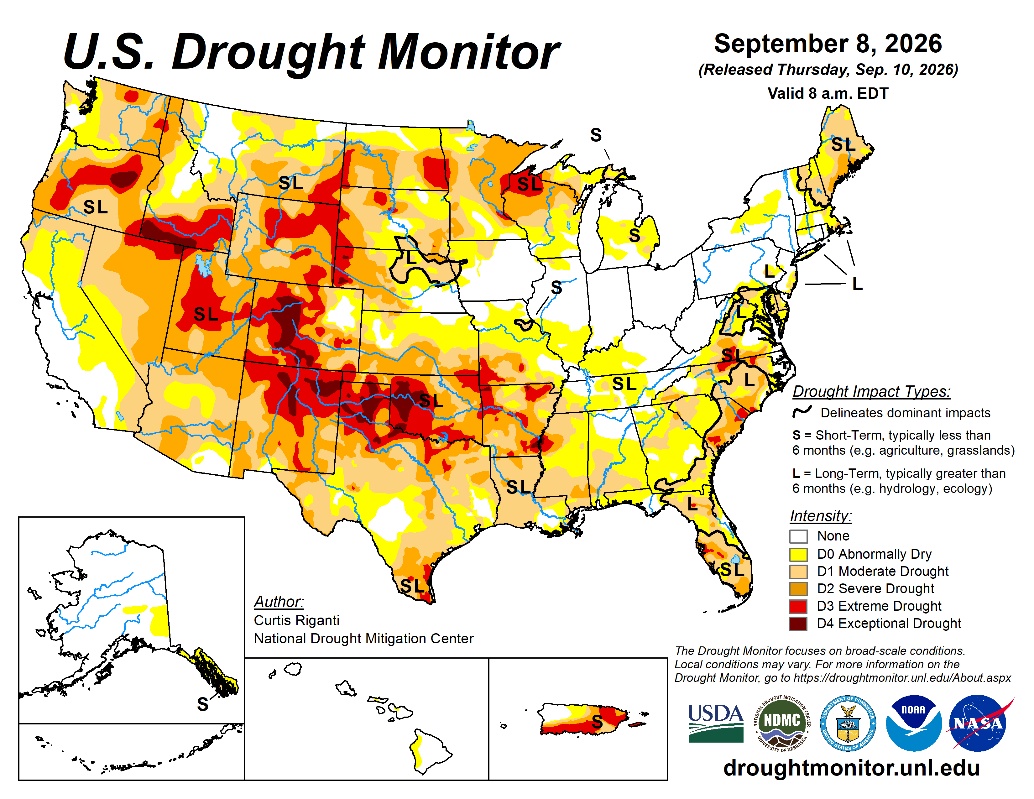
This Week’s Drought Summary

Drought and abnormal dryness continued to expand or intensify this week across parts of the central and south-central United States as flash drought conditions continued from much of Texas northeast to the middle and lower Mississippi River Valley. Warmer-than-normal temperatures, ranging from 10-15 degrees F above normal in much of the central Great Plains, Corn Belt and Missouri, combined with mostly dry weather in these areas to support worsening drought. Largely drier weather also continued this week in New England, in parts of the Michigan Upper Peninsula, along parts of the North Dakota-South Dakota border, in southeast Montana and in southwest Colorado, leading to degradations occurring in parts of these areas. In contrast, heavy rains fell from southeast South Dakota into western Iowa and southern Minnesota, in eastern Wisconsin, in northern North Dakota, in western Oregon and in parts of the northern Rocky Mountains in Montana and Idaho. Scattered heavy rains, locally 2-3 inches or more, also occurred in parts of Pennsylvania, New Jersey and Delaware, eastern North Carolina and Florida. Tropical Storm Edouard and its remnants delivered very heavy rain amounts, locally 10-15 inches or more, in a narrow corridor in southeast Texas. Lowell, in the central Pacific Ocean, delivered heavy rain amounts to Niihau, Kauai and Oahu as it passed west of the islands as a hurricane earlier this week, alleviating abnormal dryness in a few areas. Conditions continued to improve in localized areas of Puerto Rico this week after recent heavy rains. While the central United States dealt with an early-autumn heat wave, near- or below-normal temperatures occurred from the Great Basin west to the Pacific Ocean…

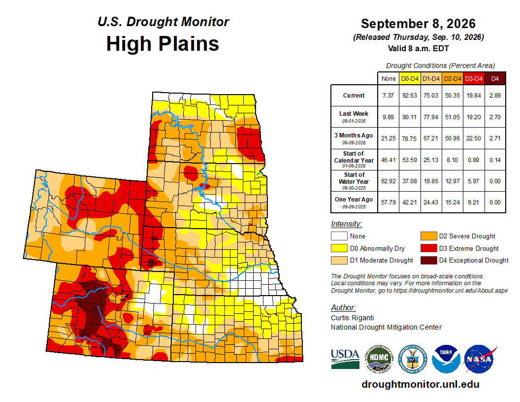
High Plains

Conditions in the High Plains region this week were mixed. Scattered heavy rains fell in northeast and southwest Nebraska, southeast South Dakota, northern North Dakota and far southwest Kansas, leading to localized or widespread improvements in these and neighboring areas. However, temperatures across the region were warmer than normal, leading to abnormally high atmospheric thirst and widespread degrading conditions in parts of the region. Temperatures were mostly 10-15 degrees above normal in Kansas, eastern Nebraska and southeastern South Dakota. Eastern Kansas and southeast Nebraska were particularly hot and dry this week, leading to large expansions of moderate, severe and extreme drought in south-central and southeast Kansas, and the introduction of abnormal dryness in much of northeast Kansas. Unusually wet weather in August kept conditions in southeast Nebraska from drying as much as areas farther south and southeast. Severe and extreme drought also grew in coverage in southeastern North Dakota, where warm and dry weather this week worsened precipitation deficits and soil moisture conditions. Drought conditions improved in southeastern South Dakota, and adjacent far northeast Nebraska, where rain amounts of 2-5 inches fell. Similar amounts of rain fell in parts of northern North Dakota, leading to improvements in soil moisture and streamflow there and improving drought conditions. Heavy rain amounts of 1-3 inches fell in parts of southwest Nebraska and the Nebraska Panhandle, and adjacent northeast Colorado, lessening precipitation deficits and improving drought conditions…
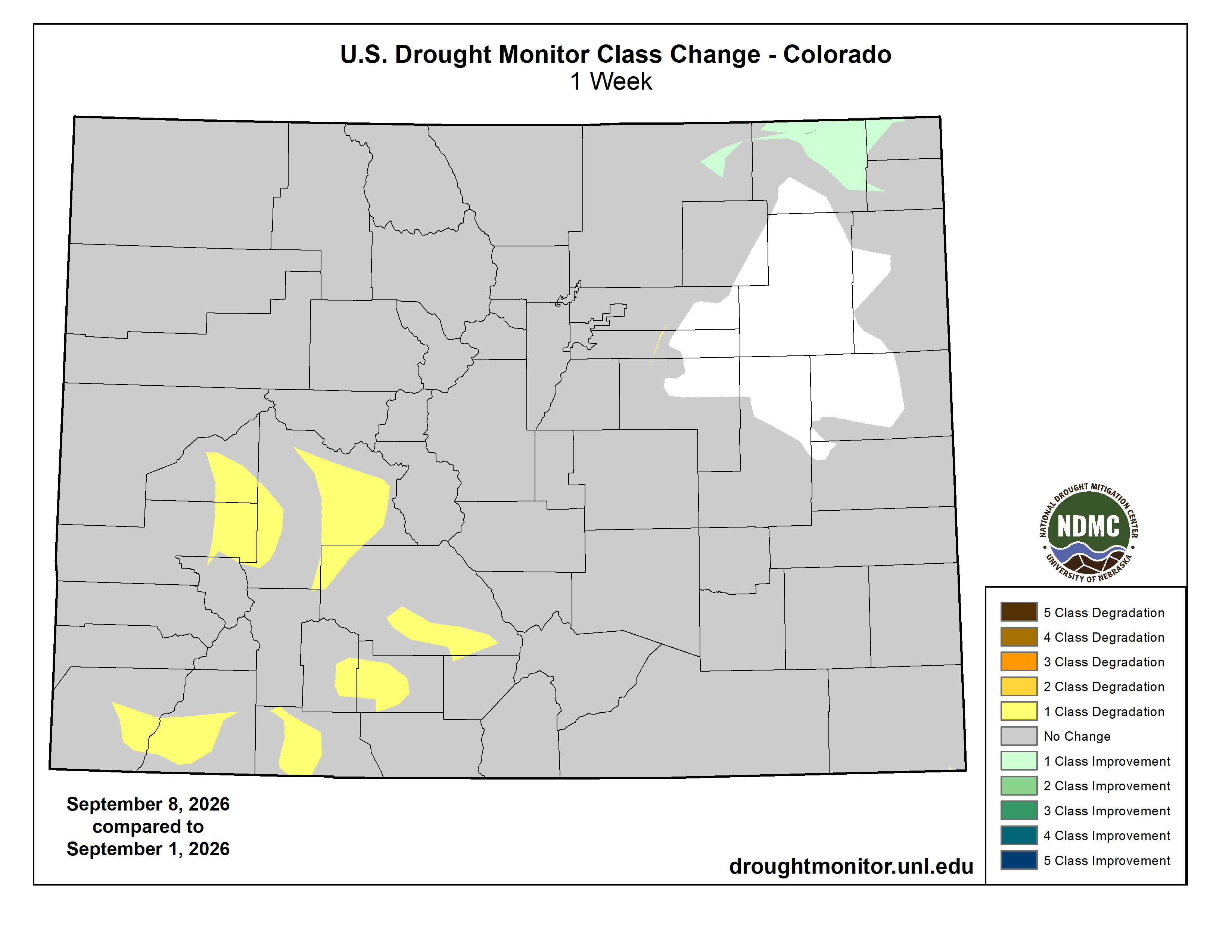
Colorado Drought Monitor one week change map ending September 8, 2026.

West

Most of California, Oregon, Washington and Idaho were cooler-than-normal this week, with some areas of northern California and southern Oregon finishing the week 10-15 degrees below normal. Eastern portions of New Mexico and Montana, by contrast, were warmer than normal, with temperatures in most areas 5-10 degrees above normal. Widespread moderate to heavy precipitation fell from northern California across portions of Oregon, central and northern Idaho and western and northern Montana. Precipitation amounts in western Montana and northern Idaho ranged from 2 to 6 inches. This led to increased soil moisture and streamflow and lessened short- and long-term precipitation deficits, and the coverage of moderate and severe drought and abnormal dryness lessened in some areas. Precipitation also improved conditions in south-central Oregon, as long-term precipitation deficits lessened in severity. Long-term precipitation deficits grew amid groundwater and soil moisture shortages in south-central Nevada, leading to an increase in severe drought coverage there. In southeast Montana, warm and dry weather led to decreased streamflow and soil moisture in a few areas, leading to localized expansion of severe and extreme drought…

South

Large parts of the South region continued to quickly dry this week amid mostly above-normal temperatures and dry weather. A few exceptions include southern Louisiana, southeast Texas (where former Tropical Storm Edouard dropped rain amounts that locally exceeded 10 inches), and parts of the western Oklahoma Panhandle, where scattered thunderstorm rains occurred. Isolated one-category improvements occurred in the Oklahoma Panhandle, while one- and two-category improvements occurred in southeast Texas, where precipitation deficits were either reduced or erased entirely, along with improved soil moisture and streamflow. Elsewhere, mostly dry weather and hot temperatures (5-15 degrees above normal) covered a wide area from western and northern Texas through most of Oklahoma, Arkansas, northern Mississippi and Tennessee. Short-term rainfall deficits continued to grow across much of the region, along with dropping soil moisture and streamflow levels, leading to widespread agricultural drought impacts. Large areas of degrading conditions spread from much of Texas into eastern Oklahoma, Arkansas, northern Mississippi and portions of Tennessee. The rapidly drying weather in Tennessee came after much wetter recent weather, somewhat lessening the impact of the recent heat and dryness there and in neighboring Kentucky…
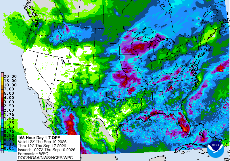
Looking Ahead

From the evenings of Wednesday, September 9-Monday, September 14, the National Weather Service Weather Prediction Center precipitation forecast is for mostly dry weather in the West, and in the western half of the Great Plains, except for parts of north-central Idaho eastward across Montana into North Dakota, where over 0.75 inches of precipitation are forecast in most areas. Eastern parts of South Dakota, Nebraska, Kansas and Oklahoma may also receive 0.75 inches or more of rain, with some parts of eastern Kansas and western Missouri forecast to receive 1.5 inches of rain or more. Much of northern Iowa, Minnesota, northwest Wisconsin and the western Upper Peninsula of Michigan are forecast to receive at least 1.5 inches of rain. Rain amounts at or above 0.75 inches are also likely in parts of the Ohio River Valley, southern Mid-Atlantic, southeast Louisiana, and parts of southern Mississippi, Alabama, northern Georgia and the Carolinas. Parts of the Florida Peninsula may receive 1.5-4 inches of rain. Generally drier weather, with local exceptions, is forecast in Texas, the Lower Peninsula of Michigan, northern parts of Illinois, Indiana and Ohio, and southern New England.

For September 15-19, the National Weather Service Climate Prediction Center forecast favors above-normal precipitation for much of the contiguous United States, especially in the Four Corners states. Near-normal precipitation is favored near the Gulf Coast and in parts of central and northern California and Nevada and eastern Oregon and Washington. Below-normal precipitation is favored in western parts of Oregon and Washington. Warmer-than-normal temperatures are favored across much of the southern and eastern United States, especially in the Southeast. Cooler-than-normal temperatures are favored in North Dakota, northern South Dakota, northwest Minnesota and most of Montana. Above-normal precipitation and temperatures are both favored in Hawaii. In Alaska, warmer-than-normal temperatures are favored across the state. Above-normal precipitation is favored in most of Alaska, though below-normal precipitation is likelier in southeast Alaska, and near-normal precipitation is favored in the central Aleutian Islands.

US Drought Monitor one week change map ending September 8, 2026.

Western states step up to save their wetlands — Natalia Mesa (High Country News)

Hannah Agosta/High Country News

Click the link to read the article on the High Country News website (Natalia Mesa):

July 1, 2025

The U.S. Supreme Court’s 2023 decision on Sackett v. Environmental Protection Agency dramatically weakened protections for millions of acres of the West’s essential wetlands and streams. Under the ruling, only bodies of water with a “continuous surface connection” to a “relatively permanent” traditional, navigable water body can be legally considered part of the waters of the United States (WOTUS) and therefore covered by the Clean Water Act.

The court’s definition excludes wetlands with belowground connections to bodies of water as well as those fed by ephemeral or intermittent streams. In effect, an estimated 60% of wetlands have lost federal protection, according to a National Resources Defense Council report. The language in the decision was ambiguous — exactly how wet a wetland has to be to fall under WOTUS and qualify protections was left up to federal agencies.

Wetlands are critical to both human and ecosystem health as well as for climate change mitigation. But they are also prime targets for dredging, filling and other disruptions because of their proximity to water and rich, fertile soil.

Under President Biden, the EPA broadly interpreted Sackett, focusing on protecting wetlands adjacent to bodies of water, with no explicit threshold for how often they had to be flooded. In March, however, Donald Trump’s EPA released a memo indicating that it plans to restrict all WOTUS, although it’s not yet clear by how much. 

“The current EPA seems to be using Sackett as a springboard to find any perceived ambiguities and narrow the definition of WOTUS further,” said Julian Gonzalez, senior legislative counsel at Earthjustice.

“The current EPA seems to be using Sackett as a springboard to find any perceived ambiguities and narrow the definition of WOTUS further.”

In the absence of federal regulations, state dredge-and-fill permitting programs can protect wetlands, and California, Oregon and Washington all have broad protections for non-WOTUS wetlands and streams. And since the Sackett decision, Colorado and New Mexico have passed laws restoring clean water protections for waters excluded from WOTUS. “It’s a dereliction of duty on the federal government’s part by not appropriately protecting the waters of the U.S. and that leaves it up to the states to fill in those protections,” said Rachel Conn, deputy director of Amigos Bravos, a New Mexico conservation organization.

The result is a patchwork of laws protecting the nation’s wetlands. But if more Western states were to emulate their neighbors’ efforts and take action, millions of acres of wetlands could be saved, even in the absence of strong federal protections. 

National Resources Defense Council estimates are based on scenarios in which the federal government adopts two interpretations of Sackett that are supported by industry and some states: one, excluding wetlands adjacent to intermittent or ephemeral streams (bottom of range), and another, excluding wetlands that are not wet or flooded most of the year (top of range). According to legal experts, the EPA’s current guidance suggests that the administration will limit WOTUS significantly, excluding most wetlands. Alaska is excluded from this graph due to lack of data.

Credit: High Country News

Arizona

Wetland oversight is primarily conducted through the Surface Water Protection Program (SWPP), administered by the Arizona Department of Environmental Quality. House Bill 2691, passed in 2021 before Sackett, established the SWPP, which allows the state to protect some waters not covered under the Clean Water Act. 

Wyoming 

While Wyoming lacks a permitting program, it does bar the discharge of any pollution or wastes into its waters without a clean water permit. In addition, Wyoming established a Wetland Banking Fund before Sackett to encourage individuals and companies to preserve wetlands. It enables entities to bank wetland credits earned from wetland conservation projects and use them later to offset a development’s impacts on wetlands, with the goal of achieving “no net loss of wetland function and value in the state.”

Colorado

Wetland protections are primarily governed by House Bill 24-1379, a law passed in 2024 that aims to restore Clean Water Act protections to state wetlands that lost them owing to Sackett. It establishes a state permitting program.

New Mexico

The Pollutant Discharge Elimination System Act (SB 21), which was signed into law on April 8, gives the state authority to regulate surface waters. It creates a statewide permitting program and addresses polluted groundwater that falls outside federal programs.


Credit: Hannah Agosta/High Country News

How wetlands work

Approximately 40% of species, including half of all federally listed species, rely on wetlands, which act like sponges for excess water, offering billions of gallons of flood protection and storing this water for later use. Their plants, roots and microbes filter pollution from drinking water and also store 20%-30% of the world’s total soil carbon. But Western states have lost 50% of their wetlands since colonization, and roughly half of the region’s remaining ones are degraded.  

Illustrations by Hannah Agosta/High Country News

SOURCES: From Gold, 2024 in Science/Environmental Defense Fund, National Resources Defense Council, U.S. Fish and Wildlife National Wetlands Inventory, Wetlands International. 

This article appeared in the July 2025 print edition of the magazine with the headline “In defense of wetness.”

Iron Fen. Photo credit from report “A Preliminary Evaluation of Seasonal Water Levels Necessary to Sustain Mount Emmons Fen: Grand Mesa, Uncompahgre and Gunnison National Forests,” David J. Cooper, Ph.D, December 2003.

Tiny backpacks reveal the secret, sometimes circuitous migrations of small songbirds — Stephanie Szarmach (TheConversation.com)

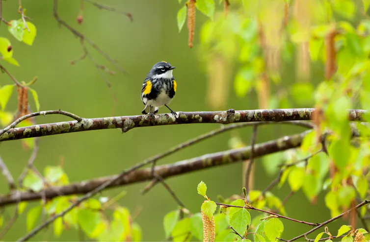
A small black, white and yellow bird perched on a branch with a green background.
A tracker must be light enough to not weigh down a bird that weighs only as much as a spoonful of sugar. Thor Veen

Stephanie Szarmach, Smithsonian Institution

Squinting through my binoculars, I scanned the dense branches of a black spruce, trying my best to catch a glimpse of the thin legs of a small black, white and yellow songbird. I was on the hunt for a yellow-rumped warbler – a bird affectionately called “butter-butt” by bird-watchers after the distinctive buttery yellow patch of feathers above its tail.

A woman in a veiled hat holds a small bird with red and yellow bands on its legs.
Stephanie Szarmach holds a yellow-rumped warbler that was banded as part of a study. Johanna Beam

Once I spotted a flash of red on one of the bird’s legs, I knew that this individual was special – in fact, it was one that I already knew well. That’s because I had placed identifying bands on it the previous year as part of my Ph.D. research, and it was carrying a very important piece of new technology.

I played the high pitched “warble” of its song through a speaker placed below a mist net of fine, nearly invisible mesh. Thinking another male had intruded on his territory, the bird quickly descended. My tactic worked – he got caught in the net. As I gently removed him, I breathed a sigh of relief as I saw the Tic Tac-size device sitting on his back.

A hand holding a bird that has a small grey device on its back
A yellow-rumped warbler wears a multisensor geolocator backpack. Stephanie Szarmach

Over the past year, this warbler carried a multisensor geolocator backpack throughout his migratory journey, recording the long trek from his breeding grounds in Anchorage, Alaska, to a yet unknown winter refuge and back again. Working with my Ph.D. adviser, evolutionary biologist David Toews, I deployed dozens of these cutting-edge tags to illuminate the migratory journeys of these high-latitude breeding warblers at a scale not previously possible for small birds.

Now, after a year of waiting, I finally had the data in hand.

How can scientists track small birds?

Researchers began tracking the movements of migrating birds in the late 1960s using radio telemetry, a technique that requires tagged birds to be physically followed with receiver equipment, sometimes aided by a small aircraft.

Then, as GPS became more widely available in the early 2000s, satellite tags let researchers accurately track birds remotely. However, GPS transmitters are hefty – even just the battery that powers them is too heavy to be carried by the majority of small migratory songbirds, which often weigh less than a spoonful of sugar.

To address this problem, researchers developed ingenious little light-level geolocators. These miniature tags minimize weight by containing only a tiny battery, clock, computer chip and light sensor. They store data internally rather than transmitting it – hence my need to recapture tagged birds a year later. Researchers infer a bird’s locations from the timing of sunrise and sunset, which vary predictably across the globe and throughout the year.

Light-level geolocators have opened new windows into the migrations of small birds, but they also have limitations: Their estimated locations can err by hundreds of miles, and this uncertainty becomes impractically high around the equinoxes, when day length is the same worldwide.

Two small grey devices sitting on a scientific data sheet.
Each harness loop of the multisensor geolocator goes around one of the bird’s legs and the tag sits on the bird’s lower back. Stephanie Szarmach

More recently, researchers developed a newer method of geolocation that uses atmospheric pressure to circumvent these limitations. When a bird ascends during a migratory flight, a barometric geolocator records a steep drop in air pressure, capturing the timing of departure and arrival for every stop along a bird’s migration route. In between flights, the pressure the tag records reflects the elevation at the bird’s position.

Knowing the bird’s elevation helps to narrow down possible locations, which researchers can then refine further by comparing the change in pressure over time recorded by the tag to global weather data using the computer program GeoPressureR. The unique pattern of rises and falls in pressure acts as a kind of pressure fingerprint for a specific location. Including light and wind data in the model of the bird’s movements can increase precision even more.

A graph showing atmospheric pressure over time. There are periods of steady pressure, with sharp drops in pressure occurring once per day.
Atmospheric pressure data collected from a multisensor geolocator carried by a yellow-rumped warbler over five days in spring. When the bird is stationary, such as when resting at a stopover site, the measured pressure remains steady. During migratory flights, when the bird ascends into the sky, the pressure drops and fluctuates dramatically. Stephanie Szarmach

New tech answers an old question

We used these new multisensor backpacks to study the migration patterns of myrtle warblers, the northern subspecies of yellow-rumped warbler, which breed across North America’s boreal forest. Myrtle warblers in the northeast are known to winter along the Atlantic and Gulf coasts, but where northwestern populations migrate has been more of a mystery. In 1899, ornithologist Richard McGregor observed myrtle warblers wintering in coastal California, and hypothesized that these birds might breed in Alaska and British Columbia.

Using these new tags allowed us to test whether warblers breeding in Anchorage, Alaska, actually followed the shortest migration route to winter in California. To our surprise – and probably to McGregor’s as well, if he were still alive – we found that all the birds we tracked traveled east across the boreal forest of Canada before shifting south to the Gulf Coast – certainly not the Pacific Coast route we expected.

All told, this 6,800-mile (10,900-kilometer) round-trip journey was much longer than we anticipated for a species commonly considered a short- or medium-distance migrant.

A map showing six geolocator tracks. All tracks start in Anchorage Alaska, before moving eastward across boreal Canada and then after reaching the Great Lakes curving south to end at the Gulf Coast. The predicted wintering area in California is circled.
Researchers tracked the routes six myrtle warblers flew on their fall migration southeast from Anchorage, Alaska. Figure by Stephanie Szarmach. Warbler illustration by Emily Griffith

Why take such a circuitous route?

The long, seemingly suboptimal route taken by our Alaskan myrtle warblers is actually mirrored by some other songbird species tracked from northwestern North America, including blackpoll warblers and Swainson’s thrushes.

Part of this pattern may relate back to the glaciations that isolated ancient populations of birds millions of years ago. The thinking goes that as these glaciers spread, they squashed the ranges of formerly northern species into the south. Then, as the glaciers slowly receded, the forests gradually reexpanded.

As more land opened up, birds moved farther north and west into that habitat. Each season some birds went a little farther as the forest available in their northern breeding grounds expanded. For migratory species such as myrtle warblers, the farther north and west their breeding range expanded, the longer the migration to their southern wintering ground became.

Scientists think migration routes are genetically encoded. The birds’ genes may have traced this expansion front, like Hansel and Gretel putting down breadcrumbs as they journeyed deeper and deeper into the forest. Today’s migration routes still trace that incrementally expanded path, even though the glaciers that shaped the original boundaries are long gone.

We’re still not sure exactly where the California-wintering myrtle warblers spotted in the 1800s are breeding. We suspect that a small proportion of the Anchorage-breeding birds may migrate to California, but that most of them travel from more distant, unstudied regions of Alaska or Yukon. Future research, potentially tagging myrtle warblers directly on the California wintering grounds, will shed more light on this population and why certain individuals follow a different migration route.

Barometric geolocation provides new data

Today, this new geolocation approach improves scientists’ ability to study the migrations of small birds and supports more effective conservation actions across the course of the entire year. More precise location estimates help researchers identify key stopover and wintering sites in need of protection and better understand the threats birds face throughout their journeys. These geolocators also reveal the altitude of migratory flights, which is important for understanding the risk of birds colliding with buildings or wind turbines.

Because these new tags capture pressure data for every migratory flight, they’re especially valuable for studying migration timing. Researchers have combined data from over 50 bird species to understand at what time of day or night different birds migrate. Now, as a postdoctoral researcher at the Smithsonian Migratory Bird Center, I am integrating multisensor geolocator data with satellite imagery to investigate how arrival and departure decisions throughout a bird’s migratory journey relate to seasonal changes in plant growth.

Scientists have now tracked dozens of bird species with multisensor geolocators, and that number increases every year. Each mapped migratory journey improves our understanding of how small birds migrate, what factors shape their movements and how best to protect them.

Stephanie Szarmach, James Smithson Postdoctoral Fellow, Smithsonian Institution

This article is republished from The Conversation under a Creative Commons license. Read the original article.