Photograph of a woman saving water as she washes dishes. Image by Storyblocks.
by Robert Marcos
A commonly cited metric claims that two households typically use an acre foot of water a year. But thanks to conservation in western cities an acre foot is often enough for 3-1/2 to 6 households. So why are government agencies, academics, and news agencies continuing to use an obsolete metric that makes residential water users look like they’re wasting water? 1
It’s bad enough that “40 million people” are reported to depend upon the Colorado River, while agriculture – which uses 80% of that water isn’t mentioned, while at the same time claiming that households are using twice as much water as they really are. The fact is that while the populations of cities have increased, per capita water use has fallen, dramatically.
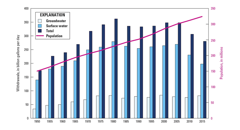
A US Geological Survey chart from 2015 shows America’s population rising (purple) as surface water use (blue) fell.
Here are recent statistics of residential water use from 7 western cities –
SAN FRANCISCO, California A typical household in San Francisco consumes approximately 0.14 to 0.17 acre-feet of water per year. Because San Francisco households use so little water, one acre-foot of water can supply about six households for an entire year. Mathematically, this equals roughly 0.166 acre-feet per household annually. 2
DENVER, Colorado A typical household in Denver uses between 0.25 – 0.28 AF per year. Residents of Denver practice moderate outdoor summer watering balanced by high indoor winter efficiency. Single-family residential customers average about 50 gallons per person per day for indoor use, with overall annual use split roughly 50/50 between indoor and outdoor needs. 3
LAS VEGAS, Nevada A typical household in Las Vegas uses between 0.28 – 0.35 AF. While 60% of residential water in Southern Nevada is consumed outdoors for landscape irrigation, nearly 99% of indoor water is recycled. Water that flows down the drain or into the toilet is treated and pumped straight back into Lake Mead, which generates “return-flow credits” for the city.
TUCSON, Arizona Average annual residential water use is between 0.20 – 0.22 AF per year. The city of Tucson has dramatically reduced residential water usage during the past two decades. Tucson residential customers average about 74 to 76 gallons per person per day, ranking among the lowest per-capita residential consumers in the desert Southwest. The city of Tucson has been proactive in encouraging water conservation by offering a wide range of rebates and incentive programs to residential and commercial customers. 5
FLAGSTAFF, Arizona An average household in Flagstaff consumes about 0.25 acre-feet of water per year – or about one acre-foot for every four homes. Flagstaff residents use about 84 gallons of water per person daily, which is roughly half of the Arizona state average. 6
SAN DIEGO, California Average annual residential water use is between 0.22 – 0.24 AF per year. Multi-family housing density and strong baseline state efficiency standards. County-wide residential water use averages approximately 76 gallons per person per day, down from historical averages due to ongoing state and local efficiency standards. 7
PHOENIX, Arizona Average annual residential water use is between 0.29 – 0.45 AF per year. Large variations between newer low-water developments and older properties with pools and grass lawns. City residents average between 100 and 155 gallons per person per day total residential use, with the majority consumed outdoors via landscaping and pools. 8
When fire commanders try to figure out how to contain a major wildfire, the last thing you might expect them to deploy is a herd of beef cattle. But on the recent Gold Mountain Fire in western Colorado, cows are eating the “fine fuels” along a three-mile fire line on the Big Cimarron River.
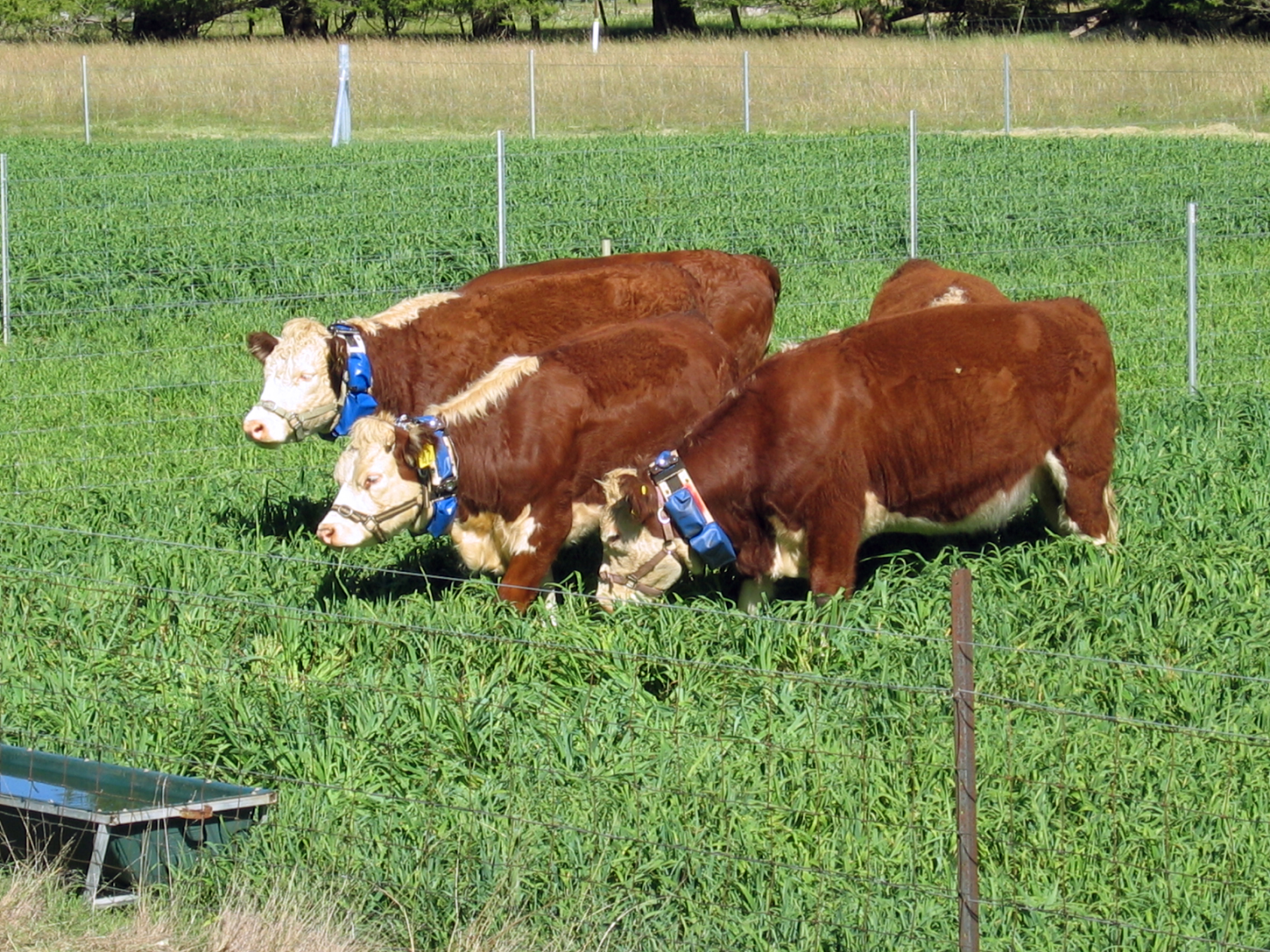
Putting that idea into practice five years ago would have required miles of electric fencing and a range rider to gather strays. Now, new technology has changed the game for cattle grazing by putting electronic collars — all solar-powered — on cows and linking them by satellite.
Using satellite technology, scientists from the Food Futures Flagship have helped to develop a prototype, animal-friendly virtual fencing system for cattle that enables the animals to be confined without using fixed fences. With virtual fencing, boundaries are drawn entirely by global positioning satellite (GPS) and exist only as a line on a computer. There are no wires or fixed transmitters used.The animals wear collars containing software that identifies where they are and emit a sound when they approach the boundary. The sound replaces the visual cue of a conventional electric fence that cows learn to avoid. The sophisticated software embedded in the system enables it to respond to varying animal temperaments. The research, overseen by an independent animal welfare expert, also showed the animals are not unduly stressed by the virtual fence. CC 3.0
“The Halter Collar is similar to a dog collar, has a tone, vibrate and a shock,” explained Mike Higuera, agricultural manager of Western States Ranches, based in Eckert, Colorado. An app on a smartphone allows range riders to draw electronic fences and track each cow by GPS.
“Gathering cattle in fall used to take four or more weeks and hundreds of person hours, but now it’s a few days,” said Higuera.
The idea for using cows to help contain wildfire came from Sean Brown, a 23-year veteran of range management at the U.S. Forest Service, who pulls in overtime organizing logistics for major forest fires near his base in Montrose, Colorado. He said he and the fire commanders realized that cattle would offer a safer way than setting a hazardous back burn to add to an “indirect” fire line, one away from direct flames.
Once Brown had permission from his bosses, he called Tyler Westhoff, Western States Ranches ranch manager. Westhoff quickly agreed to bring 350 radio-collared cows onto the fringes of the fire zone, which at that point, in mid-August, was 87% contained.
“Tyler flew into action,” Brown said. It turned out that Higuera and Westhoff were relieved to put cows onto their Big Cimarron federal grazing permit. “We’d been trucking water on another permit on the Uncompahgre Plateau, but this is better feed and good water,” said Higuera, who stressed that fire officials were ready to remove the cows if fire conditions turned ugly.
Brown said equipping the cows electronically gave him confidence that they could eat their way to an expanded fire line. This would reduce the burden on fire crews trying to keep the 39,000-acre fire contained until a season-ending event, typically rain or snow.
Westhoff loves what he calls the “Big Cim” grazing permit: “The top of it goes from 8,800 up to 12,000 feet. It’s northern San Juans and a prime grazing permit.” Best of all, he added, “There’s lots of grass.”
Brown took me on a Big Cim tour five days after the herd went to work. Standing in a field where tall grasses were now three inches tall, he explained that cattle are typically kept off burned permits for two years. Nature comes back, Brown said, but without constant herding cattle can move into sensitive areas and exacerbate erosion.
“We’ll have this herd in the Cimarron Valley next year, and fire-affected areas will be excluded with a virtual fence.”
The wildfire work on the Big Cim is good news for Western States Ranches, which was having a dismal summer. The Gold Mountain Fire started near the tourist town of Ouray, quickly roared across the ranch’s Owl Creek permit outside Ridgway, and traveled 26 miles onto the ranch’s Big Cimarron permit.
David Marston. Photo credit: Writers on the Range
“We felt like we had a target on our back,” Higuera said. “We were geared to release cattle above Ridgway, then four days later our evacuated cow camp was in flames.”
What does an cost? The leased equipment costs $96 per cow per season. “But for sprawling operations, when you add up person hours, diesel, and trucking water, a Halter pays for itself quickly,” Higuera said.
The collars have other uses besides wildfire work, especially for weed control. Often the first grasses to return after a burn are cheatgrass, which grows quickly in spring and then dries to become highly flammable. “But cows love it,” Westhoff said, “and on lower elevation permits, we’ve made it through a couple winters on cheatgrass.”
The ranchers said they were grateful to Brown and fire commanders for letting the cows perform. “Typically, there’s a risk aversion in the agency… but we showed we can be part of the solution,” Higuera said.
As for Brown, he said that sending in cows to expand a fire line was unique: “Never in my 23 years have I ever done something like this.”
Dave Marston is publisher of Writers on the Range, an independent nonprofit dedicated to spurring lively conversation about the West. He lives in Durango, Colorado.
Hey, guess what! I friggin’ hate putting Tr*)*p in the headline of this newsletter once again. It makes me nauseous. But the thing is, his administration has significantly stepped up its attacks on the environment, public lands, and wildlife over the last few months. I don’t know if this is an attempt to distract from ridiculous wars and crazy gasoline prices, or if it’s a rush to roll back as many protections as possible before the midterms. Whatever it is, I have to respond and cover the news, especially when it’s as big and consequential as today’s.
Last week, U.S. Fish and Wildlife Service Director Brian Nesbitvik sent out a memo to directing agency leadership to effectively eviscerate the Endangered Species Act by exempting industry from its purview, leaving imperiled wildlife vulnerable to slaughter and even extinction, so long as the action wasn’t “intentionally directed against a particular animal or animals.”
The Endangered Species Act declares it “unlawful for any person” to “take” — meaning to harass, harm, pursue, hunt, shoot, wound, kill, trap, capture, or collect — any species listed under the ESA. Since the law was passed in 1973, “take” has always been unqualified and absolute, meaning that killing or harming one of these animals is illegal whether the animal is targeted or not. This not only protects the animals from hunters, say, but also from industrial activities that may incidentally kill protected species.
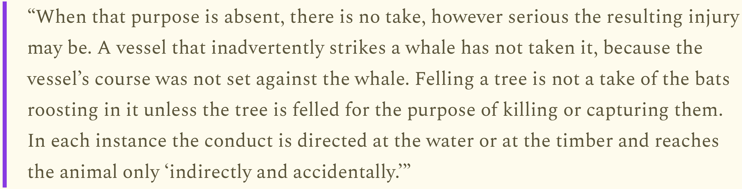
The Sept. 14 memo, however, directs the agency to adopt U.S. Supreme Court Justice Antonin Scalia’s interpretation of “take” in his dissenting opinion on a 1995 case, where he wrote that “take is a term of art” that “describes a class of acts (not omissions) done directly and intentionally (not indirectly and by accident) to particular animas (not populations of animals).”
Scalia expanded by writing that setting out poison with the intention of killing a wolf or other particular animal or chopping down a tree in which a bird is nesting would be a take if the “actor acted to reach the animal.” He then went on:
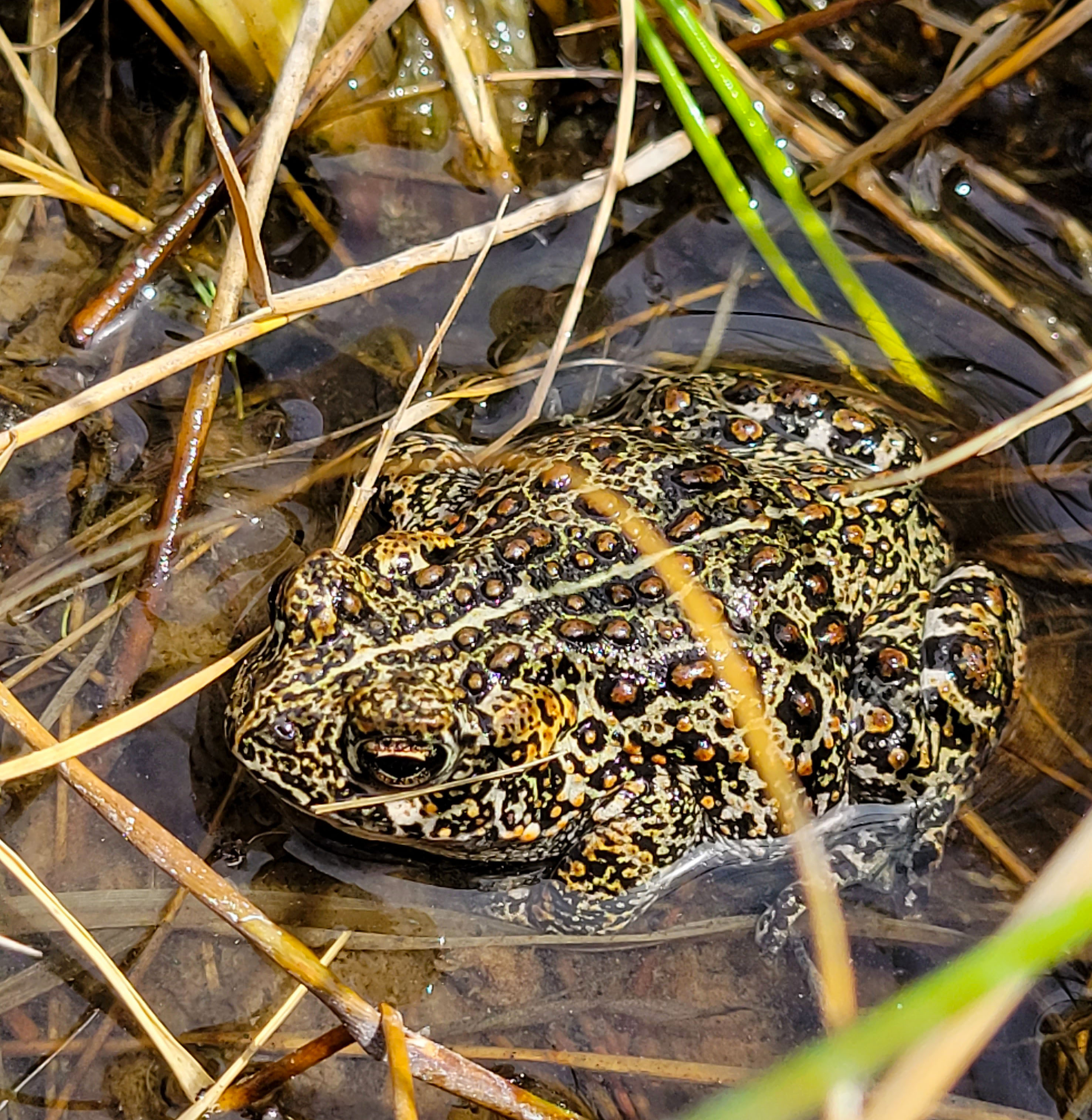
What this means is that hunting and killing a Valley Dixie toad to eat it would be a prohibited take. Wiping out the entire species with a lithium mine or geothermal operation would not constitute a take under this new interpretation because it isn’t targeting a specific animal. Therefore it would be acceptable under the ESA. The Trump administration gutted the Migratory Bird Act in a similar fashion last year.
Dixie Valley toads are found only in a hot-spring fed wetland in Dixie Valley, northeast of Fallon, Nevada. Dixie Valley toads were emergency listed as an endangered species in April 2022. Primary threats include geothermal development, disease, predation by other non-native frog species, groundwater pumping for human and agricultural use and climate change. By USFWS Pacific Southwest Region from Sacramento, US – Dixie Valley toad in its wetland habitat., Public Domain, https://commons.wikimedia.org/w/index.php?curid=120784750
To be clear, industry has killed endangered wildlife and migratory birds even under the stricter interpretation of “take.” But the prohibition on doing so, and the sometimes substantial fines that go along with it, incentivize industries to take measures to avoid incidental takes.
The new interpretation essentially gives industry carte blanche to harm or kill endangered species without accountability or recourse and reduces the ESA to no more than a ban on hunting certain species of wildlife. If this directive holds, the consequences will be dire.
🌵 Public Lands 🌲
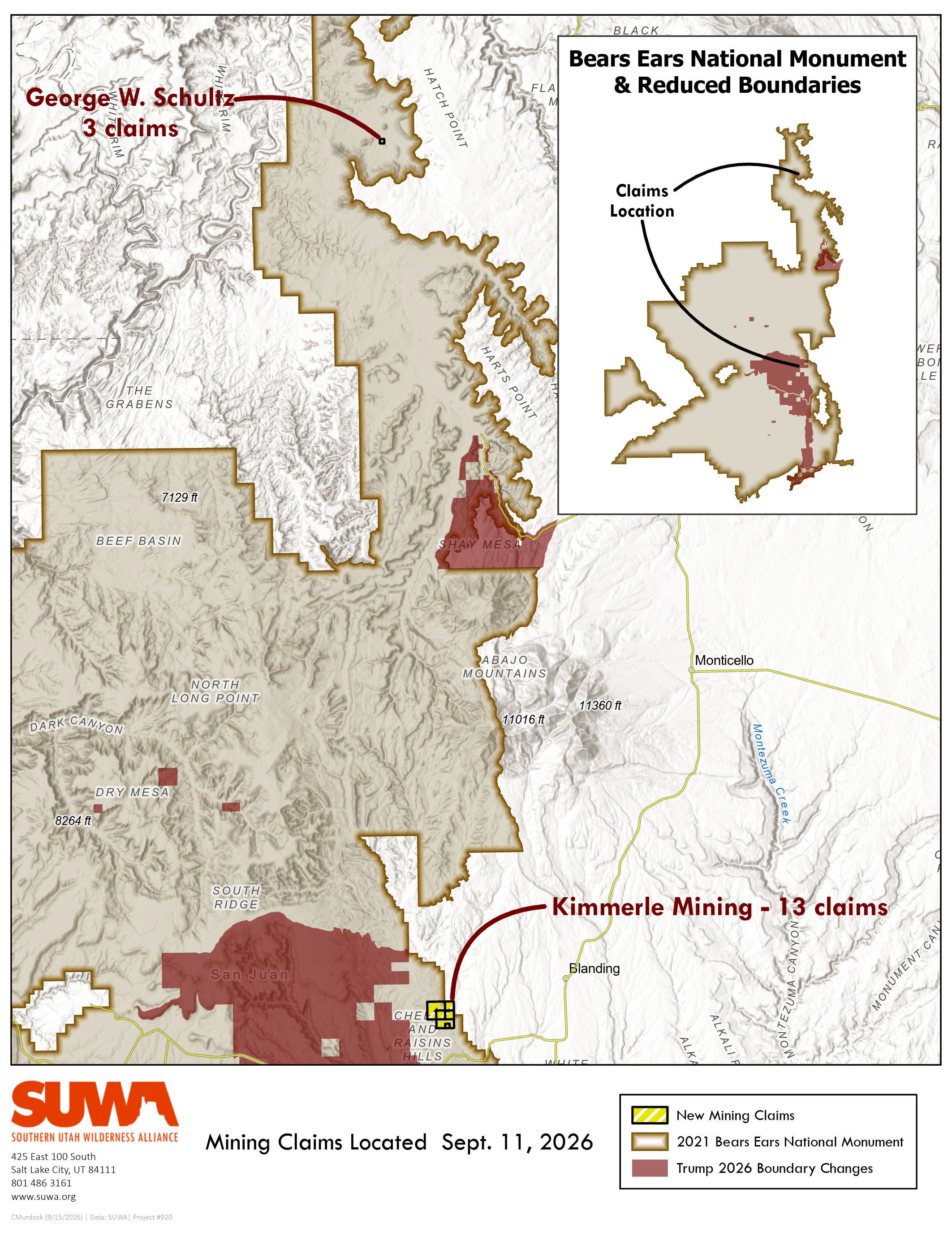
President Donald Trump’s unlawful shrinkage of Bears Ears and Grand Staircase-Escalante national monuments went into effect Sept. 11. That same day, two separate parties filed 16 new mining claims with the San Juan County recorder in the reopened areas (but they are not yet in the BLM’s records).
George W. Schultz filed three claims in the Lockhart Basin area, which is on the northern end of the pre-shrinkage monument below and north of Needles Overlook. And Kimmerle Mining staked 13 claims in the Cottonwood Creek drainage near the Cheese & Raisins Hills (they had previously filed seven claims in that same area).
Schultz owns and operates a Jeep tour outfit in Moab and is active in the off-road vehicle advocacy community. His father was a geologist who staked dozens of claimsin southeastern Utah, and the younger Schultz has also staked claims in the past, including several inactive ones in Lockhart Basin, near the new ones. While the area had a few prospects, it was not an especially active area for uranium mining historically.
The Kimmerle family and its various firms hold hundreds of mining claims across southern and eastern Utah, including several within Bears Ears National Monument. Kyle Kimmerle proposed mining unpatented claims within the monument, but did not go through the process of proving the claim’s validity that was a prerequisite for obtaining an operating permit. Kimmerle then joined Utah’s lawsuit seeking to block the Biden administration’s restoration of the monument’s original boundaries.
Kyle Kimmerle’s firm, Three Step Resources, was the underground contractor at Energy Fuels’ La Sal Complex uranium mine in 2024 and early 2025, when the federal Mine Safety & Health Administration issued 16 citations for violations related to radon concentration and radon monitoring requirements, worker training, personal protection equipment use, and explosive material storage. In late 2024 Kimmerle was appointed to the board of Urano Energy, now Manhattan Uranium, which holds claims in the Lisbon Valley and near the San Rafael Swell.
In 2024, Sassy Gold was set to acquire 345 uranium mining claims on 8,206 acres in La Sal Creek, the Lisbon Valley, the Uravan Mineral Belt, and on the San Rafael Swell from Kimmerle Mining and its associated firm, Three Step Partnership. But a few months later, Sassy retracted its offer, saying it “identified a number of material political, environmental and technical risks associated with the properties” that “fundamentally altered the value of the proposed transaction.”
Kimmerle’s new claims are in an area that was heavily mined historically.
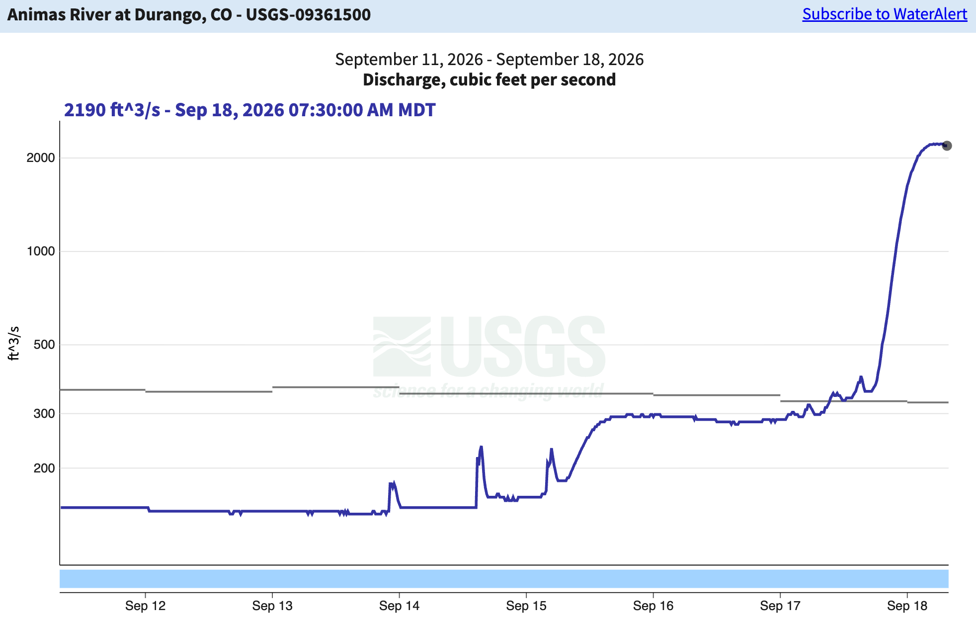
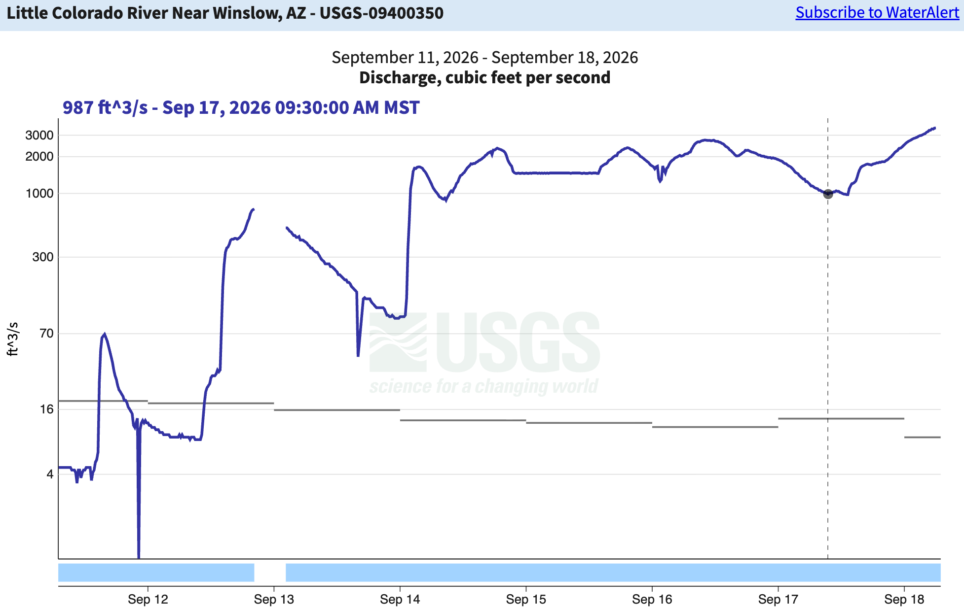
The rains have finally arrived in the Four Corners, which is a big relief, but also has had tragic consequences: A flash flood on Wednesday swept three people to their deaths near Newcomb, New Mexico, on the Navajo Nation. A flash flood watchremains in effect in northern New Mexico today.
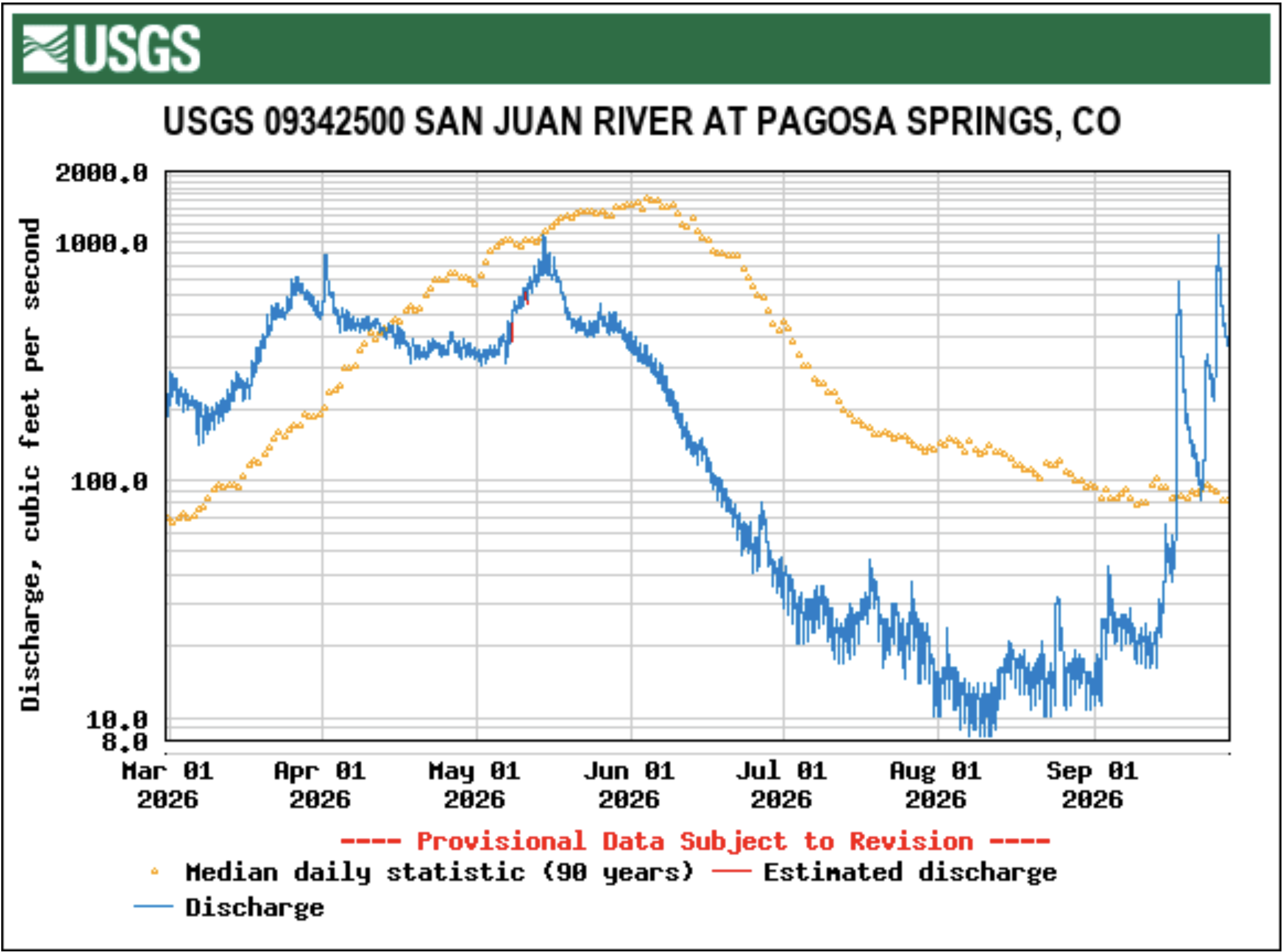
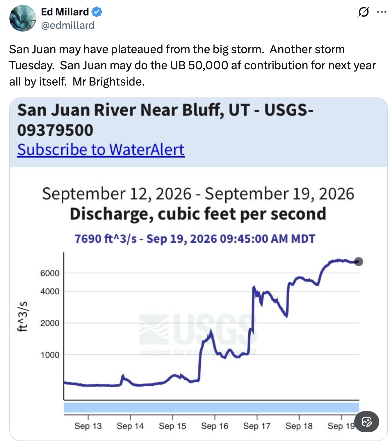
As one might expect, the rains bolstered streamflows significantly. Here are a couple of graphs for some of the biggest beneficiaries of the extra precipitation:
Click the link to read the article on the Pagosa Springs Sun website (Clayton Chaney). Here’s an excerpt:
September 24, 2026
Pagosa Country has experienced both record-low river levels and flooding that caused closures over the last week, including the ongoing closure of Chimney Rock National Monument. The San Juan River in downtown Pagosa Springs hit a new record low flow on Thursday, Sept 10, falling below 12 cubic feet per second (cfs), before trending back up with this week’s rains. On Friday, Sept. 11, the Piedra River near Arboles set a new record low flow of 10.4 cfs. The previous record for that day was set in 2018 at 17.3 cfs. By Wednesday morning, the San Juan River was flowing above 60 cfs, according to the U.S. Geological Survey (USGS), and had an instantaneous reading over 55.1 cfs at 2 p.m. According to 90 water years of USGS records, the record low flow for Sept. 16 was set in 2018 at 12.9 cfs. The record high was recorded in 1970 at 1,190 cfs. The median cfs for that date is 85 cfs, and the mean is 144 cfs. As of 2 p.m. on Wednesday, the Piedra River was flowing at a rate of 25.2 cfs. According to 63 water years of USGS records, the record low for that date was set in 2018 at 11.2 cfs, and the record high was set in 1970 at 1,630 cfs. The mean flow for that date is 216 cfs, and the median flow is 123 cfs. Pagosa County experienced multiple rain events beginning on Monday, Sept. 14, with reports from the Community Collaborative Rain, Hail and Snow Network in Archuleta County showing anywhere from just under an inch to more than 2 inches of rain received from Monday to Wednesday.
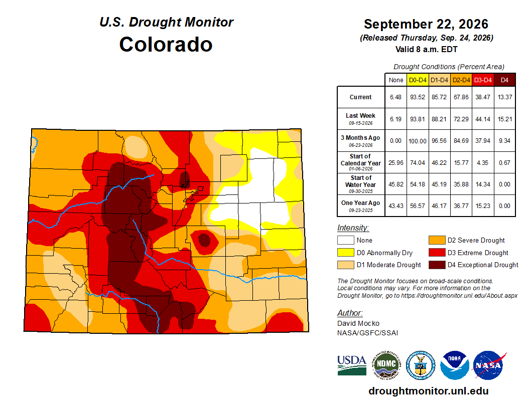
Colorado Drought Monitor map September 22, 2026.
The most recent drought map released by the U.S. Drought Monitor was published on Sept. 10, before the area’s most recent rain events, and shows just over 50 percent of Archuleta County being in a stage three, extreme drought. That was up from just over 22 percent of the county falling under extreme drought as of Sept. 1.
Colorado Parks and Wildlife recently released a Beaver Conservation and Management Strategy to help beaver coexist with human activity in the state. | Credit: Colorado Parks and Wildlife
Click the link to read the article, and listen to the radio program, on the H2ORadio website (Frani Halperin):
September 20, 2026
Long hunted for their fur or extinguished as a nuisance, states like Colorado are promoting coexistence policies for the animals in recognition of their engineering abilities to move water where it’s needed most—especially in times of drought and increasing wildfires.
Honestly, I thought it was a prank. Running in my park in southeast Denver this summer, I saw several small cottonwood trees cut down along the creek. They had that distinctive hourglass-shaped stump that beavers make, but I live in an urban area, so clearly not felled by large aquatic rodents with buck teeth?
“So many people that live in Denver don’t even realize that beaver live in our creeks,” says Vikki Vargas-Madrid, the wildlife program manager for Denver Parks and Recreation.
Count me among those who did not know that anywhere there’s a creek, river, or stream along the Front Range of Colorado, (a term many people use to describe an urban corridor that stretches from Fort Collins to Colorado Springs and includes cities like Denver) you will find the animals.
Have water, will travel—but the beaver are not always welcome. Vargas-Madrid says her office gets calls every day from the public asking, for example, “why aren’t you protecting the trees in Bear Creek? The beaver are eating them all.” In the old days, Vargas-Madrid says, “the easy answer was, well, we’re just going to kill them all.”
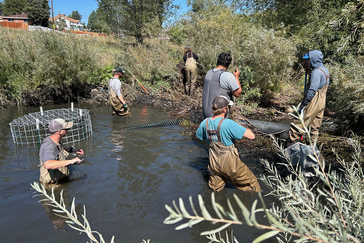
But times have changed and management practices have evolved—something I was able to see firsthand. I met Vargas-Madrid at a creek called Sanderson Gulch that runs through a park in a residential area of southwest Denver. On a summer morning, we bushwhacked through some willows on the bank to get a closer look at a beaver dam with a large corrugated PVC pipe running through it that allows water to pass while maintaining the pond that the beaver created.
Denver Parks and Recreation wildlife & open space team install a pond leveler in a beaver dam at Sanderson Gulch that will allow water to pass. | Credit: Vicki Vargas- Madrid, wildlife program manager
Vargas-Madrid explains that the intent of installing the flow devices, which are made up of a pipe with cages to keep the structures in place, is to allow the beaver to remain. She says that beaver are important for ecological benefits, but some of the public don’t necessarily see that.
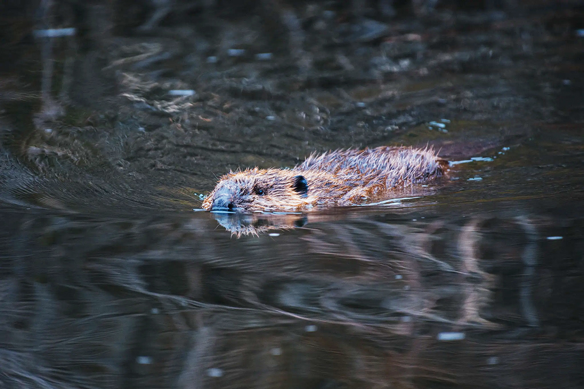
American beaver, he was happily sitting back and munching on something. and munching, and munching. By Steve from washington, dc, usa – American Beaver, CC BY-SA 2.0, https://commons.wikimedia.org/w/index.php?curid=3963858
North American beaver (Castor canadensis), which are a “keystone species” in riparian communities, create wetlands that support aquatic vegetation that provide food for other wildlife, like the Swainson’s hawk that Vargas-Madrid spots overhead. She says her staff see more diversity in the birds, fish, and waterfowl that exist in the pools of water that the beaver create.
It’s not just the city of Denver that sees the value of beaver in the urban landscape. Kris Inman with Colorado Parks and Wildlife (CPW), a division of the Colorado Department of Natural Resources, says that urban areas are great places to see beaver doing what they do well.
Inman is the new beaver conservation program manager for the agency. Her job is to implement the new Beaver Conservation and Management Strategy released in March. The state wants to promote coexistence practices with beaver and she’s in luck, as beaver are having a moment. States, especially across the West but also around the country and even places internationally, are recognizing how the animals help protect ecosystems. Inman says that when beavers construct dams, they reconnect surface water to the pond that forms behind it with groundwater, and that enables the ground to act as a sponge. It can hold onto winter snowpack a little bit longer, and then slowly release it back into streams, providing us water when we—especially in the arid West—need it most.
Inman says there’s also been a lot of momentum to use beaver and their engineering prowess to help with wildfire prevention. Beaver efforts can be a natural way in which to store water longer, potentially having natural fuel breaks. She says the state can take advantage of this attribute by mimicking beaver dams and putting beaver dam “analogs” out in the field.
According to Inman, the hope is that beaver will adopt the human-constructed dams—the analogs—and maintain them, but that still doesn’t eliminate the potential conflicts with landowners, especially agriculture. Beaver “basically eat themselves out of house and home,” comments Inman, and then move on, adding that “they’re constantly doing forays and traveling up and down rivers and streams looking for new places to live.”
That new place could be someone’s private pond or fishery where beaver have moved in because water flows have become too low during droughts. Deep water is one of the primary protections beaver have against predators, but undoubtedly, it’s frustrating when dams disrupt water flows. Inman notes that a farmer might have a canal that’s blocked preventing water from going where it’s needed. Also, beaver activity could cause trails to flood or bridges to be washed out.
The Colorado beaver management plan includes strategies to relocate beaver, take out troublesome dams, paint trees with a sand-like texture to make them less tasty, install fencing around culverts—or add flow devices like the one at Sanderson Gulch.
Back at Sanderson Gulch in Denver near the beaver dam, a jogger along the adjacent path stops to talk to Vargas-Madrid and me. She says she sees the creatures early in the morning when she walks her dog. They’ll be on the side of the creek or occasionally in deeper water, and spotting them, she says, is “pretty cool.”
Her appreciation for having beaver in her local park was a sentiment expressed by other residents of the area when a project for the creek was being considered at a recent Denver City Council meeting. On September 14, 2026, the Denver City Council approved $20.6 million for improvements along Sanderson Gulch. As Denveritereports, among other improvements, the money will be used to deepen the creek. The city won’t remove the beaver but did acknowledge that the project will likely mean they will relocate. Gordon Robertson, of Denver Parks and Recreation said at the meeting that the goal was to widen the creek, and make it flatter to create more ecological benefits. Other work in city parks has disrupted beaver to leave temporarily, but, Robertson said, they will likely eventually return and this project will create more opportunity for them and hundreds of other species.
At the council meeting, beaver advocates from the local neighborhood organization voiced their concerns with some saying the project was not designed with beaver in mind. The group’s interest in coexisting with the animals and being eager to have beaver as their neighbor, makes the new state management plan’s objectives that much closer to being met.
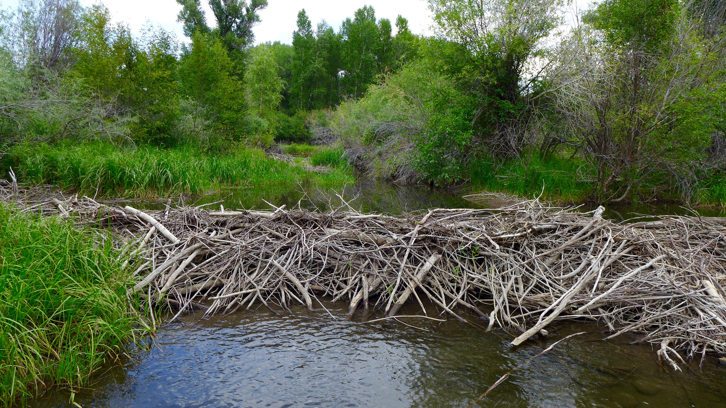
A beaver dam on the Gunnison River. Photo: Brent Gardner-Smith/Aspen Journalism