Study reach in the Cliff-Gila Valley, showing the three study transect locations for this work: upstream perennial (UP), seasonally dewatered (SD) and downstream perennial (DP); major irrigation diversion sites and the approximate regions where the channel was seasonally dewatered by diversions in normal and extremely dry years. The dewatered region is magnified in the inset figure to show the position of the Fort West ditch overflow channel. USGS gaging station 09430500 is located at the upstream end of the valley. Gila River flows from north to south.
Click the link to access the research paper on the Wiley Online Library website (Ellen Soles, Martha Cooper, Laurel Saito). Here’s the abstract:
In arid regions with limited water supplies like the Colorado River basin of the southwestern United States, flow regimes and water availability are major controls on native riparian ecosystems resilience, persistence and function. In this paper, we share a case study that uses a long-term dataset of topographic, vegetation and groundwater data collected over water years 2011–2021 to demonstrate how secondary channels formed during high flow events enhance groundwater-dependent riparian ecosystem resilience, favouring native over non-native vegetation. In the Cliff-Gila Valley of southwestern New Mexico, channelization and levee construction between 1940 and 1980 profoundly altered the floodplain and channel of the Gila River, a Colorado River tributary. During subsequent large floods, river anastomosis (branching) left a network of secondary channels across the floodplain. Long-term data show that these channels improve vegetation access to groundwater, facilitating regeneration and expansion of diverse native groundwater-dependent vegetation. Data also show that even the lowest perennial flows (0.4–0.6 m3 s−1) sustain rates of groundwater recession favourable to successful native riparian seedling recruitment in the topographic lows created by secondary channels. Alluvial groundwater recedes more sharply in a reach seasonally dewatered by irrigation diversions, but seepage through diversion structures and unlined ditches maintains shallow groundwater levels. This case study demonstrates that even in arid regions, robust native groundwater-dependent riparian areas can co-exist with human water demands when large floods can move across broad floodplains and create topographic complexity. [ed. emphasis mine] The study also highlights the importance of long-term datasets for documenting ecosystem resilience to floods, drought and ongoing climate change.
The Pinto Valley Mine, processing area, and tailings depositories in the Globe-Miami mining district. Pinto Creek is to the viewer’s left. Source: Google Earth.
Pinto Creek used to run year-round. Bubbling up from springs and occasional snowmelt in the Pinal Mountains of central Arizona, it nourished a riparian ribbon of green through the rocky, arid landscape, shaded by sycamores, willows, and alders, until it empties into Theodore Roosevelt Reservoir. Gila topminnow, longfin dace, and roundtail chub plied its waters. Even during drought years it reliably delivered at least 1,000 acre-feet of water at its Magma Weir gauge, and in wet times as much as 39,000 acre-feet annually might flow along its bed.
Then, a little over a decade ago, something odd happened. The flow volume plummeted from 4,147 acre-feet in 2013 to just 482 acre-feet in 2014, and ever since the once year-round stream has run only intermittently and at similarly diminished levels. Towering trees along its banks have died and toppled, and the green swath has lost much of its color. It’s possible that long-term aridification simply caught up with the little stream, as 2013 was a dry year. But there’s a more likely culprit: In October 2013 Capstone Copper Corporation acquired the nearby Pinto Valley Mine, a massive, open pit copper and molybdenum operation that had just emerged from several years of dormancy, and resumed heavy groundwater pumping from its Peak Well field.
While correlation is not causation, the Tonto National Forest saw enough evidence of a link to ask the Arizona Department of Water Resources to put the brakes on the mine’s groundwater pumping. Failing to do so would harm the Forest Service’s instream Pinto Creek water right — along with the downstream riparian ecosystem it supports. The state did nothing and the Forest Service dropped the complaint and approved the mine’s expansion in 2021.
The Land Desk has often looked at mining’s effects on water quality.1 But the Pinto Valley case highlights the fact that mines can also affect water quantity — and vice versa, as water scarcity can limit mining operations. It warrants a closer look during these water-constrained times, when water consumption by everything from data centers to golf courses to alfalfa farms has attracted more scrutiny.
A mining operation goes through water in two ways. First, the mine itself, whether underground or open pit, can act like a well. Dig a hole into the earth, and groundwater will flow into it. While gravity can drain this flow in underground mines burrowed into the sides of mountains, the water must be pumped from open pit and underground shaft mines, a practice known as dewatering, which can take large amounts of water out of the aquifer. Capstone says it pumps about 400 gallons per minute from its pit.
This draws down groundwater wells and can dry up springs and diminish streamflows. Without dewatering, you end up with something like the Berkeley Pit, which is now a 50-billion-gallon, acidic and contaminated lake that’s about 900 feet deep. Because this water is usually contaminated by acid mine drainage, it often can’t be reused without some treatment, and dumping it into a stream or back into the aquifer is also problematic.
A mining operation also requires significant amounts of water for dust control, mineral processing, slurrying, and other uses. Capstone’s 2024 sustainability report says its Pinto Valley Mine withdrew a total of 8,932 acre-feet — or 2.9 billion gallons — of groundwater and surface water.
West Drought Monitor map March 24, 2026.
The company has not released its 2025 data yet, but in financial filings reported that the Pinto Valley Mine had to slash mine production and mill throughput by about 37% in 2025 due to “unplanned downtime driven by water constraints due to the drought conditions in central Arizona.” The company is trying to address this by reducing per-ton water usage by 20%, but that may not be enough given the extreme drought conditions spreading across the Southwest.
A central clearing house or database of mine water use in Arizona does not exist, but various sources can help paint a picture of how much water the mining industry in the state uses (I’ll look at other states in a future dispatch).
Safford Mine Complex: Consumptive water use increased from 3,624 acre-feet per year to 6,099 af/yr following a 2020 expansion, according to the Arizona Department of Water Resources 2025 Safford supply and demand report. Municipal uses in the Safford Basin use about 6,000 acre-feet per year, while agriculture — primarily for cotton, pecans, pistachios, and alfalfa — consumes about 138,301 acre-feet annually.
Freeport-McMoran reported to the AZDWR that in 2023 it withdrew 22,490 acre-feet of groundwater for its Sierrita Mine south of Tucson. The cost? $3.50 per acre-foot. That’s about one penny for 1,000 gallons of water.
Freeport-McMoran’s Morenci Mine, one of the nation’s largest copper operations, uses about 14,000 acre-feet per year on average, according to the AZDWR. The mine imports much of its water from the Black River, a tributary to the Salt River, under a lease with the San Carlos Apache Tribe for a portion of its Central Arizona Project allocation.
The following chart is from an Arizona Department of Mines & Mineral Resources report from 2010 by Dr. Madan M. Singh. It’s a nice, comprehensive look at how much water the state’s major mines used in the preceding years. Current use is likely about the same, except that now there are additional mines (the Pinto Valley Mine was not operational in 2010, which is why it’s missing).
Source: Water Consumption at Copper Mines in Arizona, by Dr. Madan M. Singh, 2010.
So, according to Singh’s report, Arizona’s largest mines used a total of 55,659 acre-feet per year during the 2000s. Add the Pinto Valley Mine (8,932 af) and Safford Mine (6,099 af) and you get about 70,600 acre-feet per year, or 23 billion gallons annually.
That’s a lot of water, but it pales in comparison to many other uses. Arizona alfalfa, alone, probably uses more than 1.5 million acre-feet (based on 6 af water/acre over 280,000 planted acres, according to the USDA). “Turf facilities” guzzled some 157,000 af in 2024, according to the AZDWR, while power generation used 86,053 acre-feet. TSMC’s north Phoenix chip manufacturing facility is projected initially to use about 19,000 acre-feet of water annually.
In other words, when Arizona’s water cops come looking for the big water users, the mines probably won’t be at the top of their list. Since most mines rely on groundwater, Colorado River water shortages may not affect them too much, at least in the near future.
Still, some mines, including ASARCO’s Mission Mine, do pull some water from the Central Arizona Project, which could be hit hard by the Colorado River crisis as early as next year. And, as the Pinto Valley Mine situation last year demonstrated, continued aridification and relentless pumping could lead to groundwater shortages at the mines, forcing them to reduce production even as they work to become more water-efficient.
Prospective mines could face serious challenges, as well. Resolution Copper estimates its contentious Oak Flat mine would use between 15,700 acre-feet and 20,000 acre-feet per year. Others, however, say this is too low; one study says it would likely be closer to 50,000 acre-feet annually, based on the per-ton water consumption for copper at other Arizona mines. Resolution has said it would rely at least partly on Central Arizona Project water, the security of which grows shakier with each passing year. It’s hard to imagine that there will be any water available for new users by the time that mine is up and running if current climatic trends continue.
That may be what Faraday Copper had in mind when it signed a letter of intent to acquire the San Manuel copper mine in southern Arizona. While Faraday said it would be reopening the long-shuttered operation and combining it with its proposed Copper Creek venture nearby, it may also be eying the substantial water rights BHP Copper holds for the San Manuel Mine. Those could come in handy if and when the Copper Creek facility is developed.
Regardless, however, one thing is clear: Any new mine is going to rob the springs, the streams, and the wildlife and communities that rely on them of at least some of their precious water. [ed. emphasis mine]
1 In 1993, when the Pinto Valley Mine was operated by Magma Copper, a large rain event “overwhelmed the mine’s water management capabilities,” causing the reservoir to overflow the tailings pile, tear out a levee, and carry hundreds of tons of tailings and millions of gallons of contaminated water into Pinto Creek. The creek was found to have low pH (high acidity) and high concentrations of cadmium, copper, lead, mercury, and zinc, resulting in significant fish die off, specifically of desert or Gila Mountain suckers.
Lamar Fields, a tribal member, gathers blue corn to sample. With increasingly unreliable access to water, flexible crops like corn have become integral to the farm’s survival. To increase revenue, the farm built a mill to process crops like blue corn. Caitlin Ochs
For a century, the Colorado River has been managed in pieces. Legally and politically, it’s divided into two basins, with each state and community focused on securing its respective water supply. But that is not how a river functions. The Colorado River is an interconnected system, sustained by Rocky Mountain snowpack, rainfall and groundwater.
It is fragile, and under increasing stress. Two and a half decades into this century, the river that built the modern West has 20% less water flowing through it than it did on average in the last century. As heat and drought intensify, so do the stakes: Failure to recognize the severity of changing conditions, managing the river in parts without considering needs of the whole and inadequate planning for long-term shortages put the future of all the basin at risk.
For the last five years, I have documented how the Colorado River Basin’s farmers are navigating water shortages and uncertainty amid deep political divisions about the river’s future. This project, called American Adaptation, examines three agricultural communities whose survival is threatened by a shrinking river, examining what happens to people when policies and water management struggle to keep pace with a changing climate.
In one of the river’s northern watersheds, the Ute Mountain Farm and Ranch Enterprise is adapting its management as the water it relies on becomes less dependable. In central Arizona, farmers have returned to well water after becoming the first communities to have their supply cut off completely due to the basin-wide shortage. And in California’s Imperial Valley, the farms that receive the river’s largest water allocation are under growing pressure to share the burden of shortage.
Together, their stories illustrate the stakes — and rising tensions — of the current negotiations over the river’s future management. States, tribal nations and the federal government are reckoning with 100 years of developing water infrastructure based on assumptions of continuing abundance and expansion. These ideas — and the legal frameworks built around them — are colliding with the reality of a river with much less water than expected, raising complex questions about what the Colorado can sustain, how its water should be used and who will shoulder the necessary cuts.
The Dolores Project, located in the Dolores and San Juan River Basins in southwestern Colorado, develops water from the Dolores River for irrigation, municipal and industrial users, recreation, fish and wildlife, and hydroelectric power. It also provides vital water to the Dove Creek area, central Montezuma Valley area, and to the Towaoc area on the Ute Mountain Ute Indian Reservation. McPhee Dam and Reservoir is the principle storage feature of the Dolores Project which includes a system of canals, tunnels, and laterals to deliver water to over 61,000 acres of land. Photo credit: Kenny Browning/Flickr
When Water is Uncertain
On 7,600 acres painstakingly carved out of desert brush, the Ute Mountain Farm and Ranch, a tribally run enterprise of the Ute Mountain Ute nation, produces cattle, alfalfa, corn and wheat. Its operations are led by Simon Martinez, Eric Whyte and Michael Vicente, who have deep personal connections to the enterprise. Martinez helped build the dam for the reservoir that provides the farm’s water, while Whyte cleared desert brush and mapped where the fields would go. Vicente, as the lead irrigator, can account for every drop of water that’s used.
In good years, the farm’s circular fields flourish in brilliant green bursts. But the past decade has brought increasingly erratic access to water. Each spring, the local irrigation district announces potential cuts after assessing snowpack runoff and the available water stored in nearby McPhee Reservoir. In 2021, the farm received just 10% of its water allocation and was forced to leave 6,000 acres unplanted. In 2022, 30% of the water came in, and last year, 34%, which the farm was able to increase to 50% after leasing shares from other water users.
To survive, they adapted. Every year, the farm’s leadership creates numerous plans for different water scenarios. They have applied for grants, implemented low-flow nozzles in the irrigation system, installed small-scale hydropower generators. They joined a Land Institute pilot program to test crops that use less water.
On a day in late May [2022] when wildfire smoke obscured the throat of an ancient volcano called Shiprock in the distance, I visited the Ute Mountain Ute farming and ranching operation in the southwestern corner of Colorado. Photo credit: Allen Best/Big Pivots
“We still haven’t thrown the towel in,” said Simon Martinez. “Nobody ever thought, when the reservoir was built, that there wouldn’t be enough water to supply the farms that have been put out here. It’s not only us; it’s happening all through southwestern Colorado.”
Low-water years leave their mark. Brush and scrub quickly reclaim unplanted fields. Employees laid off during dry years are hard to replace. During consecutive years of heat and drought, farms that rely on the basin’s many smaller reservoirs become even more vulnerable. As the number of dry years grows, it is increasingly uncertain how much shortage the Ute Mountain Farm and Ranch Enterprise can sustain in the long term, despite the farmers’ determination to adapt.
Arizona Rivers Map via Geology.com.
When Water Disappears
Hundreds of miles south, Will Clemens manages his uncle’s 2,100-acre farm, cultivating cotton, alfalfa and Bermuda grass. Farmers in this region operate with a year-round growing season punctuated by dust storms and summer monsoons.
In this intense environment, wells were the only water source before Colorado River water became available. Until the 1980s, farmers drew their water from deep underground, contributing to fissures, land subsidence and drying wells. The completion of the Central Arizona Project alleviated the pressure, delivering farmers cheap imported river water that was classified as lower priority and the first to be cut during shortages. Deliveries continued until 2022, when low water levels at Lake Mead triggered federal cuts, and central Arizona farms lost access. In response, Clemens’ local irrigation district drilled a dozen new wells.
Without the river, Clemens and his neighbors have seen the canals’ water drop. At times, their irrigation district will cut off water before a field is fully irrigated, or struggle to keep up with the farmers’ water orders. More pressure on groundwater raises questions about what is sustainable in the future. Large parts of Arizona have no legal limits on pumping water from the ground. Even areas with legally protected groundwater have failed to meet a safe yield goal set in the 1980s to balance groundwater taken each year with naturally replenished water by 2025.
Some central Arizona farmers are selling or leasing their farmland to solar developers, as water dwindles and energy demands grow. Miles up the road from where Clemens farms, sleek black grids of solar panels gleam next to green alfalfa. For years, Arnold Burruel, Clemens’ uncle, has been in talks with a solar developer about selling the land.
“I’ve been asking myself: Does America really need to be in the agriculture industry?” Burruel said. “America is not totally enamored with agriculture when it comes to pesticides, herbicides, groundwater, GMOs — all of the above. We are at a crossroads. Are we going to continue to farm the way we are farming and heavily subsidize growers that can’t make ends meet? Society has to come up with an answer.”
California uses the most water of any state in the Colorado River Basin, partly for its cities along the Pacific Coast but a substantial amount for agriculture in the Imperial Valley. Photo December 2015/Allen Best
When Water is Abundant
From above,the All American Canal forms a stark blue line, slicing through the Algodones Dunes. One of the world’s largest canals, it is fed by the Imperial Dam, which diverts up to 6.8 million gallons of water each minute from the Colorado River.
This is the only water source for 500,000 acres of Imperial Valley farmland. Farms here are protected by senior rights at low risk of cuts and receive regular releases from Lake Mead, the largest reservoir in the United States. During summer months, the sun looms over the valley’s dusty, flat horizon, and temperatures often climb above 100 degrees. Despite decades of drought and growing water shortage, water has flowed uninterrupted to the Imperial Valley.
Fourth-generation family farmer Jack Vessey, who oversees a 10,000-acre produce operation, knows the canal system well. Growing up, he searched for places to swim on hot summer days.
“We take water seriously,” said Vessey, who added sprinkler systems, which are more efficient than flood irrigation. In recent years, the Imperial Irrigation District joined other communities throughout the basin in voluntarily cutting water through 2026 in exchange for federal funds. The district’s compensation was several hundred dollars more per acre-foot than other participants. But as funding set aside for Western water by the Biden administration is drawn down, it is unclear how much will be available to pay for future voluntary cuts.
Vessey is aware of the growing pressure on the river and the valley’s farms, but he emphasizes that the community has helped with shortages and is protective of its water.
“I have a responsibility for the people who work here to make sure we survive,” he said. “I have to be a little selfish at some point and say, ‘Keep giving us the water we need.’ I know we’ve got to do our part, but I can look in the mirror and say we are not wasting water, we are growing food people need.
“If it wasn’t for that canal coming off the Colorado River, this would just turn to desert.”
This project was supported by the National Geographic Society’s World Freshwater Initiative.
An early start to the irrigation season in the San Luis Valley is coinciding with the arrival of spring’s first heat wave.
Craig Cotten, Division 3 engineer for Colorado Division of Water Resources, announced a staged approach to opening the water year for producers in the Upper Rio Grande Basin.
The water season will begin on March 16 for surface and groundwater irrigators in the Conejos River area (Water District 22), the Culebra Creek area (Water District 24), the Trinchera Creek area (Water District 35) and the La Jara Creek area. The irrigation season will begin on March 23 for all surface and groundwater irrigation structures in the Rio Grande area (Water District 20).
“I decided to start the irrigation season earlier than the presumptive April 1 date for many valley areas due to the very warm, dry spring and the low current snowpack. We are already seeing an increase in streamflows due to the warmer weather, and it is beneficial for water rights holders to be able to use this water while it is available,” Cotten said in an email exchange with Alamosa Citizen. [ed. emphasis mine]
On the Conejos River and Rio Grande, another reason is that Colorado is projected to meet its compact obligation without needing to deliver water during the irrigation season, Cotten said.
“In order to avoid a significant over-delivery of water to the stateline, I have decided to begin the irrigation season on these rivers prior to April 1.”
The coming week of March 16 could see record-setting temperatures to the official start of spring. The forecast calls for midweek daytime highs in the low- to mid-70s. March has seen 21 of its 31 days establish new record high temperatures since 2004, a heating trend that accentuates the warming winters and spring months.
This March opened with back-to-back days of new daily high records. More heat records could fall in the coming week. The irrigation season can’t open soon enough.
Upper Rio Grande SWE March 14, 2026. Note the early melt-out.
Chart showing water use trends in US and Mexico. Credit: Overconsumption gravely threatens water security in the binational Rio Grande-Bravo basin. Map via Springer Nature.
Corn in Baca County. Photo credit: Allen Best/Big Pivots
Click the link to read the article on the Big Pivots website (Allen Best):
February 28, 2026
Study being completed will help guide decisions about continued mining of groundwater in the Springfield area. Ogallala will be gone within 20 years, but deepest formation could last a century.
Before center-pivot sprinklers powered by rural electrification in the mid-20th century, farmers in Colorado’s southeastern corner necessarily relied upon what came from the sky for water. HIgh-capacity pumps, first used in the Springfield area during the late 1940s allowed the farmers to go underground, to more lucratively plumb a series of aquifers and deliver far-higher crop yields.
The Ogallala — also called the High Plains — is the water-bearing geologic formation nearest the surface, followed by the more water-rich Dakota and Cheyenne formations. Underlying both is a far larger reservoir yet called the Dockum Group.
How long will that water last? A new report commissioned by Colorado, still in rough draft stage, finds that a little more than 2,000 wells mine these formations in Baca County and a portion of adjoining Prowers County. The vast majority of the water, 97%, irrigates alfalfa, corn and other crops. Remaining water goes to hog farms, stock ponds, and domestic wells for farmhouses as well as municipal supplies in Springfield and several even smaller towns.
An average 157,000 acre-feet were mined annually from these subterranean deposits from 2020 through 2024. To put that into perspective Denver Water delivers an average 232,000 acre-feet to the 1.5 million residents in Denver and adjoining jurisdictions.
The answer to the question about how long the water will last has not been fully answered. At current rates of pumping, the Ogallala will be gone by 2045, according to this draft study. The next two deeper formations, Dakota and Cheyenne, have been depleted more rapidly but have more water.
The deepest water, in the Dockum, could last a century or more. It depends partly on the quality of water extracted at greater depths. There seem to be some unknowns about this. Cost of extraction is also a factor. Deeper wells cost more money to drill. It also takes more electricity to pump water to the surface. Would crop prices justify the added expenses?
Pueblo can be seen in the upper left-hand corner of this map, and the southern high plains district is designated by lavender.
With those asterisks in mind, the study estimates nearly 33 million acre-feet of water can be economically recovered from the four water-bearing geologic formations in that southern high plains groundwater district.
On average, Colorado consumes 5.3 million acre-feet of water per year, although some of that water gets reused. Think of runoff from farm fields or treated sewage that reenters streams and rivers. When that is added up, Colorado’s total diversions hit 15.3 million acre-feet. This southern plains basin bordering Kansas and Oklahoma is just a small part of Colorado.
Unlike Colorado’s rivers, which are mostly derived from snowmelt and rainfall, the groundwater recharges but much more slowly than the extraction. This study estimates an annual recharge of 32,000 acre-feet compared to the 157,000 acre-feet withdrawn.
Apart from the river valleys, dryland areas of southeastern Colorado were among the last places homesteaded in Colorado. First came the settlements of Denver, Colorado Springs, and Boulder with their access to water from the mountain streams and rivers and proximity to the mountain mining camps. Very quickly, water was diverted to create farms.
Homesteading of the high plains began about 30 years later. By then, the buffalo were gone, and the last battle with Native Americas had occurred in 1869 at Summit Springs. Settlement near Springfield, Walsh and other Baca County towns continued through the 1920s. Peak settlement occurred in about 1930, before the weather turned hotter and drier and the skies filled with dust. Baca County during the decade of the Dust Bowl and the Great Depression lost more than a third of its population.
Baca County since then has continued to lose population as farm sizes have grown. While groundwater extraction has provided a modicum of prosperity, the county ranked 57th among Colorado’s 64 counties in per-capita income as of 2022.
The hydrogeology that is believed to exist in this basin can be seen in this west-east profile. Some formations, including the Graneros and Kiowa shales, contain no water and act as barriers.
The Colorado Ground Water Commission — created in 1965, before groundwater became a common word — has legal purview over extraction. The commission can set limits on the allowable rate of depletion.
The southern high plains district limits new wells within a half-mile of existing high-capacity wells. But it is still possible to get a permit for a new well. That is in dispute. Some think the basin needs to be “closed,” to bar future wells and hence prolong the life of the aquifers.
This groundwater basin in southeastern Colorado is very different from the Republican River Basin of northeastern Colorado in one crucial way. The aquifers do not deliver water to a river subject to a multi-state compact. The Cimarron River nicks the extreme corner of Colorado, but testimony to the poverty of water in this “river” is provided by those traveling to Santa Fe in the 19th century. Nearly all followed the Arkansas River, not the Cimarron, despite the latter route being much shorter.
In contrast, a compact struck in 1943 governs flows in the Republican River. It arises far from Colorado’s mountains and is instead nourished by water seeping out of the Ogallala in places like Holyoke and Yuma and Burlington. Mining of groundwater in the basin to grow crops reduced flows to the extent that Kansas sued Nebraska, which in turn sued Colorado. Now, farmers in the basin are trying to reduce their withdrawals by voluntary retirement of 25,000 acres from active irrigation. The 19,000-plus acres retired so far have been induced by financial incentives that tap federal but also state funds.
Without a compact to force reduced pumping in southeastern Colorado, the state can adopt its own rules.
Residents of southeastern Colorado appear to be somewhat conflicted about whether new rules governing withdrawal are needed and what they should look like. Baca County’s Herald Plainsman in March 2023 reported on a “highly charged” meeting in Springfield called by the state’s Division of Water Resources. Tracy Kosloff, the deputy state engineer, explained that a group from the community had requested a rule change in the previous year.
Their intent was to block the issuance of new permits for high-capacity wells. Kosloff asked for the community to come to a consensus, if possible.
No consensus was evident at that meeting. at least according to the Plainsman Herald report. One speaker said that “without high-capacity wells, there will be no people left in the county.” Tim Hume, who is the region’s representative on the Colorado Ground Water Commission, said that without irrigation, two thirds of the people in the room would not be there. He also noted that one of the 67 monitoring wells had actually shown higher levels in the previous 20 years. But another speaker, Jack Dawson, said to keep irrigation going for quite some time, there was a real need to start conserving water.
With aid of a special $250,000 appropriation by state legislators, the Division of Water Resources commissioned a study by Wilson Water Group and HRS Water Consultants to provide new estimates of how much water remains that can be recovered economically. These consultants are also creating a planning tool to allow groundwater basin users to evaluate future groundwater use scenarios.
At a meeting scheduled for March 16 in Springfield, the consultants hope to glean insight from farmers about what constitutes economically viable extraction. How deep into the Dockum can they go and hope to be able to make money? How much water treatment is required and feasible? The big question is whether new rules will be needed to limit extraction.
Also to be determined are the goals under future conditions. How fast should the groundwater be mined? Or should there be limits beyond those few already in place? The consultants are to submit a final report before the end of 2026.
What comes of this new knowledge? It’s possible — maybe even likely — that some residents of southeastern Colorado will then file a petition with the Colorado Ground Water Commission to adopt new rules restricting extraction. This study sets up the facts for helping make that decision of whether to do so, and if so, how.
The draft study says a range of viewpoints can be expected. Some stakeholders will favor the status quo. Others might favor restricted pumping from specific aquifers or even from new wells, conceivably all wells. Expansion of irrigated acreage cold be curbed — although in some cases land has been taken out of irrigated production already.
Also relevant is the shifting climate. The study mentions climate change just once, noting that hotter or drier conditions may occur in 50 years, affecting crop irrigation requirements. Already, however, the hotter temperatures of southeastern Colorado cause crops to need a third more water than those grown 200 miles north.
The most direct parallel to a ban on new wells in southeastern Colorado would be a similar ban on new wells in the upper Crow Creek drainage northeast of Greeley near the Wyoming border. The alluvial, Fan and White River aquifers within the designated basin were declared over-appropriated effective April 14, 2017.
Hydrogeology of Colorado’s southeastern corner has been studied several times. First was a studyby the U.S. Geological Survey in conjunction with the Colorado Water Conservation Board completed in 1954. It recorded springs and creeks and pumping from wells for house and towns and stock ponds, with some of the records gleaned by New Deal workers in the 1930s. It made no attempt to quantify groundwater storage volume. Aquifer mining was non-existent in that area as high-capacity pumps had been created less than a decade before.
A 1967 study by R.W. Beck and Associates did attempt to quantify the groundwater resources. It estimated that groundwater extraction of 13,200 acre-feet in 1950 had grown by 1964 to 118,700 acre-feet.
The study projected that groundwater extraction in the basin would grow to 276,000 acre-feet by 2017. It is somewhat less. That study also projected that population of Baca County would grow to 4,700 by 2017. Actually, it declined to 3,500.
That study made no mention of the Dockum, the formation now believed to have the most water, based on well logs and other lines of evidence.
That study also recommended creation of a groundwater management district to assist in “development” of the extraction. That district was created.
Southeastern Colorado’s groundwater was also part of a six-state study of the Ogallala Aquifer in 1983.
Most recent were two related reports in 2002 by McLaughlin Water Engineers. This new study differs in a substantial way in that it uses data deeper than the 200 feet of the Dockum and hence increases the volume of water that may potentially be extracted. It also employs newer tools to figure out what exactly is going on down there in the dark, although exactly how much sharper insight this report delivers is not yet clear.
The Division of Water Resources also has conducted three studies in this century that define a steady but not dramatic decline of the aquifers in southeastern Colorado.
Helen Silver has helped lead a statewide effort to improve soil-moisture monitoring and to make data widely available. She is co-director of the Integrated Rocky Mountain-region Innovation Center for Healthy Soils. Photography: Matthew Staver.
CSU scientists have installed dozens of new soil moisture monitoring sensors across the state, increasing capacity by 60%, and have received additional funding to install more sensors this year.
Researchers have also launched a new web-based platform that allows anyone to view both historical and real-time statewide soil moisture data.
Interest in soil moisture is skyrocketing, and the data is useful to farmers, foresters, scientists, water managers, weather forecasters and others.
Colorado State University is leading an effort to track a critical but unseen resource in Colorado: water stored in soil. This statewide effort to enhance soil moisture monitoring is producing important insights that can help everyone from farmers to weather forecasters better predict water supplies, understand the risk of wildfire and assess the impacts of drought.
“Soil moisture is one of the most under-monitored natural resources, yet it is a foundational driver of ecosystem services and risk management,” said Helen Silver, co-director of CSU’s Integrated Rocky Mountain-region Innovation Center for Healthy Soils, or IN-RICHES, which is helping to lead the work. “Because soil moisture data are both scarce and difficult to access, this project addresses both challenges by expanding monitoring infrastructure while making the resulting information openly available and usable for land managers, policymakers and researchers.”
In Colorado, estimates suggest that the amount of water stored in soils is more than twice the amount that flows on the surface. As the Western U.S. faces growing challenges with water availability due to drought, climate variability and competing demands, there is heightened interest in better understanding and monitoring this critical resource. The work is being done in collaboration with the Colorado Climate Center and the CSU’s Department of Computer Sciences.
Historically, soil moisture monitoring in Colorado has been concentrated in high-elevation mountains, with croplands and forests underrepresented. This imbalance has limited the ability of land managers and others to fully understand soil-water dynamics across areas where water scarcity, wildfire risk and agricultural drought are most acute.
Aimed at filling this critical gap, the federal government allocated $1.45 million to CSU in spring 2023 to lead an expansion of the number of in-ground sensors, create a publicly available platform to increase access and expand other precipitation monitoring efforts. From May to October, a team of researchers installed 64 additional sensors at underrepresented sites across the state, expanding Colorado’s monitoring capacity by roughly 60%. This project was known as the Colorado Open Soil Moisture Monitoring Network. CSU recently received additional funding from the state’s Colorado Water Plan Grant Program to install another 15 sensors this year.
An above-ground apparatus is connected to below-ground moisture sensors that help scientists understand the amount of water stored in soils. Photo credit: Colorado State University
Beneficial collaboration
There are several entities monitoring soil moisture in Colorado, including the U.S. Department of Agriculture’s Natural Resources Conservation Service, which operates snow telemetry, or SNOTEL, sites; the Roaring Fork Observation Network, supported by the nonprofit Aspen Global Change Institute; and the CSU-run Colorado Agricultural Meteorological Network, which operates automated weather stations capable of tracking soil moisture.
Quench is the first centralized tool for viewing all available soil moisture data, including historic data, in Colorado.
“The integration of soil moisture data into a single platform is a monumental advancement,” said Megan Machmuller, IN-RICHES co-director and a research scientist in CSU’s Soil and Crop Sciences Department. “This publicly accessible tool will streamline comparisons across the state, providing critical insights for managing water resources and proactively addressing risks.”
Expanding the soil moisture network and launching Quench involved input from dozens of water managers, farmers and ranchers, researchers, and state and local officials. Elise Osenga, who works for the University of Colorado in partnership with the National Oceanic and Atmospheric Administration’s National Integrated Drought Information System, said she appreciated the collaboration. “There’s so much interest in soil moisture, especially in the Western U.S., because of recent intense droughts,” Osenga said. “But a lot of people aren’t really sure where to find that information.”
She added, “This work is beneficial not just for the information itself, but also as a model of collaboration; CSU did a great job of reaching out to different groups to develop this platform.”
Eric Schroder, a soil scientist with the U.S. Forest Service, is looking forward to sharing Quench with Forest Service personnel in Colorado. “The ability to easily access real-time soil moisture data from multiple partner networks and explore historical trends to see how conditions are changing over time will support and improve our ongoing management of USFS lands in Colorado,” Schroder said.
Schroder emphasized that the Forest Service relies on soil moisture data to support disaster preparedness and to inform ongoing land and water management operations, including fire prediction, controlled burn operations, drought forecasting, landslide risk, flood risk, reforestation initiatives and timber management.
In addition to installing new sensors, the CSU team plans to continue to upgrade Quench, eventually integrating satellite-based soil moisture data and other features.
Helen Silver | Co-director of IN-RICHES
Soil science • Soil water dynamics • Drought and water resilience • Soil data systems
Helen Silver is an environmental policy expert focused on soil health, water and sustainable food systems in the Rocky Mountain West, bridging science, law and data to support farmers, land managers and climate resilience efforts.
The Quench Open Knowledge Platform brings data collected from in-situ soil moisture sensing stations across a range of monitoring networks into one easy-to-use platform. Users can view current conditions, compare trends across regions, and access satellite-derived soil moisture data.
Spud Valley Energy Center’ would be built on 2,578 acres near Mosca and Hooper; it would ultimately develop 600 megawatts of solar energy and 600 megawatts of battery storage.
‘Spud Valley Energy Center’ would be the largest ever conceived for the Valley, and one of Colorado’s biggest solar projects, at a time when ag producers are being forced to reduce their footprint to save on the water
It is an agricultural corridor in Alamosa County that is drying faster and seeing more buy-and-dry deals than other parts of the San Luis Valley due to the scarcity of water from the Upper Rio Grande Basin.
On 2,578 acres of private land off State Highway 17 leading into Mosca and Hooper, a number of families are entering into contracts with NextEra Energy and its bid to ultimately develop 600 megawatts of solar energy and 600 megawatts of battery storage on the fields that once grew crops.
The solar project, dubbed the “Spud Valley Energy Center,” is the largest ever conceived for the Valley and one of Colorado’s biggest. It comes at a time when ag producers in Subdistrict 1 of the Rio Grande Water Conservation District are being forced to reduce their footprint to save on the water. Solar development then, in a Valley plentiful with sunshine, becomes an alternative for the land and a company like NextEra Energy has the means to make it happen.
“A number of the landowners we’re working with have already either retired their wells or they’re participating in CREP (Conservation Reserve Enhancement Program) to rest their lands for longterm,” said Evan Reimondo, the project manager, in an interview with Alamosa Citizen.
Spud Valley is perfectly sited when you consider the other solar development already in the corridor, the Public Service Co. substation near the project site, the water conservation subdistrict it is in, and Alamosa County’s own interests for solar development through its 1041 permit process.
A different solar development proposal — Korsail Energy’s Cornflower Solar project — had its permit application denied by the county commissioners last year after it met a headwind of resistance from locals concerned about the location of the project that was within a migratory range of sensitive wildlife areas in west Alamosa County.
Korsail was seeking to build 90 megawatts of solar and 80 megawatts of battery storage on 986 acres, but was doomed because of the location it selected. NextEra Energy’s Spud Valley doesn’t seem to carry that burden with its location, and at 600 megawatts puts the Valley on the map for solar generation to support Colorado’s goal of a state power grid built on 80 percent renewable energy by 2030.
“Colorado’s demand for electricity is going to keep growing as the population grows and technology develops and all of those things,” said Reimondo, Spud Valley’s project manager. “So we’re preparing for the future when we over-permit. By permitting for 600, it gives us that future flexibility.”
The plan is to build an initial 200 megawatts of solar and 200 megawatts of battery storage, and then stage to 600 megawatts of each from there. The transmission bottleneck — bringing power in and out of San Luis Valley — presents the biggest challenge.
“As the grid is built out, as network upgrades are completed in the future, new (transmission) lines are built, and we’ll be ready to take advantage of that,” Reimondo says.
Alamosa County is currently reviewing NextEra Energy’s 1041 permit application and eventually will hold public hearings at the county planning level and then before the county commissioners.
Reimondo says the company hopes to begin construction in 2027, with the first 200 megawatts of solar and battery storage built and tied into the neighboring Public Service Co. substation by the end of 2029.
Division engineer Craig Cotten, left, and Pat McDermott of the Colorado Division of Water Resources, deliver the state water resources report on the final day of the 2026 Southern Rocky Mountain Ag Conference. Credit: The Citizen
An unconfined aquifer that is getting “worse and worse,” not better.
Such is the reality of the situation for the Upper Rio Grande Basin and warnings given to the San Luis Valley farming and ranching community on the final day of the 2026 Southern Rocky Mountain Ag Conference.
If you’re a praying sort, it isn’t too early in 2026 to fold your hands together toward the heavens. If not, a good wish or two would be fine as well.
The outlook is that dire. Except for the hope that a changing weather pattern from La Niña to El Niño at some point this year will deliver the goods and avoid even more of a collapse.
“We do anticipate at this moment, at this date that it’s going to be a poor runoff in 2026,” said Pat McDermott of the Colorado Division of Water Resources. It is customary for him and state division engineer Craig Cotten to provide a look back at the recent water year and a look ahead to the next spring runoff.
McDermott typically attempts a positive spin for the large audience that fills the main conference room at the Outcalt Center of the Ski Hi Complex in anticipation of the state water resources report. He did his best by pointing to a rosier outlook in the 2026 Farmer’s Almanac, the last annual edition.
It is the state, after all, that governs groundwater pumping in the San Luis Valley and has metrics Valley farmers are required to meet to stay in business. One is the recovery of the unconfined aquifer through buy-and-dry and reduced groundwater pumping strategies.
“It just kind of gets worse and worse every year that we look at it,” said Cotten in referencing the storage levels of the Upper Rio Grande’s unconfined aquifer and the greater level of recovery efforts crop producers in Subdistrict 1 are facing as a result.
“Unfortunately it’s going in the wrong direction and it has been for quite some time here,” Cotten said in referencing the latest five-year average for storage.
THE NUMBERS
Rio Grande 2025
493,000 acre-feet – Annual index flow or 80 percent of long-term average past 30 years
125,000 acre-feet – Obligation to New Mexico and Texas under Rio Grande Compact
Rio Grande saw an increase of 95,000 acre-feet due to October 2025 rain.
Conejos River 2025
205,000 acre-feet – Annual index flow or 68 percent of the long-term average of 300,000 acre-feet
46,900 acre-feet – Obligation to New Mexico and Texas
Conejos River saw an increase of 15,000 acre-feet due to October 2025 rain.
February’s current conditions
Statewide snowpack: 55 percent of median
Upper Rio Grande snowpack: 48 percent of median
Warmest December on record for nine western states based on 131 years of temperature data.
Nathan Coombs and Heather Dutton, both key players in the water conservation world locally and at the state level, gave further explanation on the changing weather patterns that are impacting the basin and the amount of water available for irrigation.
Coombs pointed to the problem of overnight temperatures in the late fall and winter months, and the fact the Valley just isn’t getting the sub-zero temperatures it used to.
Look at December 2025, which saw an average daily low for the month of 11 degrees – double digits overnight – when the normal low for December is 0.8 degrees. January of this year had an average daily low of 4 degrees instead of the -1 that is a normal overnight low temperature for the month. It would have been higher than 4 degrees were it not for sub-zero overnight lows in 5 of the last 7 nights of January.
“We’re not sunburning that much harder, we’re just losing the cold,” Coombs said to his fellow farmers.
The timing of when the moisture comes is off, too. Look at the past two water years – 2024 and 2025 – when heavy rains in October came through and added to the total overall amount of water in the Rio Grande and Conejos River systems.
Too late to help irrigators, but good enough to help the amount of water in the Rio Grande and Conejos River, overall.
“Look at how it’s changing,” Coombs said. “Useful water for irrigation is changing in more ways than just volumes. We’re seeing timing change. So that’s part of what this is. Mother Nature is playing a big role in this. We’ve got to figure that component out a little better. We don’t need to look across the fence at what our neighbors are or aren’t doing. Let’s figure out how we correct to that.”
Rio Grande and Pecos River basins. Map credit: By Kmusser – Own work, Elevation data from SRTM, drainage basin from GTOPO [1], U.S. stream from the National Atlas [2], all other features from Vector Map., CC BY-SA 3.0, https://commons.wikimedia.org/w/index.php?curid=11218868
There is another emerging issue that decades of drought and the warming climate is causing in the San Luis Valley – elevated levels of heavy metals in drinking wells that can cause health issues for households that rely on them.
It’s a topic Kathy James, Ph.D., and associate professor with the Colorado School of Public Health, knows well after spending the past three years working with families in the Valley that rely on private drinking wells.
James provided an update to the work during Tuesday’s opening day of the 2026 Southern Rocky Mountain Ag Conference. She reported that 15 to 25 percent of the private groundwater wells used for drinking water in the San Luis Valley contain elevated levels of arsenic, uranium and other heavy metals.
Her confidence in the findings is bolstered by the fact that 850 households in the different counties of the Valley participated in the study and provided samples to help James and her team evaluate the effect drought is having on water quantity and water quality.
“The comprehensive information that we have about distribution of metals across the Valley is by far one of the best we’ve seen in most western states that do experience elevated metals,” James said.
She noted how low snowpack impacts the age of water underground and ultimately the quality of water people are drinking from a private well.
The Upper Rio Grande Basin, like the Colorado River, is suffering from snow droughtsin the high elevations of the west and below-normal spring runoff levels.
Less snow, less spring runoff for recharge of the aquifers, and higher levels of arsenic, uranium and other heavy metals is the emerging issue. James talks more about the study and the team’s findings in the next episode of The Valley Pod, which streams Wednesday on AlamosaCitizen.com.
Federal Water Tap is a weekly digest spotting trends in U.S. government water policy. To get more water news, follow Circle of Blue on Twitter and sign up for our newsletter.
The Rundown
South Dakota representatives introduce three bills to authorize feasibility studies for regional water supply projects, including two Missouri River diversions.
BLM revises its publication date for a final environmental assessment of a proposed groundwater pipeline in southwest Utah.
White House advisory group recommends changes to FEMA’s disaster response.
USGS researchers assess a less-toxic means of controlling a non-native, ecologically-damaging reed in the Great Lakes.
And lastly, a federal financial oversight board’s annual report notes that the Trump administration removed climate-risk guidance for large financial institutions.
“The associated mission drift can also lend itself to political ends, such as excessive focus on climate risk and the effective debanking of certain industries. Collectively, this increases distraction and compliance costs while impeding responsible lending and risk-taking.” – Excerpt from the Financial Stability Oversight Council’s 2025 annual report. The council, established after the 2007-09 financial crisis, oversees the nation’s banking system. The report argues that the council should focus on “material financial risks” instead of things like climate risk. Last year, the Trump administration retracted federal climate-risk guidance that applied to financial institutions with more than $100 billion in assets, saying it was “distracting.”
By the Numbers
11: Features that the departments of Agriculture, Commerce, and Interior should incorporate into their agreements with tribes that would strengthen tribal co-management of land and waters, according to a Government Accountability Office report. The features include clear definition of roles and goals, dispute resolution, and accountability. The three agencies signed a joint order in 2022 to collaborate with tribes on natural resources management.
News Briefs
Water Bills in Congress Representatives in the western states introduced several water-supply bills in the last week.
South Dakota’s delegation introduced a trio of bills in the House and Senate that would require the Interior Department to study the feasibility of new or expanded rural water supply projects in that state and its neighbors. One study, authorized at $10 million, regards a potential diversion of Missouri River water to the growing Rapid City area. This bill failed in the previous Congress. Another bill is to study a potential Missouri River diversion to a separate regional water system in eastern South Dakota, Iowa, and Minnesota. Still another bill is to study an expansion of the Lewis and Clark rural water system, which extends into Iowa and Minnesota and has been under construction for more than two decades.
Rep. David Schweikert (R-AZ) is seeking to protect his state in the tussle over the Colorado River. His bill would require proportional cutbacks among Arizona, California, and Nevada, instead of relying on the Supreme Court’s decreed rights, which do not favor Arizona.
Sen. Ruben Gallego (D-AZ) introduced a bill to establish a $15 million per year grant program for “natural water retention and release” projects that hold water in aquifers and floodplains.
Studies and Reports
Proposed FEMA Changes A White House advisory group is preparing to recommend an overhaul in how FEMA distributes post-disaster aid, according to Politico’s E&E News.
A draft of the plan would shift post-disaster funding to a “parametric” model – paying out based on thresholds like river height and wind speed – rather than the current one that is derived from estimated loss and damage.
The change would prioritize speed over precision, disaster aid experts told the news site.
Great Lakes Phragmites Fight Phragmites is a reedy, non-native wetland plant that has grown into dense, ecologically-damaging clusters along Great Lakes shorelines.
Weedkillers are a common management strategy, but U.S. Geological Survey researchers contributed to a study that assessed a less toxic alternative.
They found that “cut-to-drown” – cutting phragmites stems below water – was an effective way of “drowning the plant and depleting its stored resources.”
On the Radar
Senate Cybersecurity Hearing On February 4, the Senate Committee on Environment and Public Works will hold a hearing on cybersecurity for America’s water infrastructure systems. Witnesses include a researcher and water utility representatives.
Southwest Utah Groundwater Pipeline The Bureau of Land Management now expects to publish a final environmental impact statement for the Pine Valley Water Supply Project on February 27, 2026.
The initial publication date of November 2025 was delayed due to the government shutdown.
The project is a 70-mile pipeline to pump 15,000 acre-feet of water per year from wells in Beaver County to customers in neighboring Iron County.
When people think about agricultural pollution, they often picture what is easy to see: fertilizer spreaders crossing fields or muddy runoff after a heavy storm. However, a much more significant threat is quietly and invisibly building in the ground.
Across some of the most productive farmland in the United States, a nutrient called phosphorus has been accumulating in the soil for decades, at levels far beyond what crops actually require. While this element is essential for life-supporting root development and cellular chemistry to grow food, too much of it in the wrong places has become a growing environmental liability.
Phosphorus is one of the three primary nutrients plants require for growth, along with nitrogen and potassium. Without enough phosphorus, crops struggle and production suffers.
For decades, applying phosphorus fertilizer has been a kind of insurance policy in American agriculture. If farmers weren’t sure how much was already in the soil, adding a little extra seemed safer than risking a shortfall. Fertilizer was relatively inexpensive, and the long-term consequences were poorly understood.
However, phosphorus can still be carried off fields when rain or irrigation water erodes phosphorus-rich soil, or some of the built-up phosphorus dissolves into runoff.
Years of application have led to something no one initially planned for: accumulation.
How much phosphorus has built up?
Since the mid-20th century, farmers across the United States have applied hundreds of millions of tons of phosphorus fertilizer. From 1960 to 2007, phosphate fertilizer consumption in the U.S. increased from approximately 5.8 million metric tons per year to over 8.5 million metric tons annually.
In more recent decades, fertilizer use has continued to rise. In corn production alone, phosphorus applications increased by nearly 30% between 2000 and 2018. Crops absorb some of that phosphorus as they grow, but not all of it. Over time, the excess has piled up in soils.
Scientists call this buildup “legacy phosphorus.” It’s a reminder that today’s environmental challenges are often the result of yesterday’s well-intentioned decisions.
If phosphorus stayed locked in the soil, farmers would have wasted money on fertilizer they didn’t need. And excess phosphorus in soil can hinder the uptake of essential plant micronutrients and alter the soil microbial community, reducing diversity that is important for good soil health.
Unfortunately, phosphorus doesn’t always remain in place. Rainfall, irrigation and drainage can transport phosphorus – either dissolved in water or attached to eroded soil particles – into nearby canals, streams, rivers and lakes. Once there, it becomes food for algae.
The result can be explosive algal growth, known as eutrophication, which turns clear water a cloudy green. When these algae blooms die, their decomposition consumes oxygen, sometimes creating low-oxygen “dead zones” where fish and other aquatic life struggle to survive. This process is primarily driven by phosphorus leaching, as seen in the Florida Everglades.
Another prime example is the largest dead zone in the United States, covering about 6,500 square miles (16,835 square kilometers), which forms each summer in the Gulf of Mexico. Cutting back on nitrogen without lowering phosphorus can worsen eutrophication.
Some algal blooms also produce toxins that threaten drinking water supplies. Communities downstream may be told not to drink or touch the water, and face high treatment costs and lost recreational opportunities. National assessments document toxins associated with algal blooms in many states, particularly where warm temperatures and nutrient pollution overlap.
Rising global temperatures are exacerbating the problem. Warmer waters hold less oxygen than colder waters, increasing the likelihood that phosphorus pollution will trigger eutrophication and dead zones.
A phosphorus monitor operates next to a small stream near an agricultural field in Ohio. AP Photo/Joshua A. Bickel
Flawed testing hid the problem
Given the risks, a natural question arises: Why don’t farmers simply stop adding phosphorus where it isn’t needed?
Part of the answer lies in how the amount of phosphorus in the soil is measured. Most soil tests used today were developed decades ago and were designed to work reasonably well across many soil types. But soils are incredibly diverse. Some are sandy; others are rich in organic matter formed from centuries of decayed plants.
And those traditional soil tests use acids to extract phosphorus from the soil, delivering inaccurate findings of how much phosphorus plants can actually access. For instance, in soils that have more than 20% organic matter, like those found in parts of Florida and other agricultural regions, the tests’ acids may be partially neutralized by other compounds in the soil. That would mean they don’t collect as much phosphorus as really exists.
In addition, the tests determine a total quantity of phosphorus in the soil, but not all of that is in a form plants can take up through their roots. So soil where tests find high phosphorus levels may have very little available to plants. And low levels can be found in soil that has sufficient phosphorus for plant growth.
When farmers follow the recommendations that result from these inaccurate tests, they may apply fertilizer that provides little benefit to crops while increasing the risk of pollution. This isn’t a failure of farmers. It’s a mismatch between outdated tools and complex soils.
Soil testing determines levels of various nutrients, but the results don’t always line up with what’s available to plants. Wayan Vota via Flickr, CC BY-NC-SA
A smarter way forward
The solution isn’t to eliminate phosphorus fertilization. Crops still need it, and many soils genuinely require additional nutrients. The challenge is knowing when enough is truly enough.
Researchers, including me, are developing improved testing methods that better reflect how plants actually interact with soil. Some approaches mimic plants’ root behavior directly, estimating how much phosphorus crops can realistically take up from any given field or type of soil – rather than only measuring how much exists chemically.
Other tests look at the amount of phosphorous a field’s soil can hold before releasing excess nutrients into waterways. These approaches can help identify fields where farmers can use less phosphorus or pause it altogether, allowing crops to draw down the legacy phosphorus already present.
The phosphorus problem is a slow-moving one, built over decades and hidden below ground. However, its effects are increasingly visible in the form of algal blooms, fish kills and contamination of drinking water supplies. Farmers can measure and manage soil nutrients differently and reduce pollution, save money and protect water resources without sacrificing agricultural productivity.
Firefighting foam containing PFAS chemicals is responsible for contamination in Fountain Valley. Photo via USAF Air Combat Command
Click the link to read the article on The Denver Post website (Elliot Wenzler). Here’s an excerpt:
January 21, 2026
An Adams County water district filed a lawsuit against Denver on Tuesday [January 20, 2026], alleging that foam from the city’s fire training facility has contaminated its water for decades. The South Adams County Water and Sanitation District says the city’s Roslyn Fire Training Facility, near the Rocky Mountain Arsenal National Wildlife Refuge, has used firefighting foam containing a group of chemicals known as PFAS, also known as “forever chemicals,” since at least 1991…
“Denver has failed to eliminate or control releases of (the chemicals) at and from the fire training facility and those releases have contaminated and continue to contaminate the District’s drinking water supplies,” the lawsuit alleges.
The district serves about 75,000 residents in Commerce City and unincorporated Adams County. It first discovered the contamination in 2018. Since then, the district has spent tens of millions of dollars to mitigate the issue, according to the lawsuit. Officials there built another water treatment facility specifically to treat PFAS, and it purchased water from Denver Water to dilute the contaminated water…Even with state and federal funding, the lawsuit says, “there remains a huge deficit” from the costs associated with the firefighting foam. The district asks a U.S. District Court judge to rule that Denver is liable for the response costs and for the ongoing costs the district will incur. It notes that water district officials notified Denver city officials of this claim back in 2019. The amount that the city of Denver would have to pay, if found liable, would be determined in a trial.
The world is now using so much fresh water amid the consequences of climate change that it has entered an era of water bankruptcy, with many regions no longer able to bounce back from frequent water shortages.
About 4 billion people – nearly half the global population – live with severe water scarcity for at least one month a year, without access to sufficient water to meet all of their needs. Many more people are seeing the consequences of water deficit: dry reservoirs, sinking cities, crop failures, water rationing and more frequent wildfires and dust storms in drying regions.
Water bankruptcy signs are everywhere, from Tehran, where droughts and unsustainable water use have depleted reservoirs the Iranian capital relies on, adding fuel to political tensions, to the U.S., where water demand has outstripped the supply in the Colorado River, a crucial source of drinking water and irrigation for seven states.
Droughts have made finding water for cattle more difficult and have led to widespread malnutrition in parts of Ethiopia in recent years. In 2022, UNICEF estimated that as many as 600,000 children would require treatment for severe malnutrition. Demissew Bizuwerk/UNICEF Ethiopia, CC BY
Water bankruptcy is not just a metaphor for water deficit. It is a chronic condition that develops when a place uses more water than nature can reliably replace, and when the damage to the natural assets that store and filter that water, such as aquifers and wetlands, becomes hard to reverse.
In financial bankruptcy, the first warning signs often feel manageable: late payments, borrowed money and selling things you hoped to keep. Then the spiral tightens.
Water bankruptcy has similar stages.
At first, we pull a little more groundwater during dry years. We use bigger pumps and deeper wells. We transfer water from one basin to another. We drain wetlands and straighten rivers to make space for farms and cities.
How the Aral Sea shrank from 2000 to 2011. It was once closer to oval, covering the light-colored areas as recently as the 1980s, but overuse for agriculture by multiple countries drew it down. NASA
That last one, subsidence, often surprises people. But it’s a signature of water bankruptcy. When groundwater is overpumped, the underground structure, which holds water almost like a sponge, can collapse. In Mexico City, land is sinking by about 10 inches (25 centimeters) per year. Once the pores become compacted, they can’t simply be refilled.
The Global Water Bankruptcy report, published on Jan. 20, 2026, documents how widespread this is becoming. Groundwater extraction has contributed to significant land subsidence over more than 2.3 million square miles (6 million square kilometers), including urban areas where close to 2 billion people live. Jakarta, Bangkok and Ho Chi Minh City are among the well-known examples in Asia.
A sinkhole in Turkey’s agricultural heartland shows how the landscape can collapse when more groundwater is extracted than nature can replenish. Ekrem07, 2023, Wikimedia Commons, CC BY
About 3 billion people and more than half of global food production are concentrated in areas where water storage is already declining or unstable. More than 650,000 square miles (1.7 million square kilometers) of irrigated cropland are under high or very high water stress. That threatens the stability of food supplies around the world.
In California, a severe drought and water shortage forced some farmers in 2021 to remove crops that require lots of irrigation, including almond trees. Robyn Beck/AFP via Getty Images
Droughts are also increasing in duration, frequency and intensity as global temperatures rise. Over 1.8 billion people – nearly 1 in 4 humans – dealt with drought conditions at various times from 2022 to 2023.
Every year, nature gives each region a water income, depositing rain and snow. Think of this like a checking account. This is how much water we receive each year to spend and share with nature.
When demand rises, we might borrow from our savings account. We take out more groundwater than will be replaced. We steal the share of water needed by nature and drain wetlands in the process. That can work for a while, just as debt can finance a wasteful lifestyle for a while.
The exposed shoreline at Latyan Dam shows significantly low water levels near Tehran on Nov. 10, 2025. The reservoir, which supplies part of the capital’s drinking water, has seen a sharp decline due to prolonged drought and rising demand in the region. Bahram/Middle East Images/AFP via Getty Images
Those long-term water sources are now disappearing. The world has lost more than 1.5 million square miles (4.1 million square kilometers) of natural wetlands over five decades. Wetlands don’t just hold water. They also clean it, buffer floods and support plants and wildlife.
Water quality is also declining. Pollution, saltwater intrusion and soil salinization can result in water that is too dirty and too salty to use, contributing to water bankruptcy.
Climate change is exacerbating the situation by reducing precipitation in many areas of the world. Warming increases the water demand of crops and the need for electricity to pump more water. It also melts glaciers that store fresh water.
Despite these problems, nations continue to increase water withdrawals to support the expansion of cities, farmland, industries and now data centers.
Not all water basins and nations are water bankrupt, but basins are interconnected through trade, migration, climate and other key elements of nature. Water bankruptcy in one area will put more pressure on others and can increase local and international tensions.
Stop the bleeding: The first step is admitting the balance sheet is broken. That means setting water use limits that reflect how much water is actually available, rather than just drilling deeper and shifting the burden to the future.
Protect natural capital – not just the water: Protecting wetlands, restoring rivers, rebuilding soil health and managing groundwater recharge are not just nice-to-haves. They are essential to maintaining healthy water supplies, as is a stable climate.
In small island states like the Maldives, sea-level rise threatens water supplies when salt water gets into underground aquifers, ruining wells. UNDP Maldives 2021, CC BY
Use less, but do it fairly: Managing water demand has become unavoidable in many places, but water bankruptcy plans that cut supplies to the poor while protecting the powerful will fail. Serious approaches include social protections, support for farmers to transition to less water-intensive crops and systems, and investment in water efficiency.
Measure what matters: Many countries still manage water with partial information. Satellite remote sensing can monitor water supplies and trends, and provide early warnings about groundwater depletion, land subsidence, wetland loss, glacier retreat and water quality decline.
Plan for less water: The hardest part of bankruptcy is psychological. It forces us to let go of old baselines. Water bankruptcy requires redesigning cities, food systems and economies to live within new limits before those limits tighten further.
With water, as with finance, bankruptcy can be a turning point. Humanity can keep spending as if nature offers unlimited credit, or it can learn to live within its hydrological means.
Lake Powell is seen from the air in October 2022. Three of the management options released by the feds have the option for an Upper Basin conservation pool in Lake Powell. CREDIT: ALEXANDER HEILNER/THE WATER DESK
Federal officials have released detailed options for how the Colorado River could be managed in the future, pushing forward the planning process in the absence of a seven-state deal. But some Colorado River experts and water managers say cuts don’t go deep enough under some scenarios and flow estimates don’t accommodate future water scarcity driven by climate change.
On Jan. 9, the U.S. Bureau of Reclamation released a draft of its environmental impact statement, a document required by the National Environmental Policy Act, which lays out five alternatives for how to manage the river after the current guidelines expire at the end of the year. This move by the feds pushes the process forward even as the seven states that share the river continue negotiating how cuts would be shared and reservoirs operated in the future. If the states do make a deal, it would become the “preferred alternative” and plugged into the NEPA process.
“Given the importance of a consensus-based approach to operations for the stability of the system, Reclamation has not yet identified a preferred alternative,” Scott Cameron, the acting Reclamation commissioner, said in a press release. “However, Reclamation anticipates that when an agreement is reached, it will incorporate elements or variations of these five alternatives and will be fully analyzed in the final EIS, enabling the sustainable and effective management of the Colorado River.”
For more than two years, the Upper Basin (Colorado, New Mexico, Utah and Wyoming) and the Lower Basin (California, Arizona and Nevada) have been negotiating, with little progress, how to manage a dwindling resource in the face of an increasingly dry future. The 2007 guidelines that set annual Lake Powell and Lake Mead releases based on reservoir levels do not go far enough to prevent them from being drawn down during consecutive dry years, putting the water supply for 40 million people in the Southwest at risk.
The crisis has deepened in recent years, and in 2022, Lake Powell flirted with falling below a critical elevation to make hydropower. Recent projections from the U.S. Bureau of Reclamation show that it could be headed there again this year and in 2027.
John Berggren, regional policy manager with Western Resource Advocates, helped craft elements of one of the alternatives, Maximum Operational Flexibility, formerly called Cooperative Conservation.
“My initial takeaway is there’s a lot of good stuff in there,” Berggren said of the 1,600-page document, which includes 33 supporting and technical appendices. “Their goal was to have a wide range of alternatives to make sure they had EIS coverage for whatever decision they ended up with, and I think that there are a lot of innovative tools and policies and programs in some of them.”
The infamous bathtub ring could be seen near the Hoover Dam in December 2021. The U.S. Bureau of Reclamation has released a draft Environmental Impact Statement for post-2026 management of the river. CREDIT: HEATHER SACKETT/ASPEN JOURNALISM
Alternatives
The first alternative is “no action,” meaning river operations would revert to pre-2007 guidance; officials have said this option must be included as a requirement of NEPA, but doesn’t meet the current needs.
The second alternative, Basic Coordination, can be implemented without an agreement from the states and represents what the feds can do under their existing authority. It would include Lower Basin cuts of up to 1.48 million acre-feet based on Lake Mead elevations; Lake Powell releases would be primarily 8.23 million acre-feet and could go as low as 7 million acre-feet. It would also include releases from upstream reservoirs Flaming Gorge, Blue Mesa and Navajo to feed Powell. But experts say this alternative does not go far enough to keep the system from crashing.
“It was pretty well known that the existing authorities that Reclamation has are probably not enough to protect the system,” Berggren said. “Especially given some of the hydrologies we expect to see, the Basic Coordination does not go far enough.”
The Enhanced Coordination Alternative would impose Lower Basin cuts of between 1.3 million and 3 million acre-feet that would be distributed pro-rata, based on each state’s existing water allocation. It would also include an Upper Basin conservation pool in Lake Powell that starts at up to 200,000 acre-feet a year and could increase up to 350,000 acre-feet after the first decade.
Under the Maximum Operational Flexibility Alternative, Lake Powell releases range from 5 million acre-feet to 11 million acre-feet, based on total system storage and recent hydrology, with Lower Basin cuts of up to 4 million acre-feet. It would also include an Upper Basin conservation pool of an average of 200,000 acre-feet a year.
These two alternatives perform the best at keeping Lake Powell above critical elevations in dry years, according to an analysis contained in the draft EIS.
“There are really only two of these scenarios that I think meet the definition of dealing with a very dry future: Enhanced Coordination and the Max Flexibility,” said Brad Udall, a senior water and climate research scientist at Colorado State University. “Those two kind of jump out at me as being different than the other ones in that they actually seem to have the least harmful outcomes, but the price for that are these really big shortages.”
The final scenario is the Supply Driven Alternative, which calls for maximum shortages of 2.1 million acre-feet and Lake Powell releases based on 65% of three-year natural flows at Lees Ferry. It also includes an Upper Basin conservation pool of up to 200,000 acre-feet a year. This option offers two different approaches to Lower Basin cuts: one based on priority where the oldest water rights get first use of the river, putting Arizona’s junior users on the chopping block, and one where cuts are distributed proportionally according to existing water allocations, meaning California could take the biggest hit.
This alternative is based on proposals submitted by each basin and discussions among the states and federal officials last spring. Udall said the cuts are not deep enough in this option.
“You can take the supply-driven one and change the max shortages from 2.1 million acre-feet up to 3 or 4 and it’s going to perform a lot like those other two,” he said. “I think what hinders it is just the fact that the shortages are not big enough to keep the basin in balance when push comes to shove.”
Reclamation’s Acting Commissioner Scott Cameron speaks at the Colorado River Water Users conference in Las Vegas in December 2025. The agency has released a draft Environmental Impact Statement, which outlines options for managing the river after this year. CREDIT: HEATHER SACKETT/ASPEN JOURNALISM
Pivotal moment
In a prepared statement, Glenwood Springs-based Colorado River Water Conservation District officials expressed concern that the projected future river flows are too optimistic.
“We are concerned that the proposed alternatives do not accommodate the probable hydrological future identified by reliable climate science, which anticipates a river flowing at an average of 9-10 [million acre feet] a year,” the statement reads. “The Colorado River Basin has a history of ignoring likely hydrology, our policymakers should not carry this mistake forward in the next set of guidelines.”
The River District was also skeptical of the Upper Basin conservation pool in Lake Powell, which is included in three of the alternatives. Despite dabbling in experimental programs that pay farmers and ranchers to voluntarily cut back on their water use in recent years, conservation remains a contentious issue in the Upper Basin. Upper Basin water managers have said their states can’t conserve large volumes of water and that any program must be voluntary.
Over the course of 2023 and 2024, the System Conservation Pilot Program, which paid water users in the Upper Basin to cut back, saved about 101,000 acre-feet at a cost of $45 million.
The likeliest place to find water savings in Colorado is the 15-county Western Slope area represented by the River District. But if conservation programs are focused solely on this region, they could have negative impacts on rural agricultural communities, River District officials have said.
“Additionally, several alternatives include annual conservation contributions from the Upper Basin between [200,000 acre-feet] and [350,000 acre feet],” the River District’s statement reads. “We do not see how that is a realistic alternative given the natural availability of water in the Upper Basin, especially in dry years.”
In a prepared statement, Colorado officials said they were looking forward to reviewing the draft EIS.
“Colorado is committed to protecting our state’s significant rights and interests in the Colorado River and continues to work towards a consensus-based, supply-driven solution for the post-2026 operations of Lake Powell and Mead,” Colorado’s commissioner, Becky Mitchell, said in the statement.
The release of the draft EIS comes at a pivotal moment for the Colorado River Basin. The seven state representatives are under the gun to come up with a deal and have less than a month to present details of a plan by the feds’ Feb. 14 deadline. Federal officials have said they need a new plan in place by Oct. 1, the start of the next water year. This winter’s dismal snowpack and dire projections about spring runoff underscore the urgency for the states to come up with an agreement for a new management paradigm.
Over a string of recent dry years, periodic wet winters in 2019 and 2023 have bailed out the basin and offered a last-minute reprieve from the worst consequences of drought and climate change. But this year is different, Udall said.
“We’re now at the point where we’ve removed basically all resiliency from the system,” he said. “Between the EIS and this awful winter, some really tough decisions are going to be made. … Once we finally get to a consensus agreement, the river is going to look very, very different than it ever has.”
The draft EIS will be published in the Federal Register on Jan.16, initiating a 45-day comment period that will end March 2.
Udall/Overpeck 4-panel Figure Colorado River temperature/precipitation/natural flows with trend. Lake Mead and Lake Powell storage. Updated through Water Year 2025. Note the tiny points on the annual data so that you can flyspeck the individual years. Credit: Brad Udall
Just over a month before the deadline for the Colorado River states to agree on a plan for sharing the river’s diminishing waters, the feds released their options, one of which could be implemented if the states don’t reach a deal. The Bureau of Reclamation’s “Post-2026 Operational Guidelines and Strategies for Lake Powell and Lake Mead” offers five alternative scenarios for how to run the river, all of which are aimed at keeping the two reservoirs viable through different methods of divvying up the burden of inevitable shortages in supply.
The document, and the need to deal with present and future shortages, is necessary because human-caused climate change-exacerbated aridification has diminished the Colorado River’s flow, throwing the supply-demand equation out of balance. So it is somewhat surreal to peruse the voluminous report that was published by an administration whose leader has called climate change a “hoax” and a “con job.”
My cursory search of the document turned up only one occurrence of the term “climate change.”1 Yet the authors do acknowledge, if obliquely, that global warming is shrinking the river. “The Basin is experiencing increased aridity due to climate variability,” they write, “and long-term drought and low runoff conditions are expected in the future.” This tidbit also evaded the censors: “Since 2000, the Basin has experienced persistent drought conditions, exacerbated by a warming climate, resulting in increased evapotranspiration, reduced soil moisture, and ultimately reduced runoff.”
All of the alternatives put most of the burden of cutting consumptive use on the Lower Basin states, while directing the Upper Basin to take unspecified conservation measures. I’ll summarize the alternatives below, but first, it seems telling to see which which proposed alternatives the Bureau considered, but ultimately eliminated from detailed analysis.
The “boating alternative,” which would prioritize maintaining Lake Powell’s surface level at or above 3,588 feet to serve recreational boating needs. This proposal was put forward in the “Path to 3,588” plan by motorized recreation lobbying group BlueRibbon Coalition. It was dismissed because, basically, it would sacrifice downstream farms and cities for the sake of boating.
The ecosystem alternative, which would prioritize the Colorado River’s ecosystem health by focusing management and reducing consumptive human use to protect wildlife, vegetation, habitats, and wetlands.
One-dam alternative, a.k.a. Fill Mead First. This proposal would entail either bypassing or decommissioning Glen Canyon Dam with the aim of filling Lake Mead. The Bureau said they rejected the plan because it would be inconsistent with the Law of the River and might be unacceptable to stakeholders (even though some Lower Basin farmers got a little Hayduke-fever a couple of years back, suggesting that ridding Glen Canyon of the dam might be the best way to manage the river).
Okay, so that’s what’s NOT going to happen. So what might happen if the feds feel the need to intervene? Here’s a very short summary of each alternative:
No Action: This is always offered in these things, and it just means that they would revert back to the pre-2007 interim guidelines era, when releases from Lake Powell were fixed at an average of 8.23 million acre-feet per year and shortages were determined based on Lake Mead levels and would be distributed based on priority.
Basic Coordination Alternative: Lake Powell releases would range from 7 to 9.5 maf annually, based on the reservoir’s surface level, and releases from upper basin reservoirs would be implemented to protect Glen Canyon Dam’s infrastructure. Lower Basin shortages (and cuts) would be based on Lake Mead elevations and would be distributed based on water right priority (meaning Arizona gets cut before California).
Enhanced Coordination Alternative: Lake Powell annual releases would range from 4.7 maf to 10.8 maf, based on: a combination of Powell and Mead elevations; the 1-year running average hydrology; and Lower Basin deliveries. The Upper Basin would implement conservation measures to bolster Lake Powell levels if needed, and the Lower Basin shortages would range from 1.3 maf (when Mead and Powell, combined, are 60% full) to 3.0 maf (when Mead and Powell are 30% full or lower) annually. The Lower Basin shortages would be distributed proportionally, meaning that California — which has the largest allocation — would take 49% of the cuts, Arizona 31%, Nevada 3.3%, and Mexico 17%.
Maximum Operational Flexibility Alternative: Lake Powell annual releases would range from 5 maf to 11 maf, based on total Upper Basin system storage and recent hydrology. But when Lake Powell’s surface level drops to 3,510 feet, Glen Canyon Dam would be operated as a “run of the river” facility, meaning that it would release only as much as what it running into the reservoir minus evaporation and seepage to keep the elevation from dropping further. Lower Basin shortages would be on a sliding scale, starting when Powell and Mead drop below 80% full, reaching 1 maf when the two reservoirs are 60% full. When the reservoirs drop below 60%, then shortages would be determined by the previous 3-year flows at Lee Ferry, topping out at a maximum shortage of 4 maf. Shortages would be distributed according to priority and proportionally.
Supply Driven Alternative: This one is based on the amount of water that is actually in the river (go figure!). Lake Powell releases would range from 4.7 maf annually to 12 maf, or about 65% of the 3-year natural flows at Lees Ferry. Lower Basin shortages would kick in when Lake Mead’s surface elevation drops below 1,145 feet, reaching a maximum of 2.1 maf at 1,000 feet and lower. (As of Jan. 12, Mead’s level was 1,063 feet). Shortages would be distributed according to priority and proportionally.
The estimated “natural flow” at Lee Ferry. Some of the alternatives would base Lake Powell releases on recent average natural flows at Lee Ferry. If the recent past is an indicator of what’s to come, we could expect a relatively minuscule amount of water running through the Grand Canyon to the Lower Basin states. Source: Bureau of Reclamation.
The Lower Basin states reportedly aren’t too happy about any of the alternatives, because they put most of the onus for cutting consumption on the Lower Basin. Under the Maximum Flexibility option, for example, Lower Basin shortages could go as high as 4 million acre-feet, or about half of those states’ total annual consumptive use. And under another, California alone could have to cut up to 1.5 million acre-feet of water use, which could trigger litigation, since California users have some of the most senior rights on the river. Some of the alternatives would potentially nullify the Colorado Compact’s clause ordering the Upper Basin to “not cause the flow of the river at Lee Ferry to be depleted below an aggregate of 75 maf for any period of ten consecutive years.”
The Bureau does not pick a “preferred” alternative, like federal agencies typically do with environmental impact statements, leaving readers guessing about which option or combination of options might be chosen should the need arise. But it also gives more room for the states to reach some sort of agreement to pick an option from the provided list.
* It is found in the Hydrologic Resources section: “While the flows in the Colorado River would not affect groundwater in the region, changes to the groundwater systems in the Grand Canyon due to climate change may be an additional environmental factor that affects flows in the Colorado River.”
The snowpack remains dismal in most of the West, and it’s not just because of lack of precipitation. In fact, it’s probably more due to the crazy-warm temperatures. The average temperatures across the Interior were way above normal in November and December, as the map below shows. And January’s similarly unseasonably balmy so far. Yikes.
Precipitation levels were mixed across the West during late autumn and early winter, but temperatures were warmer than normal across the entire region, diminishing snowpack and leading to rather unwintery conditions. Source: NOAA.
🌵 Public Lands 🌲
Last week the new public lands media outlet, RE:PUBLIC, warned readers of “major shrinkage” this year. They meant, of course, that the Trump administration will probably get around to eliminating or eviscerating at least one national monument in the next twelve months. It’s probably a pretty safe bet, given that in Trump’s first term he shrank Bears Ears and Grand Staircase-Escalante national monuments, and Project 2025, which the administration has hewn closely to, calls for even more reductions.
Indeed, I’m surprised they haven’t already moved to eliminate some of these protected areas, especially the more recently designated ones like Bears Ears, Baaj Nwaavjo I’tah Kukveni-Ancestral Footprints of the Grand Canyon National Monument, or Chuckwalla National Monument in California. An optimist might hope that the Trump administration has realized how deeply unpopular this would be, or has come to terms with the fact that the Antiquities Act only allows presidents to establish national monuments, not eliminate them. But I think it’s more likely they were simply too busy dismantling other environmental safeguards — and, for that matter, democracy — to get around to diminishing national monuments.
I was a little surprised by RE:PUBLIC’s list of vulnerable national monuments, however. It included Bears Ears et al, which makes sense, but then also speculates about other “likely targets, due to their proximity to energy and mining interests,” including: Aztec Ruins, Dinosaur, Hovenweep, and Natural Bridges national monuments.
I hate trying to predict what the Trump administration will do in the future, but I’m going to go out on a limb here and say that these particular national monuments are not in the administration’s crosshairs. While these protected areas are close to energy-producing areas, and probably have some oil and gas, uranium, lithium, and/or potash producing potential, they simply offer too little to the extractive industries to make it worth the political blowback from eviscerating them.
Hovenweep National Monument. Jonathan P. Thompson photo
For those who may be unfamiliar with these places, I’ll take each one individually:
Aztec Ruins: First off, this tiny national monument adjacent to the residential neighborhoods of Aztec, New Mexico, is an amazing place and well worth the visit. The Puebloan structures here are built in the style of Chacoan great houses, and the community — which was established at the end of Chaco’s heyday — may have been become succeeded Chaco as a regional cultural and political center. It is in the San Juan Basin coalbed methane fields and is surrounded by gas wells. In fact, there are a few existing, active wells within the monument boundaries. But no one is champing at the bit to drill any new wells in this region, and they certainly don’t need to do so in this tiny monument.
Dinosaur National Monument, in northwestern Colorado, is probably somewhat vulnerable, given its size and proximity to oil and gas fields. But again, there’s not a whole lot of new drilling going on in the area. It was established in 1915 to protect dinosaur quarries — clearly in tune with the Antiquities Act — so shrinking it would be met with serious bipartisan political pushback.
When Warren G. Harding designated Hovenweep National Monument in 1923 to protect six clusters of Puebloan structures in southeastern Utah from development and pothunters, he strictly followed the Antiquities Act’s mandate to confine its boundaries to “the smallest area compatible with proper care and management of the objects to be protected.” As such, the boundaries of each “unit” is basically drawn right around the pueblo and a small area of surroundings, leaving little room for shrinkage. Though it lies on the edge of the historically productive Aneth Oil Field, oil and gas drillers have no need to get inside the boundaries to get at the hydrocarbons. Besides, Trump and Harding have a lot in common, so Trump’s not likely to want to erase his predecessor’s legacy.
Natural Bridges: It’s odd to me that this one, which is currently surrounded by Bears Ears National Monument, is included on this list. Yes, there are historic uranium mines nearby, and yes, White Canyon, where the monument’s namesake formations are located, was once considered for tar sands and oil shale development. But the small monument itself — which was designated by Teddy Roosevelt in 1908 — is not getting in the way of any of this sort of development. It’s much more likely that Trump would remove the White Canyon area from Bears Ears National Monument, as he did during his first term, potentially opening the area around Natural Bridges back up to new uranium mining claims, while leaving the national monument’s current boundaries intact.
So, in summary: Don’t fret too much about these national monuments getting eliminated or shrunk anytime soon. And for now, maybe we shouldn’t worry about any national monument shrinkage. It is possible that Trump won’t go there this term. Trump shrunk Bears Ears and Grand Staircase-Escalante during his first term in part out of spite toward Obama and Clinton, but also to get then-Sen. Orrin Hatch’s legislative support. That the shrinkage also re-opened some public lands to new mining claims and drilling was a secondary motivation.
This time around, Trump has come up with far more generous gifts for the mining and drilling companies, and much more sinister ways to attack his political adversaries. Besides, he’s got his eyes on much bigger prizes — like Greenland.
1 * The single use of the term “climate change” is found in the Hydrologic Resources section: “While the flows in the Colorado River would not affect groundwater in the region, changes to the groundwater systems in the Grand Canyon due to climate change may be an additional environmental factor that affects flows in the Colorado River.”
Map of the Colorado River drainage basin, created using USGS data. By Shannon1 Creative Commons Attribution-Share Alike 4.0
Karen Budd-Falen, the No. 3 at the Interior Department, didn’t disclose a $3.5 million water-rights contract between her husband and the developers of a Nevada mine, records show.
A high-ranking official in the Interior Department is drawing scrutiny from ethics experts because she failed to disclose her family’s financial interest in the nation’s largest lithium mine that had been approved by her agency, according to state and federal records. In 2018 Frank Falen sold water from a family ranch in northern Nevada to Lithium Nevada Corp., a subsidiary of Lithium Americas, for $3.5 million. The company was planning a $2.2 billion lithium mine nearby called Thacker Pass, and lithium mining requires significant amounts of water. The mine needed a permit from the Interior Department, where Mr. Falen’s wife, Karen Budd-Falen, worked as the deputy solicitor responsible for wildlife from 2018 until 2021. She returned to the agency last year and is now the associate deputy secretary, the third highest-ranking position. Mr. Falen’s sale of his water rights also depended on the mine getting a permit from the Interior Department. Without it, Lithium Nevada Corp. could have terminated its deal with him…In November 2019, about two years before the agency approved the mine, Ms. Budd-Falen met with Lithium Americas executives over lunch in the cafeteria at the Interior Department.
Tim Crowley, a spokesman for Lithium Americas, said executives did not discuss the mine or pending environmental reviews with Ms. Budd-Falen. “We haven’t worked directly with Karen Budd-Falen related to Lithium Americas,” he said in an email, “nor have we ever met with her in a formal capacity regarding our project.”
Ms. Budd-Falen did not respond to questions for this article. Her husband, who was not at the lunch, characterized it in a telephone interview as a social occasion, not a work meeting. He said his wife knew few details about the water contract and may not have known that the company was seeking approval from the Interior Department.
In May of 2023, the Supreme Court handed down a decision that significantly limited the scope of the Clean Water Act, undoing protections that safeguarded the nation’s waters for over 50 years. Specifically, it erased critical protections for tens of millions of acres of wetlands, threatening the clean drinking water sources for millions of Americans.
While the Biden administration amended rules to comply with the Supreme Court ruling, the Trump administration recently released a new draft rule that would go further than even the Supreme Court in limiting what waters can be protected.
Nooksack River, Washington | Brett Baunton
The Clean Water Act’s definition of “Waters of the United States” (WOTUS) is core to defining what waters are protected and which aren’t. Unfortunately, the Trump Administration’s newly proposed WOTUS rule would roll back protections for vast areas of wetlands and river tributaries. It’s estimated that close to 80% of America’s remaining wetlands would lose Clean Water Act protections. As written, the rule would leave many waterways vulnerable to pollution, degradation, and destruction, threatening water quality and community resilience across the country.
Blanca Wetlands, Colorado BLM-managed ACEC Blanca Wetlands is a network of lakes, ponds, marshes and wet meadows designated for its recreation and wetland values. The BLM Colorado and its partners have made strides in preserving, restoring and managing the area to provide rich and diverse habitats for wildlife and the public. To visit or get more information, see: http://www.blm.gov/co/st/en/fo/slvfo/blanca_wetlands.html. By Bureau of Land Management – Blanca Wetlands Area of Critical Environmental Concern, Colorado, Public Domain, https://commons.wikimedia.org/w/index.php?curid=42089248
Here are our top four concerns with the new WOTUS proposal
1. The rule requires streams and wetlands to have surface water “at least during the wet season” in order to qualify for protection. But it never defines what the wet season actually is.
What this means for rivers: Wet seasons vary dramatically from region to region, and without a clear, science-based definition, many healthy and ecologically important streams risk being excluded.
2. Narrow definitions and expanded exemptions shrink the scope of protected waters.
What this means for rivers: By redefining “tributary” to include only streams with year-round or steady “wet-season” flow, and expanding exemptions for wastewater and waste-treatment systems, the new rule would eliminate protections for many intermittent streams and man-made infrastructure that function like natural streams, opening the door to more unregulated pollution. Many rivers in the Southwest only flow for part of the year. This updated definition would put many of these rivers at risk.
3. The rule suggests any artificial or natural break in flow cuts off upstream protection.
What this means for rivers: Under the proposed rule, a culvert, pipe, stormwater channel, or short dry stretch can sever jurisdiction. This means upstream waters that feed larger rivers may no longer be protected, allowing pollution to still flow into nominally protected rivers and streams.
4. The rule significantly eliminates wetland protections by requiring “wetlands” to physically touch a protected water and maintain surface water through the wet season.
What this means for rivers: The new definition excludes many wetlands, which naturally store floodwater, filter pollutants, and safeguard communities. This puts the drinking water for millions at risk and increases the risks of flooding for many communities.
The health of our rivers depends on the small streams and wetlands that feed them. By discarding science, narrowing long‑standing definitions, and creating confusing jurisdictional tests, the Trump Administration’s proposed WOTUS rule risks undoing decades of progress toward cleaner, safer water. America’s rivers—and the communities that depend on them—deserve better.
These rollbacks will put our waterways and the life that depends on them in jeopardy. The public comment period to speak up and defend clean water protections is open until January 5. Please take action today and send a letter to the EPA urging them to keep the current definition of Waters of the United States in place!
Ephemeral streams are streams that do not always flow. They are above the groundwater reservoir and appear after precipitation in the area. Via Socratic.org
A private development company is investing $150 million in an ambitious plan to harvest groundwater lying beneath sprawling northern Colorado ranches to serve fast-growing towns along the Interstate 25 corridor.
FrontRange H2O, backed by a Texas oil and real estate company, is behind the venture. The firm has been operating in Colorado for more than 20 years, treating and delivering wastewater from oil wells for oil industry reuse on the West Slope, and overseeing extensive real estate holdings in Denver and elsewhere, according to Brent Waller, who is president of the Loveland-based company.
“We were recycling produced water before it was cool,” Waller said. Produced water describes wastewater that is generated through oil production.
Experts say the large-scale, private urban water development is the first of its kind in Colorado and could help thirsty towns like Fort Collins and Loveland shore up their water systems.
But others worry that the privatization of water in the state could lead to price hikes and might also, because of its reliance on nonrenewable groundwater, undermine the state’s future water security.
Still, Front Range H20 believes its system will deliver water at less cost and sooner than other government-backed projects.
Until now, Colorado communities have relied on water that is captured, stored and treated by public, nonprofit water utilities, such as Denver Water. The agency is an independent entity governed by commissioners who are appointed by the Denver mayor. In other cases, cities operate their own water systems. Public entities such as these are required by law to regulate water rates, to issue bonds to finance their work, and they are subject to oversight by elected or appointed bodies.
But FrontRange H2O is a private company that is using millions of dollars in private financing to secure the water rights, obtain state permission to drill the groundwater wells, and to build a water treatment system and pipeline to carry the water. Although it must obtain state permission to drill the wells and build the water treatment plant, it is not subject to the same public oversight as a public government system would be.
“This kind of thing is common in Texas and Arizona, particularly with groundwater, but it is unique in Colorado,” said Adam Jokerst, Rocky Mountain regional director for WestWater Research, based in Fort Collins. Jokerst is a groundwater expert who has consulted with Front Range H2O on its northern Colorado plans.
FrontRange H2O refers to its current project as VitaH2O. Nine wells drilled into the aquifer are expected to generate up to 5,000 acre-feet of water initially, Waller said. An acre foot equals nearly 326,000 gallons of water and is eough to serve to two to four urban households for one year. The water will be treated at a new plant north of Nunn and then delivered down to Cobb Lake, a reservoir owned by the Fort Collins-Loveland Water District, or FCLWD.
The district was in the news earlier this year when it opted out of a large-scale water and reservoir project run by Northern Water known as NISP, the Northern Integrated Supply Project. It will instead partner with VitaH2O.
Typical water well
As the project moves forward, Waller said FCLWD will contribute an additional $150 million to help complete the new water supply project. Chris Pletcher, general manager of FCLWD, declined an interview request. The water district was NISP’s largest customer and was on track to pay $400 million to help build the giant system.
Colorado derives most of its water supplies from melting snows that fill its streams and rivers, but large swaths of the state, including Douglas County, rely heavily on wells drilled deep into aquifers, many of which are not recharged through rain and snow.
As the state grows, the pressure to tap these nonrenewable waters is growing as well.
According to the Colorado Division of Water Resources, interest in drilling high producing groundwater wells in northern Colorado is growing.
“There has been more activity in this area in the last 10 years,” said Tracy Kosloff, deputy state engineer at Colorado’s Division of Water Resources.
Major players in the area include Front Range H2O and the city of Greeley, among others.
The interest in nonrenewable groundwater worries people like Steve Boand, a former Douglas County commissioner and water consultant who has watched his region’s nonrenewable groundwater supplies shrink as they are used by fast-growing towns like Parker and Castle Rock.
Any project that relies on nonrenewable groundwater is problematic, Boand said.
“In general, sustainable water supplies are the preferred source,” Boand said, noting that Douglas County water providers are spending hundreds of millions of dollars to recycle water and tap rivers and streams to wean themselves off nonrenewable groundwater. Their hope is, eventually, to use their aquifers only in drought years when surface supplies are scarce.
And that is part of the plan with VitaH2O, Waller said. The project will use surface supplies that the Fort Collins-Loveland district already owns to recharge the aquifers they plan to withdraw water from, in hopes that the treated water being pumped back into the ground in wet years will extend the life of the nonrenewable aquifers.
Under Colorado water law, groundwater can be drilled by whomever owns the land above the aquifer, but they must demonstrate that they are extracting water gradually and must prove it will last at least 100 years.
Waller said he believes the surface supplies that VitaH2O will inject back into the aquifers in wet years will extend the life of the system beyond 100 years, to 300 years or more.
The location of the wellfield as seen in a PDF provided by the Vita H20 Project.
East of Waller’s development, the city of Greeley has already invested $85 million in developing an aquifer system under the Terry Ranch that will supply water in drought years and will also store treated water, according to Sean Chambers, Greeley’s director of water and sewer utilities.
“What you are seeing now is a new approach to diversifying surface water supplies with this deep aquifer, nonrenewable groundwater … and there is a rush on that,” Chambers said.
Looming in the background is Northern Water’s NISP project. It was originally designed to serve 15 entities, but three have already pulled out, including the largest, the Fort Collins-Loveland district. Waller said he is in talks with several other communities, including Wellington and Eaton, who are looking for an alternative to the costly $2.7 billion NISP, which will rely on renewable water supplies from the Poudre and South Platte rivers.
Brad Wind, general manager of Northern Water, said NISP’s growing cost is prompting long-time supporters to rethink their participation and that some will inevitably go with other providers, such as VitaH2O.
“People have some hard choices to make,” Wind said.
How much water is available to be mined from these aquifers isn’t clear yet, though developers such as Waller and Greeley have invested heavily in doing the hydrological analysis that gives them an estimate of what is available.
But overuse is a major concern and Chambers says that is a key issue the city is addressing as it develops its system.
“Collectively we will have to find ways over time to make sure that northern Colorado and other communities that rely on this water don’t just mine it to extinction … Greeley goes into this effort with our eyes very wide open about that,” Chambers said.
“This is a resource that should last for 10 generations or longer and provide a runway for public officials to figure out how to build resilience into all of our sources of supply,” he said.
Boand isn’t convinced that the recharge technologies and state rules designed to make the water last longer are going to be enough to protect the aquifers.
“Recharge has been somewhat successful but everybody has talked about it as if it is the great salvation, even though it is very much in the testing phase,” Boand said. “And it takes the same attention to detail that running a nuclear power plant takes … lots of engineers and lots of scientists.”
Another concern with having a private company develop a major public water supply is the stability of the company and the water system if the company should fail.
Waller says his company’s contracts provide protection for that possibility.
“If we go belly up, five years or 10 years down the road, the water districts and participants have the right to step in and take over the system. There are controls in place,” Waller said. They expect to deliver water in the first quarter of 2029.
As with most new water projects, developers go through a special court review where they must prove their water estimates are accurate and that their water use won’t harm others. Waller said his company’s water court application was filed in October.
And it is being closely watched.
Chambers, with the city of Greeley, is concerned that the VitaH2O project may impact the Terry Ranch project, which lies nearby. He said he expects to fight to defend Greeley’s rights and will object to anything he sees as threatening.
“We intend to be an objector in the water court process to protect our decree and our investments,” he said.
January date scrapped in favor of June 29, 2026, after ‘key witness unavailability’ — four years after Fourth Amended Plan of Water Management was first approved by Subdistrict 1 and with the unconfined aquifer still in a historic decline
The San Luis Valley’s highly-anticipated district water court case — the water trial of this century if you will — originally scheduled to last five weeks beginning in January has been pushed back six months to the summer of 2026 due to the departure of a key witness in the fallout from a series of contentious October emails.
The Fourth Amended Plan of Water Management by Subdistrict 1 in the Rio Grande Water Conservation District has lived a precarious life without ever being implemented, going back to 2022 when it was originally crafted by subdistrict managers and January 2023 when it was adopted by Rio Grande Water Conservation District board.
Later came approval by the state engineer, and then after objections were filed against the new amended plan, Colorado Water Court Division 3 Judge Michael Gonzales set a trial date to commence on Jan. 5, 2026, and to last five weeks.
That is, until the week before Thanksgiving when Gonzales scrapped the January date in favor of June 29, 2026, some four years after the plan was first approved at the subdistrict level and the unconfined aquifer still in a historic decline. The judge did so after a series of emails sent by a key expert witness for the main objectors to the plan surfaced.
The effect is that a new plan to recover the Rio Grande’s unconfined aquifer, which has been approved at the local and state levels but still requires sign-off from district water court, remains in limbo.
Following filings by the Northeast Water Users Association and Sustainable Water Augmentation Group requesting a six-month continuance to the start of the trial, and the Rio Grande Water Conservation District and state Division of Water Resources objecting to the request, Gonzales ruled the two main objectors challenging the new aquifer recovery plan had good reason to ask for a six-month continuance after Taylor Adams, an environmental and water resources engineer for Hydros Consulting in Boulder, resigned from the case due to “personal and family circumstances.”
Adams was set to challenge the Subdistrict 1 water plan on a variety of engineering fronts until a series of emails he sent in October to State Engineer Jason Ullman and Senior Assistant Attorney General Preston Hartmann came to light. In one email, he tells Ullman, “Also, GFY.” In another, he emails that he is “no longer interested in anything other than publicly exploding the rampant corruption at DWR and the AG Office.”
And in an email sent Sunday, Oct. 19, to Attorney General Phil Weiser, Adams writes, “We haven’t met, but I understand that you’re running for governor of Colorado. You should know that if you continue this pursuit without addressing the persistent and laughable perjury that has been carried out in your name by Preston Hatman (sic) and Jason Ullman, you will be the subject of my attention throughout your campaign…”
The Rio Grande Water Conservation District asked Gonzales not to delay the water court proceedings due to the urgency to recover the unconfined aquifer and the lack of “credible evidence that demonstrates that Mr. Adams is unavailable. Rather, they now assert that he ‘should not be pressured into returning to the case at the risk of further harm to his mental health.’”
“In any event,” district water attorneys argued in their objection to a trial delay, “none of this changes the fact that the unconfined aquifer is still over 1.3 million acre-feet below the water levels measured in 1976, and more than 830,000 acre-feet below the water levels previously determined by this Court and the Colorado Supreme Court to be sustainable.”
State Engineer Jason Ullman, consultant Taylor Adams, Colorado Water Court Division 3 Judge Michael Gonzales
Subdistrict 1 is home to the San Luis Valley’s richest crops of potatoes, barley and alfalfa. Without recovery of the shallow aquifer, the state is threatening mass shut down of groundwater pumping wells and requires both a master plan and annual replacement plans to show recovery efforts.
The subdistrict’s proposed Fourth Plan of Water Management is its most drastic effort yet to meet the state’s orders. The new plan, crafted in 2022 and adopted by the Rio Grande Water Conservation District in January 2023, is designed to “match the amount of groundwater pumping to the amount of water coming into the subdistrict.”
It does this through a 1-to-1 augmentation, meaning for every acre-foot of water used, an acre-foot has to be returned to the unconfined aquifer through recharging ponds. The amended plan relies on covering any groundwater withdrawals with natural surface water or the purchase of surface water credits.
Farmers in the subdistrict have expressed support for the plan, which includes a $500 per acre-foot overpumping fee that farmers would pay if they exceed the amount of natural surface water tied to the property in their farming operations.
Objections are coming from farmers who do not have natural surface water coming into their property and around the steep fee for purchasing surface water credits from a neighboring operation to offset groundwater pumping irrigation. Both proponents and opponents of the plan say the $500 per acre-foot overpumping fee could put farmers who rely on groundwater pumping out of business.
The five-week water trial will sort through these issues in much more granular detail. With the trial date pushed back six months, any new strategy to recover the Valley’s ailing aquifer will shift into 2027 at the soonest.
San Luis Valley farm. Photo credit: Allen Best/Big Pivots
The News:The Trump administration last week weighed in on the 53-year battle over what waterways are covered by the 1972 Clean Water Act — with a draft rule that would narrow the definition of “Waters of the United States,” or WOTUS. The rule would effectively remove federal CWA protections from hundreds of arroyos, rivers, and ephemeral streams in the Southwest, giving developers industries more latitude to alter or pollute those waterways. The public has until Jan. 5 to submit comments.
The Context: For years, the Environmental Protection Agency and Army Corps of Engineers—the agencies charged with enforcing the CWA—considered WOTUS to include everything from arroyos to prairie potholes to sloughs to mudflats, so long as the destruction or degradation thereof might ultimately affect traditionally navigable waters or interstate commerce (which could include recreation, sightseeing, or wildlife watching). It was a broad definition that gave the agencies latitude to “restore and maintain the chemical, physical, and biological integrity of the Nation’s waters,” as Congress mandated when creating the law in 1972.
Developers and property rights ideologues pushed back on this definition, saying it was too broad and therefore gave the feds too much power to curb pollution or restrict development. The issue ended up in the courts and, ultimately, to the U.S. Supreme Court.
The waters were muddied, so to speak, by the 2006 Supreme Court split decision on the Rapanos case. The late Justice Antonin Scalia wrote what would become the right-wing’s preferred definition of waters of the U.S. He argued that they should include only “relatively permanent, standing or continuously flowing bodies of water … described in ordinary parlance as streams[,] … oceans, rivers, [and] lakes.” Scalia’s definition emphatically excluded “ephemeral streams” and “dry arroyos in the middle of the desert.” Justice Anthony Kennedy disputed Scalia, saying instead the CWA should extend to any stream or body of water with a “significant nexus” to navigable waters, determined by a wetland’s or waterway’s status as an “integral part of the aquatic environment.”
Then, in 2023, in its ruling on the Sackett case, the SCOTUS majority deferred to Scalia’s Rapanos definition, writing: “… we conclude that the Rapanos plurality was correct: the CWA’s use of ‘waters’ encompasses ‘only those relatively permanent, standing or continuously flowing bodies of water forming geographical features that are described in ordinary parlance as streams oceans, rivers and lakes.’”
It’s up to the relevant agencies to translate these rulings into actual rules, often adding their own ideological twists. The W. Bush, Obama, and Trump I administrations issued their own post-Rapanos definitions of WOTUS, Biden weighed in post-Sackett, now Trump II is submitting its own set of industry-friendly, deregulatory definitions.
The EPA’s proposed definition of ‘‘waters of the United States’’ would include:
“Relatively permanent,” under the new rule, would mean
And then there’s this weird and vague, yet critical, term, “wet season,” which the rule defines as:
Sometimes you have to wonder whether the bureaucrats who come up with these things have ever even been to the Western U.S., particularly the arid Southwest.
The “relatively permanent” requirement clearly excludes thousands of arroyos, ephemeral streams, washes, gullies, and even rios and rivers — from the Santa Cruz to the Rillito to the Santa Fe to the Puerco and the Dirty Devil — from CWA jurisdiction. Indeed, it leaves huge swaths of the Southwest without Clean Water Act protections, and at the mercy of respective states or counties. A 2008 EPA study estimates that ephemeral and intermittent streams make up 59% of all of the waterways in the U.S. (excluding Alaska) and over 81% in the arid and semi-arid Southwest (AZ, NM, UT, CO, CA).
Source: U.S. EPA.
The ecological benefits of ephemeral streams are obvious to any Western wanderer who happens to venture down a seemingly dry and barren arroyo bed, where they may find cool air, the smell of water even on the hottest day, tiny tracks of animals seeking sanctuary from the sun, the lascivous bloom of a datura, and cottonwoods and even willows miles and miles away from any “relatively permanent” water source. And if that’s not enough, then consider that peer-reviewed research has found that these same ephemeral streams are major contributors to the water quantity and quality of the entire river drainage network of which they are a part.
Ephemeral streams are streams that do not always flow. They are above the groundwater reservoir and appear after precipitation in the area. Via Socratic.org
A 2024 study by Craig Brinkerhoff et al concludes: “This ephemeral influence directly implicates downstream water quality standards: Excluding ephemeral streams from coverage under the CWA would substantially narrow the extent of federal authority to regulate water quality in the United States.”
While the administration was looking to provide “clarity,” the “wet season” provision does exactly the opposite, especially when one tries to apply it to the desert Southwest. If southern Arizona has a wet season, wouldn’t it be the days and weeks of the late summer monsoon? Many arroyos do run continuously during a good monsoon season, even if it is only for two or three weeks. So would that put them back under CWA jurisdiction?
How these proposed changes would play out on the ground is a bit of a puzzle — especially given the “wet season” ambiguity. But what is clear is that developers of big housing projects in the desert outside Phoenix or Las Vegas or Tucson, for example, would be allowed to fill in or build roads through arroyos and washes without obtaining a federal CWA permit from the Army Corps of Engineers. That would leave it to the state and county to implement their own, similar, permitting systems if they chose to do so.
As one might expect, the energy industry, developers, ranchers, and farmers generally support the changes, since it will eliminate some of the red tape that tangles up and delays projects.
“For U.S. oil and natural gas operators, this is a game-changer,” wrote the head of a Texas petroleum industry group in the Odessa American. “Picture the Permian Basin or Bakken Formation: vast swaths dotted with intermittent draws and playas that previous rules treated like sacred rivers, triggering Section 404 permits under the U.S. Army Corps that could drag on for years and cost millions in mitigation. Now, with ephemeral features sidelined and groundwater off-limits, operators can overcome those hurdles for well pads, access roads, and seismic surveys.”
If you live in the West, you probably live near at least one of the ephemeral streams that would lose federal protections under these new definitions. You might want to go walk up it sometime soon before it goes away.
In the meantime, you have until Jan. 5 to send your comments, identified by Docket ID No. EPA–HQ– OW–2025–0322, by any of the following methods:
Federal eRulemaking Portal: https://www.regulations.gov/ (our preferred method). Follow the online instructions for submitting comments.
Email: OW-Docket@epa.gov. Include Docket ID No. EPA–HQ–OW– 2025–0322 in the subject line of the message.
Mail: U.S. Environmental Protection Agency, EPA Docket Center, Water Docket, Mail Code 28221T, 1200 Pennsylvania Avenue NW, Washington, DC 20460.
Read more about the Clean Water Act, WOTUS, and the value of ephemeral waterways here (but remember, you gotta become a paid subscriber to bust through the paywall!)
Scene from a huge coal mine in the Powder River Basin. Jonathan P. Thompson photo.
🌵 Public Lands 🌲
Congressional Republicans have apparently decided that the best way to turn over public lands to the extractive industries is to do away with the plans guiding management of those lands. Earlier this year, Congress revoked three Bureau of Land Management resource management plans in Montana, North Dakota, and Alaska. Now, they’ve done the same for the RMP for the BLM’s Buffalo Field Office in Wyoming, which covers a good portion of the coal-rich Powder River Basin.
These mark the first times ever that the Congressional Review Act, which is intended to give Congress the power to review and possibly revoke recently implemented administrative rules, has been used in this manner. That’s in part because RMPs have not been considered “rules” in the past, meaning they are not subject to congressional review.
Resource Management Plans provide a framework for managing large swaths of land and authorize the BLM to permit mining, drilling, grazing, and other activities. They endeavor to balance the agency’s multiple-use mandate with environmental protections, guiding resource extraction and development away from sensitive areas and toward more appropriate ones, for example. They can take years to develop, and incorporate science, legal considerations, court orders, tribal consultation, and input from local officials and the general public.
And then, with just a few hours of debate and no opportunity for public input, Congress can toss the whole thing into the can.
In this case, the main target was a provision of the Biden-era RMP that halted new coal leasing on that swath of public land. While the moratorium was celebrated by environmentalists and panned by fossil fuel lovers when it was implemented late last year, it was largely symbolic, since existing leases contain enough coal to meet demand at least until 2040. So revoking the ban similarly won’t lead to any new mining anytime soon, nor are resulting lease sales likely to fetch much industry interest or acceptable bids.
But in their haste to scrap the ban, Congress also may have taken away the BLM’s power to issue new leases altogether — not just for coal, but for oil and gas drilling, grazing, or any other use. And not just for the Buffalo Field Office, either. This is a bit wonky, but basically it goes like this:
By applying the CRA to RMPs, Congress is saying that RMPs are “rules.”
According to the CRA, rules must be submitted to Congress before they can take effect.
No RMP that has been implemented since 1996 has been submitted to Congress.
Therefore, no post-1996 RMP has legally taken effect, making it invalid.
The Federal Land Policy Management Act says the BLM can only issue permits, leases, rights of way, and other authorizations “in accordance with” a valid land use plan, or RMP.
Therefore all permits, leases, ROWs, and other authorizations issued under post-1996 RMPs — including over 5,000 oil and gas leases, and hundreds more coming up for auction in the near future — are invalid.
This summer, 31 law professors and public land experts called on Congress to refrain from using the CRA to revoke RMPs. “The resulting uncertainty could trigger an endless cycle of litigation,” they wrote, “effectively freezing the ability of the BLM and other agencies to manage public lands for years, if not decades to come.”
Just last week, a group of conservation organization legal analysts expanded on the potential for chaos, and called on the BLM to pause new leasing and address the “potential legal deficiencies” of oil and gas leases covering some 4 million acres that were issued under now potentially invalid RMPs. The agency should not issue drilling permits for those leases, the analysts wrote, and it should consider canceling the leases.
Somehow, I don’t think the BLM under the current administration is going to follow that suggestion. Given its track record, it seems more likely that the agency will see the sudden lack of valid RMPs as an open gate through which it can ferry its pro-extractive agenda. This one is almost sure to end up in court.
🦫 Wildlife Watch 🦅
The Trump administration is proposing new regulations that would dial back Endangered Species Act protections and weaken the landmark law to “strengthen American energy independence,” according to an Interior Department news release.
The new rules would:
Make it more difficult for the U.S. Fish & Wildlife Service to designate critical habitat in areas that are not currently occupied by an endangered species — likely because they were extirpated from the area — but that are essential for the conservation of that species. This would make recovering an endangered species that much more difficult.
Remove a rule that extends ESA protections to species that are listed as “threatened,” which is one step away from “endangered.” This would potentially remove protections for species such as the marbled murrelet, vernal pool fairy shrimp, western snowy plover, Gunnison sage grouse, northern sea otter, and many others.
Direct agencies to give economic impacts greater weight when deciding whether to extend ESA protections to a species. This could have potentially pushed the feds to, say, back off on listing the Tiehm’s buckwheat under the ESA, because doing so would potentially restrict or nix a proposed lithium mine in its only known habitat.
“This plan hacks apart the Endangered Species Act and creates a blueprint for the extinction for some of America’s most beloved wildlife,” said Stephanie Kurose, deputy director of government affairs at the Center for Biological Diversity, in a written statement.
📸 Parting Shot 🎞️
Raven and the red, white, and blue. Digital Painting by Jonathan P. Thompson.
And, finally, the Land Desk readers have spoken, and they have chosen El Burro Blanco as the name for the new Land Desk dispatch-mobile, with Hank coming in a distant second.
The Colorado River and its woes tend to get all of the attention, but the Southwest’s “other” big river, the Rio Grande, is in even worse shape thanks to a combination of warming temperatures, drought, and overconsumption. That’s become starkly evident in recent years, as the river bed has tended to dry up earlier in the summer and in places where it previously had continued to carry at least some water. Now Brian Richter and his team of researchers have quantified the Rio Grande’s slow demise, and the conclusions they reach are both grim and urgent: Without immediate and substantial cuts in consumption, the river will continue to dry up — as will the farms and, ultimately, the cities that rely on it.
The Rio Grande’s problems are not new. Beginning in the late 1800s, diversions for irrigation in the San Luis Valley — which the river runs through after cascading down from its headwaters in the San Juan Mountains — sometimes left the riverbed “wholly dry,” wrote ichthyologist David Starr Jordan in 1889, “all the water being turned into these ditches. … In some valleys, as in the San Luis, in the dry season there is scarcely a drop of water in the riverbed that has not from one to ten times flowed over some field, while the beds of many considerable streams (Rio la Jara, Rio Alamosa, etc.) are filled with dry clay and dust.”
San Luis Valley farmers gradually began irrigating with pumped groundwater, allowing them to rely less on the ditches (but causing its own problems), and the 1938 Rio Grande Compact forced them to leave more water in the river. While that kept the water flowing through northern and central New Mexico, the Rio Grande’s lower reaches still occasionally dried up.
Then, in the early 2000s, the megadrought — or perhaps permanent aridification — that still plagues the region settled in over the Southwest. [ed. emphasis mine] Snowpack levels in the river’s headwaters shrank, both due to diminishing precipitation and climate change-driven warmer temperatures, which led to runoff and streamflows 17% lower than the 20th century average, according to the new study. And yet, overall consumption has not decreased.
“In recent decades,” the authors write, “river drying has expanded to previously perennial stretches in New Mexico and the Big Bend region. Today, only 15% of the estimated natural flow of the river remains at Anzalduas, Mexico near the river’s delta at the Gulf of Mexico.” Reservoirs, the river’s savings accounts, have been severely drained to the point that they won’t be able to withstand another one or two dry winters. As farmers and other users have increasingly turned to groundwater pumping, aquifers have also been depleted. The situation is clearly unsustainable.
Something’s gotta give on the Rio Grande, and while we may be tempted to target Albuquerque’s sprawl, drying up all of the cities and power plants that rely on the river wouldn’t achieve the necessary cuts.
Source: “Overconsumption gravely threatens water security in the binational Rio Grande-Bravo basin” by Brian Richter et al.
It will come as little surprise to Western water watchers that agriculture is by far the largest water user on the Rio Grande — taking up 87% of direct human consumption — and that alfalfa and other hay crops gulp up the lion’s share, or 52%, of agriculture’s slice of the river pie. This isn’t necessarily because alfalfa and other hays are thirstier than other crops, but because they are so prevalent, covering about 433,000 acres over the entire basin, more than four times as much acreage as cotton.
Source: Overconsumption gravely threatens water security in the binational Rio Grande-Bravo basin
This kind of math means farmers are going to have to bear the brunt of the necessary consumption cuts — either voluntarily or otherwise. In fact, they already have: Between 2000 and 2019, according to the report, Colorado lost 18% of its Rio Grande Basin farmland, New Mexico lost 28%, and the Pecos River sub-basin lost 49% (resulting in a downward trend in agricultural water consumption). Some of this loss was likely incentivized through conservation programs that pay farmers to fallow their fields. But it was also due to financial struggles.
Yet even when farmers are paid a fair price to fallow their fields there can be nasty side effects. Noxious weeds can colonize the soil and spread to neighbors’ farms, it can dry out and mobilize dust that diminishes air quality and the mountain snowpack, and it leaves holes in the cultural fabric of an agriculture-dependent community. If a field’s going to be dried up, it should at least be covered with solar panels.
Another possibility is to switch to crops that use less water. This isn’t easy: Farmers grow alfalfa in the desert because it’s actually quite drought tolerant, doesn’t need to be replanted every year, is less labor-intensive than other crops, is marketable and ships relatively easy, and can grow in all sorts of climates, from the chilly San Luis Valley to the scorching deserts of southern Arizona.
Still, it can be done, as a group of farmers in the San Luis Valley are demonstrating with the Rye Resurgence Project. This effort is not only growing the grain — which uses less water than alfalfa, is good for soil health, and makes good bread and whiskey — but it is also working to create a larger market for it. While it’s only a drop in the bucket, so to speak, this is the sort of effort that, replicated many times across the region, could help balance supply and demand on the river, without putting a bunch of farmers out of business.
Photo credit: The Rye Resurgence Project
***
Oh, and about that other river? You know, the Colorado? Representatives from the seven states failed to come up with a deal on how to manage the river by the Nov. 15 deadline. The feds had mercy on them, giving them until February to sort it all out. I’m not so optimistic, but we’ll see. Personally, I think the only way this will ever work out is if the Colorado River Compact — heck, the entire Law of the River — is scrapped, and the states and the whole process is started from scratch, this time with a much better understanding of exactly how much water is in the river, and with the tribal nations having seats at the table.
⛏️ Mining Monitor ⛏️
There are a bunch of wannabe uranium mining companies out there right now, locating claims and acquiring and selling claims and touting their exploratory drilling results. But there are only a small handful of firms that are actually doing anything resembling mining. One of them is the Canada-based Anfield, which just broke ground on its Velvet-Wood uranium mine in the Lisbon Valley, even without all of the necessary state permits.
Now Anfield says it has applied for a Colorado permit to restart its long-idle JD-8uranium mine. The mine is on one of a cluster of Department of Energy leases overlooking the Paradox Valley from its southern slopes, and was previously owned and operated by Cotter Corporation. The mine has not produced ore since at least 2006. Anfield says it will process the ore at its Shootaring Mill near Ticaboo, Utah, which has yet to get Utah’s green light.
🏠 Random Real Estate Room 🤑
Look! Affordable housing near Moab! Sure, it’s a cave, but it’s only $99,000. Oh, what’s that? $998,000? They’re selling a cave for a million buckaroos? But of course they are. To be fair, it’s not just a cave. It’s several of them, plus a trailer. Crazy stuff.
📸 Parting Shot 🎞️
A work train in the Animas River gorge just below Silverton. Jonathan P. Thompson photo.
Rio Grande and Pecos River basins. Map credit: By Kmusser – Own work, Elevation data from SRTM, drainage basin from GTOPO [1], U.S. stream from the National Atlas [2], all other features from Vector Map., CC BY-SA 3.0, https://commons.wikimedia.org/w/index.php?curid=11218868
San Luis Valley farm. Photo credit: Allen Best/Big Pivots
Click the link to read the article on the Big Pivots website (Allen Best):
November 20, 2025
In November 2023, I stopped by the office of Cleave Simpson, then (and still now, at least for a brief time more), the general manager of the Rio Grande Water Conservancy District.
There, in Alamosa, he shared with me his observation that the Rio Grande during the 21st century has had water declines parallel to those of the Colorado River.
Both rivers originate in Colorado, and neither river has been able to deliver the water assumed by any number of diversion projects. Problems began in the 20th century but have intensified greatly in the 21st century because of drought but also rising temperatures.
The Rio Grande has had 17% reduced flows since 2000. The Colorado River flows have declined 20%.
Of the two rivers, the Rio Grande is longer, at 1,900 miles but carries less water, 9.1 million acre-feet/year. The Colorado flows 1,450 miles and has been carrying an average 15.4 million acre-feet. Neither river has delivered water into oceans with any reliability in decades.
Sandhill cranes and a few mallard ducks roost at sunset on a sandbar of the Rio Grande in Albuquerque during January. Photo(and copyright)/WWF-us, Diana Cervantes. Top: The San Luis Valley near Del Norte. Photo/Brian Richter
Despite these parallels, the Colorado has received far more attention, as is pointed out in a new report by Brian Richter of the World Wildlife Fund and nine others from academic institutions in Arizona, California, and other states.
Why is that? The Colorado provides drinking water for about 40 million people compared to 15 million for the Rio Grande. In irrigated agriculture, it’s a similar story: 22,300 square kilometers in the Colorado River Basin vs. 7,800 square kilometers in the Rio Grande.
“However, the water crisis facing the Rio Grande Basin is arguably more severe and urgent than the Colorado River Basin,” Richter and his colleagues contend. They argue for some rethinking and institutional alignments to help ratchet water use down to sustainable levels.
The study is the first full accounting of how water is consumed across the entire Rio Grande Basin. Mexico calls it the Rio Bravo.
Doesn’t Colorado also have a strong accounting system, as necessary to meet requirements of the 1938 compact among states that share the Rio Grande?
Yes, says Richter. However, he adds a “but.” He reports difficulty in getting estimates of how much water is being consumed by each sector and by each crop. He believes he has succeeded.
“To my knowledge, nobody has laid out the numbers at the level of clarity and accuracy that we were able to accomplish,” he said.
Another major contribution of the paper is the estimation of the degree to which water consumption is unsustainable, he said.
“We estimate that 11% of water consumption in Colorado is unsustainable. Natural replenishment from snowmelt runoff, precipitation, and groundwater recharge supplies only 89% of the water being consumed; the remainder (deficit) is being met by depleting groundwater.”
“The Rio Grande basin is at a tipping point, and everyone needs to be part of the solution,” said Enrique Prunes, a co-author and the World Wildlife Fund Rio Grande manager. “These findings will help us rethink how we manage water to secure a future for everyone.”
For the second time in the 21st century, this segment of the Rio Grande in Albuquerque went dry, leaving this image of cracked sediment on a blistering afternoon on Aug. 7, 2025. Photo(and copyright)/WWF-us, Diana Cervantes
Dry cracked sediment from the Rio Grande on a blistering afternoon on Aug. 7, 2025 in Albuquerque, N.M. For the second time in the 21st century the Rio Grande has gone dry in the Albuquerque stretch. (TC) (EDITOR’S NOTE: T/C, to fact check).
Agriculture uses 99.9% of the water in Colorado’s San Luis Valley and 87% in the basin altogether.
Dramatic declines in reservoir storage illustrate the scope of problem. Altogether, 12% of reservoir storage has been lost in the 21st century. The decline is most severe in New Mexico, where 71% less water was stored at the end of 2024 compared to 2002.
Groundwater depletion has been even more drastic. Roughly 15 times more groundwater has declined compared to surface storage. The two are coupled. As surface water supplies decline, groundwater mining grows.
“In the San Luis Valley of Colorado, diminished river flows and aquifer recharge have led to continued over-pumping, causing aquifers levels to decline,” Richter and his team write. “The Colorado state engineer has threatened to shut off hundreds of groundwater wells if the aquifer supporting irrigated farms cannot be stabilized.”
The San Luis Valley is famous for its potatoes as well as the barley to make Coors beer, but potatoes use just 7% of the water and barley 9%. The vast majority of water in the valley produces feedstocks for livestock: 47% for alfalfa, 27% for other hay, and 6% for pasture lands.
The study finds that groundwater in the San Luis Valley has been depleted at a rate of 89,179 acre-feet/year, equivalent to 11% of the annual average of direct water consumption in the valley.
What can be done? Large cities have done more with less. Albuquerque’s population grew 40% while its water use declined by 17%. However, municipal and commercial water consumption account for only 7% of all direct consumption in the three-state and two-country basin.
Strategies for reducing consumption in irrigated agriculture have been proven but must be rapidly deployed at sufficient scale and financially sustained by governments, companies, and credit institutions to rebalance the basin’s water budgets, state, and binational levels.
At the same time, water shortages have contributed to the loss of 18% of farmland in the river’s headwaters in Colorado, 36% in New Mexico, and 49% in the Pecos River tributary in New Mexico and Texas.
Strategies being embraced to curb groundwater drafting in the closed basin of the San Luis Valley have been controversial. A key case is likely to go before the Colorado Supreme Court. In Mexico, cutbacks have led to violence. One protestor died.
The study points to several strategies that could reshape how water is used in the basins. These include restoring river habitats, adjusting dam operations to better support seasonal flows, improving water-sharing agreements, and helping farmers switch to crops that require less water.
That effort to encourage crop-switching has been underway in the San Luis Valley, but with successes only at the margins.
Rio Grande and Pecos River basins. Map credit: By Kmusser – Own work, Elevation data from SRTM, drainage basin from GTOPO [1], U.S. stream from the National Atlas [2], all other features from Vector Map., CC BY-SA 3.0, https://commons.wikimedia.org/w/index.php?curid=11218868
Chart showing water use trends in US and Mexico. Credit: Overconsumption gravely threatens water security in the binational Rio Grande-Bravo basin. Map via Springer Nature.
major new study on the nearly 1,900-mile long Rio Grande Basin — from the San Luis Valley into the Gulf of Mexico — shows a “severe water crisis emerging” with total reservoir storage in decline at around 4.24 million acre-feet or 26 percent of capacity.
The study brings together detailed water consumption estimates of surface and ground water use throughout the basin and concludes “a likely outcome will be continued loss of farmland due to financial insolvency from lowered crop production and other factors including the aging of farmers and lack of affordable farm labor,” without urgent action.
“Climate scientists have reframed the long-running drought as the onset of long-term aridification and are forecasting additional river flow diminishment of 16-28% in coming decades as the climate continues to warm,” the study notes.
The authors’ analysis shows that during 2000–2019, Colorado lost 18 percent of its farmland in the Upper Rio Grande Basin, New Mexico lost 28 percent along its Rio Grande sub-basins, and the Pecos River sub-basin lost 49 percent.
Further drying puts farmers and cities who rely on the Rio Grande in an “existential water crisis.”
Brian Richter, one of the authors of the study, says San Luis Valley farmers are central to the development and implementation of solutions for the rapidly drying Rio Grande given that “the vast majority of the direct human consumption of water in the SLV takes place on irrigated farms.”
Researchers estimate that the present level of over-consumption of both surface and groundwater in the Valley is approximately 11 percent. “That means that water consumption needs to be reduced by that percentage,” Richter said.
Richter is president of Sustainable Waters and senior freshwater fellow for the World Wildlife Fund. The two organizations teamed with researchers to provide a full accounting of the consumptive uses as well as evaporation and other losses within the Rio Grande Basin.
The Rio Grande stretches nearly from the San Luis Valley through New Mexico, El Paso, Texas, and empties into the Gulf of Mexico. It provides drinking water for more than 4 million in Colorado, New Mexico and Texas, and 11 million people in Mexico, the study notes. More than 1.9 million acres of irrigated farmland is tied to the Rio Grande.
The study, “Overconsumption gravely threatens water security in the binational Rio Grande-Bravo basin,” relies on data from annual runoff volumes, municipal and commercial consumptive use estimates from the U.S. Geological Survey, and reservoir storage levels, among other data sets.
Snowmelt runoff has decreased 17 percent over the past 25 years, according to the report. At the same time, total direct water consumption has been increasing since 2000, largely due to increasing water usage by farmers in Mexico.
When comparing challenges of Colorado River users to the Rio Grande, researchers say the “water crisis facing the RGB is arguably more severe and urgent than the CRB,” given the fact groundwater in the San Luis Valley has been depleted at a rate of 89,000 acre-feet per year; New Mexico has a water debt to Texas; and Mexico has a mounting water debt to the U.S. under a 1944 treaty that is causing political tension between the two countries.
The Upper Rio Grande here at the end of 2025 is benefitting from heavy October rainsthat materialized across the southwest and provided a stopgap to what were some of the worst summer river flows ever recorded on the river.
Management of the Upper Rio Grande Basin will be back in the spotlight come January 2026 when Colorado Water Court Division Three takes up the Fourth Amended Plan of Water Management for Subdistrict 1 of the Rio Grande Water Conservation District. The new strategy calls for a groundwater overpumping fee of $500 per acre-foot any time an irrigator in Subdistrict 1 exceeds the amount of natural surface water tied to the property of their operation. The rule punishes farmers who do not have natural surface water coming into their fields but instead rely solely on groundwater pumping for their crops.
The whole point of the plan for the agricultural-rich area of the San Luis Valley is to let Mother Nature dictate the pattern of how irrigators in Subdistrict 1 restore the unconfined aquifer and build a sustainable model for farming in the future.
Richter credits Colorado and irrigators in the Valley for taking steps to address the Rio Grande. The proposed $500 fee for overpumping in Subdistrict 1, he says, “is going to set off a lot of change in the Valley, because many/most farmers won’t be able to continue producing the same crops they’ve been growing in recent years.”
“Colorado has definitely taken some important steps, and manages its water resources far better than New Mexico or Texas,” Richter says. “But Colorado still has not been able to reduce pumping to anywhere near the needed degree, so it’s no surprise the aquifer continues to decline.”
The study looks at crops grown along the Rio Grande and how agricultural fields account for 87 percent of direct water consumption.“Overall, agricultural consumption is nearly seven times the volume of all other direct uses combined.”
Alfalfa and grass hay – water-intensive crops that dominate the landscape in the Valley and in Northern and the Middle Rio Grande of New Mexico – account for nearly 45 percent of the irrigation water consumed along the Rio Grande Basin. A shift to less-intensive crops, as the Rye Resurgence Project advocates, and a moratorium on new wells in over-drafted areas of basin in New Mexico and Texas, are necessary first steps to addressing the Rio Grande’s challenges, according to researchers of the study.
“Potatoes might be one of the few crops that remain sufficiently profitable to persist in the Valley,” says Richter. “If those transitions to other crops or to permanent farmland retirement lead to reduced water consumption to the level needed (11 percent), there is hope that the (unconfined) aquifer can be rebalanced with natural replenishment. However, it will require a greater level of pumping reductions to enable the aquifer to recover to the level required by the state engineer.”
San Luis Valley center pivot August 14, 2022. Photo credit: Allen Best/Big Pivots
On the far edge of suburban Phoenix, a giant concrete arch spans the Central Arizona Project, dubbed a “Bridge to Nowhere” by developers and neighborhood activists alike. Nobody can use it; even pedestrians are barred by a chain-link fence sporting a huge “Road Closed” sign. To the bridge’s north, the desert sits as raw as ever.
The bridge was built in recent years to connect an existing subdivision to the planned North Star Ranch and its proposed 9,600 homes. North Star was to be the latest of many new master-planned communities in Buckeye, one of the fastest-growing cities in one of the nation’s fastest-growing metro areas.
But now, this development is on hold over concerns that there’s not enough groundwater to supply the community. And it’s not the only project: High Country News found that almost half a million homes, including thousands in North Star, are currently on pause, far more than developers or local elected officials have acknowledged publicly.
Developments like North Star have long represented the future of housing for local developers and prospective homebuyers. Phoenix has sprawled endlessly in every direction since World War II, a beacon of the Sun Belt. The city’s rampant growth has transformed former agricultural fields and open desert into homes and tested the bounds of the water supply in Maricopa County, which usually ranks as one of the nation’s fastest-growing counties. The proposed new developments would stretch past the White Tank Mountains, a low-slung collection of peaks that has long served as Phoenix’s unofficial western boundary, making them the most remote developments yet.
But then, in June 2023, state modeling studies concluded that Phoenix and the surrounding areas had “reached the anticipated limits of growth on groundwater supplies,” and the Arizona Department of Water Resources (ADWR) made the stunning decision to stop issuing new water supply certificates to developments served by groundwater in the city’s outer ring of suburbs. Nowhere on Phoenix’s edges did this moratorium hit harder than in Buckeye, where many of the halted projects were slated to be built.
The decision stemmed from a provision in the state’s pioneering 1980 Arizona Groundwater Management Act that required metro areas and developers to prove that new subdivisions have enough water to last 100 years.
A slew of sensational headlines followed. The New York Times said it likely signaled the “beginning of the end to the explosive development that has made the Phoenix area the fastest growing metropolitan region in the country,” a prediction echoed by other outlets. The number of homes halted due to unsustainable reliance on groundwater is a striking indication of how widespread the practice has become — and of the state’s determination to rein it in.
The moratorium’s impacts heightened a political crisis that had been building in Phoenix for years as the demand for cheap housing and the limits on its water supply collided. Not only did the moratorium come during the worst drought to hit the Southwest in at least 1,200 years, it also hit in the midst of a nationwide housing crisis that has impacted even the Phoenix area, once a bastion of affordability. Developers and their supporters argue that it has caused real economic harm to homebuyers, because they say growth has stopped where the housing is most affordable. But the moratorium could also encourage denser growth in the city — something urban planners say would be healthy for Phoenix and also preserve desert habitat, conserve water and bolster the sense of community.
In the two years since the moratorium began, the housing and water pressures on the area have only increased. Phoenix has become trapped between a demand for affordable homes that meet people’s expectations for a good middle-class life and what government officials say is the dwindling amount of water available to supply those homes. And decision-makers have splintered along partisan lines, seemingly intractably, divided over the best way forward. Republican legislators have pushed hard for bills that would ease or lift the moratorium, while Democratic Gov. Katie Hobbs, whose administration introduced it, and most Democratic legislators have continued to stand by it.
Phoenix is at an inflection point, Tom Buschatzke, Arizona’s water chief, said at a June 2023 press briefing announcing the new restrictions. The question remains: In which direction will Phoenix tip?
Locals call this bridge over the Central Arizona Project canal in Buckeye, Arizona, the “Bridge to Nowhere.” Caitlin O’Hara/High Country News
ONCE A QUIET FARMING COMMUNITY, Buckeye has rapidly mushroomed; town officials say about 125,000 people live here today, making it about 19 times larger than it was in 2000. That’s nothing, though, compared to the future growth already approved by the Buckeye City Council — enough new development to push the city’s population to more than 1 million.
State officials and local governments like Buckeye’s have routinely enabled this kind of growth through zoning and planning policies that treat sprawl as a way of life. Homes built within the urban core typically use less land, consume less water and require less infrastructure. Although they’re more expensive to build due to land costs, their urban location preserves desert habitat. But development on the edges has long been seen as the quickest, simplest way to meet people’s housing needs.
“In Phoenix, land development has always been as natural as breathing,” Andrew Ross observed in his 2011 book Bird on Fire, one of the few works that has ever taken a critical look at the region’s growth practices. “Any corner of the landscape is a parcel, begging for a contract; each building is a renovation opportunity, every open space a ‘vacant lot,’ awaiting its approver, and, with a little backing, it could be you.”
Efforts to rein in sprawl have run into economic — and political — walls. Growth-related industries such as construction and real estate account for a substantially larger share of the area’s economic base than they do in the U.S. as a whole — nearly 19% compared with 14.3% nationally. In 2000, the Sierra Club led a high-profile ballot initiative to compel Arizona cities to form growth management plans and impose urban growth boundaries on all cities with more than 2,500 people. A sizable majority of voters favored it initially, but the effort ultimately crashed at the polls, crushed by the real estate industry’s over $4 million opposition campaign.
Kathleen Ferris, a former state water director who is now a senior researcher studying water supply issues at Arizona State University, takes a particularly cynical view of the local attitude toward development — the “god of growth,” as she calls it.
An architect of the 1980 law that, years later, would halt North Star Ranch and the hundreds of thousands of other new suburban homes, she sees the restrictions as a protection against the worst of Arizona’s past excesses. “We are not going to have growth without water,” she said. “We will have water in hand before growth is allowed.”
Today, Ferris, at 76, is a key player in the ongoing struggle over the city’s water issues — one part water lawyer, one part researcher and one part crusader. She regularly talks with legislators and gives ADWR a piece of her mind about pending bills and regulations. As a water expert and a prominent voice speaking against groundwater-based development, her presence has become almost obligatory in discussions of Arizona’s water troubles.
Kathleen Ferris has spent her career working toward water security in Arizona as the state’s population doubled. Caitlin O’Hara/High Country News
In 1980, her presence loomed even larger: She was at the center of Arizona’s seemingly intractable groundwater wars. Back then, when lawmakers were drafting the bill that would ultimately spawn the current moratorium, the state’s groundwater levels were already nearing a crisis point: There were essentially no limits on groundwater pumping in any sector of the state’s economy, which was booming with the same intensity as it is today. Cities, farms and mines were at one point pulling at least 1.9 million more acre-feet a year out of the state’s aquifers than rainfall and snowmelt could replenish. In some areas, the aquifers were so depleted that they were collapsing, causing the land to sink and subside.
Around 200 miles of earth fissures caused by this subsidence have been mapped across Arizona. In both rural and suburban areas, earth fissures have undermined and closed roads, power lines, irrigation canals and sewer systems. In 2007, a horse fell into a 10-foot-deep, 15-foot-wide fissure in suburban Phoenix and died before it could be rescued.
Arizona already had a well-earned national reputation as a haven for land fraud. Legendary swindlers like Nathan Waxman, the self-proclaimed godfather of land fraud, were behind the sale of lots without any water supplies, roads or a clear understanding of who even owned the land. In the 1960s and 1970s, Waxman, working secretly with some of Arizona’s most prominent businessmen, “had scammed millions of dollars from Easterners who thought they were buying a retirement home rather than a chunk of barren desert,” reporters for the Arizona Project wrote.
“It just seemed horrible to me,” Ferris recently recalled. “Growth was really starting to happen big-time in Arizona. We were using way too much groundwater.”
In late 1979 and into 1980, then-Gov. Bruce Babbitt and more than a dozen lobbyists and legislators gathered in a downtown Phoenix law office for a closed-door meeting to hammer out details of what would become the state’s Groundwater Management Act. Ferris, one of the state’s preeminent groundwater authorities, and one of her staff members were the only women in the room.
Ferris was a few months shy of 31, but she was already regarded as an authority on groundwater. She had been intimately involved in day-to-day negotiations and politicking over the groundwater law. She spent countless mornings and evenings with Babbitt, the law’s prime architect, sifting through the bill’s fine points and hashing out the details.
As director of the Arizona Groundwater Management Study Commission, she spent nearly two years during the late 1970s traversing the state, seeking public comments on how to cobble together a new law regulating groundwater pumping. The committee’s recommendations would form the basis of the negotiations over the 1980 law.
Congress authorized construction of the $4 billion Central Arizona Project (CAP) in 1968, hoping to ease the groundwater deficit and deliver Colorado River water to Phoenix and Tucson. It was still under construction in the late 1970s, but a report commissioned by then-State Water Engineer Wes Steiner predicted that CAP would only bring in enough river water to fill two-thirds of central Arizona’s total overdraft — even if substantial farmland was retired.
Ferris agreed. She worked with Babbitt to orchestrate a quiet, successful effort to induce then-Interior Secretary Cecil Andrus to threaten to cut off federal funding for finishing CAP’s construction unless Arizona enacted a groundwater law.
But at one spring 1980 meeting, Bill Stephens, an attorney for the Arizona Municipal Water Users Association, made it clear that his group had strong objections to the assured water supply rule. And his association, which represented water utilities in Phoenix and its largest suburbs, had plenty of influence. Many of its members were already formalizing contracts to buy very expensive CAP water, and Stephens felt the rule was unfair.
“We were late in the negotiations, and I just remember Babbitt saying something like ‘I guess we’re going to have to put the issue aside. We’re not going to resolve this one,’” Ferris said.
“I just lost it,” Ferris recalled. “Tears were starting to flow down my face. I gathered up my books and my papers, and I walked out of the room. I was demoralized; I was so sad. I just had to get out of the room. I left while all those men were sitting around the table watching me.”
Within days, though, cooler heads prevailed. Ferris’ supporters among the negotiators convinced her to stay. If she walked out, it would permanently sink the bill. Some crafty negotiating got the cities back on board with the assured supply provision.
After the law was passed, Ferris became the first chief counsel of the Arizona Department of Water Resources, which the law created, then the director. These days, she sits on a water policy council that Gov. Katie Hobbs appointed shortly after taking office.
Kathleen Ferris holds a copy of the 1980 Arizona Groundwater Management Act at her office in Paradise Valley, Arizona.
Caitlin O’Hara/High Country News
WHEN NEWS BROKE OF THE STATE’S 2023 BAN on new groundwater-based subdivisions, sparking apocalyptic national coverage, local and state officials switched into defense mode.
“It seems in some ways like there’s criticism for us for doing planning and smart development,” Phoenix Mayor Kate Gallego told the Arizona Republic after the ADWR moratorium was announced. “It is a strength, not a weakness. We are planning ahead. We have a very simple principle: Water first, then development.”
While the moratorium is unlikely to stop the area’s runaway growth — 80,000 lots had already been approved — the initial response far downplayed the number of homes on hold, according to a High Country News review of state records.
Developers had filed for confirmation that they had enough water to move ahead on roughly 300,000 home lots when the state decision came down. Another 162,000 home lots on state-owned land from Phoenix west to Buckeye also remain undeveloped due to water shortfalls, ADWR records show. Arizona’s Constitution mandates that such lands be sold or leased to help fund public schools, meaning it’s usually developed with housing. But the application process for the assured water supply certificates started in the 2000s and never came through. The development plans were halted.
Among the biggest developments currently on hold are Teravalis and Belmont. Both have been in the works more than two decades. The aftereffects of the 2008 real estate crash delayed them, but they had recently been revived.
Teravalis, at 100,000 homes on nearly 37,000 acres, heralds itself as “the community of your future” and “the nation’s next premier master planned community.” Its website is packed with photos of sunset-drenched saguaros and chollas, and it promises to reduce water use by promoting native landscaping and to set aside 7,000 acres as natural open space, parks and trails. To its west runs Sun Valley Parkway, a seldom-traveled, 30-mile-long four-lane road, itself long known as the Road to Nowhere. Belmont would be only a little less grandiose, building 80,000 homes on 24,000 acres in unincorporated Maricopa County, along with data centers and autonomous vehicles, according to a 2017 press release.
In 2022, developers began construction on 8,000 homes in Teravalis that already had a guaranteed water source. Some are now listed for sale; model homes are already up and the first homes could be occupied by early 2026. But since none of the other planned homes were certified prior to the ruling, the rest of the project is on hold.
THE MORATORIUM CAME AS A COLLECTIVE SHOCK to the Phoenix-area homebuilding industry. But it shouldn’t have: For more than two decades, Arizona water officials had been sending out warnings, echoed by Ferris’ high-profile criticism. Time after time, they concluded that far less groundwater was available for proposed subdivisions than the developers claimed.
Belmont’s original developers, for example, wanted permission to use 39,000 acre-feet of groundwater per year. But back in 2003, ADWR determined that barely half that amount was physically available. Around the same time, Tartesso’s developer asserted that 26,000 acre-feet was available, while ADWR said it was actually only about 19,000 acre-feet. Similar discrepancies arose around proposed developments across the West Valley.
Then, in 2021 and 2022, ADWR told the developers of several subdivisions, including Festival Ranch and North Star Ranch, that it was finalizing a computer model for the West Valley area that showed the subdivisions’ groundwater demands likely exceeded known supplies.
But then-Gov. Doug Ducey’s Republican administration was said to have prevented the model’s public release. The day after Gov. Hobbs took office in January 2023, Ferris urged the new governor to release the study in an opinion piece for the Arizona Republic. Hobbs did so six days later. Alarm bells began to go off for developers and builders.
The moratorium that ADWR declared five months later “had pretty devastating impacts to housing,” homebuilder lobbyist Spencer Kamps told an ADWR advisory committee meeting a few weeks after its release. “We are the only land use that does meet the 100-year requirements,” since apartment, commercial and industrial development were not covered by the 1980 law.
Emilie Myth and her dog, Piper, at home in September. Caitlin O’Hara/High Country News
He estimated that developers and homebuilders were sitting on at least $2 billion worth of investments in infrastructure in the Buckeye area, including roads and sewer and water lines, along with the Bridge to Nowhere. His estimate rose to $4 billion as the moratorium continued. Kamps also said it contributed to rising housing costs as well, adding to the existing 45,000-unit housing shortage in the metro area.
The moratorium has also intensified the isolation of suburban areas where new development had been planned. Emilie Myth moved to Tartesso, a subdivision of Buckeye, well over three years ago. She had been living in Torrance, south of Los Angeles, but found herself stressed by the cost and concerned about the safety of her neighborhood. Late one night, for example, she found a woman sleeping in her garage and was barely able to wake her and get her to leave.
So she moved to Tartesso, where the mortgage for a four-bedroom house costs the same as the rent for her one-bedroom apartment back in California: about $1,600 a month.
The downside is being marooned on a service-less island. Tartesso, with its 3,400 homes housing 10,000 residents, is about 10 miles east of the nearest gas station and 20 miles west of the nearest place to buy groceries. A convenience store is expected to open a few miles away at the end of this year. The only food service available comes from the handful of food trucks that spend evenings in one of Tartesso’s many parks. Similarly, North Star Ranch would lie an hour’s drive north of downtown Buckeye. Just south at one of Festival Ranch’s subdivisions, there’s a lone restaurant attached to a golf course, and a single Subway outlet and convenience market at the development’s entrance. The nearest grocery store is a Safeway 20 miles east.
The Festival Ranch housing development in Buckeye, Arizona. Caitlin O’Hara/High Country News
Yet, in some ways, Myth enjoys the isolation. “I like the quiet,” she said. “The only things you hear are cars going by, people talking and dogs barking, whereas in cities it was traffic, 24-7.
“I never felt at peace.”
But it’s been an adjustment, too. She grew up in South Sacramento, where she could take the bus to the movies or walk to the convenience store to get a candy bar. “What do kids do around here? What do teenagers do around here?” she wondered. “I just feel like as a kid I could be more independent than a child is here.”
The very thing she struggles with now contributes to her new neighborhood’s low cost: Since World War II, homebuilders have hopped over the urban fringe and alfalfa and cotton fields to develop the vast swaths of cheap desert land beyond them. This made the housing more affordable; denser construction would have cost more per unit, as would including commercial services.
Buckeye, for example, is among the handful of areas in the Phoenix area where homeowners can find a new home for under $400,000, a study by longtime Phoenix economic consulting firm Elliott D. Pollack and Co. found. Between June 2019 and June 2025, the median home price in Maricopa County jumped 65% to nearly $474,000, according to one real estate company, putting home ownership out of reach for much of the working class. In a 12-month stretch, though, more than a quarter of the 2,700 homes that sold for less than $400,000 were in Buckeye. According to Pollack, “There are few suitable alternatives for affordable homes in the region if Buckeye cannot continue to develop homes.” Pollack’s study was commissioned by the Home Builders Association of Central Arizona.
Other reports, though, suggest that the moratorium may have had less of an impact than developers claim. There are dozens of homes listed in Tartesso, Festival Ranch and Buckeye in general for under $400,000. And a variety of other factors affect housing prices, according to a recent study from ASU’s Kyl Center for Water Policy: federal interest rates, inflation, supply chain interruptions, migration patterns, remote work, labor markets, inventory and local, state and federal government policies and regulations.
For example, the single-family, low-density zoning that covers most of the metro area can discourage lower-cost housing development and increases the cost of infrastructure such as roads and utilities. Macroeconomic influences account for much of the housing costs and availability, the study found. “In the absence of economic studies, it is difficult to say whether or how the (ADWR) moratorium might impact housing affordability.”
But it does mean that residents like Myth will likely continue to live in suburban isolation. “In a lot of ways, it sucks,” said Myth. “I understand why the governor wants to do that. We don’t want to turn off water for some people and have other people have it. But at the same time, when I moved here, I was told there is going to be more housing soon and eventually there will be a grocery store. That looks like it’s not going to happen for decades now.”
Some Tartesso homeowners told HCN they were leaving, or at least considering it, due to the long bus rides for schoolchildren and the onerous drives to get basic groceries. Not Myth, though. “I’ll probably stay here,” she said, since anywhere else, her mortgage bill could easily double.
Clouds catch the last light of the day behind a sign for the Tartesso development in Buckeye, Arizona. Caitlin O’Hara/High Country News
WITH TIME, THE FIGHT OVER THE MORATORIUM has hardened along familiar lines. Republican legislators have essentially accused ADWR of waging war against affordable housing, while ADWR and its backers say they’re standing firm on behalf of the state’s 45-year-old tradition of responsible groundwater management. A complicated history and a challenging present, distilled into a simple fight: affordability versus environment.
Duane Schooley Jr. bought two houses in Tartesso to rent out at first back in 2018 and 2019 because “we figured that Arizona was going to be a hot spot.” But Schooley, a local Republican party activist, is now openly disdainful of the state’s decision to stop allowing new homes to be built on groundwater supplies. He even doubts the state’s talk of a water shortage.
“When I moved here, it was all farmland, all of it,” Schooley recalled “Now, you have the Walmarts, the Boeings, the distribution centers. You displaced 1.3 million square feet of farmland for a concrete warehouse. Where did the water rights go? How much water were they using?” ADWR’s model found, however, that even those kinds of reductions in water use — moving away from farming, cutting back water use — hadn’t been enough.
Arizona officials are “playing with fire” and are “kind of short-sighted” by stopping so much development simply because of water, he added. “It seems kind of heavy-handed.”
Homebuilders began looking for a way around the moratorium just weeks after it was implemented. Industry representatives argued that developments that had been in process should be allowed to move forward, but state legislation on that got nowhere. After that and other efforts to overturn the moratorium failed, they pushed for a bill to allow new subdivisions to be built on retired farmland, since homes generally guzzle less water than cotton fields. The Legislature passed it in 2024, but Hobbs vetoed it after ADWR officials claimed it could actually lead to more water use in those areas. Developers have also challenged the accuracy of the forecasts made by ADWR’s groundwater model, saying its forecasts make faulty assumptions about where wells would be placed, overestimate future demands and underestimate supplies. Their consultant prepared an alternative model that projected groundwater supplies would more than suffice for 100 years. ADWR, however, pushed back on its findings.
For now, the department has focused instead on extending the responsibility to restrict groundwater use to some cities as well, by requiring them to cut groundwater use once renewable supplies arrive. While the rule’s backers say this provision is essential for reducing dependence on native groundwater, homebuilders and Republican legislative leaders have claimed it is an illegal “tax.” (ADWR has denied this, saying that it isn’t a tax.)
In early 2025, the Home Builders Association of Central Arizona joined two lawsuits against ADWR. One was filed on their behalf by the Goldwater Institute, a conservative think tank. This complaint challenged ADWR’s decision to stop issuing certificates for development, while the other, which was filed along with the Arizona Senate and House of Representatives, went after the requirement that cities importing renewable water cut groundwater use by 25%.
The Goldwater Institute lawsuit alleges that ADWR lacked the authority under state law to impose its moratorium in the first place, arguing that ADWR’s rules have become “insurmountable obstacles” to obtaining state certification of a 100-year supply.
In response, ADWR filed to have that lawsuit dismissed. “What is at stake in this lawsuit is the ability of the state to protect the Arizonans that are here today, by ensuring that their water supplies don’t run out or water levels fall to alarming depths of 1,000 feet due to new groundwater pumping,” Buschatzke, a defendant in the Goldwater lawsuit, wrote in an op-ed. “The Goldwater lawsuit would create a policy directive to rubber-stamp new developments if water was available beneath them, while forcing ADWR to ignore any potential impacts to neighboring homeowners or communities.”
The various factions have found one area of compromise, however: Legislation was passed this summer that could allow several hundred thousand new homes to be built on farmland. New subdivisions can only be built if they use as much as 1.5 acre-feet of groundwater per acre of developed land — enough water to serve three Phoenix-area homes for a year but far less than the farms themselves would have used.
But the new law won’t help the hundreds of thousands of planned homes in Buckeye and other suburbs in the desert. Instead, it focuses on developments that are less likely to move quickly.
Developers of master-planned communities want to build in lush desert mountain landscapes because they are selling atmosphere, said Sarah Porter, director of ASU’s Kyl Center. “They are designed from top to bottom, and everything is beautifully designed for a look, to work well together. It’s very hard to do that in an old farming town.”
A roofer works on a home in a housing development in Buckeye, Arizona, in September. Caitlin O’Hara/High Country News
WHATEVER THE OUTCOME of the various debates and lawsuits, Phoenix’s future growth ultimately depends on the public’s willingness to pay. “For enough money, people can dig a trench between Phoenix and the ocean to bring water. It might cost a trillion dollars, but it can be done,” said Brett Fleck, a water resources manager for the city of Peoria, northwest of Phoenix. “It’s not about running out. It’s about: Are you willing to pay for what it costs?”
Even relatively straightforward solutions are expensive and quickly run into problems. The city of Buckeye, for instance, agreed in early 2023 to pay $80 million to buy rights to 5,926 acre-feet of groundwater a year — enough to serve more than 17,000 homes annually — from a company that represents farms west of Phoenix. The town of Queen Creek spent $30 million for about 5,000 acre-feet from farms in the same area a year earlier.
In July, ADWR allowed the cities to take the water. But they still need the Central Arizona Project’s permission to put the water into the canal to bring it about 60 miles to the Phoenix area. That won’t be easy, since the water will require costly treatment: Much of it is contaminated with unsafe levels of naturally occurring arsenic and nitrates from crop fertilizers. If it’s put in the canal untreated, it would make water flowing to other houses and farms unusable.
And the CAP canal itself may very well be carrying less water soon. It has delivered renewable Colorado River water supplies to the state’s hot, dry interior since 1985, but with officials of the seven river basin states locked in tense negotiations over how to apportion the water supply from the oversubscribed river, the prospect of cuts looms large. Water officials of five Phoenix-area suburbs that get Colorado River water told HCN that they may have to scale back their future growth plans if the region sustains a significant cut to CAP deliveries.
Another proposal is to raise the Bartlett Dam on the Lower Verde River northeast of Phoenix so it can store an additional 323,000 acre-feet of water for metro-area cities in central Arizona. But one projection estimated it will cost about $1 billion, needs congressional authorization and wouldn’t go online until the late 2030s. The city of Phoenix is considering a facility that would treat upward of 80 million gallons of wastewater per day to make it drinkable — projected to cost $4 billion to build, and that’s a decade away.
Former Gov. Ducey proposed spending more than $1 billion for seawater desalinization plants on the Gulf of California and a pipeline to ship the treated seawater 200 miles north to the CAP canal. Ducey proposed this billion-dollar allocation toward the cost of such a project to the Arizona Legislature in 2022, but major state revenue shortfalls in 2024 led to a more than $400 million cut to the funding, leaving the prospect for water imports uncertain at best.
Myth would like to see some of these options considered more seriously. Why not, she asks, if the question is having enough water for people to drink and to bathe and to live?
“I would say that we are not being as imaginative about water as we could be,” she said. “If we could pipe oil from Canada to the Gulf of Mexico, why can’t we pipe water from the Great Lakes here, or bring water up from the Sea of Cortez and treat it up here?”
Tom Berry at home in the Festival Ranch housing development in Buckeye, Arizona in September. Caitlin O’Hara/High Country News
But for some residents the moratorium has offered unexpected benefits. They have come to love their subdivisions marooned in the desert and dread the revival of the growth machine. Tom Berry began thinking of moving to Arizona more than a decade ago but dismissed Phoenix’s rural suburbs as an option. “I thought, ‘Who in their right mind would ever live out there?’ It was so remote.” But after years living in a booming neighborhood of northern Peoria west of Phoenix, he grew concerned about all the development he could see coming. “It was really going to impact our lifestyle.” So he drove to Festival Ranch “on a whim,” and bought a new home there in September 2021. Like many Festival Ranch residents, he was delighted that the state had blocked North Star Ranch.
“(The city is) enamored with the high growth rate of Buckeye,” he said. “It is growth at any cost, and too bad if you already live here.”
Just across the Sun Valley Parkway from his neighborhood lies the huge White Tank Mountains Regional Park, he noted. The parkway drive passes through open desert where cattle that graze on neighboring state land occasionally break through fences and stroll onto the road. Authorities have posted signs between Festival Ranch and Surprise warning drivers to “Watch for cattle.”
“So one of my friends said, ‘How about we put signs on the fenceline facing the desert that says ‘Watch for cars?’” Berry said.
A few streets over, Billy Ryan, a 39-year-old paramedic and Phoenix-area native whose four-bedroom house lies a block away from the bridge, was also cautiously celebrating the halt on new homes.
“I don’t want any development up there. It’s more traffic, more people, more everything,” said Ryan. “The whole reason I moved out here was to get away from that.
“You go five miles down the road and you’re in open desert. You see snakes and bugs. There’s nothing to the north of us, to the east or to the west. We’re kind of like an island,” he added. “If you like being outside, in nature, it’s ideal.”
Still, he tempers his relief at the indefinite delay imposed on the North Star Ranch project with the intuitive awareness of someone born in the state that “you can’t stop progress.
“It will happen,” he said. “The developers always get their way. At the same time … if people want to develop here, they need to find a better way to get the water.
“I don’t know where they are going to get the water, it is a finite resource, to be sure. But at the end of the day, developers are the ones with cash. If not this election cycle, not now, four years later, five years later, 15 years later, it will get done.”
Development meets the desert in suburban Phoenix, Arizona. Caitlin O’Hara/High Country News
A major question looms over Colorado’s energy future: why does geothermal energy — a natural renewable resource — remain virtually untapped?
Professor Bri-Mathias Hodge. Photo credit: University of Colorado Boulder
Professor Bri-Mathias Hodge, based in the Department of Electrical, Computer & Energy Engineering, along with Assistant Teaching Professor Shae Frydenlund from the Center for Asian Studies, will examine the technological and social barriers that have held back geothermal development in Colorado.
Geothermal energy comes from the natural heat stored beneath the Earth’s surface. It’s harnessed by tapping underground reservoirs of steam or hot water to produce electricity or provide direct heating.
Colorado is home to significant geothermal areas including the areas of Mount Princeton Hot Springs, Waunita Hot Springs and the San Luis Valley — yet no geothermal power plants currently operate in the state. That could soon change, thanks to growing collaboration among researchers, energy companies and policymakers.
Assistant Teaching Professor Shae Frydenlund. Photo credit: University of Colorado Boulder
“We know there is an abundant amount of geothermal energy potential in our state,” said Hodge, who brings two decades of experience in renewable energy integration and power systems simulation. “What we need is a better understanding of the social, economic and regulatory factors that influence its development.”
Bridging technology and community
Frydenlund’s work with Indigenous communities in Indonesia, some of whom oppose geothermal projects due to environmental justice concerns, sparked an interdisciplinary collaboration with Hodge.
“I became very interested in bringing together physical science and social science perspectives,” Frydenlund said, “and to understand why a place as geothermal-rich as Colorado hasn’t tapped into this natural resource.”
Her research, together with Geography Professor Emily Yeh, revealed that struggles over geothermal projects emerge in and through the politics of indigeneity, land tenure and uneven development.
“There are concerns over land rights, sacred territories, livelihoods and environmental justice,” she said. “We need to bring those perspectives as we think about using geothermal here.”
To capture both the human and technical sides of geothermal development, the CU Boulder team will combine tools, such as power systems modeling, spatial statistics and GIS mapping along with community forums, surveys and interviews. Gaining community input will be integral for this project.
One of their main goals is to create an interactive map tool of Colorado showing potential geothermal sites, layered with data on social and technological factors.
“Just because an area has strong potential doesn’t mean it’s a good place to develop geothermal energy,” Frydenlund said. “If it’s not culturally appropriate or desired by the community, resources can be wasted and projects can fail.”
The issue isn’t unique to Colorado.
“We’ve seen this already in the U.S.,” Hodge said. “Hawaii has been a leader in decarbonization goals and has great geothermal resources. Yet, there’s very little being developed there because you have to be mindful of the traditions in Hawaiian culture.”
The planning phase for the project includes three major steps: campus-wide town halls to connect with geothermal experts, identifying industry and community partners across the state and gathering preliminary data through stakeholder engagement. Between January and March 2026, Frydenlund will conduct fieldwork at six sites across Colorado, including Steamboat Springs, Buena Vista and Sterling Ranch in the South Metro area.
Building toward carbon neutrality
Geothermal exploration speaks directly to CU Boulder’s goal of carbon neutrality by 2050 and the Western Governors Association’s Heat Beneath Our Feet initiative, which announced $7.7 million in funding in May 2024 to advance geothermal technology in Colorado.
Geothermal technologies can operate at multiple scales from single buildings to community thermal networks to large-scale power generation.
“What’s really interesting from a power systems standpoint is that geothermal affects not only electricity supply, but also demand,” Hodge said. “If ground-source heat pumps became widespread, Colorado’s power grid could shift from a summer to a winter peak system.”
However, these technological advances alone can’t drive an increased transition to geothermal.
“Understanding the intimate relationships that people have with land and with energy and with each other will make for a much richer picture of what kind of future geothermal energy has in this state,” Frydenlund said.
The October rains that changed this water year in the San Luis Valley came at a particularly critical time.
In September the closely-watched unconfined aquifer hit its lowest level ever recorded since monitoring of the troubled aquifer began in January 2002, according to the Davis Engineering report given at Tuesday’s quarterly meeting of the Rio Grande Water Conservation District.
Knowing that, now imagine the conversations that would be happening in the Valley’s farming and ranching community had there been diminished or no October rains. The year was shaping up to be among the worst for flows on the Upper Rio Grande and readings on the unconfined aquifer reinforced it.
Then October delivered heavy rains across the southwest, which resulted in historic fall seasonal flows on the San Juan and into the Rio Grande and Conejos River systems. The Rio Grande grew by 80,000 acre-feet and the Conejos River by 20,000 acre-feet as a result of the rains, said Craig Cotten, division engineer for the Colorado Division of Water Resources.
Colorado is now estimating a total annual flow of 470,000 acre-feet on the Upper Rio Grande, up from its earlier estimates for the year at 390,000 acre-feet. Still, the irrigation year on the Rio Grande will likely end on Nov. 1 as scheduled, said Cotten.
“That’s a big amount of water in just a short amount of time,” he said in noting the latest accounting for Rio Grande Compact purposes.
2026 budget hearing set
The Rio Grande Water Conservation District set a 2026 budget work session for Nov. 24; then a public hearing to adopt next year’s budget on Dec. 11. The water conservation agency is proposing a year-over-year increase to its mill levy. It is proposing a 1.75 mill levy property tax, up from 1.6 mills in 2025.
Rio Grande and Pecos River basins. Map credit: By Kmusser – Own work, Elevation data from SRTM, drainage basin from GTOPO [1], U.S. stream from the National Atlas [2], all other features from Vector Map., CC BY-SA 3.0, https://commons.wikimedia.org/w/index.php?curid=11218868
A new nonprofit in Hartsel is seeking to raise funds to support a Community Water Station Project that would benefit area residents who struggle with water access. Recently formed this May, the community-driven initiative is rallying residents to support its ongoing efforts through monthly community meetings and an upcoming family-friendly Fall Festival Fundraiser in October. Angie Mills, Vice President of Hartsel Water, explained that the organization will be applying for funding from the Park County Land and Water Trust Fund (LWTF) with an ask of $2 million, 10% of which would be covered by Hartsel Water. “We’re currently working on trying to raise $200,000,” said Mills. “That’s our primary focus right now.” Mills stressed the strong need for the local water station in Hartsel, as many residents are unable to drill their own wells. “Whether it is for financial reasons or their location,” said Mills. “Closer to town, there’s a lot of hard water, and unless you put it in an expensive filtration system, it makes things tough.” As a result, Mills said that most residents use cisterns, water totes, or drive to other cities to retrieve their water resources, which is not always convenient or even feasible in the rural mountain town. Currently working with an engineer on technicalities, Mills said Hartsel Water has a few potential plots for the station in mind, ideally close to Highway 24 and Highway 9, conveniently located close to town.
Rick Jones strides quickly into the offices of the May Valley Water Association. He’s running late after a morning of checking leaks in a pipeline that is one of several delivering well water to his 1,500 customers.
Jones has lived in Wiley, nearly 200 miles southeast of Denver, most of his life and has served as superintendent of the association for 38 years.
Outside the front door of his office in a small, well-kept brick building on Main Street, a dispenser delivers radium-free water for 25 cents a gallon to anyone who walks up with a container. It helps the small water company offer clean water because its own groundwater-based system struggles with radium contamination. Having the dispenser helps it meet its state obligations to deliver some clean water to the public.
Last year, the machine dispensed 24,000 gallons.
“It’s usually pretty busy,” Jones says.
But this may be changing. With construction of the long-awaited Arkansas Valley Conduit finally underway, the May Valley Water Association is in line to get clean water from Pueblo Reservoir, more than 100 miles to the west. Then contamination notices from the state health department will stop and the cloud that lies over these small towns in the Lower Arkansas River Basin due to their historically bad water will begin to lift.
The long-awaited conduit, he says, “is what everyone is hanging their hopes on.”
Arkansas Valley Conduit map via the Southeastern Colorado Water Conservancy District (Chris Woodka) June 2021.
A dark water history
The need for clean water in the Lower Arkansas Valley became apparent long before the conduit was initially approved more than 60 years ago. In the 1950s and earlier, by some accounts, wells drilled near the river were showing a range of toxic elements, including naturally occurring radium and selenium. Both can cause severe health problems, including bone cancer, with long-term exposure to radium, and heart attacks and lung issues with selenium, if high amounts are consumed.
In 1962, the U.S. Bureau of Reclamation prepared to build the Fryingpan-Arkansas Project, an ambitious plan to capture clean water from the Arkansas and Colorado rivers and store it in Pueblo Reservoir. The conduit, or AVC, was a component of the project that never got built.
Source: Southeastern Colorado Water Conservancy District
Why? No one could figure out how to provide clean water to so few people living in a remote area of the state, let alone how to pay for it, according to Chris Woodka, a senior policy manager with the Southeastern Colorado Water Conservancy District. The district operates the sprawling Fryingpan-Arkansas Project for the federal government and is overseeing the conduit’s construction.
But everything changed in 2023, when decades of lobbying Congress produced some $500 million in cash toward the $1.39 billion pipeline. That equals $30,888 per person, a cost many people say is extraordinary in a region whose household income of $47,000 is roughly half of the state average of $89,000.
“It’s a very expensive project for 45,000 people,” said Keith McLaughlin, executive director of the Colorado Water Resources and Power Development Authority, which has set aside $30 million in federal grant money to help cover the cost. “It’s an enormous project for that number of people.”
Still he said it’s important for the state, despite the state’s own budget challenges. “You have very low-income communities down there and it’s a really critical project. That makes this very high on our priority list,” McLaughlin said.
To date, 39 communities have signed onto the project. Towns at the far western end of the conduit, such as Avondale and Boone just outside Pueblo, could see water as soon as 2027, while others farther east will wait another 10 years or so as each segment of pipeline is laid and spurs to each community are built, Woodka said.
Alarm as costs rise
La Junta is the largest customer so far, according to Tom Seaba, who manages the historic town’s water and sewer department. He can’t remember a time when the much-delayed conduit and water quality problems didn’t hang darkly over the region.
La Junta residents are among the most critical of the pipeline largely because it’s not clear exactly when it will reach the town, and costs are expected to continue rising, Seaba said..
In the valley these are not idle concerns. The federal government’s first construction estimate in 2016 put the price of the pipeline at $600 million. Nearly 10 years later it has more than doubled, to $1.39 billion, according to the Southeastern Colorado Water Conservancy District.
Seaba won’t say whether he supports or opposes the giant pipe, but he will say that the final cost is likely to be breathtaking.
“Could people’s water bills double? Absolutely,” he said.
To address those staggering costs, Colorado’s congressional delegation, in a bipartisan effort, has pushed hard to make sure the cash comes through and that repayment terms are affordable. The delegation is proposing, right now, to cut interest rates in half and extend the life of the loans to 75 years. The bill has passed the U.S. House, where it was sponsored by Republican Reps. Lauren Boebert and Jeff Hurd, whose congressional districts span the valley. It is pending in the U.S. Senate, where it is being sponsored by Democratic Sens. John Hickenlooper and Michael Bennet.
The State of Colorado has also stepped in to help. The Colorado Water Conservation Board is offering $30 million in grants, and a $90 million loan. The Colorado Water Resources and Power Development Authority can provide up to another $30 million in federal grants if application deadlines can be met.
A plan to share costs
Right now, the U.S. Bureau of Reclamation is slated to pick up 65% of the project’s $1.39 billion cost, or $903.5 million. The Southeastern Conservancy District will cover its 35% share, or $486.5 million.
At the same time, there are also plans to ask the U.S. Bureau of Reclamation to declare the project a hardship due to the region’s low income, and its shrinking population and economy, Woodka said. Should that occur, the valley’s remaining costs could be picked up by the federal government.
Sources: Southeastern Colorado Water Conservancy District, Colorado Water Resources and Power Development Authority, Colorado Water Conservation Board
Still financial pressures are rising. The Colorado Water Resources and Power Development Authority received millions in federal funding after the pandemic, but it must spend all the cash by 2028. And that means that small towns and water districts hoping to connect to the pipeline must move quickly to design new delivery systems, get cost estimates, and submit applications to the state.
McLaughlin, the water and power authority director, is worried these communities, some with just 200 or 300 people, won’t be able to get their loan applications for the spur lines done in time to meet his agency’s deadlines with the federal government. Only a handful have been received to date.
“While we want to fund as many of the spur lines coming in as possible, there are lots of projects competing for the same dollar,” McLaughlin said. “And the money is awarded first-come, first-served.”
The Colorado Department of Public Health and Environment (CDPHE) is also watching the clock as the valley’s water woes continue.
Seventeen of the 39 districts and towns that plan to tap the conduit’s clean water, are under state enforcement orders to permanently remove contaminants, according to the CDPHE. Some of those orders have been in place for decades, and the state has, so far, allowed them to continue delivering flawed water as the long-awaited pipeline comes together.
“As part of this regulatory process, the public drinking water systems are required to do public notice, and certainly they are aware of the health risk associated with their drinking water so they can decide whether they want to make another choice,” said Ron Falco, safe drinking water program manager for the state health department.
Las Animas is one of them, according to Bill Long, a resident who also serves as president of the Southeastern Colorado Water Conservancy District.
“In Las Animas, we built a reverse osmosis plant. Now our drinking water is perfect, but we have a problem with the reject water from the RO plant,” Long said, referring to the contaminated wastewater that is a byproduct of treatment. “We can discharge that back to the river, but we can’t do that in perpetuity. We solved one problem but we created a new one. … The state won’t allow us to discharge that forever.”
To Long, the pipeline is the only way to ensure long-term, clean drinking water for the Lower Valley and to provide a chance to rebuild its economy.
“Better water creates new opportunities,” Long said. “If we try to do anything in Las Animas that requires a new water supply, we can’t do it. We would have to build a new RO plant, and apply for a new discharge permit, which the state would likely not give us.” Long was referring to the Arkansas River’s own water quality problems, which can be worsened by the discharges.
Back in Wiley, Jones said the May Valley Water Association plans to start saving to pay for the $5.1 million he expects to spend to repair aging pipes, and install the new lines and pumps that will allow him to connect to the conduit and get off the state’s list of drinking water safety violators.
Does his community feel shortchanged that it has taken so long to have what most communities take for granted?
“Yes. There are people who say ‘Yeah, we got shorted.’ But the good thing is they’ve started it. I guess I’m hopeful. It will bring better water quality, and for some places like us, we will finally get out of trouble with the state.”
“America’s Data Centers Could Go Dark,” the subject line of the email read.
If only, I mused. I’m less worried about data centers going dark than about everything else going dark because of data centers. But whatever. That’s not what the PR person (or AI bot?) who sent the email was trying to say. They were there to ask, rhetorically: “Can Microreactors Save the Day?”They then offered to connect me with James Walker, CEO of a firm called NANO Nuclear Energy, who would then try to sell me on his KRONOS MMR™, described as a “compact, carbon free” way to power data centers.
There is a lot of hysteria around data centers these days. Folks like me are worried about how much energy and water they use, and the effect that might have on the grid, the climate, scarce water supplies, and other utility customers. Others are panicking over the possibility that the U.S. might fall behind in the AI race — though I have no idea what winning the race would entail or look like.
And, in our capitalistic system, where there is fear, there are myriad solutions, most of which entail building or making or consuming more of something rather than just, well, you know, turning off the damned data centers. The Trump administration would solve the problem by subsidizing more coal-burning, while the petroleum industry is offering up its surplus natural gas. Tech firms are buying up all the power from new solar arrays and geothermal facilities, long before they’re even built.
Perhaps the most hype, and the loftiest promises of salvation, however, involve nuclear power and a new generation of reactors that are smaller, portable, require less up-front capital, and supposedly not weighed down with all of the baggage of the old-school conventional reactors, which not only cost a lot to build, but also tend to evoke visions of Chernobyl, Three Mile Island, or Fukushima.
Yet for all the buzz — which may be loudest in the Western U.S. — it’s far from certain that this so-called nuclear renaissance will ever come to fruition. The latest generation of reactors may go by slick, newfangled names, but they are still expensive, require dangerous and damaging mining to extract uranium for fuel, produce waste, are potentially dangerous — and are still largely unproven.
Experimental Breeder Reactor II on the Idaho National Laboratory. The reactor was shut down and decommissioned in 1994. Now Oklo is building a new reactor, using similar technology, nearby. Jonathan P. Thompson photo.
Several years ago I visited Experimental Breeder Reactor I, located west of Idaho Falls. It has been defunct since 1963 and is now a museum, and a sort of time capsule taking one back to heady times when atomic energy promised to help feed the exploding, electricity-hungry population of the post-war Western U.S. and its growing number of electric gadgets (remember electric can openers?).
The retro-futuristic facility is decked out with control panels and knobs and valves and other apparatus that possess the characteristic sleek chunkiness of mid-century high-tech design. A temperature gauge for the “rod farm” goes up to 500 degrees centigrade, and if you look closely you’ll see a red button labeled “SCRAM” that, if pushed, would have plunged the control rods into the reactor, thereby “poisoning” the reaction and shutting it down. If you have to push it, you’d best scram on out of there.
I couldn’t help but get caught up in the marvels of the technology. On a cold December day in 1951, scientists here had blasted a neutron into a uranium-235 atom and shattered it, releasing energy and yet more neutrons that split other uranium atoms, causing a frenetically energetic chain reaction identical to the one that led to the explosions that annihilated Hiroshima and Nagasaki several years earlier. Mass is destroyed, energy created. Only this time the energy was harnessed not to blow up cities, but to create steam that turned a turbine that generated electricity that illuminated a string of lightbulbs and then powered the entire facility — all without burning fossil fuels or building dams.
This particular reactor was known as a “breeder” because its fuel reproduces itself, in a way. During the reaction, loose neutrons are “captured” by uranium-238 atoms, turning them into plutonium-239, which is readily fissionable, meaning it can be used as fuel for future reactions.
A diagram of the atomic fission and breeding process at Experimental Breeder Reactor-I in Idaho. The reactor began generating electricity in 1951. Jonathan P. Thompson photo.
At first glance it seems like the answer to the world’s energy problems, and two years after EBR-I lit up, Dwight D. Eisenhower delivered his 1953 “Atoms for Peace” speech. Nuclear energy would help redeem the world from the terrible scourge of atomic weapons, the president said; it would be used to “serve the needs rather than the fears of the world — to make the deserts flourish, to warm the cold, to feed the hungry, to alleviate the misery of the world.”*
Now, with Arizona utilities teaming up to develop and build new reactors; with Wyoming’s, Idaho’s, and Utah’s governors collaborating on their nuclear-powered “Energy Superabundance” effort; and with Oklo looking to build a modern version of EBR-I not far from the original, it’s beginning to feel like 1953 all over again. Only now the nuclear reaction promises to serve the needs of cyberspace rather than the real world — to make AI do your homework, to cool the server banks, to feed the Instagram feeds, to send out those Tik-Toks at twice the speed.
Advertisement from 1954.
Seven decades later, Eisenhower’s hopes have yet to be fulfilled.
It turns out a lot of people aren’t comfortable with the idea nuclear reactions taking place down the road, regardless of how many safety backstops are in place to avoid a catastrophic meltdown a la Chernobyl. Nuke plants cost a lot of money and take forever to build. They need water for steam generation and for cooling, which can be a problem in water-constrained places and even in water-abundant areas: Diablo Canyon nuke plant sucks up about 2.5 billion gallons of ocean water to generate steam and to cool the reactors, before spitting it — 20 degrees warmer — back into the Pacific. This kills an estimated 5,000 adult fish each year, along with an additional 1.5 billion fish eggs and fry and messes up water temperature and the marine ecosystem. And while nukes are good at producing baseload power (meaning steady, 24/7 generation), they aren’t very flexible, meaning they can’t be ramped up or down to accommodate fluctuating demand or variable power sources like wind and solar.
And then there’s the waste. The nuclear reaction itself may seem almost miraculous in its power, simplicity, and even purity.
But the steps required to create the reaction, along with the aftermath, are hardly magical. To fuel a single reactor requires extracting hundreds of thousands of tons of ore from the earth, milling the ore to produce yellowcake (triuranium octoxide), converting the yellowcake to uranium hexafluoride gas, enriching it to concentrate the uranium-235, and fabricating the fuel pellets and rods.
Each step generates ample volumes of toxic waste products. Mining leaves behind lightly radioactive waste rock; milling produces mill tailings containing radium, thorium, radon, lead, arsenic, and other nasty stuff; and enrichment and fabrication both produce liquid and solid waste. It has been about 40 years since the Cold War uranium boom busted, and yet the abandoned mines and mills are still contaminating areas and still being cleaned up — if you can ever truly clean up this sort of pollution.
Yet the reaction, itself, generates the most dangerous form of leftovers, containing radioactive fission products such as iodine, strontium, and caesium and transuranic elements including plutonium. This “spent nuclear fuel,” or radioactive waste, is removed from the reactor during refueling and for now is typically stored on site. Efforts to create a national depository for these nasty leftovers have failed, usually because the sites aren’t deemed safe enough to contain the waste for a couple hundred thousand years, or because locals don’t want it in their back yard. If it were to fall into the wrong hands, it could be used in a “dirty bomb,” a conventional explosive that scatters radioactive material around an area.
Plus, breeder reactors, especially, produce plutonium, which can then be used in nuclear warheads (India used U.S.-supported breeder technology to acquire nuclear weapons). That’s one of the reasons folks soured on the technology and the U.S. ended its federal plutonium breeder reactor development program in the 1980s. The other reasons were high costs and sodium coolant leaks (and resulting fires). After the EBR-I shut down in 1963, because it was outdated, the Idaho National Laboratory built EBR-II nearby. It was shut down and decommissioned in 1994.
Nevertheless, Oklo — one of the rising new-nuke stars — is touting its use of similar technology as the EBR-II, i.e. liquid-metal-cooled, metal-fueled fast reactor, as a selling point for the reactor it is currently developing at the INL.
The envisioned new fleet of reactors go by many names: SMRs, or small modular reactors, and advanced, fast, micro, or nano-reactors. Most of them can be fabricated in a factory, then trucked to or assembled on-site. Some are small enough to fit in a truck. They can be used alone to power a microgrid or a data center, or clustered to create a utility-scale operation that feeds the grid.
Their main selling point is that they require less up-front capital than a conventional reactor, that you can build and install one of these things for a fraction of the cost and a fraction of the time (once the reactors are actually licensed, developed, and produced on a commercial scale, which is still not the case).
A decade ago, companies like NuScale were also promoting them as ways to power the grid in a time of increasing restraints on carbon. Now that the feds are not only declaring climate change a “hoax,” but also forbidding agencies from even uttering the term, that no longer carries as much weight. Instead, almost every new proposal now is marketed as a “solution” to the data center “problem.” Google, Switch, Amazon, Open AI, and Meta are all looking to power their facilities with nukes, if and when they are finally up and running.
The new technology is not monolithic. Some are cooled in different ways, or use different types of fuel, but they all work on the same principle as old-school conventional reactors. As such, they also require the same fuel-production process, also have potential safety issues, and also create hazardous waste.
In fact, a 2022 Stanford study found that small modular reactors could create more, and equally hazardous, waste than conventional reactors per unit of power generated. The authors wrote: “Results reveal that water-, molten salt–, and sodium-cooled SMR designs will increase the volume of nuclear waste in need of management and disposal by factors of 2 to 30 {compared to an 1,100 MW pressurized water reactor}.”
The cost thing isn’t all that clear cut, either. The smaller reactors may be cheaper to build, but because they don’t take advantage of economies of scale, they are more expensive per unit of electricity generated than conventional reactors, and still can be cost prohibitive.
In 2015, for example, Oregon-based NuScale proposed installing 12 of its 50-MW small modular reactors at the Idaho National Laboratories to provide 600 MW of capacity to the Utah Associated Municipal Power Systems, or UAMPS (which also includes a handful of non-Utah utilities). In 2018 — after receiving at least $288 million in federal subsidies — NuScale upped the planned capacity to 720 MW, saying it would lower operating costs.
But what started out as a $3 billion project in 2015 kept increasing, so that even after it was ramped down to 421 MW, the projected price tag had ballooned to $9.3 billion in 2023 (still about one-third of the cost of the new Vogtle plant in Georgia, but with a fraction of the generating capacity). UAMPS’s collective members, realizing there were plenty of more cost-effective ways to keep their grids running, canceled the project later that year.
It kind of makes you wonder: Is this new wave of nuclear reactors solving the data center energy demand problem? Or are data centers’ energy-gobbling habits solving the nuclear reactors’ cost and feasibility problems?
I suspect it’s a little bit of both, with the balance swinging toward the latter. In that case, nuclear reactors are not alone: The Trump administration is using data center demand as the prime justification for propping up the dying coal industry.
Before the Big Data Center Buildup, utilities really had no need for expensive, waste-producing reactors — they could more cheaply and safely build solar and wind installations with battery storage systems for backup. If needed, they could supplement it with geothermal or natural gas-fired peaker plants.
But if data centers end up demanding as much power as projected (like 22,000 additional megawatts in Nevada, alone), utilities will need to pull out all the stops and add generating capacity of all sorts as quickly as possible, or they’ll tell the data centers to generate their own power. Either scenario would likely make small nukes more attractive, even if they do cost too much, and even if it means that data centers end up being radioactive waste repositories, too.
Another plausible scenario is that the tech firms figure out ways to make their data centers more efficient; that it’s more cost-effective (and therefore profitable) to develop less energy- and water-intensive data processing hardware than to spend billions on an experimental reactor that may not be operating for years from now.
What a novel concept: To use less, rather than always hungering for more and more and more.
Scientists secure jute netting over mulch on a newly planted section of the Ophir Pass fen in Colorado’s San Juan Mountains. Anna Marija Helt/High Country News
The resinous scentof Engelmann spruce wafted over a shallow, mossy pool surrounded by lush sedges near the 11,800-foot summit of Ophir Pass, in southwestern Colorado’s rugged San Juan Mountains. This type of wetland, known as a fen, forms when perennial water saturates the ground, limiting plant decomposition and allowing organic matter to accumulate as peat.
Just downhill, however, on that hot, sunny July day, another part of the fen was visible: a degraded area, bare soil exposed on a steep slope.
Peatlands — fens and bogs — are key climate regulators. (Bogs are maintained by precipitation, but fens, which, in North America, occur in the Northeast, Midwest and Mountain West, depend on groundwater.) Their peat retains plant carbon that would otherwise decompose and be released as carbon dioxide. Despite covering only about 4% of Earth’s land area, peatlands store a third of the world’s soil carbon — twice the amount trapped in forest biomass. “Fens are old-growth wetlands,” said Delia Malone, a recently retired field ecologist with the Colorado Natural Heritage Program. Some of Colorado’s fens are over 10,000 years old.
In relatively dry southern Colorado, they also provide a secondary round of water storage. The first round is Colorado’s snowpack, which, as it melts, feeds groundwater that fens’ spongy peat captures and later releases to dwindling waterways and drying landscapes after the snow is gone.
But the steep and degraded bare patch at Ophir Pass no longer functions. Where sedges, mosses, bog birch and other wetland species should be thriving, white PVC groundwater testing wells dot the ground, and heavy straw tubes called wattles reduce water and sediment runoff into the creek below.
“This is the steepest peatland we’ve ever tried to restore, as far as I know,” said wetland ecologist Rod Chimner, a professor at Michigan Tech. In the Rockies, fens lie at high elevations, which complicates restoration. Approximately 2,000 fens have been mapped so far in the San Juans, and about 200 need work. Chimner’s Ph.D. advisor, David Cooper, began restoring the area’s fens decades ago, and together they’ve literally written the book on mountain peatland restoration. Now, Chimner and staff from Mountain Studies Institute (MSI) — a local nonprofit research and education center — are restoring an ecosystem born from the last ice age but damaged by bulldozing in the 1970s.
Dams, road-building and other human activities harm Colorado’s fens, which can take 1,000 years to build just 8 inches of peat soil. The Ophir Pass fen is a rare iron fen, fed by groundwater rendered acidic by iron pyrite. The resulting chemistry supports unique plant communities — and leaves iron and other minerals incorporated in the peat or deposited in hardened layers. This fen was likely damaged by bog iron mining, which has degraded several iron fens in the San Juans.
Wattles on a steep degraded section of the fen. Anna Maria Helt/High Country News
Lenka Doskocil examines roots in peat that could be centuries old. Anna Maria Helt/High Country News
A restored pool flanked by sedges. Anna Maria Helt/High Country News
CLOUDS STARTED TO BUILD as workers used hand saws to extract plugs of sedge and soil from a healthy, already restored part of the fen. Like Goldilocks’ bed, the plugs have to be just right: Too large or too many, and digging them up disturbs the soil surface; too small, and they won’t survive transplantation. “As long as it has at least one rhizome, it will plant and spread,” said Lenka Doskocil, a research associate with MSI’s Water Program and Chimner’s graduate student. She split a plug, revealing rhizomes embedded in the rusty-brown peat, then nestled it into a bucket of plugs. Sometimes, workers plant nursery plugs or greenhouse starts from seeds collected in the area.
Chimner and Doskocil hauled the first bucket of plugs up to the bare patch, began digging small, regularly spaced holes, then gently inserted one sedge plug per opening. A stiff breeze provided relief as several other people joined in. “Take your time and do it right,” Chimner said encouragingly as he stepped back to observe. Otherwise, the plugs wouldn’t take.
Doskocil spotted an older plug protruding from the soil. But it wasn’t from rushed planting: Frost heave, a freeze-thaw cycle that thrusts soil upwards, had kicked it out of the ground, she said, tucking it back in. Frost heave complicates planting and breaks rhizomes, preventing nearby plants from colonizing bare soil. But Chimner’s past research has yielded a solution: Team members insulated the surface around each newly transplanted sedge with Excelsior, a shredded aspen mulch tough enough to withstand several winters. “We’re giving them little down jackets,” Chimner said.
A rhythm of extract-portage-dig-plant-mulch ensued as the iron-painted ridge of Lookout Peak towered to the north. A passenger yelled “thank you” from a truck descending the pass. Doskocil broke open a handful of peat, revealing roots that were hundreds of years old, if not older.
Planting the steepest quarter acre here has been difficult, and a 2021 fire didn’t help. “We’re kind of starting all over again” in that section, Chimner explained. They’re experimenting with direct seeding, which is common in wetland restoration, but challenging at the high-elevation site. “I’ve seeded here three times,” said Haley Perez, a community science program assistant with MSI.
Conservation biologist Anthony Culpepper, associate director of MSI’s Forest Program, gestured uphill toward what used to be a bare “Mars slope.” He listed the challenges: timing, winds that blow seeds away, variable winter and monsoonal precipitation, a short growing season, a sunbaked slope and animals that eat the seeds. Still, over many seasons and with multiple collaborators — several federal agencies, San Juan National Forest, Purgatory Village Land, the National Forest Foundation, San Juan Citizens Alliance and others — they’ve made great progress. That former Mars slope is now covered with mat-forming, soil-stabilizing wetland plants, including rare species.
The fen is wetter from strategic placement of wattles and check dams, wooden slats that slow surface water flow so that it soaks into the ground instead of running straight downhill. In turn, more groundwater has enabled transplantation and spread of thousands of plants. Much of the fen is now green, with mosses and other vegetation colonizing on their own. “This is the first time I’ve seen arnica at the site,” said Culpepper, who also noted the lack of invasives, a promising sign.
MSI takes an adaptive approach to restoration: Research guides planning and execution, and outcomes are carefully monitored to guide future work. That’s important in a region and state where rising temperatures and declining snowpack are predicted to lower water tables, which could disrupt new peat formation and even promote peat decomposition, potentially shifting some fens from carbon storage to carbon release. “How do we get our systems to a spot where they’re resilient enough to withstand the challenges that are going to continue to come?” asked Doskocil. MSI and its collaborators are working on it — at Ophir Pass; at Burrows Fen, a new project north of Silverton; and elsewhere throughout the San Juans.
Fat raindrops landed as the group debated whether to secure the mulch with a layer of jute netting. A wind gust decided it; they added the netting and then, just as the sun returned, trooped uphill to their vehicles to head home. Someone asked Chimner if he was satisfied with the day. “When I can look down and see all green, I’ll be satisfied,” he replied.
In Alaska’s Brooks Range, rivers once clear enough to drink from now run orange and hazy with toxic metals. As warming thaws formerly frozen ground, it sets off a chemical chain reaction that is poisoning fish and wreaking havoc on ecosystems.
Researcher testing murky waters in Alaska’s Brooks Range. (Photo: Taylor Rhoades)
As the planet warms, a layer of permafrost — permanently frozen Arctic soil that locked away minerals for millennia — is beginning to thaw. Water and oxygen creep into the newly exposed soil, triggering the breakdown of sulfide-rich rocks, and creating sulfuric acid that leaches naturally occurring metals like iron, cadmium, and aluminum from rocks into the river.
Often times, geochemical reactions like these are triggered by mining operations. But that is not the case this time.
“This is what acid mine drainage looks like,” said Tim Lyons, a biogeochemist at the University of California, Riverside. “But here, there’s no mine. The permafrost is thawing and changing the chemistry of the landscape.”
How the Salmon River looked prior to the permafrost thawing. (Patrick Sullivan/University of Alaska)
A new paper detailing the severity of the contamination has been published in the Proceedings of the National Academy of Sciences. Though the study focuses on the Salmon River, researchers warn that similar transformations are already underway across dozens of other Arctic watersheds.
“I have worked and traveled in the Brooks Range since 1976, and the recent changes in landforms and water chemistry are truly astounding,” said David Cooper, Colorado State University research scientist and study co-author.
Ecologist Paddy Sullivan of the University of Alaska first noticed the dramatic changes in 2019 while conducting fieldwork on Arctic forests shifting northward — another consequence of climate change. A pilot flying Sullivan into the field warned him the Salmon River hadn’t cleared up after the snowmelt and looked “like sewage.” Alarmed by what he saw, Sullivan joined forces with Lyons, Roman Dial from Alaska Pacific University, and others to investigate the causes and ecological consequences.
The research team on site in the Alaska wilderness. (Photo: Taylor Rhoades)
Their analysis confirmed that thawing permafrost was unleashing geochemical reactions that oxidize sulfide-rich rocks like pyrite, generating acidity and mobilizing a wide suite of metals, including cadmium, which accumulates in fish organs and could affect animals like bears and birds that eat fish.
In small amounts, metals aren’t necessarily toxic. However, the study shows that levels of metals in the river’s waters exceed U.S. Environmental Protection Agency toxicity thresholds for aquatic life. In addition, the iron-clouded waters reduce the amount of light reaching the bottom of the river and smother insect larvae eaten by the salmon and other fish.
While current metal concentrations in edible fish tissue are not considered hazardous to humans, the changes to the rivers pose indirect but serious threats. Chum salmon, a key subsistence species for many Indigenous communities, might struggle to spawn in gravel beds choked with fine sediment. Other species, such as grayling and Dolly Varden, may also be affected.
Hoof prints serve as reminders that river contamination affects more than fish. There are implications for whole ecosystems. (Photo: Taylor Rhoades)
“It’s not just a Salmon River story,” Lyons said. “This is happening across the Arctic. Wherever you have the right kind of rock and thawing permafrost, this process can start.”
Unlike mine sites, where acid drainage can be mitigated with buffers or containment systems, these remote watersheds might have hundreds of contamination sources and no such infrastructure. Once the chemical process begins, the only thing that can stop it is recovery of the permafrost.
“There’s no fixing this once it starts,” Lyons said. “It’s another irreversible shift driven by a warming planet.” [ed. emphasis mine]
The study, funded by the National Science Foundation’s Rapid Response program, highlights the potential danger for other Arctic regions. The researchers would like to help communities and land managers anticipate future impacts and, when possible, prepare for them.
“There are few places left on Earth as untouched as these rivers,” Lyons said. “But even here, far from cities and highways, the fingerprint of global warming is unmistakable. No place is spared.”
For the most part, President Donald Trump has done everything we feared the candidate would do and then some: following Project 2025 to a T, gutting environmental and public health protections, shredding the First Amendment (to the point of even losing Tucker Carlson), threatening political opponents, and generally embracing authoritarianism.
But when it comes to public lands, there is actually one act we expected the administration to do shortly after the inauguration, but that it hasn’t yet attempted: Shrinking or eliminating national monuments, especially those designated during the Clinton, Obama, and Biden administrations. Even after Trump’s Justice Department opined (wrongly, I’d say) that the Antiquities Act authorizes a president to shrink or revoke national monuments, the administration didn’t actually do it.
I suspect this is because they realize how deeply unpopular that would be. Sure, Trump’s first-term shrinkage of Grand Staircase-Escalante and Bears Ears national monuments may have garnered some support from a handful of Utah right-wingers, but they’d be behind him regardless. Meanwhile, it pissed off a lot of Americans who value public lands but might otherwise support Trump’s policies.
That’s not to say the national monuments are safe. It’s just that the administration seems to be intent, for now, to outsource their destruction to their friends in Congress. The House Republicans’ proposed budget, for example, would zero out funding for GSENM’s new management plan — a de facto shrinkage.
And now, Rep. Paul Gosar, a MAGA Republican from Arizona, has introduced bills that would nullify Baaj Nwaavjo I’tah Kukveni – Ancestral Footprints of the Grand Canyon National Monument and the Ironwood Forest National Monument northwest of Tucson. The former blocks new mining claims in an area that has been targeted for uranium extraction. And the latter, established by Bill Clinton in 2000, covers a 189,713-acre swath of ecologically rich Sonoran Desert near the gaping wound known as the Asarco Silver Bell copper mine. The national monument designation blocked new mining claims.
Interestingly enough, neither of the national monuments are in Gosar’s district, which covers the heavily Republican western edge of the state, so he won’t suffer from voter blowback if the legislation succeeds.
⛏️ Mining Monitor ⛏️
Congressional Republicans, with some Democratic support, are again trying to pass legislation that would allow mining companies to dump their waste on public lands.
The Mining Regulatory Clarity Act of 2025, introduced by Rep. Mark Amodei, R-Nevada, made it through the House Natural Resources Committee this week on a 25-17 vote. It would tweak the 1872 Mining Law to ensure that mining companies can store tailings and other mining-related waste on public land mining claims that aren’t valid, meaning the claimant has not proven that the parcels contain valuable minerals. This was actually the norm for decades until 2022, when a federal judge ruled that the proposed Rosemont copper mine in Arizona could not store its tailings and waste rock on public land. That ruling was followed by a similar one in 2023, leading mining state politicians from both parties to try to restore the pre-Rosemont Decision rules.
The bill would supplement Trump’s executive order from March invoking the Defense Production Act to expedite mining on public lands, and his “emergency” order that fast-tracks mining and energy permitting on public lands.
***
Photo credit: Jonathan P. Thompson/The Land Desk
IsoEnergy, the company that owns the controversial Daneros Mine just outside Bears Ears National Monument and the Tony M Mine,plans to begin exploratory drilling at its Flatiron claims in Utah’s Henry Mountain uranium district. Last year, the Canada-based company staked a whopping 370 lode claims on federal land. Along with two Utah state leases, this adds up to about 8,800 acres south-southwest of Mt. Hillers.
🛢️ Hydrocarbon Hoedown
A peer-reviewed study out of UCLA recently found that pregnant women living near the Aliso Canyon natural gas storage facility in Los Angeles during the sustained blowout of 2015 experienced more adverse birth outcomes than expected. Specifically, the prevalence of low birthweight was 45% to 100% higher than those living outside the affected area. This should concern not only folks living near Aliso Canyon (which is still operational), but also anyone who lives near an oil and gas well or other facility.
Aliso Canyon is a depleted oil field in the hills of the Santa Susana Mountains in northern LA. Southern California Gas pipes in natural gas, pumps it into the oil field, and stores up to 84 billion cubic feet of the fuel there. In October 2015, one of the wells blew out and for the next 112 days spewed a total of about 109,000 metric tons of methane, a potent greenhouse gas and the main ingredient of natural gas.
That’s bad. But also mixed into the toxic soup that erupted from the field were other compounds such as mercaptans including tetrahydrothiophene and t-butyl mercaptan, sulfides, n-hexane, styrene, toluene, and benzene. All really nasty stuff that you don’t want in your air, and that is often emitted by oil and gas wells. The authors write:
“The emissions of BTEX and other HAP compounds are of particular concern as even at levels below health benchmarks they have been linked to health effects, including neurological, respiratory, and developmental effects.”
That appears to have been the case with the Aliso Canyon blowout, where “low birth weight and term low birth weight was higher than expected among women living in the affected area whose late pregnancy overlapped with the disaster.”
It’s simply more confirmation that fossil fuel development and consumption can take a big toll on the environment, the climate, and the people who live in or near the oil and gas patch or associated infrastructure. And that limits on methane emissions are important, even if you don’t care about climate change.
***
Long-time Land Desk readers might remember my story about the Horseshoe Gallup oil and gas field and sacrifice zone in northwestern New Mexico. I wrote about how the area had been ravaged by years of drilling and largely unfettered development, how the wells had been sold or handed off to increasingly irresponsible and slipshod companies as they were depleted, and how that had left dozens of abandoned facilities, oozing and seeping nasty stuff, but were not cleaned up because state and federal regulators still considered them to be “active.”
The field is still there, along with most of the abandoned wells. But Capital & Main’s Jerry Redfern reports that some of the worst sites, including the NE Hogback 53, are being cleaned up. Well, sort of. The extensive reclamation of the well and the tank battery was started, only to be halted in May at the end of the state’s fiscal year. It resumed in July, and is expected to cost about $650,000.
This highlights the need for stronger enforcement and, most importantly, adequate reclamation bond requirements. At prices like that, cleaning up just the Horseshoe Gallup could cost tens of millions of dollars, and the taxpayer will be left to shoulder most of the bill.
🥵 Aridification Watch 🐫
Clarification: In Tuesday’s dispatch on the Colorado River and Lake Powell, I wrote that another dry winter would put “… the elevation of Lake Powell at 3,500 feet by this time next year. And, due to the infrastructure’s limitations, Glen Canyon Dam would have to be operated as a ‘run of the river’ facility.” That probably needs a bit more explanation.
One smart reader pointed out that even after the surface level of Lake Powell drops below minimum power pool, or 3,490 feet in elevation, the dam can still release up to 15,000 cfs from its river outlets. Technically, managers would not be forced to go to run of the river until the surface level dropped below 3,370 feet, which is known as “dead pool.”
However, the Bureau of Reclamation is very wary of relying on the river outlets, because they weren’t designed for long-term use and could fail under those circumstances. So, BoR is intent on keeping the water levels above minimum power pool so that all releases can go through the penstocks and the hydroelectric turbines. “In effect,” the authors of the paper wrote, “at least for the short term, the engineering and safety issues associated with the ability to release water through Glen Canyon Dam mean that the amount of water actually available for release from Lake Powell is only that which exists above elevation 3500 feet.”
So, as long as this is the case, the BoR will need to go to run of the river as soon as the elevation drops to 3,500 feet. I hope that helps clear things up!
🗺️ Messing with Maps 🧭
Today’s map is less about the map than it is about the publication it comes from, the USGS’s Guidebook of the Western United States Part E. the Denver & Rio Grande Western Route, published in 1922. This thing is super cool, and super detailed (it’s 384 pages long). It’s got some great photos and maps, like this one (click on the image to see it in larger size on the website).
Besides having a cool, hand drawn style, this map struck me because it was made prior to the reservoirs on the Gunnison River. And it shows how the railroad tracks used to go into the Black Canyon at Cimarron and continue along the river all the way to Gunnison (most of that section is now under water). I suppose I should have known that was where the tracks went, but it never really occurred to me before. Credit: USGS
Related to that map were these two photos illustrating the miracle of irrigation.
SALT LAKE CITY — Researchers at Utah State University just completed a joint study with the Utah Division of Water Rights to better understand surface water movement and measurement near Great Salt Lake.
The critical study comes as efforts are underway by the Great Salt Lake Watershed Enhancement Trust, Office of the Great Salt Lake Commissioner and other agencies to increase flows to benefit the lake’s diverse objectives including lake level, habitat and salinity.
By speaking with local water managers, USU researchers were able to gather key information about how surface water moves throughout the Great Salt Lake ecosystem, inclusive of Great Salt Lake’s peripheral wetlands and its water body, as well as document existing measurement infrastructure, which was previously unavailable in one location.
“This information was not included in the first report because we realized we needed extra time to understand the important nuances of the whole lake ecosystem connectivity,” said Eileen Lukens, a Utah Water Research Laboratory researcher on the project.
Measurement of the water flowing to the Great Salt Lake commonly relies on four gages upstream of Great Salt Lake’s peripheral wetland complexes with little measurement below those points prior to 2024, according to USU researcher Eryn Turney. This unique study involved a three-season field campaign in which the USU team visited sites at the last measurable points of inflow to Great Salt Lake.
“We realized that there was a gap in our understanding of how water moves not only to Great Salt Lake’s ecosystem as a whole, but also between distinctive portions of the ecosystem like the wetlands and water body,” Turney said. “We wanted to understand the interconnection of these areas and how increased measurement could facilitate future water delivery.”
With this in mind, USU researchers were able to identify locations where additional measurement infrastructure is needed to aid in lake-oriented objectives as well as develop diagrams to identify potential pathways for water delivery to areas of Great Salt Lake’s ecosystem.
“This study is an important step forward in understanding how water moves through the Great Salt Lake ecosystem,” said Division of Water Rights Deputy State Engineer Blake Bingham. “By identifying where additional measurement is needed, we can make better-informed decisions that support management objectives of the lake and water distribution across the basin. Collaboration like this between state agencies and our research partners strengthens our ability to administer and distribute water rights with greater confidence and transparency.”
Lukens added that their work is a part of a larger whole made up of many lake stakeholders with projects underway that contribute to tracking and managing water.
“The United States Geological Survey, Division of Water Rights and other agencies made huge efforts this past year while our study was underway to address some of the measurement gaps around the lake.” Lukens said. “Although there are still more gaps to address, we are a lot closer to understanding inflow to Great Salt Lake now.”
Sunset from the western shore of Antelope Island State Park, Great Salt Lake, Utah, United States.. Sunset viewed from White Rock Bay, on the western shore of Antelope Island. Carrington Island is visible in the distance. By Ccmdav – Own work, Public Domain, https://commons.wikimedia.org/w/index.php?curid=2032320
Dave Fosdeck climbs a hill of dirt surrounding an excavation at the site of a Chuza tank battery outside Farmington, New Mexico, in June. The orange staining in the hole is the result of years of leaking oil waste from the tanks and equipment that once sat here. Jerry Redfern
This story was originally published by Capital & Main and is republished here by permission.
Dave Fosdeck crested a dirt berm on the Hogback, a ridge of hills west of Farmington, New Mexico, when the scent hit him. “Whoa! It stinks!” he yelped. It was June, and he was there with two others to look at the cleanup operations around a battery of massive oil tanks that sat abandoned for years in this rolling, high-desert corner of New Mexico.
The berm surrounds a hole where a semi-buried tank the size of a backyard swimming pool once sat, collecting and leaking waste sludge from surrounding oil wells. Nearby is an even bigger but much newer hole where a cleanup crew had removed contaminated soil. The void wasn’t fully excavated but already was big enough to drop a small house in. The pit’s sides were stained orange and an even stronger petroleum smell rose from it.
For years, a separator, a semi-trailer-sized machine that split valuable oil from wastewater and other contaminants, sat here. And for years, that separator leaked those toxic compounds onto the ground, where they soaked in, leading to the orange, contaminated soil and foul air.
The two holes, the stink and a few massive piles of dirt were about all that remained of a facility — known as a tank battery — that treated oil from 30 nearby wells for decades. In addition to the separator and sludge pit, the site was home to seven cylindrical green tanks the size of small grain silos, a decades-old tanker truck with flat tires, several plastic barrels and dozens of ruptured, unlabeled, cube-shaped tanks leaking mystery chemicals. That’s mostly gone now, except for the white and yellow chemical staining on the ground where those cubical tanks leaked.
“I can’t believe they didn’t dig that all out,” Fosdeck said.
For a few years, all of this belonged to Chuza Oil, which went bust in 2018, leaving the wells, tank battery and other equipment to bake in the high desert sun. In 2022, Fosdeck, Mike Eisenfeld of the San Juan Citizens Alliance and local rancher Don Schreiber identified the remote site covered in abandoned wells and leaking equipment and began nagging federal and state officials to do something about it.
A view of the Chuza tank battery in 2023. It had been abandoned for years at this point and several unmarked plastic containers were clearly leaking. Jerry Redfern
This spot in the Hogback exemplifies a worrying, expensive trend in New Mexico’s changing oilfield remediation landscape, where well operators declare bankruptcy and abandon highly contaminated and dilapidated facilities for state and federal agencies to clean up. It’s a national trend that sweeps from the country’s first oilfields in Pennsylvania to the California coast.
Currently, New Mexico pays contractors as much as $165,000 to plug an old oil well, according to the Oil Conservation Division, the state’s primary oil and gas regulator. That’s $65,000 more than the Division reported paying just three years ago. A recent report by the state’s Legislative Finance Committee warns that New Mexico could be on the hook for up to $1.6 billion in cleanup costs in coming years from bankrupt oil and gas companies and rising plugging costs. (The report also gave the Oil Conservation Division a tongue lashing over “inconsistent cost control” in its oilfield remediation contracts.)
And while the report does talk about cleaning up tank batteries — and describes three very expensive examples — it doesn’t mention how many more may be lurking in the state’s oilfields, or what they could cost the state in the future.
Well plugging involves pulling old equipment out of the ground and scraping and flushing the wellbore before sealing it. So when a contractor arrives on site, often, “Nobody knows what they’re dealing with because it’s subsurface,” said Jason Sandel, the president of Aztec Well Servicing. Pipes rust. Pipes break. Wells might be shallower or deeper than recorded. After the pipe comes out, the contractor injects a series of cement plugs underground to keep oil, gas and other contaminants from migrating to water-bearing formations.
A tank battery has none of that, so at first glance cleaning one up looks like the easier task. But that’s not necessarily the case. The Chuza Oil tank battery site covers only about half an acre, and according to the Oil Conservation Division, the cleanup operation is on track to cost more than $650,000, much of that incurred because it was necessary to dig out and truck away the contaminated soil where the separator leaked at the remote location.
In mid-June, the cleanup clearly wasn’t finished. Orange barrier netting flapped in the wind around the pits, and the orange staining and gassy reek indicated more contaminated soil awaited removal. (Sidney Hill, public information officer for the New Mexico Energy, Minerals and Natural Resources Department, said that work stopped in May due to the end of the state’s 2025 fiscal year and resumed in July with the new fiscal year.)
Fosdeck, Eisenfeld and Schreiber have spent years tracking and highlighting problems in the oilfields around Farmington. Fosdeck, on his own, follows the paper trails of abandoned wells and other fossil fuel ventures. Schreiber and Eisenfeld rattle the cages of state and federal government officials to get oil, gas and coal sites cleaned up.
“This whole part of the equation — the cleanup part — has been neglected,” Eisenfeld said. That’s one of many reasons why he thinks digging for oil, gas and coal shouldn’t be done in the first place.
Randy Pacheco retired recently from a company that plugs and cleans up old well sites like Chuza’s, and before that he was dean of the School of Energy at San Juan College in Farmington, the state’s oilfield trade school. He visited the Hogback field with Fosdeck, Eisenfeld and Schreiber before the cleanup began. It wasn’t the worst thing he had ever seen, but, still, it was a mess.
“I think there’s people who have big aspirations to make a lot of money in the oil and gas industry and they end up purchasing these assets and then they don’t know what to do,” he said.
Even so, the site confounded him. “How would you get yourself in this kind of a mess?” he wondered about the abandoned equipment and dilapidated tank battery he saw. “Who’s selling them those dreams?”
Mike Eisenfeld, the energy and climate program manager at the San Juan Citizens Alliance, checks out a piece of abandoned equipment in the remains of the Chuza oilfield in June. Jerry Redfern
SOMETIMES THE DREAM sells itself.
Bobby Goldstein is best known for producing Cheaters, a COPS-style reality TV show of hidden cameras, secret lovers, slapped faces and shattered dreams.
“I’ve got a thousand episodes that run wild all over the world, every day, all day,” Goldstein said. Those episodes made him wealthy. In July, over a long, free-wheeling phone call, Goldstein explained in his smooth Texas patter how he, a Dallas lawyer and TV impresario, followed a dream to become an oil man and how that venture completely collapsed.
“I’ll never forget all this shit,” he said.
In 2010, Goldstein persuaded a couple of acquaintances to go into the oil business with him. They formed Chuza Oil — the name behind the Hogback mess — and, for a little less than $3 million, they bought Parowan Oil, a small company with some old wells and a tank battery near Farmington.
“[I] grew up around a bunch of rich brats whose families were big oil people,” he said. “They made the earth shake and I always thought, ‘Man, I wish I had some sense to do that.’ That opportunity came about, and I went on it.”
He continued, “I never was an oil man. I was a speculator, and for a minute there I looked real smart. … You see, I bought the land cheap, [and] oil rose and rose and rose.”
Goldstein said Chuza spent about $2 million redeveloping the oilfield infrastructure. “We made a vast improvement to the field so that it would be more efficient and more likely to be operational. So, over time, most all of those wells were working … I even moved to Santa Fe where I could be closer,” he said. “Shit, I bought a jet so I could fly out there direct in an hour and a half and be on that field. I was out there a lot.”
What happened next set the stage for the collapse of Chuza Oil and what became of the Hogback Field.
Goldstein said the company spent millions drilling two fracked wells, which involved ramming huge amounts of water, sand and chemicals into long, horizontal branches of a main wellbore to fracture the surrounding rock and loosen oil and gas trapped within.
Those wells produced for two months, but the oil was laden with paraffin. The naturally occurring, waxy hydrocarbon can slowly clog wells, in much the same way that cholesterol blocks arteries. In addition, the fracking loosened paraffin in Chuza’s other wells, fouling them as well, Goldstein said.
Then, a financial catastrophe: “The son of a bitch [partner] that was supposed to pay for the wells left us a $3 million unpaid bill with various creditors,” Goldstein said. “So not only did we have a fiscal issue going on, but we also had production issues and the company wound up into a Chapter 11,” he said.
“If everybody had listened to me on that field, we’d probably already sold it for $200 or $300 million. But people that have a little money think they know something, especially when they inherited it and never worked for it,” Goldstein said. “Those are the worst kind of idiots to have to deal with.”
After spending around $15 million to buy and expand the operation, Goldstein said Chuza Oil collapsed into years of bankruptcy litigation, foreclosure, 30 abandoned, paraffin-clogged wells and one messy tank battery.
“It was my Tom Sawyer experience,” Goldstein said. “I did something that I never had any background in, training for, education. And it was just a Wild West venture capital gamble.”
And if he made a show about the experience? “I would call it ‘Pricks and Jackasses Gone Wild,’” he said.
As for his former oilfield in New Mexico, Goldstein said, “I don’t really know what’s going on.” He was unaware that the wells had been plugged and the tank battery removed. In part, that’s because he’s no longer responsible.
One reason to set up a corporation is to protect its principals from fiscal fallout should the company fail. And in that, Chuza Oil succeeded: Bankruptcy protected Goldstein and the other partners from paying for the cleanup.
Chuza’s assets were on Navajo tribal trust land, managed by the U.S. government for the benefit of the tribe. The Bureau of Land Management managed those operations, making it responsible for the overall cleanup that began late last year.
Fosdeck, left, and Schreiber talk while standing next to an abandoned Chuza oil well west of Farmington, New Mexico, in 2023. The site is on tribal trust land and the warning sign is written in Navajo. Jerry Redfern
Federal regulations give the Bureau the ability to go after earlier but still extant owners to clean up well sites abandoned by recent owners. In this case, Chuza Oil was the last in a string of owners stretching back to the 1940s for some of the oldest wells. In the end, a Bureau spokesperson said Marathon Petroleum, BP America, Woodside Energy/BHP and Enerdyne plugged 23 Chuza wells they sold years ago. BLM asked the New Mexico Oil Conservation Division to plug five wells and deal with the tank battery — none of which had extant previous owners. The Bureau plugged the remaining two wells. The cost of the cleanup bypassed Goldstein and the bankrupt Chuza Oil entirely.
Goldstein wasn’t too wistful about his wells getting torn out and smoothed over. “I’m sure the Navajo are glad that all that shit’s gone. I don’t think they ever liked all that going on there and it’s a beautiful piece of land. It was really nice to be out there,” he said.
“Special experience for me,” he concluded.
THE CLEANUP OF Chuza Oil’s wells and tanks represents a nominal victory after years of work by Fosdeck, Eisenfeld, Schreiber and others to expunge the legacy of neglect from the northwest corner of the state. But the victory is small.
According to Oil Conservation Division numbers from the beginning of September, New Mexico has 70,000 oil and gas wells and 6,717 registered tank batteries. About 100 new wells are drilled each month. Eventually, all of those will have to be plugged, and the land returned to something resembling its natural state.
The Legislative Finance Committee report notes that over the past 20 years, operators themselves plugged 95% of nonproducing wells in New Mexico, as the law requires. The remaining 5% were declared orphaned wells and plugged by the Oil Conservation Division.
The report says there are around 700 orphan wells awaiting state plugging with another 3,400 inactive or low-producing wells that could be added to the list in the near future. Extrapolating forward, the report suggests New Mexico could be on the hook for up to $1.6 billion in cleanup costs over the coming years as more small companies declare bankruptcy before fulfilling their obligations to plug their wells and remove equipment.
New Mexico’s Oil and Gas Reclamation Fund — filled by a fraction of a tax paid by oil and gas producers — covers the costs of implementing the Oil and Gas Act, which defines how the industry can operate in the state. The fund also pays for plugging and reclamation costs of abandoned wells and facilities. Earlier this year, the fund had $66 million, its highest balance ever. The state has kept that much in the fund by paying for plugging operations with $55.5 million in recent federal grants, as well as forfeited financial assurances that well owners are required to carry but rarely cover the actual costs of cleanup. The Finance Committee report says that the state is eligible for another $111 million from the feds.
All told, it’s a long way from $1.6 billion.
“That is why the Reclamation Fund is not a substitute for adequate bonding and financial assurance from operators,” state Rep. Matthew McQueen (D – Galisteo) said. He thinks that the report’s $1.6 billion estimate is “scary enough,” but could be low. He said the report seems to expect a stable future for an industry with a notorious boom-and-bust cycle. “In a significant downturn, the State’s liability could skyrocket rapidly” as weak companies fold and abandon wells, he said.
Smaller companies are often the first to feel economic shocks, and the state has a lot of smaller oil and gas producers. In 2024, 326 companies reported producing 740 million barrels of oil to New Mexico’s Oil Conservation Division. Just 25 companies produced 92% of that total. The numbers are similar for natural gas production.
Fosdeck holds a methane detector as it lights up from a leak at an abandoned Chuza oil well in 2023. Schreiber shields the detector from the wind with his hat. Jerry Redfern
In the last legislative session, McQueen proposed a bill that would have kept well owners on the hook for remediation costs into the future if they sell wells to owners that go bankrupt — similar to what the federal government does. “It would cause the industry to self-police and make sure that any future operators had the wherewithal to properly remediate well sites,” he said. It didn’t pass.
McQueen also proposed legislation to weed out potential buyers without the money or know-how to run an oil production business, as well as so-called bad actors with histories of negligence or bankruptcy. That, too, didn’t pass.
The Finance Committee report recommends several procedural and definition changes, as well as creating a law allowing the Oil Conservation Division to disallow well sales if “the purchaser is unlikely to be able to fulfill its asset retirement obligations” — much like McQueen proposed. It also called for increasing the required financial assurances paid by oilfield operators for cleanup costs on low-producing wells, which are more likely to be orphaned.
However, the Chuza Oil assets wouldn’t have been subject to these proposed laws, because the wells and tank battery were on federal land not subject to state jurisdiction, despite the fact that the state ended up paying for the cleanup.
Ben Shelton, deputy cabinet secretary of the New Mexico Energy, Minerals and Natural Resources Department — the mothership to the Oil Conservation Division — said, “The report got a lot right, including identifying a need for [the Division] to be able to scrutinize transfers more closely in order to reduce the likely incidences of orphaned wells.”
Shelton said that the Division didn’t have an estimate for either the number of orphaned tank batteries or their average cleanup costs, but the oilfield cleanups of a trio of tank batteries were some of the most expensive the state paid for in the last couple of years, at $623,000, $5.1 million and $7.6 million. The estimated $650,000 Chuza Oil tank battery cleanup will eventually join the list.
As of publication, that months-long process wasn’t finished. And in the end, the cleanup around the Chuza Oil tank battery, while expensive and time-consuming, isn’t necessarily uncommon, according to Sandel at Aztec Well Servicing, which is cleaning up the site.
“There were many more yards of contaminated soil than expected. … But I don’t think that’s abnormal,” Sandel said. “I wouldn’t characterize it as outside the bounds at all.”
Center pivot south of Holyoke. Photo credit: Allen Best/Big Pivots
Click the link to read the article on the Big Pivots website (Allen Best):
September 18, 2025
Cumulus clouds towering over the Great Plains on Tuesday afternoon inspired visions of Greek gods casting bolts. In McCook, Neb., the storm dumped five inches of rain accompanied by hail that ranged from the size of golf balls to baseballs.
McCook is located along the Republican River, which originates on the eastern plains of Colorado far distant from mountain snows. Despite summer thunderstorms, it’s a dry area with an average annual precipitation of about 17 inches. The water in the river that flows into Nebraska comes almost entirely from the Ogallala Aquifer, much of that water deposited millions of years ago.
In Colorado, the North Fork of the Republican River flows through Yuma. It stormed there on Tuesday night, too, lightning flashing occasionally through the windows. But the storm inside a room at the Yuma County Fairgrounds was of an entirely different sort.
The simple question was how did those farmers who pump water from the underlying Ogallala aquifer wish to tax themselves? For Colorado to honor its compact commitments to Nebraska and hence Kansas, both of them downstream, it has to make changes.
Those who spoke loudest said they did not want to be taxed based on the volumes of water they use. Some questioned the need for any fees. Some questions suggested a denial that any problem exists. Just let us keep pumping the aquifer as we have!
The meeting was the finale of six meetings held across the Republican River Basin in recent weeks. Like the others, it was well attended. At least 75 people showed up, many wearing the cap and blue jeans they had worn earlier in the day while working in their fields of corn and other crops.
In November, directors of the Republican River Water Conservation District must decide exactly how they want to move forward. To stay in compact compliance, the district wants to expand a well field that has allowed them to do so, if sometimes with narrow margins.
A 1942 compact among Colorado, Nebraska and Kansas specified how much water the upstream states must allow to flow downstream. That wasn’t an issue until the massive application of high-capacity pumps and then center-pivot sprinklers in the 1960 and 1970s allowed farmers to mine the aquifer in the Republican River Basin. In Colorado, more than a million acre-feet of water were pumped in peak years.
This has had the effect of reducing flows in downstream states. Kansas sued Nebraska, and then Nebraska sued Colorado. The case went to the U.S. Supreme Court, as all interstate compacts must.
The upshot is that Colorado agreed to toe the line. The Republican River Water Conservation District was created in 2004 with the principal function of keeping Colorado in compact compliance.
That’s a tall order. Rod Lenz, the president of the board of directors, said that farmers in the district need to figure out how to reduce their pumping to extract an average of 600,000 acre-feet a year. They have averaged 700,000 acre-feet in recent years.
The warming climate has not helped. Drought most definitely does not. In 2022, a hot and dry year, farmers pumped 940,000 acre-feet.
By reducing pumping to 600,000 acre-feet, farmers in the basin will have a longer glide path as they figure out more sustainable ways to farm.
Pumping at current rates will cause some areas to lose water in 25 years, although other areas will have water for many more decades. Yuma lies in one of the more water-flush areas.
“We’re not here to regulate,” said Lenz at a meeting in Joes the prior week. “We’re here to stay in compact compliance.”
That’s a thin distinction but one suggestive of the tricky line being negotiated by directors. Change must occur, but change is rarely welcomed except by babies with soiled diapers.
The district’s directors have adopted a two-pronged strategy for keeping Colorado out of the courtroom with Nebraska. One strategy, which was initiated in 2016, involving taking land out of irrigated production. By early 2025, more than 17,000 acres had been removed from irrigation, almost entirely within the river’s south fork area. The Ogallala in that area around Cheyenne Wells, Burlington, and Idalia never was as thick, the reservoir of water amid the underground rocks never as plentiful. In many places, the aquifer has been drained.
The second strategy to ensure compact compliance has been to mine water from north of Wray, where the aquifer has greater quantities of water, to deliver at the Nebraska border to ensure compact compliance. Those wells have produced 98,519 acre-feet in the first 10 years.
All of this has not come cheaply. More than $123 million has been spent by the district so far, a combination of federal and state funds along with assessments by the Republican River district of irrigated lands. Those assessments began at $5 an acre but have elevated to $30 an acre.
At the meeting in Yuma, as they had the week before in Joes, Lenz and other directors outlined their thoughts and choices. Foremost in their current strategy is to continue to pay landowners enough money to take land out of production to achieve the goal of 25,000 acres before the end of 2029. The district has about 8,000 acres to go. Landowners are paid for full or partial retirement of land from cultivated agriculture.
More controversially, they also want to expand the well field that allows water to be pumped and then delivered to Nebraska. They plan eight more wells at an estimated cost of $11 million.
Beyond that, they envision even more wells, elevating the total cost to more than $165 million to keep in compliance. That would allow the farmers now mining the Ogallala to continue to mine it without drastic alteration.
The immediate question is whether to stay with the existing assessment of $30 per acre of land. Another approach would be to adopt a fee, half of it to be based on amounts of land being irrigated and half on the amount of water pumped. The third option is the amount of land being irrigated and a tiered rate based on amount of water used, with those using more water paying more.
These latter two proposals would have the effect of encouraging conservation. Directors say they would keep the district’s budget at $15 million annually. However, it’s not clear what impact expanding the well field will have on that budget.
A show of hands at the Yuma meeting showed little appetite for changes in the fee structure. Some questions from audience members suggested rejection of the need for change. Do you really need this money? And is this expensive expansion of the well field needed? Might just two wells, not eight, suffice?
One speaker even challenged whether Colorado had to comply with the compact.
The short answer is that yes, it must. It’s that or agree to spend considerable money in litigation that would go directly to the U.S. Supreme Court, as it has already twice.
The question beyond that question is what would be the stance of Colorado’s governor and attorney general in 2030 if Colorado were to choose to violate the compact? The state water engineer — an appointee of the governor — has authority to shut down all wells in the basin as necessary to comply. Would the state water engineer do so?
That strategy would be risky, responded Randy Hendrix, the river district’s engineering consultant. Wells could be shut down for multiple years.
A few audience members, however, did acknowledge the difficult challenge. “I want to thank all you guys for the hard work. This is a hard job, hard subject,” said one audience member.
What can be said with certainty is that directors of the district who fielded questions managed to keep their cool in the face of the sometimes hard questions and statements.
At their quarterly meeting in November, directors must figure out how to move forward. Or, as some suggested, just ignoring Nebraska and the state engineer and letting those chips fall where they may.
San Luis Valley center pivot August 14, 2022. Photo credit: Allen Best/Big Pivots
Click the link to read the article on the Big Pivots website (Allen Best):
September 12, 2025
Woes of the Colorado River have justifiably commanded broad attention. The slipping water levels in Lake Powell and other reservoirs provide a compelling argument for changes. How close to the cliff’s edge are we? Very close, says a new report by the Center for Colorado River Studies.
But another cogent — and somewhat related — story lies underfoot in northeastern Colorado. That’s the story of groundwater depletion. There, groundwater in the Republican River Basin has been mined at a furious pace for the last 50 to 60 years.
Much of this water in the Ogallala aquifer that was deposited during several million years will be gone within several generations. In some places it already is. Farmers once supplied by water from underground must now rely upon what falls from the sky.
In the San Luis Valley, unlike the Republican River Basin, aquifers can be replenished somewhat by water that originates from mountain snow via canals from the Rio Grande. The river has been delivering less water, though. It has problems paralleling those of the Colorado River. Changes in the valley’s farming practices have been made, but more will be needed.
In a story commissioned by Headwaters magazine (and republished in serial form at Big Pivots), I also probed mining of Denver Basin aquifers by Parker, Castle Rock and other south-suburban communities.
Those Denver Basin aquifers, like the Ogallala, get little replenishment from mountain snows. Instead of growing corn or potatoes, the water goes to urban needs in one of America’s wealthier areas.
Parker and Castle Rock believe they can tap groundwater far into the future, but to diversify their sources, they have joined hands with farmers in the Sterling area with plans to pump water from the South Platte River before it flows into Nebraska. This pumping will require 2,000 feet of vertical lift across 125 miles, an extraordinary statement of need in its own way.
Like greenhouse gases accumulating in the atmosphere, these underground depletions occur out of sight. Gauges at wellheads tell the local stories, just like the carbon dioxide detector atop Hawaii’s Mauna Loa has told the global story since 1958.
Colorado’s declining groundwater can be seen within a global context. Researchers from institutions in Arizona, California, and elsewhere recently used data from satellites collected during the last two decades. The satellites track water held in glaciers, lakes, and aquifers across the globe. In their study published recently in Science Advances, they report that water originating from groundwater mining now causes more sea level rise than the melting of ice.
“In many places where groundwater is being depleted, it will not be replenished on human timescales,” they wrote. “It is an intergenerational resource that is being poorly managed, if managed at all, by recent generations, at tremendous and exceptionally undervalued cost to future generations. Protecting the world’s groundwater supply is paramount in a warming world and on continents that we now know are drying.”
This global perspective cited several areas of the United States, most prominently California’s Central Valley but also the Ogallala of the Great Plains.
In Colorado, the Ogallala underlies the state’s southeastern corner, but the main component lies in the Republican River Basin. The river was named by French fur trappers in the 1700s, long before the Republican Party was organized. The area within Colorado, if unknown to most of Colorado’s mountain-gawking residents, is only slightly smaller than New Jersey.
A 1943 compact with Nebraska and Kansas has driven Colorado’s recent efforts to slow groundwater mining. The aquifer feeds the Republican River and its tributaries. As such, the depletions reduce flows into down-river states.
Farmers are being paid to remove land from irrigation with a goal of 25,000 acres by 2030 to keep Colorado in compliance. So far, it’s all carrots, no sticks. Colorado is also deliberately mining water north of Wray to send to Nebraska during winter months. This helps keep Colorado in compact compliance. So far, these efforts have cost more than $100 million. The money comes from self-assessments and also state and federal grants and programs.
In some recent years, more than 700,000 acre-feet of water have been drafted from the Ogallala in the Republican River Basin. To put that into perspective, Denver Water distributes an average annual 232,000 acre-feet to a population of 1.5 million.
Hard conversations are underway in the Republican River Basin and in the San Luis Valley, too. They will get harder yet. Sixteen percent of all of Colorado’s water comes from underground.
The Colorado River has big troubles. It’s not alone.
Part II: South Metro cities starting to diversify water sources: Castle Rock and Parker 25 years ago were almost entirely dependent upon groundwater. They are diversifying, and one plan is to import water from far down the South Platte River Valley.
The Republican River basin. The North Fork, South Fork and Arikaree all flow through Yuma County before crossing state lines. Credit: USBR/DOIRio Grande and Pecos River basins. Map credit: By Kmusser – Own work, Elevation data from SRTM, drainage basin from GTOPO [1], U.S. stream from the National Atlas [2], all other features from Vector Map., CC BY-SA 3.0, https://commons.wikimedia.org/w/index.php?curid=11218868Water stored in Colorado’s Denver Basin aquifers, which extend from Greeley to Colorado Springs, and from Golden to the Eastern Plains near Limon, does not naturally recharge from rain and snow and is therefore carefully regulated. Courtesy U.S. Geological Survey.The South Platte River Basin is shaded in yellow. Source: Tom Cech, One World One Water Center, Metropolitan State University of Denver.Map of the Colorado River drainage basin, created using USGS data. By Shannon1 Creative Commons Attribution-Share Alike 4.0
The San Luis Valley is running out of water and there’s no way around it.
In Saguache County specifically, the amount of water in Saguache Creek has consistently been going down, while the amount needed to irrigate remains the same. This lack of water due to climate change, drought and overuse affects every aspect of life. Impacts on water access and streamflow are making irrigation more complicated and unpredictable, and for a community that has been built around, and economically relies on, agriculture, this is concerning. Millions of dollars are being spent to try to find solutions and mitigate the impacts, but as these challenges persist, a broader discussion is opening up about the future of agriculture in the Valley.
The question at the heart of the issue: how do communities around the San Luis Valley, like Saguache, not only manage and survive this crisis, but sustainably adapt to a landscape with less water?
The answer is complicated.
Saguache Creek in September, 2025. Credit: Ryan Michelle Scavo
Since 2002, the entire American southwest has been experiencing a severe drought. The San Luis Valley is at the center of this crisis, warming faster than any other region. Increased temperatures, inconsistent precipitation, and decreasing snowpack – alongside overpumping and overuse – has created a dire situation in which the amount of water available for use in Saguache County is rapidly decreasing.
There are two ways to access water in the Valley: pulling directly from surface water sources like creeks, rivers, and lakes, or pumping from wells that pull from the aquifer below. The water system is all connected, and the water level of the aquifer contributes to the streamflow of creeks and surface water through groundwater discharge and baseflow.
Currently, the unconfined aquifer is down over a million acre-feet of water, an amount equal to the size of the Blue Mesa Reservoir in Gunnison. The San Luis Valley has both an unconfined and confined aquifer, but the part that is under Saguache in the north end of the Valley is the confined artesian aquifer. With the structure of a confined aquifer, the loss of water, though concerning, does not prevent well users from accessing water.
It does, however, impact surface water. Unlike the aquifer, where there is still water to pull from even with losses, for surface water, significant losses to the water system mean lower streamflow and sometimes a nonexistent water source.
“If the water table drops 3 to 5 feet, suddenly it becomes disconnected from the creek and doesn’t support the streamflows. The streams just start sinking into the ground,” said Tom McCracken, a farmer and former Saguache creek surface water user. “Streamflows are down across the board. It’s really really getting bad, and it’s exacerbated by the fact that the aquifer is so low. The water is just soaking into the ground instead of running out into the Valley like it used to.”
San Luis Valley Groundwater
This means that when the wells are pumping from the aquifer, if the water level drops low enough, they’re inadvertently depleting the flow of the creek, which is water somebody has a right to divert. While this pumping impacts the aquifer as a whole, and is not localized specifically to Saguache County, streamflow of surface water around the Valley feels the impacts. These losses are considered injurious depletions, and they have been disproportionately impacting surface water rights holders, who rely on streamflow to irrigate.
This is especially problematic because water rights in the Valley operate on the concept of prior appropriation, where the longer a water right has existed, the more seniority it gets. In times of water shortage, older water rights have priority over newer water rights.
Saguache rancher George Whitten, owner of Blue Range Ranch and San Juan Ranch. Credit: Ryan Michelle Scavo
“On a creek system like this, there’s a longstanding history of struggles between one ranch and the other because the doctrine of prior appropriation kind of sets up a struggle for water rights right from the very beginning,” said George Whitten, a lifelong rancher in Saguache, who owns Blue Range Ranch and San Juan Ranch. “It’s not a system of sharing but a system of allocation. You have all the water until there’s enough for the next guy and on down. And that changes daily depending on the flow of the stream.”
Generally, in Saguache County, surface water rights are older, and considered senior, often holding numbers that rank priority within surface rights, and well water rights are newer and considered junior.
This has created a unique and challenging problem, spurring tensions in the community, as surface water users, used to having senior water rights, are finding themselves with decreasing water access because of low streamflow, while well water users are able to continue pumping from the aquifer.
“People with surface water rights that are from the 1870s are never happy with the idea that a well that was drilled in 1970 could be flowing when their water right is not there anymore,” said Whitten. “As the Valley starts to dry up, with climate change and a lack of snow fall, surface rights are less and less dependable. We’re set up in this epic struggle for how to deal with that.”
The solution to this problem might seem simple: people just need to pump less water. And while that is true to a degree, addressing this problem is a lot more complicated than that.
“Most people want to restore the aquifer, really, in their heart,” said McCracken. “But it’s like ‘I’m not going to do it if my neighbor’s not going to do it. Why should I be the one to suffer?’”
Under the current state Division of Water Resources model, established with the passing of Senate Bill 04-222, the state provides subdistricts with a maximum amount of predicted depletions for the area annually. Subdistricts then must find enough water to repair those depletions before the growing season starts, mapping it out in an annual replacement plan, which is approved by the state.
That means that for wells to continue operation, the injurious depletions must be remedied, by putting an amount equal to the amount of depletions back into the creek, so that surface water users also have access.
If enough water isn’t located and the plan isn’t approved, users won’t be granted access until it can be figured out. This means water shut off during the growing season. In 2021, Subdistrict 5’s replacement plan was rejected, resulting in about 230 wells being shut off from April 1 through the end of June, when a challenge to the rejection was finally approved, granting water access. Nearly half of the growing season was lost, yielding serious economic consequences.
In order to meet these goals, the Rio Grande Water Conservation District (RGWCD) has been leasing and buying properties and water rights around Saguache County, retiring them from agricultural production, and redirecting the water to repair depletions.
In early 2022, Subdistrict 5 was looking to be in a similar spot as 2021: without enough water to counter the depletions and unable to agree on how to get that water. The RGWCD bought its first big property, the Hazard Ranch, in May of 2022. The purchase consisted of 110 acres of property and 143 acres of water rights from the Hazard family, who had been ranching in the Valley since the 1870s. The water from the Hazard sale was enough to replenish the remaining depletions and got the annual replacement plan approved, allowing other water users to stay in operation. This last-minute purchase ultimately saved Subdistrict 5’s water from being shut down for a second year in a row.
The way the process works is that the subdistricts can purchase water rights and sometimes also the property that those water rights sit on, retiring the land from agricultural use. But finding the right properties and water rights can be tricky. There are limited water rights that are available to be used by the subdistricts, because existing conservation easements along the creek and other factors restrict the locations of potential surface water rights purchases. Each subdistrict also has its own criteria and valuations for what water rights are valuable, and only certain properties meet those criteria.
Currently, Subdistrict 5 is funding projects using loans from the Colorado Water Conservation Board. Right now it has two loans worth about $12 million.
Once purchases have been made, the subdistrict files a change of use form that switches the water’s usage designation from irrigation to augmentation. Because this process is usually happening quickly in order to meet depletion needs, this form is often filed as a temporary change of use. A permanent change requires a lengthy court process that can take up to 20 years. As long as the subdistrict has started the court process to get the designation changed, it can continue to operate under the new, temporarily changed designation, until that is officially changed, which allows for more immediate action.
After the change of use, using augmentation wells that pump water to the creek, the water that was previously irrigation and consumptive use (the amount being consumed by the crops) can be redirected and returned, offsetting depletions.
For Subdistrict 5, when it makes this switch to augmentation, it isn’t actually retiring the water rights. The water remains available to be pumped if the subdistrict needs more water to meet requirements in years with large depletions. It is still conserving water because it usually isn’t pumping, and when it is, it isn’t getting anywhere near the historical levels that were pumped when pumping was used for agriculture.
“We all need to pump significantly less or else everybody is going to be shut down. So if we shut down these quarters here, it will allow the other quarters to continue to operate versus everyone being shut down,” said Chris Ivers, program manager for Subdistrict 5. “It’s not that we want to retire productive agricultural land, it’s just that the rules limit how much we can sustainably pump – the rules of nature, I mean.”
Subdistricts must meet both sustainability mandates and injurious depletion mandates from the state. Currently, to meet sustainability goals, Subdistrict 5 must remain within the limits of the historical pumping that took place between 1978-2000 for a 10-year period. Because the district is well within this sustainable range, it has been able to focus on buying water rights without having to prioritize full retirement for sustainability reasons, which is the main focus of some other subdistricts.
“What we’re seeing in the state’s annual measurement under the groundwater rules is that the Saguache response area, the aquifer, is actually recovering in that area at a greater rate than anywhere else in the confined aquifer in the Valley,” said Amber Pacheco, deputy general manager of the Rio Grande Water Conservation District.
The district’s next big purchase will likely be more of North Star Farm, from whom it has been leasing and buying property for years. North Star, one of the largest water users in the Valley, runs around 30 circles in Subdistrict 5, growing alfalfa for large dairy operations in California. North Star only holds junior, groundwater rights, and its operation consists of a system that pumps water from wells and irrigates using water pivots at the center of every circle.
Farm land in Saguache. Credit: Ryan Michelle Scavo
For surface water users, this purchase is a step in the right direction, as North Star’s water usage has been a point of contention for many years.
“It’s a difficult thing to see a sprinkler running on North Star Farm when the number 10 water right is off in Saguache Creek,”said Whitten, who is vice president of the Subdistrict 5 board of managers. “Seeing them able to pump a full supply of water without any surface rights whatsoever, when the people on the creek, due to the lack of inflows, are sitting there drying up and watching that go on – it’s a hard spot in this community for sure,” said Whitten. “I totally get it. I have a lot of land that is not usable anymore because of North Star.”
This situation acts as a prime example of the cultural clash that exists in the Valley, not only between surface and well water rights holders, but also between a large corporate entity in a sea of family-owned and operated businesses.
But even though North Star is an out-of-state corporation, the situation is complicated because the locals who are employed by North Star are a part of the community as well.
“You know the people who work there, who manage that farm, they live in Sanford, but they have kids in school and they’re part of the community too. If you get too focused on Saguache Creek you lose your perspective,” Whitten said.
Drying up North Star has been a longtime goal of the RGWCD and other community members. They have embarked on several endeavors over the years with the goal of purchasing the whole property and all of its water rights, but the price has always been just out of reach. Ultimately people want the land dried up and revegetated, with all of that water being put back into the creek.
Today, the goal remains the same, but instead of all at once, it’s starting to happen in small pieces. Starting in 2021, Subdistrict 5 was leasing one to three groundwater irrigated sprinkler quarter sections from North Star, negotiating those leases annually. Each quarter contains about 120 acres of irrigated ground. In 2024, Subdistrict 5 purchased the water rights to those three leased quarters, and Subdistrict 2 purchased two quarters as well. Subdistrict 5 is planning to purchase four additional quarters in the upcoming year, using funding from a loan approved in January of this year.
Having recently made big purchases like the Hazard Ranch and parts of the North Star property, Subdistrict 5 has a large quantity of water available to be redirected.
Some wells that already exist work as augmentation wells, but sometimes new augmentation wells need to be built in more optimal locations in order to connect certain groundwater areas to the creek. This is a priority for the subdistrict right now.
“Our current problem isn’t the amount of water. [With recent purchases], we have enough water, but we don’t have enough ability to deliver that water,” said Ivers. “We’re really focused on finding locations for augmentation wells on Saguache Creek.”
While things are moving in a positive direction, the situation will likely only intensify in the upcoming years. When the state model gets updated, predicted depletions change based on the water situation from the prior decade. The new calculations that have come out, which would go into effect in 2026, show a drastic jump in the amount of depletions Subdistrict 5 will have to remedy.
“It’s a pretty significant increase for the subdistrict, which means it’s going to have a significant and kind of an immediate impact on those subdistrict members to try to recover enough groundwater that they can pay for these increased depletions,” said Pacheco. “It’s going to be a big, big challenge for Subdistrict 5 especially, to try to be able to meet those with the limited availability of what they can use in the area. They’re working on it already and I have faith that we’ll be able to do that successfully, but it will be a challenge for sure.”
While the subdistricts operate individually, 1, 4, and 5 all owe depletions to Saguache Creek, and are combining efforts and sharing resources when they can to make sure depletions and goals get met.
“Subdistricts 1, 4, and 5 have agreed to work together as best they can to solve the problem as one. It’s kind of a good opportunity for a more collaborative effort for Saguache Creek,” said Ivers.
While the purchasing and retirement of agricultural land has been regarded as one of the only sustainable solutions to the problem, the strategy has been met with some questions and concerns – both economic and environmental.
The establishment of the state model was controversial in some circles because it created an irrigation season and seasonal restrictions on water access for all water rights holders. It was met with backlash from certain parts of the community, particularly surface water users, who were used to irrigating when they felt it was necessary, even if it was outside of the usual growing season. Many still don’t love it, and a consistent point of frustration has been centered around the impacts of climate change, which is causing fluctuations in the timing of runoff and snowpack melt. Earlier flows, coming down before the start of the state’s irrigation season, means farmers have to watch water go by in the river that can’t be diverted, while struggling with a lack of water later in the season.
How the property retirement and dry-up will impact taxes is another area of concern.
“Saguache County’s tax base could be drastically affected by all this dry-up. The property tax base is based on agriculture mainly, and if we lose that, we gotta find alternative ways to finance the county’s operations. It really should be part of the negotiations to dry up a circle to maintain that tax base, but it’s not at the moment. So I’m really concerned about it,” said McCracken, who serves on the Saguache County Board of Commissioners.
Property taxes are calculated based on how productive the land is, so when it gets dried up and stops, it loses that productivity and therefore also the tax classification. Losing large properties to dry-up, while good for water, could mean a huge loss to county coffers. The Rio Grande Water Conservation District says that this is something it takes into consideration.
“If the RGWCD buys the land and actually controls the land, we do work with the counties to try to continue the tax base for that property, even though it’s now gone to a different taxable classification,” said Pacheco. “We try to keep their budgets as whole as we can when we buy properties, so we pay Alamosa County, we get bills from Saguache County, all to try to minimize the impact on those government services.”
Retiring agricultural land also creates a few environmental concerns. First, putting surface water back into the ground, while sustainable, endangers riparian zones on the creeks going up into the canyons, which are critical wildlife habitats and for regional tourism.
Diverting a property’s water without the proper plan, especially with a persistent drought, can also create the optimal conditions for a dust bowl. Changing weather, with decreasing precipitation and strong, unpredictable winds, alongside the removal of water and crops, causes the topsoil to dry up. With no roots or vegetation to hold the soil in place, the potential for it to blow away increases.
“You potentially have these huge dust storms where you lose an inch of top soil in the storm, and there’s traffic pile ups on Highway 17 and there’s drifts of soil up to the top of the fencelines. I mean it’s just out of control,” said McCracken. “Those circles, if they’re dried up, have to be revegetated. It’s just an absolute necessity.”
The RGWCD, along with other groups in the Valley, is working to make revegetation a priority. Whitten is part of a group, along with Patrick O’Neill and Madeline Wilson from CSU Extension, that has been discussing the best ways to go about revegetation in the area. The goal would be to improve soil health and restore nutrients that have been stripped during prior agricultural use, by bringing in native plant cover and potentially grazing livestock as well. Different plans allow for a few inches of water to be left on retired land to support revegetation efforts in the first few years.
Enforcing revegetation is a problem the RGWCD and county officials are still working to address. If the RGWCD doesn’t control the land, either because it only owns water rights, or because landowners had to dry up land they couldn’t afford to farm, but aren’t connected to a program, the RGWCD can’t force them to revegetate. These situations are complicated, because while people may want those properties to be revegetated for environmental and aesthetic reasons, it’s unclear who has the authority, and whose responsibility it is, to make those decisions or enforce rules.
Many also question whether or not the millions of dollars being spent buying properties could be better allocated toward other sustainability and conservation efforts that impact water. Instead of so much money being used to buy properties, a portion could be going to farmers to help them start practicing more sustainable methods, like sequestering carbon and improving soil health, which naturally help reduce water usage while also restoring the ecosystem.
A view of silos in Saguache. Credit: Ryan Michelle Scavo
This concern is rooted in the idea that, if industrial agriculture practices are going to continue running through water and harming the soil, eventually requiring more and more land to be bought up and retired – which some call a “Band-aid solution” – it might be productive to look into reworking the agricultural system into a more sustainable model.
“We have farmers in the Valley using sustainable farming methods that have reduced their water usage by like 40 to 50 percent. Why aren’t we doing that? Why aren’t we taking the resources we have and spending at least some of them to try to change, not just take land out of agriculture permanently,” said McCracken. “Change their way of farming and maybe change some of the crops and the number of rotations that they do. Maybe we can get that water back if we do this right. Maybe we can keep more people in business. Maybe it doesn’t have to be only the corporations that survive all of this.”
The efforts being made around the Valley by Rio Grande Water Conservation District and other organizations are an important part of the search for a solution to what could be considered an impossible problem, one that communities around the southwest continue to grapple with.
“I’m really proud of the San Luis Valley and the RGWCD and the people here who have tried to figure out a way to mitigate those impacts on surface rights by well pumping,” said Whitten. “I’ve spent most of my life involved in this struggle and we’re way ahead of most people in the West, I think, in dealing with these issues.”
It will likely only continue to get more complex, as climate change, drought, and water availability become more unpredictable. But, it is a Valley-wide and basin-wide issue that affects everyone, and it seems as though, despite certain disagreement points, the community can agree that attempting to adapt and find sustainable paths forward is the only solution.
“What we endeavored to do back in the day was to control the collapse of the agricultural empire that we’ve built here. We’re running out of water and there’s just no way around that,” said Whitten. “So do you let everybody just pump until the last guy who can drill the deepest well is the last one left? Or do you somehow try to control this collapse of our economy and somehow salvage it? The natural world is going to prevail in the end. How do we control this and try to become sustainable and resilient?”
These questions remain at the center of conversations in Saguache County.
1869 Map of San Luis Parc of Colorado and Northern New Mexico. “Sawatch Lake” at the east of the San Luis Valley is in the closed basin. The Blanca Wetlands are at the south end of the lake.
Lincoln Creek, just above its confluence with the Roaring Fork River, on June 14, 2017. Passersby had left rock piles in the clear, warm, and shallow stream.
About 200 fish were found dead on Aug. 18 on the banks of Grizzly Reservoir, a popular fishing and camping site near Aspen. Colorado Parks and Wildlife officials determined that naturally occurring metals had become toxic for rainbow trout the agency had stocked in the reservoir. Kendall Bakich, an aquatic biologist with CPW, is part of a team measuring the concentration of metals in the reservoir. She said this new metal toxicity is part of a growing trend.
“I would probably say across the world, but certainly across North America, there’s rivers that are becoming more impacted by heavy metals from natural sources, due to climate change,” Bakich said.
Human-caused climate change has led to warming temperatures and drought, increasing the concentration of naturally occurring metals in bodies of water and creating deadly conditions for fish. Bakich said the main culprit in this case was copper, to which fish are especially sensitive. That copper comes from a body of heavy metals at the top of Lincoln Creek, which feeds into Grizzly Reservoir and eventually into the Roaring Fork River.
Rio Grande and Pecos River basins. Map credit: By Kmusser – Own work, Elevation data from SRTM, drainage basin from GTOPO [1], U.S. stream from the National Atlas [2], all other features from Vector Map., CC BY-SA 3.0, https://commons.wikimedia.org/w/index.php?curid=11218868
EPA withdraws a proposed rule to reduce wastewater pollution from slaughterhouses.
EPA will seek to cut federal protections for wetlands.
USDA will prepare an environmental impact statement for repealing the Roadless Rule that shields national forests and grasslands from logging and road building.
New Mexico and Texas agree to Rio Grande lawsuit settlement.
CBO reports on U.S. agriculture’s greenhouse gas emissions.
EPA proposes allowing Wyoming to manage its own coal-waste program.
Interior Department completes work on soil burn severity assessment for a large fire north of the Grand Canyon.
And lastly, the Department of Energy supports a feasibility study for what would be one of the country’s largest pumped storage hydropower projects.
“The seven states need to recognize that there is pain and sacrifice all over the place and try and get past that visceral perception and figure out what they can do to work together to provide water reliability for the 40 million people who depend on the Colorado River.” – Scott Cameron, senior adviser to the interior secretary, speaking at a meeting of the Glen Canyon Dam Adaptive Management Work Group on August 20. Cameron, who said he is “cautiously optimistic” about a seven-state deal on managing the river before the current operating rules expire at the end of next year, said the basin needs to look for strategies to reduce consumption and “to facilitate transfers and exchanges.”
By the Numbers
10 Percent: Share of U.S. greenhouse gas emissions generated by agriculture, according to a Congressional Budget Office report. The main pollutants in this total are nitrous oxide, a byproduct of fertilizer, and methane, which comes from livestock manure and cow burps.
$21 Million: Research and development funding from the Department of Energy for hydropower projects. The largest portion ($7.1 million) is to investigate the feasibility of a massive pumped storage hydropower project proposed for Navajo Nation land. Pumped storage toggles water between a lower and upper reservoir, a system that functions like a battery. New Mexico State University is the co-investigator for Carrizo Four Corners, the 1,500-megawatt pumped storage project that could provide 70 hours of energy storage, far more than the several hours of storage provided by the largest lithium-ion batteries.
News Briefs
Slaughterhouse Waste The Environmental Protection Agency will not strengthen wastewater discharge rules for meat and poultry producers. The rules were proposed during the Biden administration.
To justify the action, the agency cited its desire to lower food prices and reduce industry operating costs.
The Biden-era rule intended to reduce the volume of pollutants that enter waterways from some 3,879 slaughterhouses nationally. Those pollutants include nitrogen, phosphorus, organic matter, fecal coliform, and grease. They contribute to harmful algal blooms and low-oxygen dead zones in rivers, lakes, and coastal ecosystems.
A Narrow Wetlands Definition The EPA is preparing to release a rule by the end of the year that would shrink the number of wetlands with federal protection under the Clean Water Act, E&E News reports.
According to a slide presentation seen by E&E, the agency “would regulate wetlands only if they meet a two-part test: They would need to contain surface water throughout the ‘wet season,’ and they would need to be abutting and touching a river, stream or other waterbody that also flows throughout the wet season.”
The changes are in response to a 2023 Supreme Court ruling that provided narrower, but undefined criteria for determining which water bodies have federal protection.
Rio Grande Settlement By signing a settlement agreement, New Mexico, Texas, and the Justice Department are closer to ending a long-running dispute over water rights from the Rio Grande and the groundwater pumping that affects river flows, Inside Climate News reports.
“The settlement package includes new formulas to calculate how much water each entity is owed; an agreement for New Mexico to reduce groundwater depletion, and changes to the operating manual for the Bureau of Reclamation’s Rio Grande Project.”
Roadless Rule The U.S. Department of Agriculture is pushing ahead with its attempt to undo a 24-year-old rule that prevents logging and road building in “roadless” areas of national forests and grasslands.
Rescinding the Roadless Rule, which was adopted in the last month of the Clinton administration, will affect more than 44 million acres, mostly in 10 western states.
The department will prepare an environmental impact statement for its intent to repeal the rule. It argues that more local control over land management decisions are needed.
Comments are due September 19. Submit them via http://www.regulations.gov using docket number FS-2025-0001.
Studies and Reports
Dragon Bravo Fire Burn Severity An Interior Department team completed an evaluation of the soil burn severity of the Dragon Bravo Fire, which has burned across more than 149,000 acres north of the Grand Canyon.
The fire severely burned the soils on just over 2 percent of the acres. Another 26 percent was moderately burned. The most severe burns cook the soil, which increases surface runoff after storms. Erosion and downstream floods can be the result.
Emergency Alert System Improvements The Federal Communication Commission is beginning the process to assess and potentially upgrade the nation’s emergency alert systems that local agencies use to inform residents about natural hazards like floods and fires.
The commission is taking public comments through September 25. Submit them hereusing docket number 25-224.
Wyoming Coal Waste The EPA wants to grant more states the authority to regulate waste products from burning coal for electricity. Wyoming is the latest state to seek this power, called primacy.
The agency is proposing to approve Wyoming’s bid to oversee its coal ash permitting program.
A public meeting will be held October 30. Public comments on the proposed approval are due November 3. Details are in the above link.
Three states currently have primacy. North Dakota’s application is being reviewed.
Federal Water Tap is a weekly digest spotting trends in U.S. government water policy. To get more water news, follow Circle of Blue on Twitter and sign up for our newsletter.
The Rio Grande flows over 1,800 miles from the mountains of southwestern Colorado to the Gulf of Mexico. A lawsuit filed in 2013 between Texas and New Mexico over Rio Grande water has taken as many twists and turns as the river itself.
A settlement signed this week by New Mexico, the Department of Justice and two irrigation districts, and reviewed by Inside Climate News, lays out agreements for irrigation management on the Rio Grande. It is one part of a larger settlement package that will be presented to a special master in the case, Judge D. Brooks Smith of the U.S. Third Circuit Court of Appeals, for approval next month.
The outcome of the case is expected to have broad implications for cities that rely on the Rio Grande and farmers throughout New Mexico and far west Texas.
The settlement package includes new formulas to calculate how much water each entity is owed; an agreement for New Mexico to reduce groundwater depletion, and changes to the operating manual for the Bureau of Reclamation’s Rio Grande Project.
Under the settlement, New Mexico could transfer water rights from the Elephant Butte Irrigation District (EBID) in Southern New Mexico in order to meet its obligations to Texas. The state agrees in the settlement that it would compensate EBID.
The case began when Texas alleged that groundwater pumping in Southern New Mexico deprives the state of water it is owed under the Rio Grande Compact. Colorado and the United States are also parties to the case. Local irrigation districts, cities and agricultural interest groups have been involved as friends of the court. The case has evolved from a dispute between Texas and New Mexico to encompass conflicts between groundwater and surface water users in the area.
“We are ecstatic to have reached a settlement and look forward to continue delivering water to our farmers and the City of El Paso,” said Jay Ornelas, general manager of the El Paso Water Improvement District No. 1, an irrigation district. “The agreement provides long-term protection to El Paso farmers and the City of El Paso that rely on water from the federal Rio Grande Project.”
A Strained Inter-State Compact
The Rio Grande Compact, signed in 1938, lays out how much water Colorado, New Mexico and Texas can use from the Rio Grande. The compact only addresses surface water in the river. But hydrologists now understand that aquifers and rivers are connected. Wells drilled into adjoining aquifers can reduce the flow of water into the Rio Grande.
At issue in the case is a 100-mile stretch of the river between Elephant Butte Reservoir in Southern New Mexico and the Texas-New Mexico state line. Water is released from the reservoir for both Southern New Mexico and far West Texas, including El Paso.
As agriculture expanded and severe droughts hit the region, farmers drilled more wells into the aquifer. Texas argues these wells in Southern New Mexico are siphoning off water that should flow to Texas.
“In one way it’s a conflict between the state of Texas and the state of New Mexico,” said Burke Griggs, a professor of water law at Washburn University in Topeka, Kansas. “But the conflict that really matters here is the conflict between surface water rights and groundwater pumping.”
Climate change is impacting snowmelt in the river’s headwaters. Extreme heat is increasing evaporation rates from the river where it flows downstream through the desert. The case is closely watched in New Mexico, where scientists predict thatwithin 50 years water supply from rivers and aquifers will decline by 25 percent. The City of El Paso, which relies on Rio Grande water, has diversified its water sources as the river became less reliable.
The Supreme Court rejected a settlement that the states reached in 2022 because the federal government had not consented to its terms. The parties went back to the drawing board. A new settlement was announced on May 15, with the United States on board.
“The United States got what it needed in terms of firm commitments by New Mexico to reduce groundwater depletions,” Griggs said.
In a statement, the El Paso Water Improvement District No. 1 said that the settlement will improve efficiency, conserve scarce water resources and ensure that water is available for the district’s farmers and the City of El Paso. EBID has also signed on to the settlement.
Judge Smith, the special master, has called the parties to appear in court in Philadelphia on September 30 to explain the agreements. The details of the other parts of the settlement package have not been made public. As surface water dwindles across the Southwest, the settlement could bring to an end years of uncertainty surrounding the Rio Grande.
“We’ll know with this settlement, I think with much greater precision, how much water there is to be used, how much water people are going to be able to pump a year or two out,” Nat Chakeres, general counsel for New Mexico’s Office of the State Engineer, told lawmakers in Santa Fe earlier this month.
While Texas v. New Mexico may soon come to a close, water challenges in the desert Southwest are becoming ever more urgent. The settlement comes as Elephant Butte reservoir is at less than four percent capacity, nearly a record low, and the Rio Grande south of Albuquerque has run dry for over a month.
Rio Grande and Pecos River basins. Map credit: By Kmusser – Own work, Elevation data from SRTM, drainage basin from GTOPO [1], U.S. stream from the National Atlas [2], all other features from Vector Map., CC BY-SA 3.0, https://commons.wikimedia.org/w/index.php?curid=11218868
Lake Pleasant (pictured), located north of Phoenix, serves as the Central Arizona Project’s water storage reservoir, as well as being a popular recreational amenity. Water shortages are impacting Colorado River basin reservoirs such as Lake Mead in Nevada and Lake Powell, which stretches across northern Arizona and southern Utah. Environmental changes throughout the Southwest are presenting challenges to maintaining flows. Photo courtesy of Central Arizona Project
Arizona is about to enter a new era when it comes to water rights and distribution.
The state’s main source of surface water — the Colorado River — has been dwindling as a result of climate change and increased water demand.
That means less water for approximately 40 million people in two countries, seven states and 30 Native American tribes. And the rules that govern how states face water cuts are set to expire on Dec. 31, 2026.
The seven states involved have struggled to reach an agreement regarding the future of these cuts. But whatever the outcome may be of negotiations or potential litigation between these seven states, experts say that Valley residents face significant water risks, including:
Arizona could lose up to 40% of its water supply.
The Central Arizona Water Project could be significantly cut and would deliver less water.
The reuse of water will become paramount to the state, including turning wastewater into drinking water.
One Arizona State University expert says not to panic but be prepared to open your wallet.
Rhett Larson, the Richard Morrison Professor of Water Law at ASU’s Sandra Day O’Connor College of Law, estimates water prices could significantly increase in some parts of the Valley if Arizona cannot come to an equitable and sustainable agreement with the other six states on how to share in decreased flows of the Colorado River.
“Arizona is not running out of water. We are running out of cheap water,” said Larson, who is also a senior research fellow with the Kyl Center for Water Policy at ASU’s Morrison Institute for Public Policy. “This means not just higher water rates, but also difficult choices on economic trade-offs — for example, higher food prices due to less water for agriculture but lower housing prices with more water for residential growth.”
ASU News spoke to several water policy scholars to get a behind-the-scenes look at how the seven states are working together on the new agreement, what are some viable options in case of a shortfall, and what Arizona’s future looks like when it comes to its most precious resource.
Udall/Overpeck 4-panel Figure Colorado River temperature/precipitation/natural flows with trend. Lake Mead and Lake Powell storage. Updated through Water Year 2024. Credit: Brad Udall
A ticking clock
Over the past century, the Colorado River’s flow has declined by about 20%. With rising temperatures and declining Rocky Mountain snowpack, scientists have predicted flow reductions of up to 30% by mid-century.
The seven states within the Colorado River basin are under increasing pressure to develop long-term management strategies, as the existing agreements are set to expire at the end of 2026. A significant challenge lies in managing the persistent drought while balancing the requirements of stakeholders, including agricultural interests, urban water consumers, environmental needs and Indigenous rights holders.
In response to a prolonged drought, diminishing storage capacities and increasing demands for Colorado River water, the secretary of the interior issued a directive in May 2005 for reclamation to formulate enhanced strategies aimed at optimizing the coordinated management of the reservoirs within the Colorado River system.
On April 23, 2007, all seven states signed an interim agreement that memorialized the consensus recommendation to the secretary. Those rules have remained in place for the last 18 years, but the flow of recent events demand dramatic action.
“There’s no way that this ends without lower water supplies in Arizona,” Larson said. “Even the best-case scenario means that Arizona will have to make do with less water.”
However, Larson said there’s been progress as of late. He said there is a proposal on the table where the upper basin states would shift the way the water is measured to align more closely with reality.
“There have been some promising breakthroughs, but it could also collapse into litigation,” said Larson, who is representing Arizona in the agreement.
“There’s a decent chance the states of the basin will sue each other in the United States Supreme Court, and who knows how that will play out?” he said.
Options on the table
If the seven Colorado River basin states can’t come to an agreement by the deadline, Arizona does have other water options. Some are legal, some are logistical and some are long shots. And they all come with a price tag.
“Trends are pointing to the fact that the Colorado River is becoming drier and I think it would be safe to say that the Central Arizona Project won’t be as large a provider of water as at present,” said Enrique Vivoni, ASU’s Fulton Professor of Hydrosystems Engineering in the School of Sustainable Engineering and the Built Environment and the director of the Center for Hydrologic Innovations. “So, if that’s the case, it means Arizona will have to start thinking about replacing that water supply. That would require investments.”
Vivoni, whose research focuses on hydrology and water resources, said Arizona has several water augmentation options at its disposal. They include groundwater extraction, water desalination, reservoir expansion, wastewater reclamation and interbasin transfers from other areas.
All these options require complex agreements and investments.
For example, Vivoni said groundwater extraction would require major investment in infrastructure, such as new wells and pipelines to bring water supplies to existing systems. The desalination option could involve paying to build a plant in Mexico in exchange for a portion of their Colorado River water. Expansion of Arizona’s Bartlett Reservoir capacity will require raising the dam to retain more Verde River water.
“All of these options require capital expenses and large operations and maintenance costs on an annual basis,” Vivoni said. “It’s going to require some hard choices. There will be some winners and some losers, and it’s going to require some behavioral changes by individuals, residents, communities, industry and cities.”
By measuring the gravitational pull of water for more than two decades, NASA satellites have peered beneath the surface and measured changes in the groundwater supplies of the Colorado River Basin for years 2015 to 2024. Credit: NASA
Pressure on groundwater
In addition to the costs of tapping groundwater, ASU researchers recently reported that the state’s unseen groundwater losses have been great as well.
Karem Abdelmohsen, Jay Famiglietti and colleagues used orbiting satellites to measure changes in groundwater from 2002 to 2024 in the Colorado River basin, in comparison to losses in streamflow and reservoir storage.
The satellite study found that groundwater depletion accounted for more than half of the total water storage loss in the upper Colorado River basin and more than two-thirds of losses in the lower Colorado River basin, which is greater than the losses in lakes Powell and Mead.
“The rate of depletion has actually accelerated over the last decade,” said Famiglietti, science director for ASU’s Arizona Water Innovation Initiative.
With less access to water from the Colorado River, demand for groundwater will grow. Famiglietti said that the effectiveness of groundwater management varies across the Colorado River basin states, leaving the resource open to overexploitation.
Cautious optimism abounds
If the seven states don’t come to an agreement soon, one possible scenario is that the secretary of the interior would make unilateral decisions on cuts and deliveries. Such actions would likely lead to lawsuits challenging the secretary’s authority to do so.
“Not having a consensus agreement in place means we could go from relative certainty about the conditions of shortage to total uncertainty,” said Kathryn Sorensen, who oversees the research efforts of the Kyl Center for Water Policy, serves as a professor of practice at the Watts College of Public Service and Community Solutions and contributes to the Global Futures Laboratory. “What we don’t want is someone making those decisions for us.”
That lack of certainty could lead to many drawbacks, according to Sarah Porter, director of the Kyl Center for Water Policy.
“Being in the dark about this situation could lead to higher (water) prices,” Porter said. “It could also lead to a disruption in economic development and the state’s prosperity. Not having clarity regarding how much water will be available over the long term could impact the state’s ability to attract industry. If there’s too much uncertainty about our long-term water supplies, then we’re not a good bet for investment.”
But water scarcity is not a new issue for Arizona. The state has a history of managing limited resources for collective benefit.
And that’s reason for hope as the state faces these current challenges.
“If you look at the history of water management in the Phoenix area, it’s a story of adaptation and overcoming obstacles and finding ways to be innovative,” Sorensen said. “We know how to do more with less, and we’re good at it.”
We’re also good at problem-solving and finding solutions, Porter said.
“I’m very optimistic about our water future because we’ve had over 100 years as a seven-state basin to figure out solutions,” Porter said. “I’m also optimistic because I’ve seen how creative and dedicated Arizona municipal water managers are — they’re resourceful, prepared and have their short- and long-term plans in place.
“I think there’s going to be water to help us enjoy a good quality of life and a thriving economy for central Arizona for a long time.”
ASU News reporter Joe Rojas-Burke contributed to this article.
Map of the Colorado River drainage basin, created using USGS data. By Shannon1 Creative Commons Attribution-Share Alike 4.0
Click the link to read the article on the Big Pivots website (Allen Best):
July 22, 2025
This is the final part of a series about four groundwater basins in Colorado. The story was commissioned by Water Education Colorado and benefited from editing by Caitlin that organization’s staff. It appears in a variant form in the summer 2025 issue of Headwaters magazine.
The San Luis Valley, like the Republican River Basin, has almost no tax base other than irrigated agriculture. “Nearly everything in the valley is somehow related to agriculture. Our hospital, our schools — everything is dependent on agriculture’s existence in the valley,” says Amber Pacheco from her office in Alamosa. From her office in Wray, Deb Daniel has a parallel observation.
What then constitutes sustainability of the water that is the foundation of agriculture or, in the case of Parker, Castle Rock, and other south metro communities, their economic vitality? What decisions should be made now to foster that vitality through the 21st century?
Smuggler Mine back in the day via GregRulon.com
Thoughts about conservation have shifted over time. When Colorado’s gold and silver miners arrived, they had no goal of conserving. They either mined the veins to exhaustion, or it became too costly to continue. In a sense, that has happened in the Republican River Basin. The only limits to this groundwater mining are those triggered by the interstate compact. Because the Republican River and its tributaries get most of their water from aquifers, pumping must be limited — or supplemented.
In the last 20 years, the Republican River Water Conservation District has done some of both. It has or soon will have committed $86 million to pump water from wells expressly to deliver water to the Nebraska state line. One of the directors, Tim Pautler, has called this a strategy of kicking the can down the road. Other directors have started to agree.
“It’s like the clock is ticking when it comes to sustainability,” said Rod Lenz, the board chair, at the board’s quarterly meeting in May 2025. “What more can we do with the tools we have? Do we dare ask for more tools such [as would be delivered by] statute changes? Do we really want all the groundwater districts in the basin to ask the state engineer to reconsider how much we’re allowed to pump, or do we just stay in compliance until we can’t?”
San Luis Valley Groundwater
In the San Luis Valley, coming off the century-defining drought of 2002, state legislators went in exactly the opposite direction. They said that the unconfined aquifer was to be managed sustainably. Granted, that’s easier said if you have a major river flowing nearby, even if that river has been hammered hard by the warming, drying climate of the 21st century.
Water stored in Colorado’s Denver Basin aquifers, which extend from Greeley to Colorado Springs, and from Golden to the Eastern Plains near Limon, does not naturally recharge from rain and snow and is therefore carefully regulated. Courtesy U.S. Geological Survey.
The south metro area falls somewhere between these two extremes. State legislators nearly a half-century ago ordered a “slow sip” of the groundwater such as to preserve it for a century. In some places, there seems to be sufficient water to slow sip for another 300 years. In other places, the aquifer might have enough water for a few decades. Some water utilities hope for a completely sustainable water supply in decades ahead. Much work has been done. The harder work lies yet ahead.
What we need are aspirations premised not on entitlement and enrichments solely for today, but instead to build economies and cultures that more comprehensively look several generations ahead. That should be the question in all these meetings, all these court cases, all of these individual actions. Based on what we know and understand today, what should we be doing for the kids, grandkids and their grandkids, too? Are we doing better than kicking the can down the road?
A satellite view of Mesa, Arizona, showing a handful of the 91 energy- and water-intensive data centers in the greater Phoenix metro area. Source: Google Earth.
When I first read a recent headline in Matthew Yglesias’s Slow Boringnewsletter, I assumed it was a sort of joke to rope me into reading. “There’s plenty of water for data centers,” it said, reassuringly. “Probably the last worry you should have about either water or AI.”
Unfortunately, he wasn’t joking. But he opened his piece with a line that should have warned his readers to take everything else he said with a grain of salt:
Before I continue with my rant, I’d just like to encourage Yglesias to do a little more thinking about water scarcity before writing about it. Oh, and also, maybe consider spending a little bit of time in the water-starved West before committing punditry about it. (This is the same guy who tweeted that Sen. Mike Lee’s proposal to sell off public land was “pretty reasonable” and an “okay idea on the merits”).
Yglesias acknowledges that data centers use water, and that more data centers will lead to more water consumption. But it’s okay, he says, because “We’re not living on Arrakis, and rich countries are not, in general, abstemious in their water usage.”
No, we are not on Arrakis, but have you seen the lower reaches of the Colorado River or even the mid-reaches of the Rio Grande lately? It’s looking pretty Dune-like if you ask me.
Well, sure, Yglesias argues, but even in those places, people are doing frivolous things with water, like filling up their Super Soakers or using it to make ice cubes for their cocktails. Yes, he used those actual examples. Never mind that the potable water used each day by a single Microsoft data center in Goodyear, Arizona, could yield more than 35 million ice cubes or fill about 223,000 Super Soakers. That would be one big, drunken water fight.
Yglesias also notes that agriculture, especially growing alfalfa and other feed crops for cattle, is an even larger water consumer than Big Tech. True, for now. And he writes:
His logic appears to be: People are currently using a lot of water for all sorts of things — frivolous or otherwise. So, it should be fine to use a lot more water for data centers in perpetuity, since water is “sufficiently plentiful.” This is the sort of thinking that got the Colorado River Basin into its current mess, in which there actually may not be enough water to drink very soon if its collective users don’t change their ways. Adding a fleet of water-guzzling hyperscale data centers to places like Phoenix, Las Vegas, and Tucson, where water is anything but “sufficiently plentiful,” will only exacerbate the crisis.
Researchers have tried various methods to determine how much water a single ChatGPT query or AI-assisted Google search uses as compared to, say, streaming a Netflix video or writing a standard e-mail. So far the estimates diverge wildly. An early calculation came up with a whopping 500 ml for each AI query, but the estimates have since gone down. The difficulty is due in part to the fact that water use data isn’t always publicly available, and also because data centers’ water use can vary depending on location, as do their carbon footprints.
What is clear is this: Data centers use large quantities of both energy and water, no matter where they are. The massive server banks churning away in warehouse-like buildings on the fringes of Phoenix and Las Vegas, and even in rural Washington and Wyoming, each gobble as much electricity as a small city to process AI queries, cryptocurrency extraction, and other aspects of our increasingly cloud-based society. The harder they work, the hotter they get, and the more power and water they need to cool off to the optimum operating temperature of between 70° to 80° F.
Evaporative or adiabatic cooling, where air is cooled by blowing it through moistened pads (i.e. high-tech swamp coolers), works well in arid areas like Phoenix, Tucson, or Las Vegas. They use less energy than refrigerated cooling, but also use far more water.
Data centers can also indirectly consume water through their energy use, depending on the power source. Thermal coal, nuclear, or natural gas plants need water for cooling and steam-production (some of this water may be returned to the source after use, except with zero-discharge facilities); natural gas extraction uses water for hydraulic fracturing; and solar installations can require large amounts of water for dust-suppression and cleaning. This explains how Google’s data centers withdrew 8.65 billion gallons of water globally in 2023 1.
A 2023 study found that a single Chat GPT-3 request processed at an Arizona data center uses about 30 milliliters of water, compared to 12 ml per request in Wyoming. That doesn’t seem like much (it’s less than a shot-glass) until you consider that there are at least 1 billion ChatGPT queries worldwide per day and growing, using a total of some 8 million gallons of water daily, worldwide. And, training the AI at an Arizona data center would use about 9.6 million liters — or 2.5 million gallons — of additional water.
Another estimate finds the average data center uses between 1 million and 5 million gallons of water per day, onsite, which would be far more than the aforementioned Goodyear center (56 million gallons/year), but in line with a planned Google data center in Mesa, Arizona. When Google was first planning the facility back in 2019, the city of Mesa guaranteed delivery of nearly 1 million gallons of water per day. If they reach certain milestones they can use up to 4 million gallons daily, or about 4,480 acre-feet per year.
Now multiply those numbers by the more than 90 data centers of various sizes and water and energy intensity in the Phoenix area, alone, which would amount to somewhere between 14 million to 450 million gallons per day. No matter how you add it up, they collectively are sucking up a huge amount of water and power, and enough to strain even Yglesias’s purported “sufficiently plentiful” supplies (which do not exist in Arizona, by the way).
The average Phoenix-area household uses about 338 gallons of water per day, or almost 123,000 gallons per year. One of these big data centers, then, could guzzle as much water as some 10,000 homes. And yet housing developments in groundwater-dependent areas on Phoenix’s fringe must obtain 100-year assured water supply certification before they can begin building. The same is not the case for data centers.
According to Open ET maps, a 75-acre alfalfa field in Buckeye (western Phoenix metro area), uses about 156 acre-feet — or 50.8 million gallons — per year. That’s far less than the 28-acre Apple Data Center in Mesa consumes. Of course, there are the equivalent of about 3,470 alfalfa fields of that same size in Arizona (260,000 acres), meaning the total water consumption of hay and alfalfa is still greater than that of data centers. But it shows that while replacing an alfalfa field with houses would result in a net decrease in water consumption, replacing those same fields with data centers would substantially increase consumption.
And don’t forget that the 75-acre alfalfa field produces about 690 tons of alfalfa per year, which could feed quite a few dairy cows, which in turn would produce a bunch of milk for making cheese and ice cream. Just saying. Maybe it’s time to update the old saying: “I’d rather see a cow than a data center.”
Data centers aren’t going away. After all, they are the hearts and brains of the Internet Age. Many of us may wish that AI (not to mention cryptocurrency), which are more water- and energy-intensive than other applications, would just up and vanish. But that’s probably too much to ask for. Besides, AI, at least, does have real value.
So what can be done to keep the data center boom from devouring the West’s water and driving its power grid to the snapping point? Here’s where Yglesias had a good point: Policymakers and utilities should adjust water and power pricing for large industrial users, i.e. data centers, to discourage waste, incentivize efficiency and recycling, and push tech firms to develop their own clean energy sources to power their facilities.
It’s imperative that utilities force data centers to pay their fair share for infrastructure upgrades made necessary by added water or power demand, rather than shifting those costs to other ratepayers, as is usually the case. Arizona should make data centers prove out their water supply, just like they do with housing developments. Plus, states should stop trying to lure data centers with big tax breaks, which ultimately are paid for by the other taxpayers. And local governments and planners should subject proposed data centers to the highest level of scrutiny, and not give in to promises of jobs and economic development if it means sacrificing the community’s water supply or the reliability of the power grid.
Proper policy isn’t a cure all, by any means. But it could mitigate the impacts of the imminent data center boom. Meanwhile, Mr. Yglesias, I will reiterate that the West, at least, does not have plenty of water for data centers, and I will continue to worry about them guzzling up what little water remains.
📖 Reading Room 🧐
The Land Desk is reading all of y’all’s great responses to last week’s open thread about forms of resistance. Check it out and weigh in if you haven’t already.
Len Necefer has had some really strong pieces on his All At Once by Dr. Lennewsletter recently, including this one musing about the opportunities for the Navajo Nation to build a recreation economy on the San Juan River (great idea!). He writes about how strange it is that he, a Navajo Nation citizen, must get a permit from the BLM to raft the river, when it borders his homeland (and is at the heart of Diné Bikeyah). I also like that he sees boating/recreational opportunities along the entirety of the river, not just from Sand Island to Clay Hills Crossing. I’ve always thought it would be super cool to boat the reaches between Farmington and Bluff (actually, I’ve always wanted to boat from Durango to Farmington to Bluff).
Another Substack that’s been getting my attention is Time Zero, a podcast and Substack on “the nuclearized world.” The Wastelanding series is about the legacy of uranium mining and milling on the Colorado Plateau, the Navajo Nation, and on Pueblo lands. Very powerful stuff.
The Colorado Sun’s Shannon Mullane has a good story about the Southern Ute Tribe finally getting some of its Animas-La Plata water, which was the whole reason the last big Western water project, as it’s known, was finally built.
1 This is not the same as consumption, which is the amount of water withdrawn minus the amount returned to the source.
Udall/Overpeck 4-panel Figure Colorado River temperature/precipitation/natural flows with trend. Lake Mead and Lake Powell storage. Updated through Water Year 2024. Credit: Brad Udall
The continents are rapidly drying out and the earth’s vast freshwater resources are under threat, according to a recently released study based on more than 20 years of NASA satellite data. Here are the report’s key findings and what they portend for humankind:
Much of the Earth is suffering a pandemic of “continental drying,” affecting the countries containing 75% of the world’s population, the new research shows.
The study, published in the journal Science Advances, examined changes to Earth’s total supply of fresh water and found that nearly 6 billion people live in the 101 countries facing a net decline in water supply, posing a “critical, emerging threat to humanity.”
Mining of underground freshwater aquifers is driving much of the loss.
According to the study, the uninhibited pumping of groundwater by farmers, cities and corporations around the world now accounts for 68% of the total loss of fresh water at the latitudes where most people live.
Much of the water taken from aquifers ends up in the oceans, contributing to the rise of sea levels.
Mined groundwater rarely seeps back into the aquifers from which it was pumped. Rather, a large portion runs off into streams, then rivers and ultimately the oceans. According to the researchers, moisture lost to evaporation and drought, plus runoff from pumped groundwater, now outpaces the melting of glaciers and the ice sheets of either Antarctica or Greenland as the largest contributor of water to the oceans.
Water From Land Has Become a Leading Driver of Sea Level Rise
Most of the water lost from drying regions is from groundwater pumping, which ultimately shifts fresh water from aquifers into the oceans.
Note: Glaciers refer to the parts of the continents covered in glaciers but excludes the ice sheets of Greenland and Antarctica. Drying land and aquifers refer to the water lost by the continents in areas not covered by glaciers, including river flow and evaporation. Groundwater loss accounts for 68% of the drying in those places. Credit: Lucas Waldron/ProPublica
As droughts grow more extreme, farmers increasingly turn to groundwater.
Worldwide, 70% of fresh water is used for growing crops, with more of it coming from groundwater as droughts grow more extreme. Only a small amount of that water seeps back into aquifers. Research has long established that people take more water from underground when climate-driven heat and drought are at their worst.
Drying regions of the planet are merging.
The parts of the world drying most acutely are becoming interconnected, forming what the study’s authors describe as “mega” regions. One such region covers almost the whole of Europe, the Middle East, North Africa and parts of Asia.
Drying of the Earth has accelerated in recent years.
The study examines 22 years of observational data from NASA’s Gravity Recovery and Climate Experiment, or GRACE, satellites, which measure changes in the mass of the earth and have been applied to estimate its water content. Since 2002, the sensors have detected a rapid shift in water loss across the planet. Around 2014, the study found the pace of drying appears to have accelerated. It is now growing by an area twice the size of California each year.
The Drying of the Earth Accelerated in Recent Years
The dramatic depletion of groundwater and surface water plus the melting of glaciers between 2014-24 has connected once-separate arid places, forming “mega-drying” regions that stretch across whole continents.
Credit: Lucas Waldron/ProPublica
Credit: Lucas Waldron/ProPublica
Credit: Lucas Waldron/ProPublica
Note: Data is for February 2003 to December 2013 and January 2014 to April 2024. The first time period contains seven more months of data than the second.
Water pumped from aquifers is not easily replaced, if it can be at all.
Major groundwater basins underlie roughly one-third of the planet, including about half of Africa, Europe and South America. Many of those aquifers took millions of years to form and might take thousands of years to refill. The researchers warn that it is now nearly impossible to reverse the loss of water “on human timescales.”
As continents dry and coastal areas flood, the risk for conflict and instability increases.
The accelerated drying, combined with the flooding of coastal cities and food-producing lowlands, heralds “potentially staggering” and cascading risks for global order, the researchers warn. Their findings all point to the likelihood of widespread famine, the migration of large numbers of people seeking a more stable environment and the carry-on impact of geopolitical disorder.
Data Source: Hrishikesh. A. Chandanpurkar, James S. Famiglietti, Kaushik Gopalan, David N. Wiese, Yoshihide Wada, Kaoru Kakinuma, John T. Reager, Fan Zhang (2025). Unprecedented Continental Drying, Shrinking Freshwater Availability, and Increasing Land Contributions to Sea Level Rise. Science Advances. https://www.science.org/doi/10.1126/sciadv.adx0298
Center pivot in the San Luis Valley. Photo credit: Allen Best/Big Pivots
Click the link to read the article on the Big Pivots website (Allen Best):
July 20, 2025
Center, as its name implies, lies at the center of the San Luis Valley. The valley is among the nation’s two most prominent places for growing potatoes. Among the growers is a fourth-generation family operation, Aspen Produce LLC.
Jake Burris married into the family. In addition to spuds, the family grows barley and alfalfa on 3,500 acres. Some neighboring farmers also grow canola. Burris is president of the board of managers of one of six subdistricts in the San Luis Valley’s Rio Grande Water Conservation District. His subdistrict — called Subdistrict No. 1 — was formed in 2006 in response to a declining water table. What’s known as the unconfined aquifer supports this area, the most agriculturally productive in the San Luis Valley. With just seven inches of annual precipitation, irrigation in the San Luis Valley is everything. And in Subdistrict 1, much of that water comes from 3,617 wells..
Alfalfa grown is quite thirsty, but potatoes get grown on much larger areas of the Rio Grande Water Conservancy District. Photo credit: Allen Best/Big Pivots
Alfalfa is the thirstiest crop, using 24 to 36 inches of water to get three cuttings. The strong sunshine and cooler temperatures found above elevations of 7,000 feet produce a high-quality hay that draws orders from dairies as far as California. Alfalfa is grown on 21,100 acres in the district. Potatoes cover 51,100 acres. Barley is grown on 28,000 acres. Some have replaced barley with rye. Several thousand acres have together been devoted to canola, lettuce, and other crops. A recent census found about 25,000 acres had been fallowed.
The San Luis Valley has two primary aquifers. Lower in the ground, separated by relatively impermeable beds of clay from what lies above, is the confined aquifer. The first well into the confined aquifer was bored in 1887. Because of the pressures underground, it was an artesian well. No pumping was needed to bring water to the surface. Louis Carpenter, a professor at the Colorado Agriculture College (now Colorado State University), estimated the valley had 2,000 artesian wells when he visited in 1891.
The unconfined aquifer lies above the confined aquifer. The unconfined aquifer existed prior to major water development in the valley but water volumes rose greatly when farms began using Rio Grande water in the 1880s. Four ditches deliver Rio Grande water to the farms and hence to the aquifer. Introduction of high-capacity pumps in the 1950s and center-pivot sprinklers in the 1970s accelerated groundwater extraction. In 1972, the state engineer imposed a moratorium on new wells from the confined aquifer, followed in 1981 by a moratorium on new wells in the unconfined aquifer. These moratoria acknowledge that groundwater drafting had to be limited.
Then came 2002, hot and dry, escalating the challenge. Impact to the unconfined aquifer was drastic with rising temperatures causing growing water demand even as snowpack declined.
The unconfined aquifer “has been dropping overall since about 2002,” says Craig Cotten, the Colorado Division of Water Resources engineer for Division 3, which encompasses the San Luis Valley. “We just have not had a real good series of years as far as the surface water.”
In 2004, state legislators passed a law that sets the San Luis Valley’s aquifers apart from those of the Republican River and Denver Basin groundwater stories. That law, SB04-222, explicitly orders both the confined and unconfined aquifers in the San Luis Valley be managed for sustainability. The Colorado law governing the Denver Basin aquifers requires a “slow sip” but does not imagine sustainability. In the Republican River Basin, no law speaks to sustainability. There, only the interstate compact insists upon limits.
San Luis Valley Groundwater
Here’s another difference. Water from aquifers create the Republican River and its tributaries. In the south-metro area, surface streams cause little recharge to the Denver Basin aquifers. In the San Luis Valley, the Rio Grande as well as some surface streams coming off the San Juans contribute water to both the unconfined and confined aquifers. The hydrogeology is more complex.
This 2004 law also encouraged the formation of groundwater subdistricts within the Rio Grande Water Conservation District. The thinking was that very local groups of farmers could work together to figure out how to keep their portions of the aquifers sustainable. They could also be more effective in this pursuit by working together than doing so individually.
Six subdistricts have been created in the Rio Grande Water Conservation District and one in the Trinchera Water Conservancy District. Subdistrict No. 1 began operations in 2012 after the state approved its operating plan.
All these groundwater districts have the goal of reducing water consumption as necessary to replenish the aquifers or by introducing water into the aquifer from the Rio Grande or other sources.
Agriculture constitutes nearly the entire economy of the San Luis Valley. Photo credit: Allen Best/Big Pivots
Exactly how much restoration of the aquifers is needed? The state law specified a return to volumes that approximate those of 1976 to 2001 in the confined aquifer. But there’s some guesswork about how much water the confined aquifer had then. Detailed records on Subdistrict No. 1 were not kept until 1976.
In August 2024 the unconfined aquifer in Subdistrict 1 was estimated to have averaged almost 1.2 million acre-feet less water during the five preceding years than it had in 1976. The rules approved by the Colorado Supreme Court in 2011 in a document called the Plan for Water Management call for the unconfined aquifer recovery within 200,000 to 400,000 acre-feet of where it was in 1976. That would be deemed sustainable, as ordered by the 2004 law.
To achieve this, the state engineer said that Subdistrict No. 1 would need to recover 170,000 acre-feet each year between now and 2031. Initially, Subdistrict No. 1 aimed to take 40,000 acres out of irrigation per year, or about 80,000 acre-feet of annual groundwater pumping, to allow the unconfined aquifer to recover. That goal is unattainable, say water officials, and hence a rethink is needed. Success has occurred, though. In 2024, for example, roughly 176,000 acre-feet were pumped from the confined and unconfined aquifers in Subdistrict No. 1, the fewest since groundwater metering began in 2009. That’s about a 30% reduction.
More sustained success will be necessary. “You don’t recover that unconfined aquifer through single years of good runoff,” says Ullmann, the state engineer. “There are difficult decisions that have to be made in order to recover and restore the aquifers, but that’s what these subdistricts are trying to do.”
Unlike the Republican River Basin, the unconfined aquifer in the San Luis Valley is fed water diverted from the Rio Grande, seen here at Monte Vista, and into irrigation canals. Photo credit: Allen Best/Big Pivots
This success is at least partly due to efforts to modify irrigation practices and taking land out of production. Amber Pacheco, deputy general manager of the Rio Grande Water Conservation District, explains that it’s difficult to quantify the reductions.
“Some farmers, for example, have simply reduced the number of alfalfa cuttings (and hence the irrigation required), for example. Or they only irrigate when they need to do so. Others have changed the cover crops planted after a potato harvest to reduce the amount of water needed.”
As in the Republican River District, local efforts to take land out of production use the foundation of federal programs, particularly CREP, or Conservation Reserve Enhancement Program. The subdistrict provides 20% of funds and the federal government 80%.
As did the Republican district in 2022, the Rio Grande district got an additional $30 million allocation of federal money funneled through the state. That money allows $3,000 in payment per acre-foot of curtailed groundwater use.
More must be done to recover the aquifer. The current proposal assembled by Burris and other directors of Subdistrict No. 1, their fourth iteration, would require aquifer recharge as a condition of pumping on a one-to-one basis. Water for recharge would come from water secured from the Rio Grande or native flows into the unconfined aquifer. This new plan allows subdistrict members with surface water credits to pump from the aquifer, because they are resupplying it.
The pumping allowed under the plan would be cut drastically. The Rio Grande district does not have authority to shut down wells, but it does have authority to assess fees for over-pumping. That fee stands at $150 per acre-foot. The plan would elevate that to $500. And, if aquifer recovery is not achieved, it would rise to $1,000.
Ultimately, the state engineer has authority to curtail wells that do not provide replacement water pursuant to an approved groundwater management plan or some other augmentation plan.
Some farmers in the subdistrict disagree with this plan. Opponents banded together as the Sustainable Water Augmentation Group, or SWAG, and filed a lawsuit to block implementation of the plan. A five-week trial has been scheduled for early 2026. Nobody expects that court’s decision to be the end of it. Whoever loses might well appeal the decision to the Colorado Supreme Court, a process likely to continue into 2028.
Might the problem of the depleted unconfined aquifer be resolved by diverting more water from the Rio Grande? The river has long been over-appropriated. This year, for example, rights junior to 1880 were being curtailed in May. As with the Republican River, water must be allowed to flow downstream as required by the Rio Grande Compact.
For the unconfined aquifer to recover quickly, Mother Nature would need to quickly step up. “It would take multiple years of above-average flows [in the Rio Grande] to recover to the level that we need,” says Pacheco. In fact, 19 of the last 20 years have been sub-average as compared to 1970 to 2000. This year’s runoff in mid-May was forecast to be 61% of the average from 1890 through 2024.
Part IV: “It’s like the clock is ticking when it comes to sustainability,” said Rod Lenz, chair of the Republican River Water Conservation District, at a recent board meeting. This and other parting thoughts about the three groundwater basins examined in this story. Also, a study is underway to provide a better estimate of the groundwater remaining in Baca County.You can also download the entire story here in a magazine format.
Unlike the sparsely populated Republican River Basin, the south metro area of the Denver Basin has large and still-growing cities. Most of the south metro area lies within Douglas County, whose population ballooned between 1980 and 2025 from 25,200 to nearly 400,000.
Castle Rock, the county’s largest city, has 87,000 residents. Based on approved development, the city expects to grow to a population of 120,000 to 140,000. Parker, the second largest city, has 68,000 residents and has zoning for 80,000. Utilities serving these two cities in 2005 were almost 100% dependent upon extractions from the underlying Dawson, Denver, Arapahoe and Laramie-Fox Hills aquifers. Both cities as well as other jurisdictions have lessened their dependence, but they have much work to do.
How much water remains? That’s not an easy answer to deliver, as a consultant told the Castle Rock City Council in 2005. A council member asked him: “Just how much water remains?” Perhaps leery of trying to offer easy answers that required a half-hour explanation, he simply smiled and said: “It’s dark down there.”
That absence of total certainty was at the heart of a Colorado Supreme Court decision handed down in late 2024. Parker Water and Sanitation District, Castle Rock Water and others had squared off in water court beginning in 2021 with the Colorado Division of Water Resources. Parker Water has 33 wells that are 515 to 2,745 feet deep. State-issued permits for the newest five wells limit the volumes to what could be withdrawn during 100 years at a rate of 1% a year. Parker Water and several other south-metro jurisdictions disputed the state’s authority to attach this stipulation.
The stipulation was premised on a 1973 law in which state legislators ordered a “slow sip” of Denver Basin aquifers. Later legislation and rulemaking clarified that withdrawals were not to exceed 1% of total recoverable water in that portion underlying the land of the permittee’s well in any given year.
Castle Rock believes it has underlying water in the Denver Basin aquifers to satisfy its needs for 300 years but is also making efforts to reduce per-capita use while also diversifying sources. It has 87,000 residents now but expects to grow to between 120,000 and 140,000. Photo credit: Allen Best/Big Pivots
This dispute is about the future. When the cities reach those 100-year limits and the total volumetric limits associated with their wells, will they be able to continue pumping. Must they cease pumping even if water remains in the aquifer?
Aurora, which lies within a half-mile of Parker Water wells, argued its water rights could be harmed if Parker pumped more than the total volume of water found to be available for its wells.
It’s crucial to understand that water underground knows no property lines, no signs saying “Welcome to Parker.” Water could, in theory, flow from below Aurora’s land to Parker’s wells. Underground, there are no fences.
Colorado Supreme Court justices, in their November 2024 majority opinion, warned of a “race to the bottom of the aquifer, with earlier permittees receiving a significant head start.” What would happen if Parker Water, Castle Rock Water and others had their druthers? “Absent a total volumetric limit, a permittee who continues to pump at the maximum permitted rate for more than 100 years would end up pulling water to its well that would not otherwise be underlying its land,” said the justices in their majority opinion.
In his dissent, Justice Brian Boatright came to the opposite conclusion, siding with the south-metro jurisdictions.
A study by the U.S. Geological Survey published in 2011 used a model that found 1% to 2% of precipitation becomes water in the bedrock aquifers and 7% in the alluvial aquifer. For urban irrigation, such as at the Watercolor subdivision in Castle Rock, 2.5 inches of water makes it back to underlying aquifers each year. Photo credit: Allen Best/Big Pivots
Some south-metro entities may seek state legislation that reflects what they believe is the best policy. As it stands now, a permit-holder that has withdrawn the total volumetric amount identified on a well permit must cease pumping, says Jason Ullmann, the state engineer and director of the Colorado Division of Water Resources. He has authority to notify users in writing of their violations. Could he shut down wells? They would be given “time as may reasonably be necessary to correct deficiencies,” he says. But yes, they would be “subject to enforcement.”
Just how much water remains in the Denver Basin aquifers? The Division of Water Resources issues well permits, and in doing so, estimates the potential volume of water underlying the applicant’s parcel. But the state agency does not track changes in volume over time, nor does it track the amount of water that wells pump. It requires well owners to maintain pumping records.
When asked how much water remains in Castle Rock’s wells, Mark Marlowe, director of the city’s water utility, suggested consultation of a hydrogeologist, perhaps from the U.S. Geological Survey. Pressed further, he said Castle Rock’s groundwater supply will last more than 300 years “from a legal standpoint” based on current rates of use.
The practical effect of the Supreme Court ruling on Castle Rock? Very little in the short term, Marlowe says. In 2005, Castle Rock set out to create a pathway to dramatically lessen groundwater dependence. “We’ve been headed down this road for a long time,” he says. So why participate in Parker’s lawsuit? Because, he replied, the city wants to make long-term use of its investment in groundwater extraction. And as a practical matter, the city commonly extracts less than the 1% allowed annually.
Marlowe’s answer is not totally satisfying, but the work done by Castle Rock since 2005 must be acknowledged. It was 100% dependent on groundwater extraction then. It is adding new impoundments to store surface water, pumping water upstream from Chatfield Reservoir, and doubling the daily capacity for treating wastewater. Castle Rock already has lessened its dependence on groundwater to less than 69% over the last four years and Marlowe says he’s confident that by 2050 it will lessen to 25%.
Several of Castle Rock’s successes have involved working with other south-metro jurisdictions, including the Parker Water and Sanitation District. In 2013, when Ron Redd was hired by Parker Water as general manager, the utility was still 90% groundwater reliant. He was given a mission: transition to renewable sources.
A key project has been water reuse. Water introduced into the South Platte River from other basins or from groundwater can be reused. Aurora Water set out to do so in 2003. The $680 million Prairie Waters Project pumps water from the river-side aquifer near Fort Lupton to a reservoir in the southeast metropolitan area. From there, in 2010, Parker Water, Castle Rock and eight other south-metro communities joined Denver Water and Aurora Water in a partnership called WISE (Water Infrastructure and Supply Efficiency) to further manage infrastructure cooperatively and deliver the reclaimed water to their members.
Making this possible was a new 75,000-acre-foot impoundment called Rueter-Hess Reservoir. Completed in 2012, it is a core asset for Parker Water and three other utilities who share its use.
Jim Yahn, left, manager of the Prewitt Reservoir, which might become part of the Platte Valley Water Partnership, speaks with Ron Red, manager of Parker Water and Sanitation District, and Joe Frank, general manager of the Lower South Platte Water Conservancy District, which is part of the proect. There is still hope that Prewitt would be part of the plan,” says Yahn. “The decree that Parker and Lower South Platte are seeking still has Prewitt Reservoir as a component of the plan.” Photo credit: Allen Best/Big Pivots
The Platte Valley Water Partnership is even more ambitious. Parker Water and Castle Rock Water have joined with the Lower South Platte Water Conservancy District.
They plan to detain South Platte River water that currently flows downstream into Nebraska during winter and spring runoff. The South Platte River Compact allows the use of this water. Little excess exists in many years, but when there is, such as in 2023, no place exists to store that water. The project plans to use Prewitt Reservoir and a new reservoir northwest of Akron in the capture and storage of those flows before pumping some of that water 125 miles to Rueter-Hess Reservoir.
Farmers will also have access to a cut of this “new” water — with agricultural users receiving 50% of the captured water and municipalities receiving 50%. Construction is set to begin around 2035, at an anticipated cost of $780 million.
As of mid-July, it’s not clear how the Nebraska lawsuit against Colorado involving water for Nebraska’s proposed Perkins Canal might affect this project.
A final important component of the path forward for the water utilities who mine Denver Basin aquifers lies in conservation, particularly for outdoor landscaping. The prevailing theme at one time was use as much as you want — but pay for it. That thinking has shifted to limits and goals of reduced use.
Parker has reduced groundwater dependence to 60% and has goals to reduce it to 25%. Might that be achieved in tapping the aquifers of the San Luis Valley? The idea has provoked outrage for more than 30 years.
“Thanks, but no thanks,” is how Redd describes Parker’s response to the idea of a lengthy straw sucking water from two river basins away.
“We have our project, and financially it makes a lot more sense to go that route.”
For that matter, the San Luis Valley aquifers have their own problems.
Part III: Declines in flows of the Rio Grande parallel those of the Colorado River during the 21st century. There were problems anyway for the potato and other growers around in the eponymously named San Luis Valley farm community of Center. Simply put, less water must be pumped from underground. Easier said than done. You can also download the entire story here in a magazine format.
Click the link to read the article on the High Country News website (Natalia Mesa):
July 1, 2025
The U.S. Supreme Court’s 2023 decision on Sackett v. Environmental Protection Agency dramatically weakened protections for millions of acres of the West’s essential wetlands and streams. Under the ruling, only bodies of water with a “continuous surface connection” to a “relatively permanent” traditional, navigable water body can be legally considered part of the waters of the United States (WOTUS) and therefore covered by the Clean Water Act.
The court’s definition excludes wetlands with belowground connections to bodies of water as well as those fed by ephemeral or intermittent streams. In effect, an estimated 60% of wetlands have lost federal protection, according to a National Resources Defense Council report. The language in the decision was ambiguous — exactly how wet a wetland has to be to fall under WOTUS and qualify protections was left up to federal agencies.
Wetlands are critical to both human and ecosystem health as well as for climate change mitigation. But they are also prime targets for dredging, filling and other disruptions because of their proximity to water and rich, fertile soil.
Under President Biden, the EPA broadly interpreted Sackett, focusing on protecting wetlands adjacent to bodies of water, with no explicit threshold for how often they had to be flooded. In March, however, Donald Trump’s EPA released a memoindicating that it plans to restrict all WOTUS, although it’s not yet clear by how much.
“The current EPA seems to be using Sackett as a springboard to find any perceived ambiguities and narrow the definition of WOTUS further,” said Julian Gonzalez, senior legislative counsel at Earthjustice.
In the absence of federal regulations, state dredge-and-fill permitting programs can protect wetlands, and California, Oregon and Washington all have broad protections for non-WOTUS wetlands and streams. And since the Sackett decision, Colorado and New Mexico have passed laws restoring clean water protections for waters excluded from WOTUS. “It’s a dereliction of duty on the federal government’s part by not appropriately protecting the waters of the U.S. and that leaves it up to the states to fill in those protections,” said Rachel Conn, deputy director of Amigos Bravos, a New Mexico conservation organization.
The result is a patchwork of laws protecting the nation’s wetlands. But if more Western states were to emulate their neighbors’ efforts and take action, millions of acres of wetlands could be saved, even in the absence of strong federal protections.
National Resources Defense Council estimates are based on scenarios in which the federal government adopts two interpretations of Sackett that are supported by industry and some states: one, excluding wetlands adjacent to intermittent or ephemeral streams (bottom of range), and another, excluding wetlands that are not wet or flooded most of the year (top of range). According to legal experts, the EPA’s current guidance suggests that the administration will limit WOTUS significantly, excluding most wetlands. Alaska is excluded from this graph due to lack of data. Credit: Hannah Agosta/High Country News
Arizona
Wetland oversight is primarily conducted through the Surface Water Protection Program (SWPP), administered by the Arizona Department of Environmental Quality. House Bill 2691, passed in 2021 before Sackett, established the SWPP, which allows the state to protect some waters not covered under the Clean Water Act.
Wyoming
While Wyoming lacks a permitting program, it does bar the discharge of any pollution or wastes into its waters without a clean water permit. In addition, Wyoming established a Wetland Banking Fund before Sackett to encourage individuals and companies to preserve wetlands. It enables entities to bank wetland credits earned from wetland conservation projects and use them later to offset a development’s impacts on wetlands, with the goal of achieving “no net loss of wetland function and value in the state.”
Colorado
Wetland protections are primarily governed by House Bill 24-1379, a law passed in 2024 that aims to restore Clean Water Act protections to state wetlands that lost them owing to Sackett. It establishes a state permitting program.
New Mexico
The Pollutant Discharge Elimination System Act (SB 21), which was signed into law on April 8, gives the state authority to regulate surface waters. It creates a statewide permitting program and addresses polluted groundwater that falls outside federal programs.
How wetlands work
Approximately 40% of species, including half of all federally listed species, rely on wetlands, which act like sponges for excess water, offering billions of gallons of flood protection and storing this water for later use. Their plants, roots and microbes filter pollution from drinking water and also store 20%-30% of the world’s total soil carbon. But Western states have lost 50% of their wetlands since colonization, and roughly half of the region’s remaining ones are degraded.
Illustrations by Hannah Agosta/High Country News
SOURCES: From Gold, 2024 in Science/Environmental Defense Fund, National Resources Defense Council, U.S. Fish and Wildlife National Wetlands Inventory, Wetlands International.
Blanca Wetlands, Colorado BLM-managed ACEC Blanca Wetlands is a network of lakes, ponds, marshes and wet meadows designated for its recreation and wetland values. The BLM Colorado and its partners have made strides in preserving, restoring and managing the area to provide rich and diverse habitats for wildlife and the public. To visit or get more information, see: http://www.blm.gov/co/st/en/fo/slvfo/blanca_wetlands.html. By Bureau of Land Management – Blanca Wetlands Area of Critical Environmental Concern, Colorado, Public Domain, https://commons.wikimedia.org/w/index.php?curid=42089248
By measuring the gravitational pull of water for more than two decades, NASA satellites have peered beneath the surface and measured changes in the groundwater supplies of the Colorado River Basin for years 2002 to 2024. Credit NASA
By measuring the gravitational pull of water for more than two decades, NASA satellites have peered beneath the surface and measured changes in the groundwater supplies of the Colorado River Basin for years 2015 to 2024. Credit: NASA
By measuring the gravitational pull of water for more than two decades, NASA satellites have peered beneath the surface and measured changes in the groundwater supplies of the Colorado River Basin. In a recent analysis of the satellite data, Arizona State University researchers reported rapid and accelerating losses of groundwater in the basin’s underground aquifers between 2002 and 2024. Some 40 million people rely on water from the aquifers, which include parts of Arizona, California, Colorado, Nevada, New Mexico, Utah, and Wyoming.
The basin lost about 27.8 million acre-feet of groundwater during the study period. “That’s an amount roughly equal to the storage capacity of Lake Mead,” said Karem Abdelmohsen, an associate research scientist at Arizona State University who authored the study.
About 68 percent of the losses occurred in the lower part of the basin, which lies mostly in Arizona. The research is based on data collected by the GRACE (Gravity Recovery and Climate Experiment) and GRACE-FO (GRACE Follow-On) missions. The data were integrated with output from land surface models, such as NASA’s North American Land Data Assimilation System, and in-situ precipitation data to calculate groundwater losses.
The conclusions were similar to those arrived at by Arizona State University Global Futures Professor Jay Famiglietti in an analysis of the Colorado River Basin published in 2014, when his team was at the University of California, Irvine. “If left unmanaged for another decade, groundwater levels will continue to drop, putting Arizona’s water security and food production at far greater risk than is being acknowledged,” said Famiglietti, previously a senior water scientist at NASA’s Jet Propulsion Laboratory and the principal investigator of both studies.
The maps above underscore the accelerating rate of groundwater loss detected by the GRACE missions. In the first decade of the analysis, between 2002 and 2014, parts of the basin in western Arizona in La Paz and Mohave counties and in southeastern Arizona in Cochise County lost groundwater at a rate of about 5 millimeters (0.2 inches) per year. Between 2015 and 2024, the rate of groundwater loss more than doubled to 12 millimeters (0.5 inches) per year. [ed. emphasis mine]
1950 – 2023
Two key factors likely explain the acceleration, the researchers said. First, there was a global transition from one of the strongest El Niños on record in 2014-2016 to a period when La Niña reasserted control, including the arrival of a “triple-dip” La Niña between 2020 and 2023. La Niña typically shifts winter precipitation patterns in a way that reduces rainfall over the Southwest and slows the replenishment of aquifers.
Second, there was an increase in the amount of groundwater being used for agriculture. “2014 was about the time that industrial agriculture took off in Arizona,” Famiglietti said, noting that large alfalfa farms arrived in La Paz and other parts of southern Arizona around that time. Dairies and orchards in southeastern Arizona likely impacted groundwater supplies as well, he added. Other “thirsty” crops grown widely in the state include cotton, corn, and pecans. Data from the U.S. Department of Agriculture’s Cropland Data Layer(CDL) shows that these crops are common in several parts of southern Arizona, including Maricopa, Pinal, and Cochise counties.
Irrigated agriculture consumes about 72 percent of Arizona’s available water supply; cities and industry account for 22 percent and 6 percent, respectively, according to Arizona Department of Water Resources data. Many farms use what Famiglietti described as “vast” amounts of groundwater in part because they use a water-intensive type of irrigation known as flood irrigation (or sometimes furrow irrigation), a technique where water is released into trenches that run through crop fields. The long-standing practice is typically the cheapest option and is widely used for alfalfa and cotton, but it can lead to more water loss and evaporation than other irrigation techniques, such as overhead sprinklers or dripping water from plastic tubing.
Captured by the OLI (Operational Land Imager) on Landsat 8, shows desert agriculture in La Paz and Maricopa counties on July 12, 2025. CDL data from the U.S. Department of Agriculture indicates that most of the rectangular fields around Vicksburg and Wenden are used to grow alfalfa, while the fields around Aguila are typically used for fruits and vegetables, such as melons, broccoli, and leafy greens. Some of the alfalfa fields in Butler Valley (upper part of the image) have gone fallow in recent years following the termination of leases due to concerns from the Arizona State Land Department about groundwater pumping.
The satellite image above, captured by the OLI (Operational Land Imager) on Landsat 8, shows desert agriculture in La Paz and Maricopa counties on July 12, 2025. CDL data from the U.S. Department of Agriculture indicates that most of the rectangular fields around Vicksburg and Wenden are used to grow alfalfa, while the fields around Aguila are typically used for fruits and vegetables, such as melons, broccoli, and leafy greens. Some of the alfalfa fields in Butler Valley (upper part of the image) have gone fallow in recent years following the termination of leases due to concerns from the Arizona State Land Department about groundwater pumping.
The new analysis found some evidence that managing groundwater can help keep Arizona aquifers healthier. For instance, the active management areas and irrigation non-expansion areas established as part of the Arizona Groundwater Management Act of 1980 lessened water losses in some areas. The designation of a new active management area in the Willcox Basin in 2025 will likely further slow groundwater losses. “Still, the bottom line is that the losses to groundwater were huge,” Abdelmohsen said. “Lots of attention has gone to low water levels in reservoirs over the years, but the depletion of groundwater far outpaces the surface water losses. This is a big warning flag.”
NASA supports several missions, tools, and datasets relevant to water resource management. Among them is OpenET, a web-based platform that uses satellite data to measure how much water plants and soils release into the atmosphere. The tool can help farmers tailor irrigation schedules to actual water use by plants, optimizing “crop per drop” and reducing waste.
This is the first part of the series from the summer issue of Headwaters Magazine. Click the link to read the series on the Water Education Colorado website. Click the link to read the article on the Big Pivots website (Allen Best):
July 20, 2025
To understand the predicament in the Republican River Basin of eastern Colorado, you need to appreciate the volume of water being hoisted from the underlying High Plains Aquifer. The most important component is the Ogallala.
Farmers and the few small towns in the Republican River Basin average 720,000 acre-feet of withdrawals annually. In one hot and dry year, 2012, they pumped 940,000 acre-feet. As a point of reference, Blue Mesa Reservoir, the largest water body in the state, can hold 947,435 acre-feet.
Groundwater mining cannot be sustained far into the future in many areas of the Republican River Basin. Wells in some areas have not declined while wells in other areas have declined 13 feet during the last decade. Pumping at existing rates cannot be maintained. Within 25 years, about a third of land that’s now irrigated will have no water. In other places, pumps already sputter.
“Sustainable” and “pumping” do not belong in the same sentence in this basin. The water of the Republican River Basin in the High Plains Aquifer accumulated from 18 to 4 million years ago.
Far from the snowmelt of the Rocky Mountains, it is recharged by minimal surface water. Based on studies, the Republican River Compact of Colorado, Nebraska and Kansas assumes that 17% of the water on the surface trickles down through the ground to the aquifers. So, only very slowly is the aquifer recharged. It’s mostly an ancient bank account with now small, almost tiny deposits and fast-and-furious withdrawals.
The Republican River Basin and several other regions of the state rely largely on groundwater. In a 2024 decision, Colorado Supreme Court justices pointed out that it would be difficult to overstate the importance of groundwater given the state’s population and arid climate. The 285,000 wells poked into the earth across the state deliver 18% of Colorado’s water.
The Republican River Basin, the San Luis Valley, and the south metro area of the Denver Basin are all, to varying degrees, rethinking water — both its sources and uses. All three have historically relied heavily on groundwater, and all have made at least limited progress in shifting toward more sustainable groundwater use in the last 20 years. The cities have adopted policies that foster smaller, less water-intensive lawns. They have diversified their sources. Two south-metro water utilities that 20 years ago pulled nearly all their water from wells, today have lessened that dependency to 60% to 65%.
Farmers in the Republican River Basin and San Luis Valley have somewhat different challenges. They have taken action to use less water and to save their communities, but whether those actions match the scale of the challenges they face is another matter. Changes can best be achieved before emergency sirens wail. In the Republican River Basin, some already see a swirl of red lights warning of catastrophe ahead.
Irrigation pipe and corn crop near Holyoke. Photo credit: Allen Best/Big Pivots
It’s going fast! What needs to be done in the Republican River Basin?
The Republican River Basin consists of 7,000 square miles, an area slightly smaller than New Jersey. It is largely located within a triangle between Julesburg, Limon and Cheyenne Wells. A few businesses cater to travelers but agriculture constitutes nearly all of the basin’s economic foundation.
An average 17 inches of precipitation falls per year across the basin, less in some areas. High-dollar agriculture depends almost entirely upon water drawn from the Ogallala. A 2010 state report found that of the basin’s 600,000 acres then under irrigation, only 1,000 were supplied by surface water. Locals suggest the true number is far, far less.
Dryland farming prevailed until the arrival of high-capacity pumps and rural electrification in the late 1940s. Farmers in the 1950s began converting dryland areas to irrigation, dramatically expanding crop yields. Other farmers arrived to plow hitherto virgin turf. Twice in the 1970s, groundwater extraction exceeded a million acre-feet per year.
Drafting of groundwater via 5,000 wells today produces a bounty of herbaceous crops. Most end up in the bellies of livestock. Two feedlots near Yuma alone can each hold more than 150,000 cattle and several others can accommodate 75,000. The basin also has three hog farms, several dairies, and an ethanol plant.
Republican River Basin map. Credit: Republican River Compact Administration
In 1942, Colorado, Nebraska and Kansas allocated the waters of the Republican River and its tributaries in an interstate compact. The state engineer in 1973 ordered a moratorium on new wells. The most powerful limitation did not come until 1990. Rules were changed, reducing the allowed rate of depletion, effectively precluding new well permits.
Existing wells, however, were drawing down the aquifers in the Republican River Basin. Kansas in the 1990s complained that it was getting shorted by Nebraska. Nebraska in turn blamed Colorado. A 2002 settlement stipulation among the three states represented a new line in the sand. By whatever means, Colorado had to figure out how to deliver water to the downriver states.
Colorado responded by forming the Republican River Water Conservation District. In effect, the state gave farmers and others in the eight-county district responsibility for figuring out how to comply with the compact. To help achieve compliance, legislators gave the district authority to levy fees on irrigators. The fee, originally $5 per acre, has been boosted twice and is now $30 per acre annually.
The Ogallala is plumbed by many wells in the Republican River Basin within Colorado.
This $15 million in annual revenue is used in several ways. An early project was a pipeline to boost the amount of water flowing into Nebraska. The pipeline carries water from eight wells previously used for irrigation. They had been drilled amid hills with sugar-like sand between Wray and Holyoke in the deepest part of the aquifer. The water from these wells flows 12.6 miles through the pipeline and into the North Fork near the Nebraska border. The wells are pumped from October to April, ensuring minimal loss to evaporation or riverine trees or grasses.
This pipeline, since its completion in 2012, has allowed Colorado to meet its compact delivery requirements. The cost of the wells, pipeline, and water rights was $72 million. Faced with declining production from these wells, the district in 2025 is planning four more wells and 9.5 miles of pipe at an estimated cost of $14 million to deliver what the compact pledges to Nebraska.
With members and staff of the Republican River Water Conservation District looking on, Colorado Gov. Jared Polis signed a bill in May 2023 that allocated $30 million to be used to retire irrigated acreage as necessary to meet a 2029 deadline. Photo/Office of Jared Polis
In another move toward compact compliance, Bonny Reservoir, a 165,238 acre-foot impoundment on the South Fork of the Republican, was drained. Prior to the 2011 draining, Bonny had delighted boaters and anglers but lost too much water to evaporation and seepage. Water now flows more efficiently downstream.
More actions were needed to ensure Nebraska and Kansas received their apportioned water. Beginning in 2006, Colorado removed 30,000 to 35,000 acres from irrigation. A multi-state agreement in 2016 specified that Colorado would remove an additional 25,000 acres in the South Fork drainage by 2029. Dick Wolfe, then Colorado’s state engineer, was asked at the time how this was to be done. He paused a moment, then likened it to getting a haircut: a snip here, a snip there.
This snipping of irrigated acreage has been encouraged with financial incentives assembled from pots of local, state and federal funds. The money is delivered via two federal programs: the Conservation Reserve Enhancement Program (CREP), and the Environmental Quality Incentives Program (EQIP). The latter allows farmers to use the land for dryland farming or grazing.
By early 2025, the Republican River Water Conservation District had retired 17,120 of the 25,000 acres as required by the 2016 settlement. It was a milestone, a time for momentary celebration. The harder work lies ahead. Nearly 8,000 additional acres must be retired to meet the December 2029 deadline. If the goal is not met, the state engineer has authority to shut down wells. Nobody wants that, least of all the state engineer. To help sweeten the incentives in 2025, state legislators appropriated $6 million. This adds $750 to the $4,500 per acre paid to farmers participating in CREP and $750 to the $3,500 per acre in EQIP.
By June 2025, Bonny Reservoir had a forest of trees, but the water that had drawn boaters and anglers was drained in 2011. Photo credit: Allen Best/Big Pivots
Using less water is the paramount challenge. This has been accomplished almost exclusively by taking land out of irrigation. There are other ways, too. Today, corn is king, responsible for about 85% of irrigated acres in the basin. It commonly receives 20 to 22 inches of supplemental water. A growing realization of late has been that less can be more. Planting fewer seeds — say 18,000 per acre instead of 30,000 — will save money and require less fertilizer. Fewer seeds will then require only 12 to 14 inches of supplemental water, meaning less pumping and shaving electricity bills. Lower crop yields can counterintuitively produce better profit margins.
Conversations are also underway about water-conserving crop alternatives: milo, millet and wheat, kidney and pinto beans, even black-eyed peas. It’s partly a matter of developing markets. Deb Daniel, the general manager of the district since 2011, has been toying with how to emphasize productivity strategies with the phrase “crop per drop.”
None of this adds up to the scale of the challenge, though.
Above: Most of the water in the Republican River comes from the aquifers, and by Wray, there’s little in the river. Photo credit: Allen Best/Big Pivots
Republican River in Colorado January 2023 near the Nebraska border. During winter, water is pumped from wells north of Wray for delivery into the North Fork of the Republican at the Nebraska state line. Photo credit: Allen Best/Big Pivots
Kenny Helling, a fourth-generation farmer from the Idalia area of Yuma County, believes more is needed than financial incentives to take land out of production. “Continuing to throw money at the problem won’t fix the problem,” he says. Ways must be found to keep land in irrigation, because irrigated land pays more in property taxes. Those taxes are crucial for operating fire departments, schools and other community purposes. “It’s a very big concern to me.”
The answers? Helling sees value in permits specifying reduced volume of pumped water. He would like to see more crop rotation.
Helling was a member of the Republican River Water Conservation District Board of Directors for nine years. He says the district needs other tools. The true authority for limiting pumping belongs to the eight groundwater subdistricts within the basin. They do not use it. Why?
“Everybody on those groundwater management districts are generally irrigators,” says Helling. “Most of them are neighbors. A lot of them go to church together. A lot of them might have kids and grandkids in school together. Nobody wants to make anybody mad. And so, unfortunately, the groundwater management districts do not use all the authority they could to restrict the amount of water used.”
Colorado legislators, he says, need to give the Republican River Water Conservation District more authority. It needs sticks, not just carrots. “We need to use less water.”
Tim Pautler told members of the Colorado Groundwater Commission something similar in May 2025. A dryland farmer from the Stratton area, he has served on the Republican River Water Conservation District’s Board of Directors for 21 years. He says that the board has accomplished almost no basin-wide conservation. It hasn’t figured out how to substantially reduce water use.
Most landowners who have taken advantage of the incentives have been irrigators who have less groundwater available in their wells. Nearly all in the southwestern portion of the basin, where many wells were already sputtering. He says if reduced water use is the goal, the fees charged to farmers must be based on acre-feet of water pumped and not just on irrigated acres.
There’s no pretense of sustainability in the Republican River Basin. The water deposited over millions of years is now being mined. The task is to maximize value of the remaining water, to prolong the availability of the High Plains Aquifer. Few have yet been willing to talk about the gravity of the challenge.
“I hope enough water remains in the hole to sustain society,” says Pautler. “I hope we don’t go completely dry.”
Part II: Entering the 20th century, the Denver metro communities of Castle Rock and Parker were growing fast — and almost entirely reliant upon Denver Basin aquifers. They still are, but they have started diversifying their sources while encouraging conservation of water. You can also download the entire story here in a magazine format.
Click the link to read the article and listen to the Valley Pod on the Alamosa Citizen website:
July 9, 2025
A draft agreement settling the long-running Rio Grande Compact lawsuit dealing with New Mexico’s delivery of water to the Texas border is on the one-yard line and should be pushed across the goal line come fall, says Colorado Attorney General Phil Weiser.
Weiser was on a two-day tour of the San Luis Valley this week when he gave an update on the lawsuit to members of the Rio Grande Basin Roundtable. All three compact states – Colorado, New Mexico and Texas will be party to the settlement.
Earlier this week, Special Master D. Brooks Smith scheduled a hearing for the week of Sept. 29 on the parties motions toward a settlement.
The states had worked out a previous agreement to the 2013 case, only to have the federal government object when the proposed settlement was presented to the U.S. Supreme Court. This time, said Weiser, the federal government’s role has been addressed.
“We’re on track,” Weiser said during a recording of The Valley Pod. “We have a settlement that properly has the federal government in its place and resolves the concerns which were mostly between New Mexico and Texas.”
Listen here to the full Valley Pod episode with AG Phil Weiser.
Colorado has nine interstate water compact agreements, including the Colorado River Compact which dominates the headlines. At the Rio Grande Basin Roundtable meeting, Conejos Water Conservancy District Manager Nathan Coombs asked Weiser how the state and local water users could collaborate on more “creative ways” in administering the river compacts.
“We all agree with keeping our compacts whole. But I would ask what are some of the processes we could go through to make them more vehicles for the water users within the state as we see this drying?” Coombs said.
On The Valley Pod, Weiser addressed the Valley’s efforts to recover the Upper Rio Grande Basin’s confined and unconfined aquifers.
“We will have to continue looking at this situation of groundwater and have to keep asking ‘How do we best manage this precious resource?’ I don’t have any immediate views on what to do in the face of the challenging hydrology. I do believe we have to keep thinking hard about a series of strategies that include ‘How are we most smartly storing water, how are we re-using water, and how are we conserving water?’”
Weiser, a two-term attorney general, is a candidate for governor, seeking the Democratic Party nomination in 2026. In The Valley Pod episode he talks more about his candidacy as well as the 27 different lawsuits Colorado has been party to in the past six months in challenging the Trump Administration.
“This is an extraordinary moment unlike any in history,” Weiser said.
Rio Grande and Pecos River basins. Map credit: By Kmusser – Own work, Elevation data from SRTM, drainage basin from GTOPO [1], U.S. stream from the National Atlas [2], all other features from Vector Map., CC BY-SA 3.0, https://commons.wikimedia.org/w/index.php?curid=11218868

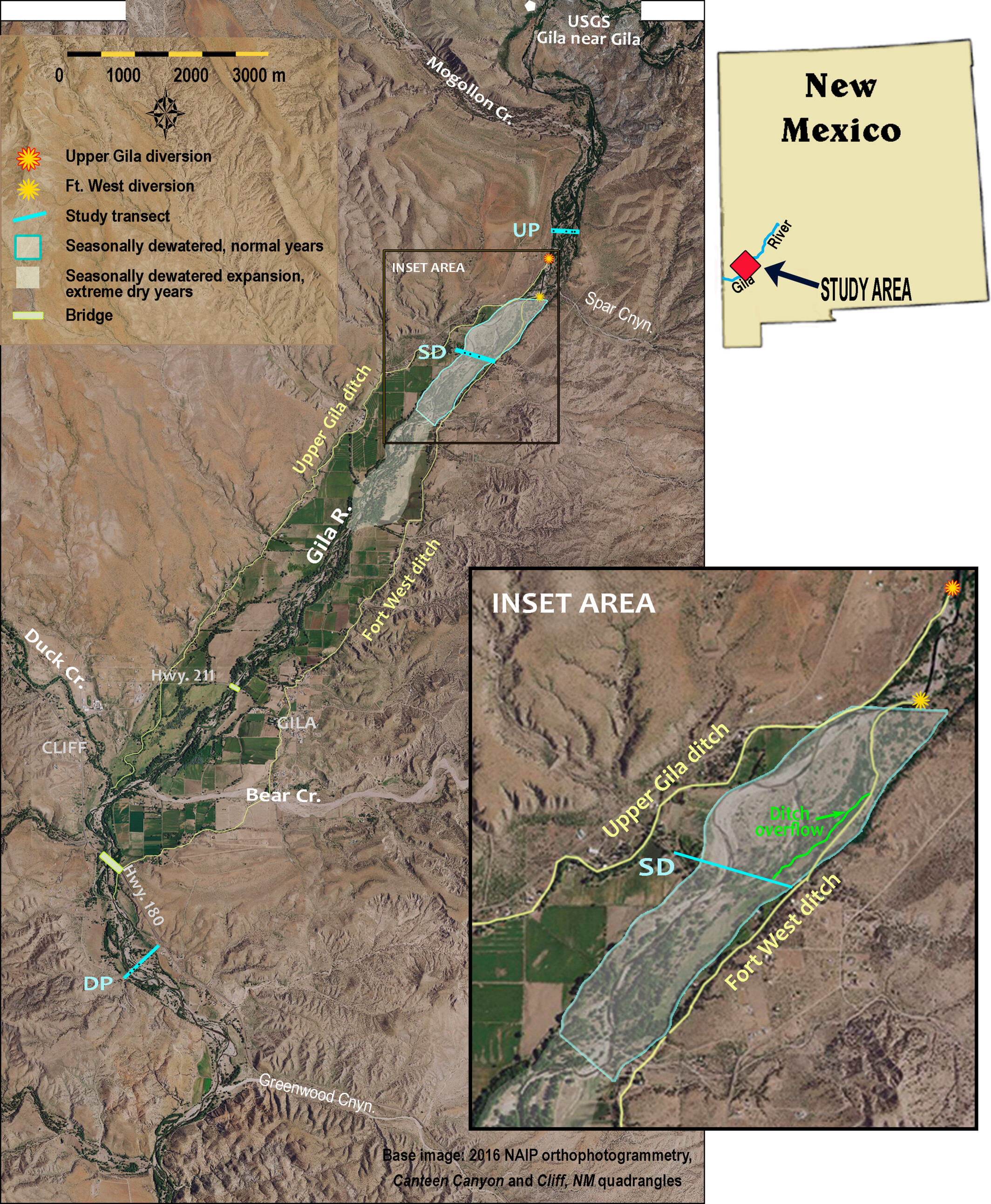

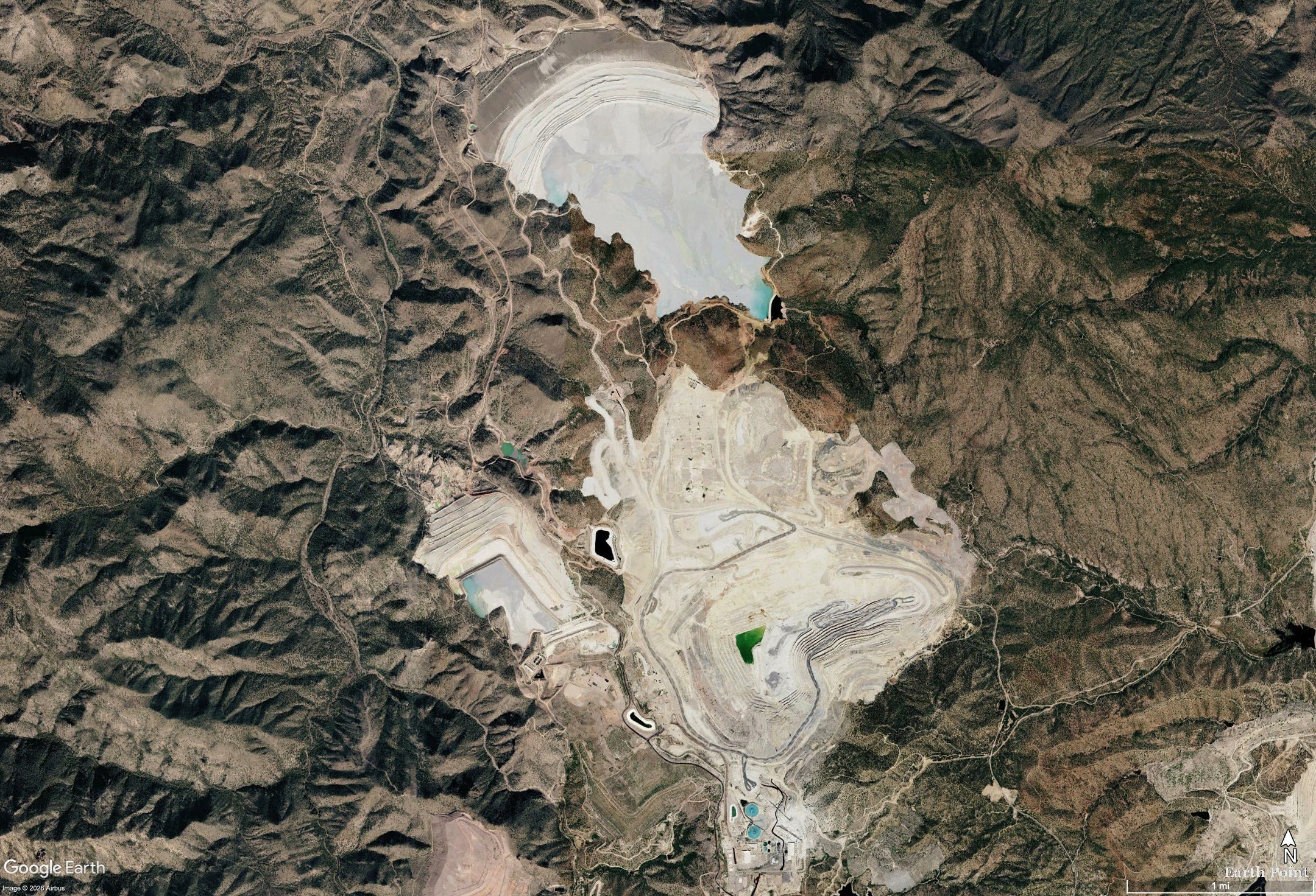

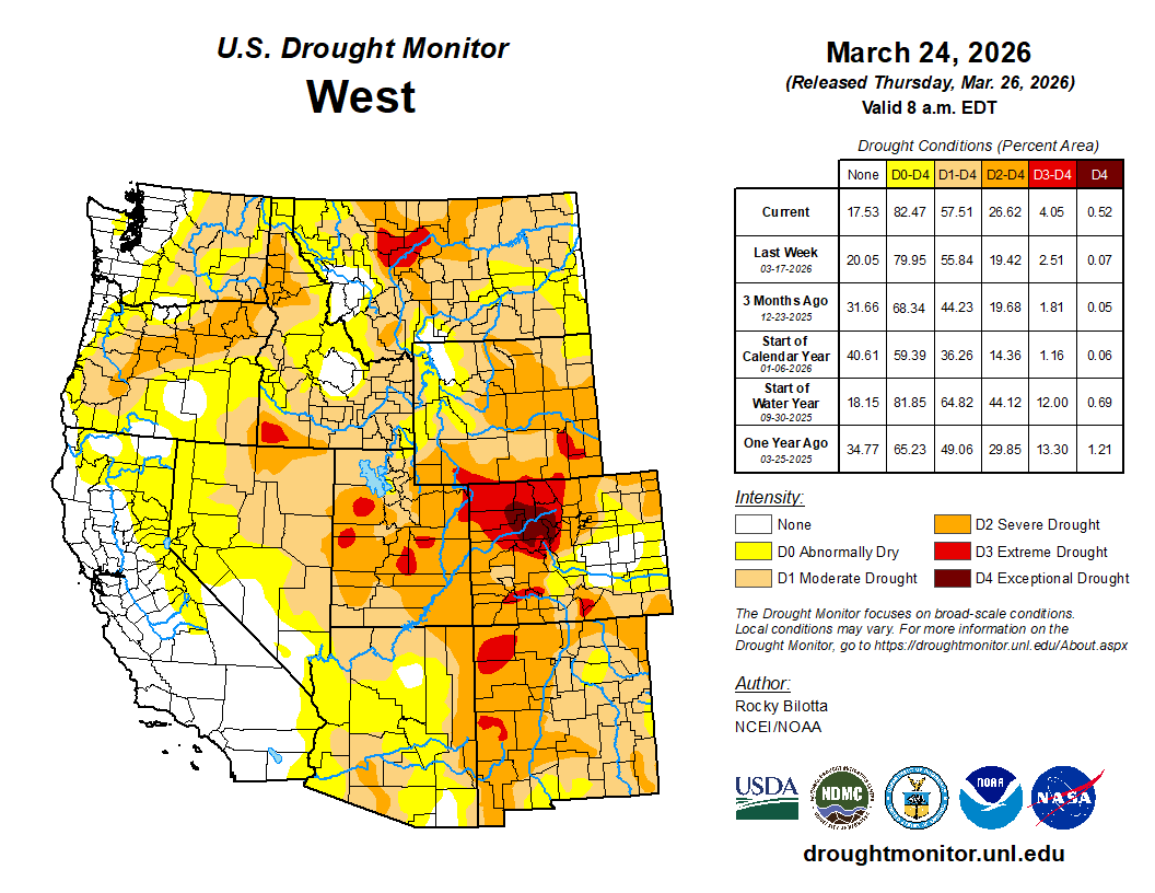
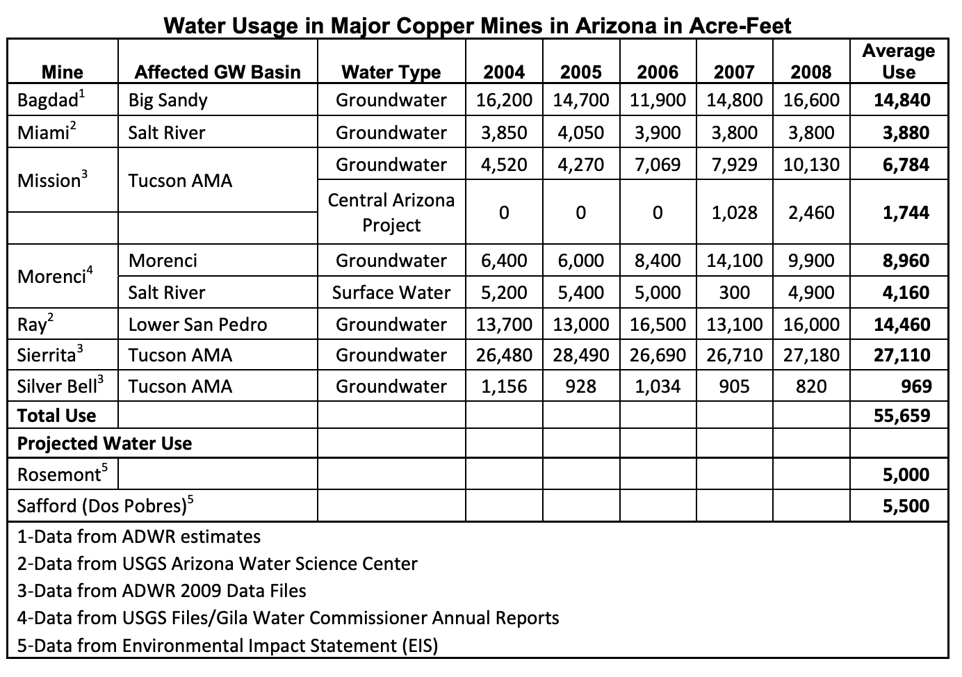

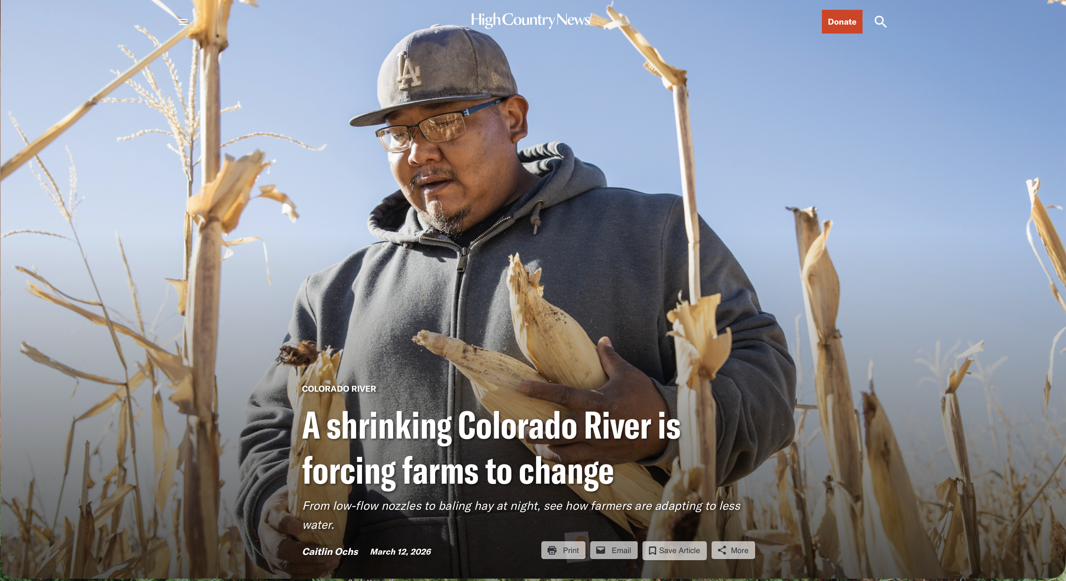
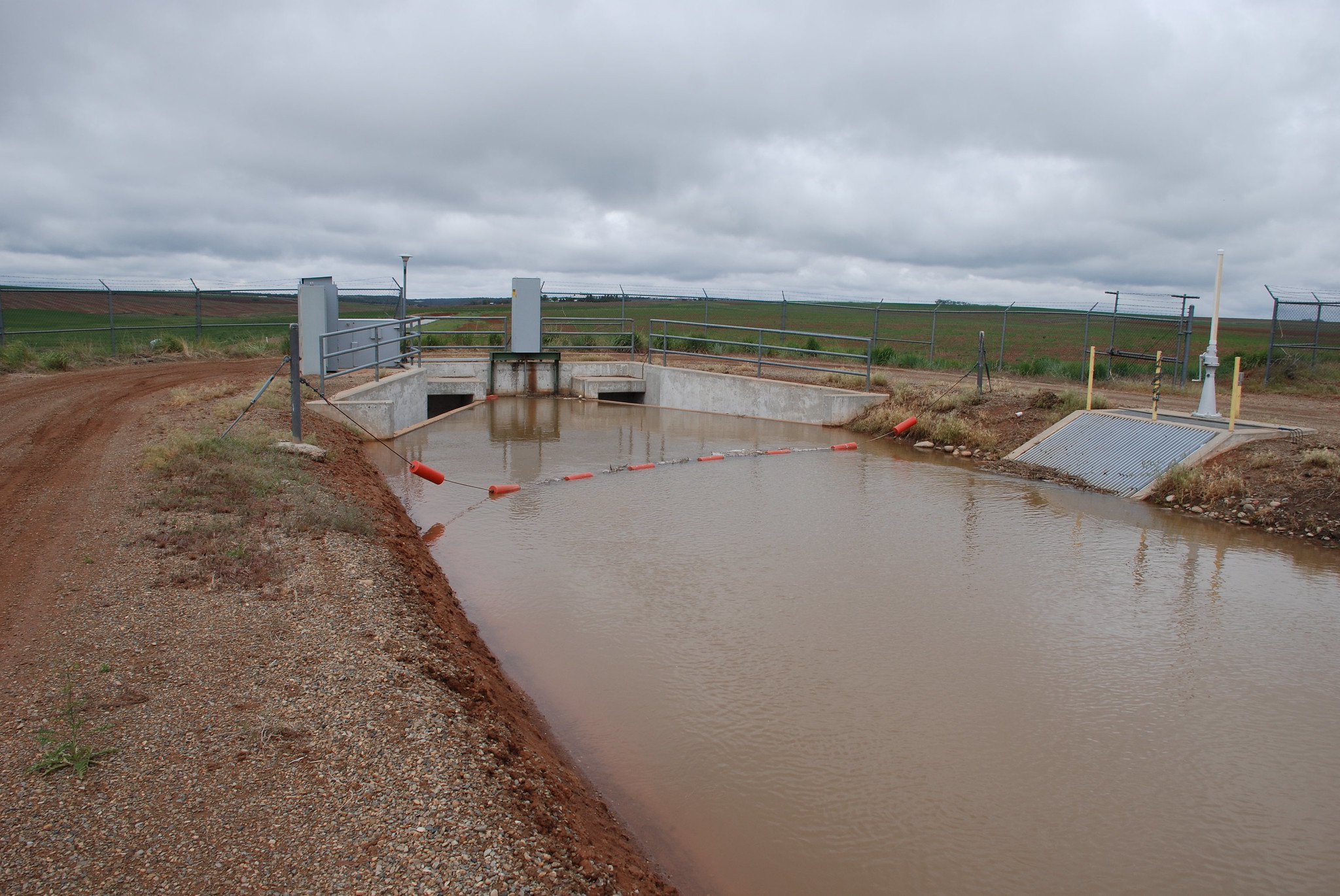


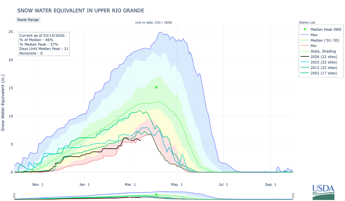


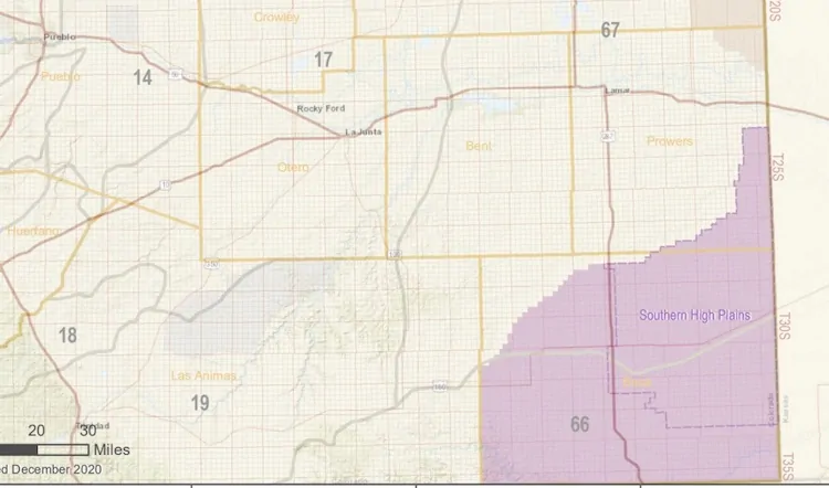

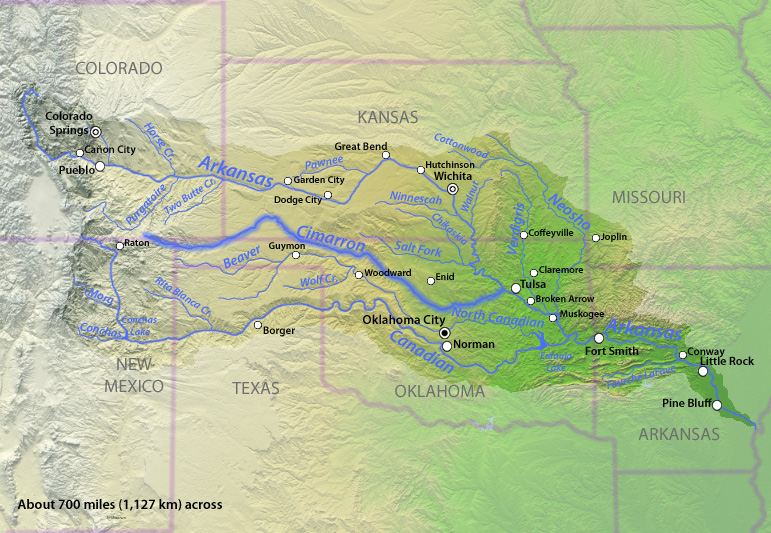
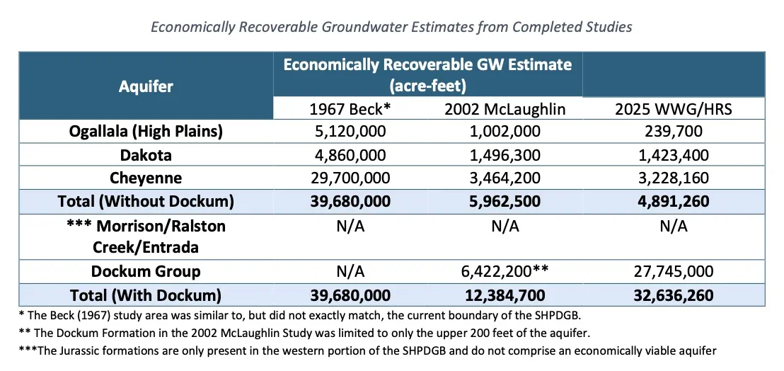
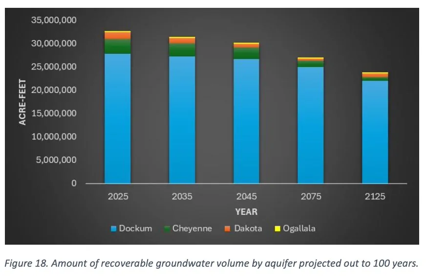
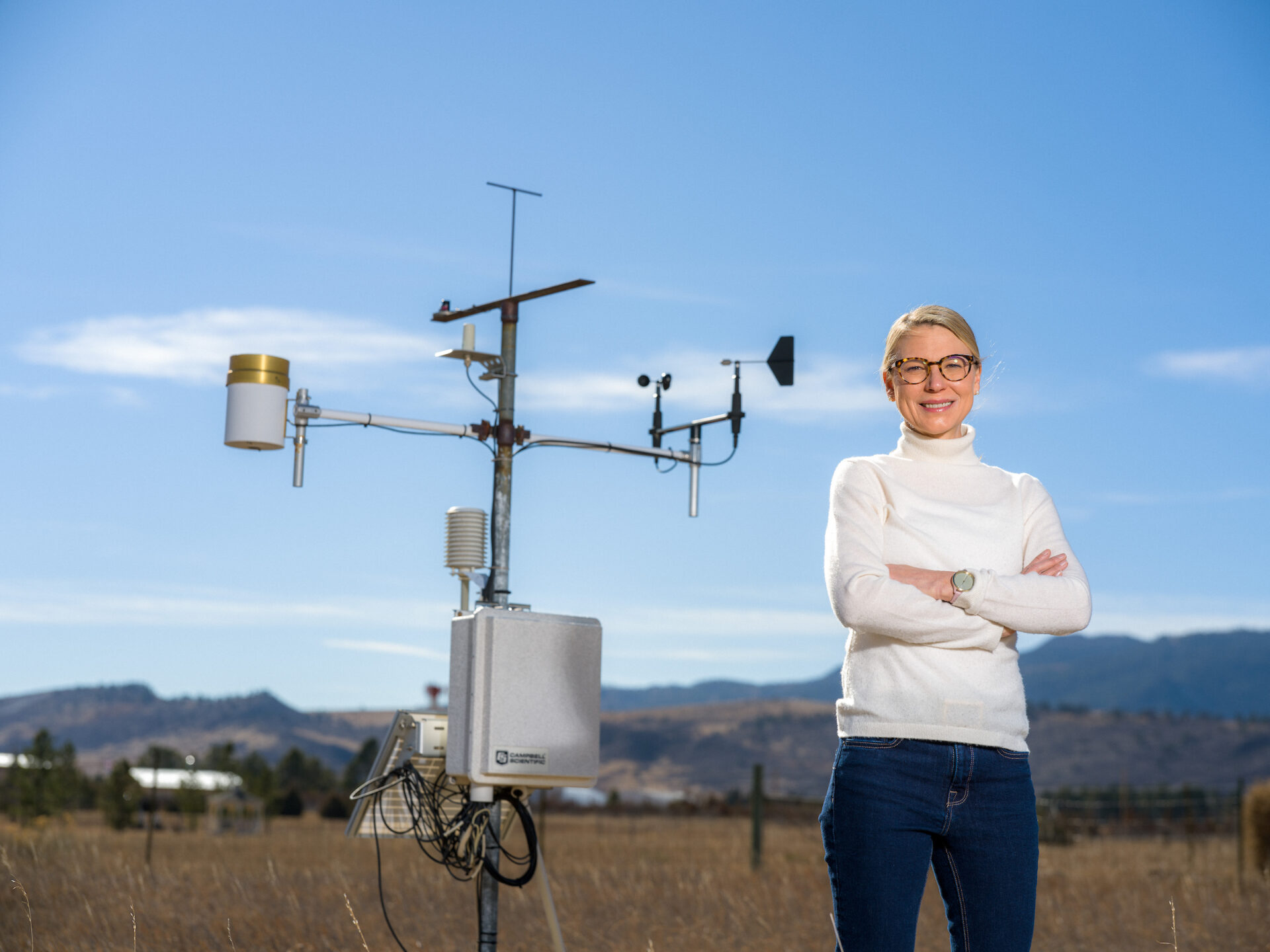
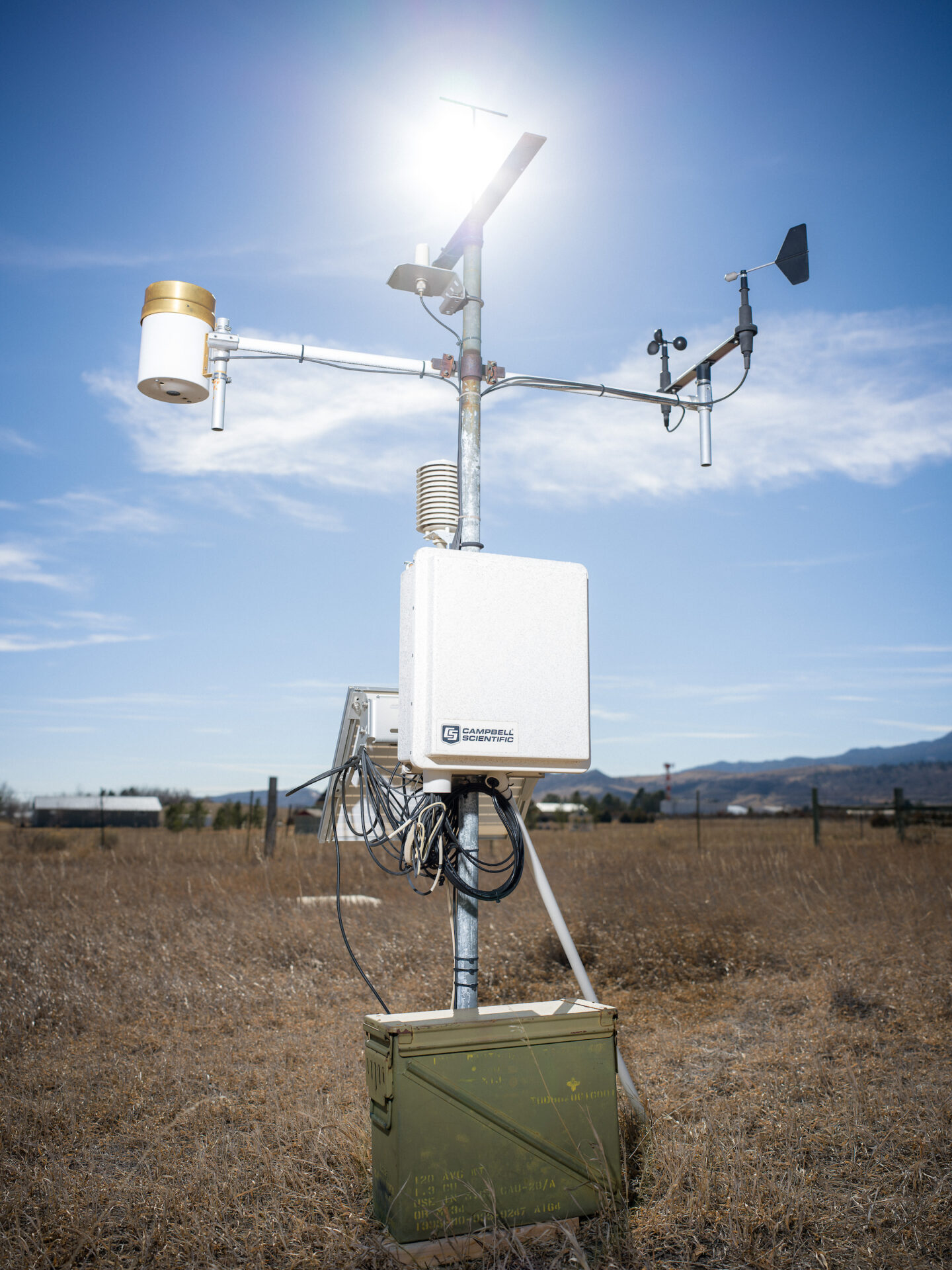

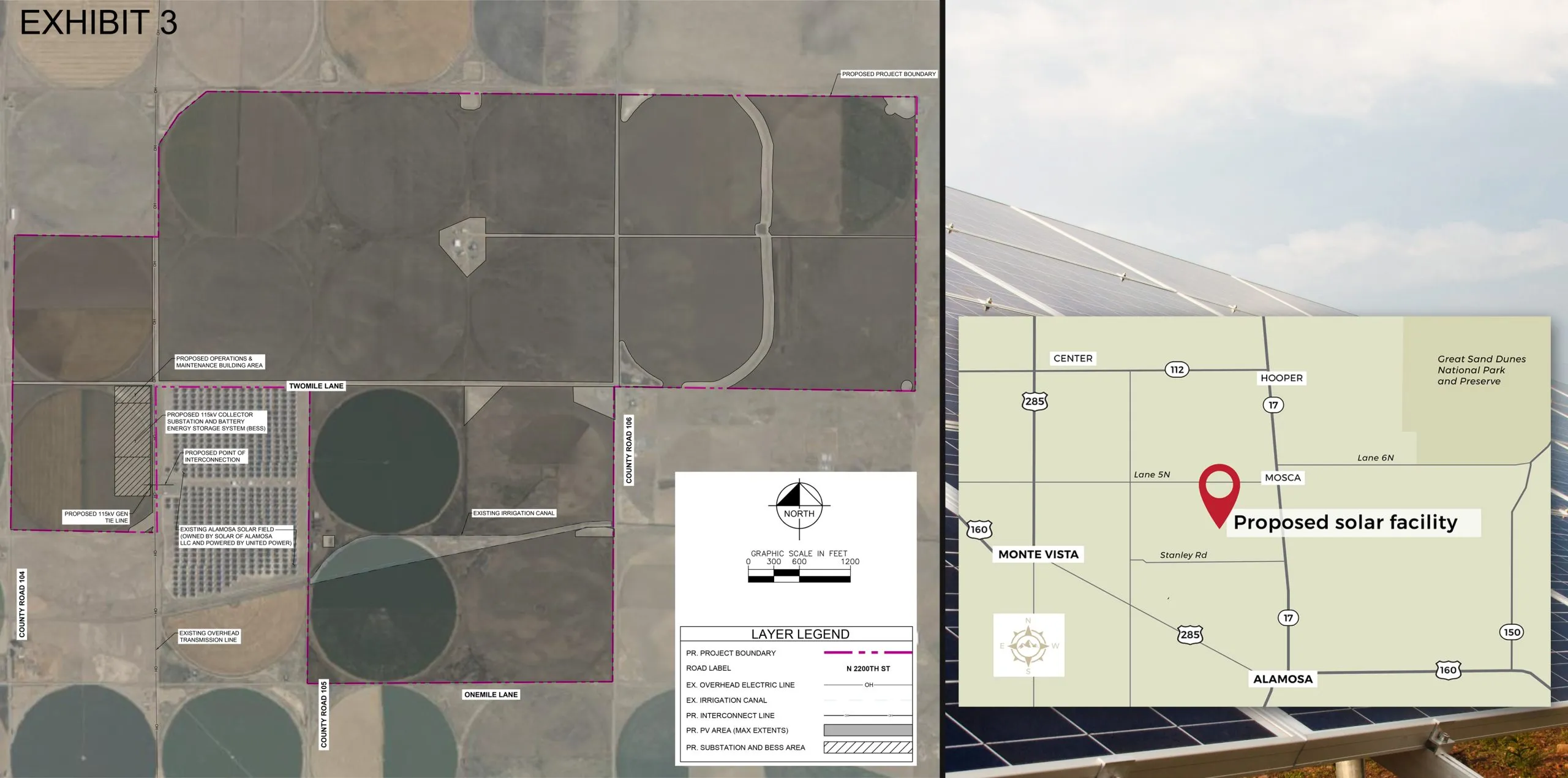
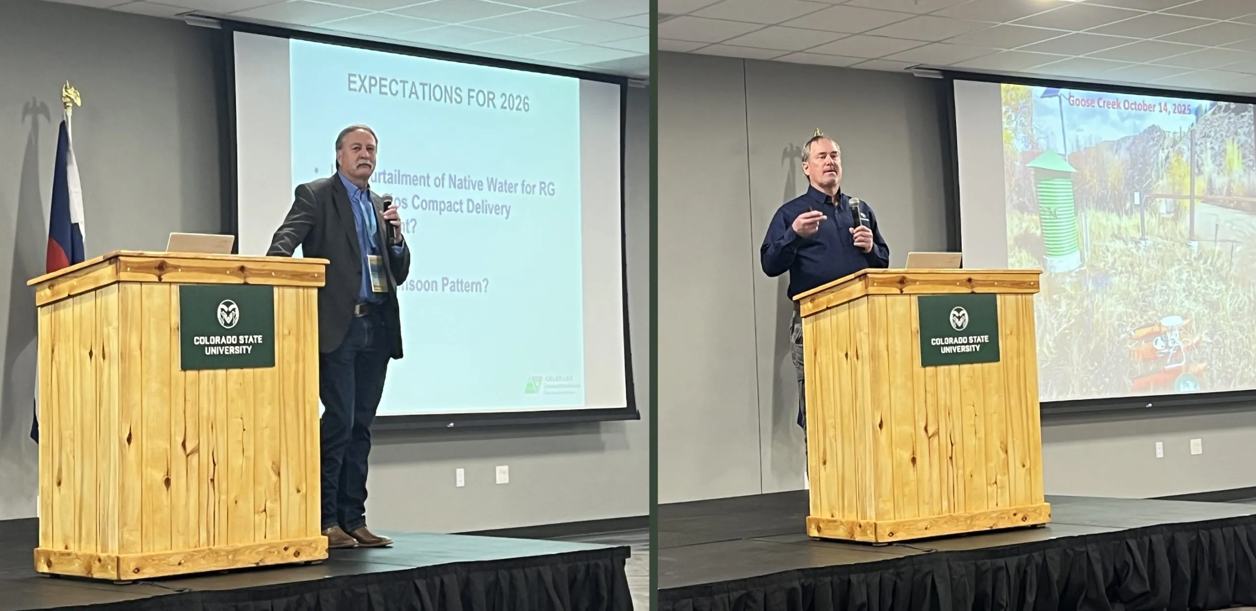
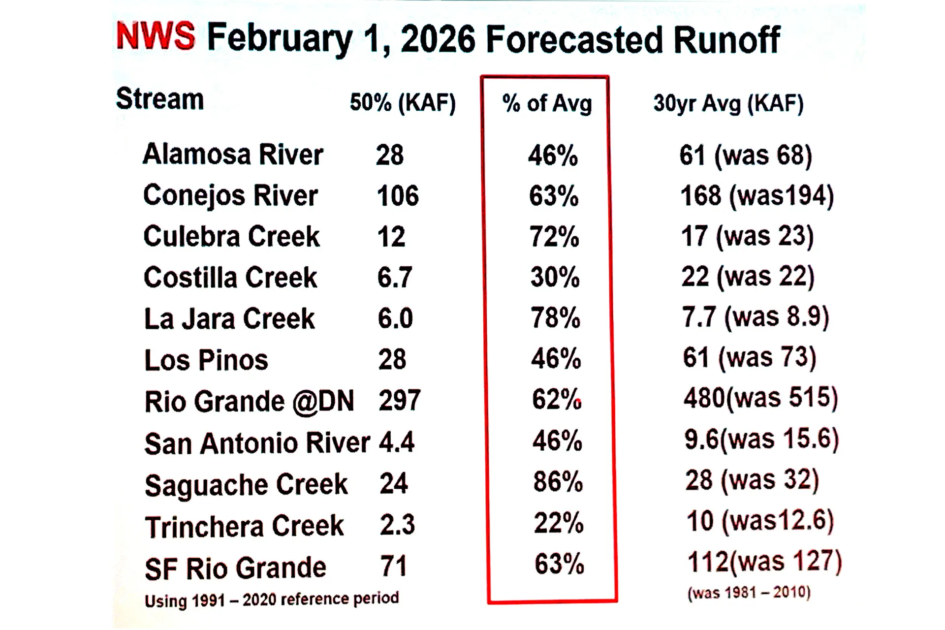
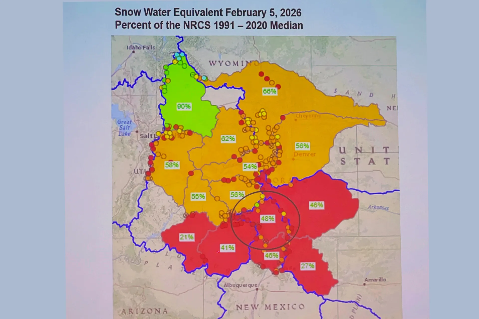

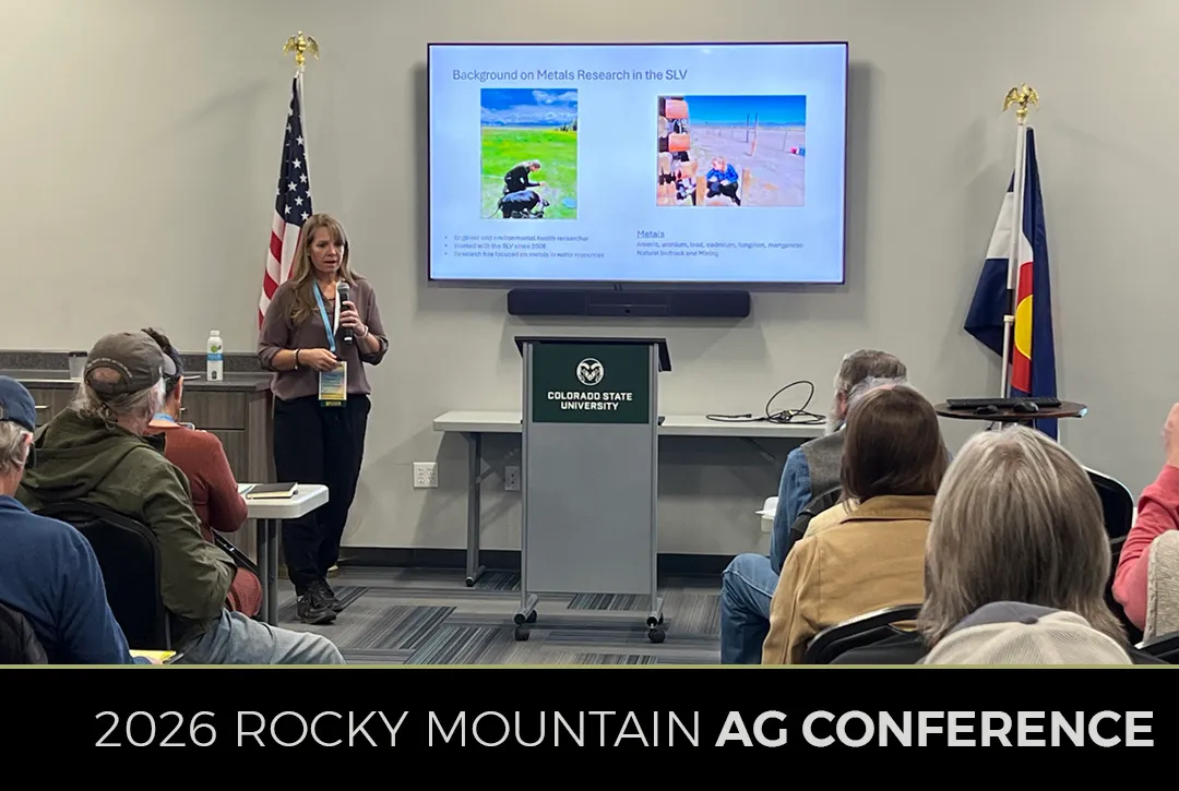


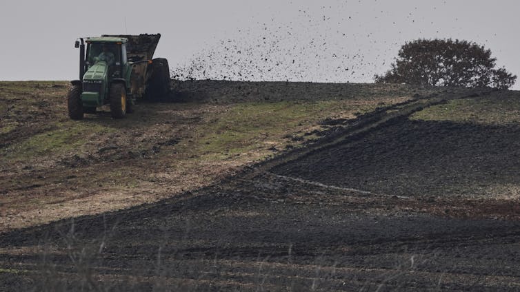


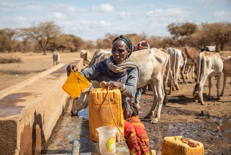
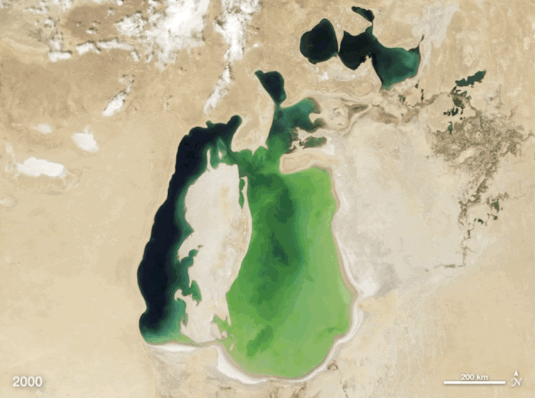
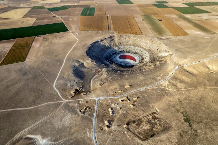


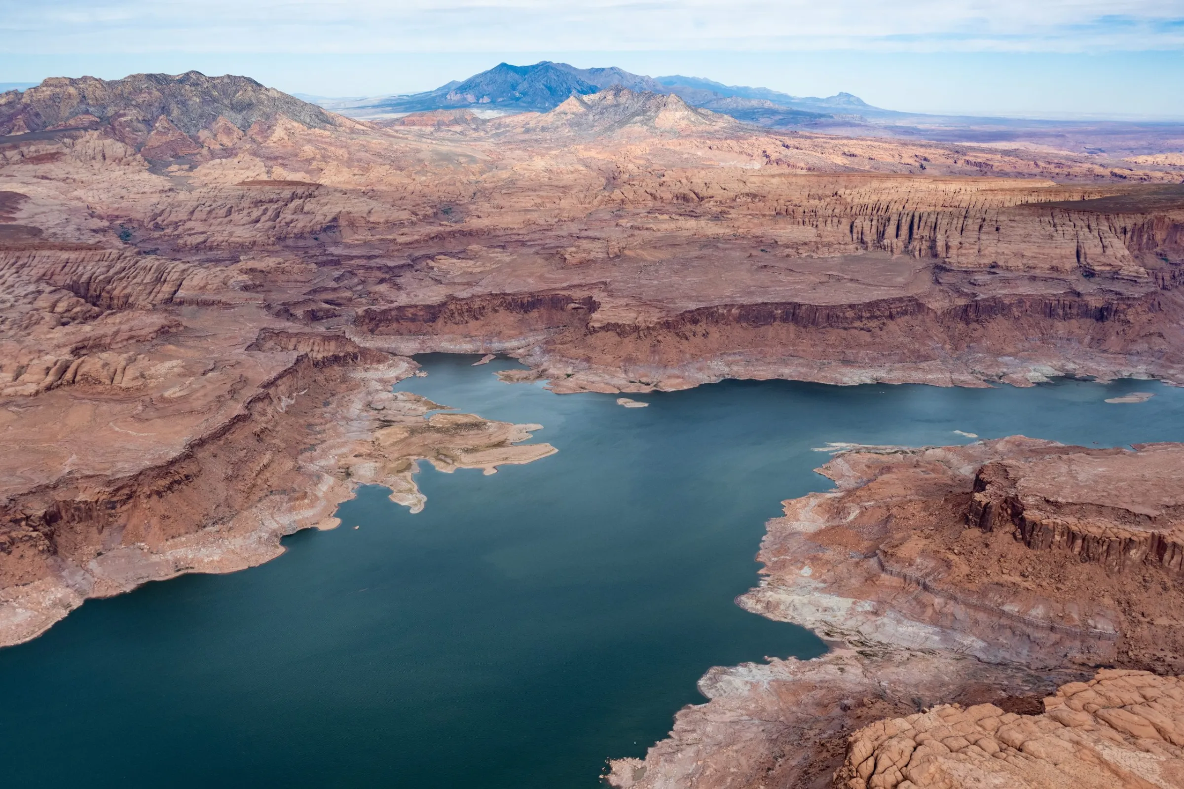


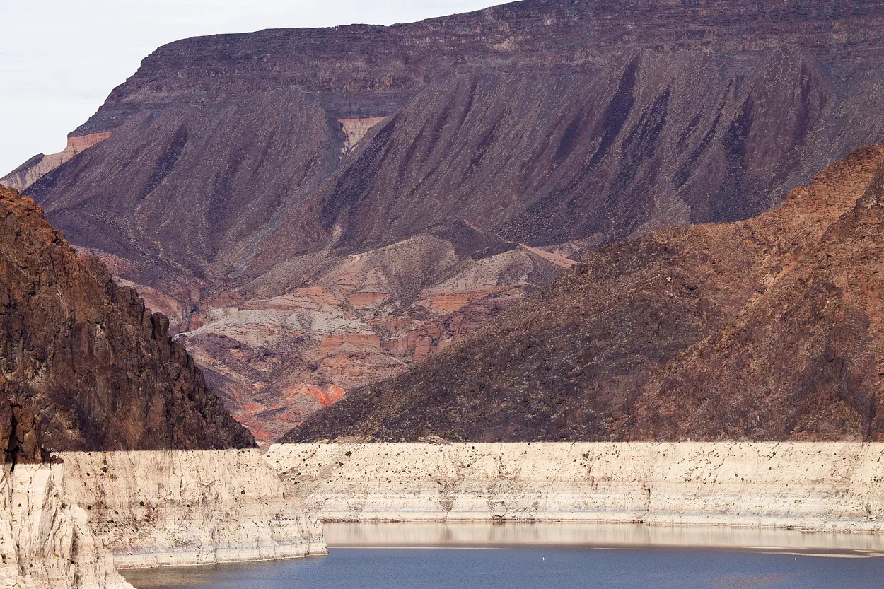

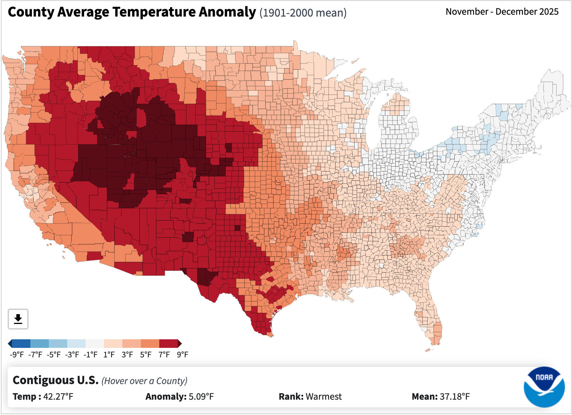


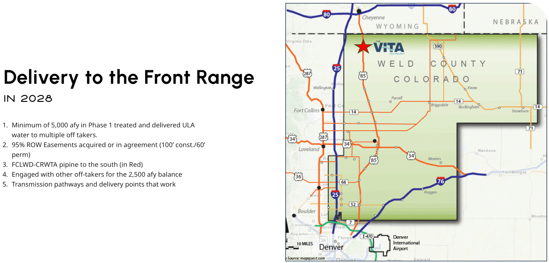


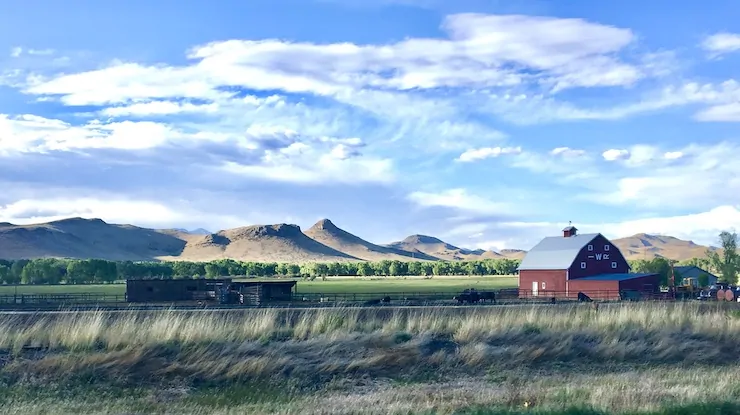


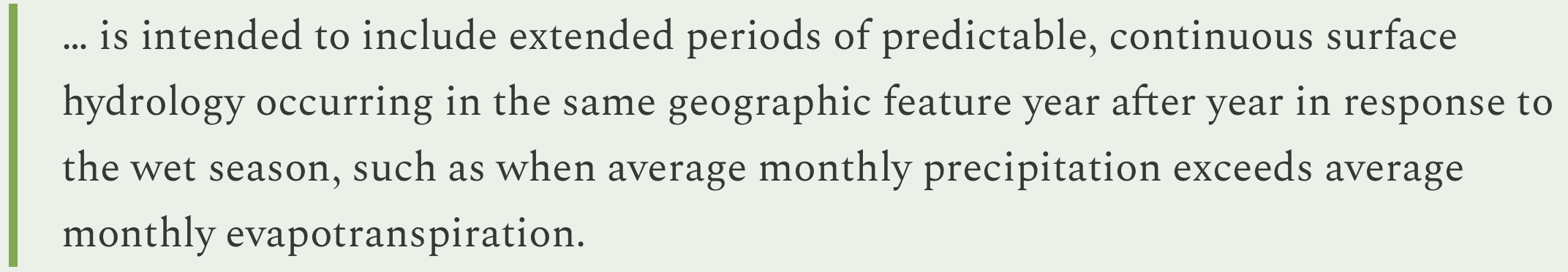
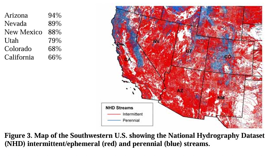


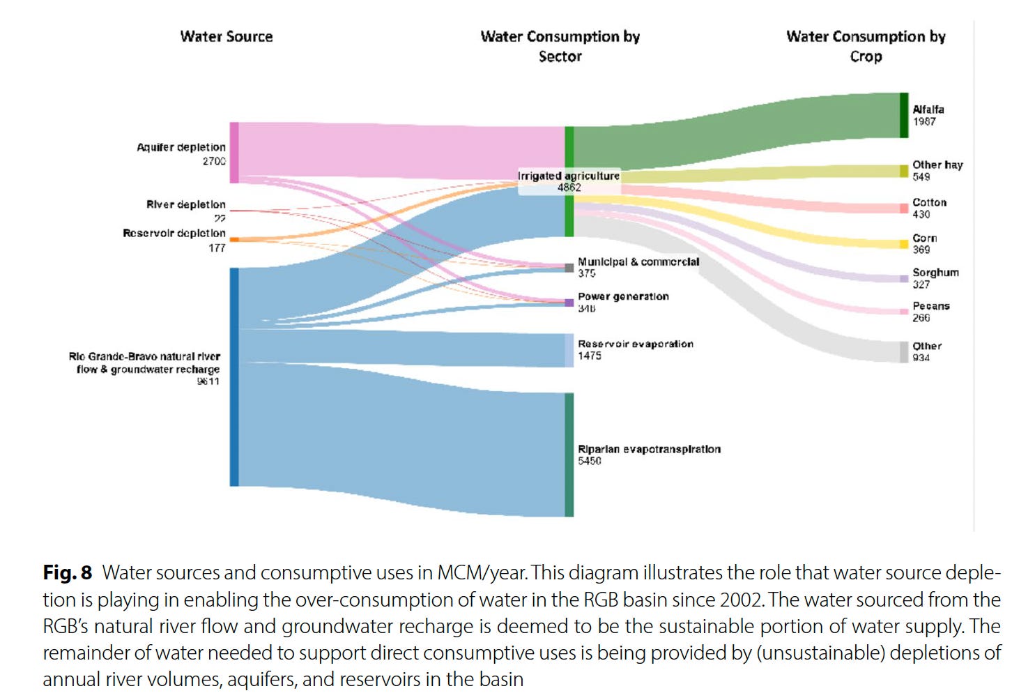
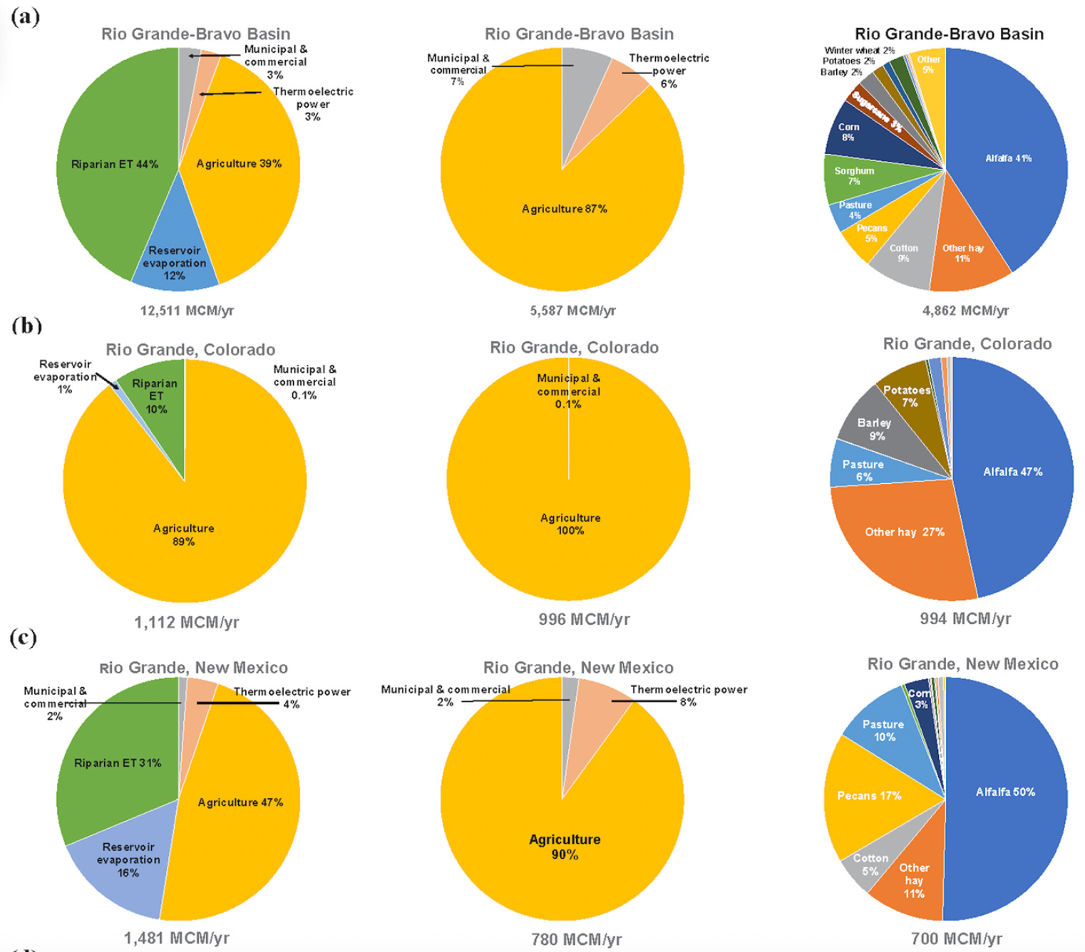

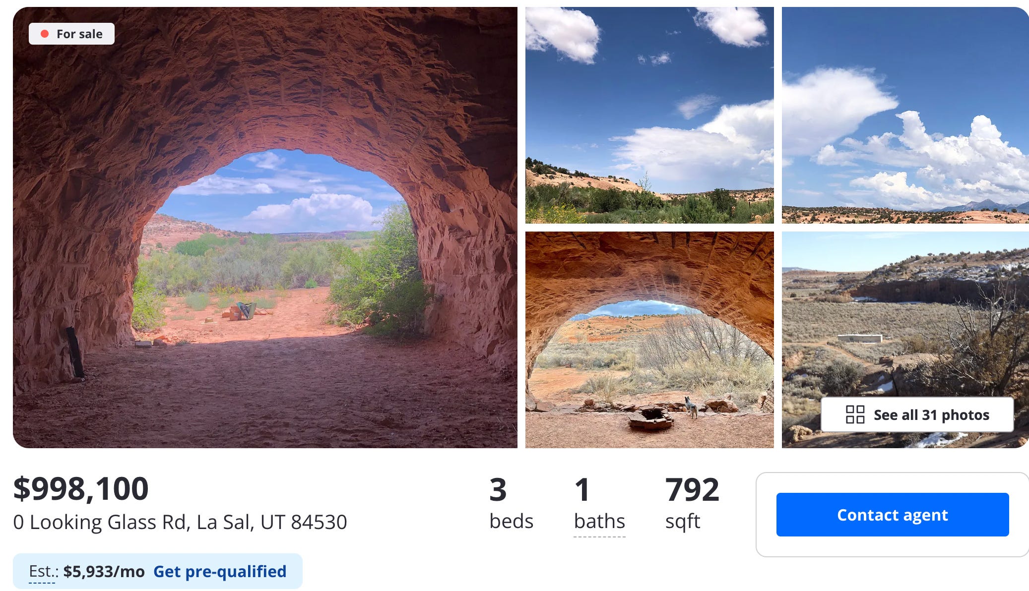

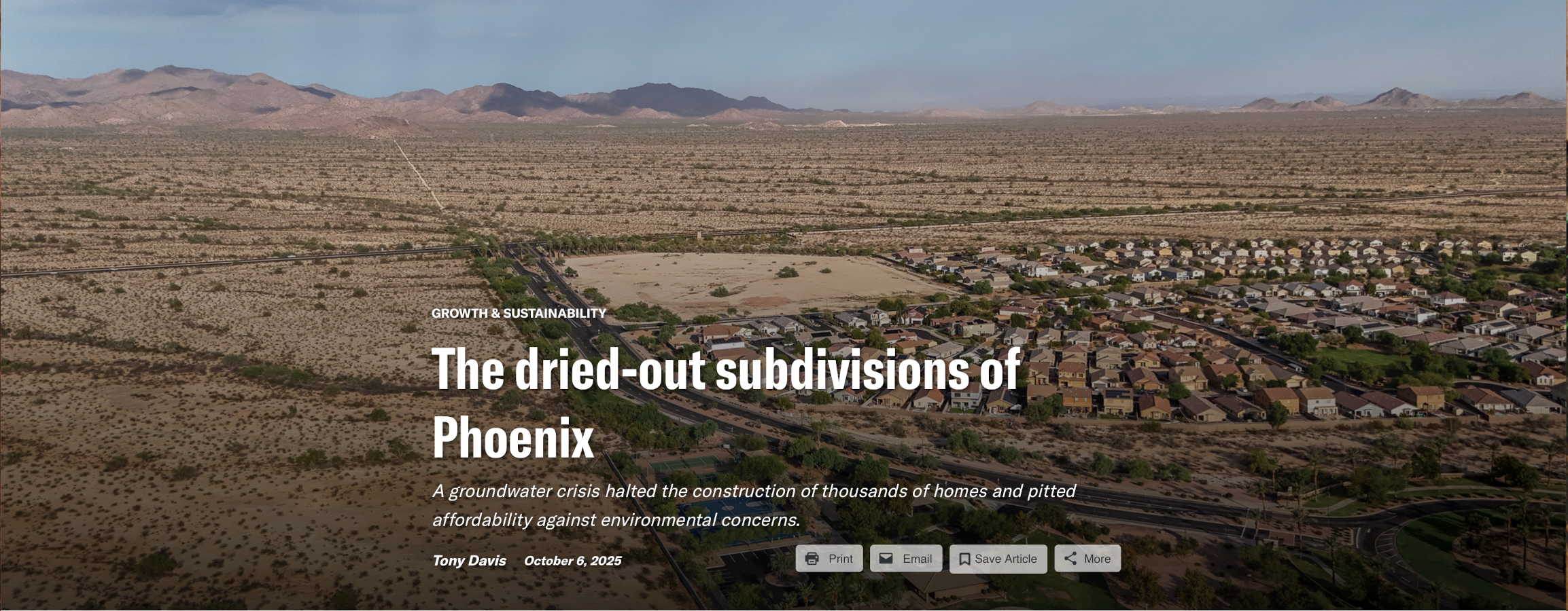


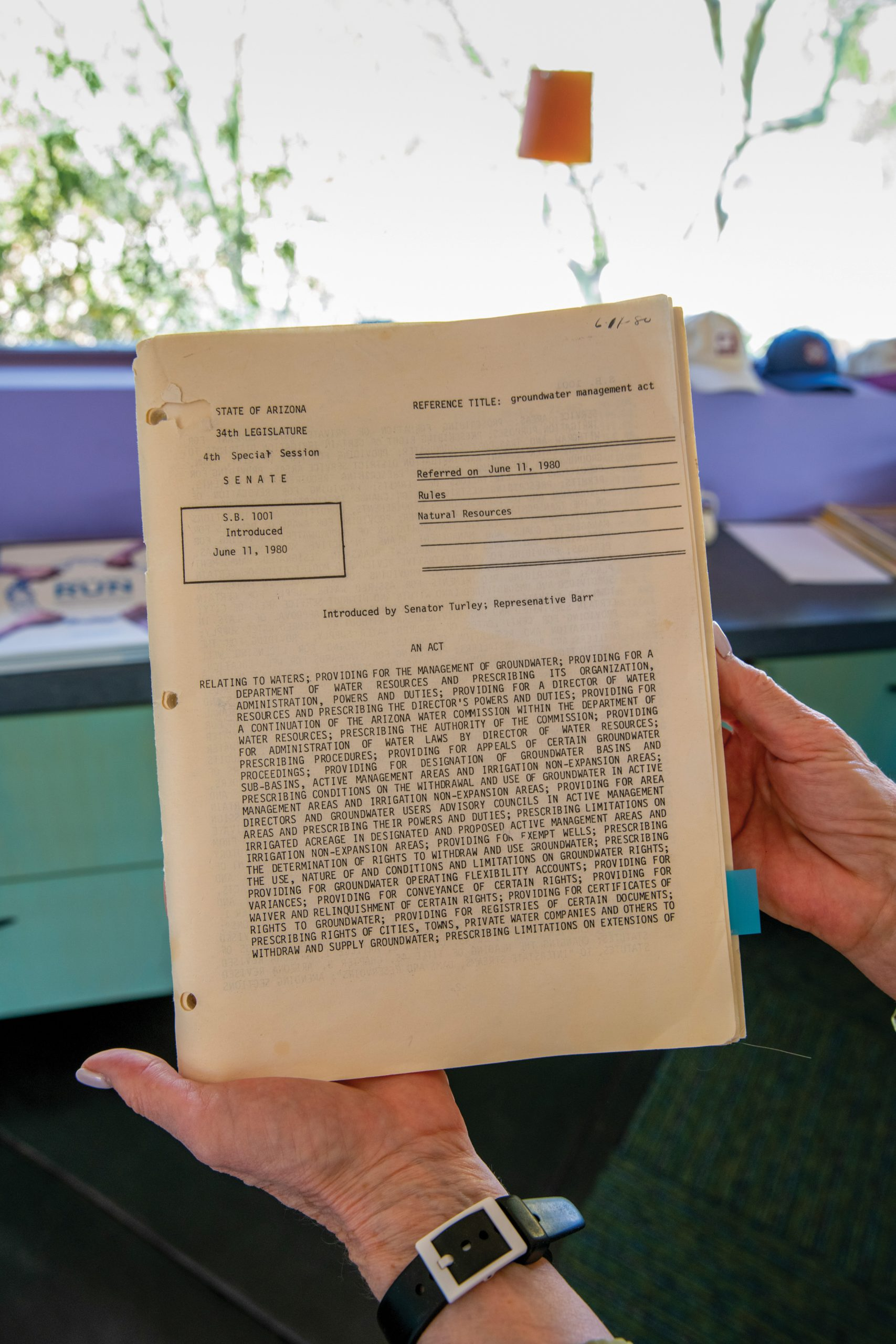


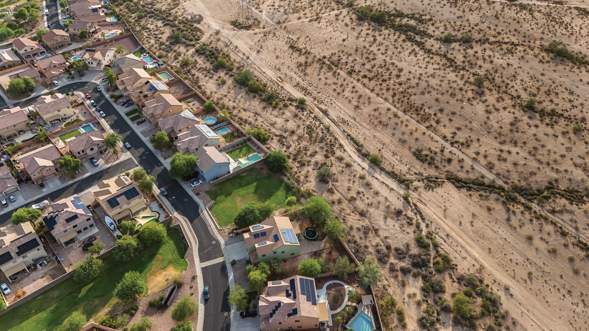


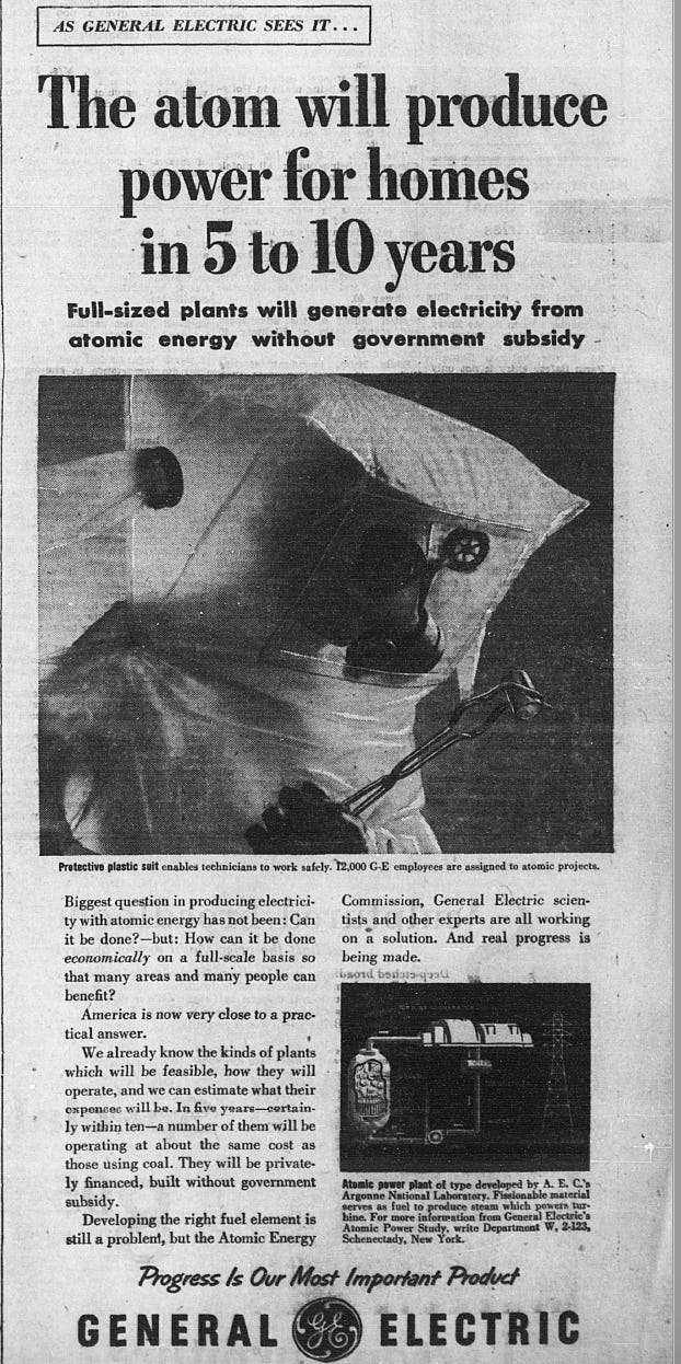
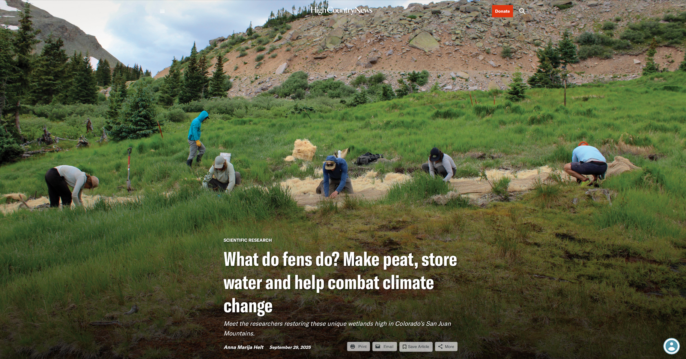
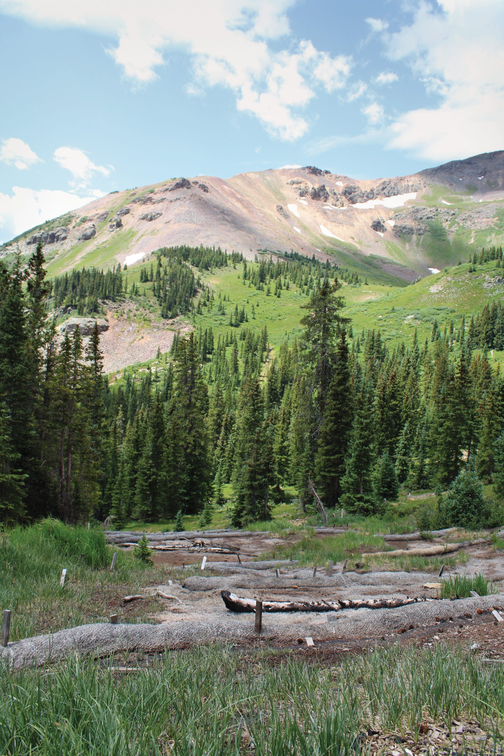


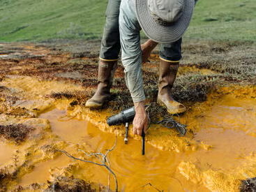


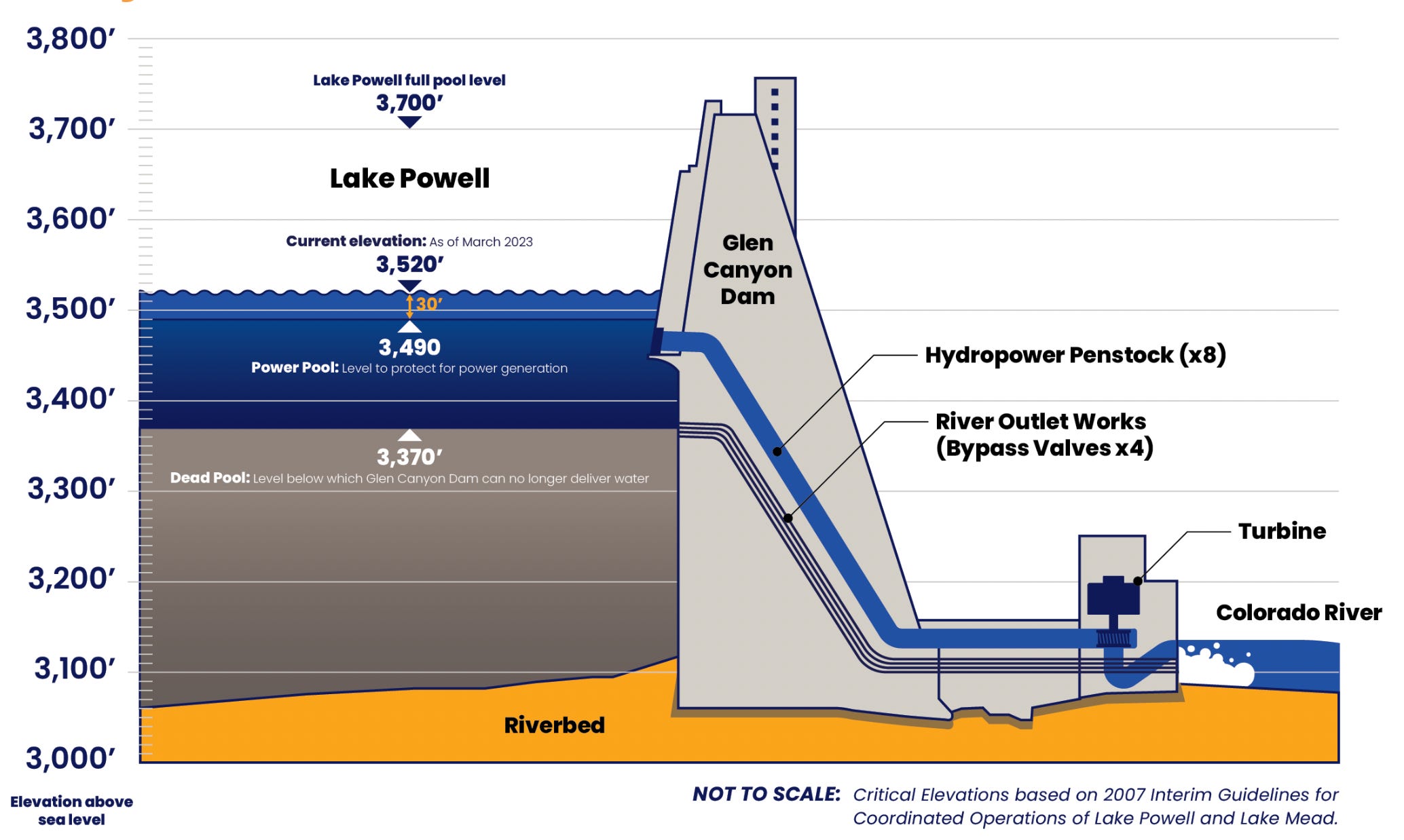


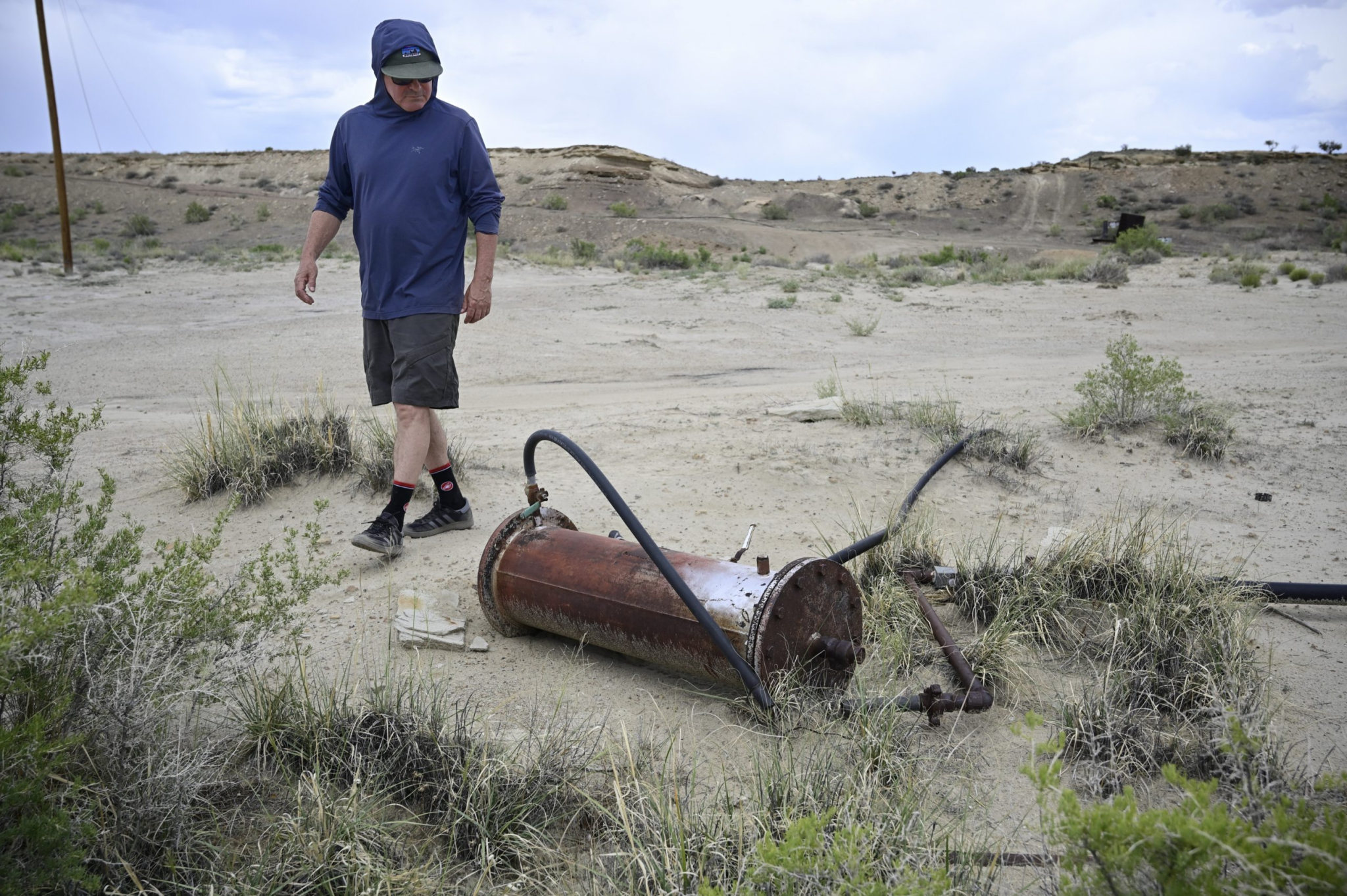


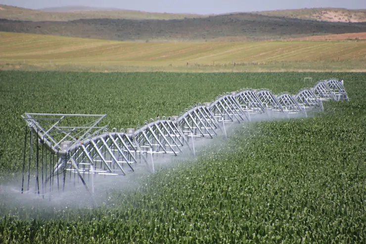


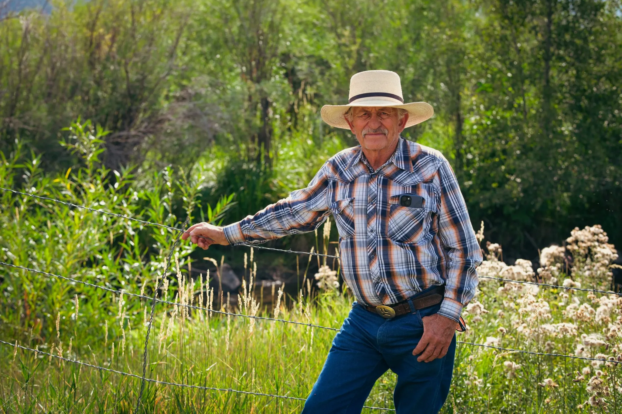

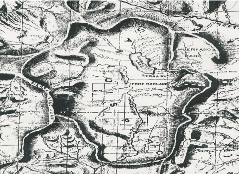
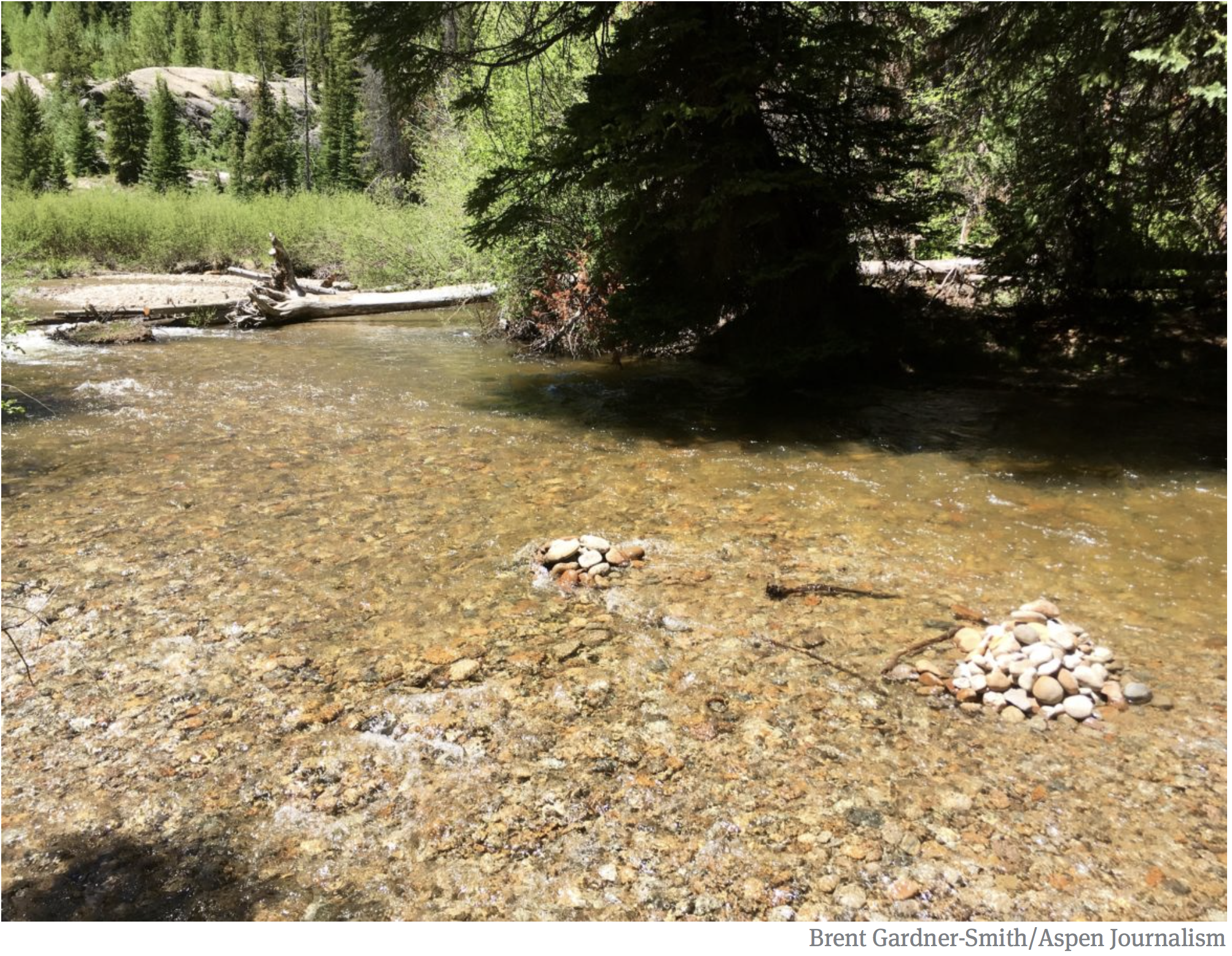


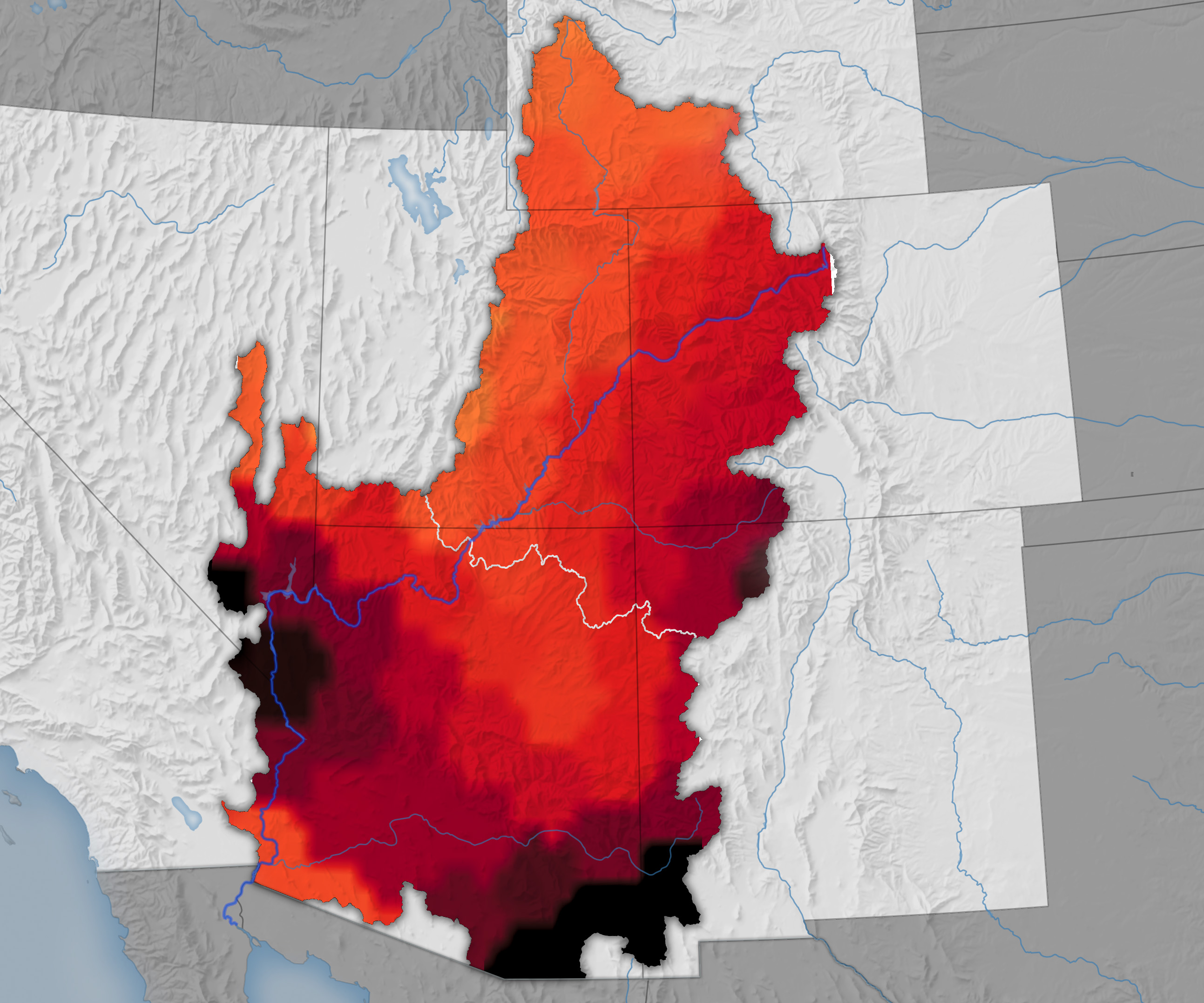


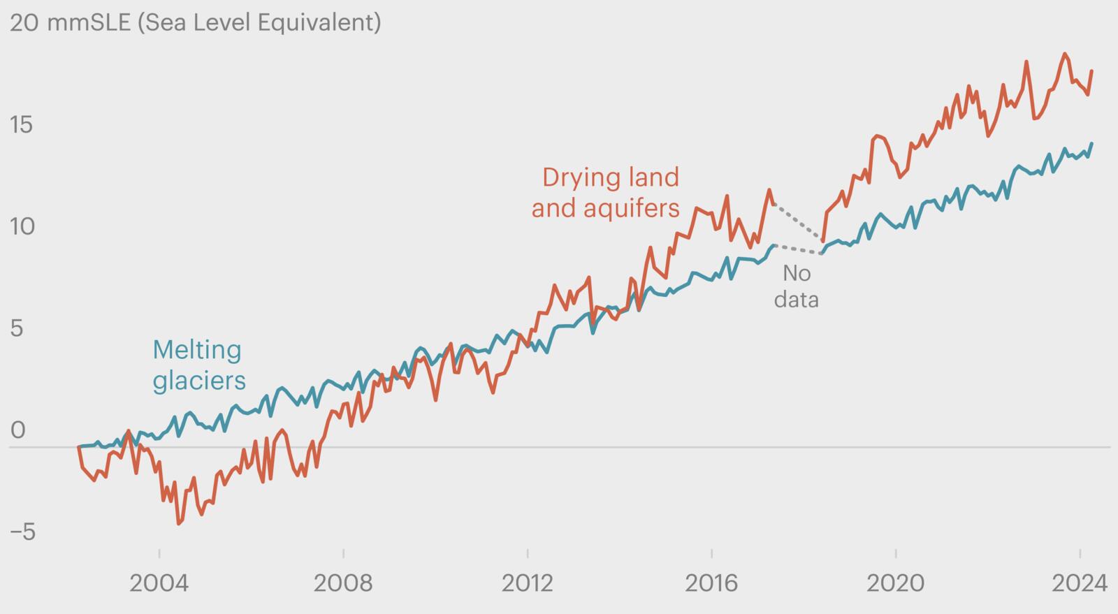
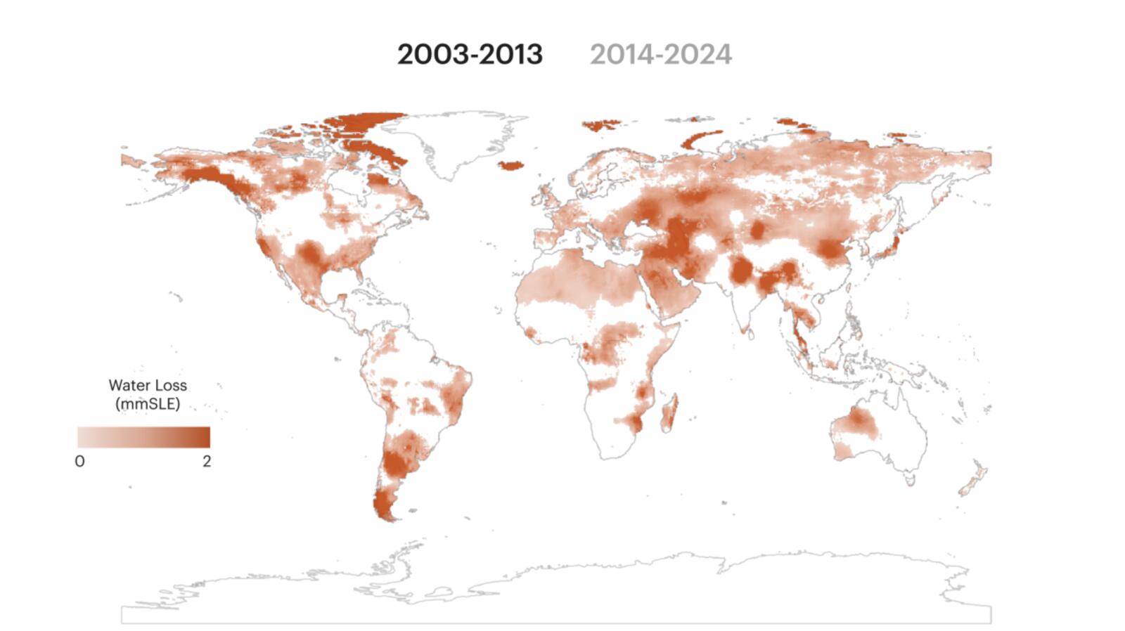

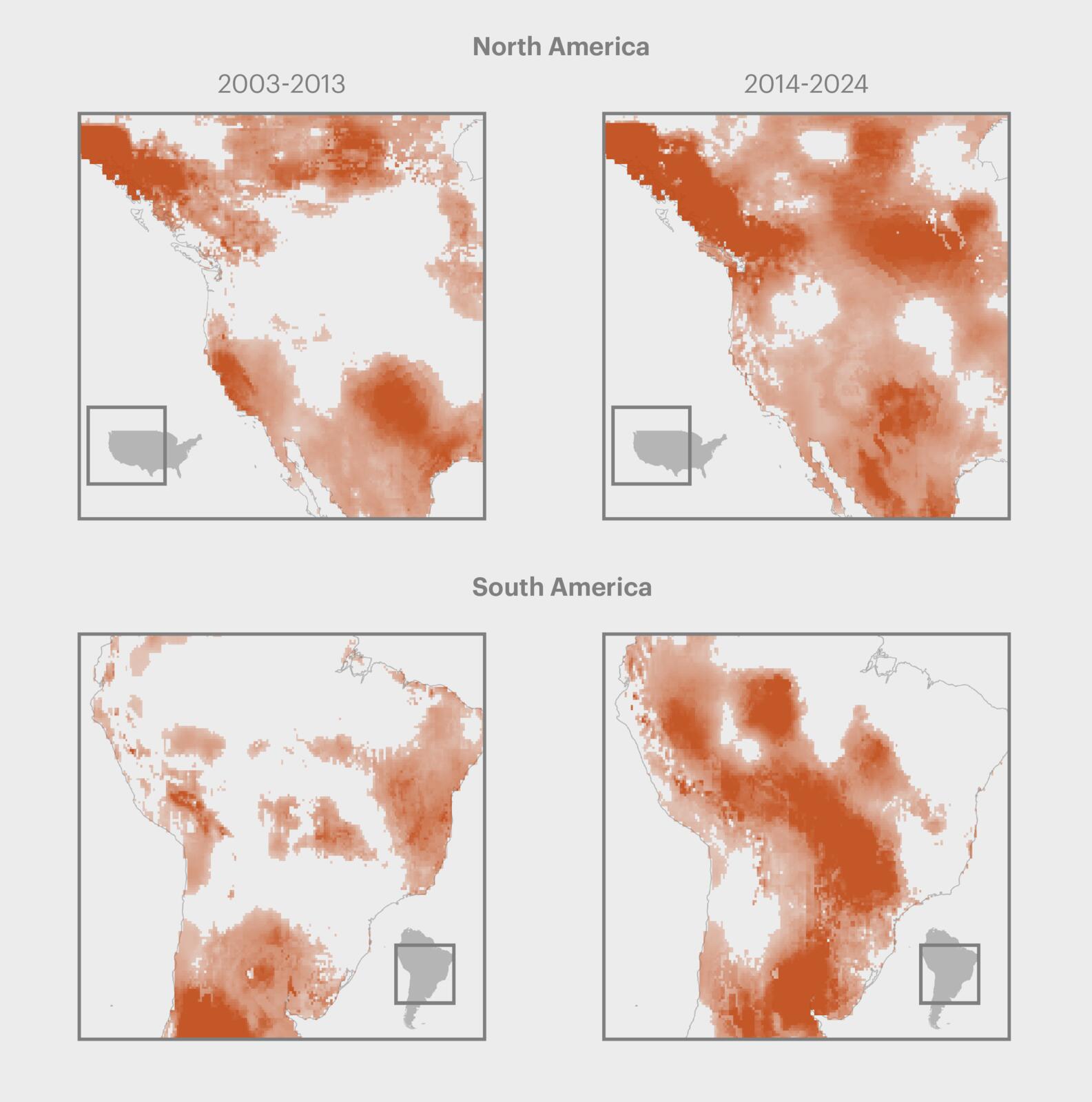


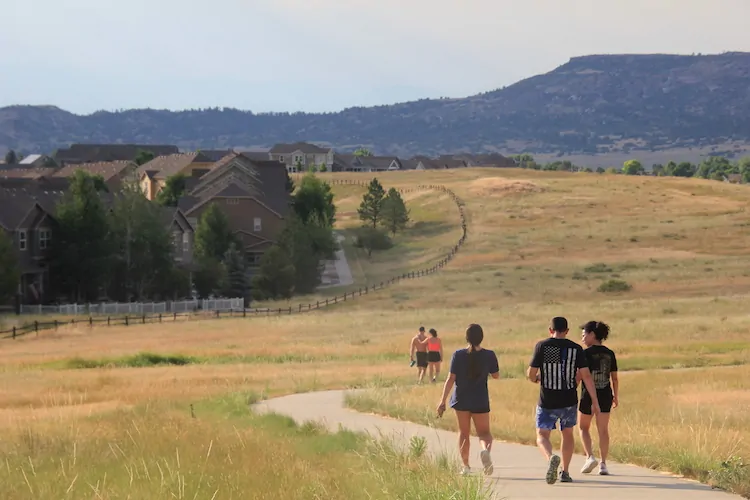
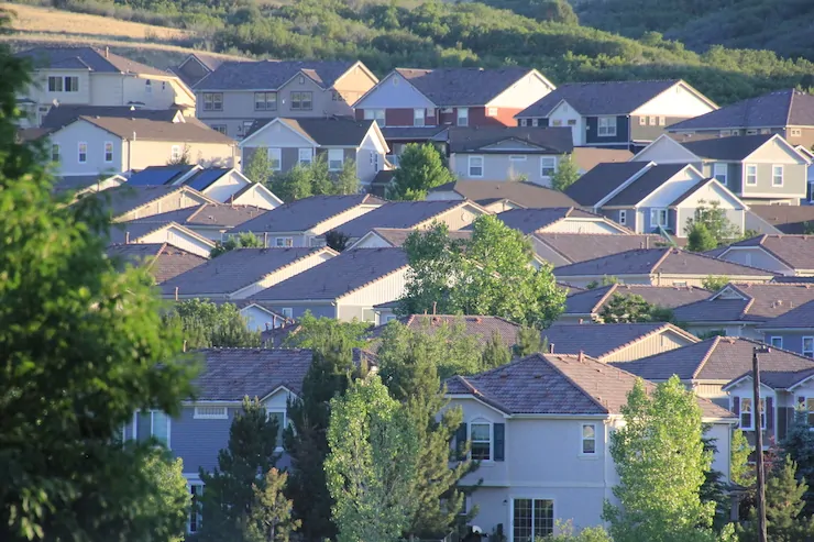


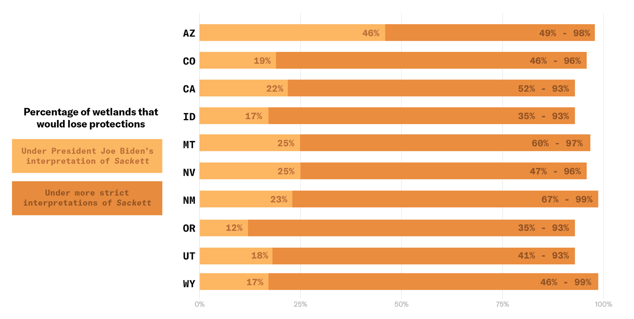

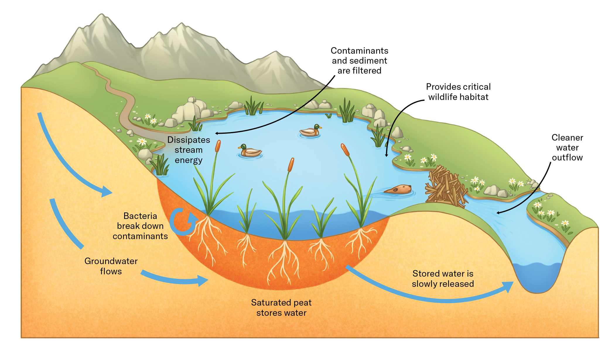


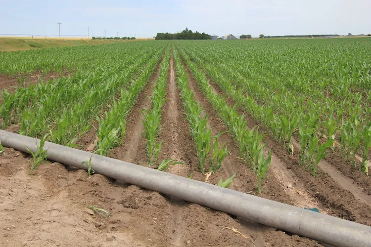
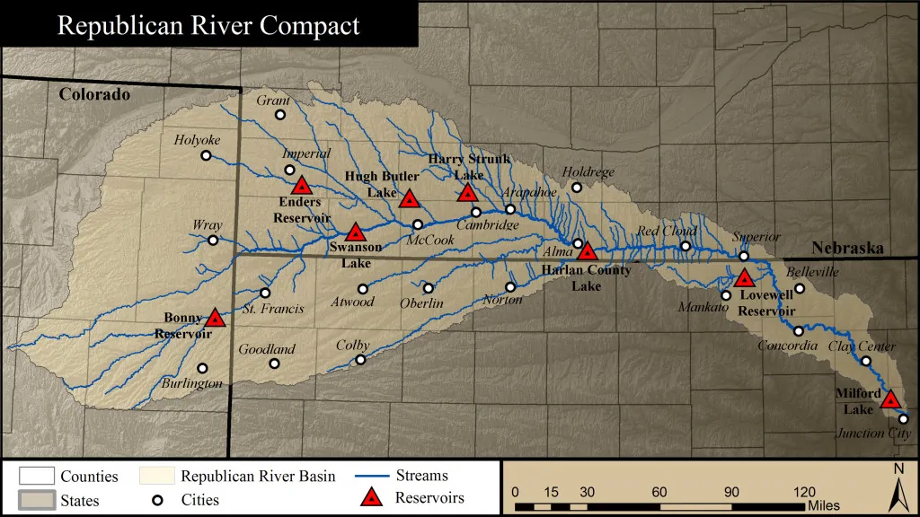
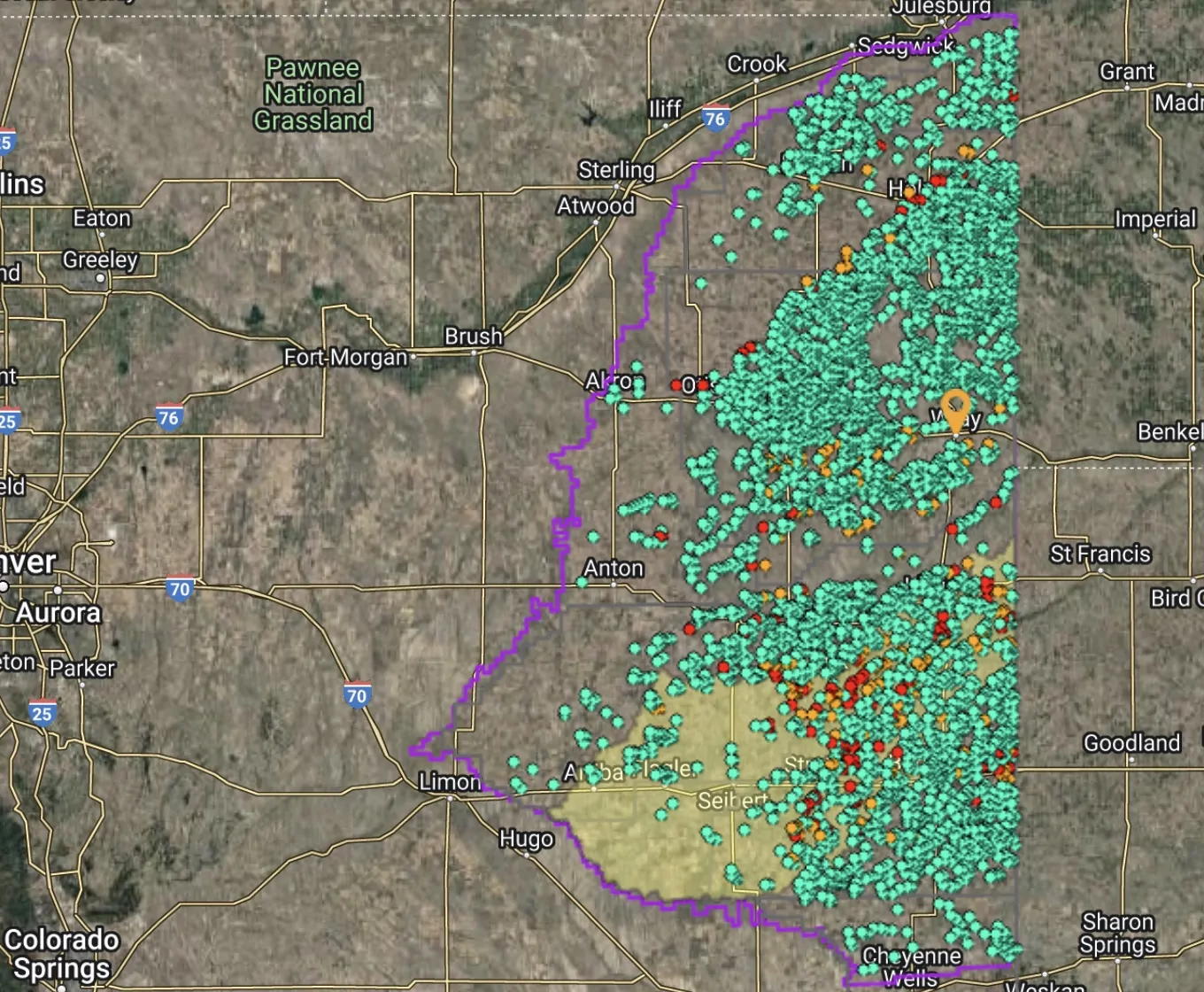

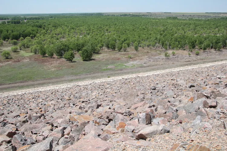


